beacon to beacon guide—brisbane river and bremer river
TRANSCRIPT
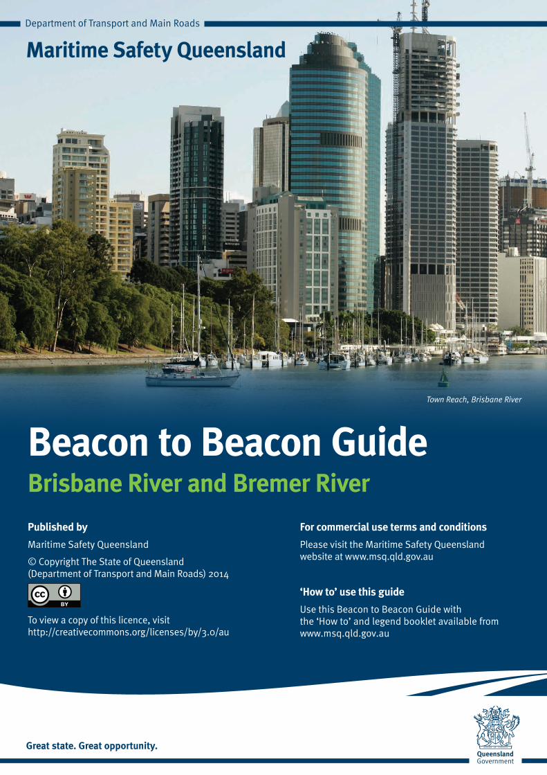
Beacon to Beacon GuideBrisbane River and Bremer River
Maritime Safety Queensland
Published by
Maritime Safety Queensland
© Copyright The State of Queensland (Department of Transport and Main Roads) 2014
To view a copy of this licence, visit http://creativecommons.org/licenses/by/3.0/au
For commercial use terms and conditions
Please visit the Maritime Safety Queensland website at www.msq.qld.gov.au
‘How to’ use this guide
Use this Beacon to Beacon Guide with the ‘How to’ and legend booklet available from www.msq.qld.gov.au
Town Reach, Brisbane River
!
!
!
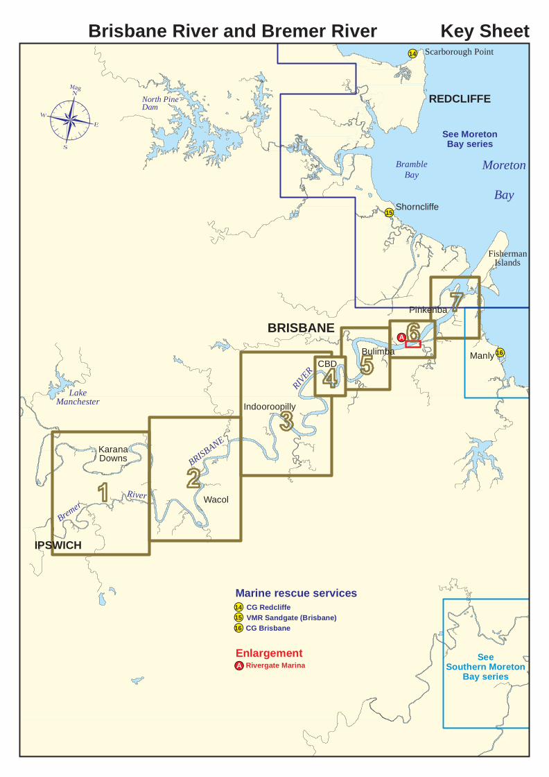
IPSWICH
LakeManchester
Wacol
15
Manly
FishermanIslands
BRISBANE
RIVER
BRISBANE16
E
KaranaDowns
BremerRiver
Indooroopilly
CBDBulimba
Pinkenba
Shorncliffe
!A
MoretonBay
Scarborough Point
North PineDam REDCLIFFE
BrambleBay
14
Marine rescue services!VMR Sandgate (Brisbane)15!CG Brisbane16
SeeSouthern Moreton
Bay series
Brisbane River and Bremer River Key Sheet
See MoretonBay series
Enlargement Rivergate Marina!A
¶Mag
AP
P
P
P
PP
PP
PP
PP
PP
PP
PP
PP
!CG Redcliffe14
KARANADOWNS
KARALEECollegesCrossing
TIVOLI
NORTHTIVOLI
NORTHBOOVAL
BUNDAMBA DINMORE
RIVERVIEW
EBBW VALE
BasinPocket
EASTIPSWICH
MooresPocket
Venus Pool
IPSWICHMOTORWAY
B risbane Road
CUNNINGH
AMHIG
HWAY
WARREGO
WaterstownRocks
HWYMotor BoatBend
MtCr
osby
Road
End of tidal influence
CHUWAR
College
Road
Tand
erra
Way
JunctionRoad
Bundamba
Creek
Sandy Ck BREMERRIVER
BRI SBANE
RIVER
NORTHIPSWICH Kookaburra
Park
Strong currentsRocks across channel
Rocks to6m out
Tivoli RocksRocks to18m out
Rocks
Wharfremains
Johnsons Rocks
Warrego HighwayBridges
Devils Elbow
RocksRocksRocks to6m out
Shallow bank
Taylors Nook
Mt Crosby Road
(Floodlit)12.5m
Weir
!!"
FinlayIsland
BARELLANPOINT
DALY
SRE
ACH
BRISBAN E
DalysCrossing
Rocks to 15m out
Brisbane
BremerJunction
MOGGILLREACH
IPSWICH
NEWTOWN
EASTERNHEIGHTS
SILKSTONE
Weir Unsurveyedupstream
Cre ekKholo
Unsurveyedupstream
MOUNT CROSBY
152°50'E152°49'E152°48'E152°47'E152°46'E
27°32
'S27
°33'S
27°34
'S27
°35'S
27°36
'S27
°37'S
BR-1CG Redcliffe (0600 – 2100 Mon - Thu r, 24 hou rs w /e (Fri 0600 - Su n 2100)) (88-91, 16-67-21-73-81, 4125-2182-2524) ph 3203 5522CG Brisbane (0600-2400 Mon - Sat, 0600-2200 Su n - p/h) (88-90-91, 16-63-67-21-73-81, 2182-4125-6215-8291) ph 3396 5911
0 0.5nautical miles (nM)
0 0.5 1kilometres
N
2
No depth contours
¶Mag
AP
P
P
P
PP
PP
PP
PP
PP
PP
PP
PP
Caution - submerged rocks
Head of navigable water
Always keep a proper lookout when boating.Look up and live for power and cable crossings that may not be shown on these maps due to scale or recent construction.
Nautical information current to 16 June 2014.
©
No depth contours
Copyright The State of Queensland 2014Queensland Department of Transport and Main Roads - Maritime Safety Queensland.To reproduce any map within this series, see terms and conditions at Maritime Safety Queensland's website (www.msq.qld.gov.au)
CAUTION: depth contours have not been re-surveyed in most areas since the 2011 and 2013 floods.Exercise care when travelling outside suggested navigation tracks.
PULLENVALE
MOGGILL WACOL
GOODNAREDBANK
RIVERVIEW
ANSTEAD
BELLBOWRIE RIVERHILLSWolston Ck
Ck
PULLENREACH
REACH
POPES
GOGGS REACH
Fl Y 2.5sCockatoo Island
COCKATOO
ISLAND REACH
GOODNA
REACH
Goo dna
Creek
Woogaroo Ck
Priors Pocket
Gumtree Crossing(Simpsons Crossing)
ChemicalCrossing
Rocks to 15m out
RockyIsland
REDB
ANK
REAC
H
Rocks to20m out
TheJunction
BedwellIsland
FinlayIsland
SixMi
leCr
ee k
MoggillVehicleFerry
Cable ferry
TheRace
Abnormalrun of tide
DALY
SRE
ACH Fl G 3s
Fl G 3s
BRISBA NERIVER
SugarsQuarry
Rocks to 8m out
Rocks to 15m out
HellsGate
Kholo
Creek Fairy Bower
Brisbane Road
Mogg
ill
Hawk
esbu
ryRo
ad
Mt CrosbyRoad
Moggill
HospitalCorner
Pullen Pullen
WishartIsland
MOGGILLREACH
Silo Water tower
Water tower
Reservoir
KENMORE
PINJARRA HILLS
WESTLAKE
Roa d
Kenmore
Road
CentenaryBridge
F BuF Bu
CENT
ENAR
Y
FloodlitSpanscanoe ramp
Westlake
TWO MILE REACH
MoggillCr eek
MT O
MMAN
EYRE
ACH
Mosquito Island11.3m
Reservoir
Reservoir
MTOMMANEY
Road
BREMERRIVER
Fl Y 2.5sFl Y 2.5s
IPSWI
CH
MWY
IPSWICHMWY
MWY
LOGAN
BRISB
ANE
RIVER
152°56'E152°55'E152°54'E152°53'E152°52'E152°51'E
27°31
'S27
°32'S
27°33
'S27
°34'S
27°35
'S27
°36'S
BR-2
0 0.5nautical miles (nM)
0 0.5 1kilometres
CG Redcliffe (0600 – 2100 Mon - Thu r, 24 hou rs w /e (Fri 0600 - Su n 2100)) (88-91, 16-67-21-73-81, 4125-2182-2524) ph 3203 5522CG Brisbane (0600-2400 Mon - Sat, 0600-2200 Su n - p/h) (88-90-91, 16-63-67-21-73-81, 2182-4125-6215-8291) ph 3396 5911
N1N
3¶Mag
AP
P
P
P
PP
PP
PP
PP
PP
PP
PP
PP
Warning - cable ferryoperates between0600 -1830 Mon - Friand 0600 - 1800 w/e.Give way to ferry.
Always keep a proper lookout when boating.Look up and live for power and cable crossings that may not be shown on these maps due to scale or recent construction.
Nautical information current to 16 June 2014.
© Copyright The State of Queensland 2014Queensland Department of Transport and Main Roads - Maritime Safety Queensland.To reproduce any map within this series, see terms and conditions at Maritime Safety Queensland's website (www.msq.qld.gov.au)
CAUTION: depth contours have not been re-surveyed in most areas since the 2011 and 2013 floods.Exercise care when travelling outside suggested navigation tracks.
MOUNTCOOT-THA
SINNAMON
SEVENTEENMILE ROCKS OXLEY
CHELMERMoggill
Road
Rd
PocketFig
Tree
F Bu
JayPark
FIG TREE
HIGH
WAY
F Bu
Floodlit pylonsWalter Taylor Bridge
Floodlitspans
Fl R 3sFl R 2.5s
Fl Y 2.5s
Fl G 3s
Fl G 3sPARKFG
Carrington Rocks
SeventeenMile Rocks
Rocks
RocksRiverside
Park
LonePineJetty
Television transmission towersChannel 7
REACH
Cubberla
C reek
CHEL
MER
REAC
H
Albert Rail Bridges
Masts
REACH
Channel 9
14.5m 12.9m13.5m
(Upstream)(Downstream)
Green HillReservoir
Reservoir
MILTON
SOUTHBRISBANE
WESTEND HIGHGATE
HILL
YERONGA
ROCKLEA
GRACEVILLE
CORINDA
SHERWOOD
AUCHENFLOWER
TOOWONG
ST. LUCIAINDOOROOPILLY
Long
TENNYSON
OxleyRoad
SherwoodRoad
TennysonTennis Centre
Fl R 4sPamphlettBridge Submergedrock
Road
Eleanor SchonellBridge
Fl G 2.5s
Queensland University
Vulture Street
Coronat
ionDr
MiltonRoad
Moggill
Road
INDOOROOPILLY
REACH
Indooroopilly Island
IndooroopillyGolf Course
Creek
Oxley
Sandy CkSt. Lucia Golf Course
REA CHCA NOE
Six MileRocks
SIXMI
LEREACH TheElbow
REACHST. LUCIA
TOOWONG
REAC
H
Fl G 2.5s
KayesRocks
BRISB
ANE
RIVER
FY
DaviesPark
MILTON
REACH
South BankParklands
5.8m
11.4m
Radio mast
BRISBANERIVERMERMAID
SHERWOOD
VictoriaBridge
Channel 10Channel 2
CENT
ENAR
Y
Ipswic
h
F Bu
JINDALEE
CentenaryBridge
11.3m
Fl R2.5sF Bu
F Bu
LONGPOCKET REACH
SEE MAP BR-4
Go-BetweenBridge
William JollyBridge
MerivaleRail
Bridge
KENMORE
KurilpaBridge
153°1'E153°0'E152°59'E152°58'E152°57'E152°56'E
27°28
'S27
°29'S
27°30
'S27
°31'S
27°32
'S27
°33'S
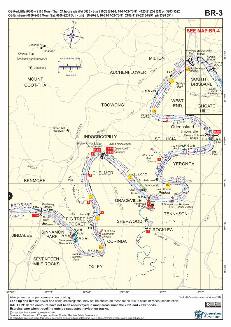
BR-3CG Redcliffe (0600 – 2100 Mon - Thu r, 24 hou rs w /e (Fri 0600 - Su n 2100)) (88-91, 16-67-21-73-81, 4125-2182-2524) ph 3203 5522CG Brisbane (0600-2400 Mon - Sat, 0600-2200 Su n - p/h) (88-90-91, 16-63-67-21-73-81, 2182-4125-6215-8291) ph 3396 5911
0 0.5nautical miles (nM)
0 0.5 1kilometres
N2
¶Mag
AP
P
P
P
PP
PP
PP
PP
PP
PP
PP
PP
Always keep a proper lookout when boating.Look up and live for power and cable crossings that may not be shown on these maps due to scale or recent construction.
Nautical information current to 16 June 2014.
© Copyright The State of Queensland 2014Queensland Department of Transport and Main Roads - Maritime Safety Queensland.To reproduce any map within this series, see terms and conditions at Maritime Safety Queensland's website (www.msq.qld.gov.au)
CAUTION: depth contours have not been re-surveyed in most areas since the 2011 and 2013 floods.Exercise care when travelling outside suggested navigation tracks.
BRISBANE
CITY
SOUTHBRISBANE
WEST END
HIGHGATEHILL
KANGAROOPOINT
WOOLLOONGABBA
Vulture
NEWFARM
F Bu
F Bu F Bu
F Bu
F Bu
F Bu
F Bu
F Bu
F Bu
Fl G 4s
Fl R 3sWilliam Jolly
BridgeMerivaleRail Bridge
MILTON
REACH
FloodlitSpans
REACH
TOWN
VictoriaBridge
Story Bridge
Stre e tMain
Captain Cook Bridge
Dockside Marina
BIGHT
MSQemergencymooring
MaritimeMuseum
HistoricallighthouseGoodwill Bridge
Gardens Point
SouthBankParklands
F Bu
RiversideCentre
BRISBANE
SOUTH
BotanicGardens
11.5m12.0m
11.4m
12.7m
13.0m
30.0m
Fl Y 2.5s
Petrie
T erra
c e
Inner City
ShafstonAvenuePACIFIC
MOTORWAY
Grey
Street
Vulture
Street
Cordelia
StreetAlice
Street
BrunswickStreet
Gregory
Terrac
e
BoundaryStreet
QueenAnn
Street
Street
REAC
H PETRIE
SHAFSTON
KurilpaBridge
Go-BetweenBridge
BRISBANE
RIVER
11.4m
F Bu
F BuFBu 9.0m
F BuWilliam
Merivale
Street
StanleyStreet
Montague
RoadBo
unda
ryStr
eet
George
RomaStreet
Bypass
StreetStreet
Hale
Stree
tREACH
Fl Y 2.5s
Fl Y 2.5s
Fl Y 2.5s
Walkway
153°2'E153°1.5'E153°1'E
27°27
.5'S
27°28
'S27
°28.5'
S27
°29'S
BR-4
0 0.25nautical miles (nM)
0 250 500metres
CG Redcliffe (0600 – 2100 Mon - Thu r, 24 hou rs w /e (Fri 0600 - Su n 2100)) (88-91, 16-67-21-73-81, 4125-2182-2524) ph 3203 5522CG Brisbane (0600-2400 Mon - Sat, 0600-2200 Su n - p/h) (88-90-91, 16-63-67-21-73-81, 2182-4125-6215-8291) ph 3396 5911
N
5
¶Mag
AP
P
P
P
PP
PP
PP
PP
PP
PP
PP
PP
N3
Always keep a proper lookout when boating.Look up and live for power and cable crossings that may not be shown on these maps due to scale or recent construction.
Nautical information current to 16 June 2014.
© Copyright The State of Queensland 2014Queensland Department of Transport and Main Roads - Maritime Safety Queensland.To reproduce any map within this series, see terms and conditions at Maritime Safety Queensland's website (www.msq.qld.gov.au)
CAUTION: depth contours have not been re-surveyed in most areas since the 2011 and 2013 floods.Exercise care when travelling outside suggested navigation tracks.
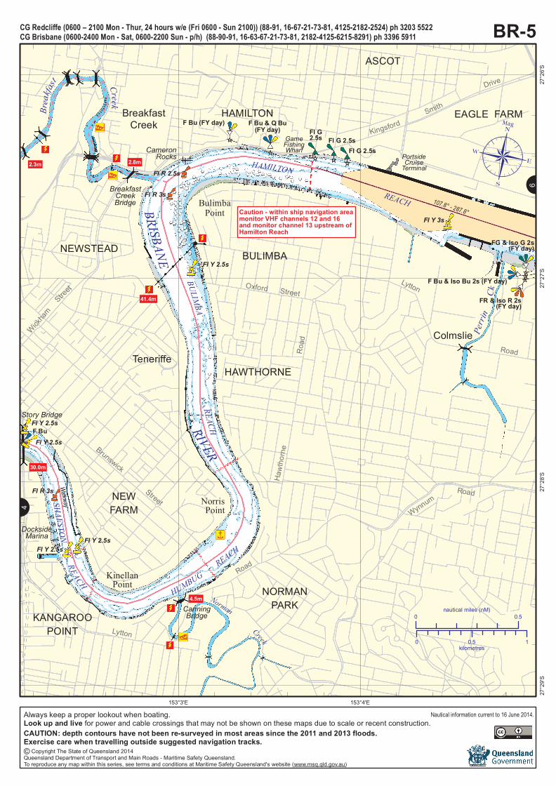
BR-5CG Redcliffe (0600 – 2100 Mon - Thu r, 24 hou rs w /e (Fri 0600 - Su n 2100)) (88-91, 16-67-21-73-81, 4125-2182-2524) ph 3203 5522CG Brisbane (0600-2400 Mon - Sat, 0600-2200 Su n - p/h) (88-90-91, 16-63-67-21-73-81, 2182-4125-6215-8291) ph 3396 5911
Norman
Creek
SHAFSTONREACH
HUMBUGREACH
HAMILTON
REACH
RIVER
Brea
kfast Creek
Perri
nNEWFARM
NORMANPARK
KANGAROOPOINT
NEWSTEAD BULIMBA
HAWTHORNE
HAMILTON EAGLE FARM
TeneriffeColmslie
BreakfastCreek F Bu (FY day) F Bu & Q Bu
(FY day)Fl G 2.5s
Fl G 2.5s
Fl G2.5s
Fl Y 2.5s
Fl R 3s
Fl R 2.5s
Fl R 3s
Fl Y 3s
FG & Iso G 2s(FY day)
FR & Iso R 2s(FY day)
F Bu & Iso Bu 2s (FY day)
Wickham
Street Oxford Street
KingsfordSmith
Drive
Lytton
Road
Hawt
horne
Road
WynnumRoad
Brunswick
Street
Lytton
Road
CanningBridge4.5m
2.3m 2.8m
BulimbaPoint
BreakfastCreekBridge
CameronRocks
NorrisPoint
KinellanPoint
DocksideMarina
PortsideCruiseTerminal
ASCOT
BRISBANE
REACH
BULIMBA
Story Bridge
30.0m
F Bu
GameFishingWharf
41.4m Ck
Fl Y 2.5s
Fl Y 2.5s
Fl Y 2.5sFl Y 2.5s
107.8° - 287.8°
Walkway
153°4'E153°3'E
27°26
'S27
°27'S
27°28
'S27
°29'S
0 0.5nautical miles (nM)
0 0.5 1kilometres
¶Mag
AP
P
P
P
PP
PP
PP
PP
PP
PP
PP
PP
N4N
6
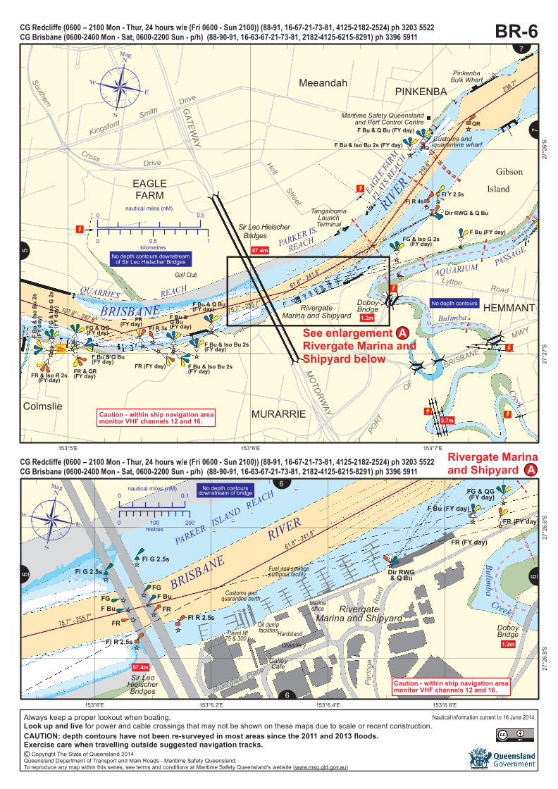
Caution - within ship navigation areamonitor VHF channels 12 and 16and monitor channel 13 upstream ofHamilton Reach
Always keep a proper lookout when boating.Look up and live for power and cable crossings that may not be shown on these maps due to scale or recent construction.
Nautical information current to 16 June 2014.
© Copyright The State of Queensland 2014Queensland Department of Transport and Main Roads - Maritime Safety Queensland.To reproduce any map within this series, see terms and conditions at Maritime Safety Queensland's website (www.msq.qld.gov.au)
CAUTION: depth contours have not been re-surveyed in most areas since the 2011 and 2013 floods.Exercise care when travelling outside suggested navigation tracks.
MOTORWAYSir Leo Hielscher Bridges
KingsfordSmith
Drive
See enlargementRivergate Marina andShipyard below
57.4m
EAGLEFARM
Meeandah
Colmslie MURARRIE
HEMMANT
GibsonIsland
QUARRIES REACH
FR & Iso R 2s(FY day)FR & QR(FY day)
FG &
Iso G
2s(FY
day)
FG & QG(FY day)F Bu &
Iso B
u 2s
(FY da
y)
F Bu & Q Bu(FY day) FR (FY day)
FR(FY day) Fl R 3sF Bu &Q Bu(FY day)
F Bu & Iso Bu 2s(FY day)
F Bu & Iso Bu 2s(FY day)
F Bu & Q Bu(FY day)
FG & Iso G 2s(FY day)
Lytton Road
MWY
F Bu (FY day)
F Bu & Iso Bu 2s (FY day)
F Bu & Q Bu (FY day)
Dir RWG & Q Bu
Fl Y 2.5s
QR
DoboyBridgeBRISBANE
RIVEREAGLE
FARM
FLAT
S REA
CH
PARKER IS.
REACH
Customs andquarantine wharf
PinkenbaBulk Wharf
1.2m
3.7m
RivergateMarina and Shipyard
TangaloomaLaunchTerminal
Maritime Safety Queenslandand Port Control Centre
Fl R 4s
Golf Club
GATEWAYPO
RTBRISBANE
OF
AQUARIUM PASSAGE
Bulimba
Creek
Southern
Cross Drive HoltStreet
PINKENBA
107.8° - 287.8°75.7° - 255.7°
61.8° - 241.8°
236.7°
216.6°
!A
153°7'E153°6'E153°5'E
27°26
'S27
°27'S
CG Redcliffe (0600 – 2100 Mon - Thu r, 24 hou rs w /e (Fri 0600 - Su n 2100)) (88-91, 16-67-21-73-81, 4125-2182-2524) ph 3203 5522CG Brisbane (0600-2400 Mon - Sat, 0600-2200 Su n - p/h) (88-90-91, 16-63-67-21-73-81, 2182-4125-6215-8291) ph 3396 5911
0 0.5nautical miles (nM)
0 0.5 1kilometres
¶Mag
AP
P
P
P
PP
PP
PP
PP
PP
PP
PP
PP
FG
FRF BuFG
FRF Bu
Dir RWG& Q Bu
FR (FY day)
FR (FY day)
F Bu (FY day)
FG & QG(FY day)
57.4m
PARKER ISLAND REACH
BRISBANERIVER
Par in
ga
Sir LeoHielscherBridges
No depth contoursdownstream of bridge
Rivergate Place
RivergateMarina and Shipyard
Fuel and sewagepumpout facility
Customs andquarantine berth Marinaoffice
Chandlery
Oil dumpfacilitiesHardstand
Road
GalleyCafe
Travel lift75 & 300 t
Fl G 2.5sFl G 2.5s
Fl R 2.5s
Fl R 2.5s
Bulimba
DoboyBridge1.2m
Creek75.7° - 255.7°
61.8° - 241.8°
153°6.6'E153°6.4'E153°6.2'E153°6'E
27°26
.6'S
27°26
.8'S
Rivergate Marinaand Shipyard
N6N
6
N6
N
6
N7
N
7
BR-6N5
0 0.1nautical miles (nM)
0 100 200metres
Mag
AP
P
P
P
PP
PP
PP
PP
PP
PP
PP
PP
No depth contours downstreamof Sir Leo Hielscher Bridges
Caution - within ship navigation areamonitor VHF channels 12 and 16.
Caution - within ship navigation areamonitor VHF channels 12 and 16.
CG Redcliffe (0600 – 2100 Mon - Thu r, 24 hou rs w /e (Fri 0600 - Su n 2100)) (88-91, 16-67-21-73-81, 4125-2182-2524) ph 3203 5522CG Brisbane (0600-2400 Mon - Sat, 0600-2200 Su n - p/h) (88-90-91, 16-63-67-21-73-81, 2182-4125-6215-8291) ph 3396 5911
No depth contours
Always keep a proper lookout when boating.Look up and live for power and cable crossings that may not be shown on these maps due to scale or recent construction.
Nautical information current to 16 June 2014.
© Copyright The State of Queensland 2014Queensland Department of Transport and Main Roads - Maritime Safety Queensland.To reproduce any map within this series, see terms and conditions at Maritime Safety Queensland's website (www.msq.qld.gov.au)
CAUTION: depth contours have not been re-surveyed in most areas since the 2011 and 2013 floods.Exercise care when travelling outside suggested navigation tracks.
!A
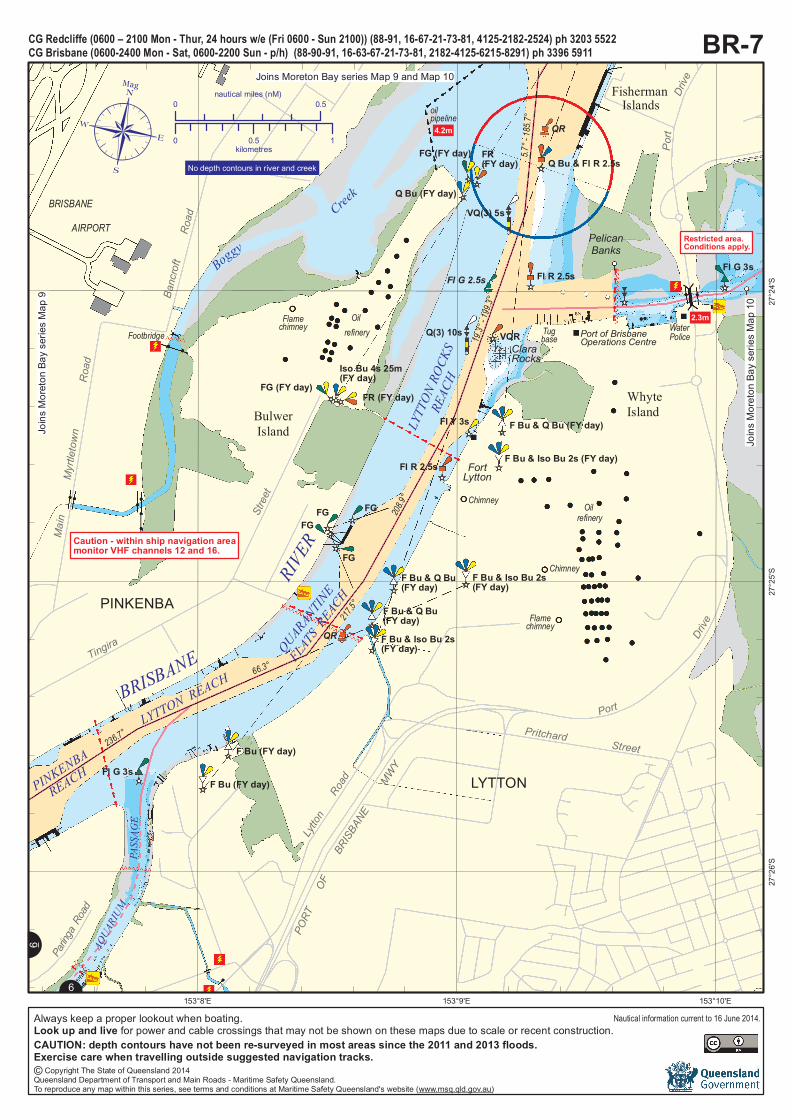
BRISBANE AIRPORT
Boggy
Creek
F Bu & Q Bu(FY day)
F Bu & Iso Bu 2s(FY day)Fl G 2.5s
Q Bu & Fl R 2.5s
VQ(3) 5s
Fl R 2.5s
VQR
Fl G 3s
Q Bu (FY day)
FR(FY day)
Q(3) 10s
Fl G 2.5s
QR
FishermanIslands
Fisherman
Islands
Wharves
SwingBasin
PelicanBanks
Port of BrisbaneOperations Centre
WhyteIsland
F Bu & Q Bu (FY day)
F Bu & Q Bu(FY day)
F Bu & Q Bu(FY day)
F Bu & Iso Bu 2s(FY day)
F Bu & Iso Bu 2s (FY day)
F Bu & Iso Bu 2s(FY day)
Fl R 2.5s
FG (FY day)FR (FY day)
Iso Bu 4s 25m(FY day)
FG
FG
FGFG
F Bu (FY day)
F Bu (FY day)
Footbridge
Oil refinery
LYTTON REACH
QUARANTINE
FLATS R
EACH
PINKENBA
REACH
LYTT
ON RO
CKS
REAC
H
BRISBANE
RIVER
Lytton
Road
Pritchard Street
PortDri
ve
LYTTON
PINKENBA
Tingira
Stree
t
Main
Myrtl e
town
Road
Oil refinery
BulwerIsland
oilpipeline
LuggagePoint
208.9°
19.3°
- 199.3
°
5.7°-
185.7°
201°- 2
1°Mag
WaterPoliceTugbase
Fl G 3s
AQUA
RIUM
PASS
AGE
FortLytton
2.3m
FG (FY day)
Flamechimney
Flamechimney
Chimney
Chimney
Banc
roft
Road
ClaraRocks
Paring
a Road
Port
Drive
4.2m
QR
Fl Y 3s
PORT
O
FBR
ISBAN
E
MWY
217.5°
66.3°
236.7°
153°10'E153°9'E153°8'E
27°24
'S27
°25'S
27°26
'S
BR-7CG Redcliffe (0600 – 2100 Mon - Thu r, 24 hou rs w /e (Fri 0600 - Su n 2100)) (88-91, 16-67-21-73-81, 4125-2182-2524) ph 3203 5522CG Brisbane (0600-2400 Mon - Sat, 0600-2200 Su n - p/h) (88-90-91, 16-63-67-21-73-81, 2182-4125-6215-8291) ph 3396 5911
0 0.5nautical miles (nM)
0 0.5 1kilometres
Mag
AP
P
P
P
PP
PP
PP
PP
PP
PP
PP
PP
N6
N
6
Restricted area.Conditions apply.
No depth contours in river and creek
Caution - within ship navigation areamonitor VHF channels 12 and 16.
Joins Moreton Bay series Map 9 and Map 10
Joins
More
ton Ba
y seri
es M
ap 9
Joins
More
ton Ba
y seri
es M
ap 10
Always keep a proper lookout when boating.Look up and live for power and cable crossings that may not be shown on these maps due to scale or recent construction.
Nautical information current to 16 June 2014.
© Copyright The State of Queensland 2014Queensland Department of Transport and Main Roads - Maritime Safety Queensland.To reproduce any map within this series, see terms and conditions at Maritime Safety Queensland's website (www.msq.qld.gov.au)
CAUTION: depth contours have not been re-surveyed in most areas since the 2011 and 2013 floods.Exercise care when travelling outside suggested navigation tracks.