before the queenstown lakes district council · before the queenstown lakes district council ... i...
TRANSCRIPT

BEFORE THE QUEENSTOWN LAKES DISTRICT COUNCIL
IN THE MATTER of the Resource Management Act 1991
AND
IN THE MATTER OF Queenstown Lakes Proposed District Plan –
Stream 13, Queenstown Mapping Hearings
STATEMENT OF EVIDENCE OF SEAN DENT
ON BEHALF OF THE FOLLOWING SUBMITTERS:
150 – Mt Crystal Limited
9th June 2017

P a g e | 2
S0150-Mount Crystal Ltd–T13-Dent S-Evidence
Introduction
1. My name is Sean Dent. I hold the qualifications of Bachelor of Resource Studies from Lincoln
University which I obtained in 2005. I reside in Cromwell, Central Otago.
2. I have been employed as a resource management planning consultant with Southern Planning Group
for approximately nine years. As of the 1st of April 2017 I became a Director of Southern Planning
Group.
3. Prior to my employment with Southern Planning Group I was employed as a resource consent
processing planner and compliance officer with Lakes Environmental (formerly CivicCorp) for
approximately two years.
4. Throughout my professional career, I have been involved in a range of resource consent and policy
matters. I have made numerous appearances in front of various District and Regional Councils and
the Environment Court.
5. I also appeared before the hearings panel for the District Plan Review on 27th October 2016 on behalf
of Mount Crystal Ltd (“MCL”) in respect of the height limits for the High Density Residential Zone
(“HDRZ”) – Hearing Stream T06.
6. From the variety of working roles that I have performed as described in the preceding paragraphs, I
have acquired a sound knowledge and experience of the resource management planning issues that
are faced in the Queenstown area and the wider District.
7. Whilst I acknowledge that this is a Council hearing I confirm that I have read the Code of Conduct for
Expert Witnesses outlined in the Environment Court’s Consolidated Practice Note 2014 and have
complied with it in preparing this evidence.
8. I have read the Section 42A reports and supporting documentation prepared by the Council officers
and their experts with respect to the Queenstown Mapping Hearings of the Proposed District Plan
(“PDP”) and in particular the parts of those briefs of direct relevance to MCL’s site. I have considered
the facts, opinions and analysis in this documentation when forming my opinions which are expressed
in this evidence.
9. I confirm that the matters addressed in this brief of evidence are within my area of expertise except
where I advise otherwise and that I have not omitted to consider material facts known to me that might
alter or detract from my opinions.

P a g e | 3
S0150-Mount Crystal Ltd–T13-Dent S-Evidence
Scope of Evidence
10. I did not prepare and file the original submission of further submissions for MCL. These submissions
were prepared on the submitters behalf by the late Mr Tony Ray of MacTodd.
11. I was subsequently engaged to prepare expert planning evidence in respect of the submissions by
MCL in early 2016.
12. My brief of evidence is set out as follows:
a) Detailed Description of MCL Proposed Re-Zoning;
b) Statutory Considerations;
c) The Strategic Direction of the PDP;
d) Assessment of the Proposed Effects of Re-Zoning;
e) Analysis of Opposing Submissions;
f) Section 32AA Evaluation;
g) Summary of my opinions;
13. Unless otherwise stated all references to the PDP in my evidence are to the notified version of this
document released on 26th August 2015 as opposed to the versions amended by Council’s Rights of
Reply in previous hearing streams. Ms Macdonald has provided me with legal advice that the Council’s
Rights of Reply are merely recommendations to the Commissioner’s and are not binding. Accordingly,
the most appropriate assessment is in my opinion one that addresses the notified provisions of the
PDP.
Detailed Description of MCL Proposed Re-Zoning
14. As identified above MCL’s primary submission was lodged by the late Mr Tony Ray. The original
submission noted that the PDP Planning Map #32 identified the subject site as being located within
the Low Density Residential Zone (“LDRZ”).
15. The submission sought the following amendments in respect of the notified zoning:
1. Re-Zone the subject site in part (1.24Ha) to Medium Density Residential (“MDRZ”);
2. Re-Zone the subject site in part (1.49Ha) to HDR;
3. Amend the Rule 9.5.2 with respect to building height from 10m to 12m;
4. Amend the Rule 9.5.3 with respect to building height from 10m to 12m;
5. If (1) – (4) is not accepted to Re-Zone the entire site MDR with a maximum 12m height limit
and provision for Visitor Accommodation as was notified for the HDR; and

P a g e | 4
S0150-Mount Crystal Ltd–T13-Dent S-Evidence
6. To amend the status for subdivision of the LDRZ, MDRZ & HDRZ from fully Discretionary to
Restricted Discretionary.
16. I acknowledge that the Council has withdrawn all provisions relating to Visitor Accommodation within
the residential zones of the PDP and that such provisions will be addressed within the later stages of
the District Plan Review. Accordingly, I have undertaken no further assessment in regards to the
request for Visitor Accommodation provisions.
17. I also acknowledge that the provisions relating to the activity status for subdivision in the LDRZ, MDRZ
and HDRZ’s have been considered during Hearing Stream T04. Accordingly, my evidence does not
address these provisions.
18. I have undertaken an assessment of the subject site and the receiving environment in the lead up to
these hearings and have formed the opinion that a ‘split zoning’ of the subject site (and potential
bespoke height limit for the MDRZ portion) is not the most efficient and effective approach to zoning
of the subject site.
19. My opinion is that the subject site is best suited to being located within the HDRZ. On the basis of this
opinion I appeared along with Mr Tim Williams (Urban Designer) at the residential zone hearings to
promote an 11m height limit for the HDRZ (9m height limit + a 2m roof bonus).
20. Based on the above, my evidence is focused on an assessment of whether the HDRZ is the most
appropriate zone for the site in association with amendments to the provisions I supported in Hearing
Stream T06. As such, I will not address the MDRZ or potential bespoke height provisions for such
zoning on this site within my evidence.
21. I have also considered whether the hearings panel has scope to consider a request to re-zone the
entire site to HDRZ given the ‘split zone’ approach of the original submission. The original submission
sought 1.49Ha of the site to be zoned HDRZ.
22. As a result of the potential buildable area on the site due to geotechnical constraints (to be discussed
in detail later) the likely area of future HDRZ development is approximately 1.27Ha. Therefore; in terms
of the nature and scale of potential future development on the site it would not be significantly different
to what was presented in the original submission albeit the whole site will be re-zoned to HDRZ.
23. In terms of opposing submitters QAC are opposed to any intensification of the site whether it be MDRZ
or HDRZ so they are unlikely to be prejudiced by the approach for HDRZ over the whole site.
24. In terms of general public who may have been prejudiced if they had been aware of the whole site
being zoned HDRZ I think the comments above are equally applicable particularly given that the
P a g e | 5
S0150-Mount Crystal Ltd–T13-Dent S-Evidence
submitter sought that any part of the site zoned MDRZ also sought a height limit of 12m. As will be
discussed below, I am supportive of a height limit of 9m + 2m roof bonus for the HDRZ which is less
than that originally sought by the submitter.
25. For these reasons, I consider that my approach to the zoning of the site is sufficiently within the scope
of the original submission.
Statutory Considerations
Resource Management Act 1991
26. The statutory framework for an assessment of MCL’s re-zoning proposal under the Resource
Management Act is set out within Sections 31, 32, 32A, and 72 to 76 of the Act.
27. Within the relevant sections of the Act are a number of requirements which I consider to be of specific
relevance to the MCL’s proposal. These are outlined below:
The re-zoning must accord with and assist the Council in carrying out its functions so as to
meet the requirements of Part 2 of the Act;
The re-zoning must have regard to the actual and potential effects of activities on the
environment;
The re-zoning must have regard to any evaluation report prepared in accordance with Section
32;
The re-zoning must be in accordance with any regulations (including National Environmental
Standards and National Policy Statements);
The re-zoning must give effect to the Otago Regional Policy Statement;
The re-zoning must have regard to management plans and strategies under other Acts (to the
extent that the they have a bearing on the resource management issues in the District);
The re-zoning must have regard to the extent to which the District Plan needs to be consistent
with policy statements and plans of adjacent regional councils and territorial authorities; and
The re-zoning must take into account any relevant planning document recognised by an iwi
authority and lodged with the Council to the extent that its content has a bearing on the
resource management issues of the District.

P a g e | 6
S0150-Mount Crystal Ltd–T13-Dent S-Evidence
Part 2 Purpose and Principles
28. The purpose of the Act is to promote the sustainable management of natural and physical resources.
Sustainable management is outlined in Section 5(2) of the Act as:
In this Act, sustainable management means managing the use, development, and
protection of natural and physical resources in a way, or at a rate, which enables people
and communities to provide for their social, economic, and cultural well-being and for
their health and safety while—
(a) sustaining the potential of natural and physical resources (excluding minerals)
to meet the reasonably foreseeable needs of future generations; and
(b) safeguarding the life-supporting capacity of air, water, soil, and ecosystems;
and
(c) avoiding, remedying, or mitigating any adverse effects of activities on the
environment.
29. The PDP’s application of ‘Zones’ and associated policy framework sets out the Council’s direction with
respect to the appropriate land use and activities within identified areas which are expected to achieve
‘sustainable management’
30. Section 6 of the Act sets out Matters of National importance that must be given regard to and provided
for when exercising the functions and powers of the Act and particularly when considering the
appropriate zoning framework. Of specific relevance to the MCL’s proposed re-zoning is:
(h) the management of significant risks from natural hazards.
31. The subject site contains a deeply incised water course and the south western corner of the site is
identified on QLDC’s hazard maps as being affected by a composite, active alluvial fan. The s ite is
also located in close proximity to active and unknown or episodic schist landslide activity. The hazard
notations in respect of the site are illustrated below:

P a g e | 7
S0150-Mount Crystal Ltd–T13-Dent S-Evidence
Figure 1. QLDC Hazard Map Sourced from QLDC GIS 01.06.17
32. Section 7 of the Act contains a set of ‘Other Matters’ that must be given particular regard to when
exercising powers and functions under the Act. The matters that I consider relevant include:
“(b) the efficient use and development of natural and physical resources:
(c) the maintenance and enhancement of amenity values:
(f) maintenance and enhancement of the quality of the environment:
(g) any finite characteristics of natural and physical resources
33. I consider these matters to be relevant as intensification of ‘infill’ housing is necessary due to the
limited land resource available and to ensure that priority is to be given to protecting the visual amenity
values of the rural landscape through prevention of urban sprawl.
34. Further, due to the proximity of the subject site to key transport and infrastructure services and its
location within the Urban Growth Boundary, the intensified development of the subject site is
considered to be an efficient use of the natural land resource.
35. Section 8 requires the Principles of the Treaty of Waitangi to be taken into account.

P a g e | 8
S0150-Mount Crystal Ltd–T13-Dent S-Evidence
Operative Regional Policy Statement
36. Section 75(3) of the Act requires that a District Plan must give effect to any Regional Policy Statement.
At the current time this includes the Operative Otago Regional Policy Statement 1998.
37. The relevant Objectives and Policies from this document are contained within Chapter 5 – Land,
Chapter 9 – Built Form, and Chapter 11 – Natural Hazards. The relevant provisions are outlined below:
Chapter 5 – Land
Objective 5.4.1 To promote the sustainable management of Otago’s land resources in order:
(a) To maintain and enhance the primary productive capacity and life-
supporting capacity of land resources; and
(b) To meet the present and reasonably foreseeable needs of Otago’s
people and communities.
Objective 5.4.3 To protect Otago’s outstanding natural features and landscapes from
inappropriate subdivision, use and development.
Policy 5.5.2 To promote the retention of the primary productive capacity of Otago’s
existing high class soils to meet the reasonably foreseeable needs of future
generations and the avoidance of uses that have the effect of removing those
soils or their life-supporting capacity and to remedy or mitigate the adverse
effects on the high class soils resource where avoidance is not practicable.
Policy 5.5.6 To recognise and provide for the protection of Otago’s outstanding natural
features and landscapes which:
(a) Are unique to or characteristic of the region; or
(b) Are representative of a particular landform or land cover occurring in
the Otago region or of the collective characteristics which give Otago
its particular character; or
(c) Represent areas of cultural or historic significance in Otago; or
(d) Contain visually or scientifically significant geological features; or
(e) Have characteristics of cultural, historical and spiritual value that are
regionally significant for Tangata Whenua and have been identified
in accordance with Tikanga Maori.
P a g e | 9
S0150-Mount Crystal Ltd–T13-Dent S-Evidence
Chapter 9 – Built Environment
Objective 9.4.1 To promote the sustainable management of Otago’s built environment in
order to:
(a) Meet the present and reasonably foreseeable needs of Otago’s
people and communities; and
(b) Provide for amenity values, and
(c) Conserve and enhance environmental and landscape quality; and
(d) Recognise and protect heritage values.
Objective 9.4.2 To promote the sustainable management of Otago’s infrastructure to meet
the present and reasonably foreseeable needs of Otago’s communities.
Objective 9.4.3 To avoid, remedy or mitigate the adverse effects of Otago’s built environment
on Otago’s natural and physical resources.
Policy 9.5.2 To promote and encourage efficiency in the development and use of Otago’s
infrastructure through:
(a) Encouraging development that maximises the use of existing
infrastructure while recognising the need for more appropriate
technology; and
(b) Promoting co-ordination amongst network utility operators in the
provision and maintenance of infrastructure; and
(c) Encouraging a reduction in the use of non-renewable resources while
promoting the use of renewable resources in the construction,
development and use of infrastructure; and
(d) Avoiding or mitigating the adverse effects of subdivision, use and
development of land on the safety and efficiency of regional
infrastructure.
Policy 9.5.3 To promote and encourage the sustainable management of Otago’s transport
network through:
(a) Promoting the use of fuel efficient modes of transport; and
(b) Encouraging a reduction in the use of fuels which produce emissions
harmful to the environment; and
(c) Promoting a safer transport system; and

P a g e | 10
S0150-Mount Crystal Ltd–T13-Dent S-Evidence
(d) Promoting the protection of transport infrastructure from the adverse
effects of land use activities and natural hazards.
Policy 9.5.4 To minimise the adverse effects of urban development and settlement,
including structures, on Otago’s environment through avoiding, remedying or
mitigating:
(a) Discharges of contaminants to Otago’s air, water or land; and
(b) The creation of noise, vibration and dust; and
(c) Visual intrusion and a reduction in landscape qualities; and
(d) Significant irreversible effects on:
(i) Otago community values; or
(ii) Kai Tahu cultural and spiritual values; or
(iii) The natural character of water bodies and the coastal
environment; or
(iv) Habitats of indigenous fauna; or
(v) Heritage values; or
(vi) Amenity values; or
(vii) Intrinsic values of ecosystems; or
(viii) Salmon or trout habitat.
Policy 9.5.5 To maintain and, where practicable, enhance the quality of life for people and
communities within Otago’s built environment through:
(a) Promoting the identification and provision of a level of amenity which
is acceptable to the community; and
(b) Avoiding, remedying or mitigating the adverse effects on community
health and safety resulting from the use, development and protection
of Otago’s natural and physical resources; and
(c) Avoiding, remedying or mitigating the adverse effects of subdivision,
land use and development on landscape values.
Chapter 11 – Natural Hazards
Objective 11.4.1 To recognise and understand the significant natural hazards that threaten
Otago’s communities and features.
Objective 11.4.2 To avoid or mitigate the adverse effects of natural hazards within Otago to
acceptable levels.

P a g e | 11
S0150-Mount Crystal Ltd–T13-Dent S-Evidence
Policy 11.5.2 To take action necessary to avoid or mitigate the unacceptable adverse effect
of natural hazards and the responses to natural hazards on:
(a) Human life; and
(b) Infrastructure and property; and
(c) Otago’s natural environment; and
(d) Otago’s heritage sites.
Policy 11.5.3 To restrict development on sites or areas recognised as being prone to
significant hazards, unless adequate mitigation can be provided.
Policy 11.5.4 To avoid or mitigate the adverse effects of natural hazards within Otago
through:
(a) Analysing Otago’s natural hazards and identifying their location and
potential risk; and
(b) Promoting and encouraging means to avoid or mitigate natural
hazards; and
(c) Identifying and providing structures or services to avoid or mitigate
the natural hazard; and
(d) Promoting and encouraging the use of natural processes where
practicable to avoid or mitigate the natural hazard.
Proposed Regional Policy Statement
38. Section 74(2) of the Act requires a District Plan to have regard to any proposed Regional Policy
Statement. The Proposed Regional Policy Statement was publicly notified on 23 May 2015. Public
hearings were then held in November 2015.
39. The hearings panel released their ‘Decisions Version’ of the Regional Policy Statement on 01st October
2016. It is understood that 26 appeals have been received in opposition and mediation is presently
underway.
40. The Decision’s Version of the Proposed Regional Policy Statement cannot be given significant weight
due to the currently unresolved appeals. However, I consider that the relevant provisions contained in
this document are not dissimilar to those in the Operative Regional Policy Statement. The relevant
provisions are as follows:
Part B – Chapter 1 Resource management in Otago is integrated

P a g e | 12
S0150-Mount Crystal Ltd–T13-Dent S-Evidence
Objective 1.1 Recognise and provide for the integrated management of natural and physical
resources to support the wellbeing of people and communities in Otago
Policy 1.1.1 Integrated resource management
Achieve integrated management of Otago’s natural and physical resources,
by all of the following:
a) Coordinating the management of interconnected natural and physical
resources;
b) Taking into account the impacts of management of one resource on
the values of another, or on the environment
c) Recognising that resource may extend beyond the immediate, or
directly adjacent, area of interest;
d) Ensuring that resource management approaches across
administrative boundaries are consistent and complementary;
e) Ensuring that effects of activities on the whole of a resource are
considered when that resource is managed as subunits.
Policy 1.1.2 Economic wellbeing
Provide for the economic wellbeing of Otago’s people and communities by
enabling the use and development of natural and physical resources only if
the adverse effects of those activities on the environment can be managed to
give effect to the objectives and policies of the Regional Policy Statement.
Policy 1.1.3 Social and cultural wellbeing and health and safety
Provide for the social and cultural wellbeing and health and safety of Otago’s
people and communities when undertaking the subdivision, use,
development and protection of natural and physical resources by all of the
following:
a) Recognising and providing for Kāi Tahu values;
b) Taking into account the values of other cultures;
c) Taking into account the diverse needs of Otago’s people and
communities;
d) Promoting good quality and accessible infrastructure and public
services;
e) Avoiding significant adverse effects of activities on human health.

P a g e | 13
S0150-Mount Crystal Ltd–T13-Dent S-Evidence
PART B Chapter 3 - Otago has high quality natural resources and ecosystems
Objective 3.2 Otago’s significant and highly-valued natural resources are identified, and
protected or enhanced
Policy 3.2.3 Identifying outstanding natural features, landscapes and seascapes
Identify areas and values of outstanding natural features, landscapes and
seascapes, using the attributes in Schedule 3.
Policy 3.2.4 Managing outstanding natural features, landscapes and seascapes
Protect, enhance and restore outstanding natural features, landscapes and
seascapes, by all of the following:
a) Avoiding adverse effects on those values which contribute to the
significance of the natural feature, landscape or seascape;
b) Avoiding, remedying or mitigating other adverse effects;
c) Recognising and providing for the positive contributions of existing
introduced species to those values;
d) Controlling the adverse effects of pest species, preventing their
introduction and reducing their spread;
e) Encouraging enhancement of those areas and values which
contribute to the significance of the natural feature, landscape or
seascape.
Policy 3.2.5 Identifying highly valued natural features, landscapes and seascapes
Identify natural features, landscapes and seascapes, which are highly valued
for their contribution to the amenity or quality of the environment but which
are not outstanding, using the attributes in Schedule 3.
Policy 3.2.6 Managing highly valued natural features, landscapes and seascapes
Protect or enhance highly valued natural features, landscapes and seascapes
by all of the following:
a) Avoiding significant adverse effects on those values which contribute
to the high value of the natural feature, landscape or seascape;

P a g e | 14
S0150-Mount Crystal Ltd–T13-Dent S-Evidence
b) Avoiding, remedying or mitigating other adverse effects;
c) Recognising and providing for positive contributions of existing
introduced species to those values;
d) Controlling the adverse effects of pest species, preventing their
introduction and reducing their spread;
e) Encouraging enhancement of those values which contribute to the
high value of the natural feature, landscape or seascape.
PART B Chapter 4 - Communities in Otago are resilient, safe and healthy
Objective 4.1 Risk that natural hazards pose to Otago’s communities are minimised
Policy 4.1.1 Identifying natural hazards
Identify natural hazards that may adversely affect Otago’s communities,
including hazards of low likelihood and high consequence by considering all
of the following:
a) Hazard type and characteristics;
b) Multiple and cascading hazards;
c) Cumulative effects, including from multiple hazards with different
risks;
d) Effects of climate change;
e) Using the best available information for calculating likelihood;
f) Exacerbating factors.
Policy 4.1.2 Natural hazard likelihood
Using the best available information, assess the likelihood of natural hazard
events occurring, over no less than 100 years.
Policy 4.1.3 Natural hazard consequence
Assess the consequences of natural hazard events, by considering all of the
following:
a) The nature of activities in the area;

P a g e | 15
S0150-Mount Crystal Ltd–T13-Dent S-Evidence
b) Individual and community vulnerability;
c) Impacts on individual and community health and safety;
d) Impacts on social, cultural and economic wellbeing;
e) Impacts on infrastructure and property, including access and
services;
f) Risk reduction and hazard mitigation measures;
g) Lifeline utilities, essential and emergency services, and their co-
dependence;
h) Implications for civil defence agencies and emergency services;
i) Cumulative effects;
j) Factors that may exacerbate a hazard event.
Policy 4.1.4 Assessing activities for natural hazard risk
Assess activities for natural hazard risk to people and communities, by
considering all of the following:
a) The natural hazard risk identified, including residual risk;
b) Any measures to avoid, remedy or mitigate those risks, including
relocation and recovery methods;
c) The long term viability and affordability of those measures;
d) Flow on effects of the risk to other activities, individuals and
communities;
e) The availability of, and ability to provide, lifeline utilities, and essential
and emergency services, during and after a natural hazard event.
Policy 4.1.5 Natural hazard risk
Manage natural hazard risk to people and communities, with particular regard
to all of the following:
a) The risk posed considering the likelihood and consequences of
natural hazard events;
b) The implications of residual risk, including the risk remaining after
implementing or undertaking risk reduction and hazard mitigation
measures;
c) The community’s tolerance of that risk, now and in the future,
including the community’s ability and willingness to prepare for and
adapt to that risk, and respond to an event;
d) The changing nature of tolerance to risk;
e) Sensitivity of activities to risk.
Objective 4.3 Infrastructure is managed and developed in a sustainable way.

P a g e | 16
S0150-Mount Crystal Ltd–T13-Dent S-Evidence
Policy 4.3.1 Managing infrastructure activities
Manage infrastructure activities, to achieve all of the following:
a) Maintaining or enhancing the health and safety of the community;
b) Avoiding, remedying or mitigating adverse effects of those activities
on existing land uses, including cumulative adverse effects on natural
and physical resources;
c) Supporting economic, social and community activities;
d) Improving efficiency of use of natural resources;
e) Protecting infrastructure corridors for infrastructure needs, now and
for the future;
f) Increasing the ability of communities to respond and adapt to
emergencies, and disruptive or natural hazard events;
g) Protecting the functional and operational requirements of lifeline
utilities and essential or emergency services.
Policy 4.3.2 Nationally and regionally significant infrastructure
Recognise the national and regional significance of all of the following
infrastructure:
a) Renewable electricity generation activities, where they supply the
national electricity grid and local distribution network;
b) Electricity transmission infrastructure;
c) Telecommunication and radiocommunication facilities;
d) Roads classified as being of national or regional importance;
e) Ports and airports and associated navigation infrastructure;
f) Defence facilities;
g) Structures for transport by rail.
Policy 4.3.4 Protecting nationally and regionally significant infrastructure
Protect infrastructure of national or regional significance, by all of the
following:
a) Restricting the establishment of activities that may result in reverse
sensitivity effects;
b) Avoiding significant adverse effects on the functional needs of such
infrastructure;
c) Avoiding, remedying or mitigating other adverse effects on the
functional needs of such infrastructure;
d) Protecting infrastructure corridors from sensitive activities, now and
for the future.
Objective 4.4 Energy supplies to Otago’s communities are secure and sustainable
P a g e | 17
S0150-Mount Crystal Ltd–T13-Dent S-Evidence
Policy 4.4.6 Energy efficient transport
Enable energy efficient and sustainable transport for Otago’s communities,
by all of the following:
a) Encouraging the development of compact and well integrated urban
areas, to reduce travel needs within those areas;
b) Ensuring that transport infrastructure in urban areas has good
connectivity, both within new urban areas and between new and
existing urban areas, by all of the following:
i. Placing a high priority on walking, cycling, and public
transport, where appropriate;
ii. Maximising pedestrian and cycling networks connectivity,
and integration with public transport;
iii. Having high design standards for pedestrian and cyclist
safety and amenity;
c) Enabling the development or upgrade of transport infrastructure and
associated facilities that both:
i. Increase freight efficiency; and
ii. Foster the uptake of new technologies for more efficient
energy uses, and renewable or lower emission transport
fuels.
Objective 4.5 Urban growth and development is well designed, reflects local character and
Integrates effectively with adjoining urban and rural environments.
Policy 4.5.1 Managing for urban growth and development
Manage urban growth and development in a strategic and co-ordinated way,
by all of the following:
a) Ensuring there is sufficient residential, commercial and industrial land
capacity, to cater for the demand for such land, over at least the next
20 years;
b) Coordinating urban growth and development and the extension of
urban areas with relevant infrastructure development programmes,
to provide infrastructure in an efficient and effective way;
c) Identifying future growth areas and managing the subdivision, use
and development of rural land outside these areas to achieve all of
the following:
i. Minimise adverse effects on rural activities and significant
soils;
P a g e | 18
S0150-Mount Crystal Ltd–T13-Dent S-Evidence
ii. Minimise competing demands for natural resources;
iii. Maintain or enhance significant biological diversity,
landscape or natural character values;
iv. Maintain important cultural or historic heritage values;
v. Avoid land with significant risk from natural hazards;
d) Considering the need for urban growth boundaries to control urban
expansion;
e) Ensuring efficient use of land;
f) Encouraging the use of low or no emission heating systems;
g) Giving effect to the principles of good urban design in Schedule 5;
h) Restricting the location of activities that may result in reverse
sensitivity effects on existing activities
Policy 4.5.2 Planned and coordinated urban growth and development
Where urban growth boundaries or future urban development areas, are
identified in a district plan, control the release of land within those boundaries
or areas, by:
a) Staging development using identified triggers to release new stages
for development; or
b) Releasing land in a way that ensures both:
i. a logical spatial development; and
ii. efficient use of existing land and infrastructure before new
land is released; and
c) Avoiding urban development beyond the urban growth boundary or future urban development area.
Policy 4.5.3 Urban design
Encourage the use of Schedule 5 good urban design principles in the
subdivision and development of urban areas.
Policy 4.5.7 Integrating infrastructure with land use
Achieve the strategic integration of infrastructure with land use, by
undertaking all of the following:
a) Recognising the functional needs of infrastructure of regional or
national importance;
b) Locating and designing infrastructure to take into account all of the
following:
i. Actual and reasonably foreseeable land use change;
ii. The current population and projected demographic changes;
iii. Actual and reasonably foreseeable change in supply of, and
demand for, infrastructure services;

P a g e | 19
S0150-Mount Crystal Ltd–T13-Dent S-Evidence
iv. Natural and physical resource constraints;
v. Effects on the values of natural and physical resources;
vi. Co-dependence with other infrastructure ;
vii. The effects of climate change on the long term viability of that
infrastructure;
viii. Natural hazard risk.
c) Locating growth and development:
i. Within areas that have sufficient infrastructure capacity; or
ii. Where infrastructure services can be upgraded or extended
efficiently and effectively;
d) Coordinating the design and development of infrastructure with land use
change in growth and redevelopment planning.
National Policy Statement on Urban Development Capacity 2016.
41. The National Policy Statement on Urban Development Capacity 2016 (“NPS”) has been developed to
recognise the significance of the following:
(a) Urban Environments and the need to enable such environments to develop and change; and
(b) Providing sufficient development capacity to meet the needs of people and communities and
future generations in urban environments.
42. The NPS provides direction for Councils to ensure that their planning decisions enable the supply of
housing to meet demand. The NPS specifically requires that Council’s provide in their District Plans
enough development capacity to ensure the demand for land for housing (and business purposes)
and varying types, sizes and locations of such are provided and are commercially feasible to develop.
43. The land supply also needs to be plentiful enough to recognise that not all feasible development
opportunities will be taken up. However, the supply of land for this purpose and the direction of the
NPS is not to provide the supply with complete disregard to the environmental effects.
44. Overall the NPS requires an evidence based approach to development capacity with responsive
planning to provide for urban growth and infrastructure in the short, medium and long term.
45. A full copy of the NPS and its relevant Objectives and Policies (all of them as Queenstown is a high-
growth urban area) is contained in Appendix [A] to my evidence.

P a g e | 20
S0150-Mount Crystal Ltd–T13-Dent S-Evidence
46. It is understood that Council will be addressing the NPS and its reporting requirements following the
submission of submitters evidence in the current evidence exchange time table for Hearing Stream
T13.
The Strategic Direction of the Proposed District Plan (“PDP”)
47. The PDP has a hierarchical structure. The higher order provisions of 'Part Two – Strategy' highlight
overarching resource management goals and objectives, to meet the needs of the community and
achieve Part 2 of the RMA. These chapters also provide the framework to integrate and manage
matters of national importance (s6(b), s6(c), s6(e) of the RMA).
48. Strategic Directions Chapter (Chapter 3) sits above the remaining strategic chapters (Chapters 4
Urban Development, 5 Tangata Whenua and 6 Landscapes). These chapters as a group sit above the
remaining zone and District Wide chapters.
49. Chapter 3: Strategic Direction brings together the key resource management issues for the District in
a relatively concise manner and provides a policy framework that establishes the rationale for the
remaining components of the District Plan.
50. Of specific relevance to this re-zoning proposal is the Strategic Directions, Urban Development, Low
Density Residential, High Density Residential and Natural Hazards chapters. The relevant Goals,
Objectives and Policies from the notified versions of these chapters with respect to the proposed re-
zoning are outlined below:
3.2.2 Goal - The strategic and integrated management of urban growth
Objective 3.2.2.1 Ensure urban development occurs in a logical manner:
• to promote a compact, well designed and integrated urban form;
• to manage the cost of Council infrastructure; and
• to protect the District’s rural landscapes from sporadic and sprawling
development.
Policy 3.2.2.1.1 Apply Urban Growth Boundaries (UGBs) around the urban areas in the
Wakatipu Basin (including Jack’s Point), Arrowtown and Wanaka.
Policy 3.2.2.1.2 Apply provisions that enable urban development within the UGBs and avoid
urban development outside of the UGBs.
Policy 3.2.2.1.3 Manage the form of urban development within the UGBs ensuring:
• Connectivity and integration with existing urban development;
P a g e | 21
S0150-Mount Crystal Ltd–T13-Dent S-Evidence
• Sustainable provision of Council infrastructure; and
• Facilitation of an efficient transport network, with particular regard to
integration with public and active transport systems
Policy 3.2.2.1.4 Encourage a higher density of residential development in locations close to
town centres, local shopping zones, activity centres, public transport routes
and non-vehicular trails.
Policy 3.2.2.1.5 Ensure UGBs contain sufficient suitably zoned land to provide for future
growth and a diversity of housing choice.
Objective 3.2.2.2 Manage development in areas affected by natural hazards.
Policy 3.2.2.2.1 Ensure a balanced approach between enabling higher density development
within the District’s scarce urban land resource and addressing the risks
posed by natural hazards to life and property.
3.2.3 Goal - A quality built environment taking into account the character of individual
communities
Objective 3.2.3.1 Achieve a built environment that ensures our urban areas are desirable and
safe places to live, work and play.
Policy 3.2.3.1.1 Ensure development responds to the character of its site, the street, open
space and surrounding area, whilst acknowledging the necessity of increased
densities and some change in character in certain locations.
3.2.4 Goal - The protection of our natural environment and ecosystems
Objective 3.2.4.8 Respond positively to Climate Change.
Policy 3.2.4.8.1 Concentrate development within existing urban areas, promoting higher
density development that is more energy efficient and supports public
transport, to limit increases in greenhouse gas emissions in the District.
3.2.5 Goal - Our distinctive landscapes are protected from inappropriate development.
Objective 3.2.5.3 Direct new subdivision, use or development to occur in those areas which
have potential to absorb change without detracting from landscape and visual
amenity values.
P a g e | 22
S0150-Mount Crystal Ltd–T13-Dent S-Evidence
Policy 3.2.5.3.1 Direct urban development to be within Urban Growth Boundaries (UGB’s)
where these apply, or within the existing rural townships.
3.2.6 Goal - Enable a safe and healthy community that is strong, diverse and inclusive for all
people.
Objective 3.2.6.1 Provide access to housing that is more affordable.
Policy 3.2.6.1.1 Provide opportunities for low and moderate income Households to live in the
District in a range of accommodation appropriate for their needs.
Policy 3.2.6.1.2 In applying plan provisions, have regard to the extent to which minimum site
size, density, height, building coverage and other controls influence
Residential Activity affordability.
Objective 3.2.6.2 Ensure a mix of housing opportunities.
Policy 3.2.6.2.1 Promote mixed densities of housing in new and existing urban communities.
Policy 3.2.6.2.2 Enable high density housing adjacent or close to the larger commercial
centres in the District.
Policy 3.2.6.2.3 Explore and encourage innovative approaches to design to provide access to
affordable housing.
Chapter 4 – Urban Development
Objective 4.2.1 Urban development is coordinated with infrastructure and services and is
undertaken in a manner that protects the environment, rural amenity and
outstanding natural landscapes and features.
Policy 4.2.1.1 Land within and adjacent to the major urban settlements will provide the focus
for urban development, with a lesser extent accommodated within smaller
rural townships.
Policy 4.2.1.2 Urban development is integrated with existing public infrastructure, and is
designed and located in a manner consistent with the capacity of existing
networks.

P a g e | 23
S0150-Mount Crystal Ltd–T13-Dent S-Evidence
Policy 4.2.1.3 Encourage a higher density of residential development in locations that have
convenient access to public transport routes, cycle ways or are in close
proximity to community and education facilities.
Objective 4.2.3 Within Urban Growth Boundaries, provide for a compact and integrated urban
form that limits the lateral spread of urban areas, and maximises the efficiency
of infrastructure operation and provision.
Policies 4.2.3.1 Provide for a compact urban form that utilises land and infrastructure in an
efficient and sustainable manner, ensuring:
• connectivity and integration;
• the sustainable use of public infrastructure;
• convenient linkages to the public and active transport network; and
• housing development does not compromise opportunities for
commercial or community facilities in close proximity to centres.
Policy 4.2.3.2 Enable an increased density of residential development in close proximity to
town centres, public transport routes, community and education facilities.
Policy 4.2.3.3 Low density development does not compromise opportunities for future urban
development
Policy 4.2.3.4 Urban development occurs in locations that are adequately serviced by
existing public infrastructure, or where infrastructure can be efficiently
upgraded
Objective 4.2.4 Manage the scale and location of urban growth in the Queenstown Urban
Growth Boundary.
Policy 4.2.4.1 Limit the spatial growth of Queenstown so that:
• the natural environment is protected from encroachment by urban
development
• sprawling of residential settlements into rural areas is avoided
• residential settlements become better connected through the
coordinated delivery of infrastructure and community facilities
• transport networks are integrated and the viability of public and active
transport is improved
• the provision of infrastructure occurs in a logical and sequenced
manner

P a g e | 24
S0150-Mount Crystal Ltd–T13-Dent S-Evidence
• the role of Queenstown Town Centre as a key tourism and
employment hub is strengthened
• the role of Frankton in providing local commercial and industrial
services is strengthened
Policy 4.2.4.2 Ensure that development within the Queenstown Urban Growth Boundary:
• Provides a diverse supply of residential development to cater for the
needs of residents and visitors
• Provides increased density in locations close to key public transport
routes and with convenient access to the Queenstown Town Centre
• Provides an urban form that is sympathetic to the natural setting and
enhances the quality of the built environment
• Provides infill development as a means to address future housing
demand
• Provides a range of urban land uses that cater for the foreseeable
needs of the community
• Maximises the efficiency of existing infrastructure networks and
avoids expansion of networks before it is needed for urban
development
• Supports the coordinated planning for transport, public open space,
walkways and cycle ways and community facilities
• Does not diminish the qualities of significant landscape features
Chapter 7 - Low Density Residential Zone
Objective 7.2.1 The zone provides for low density residential living within the District’s urban
areas.
Policy 7.2.1.1 Low density zoning and development is located in areas that are well serviced
by public infrastructure, and is designed in a manner consistent with the
capacity of infrastructure networks.
Policy 7.2.1.2 The zone is suburban in character and provides for a low density housing
development on larger urban allotments primarily comprising dwellings up to
two storeys in height.
Objective 7.2.2 Ensure protection of amenity values in recognition of the zone’s lower
intensity character, whilst providing for subtle and low impact change.
Policy 7.2.2.1 Enable residential development on allotments of a size consistent with a low
density character, which are typically larger than 450 square metres, but

P a g e | 25
S0150-Mount Crystal Ltd–T13-Dent S-Evidence
enable infill development at a higher density where it is low scale and discrete,
and relates well to existing land use.
Objective 7.2.3 Allow higher housing densities than typical in the zone provided that it retains
a low rise built form and responds appropriately and sensitively to the context
and character of the locality.
Policy 7.2.3.1 Ensure any higher density residential development is planned and designed
to fit well within its immediate context, paying particular attention to the way
the development:
• Relates to neighbouring properties, through employing larger
setbacks, sensitive building orientation and design, and landscaping
to mitigate dominance and privacy impacts
• Avoids large continuous building facades that are not articulated or
broken down into smaller elements
• Provides street activation through connection between front doors
and the street
Objective 7.2.4 Allow low rise, discrete infill housing as a means of providing a more diverse
and affordable housing stock.
Policy 7.2.4.1 Provide for compact, low rise infill housing that does not fundamentally
compromise the integrity of the zone’s low density character and amenity
values.
Chapter 9 High Density Residential
Objective 9.2.1 High-density housing development will occur in urban areas close to town
centres, to provide greater housing diversity and respond to strong projected
growth in visitor numbers.
Policy 9.2.1.1 Provide sufficient high density zoned land with the potential to be developed
to greater than two storeys in Queenstown and two storeys in Wanaka to
enable diverse housing supply close to town centres.
Objective 9.2.2 High-density residential development will provide a positive contribution to the
environment through design that demonstrates strong urban design principles
and seeks to maximise environmental performance.

P a g e | 26
S0150-Mount Crystal Ltd–T13-Dent S-Evidence
Policy 9.2.2.4 The mass of buildings shall be broken down through variation in facades and
roof form, building separation or other techniques to reduce dominance
impacts on streets, parks and neighbouring properties, as well as creating
interesting building forms.
Objective 9.2.3 A reasonable degree of protection of amenity values will be provided, within
the context of an increasingly intensified and urban zone where character is
changing.
Policy 9.2.3.1 Apply recession plane, building height, floor area ratio, yard setback and site
coverage controls as the primary means of limiting overly intensive
development and ensuring reasonable protection of neighbours’ outlook,
sunshine and light access, and privacy.
Policy 9.2.3.2 Ensure that where development standards are breached, impacts on the
amenity values of neighbouring properties, and on public views (especially
towards
Objective 9.2.6 High-density residential development will efficiently utilise existing
infrastructure and minimise impacts on infrastructure and roading networks.
Policy 9.2.6.1 Promote high-density development close to town centres to reduce private
vehicle movements, maximise walking, cycling and public transport
patronage and reduce the need for capital expenditure on infrastructure.
Policy 9.2.6.4 Ensure access and parking is located and designed to optimise connectivity,
efficiency and safety.
Policy 9.2.6.7 A reduction in parking requirements may be considered in Queenstown and
Wanaka where a site is located within 400 m of a bus stop or the edge of a
town centre zone.
Natural Hazards
Objective 28.3.1 The effects of natural hazards on the community and the built
environment are minimised to tolerable levels.
Policy 28.3.1.1 Ensure assets or infrastructure are constructed and located so as to avoid or
mitigate the potential risk of damage to human life, property, infrastructural
networks and other parts of the environment.

P a g e | 27
S0150-Mount Crystal Ltd–T13-Dent S-Evidence
Policy 28.3.1.2 Restrict the establishment of activities which have the potential to increase
natural hazard risk, or may have an impact upon the community and built
environment.
Objective 28.3.2 Development on land subject to natural hazards only occurs where the
risks to the community and the built environment are avoided or
appropriately managed or mitigated.
Policy 28.3.2.1 Seek to avoid intolerable natural hazard risk, acknowledging that this will not
always be practicable in developed urban areas.
Policy 28.3.2.2 Allow subdivision and development of land subject to natural hazards where
the proposed activity does not:
• Accelerate or worsen the natural hazard and/or its potential impacts.
• Expose vulnerable activities to intolerable natural hazard risk.
• Create an unacceptable risk to human life.
• Increase the natural hazard risk to other properties.
• Require additional works and costs that would be borne by the
community.
Policy 28.3.2.3 Ensure all proposals to subdivide or develop land that is subject to natural
hazards provide an assessment covering:
• The type, frequency and scale of the natural hazard.
• The type of activity being undertaken and its vulnerability to natural
hazards.
• The effects of a natural hazard event on the subject land.
• The potential for the activity to exacerbate natural hazard risk both in
and off the subject land.
• The potential for any structures on the subject land to be relocated.
• The design and construction of buildings and structures to mitigate
the effects of natural hazards, such as the raising of floor levels.
• Site layout and management to avoid the adverse effects of natural
hazards, including access and egress during a hazard event.
51. The overarching policy direction that flows through Part II of the Act, the Operative and Proposed
Regional Policy Statements, the Strategic Directions, Urban Development and High Density
Residential chapters of the PDP are:
Provision of a variety of housing types and affordability;

P a g e | 28
S0150-Mount Crystal Ltd–T13-Dent S-Evidence
Contain urban development within the identified urban growth boundaries and protection of
the Outstanding Natural Landscape from sprawling subdivision, use and development which
would result in adverse effects on landscape and visual amenity values;
Concentrate development in existing urban areas and promote higher density development in
close proximity to town centres and public transport systems;
Ensure the efficient use and development of infrastructure servicing.
Avoidance of development in areas susceptible to natural hazards.
52. This consistent series of policy directives illustrates that the direction of the PDP is progressing in
accordance with Sections 72 – 76 of the Resource Management Act and is not inconsistent with the
relevant statutory documents to which it must have regard.
53. Accordingly, an assessment must be undertaken as to how the proposed re-zoning of the of the site
aligns with the policy direction outlined above. This assessment is undertaken below:
Assessment of Effects of the Proposed Re-Zoning
54. It is my opinion that the assessment of the appropriateness of the land to be up-zoned to HDRZ needs
to address the following key matters:
The Surrounding Environment and Character;
Natural Hazards and Geotechnical Constraints;
Infrastructure Servicing;
Transport and Access
These matters are addressed in turn below:
The Surrounding Environment
55. It is important to consider the surrounding environment as Mrs Devlin has alleged that the proposed
zoning would result in an inappropriate ‘spot zone’ with subsequent adverse effects on the character,
dominance and overall residential amenity due to the additional building height and development
capacity sought1.
56. I acknowledge that the ODP and PDP Zoning either side of the MCL site is Low Density Residential.
The purpose of the LDRZ in the PDP is to provide for traditional suburban densities and housing forms
1 Evidence of Mrs Devlin, Queenstown Urban Group 1C, Section 6, page 17.

P a g e | 29
S0150-Mount Crystal Ltd–T13-Dent S-Evidence
where houses will typically be detached and set on sections between 450 and 1000 square metres in
area. However, the zone is also intended to support some increased density, through smaller scale
and low rise infill development, or larger comprehensively designed proposals, to provide more diverse
and affordable housing options.
57. I note that the land holdings either side of the subject site (which are also notified as LDRZ) have been
developed. However, the existing development in the vicinity of the subject site is not in my opinion
typical of the traditional suburban densities and residential character that the PDP anticipates for the
LDRZ.
58. For example, the Remarkables View Apartments located immediately east of the MCL site and
adjacent to Frankton Road (Lot 1 DP 305273) were developed via land use consent RM030948 (and
subsequent variations) as a Comprehensive Residential Development. The density of the completed
development is approximately 1 residential unit per 214m2 of the subject site – well below the
anticipated density for the LDRZ in both the ODP (density of 1 per 450m2) and PDP (density of 1 per
300m2).
59. The Greenstone Apartments some 200m east of the MCL site were developed pursuant to Certificates
of Compliance and land use consent for height infringements2 and have a density of 1 residential unit
per 219m2.
60. Adjacent to the MCL sites elevated eastern boundary (above the Remarkables View Apartments) is
another residential development where fee simple lots as small as 176m2 have been created 3 .
Unfortunately, due to the inherent problems with Council’s E-Doc’s system in linking consent
documentation to newly created sites I have been unable to ascertain the consenting process that
enabled this development to occur.
61. To the immediate west the MCL site is bordered by Goldridge Resort Hotel (I now understand
rebranded to the Holiday Inn). This large hotel is contained (mostly) within a Visitor Accommodation
Sub-Zone in the ODP. The hotel covers a collective land area of 18,393m2 over four land parcels. Not
only do I consider large hotels to be an anomaly in the LDRZ but of note, the number of visitor
accommodation units in this facility is at an average density of 1 per 248m2 (notwithstanding 1/3 of the
total land area of the site has not been developed).
62. Immediately above Goldridge Resort / Holiday Inn is a 26 unit residential development located off
Goldrush Way. The density of development of this site is approximately 1 unit per 205m2.
2 Certificates of Compliance 930749, 960416, land use consent RM000956 and subdivision consent RM010389. 3 Lot 12 DP 498650 as held in Certificate of Title 741320 issued on 13 July 2016.

P a g e | 30
S0150-Mount Crystal Ltd–T13-Dent S-Evidence
63. Overall, it is my opinion that the character of the surrounding area is not typical of the existing LDRZ.
It is also not what I consider the LDRZ of the PDP anticipates as the existing density of development
(and provision of large scale visitor accommodation) goes beyond the standards and policy direction
of the PDP LDRZ and particularly Objective 7.2.1 and Policies 7.2.1.1 and 7.2.1.2.
64. As such, I do not consider it an effective or efficient planning approach to try and maintain a LDRZ
characteristic that presently does not exist and which cannot be regained in this area.
65. Mrs Devlin refers to the proposed change in zoning to HDRZ as a ‘Spot Zone’ that would be out of
character with the surrounding area 4 . I don’t consider the term ‘spot zoning’ to be an accurate
terminology in this scenario (nor does the Act define this term). A ‘spot zone’ in my opinion is a specific
zoning and accompanying provisions that applies to a singular area of land. In terms of the
appropriateness of such an approach this generally is seen as undesirable unless the area in question
contains unique characteristics.
66. In the situation of MCL’s site and the proposed re-zoning to HDRZ I consider describing the proposal
as a ‘spot zoning’ is somewhat disingenuous, given the fact that MCL are proposing an existing
residential zone and assessing the implications of differing levels of development and density within
the site. The application of a mixture of housing density has been a feature of the ODP (i.e. HDR Sub-
Zones A-C) and continues to the PDP where land can and should be zoned based on a whole host of
factors such as topography, neighbouring developments, amenity, distance to major transport routes
and public transport.
67. Of note is that Policy 3.2.6.2.1 in the Strategic Directions chapter promotes mixed densities of housing
in new and existing urban communities. In my opinion, the HDRZ approach to development of the site
is a mixed density approach and not a ‘spot zone’ as purported.
68. Notwithstanding the above, I accept that if re-zoned to HDRZ the subject site will be able to take
advantage of greater bulk and location standards.
69. Given the built environment development standards have a significant influence on the character and
amenity of residential neighbourhoods, I have compared the differences between the requested HDRZ
and the proposed LDRZ.
70. The LDRZ provisions of the PDP provide for residential units at a density of one per 450m2 as a
permitted activity subject to the key standards outlined in Table 1 below. The HDRZ provisions of the
Proposed Plan provide for three or less residential units per site without any restriction on site density
as a permitted activity subject to the key standards outlined in Table 1.
4 Evidence of Ms Banks, Queenstown Urban, page 21 paragraph 6.12.

P a g e | 31
S0150-Mount Crystal Ltd–T13-Dent S-Evidence
Standard LDRZ HRDZ
Road setback 4.5 metres 2 metres
Internal setbacks 2 metres 2 metres
Residential unit
separation internal
4 metres N/A
Continuous building
length
16 metres 30 metres at ground level.
Building coverage 40% 70%(F) 65%(S)
Landscaping 30% 20%
Building height (sloping
sites)
7 metres 7 metres
Table 1 - Comparison of key LDRZ and HDRZ standards
71. Clearly that the HDRZ provides for more intensive residential development – owing mostly to a greater building coverage allowance and no minimum site density. If the site was zoned HDRZ and developed for residential purposes, the existing LDRZ neighbours could expect significantly more people living in the neighbourhood and those people would be housed in larger buildings (but not necessarily higher buildings).
72. As identified above in paragraphs 55 – 62 the existing residential character in this locality is already
one of intensified land use with most residential and visitor accommodation units constructed to a
density of approximately 1 per 200m2 of net area.
73. Therefore, in a general sense I do not consider that up-zoning to HDRZ will be detrimental to the
character and amenity of the surrounding area.
74. I do acknowledge that I have recommended an increase in height for the HDRZ. Specifically, I refer to
my evidence on Hearing Stream T06 whereby I recommended that Standard 9.5.2 be amended to
enable a Permitted height limit of 7m for sloping sites and up to 9m with a 2m roof bonus is to be a
Restricted Discretionary Activity with the key matters of Council’s discretion being:
The extent to which the application of the roof bonus provides for greater articulation of
rooflines and visual interest; and
The extent to which the infringement adversely affects the amenity values of neighbouring
properties, relative to a complying proposal, with particular reference to dominance impacts,
views and outlook, and sunlight access to adjacent properties.

P a g e | 32
S0150-Mount Crystal Ltd–T13-Dent S-Evidence
75. Notwithstanding the character of the receiving environment I consider that this potential for increased
height is likely to be the greatest driver of potential adverse effects on existing and adjacent
development. However, the increased height I have recommended for the HDRZ is complimented by
strategic directions to ensure development responds to the character of its site, street 5, and the
surrounding area, provides quality urban design outcomes6 and provides a degree of protection for
existing amenity values but recognising the PDP’s focus on intensification7.
76. Accordingly, I consider that HDRZ development of the site is an appropriate planning approach for the
site and consistent with the higher order statutory documents.
Natural Hazards and Geotechnical Constraints
77. Mrs Devlin has correctly pointed out that the site has potential geotechnical and natural hazard issues
that could impact on the appropriateness of the site to be used for HDRZ purposes8.
78. MCL commissioned a report on these matters from GeoSolve Limited in August 2016. The preliminary
assessment by GeoSolve did indicate geotechnical and natural hazard risks within the subject site.
79. However, Goesolve confirm that these hazards do not preclude future development of the site although
further detailed investigations will be required at the time of future development and may involve
engineering requirements and detailed design implications.
80. Their assessment notes that the steeply sloping central and upper areas of the site in close proximity
to the gully, will be technically difficult to develop and high development costs may be incurred.
However, the north eastern, western and southern areas of the site are expected to be more favourable
for development; noting that further investigation will be required at design stage and mitigation
measures are likely to be necessary.
81. A full copy of the Geosolve Report and Appendix 1(b) which illustrates the favourable buildable areas
is contained in Appendix [B].
82. I also note that under the PDP HDRZ provisions9 development of four or more residential units on the
subject site will necessitate a Restricted Discretionary Activity consent with one of the matters of
Councils discretion being that where a site is affected by natural hazards an assessment by a suitably
qualified person is required to be provided that addresses the nature and degree of risk the hazard(s)
5 Objective 3.2.3.1 and Policy 3.2.3.1.1 6 Appendix 1 (Revised HDRZ Chapter) to Ms Banks Section 42A Report in Stream T06, Objective 9.2.2, Policy 9.2.2.4, 9.2.2.7 7 Appendix 1 (Revised HDRZ Chapter) to Ms Banks Section 42A Report in Stream T06, Objective 9.2.3, Policies 9.2.3.1 to
9.2.3.3 8 Evidence of Mrs Rosalind Devlin,Paragraphs 6.10 to 6.11 Queenstown Urban Evidence Group 1C, page 21 9 PDP Notified Version, Rule 9.4.4 page 9-6

P a g e | 33
S0150-Mount Crystal Ltd–T13-Dent S-Evidence
pose to people and property, whether the proposal will alter the risk to any site, and the extent to which
such risk can be avoided or sufficiently mitigated.
83. Based on the expert advice of Geosolve and the ability of the provisions to required detailed natural
hazard investigations at the time of land use, it is my opinion that a large proportion of the subject site
is likely to be favourable for future development and the proposed re-zoning is consistent with higher
order Objectives and Policies that seek to ensure a balanced approach to enabling higher density
development while addressing the risks to life and property posed by natural hazards10.
Infrastructure Servicing
84. With respect to infrastructure servicing I have in part relied on the expert evidence of Mr Glasner. Mr
Glasner’s opinion identifies only one matter of infrastructure capacity with which there is concern that
future capacity issues cannot be overcome and this relates to the provision of fire-fighting capacity.
85. Specifically, Mr Glasner considers that if the site were developed to a HDRZ standard (based on
Council’s capacity assumptions11 the fire-fighting requirements would change from FW2 to FW3.
Council’s modelling indicates that by 2055 an FW3 firefighting supply won’t be achieved at any
adjacent sites of similar elevation.
86. Mr John McCartney has subsequently been engaged by MCL to assess this matter in more detail and
provided evidence on this matter. Mr McCartney notes that:
The rezoning of the land to a high density residential zoning does not automatically require
the coverage of the site by an FW3 firefighting water supply.
It is entirely conceivable that the future dwellings will be able to be built so as to not require
an FW3 firefighting water supply. This could be done by either installing a sprinkler system to
an approved standard or by ensuring that the buildings are configured so they are not multi-
storeyed apartment blocks that would need an FW3 firefighting water supply.
The new ‘Middleton Reservoir’ has been developed to service new residential development
and the wider area. Given the pipe sizes that have been constructed and the size and elevation
of the reservoir it is feasible to service the subject land with an FW3 firefighting water supply.
87. In addition to commenting on the future fire-fighting water capacity Mr McCartney has also assessed
the implications of future waste water flows.
10 PDP Notified Version, Objective 3.2.2.2 and Policy 3.2.2.2.1 page 3-4 11 Evidence of Kimberley Banks Strategic Overview and Common Themes, 25th May 2017 page 59

P a g e | 34
S0150-Mount Crystal Ltd–T13-Dent S-Evidence
88. WhiIe Mr McCartney accepts Mr Glasner’s concerns that there is a capacity constraint in Council’s
waste water reticulation system (a relatively flat wastewater main on Frankton Road) he confirms that
once the waste water reticulation is across Frankton Road it has sufficient fall to have capacity to carry
the potential future additional flows anticipated from the subject site.
89. Mr Glasner has stated that as long as the waste water flows from the site are connected to the existing
waste water reticulation past this capacity constraint then future development of MCL site should be
able to connect. Mr McCartney concurs with Mr Glasner on this matter and considers that it is entirely
feasible to make such a connection to the existing reticulation past the capacity constraint on the
downhill side of Frankton Road.
90. Accordingly, based on the expert advice of Mr Glasner and Mr McCartney it is my opinion that the
subject site can be appropriately serviced if developed to a HDRZ density. This will achieve the
Strategic Goal 3.2.2 - The Strategic and Integrated Management of Urban Growth12 and its supporting
Objective and Policies that seeks to manage the cost of Council’s infrastructure13.
Transport and Access
91. In my opinion the Council officers have erred in their assessment of traffic effects of the proposed re-
zoning.
92. The most glaring issue is that it is alleged by Ms Banks14 and accepted by Mrs Devlin15 that the site is
not within walking distance of bus stops. There are in fact two public bus stops each with shelters
providing for buses to stop and pick up / drop off passengers on east and west bound routes between
95m and 110m east of the subject site.
93. While there is no footpath immediately adjacent the sites frontage to Frankton Road there would
appear from aerial photographs with cadastral boundaries, to be sufficient room to establish a footpath
within the road reserve in an easterly direction (if necessary) to provide access to the bus stops
mentioned above and a crossing point on Frankton Road.
94. Alternatively, there are lots of existing parts of Frankton Road where there is only a footpath located
on the southern side of the road. While not ideal, it is possible to cross the road and the footpath
provides walking access to the Town Centre and Frankton Track. As part of any discussions with
NZTA for significant re-development of the site and changes to the access configuration and scale of
use I consider the possibility of a pedestrian ‘island’ crossing point could be a feasible solution to
12 PDP Notified Version Chapter 3, page 3-3, Goal 3.2.2 13 PDP Notified Version Chapter 3, page 3-3, Objective 3.2.2.1 and Policy 3.2.2.1.3 14 Evidence of Wendy Banks, Transport, Queenstown Urban dated 25th May 2017, paragraph 8.14 page 62. 15 Evidence of Mrs Devlin, Group 1C Queenstown Urban, Central West and Arthurs Point paragraph 6.6 to 6.8 page 20.

P a g e | 35
S0150-Mount Crystal Ltd–T13-Dent S-Evidence
assisting access across the road. I note this has be undertaken at other locations along Frankton
Road.
95. The site itself is less than 4kms into central Queenstown and a similar distance to Frankton
(Remarkables Park) and therefore within relatively easy cycle and walking distance of the key
commercial hubs and amenities of Queenstown.
96. The proposed up zoning to HDRZ is also opposed by Council officers due to additional traffic
generation onto Frankton Road.
97. In this regard, I note that Frankton Road is a State Highway and the New Zealand Transport Agency
have not opposed the re-zoning. Further, the Certificate of Title for the subject site identifies that
Frankton Road is a Limited Access Road. Accordingly, any change to the existing access point or the
scale, nature and activity utilising it will require approval from NZTA.
98. Council can also take comfort that under the notified provisions for the HDRZ the construction of four
or more residential units is a Restricted Discretionary Activity pursuant to Rule 9.4.4 with one of the
matters of discretion being “parking and access arrangements: safety and efficiency”.
99. Given the above, it is my opinion that Council will retain sufficient control over the access implications
of future development and has the ability to request affected party approval from NZTA for anything
but a minor increase in the existing level of residential development on the subject site.
100. Given the above, I do not consider there is any evidence promoted by Council that justifies not up-
zoning the site to HDRZ due to traffic and access issues.
Analysis of Oppossing Submissions
101. It is understood that the only opposing submission in respect of the zoning MCL seeks to have applied
to the subject site has come from the Queenstown Airport Corporation (“QAC”) FS1340.64.
102. QAC are concerned that activities that are sensitive to aircraft noise (residential development) should
be allowed to intensify where they are located adjacent to the airports Outer Control Boundary on the
basis that this could have potential long term planning implications for the operation of the airport.
103. MCL through its solicitors sought further information from the QAC in respect of this submission and
received a written response dated 19th May 2017. The following statements were made within this
response:

P a g e | 36
S0150-Mount Crystal Ltd–T13-Dent S-Evidence
And, with respect to the QAC’s future operational projections they state:
104. A full copy of the QAC letter is contained in Appendix [C].
105. With all due respect to QAC, their suggested approach to not intensifying the development potential
of land for residential development beyond the Outer Control Boundary is unjustifiable. The issue of
intensification is not the density per se but how the potential environmental effects can be mitigated.
106. It is my understanding that through Plan Change 35 QAC provided evidence that it was feasible to
acoustically insulate and ventilate residential properties within the Air Noise Boundary and Outer
Control Boundary to achieve reasonable internal noise levels.
107. I see no reason why such building controls could not be employed in more distant residential locations
such as MCL’s site should the airport seek to extend the Outer Control Boundary in the future.
108. Further, it seems somewhat contradictory that the QAC of which the Council is the majority
shareholder, is directly opposing the strategic direction of the PDP which seeks to promote infill
development and intensification of residential density to combat major housing supply and affordability
issues in this District.
109. Overall, it is my opinion that the QAC position is inconsistent with the strategic approach to the PDP
and is not justified in terms of the planning implications arising from increased density on the MCL site
for the continued operation of the airport.
Section 32AA Evaluation
110. Section 32AA of the Resource Management Act requires that a further evaluation is required for any
changes made to or proposed since Section 32 evaluation report for a proposed plan was completed.
P a g e | 37
S0150-Mount Crystal Ltd–T13-Dent S-Evidence
Essentially assessment under Section 32AA of the Act is a comprehensive evaluation of the proposed
changes.
111. Such an evaluation must:
Be undertaken at a level of detail that corresponds with the scale and significance of the
changes;
Be published in an evaluation report made available for public inspection at the same time as
the decision on a proposal is publicly notified; or
Be referred to in the decision making record in sufficient detail to demonstrate that a further
evaluation was undertaken in accordance with this Section of the Act and
A specific evaluation report does not need to be prepared if a further evaluation is undertaken
within the decision making record.
112. I have not prepared a standalone Section 32AA evaluation report for the submitters proposed re-
zoning. However, I consider that I have demonstrated within the body of my evidence that the proposed
HDRZ provisions and the change in Zoning are the most appropriate way to achieve the purpose of
the Act.
113. I have identified that the proposed zoning and associated provisions are the most efficient and effective
way to achieve the proposed Objectives and Policies. The costs and benefits of the proposal have
been identified and my assessment contains a level of detail that corresponds to the scale and
significance of the re-zoning proposal.
114. Notwithstanding this, the proposed re-zoning and assessment under Section 32 is as much an
assessment of the policy framework as it is an assessment adverse effects.
115. The analysis required under Section 32 is much broader than that required for assessment of a
resource consent and looks at the overall suitability of the sites as a whole rather than on an individual
resource consent basis.
Summary
116. Overall, the proposed re-zoning is considered to be more efficient and effective than the notified LDRZ.
117. Re-zoning the site to HDRZ will not be inconsistent with the existing character of the land either side
of the MCL site and the potential effects of increased bulk and location provisions that would apply to
future development are controlled through Policy direction for high quality urban design outcomes and

P a g e | 38
S0150-Mount Crystal Ltd–T13-Dent S-Evidence
consideration of effects on surrounding character and amenity (particular when considering the
appropriateness of increased height above 7m for sloping sites).
118. The MCL site is close to key transport networks and based on the evidence of Mr Glasner and Mr
McCartney, can be adequately serviced to a HDRZ density with the existing reticulated infrastructure.
119. The proposed re-zoning of the site to HDRZ is considered to be in accordance with the higher order
Strategic and Urban Development provisions of the PDP.
120. Overall, the proposed re-zoning enables a more efficient and effect use of the land than retaining it
within the LDRZ while at the same time adequately mitigating the potential adverse effects on key
District Wide issues such as natural hazards, transportation and infrastructure.
121. As such, I consider that the proposal accords with the direction of the higher order Statutory documents
and the purpose and principles of the RMA.
Sean Dent 9th June 2017

NATIONAL POLICY STATEMENT
on Urban Development Capacity 2016

2
Contents
Preamble 3
Title 6
Commencement 6
Interpretation 6
National significance 9
Objectives 10
Policies 11
Timeframes to implement this National Policy Statement 17
Review of this National Policy Statement 18
3
Contents
Preamble 3
Title 6
Commencement 6
Interpretation 6
National significance 9
Objectives 10
Policies 11
Timeframes to implement this National Policy Statement 17
Review of this National Policy Statement 18
Preamble New Zealand is highly urbanised, with 73 percent of us living in urban areas of at least 30,000 people.1
Urban environments are characterised by the closeness of people and places, and the connections between them. They enable us to live, work and play in close proximity, giving us access to amenity, services and activities that people value. While urban environments share these common characteristics, they also have unique local variations; the traits that make one urban environment different from another. Urban environments often have high rates of population and economic growth. Reflecting this, they are dynamic, and are constantly changing to reflect the needs of their communities. This constant change can have both positive and negative impacts: well-functioning urban areas maximise the positives and minimise the negatives.
Well-functioning urban environments provide for people and communities’ wellbeing. They provide people with access to a choice of homes and opportunities to earn income, good connections between them, and attractive built and natural environments. They have good quality physical and social infrastructure and open space. They make efficient use of resources and allow land uses to change to meet the changing needs of their inhabitants while protecting what is precious. They make the most of their ability to connect to other parts of the world through trade and the movement of goods and people. Such urban environments attract people and investment, and are dynamic places that make a significant contribution to national economic performance.
Local authorities play an important role in shaping the success of our cities by planning for growth and change and providing critical infrastructure. Ideally, urban planning should enable people and communities to provide for their social, economic, cultural and environmental wellbeing through development, while managing its effects. This is a challenging role, because cities are complex places; they develop as a result of numerous individual decisions, and this often involves conflict between diverse preferences.
This national policy statement provides direction to decision-makers under the Resource Management Act 1991 (RMA) on planning for urban environments. It recognises the national significance of well-functioning urban environments, with particular focus on ensuring that local authorities, through their planning, both:
• enableurbanenvironmentstogrowandchangeinresponsetothechangingneedsofthecommunities, and future generations; and
• provideenoughspacefortheirpopulationstohappilyliveandwork.Thiscanbeboththrough allowing development to go “up” by intensifying existing urban areas, and “out”by releasing land in greenfield areas.
This national policy statement covers development capacity for both housing and business, to recognise that mobility and connectivity between both are important to achieving well-functioning urban environments. Planning should promote accessibility and connectivity between housing and businesses. It is up to local authorities to make decisions about what sort of urban form to pursue.
This national policy statement aims to ensure that planning decisions enable the supply of housing needed to meet demand. This will contribute to minimising artificially inflated house prices at all
1According to Statistics New Zealand’s most recent estimates.

4
levels and contribute to housing affordability overall. Currently, artificially inflated house prices drive inequality, increase the fiscal burden of housing-related government subsidies, and pose a risk to the national economy.
Local authorities need to provide for the wellbeing of current generations, and they must also provide for the wellbeing of the generations to come. The overarching theme running through this national policy statement is that planning decisions must actively enable development in urban environments, and do that in a way that maximises wellbeing now and in the future.
This national policy statement does not anticipate development occurring with disregard to its effect. Local authorities will still need to consider a range of matters in deciding where and how development is to occur, including the direction provided by this national policy statement.
Competition is important for land and development markets because supply will meet demand at a lower price when there is competition. There are several key features of a competitive land and development market. These include providing plenty of opportunities for development. Planning can impact on the competitiveness of the market by reducing overall opportunities for development and restricting development rights to only a few landowners.
This national policy statement requires councils to provide in their plans enough development capacity to ensure that demand can be met. This includes both the total aggregate demand for housing and business land, and also the demand for different types, sizes and locations. This development capacity must also be commercially feasible to develop, and plentiful enough to recognise that not all feasible development opportunities will be taken up. This will provide communities with more choice, at lower prices.
Development capacity must be provided for in plans and also supported by infrastructure. Urban development is dependent on infrastructure, and decisions about infrastructure can shape urban development. This national policy statement requires development capacity to be serviced with development infrastructure, with different expectations from this infrastructure in the short, medium and long-term. It encourages integration and coordination of land use and infrastructure planning. This will require a sustained effort from local authorities, council-controlled organisations, and infrastructure providers (including central government) to align their intentions and resources.
Another key theme running through the national policy statement is for planning to occur with a better understanding of land and development markets, and in particular the impact that planning has on these. This national policy statement requires local authorities to prepare a housing and business development capacity assessment and to regularly monitor market indicators, including price signals, to ensure there is sufficient development capacity to meet demand. Local authorities must respond to this information. If it shows that more development capacity needs to be provided to meet demand, local authorities must then do so. Providing a greater number of opportunities for development that are commercially feasible will lead to more competition among developers and landowners to meet demand.
This national policy statement also places a strong emphasis on planning coherently across urban housing and labour markets, which may cross local authority administrative boundaries. This will require coordinated planning between local authorities that share jurisdiction over urban housing and labour markets. This includes collaboration between regional councils and territorial authorities who have differing functions under the RMA, but which all impact on and are impacted on by urban development.

5
This national policy statement recognises that the benefits of the statement are greatest in urban areas experiencing the highest levels of growth. It takes a tiered approach to the application of policies using the Statistics New Zealand urban areas classification, and population projections to target different policies to different local authorities. This classification also informs local authorities that they must work together. The boundaries of the urban areas do not restrict the area in which the local authorities apply the policies.
Local authorities that have a high-growth urban area within their jurisdiction are expected to meet all of the requirements of policies in this national policy statement, while local authorities with medium-growth urban areas in their jurisdiction, and all other local authorities, have lesser requirements, as per the table below.
All local authorities
Local authorities that have a medium-growth urban area within their district or region
Local authorities that have a high-growth urban area within their district or region
Objectives that apply
All All All
Policies that apply
PA1 - PA4 PA1 - PA4 PA1 - PA4
PB1 - PB7
PC1 - PC4
PD1 - PD2
PB1 - PB7
PC1 - PC4
PD1 - PD2PC5 - PC14
PD3 - PD4
This preamble may assist the interpretation of the national policy statement.

6
TitleThis national policy statement is the National Policy Statement on Urban Development Capacity 2016.
CommencementThis national policy statement comes into force on the 28th day after the date on which it is notified in the New Zealand Gazette.
InterpretationIn this national policy statement, unless the context otherwise requires, –
Act means the Resource Management Act 1991.
Business land means land that is zoned for business uses in urban environments, including but not limited to land in the following examples of zones:
• industrial
• commercial
• retail
• business and business parks
• centres (to the extent that this zone allows business uses)
• mixed use (to the extent that this zone allows business uses).
Decision-maker means any person exercising functions and powers under the Act.
Demand means:
In relation to housing, the demand for dwellings in an urban environment in the short, medium and long-term, including:
a) the total number of dwellings required to meet projected household growth and projectedvisitor accommodation growth;
b) demand for different types of dwellings;
c) the demand for different locations within the urban environment; and
d) the demand for different price points
recognising that people will trade off (b), (c) and (d) to meet their own needs and preferences.
In relation to business land, the demand for floor area and lot size in an urban environment in the short, medium and long-term, including:
a) the quantum of floor area to meet forecast growth of different business activities;
b) the demands of both land extensive and intensive activities; and
c) the demands of different types of business activities for different locations within theurban environment.

7
Development capacity means in relation to housing and business land, the capacity of land intended for urban development based on:
a) the zoning, objectives, policies, rules and overlays that apply to the land, in the relevantproposed and operative regional policy statements, regional plans and district plans; and
b) the provision of adequate development infrastructure to support the development of theland.
Development infrastructure means network infrastructure for water supply, wastewater, stormwater, and land transport as defined in the Land Transport Management Act 2003, to the extent that it is controlled by local authorities.
Feasible means that development is commercially viable, taking into account the current likely costs, revenue and yield of developing; and feasibility has a corresponding meaning.
High-growth urban area means any urban area (as defined by Statistics New Zealand in 2016) that:
a) has either:
• a resident population of over 30,000 people according to the most recent StatisticsNew Zealand urban area resident population estimates
or
• at any point in the year a combined resident population and visitor population ofover 30,000 people, using the most recent Statistics New Zealand urban area residentpopulation estimates
and
b) in which the resident population of that urban area is projected to grow by more than10% between 2013 to 2023, according to the most recent Statistics New Zealand mediumurban area population projections for 2013(base)-2023.
Note that the definition of high-growth urban area is a transitional definition, and will be reviewed and amended no later than 31 December 2018.
Local authority has the same meaning as in section 2 of the Resource Management Act 1991.
Long term means between ten and thirty years.
Medium-growth urban area means any urban area (as defined by Statistics New Zealand in 2016) that:
a) has a resident population of over 30,000 people according to the most recent StatisticsNew Zealand urban area resident population estimates
and
b) in which the resident population of that urban area is projected to grow by between 5%and 10% between 2013 to 2023, according to the most recent Statistics New Zealandmedium urban area population projections for 2013(base)-2023.
Note that the definition of medium-growth urban area is a transitional definition, and will be reviewed and amended no later than 31 December 2018.
Medium term means between three and ten years.

8
Other infrastructure means:
a) open space;
b) community infrastructure as defined in the Local Government Act 2002;
c) land transport as defined in the Land Transport Management Act 2003, that is not controlled by local authorities;
d) social infrastructure such as schools and healthcare;
e) telecommunications as defined in the Telecommunications Act 2001;
f) energy; and
g) other infrastructure not controlled by local authorities.
Plan means any plan under section 43AA of the Act or proposed plan under section 43AAC of the Act.
Planning decision means any decision on any plan, a regional policy statement, proposed regional policy statement, or any decision on a resource consent.
Short term means within the next three years.
Sufficient means the provision of enough development capacity to meet housing and business demand, and which reflects the demands for different types and locations of development capacity; and sufficiency has a corresponding meaning.
Urban environment means an area of land containing, or intended to contain, a concentrated settlement of 10,000 people or more and any associated business land, irrespective of local authority or statistical boundaries.

9
National significanceThis national policy statement is about recognising the national significance of:
a) urban environments and the need to enable such environments to develop and change;and
b) providing sufficient development capacity to meet the needs of people and communitiesand future generations in urban environments.

10
ObjectivesThe following objectives apply to all decision-makers when making planning decisions that affect an urban environment.
Objective Group A – Outcomes for planning decisions
OA1: Effective and efficient urban environments that enable people and communities and future generations to provide for their social, economic, cultural and environmental
wellbeing.
OA2: Urban environments that have sufficient opportunities for the development of housing and business land to meet demand, and which provide choices that will meet the needs of people and communities and future generations for a range of dwelling types and locations, working environments and places to locate businesses.
OA3: Urban environments that, over time, develop and change in response to the changing needs of people and communities and future generations.
Objective Group B – Evidence and monitoring to support planning decisions
OB1: A robustly developed, comprehensive and frequently updated evidence base to inform planning decisions in urban environments.
Objective Group C – Responsive planning
OC1: Planning decisions, practices and methods that enable urban development which provides for the social, economic, cultural and environmental wellbeing of people and communities and future generations in the short, medium and long-term.
OC2: Local authorities adapt and respond to evidence about urban development, market activity and the social, economic, cultural and environmental wellbeing of people and communities and future generations, in a timely way.
Objective Group D – Coordinated planning evidence and decision-making
OD1: Urban environments where land use, development, development infrastructure and other infrastructure are integrated with each other.
OD2: Coordinated and aligned planning decisions within and across local authority boundaries.

11
PoliciesOutcomes for planning decisions
Policies PA1 to PA4 apply to any urban environment that is expected to experience growth.
PA1: Local authorities shall ensure that at any one time there is sufficient housing and business land development capacity according to the table below:
Short termDevelopment capacity must be feasible, zoned and serviced with development infrastructure.
Medium term
Development capacity must be feasible, zoned and either:
• serviced with development infrastructure, or
• the funding for the development infrastructure required to service thatdevelopment capacity must be identified in a Long Term Plan requiredunder the Local Government Act 2002.
Long-term
Development capacity must be feasible, identified in relevant plans and strategies, and the development infrastructure required to service it must be identified in the relevant Infrastructure Strategy required under the Local Government Act 2002.
PA2: Local authorities shall satisfy themselves that other infrastructure required to support urban development are likely to be available.
PA3: When making planning decisions that affect the way and the rate at which development capacity is provided, decision-makers shall provide for the social, economic, cultural and environmental wellbeing of people and communities and future generations, whilst having particular regard to:
a) Providing for choices that will meet the needs of people and communities and futuregenerations for a range of dwelling types and locations, working environments and placesto locate businesses;
b) Promoting the efficient use of urban land and development infrastructure and otherinfrastructure; and
c) Limiting as much as possible adverse impacts on the competitive operation of land anddevelopment markets.
PA4: When considering the effects of urban development, decision-makers shall take into account:
a) The benefits that urban development will provide with respect to the ability for peopleand communities and future generations to provide for their social, economic, culturaland environmental wellbeing; and
b) The benefits and costs of urban development at a national, inter-regional, regional anddistrict scale, as well as the local effects.

12
Evidence and monitoring to support planning decisions
Policies PB1 to PB7 apply to all local authorities that have part, or all, of either a medium-growth urban area or high-growth urban area within their district or region.
The application of these policies is not restricted to the boundaries of the urban area.
PB1: Local authorities shall, on at least a three-yearly basis, carry out a housing and business development capacity assessment that:
a) Estimates the demand for dwellings, including the demand for different types ofdwellings, locations and price points, and the supply of development capacity to meetthat demand, in the short, medium and long-terms; and
b) Estimates the demand for the different types and locations of business land and floorarea for businesses, and the supply of development capacity to meet that demand, in theshort, medium and long-terms; and
c) Assesses interactions between housing and business activities, and their impacts on eachother.
Local authorities are encouraged to publish the assessment under policy PB1.
PB2: The assessment under policy PB1 shall use information about demand including:
a) Demographic change using, as a starting point, the most recent Statistics New Zealandpopulation projections;
b) Future changes in the business activities of the local economy and the impacts that thismight have on demand for housing and business land; and
c) Market indicators monitored under PB6 and PB7.
PB3: The assessment under policy PB1 shall estimate the sufficiency of development capacity provided by the relevant local authority plans and proposed and operative regional policy statements, and Long Term Plans and Infrastructure Strategies prepared under the Local Government Act 2002, including:
a) The cumulative effect of all zoning, objectives, policies, rules and overlays and existingdesignations in plans, and the effect this will have on opportunities for developmentbeing taken up;
b) The actual and likely availability of development infrastructure and other infrastructurein the short, medium and long term as set out under PA1;
c) The current feasibility of development capacity;
d) The rate of take up of development capacity, observed over the past 10 years andestimated for the future; and
e) The market’s response to planning decisions, obtained through monitoring underpolicies PB6 and PB7.
PB4: The assessment under policy PB1 shall estimate the additional development capacity needed if any of the factors in PB3 indicate that the supply of development capacity is not likely to meet demand in the short, medium or long term.

13
PB5: In carrying out the assessment under policy PB1, local authorities shall seek and use the input of iwi authorities, the property development sector, significant land owners, social housing providers, requiring authorities, and the providers of development infrastructure and other infrastructure.
PB6: To ensure that local authorities are well-informed about demand for housing and business development capacity, urban development activity and outcomes, local authorities shall monitor a range of indicators on a quarterly basis including:
a) Prices and rents for housing, residential land and business land by location and type; andchanges in these prices and rents over time;
b) The number of resource consents and building consents granted for urban developmentrelative to the growth in population; and
c) Indicators of housing affordability.
PB7: Local authorities shall use information provided by indicators of price efficiency in their land and development market, such as price differentials between zones, to understand how well the market is functioning and how planning may affect this, and when additional development capacity might be needed.
Local authorities are encouraged to publish the results of their monitoring under policies PB6 and PB7.
Responsive planning
Policies PC1 to PC4 apply to all local authorities that have part, or all, of either a medium-growth urban area or high-growth urban area within their district or region.
The application of these policies is not restricted to the boundaries of the urban area.
PC1: To factor in the proportion of feasible development capacity that may not be developed, in addition to the requirement to ensure sufficient, feasible development capacity as outlined in policy PA1, local authorities shall also provide an additional margin of feasible development capacity over and above projected demand of at least:
• 20% in the short and medium term, and
• 15% in the long term.
PC2: If evidence from the assessment under policy PB1, including information about the rate of take-up of development capacity, indicates a higher margin is more appropriate, this higher margin should be used.
PC3: When the evidence base or monitoring obtained in accordance with policies PB1 to PB7 indicates that development capacity is not sufficient in any of the short, medium or long term, local authorities shall respond by:
a) Providing further development capacity; and
b) enabling development
in accordance with policies PA1, PC1 or PC2, and PC4. A response shall be initiated within 12 months.

14
PC4: A local authority shall consider all practicable options available to it to provide sufficient development capacity and enable development to meet demand in the short, medium and long term, including:
a) Changes to plans and regional policy statements, including to the zoning, objectives,policies, rules and overlays that apply in both existing urban environments and greenfieldareas;
b) Integrated and coordinated consenting processes that facilitate development; and
c) Statutory tools and other methods available under other legislation.
Minimum targets
Policies PC5 to PC11 apply to all local authorities that have part, or all, of a high-growth urban area within their district or region.
Local authorities that have part, or all, of a medium-growth urban area within their district or region are encouraged to give effect to policies PC5 to PC11.
The application of these policies is not restricted to the boundaries of the urban area.
PC5: Regional councils shall set minimum targets for sufficient, feasible development capacity for housing, in accordance with the relevant assessment under policy PB1 and with policies PA1 and PC1 or PC2, and incorporate these minimum targets into the relevant regional policy statement.
PC6: A regional council’s minimum targets set under policy PC5 shall be set for the medium and long term, and shall be reviewed every three years.
PC7: When the relevant assessment required under policy PB1 shows that the minimum targets set in the regional policy statement are not sufficient, regional councils shall revise those minimum targets in accordance with policies PC5, and shall incorporate these revised targets into its regional policy statement.
PC8: Regional councils shall amend their proposed and operative regional policy statements to give effect to policies PC5 to PC7 in accordance with section 55(2A) of the Act without using the process in Schedule 1 of the Act.
PC9: Territorial authorities shall set minimum targets for sufficient, feasible development capacity for housing, as a portion of the regional minimum target, in accordance with the relevant assessment under policy PB1, and with policies PA1, PC1 or PC2, and PD3 and incorporate the minimum targets as an objective into the relevant plan.
PC10: If a minimum target set in a regional policy statement is revised, the relevant territorial authorities shall also revise the minimum targets in their plans in accordance with policy
PC9.
PC11: Territorial authorities shall amend their relevant plans to give effect to policies PC9 and PC10 in accordance with section 55(2A) of the Act without using the process in Schedule 1 of the Act.
Note that using section 55(2A) of the Act for policies PC8 and PC11 only applies to setting minimum targets and not to plan changes that give effect to those minimum targets.

15
Future development strategy
Policies PC12 to PC14 apply to all local authorities that have part, or all, of a high-growth urban area within their district or region.
Local authorities that have part, or all, of a medium-growth urban area within their district or region are encouraged to give effect to policies PC12 to PC14
The application of these policies is not restricted to the boundaries of the urban area.
PC12: Local authorities shall produce a future development strategy which demonstrates that there will be sufficient, feasible development capacity in the medium and long term. This strategy will also set out how the minimum targets set in accordance with policies PC5 and PC9 will be met.
PC13: The future development strategy shall:
a) identify the broad location, timing and sequencing of future development capacity over the long term in future urban environments and intensification opportunities within existing urban environments;
b) balance the certainty regarding the provision of future urban development with the need to be responsive to demand for such development; and
c) be informed by the relevant Long Term Plans and Infrastructure Strategies required under the Local Government Act 2002, and any other relevant strategies, plans and documents.
PC14: The future development strategy can be incorporated into a non-statutory document that is not prepared under the Act, including documents and strategies prepared under other legislation. In developing this strategy, local authorities shall:
a) Undertake a consultation process that complies with:
• Part 6 of the Local Government Act; or
• Schedule 1 of the Act;
b) be informed by the assessment under policy PB1; and
c) have particular regard to policy PA1.
Coordinated planning evidence and decision-making
Policies PD1 and PD2 apply to all local authorities that have part, or all, of either a medium-growth urban area or high-growth urban area within their district or region.
The application of these policies is not restricted to the boundaries of the urban area.
PD1: Local authorities that share jurisdiction over an urban area are strongly encouraged to work together to implement this national policy statement, having particular regard to cooperating and agreeing upon:
a) The preparation and content of a joint housing and business development capacity assessment for the purposes of policy PB1; and
b) The provision and location of sufficient, feasible development capacity required under the policies PA1, PC1 and PC2.

16
PD2: To achieve integrated land use and infrastructure planning, local authorities shall work with providers of development infrastructure, and other infrastructure, to implement policies PA1 to PA3, PC1 and PC2.
Policies PD3 and PD4 apply to all local authorities that have part, or all, of a high-growth urban area within their district or region.
Policy PD3 a) applies to all local authorities that have part, or all, of a medium-growth urban area within their district or region and choose to set minimum targets under policies PC5 to PC11.
PD3 b) and PD4 apply to all local authorities that have part, or all, of a medium-growth urban area within their district or region and choose to prepare a future development strategy under policies PC12 to PC14.
The application of these policies is not restricted to the boundaries of the urban area.
PD3: Local authorities that share jurisdiction over an urban area are strongly encouraged to collaborate and cooperate to agree upon:
a) The specification of the minimum targets required under PC5 and PC9 and their reviewunder policies PC6, PC7 and PC10; and
b) The development of a joint future development strategy for the purposes of policiesPC12 to PC14.
PD4: Local authorities shall work with providers of development infrastructure, and other infrastructure, in preparing a future development strategy under policy PC12.

17
Timeframes to implement this national policy statementThe timeframes for giving effect to particular policies in this national policy statement are as follows.
Objectives OA1 to OD2, policies PA1 to PA4 (outcomes for planning decisions), policies PC1 to PC4 (responsive planning) and policies PD1 to PD4 (coordinated planning evidence and decision-making) must be given effect immediately.
Local authorities that have part or all of either a medium-growth urban area or a high-growth urban area within their district or region shall begin to monitor indicators under policy PB6 within 6 months of this NPS coming into effect.
Local authorities that have part or all of either a medium-growth urban area or a high-growth urban area within their district or region shall begin to use indicators of price inefficiency under policy PB7 by 31 December 2017.
Local authorities that have part or all of a high-growth urban area within their district or region shall have completed the housing and business development capacity assessment under policy PB1 by 31 December 2017.
Local authorities that have part or all of a medium-growth urban area within their district or region shall have completed the housing and business development capacity assessment under policy PB1 by 31 December 2018.
Local authorities that have part or all of a high-growth urban area within their district or region shall have produced the future development strategy under policies PC12 to PC14 by 31 December 2018.
Local authorities that have part or all of a high-growth urban area within their district or region shall have set minimum targets in their relevant plan or regional policy statement under policies PC5 and PC9 by 31 December 2018.
Local authorities with part or all of an urban area in their district or region that, through revisions to the Statistics New Zealand medium urban area population projections for 2013(base)-2023, comes to be defined as either a medium-growth urban area or a high-growth urban area, shall give effect to the requirements by the dates set out above with the following exceptions:
• Local authorities with part or all of an urban area in their district or region that is newly classified as a medium-growth urban area shall begin monitoring indicators under policy PB6 and using indicators of price efficiency under policy PB7 by 31 March 2018.
• Local authorities with part or all of an urban area in their district or region that is newly classified as a high-growth urban area shall complete the housing and business development capacity assessment under policy PB1 by 30 June 2018.

18
Review of this national policy statementThe Minister for the Environment intends to review and amend the definitions of high-growth urban area and medium-growth urban area no later than 31 December 2018.
The Minister for the Environment intends to review the implementation and effectiveness of this national policy statement in achieving all its objectives and policies and in achieving the purpose of the Act, no later than 31 December 2021. The Minister shall then consider the need to review, change or revoke this national policy statement.
Regulatory impact statement
The Ministry for the Environment produced a regulatory impact statement on 29 September 2016 to help inform the decisions taken by the Government relating to the contents of this instrument.
A copy of this regulatory impact statement can be found at:
• http://www.mfe.govt.nz/more/cabinet-papers-and-related-material-search/regulatory-impact-statements/ris-proposed-nps-urban
• http://www.treasury.govt.nz/publications/informationreleases/ris

Geotechnical Hazards –Preliminary Assessment
Pt Lot 1 DP 9121, 634 Frankton Road, Queenstown
Report prepared for:
Mount Crystal Limited
Report prepared by:
GeoSolve Ltd
Distribution:
Mount Crystal Limited
GeoSolve Limited (File)
August 2016
GeoSolve Ref: 160184
1
Geotechnical Hazards – Preliminary Assessment GeoSolve ref: 160184 634 Frankton Road, Queenstown August 2016
Table of Contents
1 Introduction .................................................................................................................................... 1
2 Site Description ............................................................................................................................... 1
3 Natural Hazard Assessment ............................................................................................................ 2
3.1 Existing hazard mapping ......................................................................................................... 2
3.2 Geotechnical hazard assessment ............................................................................................ 3
3.2.1 Flooding and Debris Hazard ............................................................................................ 3
3.2.2 Landslide and Rockfall Hazard ........................................................................................ 3
3.2.3 General Geotechnical Considerations............................................................................. 3
4 Conclusions and Recommendations ............................................................................................... 4
5 Applicability ..................................................................................................................................... 4
Appendix A .............................................................................................................................................. 5

1
Geotechnical Hazards – Preliminary Assessment GeoSolve ref: 160184 634 Frankton Road, Queenstown August 2016
1 Introduction
This report presents the results of preliminary investigations carried out by GeoSolve Ltd in the context of a proposed District Plan change. The objective is to assess the suitability of the subject area, in terms of geotechnical hazards, to increase the zoned density from low to either medium or high density residential and increase the development capacity. This report will supplement a proposed zoning change to the district plan hearings panel.
2 Site Description
The subject property is located approximately 3.5 km northeast of central Queenstown, as shown in Figure 1 below. The site is located on the northern side of Frankton Road and is immediately adjacent to Goldridge Resort.
Figure 1: Location Plan
The site, legally described as Pt Lot 1, DP 9121, is currently zoned as low density residential. There is an existing residential dwelling and associated landscaping located in the southwest corner of the site. The ground is sub-horizontal in the area of the existing dwelling and gently sloping towards the south in the surrounding area.
A deeply incised watercourse runs through the site, from the northwest to the southeast corner. The gully walls are approximately 6.0 m high and slope at approximately 35-50°, becoming sub-vertical at the gully base. A second stream runs down a 35° slope along the eastern side of the site and connects up to the other watercourse in the southeast corner of the site. The remainder of the site is moderately sloping at approximately 20° towards the south. The eastern half of the site is heavily vegetated in broom and the western side of the main gully is vegetated in grass and is traversed by tracks.

2
The site soils are inferred to comprise deposits of fan alluvium and lake delta deposits in lower areas, and colluvium overlying schist bedrock in steeper central and upper areas. Uncontrolled fill has been placed in the northwest and southwest corner and along the east boundary of the site. A test pit was completed approximately 3 m outside the eastern boundary during a previous assessment, which comprised topsoil and colluvium overlying schist bedrock.
3 Natural Hazard Assessment
3.1 Existing hazard mapping
Council hazard mapping indicates the following hazards and interpretation of the site and surrounding area:
Alluvial Fan: Composite, active, located in the southwest area of the site.
Schist debris landslides:
- Active slides in debris derived from schist bedrock with unknown or apparent episodic activity in historic times (last 150 years), located 100 m to the north of the subject area;
- Unknown activity, slides in debris derived from schist bedrock with activity unknown due to lack of information, located 60 m northeast of the subject area.
Figure 2: Site Boundary and Mapped Natural Hazards
No liquefaction risk has been identified for this site and based on our preliminary assessment this hazard is not expected to be an issue.

3
3.2 Geotechnical hazard assessment
A site inspection was undertaken with relevant features observed and mapped; see Figure 1, Appendix A.
3.2.1 Flooding and Debris Hazard
Two stream gullies are located within the site, nominally the Western stream and the Eastern stream; with respective catchment areas of approximately 112 and 22 ha, and 100-year flows estimated as 5.0 and 1.0 m3/s. With the relatively steep stream-bed gradients, these flows can be passed through the site at depths generally less than 1.0 m although this will be variable. From a flooding perspective, it would be prudent to avoid building generally between the ‘top of bank’ lines as marked on in Figure 1, Appendix A. Also finished floor levels should be no less than 2.0 m above the nearest streambed, to provide freeboard and some protection against potential debris blockages. It is also recommended to entrench the Eastern stream channel in the filled area so it is well defined, with a minimum bed width of 1 m and depth of 1.5 m, to avoid any tendency for this stream to ‘wander’ across the filled area.
In an extreme flood the Highway culverts may head up above roadway level. To mitigate against such extreme flows and/or culvert blockage, no finished floor level should be lower than 0.75 m above the adjacent Highway surface.
According to QLDC hazard mapping, an area in the lower southern part of the site is mapped as active composite fan in the ORC regional scale (broad-brush) alluvial fan mapping. This classification was not confirmed in subsequent higher resolution mapping; however, we have undertaken site specific assessment. Some boulders were observed on the ground and in the stream; however, it appears that these have fallen from the schist bluffs above, as they do not exhibit lobate form as would be expected in debris flow deposits. Topsoil development of a typical 100 mm depth was observed in exposures across the site, and no scarring was observed on trees, suggesting a substantial passage of time since any significant debris activity on the site.
For buildings located as recommended above, we consider that the risk of flooding or debris activity is very low across the site in general. It is expected that any localised issues, which may be identified at detailed design stage, can be readily avoided or mitigated by standard planning or engineering measures.
3.2.2 Landslide and Rockfall Hazard
The schist debris landslides present on the QLDC hazard mapping are considered to be a very low risk and are not expected to directly influence the subject lot. Note that extensive investigation has been undertaken for the landslide feature identified 60 m to the northeast as part of the Tiers residential development.
Schist exposures are present along the gully sides, however are typically low in height and discontinuous. Rock fall from these features is considered to be very low risk, effecting gully areas only, and similar to developed areas of Queenstown Hill where schist exposures are present. No specific requirements are considered necessary with respect to rock fall.
3.2.3 General Geotechnical Considerations
Preliminary review of the likely geology and site topography has been completed, and the potential for adverse geotechnical conditions has been identified.
In the lower part of the site, the central gully sides are expected to comprise soil materials. Static and seismic stability of the gully slopes should be confirmed for all developments located close to these features. Building setbacks or specific foundation design may be appropriate in some cases to
4
ensure adequate factors of safety are provided against slope failure. Additionally, the need for scour protection on the gully sides to maintain the long-term stability may be required.
In central and upper areas of the site geotechnical conditions close to the deeply incised central gully will need to be carefully assessed as part of any future development proposal. The eastern slope of the gully is unfavourably orientated with respect to the schist foliation, and forms a ‘dip slope.’ Available exposures of schist were limited however; observations indicate some displacement may have occurred around the gully edge. Detailed investigations and assessment would be required to confirm site stability, extent of affected areas and implications for development in this area. The risk of instability on the eastern side of the gully is expected to diminish with distance, and development in north eastern and eastern areas of the site is considered more favourable. No significant constraints are expected on the western side of the gully. Standard assessment and engineering practices are considered appropriate to control geotechnical risks in this area.
Areas of uncontrolled fill are present however do not pose a significant risk to future development. Standard investigation, engineering and assessment procedures are considered suitable to control any risk associated with uncontrolled fill, and address other geotechnical inputs to development e.g. foundation bearing capacity.
4 Conclusions and Recommendations
Preliminary assessment of the site indicates geotechnical hazards and risks are present within the lot boundary and will influence future development. These hazards are discussed in Section 3 above. Whilst these hazards do not preclude future development, further detailed investigation and assessment would be required to establish the extent of affected areas, engineering requirements and detailed design implications.
We conclude that some areas of the site, particularly steeply sloping central and upper areas in close proximity to the gully, will be technically difficult to develop and high development costs may be incurred. The north eastern, western and southern areas of the site are expected to be more favoured for development; noting that further investigation will be required at design stage and mitigation measures are likely to be necessary.
5 Applicability
This report has been prepared for the benefit of Mount Crystal Limited with respect to the particular brief given to us and it may not be relied upon in other contexts or for any other purpose without our prior review and agreement.
Further geotechnical investigations and reporting will be required at the detailed design phase after development plans are completed.
Report prepared by: Reviewed for GeoSolve Ltd by:
................................................. ...........................….......…...............
Georgia Scott Fraser Wilson Graduate Geologist Senior Engineering Geologist

5
Appendix A
Site Plans

= Alluvial fan (off QLDC hazard map)Key
= Schist outcrop= Schist foliation measurement
!
10°/160°
30°/200°
20°/200°
20°/200°
18°/190°
20°/200°
30°/130°
10°/120°
25°/210°
05°/100°
22°/200°
-
-
20°/190°
20°/190°
20°/210°20°/180°
= Test pit (neighbouring data)
= Lake delta deposit exposure
= Uncontrolled fill
20°/200°
Culvert beneath Frankton Road
Existing dwelling
70 Macandrew Road, PO Box 2427, South Dunedin 9044. ph 03 466 4024
634 Frankton Road, QueenstownSite Plan
160184
Appendix A - Figure 1 0
PDFFILE :
DRAFTING CHECKEDDRAWN
APPROVED
FIG No. REV. PROJECT No.
SCALE: (AT A3 SIZE)
1:1000
MOUNT CRYSTAL LIMITEDGXS
Scale 1:10000 10 20 30 40(m)
Geotechnical Hazards- Preliminary Assessment
07/16
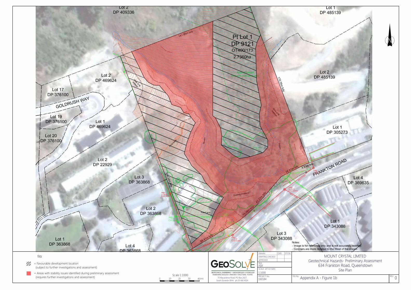
Key
= Favourable development location (subject to further investigations and assessment)
!
634 Frankton Road, QueenstownSite Plan
MOUNT CRYSTAL LIMITEDGeotechnical Hazards- Preliminary Assessment
Scale 1:10000 10 20 30 40(m)
= Areas with stability issues identified during preliminary assessment (requires further investigations and assessment) 70 Macandrew Road, PO Box 2427,
South Dunedin 9044. ph 03 466 4024 160184
Appendix A - Figure 1b 0
PDFFILE :
DRAFTING CHECKEDDRAWN
APPROVED
FIG No. REV. PROJECT No.
SCALE: (AT A3 SIZE)
1:1000
GXS 07/16

