best practices for preparing data for sharing and archiving · gis . 10 . best practices, nasa...
TRANSCRIPT

Best Practices for Preparing Data for Sharing and Archiving
Bob Cook Environmental Sciences Division Oak Ridge National Laboratory September 12, 2013 NASA EarthData Webinar
National Aeronautics and Space Administration
www.nasa.gov

Best Practices, NASA EarthData Webinar, September 12, 2013
Presenter: Bob Cook
– Biogeochemist – Chief Scientist, NASA’s ORNL Distributed Active Archive
Center for Biogeochemical Dynamics – Associate Editor, Biogeochemistry – Oak Ridge National Laboratory, Oak Ridge, TN – [email protected] – Phone: +1 865 574-7319
2
ORNL, Oak Ridge, TN

Best Practices, NASA EarthData Webinar, September 12, 2013
Agenda: • Introduction • Metadata • Fundamental Best Practices
Best Practices for Preserving Data
3
Best Practices, NASA EarthData Webinar, September 12, 2013
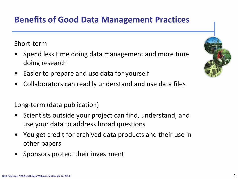
Benefits of Good Data Management Practices
Short-term • Spend less time doing data management and more time
doing research • Easier to prepare and use data for yourself • Collaborators can readily understand and use data files Long-term (data publication) • Scientists outside your project can find, understand, and
use your data to address broad questions • You get credit for archived data products and their use in
other papers • Sponsors protect their investment
4

Best Practices, NASA EarthData Webinar, September 12, 2013
Metadata
Information to find, understand, and use the data
– descriptors – documentation
5

Best Practices, NASA EarthData Webinar, September 12, 2013
Who Who collected the data? Who processed the data? Who wrote the metadata? Who to contact for questions? Who to contact to order? Who owns the data?
Where Where were the data collected? Where were the data processed? Where are the data located?
What What are the data about? What project were they collected under? What are the constraints on their use? What is the quality? What are appropriate uses? What parameters were measured? What format are the data in?
When When were the data collected? When were the data processed?
How How were the data collected? How were the data processed? How do I access the data? How do I order the data? How much do the data cost? How was the quality assessed?
Why Why were the data collected?
What is Metadata?
6

Best Practices, NASA EarthData Webinar, September 12, 2013
This is the metadata for this.
What’s Missing?
7

Best Practices, NASA EarthData Webinar, September 12, 2013
The 20-Year Rule
• The metadata accompanying a data set should be written for a user 20 years into the future – What does that investigator need to know to use the
data?
• Prepare the data and documentation for a user who is unfamiliar with your project, methods, and observations
NRC (1991)
8

Best Practices, NASA EarthData Webinar, September 12, 2013
Metadata needed to Understand Data
The details of the data ….
Measurement
date Sample ID
Parameter name
location
9
Courtesy of Raymond McCord, ORNL

Best Practices, NASA EarthData Webinar, September 12, 2013
Metadata Needed to Understand Data
Measurement QA flag
media
generator
method
date Sample ID
parameter name
location
records
Units
Sample def. Type, date
location generator
lab field
Method def.
Units method
Parameter def.
org.type name
custodian address, etc.
coord. elev. type
depth
Record system
date words, words.
QA def.
Units def.
GIS
10

Best Practices, NASA EarthData Webinar, September 12, 2013
Fundamental Data Practices
1. Define the contents of your data files 2. Define the parameters 3. Use consistent data organization 4. Use stable file formats 5. Assign descriptive file names 6. Preserve processing information 7. Perform basic quality assurance 8. Provide documentation 9. Protect your data 10. Preserve your data
11

Best Practices, NASA EarthData Webinar, September 12, 2013
1. Define the contents of your data files
• Content flows from science plan (hypotheses) and is informed from requirements of final archive.
• Keep a set of similar measurements together in one file
• same investigator, • methods, • time basis, and • instrument
– No hard and fast rules about contents of each file.
12
Best Practices, NASA EarthData Webinar, September 12, 2013
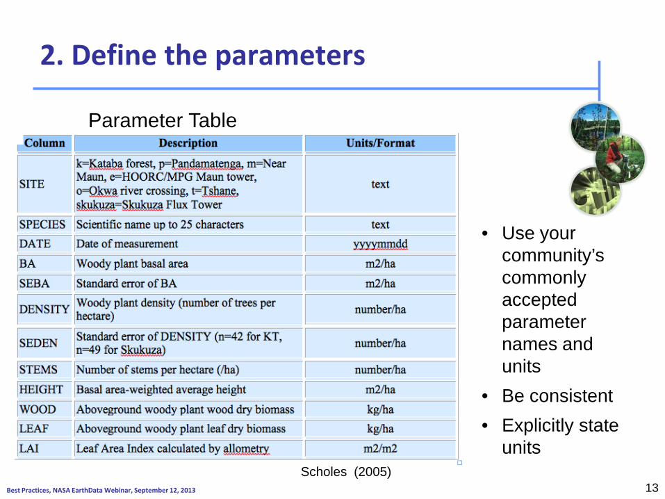
2. Define the parameters
13 Scholes (2005)
• Use your community’s commonly accepted parameter names and units
• Be consistent • Explicitly state
units
Parameter Table

Best Practices, NASA EarthData Webinar, September 12, 2013
2. Define the parameters (cont)
• Choose a format for each parameter, explain the format in the metadata, and use that format throughout the file – e.g., use yyyymmdd; January 2, 1999 is 19990102 – Report in both local time and Coordinated Universal Time
(UTC) and 24-hour notation (13:30 instead of 1:30 p.m.) • Avoid Daylight standard time
– Use a code (e.g., -9999) for missing values
• See Hook et al. (2010) for additional examples of parameter formats
• http://daac.ornl.gov/PI/bestprac.html#prac3
14

Best Practices, NASA EarthData Webinar, September 12, 2013
3. Use consistent data organization (one good approach)
Station Date Temp Precip
Units YYYYMMDD C mm
HOGI 19961001 12 0
HOGI 19961002 14 3
HOGI 19961003 19 -9999
Note: -9999 is a missing value code for the data set
15
Each row in a file represents a complete record, and the columns represent all the parameters that make up the record.

Best Practices, NASA EarthData Webinar, September 12, 2013
3. Use consistent data organization (a 2nd good approach)
Station Date Parameter Value Unit
HOGI 19961001 Temp 12 C
HOGI 19961002
Temp 14 C
HOGI 19961001 Precip 0 mm
HOGI 19961002
Precip 3 mm
16
Parameter name, value, and units are placed in individual rows. This approach is used in relational databases.

Best Practices, NASA EarthData Webinar, September 12, 2013
3. Use consistent data organization (cont)
• Be consistent in file organization and formatting – don’t change or re-arrange columns – Include header rows (first row should contain file name,
data set title, author, date, and companion file names) – column headings should describe content of each column,
including one row for parameter names and one for parameter units
17

Best Practices, NASA EarthData Webinar, September 12, 2013 18
Example of Poor Data Practices for Collaboration and Data Sharing
C:\Documents and Settings\hampton\My Documents\NCEAS Distributed Graduate Seminars\[Wash Cres Lake Dec 15 Dont_Use.xls]Sheet1Stable Isotope Data Sheet
Wash Cresc Lake Peter's lab Don't use - old dataAlgal Washed RocksDec. 16Tray 004
SD for delta 13C = 0.07 SD for delta 15N = 0.15
Position SampleID Weight (mg) %C delta 13C delta 13C_ca %N delta 15N delta 15N_ca Spec. No.A1 ref 0.98 38.27 -25.05 -24.59 1.96 4.12 3.47 25354A2 ref 0.98 39.78 -25.00 -24.54 2.03 4.01 3.36 25356A3 ref 0.98 40.37 -24.99 -24.53 2.04 4.09 3.44 25358A4 ref 1.01 42.23 -25.06 -24.60 2.17 4.20 3.55 25360 Shore Avg ConA5 ALG01 3.05 1.88 -24.34 -23.88 0.17 -1.65 -2.30 25362 c -1.26 -27.22A6 Lk Outlet Alg 3.06 31.55 -30.17 -29.71 0.92 0.87 0.22 25364 1.26 0.32A7 ALG03 2.91 6.85 -21.11 -20.65 0.48 -0.97 -1.62 25366 cA8 ALG05 2.91 35.56 -28.05 -27.59 2.30 0.59 -0.06 25368A9 ALG07 3.04 33.49 -29.56 -29.10 1.68 0.79 0.14 25370A10 ALG06 2.95 41.17 -27.32 -26.86 1.97 2.71 2.06 25372B1 ALG04 3.01 43.74 -27.50 -27.04 1.36 0.99 0.34 25374 cB2 ALG02 3 4.51 -22.68 -22.22 0.34 4.31 3.66 25376B3 ALG01 2.99 1.59 -24.58 -24.12 0.15 -1.69 -2.34 25378 cB4 ALG03 2.92 4.37 -21.06 -20.60 0.34 -1.52 -2.17 25380 cB5 ALG07 2.9 33.58 -29.44 -28.98 1.74 0.62 -0.03 25382B6 ref 1.01 44.94 -25.00 -24.54 2.59 3.96 3.31 25384B7 ref 0.99 42.28 -24.87 -24.41 2.37 4.33 3.68 25386B8 Lk Outlet Alg 3.04 31.43 -29.69 -29.23 1.07 0.95 0.30 25388B9 ALG06 3.09 35.57 -27.26 -26.80 1.96 2.79 2.14 25390B10 ALG02 3.05 5.52 -22.31 -21.85 0.45 4.72 4.07 25392C1 ALG04 2.98 37.90 -27.42 -26.96 1.36 1.21 0.56 25394 cC2 ALG05 3.04 31.74 -27.93 -27.47 2.40 0.73 0.08 25396C3 ref 0.99 38.46 -25.09 -24.63 2.40 4.37 3.72 25398
23.78 1.17
Reference statistics:
Sampling Site / Identifier:Sample Type:
Date:Tray ID and Sequence:
Courtesy of Stefanie Hampton, NCEAS

Best Practices, NASA EarthData Webinar, September 12, 2013
Stable Isotope Data at ORNL: tabular csv format Aranabar and Macko. 2005. doi:10.3334/ORNLDAAC/783
19

Best Practices, NASA EarthData Webinar, September 12, 2013
4. Use stable file formats
Lose years of critical knowledge because modern PCs could not always open old file formats.
20
http://news.bbc.co.uk/2/hi/6265976.stm

Best Practices, NASA EarthData Webinar, September 12, 2013
4. Use stable file formats
Lose years of critical knowledge because modern PCs could not always open old file formats.
Lesson: Avoid proprietary formats They may not be readable in the future
21
http://news.bbc.co.uk/2/hi/6265976.stm

Best Practices, NASA EarthData Webinar, September 12, 2013
4. Use stable file formats (cont)
22
Aranibar, J. N. and S. A. Macko. 2005. SAFARI 2000 Plant and Soil C and N Isotopes, Southern Africa, 1995-2000. Data set. Available on-line [http://daac.ornl.gov/] from Oak Ridge National Laboratory Distributed Active Archive Center, Oak Ridge, Tennessee, U.S.A. doi:10.3334/ORNLDAAC/783
• Use text file formats for tabular data • (e.g., .csv (comma-separated values))

Best Practices, NASA EarthData Webinar, September 12, 2013
4. Use stable file formats (cont) Suggested Geospatial File Formats
Raster formats • Geotiff • netCDF
o with CF convention preferred • HDF • ASCII
o plain text file gridded format with external projection information
Vector • Shapefile • KML/GML
23
GTOPO30 Elevation
Minimum Temperature

Best Practices, NASA EarthData Webinar, September 12, 2013
File Names should
• Be Unique
• Reflect contents
• Use ASCII characters only
• Avoid spaces and special characters
Bad: My data.xls 2001 data.csv best version.txt Final data.csv
bigfoot_agro_2000_gpp.tiff
Site name
Year What was measured
Project Name
File Format
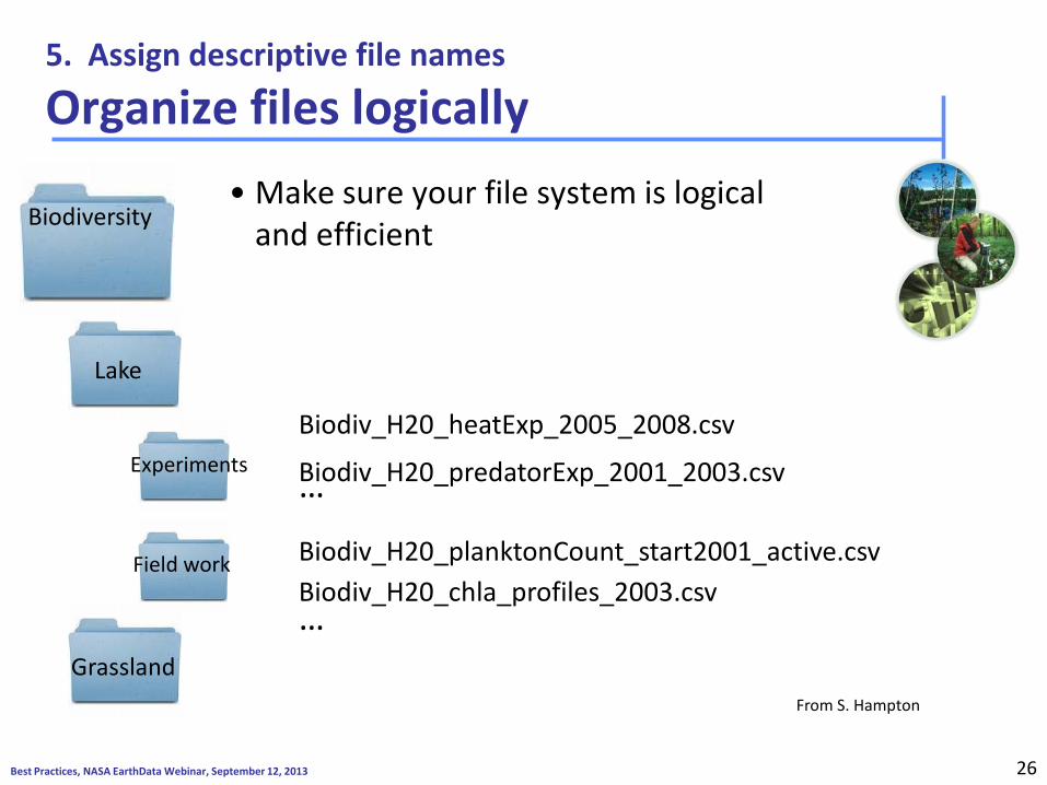
5. Assign descriptive file names
24

Best Practices, NASA EarthData Webinar, September 12, 2013 25 Courtesy of PhD Comics
Best Practices, NASA EarthData Webinar, September 12, 2013
Biodiversity
Lake
Experiments
Field work
Grassland
Biodiv_H20_heatExp_2005_2008.csv
Biodiv_H20_predatorExp_2001_2003.csv
Biodiv_H20_planktonCount_start2001_active.csv Biodiv_H20_chla_profiles_2003.csv
…
…
5. Assign descriptive file names
Organize files logically • Make sure your file system is logical
and efficient
26
From S. Hampton

Best Practices, NASA EarthData Webinar, September 12, 2013
6. Preserve processing information
Keep raw data raw:
•Do not Include transformations, interpolations, etc in raw file
•Make your raw data “read only” to ensure no changes
Giles_zoopCount_Diel_2001_2003.csv TAX COUNT TEMPC C 3.97887358 12.3 F 0.97261354 12.7 M 0.53051648 12.1 F 0 11.9 C 10.8823893 12.8 F 43.5295571 13.1 M 21.7647785 14.2 N 61.6668725 12.9
…
Raw Data File –### Giles_zoop_temp_regress_4jun08.r
–### Load data
–Giles<-read.csv("Giles_zoopCount_Diel_2001_2003.csv")
–### Look at the data
–Giles
–plot(COUNT~ TEMPC, data=Giles)
–### Log Transform the independent variable (x+1)
–Giles$Lcount<-log(Giles$COUNT+1)
–### Plot the log-transformed y against x
–plot(Lcount ~ TEMPC, data=Giles)
When processing data:
• Use a programming language (e.g., R, SAS, MATLAB)
• Code is a record of the processing done
• Codes can be revised, rerun
27

Best Practices, NASA EarthData Webinar, September 12, 2013
7. Perform basic quality assurance
• Assure that data are delimited and line up in proper columns
• Check that there no missing values (blank cells) for key parameters
• Scan for impossible and anomalous values • Perform and review statistical summaries • Map location data (lat/long) and assess errors
No better QA than to analyze data
28

Best Practices, NASA EarthData Webinar, September 12, 2013
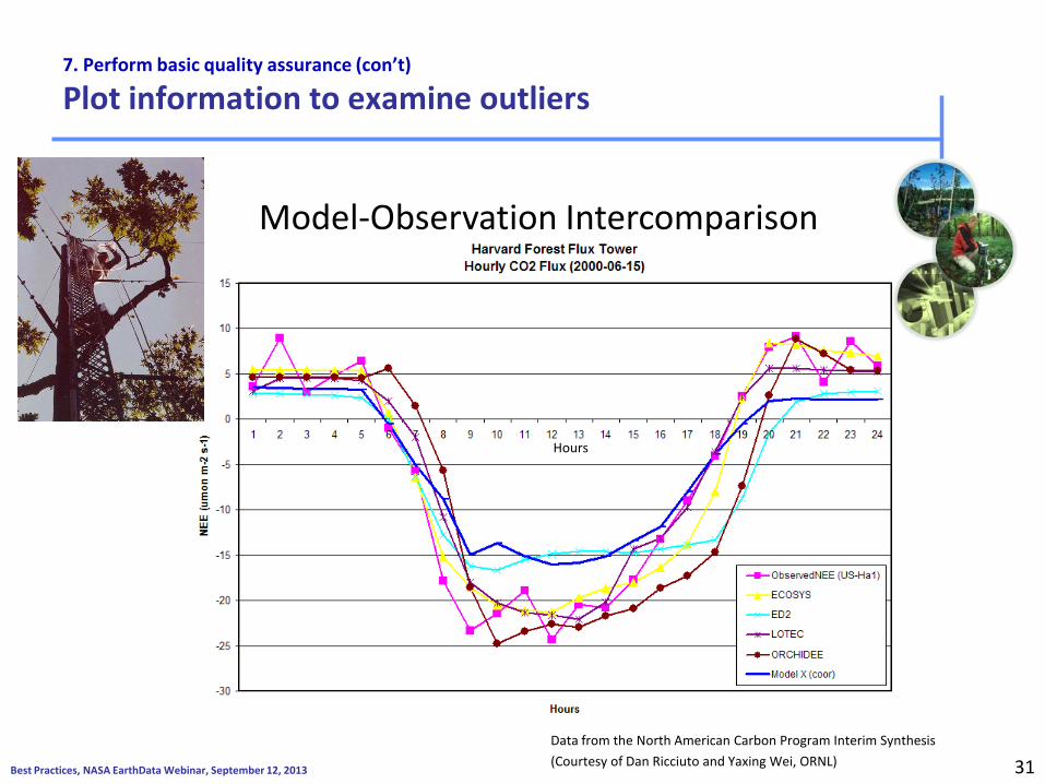
7. Perform basic quality assurance (con’t)
Plot information to examine outliers
29 Data from the North American Carbon Program Interim Synthesis (Courtesy of Dan Ricciuto and Yaxing Wei, ORNL)
Model-Observation Intercomparison
Hours

Best Practices, NASA EarthData Webinar, September 12, 2013
7. Perform basic quality assurance (con’t)
Plot information to examine outliers
30
Model X uses UTC time, all others use Eastern Time
Model-Observation Intercomparison
Hours
Data from the North American Carbon Program Interim Synthesis (Courtesy of Dan Ricciuto and Yaxing Wei, ORNL)
Best Practices, NASA EarthData Webinar, September 12, 2013
7. Perform basic quality assurance (con’t)
Plot information to examine outliers
31
Model-Observation Intercomparison
Hours
Data from the North American Carbon Program Interim Synthesis (Courtesy of Dan Ricciuto and Yaxing Wei, ORNL)

Best Practices, NASA EarthData Webinar, September 12, 2013
8. Provide Documentation / Metadata • What does the data set describe? • Why was the data set created? • Who produced the data set and Who prepared the metadata?
• When and how frequently were the data collected?
• Where were the data collected and with what spatial resolution? (include coordinate reference system)
• How was each parameter measured? • How reliable are the data?; what is the uncertainty, measurement
accuracy?; what problems remain in the data set? • What assumptions were used to create the data set?
• What is the use and distribution policy of the data set? How can someone get a copy of the data set?
• Provide any references to use of data in publication(s)
32

Best Practices, NASA EarthData Webinar, September 12, 2013
9. Protect data
• Create back-up copies often – Ideally three copies
– original, one on-site (external), and one off-site
– Frequency based on need / risk • Know that you can recover from a
data loss – Periodically test your ability to
restore information
33

Best Practices, NASA EarthData Webinar, September 12, 2013
9. Protect data (cont)
• Ensure that file transfers are done without error – Compare checksums before and after transfers – numerical value based on the number of bits in the
file • Example tools to generate checksums http://www.pc-tools.net/win32/md5sums/ http://corz.org/windows/software/checksum/
34

Best Practices, NASA EarthData Webinar, September 12, 2013
10. Preserve Your Data
What to preserve from the research project?
• Well-structured data files, with variables, units, and values defined
• Documentation and metadata record describing the data
• Additional information (provides context)
• Materials from project wiki/websites
• Files describing the project, protocols, or field sites (including photos)
• Publication(s)
35

Best Practices, NASA EarthData Webinar, September 12, 2013
Fundamental Data Practices
1. Define the contents of your data files 2. Define the parameters 3. Use consistent data organization 4. Use stable file formats 5. Assign descriptive file names 6. Preserve processing information 7. Perform basic quality assurance 8. Provide documentation 9. Protect your data 10. Preserve your data
36

Best Practices, NASA EarthData Webinar, September 12, 2013
When your project is over, where should the data be archived? • Part of project planning • Contact archive / data center early to find
out their requirements – What additional data management steps would
they like you to do?
• Suggested data centers / archives:
37
– DataONE (Observation Network for Earth)
– Ecological Archives
– ORNL DAAC – CDIAC – Dryad

Best Practices, NASA EarthData Webinar, September 12, 2013
Best Practices: Conclusion
• Data management is important in today’s science
• Well organized data: – enables researchers to work more efficiently – can be shared easily by collaborators – can potentially be re-used in ways not imagined
when originally collected
• Include data management in your research workflow.
• Data Management should be a habit
38

Best Practices, NASA EarthData Webinar, September 12, 2013
Web Resources
Workshops http://daac.ornl.gov/workshops/workshops.shtml
– This Webinar – Other recent workshops
On-line Materials – Data Management for Data Providers
• ORNL DAAC Guidance on Data Management
39

Best Practices, NASA EarthData Webinar, September 12, 2013
Bibliography
• Christensen, S. W. and L. A. Hook. 2007. NARSTO Data and Metadata Reporting Guidance. Provides reference tables of chemical, physical, and metadata variable names for atmospheric measurements. Available on-line at: http://cdiac.ornl.gov/programs/NARSTO/
• Cook, R.B., R.J. Olson, P. Kanciruk, and L.A. Hook. 2001. Best Practices for Preparing Ecological Data Sets to Share and Archive. Bulletin of the Ecological Society of America, Vol. 82, No. 2, April 2001.
• Hook, L.A., S.K.S. Vannan, T.W. Beaty, R.B. Cook, and B.E. Wilson. 2010.. June 2010. Best Practices for Preparing Environmental Data Sets to Share and Archive. http://dx.doi.org/10.3334/ORNLDAAC/BestPractices-2010
• Michener, W.K. and J.W. Brunt (ed.). 2000. Ecological Data: Design, Management and Processing, Methods in Ecology, Blackwell Science. 180p.
• Michener, W. K., J. W. Brunt, J. Helly, T. B. Kirchner, and S. G. Stafford. 1997. Non-Geospatial Metadata for Ecology. Ecological Applications. 7:330-342. http://dx.doi.org/10.1890/1051-0761(1997)007[0330:NMFTES]2.0.CO;2
40

Best Practices, NASA EarthData Webinar, September 12, 2013
Additional Data Management Webinars
Encore Webinar Part 2: Geospatial Data 3 pm EDT (UTC-4:00) Thursday, September 12
41