beveridge spring vegetation management plan
TRANSCRIPT

Beveridge
Recreation
Reserve
Vegetation
Management
Plan 2010-15
Merri Creek Management Committee for Mitchell Shire Council,
July 2010
With funding from Melbourne Water

Cover image; The Swamp Tigertail, Synthemis eustalacta has larvae that hunt in sediments and still waters of swamps. It is seldom reported in the Melbourne area or on the Volcanic Plains and its occurrence at Beveridge Spring is potentially significant, indicating the unusual hydrology and habitat of the site. Photo taken at Beveridge Community Park, February 2010. MCMC
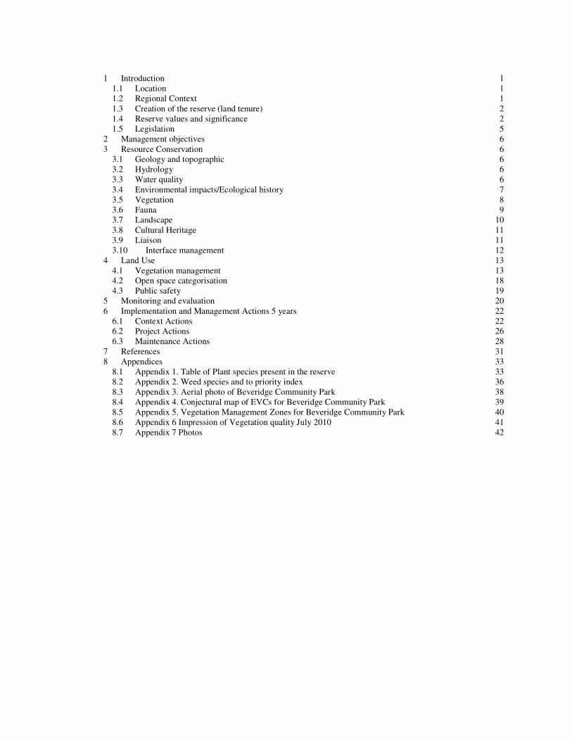
1 Introduction 1
1.1 Location 1 1.2 Regional Context 1 1.3 Creation of the reserve (land tenure) 2 1.4 Reserve values and significance 2 1.5 Legislation 5
2 Management objectives 6 3 Resource Conservation 6
3.1 Geology and topographic 6 3.2 Hydrology 6 3.3 Water quality 6 3.4 Environmental impacts/Ecological history 7 3.5 Vegetation 8 3.6 Fauna 9 3.7 Landscape 10 3.8 Cultural Heritage 11 3.9 Liaison 11 3.10 Interface management 12
4 Land Use 13 4.1 Vegetation management 13 4.2 Open space categorisation 18 4.3 Public safety 19
5 Monitoring and evaluation 20 6 Implementation and Management Actions 5 years 22
6.1 Context Actions 22 6.2 Project Actions 26 6.3 Maintenance Actions 28
7 References 31 8 Appendices 33
8.1 Appendix 1. Table of Plant species present in the reserve 33 8.2 Appendix 2. Weed species and to priority index 36 8.3 Appendix 3. Aerial photo of Beveridge Community Park 38 8.4 Appendix 4. Conjectural map of EVCs for Beveridge Community Park 39 8.5 Appendix 5. Vegetation Management Zones for Beveridge Community Park 40 8.6 Appendix 6 Impression of Vegetation quality July 2010 41 8.7 Appendix 7 Photos 42

Beveridge Recreation Reserve Vegetation Management Plan 2010-2015
1
1 Introduction
This plan was commissioned by Mitchell Shire Council to provide directions for on-ground remnant vegetation management throughout the Beveridge Recreation Reserve.
The direction for this Vegetation Management Plan is indicated by the Council Plan 2009-2013 (Mitchell Shire 2009) to ‘Protect and enhance our natural environment’.
The most pressing issue for vegetation management in the Recreation Reserve is that changes in vegetation structure, in particular unmanaged weed infestations and expansion of areas dominated by the native Common Reed, Phragmites australis. These changes are perceived to have reduced amenity values of the reserve and, notwithstanding the habitat values of Reedbeds, the expansion has degraded other ecological values.
Toward the end of the project, a minor consultation from leading wetland restoration and consultation firm, Australian Ecosystems, was commissioned by Merri Creek Management Committee (MCMC) to inform recommendations on wetland management. Experienced ecologist from this firm, Dylan Osler, provided expert opinions during a two hour on-site consultation on July 2010.
The assessment of vegetation assets also aims to inform ongoing discussions on recreational proposals within the reserve.
The target audiences for this report are;
• The Beveridge Recreation Reserve Committee of management to provide information in strategic planning and decision making for the reserve
• Council environment officers for assessing infrastructural proposals, design constraints, developing budgets and grant applications relating to the vegetation management of the reserve
• Contractors involved in vegetation management to identify works and provide background essential to devising induction and detailed works programs
• Department of Sustainability and Environment (DSE) and Parks Victoria (PV) staff involved in assessing and tracking biodiversity actions relating to significant biodiversity assets.
1.1 Location
The Beveridge Recreation Reserve (the Reserve) bounded by Spring Street to the west, Lithgow Street to the north and private land to the east and south in the township of Beveridge, approximately 42 kilometres north of Melbourne in the Shire of Mitchell. Coordinates are;
Lat/Long: 37° 28' 30.5" S, 144° 58' 36.0" E MGA 55: 321088, 5850493 It is found on Map 686 A3 of the Melway Greater Melbourne Street Directory (Melway, 2010)
The reserve occupies 10 hectares below the southern flanks of the dormant volcano, Mt Fraser. A perennial spring occurs at the break of slope in the middle of the Reserve.
1.2 Regional Context The values of the Reserve have been variously interpreted in the context of the Merri Creek catchment, the
Greater Melbourne Area and Port Phillip Region in different publications.
Specific Under the Victorian Government’s sites of biodiversity significance (BioSites) scheme, the Reserve is indicated
as being of Regional significance as ‘BioSite 5046’. (DSE 2005a). The most comprehensive analysis of the biodiversity significance was that of Beardsell (1997), in which the site
was judged to be of Regional Significance within the Greater Melbourne Area. Values that contributed to Beardsell’s contributing to this are included in Section 0 and Section 0.
Wetlands Wetlands often constitute ‘biodiversity hotspots’ recognised for their diverse assemblage of species and
ecosystems, some of which have international, national, regional and local significance. An analysis of historical and extant wetlands indicates that only 83ha out of an original 2,140ha (<4%) remains in the Merri Catchment (MCMC 2009). In Victoria, almost 4,000 natural wetlands (191,000 hectares) have been lost since European settlement.
Beveridge Recreation Reserve Vegetation Management Plan 2010-2015
2
Habitat corridor The Beveridge Recreation Reserve is relatively distant from habitat corridors identified as part of the Merri Creek
Catchment ‘Habitat Corridor Network’ (MCMC 2009). The position of the Reserve at a head of the Kalkallo Creek and the fragmentary native vegetation along the creek limits its function as a riparian habitat corridor. However, the wetland remains connected to the wider habitat network as a ‘stepping stone’ site for highly mobile species such as wetland birds and forest species attracted to the Swamp Scrub vegetation. The perennial Beveridge spring is potentially important as a refuge for water dependant flora and fauna. The ‘Swamp Tigertail’ Dragonfly Synthemis eustalacta, (see Section 0) may be significant in this regard.
Hardy species probably continue to use the degraded drainage line along the Kalkallo Creek. These connections for wetland fauna may be enhanced or re-established through sympathetic management of the open space along the Kalkallo Creek.
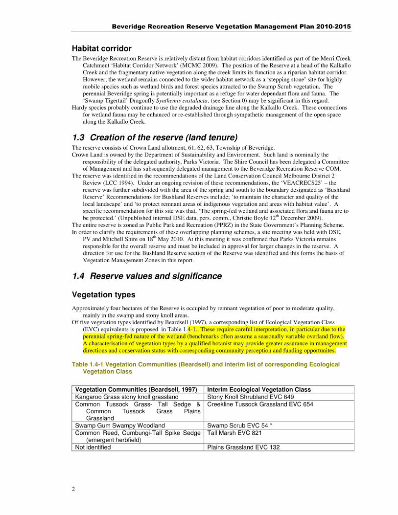
1.3 Creation of the reserve (land tenure) The reserve consists of Crown Land allotment, 61, 62, 63, Township of Beveridge. Crown Land is owned by the Department of Sustainability and Environment. Such land is nominally the
responsibility of the delegated authority, Parks Victoria. The Shire Council has been delegated a Committee of Management and has subsequently delegated management to the Beveridge Recreation Reserve COM.
The reserve was identified in the recommendations of the Land Conservation Council Melbourne District 2 Review (LCC 1994). Under an ongoing revision of these recommendations, the ‘VEACRECS25’ – the reserve was further subdivided with the area of the spring and south to the boundary designated as ‘Bushland Reserve’ Recommendations for Bushland Reserves include; ‘to maintain the character and quality of the local landscape’ and ‘to protect remnant areas of indigenous vegetation and areas with habitat value’. A specific recommendation for this site was that, ‘The spring-fed wetland and associated flora and fauna are to be protected.’ (Unpublished internal DSE data, pers. comm., Christie Boyle 12th December 2009).
The entire reserve is zoned as Public Park and Recreation (PPRZ) in the State Government’s Planning Scheme. In order to clarify the requirements of these overlapping planning schemes, a site meeting was held with DSE,
PV and Mitchell Shire on 18th May 2010. At this meeting it was confirmed that Parks Victoria remains responsible for the overall reserve and must be included in approval for larger changes in the reserve. A direction for use for the Bushland Reserve section of the Reserve was identified and this forms the basis of Vegetation Management Zones in this report.
1.4 Reserve values and significance
Vegetation types
Approximately four hectares of the Reserve is occupied by remnant vegetation of poor to moderate quality, mainly in the swamp and stony knoll areas.
Of five vegetation types identified by Beardsell (1997), a corresponding list of Ecological Vegetation Class (EVC) equivalents is proposed in Table 1.4-1. These require careful interpretation, in particular due to the perennial spring-fed nature of the wetland (benchmarks often assume a seasonally variable overland flow). A characterisation of vegetation types by a qualified botanist may provide greater assurance in management directions and conservation status with corresponding community perception and funding opportunites.
Table 1.4-1 Vegetation Communities (Beardsell) and interim list of corresponding Ecological
Vegetation Class
Vegetation Communities (Beardsell, 1997) Interim Ecological Vegetation Class
Kangaroo Grass stony knoll grassland Stony Knoll Shrubland EVC 649
Common Tussock Grass- Tall Sedge & Common Tussock Grass Plains Grassland
Creekline Tussock Grassland EVC 654
Swamp Gum Swampy Woodland Swamp Scrub EVC 54 * Common Reed, Cumbungi-Tall Spike Sedge
(emergent herbfield) Tall Marsh EVC 821
Not identified Plains Grassland EVC 132
Beveridge Recreation Reserve Vegetation Management Plan 2010-2015
3
*Swampy Riparian Woodland EVC would also be similar to Beardsells’ ‘Swamp Gum Swampy Woodland’
however the absence of any Eucalyptus ovata trees or stumps suggest that the Woolly tea-tree dominated
areas instead comprise a form of Swamp Scrub EVC (Osler, D., pers comm. 19th
July 2010). With the exception of the recently defined ‘Tall Marsh’ EVC, all of these EVCs warrant the highest priority for
vegetation protection, reservation and management based on criteria under Port Phillip and Westernport Native Vegetation Plan as identified in Merri Creek Environs Strategy 2009-2014. (MCMC 2009). Tall Marsh is a component of ‘Shallow Freshwater Marsh Wetland EVC Mapping Unit’ which has in the past been identified as Endangered on the Victorian Volcanic Plains (DSE 2003) however no published updated analysis appears to be available.
A conjectural map of the EVCs present or likely to have occurred in the reserve is included as section 8.4. An additional EVC (Plains Grassland, EVC 132) has been added to this mapping for higher slopes on the north of the Reserve, based on similar topography in other parts of the Merri Catchment. However, Plains Woodland or Scoria Cone Woodland EVC are alternative vegetation types that may have been present.
The Woolly Tea-tree dominated areas of the site are characteristic of Swamp Scrub (EVC 53) of the Victorian Volcanic Plain (VVP). This EVC is dominated by Woolly Tea-tree on VVP, and can have occasionally emergent trees in particular Swamp Gum (Eucalyptus ovata) and Blackwood (Acacia melanoxylon) on the drier fringes.
It was also D. Osler’s opinion that although small, this stand of Swamp Scrub is of high ecological importance as;
• it represents an ecological vegetation type that is likely to have been naturally restricted on VVP in the greater Melbourne area
• it is one of the only stands of Swamp Scrub on public lands in the VVP in the greater Melbourne area
• the Woolly Tea-trees are unusually tall-growing and of an apparently unusual age
• with the continuation practical weed contro,l it will allow ground layer components of this EVC to expand
(Osler, D, pers. comm. 19th July 2010) In an email of 21st July 2010, D. Osler provided the following notes;
• The predominant Reed and Cumbungi areas of the swamp are a form of Tall Marsh EVC. This EVC is likely to have naturally occurred within the area but has increased in cover as a response to the various changes in land management. A limited but distinctive flora associated with Reeds at this site is present including Crassula helmsii, Carex fascicularis and Epilobium billardieranum although some areas do hold a natural monoculture of Reed. The Index to Wetland Condition EVC Benchmarks describes Tall Marsh as ‘typically in species-poor swards’. Therefore it should not be presumed that the lack of diversity is indicative of poor health, but a characteristic of the EVC.
• Some currently weed-dominated areas on the swamp’s south-eastern and north-western fringe have remnant vegetation and physical characteristics that suggest that they could be restored as Swamp Scrub. Species reflective of this include Tassel Sedge (Carex fascicularis), Common Reed (Phragmites australis), Common Spike-sedge (Eleocharis acuta), Austral sweet-grass (Glyceria australis) and Streaked arrow-grass (Triglochin striata).
The quality of remnants of all these vegetation types in the reserve is generally poor to moderate and Creekline Tussock Grassland appears to have been extirpated since Beardsell’s observations. As previously mentioned, the existance of Plains Grassland at this site is hypothetical. An impression of the current vegetation quality based on several random walks through the site is included as 8.6 Appendix 6 Impression of Vegetation quality July 201.
Fauna Three sources of statements on significance of the site as it relates to fauna were referred to. The Beardsell
(1997) assessment is the only one backed up by a comprehensive methodology and long-term observations but is now very dated. The Ecological Consulting Services report provides some up to date observations however suffers from limited observation time which limits the value of the general statements made regarding significance of the site. A third source of information are incidental observations made during the production of this report.
The methodical acquisition and compilation of new observations in all seasons over a period of time is strongly recommended to update data from Beardsell. Community members and organisations are a viable source of such monitoring for groups such as frogs, birds and dragonflies.
Beardsell (1997) Beardsell (1997) described the wetland as the last remnant of ‘Inverlochy Swamp’ and significant for its habitat
values. This site achieved the lowest (third) class of regional significance in Beardsell’s scheme. Four criteria contributed to the regional significance status;
• Diversity (Species/assemblage Richness- point census- trapping) criteria
Beveridge Recreation Reserve Vegetation Management Plan 2010-2015
4
o Local Significance for waterbirds, Regional significance for Frogs, Local significance for reptiles,
• Representativeness Faunal Assemblages- reference grid data o Regional Significance for Herpetofauna- 12 species recorded o Local significance for birds- 32 bird species recorded
• Representativeness- significant species o Local significance as a site that contained 6 species considered as ‘Critical Fauna’ for the Greater
Melbourne Area (those in the highest 4 regional significance sub categories) o In addition was locally significant for containing 5 species considered regionally restricted.
• Population density- viability and abundance o Regional significance for International Migratory Birds o Regional significance for Frogs
Since 1997, two the fauna species identified by the Beardsell at the reserve, Growling Grass Frog and Latham’s Snipe (as a Migratory species), have become listed under the Environment Protection and Biodiversity Conservation Act 1999. No records were available for these species from more recent sources however, given the mobility of both species and nearby populations of Growling Grass Frog either could conceivably still visit the site or recolonise the site.
Ecological Consulting Services (2009) In contrast to Beardsell’s assessment, a report commissioned by Mitchell Council in 2009 (Ecological Consulting
Services 2009) concluded that the swamp provided limited fauna habitat values, in particular for wetland birds and frogs. It cited as reasons for this the lack of intensive controls of Toowoomba Canary Grass,*Phalaris aquatica, Spear Thistle, Cirsium vulgare and management of Common Reed leading to a simplification of habitat. Section 3.4.1 on the wider conservation significance of the site as part of a Habitat Corridor Network includes the prognosis that the site provides little in the way of connectivity for terrestrial fauna and has limited conservation significance at a landscape scale in its present state.
The list of bird species in the Ecological Consulting Services report included Buff-rumped Thornbill, Acanthiza
reguloides sighted in October 2008. Although this was not remarked upon as exceptional, it does constitute an anomalous sighting given box-forest habitat typical of this species. Confirmation of this species at this site would be an outlying population of a species that was not reported from the Volcanic Plains bioregion area covered by Beardsell (1997 p. 118). Yellow Thornbills, Acanthiza nana, observed by the author at this site in July 2010 are a possible confusion species and misidentification should be considered.
Incidental observations made during production of this report. A Swamp Tigertail Dragonfly Synthemis eustalacta identified from a photo taken in February appears to
represent an unusual record for this species. Records of Museum specimens from Victoria were provided by the entomologist, Ian Endersby. These show that most records near Melbourne are from the Highlands Bioregions, (e.g. Healesville, Taggerty, Ferntree Gully). The only other record from the Victorian Volcanic Plains Bioregion is a pair of 1959 specimens taken from Meredith over 70 kilometres to the south west. Otherwise records are predominantly from the Alps and Highlands. In an email received on 1st June 2010, Ian Endersby commented that some of that rarity is due to lack of sampling but that this species does tend to be more of a high country resident. The distinctive hydrology is likely to be a factor in its occurrence at this site, possibly as a relict population from the more extensive swamps that once occurred in this area or as a species persisting in a traditional climatic refugia. Greater sampling intensity may prove the species to be more widespread in a range of connected populations however at this stage the significance of a population of this species is probably of at least regional significance for the Melbourne area.
A Golden Whistler using the Woolly Tea-tree areas observed on 18th May and again on the 17th July supports the likely role of this site as a wintering site for altitudinal migrant woodland and forest-dependant birds. It may also have a role as a ‘stepping stone’ habitat for migratory species and still appears to be suitable for playing this role for the EPBC-listed species Latham’s Snipe. Other locally uncommon migratory species observed in July were a White-eared Honeyeater (altitudinal migrant) and a Spiny-cheeked Honey-eater (apparently seasonal migrant from inland).
Following inspection of the site on July 19th 2010, ecologist D. Osler confirmed that the Reed beds at this site do have potential for supporting populations or temporary habitat for Bitterns, Crakes and other wetland wildlife of conservation interest.
Beveridge Recreation Reserve Vegetation Management Plan 2010-2015
5
1.5 Legislation
CALP
The principal legislation relating to environmental weeds is the Catchment and Land Protection Act 1994 (CaLP Act). There is also provision under the Local Government Act 1989 for councils to enact local by-laws targeting specific weeds.
Key provisions relating to noxious weeds relevant to management of the Beveridge Reserve are that
In relation to his or her land a land owner must take all reasonable steps to;
• eradicate regionally prohibited1 weeds; and
• prevent the growth and spread of regionally controlled2 weeds.
A land owner must take all reasonable steps to prevent the spread of regionally controlled weeds and established pest animals on a roadside that adjoins the land owner's land.
No weeds in the reserve qualify as Regionally prohibited (requiring eradication) but ten qualify as Regionally Controlled and one as Regionally Restricted (prohibiting its sale or trade). These are in section 8.2 Appendix 2. Weed species and to priority index). All such weeds have been accorded a high priority in the weed control table. Although eradication is not required for controlled weeds, it is a feasible goal for this site and eradication will free up resources to tackle other weed issues, some having greater impact on Native vegetation (e.g. *Phalaris aquatica).
The adjacent roadsides should also be considered as a part of the vegetation management of the reserve.
The risk of introduction of noxious weeds is high due to movement of horses and slashing machinery through the reserve. Impending urbanisation may also be increase the influx of weeds originating as garden escapees. Hygiene measures may reduce the risk of establishment of new weed species. Patrol and inspection for new weed incursions should be integrated with vegetation maintenance, concentrated on areas of high risk such (disturbed areas, among trees and areas horses are tied).
Victoria’s Native vegetation Framework Vegetation in the Reserve is subject to Victoria’s Native Vegetation Framework (Department of Natural
Resources and Environment (NRE) 2002) which aims to minimise reduce and mitigate any destruction of vegetation and offset any destruction that does occur.
In the opinion of the author, it is likely that all the vegetation identified as ‘Moderate’ in Appendix 6 Impression of Vegetation quality July 201 will qualify for consideration under this legislation. In addition, a small number of isolated trees in other parts of the reserve may also qualify.
A more detailed investigation should be undertaken where destruction or significant modification of vegetation in any part of the reserve is to be considered.
EPBC Natural temperate grasslands of the Victorian Volcanic Plain were listed under the Environment Protection and
Biodiversity Conservation (EPBC) Act on 21 June 2008. A degraded example of this vegetation occurs in the rocky areas of the reserve. Due to the small size and extent of degradation (listed remnants must be
1 Regionally Prohibited weeds are not widely distributed in a Region but are capable of spreading further. It is reasonable to expect that they can be eradicated from a Region and they must be managed with that goal. Land owners, including public authorities responsible for Crown land management, must take all reasonable steps to eradicate Regionally Prohibited weeds on their land.
2 Regionally Controlled Weeds are usually widespread and are considered important in a particular Region. To prevent their spread, continuing control measures are required. Land owners have the responsibility to take all reasonable steps to prevent the growth and spread of Regionally Controlled weeds on their land.

Beveridge Recreation Reserve Vegetation Management Plan 2010-2015
6
greater than 0.05 ha and native grasses must comprise greater than 50% cover of the site) there are no parts of the site that would qualify for protection under the act.
Under the EPBC act, Federal government approval is required if a new activity is likely to have a significant impact on the protected grasslands and grassy woodlands. If federal government approval is required, then it is up to the landowner or land user to seek this approval.
Individual species are also subject to the EPBC act. One of these, Growling Grass Frog (Litoria raniformis) has been recorded from this site (Beardsell 1997). Three other species are possible at the site, Matted Flax Lily, Golden Sun Moth and Striped Legless Lizard. Observations at appropriate times of the year to detect these species should be undertaken.
2 Management objectives The objective of the vegetation management plan is to improve and conserve the environmental values on the
site. Subsidiary obkjectives are that the reseerve;
• supports viable and robust ecosystems
• continues to support a significant and representative native vegetation remnant
• has valued educational and public relations roles for the natural environment
• is used and appreciated by people without compromising key biodiversity values
3 Resource Conservation
3.1 Geology and topographic It is beyond the scope of this report to present a detailed assessment of the geology and topography of the reserve.
Features that are pertinent to the vegetation management of the reserve include;
• Entire site appears to be underlain by basaltic rocks and derived clays
• Peaty, organic matter occupies the swamp area
• Low-lying areas adjacent to the existing swamp appear to retain a high organic content, perhaps reflecting former extent of swamp vegetation.
• Rocky outcrops with shallow soils are present in the central north and central south of the reserve The spring-fed swamp is apparently uncommon and an assessment of its geological significance should be
undertaken as suggested by Target 2 in the Geodiversity chapter of the Merri Creek and Environs Strategy (MCMC 2009, p 77).
Conserving significant features of this geology would involve avoiding earthworks that would cover rocky outcrops or change topography.
Rocks and dirt have been shoved into two piles in the past on the southern side of the swamp. Whether these piles could be used as a stockpile of landscaping rocks for the reserve or as a basis for a lookout or other feature needs to be identified. They currently constitute a source of weeds, a likely haven for vermin and a possible safety hazard. They currently constitute a weed source for adjoining areas of the
Some of these features may constitute significant landscape features (see Section 3.7) that will ideally be retained or enhanced as a result of vegetation management.
3.2 Hydrology It is beyond the scope of this report to make definitive statements on the significance of the existing hydrology of
the spring and no detailed description of this feature appears to have been done. However, the hydrology of this site appears to be unique in the Merri Creek valley and uncommon on the Victorian Volcanic Plains.
It is strongly recommended that an assessment of the existing hydrology be undertaken as a matter of priority prior to any proposals to significantly alter this feature. This includes redirecting storm water runoff from streets as has previously been suggested (Ecological Consulting Services 2009, p. 14).
3.3 Water quality A detailed assessment of water quality is not within the scope of this report. Some relevant points that may
impact on vegetation management for the site include;
• It has been identified that septic tank lines from the CFA shed and Community centre were directed towards the swamp (Mitchell Shire Council 2006)

Beveridge Recreation Reserve Vegetation Management Plan 2010-2015
7
• Testing of nutrient (nitrogen and phosphorus) levels was supplied to Council’s Environmental Health Officer in September 2009. These were interpreted as indicating that no significant septic contamination was present in water from the spring (Kelly, E. pers. comm., 9th October 2009
• Increased development may increase the pressure to direct storm water into the swamp. Such proposals must consider the significance of the natural hydrology and its role in maintaining the existing vegetation structure.
• Existing contamination sources include the Spring Street roadside where undirected drainage currently enters the ditch which is connected with the swamp. The roadside adjacent to the reserve on Spring Street currently could be acting as a grassed swale, providing some water treatment for water entering at this point. Roadworks and disturbance on this road must consider the impact on runoff entering the swamp. A high quality water sensitive urban design treatment is recommended on this roadway when it is upgraded.
3.4 Environmental impacts/Ecological history The following environmental history is based on the general history of the Merri Creek valley, notes in Beardsell
(1997), observations provided by local residents as well as interpretation of existing conditions and structures on site. Much if this is conjectural and it is recommended that additional detail is sought from local residents to improve the interpretation of earlier-sketchier periods.
Pre- 1830s- Area subject to land management of the Wurundjeri for tens of thousands of years. Surrounding grasslands and possibly parts of the swamp may have been burned to enhance growth of favoured food plants, promote game or improve safety. Food harvesting of roots and tubers by Wurundjeri may have been a significant source of soil disturbance which, along with the activities of native wildlife such as Bettongs, Bandicoots and Pademelons (‘bioturbation’) would have influenced vegetation composition. The reliable water from the spring and foods from the swamp may have made this an important site for camping.
1830-1860s – The abrupt disruption of Wurundjeri land management patterns occurred simultaneously with introduction of livestock and the beginnings of an influx of exotic plant and pest animal species. Profound vegetation changes such as decimation of sensitive plants (including staples such as Microseris species) and dominance of less palatable grass species (such as Austrostipa sp.) have been documented as occurring soon after the introduction of large flocks of sheep to the Port Phillip district.
It is possible the drystone-wall fence on the southern boundary dates from this time, the boulders for its construction having been removed from surrounding grassland areas with consequences for boulder-associated flora such as dwarf lilies, grasses and ferns.
1860s-1960s Progressive extinction of small mammals responsible for ‘bioturbation’, introduction of rabbits and grazing would have led to further stresses on indigenous plants remaining in this area. This would have made the vegetation more susceptible to invasion by the constantly increasing variety of exotic plants being introduced. The homestead on the south of the reserve means this area may have been subject to more intensive disturbance such as grazing by house cows and vegetable gardening, contributing to the generally poor vegetation quality. The survival of a single old-variety apple to the west of the stony knoll suggests this area may also have had an orchard, another factor in removing indigenous vegetation.
Draining of the surrounding Inverlochy swamp may have allowed grazing onto formerly unsuitable ground for longer periods and the dying out of more sensitive swamp flora. Some old fence posts in the interior of the swamp indicate that grazing once occurred across the site although was presumably restricted around the spring to avoid animals becoming bogged.
Pasture improvement including seeding with Phalaris aquatica and Rye-grass may have occurred during this time.
1960s-1990s In the 1970s the site was described as having cattle grazing occurring through the areas that are now Tall marsh, with the creek visible as a small drainage line. The Swamp Scrub was the focus of an annual drive to control foxes. Grazing agistment of the crown land was occurring up to the 1990s. Beardsell (1997). considered that pugging, nutrient enrichment and substrate damage were all occurring and contributing to weed invasion in the swamp and swamp scrub areas. He observed that the grazing was preventing regeneration of Woolly Tea-trees while allowing Hawthorn and Blackberry to thrive. Beardsell also attributed increasing *Spiny Rush and the extensive areas of Streaked Arrow-grass to increasing salinity of the site. He considered that sewage and storm water contamination from Beveridge township may have been reducing water quality. Observations of species such as Yellow-billed Spoonbills and Growling Grass-frogs are indicative of extensive shallow open water areas would have been present at this time although Beardsell also noted presence of Tall Marsh species and associated fauna such as Reed-warblers.
1990s-2007 The development of extensive Reed-beds appears to have followed cessation of grazing and the Reed-dominated area has continued to expand. Progressive development of the site for recreational purposes, including slashing of paddocks for equestrian and informal sports, construction of equestrian

Beveridge Recreation Reserve Vegetation Management Plan 2010-2015
8
facilities, parking, CFA shed, Community Hall and tennis courts. Some regeneration of Woolly Tea-trees has occurred.
2007-2010 Introduction of vegetation management specifically for the improvement of remnant vegetation including herbicide control of thistles, Briar, Blackberry and Spiny Rush. Two burns of Reed bed areas (2007 and 2009) were carried out to remove high fuel loads and to observe whether this may lead to a reduction in Reed-density.
3.5 Vegetation Vegetation survey carried out in February 2010 and further observations in July 2010 identified 49 indigenous
plant species and 69 exotic (including two non-indigenous native plants) species across the site. (See Appendix 1. Appendix 1. Table of Plant species present in the reserve).
Additional species may be added to these lists in the future. A conjectural map of Ecological Vegetaiton Classes across the reserve is included as Appendix 4. Conjectural
map of EVCs for Beveridge Community Park and an impression of vegetaion quality is included as Appendix 6 Impression of Vegetation quality July 201.
Conservation of vegetation is discussed under relevant EVC types. Stony Knoll areas The highest number of indigenous species (19) was found on the Stony Knoll area in the south of the reserve.
Although 18 species were also found on knoll area in the north of the reserve, only six of these species were found in both areas. Different land use histories may have contributed to the markedly different flora. Under improved management and with a translocation/planting program, it is possible both of the knoll areas could eventually support the full range of these species (31) which would be desirable for restoration and plant conservation.
Creekline Tussock Grassland Vegetation broadly equivalent to Creekline Tussock Grassland appears to have been eliminated since identified
by Beardsell (1997). Based on its occurrence in other parts of the Merri Creek, it is presumed to have occupied the low-lying areas now occupied by dense *Phalaris aquatica. Grazing is likely to have weakened this vegetation type in earlier decades. Subsequent to cessation of grazing, competition from *Phalaris
aquatica may have caused elimination of the Poa labillardierei dominant, a process which has been observed at other sites on the Merri Creek by the author. Restoring this vegetation type would invovle total reconstruction of the vegetation. This has been attempted at other sites in the Merri Creek but is a resource intensive exercise.
Tall Marsh The description in the NEROC report of ‘mudflats’ and ‘herb fields’ (Beardsell 1997) suggests a more open
habitat, probably maintained by grazing was present during the 1980’s and early 1990s. The predominant Reed and Cumbungi areas of the swamp are a form of Tall Marsh EVC. This EVC is likely to have naturally occurred within the area but has increased in cover as a response to the various changes in land management (Osler, D. pers comm. 17th July 2010).
Due to the expansion of Tall Marsh vegetation, habitat characteristics that supported Growling Grass Frogs (Litoria raniformis) and some other threatened species identified by Beardsell (1997), have diminshed.
During discussion on-site with D. Osler on 16th July the following points were made in relation to whether attempts should be made to reverse the trend to ‘Tall Marsh’ structure of the swamp.
• A program to permanently reduce the extent and density of reeds is not simple or inexpensive and relies on ongoing management. Reducing reeds to reinstate vegetation structure capable of supporting Litoria
raniformis, (formerly present at this site under earlier grazing), would involve an intensive effort for uncertain results. Owing to the lack of remnant vegetation that could supply a reference, the structure of any sustainable alternative vegetation to the existing Tall Marsh would be highly speculative. For all these reasons, an extensive program of reed reduction is not advisable.
• Reed beds at this site do have potential for supporting populations or temporary habitat for Bitterns, Crakes and other wetland wildlife of conservation interest. A limited but distinctive flora associated with Reeds at this site is present including Crassula helmsii, Carex fascicularis and Epilobium billardieranum although some areas do hold a natural monoculture of Reed. The Index to Wetland Condition EVC Benchmarks describes Tall Marsh as ‘typically in species-poor swards’. Therefore it should not be presumed that the lack of diversity is indicative of poor health, but a characteristic of the EVC.
Swamp Scrub The very distinctive Swamp Scrub vegetation has been the subject of the most intense weed control efforts since
2008. These appear to have been successful in reducing the extent of Blackberry infestation in particular. Strong regeneration of ground storey herbs and sedges is apparent. This suggests that improvement of the

Beveridge Recreation Reserve Vegetation Management Plan 2010-2015
9
vegetation should be relatively straightforward despite the challenges that the initial Blackberry control presents. Some areas of Carex gaudichaudii and regenerating Woolly tea-tree present good opportunities to extend this vegetation type. These areas, dominated by *Phalaris aquatica, will require intensive grassy weed control and may be aided by conducting ecological burning prior to control.
During the on-site consultation with D. Osler on the 16th July, the following points relating to Swamp Scrub were made;
• There is a strong ecological rationale to improve the quality and extent of existing vegetation. In particular, there is potential to increase the extent of Swamp Scrub vegetation.
• Establishing patches of Tea-tree plantings on the perimeter of the swamp would not be ecologically inappropriate and may address poor aesthetic perception of the dense reed beds by introducing visual diversity along the interface. Temporary reduction of reeds would be needed to establish these plants.
Plains Grassland The higher areas of the reserve currently have only traces of indigenous vegetation, primarily species that persist
under slashing. Restoration of these areas would require total reconstruction with attendant ongoing maintenance costs. Plantings developed for amenity could usefully aim towards reconstructing the simpler Scoria Cone Woodland (EVC 894). Identification and retention of existing indigenous ground storey plants in future planting schemes should be considered.
3.6 Fauna The two published sources of information on fauna for this site (Ecological Consulting Services (ECS) 2009 and
Beardsell 1997) contain a number of management recommendations for improving habitat for fauna. In Beardsell (1997), it was suggested that the Regional significance would increase with cessation of grazing and
planting of further Woolly tea-trees and Swamp Gums. The ECS (2009) report concluded that the swamp provided limited fauna habitat values, in particular for wetland
birds and frogs. It cited as reasons for this the lack of intensive controls of *Phalaris aquatica, Spear Thistle and control of Common Reed- leading to a simplification of habitat.
Specific recommendations relating to the vegetation of the site were;
• investigate use of mosaic burning across the site or strategic grazing
• reduce the density of Common reed
• increase weed control
• investigate diversion of stormwater into the Spring St swamp While grazing did cease within a few years of the Beardsell (1997) being completed, some fauna values declined
rather than improved, in particular the habitat value of the site for species favouring more open wetland areas (e.g. Growling Grass Frogs and Yellow-Billed Spoonbills) due to increase in the area of Tall Marsh vegetation. However, for reasons detailed in the previous section on vegetation it is not advised that the recommendation in the ECS report (to reduce density of Common Reed) be followed. While the Tall Marsh vegetation is not suitable for some previously occurring species, Reed beds at this site do have potential for supporting populations or temporary habitat for Bitterns, Crakes and other wetland wildlife of conservation interest. (D. Osler pers. comm. 17th July 2010).
The ECS (2009) recommendation to divert water into the Swamp also rejected for reasons described in Section 3.2 Hydrology of this report. The rationale for doing this is not identified and the unusual spring-fed hydrology and potential specialised habitats it may foster are not considered. A Swamp Tigertail dragonfly observed by the author in February 2010 indicates that poorly known fauna with specialised habitat needs may be present and raises caution against significantly altering hydrology. Monitoring of the site in November to February for observing the habits and particular habitat use of this insect is recommended by Ian Endersby (pers comm).
Establishing patches of Tea-tree plantings on the perimeter of the swamp would not be ecologically inappropriate and may address poor aesthetic perception of the dense reed beds by introducing visual diversity along the interface (D. Osler pers. comm. 19th July). Temporary reduction of reeds would be needed to establish these plants. Migratory (Golden Whistler, White-eared Honeyeater) and resident (Yellow Thornbill, Grey Fantail) forest birds using the dense Swamp Scrub would benefit from increasing the extent of this vegetation type. This is consistent with the recommendatins of Beardsell (1997).
Ecological burning is likely to be an essential tool for weed control efforts, improving the quality of the existing vegetation and for ongoing fuel management. For retention of fauna refuge, it is essential that this occurs in a ‘mosaic’ as recommended in the ECS (2009) report.
Beveridge Recreation Reserve Vegetation Management Plan 2010-2015
10
3.7 Landscape Visual character is discussed in the Merri Creek and Environment Strategy 2009-2014 (Merri Creek Management
Committee 2009 pp. 41-51). A number of issues, objectives and targets relate to vegetation management at Beveridge Community Reserve. Of the issues, the following are particularly important in relation to the Reserve.
• Under ‘Visual Character Issue 18’, it is highlighted that the visual amenity of Merri Creek’s tributaries was not assessed in the 1993 Merri Creek Concept Planning background reports.
‘Visual Character Issue 12’, highlights that exotic vegetation can contribute to a mixed landscape valued by some members of the community. Further, “The Merri Creek’s value and potential as a habitat corridor obliges management to restore and/or establish indigenous plant communities thereby contributing to a more natural visual character though some prefer exotic landscapes.” (Merri Creek Management Committee 2009 pp. 49-51).
The following objectives were adopted from the State Planning Policy Framework (SPPF), or from the Merri
Creek Environmental Significance Overlay. Whilst as part of the ESO they do not apply to waterway
corridors not covered by the ESO, the MCES includes the statement that their use here implies they should
be, (Merri Creek Management Committee 2009 pp. 49-51). 1. To protect and enhance the natural and visual character of the waterway corridors. 2. To protect sites and features of high landscape value (from SPPF 12.05-2) 3. To ensure development responds to its context and reinforces special characteristics of local
environment and place by emphasising the underlying natural landscape character (from SPPF 12.05-2). 4. To create a peaceful, passive open space quality in the creek parkland and valley. (from ESO) The MCES identifies a series of targets for 2009-2014, any of which are pertinent to conservation of landscape
values in the Reserve and vegetation management, (Merri Creek Management Committee 2009 pp. 49-51). 1. To strengthen the connection of private gardens and streetscapes adjacent to catchment waterways to the
underlying natural landscape character. 2. To protect and enhance stream geomorphology, the valley form and key natural landscape features such as
gorges, escarpments and stands of remnant vegetation especially River Red Gums. 3. To refine and document what the underlying natural landscape character of Merri Creek and its tributaries is,
what extant features contribute to it, identify sites and features of high landscape value and how these values can be best be protected and enhanced, through a new landscape study covering all the main waterway corridors of the catchment.
4. The natural and visual character of Merri Creek and all major tributaries is protected by an Environmental Significance Overlay (as well as other provisions) in the relevant Council’s planning schemes by 2010.
5. Vegetation management and well-designed screening vegetation which enhances the visual environment of the corridor and protects views for creek users, while being sensitive to the need for an active interface with adjoining residential areas.
6. Escarpments and rocky outcrops are managed as features and restored through integrated weed control and rubbish removal, and any risk management of such features considers the value of the feature itself prior to applying major changes to the visual character of that feature.
7. All areas undergoing a weed removal program including willow removal are revegetated with indigenous species (with the exception of Heritage Parkland areas).
From the above, it is evident that major revegetation or landscaping of the community park must consider
landscape values. A number of distinctive landscape features of small scale are present including drystone walls, an old fruit tree, low rocky rises and the unusual Woolly tea-tree swamp. Restoration of the indigenous vegetation has the potential to enhance these features but must also consider values of non-indigenous vegetation.
In the future, more close development of surrounding land may increase the need to consider filtering or screening views. Anticipation of such development may assist in ensuring these are of a nature that these minimise impact on the amenity of the reserve (e.g. by determining appropriate fencing styles and landscaping.
An assessment of visual amenity assets of the reserve and future impacts and recommendations for adjacent development would assist in complying with the points identified in the MCES.

Beveridge Recreation Reserve Vegetation Management Plan 2010-2015
11
3.8 Cultural Heritage
Aboriginal Heritage Despite the area not falling within a currently mapped area of cultural sensitivity, the presence of aboriginal
heritage area within the reserve should not be dismissed. In particular, stone chips on the Stony Knoll areas of the reserve observed during preparation of this report resemble stone artefacts and should be assessed. It is recommended that this be undertaken pro-actively. It should certainly occur prior to consideration of major infrastructural changes such as cconstruction of paths which will trigger the Aboriginal Heritage Act, and has the potential to trigger the Heritage Act 1995.
For the Aboriginal Heritage Act (State) See; http://www.aboriginalaffairs.vic.gov.au/web7/aavmain.nsf/headingpagesdisplay/aboriginal+cultural+heritageab
original+heritage+act+2006) The Aboriginal Heritage Regulations define areas of Aboriginal Heritage Sensitivity to include land within 200m
of a waterway unless the land has been subject to significant land disturbance. If there is doubt, it is prudent to follow this through the Act. The process for preparing a cultural heritage management plan is available at http://www.dpcd.vic.gov.au/web14/dvc/dvcmain.nsf/AllDocs/9A6108E116632C49CA257591001BD8BC?Op
enDocument . The relevant Registered Aboriginal Party for this area would be the Wurundjeri Tribe Land Compensation and Cultural Heritage Council.
Vegetation management actions proposed under this report are generally aligned with the needs of retaining aboriginal heritage, in particular avoiding significant soil disturbance. A further recommendation is that field staff be made aware of protocols in event of finding artefacts.
Non-indigenous heritage
The Burra Charter sets a standard of practice for those who provide advice, make decisions about, or undertake works to places of cultural significance, including owners, managers and custodians. This appears to offer the best guidance for making judgments on conservation of non-indigenous heritage on this site. (http://www.nationaltrust.com.au/burracharter.html)
In the opinion of the author, the following elements of the reserve landscape may be deemed to constitute culturally significant features. An assessment of these features should be made to identify features that may be retained as a means of retaining this value in the long-term landscaping plans.
• Drystone wall
• Fence posts
• Farm ruins and remains of associated plantings (inc. some that are known environmental weeds)
• An isolated apple tree that appears to be old and of a ‘heritage’ variety The vegetation management actions in this report do affect some of these values. The removal of hazardous
barbed wire from a length of old farm fencing would ideally retain the weathered fence posts as indicators of old boundaries.
The control of an expanding infestation of suckering Elm and Privet is desirable to be commenced in the short term despite their likely origin as plantings in a homestead garden.
It is recommended that council undertakes a more formal assessment of cultural values of the reserve to inform future planning.
3.9 Liaison Co-coordinated management of the site relies on communication with a range of stakeholders and authorities. At
a meeting on 18th May 2010 clarified the roles of Mitchell Shire Council, the Committee of Management for Reserve, Parks Victoria and the Department of Sustainability and Environment. At this meeting it was confirmed that Parks Victoria continues to have a role in the approval process for any major development in the reserve.
In addition to the above major stakeholders it is suggested that the following constitute a significant resource for
perspectives and information on the reserve; Reserve users, Local residents, in particular those with adjoining properties, Merri Creek Management Committee, Friends of Merri Creek, the Wallan Environment Group and Melbourne Water. It is recommended that input from these groups be sought in planning major developments at this site.

Beveridge Recreation Reserve Vegetation Management Plan 2010-2015
12
3.10 Interface management Vegetation management on external interfaces of the reserve with roadsides and with adjacent properties will
require active and ongoing liaison with relevant agencies and adjacent landholders. The roadside has been included as a management zone for the purposes of this vegetation management report. The internal interfaces between different management zones, in particular between Conservation and Recreation Zones (see section 8.5, Appendix 5. Vegetation Management Zones for Beveridge Community Park).
External interface Several issues relating to vegetation management will need to be considered in conjunction with adjoining
landholders and agencies including council road maintenance crews and CFA. 1. Elm and other environmental weeds growing along southern interface. Some control measures may be able
to be done on the Elm and Privets growing on this interface but reinfestation will occur unless eradication works are done in conjunction with the adjoining landholder. It is strongly recommended that liaison be established with this landholder for this purpose and also for maintenance of the drystone wall.
2. Fuel breaks – can be established using mowing along most internal interfaces of the reserve. Exceptions are small stretches in the Stony Knoll area of the reserve on the southern boundary, and along the western boundary where the heavily vegetated roadside ditch is contiguous with the heavy vegetation of the larger swamp. Weed control and ecological burns has good potential to maintain a low fuel load on the stony knoll. Slashing of ditch vegetation from the roadside may be the only feasible means of reducing the risk from fires moving between the roadside and swamp vegetation.
3. Management of roadside reserves Ideally roadside slashing surrounding the reserve will be regular in order to reduce seeding of weed species. Eradication of Blackberry and other serious environmental weeds should be organised to occur into the roadside reserve in tandem with works inside the reserve. Hygiene measures to reduce reinfestation may be considered for serious environmental weeds such as Chilean Needle Grass *Nassella neesiana.
4. Amenity plantings. Screening plantings may be contemplated as a part of future landscaping for the reserve and has considerable potential to increase amenity and habitat values. Such landscaping should prioritise use of indigenous species to maximise habitat values and to support the highly fragmented remnants in the surrounding landscape.
5. Traffic view lines Any future landscaping should avoid obscuring view lines at critical points such as on the corner of Spring and Frank (Lithgow) Streets.
Internal interfaces The Committee of Management of the reserve will be a valuable forum for discussing the following issues that
occur along the interfaces between different vegetation management zones as these tend to align with the areas of interest for the different user groups represented on this committee.
1. Delineation of vegetation management protection areas – Determining the exact location of boundaries between the Management zones should involve discussion with the user groups to identify any small-scale issues and alignment issues.
2. Buffer mowing to prevent propagule incursion – Frequent mowing in ‘buffers’ adjacent to unmown Habitat Zones may be a useful means of avoiding weed propagules entering the habitat zone and keeping Reed incursions to slashed areas to a manageable height. Mowing schedules and design of the interface to facilitate mowing equipment should be discussed with user groups and maintenance staff.
3. Access within site The appropriate location of gates and openings in any barriers between zones needs to be discussed with people undertaking on-ground works in order to identify the most efficient and safest location for maintenance and emergency access. Recreational users of the different zones should also be involved in this discussion.
4. Amenity plantings- Plantings to improve visual presentation of the Swamp Zone have been proposed for the northern side of the swamp. Where these adjoin the recreation areas, liaison to identify design issues for equestrian users needs to take place, for example, the nature of the vegetation adjacent to the ‘Menage’ area that is to replace recently controlled Blackberry infestations.
5. Appropriate barrier design guidelines- In some areas, fencing to divide equestrian uses on Recreation Zones from Habitat Zones may be helpful, in particular, replacing current dangerous barbed wire fences. These dividers need to be of a standard appropriate for equestrian uses. Design should involve the adjoining equestrian users, managers of the mown vegetation and of the Habitat Zones. Such barriers have potential to double as vermin-proof fences.

Beveridge Recreation Reserve Vegetation Management Plan 2010-2015
13
4 Land Use
4.1 Vegetation management
Vegetation restoration Weed management that will reverse competition and foster natural regeneration should be the first priority for
vegetation management of Habitat Zones however some revegetation may be warranted in areas in order to;
• achieve timely replacement of competitive indigenous vegetation cover
• reintroduce plant species presumed to have disappeared as a result of earlier land uses
• develop plantings for habitat and/or amenity purposes such as screening, shade trees or environmental interpretation.
Biomass Reduction Biomass reduction involves either slashing, ‘mulching’, grazing or use of fire to remove standing vegetation in
order to stimulate essential ecological processes (such as germination, preparation of seed bed, rejuvenation of mature plants, nutrient redistribution) that may be critical in maintaining species composition of the reference vegetation type.
Biomass reduction can also double as a means of;
• reducing fuel loads that pose a potential fire risk
• provide improved conditions for control of exotic weeds
• replace expensive labour-intensive physical removal of vegetation for purposes of exotic weed control Fire has already been used in 2007 and 2009 to remove bulky biomass among the reed-beds and *Phalaris
aquatica dominated areas of the Informal Use Zones. Observation was also made to see if this would reduce the density or extent of Common Reeds but this proved not to be the case. In fact, monitoring in South Australia suggests Phragmites species recover rapidly after burning and that grazing is a more effective means of inhibiting its dominance. (Queensland Government, 2005)
The skills and resources of the CFA (based at the reserve) have made possible previous burns at this site and an ongoing procedure and schedule for burns should be developed in consultation with this stakeholder. Identification of additional vegetation management actions (such as slashing of boundaries) that will facilitate fuel reduction should take place as a part of this consultation.
Reed management For reasons already described (see section 3.5 Vegetation), reduction in the extent and density is not advocated as
it is considered neither feasible nor is it warranted from an ecological standpoint. Temporary reduction in Reed density may be attempted for the purposes of establishing some additional areas of Swamp Scrub on peripheral areas.
Mowing/slashing is a viable means of maintaining the boundary between the current extent of reeds in the Habitat Zone and the slashed areas in the Recreation and Informal Use Zones.
Retention of the Reed beds means that the build up of fuel loads will continue to be an ongoing issue. It is proposed that, in consultation with the CFA, periodic biomass reduction burns be carried out as a recurrent maintenance task. These burns should continue the principles established with burns in 2007 and 2009 of retaining approximately a third of the Reed bed unburnt to act as a refuge for wildlife. Preventing entry of fire into the Swamp Scrub areas will also be essential. Identification of additional vegetation management actions (such as slashing of boundaries) that will facilitate fuel reduction in Reed beds should take place as a part of the consultation action identified in Section 0.
Weed Management In developing maintenance and enhancement actions for indigenous vegetation it is helpful to identify priority
classes among the 69 weed species (identifeid so far) that might be treated. Three criteria were used to create an index score to allocate management priority for the weeds present in the
reserve:
• Regionally Controlled weeds where there is a legal obligation to control the species (Score 2 [Regionally Controlled] or 0 [not Regionally Controlled]).
Beveridge Recreation Reserve Vegetation Management Plan 2010-2015
14
• Potential for eradication with application of a moderate amount of resources (2 = high probability, 1 = low probability in the short term, but possible with a concerted effort over a number of years, 0 = no likelihood of ever being eradicated from the reserve as a whole).
• The degree of threat that the weed poses to indigenous vegetation, (2 = invades established indigenous vegetation areas and capable of altering conditions such that the viability of indigenous vegetation is impaired, 1= generally invades only heavily disturbed indigenous vegetation, and likely to co-exist with established vegetation without causing serious ecological change, 0 = generally weeds that tend to diminish in the absence of regular disturbance in the presence of indigenous vegetation).
Scores for points 2 and 3 have been subjectively allocated based on the experience of the author in the local area. The index results in a score of 0 to 6.
Priority 1 (score 5-6) Eradication feasible and highly indicated in the short term Priority 2 (score 3-4) Intensive works to control are necessary for successful maintenance of remnants, but eradication across the
entire reserve is generally impractical, at least in the short term. Priority 3 (Score 1-2) Usually don’t threaten established indigenous vegetation, but removal may be desirable for aesthetics or new
planting establishment. The Weed species with Priority Index (section 8.2) includes individual weed scores for the criteria and priority
scores. Table 4.1-1Descriptions of High Priority and Selected Second Priority Weed Species (over) includes management notes for all High Priority weeds and those Second Priority weeds that, in the author’s opinion warrant a particular effort

Beveridge Recreation Reserve Vegetation Management Plan 2010-2015
15
� Table 4.1-1Descriptions of High Priority and Selected Second Priority Weed Species
WOODY WEEDS
Scientific Name Common Name Location & Population Threat/CaLP Status C=Regionally Controlled, R=Regionally Restricted
Crataegus monogyna
Hawthorn A few individuals mainly around margins of reserve
Priority 1/ C Readily spread by birds, a thorny, deciduous shrub that can shade out indigenous ground storey vegetation and generates cover for rabbits.
Control notes Cut and paint on this species. This species presents a low threat in its current low numbers, but could be readily eradicated from the park with minimum of time.
Season Herbicide applications need to
occur during growing period (summer-autumn).
Genista monspessulana
Montpellier Broom Priority 1/ C
Control notes Methodical herbicide application with an appropriate brush control herbicide as well as chipping out plants should allow eradication of this species to occur. New plants are likely to grow from soil-stored seed for many years to come. Preventing seed set of young plants is essential to break the cycle and achieve eradication.
Season Herbicide applications should
occur in warmer months but avoid drought periods. Hand removal may occur at any time.
Hedera helix Ivy A low number of on drystone wall and widespread on trees within Swamp
Priority 2/ NA
Control note: See notes in Muyt (2001) pp. 138-140 Season While actively growing, Spring
Ligustrum vulgare
European privet A dense infestation of suckering stems on southern boundary
Priority 2/ NA
Control note: See Muyt (2001) pp. 194-196. He notes that mass germination of seed is likely to occur following clearing and this must be anticipated and resources allocated to treat these. Care will be needed to avoid damaging drystone wall while treating stems.
Season May be deciduous- treat during
growing season.
Lycium ferocissimum
African Boxthorn A few scattered individuals Priority 1/ C
Control note: Avoid treatments in mid summer when the plant often loses its leaves (summer storms may stimulate regrowth at which time the plant is susceptible).
Season Whenever foliage is present
Rosa rubiginosa Briar Rose Mainly through stony knoll zone in south.
Priority 1/ C A thorny shrub that can become dense if left untreated. Restricts access for maintenance of indigenous vegetation and generates cover for rabbits.
Control note: Cut and paint this species where it is growing tall and straggly amid indigenous vegetation although regrowth is Season

Beveridge Recreation Reserve Vegetation Management Plan 2010-2015
16
likely from the woody rhizomatous root system. Spraying any regrowth with an herbicide containing metsufuron-methyl is a more effective treatment since resources from the rootstock will have been mobilised. Ideally map infestations and ensure areas are inspected and treated in the period following removal of top growth whether through fire or cutting. This species presents a low threat in its current low numbers, but could be readily ‘eradicated’ from the reserve.
Herbicide applications need to occur during growing period (summer-autumn). Physical removal of young plants may occur at any time.
Rubus. ulmifolius Blackberry Several large thickets through the swamp area
Priority 1/ C
Control note: Works to date have removed Blackberry from amid desirable swamp vegetation with alternating herbicide and physical removal
of the dead canes and treatment of regrowth. The staged approach has avoided damage to indigenous vegetation.
Season Herbicide applications need to
occur during growing period (summer-autumn). Avoiding berry-bearing periods.
GRASSY & BULBOUS WEEDS
Scientific Name
Common Name Location & Population Threat
Asparagus asparagoides
Bridal Creeper Several scattered individuals within swamp
Priority 1/R
Control notes: As the plants appear relatively small, physical removal may still be a feasible. A concerted attempt while the infestation is relatively small should therefore be a high priority as chemical control is limited and any program will need to contemplate inspection and re-treatment for up to five years. This should be thorough, removing as much of the rhizome mass as possible. It can occur anytime the plant is visible and soil relatively soft. The conditions following Blackberry cane removal are likely to provide the best opportunities for detection and removal.
Season May die back in dry conditions
however in the spring-fed conditions of the swamp, growth may be continuous keeping the plant detectable and susceptible to herbicide.
Juncus acutus Sharp Rush Occurs throughout the swamp area, in low numbers and some swards
Priority 1/C
Control notes: Inspection and repeat applications is usually needed. Season
Phalaris aquatica
Phalaris, Toowoomba Canary Grass
Throughout the wetter parts of the reserve, as a virtual monoculture in the South western corner.
Priority 2/NA Smothers indigenous vegetation. Can seriously compete for soil water with native vegetation. Stands of this species produce very heavy fuel loads approximately three times larger than Kangaroo Grass grassland. (Stoner, Adams and Simmons (2004)
Control notes: Only treat in areas where it is intermingled with more desirable vegetation. Slashed stands of this species are likely to remain
as an important cover for the ground until substantial further An effective treatment sequence would include brush cutting or burning in autumn, a herbicide treatment of regrowth in late winter and a repeat inspection to treat stray regrowth in
Season Herbicide application is best spring prior to flowering (November) although brush cutting may stimulate
Beveridge Recreation Reserve Vegetation Management Plan 2010-2015
17
spring prior to elongation of culms. Inspection and repeat applications is usually needed. susceptible regrowth later in season.
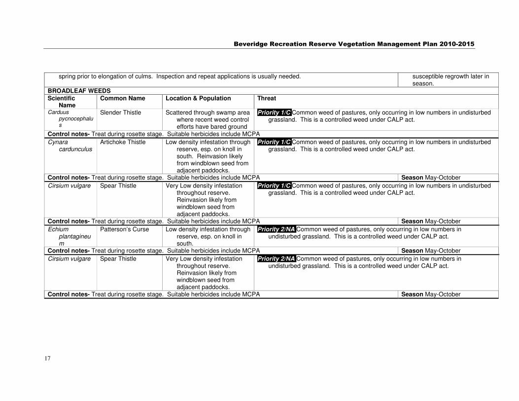
BROADLEAF WEEDS
Scientific Name
Common Name Location & Population Threat
Carduus pycnocephalus
Slender Thistle Scattered through swamp area where recent weed control efforts have bared ground
Priority 1/C Common weed of pastures, only occurring in low numbers in undisturbed grassland. This is a controlled weed under CALP act.
Control notes- Treat during rosette stage. Suitable herbicides include MCPA
Cynara cardunculus
Artichoke Thistle Low density infestation through reserve, esp. on knoll in south. Reinvasion likely from windblown seed from adjacent paddocks.
Priority 1/C Common weed of pastures, only occurring in low numbers in undisturbed grassland. This is a controlled weed under CALP act.
Control notes- Treat during rosette stage. Suitable herbicides include MCPA Season May-October
Cirsium vulgare Spear Thistle Very Low density infestation throughout reserve. Reinvasion likely from windblown seed from adjacent paddocks.
Priority 1/C Common weed of pastures, only occurring in low numbers in undisturbed grassland. This is a controlled weed under CALP act.
Control notes- Treat during rosette stage. Suitable herbicides include MCPA Season May-October
Echium plantagineum
Patterson’s Curse Low density infestation through reserve, esp. on knoll in south.
Priority 2/NA Common weed of pastures, only occurring in low numbers in undisturbed grassland. This is a controlled weed under CALP act.
Control notes- Treat during rosette stage. Suitable herbicides include MCPA Season May-October
Cirsium vulgare Spear Thistle Very Low density infestation throughout reserve. Reinvasion likely from windblown seed from adjacent paddocks.
Priority 2/NA Common weed of pastures, only occurring in low numbers in undisturbed grassland. This is a controlled weed under CALP act.
Control notes- Treat during rosette stage. Suitable herbicides include MCPA Season May-October

Beveridge Recreation Reserve Vegetation Management Plan 2010-2015
18
4.2 Open space categorisation Categorisation of the vegetation zones in the Reserve are described below. These zones are mapped in section
8.5 Appendix 5. Vegetation Management Zones for Beveridge Community Park. � Table 4.2-1Open Space Categorisation
Zone Issues at Beveridge Community Park Authorised uses
Recreation Zone
Carry only traces of indigenous vegetation, of species with low conservation significance where ‘higher impact’ recreation or other community use is the primary land use goal.
4.96 hectares (50 %) of the reserve is to be managed as Recreation Zone.
Recreation relies on hard-wearing mown areas and structures that are typically maintained by council staff or community without specific vegetation management skills.
Management activities in other parts of the reserve should ensure they do not cause this vegetation to become unsuitable for designated activities.
Some management may be needed to ensure serious exotic weeds in this zone are treated so they do not pose a threat to Habitat Zone vegetation.
Amenity plantings in this zone may complement or, conversely, impact negatively on Habitat Zone vegetation so should be developed in consultation with managers of the Habitat Zone vegetation.
Equestrian uses, ball games, 'dogs off-lead' areas, visitor facilities such as BBQs, picnic tables. Delineation/allocation of areas between such uses is outside of
Informal Parkland
Zone
Carry only traces of indigenous vegetation of species with low conservation significance but has value for wildlife due to its seclusion and interaction with Habitat Zones.
1.26 hectares (14%) of the parkland is to be managed as Informal Parkland Zone
These areas need to be maintained to ensure no adverse impact on either habitat or recreation zones. Most of this area currently consists of exotic pasture grasses which it is proposed to maintain in a slashed condition to reduce fire risk and make suitable for low-impact recreation.
Areas of this Zone may be suitable for revegetation to enhance the Habitat Zone.
Walking, dogs on-lead, informal ball games, general nature appreciation
Habitat Zone
Land containing remnant indigenous vegetation in the process of restoration Primarily for flora and fauna conservation rather than recreation.
3.47 hectares (36%) to be managed as Habitat Zone
Fencing and interpretation signage may assist public recognition and acceptance of conservation based management which should include allowing dead trees to stand and biomass burning. A boardwalk through the swamp is possible.
Biomass reduction in a staged manner will be needed for the Stony Knoll areas at perhaps 3-5 year intervals. Aim to ensure patches of unburnt/slashed area are retained as refuge but that all areas get treated over time resulting in a vegetation ‘mosaic’.
Walking, nature appreciation from defined paths
Roadside Zone
Land outside fence, generally with only traces of indigenous vegetation.
0.52 hectares of roadside abut the north and western boundaries of the reserve. Likely to be subject to disturbance by utilities maintenance, informal parking etc.
Mostly maintained by council roadside crews.
Walking, parking overflow for large events, access for
Beveridge Recreation Reserve Vegetation Management Plan 2010-2015
19
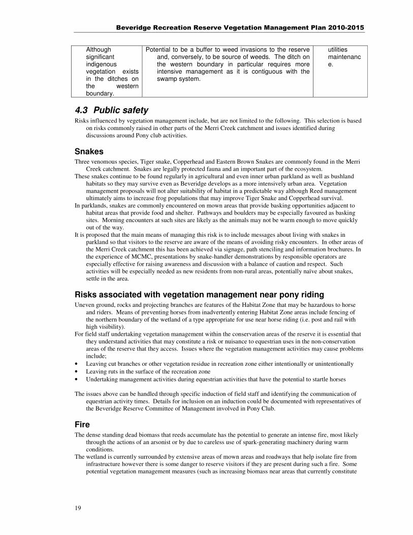
Although significant indigenous vegetation exists in the ditches on the western boundary.
Potential to be a buffer to weed invasions to the reserve and, conversely, to be source of weeds. The ditch on the western boundary in particular requires more intensive management as it is contiguous with the swamp system.
utilities maintenance.
4.3 Public safety Risks influenced by vegetation management include, but are not limited to the following. This selection is based
on risks commonly raised in other parts of the Merri Creek catchment and issues identified during discussions around Pony club activities.
Snakes Three venomous species, Tiger snake, Copperhead and Eastern Brown Snakes are commonly found in the Merri
Creek catchment. Snakes are legally protected fauna and an important part of the ecosystem. These snakes continue to be found regularly in agricultural and even inner urban parkland as well as bushland
habitats so they may survive even as Beveridge develops as a more intensively urban area. Vegetation management proposals will not alter suitability of habitat in a predictable way although Reed management ultimately aims to increase frog populations that may improve Tiger Snake and Copperhead survival.
In parklands, snakes are commonly encountered on mown areas that provide basking opportunities adjacent to habitat areas that provide food and shelter. Pathways and boulders may be especially favoured as basking sites. Morning encounters at such sites are likely as the animals may not be warm enough to move quickly out of the way.
It is proposed that the main means of managing this risk is to include messages about living with snakes in parkland so that visitors to the reserve are aware of the means of avoiding risky encounters. In other areas of the Merri Creek catchment this has been achieved via signage, path stenciling and information brochures. In the experience of MCMC, presentations by snake-handler demonstrations by responsible operators are especially effective for raising awareness and discussion with a balance of caution and respect. Such activities will be especially needed as new residents from non-rural areas, potentially naïve about snakes, settle in the area.
Risks associated with vegetation management near pony riding Uneven ground, rocks and projecting branches are features of the Habitat Zone that may be hazardous to horse
and riders. Means of preventing horses from inadvertently entering Habitat Zone areas include fencing of the northern boundary of the wetland of a type appropriate for use near horse riding (i.e. post and rail with high visibility).
For field staff undertaking vegetation management within the conservation areas of the reserve it is essential that they understand activities that may constitute a risk or nuisance to equestrian uses in the non-conservation areas of the reserve that they access. Issues where the vegetation management activities may cause problems include;
• Leaving cut branches or other vegetation residue in recreation zone either intentionally or unintentionally
• Leaving ruts in the surface of the recreation zone
• Undertaking management activities during equestrian activities that have the potential to startle horses The issues above can be handled through specific induction of field staff and identifying the communication of
equestrian activity times. Details for inclusion on an induction could be documented with representatives of the Beveridge Reserve Committee of Management involved in Pony Club.
Fire The dense standing dead biomass that reeds accumulate has the potential to generate an intense fire, most likely
through the actions of an arsonist or by due to careless use of spark-generating machinery during warm conditions.
The wetland is currently surrounded by extensive areas of mown areas and roadways that help isolate fire from infrastructure however there is some danger to reserve visitors if they are present during such a fire. Some potential vegetation management measures (such as increasing biomass near areas that currently constitute

Beveridge Recreation Reserve Vegetation Management Plan 2010-2015
20
fuel breaks) have the potential to increase fire risk. Other activities, (such as reed-management) may reduce the fuel risk.
• Reduce risk through proposals to reduce the extent of the wetland dominated by tall reed vegetation for habitat and biodiversity purposes
• Identify with CFA officers the area where fuel gaps need to be are maintained or enhanced
• Ensure field staff are aware of, and adhere to, directives for use of machinery in areas during high fire risk weather
• Ensure recreational activities involving fire (e.g. Fireworks, bonfires, campfires) only occur in areas that do not constitute a risk and are strictly controlled through appropriate signage and open space risk managmeent protocols for community events
• Undertake fuel reduction either through fire or biomass removal as a part of reed management
Falling dead standing trees that have been retained as habitat Dead trees are highly valuable for habitat (as perches/basking sites for wildlife, food and shelter for a wide range
of invertebrates) however these can constitute a hazard in areas with high visitor use due to risk of falling limbs or trees.
Visitor occupancy of the Habitat Zones is limited and the risk of falling trees within this zone is low however dead trees on the margins of the Habitat Zone that may fall into Recreation Zone could constitute a risk.
Council or field staff responsible for maintaining remnant vegetation should broadly assess the risk level that a dead tree constitutes and, when a hazard is suspected, alert the appropriate authority to arrange for inspection or felling to occur. The size and lean of the dead tree will influence which individual trees constitute a hazard.
Trees deemed hazardous should be felled in a controlled manner both to avoid the immediate risk to reserve users and also the hazard that unexpected fallen limbs may constitute to equestrian activities.
Retaining felled trees in the conservation zone is a way of retaining many of the biodiversity values of dead tree on site and is preferred to removing where feasible.
5 Monitoring and evaluation A monitoring program for some vegetation management actions proposed for the reserve is described in Table
5.1. This monitoring is an essential minimum to be able to fulfill ‘adaptive management’ approach and should therefore be considered in the design of any project and appropriately resourced.
� 5-1 Monitoring Program
Monitoring question
Aim of monitoring Measurable
attribute
Survey intensity
Season
1. What progress has been made on eradication of High Priority and selected second priority weeds
Assess progress towards eradication and highlight need for any change in control efforts (e.g. Increase, changed focus of attention, cessation)
Presence and extent of weed species
Annual Will vary with species but a late spring (October) will provide allow monitoring to double as site inspection for early summer control measures for many of the weed species
2. Assess plant establishment of under revegetation activities
To identify issues with plant establishment to inform decisions to follow up plantings or design of future plantings.
Survivorship counts, assess general health,

Beveridge Recreation Reserve Vegetation Management Plan 2010-2015
21
Additional monitoring activities that could be considered by the land manager include;
• Swamp Tigertail Dragonfly habitat use
• Habitat hectare assessments of swamp as a whole

Beveridge Recreation Reserve Vegetation Management Plan 2010-2015
22
6 Implementation and Management Actions 5 years In the following tables, notional cost is $ <$1000, $1000<$$<$10,000, $$$ >$10,000 Beveridge RR COM = the Committee of Management of the Beveridge Recreation Reserve ARCUE = Australian Research Centre for Urban Ecology. VNPA = Victorian National Parks Association.
6.1 Context Actions These actions will improve the information base for further planning and refinement of management actions. Some of these investigations may identify additional projects or
provide information that will support further grant applications.
Management issue & cross reference this report
Management Goal Management Action
Timing
Priority
Responsibility
Organisation partners
Notional Cost
Ecological rationale and contingencies
C1. Potential for enhanced habitat connectivity along Kalkallo Creek is unknown. See 0
Identify projects to maximise habitat connectivity of the Community reserve along Kalkallo Creek are identified
Do a desktop assessment of open space and private land with potential for habitat enhancement, identify attitude of relevant landholders.
2014 Medium
MW, Mitchell
Adjacent landholders, MCMC
$ Long-term survival of some flora and fauna in the reserve is contingent on sympathetic management downstream
C2. Vegetation characterisation is provisional See 0
Have a well-founded reference state identified including restoration targets and species reintroduction lists
Contract botanical consultant with expertise in wetland characterisation
2014 Low Mitchell
MCMC, DSE $ Well founded ecological descriptions are critical to a more comprehensive effective restoration.
C3. Fauna data is out of date See 0
Community-based fauna monitoring activities in place with methodical documentation of results
Liaise with groups that already carry out similar monitoring
2013 Medium
MCMC
FOMC, Wallan Environment Group, Bird Observer Club, VNPA, Educational institutions, ARCUE
$ Fauna usage of the reserve is important for refining vegetation/habitat prescriptions
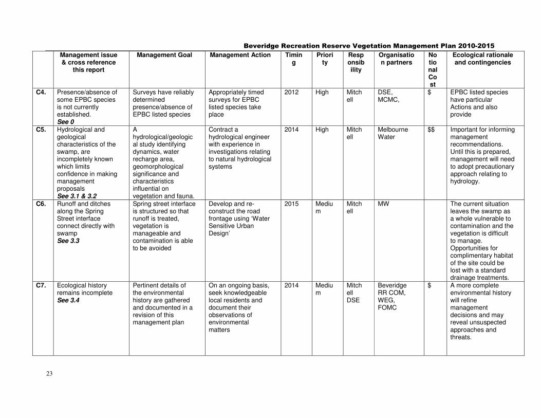
Beveridge Recreation Reserve Vegetation Management Plan 2010-2015
23
Management issue & cross reference
this report
Management Goal Management Action
Timing
Priority
Responsibility
Organisation partners
Notional Cost
Ecological rationale and contingencies
C4. Presence/absence of some EPBC species is not currently established. See 0
Surveys have reliably determined presence/absence of EPBC listed species
Appropriately timed surveys for EPBC listed species take place
2012 High Mitchell
DSE, MCMC,
$ EPBC listed species have particular Actions and also provide
C5. Hydrological and geological characteristics of the swamp, are incompletely known which limits confidence in making management proposals See 3.1 & 3.2
A hydrological/geological study identifying dynamics, water recharge area, geomorphological significance and characteristics influential on vegetation and fauna.
Contract a hydrological engineer with experience in investigations relating to natural hydrological systems
2014 High Mitchell
Melbourne Water
$$ Important for informing management recommendations. Until this is prepared, management will need to adopt precautionary approach relating to hydrology.
C6. Runoff and ditches along the Spring Street interface connect directly with swamp See 3.3
Spring street interface is structured so that runoff is treated, vegetation is manageable and contamination is able to be avoided
Develop and re-construct the road frontage using ‘Water Sensitive Urban Design’
2015 Medium
Mitchell
MW The current situation leaves the swamp as a whole vulnerable to contamination and the vegetation is difficult to manage. Opportunities for complimentary habitat of the site could be lost with a standard drainage treatments.
C7. Ecological history remains incomplete See 3.4
Pertinent details of the environmental history are gathered and documented in a revision of this management plan
On an ongoing basis, seek knowledgeable local residents and document their observations of environmental matters
2014 Medium
Mitchell DSE
Beveridge RR COM, WEG, FOMC
$ A more complete environmental history will refine management decisions and may reveal unsuspected approaches and threats.

Beveridge Recreation Reserve Vegetation Management Plan 2010-2015
24
Management issue & cross reference
this report
Management Goal Management Action
Timing
Priority
Responsibility
Organisation partners
Notional Cost
Ecological rationale and contingencies
C8. Amenity plantings in non-Habitat Zone should be compatible with environmental management. See 3.5
Plantings in reserve are fulfilliing amenity and management needs and maximise habitat values.
Develop a planting scheme, principles that identifies a plant pallette.
2015 Medium
Mitchell,
Beveridge RR COM
Planting schemes and plant pallettes will increase the likelihood that these will complement and enhance ecological restoration works.
C9. Habitat needs of Swamp Tigertail dragonfly is unknown. See 3.6
Areas of critical habitat identified and dynamics of retaining suitable habitat identified and reflected in vegetation management plan.
Observation and documentation of critical habitat including favoured courtship, feeding and oviposition sites. Ideally involving community volunteers and educational institutions.
2015 Medium
Mitchell, Educational institutions. WEG, FOMC
$ There is potential for habitat restoration works to impact on dragonfly population due to ignorance of critical habitat needs.
C10. Landscape/visual amenity issues are currently un-planned and will be increasingly impacted by development around the reserve. See 3.7
Landscaping and maintenance actions are in place that is in place that protect and enhance the Reserve’s visual amenity into the future.
An assessment of visual amenity assets of the reserve and future impacts and recommendations for adjacent development complying with the points identified in the Merri Creek and Environs Strategy
2013 Low Mitchell
Beveridge RR COM
$$ Landscaping works have the potential to enhance or degrade ecological values of the Reserve and planning will prevent negative impacts resulting from ad-hoc developments.
C11. Aboriginal heritage assessment has not been carried out in the reserve and its values are unknown. See 0
Aboriginal Heritage assessment has been completed and recommendations reflected in management.
Aboriginal Heritage assessment commissioned and implications of findings disseminated to stakeholders.
2011 High Mitchell
Beveridge RR COM
$$ Aboriginal heritage values may be affected by vegetation management. Guidelines based on an assessment will ensure these are aligned

Beveridge Recreation Reserve Vegetation Management Plan 2010-2015
25
Management issue & cross reference
this report
Management Goal Management Action
Timing
Priority
Responsibility
Organisation partners
Notional Cost
Ecological rationale and contingencies
C12. The values of non-indigneous heritage on the site is unassessed
Non-indigenous heritage features assessed and irecommendations reflected in management
Non-indigenous heritage assessment commissioned and implications of findings disseminated to stakeholders
2012 Medium
Mitchell
Beveridge RR COM, Adjacent landholders with drystone wall and ruins
$$ Non-indigenous heritage values may be affected by vegetation management activities- most makedly Elm and privet eradication. Having guidelines based on an assessment will ensure these are aligned
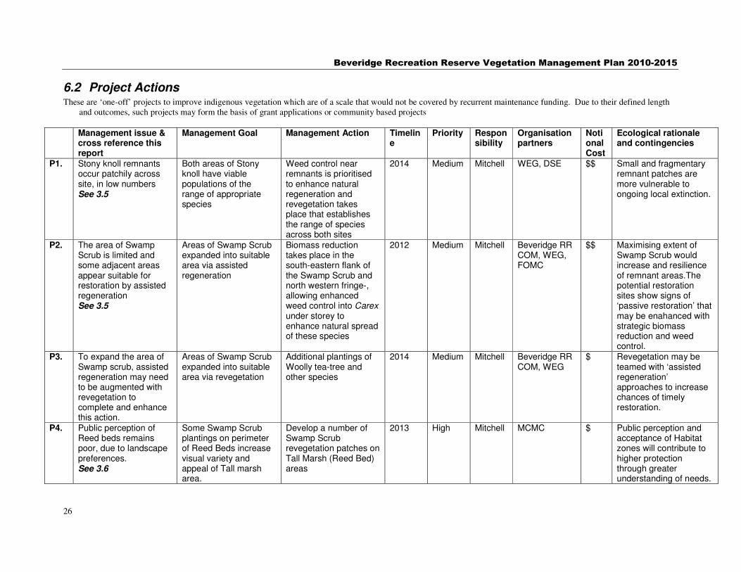
Beveridge Recreation Reserve Vegetation Management Plan 2010-2015
26
6.2 Project Actions These are ‘one-off’ projects to improve indigenous vegetation which are of a scale that would not be covered by recurrent maintenance funding. Due to their defined length
and outcomes, such projects may form the basis of grant applications or community based projects
Management issue & cross reference this report
Management Goal Management Action
Timeline
Priority Responsibility
Organisation partners
Notional Cost
Ecological rationale and contingencies
P1. Stony knoll remnants occur patchily across site, in low numbers See 3.5
Both areas of Stony knoll have viable populations of the range of appropriate species
Weed control near remnants is prioritised to enhance natural regeneration and revegetation takes place that establishes the range of species across both sites
2014 Medium Mitchell
WEG, DSE $$ Small and fragmentary remnant patches are more vulnerable to ongoing local extinction.
P2. The area of Swamp Scrub is limited and some adjacent areas appear suitable for restoration by assisted regeneration See 3.5
Areas of Swamp Scrub expanded into suitable area via assisted regeneration
Biomass reduction takes place in the south-eastern flank of the Swamp Scrub and north western fringe-, allowing enhanced weed control into Carex under storey to enhance natural spread of these species
2012 Medium Mitchell Beveridge RR COM, WEG, FOMC
$$ Maximising extent of Swamp Scrub would increase and resilience of remnant areas.The potential restoration sites show signs of ‘passive restoration’ that may be enahanced with strategic biomass reduction and weed control.
P3. To expand the area of Swamp scrub, assisted regeneration may need to be augmented with revegetation to complete and enhance this action.
Areas of Swamp Scrub expanded into suitable area via revegetation
Additional plantings of Woolly tea-tree and other species
2014 Medium Mitchell Beveridge RR COM, WEG
$ Revegetation may be teamed with ‘assisted regeneration’ approaches to increase chances of timely restoration.
P4. Public perception of Reed beds remains poor, due to landscape preferences. See 3.6
Some Swamp Scrub plantings on perimeter of Reed Beds increase visual variety and appeal of Tall marsh area.
Develop a number of Swamp Scrub revegetation patches on Tall Marsh (Reed Bed) areas
2013 High Mitchell MCMC $ Public perception and acceptance of Habitat zones will contribute to higher protection through greater understanding of needs.

Beveridge Recreation Reserve Vegetation Management Plan 2010-2015
27
Management issue & cross reference this report
Management Goal Management Action
Timeline
Priority Responsibility
Organisation partners
Notional Cost
Ecological rationale and contingencies
P5. Safety issues exist where Recreation zone and Habitat Zone are not well defined See 0
Post and rail fencing in place to prevent pony access to Habitat zones. Induction for field staff working near horses.
Conduct liaison to discuss and act on the safety issues identified in this report in 4.3.2
2010 High Mitchell Beveridge RR COM, MCMC
$$ Appropriate definition of interfaces will avoid the installation of inappropriate or inadequate measures
P6. Snake hazard in the reserve is inadequately identified for csual users and many potentially naïve new residents will soon move into area. See 0
Snake hazard is appropriately signposted in the reserve and effective interpretation on issue is regularly occurring in township
Develop appropriate messages for signage around snakes and institute snake handler demonstrations to occur locally at least every three years.
2011 Medium Mitchell Beveridge RR COM, Mitchell
$ Snake awareness is vital to safe appreciation of biodiversity values of reserve and community support for conservation measures.
P7. Elm and Privet infestation on the southern boundary threatens swamp, drystone wall and prevents revegetation or amenity planting. See 0
Eradication of elms and privet on Reserve and on adjacent private property.
Grooming followed by herbicide application conducted in conjunction with adjacent landholder
2012 High Mitchell, Adjacent landholder
MCMC $$$ Because of suckering habit, Elm and Privet will continue to be a menace to environmental values unless eradicated.
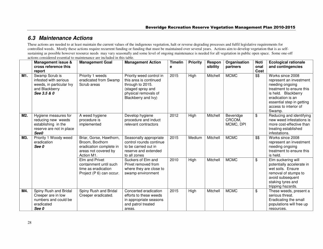
Beveridge Recreation Reserve Vegetation Management Plan 2010-2015
28
6.3 Maintenance Actions These actions are needed to at least maintain the current values of the indigenous vegetation, halt or reverse degrading processes and fulfil legislative requirements for controlled weeds. Mostly these actions require recurrent funding or funding that must be maintained over several years. Actions aim to develop vegetation that is as self-sustaining as possible however resource needs may vary seasonally and some level of ongoing maintenance is needed for all vegetation in public open space. Some one-off actions considered essential to maintenance are included in this table.
Management issue & cross reference this report
Management Goal Management Action
Timeline
Priority Responsibility
Organisation partners
Notional Cost
Ecological rationale and contingencies
M1. Swamp Scrub is infested with serious weeds, in particular Ivy and Blackberry See 3.5 & 0
Priority 1 weeds eradicated from Swamp Scrub areas
Priority weed control in this area is continued through to 2015. (staged spray and physical removals of Blackberry and Ivy)
2015 High Mitchell MCMC $$ Works since 2008 represent an investment needing ongoing treatment to ensure this is held. Blackberry eradication is an essential step in getting access to interior of Swamp.
M2. Hygiene measures for reducing new weeds establishing in the reserve are not in place See0
A weed hygiene procedure is implemented
Develop hygiene procedure and induct relevant contractors
2012 High Mitchell Beveridge CRCOM, MCMC, DPI
$ Reducing and identifying new weed infestations is more cost-effective than treating established infestations.
Briar, Gorse, Hawthorn, Broom, Boxthorn eradication complete in areas not covered by Action M1.
Seasonally appropriate control rounds continue to be carried out in reserve and extended to all zones
2015 Medium Mitchell
MCMC $$ Works since 2008 represent an investment needing ongoing treatment to ensure this is held.
M3. Priority 1 Woody weed eradication See 0
Elm and Privet containment until such time as eradication Project (P 6) can occur.
Suckers of Elm and Privet removed from where they are close to swamp environment
2010 High Mitchell MCMC $ Elm suckering will potentially accelerate in wet soils. Ensure removal of stumps to avoid subsequent staking tyres and tripping hazards.
M4. Spiny Rush and Bridal Creeper are in low numbers and could be eradicated See 0
Spiny Rush and Bridal Creeper eradicated.
Concerted eradication efforts to these weeds in appropriate seasons and patrol treated areas.
2015 High Mitchell MCMC $ These weeds, present a serious threat. Eradicating the small populations will free up resources.
Beveridge Recreation Reserve Vegetation Management Plan 2010-2015
29
Management issue & cross reference this report
Management Goal Management Action
Timeline
Priority Responsibility
Organisation partners
Notional Cost
Ecological rationale and contingencies
M5. Priority 1 Broadleaf weeds persist and require consistent management to eradicate
Artichoke thistle, Patterson’s Curse and other Thistles eradicated and re-invasions prevented from seeding
Schedule weed constorl rounds and patrols for at least three visits per year in order to break floweing/seedign cycle.
2014 High Mitchell MCMC $$ These Controlled weed species are at low numbers but require consistent treatment over a period of approx three years to exhaust soil-stored sed banks and then patrolling to prevent re-establishment.
M6. Ecological burning is occurring but is currently un-programmed, reducing potential for coordinated weed control and restoration. See 3.6, 0 & 0, 0
Burning across reserve is occurring in predictable pattern that fulfils ecological and safety needs and is aligned with weed management.
Develop a burn regime for Stony Knoll and for Tall Marsh areas of the site with consultation between council, CFA and MCMC
2011 Medium Mitchell CFA, MCMC $ Burn regimes facilitate long-term planning, resourcing and maximise effectiveness of other restoration efforts.
M7. Slashed fuel breaks around the reserve are not continuous on the stony knoll on southern boundary or swamp on western boundary See 0, 0
Biomass on Stony knoll is maintained at a safe level. Tall Marsh vegetation on the western Roadside Zone has a maintenance regime that reduces biomass in an ecologically sensitive manner.
Identify a slashing and weed management regime for the Western Roadside interface. Carry out biomass reduction on the Stony Knoll as per Action M7.
2010 High Mitchell CFA, MCMC $$ Slashing for fuel breaks has potential to impact negatively on environmental values. Conversely, there are efficiencies in aligning weed control and fuel reduction actions.
M8. Roadsides are not currently subject to a weed control program aligned with Reserve needs. See 0
Priority weeds on roadside eradicated and weed hygeine measures implemented in conjunction with Roadside maintenance crews
Identify stakeholders and develop and implement a specific weed eradication scheme for this area, or extend management resources from Reserve into Roadside Zone
2011 Medium Mitchell MCMC $ Priority weeds on the Roadside Zone threaten vegetation improvement works inside the Reserve.
Management issue & Management Goal Management Action Timelin Priority Respon Organisation Noti Ecological rationale
Beveridge Recreation Reserve Vegetation Management Plan 2010-2015
30
cross reference this report
e sibility
partners onal Cost
and contingencies
M9. Strategies identified in this report will require understanding and cooperation of Reserve users and stakeholders See 0, 4.3
Stakeholders have understanding of, have commented on and support Actions identified in this report.
Vegetation Management Plan to be presented to the Beveridge Recreation Reserve Committee of Management for consideration and amendment if necessary- in particular those issues identified in Section 3.10.2 and 4.3
2012 Medium Mitchell Beveridge RR COM, MCMC
$ Successful application of the actions in this report will require aligned goals from all stakeholders.
M10. Dead standing trees are important habitat but can be a risk to Reserve visitors See 0
Standing dead trees that present a risk are ideintified and felled in a timely manner
Field staff are instructed to consider the risk posed by standing dead trees as part of routine vegetation managmeent works and report risks to Mitchell Council for felling
2010 High Mitchell MCMC, Beveridge RR COM
NA Standing dead trees are valuable habitat but cannot be allowed to remain where they cause a risk.
M11. Monitoring is needed to assess success of vegetation management actions See 5
Monitoring is occurring for significant vegetation management actions.
Monitoring Program identified in Table 5.1 are appreoved and resources included in maintenance program.
2010 High Mitchell MCMC $ Monitoring is an essential activity for adaptive management in ecological restoration.

Beveridge Recreation Reserve Vegetation Management Plan 2010-2015
31
7 References Beardsell, C. 1997 Sites of Faunal and Habitat Significance in the North East Melbourne, A report prepared for the
North-East Region of Councils (NEROC) by Dunmoochin Biological Surveys, Melbourne. Department of Natural Resources and Environment (NRE) 2002 Victoria’s Native Vegetation Management – A
framework for Action Department of Sustainability and Environment (DSE) 2003 Biodiversity Action Planning. Landscape Plan for the
Craigieburn Zone in the Victorian Volcanic Plain Bioregion. (Draft May 2003) Department of Sustainability and Environment (DSE) 2004 EVC/Bioregion Benchmark for Vegetation Quality
Assessment, Victorian Volcanic Plain bioregion, EVC 132_61: Heavier-soils Plains Grassland. http://www.dse.vic.gov.au/conserv/EVC-PDF/VVP_0132_61.pdf (Viewed 16/11/09)
Department of Sustainability and Environment (DSE) 2005a Biosites, Maps and Reports for Land and Water
Management Agencies, Port Phillip Region The State of Victoria Department of Sustainability & Environment (CD-ROM)
Department of Sustainability and Environment (DSE) 2005b The Index of Wetland Condition. Conceptual framework
and selection of measures P. 2 Department of Environment, Water, Heritage and the Arts 2009 Farming and Nationally Protected Grasslands and
Woodlands of the Victorian Volcanic Plain. http://www.environment.gov.au/epbc/publications/pubs/grasslands-victoria-fact-sheet.pdf (Viewed 5/1/10)
Ecological Consulting Services 2009. Spring Street Swamp Assessment. Unpublished report for Mitchell Shire
Council. Newport. Frood, Douglas, 1992, Vegetation of the Native Grasslands in the Merri Creek Valley, Outer Melbourne Area,
Ecological survey report No. 92 Department of Conservation & Environment Land Conservation Council 1994 Melbourne Area District 2 Review Final Recommendations July 1994
http://www.veac.vic.gov.au/lcc/melbdist2part1.pdf (Viewed 4 /1/10) McMahon, A.R.G. and Schulz, M. 1993 Merri Creek Concept Plan. Flora and Fauna Report by Ecological
Horticulture Pty. Ltd for Merri Creek Management Committee and Melbourne Water. Melway 2011 Melway Greater Melbourne Ed. 38. Melway Publishing Pty. Ltd. Mount Waverley Merri Creek Management Committee 2009 Merri Creek and Environs Strategy 2009-2014 Merri Creek Management
Committee, Melbourne Mitchell Shire Council 2006 Beveridge Recreation Reserve Master plan Unpublished report commissioned by Mitchell
Shire Council Mitchell Shire Council 2009 Council Plan 2009-2013 p 8.
http://www.mitchellshire.vic.gov.au/Files/CouncilPlan_2009-2013_July1509.pdf (Viewed 11/12/09) Muyt, Adam 2001 Bush Invaders of South-East Australia. R.J. & F.J. Richardson, Meredith Port Phillip & Westernport Catchment Management Authority, 2006, Port Phillip and Westernport Native Vegetation
Plan, Port Phillip and Westernport Catchment Management Authority Queensland Government, 2005 Wetland Management Profile Great Artesian Basin spring Published by Ecosystem
Conservation Branch, EPA Queensland. (Viewed 17 June 2010 http://www.derm.qld.gov.au/register/p01718aa.pdf)
Richardson, F. J., Richardson, R. G. and Shepherd, R. C. H. 2006, Weeds of the south-east: an identification guide for
Australia. R. G. and F. J. Richardson

Beveridge Recreation Reserve Vegetation Management Plan 2010-2015
32
Vallee, L., Hogbin, T., Monks, L., Makinson, B., Matthes, M. and Rossetto, M. 2004, Guidelines for the Translocation
of Threatened Plants in Australia 2nd
Ed. Australian Network for Plant Conservation. Canberra Walsh, N. G and Stajsic, V. 2007, A Census of the Vascular Plants of Victoria 8th Ed. Royal Botanic Gardens,
Melbourne
Beveridge Recreation Reserve Vegetation Management Plan 2010-2015
33
8 Appendices
8.1 Appendix 1. Table of Plant species present in the reserve ‘*’ indicates and exotic, ‘#’ non-indigenous native plant
Species Common name Beveri
dge R
ec.
Res.,
A
SE
Corn
er
Beveri
dge R
ec.
Res.,
B
Tea t
ree t
hic
ket sw
am
p
Beveri
dge R
ec.R
es.
, C
K
noll
Beveri
dge R
ec.R
es.
, D
O
pen S
wam
p
Beveri
dge R
ec.
Res.,
E
SW
Corn
er
Beveri
dg
e R
ec.R
es., F
N
ort
hern
Pad
dock
Beveri
dg
e R
ec.R
es., G
N
ort
hern
Kn
oll
Beveri
dge R
ec.R
es.
, H
R
oadsid
e
Be
v.
Rec. R
es. T
OT
AL
Acacia mearnsii Black Wattle 1 1 2
Acacia melanoxylon Blackwood 1 1 1 3
Acaena novae-zelandiae Bidgee Widgee 1 1
Acaena ovina Sheep's Burr 1 1
* Acetosella vulgaris Sheep Sorrel 1 1 2
* Aira caryophyllea Silvery Hair Grass 1 1
* Amaryllis belladonna Easter Lily 1 1
Apium prostrata Native Celery 1 1 2
* Aptenia cordifolia Heart-leaf Ice Plant 1 1
Arthropodium strictum Chocolate lily 1 1
Arthropodium minus Small Vanilla lily 1 1
* Arctotheca calendula Capeweed 1 1 2
* Artemisia arborescens Silver Wormwood 1 1
* Aster subulatus Aster-weed 1 1
* Atriplex prostrata Hastate Orache 1 1
Austrodanthonia caespitosa Common Wallaby Grass 1 1 1 1 1 5
Austrodanthonia fulva Leafy Wallaby Grass 1 1
Austrodanthonia geniculata Kneed Wallaby Grass 1 1
Austrodanthonia penicillata Slender Wallaby Grass 1 1 1 3
Austrodanthonia racemosa Stiped Wallaby Grass 1 1 1 3
Austrostipa bigeniculata Kneed Spear-grass 1 1
Austrostipa oligostachya Spear Grass 1 1
Austrostipa scabra ssp.falcata Slender Spear-grass 1 1
* Brassica fruticulosa Twiggy Turnip 1 1
* Briza maxima Large Quaking Grass 1 1
* Bromus catharticus Prairie Grass 1 1 2
* Bromus diandrus Rip gut Brome 1 1
Calystegia sepium Large Bindweed 1 1 2
* Carduus pycnocephalus Slender Thistle 1 1 2
Carex appressa Tall Sedge 1 1
Carex fascicularis Tassel Sedge 1 1 2
Carex gaudichaudiana Fen Sedge 1 1
* Centaurium erythraea Common Centaury 1 1
* Chenopodium album Fat Hen 1 1 2
Chenopodium pumilio Small Crumb-weed 1 1
* Cirsium vulgare Spear Thistle 1 1 1 1 4
Crassula helmsii Water Stonecrop 1 1
Crassula sieberi Stonecrop 1 1
Beveridge Recreation Reserve Vegetation Management Plan 2010-2015
34
Species Common name Beveri
dge R
ec.
Res.,
A
SE
Corn
er
Tea tre
e t
hic
ket
swam
p
Beveri
dg
e R
ec.R
es.,
C K
noll
Beveri
dg
e R
ec.R
es.,
D O
pen S
wam
p
Beveri
dge R
ec.
Res.,
E
SW
Corn
er
Beveri
dg
e R
ec.R
es., F
N
ort
hern
Pad
dock
Beveri
dg
e R
ec.R
es.,
G N
ort
hern
Knoll
Beveri
dg
e R
ec.R
es.,
H R
oad
sid
e
Be
v.
Re
c.
Res.
TO
TA
L
Convolvulus erubescens sensu lato Blushing Bindweed 1 1
* Conyza spp. Flea-bane 1 1
* Coprosma repens Mirror Bush 1 1
* Crataegus monogyna Hawthorn 1 1 2
* Cynara cardunculus Spanish Artichoke 1 1 1 3
Cynoglossum suaveolens Sweet Hound's-tongue 1 1
* Cynosurus echinatus Rough Dog's Tail 1 1
* Dactylis glomerata Cock's-foot 1 1 1 1 1 5
* Echium plantagineum Patterson's Curse 1 1 2
Einadia nutans Nodding Saltbush 1 1
* Ehrharta longiflora Annual Veldt Grass 1 1
Eleocharis acuta Common Spike-rush 1 1
Elymus scaber var. scaber Wheat-grass 1 1
Epilobium billardieranum Smooth Willow Herb 1 1
# Eucalyptus cladocalyx Sugar Gum 1 1
* Festuca arundinacea Tall Fescue 1 1
* Fumaria muralis Wall Fumitory 1 1
* Galium aparine Cleavers 1 1 2
* Genista monspessulana Montpellier Broom 1 1
Geranium sp. 5 Naked Crane's Bill 1 1 2
* Hedera helix Common Ivy 1 1
* Helminthotheca echioides Bristly Ox-tongue 1 1 1 1 1 1 6
* Holcus lanatus Yorkshire Fog 1 1 1 3
* Hordeum marinum Salt Barley Grass 1 1
* Hypochoeris radicata Cat's Ear 1 1
Hypoxis glabella var. glabella Tiny Star 1 1
Isolepis cernua Nodding Club-sedge 1 1 2
* Juncus acutus Spiny Rush 1 1 2
* Juncus articulatus Jointed Rush 1 1
Juncus australis Austral Rush 1 1 2
* Lactuca saligna Willow-leaf Lettuce 1 1 2
* Lactuca serriola Prickly Lettuce 1 1 1 1 1 5
Lemna disperma Duckweed 1 1
* Lepidium africanum Common Pepper Cress 1 1
Leptospermum lanigerum Wooly Tea-tree 1 1 2
* Ligustrum vulgare European Privet 1 1
* Lolium perenne Perrenial Rye 1 1 1 3
Lomandra filiformis Wattle Mat Rush 1 1 2
* Lycium ferocissimum African Box-Thorn 1 1
* Malus cv. Apple 1 1
Melicytus dentatus Tree Violet 1 1
* Melilotus indicus Sweet Melilot 1 1
* Mentha spicata Common Mint 1 1
Microlaena stipoides var. stipoides Weeping Grass 1 1 1 3

Beveridge Recreation Reserve Vegetation Management Plan 2010-2015
35
Species Common name
Beveri
dge R
ec.
Res.,
A
SE
Corn
er
Beveri
dge R
ec.
Res.,
B
Tea t
ree t
hic
ket sw
am
p
Beveri
dge R
ec.R
es.
, C
K
noll
Beveri
dge R
ec.R
es.
, D
O
pen S
wam
p
Beveri
dge R
ec.
Res.,
E
SW
Corn
er
Beveri
dg
e R
ec.R
es., F
N
ort
hern
Pad
dock
Beveri
dg
e R
ec.R
es., G
N
ort
hern
Kn
oll
Beveri
dge R
ec.R
es.
, H
R
oad
sid
e
Be
v.
Rec. R
es. T
OT
AL
* Modiola caroliniana Carolina Mallow 1 1 1 3
* Nasturtium officionale Two-rowed Watercress 1 1 2
* Olea europaeus Olive 1 1
Oxalis perennans Wood Sorrel 1 1 1 1 4
* Paspalum dilatatum Paspalum 1 1 2
Pennisetum clandestinum Kikuyu 1 1
Persicaria prostrata Creeping Knotweed 1 1
* Phalaris aquatica Toowoomba Canary Grass 1 1 1 1 1 1 1 7
Phragmites australis Common Reed 1 1 1 3
* Pinus radiata Monterey Pine 1 1 2
# Pittosporum undulatum Sweet Pittosporum 1 1
* Plantago lanceolata Ribwort 1 1 1 1 1 1 6
* Poa pratensis English Meadow-grass 1 1 2
Poa sieberiana ssp. sieberiana Tussock Grass 1 1 2
* Podranea ricasoliana Port St. John Vine 1 1
* Polypogon monspessulana Common Beard Grass 1 1
Portulaca oleraceus Pigweed 1 1
* Prunus cerasifera Cherry Plum 1 1
* Romulea rosea var. australis Onion Grass 1 1 2
* Rosa CV a Moss Rose 1 1
* Rosa CV b Rose cultivar 1 1
* Rosa rubiginosa Briar Rose 1 1 1 3
* Rubus ulmifolius Blackberry 1 1 1 1 4
Rumex brownii Slender Dock 1 1 2
* Rumex crispus Curly Dock 1 1 1 3
Rumex dumosus Wiry Dock 1 1
* Rumex conglomeratus Clustered Dock 1 1
* Schinus molle Peppercorn 1 1
Senecio quadridentatus Cotton Fireweed 1 1
* Solanum nigrum Black Nightshade 1 1 2
* Sonchus asper ssp. asper Rough Milk Thistle 1 1 2
* Soncus oleraceus Milk Thistle 1 1 1 1 1 1 6
Tricoryne elatior Yellow Rush-lily 1 1
* Trifolium fragiferum Strawberry Clover 1 1 2
Typha domingensis Cumbungi 1 1 2
* Ulmus aff. procera English Elm 1 1
Urtica incisa Bush Nettle 1 1
Wahlenbergia luteola Yellowish Bluebell 1 1
TOTAL SPECIES 27 26 40 29 14 23 35 22 122
TOTAL NON_INDIGENOUS 22 17 21 18 11 13 17 15 69
TOTAL INDIGENOUS 5 9 19 11 3 10 18 7 53
‘C’ in CaLP Act refers to as ‘Regionally Controlled’ in the Port Phillip and Westernport region. See Section 0

Beveridge Recreation Reserve Vegetation Management Plan 2010-2015
36
8.2 Appendix 2. Weed species and to priority index
Species Common name CaLP category Threat Eradicability Priority Index Priority Ranking
Asparagus asparagoides Bridal Creeper Restricted High High 6 High Priority
Cynara cardunculus Spanish Artichoke Regionally Controlled High High 6 High Priority
Echium plantagineum Patterson's Curse Regionally Controlled High High 6 High Priority
Genista monspessulana Montpellier Broom Regionally Controlled High High 6 High Priority
Juncus acutus Spiny Rush Regionally Controlled High High 6 High Priority
Lycium ferocissimum African Box-Thorn Regionally Controlled High High 6 High Priority
Rubus sp. Blackberry Regionally Controlled High High 6 High Priority
Carduus pycnocephalus Slender Thistle Regionally Controlled Low High 5 High Priority
Cirsium vulgare Spear Thistle Regionally Controlled Low High 5 High Priority
Crataegus monogyna Hawthorn Regionally Controlled Low High 5 High Priority
Rosa rubiginosa Briar Rose Regionally Controlled Low High 5 High Priority
Festuca arundinacea Tall Fescue Uncategorised High High 4 Second Priority
Hedera helix Common Ivy Uncategorised High High 4 Second Priority
Ligustrum vulgare European Privet Uncategorised High High 4 Second Priority
Paspalum dilatatum Paspalum Uncategorised High High 4 Second Priority
Pinus radiata Monterey Pine Uncategorised High High 4 Second Priority
#Pittosporum undulatum Sweet Pittosporum Uncategorised High High 4 Second Priority
†Schinus molle Peppercorn Uncategorised High High 4 Second Priority
Ulmus aff. procera English Elm Uncategorised High High 4 Second Priority
Acetosella vulgaris Sheep Sorrel Uncategorised High Low 3 Second Priority
†Amaryllis belladonna Easter Lily Uncategorised Low High 3 Second Priority
Aptenia cordifolia Heart-leaf Ice Plant Uncategorised Low High 3 Second Priority
†Artemisia arborescens Silver Wormwood Uncategorised Low High 3 Second Priority
Atriplex prostrata Hastate Orache Uncategorised High Low 3 Second Priority
Dactylis glomeratus Cock's-foot Uncategorised High Low 3 Second Priority
Ehrharta longiflora Annual Veldt Grass Uncategorised High Low 3 Second Priority
#†Eucalyptus cladocalyx Sugar Gum Uncategorised Low High 3 Second Priority
Helminthotheca echioides Bristly Ox-tongue Uncategorised High Low 3 Second Priority
Holcus lanatus Yorkshire Fog Uncategorised High Low 3 Second Priority
Juncus articulatus Jointed Rush Uncategorised High Low 3 Second Priority
Lolium perenne Perrenial Rye Uncategorised High Low 3 Second Priority
†Malus cv. Apple Uncategorised Low High 3 Second Priority
Melilotus indicus Sweet Melilot Uncategorised Low High 3 Second Priority
Nasturtium officionale Two-rowed Watercress Uncategorised High Low 3 Second Priority
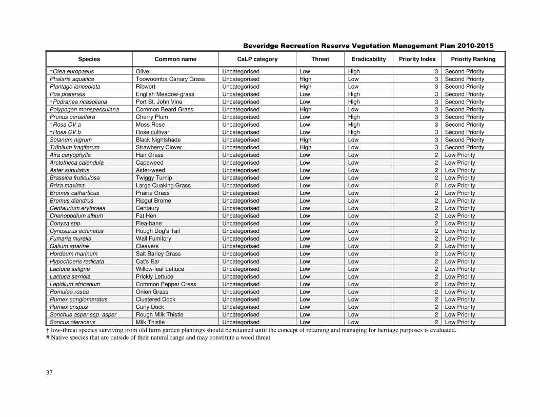
Beveridge Recreation Reserve Vegetation Management Plan 2010-2015
37
Species Common name CaLP category Threat Eradicability Priority Index Priority Ranking
†Olea europaeus Olive Uncategorised Low High 3 Second Priority
Phalaris aquatica Toowoomba Canary Grass Uncategorised High Low 3 Second Priority
Plantago lanceolata Ribwort Uncategorised High Low 3 Second Priority
Poa pratensis English Meadow-grass Uncategorised Low High 3 Second Priority
†Podranea ricasoliana Port St. John Vine Uncategorised Low High 3 Second Priority
Polypogon monspessulana Common Beard Grass Uncategorised High Low 3 Second Priority
Prunus cerasifera Cherry Plum Uncategorised Low High 3 Second Priority
†Rosa CV a Moss Rose Uncategorised Low High 3 Second Priority
†Rosa CV b Rose cultivar Uncategorised Low High 3 Second Priority
Solanum nigrum Black Nightshade Uncategorised High Low 3 Second Priority
Trifolium fragiferum Strawberry Clover Uncategorised High Low 3 Second Priority
Aira caryophylla Hair Grass Uncategorised Low Low 2 Low Priority
Arctotheca calendula Capeweed Uncategorised Low Low 2 Low Priority
Aster subulatus Aster-weed Uncategorised Low Low 2 Low Priority
Brassica fruticulosa Twiggy Turnip Uncategorised Low Low 2 Low Priority
Briza maxima Large Quaking Grass Uncategorised Low Low 2 Low Priority
Bromus catharticus Prairie Grass Uncategorised Low Low 2 Low Priority
Bromus diandrus Ripgut Brome Uncategorised Low Low 2 Low Priority
Centaurium erythraea Centaury Uncategorised Low Low 2 Low Priority
Chenopodium album Fat Hen Uncategorised Low Low 2 Low Priority
Conyza spp. Flea-bane Uncategorised Low Low 2 Low Priority
Cynosurus echinatus Rough Dog's Tail Uncategorised Low Low 2 Low Priority
Fumaria muralis Wall Fumitory Uncategorised Low Low 2 Low Priority
Galium aparine Cleavers Uncategorised Low Low 2 Low Priority
Hordeum marinum Salt Barley Grass Uncategorised Low Low 2 Low Priority
Hypochoeris radicata Cat's Ear Uncategorised Low Low 2 Low Priority
Lactuca saligna Willow-leaf Lettuce Uncategorised Low Low 2 Low Priority
Lactuca serriola Prickly Lettuce Uncategorised Low Low 2 Low Priority
Lepidium africanum Common Pepper Cress Uncategorised Low Low 2 Low Priority
Romulea rosea Onion Grass Uncategorised Low Low 2 Low Priority
Rumex conglomeratus Clustered Dock Uncategorised Low Low 2 Low Priority
Rumex crispus Curly Dock Uncategorised Low Low 2 Low Priority
Sonchus asper ssp. asper Rough Milk Thistle Uncategorised Low Low 2 Low Priority
Soncus oleraceus Milk Thistle Uncategorised Low Low 2 Low Priority
† low-threat species surviving from old farm garden plantings should be retained until the concept of retaining and managing for heritage purposes is evaluated. # Native species that are outside of their natural range and may constitute a weed threat
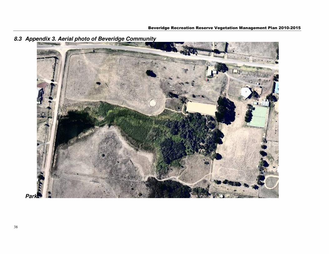
Beveridge Recreation Reserve Vegetation Management Plan 2010-2015
38
8.3 Appendix 3. Aerial photo of Beveridge Community
Park
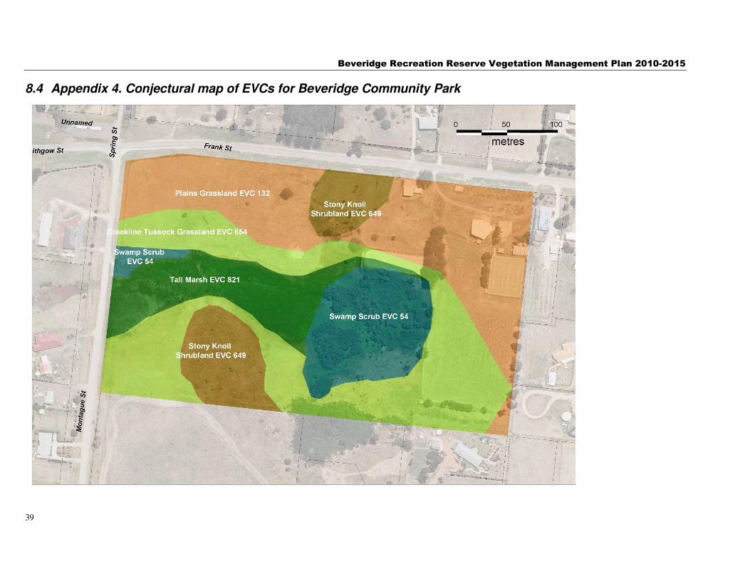
Beveridge Recreation Reserve Vegetation Management Plan 2010-2015
39
8.4 Appendix 4. Conjectural map of EVCs for Beveridge Community Park
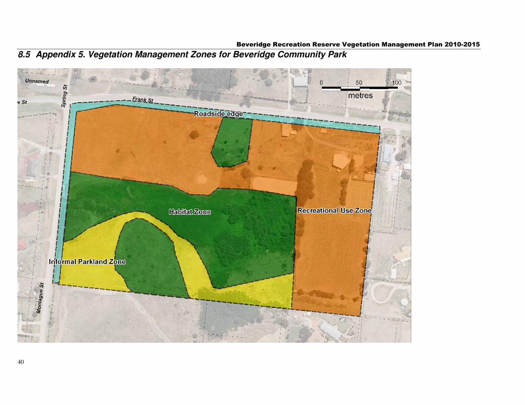
Beveridge Recreation Reserve Vegetation Management Plan 2010-2015
40
8.5 Appendix 5. Vegetation Management Zones for Beveridge Community Park

Beveridge Recreation Reserve Vegetation Management Plan 2010-2015
41
8.6 Appendix 6 Impression of Vegetation quality July 2010
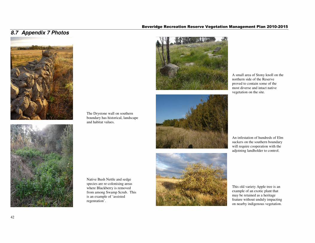
Beveridge Recreation Reserve Vegetation Management Plan 2010-2015
42
8.7 Appendix 7 Photos
The Drystone wall on southern boundary has historical, landscape and habitat values.
Native Bush Nettle and sedge species are re-colonising areas where Blackberry is removed from among Swamp Scrub. This is an example of ‘assisted regenration’.
A small area of Stony knoll on the northern side of the Reserve proved to contain some of the most diverse and intact native vegetation on the site.
An infestation of hundreds of Elm suckers on the southern boundary will require cooperation with the adjoining landholder to control.
This old variety Apple tree is an example of an exotic plant that may be retained as a heritage feature without unduly impacting on nearby indigenous vegetation.