bowland hill lcap... · valley which make up the pendle hill lp area. in the late 1990s the aonb...
TRANSCRIPT
BOWLANDPendle Hill Landscape Conservation Action Plan: Part 1

CONTENTS Executive Summary 1
Chapter 1: Introduction 2 1.1 Location 2 1.2 Partnership 2 Chapter 2: Vision, Aims and Objectives 4 2.1 Vision, Aims and Objectives 4 2.2 Scheme Aims 4 2.3 Scheme Objectives 4 2.4 Partnership Values 4 2.5 Development and Consultation 5 2.6 Structure of the LCAP 6
Chapter 3: What Makes Pendle Hill Special? Our Sense of Place 7 3.1 Introduction 7 3.2 Landscape 7 3.3 Geology 8 3.4 Biodiversity and Habitats 9 3.5 Archaeology and Early History 10 3.6 Built Heritage 11 3.7 Cultural, Inspirational and Spiritual Value 12 3.8 Recreation and Tourism 13
Chapter 4: Understanding Pendle Hill 15 4.1 The Meaning of Landscape 15 4.2 Context and Location 15 4.3 Policy Background 17 4.4 DefiningtheLPBoundary 18 4.5 The Making of the Pendle Hill Landscape 18 4.6 Landscape Character Assessment 28 4.7 Historic Development of the LP Area 35 4.8 Habitats and Wildlife 39 4.9 Farming and Land Use 41 4.10 Boundaries 44 4.11 Ecosystem Services 46 4.12 Communities 48 4.13 The Visitor Economy 53
Chapter 5: A Landscape Under Threat – Risks and Opportunities 56 5.1 Introduction 56 5.2 Environmental Threats and Opportunities 57 5.3 Economic Changes, Threats and Opportunities 61 5.4 Everyone – Threats and Opportunities 62 5.5 Delivery of Activity 66 5.6 Future Aspirations 67 5.7 References 68

Pendle Hill Landscape Conservation Action Plan: Part 1
1
Nationally protected as an outlier to the Forest of Bowland Area of Outstanding Natural Beauty (AONB), it is a place with a character and qualities quite distinct from its surroundings. A kingdom of its own and to some a place of escape, adventure, ‘old ways’ and traditions, myths and stories. A destination that trades off its rich heritage, wildlife, fantastic scenery and bustling events. A place where you can ‘touch the sky’, reawaken your senses and be inspired. Much more than just a hill.
It’s a place of duality: a hill with two different sides composed of different geologies, histories, communities, economies and ‘sense of place’ – and there is tremendous potential to capitalise on these disparities, to make play of friendly rivalries and gather both sides of the Hill together in new and meaningful ways.
It’s also a place of untold stories in need of new owners and celebration. The famous Witches are omnipresent and while the world is still a place of persecution, the lesser known tales of the Pendle Radicals are arguably more relevant and inspiring to people today: the Quaker movement, the Independent Labour Party and numerous religious non-conformists. All of them were inspired by Pendle Hill to see the world differently – and moreover, to realise their visions with the help of others, through action.It’shardtoimagineamorefittingthemeforthe Landscape Partnership and its ambition to have a positive impact on local communities, some of which are amongst the 10% most deprived neighbourhoods in the UK.
And then there is the landscape itself. Sculpted by ice from nationally important geology (designated as Sites ofSpecialScientificInterest)andsupportingawealthofhabitats - peat bogs, heather moorland, woodland and grassland - each in turn supporting a diversity of wildlife and providing valuable ecosystem services, including assets for tourism and health and wellbeing. A sometimes challenging environment that has attracted settlers since the Bronze Age, whose activities (notably farming and mining) have forged the character of the landscape that is treasured and stewarded by people today.
The Pendle Hill Landscape Partnership Scheme (LPS) is a programme of activity that seeks to re-connect its
many people (residents, neighbours and visitors) with their past and their landscape, to safeguard wildlife and heritage and improve people’s access - both physically and intellectually - to what is a nationally protected area.
Led by the Forest of Bowland AONB and supported by the Heritage Lottery Fund, the Scheme will provide opportunities for training and volunteering; restore important landscape features; support research and develop innovative interpretation to inspire a new generation about heritage - all underpinned by the support of local and neighbouring communities.
The Scheme will be delivered through more than a dozen individual projects, many of them involving a creative ‘Gathering’ that will help to bring people together from both sides of the Hill, build cohesion, facilitate dialogue and create shared points of view. Project themes include:
Environment: creating and repairing traditional boundaries: our iconic dry stone walls and hedgerows; improving the management and extent of wildlife sites; improving and extending our woodlands; and restoring the Summit of Pendle Hill.
Economy: strategic development of visitor hubs (reducing environmental pressures and impacts); improving access for everyone by promoting all ability routes; offering apprenticeships for young people in traditional skills; supporting the development of sustainable tourism; and researching the value of Pendle Hill’s ecosystem services.
Everyone: supporting local groups to develop the skills to undertake their own archaeology projects; creatively exploring Pendle’s Radical history; delivering training, education and events; linking people dealing with mental health issues to outdoor opportunities to improve their wellbeing; and managing the Pendle Hill Fund to support community-led projects focusing on heritage, landscape and the environment.
Threads: these cross cutting projects will support volunteers and learning; deliver creative ‘Gatherings’ to explore and interpret the landscape and engage new audiences; and develop interpretation materials based on the area’s sense of place and ‘destination brand’, including use of digital media to engage new and wider audiences.
EXECUTIVE SUMMARY
Not quite a mountain, yet much more than ‘just a hill’: a beloved and familiar backdrop to the lives of local people, a destination for many thousands of visitors in search of fresh air, walks, great food and of course, the witches… Pendle Hill is an icon of the Lancashire landscape.
Pendle Hill Landscape Conservation Action Plan: Part 1
2
1. Introduction
This Landscape Conservation Action Plan is the guiding resource for the Pendle Hill Landscape Partnership scheme. It draws together the research, consultation and planning that has been taking place since 2014 under the leadership of the Forest of Bowland Area of Outstanding Natural Beauty (AONB). The Plan will guide four years of delivery of an ambitious and exciting Heritage Lottery Funded scheme which aims to bring town and country people together to understand, restore and celebrate the distinctive landscape and heritage of this much loved and inspiring place: Pendle Hill.
1.1 Location
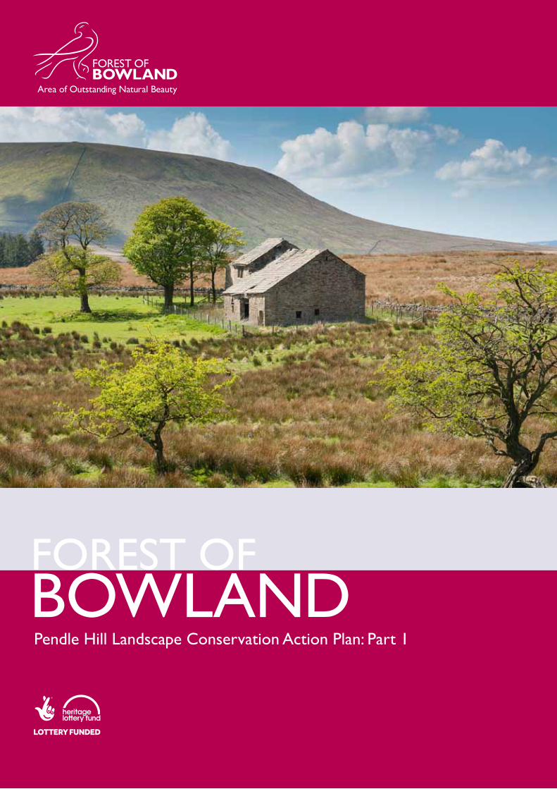
Pendle Hill is located in the south eastern corner of Lancashire. Although at 557m it is not the tallest hill in the area, it is certainly the most dominant. Its proximity to the post-industrial towns of Pennine Lancashire, and the market towns of Clitheroe and Gisburn provides an ever present backdrop to the lives of over 250,000 neighbouring residents, and also for the thousands of people who travel through the region crossing between Lancashire and Yorkshire. The Hill provides people with a ‘green lung’ and a reminder of the times when we were all more connected to the land.
More than half of the 124 square kilometres of Landscape Partnership area is included in the Forest of Bowland AONB designation. It was included as an outlier to the main AONB area because of its natural beauty and landscape quality. The lower slopes of the Hill, outside of the AONB, are more intensively farmed and do not have the remote and rugged qualities of the moorland. However they are included in the LP area as they make up a much more complete landscape and one with a recognisable sense of place, based not only on the area’s appearance but also on its history and culture.
1.2 Partnership
The Forest of Bowland AONB was designated back in 1964. Its main purpose is to conserve and enhance the landscape, and since the 1980s it has done this through the preparation and delivery of a Management Plan, and with the support of the AONB Unit. The AONB partnership is made up of the statutory environmental bodies, plus the eight local authorities which make up the AONB area, including the County Councils from North Yorkshire and Lancashire (the lead body) and the six districts and boroughs, including Pendle and Ribble Valley which make up the Pendle Hill LP area.
In the late 1990s the AONB set up a Pendle Hill Advisory Group to deal with a number of issues developing in the outlier area. The Advisory Group was made up of key landowners, countryside staff and local authorities and it was successful in dealing with issues such as unlicensed vendors, ‘Halloween mischief’ and liaison with key user groups such as fell running competitions and paragliding clubs. The Advisory Group also set up the Pendle Hill Fund which received income from user groups and allocated it to key footpath and boundary restoration projects, delivered largely by the AONB Unit.
In 2014, when the AONB decided to develop a Landscape Partnership for Pendle Hill, the Advisory Group agreed to form the core of the Partnership Board and to expand membership to include more community representation. They also agreed to provide match funds to the scheme from the nascent Pendle Hill Fund.
CHAPTER 1. INTRODUCTION
The Pendle Hill landscape has its own importance, and can be seen as a series of layers which together make up a distinctive character.

Pendle Hill Landscape Conservation Action Plan: Part 1
3
Map showing the Pendle Hill Landscape Partership Area in the North West
0 15 30 60LPS boundary
Admiring the view

Pendle Hill Landscape Conservation Action Plan: Part 1
4
2.1 Vision, Aims and Objectives
This is the stated vision of the Pendle Hill Landscape Partnership:
A landmark of Pennine Lancashire, this iconic hill will become a focus for bringing town and country people together to understand, restore and celebrate the distinctive landscape and heritage of this much loved and inspiring place.
2.2 Scheme Aims
A. To restore, enhance and conserve the heritage and landscape quality of Pendle Hill
B. To re-connect people with the landscape
C. To re-connect people and the past
D. To bring together the two sides of the Hill
E. To create a sustainable future for the environment, heritage and for visitors’ experience of Pendle Hill
2.3 Scheme Objectives
1. To better manage and increase the species diversity of natural habitats at a landscape scale
2. Toreducetheriskoffloodingthroughtheuseofnaturalfloodmanagementmeasures
3. To provide opportunities for volunteering and engagement in the environment
4. To increase knowledge, skills and opportunities for employment in the heritage sector
5. To restore and celebrate distinctive heritage features of Pendle Hill
6. To connect a wide range of people and local communities with their heritage and landscape
7. To develop a unique sense of place to help bring the two sides of the Hill together
8. To increase understanding of the value of a high qualitylandscapeandthebenefitsitcandeliver
9. To improve the physical and cultural access to Pendle Hill
10. To implement the programme through a creative, sustainable and inclusive approach
2.4 Partnership Values
The Pendle Hill LPS has developed over a long period of time, with a year spent preparing the stage one application, and a further 18 months in a funded development phase preparing the stage two application, including this LCAP, which is submitted in September 2017. In this time the staff and partnership has been embedded in the area and generated a high level of awareness, consultation and support amongst the resident and neighbouring communities.
The programme has very similar values to that of the AONB in that it has a focus on conserving and enhancing the natural and historic landscape, whilst delivering projects of a holistic nature. It also operates in a very consultative manner, ensuring that stakeholders are engaged and listened to throughout the process. Sustainable development is also prominent – the AONB has a strong track record in supporting local businesses, community facilities, producers and contractors. We also procure suppliers of recycled and locally sourced materials in an effort to reduce our carbon footprint and food miles.
Our programme intends to provide many opportunities for creative engagement, experimentation and expression via a series of exciting artists commissions, ‘the Gatherings’. These will create new ways of interpreting the landscape, its history and people, and will encourage engagement with new audiences.
The Pendle Hill scheme offers us a major opportunity to develop new audiences for the LP area, and our plan is to engage with many more, and a wider variety of, people: some of whom have not had the opportunity to explore, engage with and enjoy the area despite living within sight of the Hill. We are putting a particular emphasis on supporting people dealing with issues around mental health and social isolation, and exploring the impact that countryside and heritage experiences can have on their health and wellbeing. Pendle Hill has two very different sides, both physically and in socio-economic terms and it is our intention to gather together the two sides in our activities. We will do this by providing opportunities to share knowledge and experience, to explore the wider area and to celebrate the local distinctiveness of the area together.
CHAPTER 2. VISION, AIMS & OBJECTIVES

Pendle Hill Landscape Conservation Action Plan: Part 1
5
2.5 Development and Consultation In the summer of 2014, the AONB led a series of workshops and meetings with local stakeholders to identify the key heritage assets of the area and to identify the main threats to these assets. These workshops were attended by over 40 people from parish councils, history groups, environmental bodies and council departments and focussed on cultural heritage, built heritage, natural heritage and tourism and recreation. The information from these discussions was added to the existing AONB landscape character assessment for landscape areas within the Pendle Hill LP boundary, and the following threats to our heritage began to emerge: 1. Loss of landscape features and species diversity
2. Erosion,conflictandcongestioncausedbyvisitor numbers
3. People losing touch with the past
4. People losing touch with the landscape
5. Reducedfinanceforrecreation,heritageand wildlife conservation
A number of consultative ‘Gatherings’ were held during the application and development stage. These meetings were held around the LP area and included presentations, exhibitions and activities open to the general public and stakeholders. Meetings were held in
May 2015, October 2016, and April 2017 with 40-50 people attending each event.
Several of the projects convened or utilised existing working groups during the development phase, or consultedwithspecificinterestgroups–egtheArchaeology research included a forum of local history groups; the Traditional Boundaries project convened a working group and the AONB Biodiversity Working Group advised the natural heritage projects. The audience development planning carried out by In-Situ Arts (see below) included analysis of recent creative practice – Fields on Prescription and the River Project with Mums2Mums – as well as with a large number of interest and focus groups, particularly from the neighbouring communities and ‘hard to reach’ groups.
Between October 2016 and September 2017 the LPemployedanAssistantDevelopmentOfficerwho focussed on community engagement activity. This included setting up and running the Pendle Hill Volunteers, meeting at least twice each month to carry out a range of surveys, boundary restoration and conservation projects. It also included organising and delivering the pilot PEN project (People Enjoying Nature) in partnership with NHS Community Restart and a number of their clients who were dealing with mental health and social isolation issues. This pilot was run to test out approaches and attitudes, and also to meet demand from the service users who were keen to get started!
Creative consultation work undertaken in the development phase © (AONB)

Pendle Hill Landscape Conservation Action Plan: Part 1
6
2.6 Structure of the LCAP
The Landscape Conservation Action Plan is the key document guiding the delivery of the Pendle Hill Landscape Partnership scheme. It is set out as follows:
Part 1– Introduction and background: this document outlines the story of the Pendle Hill Landscape Partnership, the Partnership’s visions and aims, the importance and sense of place of the area and the origins of its landscapecharacter.Italsoidentifiesthethreats,risksandopportunitiesthatthisuniquelandscapefaces.
Part 2 – The scheme plan outlines what will be delivered to protect enhance and celebrate the area’s heritage. It includes a series of non-technical project summaries.
Part 3 – Full project plans: working documents for each project with detailed key actions and planned outcomes and outputs.
Part 4 –Schemedelivery:thisoutlineshowtheschemewillbemanagedanditincludesdetailsaboutfinances, outputsandoutcomes,thestaffingstructure,atimetableforschemeactivity,ourplansforlegacyand management of risks.
Audience Development Plan & Toolkit In-Situ Arts Landscape Character Assessment Robin Gray Communications Strategy Countryscape Interpretation Plan Countryscape Visitor Management Plan Fourth Street & Heritage Naturally Habitat and Boundary Surveys and Action Plans Rigby Jerram Geodiversity Action Plan GeoLancashire Volunteer Toolkit Burnley, Pendle & Rossendale CVS with Hyndburn & Ribble Valley CVS Tourism Scoping Report RJS Associates Ltd Report on the PEN Pilot, 2017 Jayne Ashe, Pendle Hill LPS Monitoring and Evaluation Framework Countryside Training Partnership
During the development stage, a number of reports and action plans were produced to support the development of projects and the overall programme. These were as follows:
During the development phase a number of changes to the original projects have taken place. These have been due to loss of staff support (eg Lancashire County Council reduction of libraries and museums staff), a lack of experience in voluntary groups, further discussion and consultation, reductions in funding opportunities and changing priorities. The key changes are detailed in Part 4 of the LCAP.
Rigby Jerram undertaking habitat survey work © Margaret Wright
Pendle Hill Landscape Conservation Action Plan: Part 1
7
3.1. Introduction
Pendle Hill is the distinctive outlier to the Bowland Fells and the AONB. It forms the backdrop to the Pennine Lancashire former textile towns of Burnley, Nelson and Colne; and also to the historic market towns of Clitheroe, Gisburn and Whalley. Yet despite its proximity tosignificanturbanpopulations,itissurprisinglyruralboth on its eastern and western escarpments and it has a real sense of remoteness on the moorland plateau.
Humaninfluenceshavehadanimpactonthislandscapewhether that is as the medieval Forest of Pendle, the enclosures of the 17th, 18th and 19th centuries, early industrial activity or the designed parkland landscapes of Read and Huntroyde.
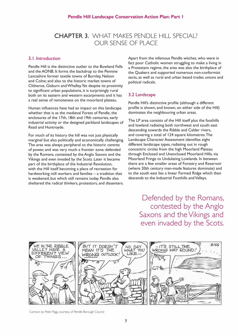
For much of its history the hill was not just physically marginal but also politically and economically challenging. The area was always peripheral to the historic centres of power, and was very much a frontier zone: defended by the Romans, contested by the Anglo Saxons and the Vikings and even invaded by the Scots. Later it became part of the birthplace of the Industrial Revolution, with the Hill itself becoming a place of recreation for hardworking mill workers and families – a tradition that is weakened, but which still remains today. Pendle also sheltered the radical thinkers, protestors, and dissenters.
Apart from the infamous Pendle witches, who were in fact poor Catholic women struggling to make a living in a Protestant regime, the area was also the birthplace of the Quakers and supported numerous non-conformist sects, as well as rural and urban based trades unions and political radicals.
3.2 Landscape
PendleHill’sdistinctiveprofile(althoughadifferentprofileisshown,andknown,oneithersideoftheHill)dominates the neighbouring urban areas.
The LP area consists of the Hill itself plus the foothills and lowland radiating both northwest and south east descending towards the Ribble and Calder rivers, and covering a total of 124 square kilometres. The LandscapeCharacterAssessmentidentifieseightdifferent landscape types, radiating out in rough concentric circles from the high Moorland Plateau through Enclosed and Unenclosed Moorland Hills, via Moorland Fringe to Undulating Lowlands. In between there are a few smaller areas of Forestry and Reservoir (where 20th century man-made features dominate) and to the south east lies a linear Farmed Ridge which then descends to the Industrial Foothills and Valleys.
CHAPTER 3. WHAT MAKES PENDLE HILL SPECIAL? OUR SENSE OF PLACE
Cartoon by Peter Rigg, courtesy of Pendle Borough Council
Defended by the Romans, contested by the Anglo
Saxons and the Vikings and even invaded by the Scots.

Pendle Hill Landscape Conservation Action Plan: Part 1
8
3.3 Geology
Pendle Hill is special geologically because it straddles the junction between older limestones to the north and west and younger gritstones to the south and east. These rocks are the result of tropical seas, mountain building and continental collisions during the Carboniferous period, from about 350 million years ago until about 300 million years ago. Earth movements during and after the deposition of the rocks created a suite of rocks dipping to the south east. On the Burnley side of Pendle Hill the surface topography follows the dip of the beds, largely exposing the Millstone Grit; while the north and west side presents an escarpment revealing strata of different ages, with the lower slopes underlain with Carboniferous Limestone.
The different geology of the two sides oftheHillhasgreatlyinfluencedthesubsequent development of vegetation and farming types and tenure, thus leading to very different density and style of human settlement. Geology has also created economically important resources for the area, including lime, coal, lead and stone – many of which were exploited in the centuries leading up to, as well as during, the industrial revolution.
There are three local Geodiversity Sites(ofCountysignificance),andthree geological Sites of Special ScientificInterest,whichareofnationalimportance, within the Pendle Hill LP area.
Light Clough SSSI near Wiswell is recognised as the standard for the base of the Upper Carboniferous and as such is of international importance; whilst Little Mearley Clough SSSI also exhibits the entire subdivision of the oldest Namurian gritstones which lie conformably on Lower Carboniferous strata, see table below. They are actually named after the Hill – the Pendelian Stage. The third SSSI is Clitheroe knoll reefs, an area of ‘Walsourtian mudmounds’ deposited in warm tropical seas during the Lower Carboniferous period, and now supporting a rich calcareous grassland.
Map showing the sites of geological interest and the geological SSSI sites in the Pendle Hill LP area
Pendle LP geo sites Pendle SSSI LPS boundary
0 1 2 4
Kilometers
PERMIAN
DEVONIAN
CA
RB
ON
IFER
OU
S
Autonion
Stephanian
Westphalion
Namurian
Visean
Tournaisian
Fammenian
Cisuralian
Upper Devonian
Din
antia
n or
Low
er
Car
boni
fero
usSi
lesi
an o
r U
pper
C
arbo
nife
rous
Bolosovian
Duckmanthian
Langesttian
younger
305 - 300
316.5 - 305
326.4 - 316.5
346.7 - 316.5
358.9 - 346.7
older
PERIOD EPOCH STAGE SUB STAGES AGE (in millions of years)
Yeadonian
Marsdenian
Kinderscoutian
Pendleian
Chart showing the Pendleian sub stage of Geological Time

Pendle Hill Landscape Conservation Action Plan: Part 1
9
3.4 Biodiversity and Habitats
A Phase 1 survey carried out in the LP area in 2016 discovered and mapped the following habitats:
The area supports valuable blanket bog, upland heath, calcareous grassland and deciduous woodland. Wildlife of key interest for the area includes wading birds (particularly Lapwing, Redshank and Curlew), woodland birds (Pied and Spotted Flycatchers) and Starlings and Swifts in the villages.
The LP includes 60 locally important wildlife sites (called Biological Heritage Sites in Lancashire) covering 2043 hectares or 17% of the total area. See appendix 1 for a full list and description of the BHS present.
Relative proportions of main habitat types
Improved grassland 65%
Semi-improved grassland 2%
Neutral grassland 1%
Acid grassland 11%
Calcareous grassland 0.3%
Broadleaved woodland 6%
Coniferous woodland 1%
Mixed woodland 0.5%
Bracken and tall herbs 1%
Heath 1%
Blanket bog 5%
Flush and valley mire 1%
Marshy grassland 3%Swamp 0.1%Open water 1%Arable 1%Other 2%
Pendle Hill Landscape Conservation Action Plan: Part 1
10
3.5 Archaeology and Early History
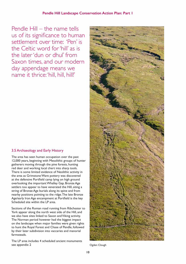
The area has seen human occupation over the past 12,000 years, beginning with Mesolithic groups of hunter gatherers moving through the pine forests, hunting red deer and working local chert into sharp tools. There is some limited evidence of Neolithic activity in the area as Grimstone Ware pottery was discovered atthedefensivePortfieldcamplyingonhighgroundoverlooking the important Whalley Gap. Bronze Age settlers too appear to have venerated the Hill, siting a string of Bronze Age burials along its spine and from nearby positions pointing to the ridge. The late Bronze Age/earlyIronAgeencampmentatPortfieldisthekeyScheduled site within the LP area.
Sections of the Roman road running from Ribchester to York appear along the north west side of the Hill, and we also have sites linked to Saxon and Viking activity. The Norman period however had the biggest impact on the landscape when major families were given rights to hunt the Royal Forest and Chase of Pendle, followed by their later subdivision into vaccaries and manorial farmsteads.
The LP area includes 4 scheduled ancient monuments see appendix 2
Pendle Hill – the name tells us of its significance to human settlement over time: ‘Pen’ is the Celtic word for ‘hill’ as is the later ‘dun or dhul’ from Saxon times, and our modern day appendage means we name it thrice: ‘hill, hill, hill!’
Ogden Clough

3.6 Built Heritage
Maybe the largest example of built heritage visible on the Hill is the network of dry stone walls, tracing the contours, ownership and history of the land. The earliest appeared in medieval times, outlining the huge cattle ranches or vaccaries built for the Norman de Lacy family who managed the area from their powerbase in Pontefract. Enclosures continued to take in and improve land from the ‘wastes’ of moorland and commons from the 14th century well into the 19th century – marking out deer parks, farmland and the designed parklands at Downham, Read and Huntroyde. The latter also had built decorative features including ‘hahas’, eye catchers, gateways, estate yards and gardens surrounding grand halls – not all of which remain intact today.
Enclosure patterns differ on the two sides of the Hill. The eastern side became more subdivided as wealthy copyholders of the Forest of Pendle sub-let their land in the 16th century, whilst in the west landed estates retained their land ownership as part of the Honor of Clitheroe,withlargerfieldsandparkland.
The LP area has eight Grade I and II listed buildings at Downham village: Halls at Little Mearley, Great Sabden and Read, the church of St Mary the Virgin in Newchurch, and over a hundred more 17th and 18th century farms, barns and manor houses.
Vernaculararchitecturereflectsthestrengthsandweaknesses of local stone (limestone, gritstone or river cobbles) and the favoured building style is traditional laithe farmhouses with adjoining barns.
Pendle Hill Landscape Conservation Action Plan: Part 1
11
"
"
"
"
"
$ 0 2 41
Kilometers
" Scheduled monuments Pendle
New_LPS_boundary
Pendle_-_listed_buildings
0 1 2 4
Kilometers
Map showing the listed buildings in the Pendle Hill LP area
Scheduled monuments Pendle
LPS boundary
Pendle-listed buildings
A laithe style farmhouse

Pendle Hill Landscape Conservation Action Plan: Part 1
12
3.7 Cultural, Inspirational and Spiritual Value
Pendle is famous for its witches. In the early 17th century, the area was remote and under-serviced by the church. Catholicism was outlawed and underground, and King James I was leading a witch hunt. The story of the events leading up to the trial and hanging of eleven unfortunate men and women from Pendle Hill in 1612 was told at the time by the trial clerk Thomas Potts, and became infamous in Victorian times as told in The Lancashire Witches by William Harrison Ainsworth. The 1951 novel by Robert Neill, Mist over Pendle, added to the area’s notoriety. However, anniversary events in 2012 helped to draw the truth out of the romanticised story.
Just forty years after the trial, in 1652, the Hill had anothersignificantevent.GeorgeFox,areligiousdissenter was visiting the area and described his experience:
“As we travelled we came near a very great hill, called Pendle Hill, and I was moved of the Lord to go up to the top of it; which I did with difficulty, it was so very steep and high. When I was come to the top, I saw the sea bordering upon Lancashire. From the top of this hill the Lord let me see in what places he had a great people to be gathered. As I went down, I found a spring of water in the side of the Hill, with which I refreshed myself, having eaten or drunk but little for several days before.”This epiphany led Fox to set up his Religious Society of Friends popularly known as the Quakers: so called because Fox supposedly told a magistrate to “tremble at the word of the Lord” – Fox himself was imprisoned at least ten times for dissent.
Pendle Hill, possibly still seen as a remote and lawless place as late as the middle of the 19th century, hosted a great many other dissenting preachers – Wesley, Ingham, Jolley and others – as well as early workers’ rights movements such as the Chartists and Free Traders, and later the Independent Labour Party and suffragettes. These radical thinkers, inspired and sheltered by Pendle Hill, left their mark on the world.
An illustration of the Pendle Witches by Srirat Jongsanduandi
A sketch of George Fox
Clarion House

Pendle Hill Landscape Conservation Action Plan: Part 1
13
3.8 Recreation and Tourism
A hill – especially one so prominent and dominant in the locality as Pendle - always attracts people. George Fox felt drawn to ascend it, as had the Bronze Age people 4000 years ago. During the 18th and 19th centuries many people left the land to live in neighbouring mill towns, but they would return and visit on ‘high days and holidays’ with an annual pilgrimage up the Hill on Good Friday, often with egg rolling; and charabanc trips were a regular occurrence. The area around Roughlee became known as ‘Happy Valley’ with its swing-boats and other amusements. Pubs, teashops and the Clarion House catered for walkers who would happily trek the 6 or 10 mile round trip out of town for fresh air and respite; cyclists would visit for the day from Manchester, Bolton and Bradford. Small colonies of huts and vans grew up at two campsites in the valley (one called Palm Beach!) and acted as weekend retreats for many mill town families, but they were demolished in the 1960s to make room for the current caravan or holiday home parks.
This tradition continues today, although most of our 700,000 annual visitors now come by car. Many will enjoy a gentle stroll followed by a pint or a brew; others come to partake of the excellent local food and drink; some (we estimate 300,000 a year) will climb Pendle Hill itself; and sports enthusiasts come to seek challenging fell runs, steep cycle climbs and paragliding thrills.
Many will enjoy a gentle stroll followed by a pint or a brew; others come to partake of the excellent local food and drink; some (we estimate 300,000 a year) will climb Pendle Hill itself
Downham © Charlie Hedley

Pendle Hill Landscape Conservation Action Plan: Part 1
14

Pendle Hill Landscape Conservation Action Plan: Part 1
15
CHAPTER 4. UNDERSTANDING PENDLE HILL
4.1 The Meaning Of Landscape
“Landscape: from the Anglo Saxon - Land (a space with boundaries) scape (a composition of similar objects).”
“Landscape: an area, as perceived by people, whose character is the result of the action, and interaction, of natural and / or human factors.” (European Landscape Convention)
The Pendle Hill landscape has its own importance, and can be seen as a series of layers which together make up a distinctive character.
PEOPLE, ENGAGEMENT AND RECREATION
BUILT HERITAGE AND SETTLEMENT
ARCHAEOLOGY
VEGETATION, SOILS AND WILDLIFE
GEOLOGY AND LAND
4.2 Context and Location The Pendle Hill Landscape Partnership area is centred on the outlier of the Forest of Bowland Area of Outstanding Natural Beauty, which in total covers 800 square kilometres of Lancashire and North Yorkshire.
Although separated by Clitheroe and the Ribble, the 90 square kilometre outlier is physically connected to the large mass of the Bowland Fells: it is based on the same geology and linked to the northern Pennine chain, and sculpted by the same ice and water. However, Pendle Hill is distinct and different from the rest of Bowland: it is less remote, it is closely linked to the nearby urban areas and is more heavily used by those residents.

Pendle Hill Landscape Conservation Action Plan: Part 1
16$ 0 6 123
Kilometers
New_LPS_boundaryMap showing AONB and National Park Map showing the Forest of Bowland Area of Outstanding Natural Beauty
Forest of Bowland AONB
Forest of Bowland AONB
Arnside and Silverdale AONB
Yorkshire Dales National Park
Pendle Hill Landscape Partnership Boundary
0 3 6 12
KilometersLPS boundary

The AONB status is a protected landscape, yet this designation brings very little additional investment to the area. The Landscape Partnership approach is vital to making a real difference to the area and its heritage whichisunderthreatfromagriculturalintensification;urban development; reductions in local government spending; and changing cultural attitudes leading to a loss of connection between people and the landscape and their past.
The LP area, a total of 124 square kilometres, is divided between two very different local authority areas, Pendle and Ribble Valley, and wholly within the county of Lancashire. The differences in population are shown below (data from Lancashire Insight & Public Health England) and explained further below (4.12)
4.3 Policy Background4.3.1 AONB Management PlanThe Forest of Bowland AONB has a statutory duty to produce a Management Plan setting out objectives and actionsforafiveyearperiod.Thecurrentplan(2014-19) has four primary objectives:
1. An Outstanding Landscape of Natural and Cultural Heritage
2. Resilient and Sustainable Communities
3. A Strong Connection between People and the Landscape
4. Working in Partnership
These objectives and their numerous actions are intended to be delivered by the AONB Partners: made up of the statutory and funding partners, plus voluntary and community organisations, farmers, landowners
and businesses. Many of the objectives relate directly to the LP area and will be delivered via this LCAP and our planned activity. The next Management Plan is to be prepared during the lifetime of the LP scheme and will incorporate emerging issues, lessons learned and actionsidentifiedfromtheresearchanddevelopmentundertaken for, and early delivery of, the Pendle Hill LP. 4.3.2 European Policy FrameworkThe raft of environmental and habitat directives adopted from European legislation will hopefully be maintained post-Brexit, and help to secure a future for the SSSI designation in the LP area. We also anxiously await new announcements on future agri-environmental and rural development support once European funds have ceased being distributed in the UK.
4.3.3 UK PolicyThe Natural Choice: securing the value of nature White Paper contains the UK Government’s vision for the natural environment over the next 50 years. Many of its key themes, such as ‘Protecting and improving our natural environment’ and ‘Reconnecting people and nature’arealsoreflectedintheLandscapePartnership’sobjectives. The wildlife habitat enhancement projects that will be delivered as part of the Landscape Partnership align with the priorities.
Pendle Hill Landscape Conservation Action Plan: Part 1
17
Total population (2015) 89,452 57,132
BAME population 18,000 1,228
House price to earnings ratio (England 7.49) 3.96 7.38
Houses in fuel poverty 14% 11.6%
Median gross weekly earnings (2016) £417.70 £439.80
%age of working age population reliant on benefits 14.3 6.8
Average life expectancy at birth (2014) 81.5 (Female) 77.8 (Male) 83 (Female) 81 (Male)
%age of population with long term health
problem or disability (2011) 20.9 16.7
%age of physically active adults (2015) 59.4 48.2
%age of year 6 children classified as obese (2015/16) 20.2 18.1
%age pupils achieving 5 or more A*-C grade at GCSE (2014/15) 48.3 74.2
Rank in English Indices of Deprivation (out of 326) 2015 42nd (5th in country) 290th (lowest in country)
Ribble ValleyPendle

Pendle Hill Landscape Conservation Action Plan: Part 1
18
4.3.4 Local Nature PartnershipsThe AONB is a member of the Northern Upland Chain LNP and as such has a number of common issues with these other protected upland landscapes, including the issues facing hill sheep farmers, the need for peatland and meadow restoration, and species protection action for the hen harrier, curlew and black grouse. Lessons learnt by this partnership and activity undertaken will feed into the Pendle Hill LP and provide advice, sustainability,andinfluenceforouractivity,especiallyin terms of alternative solutions to agri-environment payments and the valuing of natural capital.
4.4DefiningtheLPboundary
The original landscape designation in 1964 of the AONB and including the Pendle outlier avoids some of the valleys and landscapes associated with the Hill. Some notable communities in the shadow of the Hill were also excluded from the landscape designation (Rimington, Pendleton, Wiswell and Higham). Having decided to draw in the wider apron of landscapes that radiate from Pendle Hill for the purposes of the Landscape Partnership, there is a need to say how wide the project boundary should be drawn. Afterall,PendleHillcanbeseenfromasfarafieldasRossendale and the Three Peaks in the Yorkshire Dales. So broadly speaking we have sought to draw the line where there is a step change in the landscape character andareductionintheinfluenceoftheHill.Oneofthe key tests of any boundary is whether it is one that ‘makes sense’ to its residents.
• TothewestandeastthevalleysoftheRibbleand the Calder are obvious boundaries.
• TothesouththeWhalleyGaphashistorically been seen as a major physical barrier that in no small measuredefinedthenatureofbothEastLancashire (urban) and the Ribble Valley (rural).
• Totheeastofthegapwechosethegreattransport routes established during the industrial age: the Leeds Liverpool Canal and the Railway.
• Tothenorth,weincludetheAdmergillvalleyas far as the outlier of Weets Hill. The ancient Gisburn Old Road and Coal Pit Road have been used here as a western boundary rather than the current A682. To a certain extent this is an arbitrary boundary but one that makes sense in the context of landscape.
There are a number of smaller settlements that are contained within the project area which are picturesque and rural (Downham, Higham, Fence, Barley, Pendleton and Wiswell) or former industrial hamlets (Spen Brook and Sabden). The scale of these settlements is consistent with the Landscape Partnership approach and to engendering a ‘sense of place’ amongst residents as well as visitors.
The major mill towns of Padiham and Barrowford have been excluded from the project area. These are significanttownscapesthataLandscapePartnershipwould be ill resourced and equipped to address.
Although it is not intended to be carrying out physical works in these and other surrounding towns: Whalley, Clitheroe, Nelson, Burnley and Colne - it is recognised that this urban hinterland is integral to the project and reaching out to the communities, many of whose residents never set foot on Pendle Hill, is a key challenge for the scheme which it intends to address.
4.5 The Making of the Pendle Hill Landscape
At557mPendleHillisasignificanthill,moredominantthan its height suggests as it rises steeply over 400m from the village of Downham lying just 3km from the summit. The massif stretches 13km from Weets Hill in the north east, to Whalley in the south west as it incorporates Rimington and Burn Moors, through the Sabden valley to Wiswell Moor.
Pendle Hill from Twiston
Pendle Hill Landscape Conservation Action Plan: Part 1
19
$ 0 2 41
Kilometers
New_LPS_boundary
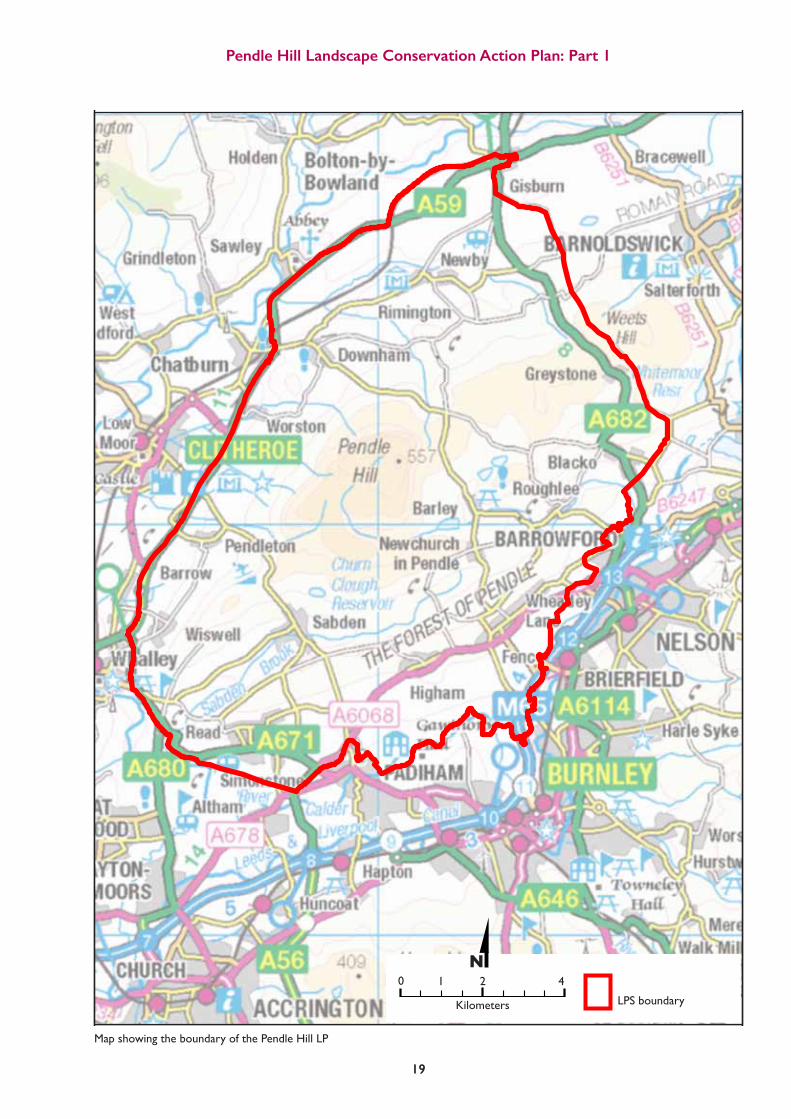
Map showing the boundary of the Pendle Hill LP
0 1 2 4
Kilometers LPS boundary
Pendle Hill Landscape Conservation Action Plan: Part 1
21
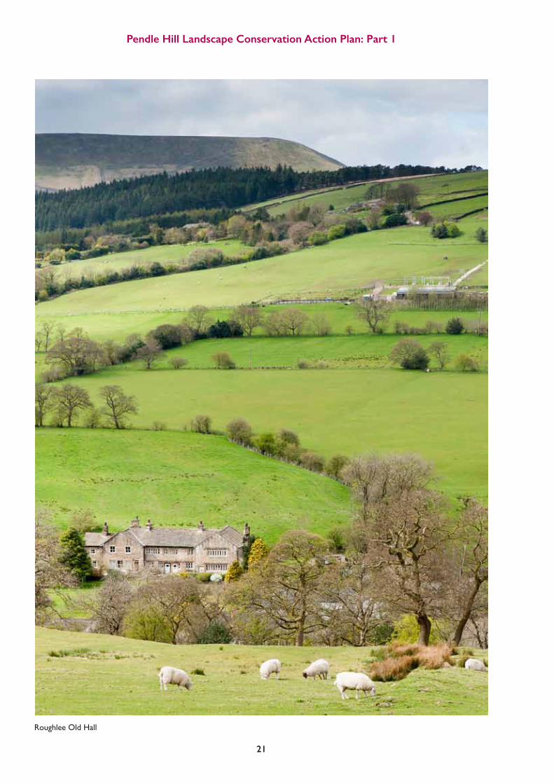
Roughlee Old Hall

Pendle Hill Landscape Conservation Action Plan: Part 1
22
4.5.1 GeologyThe layers of limestone grit and shale which underlie the area were laid down in the Carboniferous Period from about 350 million years ago until about 300 million years ago. At this time, the area which is now Great Britain was in the southern hemisphere and experiencing tropical climates. The limestones were deposited at the edge of a basin in warm, clear, shallow tropical waters, teeming with life, now preserved as fossils and seen at sites such as the nearbySalthillQuarry,aSiteofSpecialScientificInterest(SSSI).
AsthecontinenttrackednorthwardsacrossEquatoriallatitudes,thebasindeepenedandwasthenfilledbyhugequantitiesofsandandmudinanenormousdeltaatthemouthofariversystem.Oncethebasinhadfilledoveraperiodofseveralmillionyears,forestsflourishedonthedeltatop.TheremainsoftheseforestsarepreservedasthecoalseamsoftheLancashirecoalfield;andatleastoneoftheseseamsoutcropsonthesouthernflanksofPendleHill.
Earth movements during and after the deposition of the rocks of Pendle Hill resulted in a suite of rocks dipping generally to the SE. This can be seen in the sketch section below.
Sketch section from Longridge Fell to Burnley, as if looking north east across the Ribble valley. It indicates how the rock strata, all originally laid down horizontally, have been folded and faulted in the Pendle Hill area. (GeoLancashire, 2016)
North west
Longridge Fell
Clitheroe Castle
GRITSTONE
COALMEASURES
HORROCKSFORDHALL THRUST
PENDLE FAULT1000 METRES
YOUNGERLIMESTONE
YOUNGERLIMESTONE
OLDERLIMESTONE
OLDERLIMESTONE
RiverRibble
Pendle Hill
South east
Burnley
Duringthefillingofthebasin,thestretchingoftheearth’scrustledtomajorfaultssuchasthePendleFault,whichcan be traced today to 4000 metres beneath the current surface. This stretching together with compression by weightofthedepositedsediments,createdasubsidingbasinwhichcontinuedtofillasitsubsided,resultinginthousands of metres of deposition. Later tectonic activity gave rise to folding and uplift of the whole area.
Asaconsequenceoftheseearthmovements,mineral-bearingfluidswereforcedthroughtherocks,depositinglead and associated minerals including barytes (barium sulphate) in veins which have been worked in the LP area at places such as Rimington.
In the southern part of the area, for example at Ightenhill, coal was mined as long ago as the Middle Ages. Coal mining continued in the Burnley area until the latter part of the twentieth century and was vital in providing the power for the area’s textile and engineering industry.
Pendle Hill Landscape Conservation Action Plan: Part 1
23
4.5.2 GeomorphologyOver tens of millions of years, the form of Pendle Hill has evolved. It developed because of the hard gritstones: resistant to erosion, and the structural effects of the NE – SW oriented folds and faults in the underlying rocks. During the Ice Age the area was repeatedly covered and erodedbyice.Thisprobablyincludedtheiceflowingfrom the main source of glacial ice which lay over the Pennines,flowingsouth-westwardsalongthelinesoftheRibble, Sabden and Calder valleys, deepening the valleys each time the ice extended and retreated. Similarly the steep northern slope of Pendle Hill and the ‘Big End’ were formed when the glaciers repeatedly hit the hard rocks forming the landmass.
Since that period, the post-glacial rivers have cut new channels and become diverted around glacial deposits left by the last ice sheet, which melted only 18,000 years ago.
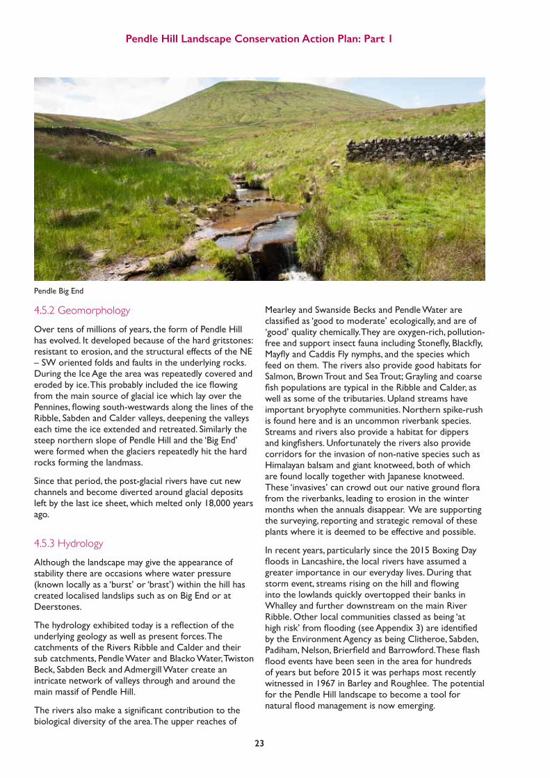
4.5.3 HydrologyAlthough the landscape may give the appearance of stability there are occasions where water pressure (known locally as a ‘burst’ or ‘brast’) within the hill has created localised landslips such as on Big End or at Deerstones.
Thehydrologyexhibitedtodayisareflectionoftheunderlying geology as well as present forces. The catchments of the Rivers Ribble and Calder and their sub catchments, Pendle Water and Blacko Water, Twiston Beck, Sabden Beck and Admergill Water create an intricate network of valleys through and around the main massif of Pendle Hill.
Theriversalsomakeasignificantcontributiontothebiological diversity of the area. The upper reaches of
Mearley and Swanside Becks and Pendle Water are classifiedas‘goodtomoderate’ecologically,andareof‘good’ quality chemically. They are oxygen-rich, pollution-freeandsupportinsectfaunaincludingStonefly,Blackfly,MayflyandCaddisFlynymphs,andthespecieswhichfeed on them. The rivers also provide good habitats for Salmon, Brown Trout and Sea Trout; Grayling and coarse fishpopulationsaretypicalintheRibbleandCalder,aswell as some of the tributaries. Upland streams have important bryophyte communities. Northern spike-rush is found here and is an uncommon riverbank species. Streams and rivers also provide a habitat for dippers andkingfishers.Unfortunatelytheriversalsoprovidecorridors for the invasion of non-native species such as Himalayan balsam and giant knotweed, both of which are found locally together with Japanese knotweed. These‘invasives’cancrowdoutournativegroundflorafrom the riverbanks, leading to erosion in the winter months when the annuals disappear. We are supporting the surveying, reporting and strategic removal of these plants where it is deemed to be effective and possible.
In recent years, particularly since the 2015 Boxing Day floodsinLancashire,thelocalrivershaveassumedagreater importance in our everyday lives. During that stormevent,streamsrisingonthehillandflowinginto the lowlands quickly overtopped their banks in Whalley and further downstream on the main River Ribble. Other local communities classed as being ‘at highrisk’fromflooding(seeAppendix3)areidentifiedby the Environment Agency as being Clitheroe, Sabden, Padiham,Nelson,BrierfieldandBarrowford.Theseflashfloodeventshavebeenseenintheareaforhundredsof years but before 2015 it was perhaps most recently witnessed in 1967 in Barley and Roughlee. The potential for the Pendle Hill landscape to become a tool for naturalfloodmanagementisnowemerging.
Pendle Big End

Pendle Hill Landscape Conservation Action Plan: Part 1
24
$New_LPS_boundary
Minor_Watercourses
Main_Watercourses
0 2.5 51.25
Kilometers
The potential for the Pendle Hill landscape to become a tool for natural flood management is now emerging.
Map showing the hydrology in the Pendle Hill LP area
0 2.51.25 5
Kilometers
LPS boundary
Minor Watercourse
Main Watercourses
Watermeetings

Re-wetting the peat by blocking gullies and re-vegetating bare peat; planting trees and shrubs in steep cloughs; creating ‘leaky dams’; identifying and restoring neglected hedgerowsandwallswhichintersectoverlandflow;andencouraging good soil management are all areas of work we intend to deliver in the planned LP scheme.
4.5.4 ClimateAs with much of north western England, the climate of Pendle Hill is cool and wet. Average daily temperatures range from 2oC in winter to 15oC in summer, with peak readings rarely above 20oC. Total rainfall for the area is 1294mm per year (period 1981-2010), with the wettest months recording well over 100mm of precipitation. Today’s cool, wet climate means that the growing season is limited and that growing grass in the lower lying areas, and farming hill sheep on the moors, is really the only way to make a living from the land.
4.5.5 Landscape HistoryThe physical factors of climate, geology and topography are not the only factors that contribute to a landscape. Cultural factors are also at play and land tenure has always been critical. For example, the protection afforded through Forest Law preserved a semi-natural landscape that remains to this day (Brigg, 1989). And in the lowland areas the ‘designed’ landscapes sought to create a landscape as a ‘rural idyll’. These private estates were and continue to be extensive, for example, the Read Estate was comprised of 22 tenanted farms until the 1940s.
Some of the original common land became privately owned through the 19th century or was purchased by local corporations to become part of the water catchment for many of the adjacent towns. Now under the stewardship of United Utilities, water quality is a major driver for their land management.
Thepatchworkoffields,woodsandmoorlandacrossPendle Hill tells the story of enclosure: the continual piecemeal encroachment of the ‘wastes’ over centuries. Moorland brought into individual ownership culminated in the parliamentary enclosures which brought in areas of what had been formerly unenclosed semi-natural areas. Landowners and their tenants saw the potential for agricultural improvement with ready access to lime and mutual enclosure of common ‘rough’ grazing.
AngusWinchesteridentifiesacommonthemetothis landscape of Pendle Hill and its hinterland as ‘marginality’ (Winchester & Crosby, 2006):
This refers not just to the physical marginality of a region where environmental constraints limit the scope for agriculture and restrict the possibilities for settlement, though this is one aspect. The upland periphery; frequently a sudden edge, is never far away, marking the boundary between lowlands where arable farming was possible and hill country where cultivation was marginal at best.
Pollenevidencesuggeststhefirstwoodlandclearancein the area was at the time of the Bronze Age. A deteriorating climate led to the abandonment of these sites and the leaching of nutrients and waterlogging that led to peat formation. The wood pastures of these areas thus became the acid moorland of later centuries.
From the Neolithic period onwards, land suitable for cultivation was settled. Free draining soils were at a premium and limited to the lowlands or higher ground above the river valleys that were not waterlogged. From these arable ‘islands’ or ridges the area taken into agricultural use was gradually extended into wetter and steeper territory as a result of population pressure.
From the 9th and 10th centuries onwards, there was anintensificationofcattlerearinginthelargefarmsor vaccaries on the eastern side of the hill, involving
Pendle Hill Landscape Conservation Action Plan: Part 1
25
TEMPERATURE
22201816141210
86120
-2
2220181614121086120-2
Jan Feb Mar Apr May Jun Jul Aug Sep Oct Nov Dec
The average temperatures were measured in the period 1961–1990
The graph shows average maximum daily temperature, average minimum daily temperature, and average daily temperature per month.
(UKMeteorologicalOffice,Bingleyweatherstationstatistics)
160
140
120
100
80
60
40
20
0
RAINFALL (mm)
(UKMeteorologicalOffice,Bingleyweatherstationstatistics)
Jan Feb Mar Apr May Jun Jul Aug Sep Oct Nov Dec

Pendle Hill Landscape Conservation Action Plan: Part 1
26
seasonal movement to summer pastures. In 1296 there were eleven vaccaries recorded in the Forest of Pendle (Brigg, 1989). The hill slopes were enclosed in a large bowl shape to serve as pastures for the vaccary milk herd and oxen. The vaccary would be served by a boothsman and many vaccary names are retained in the area today.
A map to show an area of the Pendle Hill LP area which includes place or parish names which relate to former vaccaries. The research on vaccarries has been carried out by Pendle Heritage Centre volunteers, based on archive information about the vaccaries of Pendle Forest. The list of vaccaries include Barley, Fence, and Whitehough which relate to exisiting villages on the hill, Nether and Over Goldshaw and Roughlee which relate to existing parish names.
$ 0 1.5 30.75
Kilometers
0 0.75 1.5 3
Kilometers

Pendle Hill Landscape Conservation Action Plan: Part 1
27
The area was prone to severe food shortages in the 15th and 16th century due to poor harvests of the staple crops of oats, barley and wheat, and there is evidence of a steep decline in population. By contrast, the increasing yields of the 17th and 18th century and increased security of tenure for copyholders in the old Forest area led to the sub division of land; and increased investment in farms, barns and dry stone walls.
The upland commons were largely retained until the large scale parliamentary enclosures in the 18th and 19th century.
The origin of the textile industry was in part from households seeking to supplement meagre farm incomes with spinning and weaving. As the factory workshop replaced the smaller-scale home spun workings, early
water powered mills housing textile weaving and printing sprung up in the villages at Roughlee, Barley and Sabden. From these modest beginnings, towns such as Burnley and Blackburn, with populations of around 4,000 towards the end of the 18th century, exploded in the 19th century. Satellite villages such as Whalley became desirable retreats from this industrial heartland.
The growth of East Lancashire industry led to a new wealth for the gentry class and the growth of the private estates and planned landscapes at Read, DownhamandHuntroydereflectthis.Theneedtosupply these growing towns and their mills with water also led to the construction of reservoirs and the appropriation of land for water supply in the early 20th century, although many of the mills were already closing by the 1960s.
Ogden reservoirs

Pendle Hill Landscape Conservation Action Plan: Part 1
28
4.6 Landscape Character AssessmentWithin the immediate environment of Pendle Hill are a number of concentrically arranged landscapes that encompassmoorlandplateau,moorlandfringe,andundulatinglowland.Theseareclassifiedasanumberoflandscapetypes which are described below.
Eachgenericlandscapetypehasadistinctcharacterwithsimilarphysicalinfluences(underlyinggeology,landformand soil) and a common history of land management such as the enclosure of moorland edges to create ‘in-bye land’.
$LPS_LCA_New
<all other values>
LCA_TypeEnclosed Moorland Hills
Farmed Ridges
Forestry and Reservoir
Industrial Foothills and Valleys
Moorland Fringe
Moorland Plateaux
Undulating Lowland
Undulating Lowland Farmland with Parkland
Unenclosed Moorland Hills
New_LPS_boundary
0 2 41
Kilometers
Landscape Character Assessment of the Pendle Hill LP areaLCA Type
Moorland Plateaux
Undulating Lowland
Undulating Lowland Farmland with Parkland
Unenclosed Moorland Hills
LPS boundary
(all other values) Enclosed Moorland Hills
Farmed Ridges
Forestry and Reservoir
Industrial Foothills and Valleys
Moorland Fringe
LPS LCA New
0 1 2 4
Kilometers

Pendle Hill Landscape Conservation Action Plan: Part 1
29
4.6.1 Moorland PlateauThis Landscape Character Area forms a dramatic skyline backdrop to several views towards Pendle Hill from adjacent Landscape Character Types;
Key Characteristics:
• Thecolourofthelandscapechangeswiththeseasons,frommutedbrownsandgreensinSpringandSummer,to vividpurplewhentheheatherflowersinlateSummerandwhiteintheWintermonthswhentheplateauare snow covered;
• Strongsenseofopenness,remotenessandtranquillity;
• Thesweeping,heathercladmoorlandandblanketbogiswindsweptandexposed;
• Thedistinctive‘goback’callsofRedGrouse,themournfulcriesofGoldenPlover,thebubblingcallsofCurlew, the cascading calls of Meadow Pipit and trilling calls of Skylark contribute to recognisable sense of place;
• Thedistinctivepatternofstonewalls(mostlyfromthe19thcentury)contributestorecognisablelandscape pattern;
• ThedeepvalleyofOgdenCloughisakeylandscapefeaturewhichincisestheplateauandfeedsUpperand Lower Ogden Reservoirs;
• Thereisalackofmanmadestructuresonthemoorlandplateau(asidefromtheoccasionalcairn,walls&paths) which create a feeling of tranquillity and remoteness;
• Themoorlandplateauismostlycommonlandwhichisgrazedbysheep.Aspartofthewatercatchmentarea, water quality is important as erosion can increase the extent of dissolved organic carbon;
• Theplateauisopenaccessmoorland.
Only one area of moorland plateau exists in the LP area - Pendle Hill
Moorland Plateau
Pendle Hill Landscape Conservation Action Plan: Part 1
30
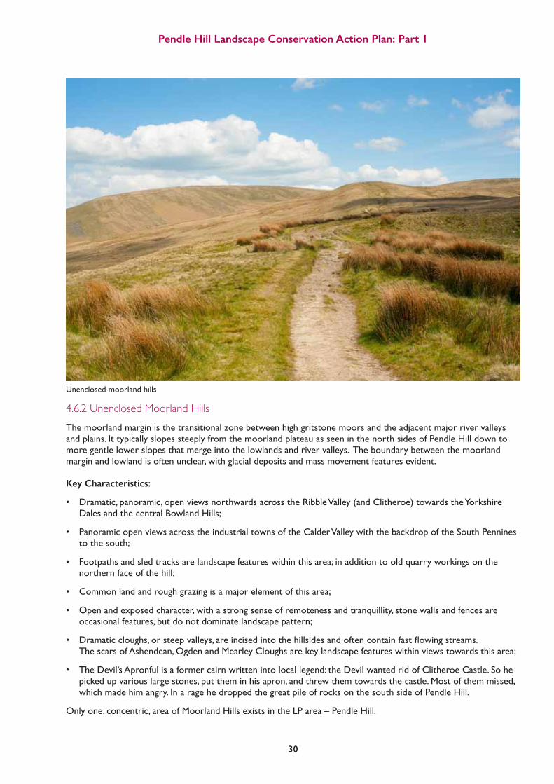
4.6.2 Unenclosed Moorland HillsThe moorland margin is the transitional zone between high gritstone moors and the adjacent major river valleys and plains. It typically slopes steeply from the moorland plateau as seen in the north sides of Pendle Hill down to more gentle lower slopes that merge into the lowlands and river valleys. The boundary between the moorland margin and lowland is often unclear, with glacial deposits and mass movement features evident. Key Characteristics:
• Dramatic,panoramic,openviewsnorthwardsacrosstheRibbleValley(andClitheroe)towardstheYorkshire Dales and the central Bowland Hills;
• PanoramicopenviewsacrosstheindustrialtownsoftheCalderValleywiththebackdropoftheSouthPennines to the south;
• Footpathsandsledtracksarelandscapefeatureswithinthisarea;inadditiontooldquarryworkingsonthe northern face of the hill;
• Commonlandandroughgrazingisamajorelementofthisarea;
• Openandexposedcharacter,withastrongsenseofremotenessandtranquillity,stonewallsandfencesare occasional features, but do not dominate landscape pattern;
• Dramaticcloughs,orsteepvalleys,areincisedintothehillsidesandoftencontainfastflowingstreams. The scars of Ashendean, Ogden and Mearley Cloughs are key landscape features within views towards this area;
• TheDevil’sApronfulisaformercairnwrittenintolocallegend:theDevilwantedridofClitheroeCastle.Sohe picked up various large stones, put them in his apron, and threw them towards the castle. Most of them missed, which made him angry. In a rage he dropped the great pile of rocks on the south side of Pendle Hill.
Only one, concentric, area of Moorland Hills exists in the LP area – Pendle Hill.
Unenclosed moorland hills

Pendle Hill Landscape Conservation Action Plan: Part 1
31
4.6.3 Enclosed Moorland HillsOpen and exposed in character. A distinctive network of stone walls contribute to landscape pattern and divide areasofroughgrazingintosmallfieldsor‘copys’.
Key Characteristics:
• Dramaticandpanoramicviewsnorthwardstowards the peaks of Pen-Y-Ghent and Ingleborough in the Yorkshire Dales provide a recognisable sense of place at Twiston;
• Theenclosedmoorlandhillsareconsideredtohave a very high visual sensitivity overall as a result of the strong sense of openness and generally uninterrupted skylines, coupled with strong inter visibility with adjacent Landscape Character Types;
• Non-nucleatedsettlementpattern;
• Drystonewallsandoccasionalstructuresofroughly hewn blocks are strong features in otherwise open moorland;
• Large,straight-edgedallotmentsenclosedby drystone walls running straight up the fellside;
• Isolatedstonebuildingsandfeatures;
• Astrongsenseofremotenessandtranquillity throughout.
Three areas of Enclosed Moorland Hills occur within the Pendle Hill LP area: at Twiston, Lingbobs and Stainscomb, and Downham Moor.
4.6.4 Moorland FringeA transitional rolling enclosed landscape of the moorlandfringedefinedbyearlyhumanactivityandretainingitsmedievalfieldboundaries.
Key Characteristics:
• Traditionalstonefieldbarnsarearecognisable landscape feature;
• Drystonewallsofrough-hewnblockscreatestrong patternswithinthelandscapeandreflectthe underlying geology;
• Sheepgrazingisthepredominantlanduse, interspersed in places with a patchwork of traditionally managed meadows, wet rushy pasture, in-bye and acid grassland;
• Isolatedfarmhousesandwindingroadsboundedby drystone walls are key features of this landscape. They are amongst the oldest buildings in the area;
• Thereareafewsmallwoodlandcopses;
• Traditionalmeadows,wheretheyexist,arerich habitats (with Marsh Marigold, Yellow Iris, Ragged Robin, and Marsh Thistle);
• Thetransportationofsalt,limeandwoolleadtothe extensionofanetworkofpackhorsewaysreflected today in the network of winding roads and hilltop passes.
Four areas of Moorland Fringe occur in the LP area:, at Pendleton, Wheathead, Upper Sabden Valley and Middop
Enclosed Moorland Hills Moorland Fringe

Pendle Hill Landscape Conservation Action Plan: Part 1
32
4.6.5 Undulating Lowland Farmland
This enclosed landscape comprises a rich patchwork of pastures, mixed farm woodlands, copses, hedgerows and scattered picturesque villages.
Key Characteristics:
• OpenviewstowardstheUnenclosedandEnclosed Moorland Hills, and the Moorland Plateau Landscape Character Types;
• Manymixedfarmwoodlands,copsesandhedgerow trees;
• Intricatetapestryofgrazedfields;
• Apatchworkofwoodandpasturewhenviewed from the fells;
• Thevalueofstreams,hedgerowsandmaturetrees as potential visual and ecological corridors linking Biological Heritage Sites is of key importance;
• WiththeirdeepsoilsaroundtheRiverRibble,these areaswereamongstthefirsttobesettledandthe network of farms and villages linked by deep, hollow ways remain today. Much of what can be seen in thepatchworkoffieldsismedievalindate.During the 18th and 19th centuries, lime quarries and kilns were created to produce lime for local supply;
• Leadminesfromthe17thcenturyareofnational significance.
Four areas of Undulating Lowland Farmland lie along the northwest boundary of the LP area at Dudland and Gisburn, Rimington, Worston, and Pendleton.
4.6.6 Undulating Lowland Farmland with ParklandThis is the Undulating Lowland Farmland with designed landscapes superimposed: mature parkland trees and other ornamental designed landscape features contribute to the ‘designed’ estate character. Key Characteristics:
• Matureparklandtrees,avenuesandhedgerows and other ornamentally designed landscape features contribute to the ‘designed’ estate character;
• Gentlyundulatingtopography;
• Remnantboundariesofformerparklandarealso visible features;
• Patchesofdeciduouswoodlandandsinglemature deciduousfieldtreescontributetoanintermittent sense of enclosure within views across this landscape;
• GeorgeWebster(1797-1864),apopulararchitect practicinginthenorthwestwhowasinfluenced by the Greek and Gothic revivals of the 19th century, designed both Read and Downham Halls. Formalgardenswithlawns,plantationsandfishponds can be found in the project area;
• Beyondthesefeaturesseeninthe‘desmene’areas, theimpactonthewidercountrysideissignificant within the extensive estate; tenanted under ‘model farms’ developed during the 19th century;
• Covertsforshooting,woodlandshelterbeltsand plantedavenuesalsoensuredsignificantareasof woodland (over 100 hectares) within this area which contrast with the rest of the project area.
MuchofthisexistingwoodlandhassignificantareasofRhododendron (a feature of designed landscapes) which tendtodominateandwouldbenefitfromcontrol.
Two areas of parkland are included in the LP area: Downham and Sabden (incorporating parts of the Huntroyde and Read estates).
Undulating Lowland Farmland Undulating Lowland Farmland with Parkland

Pendle Hill Landscape Conservation Action Plan: Part 1
33
4.6.7 Forestry and ReservoirsOnce rolling upland farmland, human interventions of forestry and water supply now dominate these landscapes; although there are also large areas of pastoralfieldsandsmallpatchesofbroadleavedwoodland. Open water is present in this area around Barley village. Key Characteristics:
• Landscapeisdominatedbyapatternofsmall reservoirs (including Upper and Lower Black Moss and Upper and Lower Ogden) and regular-edged blocks of coniferous plantation woodland, which overlayapatternofpastoralfields;
• Smooth,pasturefieldsextendtotheedgesofthe reservoirs;
• Thenetworkofminorroadcorridorsthatcrossthis landscape are often lined with stone walls;
• ThedramaticvalleyofOgdenCloughisastriking landscape feature to the north of Barley although largely invisible from the village;
• Expansesofopenwaterareafeatureofthisarea;
• Someoftheforestryhasbeenclearfelledleavinga scar on the landscape;
• Thestructuresrelatingtothewatersupplyindustry are industrial archaeological features worthy of conservation.
Only one area of this type exists in the LP area – at Barley
4.6.8 Farmed RidgeA unique ridge that offers dramatic views. Views southwards and eastwards are open and panoramic across the lush, improved pastures of the Calder Valley, with a network of hedgerows and post and wire fences on the lower slopes towards the urban areas of Barrowford and Colne. Views northwards towards moorland on Pendle Hill provide a dramatic backdrop.
Key Characteristics:
• Lowstonewallsoftendelineatefieldboundaries;
• Theroadonthesummitisnarrowandenclosed;
• Settlementpatternofisolatedstonefarmsteads which are often modernised/ suburbanised;
• Roundedridgeprofilewithgritstoneoutcrops;
• PanoramicviewssouthwardsacrosstheEast Lancashire valleys to the South Pennines, for example, from Black Hill;
• OpenviewsacrosstheglaciatedU-shapedvalleyof Sabden Brook, which is lined with patches of mature trees. Stronger sense of openness to the east of Sabden;
• Neglectedboundariesandroughgrazing.
Only one area of this type exists – at The Heights
Forestry and reservoirs Farmed ridge

Pendle Hill Landscape Conservation Action Plan: Part 1
34
4.6.9 Industrial Foothills and ValleysThe Industrial Foothills and Valleys are a complex transitional landscape of relatively small scale with intensive settlement. This landscape character area encompasses the landscape of the broad valley of the River Calder outside the urban settlements. The area has a gentler landform and more varied vegetation cover than the nearby higher ground. The areahasundergonesignificantchangewithquarrying,open cast mining and critical infrastructure (sewage works,canal,andtheM65)occupyingthefloodplain.
Key Characteristics:
• Mostlyimprovedpasturesutilisedfordairyfarming as well as sheep grazing;
• Frequently,hedgerowsandpostandwirefencingare the common enclosure features on the lower slopes and valley bottom;
• Thelandscapeiswellpopulated;therearemany houses, footpaths and large farms;
• Largerfarmhouses(usuallyonthesiteofearlier houses) are a feature of the landscape;
• ThehistoricvillageofHighamandthegreatly expanded village of Fence are prominent. More recent residential developments on the edge of the settlements tend to dominate the long distance views;
• TheurbanfringesofColne,NelsonandBurnley exertaninfluenceoverthelandscape;closetothe urban edge there are pockets of neglected land and urban fringe land uses such as horse paddocks and retail or industrial buildings;
• Linearcloughs(partiallywooded)runnorthwestto southeast to the Pendle Water and the River Calder;
• TheRiverCalderissubstantiallyalteredfrom its original course and not connected to its original floodplain;
• Theareaisdefinedbyitssouthernboundaryatthe RiverCalder(withfineviewsacrosstoGawthorpe Hall).
Only one area of this type exists in the LP area – the Calder Valley
The area has undergone significant change with quarrying, open cast mining and critical infrastructure occupying the floodplain
Industrial foothills and valleys

Pendle Hill Landscape Conservation Action Plan: Part 1
35
4.7.1 Prehistoric PendlePendle Hill has seen human occupation over the past 12,000 years, with people moving into the area during the Boreal Phase as the climate became warmer and the ice sheets retreated north. This period is known as the Mesolithic and saw groups of hunter gatherers moving through the pine forests around Pendle. Lithic scatters, indicative of axe making, have been found on the ridge of Pendle along with the remains of these tools. The Neolithic began in Britain around 4000 BC and is known as the farming revolution. It was at this time that the previously nomadic inhabitants adopted the settled lifestyles of farmers, harnessing nature with the growing of crops and keeping of livestock. Excavations ofPortfieldCampinthe1960sidentifiedaseriesofpostholesalongsideflinttoolsandsherdsofGrimstonWare pottery. This is the most convincing evidence for Neolithic occupation within the Pendle Hill Landscape Partnership boundary, pottery of the same style was excavated from the River Wyre which was dated to 3600-3350 BC.
The Neolithic also gave rise to intricate trade networks using the rivers of Britain to transport luxury items such as polished stone axes. These trade networks continued into the Bronze Age which began around 2200BC.Thisagesawthefirstuseofmetalandmetalalloys. Finds of bronze socketed axes, spears, swords, golden jewellery and the waste materials attributed to the bronze working process have been found across the Pendle Hill LP area alongside the burial mounds in which they interred the dead. An alignment of burial mounds follows the spine of Pendle Hill, beginning with a possible Early Bronze Age ringditchburialwithintheenclosureatPortfieldCamp.The next burial in the alignment can be found on The Rough of Pendle at the site now known as Jeppe Knave’s Grave. Unfortunately this site has been badly damaged in the past but a short walk along the ridge to the north east allows another two potential burial sites to be found, at Lower Apronful and the Devil’s Apronful. These stone built cairns are often added to by local walkers but may have started life as a Bronze Age burial mound. The alignment culminates with the Beacon or Big End on Pendle summit where another stone built cairn is supposed to have been seen. Another mound from this period can be found nearby on Worsaw Hill, with a grand view of Pendle. The positioning of these burial sites show how important Pendle Hill was to the prehistoric people of Lancashire.
A map of potential bronze age burial sites in the Pendle Hill LP area
$ 0 1 20.5
Kilometers
Portfield Camp
Jeppe Knave Grave
Lower ApronfulDevil's Apronful
Big End
Worsaw Hill
New_LPS_boundary
Text
Potential Bronze Age burial sites
Potential Bronze Age burial sitesNew LPS boundary
0 0.5 1 2
Kilometers
View towards Bowland
4.7 Historic Development of the Pendle Hill LP area
Pendle Hill Landscape Conservation Action Plan: Part 1
36
The Iron Age in Lancashire is notoriously hard to identify because it seems that iron did not make its way into Lancashire until much later than can be seen from the archaeology in the south of Britain. Alongside the lack of iron, it seems that the people who inhabited Lancashire at this time were ‘aceramic’, which means theydidn’tusepottery.Thismakesmanysitesdifficulttodate.PortfieldCamp,forexampleisahillfort,which were commonly built and used during the Iron Age,buttheassociatedfindsfromthissitedatethefortificationofthehilltoptotheLateBronzeAge.Despite this, the Pendle area and much of Lancashire was home to the Briganties (the name translates to ‘the High Ones’, probably due to them living on the uplands of the Pennine ridge), who were described as a tribe that stretched “from sea to sea” by the Romans. The placement of the Roman fort at Ribchester during a time of native unrest in the 70s AD, shows that the area was populated enough to require a military presence along the banks of the Ribble.
4.7.2 Historic Invasions and the Medieval PeriodA Roman road runs through the Pendle Landscape Partnership boundary to the north west of Pendle Hill from Ribchester Fort to Elslack, and it is still visible above ground just to the north of Downham. A Romano-British settlement can be seen just outside the LP boundary at Bomber Camp near Gisburn. The decline of the Roman period saw the arrival of the Anglo-Saxons who reached the North West in the sixth century with the founding of the kingdoms of Mercia and Northumbria. This era is known as the Saxon or Early Medieval. The area around Pendle would have continued to be an important routeway long after the prehistoric period and it is believed that the extent of the boundary of the Northumbrian kingdom followed the line of the river Mersey and then followed the western Pennine ridge before continuing on to the east coast. Evidence for possible Saxon settlement can be seen at Admergill and historical accounts from the Anglo-Saxon Chronicles detail a battle fought in 798 AD at Walalaga (now Whalley) where Eardwulf, King of Northumbria defeated the great rebel leader, Wada. The 9th century saw the arrival of the Norse who raided as Vikings across much of England before settling across the north of the country. The site of Noggarth, closetoSpenBrookisaseriesoffieldboundariesmarked out by rows of large boulders which are similar toSaxonorNorsefieldsystemsseeninotherpartsofthecountry.ThenameNoggarthmeansnorthfieldinthe Old Norse language and it is possible that this site could be evidence of Viking settlement at the foot of Pendle hill. The Norman Domesday survey of 1086 records the woodlands of Pendle and Bowland as prime hunting ground for red deer, wild boar, foxes and hares. The lands were given to Roger de Poitou by King William I and a castle was built at Lancaster for the administration and defence of the land. The land was divided out to subjects of the King and the de Lacy family of Pontefract were given the right to hunt the forests of Pendle. The de Lacys retained some land for themselves (the ‘demesne’), and the remaining land was portioned out to their subjects as sub manors. By the 1200s, land around Pendle and the hunting grounds were developed into the vaccaries described above. Other notable archaeological sites from the Medieval period exist at Ightenhill Manor and the, later deserted, medieval villages at Simonstone and Mearley.
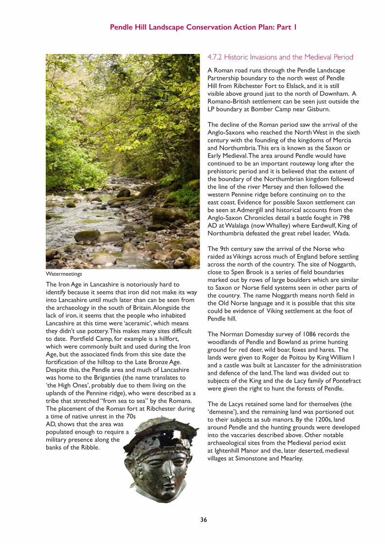
Watermeetings
Pendle Hill Landscape Conservation Action Plan: Part 1
37
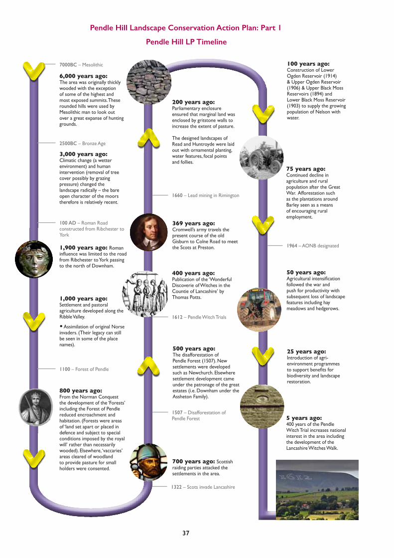
6,000 years ago: The area was originally thickly wooded with the exception of some of the highest and most exposed summits. These rounded hills were used by Mesolithic man to look out over a great expanse of hunting grounds.
1,900 years ago: Roman influencewaslimitedtotheroadfrom Ribchester to York passing to the north of Downham.
800 years ago: From the Norman Conquest the development of the ‘Forests’ including the Forest of Pendle reduced encroachment and habitation. (Forests were areas of ‘land set apart or placed in defence and subject to special conditions imposed by the royal will’ rather than necessarily wooded). Elsewhere, ‘vaccaries’ areas cleared of woodland to provide pasture for small holders were consented.
3,000 years ago: Climatic change (a wetter environment) and human intervention (removal of tree cover possibly by grazing pressure) changed the landscape radically – the bare open character of the moors therefore is relatively recent.
1,000 years ago: Settlement and pastoral agriculture developed along the Ribble Valley.
• Assimilation of original Norse invaders. (Their legacy can still be seen in some of the place names).
500 years ago: The disafforestation of Pendle Forest (1507). New settlements were developed such as Newchurch. Elsewhere settlement development came under the patronage of the great estates (i.e. Downham under the Assheton Family).
200 years ago: Parliamentary enclosure ensured that marginal land was enclosed by gritstone walls to increase the extent of pasture. The designed landscapes of Read and Huntroyde were laid out with ornamental planting, water features, focal points and follies.
75 years ago: Continued decline in agriculture and rural population after the Great War. Afforestation such as the plantations around Barley seen as a means of encouraging rural employment.
400 years ago: Publication of the ‘Wonderful Discoverie of Witches in the Countie of Lancashire’ by Thomas Potts.
100 years ago: Construction of Lower Ogden Reservoir (1914) & Upper Ogden Reservoir (1906) & Upper Black Moss Reservoirs (1894) and Lower Black Moss Reservoir (1903) to supply the growing population of Nelson with water.
50 years ago: Agriculturalintensificationfollowed the war and push for productivity with subsequent loss of landscape features including hay meadows and hedgerows.
25 years ago: Introduction of agri-environment programmes tosupportbenefitsforbiodiversity and landscape restoration.
7000BC – Mesolithic
2500BC – Bronze Age
700 years ago: Scottish raiding parties attacked the settlements in the area.
1322 – Scots invade Lancashire
100 AD – Roman Road constructed from Ribchester to York
1100 – Forest of Pendle
1507 – Disafforestation of Pendle Forest
1612 – Pendle Witch Trials
1660 – Lead mining in Rimington
1964 – AONB designated
5 years ago: 400 years of the Pendle Witch Trial increases national interest in the area including the development of the Lancashire Witches Walk.
369 years ago: Cromwell’s army travels the present course of the old Gisburn to Colne Road to meet the Scots at Preston.
Pendle Hill LP Timeline

Pendle Hill Landscape Conservation Action Plan: Part 1
38
4.7.3 Radical PendleThe Hill is forever associated with the Lancashire Witches, but many visitors never see beyond that cliché. There is so much more to tell! Since the 17th century Witch Trials and the emergence of Fox’s Religious Society of Friends, Pendle has remained a place that has sheltered and nurtured protestors and dissenters. Whether that is a product of the place being remote and lawless, or something that the landscape has instilled in people here, and which has developed from their self-reliance and tough ways of life is unknown. Whatever the causes, this radical nature is notable and we want to explore and celebrate it. We will re-tell the stories of The Pendle Radicals including prominent suffragist Selena Cooper who grew up in Barnoldswick and worked in the local mills from the age of 12. Selina became active in the early trades unions and the women’s suffrage movement and in 1910 was one of four women selected to present the case for ‘votes for women’ to the Prime Minister. During the FirstWorldWarshedevelopedthefirsteverMaternityCentre in Nelson, and her political life continued with an appointment to the Poor Law Guardians as a representative of the Independent Labour Party. Sadly, despite the passing of the law to enable women over 30 to vote in 1918, the Labour Party in Nelson refused to adopt her as candidate for the party in the General Election that year. Despite this she became a local
councillorandmagistrateandwasactiveinthefightagainst fascism in the 1930s. Richard Cobden who was a factory owner in Sabden andaninfluentialManchesterbusinessman.Cobdenwasan MP and co-founder of the Anti-Corn Law League which successfully campaigned from 1838-46 to abolish the unpopular Corn Laws. These protectionist policies were supported by wealthy British landowners and kept the price of corn and bread high, fuelling hunger and discontent for the workers. After Fox had come, Pendle also saw many other radical preachersvisitthearea:JohnWesleyfirstappearedinPadiham in 1757, and many more Methodists arrived in the 1760s and 70s. In total 57 Methodist and 47 Baptist and other non-conformist chapels sprang up in Burnley alone. Other radical preachers like Benjamin Ingham, founder of the Inghamites, and a number of other smaller non-conformist groups set up chapels and preaching stations. These groups often supported the setting up village schools, adult education and social reform movements. The Independent Labour Party in Nelson, one of the firstbranchesinthecountry,builtClarionHouseonland off Jinny Lane which they had bought as a ‘Land Trust’ in 1912, it was opened by Labour MP Philip Snowden. This is the last remaining Clarion House in the country and it still operates today as a haven for walkers, cyclists and radical thinkers.
Photo courtesy of the Clarion House

Pendle Hill Landscape Conservation Action Plan: Part 1
39
4.8 Habitats and Wildlife
Our phase 1 survey of the LP area in 2016 has shownthat81%oftheareacanbeclassifiedasgrassland, however 79% of this (over 7000 hectares) is improved for agriculture and utilised for silage crops or permanent pasture for sheep, cattle and horses – offering little refuge for wildlife. However, thefieldboundariesthatsurroundandconnectthesefieldscanactasvitalrefugesandecologicalcorridors to pollinators, birds and small mammals. This is why our activity will focus on boundary restoration and management, and on working with farmers to introduce ‘high nature value farming’ ie restoring the species diversity through sensitive land management, wherever practical and possible.
Phase 1 Habitats map
0 0.5 1 2
Kilometers 1:50,000

Pendle Hill Landscape Conservation Action Plan: Part 1
40
4.8.1 GrasslandThe majority of semi natural habitats are on the upland spine of the LP area, and these include blanket bog, peatland, acid grassland and heath. Large areas of acid grasslandarefoundontheflanksofthehillitselfandalong the ridge to the west of the Nick of Pendle. The majority of this grassland is dominated by mat grass (Nardus stricta) often with frequent bilberry (Vaccinium myrtillus). On the slightly drier slopes common bent grass dominates (Agrostis capillaris) and some sheep’s fescue grassland (Festuca ovina) is also present. There are also areas of rushy and marshy grassland present:bothassmallwetareasinfields,andaslargeexpanses in allotments on the hill slopes. On higher ground,thesearereplacedwithacidflushvegetationdominated by rushes: both soft rush (Juncus effuses) andsharp-floweredrush(Juncusacutiflorus)whichisabundant in more herb rich stands. Amongst the rushes there is a scattering of herbs such as greater bird’s foot trefoil (Lotus uliginosus), meadowsweet (Filipendula ulmaria) and common sorrel (Rumex acetosa). Stands of calcareous grassland are found on the limestone around Worston and Downham – and that on Worsaw Hill (a Biological Heritage Site) includes areas of blue moor grass (Sesleria caerulea). Large stands of bracken are found on the moderately steep slopes of the hill where the soil is deep – above Churn Clough, around Wood House Brook, below the Big End and along some of the steep cloughs. When comparing the phase 1 survey to that undertaken in 1988 it is clear that large areas mapped then as semi-improved neutral grassland have now become improved. This is particularly apparent to the south and east of Pendle Hill where the land is more agriculturally marginal than that on the lower lying ground of the western plain. In 1988, 931 hectares of semi-improved grassland of all categories was recorded, whilst in 2016 only462hectareswasmapped–aresultofsignificantagriculturalintensification,andamajorlossofnaturalhabitat.
4.8.2 HeathStands of heath are uncommon, covering less than 1% of the LP area. Stands of dry heath are dominated by heather (Calluna vulgaris) with bilberry (Vaccinium myrtillus), although on Burn Moor the dry heath is grassy. Wet heath is found on The Rough, Black Hill and Burn Moor and is composed of cross-leaved heath (Erica tetralix) heather (Calluna vulgaris) and purple moor grass (Molinia caerulea).
4.8.3 Mire and SwampLarge areas of blanket bog are present on the deep peat (that is, peat over 50cm deep) found on Pendle Hill, Spence Moor, Downham Moor, Twiston and Rimington Moors and Burn Moor. Most of this was mapped as modifiedwetordrybog.However,whereSphagnummoss species such as Sphagnum papillosum and/or Sphagnum Capillifolium were found to be frequent or abundant, the habitat was mapped as blanket bog – at The Bog Field and on The Rough. Asmentionedabove,acidflushesarefoundontheupland ridge, either as large extents as at the western end of Downham Moor and at the head of Swarndean Clough, or as narrow runnels through the acid grassland. Basic(alkali)flushesarerareandaremainlyfoundalongSwanside beck and its tributaries, along Churn Clough and on the lower end of Moor Isles Clough. Unusually, these are dominated by lesser pond sedge (Carex acutiformis).Moreconventionalbasicflushesdominatedby short sedges and brown mosses are found at The Rough and on Earton Hill. ValleymiresareconfinedtoshallowvalleysonBurnMoor and Rimington Moor and a narrow valley on The Rough. 4.8.3 Biological Heritage SitesThroughout the LP area 60 areas with a high ecological valuehavebeenclassifiedasBiologicalHeritageSites,the equivalent to County Wildlife status (see Appendix 1 – list of BHSs). Many of these were designated 30 years ago and some have not been surveyed since then, until our survey. As BHSs are mostly in private ownership and the designation does not provide any statutoryprotection,oursurveyhasidentifiedanumberin need of improved management and these will provide the focus for our ‘Wild about Pendle Hill’ project. These sites are detailed in the Habitat Action Plan for PendleHillLP.Inadditionthephase1surveyidentifieda number of new sites which may merit BHS status and these will be surveyed in more detail during the delivery stage.
Worsaw Hill

Pendle Hill Landscape Conservation Action Plan: Part 1
41
4.9 Farming and Land Use
Pendle Hill exhibits a patchwork of land use and farming types, determined largely by geology, drainage, altitude and historical tenure. 4.9.1 MoorlandLying above the limit of cultivation, moorland (often common land) remains an integral part of the upland farming system. The primary use is as summer grazing for sheep but they have in the past been a source of fuel, with peat being dug as a commoners’ right. PendleHillsupportsfivelargecommons(Pendleton,Barley, Worston, Spence and Rimington) which are still managed by associations of the graziers who retain common rights. A number of smaller commons also exist at Rimington and Sabden Fold. Some areas of the commons, which are mostly within the land ownership of the Downham Estate, have been fenced to reduce
stock numbers and to reverse the impact of historic over-grazing under recent agri-environment agreements. On Barley Moor the heather coverage is increasing as a direct result of this action.
All of the moorland and common on Pendle Hill was designated as open access land by the Countryside and Rights of Way Act (2000) and as such is open to the public. 4.9.2 WoodlandThe LP area was once much more heavily wooded, however, climate change at the end of the Atlantic Period (3500 to 3000 BC) brought in a cooler wetter period, which restricted tree growth and led to the formation of peat on the moorland plateau. Clearance of the woods for timber accelerated tree loss to the point where the remaining woodland today only exists in the steep valleys known locally as cloughs, or on escarpments unsuitable for grazing or cultivation.
$ 0 1 20.5
Kilometers
PendleCommons
New_LPS_boundary
Map of Common Land in the Pendle Hill LP area
Common LandLPS boundary
0 0.5 1 2
Kilometers

Pendle Hill Landscape Conservation Action Plan: Part 1
42
Deciduous woodlands planted in the designed landscapes of Huntroyde, Read and Downham provide the largest areas of deciduous woodland cover in the LP area. These were planted in the mid to late 19th century and today largely consist of a mix of non native beech and sycamore along with some substantial specimens of oak and ash. On the Huntroyde estate there are some notable ancient oak trees dating back several centuries. These designed woodlands were planted for aesthetics but also for shooting cover, and the inclusion of rhododendron for these purposes severely limits their wildlife value. Ancient and semi natural woodlands are very limited in the project area; they are almost totally absent to the north of the project area, they can also be seen in the cloughs that feed the River Calder and in the lower Sabden Valley. These mixed broadleaved woodlands are mostly a mix of ash, sycamore and oak. They offer an opportunity for further woodland creation and restoration: by increasing their extent and connectivity we will make these habitats more resilient intothefutureaswellasassistingwithnaturalfloodmanagement.
Sadly, Ash Dieback, caused by the fungal disease Hymenoscyphus fraxineushas, (previously called Chalara) been noted in the woodlands and roadside plantations around Whalley and Clitheroe. If this spreads throughout the LP area we will experience a notable loss of tree cover and a subsequent loss of the
biodiversity dependent on it. We will look to introduce replacement species where possible, although how can you replace such a beautiful, graceful tree so dominant in our landscape?
4.9.3 Plantation WoodlandThe conifer plantations associated with the Barley and Churn Clough reservoirs date mostly from the 1930s onwards. There was little consideration to the ecological value of the existing habitats, and plantations have been plantedondwarf-shrubheath,marshygrassland,flushhabitat and species-poor semi-improved grassland. In some areas the larch plantations have recently been clear felled, as at Churn Clough and Ogden, due to the presence of the disease Phytopthora ramorum (larch tree, or sudden oak death, disease). Surprisingly, there is more broadleaved plantation than coniferous in the LP area, and this has notably increased from 334 ha in 1988 to 602 ha in 2016: an increase of 80%, largely due to new woodland creation grants and agri-environment schemes. 4.9.4 Water GatheringThe reservoirs around Barley and at Churn Clough near Sabden were built to provide drinking water for the nearby industrial towns, and were constructed in the early 20th century. Originally built by small water companies, they are now owned and managed by United Utilities. The Ogden reservoirs to the south west of Barley are fed by Ogden Water which rises near the summit of Pendle and acts as the borough boundary between Pendle and Ribble Valley for much of its length. The name Ogden means ‘valley of oaks’. Originally harnessed to power cotton mills at Barley Green and Narrowgates, the beck was dammed in 1906 to create the Upper reservoir, and then again in 1914 to create the larger Lower reservoir. Between them, they can hold over 250 million gallons of water. Black Moss reservoirs to the north east of Barley were built in 1894 (Upper) and 1903 (Lower) and are important sites for birdlife. Between them, these two reservoirs hold around 100 million gallons of water which is taken to Nelson when needed for drinkingwater.Aregularcompensationflowfrombothreservoirs feeds the beck downstream. Churn Clough reservoir (above Sabden), is small at 5 hectares and was built in 1892. Owned and managed by UnitedUtilities,itisanimportanttroutfishingvenuemanaged by Colne Water Angling Club.
Ash tree on the Downham Estate

Pendle Hill Landscape Conservation Action Plan: Part 1
43
4.9.5 Sheep FarmingWhilst many farmers run their sheep on the moors and commons for part of the year, they also manage lower lying ‘in-bye’ land around the hill, and this includes the farmingoffieldsaspastureandasgrasslandormeadow. Pasture is land that is grazed year round (by sheep and/orcattle)whilsttheotherfieldsaremanagedprimarilyfor growing grass as winter fodder. In the past, and up untilthe1970sinthisarea,themeadowfieldsweremanaged in the more fertile lowland parts by removing stock after lambing, and then cutting hay in mid-summer. Thefieldswerethengrazedagainandmuckwasspreadto improve fertility. Haymaking,alwaysdifficultinthewetnorthwesternuplands, has largely been superseded by more intensive methods which include regular applications of herbicides, chemical fertilisers and slurry, and by taking 2 or even 3 cuts of grass as haylage or silage. This agricultural improvement of grassland, whilst good for producing fodder, has had a massive impact on wildlife and the landscape. Early cuts of grass disturb ground nesting birds such as curlew and lapwing, and
also prevent the wide range of grasses and associated meadowflowersfromflowering.Mechanicalmowinghasledtolargerfieldsandtotheabandonmentofboundariesandfieldbarns.However,smallareasofspecies-richgrasslandremaininfieldcorners,ininaccessible valleys and along roadsides, and we intend to restore more grassland to meadows as part of the ‘Wild About Pendle Hill’ project within the LP scheme.
4.9.6 Dairy FarmingIn the Gisburn area of the LP scheme, dairy farming exists on an almost industrial scale, as the fertile drumlin landscape offers opportunity to grow fodder crops such asspringwheatandmaizeonploughedfields.Somedairy herds are kept indoors most or all of the year andsothefieldsarehighlyimprovedandfertilisedwithslurry and chemicals, and traditional boundaries are not always retained or maintained.
In other parts of the LP area - around Pendleton, Rimington and Sabden - dairy farms are less intensive and smaller scale. Both organic and raw milk are produced by small farms at Gazegill and Cockshutts.

Pendle Hill Landscape Conservation Action Plan: Part 1
44
4.10 Boundaries
Theboundariestofieldsareanintegral(ifwhollyman-made) part of the landscape. They are part of the cultural landscape with different phases of enclosure dating back at least seven hundred years. This distinctive upland landscape of hedges, banks and drystone walls is therefore a product of piecemeal evolution over centuries. Ancientenclosure,classifiedasmixedspecieshedgerows, walls, banks and ditches dating from before 1600, tends to be of small to medium, irregularly shaped fields,mostofwhichseemtoencloseindividuallyfarmed holdings. In the Pendle Hill area these are found around most of the villages, ie Rimington, Downham, Worston, Pendleton, Wiswell, Sabden, Higham, Newchurch, and Roughlee; as well as in isolated areas around Gazegill, Admergill, The Rough, Blacko and Twiston. Some of these early enclosures are the result of ‘assarting’ or the enclosure of woodlands as around Sabden Hall and Barley. On the eastern side of the hill some boundaries still trace the old vaccary boundaries and the internal subdivisions of these which were created by the copyhold tenants in Pendle Forest during the 16th century. Laterfieldboundarieswerecreatedasaresultofpiecemeal enclosure of the lower-lying land and some of the commons. Then, from the 17th to 19th century ‘parliamentary enclosure’ brought much more land into farming, leaving only the very tops of the hill unenclosed and still under common land. These parliamentary walls are the longest, straightest walls you see, often running up the side of the hill, or cutting up the foothills into large,regularlyshapedandsizedfields.
This distinctive upland landscape of hedges, banks and drystone walls is therefore a product of piecemeal evolution over centuries.
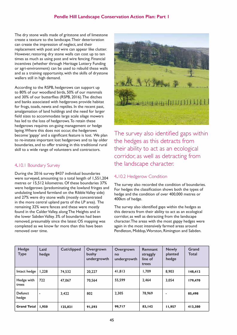
Pendle Hill Landscape Conservation Action Plan: Part 1
45
The dry stone walls made of gritstone and of limestone create a texture to the landscape. Their deterioration can create the impression of neglect, and their replacement with post and wire can appear like clutter. However, restoring dry stone walls can cost up to ten times as much as using post and wire fencing. Financial incentives (whether through Heritage Lottery Funding or agri-environment) can be used to rebuild these walls and as a training opportunity, with the skills of drystone wallers still in high demand. According to the RSPB, hedgerows can support up to 80% of our woodland birds, 50% of our mammals and30%ofourbutterflies(RSPB,2016).Theditchesand banks associated with hedgerows provide habitat for frogs, toads, newts and reptiles. In the recent past, amalgamation of land holdings and the need for larger fieldsizestoaccommodatelargescalesilagemowershas led to the loss of hedgerows. To retain these hedgerows requires on-going management or hedge laying. Where this does not occur, the hedgerows become‘gappy’andasignificantfeatureislost.Weplanto re-instate important lost hedgerows and to lay older boundaries, and to offer training in this traditional rural skill to a wide range of volunteers and contractors.
4.10.1 Boundary SurveyDuring the 2016 survey 8437 individual boundaries were surveyed, amounting to a total length of 1,551,204 metres or 15,512 kilometres. Of these boundaries 37% were hedgerows (predominating the lowland fringes and undulating lowland farmland on the Ribble Valley side) and 27% were dry stone walls (mostly concentrated in the more central upland parts of the LP area). The remaining 32% were fences and these were mostly found in the Calder Valley, along The Heights and in the lower Sabden Valley. 3% of boundaries had been removed, presumably since the latest OS mapping was completed as we know far more than this have been removed over time.
4.10.2 Hedgerow ConditionThe survey also recorded the condition of boundaries. Forhedgestheclassificationshowsboththetypesofhedge and the condition of over 400,000 metres or 400km of hedge.
Thesurveyalsoidentifiedgapswithinthehedgesasthis detracts from their ability to act as an ecological corridor, as well as detracting from the landscape character. The areas with the most gappy hedges were again in the most intensively farmed areas around Pendleton, Middop, Worston, Rimington and Sabden.
Intact hedge Hedge with trees
Defunct hedge
Grand Total
1,228 722
-
1,950
74,532 47,067
3,422
125,021
20,227 70,564
802
91,593
41,813 55,599
2,305
99,717
1,709 2,464
78,969
83,142
8,903 3,054
-
11,957
148,412 179,470
85,498
413,380
Hedge Type
Laid hedge
Cut/clipped Overgrown bushy undergrowth
Overgrown no undergrowth
Remnant straggly line of trees
Newly planted hedge
Grand Total
The survey also identified gaps within the hedges as this detracts from their ability to act as an ecological corridor, as well as detracting from the landscape character.

46
4.10.3 Wall ConditionGenerally speaking, the network of dry stone walls are in a better state of repair than the hedges, apart from around Worston, Dudland and Gisburn although the actual numbers here are low.
A number of very visible walls have been abandoned as being no longer of use in the farming system and this can lead to an atmosphere of neglect, however in reality only 3% of the 300,000 metres of wall surveyed are abandoned and nearly 80% are in good condition. The Traditional Boundaries report and Action Plan provide much more detail, and using a combination of survey data we have drawn up a list of priority areas for boundary restoration, see appendices 4 and 5. This prioritisation will be the focus of restoration and management activity to be undertaken by our ‘Traditional Boundaries’ project.
4.11 Ecosystem Services
Pendle Hill, as with any landscape area, can be described in terms of the ‘ecosystem services’ which it offers. Ecosystemservicesarethebenefitswegetfromnature. These include food, energy, clean air and water, regulationofrisks(floods,droughts,erosion)andrecreationalorspiritualbenefits. Ecosystemsservicesareusuallyclassifiedas:
a) provisioning
b) supporting
c) cultural
d) regulating
Provisioning services provide for us – food, water, energy etc; whilst other services support that provision.
Supporting ecosystem services include the ground
beneath our feet: the inert, the micro life, lower life forms, and invertebrates that, in conjunction with air, water, and light, support vegetation and thus all higher life forms (Daily et al., 1997; Rodriguez et al., 2006; MA, 2005). Soil and soil fertility is critical to the cycle of life (Daily et al., 1997; Rodriguez et al., 2006; MA, 2005). In the paper Ecosystem Service: Benefits supplied to Human Societies by Natural Ecosystems (Daily et al., 1997), five interrelated services (functions) provided by soil are described including three that lie within the supporting ecosystem services: one, soil protects seeds and physically supports their growth as they mature into plants; two, soil retains and delivers nutrients to plants; and three, soil plays a crucial role in the decomposition of dead and decaying matter. Without these functions, higher life forms, including humans, would not be able to survive. So, although often taken for granted, the supporting ecosystem services are as critical to human life as the provisioning service.
From Kerry Morrison, 2015, Exploring the cultural ecosystem services associatedwithunmanagedurbanbrownfieldsites:
An interdisciplinary (Art and Sciences) approach. (PhD Thesis) Cultural services provide the spiritual and emotional benefitsoflandscape;whilstregulatoryserviceshelpusto regulate services, for example by reducing the risk of floodingormitigatingagainstclimatechange. The majority of the LP projects interact with ecosystem services, the framework in appendix 6 illustrates the serviceswehaveidentified,andhowouractivitieswillaffect them. In particular we are interested in how the landscape, and peoples experience and connection with it, affects our health and wellbeing: ‘What’s a Hill Worth?’ and the PEN project will seek to address and quantify this directly.
Pendle Hill Landscape Conservation Action Plan: Part 1

Pendle Hill Landscape Conservation Action Plan: Part 1
47
Engaging new audiences © Phillippe Handford

4.12 Communities
The communities of Pendle Hill, along with its physical and historic character, give it a distinctive sense of place. Admittedly the two sides are different and the hill may physically divide them, but it also brings rural communities together: as a resilient and friendly population. 4.12.1 Local ResidentsThe total population of the LP area is 20,387 (2011 census), with a fairly even divide between the Pendle and Ribble Valley districts. Residents are mostly concentrated in the villages, many of which are now becoming desirable housing areas for people who commute to, or have retired from, Clitheroe, Colne and Burnley. The farming community has survived well and dominates the hill itself, as well as lower lying parts of Rimington, Sabden and Gisburn parishes. The AONB has already established a farmers network for the area, meeting 3 or 4 times a year and feeding into the LP scheme via the boundaries, woodlands and wildlife activity we are proposing. This is a thriving and active rural community, with a long history of self-reliance and resilience. See appendix 7 for more details. 4.12.2 Neighbouring CommunitiesThe neighbouring communities to the LP area are many and varied. The population totals 229,333 people (2011 census) within 3.5km of the hill itself (ie within an hour’s walking distance). As the history has described, this was once a very remote rural area later transformed by the industrial revolution, and yet until recently that connection with the land and the past was strong. Workers would escape from the polluted towns and climb the hill to reach clean air. Hundreds at a time would walk or cycle out on a Sunday to Roughlee and Happy Valley or to the Clarion House and other tearooms and pubs. The huge network of rights of way traces both the old connecting routes between farmsteads, and the paths leading out of towns to Pasture House, Noggarth, Heys Lane and onto the Hill itself.
The rivers separating the towns from the Hill – the Ribble and Calder – can be viewed as a corridor for both wildlife and people. The rivers acted as a source of power and water for the people living in the towns, and they still connect the source of Ogden Water on theverytopoftheHill,flowingthroughtheLParea,into the towns and on to join the Calder. This watery connection is one we will explore and interpret through our creative Gatherings woven through the LP scheme. As described, the urban areas of ‘Pennine Lancashire’ developed in the 18th and 19th centuries in response to the industrial revolution. Burnley and Colne grew from small towns, whilst Nelson was largely a new settlement built to house the workers from a cluster of large mills. Since the 1960s and 70s the area has been in decline with the majority of manufacturing industry facing closure. Immigrant populations attracted to the mills from largely rural Pakistan since the 1950s have remained in the area and compared to other towns social integration is good here. Cultural attitudes to the natural landscape are different amongst this BAME community with little connection to the landscape or family history of trips to the countryside, and this is therefore a target population for the engagement work of the LP. Industrial scale quarrying and cement works have eclipsed the market town of Clitheroe’s 19th and early 20th century dependence on the textile industry, whilst Gisburn has always had its hub as a regional livestock market. Clitheroe, along with the rest of Ribble Valley isnowaveryaffluentareaofLancashireandwellconnected to the cities of Preston and Manchester by road and rail. Appendix 8 describes the community infrastructure we have discovered to date: many of the groups and organisations have already been involved in consultation and planning, and we plan to identify more ‘hard to reach’ groups and engage with them and others during the lifetime of the scheme. Pennine Lancashire is one of the most deprived parts of Lancashire and the northwest of England. This divide shows up when you look at deprivation indicators such as car ownership, ethnicity, employment, income and health across the LP area and in its hinterland:
Pendle Hill Landscape Conservation Action Plan: Part 1
48

Pendle Hill Landscape Conservation Action Plan: Part 1
49
Main language not English
Sources: ONS (2001 & 2011), DCLG (2010)
Health deprivation
Income deprivation Employment deprivation
Lower 10%
Lower 20%
Lower 30%
Lower 40%
Lower 50%
Upper 50%
Upper 40%
Upper 30%
Upper 20%
Upper 10%
Rank relative to rest of EnglandMaps showing indicies of deprivation within Pendle Hill LP area and 3.5km from boundary
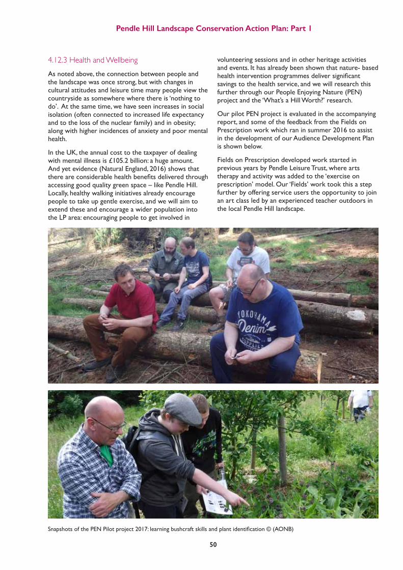
Pendle Hill Landscape Conservation Action Plan: Part 1
50
4.12.3 Health and WellbeingAs noted above, the connection between people and the landscape was once strong, but with changes in cultural attitudes and leisure time many people view the countryside as somewhere where there is ‘nothing to do’. At the same time, we have seen increases in social isolation (often connected to increased life expectancy and to the loss of the nuclear family) and in obesity; along with higher incidences of anxiety and poor mental health.
In the UK, the annual cost to the taxpayer of dealing with mental illness is £105.2 billion: a huge amount. And yet evidence (Natural England, 2016) shows that thereareconsiderablehealthbenefitsdeliveredthroughaccessing good quality green space – like Pendle Hill. Locally, healthy walking initiatives already encourage people to take up gentle exercise, and we will aim to extend these and encourage a wider population into the LP area: encouraging people to get involved in
volunteering sessions and in other heritage activities and events. It has already been shown that nature- based healthinterventionprogrammesdeliversignificantsavings to the health service, and we will research this further through our People Enjoying Nature (PEN) project and the ‘What’s a Hill Worth?’ research.
Our pilot PEN project is evaluated in the accompanying report, and some of the feedback from the Fields on Prescription work which ran in summer 2016 to assist in the development of our Audience Development Plan is shown below.
Fields on Prescription developed work started in previous years by Pendle Leisure Trust, where arts therapy and activity was added to the ‘exercise on prescription’ model. Our ‘Fields’ work took this a step further by offering service users the opportunity to join an art class led by an experienced teacher outdoors in the local Pendle Hill landscape.
SnapshotsofthePENPilotproject2017:learningbushcraftskillsandplantidentification©(AONB)

Pendle Hill Landscape Conservation Action Plan: Part 1
51
Evidence* shows the health benefits of access to good quality green spaces...
Improved mental health & wellbeing
Reduced obesity
Transforming Mental Health and Dementia Provision with the Natural Environment Conference 2016 *Ref EIN018, EIN019, EIN020, EIN021
Increased longevity People feel healthier
There was a strong focus on empowering participants through a sense of reduced control from artists in order to let participants make their own individual decisions for their engagement- the only aspects set were the agenda, time and place. Direct teaching was limited, instead leaders offered suggestions and advice accordingly. This balance of input provided a purpose for participants’ engagement in the landscape whilstproposedasituationoffreedom,aspaceforreflectionandaplaceofnoexpectations. Furthermore, this promoted personal experiences such as participants conducted the art work for themselves as opposed to for the leaders, as well as prohibited interference of the processes occurring.
Another form of engagement was through the social aspect of the projects. Following the project, participants wrote about their experiences, and often their comments did not relate to the artistic practice itself, rather forms of meaningful group involvement such as “I feel better, just because I’ve got someone to talk to” or “there’s been a lot of laughing”.
Psychological experiences of being outside conducting artist practices differed to those taking place inside, (for example, at The Shop). This was shown through a change in social engagement whereby conservations revolved around: nature, how they felt inspired by being outside, its peacefulness, how the outside had a calming influence,howtheyenjoyeditssilenceandquietness,howbeinginnatureclearedtheir mind and how they felt tranquil and ‘detoxed’. These conversations indicated thementalhealthbenefitsofexploringthelandscape.Alsomentionedwithinthefeedback sessions following the projects, were that people slept better and felt less stressed.
Personal, spontaneous and physical engagement of the landscape was another different type of engagement which occurred as a result of a lack of restrictions. A ‘little big moment’ conveys how two people used this freedom on a particular day to walkoffontheirowndevicesawayfromthegroupandfoundaspaceforreflectionat a site of personal interest. When the leader went over to them, they were relaxed and calm, connecting with their place in the landscape through being one with nature. Similarly, upon doing the artwork several participants found themselves spontaneously using the physical landscape for their artistic practices such as using grass for a green stain or washing their paintbrushes in the nearby river.
Trustwasacriticalelementinincreasingtheparticipant’sconfidencetopartakeindifferent activities or in visiting places in the landscape they have not been before. Trust was developed over time within the group and with the leader as they learned more about each other and following previous positive experiences. Thus, the leader could suggest a different task and the participants felt comfortable in doing so,withoutreluctance-subsequentlythisbuiltuptheirconfidence.Aninterestingobservation was found towards the end of the projects as participants began to converse with each other about having nothing to do, being retired and describing feelings of emptiness in their lives- this indicates the participants wanted to continue doing group artistic practices in the landscapes.

Pendle Hill Landscape Conservation Action Plan: Part 1
52
4.12.4 Visiting CommunitiesThere is a population of just over 3 million people within 40km (or an hour’s drive) of Pendle Hill. Appendix 9 provides an analysis of the visitors to the area as surveyed in 2014, 2016 and 2017.
PENDLEHILL
BLAC
KPOOL MANCHESTER LEED
S LIVERPOOL
L
ANC
AST
ER
SABDEN NELSON
CLITH
EROE COLNE
DO
WN
HA
M B
AR
LEY
BARLEY BARLEY BARLE
Y
PENDLEHILL
1hr
20 min
drive
5 min(walk)
Admiring the view from the summit

Pendle Hill Landscape Conservation Action Plan: Part 1
53
As might be expected the visiting communities have a strong demographic, being largely over 40, able-bodied and white. When compared to our neighbouring populations it is clear that large sections of the community - namely young people, people from Black, Asian and Minority Ethnic communities, and people with poor mental and physical health – are missing. That is not to say that these groups are never seen climbing the hill or visiting the villages as it has become more common in recent years to see families from BAME communities visiting the area for picnics and walks. As part of our Audience Development Planning work several barriers to accessing the wider countryside wereidentifiedbyfocusgroups,duringactivitiessuchasPEN and Fields on Prescription and the Mums2Mums River Project. These ‘barriers to participation’ can be summarised as follows: • Perceptionsofdifference–egsomeareasseenas ‘posh’ and with high expectations of visitors; people also felt they ‘stood out’ as different, as with not having ‘the right clothing’ when visiting
• Lackofknowledgeofwheretogoorwhattodo, what’s ‘allowed’
• Lackofapurpose,needingtobelegitimate–just wanting to be there was not seen as enough reason to visit
• Costsofpublictransportandlimitedaccessto private alternatives
• Pressuresonfamilytime,opportunitiestogooutas a family or with the children are limited
• lackofexperienceofthecountryside,eitherwithin the family or the community, concerns about dogs, cattle, mud, landowners etc.
In the summer of 2017 we carried out a limited number of observational surveys to ascertain the types and numbers of people reaching the summit of Pendle Hill. These were carried out at different times and on different days of the week, in and out of school holidays. Thefindingsshowthatwecanexpectnearly300,000ayear to reach the trig point. 4.13 The Visitor Economy
Pendle Hill has been a destination for walkers and cyclists since the days when millworkers would take a walk or ride into the hills for the fresh air and exercise. The Easter weekend (although often wet or even snowy) was a favourite ‘pilgrimage’ up the hill, and the area was also a popular destination for days out by charabanc (often an open top bus), especially for those who could not afford a trip to the seaside for the annual wakes week.
Nel
son
Lead
er, 1
930.
Downham village green
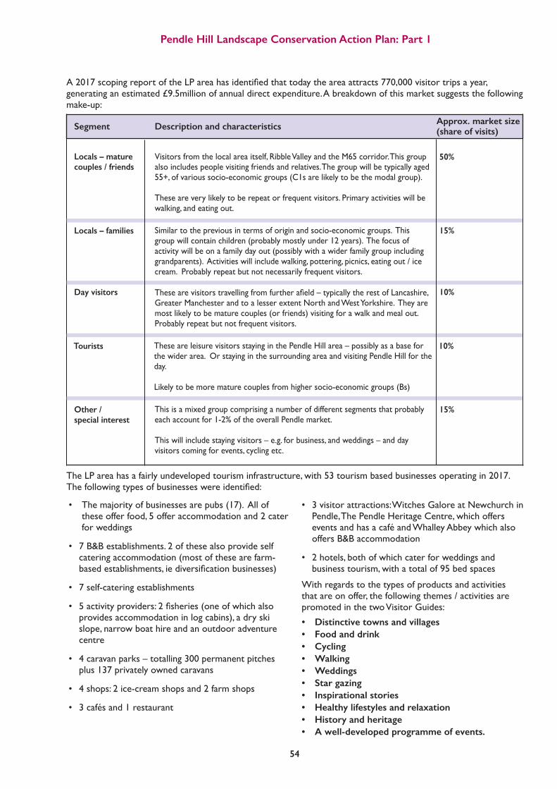
Pendle Hill Landscape Conservation Action Plan: Part 1
54
Segment Description and characteristics Approx. market size (share of visits)
Locals – mature couples / friends
Visitors from the local area itself, Ribble Valley and the M65 corridor. This group also includes people visiting friends and relatives. The group will be typically aged 55+, of various socio-economic groups (C1s are likely to be the modal group). These are very likely to be repeat or frequent visitors. Primary activities will be walking, and eating out.
50%
15%Locals – families Similar to the previous in terms of origin and socio-economic groups. This group will contain children (probably mostly under 12 years). The focus of activity will be on a family day out (possibly with a wider family group including grandparents). Activities will include walking, pottering, picnics, eating out / ice cream. Probably repeat but not necessarily frequent visitors.
10%Day visitors Thesearevisitorstravellingfromfurtherafield–typicallytherestofLancashire,Greater Manchester and to a lesser extent North and West Yorkshire. They are most likely to be mature couples (or friends) visiting for a walk and meal out. Probably repeat but not frequent visitors.
10%Tourists These are leisure visitors staying in the Pendle Hill area – possibly as a base for the wider area. Or staying in the surrounding area and visiting Pendle Hill for the day.
Likely to be more mature couples from higher socio-economic groups (Bs)
15%Other / special interest
This is a mixed group comprising a number of different segments that probably each account for 1-2% of the overall Pendle market.
This will include staying visitors – e.g. for business, and weddings – and day visitors coming for events, cycling etc.
• Themajorityofbusinessesarepubs(17).Allof these offer food, 5 offer accommodation and 2 cater for weddings
• 7B&Bestablishments.2ofthesealsoprovideself catering accommodation (most of these are farm- basedestablishments,iediversificationbusinesses)
• 7self-cateringestablishments
• 5activityproviders:2fisheries(oneofwhichalso provides accommodation in log cabins), a dry ski slope, narrow boat hire and an outdoor adventure centre
• 4caravanparks–totalling300permanentpitches plus 137 privately owned caravans
• 4shops:2ice-creamshopsand2farmshops
• 3cafésand1restaurant
• 3visitorattractions:WitchesGaloreatNewchurchin Pendle, The Pendle Heritage Centre, which offers events and has a café and Whalley Abbey which also offers B&B accommodation
• 2hotels,bothofwhichcaterforweddingsand business tourism, with a total of 95 bed spaces
With regards to the types of products and activities that are on offer, the following themes / activities are promoted in the two Visitor Guides: • Distinctive towns and villages • Food and drink • Cycling • Walking • Weddings • Star gazing • Inspirational stories • Healthy lifestyles and relaxation • History and heritage • A well-developed programme of events.
A2017scopingreportoftheLPareahasidentifiedthattodaytheareaattracts770,000visitortripsayear,generating an estimated £9.5million of annual direct expenditure. A breakdown of this market suggests the following make-up:
The LP area has a fairly undeveloped tourism infrastructure, with 53 tourism based businesses operating in 2017. Thefollowingtypesofbusinesseswereidentified:

Pendle Hill Landscape Conservation Action Plan: Part 1
55
With a strong day visitor market and many retirees visiting the area, the visitor numbers tend to follow the weather rather than the seasons. A nice cold dry Thursday in January can be every bit as busy as a sunny Sunday in July.
Ribble Valley is a popular area for weddings with a number of key hotels including Stirk House and Higher Trapp in the LP area involved in this market. For other venues, the view of Pendle Hill is often used as a wedding photo album backdrop.
‘Food and Drink’ is also a growing market – on both sides of the Hill. Clitheroe hosts an annual Food Festival each summer, attracting over 20,000 visitors in 2016. There are a rising number of ‘gastro pubs’ in and around the LP area including the Assheton Arms in Downham and the Freemasons at Wiswell which both made the
UK top 10 list drawn up by the Guardian in 2017.
The area hosts a popular walking festival each August. Administered by Pendle Borough Council it offers free guided walks led by a group of experienced volunteers, andregularlyattractsover1000visitors(2014figures)during its 10 day duration. Analysis of walkers shows that the festival tends to attract locals and people living within the 40km zone and doesn’t have a major impact on demand for accommodation.
Pendle Hill also hosts an annual Tractor Run and two key fell races – the Tour of Pendle held in November and the Pendle Fell race in April. There are a number of other fell races such as a ‘Dark Dash’ organised by the Mountain Rescue Team in March 2017; and cycle events also occur each year: in 2015 it hosted part of the Tour of Britain.
Tour of Britain 2015 Nick O’ Pendle
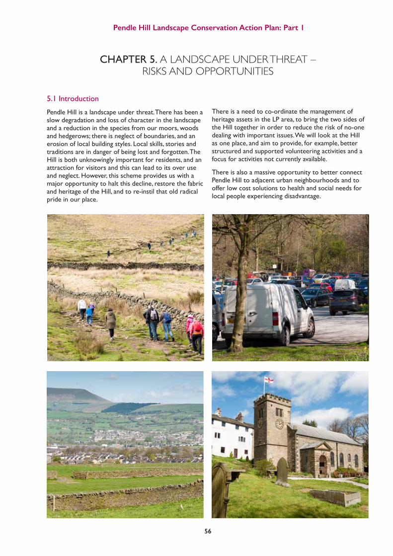
Pendle Hill Landscape Conservation Action Plan: Part 1
56
5.1 Introduction
Pendle Hill is a landscape under threat. There has been a slow degradation and loss of character in the landscape and a reduction in the species from our moors, woods and hedgerows; there is neglect of boundaries, and an erosion of local building styles. Local skills, stories and traditions are in danger of being lost and forgotten. The Hill is both unknowingly important for residents, and an attraction for visitors and this can lead to its over use and neglect. However, this scheme provides us with a major opportunity to halt this decline, restore the fabric and heritage of the Hill, and to re-instil that old radical pride in our place.
There is a need to co-ordinate the management of heritage assets in the LP area, to bring the two sides of the Hill together in order to reduce the risk of no-one dealing with important issues. We will look at the Hill as one place, and aim to provide, for example, better structured and supported volunteering activities and a focus for activities not currently available.
There is also a massive opportunity to better connect Pendle Hill to adjacent urban neighbourhoods and to offer low cost solutions to health and social needs for local people experiencing disadvantage.
CHAPTER 5. A LANDSCAPE UNDER THREAT – RISKS AND OPPORTUNITIES

Pendle Hill Landscape Conservation Action Plan: Part 1
57
5.2 Environmental Threats and Opportunities
The landscape character assessments for the LP area (Forest of Bowland AONB, 2009 and Pendle Hill LP 2016) identify a number of physical threats facing Pendle Hill. In the past these have included:
• Erosionofgulliesbywater
• Footpatherosion
• Humanhabitationandexploitationofgeologicalresources
• Lackofdrystonewallmanagement
• Reductioninecologicalvalue
• Suburbanisationoftraditionalfarmsteadsandvillages
• Declineofmaturehedgerowtrees
• Amalgamationanddeclineofdairyfarms
• Lossanddeclineofparklandfeatures
Inaddition,currentandfuturethreatsandtheircausesareidentifiedas:
• Climatechange
• Climatechange
• Climatechange
• Climatechange
• Changesinfundingleadingtoagriculturalchange
• Pressurefromdevelopment
• Changesinfundingleadingtoagriculturalchange• Pressurefromdevelopment
• Changesinfundingleadingtoagriculturalchange • Pressurefromdevelopment
• Changesinfundingleadingtoagriculturalchange
Increasesinmoorlandfireanderosion Spread of invasive and non-native species Increase in tree and animal diseases Increaseinflashflooding,gullyerosionanddownstreamflooding Wallneglect,scrubincrease,lossoffieldpattern
Increasedtouristtrafficonroads Conversion of barns, loss of vernacular style and materials Uncertainty over future management Amalgamation of farms and construction of new agricultural buildings
Threat Main Causes

Pendle Hill Landscape Conservation Action Plan: Part 1
58
The key causes of these threats and changes are
5.2.1 Climate ChangeIt is expected that the key changes we can expect to experience in the LP area as a result of climate change are:
Hotter, drier Summers – the central estimate of increase in summer mean temperature is 3.7ºC and the central estimate of change in summer mean precipitation is -22%
Warmer, wetter Winters – the central estimate of increase in winter mean temperature is 2.6ºC and the central estimate of change in winter mean precipitation is +16%
(UKCP09 headline messages for the north west of England, 2080s medium emissions scenario as in the Forest of Bowland Climate Change Adaptation Plan, 2011)
The impacts of these changes are likely to be:
• Thedryingoutofsoilsandsurfacesleadingto destabilisation and erosion, particularly when also under pressure from humans and livestock and when flashfloodingoccurs
• Lowflowinriversleadingtoalossofbiodiversity (vegetation,invertebrates,fish,birdsandmammals)
• Increasedlikelihoodoffiredamagingpeatsoils, archaeology and vegetation
• Gullyinganderosionofpeat,cloughsandsoils leading to loss of vegetation, soils and downstream flooding
• Increasedsensitivitytocompetitionbyinvasive species and increase in plant and animal pests and diseases
• Droughtleadingtoashiftinthecompositionof vegetation types and species, a reduction in diversity and a subsequent impact on wetland bird species
• Droughtleadingtoanincreaseinbrackenand moliniacoveronuplandslopes;dryingupofflushes and springs affecting vegetation, invertebrates and birds
• Lossoffrosteventscausingareductioninsome species and an increase in others
• Longergrowingseasonleadingtochangesin agriculture and a shift in some habitats eg loss of swamp, woodland succession and scrub invasion
The habitats and assets in the LP area which we expect to be most vulnerable to these changes are blanket bog, purple moor grass and rush pasture, upland hay
meadows,wetwoodlands,uplandspringsandflushes,thegroundfloraoflowlandmixedwoodlands,acidupland soils, buried archaeology, designed landscapes, fisheries,andfootpathsandbridleways.
The main response that we can make to these changes, many of which we are already experiencing, is to attempt to increase the resilience of natural habitats wherever we can. We can do this by connecting up ecological networks to strengthen them and to enable species to move around; and by improving the structure and management of important sites and habitats to bring them into good condition, and therefore more likely to be able to be resilient to the extremes of the new climate.
Wewillalsolooktotackleincreasedrisksofflooding(see appendix 3) through utilising natural methods of ‘slowingtheflow’,suchasinstallingwoodydebrisinwater courses, blocking gullies in the peatland and blanket bogs, and restoring traditional boundaries which intersectsignificantstreamsofoverlandflow. (see appendix 5a for details).
A case of ash die back © Phil Dykes

Pendle Hill Landscape Conservation Action Plan: Part 1
59
Newly planted bare peat © AONB
Peatland restoration on the Bowland fells © AONB
Major opportunities in the LP area are to:
• Restoreourblanketbog(peatlandrestoration)
• Reverttotraditionalmanagementofpastureandmeadows(highnaturevaluefarming)bymaintainingwetareas, reducing inputs and changing stocking rates and cutting regimes
• Bettermanageandextendourwoodlands
• Replacetreesandwoodlandslosttodisease
• Restoreandcreateboundariesandwoodlandswhichassistwithnaturalfloodriskmanagement
• Strategicallyremoveinvasivenon-nativespeciesandreplacelostspecieswithnativeandresilient alternatives
• SupportthePendleHillfarmersnetworkwithtrainingneedsandindeliveringlandscapescalechanges
• Introducenaturalfloodmanagement

Pendle Hill Landscape Conservation Action Plan: Part 1
60
• Encroachmentofscrubandbracken,lossofheatherand bilberry moor, loss of blanket bog and peatland
• Neglectoftraditionalboundaries,lossofshepherding tradition, reduction in active commoners
• Lossofspeciesmixanddiversity,leadingtolossof invertebrates, birds and mammals• Soilcompactionanderosion• Removalofhedgerowsandwallstoincreasefieldsize and ease of cutting
• Lossofwetflushesandwetgrasslandleadingtolossof species and diversity of vegetation, invertebrates, birds and mammals
• Newagriculturalbuildings• Changesinlivestocknumbersandbreeds• Increaseduseofslurryonfieldsleadingtosoil compaction and species loss
• Lossofmaintenanceoftraditionalboundariesand woodlands • Lossofruralskills• Lossofsmallerscaleactivityandresponsiveness• Overmaturityofparklandtreesandpoormanagement of hedgerows
Over and under grazing
Marginalisation of upland hill farming leading to loss of labour and investment
Increased number and earlier cuts of grassland, compounded by increased fertilisation, ploughing and re-seedingto produce more silage and haylage for winter feed
Improvement of pasture by fertilising and drainage
Pressures on dairy farming economics leading to larger units, farmamalgamation,increaseduseofgenetics,antibiotics,scientificnutrition and year-round or winter housing of livestock
Decline in farm labouring, increased mechanisation
Changes Caused By Funding, Policies, and Markets Environmental Impacts
5.2.2 Changes in Funding, Policies and Markets Leading to Agricultural ChangeJust as historical changes led to landscape and agricultural change in the form of the development of forest, enclosures and estate development, so too have changes in the 20th and early 21st centuries. Since 1945, Government incentives have encouraged farmers to increase production, to modernise and meet regulations, and more latterly through agri-environment grants, to begin to introduce conservation measures. The imminent loss of European farming subsidies will doubtless lead to further changes.
Changes in consumer trends, the rise of the supermarket and export markets, increased mechanisation, the introductionofgenetechnology,andgeneralintensificationoffarmingwillalsohaveanimpact.
Key changes we can see due to these forces in the LP area include:
The main steps that we can take in response to these changes are to support and encourage farmers to re-introduce high nature value farming wherever this is economically viable, in some cases by diversifying and responding to these very same consumer trends and market changes (eg organic farming, raw milk production, traditional breeds)
Major opportunities in the LP area are to:
• Restorespecies-richgrasslands
• Encouragebreedingwaderbirdsthroughchangesin land management
• Restoretraditionalpasture
• Managewoodlands
• Restoretraditionalboundariesandtheskillsneeded to do so
• SupportthePendleHillfarmers’networkwith training needs, and delivering landscape scale changes

Pendle Hill Landscape Conservation Action Plan: Part 1
61
5.2.3 Pressure from DevelopmentWehaveidentifiedanumberofchangesinthelandscape caused by increased visitor use of the area and pressures for development:
The main response that we can make to these changes are to support efforts to disperse the impacts of visitors over a wider area; improve information for, and education of visitors; and to promote the understanding of local distinctiveness and the value of sensitive development. Major opportunities in the LP area are to:
• Improvethesignageforfootpathsandbridleways
• Raisevisitorawarenessofalternativeroutesand interpret sites of heritage interest
• Encouragevisitordonationstosupport environmental improvements (Pendle Hill Fund)
5.3 Economic Changes, Threats and Opportunities
Throughconsultationandresearch,wehaveidentifiedthat a lack of investment in our heritage is beginning to detract from the value and quality of the landscape. The key concerns are:
• Thereisacontinuingreductioninfundingfor countryside access and management (maintenance of information and physical infrastructure) and a need tofindalternativesourcesofinvestment
• Thereisalackofinvestmentin,andvaluingof,rural skills – and a consequent shortage of skilled crafts workers
• Existingagri-environmentagreementswhichsupport conservation measures on farm land are coming to an end and the future, outside of the EU, is very uncertain
• Thereisalackofopportunityandaspirationfor young people to access environmental training and work experience in the rural area
• Disturbanceofgroundnestingbirdsonin-byelandandmoorlandhills• Caravanparkdevelopment• Increasedtrafficonnarrowlanes,congestioninvillages• Erosionoffootpathsandsensitivesites(egpeatlandandarchaeologicalsites)• Someconflictswithfarmers(egsheepworrying,gatesleftopen,wallsknockeddown)
• Solarfarms,windturbines,communicationmasts,powerlinesandtelephonewires visible in the landscape• Useofnon-localbrickandstone,unsympatheticrenovationoftraditionalbuildings (egreplacementdoorsandwindowframes,re-roofing)andlossoftraditionalskills (eg lime mortaring)
Increased visitor use of the area
Pressures for development
Causes Environmental Impacts
Car parking congestion on Downham Road, Barley

Pendle Hill Landscape Conservation Action Plan: Part 1
62
• Thereisalackofawarenessofthevalueofthe landscape and heritage. Pendle Hill’s natural capital, ie the economic value it offers to the local economy and society, is unknown and therefore undervalued
• Ourvisitorprofileisanarrowsegmentofthe neighbouring residential population, we need to encourage more young people and people from a wider background, to visit in order to sustain numbers into the future
• Ourvisitoreconomyisfairlyunder-developed–it is reliant on day trippers and walkers - and the product on offer is limited to witches, ice cream, gastro pubs or tearooms.
Major opportunities in the LP area are to:
• Reinvestincountrysideaccesstoimprovethe infrastructure for visitors and encourage a deeper engagement in the area’s heritage
• Provideopportunitiesforbusinessesandvisitorsto donate to the Pendle Hill Fund in order to provide long term investment in local heritage
• Provideopportunitiesforpeopletolearnruralskills and keep the crafts alive
• Provideopportunitiesforyoungpeopletogain training and work experience in rural employment
• Explorenewapproachestosupportingfarmersto undertake ‘high nature value farming’
• CarryoutresearchintothevaluewhichtheHill offers to health and wellbeing as well as its physical
benefitsincludingwaterprovision,floodmitigation and carbon storage. If we can put a price on that value it can be factored in when agencies make decisions about the need for investment in the landscape
• Supporttourismbusinessesindevelopinga‘senseof place’ around Pendle Hill, promoting and being proud of the local heritage assets and including more than witches in their promotion to visitors.
5.4 Everyone – Threats and Opportunities
As shown in chapter 4, there is a neighbouring community of nearly 250,000 people living within an hour’s walk of Pendle Hill; and over 3 million within 40km (or one hour’s drive).
Pendle Hill has a strong presence in the area, with many peopleseeingitdailyandhavingastrongaffinitywithit.The area is well used for exercise and recreation, and it is also valued for quiet contemplation, spiritual renewal and inspiration.
Despite this, the connections between people and the place and the past - the actual engagement with the area’s heritage - is quite low. Most people visit for a walk, a chat, a meal or a drink. There is little understanding, beyond the Witches and maybe George Fox, of what heritage the Hill possesses. There are also large sectors of the neighbouring community who do visit the LP area (see Audience Development Plan).
Throughconsultationanddiscussionwehaveidentifiedthe following threats:
A trainee learning how to lay a hedge © AONB

Pendle Hill Landscape Conservation Action Plan: Part 1
63
• Alackofknowledgeaboutlocalhistory,andthe significantpeopleandplacesassociatedwiththeHill. An ageing demographic dominates our local history groups and societies
• Alackofunderstandingaboutruralcraftsand farming traditions amongst residents and visitors
• Fallinglevelsofknowledgeaboutthenaturalworld, leading to a reduced number of recordings and sightings
• Achangeintheuseoffamilyleisuretime
• Thedifficultiessomepeoplefaceinaccessingthe countryside and engaging in activity
• Alackofawarenessofthehealthandwellbeing benefitsbroughtbyatriptothecountryside
In addition, the Pendle side of the Hill in particular suffers from severe economic disadvantage:
There is a need to increase educational attainment, training and employment opportunities in the heritage and land management sectors, at both apprentice and graduate levels. Aspirations amongst our young people are low and GCSE achievement is 10% below the nationalaveragewithonefifthofcommunitieslyinginthe lowest 10% of educational deprivation nationally.
There is an opportunity to offer access to our heritage as a low-cost solution to health and social needs. Pendle Borough has higher than national and county averages for child poverty, smoking, alcohol and drug abuse, and 28% of our communities lie within the 10% most health deprived nationally. Our programme can provide opportunities for the 49% of adults who are currently (2014) physically inactive with an increased risk of diabetes and cardiovascular diseases, causing life expectancy to be 1.5 to 2 years lower than the national average. Over 65s in Pendle say that lack of exercise has the biggest negative impact on their health, and 29% of all Pendle residents agree.
Current per capita spend on arts in the Pendle Hill area is below the national and regional averages.
5.4.1 Audience Development: ‘more and a wider range of people’OurVisitorSurveyssuggestthattheprofileofusersofthehilldoesnotreflecttheprofileoflocalcommunities.However, recent resident perception surveys show that 30% of Pendle and 51% of Ribble Valley residents feel that access to nature is an important service (ranked 5th and 4th respectively in the most important out of 20 issues.) This means that although many people value the hill, some of them aren’t able to access its opportunities.
BrierfieldActionGroupreachthesummit©(In-Situ)

Pendle Hill Landscape Conservation Action Plan: Part 1
64
Pie Chart to show the age demographics of the population visiting the Pendle Hill landscape; taken from the visitor survey results from 2014 and 2016.
0-24
25-34
35-54
55-64
65+
24%
15%
10%
26%25%
Pie chart to show the average ethnicity demographics of the population living within a 3.5km radius of the Landscape Partnership area; sourced from the 2011 census
Pakistani
White
All other ethnic group
1%1%9%
1%
88%
Pie chart to show the ethnicity demographics of the population visiting the Pendle Hill landscape; taken from the visitor survey results 2016
Pakistani
White
All other ethnic group
1%
98%
1%
Pie Chart to show the average age demographics of the population living within a 3.5km radius of the Landscape Partnership area; sourced from the 2011 census.
0-24
25-29
30-44
45-59
60-64
65+
15%
32%
7%
21%
19%
6%

Pendle Hill Landscape Conservation Action Plan: Part 1
65
We will look to address these issues in a number of ways. Our Audience Development Plan and Community Engagement Toolkit will help project managers to identify key audiences and ways in which to engage with different groups and communities:
We will provide opportunities for Community Engagement – there will be chances for people to get involved, to volunteer, carry out research, receive training, explore the wider area, enjoy events, learn from experts, and help save our heritage.
We will focus on Creative Engagement – working with artists and craft workers enables heritage projects to attract wider audiences than offering heritage alone. There will be opportunities for creative expression, inspiration, and the re-telling stories in new ways.
We want to provide Digital Engagement – in order to engage with tech-savvy young people we are introducing Pendlefolk.com as a new digital platform with a contemporary feel. There will be greater virtual engagement so not everyone has to climb the hill, and there will be opportunity for explorers to gather their own personalised digital information.
In order to deliver Wider Engagement we will provide supported activity for people dealing with mental health issues and social isolation through our PEN project (People Enjoying Nature, in partnership with the NHS) –givingthemsupportandconfidenceinenjoyingthelandscape, for their own wellbeing and for the future.
Our target audiences to engage are:
• BlackandAsianMinorityEthnic(BAME) • Youngpeople(under25) • Andarangeof‘hardtoreach’groups
Our overall aim will be to engage more widely with these groups, offering opportunities for them to engage in LP events and activities, and also opportunities to utilise travel bursaries so that groups from these target audiences can get involved in volunteering. Our hope is that in time the pie chart of visitor demographics more closelyreflectsthedemographicsofourneighbouringcommunities.
PEN Pilot project participants meet Alice Nutter in Roughlee © (AONB)
Faize, of Mum2Mums group enjoying the Rivers Project © (In-Situ)

Pendle Hill Landscape Conservation Action Plan: Part 1
66
5.5 Delivery of activity OurSchemeDeliveryPlan,asuiteof15projects,hasthereforedevelopedoutoftheidentifiedthreatsandopportunities shown below. The projects are described in more detail in parts 2 and 3 of the LCAP.
Threat Opportunity Project Ideas
1. Loss of landscape features and species diversity. Slow degradation and loss of landscape character and features (eg dry stonewalls);intensificationoffarmingleading to loss of species diversity and fragmentation of habitats; modernisation and suburbanisation of housing eroding the area’s character and sense of place.
2.Erosion,conflictandcongestion:over-concentration of visitors in some villages and on certain routes, leading to patherosion,conflictwithfarmersandlandowners. Over-reliance on private cars leading to congestion, erosion and pollution.
3. People losing touch with the past: a slow loss of knowledge and understanding about thehistoricalsignificanceoftheplaceandits people caused by changes in education and use of leisure time; local stories are being lost and forgotten; membership of local groups can be limited and narrow.
4. People losing touch with the landscape: lack of traditional skills and knowledge due to changes in education and in farming practice; fewer people inspired by nature so fewer enthusiasts for the future; children and some sectors of urban communitiesfindingitdifficulttoexplorethe countryside, leading to low levels of understanding, and low levels of exercise and wellbeing.
5.Reducedfinanceforrecreation,heritageand wildlife conservation caused by reductions in central and local government funding.
• Restorefeatures (natural and historic)• Encouragenaturefriendlyfarming• Managethebestwildlifesitesbetter and extend them if possible• Encouragetraditionalskills• Celebrateasenseofplace
• Dispersevisitorsandspread benefitstootherareas• Reduceerosionanddamage• Interpretandsignpostalternative routes• Maximisetheopportunityof existing ‘gateways’ and utilise public transport• Encouragecyclingandwalking
• Encourageresearch,toeducateand inspire people • Providetrainingandsupportto develop skills and knowledge• Makelinksbetweenlocalhistory groups and extend membership with outreach work and new technology• Educationaboutlocal distinctiveness and sense of place • Provideguidance,inspiration and support to people who do not normally visit • Providetrainingandeducationin recording, conserving and enjoying wildlife and geology • Provideoutreachopportunitiesto engage with urban residents • Developcareandasenseof identity for the area • Identifynewsustainablesources of income and systems to support community-led activity into the future
• TraditionalBoundaries–restoration and training • WildaboutPendleHill• PendleWINNS • PendleHillFund–landscapeand heritage grants for the community
• AccessforAll–improvingkeyroutesand visitor gateways • DiscoverPendleHill
• CommunityArchaeology • PendleRadicals • PendleHillFund–landscapeandheritage grants for the community• Interpretation • Volunteering&Learning
• Trainees
• PENproject–supportedvisitsfor people experiencing mental health and social isolation issues• Volunteering&Learning
• Interpretation • PendleHillFund–supportvisitorgiving• What’saHillWorth?–valuingecosystems services

5.6 Future Aspirations
To recap, our aims for the 4 year Landscape Partnership Scheme for Pendle Hill are:
A. To restore, enhance and conserve the heritage and landscape quality of Pendle Hill
B. To re-connect people with the landscape
C. To re-connect people and the past
D. To bring together the two sides of the Hill
E. To create a sustainable future for the environment, heritage and for visitors’ experience of Pendle Hill
So, our vision for the future will be a better managed and higher quality landscape, where people feel more connected to the landscape, and a wider variety of people from neighbouring communities are seen out in that landscape. We hope that farmers and landowners will be providing ‘public goods’ in the form of quality access, healthy habitats and sustainable management of soil, peat and woodland.
We also expect people to have a greater connection to the heritage of the Hill, to be inquisitive and knowledgeable about our radical ancestors, and the prehistoric people who settled here in the Iron Age and after.
We hope that communities from both sides of the Hill will gather together to celebrate its special sense of place, to enjoy activities led by local groups and multi-faith partnerships; and for Pendle to be a place where people can invest in their physical health and gain spiritual renewal.
For a statement about scheme legacy planning, please see section 4 of the LCAP.
Pendle Hill Landscape Conservation Action Plan: Part 1
67
The Pendle Hill LP Board
References
Atkins, 2011, Forest of Bowland Climate Adaptation Plan, Forest of Bowland AONB
Brigg, M, 1989, The People of Pendle I: The Early History of the Forest of Pendle Pendle Heritage Centre
Daily, Getal1997,EcosystemServices:BenefitssuppliedtoHumanSocietiesbyNaturalEcosystemsEcologicalSociety of America No. 2
Ede, J with Darlington, J 2002, Lancashire Historic Landscape Characterisation Lancashire County Council and English Heritage
Forest of Bowland, 2015 AONB Management Plan 2015-2020
Forestry Commission 2017, Tree cover outside woodland in GB statistical report National Forest Inventory Report
Geo Lancashire, 2016, The Geology and Landscapes of Lancashire http://geolancashire.org.uk/publications-and-interpretation/the-geology-and-landscapes-of-lancashire/
Morrison, K. 2015,ExploringTheCulturalEcosystemServicesAssociatedWithUnmanagedUrbanBrownfieldSites: An Interdisciplinary (Art and Sciences) Approach. (PhD Thesis), University of Salford, Salford. Retrieved from http://usir.salford.ac.uk/id/eprint/36752
Natural England 2016, A Review of nature based interventions for mental health NECR 204
Robinson, C, 2015PendleHillLandscapePartnership:Developingasocio-economicprofileandassessingbarriersto site access
RSPB 2016, Value of Hedgerows for Wildlife https://www.rspb.org.uk/ourwork/conservation/advice/farmhedges/value.aspx
Winchester, A & Crosby, A 2006, England’s Landscape 8: the North West Harper Collins
Pendle Hill Landscape Conservation Action Plan: Part 1
68

Report produced by the Forest of Bowland AONB Unit Kettledrum, 6 Root Hill Estate Yard, Whitewell Road, Dunsop Bridge, BB7 3AY.
Tel: 01200 448000 Web: www.forestofbowland.com With special thanks to Graham Cooper for supplying all the images (unless otherwise stated).
Graphic Design by Pendle Council iJb 11796.
The Ribble Valley side of the Hill