brad hayes petrel robertson consulting ltd. · original de #2 (2006) 275 townships southeastern...
TRANSCRIPT

Brad HayesPetrel Robertson Consulting Ltd.

DE #2 is an area designated by the ERCB, within which special drilling/completion/testing regulations promote efficient and economic gas development
Facilitates commingling of multiple stacked sands Primary targets: Cardium, Dunvegan, Notikewin,
Falher, Bluesky, Gething, Cadomin, Nikanassin, Rock Creek
Reduces regulatory requirements for drilling and completion programs No requirement for individual pressure and flow tests
for each completed interval Marginal zones can be completed cheaply

Original DE #2 (2006)
275 townships
southeastern corner 48-17W5
Expansion Area (2009)
189 townships
southeastern corner 36-3W5
Creation of DE #2 in 2006 and its expansion in 2009 are addressed in this presentation

Masters (1979) first recognized the WCSB Deep Basin
WE

• Deep Basin characterized by gas-saturated,
abnormally-pressured reservoirs
• Regional aquifers occur updip in each unit
after Masters (1979)

Deep Basin Resource Triangle(Masters, 1979)
• Estimated total gas resource of440 TCF
• Only a small proportion of totalgas resource is in “good” (conventional-quality) reservoirs,accessible to 1979 technology
• Technological advances, higherprices needed to make lower-quality reservoirs economicallyaccessible In
cre
asin
g p
rice a
nd t
echnolo
gy Conventional
reservoirs
Tight , low-pressure gas sands
Tight gas sands

Systematic exploration for stratigraphic “sweet spots”
Conventional reservoir quality
Limited resource potential (<10 TCF)
Little access to tight gas resource
Cadotte foreshore conglomerate
F 9%+ , K up to 500 mD

“Resource play” approach, single target
Continuous, mappable, lower-quality reservoirs exploited more efficiently
Enhanced drilling and completions technology
Vertical and horizontal wells
Economies of scale – access, operations, facilities
e.g., Cadomin Formation, Cutbank Ridge
x
xx
x
x
x
xx
x
x
x Conventional spacingx
x x
x
x Resource Play Development wells
xx
xx
x
xx
x
xx
x
x
x
x
xx
x x
x

Systematic commingling of multiple gas reservoirs in single wellbores
Stimulation and tie-in of stacked low-quality reservoirs, many of which would be uneconomic as single-zone producers
High resource density (BCF/section) and small drainage areas support downspacing
Focus on areas with multiple productive intervals, each demonstrating potential for modest deliverability and reserves
Not an exercise in defining single-zone “prospects” with conventional reservoir quality

Cardium
Dunvegan
Viking
Spirit River
Bluesky
Gething
CadominNikanassin
- shoreface
- channels, delta
- shoreface
- valley systems (upper),
shorefaces (lower)
- shoreface
- channels
- braidplain
- shoreface
950 m
Systematic commingling of multiple gas reservoirs
• West-central Alberta commingling targets

Systematic commingling of
multiple gas reservoirs
• Wild River area
• bubble map showsnumber of completions
• 2-13 zones commingled
• downspacing to 4(+)wells per section

PROBLEM – Regulatory requirements hinder efficient application of resource play and commingling technologies
Producers required to make application for individual acreage blocks
Collecting flow and pressure data in each producing zone adds time and expense to operations
SOLUTION – the Development Entity

“A Development Entity (DE) is an entity consisting of
multiple formations in a specific area described in an
order of the ERCB, from which gas may be produced
without segregation in the wellbore subject to certain
criteria specified in section 3.051 of the Oil and Gas
Conservation Act” (ERCB)

ERCB and industry agreed that characteristics of the Deep Basin support designation of a Development Entity
Continuous gas, little risk of water / oil / sour gas
Many similar wells; not essential to gather full dataset in each
Mapping required to establish eligible zones and DE #2 boundaries
Calculation of in-place gas resource required to ensure that the “size of the prize” would justify undertaking the DE process
Joint Industry and ERCB working group established
Petrel Robertson mapping study commissioned
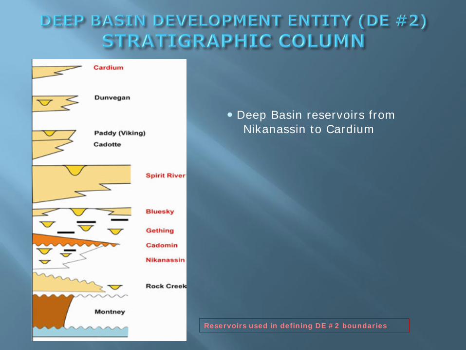
Reservoirs used in defining DE #2 boundaries
• Deep Basin reservoirs from
Nikanassin to Cardium

Eastern limit – composite of updip Deep Basinedges of individual reservoir units
Cadomin edge most critical – proven Deep Basin producer
Western limit – major Foothills thrust faults that could breach Deep Basin pressure and fluid regimes
Used easternmost significant fault traces mapped at surface
Well control
ERCB requires at least 3-4 gas tests in each township to beincluded in DE #2

1. Cadomin DB edge
2. DB edges, other reservoirs
3. Eastern edge Foothills
4. DE #2 (2006)

Calculation of in-place gas resource was required to ensure that the “size of the prize” would justify creating the Development Entity
Seven reservoirs with largest in-place gas volumes
Nikanassin
Cadomin
Gething
Bluesky
Spirit River
Cadotte
Cardium

Map each reservoir using four wells per township (where available)
Twp. 45-75, from Foothills margin east to Deep Basin edge
Gross isopach, net porous sand, average porosity picked on logs
Gas saturation, formation pressure, temperature, Z factor mapped from ERCB pool data
Each variable contoured and gridded in GeoGraphix
Grids combined to produce “resource density” map, expressed as BCF/section
Total gas resource calculated for proposed DBDE
EXAMPLE – Cadomin Formation

1. Net porous isopach valuespicked on logs
• Cadomin cutoff 3% F
• Hand contoured and
digitized (0 - 45 m)

1. Net porous isopach
2. Average porosity values pickedon logs
• Values up to 12%
• Computer contoured, no
geological bias imposed
• Contour values 3 - 8%, with
scattered spots to 11%

1. Net porous isopach
2. Average porosity
3. Gas saturation values from ERCBpool data
• Computer contoured, no geological bias imposed
• Values 60 - 85%

1. Net porous isopach
2. Average porosity
3. Gas saturations
4. Temperature values from ERCBpool data
• Values 355 - 395o K
• Insufficient data to contour
• Temperature data plotted against
depth to derive temperature / depth relationship
• Temperature mapped as function of depth

1. Net porous isopach
2. Average porosity
3. Gas saturations
4. Temperature
5. Pressure values from ERCBpool data
• Values 17,500 - 42,500 kPa
• Insufficient data to contour
• Pressure data plotted against
depth to derive pressure / depth relationship
• Pressure mapped as function ofdepth

1. Net porous isopach
2. Average porosity
3. Gas saturations
4. Temperature
5. Pressure
6. Z factor values from ERCB pooldata
• Values range 87.5 - 107.5
• Computer contoured, no geologicalbias imposed

1. Net porous isopach
2. Average porosity
3. Gas saturations
4. Temperature
5. Pressure
6. Z factor
7. Gas resource density calculated at up to 35 BCF/section
• Total 78 TCF Gas in Place

Formation TCF (in place) Area (km2)
Nikanassin 88.0 19,653
Cadomin 77.9 21,082
Gething 68.5 36,689
Bluesky 24.3 41,559
Spirit River 93.2 28,947
Cadotte 32.2 8,897
Simonette 5.7 2,744
Cardium 40.7 17,322
TOTAL 430

Success of original DBDE concept proven by production and drilling results
New drilling and more comprehensive mapping demonstrates that systematic commingling is required beyond the original DBDE boundaries
THE CHALLENGE – Make the case that DBDE concepts can be extended successfully to areas where significant resource exists beyond existing DE #2 boundaries
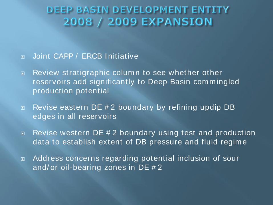
Joint CAPP / ERCB Initiative
Review stratigraphic column to see whether other reservoirs add significantly to Deep Basin commingled production potential
Revise eastern DE #2 boundary by refining updip DB edges in all reservoirs
Revise western DE #2 boundary using test and production data to establish extent of DB pressure and fluid regime
Address concerns regarding potential inclusion of sour and/or oil-bearing zones in DE #2

ADD Rock Creek
• Proven Deep Basin regime
• Concerns re oil and sour gas
Dunvegan / Paddy / Viking / Cadotte
• Geographic ranges do not expand DE #2
• Can be commingled where encountered
Montney
• Unproven Deep Basin regime
• Concerns re sour gas

DE#2 (2009)
ADDITION
REVISED CAPP
PROPOSAL
• Fernie edge is delimiter to southeast
• separates Jurassic / Cretaceous sands
• CAPP proposed western limitat Deep Basin edge
• ERCB recognizes principle, butrequires 3-4 gas wells pertownship to allow inclusion inexpanded DE
• Boundary can be reviewed asdrilling density increases
• Operators are responsible for dealingwith “problem zones” (sour, oil)appropriately by excluding them fromcommingling
DE #2 (2006) OUTLINE

The Deep Basin remains highly prospective, and is a key resource for Alberta
DE #2 is instrumental in enabling efficient exploitation, and allowing maximum capture of gas resources
Dunvegan
Belly River
Tertiary
Chinook
PaddyCadotte
Harmon
Falher
Gething
Cadomin
Nikanassin
Triassic
Cardium
Scollard
Wapiti
Notikewin
Wilrich
39
00
m
Modified after Leroux 2004, 2006