bristol avon rivers trust by brook catchment …...catchment-scale methodology to simultaneously...
TRANSCRIPT

Bristol Avon Rivers Trust
By Brook Catchment Fluvial Audit:
Source to confluence River Avon to include tributaries
March 2015

Document Control
Document: By Brook Catchment Fluvial Audit: Source to confluence River Avon to include
tributaries.
Project: By Brook Phase 2
Client: Environment Agency
Date of issue: March 2015
Prepared by: Bristol Avon Rivers Trust
3 Bakers Ground
Stoke Gifford
Bristol
BS34 8GD
Website: http://www.bristolavonriverstrust.org/
Email: [email protected]
Telephone:
Project manager: Ian Mock
Field team: Melissa Hoskings
GIS: Melissa Hoskings
Document checking
Primary author: Melissa Hoskings Signed:
Review by: Ian Mock Signed: pp
Approved by: Ian Mock Signed:
pp

Fluvial Audit Report
Bristol Avon Rivers Trust
Environment Agency 1 March 2015
By Brook Catchment
Contents
Executive Summary ................................................................................................................................ 4
1.0 Introduction .................................................................................................................................. 5
1.1 Background ............................................................................................................................. 5
1.2 Water Framework Directive (2000/60/EC) .............................................................................. 6
1.3 By Brook Catchment Overview ............................................................................................... 6
1.4 River Typology ........................................................................................................................ 7
1.5 Summary of Current EA WFD Data ........................................................................................ 8
2.0 Methodology ................................................................................................................................ 1
2.1 Geomorphological and Ecological Survey .............................................................................. 1
2.2 Recording of field data ............................................................................................................ 2
2.3 Point and Diffuse Pollution Source Survey ............................................................................. 2
2.4 Barriers to Fish Migration ........................................................................................................ 3
3.0 Results ........................................................................................................................................ 4
3.1 Geomorphological and Ecological Condition .......................................................................... 4
3.1.1 Summary of Management Reach-characteristics ........................................................... 4
3.1.1 Reach Summary Tables .................................................................................................. 4
3.2 Point and Diffuse Pollution .................................................................................................... 41
3.3 Barriers to fish passage ........................................................................................................ 43
3.4 Overview of catchment conditions ........................................................................................ 56
3.4.1 Substrate conditions ...................................................................................................... 56
3.4.2 Planform and profile characteristics .............................................................................. 58

Fluvial Audit Report
Bristol Avon Rivers Trust
Environment Agency 2 March 2015
By Brook Catchment
3.4.3 Flow dynamics and diversity ......................................................................................... 60
3.4.4 Habitat structure and species abundance ..................................................................... 62
3.4.5 Invasive non-native species .......................................................................................... 62
3.5 Point Source Pollution ........................................................................................................... 63
3.6 Diffuse Source Pollution ........................................................................................................ 63
3.7 Barriers to Fish Migration and Connectivity .......................................................................... 64
3.8 Key issues affecting the By Brook catchment ....................................................................... 65
3.8.1 In-channel structures ..................................................................................................... 65
3.8.2 Fine sediment supply and deposition ............................................................................ 65
3.8.3 Nutrient enrichment ....................................................................................................... 66
3.8.4 Bank erosion ................................................................................................................. 66
4.0 RESTORATION MEASURES ................................................................................................... 68
4.1 Short-term Measures ............................................................................................................ 68
4.1.1 Livestock fencing ........................................................................................................... 68
4.1.2 Soft bank revetment ...................................................................................................... 69
4.1.3 Bank re-profiling ............................................................................................................ 69
4.1.4 Engagement with local residents regarding misconnections ........................................ 70
4.2 Long-term Measures ............................................................................................................. 70
4.2.1 Engagement with the local water company regarding sewage treatment works
discharges ..................................................................................................................................... 70
4.2.2 Removal of in-channel structures or provision of fish passage .................................... 70
5.0 CONCLUSIONS AND FURTHER ACTION .............................................................................. 72
5.1 Purpose of this section .......................................................................................................... 72

Fluvial Audit Report
Bristol Avon Rivers Trust
Environment Agency 3 March 2015
By Brook Catchment
5.2 Summary of key issues ......................................................................................................... 72
5.3 Restoring the By Brook Catchment ....................................................................................... 72
5.3.1 Development of a restoration strategy .......................................................................... 72
5.3.2 Delivery mechanisms .................................................................................................... 72
5.3.2.1 Countryside Stewardship .............................................................................................. 73
5.3.2.2 Wessex Water ............................................................................................................... 73
5.3.2.3 DEFRA (Catchment Based Approach) ......................................................................... 74
5.3.2.4 Environment Agency (Fisheries) ................................................................................... 74
5.3.2.5 Local Angling Clubs ...................................................................................................... 75
6.0 REFERENCES ......................................................................................................................... 76

Fluvial Audit Report
Bristol Avon Rivers Trust
Environment Agency 4 March 2015
By Brook Catchment
Executive Summary
In 2014 the Bristol Avon Rivers Trust (BART) was commissioned by the Environment Agency (EA) to
undertake a fluvial audit of the By Brook catchment. The purpose of the audit was to utilise a
catchment-scale methodology to simultaneously identify the key geomorphological and ecological
parameters of the catchment, in addition to identifying and classifying diffuse and point source inputs
of phosphates, ammonia, other pollutants and barriers to fish migration within the waterbody. The 11-
day fluvial audit encompassed approximately 45km of the By Brook catchment, assessing all active
and potential issues within six Water Framework Directive (WFD) sub-waterbodies
(GB109053027500, GB109053027490, GB109053027480, GB109053027460, GB109053027400 and
GB109053027380) and a further waterbody not classified under WFD (Lid Brook).
The main driver for this project is the EU Water Framework Directive (2000/60/EC) for all EU
countries to aim to achieve at least Good Ecological Status (GES) for all water bodies by 2015, or
where this is not possible and subject to the criteria set out in the Directive, aim to achieve good
status by 2021 or 2027. Not all waterbodies within the By Brook catchment are failing GES, the By
Brook (source to confl Broadmead Brook (GB109053027500)) and the By Brook (confl Broadmead
Brook to confl unnamed trib (GB109053027480)) are currently achieving GES; however it is important
to identify any potential impacts that may also cause deterioration in status. The Broadmead Brook
(GB109053027490) and the unnamed trib (GB109053027460) are both at moderate ecological status
now, which is due to biological elements-fish- which currently achieve moderate. The two
downstream waterbodies are also failing GES, and both are currently classified as poor ecological
status, again due to biological elements-fish-which currently achieve poor.
A total of 486 sources were recorded on the 45 km walked in the By Brook catchment. Of these, 140
were diffuse and 38 were point sources. A further 640 features were recorded during the audit, such
as barriers to fish passage, large woody debris, and depositional features, however these are not
included in the point source and diffuse source pollution scores. The majority of sources were
classified as Grade 3, with a total of 300 inputs. There were 28 Grade 2 sources (6%) and 158 Grade
4 sources (32%) were recorded in the catchment.
This document is intended to provide supplementary information for the Fish Pass Feasibility Study
being undertaken concurrently to this work by Royal Haskoning DHV and to ascertain the
geomorphology of the catchment and any issues that may impact on achieving GES.
Fluvial Audit Report
Bristol Avon Rivers Trust
Environment Agency 5 March 2015
By Brook Catchment
1.0 Introduction
In 2014, BART was commissioned by the Environment Agency to undertake a fluvial audit of the By
Brook catchment. The purpose of the survey was threefold:
to support the catchment work undertaken by BART through the first phase of Environment
Agency funding into the By Brook;
to provide supplementary information for the Fish pass Feasibility Study being undertaken by
Royal Haskoning DHV on the By Brook, and;
to ascertain the geomorphology of the catchment and the issues impacting upon its function
and ability to achieve Water Framework Directive GES.
The fluvial audit was undertaken on the whole By-Brook catchment from source to confluence with the
River Avon (Bristol) and included all major WFD tributaries. A catchment-scale methodology was
used to simultaneously identify and classify diffuse and point inputs of phosphates, ammonia and
other pollutants within the catchment waterbodies and any barriers to fish migration were assessed
and classified accordingly. In addition, further field data was collected on sediment transport
characteristics, sediment sinks, physical habitat features and channel geometry.
1.1 Background
During 2012 BART worked with Area EA staff to identify and agree a sub-catchment within the
Bristol Avon area, in which to carry out a collaborative river restoration project. The sub-catchment
identified was the By Brook. During the summer of 2013 and winter 2014 BART delivered a project
in which it started to address the main causes of WFD failure in the catchment with a primary focus
on the area between Ford and Slaughterford on the By Brook. An initial fish pass feasibility study
was undertaken by Mike and Matt Beach on nine of the fourteen in-channel structures identified in
this study reach with suggested options for providing fish passage and outline drawings provided for
each. BART also undertook a substantial amount of riparian protection works along one of the main
tributaries, the Lid brook in order to prevent excess sedimentation and nutrients reaching important
spawning gravels in the main By Brook. Further wet weather sediment monitoring was undertaken
using a series of autosamplers and specialist water quality monitoring equipment on the Lid brook to
ascertain the contribution of sediment and phosphate entering the By Brook is from this tributary.
Engagement with local angling clubs along the river, landowners and local communities also started
what is hoped to be a joint long-term relationship with these groups with a shared commitment to
delivering improvements in the catchment.

Fluvial Audit Report
Bristol Avon Rivers Trust
Environment Agency 6 March 2015
By Brook Catchment
This second-stage of the project builds upon all the aforementioned work already undertaken by
BART and will provide costed site-specific designs for overcoming in-channel obstructions for fish in
the intermediate reaches (Reaches 4a, 4b and upstream of Reach 5) of the By Brook. The
information contained within this fluvial audit will help to inform the design process and identify any
important geomorphological or ecological features within the areas concerned or those immediately
upstream or downstream of the structures.
1.2 Water Framework Directive (2000/60/EC)
The Water Framework Directive (2000/60/EC) came into force in December 2000 and subsequently
became part of UK law in December 2003. The legislation is designed to improve and integrate the
manner in which waterbodies are managed. Furthermore, it aims to enhance the status and prevent
further deterioration of aquatic ecosystems, promote the sustainable use of water, reduce pollution
of water by ‘priority’ and ‘priority hazardous’ substances and ensure progressive reduction of
groundwater pollution. All member states must aim to reach good chemical and ecological status in
both inland and coastal waters by 2015. Despite this, in England and Wales only 26% of
waterbodies achieved ‘good status’ in 2009 (EA, 2009). The WFD waterbody condition assessments
are currently undertaken by the Environment Agency using methodologies agreed with the UK
Technical Advisory Group (UK TAG). For surface waters, such as rivers and lakes, the ‘overall
status’ of a waterbody is comprised of an ecological and a chemical component. Ecological status is
recorded on the scale high, good, moderate, poor and bad (with moderate or worse being regarded
as a failure), while chemical status is measured simply as ‘good’ or ‘fail’. Recommendations for
remedial catchment management interventions are made through River Basin Managements Plans
(RBMPs) and Catchment Management Plans (CMPs).
1.3 By Brook Catchment Overview
The By Brook flows for approximately 19 km from its source near Burton to its confluence with the
River Avon (Bristol) at Bathford on the south east outskirts of Bath. Flowing initially in an easterly
direction then south towards Castle Combe where the tributary of the Broadmead Brook flows into
the By Brook before flowing southwards towards the village of Ford where the Doncombe Brook and
an unnamed tributary join the By Brook on its right-hand bank before flowing through the village.
The river continues to flow southwards where a further tributary, the Lid Brook joins the By Brook on
its right-hand bank before flowing through Box and south-westerly where it flows in the River Avon
(Bristol) at Bathford.

Fluvial Audit Report
Bristol Avon Rivers Trust
Environment Agency 7 March 2015
By Brook Catchment
The hydrogeology of the By Brook catchment is comprised of a significant limestone aquifer (Great
Oolite Group) capable of producing large yields and a flashy response to precipitation. Midford
Sands of the Upper Lias are present in some areas but to a far lesser extent (CEH, 2015).
Several Sites of Special Scientific Interest (SSSI) are located within the By Brook catchment. These
include Rack Hill SSSI (a 10.35 hectare lowland calcareous grassland) located south of Castle
Combe, Dank’s Down and Truckle Hill SSSI located adjacent to an unnamed tributary of the By
Brook. Honeybrook Farm SSSI is a 42.28 hectare site situated south of Slaughterford and
approximately 300m east of the By Brook. It features three types of lowland calcareous grassland,
Centaurea nigra grassland and Fraxinus excelsior - Acer campestre - Mercurialis perennis
woodland. In addition to this, the By Brook also flows through Colerne Park and Monk’s Wood SSSI
just south of Slaughterford (Magic, 2015).
1.4 River Typology
The typology of the river is based on the Vegetation Communities of Great Britain (JNCC, 1999),
which categories river systems on an environmental gradient with three hierarchical levels:
1. River Groups. This highest level consists of four distinct broad groups (A-D) representing an
environmental gradient from lowland eutrophic rivers, to those that are essentially upland, torrential
and oligotrophic.
2. River Community Types. This second tier of division comprises ten River Community Types
(RCTs) (I-X).
3. Sub-types. This final sub-division includes 38 river sub-types (AIa-DXe).
The By Brook catchment is a mixture of Type II, lowland clay-dominated rivers and Type V,
sandstone, mudstone and hard limestone rivers. These distinct geomorphological types give rise to
specific vegetation community types and in-channel habitat characteristics. Type II rivers are
located between 10m and 200m AOD with a mean slope of 19km-1 and dominated by clay, gravel
and silt substrates. Type II rivers are dominated by runs and slacks and support approximately 38
different taxa, including Carex riparia and Potamogeton pectinasus communities. Sandstone
dominated Type V rivers are located between 5 and 244m AOD with a slope of 6.6km-1 and are
dominated by pebble, cobble and gravel substrates. Type V rivers are also dominated by slacks and
runs whilst also containing a moderate number of riffle habitats, which combined support an average
number of 35 different taxa (JNCC,1999).

Fluvial Audit Report
Bristol Avon Rivers Trust
Environment Agency 8 March 2015
By Brook Catchment
The identification of river type and geomorphological characteristics is important when considering a
baseline for restoration. Consideration of the change in river type down the By Brook corridor is
important when choosing options for riparian improvement and alterations to channel morphology.
1.5 Summary of Current EA WFD Data
For the purposes of the fluvial audit and report, the audit reach has been split into seven sections
following the WFD waterbody classification and identification scheme.
Table 1 Summary of waterbodies surveyed during the audit and the reach within which they were
surveyed. Waterbodies are in order of upstream to downstream presence.
Reach ID WFD Waterbody ID Waterbody Name Location
Reach 1 GB109053027500 By Bk - source to conf Broadmead Bk Burton to Castle
Combe
Reach 2 GB109053027490 Broadmead Bk - source to conf By Bk Pennysylvania to
Castle Combe
Reach 3 GB109053027480 By Bk - conf Broadmead Bk to conf
unnamed trib
Castle Combe to
Ford
Reach 3a GB109053027460 Unnamed trib - source to conf By Bk North Wraxhall to
Ford
Reach 3b GB109053027400 Doncombe Bk - source to conf By Bk Marshfield to Ford
Reach 4a GB109053027380 By Bk - conf Doncombe Bk to conf R
Avon (Brist)
Ford to
Slaughterford
Reach 4b GB109053027380 By Bk - conf Doncombe Bk to conf R
Avon (Brist)
Slaughterford to
Drewett’s Mill
Reach 4c N/A Lid Brook- source to conf By Bk Westwood Farm to
Saltbox Farm, Box
Reach 5 GB109053027380 By Bk - conf Doncombe Bk to conf R
Avon (Brist)
Drewett’s Mill to
Bathford

Fluvial Audit Report
Bristol Avon Rivers Trust
Environment Agency 9 March 2015
By Brook Catchment
The current ecological and physico-chemical WFD classifications for each of the WFD waterbodies
audited are summarised below (Table 2). The uppermost reach (Reach 1) is one of only two reaches
in the By Brook catchment classified as Good Ecological Status (GES), the other is Reach 3. The
Broadmead Brook is currently classed at Moderate Ecological Status due to its failure for fish. The
‘Moderate’ classification is led by the fish biological element, which is predicted to rise to ‘Good’
status by 2027. It has been determined that it would be ‘disproportionately expensive’ and
‘technically infeasible’ to try and achieve GES by 2015 (EA 2009b). Similarly Reach 3a is also
classified as Moderate due to fish and again with the objective of reaching ‘Good’ by 2027; however
the ability to achieve ‘Good’ before this date has been deemed ‘disproportionately expensive’.
There is an evident deterioration in ecological status in the intermediary and downstream reaches of
the By Brook catchment. All the hydromorphology elements meet GES and overall the physico-
chemical elements are ‘High’ for both Reach 4b and Reach 5; however, Reach 4b is only achieving
‘Moderate’ for phosphate. It is however, the ‘Poor’ status of fish which is the biological failing
element and therefore reducing the ecological status to ‘Poor’ for both reaches. The absence of
connectivity in the reach is the overriding factor causing declines in fish populations and subsequent
diversity. The connectivity of the By Brook throughout the intermediary and downstream reaches,
and with the River Avon is currently being affected by a series of man-made barriers, which impede
the natural passage of fish. Large barriers can have a major impact on fish population numbers and
diversity, as feeding or spawning movements upstream or downstream of the obstruction are
prevented. Phosphate levels in Reach 4b do not meet GES, and after discussions with the water
company regarding discharges from the sewage treatment works into the Doncombe Brook, it is
possible that point source pollution is an additional pressure on both water and biological quality in
this reach.

Fluvial Audit Report
Bristol Avon Rivers Trust
Environment Agency 1 March 2015
By Brook Catchment
Table 2 Summary of EA WFD Waterbody classification data for the surveyed reaches of the By Brook Catchment.
Waterbody Name By Bk - source to
conf Broadmead
Bk
Broadmead Bk -
source to conf By
Bk
By Bk - conf
Broadmead Bk to
conf unnamed trib
Unnamed trib -
source to conf By Bk
Doncombe Bk -
source to conf By Bk
By Bk - conf
Doncombe Bk to conf
R Avon (Brist)
Waterbody ID GB109053027500 GB109053027490 GB109053027480 GB109053027460 GB109053027400 GB109053027380
Typology Low, Small,
Calcareous
Low, Small,
Calcareous
Low, Small,
Calcareous
Low, Small,
Calcareous
Low, Medium,
Calcareous
Low, Medium,
Calcareous
Overall Status Good Moderate Good Moderate Poor Poor
Ecological Status Good Moderate Good Moderate Poor Poor
Chemical Status Does not require
assessment
Does not require
assessment
Does not require
assessment
Does not require
assessment
Does not require
assessment
Does not require
assessment
Biological
Fish - Moderate - Moderate Poor Poor
Macroinvertebrates High High High - Good -
Physico-chemical
Ammonia High High High High High High
Dissolved Oxygen High High High High High High
pH High High High High High High
Phosphate Good High Good High Moderate Good
Hydromorphology
Hydrology Supports Good Supports Good Supports Good Supports Good Supports Good Supports Good
Morphology Supports Good Supports Good Supports Good Supports Good Supports Good Supports Good

Fluvial Audit Report
Bristol Avon Rivers Trust
Environment Agency 1 March 2015
By Brook Catchment
Figure 1 WFD Surface Waterbodies in the By Brook Catchment and Reach Breakdown.

Fluvial Audit Report
Bristol Avon Rivers Trust
Environment Agency 1 March 2015
By Brook Catchment
2.0 Methodology
A standardised baseline walkover survey of the By Brook catchment was undertaken by BART and
covered approximately 45Km over a period of 11 days. The reaches surveyed are provided in Table
3 below. Walking in an upstream to downstream direction, each reach was walked by a trained
catchment officer during December 2014 and January 2015.
Table 3 Surveyed reaches of the By Brook catchment. *Based on approximate measured distance on
maps.
Reach NGR Start Point NGR End Point Date Surveyed Approximate Reach
Length (km) *
1 379370,178477 383642,177747 29/12/2014 6.09
2 376539,174439
378126,176691
377069,174791
383638,177751
02/01/2015
03/01/2015
7.27
3 383638,177751 384208,174786 08/01/2015 4.07
3a 381045,174376 384205,174816 09/01/2015 4.52
3b 378510,173173 383900,174673 15/01/2015 6.00
4a 384225,174795 384130,173852 20/01/2015 1.84
4b 384130,173852 383232,169949 20/01/2015 5.32
4c 380539,170311 383179,169941 27/01/2015 2.95
5 383232,169949 378576,166991 28/01/2015
02/02/2015
6.48
2.1 Geomorphological and Ecological Survey
The field survey of the catchment (undertaken in December and January 2014/15) included a
walkover survey of the By Brook catchment between Burton and the confluence with the River Avon
(Bristol) (approximately 19km in length) and four further tributaries of the By Brook. During the
survey, visual observations of key geomorphological and ecological parameters were recorded from
the top of the banks. The survey did not involve intrusive investigations or in-channel surveys.
Key geomorphological and ecological parameters were recorded at a series of “checkpoints”. At
every change of hydromorphological character in the river, flow type, bed and bank material, channel
geometry, sediment dynamics and vegetation character were recorded. Assessment of differences
in these parameters was used to highlight spatial trends throughout the catchment. Changes to the

Fluvial Audit Report
Bristol Avon Rivers Trust
Environment Agency 2 March 2015
By Brook Catchment
predominant geomorphological, ecological and land use characteristics of the river were then used
to determine the limits of the reaches.
A previous walkover survey of the By Brook catchment undertaken by BART in August 2013
contains data on bed sediments, summer flows, and land management issues during the summer
period. As such, this report is based on analysis of the data from the previous field survey
undertaken in August 2013 as well as the data from the new survey undertaken in December and
January 2014/15 to inform this report. The inclusion of both summer low flow condition data and
winter high flow condition data provides a comprehensive representation of the channel
geomorphology during two dominant flow scenarios. In addition to this, the inclusion of both sets of
data allows the predominant geomorphological characteristics of the river channel to be captured
and to adequately allow a robust assessment of the form and function of the river and the issues
affecting it to be made.
2.2 Recording of field data
Sediment sources, sediment sinks and flow types were continuously tallied for each reach, and
overall morphological parameters relating to valley form, channel geometry, and boundary conditions
of the reach were recorded. Grid references for key features were recorded using a hand held GPS.
The ecological characteristics of each reach were recorded and the presence of riparian vegetation
and invasive species were also noted. Key habitat requirements for interest species of Type II and
Type V rivers were also assessed along with observations as to where the channel appeared to be
recovering from previous modifications. The field data collected were based on visual observation
and therefore to some extent dependant on the conditions found on the day of survey.
2.3 Point and Diffuse Pollution Source Survey
Diffuse and point sources of pollution entering the waterbodies, including sediment and organic
inputs, were identified and recorded on the survey form (Appendix 3). Each source was categorised
based on the EA standard walkover survey methodology OI 356_12 (Appendix 1: Table 1) and the
location recorded as a 10 figure National Grid Reference (NGR) using a hand-held GPS, to allow
subsequent spatial distribution analysis through ArcGIS. The origin of each input was recorded to
facilitate analysis into the types of land-use practices causing significant levels of pollution into the
catchment as a whole. The impact or potential severity of each source was classified on a scale of
Grade 1 to Grade 4 (Appendix 2). Photographs were taken of each source and relevant comments

Fluvial Audit Report
Bristol Avon Rivers Trust
Environment Agency 3 March 2015
By Brook Catchment
recorded as appropriate. Information was also recorded regarding the type of land-use present on
both banks and whether stock fencing was present. An additional second survey form was used on
each reach to capture information on sediment sources and sediment transport, physical habitat
features and channel geometry. The second survey form was provided by Royal Haskoning DHV
and is used for all fluvial audit surveys.
2.4 Barriers to Fish Migration
Any natural and manmade barriers to fish migration, such as LWD, weirs, dams and fords, were also
recorded and assessed using EA standard walkover methodology. The type, length, width and degree
of influence of the barrier were recorded, with the degree to which the barrier could be passed by fish
assessed from Grade 1 to Grade 4 (Appendix 2).

Fluvial Audit Report
Bristol Avon Rivers Trust
Environment Agency 4 March 2015
By Brook Catchment
3.0 Results
3.1 Geomorphological and Ecological Condition
3.1.1 Summary of Management Reach-characteristics
Table 4 to Table 21 provide details of the geomorphology and ecology of each of the Reaches in
the catchment, including a photographic overview of typical characteristics of each reach. The
locations of each reach are shown in Figure 1.
3.1.1 Reach Summary Tables
Table 4 Reach Summary Table: Reach 1.
Reach 1 (By Bk - source to conf Broadmead Bk)
Upstream survey limit
NGR 379370,178477
Downstream survey limit
NGR 383642,177747
Approximate length of river
surveyed
6.09Km
Reach characterisation
Hydromorphology: In Reach 1, the upstream section of the reach between Phyldornick (NGR
379377,178482) and Goulter’s Mill Farm (NGR 382875,179170) was dry at the time of survey (Plate
A). The river displays a limited degree of flow and morphological diversity. The channel planform is
characterised by large sections of straightened channel, some of which have been heavily modified
(Plate C) as a result of road transport networks, residential housing, or historic milling. The banks are
typically steep-sided where they have been over-deepened and support predominantly glide flows
(Plate B). There is a lack of substrate between Phyldornick and Westfield Farm (NGR
379987,178907) where the river runs through a grass channel (Plate A). After Westfield Farm the
substrate becomes predominantly comprised of pebbles, cobbles and small boulders (Plate D).
Floodplain land use consists predominantly of grazing land with evidence of severe bank erosion due
to poaching in some upstream sections (Plate E).
Ecology: Trees are almost absent in the upstream section of the reach, whilst intermediate and
downstream sections benefit from the shading created on the areas of open water. Bank vegetation is
generally restricted due to grazing by livestock in the upstream section; however downstream
sections of bank support a variety of riparian species including . Deciduous woodland is present along
the banks of the downstream section of the reach providing a complex habitat for wildlife and

Fluvial Audit Report
Bristol Avon Rivers Trust
Environment Agency 5 March 2015
By Brook Catchment
beneficial microclimate for freshwater species.
Geomorphological assessment
Attribute Survey assessment
Flow dynamics and diversity In Reach 1, the upstream section of the reach between
Phyldornick (NGR 379377,178482) and Goulter’s Mill Farm (NGR
382875,179170) was dry at the time of survey (Plate A). The river
displays a limited degree of flow and morphological diversity. The
channel planform is characterised by large sections of straightened
channel, some of which have been heavily modified (Plate C) as a
result of road transport networks, residential housing, or historic
milling. The banks are typically steep-sided where they have been
over-deepened and support predominantly glide flows (Plate B).
Substrate There is a lack of substrate between Phyldornick and Westfield
Farm (NGR 379987,178907) where the river runs through a grass
channel (Plate A). After Westfield Farm the substrate becomes
predominantly comprised of pebbles, cobbles and small boulders
(Plate D). In addition to this, the reach contains substantial
evidence of siltation, which in areas of low flow velocity have
settled out and gradually built up on the river bed, thus further
slowing the flow and allowing more sediment to fall out of
suspension. There was no evidence of clean stable gravels in this
reach. In shallow downstream sections of the river where the
sediment was visible, there was a substantial proportion of
sediment coated in algae (Plate F).
Channel and banks The channel planform is characterised by large sections of
straightened channel, some of which have been heavily modified
(Plate C) as a result of road transport networks, residential
housing, or historic milling. A combination of limited
geomorphological diversity and sedimentation in the channel has
led to areas of the channel becoming choked by vegetation, thus
further slowing the flow (Plate G).
Plant community species:
Composition and abundance
Species observed during the audit included hard rush (Juncus
inflexus), compact rush (Juncus conglomeratus), meadowsweet
(Filipendula ulmaria), floating sweet grass (Glyceria fluitans),

Fluvial Audit Report
Bristol Avon Rivers Trust
Environment Agency 6 March 2015
By Brook Catchment
fennel pondweed (Potamogeton pectinatus), stinging nettle (Urtica
dioca), thistle spp., dock species, and greater willow herb
(Epilobium hirsutum).
Reach Issues
Native species Algae identified within the reach of a coverage of <25%.
Invasive non-native species No alien/introduced species were identified in this reach.
In-stream barriers 1 in-stream barrier was identified in this reach (Plate H).
Issues for restoration and management Potential restoration options
Algal formation on substrate.
Livestock poaching.
Dominating glide flows.
Heavy siltation of substrate.
BART could work with local farmers to
increase buffer strips on arable land,
employ good practise soil management
and possibly introduce sediment traps
in areas most at risk of sedimentation.
BART/EA to work with local residents
to identify misconnections from private
residences.
BART could work with farmers to
encourage fencing the river and
providing a riparian strip to both benefit
bank profile and the quality of gravel
substrate.
BART could introduce some small flow
deflectors and channel narrowing to
increase flow diversity.
Constraints
The necessary permissions and permits would be required to install livestock fencing and
possible alternative water supplies.
The necessary permits would be required to undertake in-stream works.
Fluvial Audit Report
Bristol Avon Rivers Trust
Environment Agency 7 March 2015
By Brook Catchment
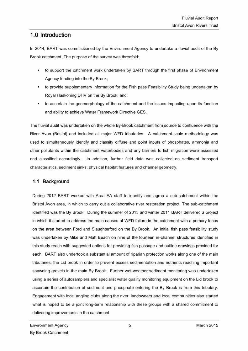
Table 5 Overview of Reach 1.
Overview of Reach 1 (By Bk - source to conf Broadmead Bk)
Reach character photographs
A: Dry grass channel upstream Reach 1. B: Dominant glide flows.
C: Substantial sections of heavily modified
channel in the upstream section of the reach.
D: Pebble, cobble substrate.

Fluvial Audit Report
Bristol Avon Rivers Trust
Environment Agency 8 March 2015
By Brook Catchment
E: Poaching by livestock. F: Algae covered sediment.
G: Channel chocked by dense vegetation growth. H: In-channel structures.

Fluvial Audit Report
Bristol Avon Rivers Trust
Environment Agency 9 March 2015
By Brook Catchment
Table 6 Reach Summary Table: Reach 2.
Reach 2 (Broadmead Bk - source to conf By Bk)
Upstream survey limit
NGR 376539,174439
Downstream survey limit
NGR 383638,177751
Approximate length of river
surveyed
7.27Km
Reach characterisation
Hydromorphology: In this reach, the Broadmead Brook flows through a narrow, shallow valley, with a
floodplain dominated by pastoral agriculture. The channel planform is characterised by regular
meandering within pastoral agricultural areas, whilst in the villages the river has been realigned as a
result of historical milling and potential flood defence for properties. There is some evidence of
historical channel widening in areas such as West Kington, which has resulted in an over-wide and
uniform channel with a shallow gradient. Fine sedimentation dominates the substrate within the
middle sections of this reach, notably between Castle Farm, Marshfield and downstream to West
Kington (Plate A).
Ecology: Emergent vegetation is present throughout the reach with a dominance of reed species,
particularly within areas of glide habitat. Sedges, rushes, and water mint were also noted, whilst
water-starwort was recorded in areas with clean gravels and good light penetration. A variety of
deciduous tree species are present in a semi-continuous habit throughout the reach which provides
shading and areas of open water. Bank vegetation is varied due to the diversity of land management
along the river. There is little bank vegetation in areas of pastoral agriculture where livestock graze
vegetation down to the water’s edge. There are occasional patches of nettle, thistle and greater
willowherb in these areas. At the downstream section of this reach there is an area under woodland
management whereby the banks are dominated by nettles, harts tongue fern and scrub with mature
trees.
Geomorphological assessment
Attribute Survey assessment
Flow dynamics and diversity This reach has a good diversity of flow with riffle-run-glide flows
present along the majority of the reach. The presence of large
woody debris and a number of in-stream structures also contribute
to the diversity of flow introducing both chute and rapid flow to
some areas. Glide habitat tends to dominate in areas where the
channel has been over-widened or over-deepened which has led

Fluvial Audit Report
Bristol Avon Rivers Trust
Environment Agency 10 March 2015
By Brook Catchment
to areas dominated by reeds.
Substrate The downstream sections of the reach contain clean stable gravels
alongside silt deposits at the channel margins. However the middle
reaches exhibit excessive siltation possibly due to the presence of
large populations of American signal crayfish burrowing into the
soft banks (Plate D).
Channel and banks The planform within this reach displays relatively large-scale
sinuosity and little evidence of active bank erosion, associated with
lower energy flows and a shallow channel gradient. There are no
embankments along the length of the reach, and the banks are
generally shallow (Plate G). Evidence of historic channel
realignment and hard bank reinforcement was observed during the
fluvial audit, notably within the village of West Kington (Plate H).
Plant community species:
Composition and abundance
Species observed during the audit included hard rush (Juncus
inflexus), compact rush (Juncus conglomeratus), pendulous sedge
(Carex pendula), lesser water-parsnip (Berula erecta), water-
crowfoot (Ranunclus spp.), water-milfoil (Myriophyllum aquaticum),
floating sweet grass (Glyceria fluitans), fennel pondweed
(Potamogeton pectinatus), water mint (Mentha aquatica), water
starwort (Callitriche stagnalis). Vegetation along the banks was
noted to includes stinging nettle (Urtica dioca), thistle spp., dock
species, greater willow herb (Epilobium hirsutum) and hartstongue
(Phyllitis scolopendrium) on woodland river banks.
Reach Issues
Native species Algae identified within the reach of coverage of 25%.
Invasive non-native species There have been a number of visual sightings of American signal
crayfish on the upper sections of this reach. In addition to this,
crayfish traps and banks peppered with crayfish-sized holes were
recorded upstream of West Kington.
In-stream barriers 61 in-stream barriers were identified in this reach of which 3 were
Grade 2 weirs and 8 were Grade 3 weirs. Substantial amounts of
large woody debris were present in the channel with 29
observations of where it was causing blockages.

Fluvial Audit Report
Bristol Avon Rivers Trust
Environment Agency 11 March 2015
By Brook Catchment
Issues for restoration and management Potential restoration options
Siltation of substrate.
Algae covered substrate.
Domestic outputs of phosphate.
Invasive American signal crayfish.
Poaching by cattle.
Joint BART/ EA project to look at
misconnections and public awareness of
phosphate in the river.
Strategic trapping of American signal
crayfish
Potential BART project to look at cattle
fencing and water provision.
Constraints
Trapping of American signal crayfish will need to be undertaken by licensed individuals over a
period of time.
The necessary permissions and permits would be required before undertaking livestock fencing.
Table 7 Overview of Reach 2.
Overview of Reach 2 (Broadmead Bk - source to conf By Bk)
Reach character photographs
A: Heavy siltation of substrate B: Eutrophication and dense algal growth during
summer

Fluvial Audit Report
Bristol Avon Rivers Trust
Environment Agency 12 March 2015
By Brook Catchment
C: Domestic outputs of phosphate D: Possible presence of American signal crayfish
causing bank erosion
E: Heavily poached banks F: Good amounts of large wood debris
G: Good flow diversity H: Over-widened channel

Fluvial Audit Report
Bristol Avon Rivers Trust
Environment Agency 13 March 2015
By Brook Catchment
Table 8 Reach Summary Table: Reach 3.
Reach 3 (By Bk – conf Broadmead Bk to conf unnamed trib)
Upstream survey limit
NGR 383638,177751
Downstream survey limit
NGR 384208,174786
Approximate length of river
surveyed
4.07Km
Reach characterisation
Hydromorphology: In this reach, the By brook exhibits a substantial proportion of hydromorphological
alteration due to historic milling and flood defence. Downstream of the confluence with the
Broadmead Brook, the river is situated within a straight heavily modified channel and exhibits
predominant glide flows. As the river flows past Brook House it enters a steep sided valley where the
gradient of the river increases and thus the river starts to exhibit more varied flows.
Ecology: Emergent vegetation is present sporadically through the reach and is comprised
predominantly of reeds in areas of glide habitat. Ranunculus spp. was noted on two occasions in this
reach in areas of fast flow and good light penetration. In areas of woodland the bankside vegetation
was predominantly comprised of nettles, dog’s mercury and scrub; whilst open water areas support
water-mint, meadowsweet, sweet vernal grass and Ranunculus spp. Deciduous woodland is present
along a good proportion of this reach, however the river is not over shaded as woodland areas are
interspersed with areas of pasture and floodplain meadow.
Geomorphological assessment
Attribute Survey assessment
Flow dynamics and diversity In the upstream section of the reach, the river is situated within a
straight heavily modified channel and exhibits predominant glide
flows. As the river flows past Brook House it enters a steep sided
valley where the gradient of the river increases and thus the river
starts to exhibit more varied flows.
Substrate The substrate in the reach is comprised predominantly of pebble
cobble substrate with the presence of some small boulders (Plate
G). The presence of macrophytes such as Ranunculus spp. in fast
flowing sections of the reach results in the in-channel accumulation
of isolated patches of fine sediment (Plate A). There is
considerable evidence of sedimentation occurring within the river,
with a number of sites identified having a ‘milky’ appearance (Plate

Fluvial Audit Report
Bristol Avon Rivers Trust
Environment Agency 14 March 2015
By Brook Catchment
D). There is also evidence of algal growth on a substantial
proportion of substrate, which is evident in the shallow sections of
the reach (Plate H).
Channel and banks The channel has been enlarged and realigned and banks heavily
modified, most noticeably in Castle Combe and near the weirs
which are present throughout the majority of the reach (Plate C).
Although there has been considerable realignment and widening of
the channel in areas, there still remains a good connection of the
river with the floodplain in the middle sections of the reach and as
such a number of wetland habitats are present (Plate B). The
banks in the reach are relatively unstable due to a combination of
high energy flows from channel gradient, in-channel structures and
livestock poaching (Plate E). The floodplain becomes quite narrow
south of Long Dean and is used for pastoral agriculture, and
grazing is allowed right up to the river’s edge. This is likely to
contribute towards sediment loading and siltation in the
downstream reaches of the By Brook.
Plant community species:
Composition and abundance
Species observed during the audit included meadowsweet
(Filipendula ulmaria), water mint (Mentha aquatica), water-crowfoot
(Ranunclus spp.), branched bur-reed (Spargantium erectum), and
some blanket weed. On the banks stinging nettle (Urtica dioca),
thistle spp., sweet vernal grass (Anthoxanthum odoratum), dock
species and greater willow herb (Epilobium hirsutum) were noted.
Reach Issues
Native species Algae identified within the reach of coverage of 25%.
Invasive non-native species No alien/introduced species were identified in this reach.
In-stream barriers 47 in-stream barriers were identified in this reach of which 5 were
Grade 1 weirs and 1 Grade 2 weir, and 5 Grade 3 weirs.
Substantial amounts of large woody debris were present in the
channel with 9 observations of where it was causing blockages.
Issues for restoration and management Potential restoration options
Barriers to fish and eel passage.
Poaching by livestock.
Potential for BART/ EA project to look at
fish passage options throughout this reach.

Fluvial Audit Report
Bristol Avon Rivers Trust
Environment Agency 15 March 2015
By Brook Catchment
Algae covered sediment.
Heavy siltation in areas.
Highly eroding banks.
Potential BART project to install livestock
fencing and water provision.
Constraints
Fish pass feasibility studies will need to consider flood risk constraints.
Constraints related to current land use.
Table 9 Overview of Reach 3.
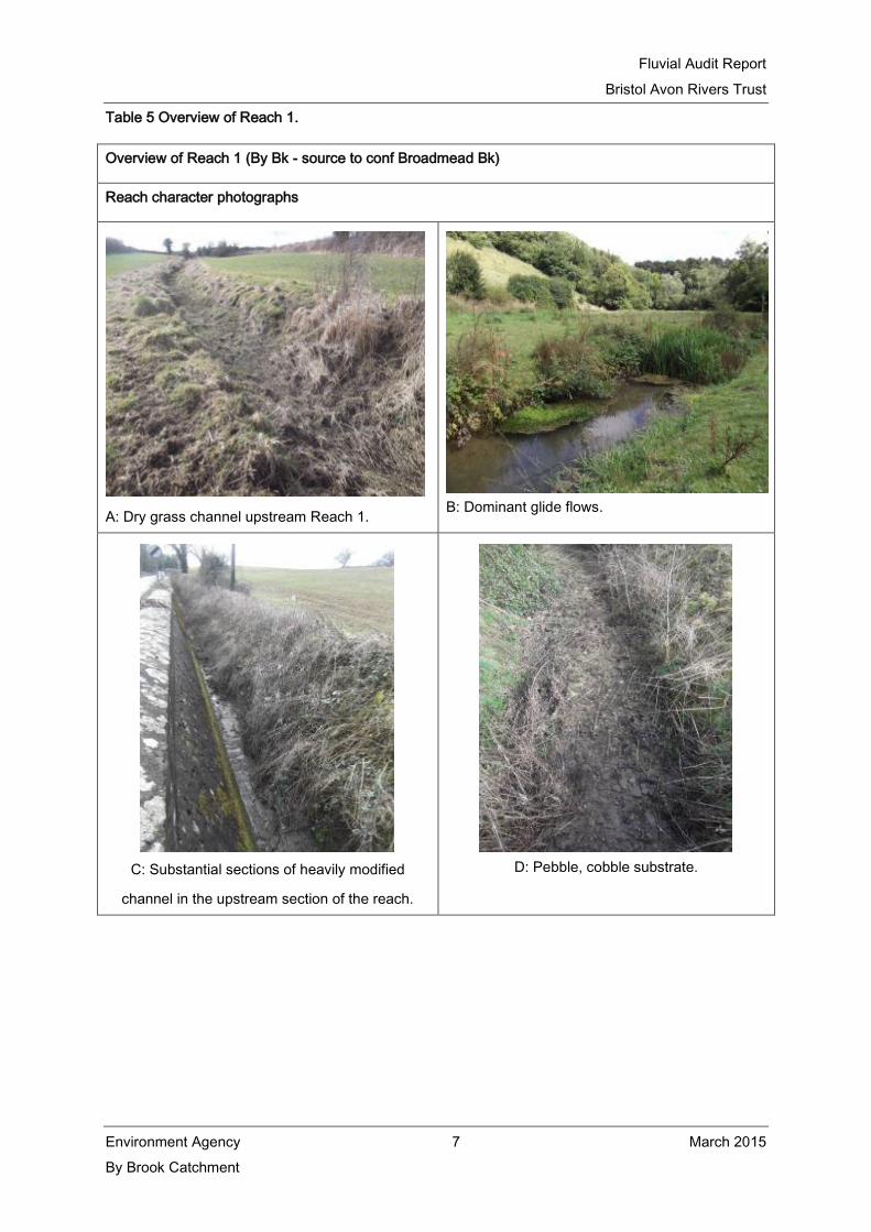
Overview of Reach 3 (By Bk – conf Broadmead Bk to conf unnamed trib)
Reach character photographs
A: Presence of diverse bank-side and emergent
vegetation with in channel Ranunculus.
B: The river is well connected to the floodplain.
Fluvial Audit Report
Bristol Avon Rivers Trust
Environment Agency 16 March 2015
By Brook Catchment
C: Over-widened channel in residential areas. D: Considerable silt deposition on substrate.
E: High energy gradient between Brook House
and Lower Long Dean.
F: A large number of in-stream structures.
G: Predominant pebble, cobble substrate. H: Considerable algal growth on substrate.

Fluvial Audit Report
Bristol Avon Rivers Trust
Environment Agency 17 March 2015
By Brook Catchment
Table 10 Reach Summary Table: Reach 3a.
Reach 3a (Unnamed trib - source to conf By Bk)
Upstream survey limit
NGR 381045,174376
Downstream survey limit
NGR 384205,174816
Approximate length of river
surveyed
4.52Km
Reach characterisation
Hydromorphology: Reach 3a is dominated by run conditions and swifter flows than the reaches on the
main By Brook channel. Sediment transport is the dominant process, with the substrate displaying
significant sections of clean gravels and other coarse sediment (Plate A). Land use is characterised
by deciduous woodland with some low intensity grazing in North Wraxhall and on the right-hand bank
at the downstream section of the reach (Plate B).
Ecology: The majority of the riparian strip throughout the reach is enclosed by deciduous woodland
which supports a complex structure of vegetation adapted to shade conditions. The complex
vegetation structure is likely to support a range of wildlife, including habitats for invertebrates.
Geomorphological assessment
Attribute Survey assessment
Flow dynamics and diversity This reach is dominated by run flows, which has resulted in more
varied channel geomorphology and created conditions suitable for
aquatic macrophytes and macroinvertebrates (Plate C).
Substrate The reach contains evidence of clean gravels and other coarse
sediment. Unlike the previous reaches, there is no evidence of
excessive siltation due to the increased flow diversity and
associated zones of erosion in areas of swift flow and preferential
deposition in low energy zones.
Channel and banks The planform within this reach is sinuous and channel banks are
generally shallow. Floodplain connectivity is good in the
downstream section as a result of the shallow bank height (Plate
D). There is some isolated evidence of channel realignment and
modification in North Wraxhall where the river enters a number of
culverts and is heavily modified in short sections (Plates E and F).
This is likely as a result of flood defence.

Fluvial Audit Report
Bristol Avon Rivers Trust
Environment Agency 18 March 2015
By Brook Catchment
Plant community species:
Composition and abundance
Species observed during the audit included hard rush (Juncus
inflexus), compact rush (Juncus conglomeratus), and lesser water-
parsnip (Berula erecta), Vegetation along the banks was noted to
include common comfrey (Symphytum officinalis), stinging nettle
(Urtica dioca), and hartstongue (Phyllitis scolopendrium) on
woodland river banks.
Reach Issues
Native species No native species of concern were identified in this reach.
Invasive non-native species No alien/introduced species were identified in this reach.
In-stream barriers 19 in-stream barriers were identified in this reach of which 1 was a
Grade 2 culvert, 1 Grade 3 culvert, and 12 Grade 4 structures
including bridges, culverts and weirs (3). Some large woody debris
was present in the channel with 5 observations of where it was
causing blockages.
Issues for restoration and management Potential restoration options
There are no issues for restoration and
management in this reach.
There is no restoration options required for this
reach.
Constraints
N/A.
Table 11 Overview of Reach 3a.
Overview of Reach 3a (Unnamed trib - source to conf By Bk)
Reach character photographs

Fluvial Audit Report
Bristol Avon Rivers Trust
Environment Agency 19 March 2015
By Brook Catchment
A: Clean gravels and other coarse substrate. B: Low-intensity grazing in adjacent pasture.
C: Good flow diversity and clean substrate
provide good habitat for macrophytes and
macroinvertebrates.
D: Shallow banks along the reach.

Fluvial Audit Report
Bristol Avon Rivers Trust
Environment Agency 20 March 2015
By Brook Catchment
E: Short sections of heavily modified channel.
F: Short sections of culverting.

Fluvial Audit Report
Bristol Avon Rivers Trust
Environment Agency 21 March 2015
By Brook Catchment
Table 12 Reach Summary Table: Reach 3b.
Reach 3b (Doncombe Bk - source to conf By Bk)
Upstream survey limit
NGR 378510,173173
Downstream survey limit
NGR 383900,174673
Approximate length of river
surveyed
6.00Km
Reach characterisation
Hydromorphology: In Reach 3b, the river displays a good degree of flow and morphological diversity.
The channel planform is characterised by a meandering low flow channel with varied bank and bed
profiles. Cattle poaching and large scale tree removal from woodland areas result in the substrate
character of lower reaches being dominated by fine sedimentation. Gravels and pebbles are cleaner
in the upstream sections of the reach but a large proportion of the substrate is covered by filamentous
algae in the middle and downstream reaches. Hard bank reinforcement is observed downstream and
the channel is disconnected from its floodplain. Land use is dominated by deciduous woodland along
the majority of the reach with some areas used as pastoral agriculture
Ecology: The reach is dominated by deciduous woodland along the majority of the reach with an
understorey of nettles and scrub. Some fields adjacent to the river in the middle section of the reach
are mown for hay which has allowed a good variety of riparian vegetation to establish, including
meadowsweet, water-mint, thistle, teasel and lesser water-parsnip.
Geomorphological assessment
Attribute Survey assessment
Flow dynamics and diversity This reach exhibits good flow diversity with the presence of riffle-
run-glide flows resulting in varied channel morphology. Only a
short section of the downstream reach is dominated by glide
habitat where the river is impounded and over abstracted during
the summer (Plate D).
Substrate Pebble-cobble is the dominant substrate along the reach with
gravels inter-dispersed. Sediment in the middle section of the
reach is covered in large amounts of filamentous algae, possibly
due to the sewage treatment works upstream (Plate B); whilst the
sediment and heavily modified channel in downstream section of
the reach is covered in fine silt, possibly due to heavy cattle
poaching upstream (Plate A).

Fluvial Audit Report
Bristol Avon Rivers Trust
Environment Agency 22 March 2015
By Brook Catchment
Channel and banks The bank profile displays considerable variation, including sections
of shallow and steep active erosion on the left-hand bank (Plate
C). The absence of livestock or woodland in small section of the
middle reaches has led to shallow banks and improved floodplain
connectivity.
In the downstream sections of the reach livestock grazing has
impacted on the riparian vegetation structure and has damaged
considerable lengths of bank through poaching. Further
downstream the channel has been straightened and impounded,
including the presence of a large sluice and the more recent
construction of an amenity lake (Plate D).
Plant community species:
Composition and abundance
Species observed during the audit included compact rush (Juncus
conglomeratus), meadowsweet (Filipendula ulmaria), lesser water-
parsnip (Berula erecta), water mint (Mentha aquatica). Vegetation
along the banks was noted to include teasel (Dipsacus fullonum),
common comfrey (Symphytum officinalis), sweet vernal grass
(Anthoxanthum odoratum), stinging nettle (Urtica dioca), thistle
spp., dock species, greater willow herb (Epilobium hirsutum) and
hartstongue (Phyllitis scolopendrium) on woodland river banks.
Reach Issues
Native species Algae identified within the reach of coverage of 25%.
Invasive non-native species No alien/introduced species were identified in this reach.
In-stream barriers 26 in-stream barriers were identified in this reach of which 2 were
Grade 1, including a wall and a weir; 2 Grade 3 structures and 8
Grade 4 structures. There were 13 observations of large woody
debris in the channel with 8 observations of where it was causing
blockages.
Issues for restoration and management Potential restoration options
Heavily poached banks due to cattle access.
Filamentous algae on sediment.
Over abstraction & low flows.
Potential for BART to work with landowners
on livestock management / fencing to
reduce cattle access to the river and water
provision.
EA to work with Wessex Water to introduce
‘phosphate stripping’ at Marshfield STW.

Fluvial Audit Report
Bristol Avon Rivers Trust
Environment Agency 23 March 2015
By Brook Catchment
EA to work with Wessex Water and
landowners over low flows and abstraction
for amenity lake.
Constraints
Implementation of ‘phosphate stripping’ at works may not be cost effective.
All necessary permissions and permits would need to be received before undertaking any
livestock fencing.
Table 13 Overview of Reach 3b.
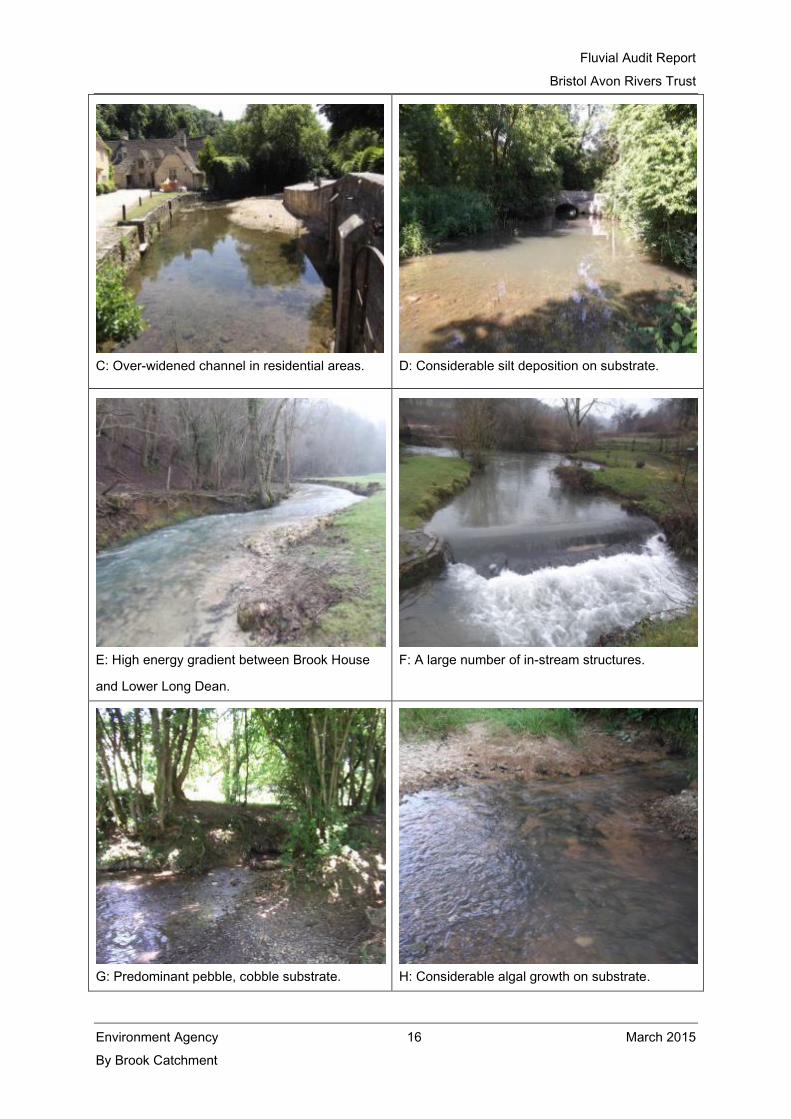
Overview of Reach 3b (Doncombe Bk - source to conf By Bk)
Reach character photographs
A: Poached banks and cattle access to the brook B: Substrate covered in algae
Fluvial Audit Report
Bristol Avon Rivers Trust
Environment Agency 24 March 2015
By Brook Catchment
C: Eroding left-hand and right-hand banks. D: Over abstraction, including water use for
amenity ponds & lakes.
E: Pebble-cobble substrate. F: Open un-grazed areas support good riparian
vegetation structure and diversity.

Fluvial Audit Report
Bristol Avon Rivers Trust
Environment Agency 25 March 2015
By Brook Catchment
Table 14 Reach Summary Table: Reach 4a.
Reach 4a (By Bk – (Conf Doncombe Brk to conf R. Avon) Doncombe Brook to Slaughterford)
Upstream survey limit
NGR 384225,174795
Downstream survey limit
NGR 384130,173852
Approximate length of river
surveyed
1.84Km
Reach characterisation
Hydromorphology: In reach 4a, the river is dominated by glide conditions associated with four in-
channel structures throughout the reach resulting in a large proportion of the reach becoming
impounded. This section of the river is situated within an asymmetrical valley with the river engineered
against the steep-sided valley to provide a sufficient hydraulic gradient suitable for milling. The
asymmetrical shape gives rise to a wide floodplain; however the channel is disconnected from its
floodplain to the over-deepened channel. Low flow velocities and impoundment result in the substrate
character being dominated by fine sedimentation.
Ecology: Bank vegetation is open grazed grass with occasional mature trees and hawthorns. There
are planted willows (cricket bat willows) on a short section of the right-hand bank. The highly
impounded sections of the reach give rise to large amounts of reed growth both on the margins and
within the centre of the channel.
Geomorphological assessment
Attribute Survey assessment
Flow dynamics and diversity Flow in this reach is dominated by impounded glide conditions and
areas of no perceptible flow (Plates A and B). One riffle was
observed (Plate E); however, this reach is predominantly
impounded by the four structures along its course.
Substrate The sediment regime in this reach is dominated by the in-channel
deposition of fine sediments; however substantial sections of
eroding bank were observed along the reach, predominantly
upstream and downstream of structures as a result of the
constriction of flow, particularly during winter periods when flows
are higher. There was one section of the reach where a riffle was
observed where flow energies were higher. Here the coarse
substrate is overlain with silt deposits (Plate E) and as a result, no

Fluvial Audit Report
Bristol Avon Rivers Trust
Environment Agency 26 March 2015
By Brook Catchment
clean gravels were observed.
Channel and banks The planform within this reach has been modified as a result of the
river’s milling history, which has left this reach with vast lengths of
straightened, over-deepened and over-widened channels. There is
one section in the middle of the reach which is slightly sinuous and
no evidence of channel straightening and thus exhibits a short
section of riffle-run flows. The bank height indicates disconnection
of the channel from its floodplain except in periods of flood flows.
Plant community species:
Composition and abundance
Species observed during the audit included hard rush (Juncus
inflexus), compact rush (Juncus conglomeratus), pendulous sedge
(Carex pendula), common reed (Phragmites communis), branched
bur-reed (Spargantium erectum), meadowsweet (Filipendula
ulmaria) and lesser water-parsnip (Berula erecta). Within the river,
water-crowfoot (Ranunclus spp.), floating sweet grass (Glyceria
fluitans), and fennel pondweed (Potamogeton pectinatus).
Vegetation along the banks was noted to include stinging nettle
(Urtica dioca) and dock species.
Reach Issues
Invasive non-native species Algae identified within the reach of a coverage of >25%.
In-stream barriers No alien/introduced species were identified in this reach.
Land management 27 in-stream barriers were identified in this reach of which 8 were
Grade 1, including 7 weir structures; 1 Grade 2 bridge, 2 Grade 3
bridges and 2 Grade 4 bridges. There were 15 observations of
large woody debris in the channel with 3 observations of where it
was causing blockages.
Issues for restoration and management Potential restoration options
In-stream structures
Algae covered sediment
Silt covered spawning gravels
Bank erosion due to livestock poaching
BART/ EA to work with landowners,
angling club and residents to identify
suitable options for fish passage.
BART/EA to work with the water
company to reduce phosphate inputs
into the river.
BART to work with farmers on livestock

Fluvial Audit Report
Bristol Avon Rivers Trust
Environment Agency 27 March 2015
By Brook Catchment
fencing and land management to
reduce sediment and nutrient input into
the river.
Constraints
White-clawed crayfish are known to inhabit areas of the By Brook and therefore an approved
strategy must be in place to ensure the survival of this species before implementing any fish
passage options.
Work to move any crayfish will require a special licensed individual.
All necessary permissions and permits should be sought before installing any livestock
fencing.
Table 15 Overview of Reach 4a.
Overview of Reach 4a (By Bk – (Conf Doncombe Bk to conf R. Avon) Doncombe Brook to
Slaughterford)
Reach character photographs
A: In-stream structures are an issue for fish
passage.
B: Channel impoundment with no perceptible flow.

Fluvial Audit Report
Bristol Avon Rivers Trust
Environment Agency 28 March 2015
By Brook Catchment
C: Bank erosion downstream on in-channel
structures.
D: Large algal blooms cover sediment and form on
the surface during the summer.
E: Silt covering potential spawning gravels. F: Bank collapse exasperated by poaching from
livestock.

Fluvial Audit Report
Bristol Avon Rivers Trust
Environment Agency 29 March 2015
By Brook Catchment
Table 16 Reach Summary Table: Reach 4b.
Reach 4b (By Bk – (Conf Doncombe Brk to conf R. Avon) Slaughterford to Drewett’s Mill)
Upstream survey limit
NGR 384130,173852
Downstream survey limit
NGR 383232,169949
Approximate length of river
surveyed
5.32Km
Reach characterisation
Hydromorphology: The upstream section of Reach 4b is situated within a steep-sided valley which
results in a dominance of run conditions and swifter flows than the upstream reach. Sediment
transport is the dominant process in the upstream section of the reach, with the substrate displaying
significant sections of clean gravels and other coarse sediment. However, downstream of Tilley’s
Wood, Widdenham, the channel is straightened and over-deepened and has led to a dominance of
glide habitat. Land use is characterised by a mixture of cattle grazing and woodland (Plates A and B).
Ecology: The upstream section of the reach is situated within deciduous woodland where a complex
structure of bankside vegetation is present. Downstream, land is grazed by dairy cattle right down to
the water’s edge which has resulted in limited amounts of riparian vegetation and occasional
scattered trees (Plate B).
Geomorphological assessment
Attribute Survey assessment
Flow dynamics and diversity The upstream section of Reach 4b is situated within a steep-sided
valley which results in a dominance of run conditions and swifter
flows than in Reach 4a. However, downstream of Tilley’s Wood,
Widdenham, the channel is straightened and over-deepened to
accommodate the downstream weir, which has led to a dominance
of glide habitat. Downstream of Widdenham Farm, glide habitat is
dominant with sporadic riffle-run flows.
Substrate The sediment regime in the upstream section of the reach above
Widdenham Farm is dominated by transport processes, supporting
gravels and other coarse sediments (Plate A). The presence of
macrophytes such as Ranunculus spp. in fast flowing sections of
the reach results in channel accumulation of isolated patches of
fine sediment.

Fluvial Audit Report
Bristol Avon Rivers Trust
Environment Agency 30 March 2015
By Brook Catchment
Channel and banks The planform within this reach is varied and consists of a sinuous
planform with shallow banks in the upstream valley dominated
reach. Moving downstream the channel becomes over-widened
and over-deepened to accommodate historic milling practices
(Plates G and H).
Plant community species:
Composition and abundance
Species observed during the audit included hard rush (Juncus
inflexus), compact rush (Juncus conglomeratus), pendulous sedge
(Carex pendula), water-crowfoot (Ranunclus spp.), floating
pondweed (Potamogeton natans), common duckweed (Lemna
minor), floating sweet grass (Glyceria fluitans). Vegetation along
the banks was noted to stinging nettle (Urtica dioca), dock species
and hartstongue (Phyllitis scolopendrium) on woodland river
banks.
Reach Issues
Native species Algae identified within the reach of coverage of 25%.
Invasive non-native species No alien/introduced species were identified in this reach.
In-stream barriers 43 in-stream barriers were identified in this reach of which 4 were
Grade 1 weirs, including 7 weir structures; 1 Grade 2 bridge, 2
Grade 3 weirs and 1 Grade 4 weir. There were 35 observations of
large woody debris in the channel with 7 observations of where it
was causing blockages.
Issues for restoration and management Potential restoration options
In-stream structures
Algae covered sediment
Silt covered spawning gravels
Bank erosion due to livestock poaching
BART/ EA to work with landowners,
angling club and residents to identify
suitable options for fish passage.
BART/EA to work with the water
company to reduce phosphate inputs
into the river.
BART to work with farmers on livestock
fencing and land management to
reduce sediment and nutrient input into
the river.
Constraints

Fluvial Audit Report
Bristol Avon Rivers Trust
Environment Agency 31 March 2015
By Brook Catchment
White-clawed crayfish are known to inhabit areas of the By Brook and therefore an approved
strategy must be in place to ensure individuals are relocated to suitable ARK before
implementing any fish passage options.
Work to move any crayfish will require a special licensed individual.
All necessary permissions and permits should be sought before installing any livestock
fencing.
Table 17 Overview of Reach 4b.
Overview of Reach 4b (By Bk – (Conf Doncombe Bk to conf R. Avon) Slaughterford to Drewett’s Mill)
Reach character photographs
A: Gravels and coarse sediment substrate. B: Cattle grazing down to the river have limited
riparian vegetation development.
C: Diffuse pollution from nearby cattle yards. D: Cattle poached banks and nutrient enrichment

Fluvial Audit Report
Bristol Avon Rivers Trust
Environment Agency 32 March 2015
By Brook Catchment
E: Siltation of potential spawning gravels. F: Algae covered sediment and signs of
eutrophication.
G: In-channel structures have lead to over-
deepened channels and are an obstruction to fish
passage.
H: Engineered straight channel.

Fluvial Audit Report
Bristol Avon Rivers Trust
Environment Agency 33 March 2015
By Brook Catchment
Table 18 Reach Summary Table: Reach 4c.
Reach 4c (Lid Brook- source to conf By Bk)
Upstream survey limit
NGR 380539,170311
Downstream survey limit
NGR 383179,169941
Approximate length of river
surveyed
2.95Km
Reach characterisation
Hydromorphology: Reach 6 is situated within a high gradient valley and as a result displays a good
degree of flow and morphological diversity. The channel planform is characterised by a meandering
channel with varied bank and bed profiles. The channel is connected well to the floodplain along the
majority of the reach and is present on both banks in the upstream sections of the reach. However, in
the middle sections of the reach the river becomes disconnected from the floodplain due to the steep
banks and returns to a wide connected floodplain in the downstream sections of the reach. Land use
in the floodplain consists of pastoral agriculture and is dominated by dairy cattle on both banks of the
river. Excessive poaching in the past has led to accelerated bank erosion and destruction of riparian
habitat.
Ecology: Very little riparian vegetation exists along this reach. This is largely due to livestock access
to the river and the excessive poaching which has caused damage to bankside structure and
vegetation. However, with livestock fencing that has been erected in the past year it is hoped that a
good diversity of riparian vegetation begins to establish.
Geomorphological assessment
Attribute Survey assessment
Flow dynamics and diversity The high gradient of the river supports a dominance of riffle-run
flows along the reach. The presence of natural in-stream structures
such as large tree roots and large woody debris also provides
additional areas of flow diversity, including chute flow (Plate A).
The downstream lower gradient sections of the reach exhibit glide
habitat and this is particularly evident adjacent to Saltbox Farm
where the river has been straightened and the banks heavily
modified to accommodate the farm (Plate B).
Substrate Upstream sections of the reach are dominated by sand and gravel
substrate (Plate C) with coarser pebbles and cobbles deposited in
the middle sections of the reach. Clean gravels are present in the

Fluvial Audit Report
Bristol Avon Rivers Trust
Environment Agency 34 March 2015
By Brook Catchment
downstream sections of the reach with short section of heavy silt
deposition in the low energy straightened sections of the river.
Channel and banks The planform within this reach is slightly sinuous and channel
banks are varied with upstream and downstream sections
exhibiting low banks, whilst the high energy middle section is
generally steep. Similarly floodplain connectivity is good in the
upstream and downstream sections of the reach, whilst
connectivity is limited in the middle reaches due to bank height.
Isolated evidence of channel adjustment was observed in the
downstream section at Saltbox Farm. The installation of livestock
fencing through funding of the 1st phase of this project will help to
provide valuable riparian habitat and reduce sediment and nutrient
inputs into the river (Plate D).
Plant community species:
Composition and abundance
Species observed during the audit included stinging nettle (Urtica
dioca), thistle spp., dock species, and hartstongue (Phyllitis
scolopendrium).
Reach Issues
Native species No native species were identified in this reach.
Invasive non-native species No alien/introduced species were identified in this reach.
In-stream barriers 24 in-stream barriers were identified in this reach of which 1 was a
Grade 2 culvert and 8 Grade 4 structures, including 3 fenced
drinking bays, 1 fence, 2 bridges and 2 further culverts. There
were 15 observations of large woody debris in the channel with 8
observations of where it was causing blockages.
Issues for restoration and management Potential restoration options
Sedimentation of downstream river gravels.
Nutrient influx from nearby farms.
BART could work with farmers to
improve land management practices,
such as bringing cattle in over the
winter, reducing compaction and
introducing land drainage where
required.
BART could work with farmers to
introduce measures to reduce diffuse

Fluvial Audit Report
Bristol Avon Rivers Trust
Environment Agency 35 March 2015
By Brook Catchment
pollution on farms, such as the
installation of guttering where required
and installation of concrete sleeping
policeman to reduce the likelihood of
dirty water reaching nearby
watercourses.
Constraints
There are no constraints identified.
Table 19 Overview of Reach 4c.
Overview of Reach 4c (Lid Brook- source to conf By Bk)
Reach character photographs
A: Tree roots provide good habitat and flow
diversity.
B: Heavily modified channel through Saltbox Farm.

Fluvial Audit Report
Bristol Avon Rivers Trust
Environment Agency 36 March 2015
By Brook Catchment
C: Sand and gravel substrate is dominant in the
upstream section of the reach.
D: The installation of livestock fencing provides a
good riparian buffer strip.

Fluvial Audit Report
Bristol Avon Rivers Trust
Environment Agency 37 March 2015
By Brook Catchment
Table 20 Reach Summary Table: Reach 5.
Reach 5 (By Bk – (Conf Doncombe Bk to conf R. Avon) Drewett’s Mill to Bathford)
Upstream survey limit
NGR 383232,169949
Downstream survey limit
NGR 378576,166991
Approximate length of river
surveyed
6.48Km
Reach characterisation
Hydromorphology: The upstream section of Reach 5 is dominated by over-widened and over-
deepened channels with a number of large in-stream structures. Downstream of Box Mill studios the
river returns to a more natural planform with good sinuosity interspersed with further in-stream
structures, yet their effect on the river dynamics appears to be less dramatic than upstream.
Downstream of Middlehill gauging weir a large section of riffle-run and pool habitat exists.
Ecology: The predominant land management along this reach is grazing with very little of the river
fenced off from livestock. As such there is limited riparian vegetation present; however in areas of
glide and no perceptible flow there is a dominance of marginal reed species. Despite this, in-channel
vegetation is present sporadically through the reach and Ranunculus spp. was noted on a number of
occasions in areas of fast flow and good light penetration (Plate E).
Geomorphological assessment
Attribute Survey assessment
Flow dynamics and diversity Flows in the upstream reaches between Drewett’s Mill and Box Mill
studios are less varied than would be typical for a type II river of this
kind due to the impoundment of the river by a series of weirs (Plate
B). Flows in the upstream reaches are dominated by low energy
glides with sections of no perceptible flow (Plate A). The middle
section of the reach from Box Mill studios to Box Bridge however,
exhibits good flow diversity with the presence of pools, riffles, glides
and chute flow. Downstream again from Box Bridge the channel is
straightened in sections with the presence of a number of weirs which
have led to further glide flows or no perceptible flow (Plate C).
Substrate Sediment deposition as a result of impoundment is the dominant
process in the upstream and downstream sections of Reach 5. As a
result there are few areas of shallow flow with clean gravels suitable

Fluvial Audit Report
Bristol Avon Rivers Trust
Environment Agency 38 March 2015
By Brook Catchment
for salmonid spawning in these areas. However, the middle section of
Reach 5 supports good quality clean stable gravels suitable for
spawning (Plate D).
Channel and banks The upstream section of Reach 5 is dominated by over-widened and
over-deepened channels with a number of large in-stream structures.
Between Box Mill studios and the Box Road Bridge the river returns to
a more natural planform with good sinuosity interspersed with one
further in-stream structure, yet its effect on the river dynamics appears
to be less dramatic than upstream. Downstream of Box Road Bridge
the river again returns to a straightened, over-deepened channel and
there is visible evidence of impoundment along large sections of the
river. The banks along the majority of the reach are quite steep as a
result of historic deepening of the channel (Plate E) and show
substantial signs of erosion (Plate F), whilst areas of shallow river
bank exist sporadically along the reach.
Plant community species:
Composition and abundance
Species observed during the audit included included hard rush
(Juncus inflexus), compact rush (Juncus conglomeratus), common
reed (Phragmites communis), branched bur-reed (Spargantium
erectum), meadowsweet (Filipendula ulmaria) and lesser water-
parsnip (Berula erecta). Within the river, water-crowfoot (Ranunclus
spp.), floating pondweed (Potamogeton natans), water-milfoil
(Myriophyllum aquaticum), floating sweet grass (Glyceria fluitans),
fennel pondweed (Potamogeton pectinatus), and water mint (Mentha
aquatica). Vegetation along the banks was noted to include teasel
(Dipsacus fullonum), common comfrey (Symphytum officinalis), sweet
vernal grass (Anthoxanthum odoratum), stinging nettle (Urtica dioca),
thistle spp., dock species, and greater willow herb (Epilobium
hirsutum)
Reach Issues
Native species No native species of concern were identified in this reach.
Invasive non-native species No alien/introduced species were identified in this reach.
In-stream barriers 88 in-stream barriers were identified in this reach of which 7 were
Grade 1 weirs, 8 were Grade 2 bridges and culverts and 1 Grade 2

Fluvial Audit Report
Bristol Avon Rivers Trust
Environment Agency 39 March 2015
By Brook Catchment
weir. In addition to this, there were a total of 11 Grade 3 bridges,
culverts and groynes. There were 56 observations of large woody
debris in the channel with 8 observations of where it was causing
blockages.
Issues for restoration and management Potential restoration options
In-stream structures.
Agricultural run-off.
Steeply eroding banks.
BART/ EA to work with landowners,
angling club and residents to identify
suitable options for fish passage.
BART to work with farmers on
implementing good land management
practices to reduce agricultural run-off.
Constraints
White-clawed crayfish are known to inhabit areas of the By Brook and therefore an approved
strategy must be in place to ensure the successful relocation of individuals to suitable ARK
sites before implementing any fish passage options.
Work to move any crayfish will require a special licensed individual.
Table 21 Overview of Reach 5.
Overview of Reach 8 (By Bk – (Conf Doncombe Bk to conf R. Avon) Drewett’s Mill to Bathford)
Reach character photographs
A: Dominant glide flow and no perceptible flow in
upstream sections of the reach.
B: In-stream structures.
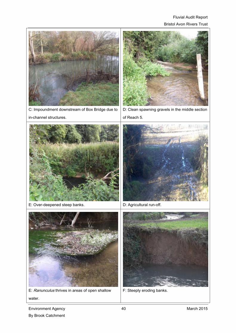
Fluvial Audit Report
Bristol Avon Rivers Trust
Environment Agency 40 March 2015
By Brook Catchment
C: Impoundment downstream of Box Bridge due to
in-channel structures.
D: Clean spawning gravels in the middle section
of Reach 5.
E: Over-deepened steep banks. D: Agricultural run-off.
E: Ranunculus thrives in areas of open shallow
water.
F: Steeply eroding banks.

Fluvial Audit Report
Bristol Avon Rivers Trust
Environment Agency 41 March 2015
By Brook Catchment
3.2 Point and Diffuse Pollution
A total of 486 sources were recorded on the 45 km walked in the By Brook catchment. Of these, 140
were diffuse and 38 were point sources. A further 640 features were recorded during the audit, such
as barriers to fish passage, large woody debris, and depositional features, however these are not
included in the point source and diffuse source pollution scores. The source grade analysis is shown
in Figure 2. The majority of sources were classified as Grade 3, with a total of 300 inputs. There
were 28 Grade 2 sources (6%) and 158 Grade 4 sources (32%) were recorded in the catchment.
Figure 2 Percentage of sources analysed by Grade.
The location of each source has been mapped in ArcGIS (Appendix 2). An analysis of graded
sources by category (Figure 3) highlights the groups of activities and issues causing notable inputs
of sediment, point source pollution and diffuse pollution. Livestock (Category B) and other sources
(Category E) were the sole contributors to Grade 2 sources in the By Brook catchment, with 18 and
10 sources respectively. Other sources (Category E) were the largest cause of Grade 3
inputs/issues, with a total number of 231 recorded. Livestock sources (Category B) accounted for
19% of Grade 3 pollution, whilst point source conduits (Category C), accounted for 2.3% of Grade 3
pollution inputs. Similarly, other sources accounted for 51% of Grade 4 source inputs, whilst
livestock accounted for 34% of Grade 4 inputs.

Fluvial Audit Report
Bristol Avon Rivers Trust
Environment Agency 42 March 2015
By Brook Catchment
Figure 3 Number of sources per Grade and analysed by Category.
A total of 21 different types of pollution sources or potential issues were documented during the
fluvial audit. These are mapped separately in Appendix 2. The most common type of issue recorded
was eroding cliffs, which accounted for 52% of sources; whilst exposed tree roots were also
recorded quite frequently, and accounted for 14% of sources (Figure 4). Poaching by livestock was
the next most common source of pollution accounting for 20% of point and diffuse sources of
pollution combined. Drainage pipes from transport links and the occurrence of algae on sediment
accounted for 4% and 3% of sources respectively.

Fluvial Audit Report
Bristol Avon Rivers Trust
Environment Agency 43 March 2015
By Brook Catchment
Figure 4 Number of sources by type.
3.3 Barriers to fish passage
A total of 249 barriers to fish passage were recorded in the By Brook catchment during the fluvial
audit. A breakdown of the different types of barrier is given in Figure 5 below. Large woody debris
was the most common type of barrier to fish passage in the catchment with 89 separate records, this
accounting for 36% of barrier types. Bridges and weirs were the second most common type of
barrier to fish passage with records of 53 (21%) and 51 (20%) respectively. The fluvial audit also
highlighted a large number of other types of barrier not commonly observed in rivers, including
telegraph poles, walls and iron sheeting, although these only accounted for a small proportion of
records.

Fluvial Audit Report
Bristol Avon Rivers Trust
Environment Agency 44 March 2015
By Brook Catchment
Figure 5 Number of barriers to fish passage by type.
There was 1 Grade 2 barrier recorded on the Broadmead Brook (Reach 2) and 4 Grade 2 barriers
recorded on the By Brook. In addition to this, a Grade 3 barrier was recorded on the By Brook on
Reach 1 and a further 5 Grade 3 barriers were also recorded on the By Brook all located on Reach 3
between Castle Combe and Ford. The sources identified are all in-stream barriers to fish migration
that have not been recorded by BART previously and are new to the project. Individual Grade
assessments were completed for each of the Grade 1 to 3 barriers identified (see Table 22 to Table
32 below).

Fluvial Audit Report
Bristol Avon Rivers Trust
Environment Agency 45 March 2015
By Brook Catchment
Table 22 Potential barriers to fish migration: Reach 1, 383599,178866.
Project By Brook catchment River By Brook
Reach
Number
1 Recorder MH
Date 29/12/2014 NGR 383599,178866
Category E Type BAR-we
Description Straight drop weir approximately 0.8m high and 0.8m wide.
Land Use LHB: lay-by/ trees. RHB: improved/ semi-improved grassland.
Comments A straight drop weir of approximately 0.8m in height and 0.8m in width, situated
upstream of Gatcombe Mill. The weir is only likely to be passable to migratory fish in
medium and high flows.

Fluvial Audit Report
Bristol Avon Rivers Trust
Environment Agency 46 March 2015
By Brook Catchment
Table 23 Potential barriers to fish migration: Reach 2, NGR 383456,177586.
Project By Brook catchment River Broadmead Brook
Reach
Number
2 Recorder MH
Date 03/01/2015 NGR 383456,177586
Category E Type BAR-we
Description Broad crested weir approximately 2.3m high and 5m wide.
Land Use LHB: Residential RHB: Public track/ woodland
Comments A broad crested weir of approximately 2.3m in height and 5m in width, situated
downstream of Nettleton Mill, near Castle Combe. The weir is only likely to be
passable to migratory fish at high flows.

Fluvial Audit Report
Bristol Avon Rivers Trust
Environment Agency 47 March 2015
By Brook Catchment
Table 24 Potential barriers to fish migration: Reach 3, NGR 384 056,176 723.
Project By Brook catchment River By Brook
Reach
Number
3 Recorder MH
Date 08/01/2015 NGR 384 056,176 723
Category E Type BAR-we
Description Straight drop weir approximately 3.5m high and 3m wide.
Land Use LHB: Improved/ semi-improved
grassland
RHB: Improved/ semi-improved grassland
Comments A straight drop weir of approximately 3.5m in height and 3m in width, situated
downstream of Brook House, Castle Combe. The weir is unlikely to be passable to any
migratory fish, even in high flows.

Fluvial Audit Report
Bristol Avon Rivers Trust
Environment Agency 48 March 2015
By Brook Catchment
Table 25 Potential barriers to fish migration: Reach 3, NGR 384104,176585.
Project By Brook catchment River By Brook
Reach
Number
3 Recorder MH
Date 08/01/2015 NGR 384104,176585
Category E Type BAR-we
Description Stepped weir approximately 3.5m high and 13m wide.
Land Use LHB: Improved/ semi-improved
grassland
RHB: Improved/ semi-improved grassland
Comments A straight stepped weir of approximately 3.5m in height and 13m in width, situated
downstream of Brook House, Castle Combe. The weir is unlikely to be passable to
any migratory fish, even in high flows.

Fluvial Audit Report
Bristol Avon Rivers Trust
Environment Agency 49 March 2015
By Brook Catchment
Table 26 Potential barriers to fish migration: Reach 3, NGR 384165,176151.
Project By Brook catchment River By Brook
Reach
Number
3 Recorder MH
Date 08/01/2015 NGR 384165,176151
Category E Type BAR-we
Description Stepped weir approximately 3m high and 8m wide. Also sluice gates.
Land Use LHB: Improved/ semi-improved
grassland
RHB: Residential garden.
Comments A straight stepped weir of approximately 3m in height and 8m in width, situated at
Colham Mill, near Castle Combe. The weir is only likely to be passable to migratory
fish at high flows.
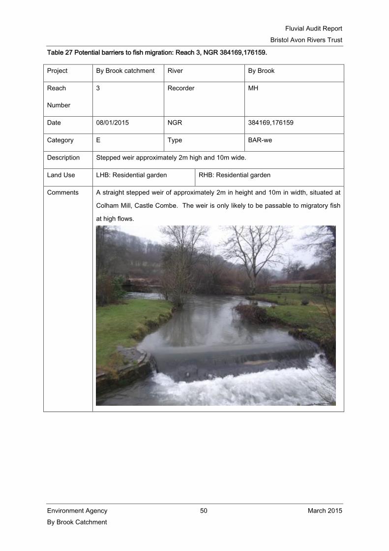
Fluvial Audit Report
Bristol Avon Rivers Trust
Environment Agency 50 March 2015
By Brook Catchment
Table 27 Potential barriers to fish migration: Reach 3, NGR 384169,176159.
Project By Brook catchment River By Brook
Reach
Number
3 Recorder MH
Date 08/01/2015 NGR 384169,176159
Category E Type BAR-we
Description Stepped weir approximately 2m high and 10m wide.
Land Use LHB: Residential garden RHB: Residential garden
Comments A straight stepped weir of approximately 2m in height and 10m in width, situated at
Colham Mill, Castle Combe. The weir is only likely to be passable to migratory fish
at high flows.

Fluvial Audit Report
Bristol Avon Rivers Trust
Environment Agency 51 March 2015
By Brook Catchment
Table 28 Potential barriers to fish migration: Reach 3, NGR 384577,175985.
Project By Brook catchment River By Brook
Reach
Number
3 Recorder MH
Date 08/01/2015 NGR 384577,175985
Category E Type BAR-we
Description Broad crested weir approximately 1m high and 4m wide.
Land Use LHB: Deciduous woodland RHB: Improved/ semi-improved grassland
Comments A broad crested weir of approximately 1m in height and 4m in width, situated
downstream of Colham Mill, near Castle Combe. The weir is likely to be passable to
migratory fish in moderate and high flows.

Fluvial Audit Report
Bristol Avon Rivers Trust
Environment Agency 52 March 2015
By Brook Catchment
Table 29 Potential barriers to fish migration: Reach 3, NGR 384700,175651.
Project By Brook catchment River By Brook
Reach
Number
3 Recorder MH
Date 08/01/2015 NGR 384700,175651
Category E Type BAR-we
Description Broad crested weir approximately 1.7m high and 2m wide.
Land Use LHB: Deciduous woodland RHB: Improved/ semi-improved grassland
Comments A broad crested weir of approximately 1.7m in height and 2m in width, situated
upstream of Long Dean. The weir is only likely to be passable to migratory fish in
high flows.

Fluvial Audit Report
Bristol Avon Rivers Trust
Environment Agency 53 March 2015
By Brook Catchment
Table 30 Potential barriers to fish migration: Reach 3, NGR 384964,175683.
Project By Brook catchment River By Brook catchment
Reach
Number
3 Recorder MH
Date 08/01/2015 NGR 384964,175683
Category E Type BAR-we
Description Straight drop weir approximately 4m high and 5m wide.
Land Use LHB: Improved/ semi-improved
grassland
RHB: Improved/ semi-improved grassland
Comments A straight drop weir of approximately 4m in height and 5m in width, situated at Long
Dean Mill. The weir is unlikely to be passable to any migratory fish, even in high
flows.
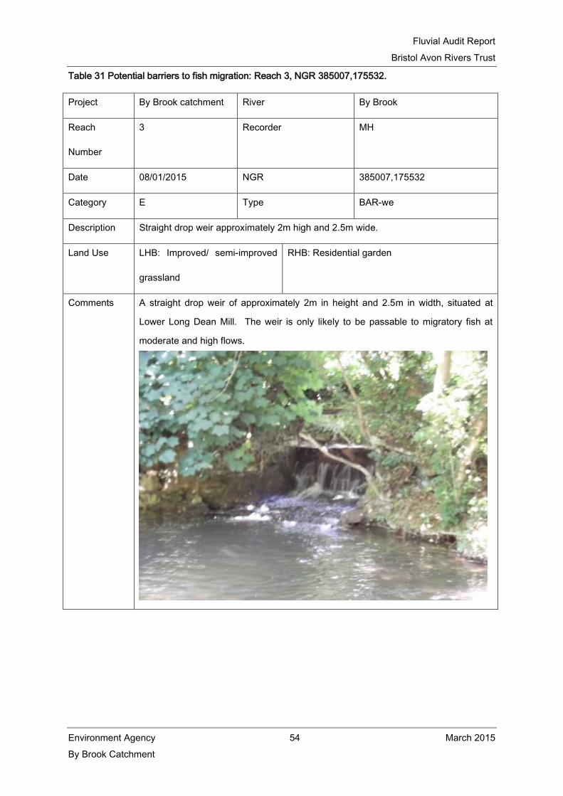
Fluvial Audit Report
Bristol Avon Rivers Trust
Environment Agency 54 March 2015
By Brook Catchment
Table 31 Potential barriers to fish migration: Reach 3, NGR 385007,175532.
Project By Brook catchment River By Brook
Reach
Number
3 Recorder MH
Date 08/01/2015 NGR 385007,175532
Category E Type BAR-we
Description Straight drop weir approximately 2m high and 2.5m wide.
Land Use LHB: Improved/ semi-improved
grassland
RHB: Residential garden
Comments A straight drop weir of approximately 2m in height and 2.5m in width, situated at
Lower Long Dean Mill. The weir is only likely to be passable to migratory fish at
moderate and high flows.

Fluvial Audit Report
Bristol Avon Rivers Trust
Environment Agency 55 March 2015
By Brook Catchment
Table 32 Potential barriers to fish migration: Reach 5, NGR 379,833,167,429.
Project By Brook catchment River By Brook
Reach
Number
5 Recorder MH
Date 02/02/2015 NGR 379833,167429
Category E Type BAR-we
Description Straight drop weir approximately 2m high and 4m wide.
Land Use LHB: Scrub/ Railway embankment RHB: Scrub/ rank grassland
Comments A straight drop weir of approximately 2m in height and 4m in width, situated
downstream of Box Bridge. The weir is unlikely to be passable to any migratory fish.

Fluvial Audit Report
Bristol Avon Rivers Trust
Environment Agency 56 March 2015
By Brook Catchment
3.4 Overview of catchment conditions
This section describes a summary of the data gathered during the winter 2015 fluvial audit and
supporting evidence from the BART walkover survey gathered in the summer of 2013.
3.4.1 Substrate conditions
The fluvial audit has demonstrated that the sediment regime in the By Brook is comprised of a good
mixture of erosional and depositional processes, with substantial evidence of both eroding cliffs and
fine siltation throughout the catchment. As a result of the combination of erosional and depositional
processes acting within the channel, the substrate composition of the main By Brook channel is
comprised of a good mixture of gravels with coarser sediments deposited in areas of slower flow.
The substrate in Reaches 4a and the upstream section of Reach 5 are dominated by fine
sediments and uniform bed conditions (Figure 6). The gravel supply in these areas is good since
there is still a substantial amount of bank erosion processes occurring, particularly in periods of
high flows and where the channel obstructions cause a restriction in flow and therefore increase
erosional processes around the obstruction. It appears that there is sufficient material in the
system (including in-situ material and sediment that is transported over these obstructions during
high flows); however due to the size of the obstructions (four Grade 1 sources) the impact of these
structures on the river is major and thus fine sedimentation is still occurring even during periods of
high flows. This means that it is not possible to encourage further substrate recovery in these
reaches through physical modifications to bed and bank form unless the obstructions were
removed or altered in such a way as to substantially reduce the impounding effect they currently
have on the river.

Fluvial Audit Report
Bristol Avon Rivers Trust
Environment Agency 57 March 2015
By Brook Catchment
Figure 6 Large amounts of fine sediment are common throughout impounded reaches of the By
Brook.
The proportion of gravel substrate increases through Reach 4b and within the middle section of
Reach 5 (between Middlehill gauging weir and Box Road Bridge). The increase in the proportion of
coarse sediment at these sites is connected to a combination of bank erosion within the reach and
from localised increases in geomorphological diversity associated with channel narrowing due to
the development of vegetated berms, increased channel gradient and increased flow velocities.
However, as a result of a combination of land management activities in the catchment, particularly
poaching by livestock and agricultural run-off; with the addition of sewage treatment works and
private septic tanks, the quality of the sediments are generally in a ‘moderate’ condition.
Observations throughout the winter fluvial audit and the walkover survey undertaken in 2013
indicate a number of sites which potentially could support good spawning gravels are covered in silt
or algae.
The presence of algae coated sediments was particularly notable in Reaches 2, 3 and 3b where
algae coverage on sediment was approximated at around 25%. Algae covered sediment was also
noted in Reach 1, 4a and 4b; however this was to a lesser extent. During the fluvial audit and the
walkover survey in 2013, a number of sites were identified where a sweet smell of washing powder,
foam and algal were recorded together. Situations like this are suggestive of misconnections and
therefore further investigation by the EA is recommended.

Fluvial Audit Report
Bristol Avon Rivers Trust
Environment Agency 58 March 2015
By Brook Catchment
Silt covered sediments were noted throughout the catchment except for the Lid Brook, where a
good supply of clean sand and gravels were present. The fact that clean sediments were only
recorded in the Lid Brook is particularly poignant since BART and the EA delivered a scheme of
land management advice and livestock fencing along the majority of the river during 2013/2014. It
is therefore suggested that more land management and infrastructure work is implemented
throughout the catchment in order to reduce the sediment influx into the catchment.
The historical dredging activities on the By Brook are likely to be responsible for observed
increases in channel capacity throughout. It is likely that these channel modifications have, in
conjunction with the shallow channel gradient characteristic of this river type, exacerbated the
observed sedimentation issues, since low energy flows in the enlarged channel sections are less
able to transport sediments than swifter flows in more natural channels. As a result, the range of
aquatic habitats supported by these flow conditions and abundant fine sediment supply is limited.
Suitable habitat for aquatic vegetation such as water crowfoot and water milfoil is generally limited
on the main By Brook channel, with the exception of some areas within Reaches 4b and 5 where
flows are sufficiently fast to prevent siltation and the river bed displays a mosaic of substrate
materials characteristic of this river type.
3.4.2 Planform and profile characteristics
The planform of the By Brook demonstrates that it has been altered quite significantly over time as
a result of historical milling activities which took place on the river on a grand scale. Reaches 1, 2,
3 and 3a display the most sinuous planform within the study area, with few signs of recent channel
straightening. These reaches exhibit characteristics of natural channel carrying capacity and cross
section shows the banks are generally low sided and of a low gradient. Some sections within these
reaches have been affected by localised geotechnical failure and livestock trampling, which is
particularly evident between West Kington and Nettleton Shrub in Reach 2. The planform of the
river within Reach 3 between Brook House and Lower Colham exhibits a varied geotechnical form
with the presence of river braiding, varied flows, good habitat structure and the presence of a
diverse range of aquatic macrophytes (Figure 7).

Fluvial Audit Report
Bristol Avon Rivers Trust
Environment Agency 59 March 2015
By Brook Catchment
Figure 7 Braided river and wetland features at Colham Mill.
A short section of the By Brook in Reach 4b (between Honeybrook Farm and Weavern Farm)
presents a good example of Type II river morphology, despite that a redundant mill leat runs
alongside this section of the river. This higher gradient section of the river gives rise to good flow
diversity with a number of riffle-run and pool flows present throughout and consequently a number
of point bars, side bars and vegetated mid-channel bars have formed.
With the exception of the reaches discussed above, the majority of the By Brook channel displays a
bank geometry characterised by a uniform, trapezoidal cross section with high banks and limited
floodplain connectivity. There is however an example of excellent floodplain habitat exhibited in
Reach 5 between Drewett’s Mill and Box Mill Sudio’s. Part of a paleochannel runs from upstream
of Inghalls Cottages and along the field boundary for approximately 450m before flowing into the
mill pool below Box Mill Studio’s (Figure 8). The presence of the spring fed paleochannel has
allowed a vast area of floodplain wetland habitat to develop within which grey heron (Ardea
cinerea) and little egret (Egretta garzetta) have been seen amongst a variety of invertebrates,
including dragonflies and butterflies (Figure 9).

Fluvial Audit Report
Bristol Avon Rivers Trust
Environment Agency 60 March 2015
By Brook Catchment
Figure 8 Spring-fed paleochannel flows along the field boundary near Box Mill Studio’s.
Figure 9 Floodplain wetland habitat upstream of Box Mill Studio’s.
3.4.3 Flow dynamics and diversity
The flow regime along a large proportion of the By Brook catchment is characterised by glide flows,
broadly complying with the requirements for Type II lowland, clay dominated rivers. However,
widespread channel enlargement has resulted in a reduction in the occurrence of faster flow
velocities, as well as riffle features. These are of crucial importance to the maintenance of the
mosaic of in-channel habitats that support the characteristic flora and fauna of this river type.

Fluvial Audit Report
Bristol Avon Rivers Trust
Environment Agency 61 March 2015
By Brook Catchment
Upstream reaches and tributaries, for example Reach 2, Reach 3, Reach 3a and Reach 3b exhibit
a wide range of flow diversity as a result of a more natural geomorphological structure of the
channel and increased bed gradient.
Impoundment by in-channel structures is a major issue in through Reaches 4a and Reach 5, which
is concurrent with enlarged sections of the river and subsequent reduction in flow velocity resulting
in notable sections of the river with no perceptible flow. Evidence of channel recovery is present at
a number of locations within Reaches 4a and 5 where wide vegetated berms have established
(Figure 10). There is also a dominance of large woody debris throughout the catchment; however,
there are only a few occurrences where these cause natural impoundment of the waterbody and
are therefore likely to be providing a wealth of valuable habitat for fish and macroinvertebrates as
well as aiding variation in flow velocity.
Figure 10 Vegetated berm formation as the river tries to recover into a more natural channel.
Notable exceptions to the uniform flows occur in Reaches 2, 3 and 3a with a short upstream
section in Reach 4b. These reaches include a good range of in-channel geomorphological features
including low banks and small point bars associated with light grazing and localised bank collapse,
resulting in variable flow types with faster flows coexisting with areas of refugia. These reaches are
therefore a good example of ideal flow characteristics for this type of a shallow gradient river.

Fluvial Audit Report
Bristol Avon Rivers Trust
Environment Agency 62 March 2015
By Brook Catchment
3.4.4 Habitat structure and species abundance
Vegetation species observed during the summer 2013 walkover survey included hard rush (Juncus
inflexus), compact rush (Juncus conglomeratus), pendulous sedge (Carex pendula), common reed
(Phragmites communis), branched bur-reed (Spargantium erectum), meadowsweet (Filipendula
ulmaria) and lesser water-parsnip (Berula erecta). Within the river, water-crowfoot (Ranunclus
spp.), floating pondweed (Potamogeton natans), water-milfoil (Myriophyllum aquaticum), common
duckweed (Lemna minor), floating sweet grass (Glyceria fluitans), fennel pondweed (Potamogeton
pectinatus), water mint (Mentha aquatica), water starwort (Callitriche stagnalis), and some blanket
weed were recorded. Vegetation along the banks was noted to include teasel (Dipsacus fullonum),
common comfrey (Symphytum officinalis), sweet vernal grass (Anthoxanthum odoratum), stinging
nettle (Urtica dioca), thistle spp., dock species, greater willow herb (Epilobium hirsutum) and
hartstongue (Phyllitis scolopendrium) on woodland river banks.
Dense stands of trees and woodland were also present along the tributary rivers and the vast
majority of the main By Brook channel providing shading to the river and a contribution of large
woody debris for in-stream habitat for fish and a food resource for macroinvertebrates.
Furthermore the presence of tree-lined banks also helps to support the bank structure particularly
in areas of active erosion which were recorded in a large number of reaches.
The trapezoidal cross-sectional profile with an over-wide and over-deep channel which dominates
the majority of the By Brook main channel is strongly associated with the small, abrupt zone of
hydrological transition observed during the fluvial audit. The lack of a more natural, gradual
transitional zone limits the range of habitat niches that are supported in the margins of the channel.
This limits the potential for colonisation of emergent species such as branched bur-reed, brook-
lime, water forget-me-not, water-mint and water-cress, and invertebrates which depend upon them.
There was no evidence of any native protected species recorded during either of the surveys,
although specific white-clawed crayfish (Austropotamobius pallipes) surveys undertaken by Ahern
Ecology and OHES confirmed the presence of white-clawed crayfish within the By Brook.
3.4.5 Invasive non-native species
No invasive non-native species were observed during the walkover survey; however evidence of
crayfish burrows were present on the Broadmead Brook. The presence of crayfish traps (Figure
11) at the side of the river and discussions with local residents are likely to suggest that the signal
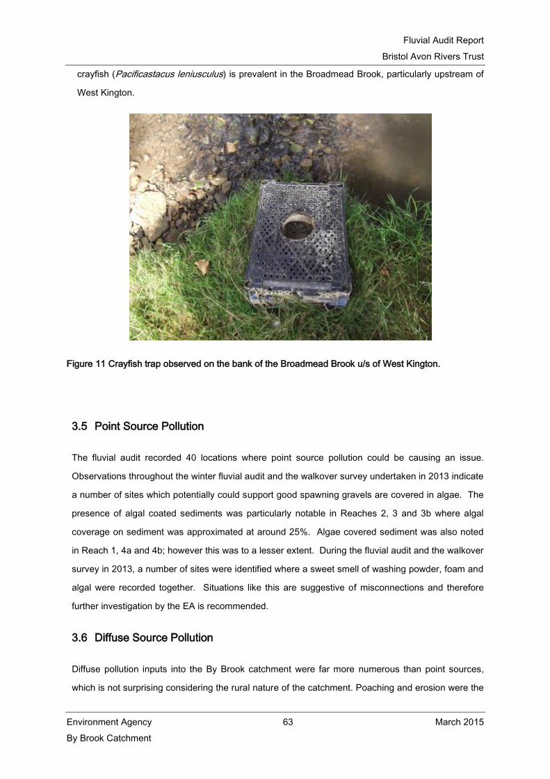
Fluvial Audit Report
Bristol Avon Rivers Trust
Environment Agency 63 March 2015
By Brook Catchment
crayfish (Pacificastacus leniusculus) is prevalent in the Broadmead Brook, particularly upstream of
West Kington.
Figure 11 Crayfish trap observed on the bank of the Broadmead Brook u/s of West Kington.
3.5 Point Source Pollution
The fluvial audit recorded 40 locations where point source pollution could be causing an issue.
Observations throughout the winter fluvial audit and the walkover survey undertaken in 2013 indicate
a number of sites which potentially could support good spawning gravels are covered in algae. The
presence of algal coated sediments was particularly notable in Reaches 2, 3 and 3b where algal
coverage on sediment was approximated at around 25%. Algae covered sediment was also noted
in Reach 1, 4a and 4b; however this was to a lesser extent. During the fluvial audit and the walkover
survey in 2013, a number of sites were identified where a sweet smell of washing powder, foam and
algal were recorded together. Situations like this are suggestive of misconnections and therefore
further investigation by the EA is recommended.
3.6 Diffuse Source Pollution
Diffuse pollution inputs into the By Brook catchment were far more numerous than point sources,
which is not surprising considering the rural nature of the catchment. Poaching and erosion were the

Fluvial Audit Report
Bristol Avon Rivers Trust
Environment Agency 64 March 2015
By Brook Catchment
most significant pressures identified during the survey and these sources are commonly connected.
The flashy nature of the watercourse has resulted in a number of eroding banks and recent bank
slips. The input of excess sediment and fine material has the potential to smother fish spawning
habitat. To reduce bank erosion and riparian vegetation degradation by livestock, it is suggested a
combination of livestock fencing and water provision is installed, particularly in those sites connected
with good spawning gravels. Water provision for livestock could include the provision of solar
powered pumps, pasture pumps, drinking bays and mains water to troughs where suitable. Drinking
bays and mains water troughs are less favourable options as the former still encourages livestock to
drink and therefore defecate in the river, whilst dependence on mains water is unfavourable with a
number of farmers. However, solar powered pumps and pasture pumps keep cattle away from the
river completely and would be the recommended options for these sites. Restricting livestock from
the watercourse will also reduce the ammonia and phosphate loading potential.
There is very little arable land managed within the By Brook catchment, however in the few areas
where land is managed under arable rotation it is suggested that BART could work with landowners
to increase the size of buffer strips or look at changes in land management practices, such as the
growing of cover crops over winter, and harvesting high risk land earlier by growing early season
varieties of crops.
3.7 Barriers to Fish Migration and Connectivity
The number and scale of barriers present in the By Brook catchment present a significant issue to
the successful catchment management and delivery of WFD objectives. An additional nine barriers
were newly identified during the fluvial audit and are concentrated in Reach 3 with a further barrier in
Reach 2. Barriers to migratory fish movement have been created in all cases due to changes in
hydraulic conditions at the structures, which exceed the swimming capabilities or do not suit the
behavioural characteristics of fish attempting to pass upstream. The major changes to natural
waterway conditions at these sites include, higher velocities, reduced flow depth, lack of resting
places or shelter, excess turbulence and water surface drop. The additional weirs require
investigation on a case-by-case base basis. There may be scope for retrofitting fish migratory aids,
such as fish ladders and passes, on a number of structures on the By Brook. A substantial amount
of LWD was recorded during the fluvial audit, and only a small proportion resulted in the formation of
debris dams. Woody debris can provide refugia from high velocity flows, shade, feeding, spawning
and nursery habitat for a number of fish, macroinvertebrate and mammalian species.

Fluvial Audit Report
Bristol Avon Rivers Trust
Environment Agency 65 March 2015
By Brook Catchment
In-channel structures alter the natural processes which operate within the river channel, creating
slow flowing impounded conditions upstream and preventing the free movement of fish and other
aquatic organisms. These changes in condition can encourage fine sedimentation, reduce the
movement of coarse sediments, and create uniform bed habitats. In addition, impounded conditions
can also result in increased water temperature and a change in biological communities from those
that prefer active flows to those that prefer still water.
3.8 Key issues affecting the By Brook catchment
The previous sections demonstrate that the condition of the By Brook catchment is adversely
affected by physical modifications and land management, which impact upon the habitats that can
be supported. The fluvial audit demonstrates that there are four primary issues which are likely to be
impacting on the catchment and overall ecological status of the waterbodies and these are in-
channel structures; fine sediment supply and deposition; nutrient enrichment; and bank erosion.
3.8.1 In-channel structures
The By Brook is affected by a large number of in-channel structures, including those already
identified by BART and the Environment Agency and the nine newly identified structures identified
as a result of the fluvial audit. These structures alter the natural functionality of the
geomorphological and hydrological processes that operate within the river channel, creating slow
flowing impounded conditions upstream and potentially limiting coarse sediment supply
downstream. These low energy conditions combine with high fine sediment supply to encourage
sedimentation in the channel. Structures also act as significant barriers to the free movement of fish
and other aquatic organisms, and may also increase temperature and promote still water species.
3.8.2 Fine sediment supply and deposition
Fine sedimentation is a common feature throughout the catchment and although good quality
gravels were observed on the Lid Brook, previous wet weather surveys undertaken by BART and
Wavelength with EA funding discovered 6 tonnes of sediment entering the main By Brook channel
from this small tributary, whilst a staggering 46 tonnes were recorded in the main By Brook channel
on the same wet weather event (BART, 2014). Sedimentation in the By Brook is largely as a result
of agricultural practices in the catchment, such as arable farming in the headwaters, agricultural
run-off from yards and fields, and livestock grazing up to the river bed. Erosive processes are
present throughout the catchment and it likely that livestock grazing up to the edge of river banks is

Fluvial Audit Report
Bristol Avon Rivers Trust
Environment Agency 66 March 2015
By Brook Catchment
causing excessive pressure and resulting in a number of banks collapsing. In addition to this, an
increase in channel capacity as a result of historical modifications and natural processes, and a
change in river flow regime due to the influence of the in-channel structures combine with the
increased sediment supply to promote in-channel sedimentation. Excessive fine sedimentation has
a detrimental effect on river habitat by reducing the diversity of the channel bed and creating
uniform, silted conditions. Furthermore, important habitats for spawning fish, macroinvertebrates,
and macrophytes become smothered and unsuitable for supporting healthy populations of aquatic
species.
3.8.3 Nutrient enrichment
Evidence of nutrient enrichment was observed both during the 2013 walkover survey and the
recent fluvial audit. The main affected areas in the catchment were Reaches 2, 3 and 3b where
algal coverage on sediment was approximated at around 25%. Algae covered sediment was also
noted in Reach 1, 4a and 4b; however this was to a lesser extent. In Reach 2 it is likely that a
number of misconnections are present within local residences causing an influx of phosphate into
the watercourse. During the survey a sweet smell of washing powder was noted along with foam
on the water surface, which could suggest a misconnected washing machine. Other possible
misconnections could include septic tanks and cess pits. The algal growth noted in Reach 3b is
likely to be due to the sewage treatment works at Marshfield which discharges into the Doncombe
Brook. Substantial areas of algal covered sediment were observed during the walkover, reducing
their suitability for fish and macroinvertebrates. In addition to this, cattle have access to the river
for drinking and it is likely that a further combination of defecation and urination from cattle is
increasing the nutrient input, alongside the degradation of the banks and influx of phosphate-bound
sediment.
Reach 4a and 4b are downstream of the two aforementioned tributaries and are therefore likely to
be receiving excessive nutrient loading from these upstream areas. In addition to this, a septic tank
misconnection was noted just downstream from Ford and the active erosion of the bank in these
areas is also likely to be contributing phosphate-bound sediment into the system.
3.8.4 Bank erosion
There are 410 records of bank erosion which were noted during the fluvial audit across the By
Brook catchment. The catchment is ‘flashy’ in nature and supports both erosive and depositional
processes throughout; however a combination of in-channel structures causing constriction in flow

Fluvial Audit Report
Bristol Avon Rivers Trust
Environment Agency 67 March 2015
By Brook Catchment
and livestock grazing are accelerating the rate of erosion in some areas leading to bank collapse
and the destruction of riparian habitat. For example over a 1Km section of Reach 2 has been
damaged by excessive poaching by cattle overwintering in the adjacent fields. Poaching by cattle
accessing the river to drink was also frequently recorded in Reaches 4a and 4b and in these areas
it was also noted that a number of point bars and riffles were present which could be suitable
spawning sites for fish if they didn’t have a fine coating of silt likely to be from the adjacent
poaching activity.
The presence of in-channel structures again places a further pressure on the river in terms of
constriction of flow, particularly in periods of high flow when both supporting banks and the
structures themselves come under pressure. Erosional activity both upstream and downstream of
the structures in Reach 4a and 4b was noted and particularly around the structures themselves. A
combination of bank lowering upstream of the structures to form a more natural bank gradient and
soft revetment downstream may help reduce the erosional impact in these areas. This work would
only be recommended where removal of the weir itself wasn’t proposed.

Fluvial Audit Report
Bristol Avon Rivers Trust
Environment Agency 68 March 2015
By Brook Catchment
4.0 RESTORATION MEASURES
In order to improve the ecological status of the six waterbodies of the By Brook catchment, the
potential restoration measures have focused on ameliorating the effect of the aforementioned
impacts, removal of any historical modifications where possible and to reinstate natural river
processes to allow more natural forms to develop through time. The process of devising a set of
prioritised measures has involved the analysis of a large amount of information taken from the 2013
walkover survey, 2014 fluvial audit and GIS; and previous phase I work undertaken in the catchment.
It must be taken into consideration that these suggested restoration measures are those which BART
feel could be achievable in the catchment. Whilst many local people have been involved in the By
Brook project over the past 2 years, a full stakeholder exercise has not yet been undertaken to
discuss priorities and options and this would be BART’S recommended next step.
The measures required to reduce the impacts on the By Brook catchment can be categorised into two
forms; short-term measures which could be undertaken in the next 1-3 years, and long-term
measures for delivery over a 5-10 year period.
The measures identified to remove or alleviate the impacts currently acting on the By Brook
catchment are as follows:
Livestock fencing;
Soft bank revetment;
Bank re-profiling;
Removal of in-channel structures or provision of fish passage;
Engagement with local residents regarding misconnections;
Engagement with the local water company regarding sewage treatment works discharges.
4.1 Short-term Measures
4.1.1 Livestock fencing
The accessibility of the river to the grazing and poaching action of cattle has encouraged bank
erosion along substantial sections of Reach 2, 4a, and 4b and is likely to be contributing to poor
water quality, increasing sediment influx into the river and impacting on valuable spawning habitat.
Given that limited grazing and poaching actually promote biodiversity, the ideal solution to
excessive grazing and poaching is to reduce stock density. However, in reality this may not be
viable economically. Therefore the simplest means of restricting cattle access to the river channel

Fluvial Audit Report
Bristol Avon Rivers Trust
Environment Agency 69 March 2015
By Brook Catchment
and riparian margins is the use of livestock fencing. Fencing should be located parallel to the
waterbody, and situated a minimum of 2m from the banktop so not as to cause an obstruction
during flooding.
Fencing will require that a drinking water supply is provided for stock, this could be in the form of
solar powered pumps, pasture pumps (for non-dairy cattle), mains water troughs or livestock
drinking bays (if required and where suitable). Additionally, a gate will need to be incorporated into
each field parcel to allow management of the strip and to retain payment under the new basic
payment scheme.
4.1.2 Soft bank revetment
A programme of soft bank revetment is suggested for areas of high bank erosion that have been
identified by the audit. In some areas soft bank revetment could be combined with livestock
fencing to help restore the structure of the bank and provide good riparian habitat in areas that
have been heavily poached. In areas prone to high erosive processes, bank revetment could
provide additional structural support to aid stabilisation and reduce excessive sediment loads
entering the channel and covering valuable spawning habitat.
Reach 2, 4a and 4b were recorded as having the largest amount of bank erosion and therefore a
combination of spilling with local willow, faggot bundles, and the log and Christmas tree technique
could be used to help stabilise banks and provide excellent in-stream habitat for fish and
macroinvertebrates.
4.1.3 Bank re-profiling
Reducing the gradient of the banks in Reach 4a through re-profiling will provide an opportunity for
natural bank-side vegetation to establish, in association with the new gradual transition between
the channel and floodplain. It is suggested that bank re-profiling upstream of the four major
structures on Reach 4a will relieve the pressure on the structures, thus reducing the amount of
erosion around the structure during periods of high flow. Re-profiling will allow a secondary flood
flow channel to develop which will take part of the flow away from the structure and be diverted into
and area downstream of the structure. A small amount of channel formation may be required to
allow this feature to work as effectively as possible. Excess spoil produced by the re-profiling of
river banks could be taken away by local farmers and used as topsoil on arable land.

Fluvial Audit Report
Bristol Avon Rivers Trust
Environment Agency 70 March 2015
By Brook Catchment
4.1.4 Engagement with local residents regarding misconnections
During the summer 2013 walkover survey and 2014 fluvial audit, a number of misconnections were
noted in the catchment. It is therefore recommended that further work is undertaken by the EA to
establish the number, type and specific location of misconnections in these areas. The main areas
of impact for misconnections appear to be in Reaches 1, 2, and 4a. In Reach 1, the main area of
impact was between Fosse Bridge and Castle Combe, whilst in Reach 2, the observed foam in the
river and sweet smell of washing powder was upstream of West Kington. In addition to this, high
levels of algae were recorded on the sediment on the By Brook between Ford and the confluence
with the Doncombe Brook. There have also been reports from local residents and local anglers
regarding a continual foul smell in this area.
Advice on misconnections could be provided by an initiative similar to operation ‘Streamclean’,
which was a partnership project between Wessex Water, EA, and Bristol City Council, which
identified and corrected sewerage misconnections at residential properties (EA, 2009b). This
Wessex Water initiative could be easily tailored to the By Brook and would provide a cost-effective
measure to help deliver improvements.
4.2 Long-term Measures
4.2.1 Engagement with the local water company regarding sewage treatment
works discharges
Engagement with the local water company, Wessex Water, regarding sewage treatment works
discharges could potentially be a long-term project as any improvements to their works will have to
be factored into their AMP funding rounds which are developed every 6 years. As a result of the
level of algae recorded in Reach 3b it is suggested that discussions with Wessex Water are
undertaken with a view to encouraging them to place phosphate stripping treatment on their works
or a similar or additional feature which will reduce the amount of phosphate in the Doncombe
Brook. This issue is particularly poignant during the summer when low flows are common in the
waterbody and therefore the dilution factor for the phosphate becomes a lot less.
4.2.2 Removal of in-channel structures or provision of fish passage
The large number of in-channel structures in the By Brook catchment creates a substantial impact
on fish passage and subsequently on the achievement of the WFD. As this report has been

Fluvial Audit Report
Bristol Avon Rivers Trust
Environment Agency 71 March 2015
By Brook Catchment
designed to support the fish pass feasibility work being undertaken by Royal Haskoning DHV, this
section will not go into detail regarding the removal or provision of fish passage on particular
structures in the catchment. However, it is important to note that the ten newly identified in-channel
structures identified by the audit will require further investigations. In particular, it is suggested that
the five Grade 2 structures on the Broadmead Brook and By Brook should be investigated first with
subsequent Grade 3 structures investigated afterwards. There were no Grade 1 in-channel
structures identified during the audit.
The current fish pass feasibility study is considering fish passage options between Ford and
Shockerwick inclusive. It is important to note that assessment of the most downstream in-channel
structures, situated at the Paper Mill at Bathford in Reach 5 should be considered a priority for the
EA since the structures currently pose a severe barrier to fish migration. The provision of fish
passage on these downstream structures will allow migratory fish upstream into the By Brook to
access further feeding and spawning habitat and thus will fully compliment the work being
undertaken by BART (in conjunction with the EA) to allow fish passage through the majority of the
By Brook channel. The installation of fish passage on the Paper Mill in conjunction with the weirs
situated between Shockerwick and upstream to Ford would open up approximately 14Km of extra
habitat for fish, thus allowing a more robust and genetically diverse populations of Salmon, trout,
sea trout and coarse fish to exist.

Fluvial Audit Report
Bristol Avon Rivers Trust
Environment Agency 72 March 2015
By Brook Catchment
5.0 CONCLUSIONS AND FURTHER ACTION
5.1 Purpose of this section
This section provides a brief summary of the key geomorphological issues which adversely affect the
By Brook catchment, suggests the development of a restoration strategy to address these issues
and provides options for delivery in order to restore the catchment to GES.
5.2 Summary of key issues
The previous sections have demonstrated that the geomorphology of the By Brook catchment is
controlled by the interaction of a complex range of physical and hydrological parameters. Four main
factors have been identified as key issues which adversely affect the catchment:
In-channel structures.
Fine sediment supply and deposition.
Nutrient enrichment.
Bank erosion.
It is therefore important that these issues are addressed effectively in any future restoration actions
undertaken within the catchment.
5.3 Restoring the By Brook Catchment
5.3.1 Development of a restoration strategy
The previous sections have demonstrated that there are a number of key geomorphological issues
within the By Brook catchment that are adversely affecting the lowland river habitat. These habitats
are to some extent dependent on the physical habitat conditions which support them, which are
themselves controlled by the interaction of geomorphological and hydrological parameters. There is
therefore a clear need to develop a restoration strategy to ensure that the catchment reaches GES.
5.3.2 Delivery mechanisms
This fluvial audit report provides an overall catchment-wide assessment of the By Brook taking into
account key issues affecting the catchment and a means of restoration. The findings of this report

Fluvial Audit Report
Bristol Avon Rivers Trust
Environment Agency 73 March 2015
By Brook Catchment
will support the fish pass feasibility study from Royal Haskoning DHV and be combined to produce
a 5 year By Brook catchment plan.
It is BART's intention during 2015 -16 to discuss all information that has been collated about the
catchment, including the fish pass feasibility study, and fluvial audit with the EA and all
stakeholders across the catchment. This will enable BART to refine their restoration plan into a set
of key deliverable actions with clear ownership of each of those actions, thus enabling them to seek
funding where appropriate.
The key to accessing a wide range of funding opportunities is to emphasise the objectives of the
project that match the criteria for each funding stream. This opens up access to the numerous
funding streams that support sustainable development and urban regeneration and is critical to
illustrate clearly the social, environmental and economic benefits of river restoration. The three
main sources of funding are National Lottery, UK Government, and European Government. The
restoration of the By Brook catchment appears to meet the requirements set by the National
Lottery’s Heritage Lottery Fund (HLF) and Big Lottery Fund, whilst European Government funding
may be available through the LIFE programme or European Maritime and Fisheries Fund (EMFF).
5.3.2.1 Countryside Stewardship
Countryside Stewardship could be a key mechanism for the delivery of some of the By Brook
catchment restoration measures and it will be crucial to maintain a strong partnership with Natural
England due to their role as Countryside Stewardship administrators and their relationship with
landowners.
It is possible to deliver one of the proposed measures (livestock fencing) through the Countryside
Stewardship scheme. However, achieving land owner support for options such as fencing may
prove difficult due to the slight negative aesthetic impact that some landowners feel that livestock
fencing creates, in addition to possible extra maintenance costs. However, it is considered that the
benefits of livestock fencing to landowners still remains high as it provides a means of stopping
livestock from straying onto other land, reduces lameness, and reduces the likelihood and
frequency of health issues such as liver fluke and mastitis.
5.3.2.2 Wessex Water
Wessex Water is the single water and sewerage service company operating within the By Brook
catchment. The company has implemented a number of measures to improve WFD waterbodies in

Fluvial Audit Report
Bristol Avon Rivers Trust
Environment Agency 74 March 2015
By Brook Catchment
the catchment as a part of their AMP4 and AMP5 investment programme, including those laid out
in Annex C of the Severn River Basin District River Basin Management Plan. Delivery under these
previous AMP rounds has included compliance with Urban Waste Water Treatment Directive
Sensitive Area designation’s to remove phosphates from Strongford Sewage treatments works and
the delivery of operation Streamclean.
Using the funding from the AMP investment programme, the proposed measures for Reach 3b may
be achieved. Suggested measures that could be delivered through future AMP funding include
those which will address both point and diffuse pollution impacts (phosphate stripping,
misconnections, agricultural land management advice, and fencing) to reduce the nutrient and
sediment input into the river and thus helps to achieve statutory actions under the Water
Framework Directive.
5.3.2.3 DEFRA (Catchment Based Approach)
The Bristol Avon is one of over 100 WFD catchments in England where local partnerships are
actively supporting the Catchment Based Approach (CABA). CABA has sought to work in
partnership to deliver improvements to waterbodies at the catchment scale. The Bristol Avon
catchment is hosted by the Avon Wildlife Trust (on behalf of the Bristol Avon Catchment Group)
(CABA, 2015). The current River Basin Management Plan, encompassing the Bristol Avon and By
Brook, identifies urban intermittent discharges and improvements to sewage treatment works,
invasive non-native species (INNS), abstraction and agricultural diffuse pollution as the main
challenges facing these catchments (EA 2009a). The plan promotes adaptive and collaborative
approaches, which include ‘Operation Streamclean’, a partnership project with Wessex Water to
highlight and correct sewerage misconnections, Catchment Sensitive Farming (CSF) delivery
initiatives, and the Avon Frome Partnership working with the Bristol Invasive Weeds Forum to
tackle INNS issues in the catchment.
5.3.2.4 Environment Agency (Fisheries)
Despite public sector spending constraints, EA fisheries funding, due to it largely deriving from rod
licence revenue, in theory should be relatively secure, as well as being particularly applicable for
spending towards the measures outlined in this report. However, it is unlikely to be able to fund all
the work required to achieve measures such as the removal of in-channel structures, and as such
should be used where it can generate maximum leverage, e.g. in providing part funding with other
parties contributing on the basis of EA‟s contribution, for example the EMFF or HLF.

Fluvial Audit Report
Bristol Avon Rivers Trust
Environment Agency 75 March 2015
By Brook Catchment
5.3.2.5 Local Angling Clubs
It is possible that local angling clubs alongside volunteers from BART and possibly the EA via their
Environmental leave days could help deliver measures to address bank erosion through the
implementation of soft revetment. The local angling clubs have a small pot of money from their
subscription fees which they may want to use towards restoring the banks along their individual
syndicate reaches. This work could be undertaken very cheaply using local resources and
members of the angling club, BART and the EA in order to achieve the maximum amount of benefit
for the lowest cost.
Fluvial Audit Report
Bristol Avon Rivers Trust
Environment Agency 76 March 2015
By Brook Catchment
6.0 REFERENCES
APEM (2010) A field guide to the classification of fine sediment sources in river catchments: A tool
developed by APEM Ltd. in collaboration with the Environment Agency.
CABA (2015) Catchment Based Approach [online] Available from:
http://catchmentbasedapproach.org/ Accessed December 2014.
CEH (2015) National River Flow Archive [online]. Available from:
http://www.ceh.ac.uk/data/nrfa/data/search.html Accessed December 2014.
Council Directive 2000/60/EC of the European Parliament and of the Council of 23 October 2000
“establishing a framework for Community action in the field of water policy.
EA (2009a) River Basin Management Plan: Severn River Basin District. Main Document. Environment
Agency, Bristol.
EA (2009b) River Basin Management Plan: Severn River Basin District. Annex B: Waterbody status
Objectives. Environment Agency, Bristol.
EA (2009c) River Basin Management Plan: Severn River Basin District Annex C: Actions to deliver
Objectives. Environment Agency, Bristol.
JNCC (1999) Vegetation communities of British rivers - a revised classification. Edited by Holmes,
N.T., Boon, P.J. and Rowell, T.A. 120 pages A4 softback 10 colour photographs, ISBN 1 86107 458
1.
Magic (2015) Magic mapping [online] Available from: http://www.magic.gov.uk/MagicMap.aspx
Accessed December 2014.