brought to you by usgif’s trajectory magazine
TRANSCRIPT

SHOWDAILYWEDNESDAY
MAY 18, 2016THE GEOINT 2016 SYMPOSIUM
B R O U G H T T O Y O U B Y U S G I F ’ S T R A J E C T O R Y M A G A Z I N E
Innovating and Recruiting for DoD ReadinessDoD’S STEPHEN WELBY TALKS NEW TECHNOLOGY AND INNOVATIVE APPROACHES FOR ATTRACTING TALENTBy Melanie D.G. Kaplan
If you’ve walked the halls
of the Pentagon lately, you
may have noticed some
individuals you wouldn’t
traditionally picture as Defense
Department employees.
“We’ve been very successful
in bringing in some remark-
ably bright folks, interesting
tattooed and pierced folks that
you normally wouldn’t see in the
Pentagon,” said Stephen Welby,
the assistant secretary of defense
for research and engineering, at
USGIF’s GEOINT 2016 Sympo-
sium. “The value of the ideas they
bring to the table is fantastic.”
More diverse Department
of Defense (DoD) hires are
encouraging, yet Welby, who
serves as the department’s chief
technology offi cer, told the audi-
ence that among many issues,
attracting and retaining the right
talent to remain competitive is
the one thing that keeps him
awake at night.
Stephen Welby, assistant secretary of defense for research and engineering, gave his fi rst GEOINT Symposium keynote Tuesday morning, in which he discussed ideas for attracting new talent to the DoD.
see Innovating p. 12
“I worry about being able to
compete with the private sector,”
he said. “I don’t have the fl ex-
ibility in terms of compensation.
What I have is an interesting
mission.” He worries especially
about hiring talent for particular
domains such as artifi cial intel-
ligence and robotics.
Although Welby leads a work-
force of nearly 114,000 science
and engineering professionals,
he acknowledges the younger
generations don’t fi nd a 30-year
career in a DoD lab particularly
appealing. He also said the depart-
ment needs to be more fl exible in
terms of recruiting, such as using
commercial recruiters or novel
methods for reaching out to indus-
try, academia, and international
partners. He noted one step in the
right direction: The department’s
Force of the Future initiative that
Secretary Ashton Carter proposed
to help shape the future work-
force mentions talent for the fi rst
“ I don’t have the fl exibility in terms of compensation. What I have is an
interesting mission.” —STEPHEN WELBY, DoD
Missed a keynote or panel?
Catch the latest videos at
vimeo.com/trajectoryonlocation


TRAJECTORYMAGAZINE.COM | 3
T A B L E O F C O N T E N T S
D E P A R T M E N T S
04 | FROM THE FLOORCubic Global Defense; Sigma Space Corporation; PlanetRisk; GEO Owl.
06 | MUST KNOWFuture GEOINT Leaders; USGIF Working Groups and Committees.
17 | AWARDS2016 USGIF Award winners announced.
The Honorable Jeffrey K. Harris, chairman of USGIF’s Board of Directors, shared some advice Monday evening with participants in the GEOINT 2016 Young Professionals Golden Ticket Program.
F E A T U R E S
08 | THE ONWARD MARCH OF TECHNOLOGY
DNI Clapper talks technological advances and clearance reform in final GEOINT Symposium keynote.
10 | REGULATION: A DOUBLE-EDGED SWORD
Panel concludes restrictions on remote sensing activities are not without risk.
p.08
G E O I N T 2 0 1 6 C L O S I N G R E C E P T I O NJoin us in celebrating another great Symposium
Before returning home from the Symposium, join USGIF one last time on the
Coquina Lawn Wednesday evening for the GEOINT 2016 Closing Reception
from 6 to 8 p.m. Discuss your Symposium experience while enjoying food and
beverages, music, and outdoor games.
14 | GOVERNMENT PAVILION STAGE
Leaders from NGA, DIA, and DHS share insights.
16 | A LIFETIME OF DEDICATION TO THE TRADECRAFT
The Honorable Martin C. Faga Named 2016 Lundahl-Finnie Lifetime Achievement Award Recipient.

4 | WEDNESDAY, MAY 18 GEOINT 2016 SYMPOSIUM
A RICH HISTORYCUBIC DISPLAYS A RANGE OF CAPABIL IT IES
Cubic Global Defense (Booth 209), began as a small electronics company in 1951, and developed
the nation’s fi rst electronic stadium scoreboard in 1966. It also developed the fi rst coast-to-coast
satellite surveying system far before the birth of GPS technology.
“Cubic has a long, rich history. It was involved in the GEOINT world long before the term existed,”
said Senior Vice President Chris Bellios. “We’ve continued to innovate.”
At the GEOINT Symposium, the company is highlighting capabilities from two subsidiaries it
recently acquired: GATR and TeraLogics. The company will showcase GATR’s portable, lightweight,
infl atable antennas designed to meet the needs of the military in uncertain terrain.
“A traditional satellite requires a huge C-130 to transport it,” Bellios said. “This could be easily trans-
ported in a commercial plane, and is durable against the elements.”
Cubic will also showcase TeraLogics’ Unifi ed Video, a secure video management system that provides
an easy way to view, manage, organize, and understand massive amounts of real-time and archived video.
Cubic is also highlighting it game-based training. The company uses animation tools to simulate
immersive, interactive activities. Traditional teaching tools such as podiums and PowerPoint pre-
sentations are only so effective, Bellios said, whereas games can simulate the ever-changing military
environment in real time.
“A game allows you to change instantaneously, as opposed to reprinting the entire curriculum,”
Bellios said. “Our mission is focused on Afghanistan, but where will the terrain be tomorrow? Eastern
Europe? Asia Pacifi c?”
In addition to its intelligence and defense community customers, Cubic is looking to expand its
training technology solutions to more commercial clients.
Unifi ed Video provides an easy way to view, manage, organize, and understand massive amounts of real-time and archived video.
FROMTHEFLOSINGLE PHOTON LIDARSIGMA SPACE DEMONSTRATES NEXT-GENERATION L IDAR CAPABIL ITY
Sigma Space Corporation
(Booth 1515) is an aerospace
engineering fi rm providing LiDAR
hardware solutions and operational
and data services to DoD and com-
mercial markets. The company is
most known for being a designer
and manufacturer of Single Photon
LiDAR (SPL) systems.
SPL provides a highly effi cient
approach to rapid, high-resolution
3D mapping—requiring only one
detected photon per ranging mea-
surement, as opposed to hundreds
or thousands of detected photons
per ranging measurement for con-
ventional or Geiger mode airborne
LiDARs. This higher SPL effi ciency
offers more 3D mapping capability
in terms of swath, spatial resolution,
acquisition time, and density of
range returns.
“Flying up to 60,000 feet on
manned or unmanned aircraft with
a 24/7 operational window, SPL
meets the demand for LiDAR capabil-
ity,” said Katie Fitzsimmons, Sigma
Space’s director of operations.
Working in a variety of envi-
ronments, SPL provides accurate
visualization of urban, littoral, and
rural environments while detect-
ing and geo-locating structures,
objects, and lines of communication,
even when concealed under dense
vegetation or manmade camoufl age.
With recent developments to include
near-real time processing, Sigma’s
SPL systems can deliver data to the
commands faster and with more
resolution than ever before.
IMA
GE
CO
URT
ESY O
F C
UBIC

TRAJECTORYMAGAZINE.COM | 5
PRECISION EYESIGHTGEO OWL SPECIAL IZES IN ANALYZING UAV VIDEO FOOTAGE
When Nick Smith named
his company three
years ago, he wanted
to go beyond acronyms. “What
has better eyes than an owl?” he
thought. “Owls are smart, have
vision, see at night. It was a per-
fect name for our company.”
Thus GEO Owl (Booth 1215) was born. The company specializes
in analyzing video from military-level UAVs.
“If you are looking at someone from 30,000 feet, we have to interpret
the behavior that’s happening on the ground,” Smith said. “What types of
HEFLOOR EXHIBIT
HALL
HIGHLIGHTS
MITIGATION THROUGH DATA MAPPINGPLANETRISK USES MODEL ING TO ENABLE DECIS ION-MAKING
PlanetRisk (Booth 1420) is displaying at GEO-
INT 2016 its web-based AIMS Common Operating
Platform, which helps analysts cope with large data
sets. Featuring more than 4,000 data layers from
public, commercial, and proprietary sources, the
advanced intelligence management system leverages
maps to help users visualize geospatial data and
streamline risk management decision-making.
“We have an unparalleled data ecosystem that incorporates
historic and live data streams from our 24/7 Global Intelligence
Operations Center—it contains data from more than 75 vendors,
as well as anything we can draw from open, deep, and dark web
domains,” explained Eileen Ratzer, director of analytics at PlanetRisk,
formerly known as iMapData.
GEOINT Symposium attendees are invited to explore Plane-
tRisk’s data sources fi rsthand via a demonstration illustrating mobile
phone movements during recent protests in London.
“PlanetRisk has exclusive rights to bring a geo-enabled mobile
telecommunications data source to the national security community.
IMA
GE
CO
URT
ESY O
F PL
AN
ETRI
SK
We’ll demonstrate the power of that data source to reveal patterns and
anomalies in behavior such that a consumer can better understand a
particular slice of society or indicators of a threat,” said Ratzer.
She added visitors to PlanetRisk’s booth will be able to see how
phones congregated during the London protests, where phones
went after the activity died down, and what the activity revealed
about the people involved.
“A consistent theme throughout our solution portfolio is the
ability to place large, complex, and disparate data sets into spatio-
temporal context. Everything we show at GEOINT 2016 is going to
be demonstrative of that,” Ratzer said.
actions we should take—to follow
them or follow a different lead.”
The company works closely
with the military, specifi cally U.S.
Special Operations Command, as
well as with government agencies
and NGOs. Apart from military
missions, the company has helped
monitor Syrian refugee move-
ments using geospatial imagery.
“We can coordinate with the
different NGOs and government
agencies and help them determine
the types of numbers they might
be looking at for people coming into camps,” Smith said.
In addition to showcasing its capabilities, GEO Owl said it is also
interested in meeting potential hires such as full motion video analysts
at GEOINT 2016.
This screenshot shows the incident dashboard controls in PlanetRisk’s AIMS platform.
“ If you are looking
at someone from
30,000 feet, we
have to interpret
the behavior
that’s happening
on the ground.”
—NICK SMITH, GEO OWL

» M U S T K N O W
6 | WEDNESDAY, MAY 18 GEOINT 2016 SYMPOSIUM
Future GEOINT LeadersMEET THE 2015 USGIF SCHOLARSHIP WINNERS
The USGIF Scholarship Program advances the GEOINT tradecraft by granting scholarships to promising students pursuing degrees in the
geospatial sciences, remote sensing, or a related fi eld. In 2015, USGIF awarded scholarships to 24 students. USGIF has awarded $891,000
in scholarship funds since the program began in 2004, and expects that number to reach more than $1 million later this year when 2016
scholarships are awarded.
DOCTORATE
Crystal English
San Diego State University/
University of California,
Santa Barbara
Geography & Geographic
Information Science
Morteza Karimzadeh
Pennsylvania State University
Geography
Ron Mahabir
George Mason University
Earth Systems & Geoinformation
Science
Monica Medel
Texas State University
Geographic
Information Science
Taylor Oshan
Arizona State University
Geography
GRADUATE
Christopher S. Beddow
University of Washington
Geographic Information Systems
Seth Bishop
University of Utah
Geography
Steven Gilbert
Pennsylvania State University
Geographic
Information Systems
Bridget Kane
University of Pennsylvania School
of Design
Urban Spatial Analytics
Joel Max
Pennsylvania State University
Geospatial Intelligence
Applications
Aishwarya Venkat
Tufts University
Environmental and
Water Resources
Engineering
UNDERGRADUATE
Sarah Campbell
West Virginia University
Geography/
Geographic Information Systems
& Spanish
Charlotte Ector
University of South Carolina
Geography
Jory Fleming
University of South Carolina
Geography & Marine Science
Courtney Koch
Harrisburg University
Geospatial Technology
Jeffrey Sherwood
Washington College
International Studies
Elijah Staple
University of Colorado, Boulder
Computer Science
GRADUATING HIGH SCHOOL SENIORS
Elizabeth Cady van Assendelft
Robert E. Lee High School;
Staunton, Va.
Now attending Yale University
Kyle Bathgate
Carbondale Community
High School; Carbondale, Ill.
Now attending the
University of Illinois at
Urbana-Champaign
Christina Bohnet
South Lakes High School;
Reston, Va.
Now attending
Calvin College
Kelly Carney
South Lakes High School;
Reston, Va.
Now attending Virginia
Polytechnic Institute and
State University
Andy Fleming
Dominion High School;
Sterling, Va.
Now attending Texas A&M
University, West Texas
Colin Flynn
Heritage High School;
Leesburg, Va.
Now attending
Northern Virginia
Community College
Daniel Gurley
South Lakes High School;
Reston, Va.
Now attending James Madison
University PHO
TOS C
OU
RTES
Y O
F TH
E SC
HO
LARS
HIP
AW
ARD
WIN
NER
S
Crystal English
Jory Fleming
Joel Max

TRAJECTORYMAGAZINE.COM | 7
USGIF Working Group & Committees Snapshot
Come see us at Booth #936
Personalized Collaborative Multi-INT Experience
Analysts, check out our demo! Solve today’s data discovery, correlation and analysis challenges. See our cognitive and immersive personalization of the machine environment in support of the user . . . a solution that enables collaboration among analysts. This software is built on Concurrent Technologies Corporation’s advanced micro-services architecture and includes our Continuous Cognitive Support Agent.
Many USGIF working groups and committees are holding meet-
ings, panels, and networking events at GEOINT 2016. These
events, taking place in Osceola A unless otherwise noted, are
open to all Symposium attendees and exhibitors interested in the topic
or seeking to learn more about a particular working group or committee.
WEDNESDAYTradecraft & Professional Development Committee/NGA Advisory Working
Group Discussion
Tradecraft & Training Needs of Acquisition Professionals
as They Transition to Analysis as a Service
11 a.m. – 12 p.m.
This event will be a facilitated discussion between industry and govern-
ment focused on exploring what contract offi cers, CORs, and PMs
should learn about the mission in order to fully execute the analysis-as-a-
service paradigm and fully incorporate commercially relevant data into
the intelligence cycle outside government spaces.
Geospatial and Remote Sensing Law Working Group Discussion
Geolocation Privacy
2-3 p.m.
Historically, the law has supported the view that a person does not have
a reasonable expectation of privacy when in a public place. However,
this view is being challenged by the courts, lawmakers, and regulators
as both the government and the private sector are increasingly looking
for ways to collect, analyze, and share geo-location information for a
variety of purposes. This talk will discuss the evolution of the concept of
a reasonable expectation to privacy when in public, and what impact it
may have on organizations that collect, use, analyze, store, or share geo-
location information.

» K E Y N O T E S
8 | WEDNESDAY, MAY 18 GEOINT 2016 SYMPOSIUM
Director of National Intelli-
gence (DNI) The Honorable
James R. Clapper celebrat-
ed his 75th birthday in March.
Another important milestone for
the nation’s chief intelligence
offi cial, however, is the GEOINT
2016 Symposium—at which he
made his fi nal keynote address
Tuesday morning.
Clapper, who will depart his
post as DNI at the end of the
Obama Administration, spent
much of his address making self-
effacing jokes about his age and
Intelligence Community stereo-
types. Beneath its jocular surface,
however, the DNI’s speech had a
very serious message: Technology
can be transformational—if the
Intelligence Community allows it
to be so.
To make his point, Clapper
invited the audience to time
travel to 1996, the year Congress
established the National Imagery
and Mapping Agency (NIMA),
the predecessor to the National
The Onward March of TechnologyDNI CLAPPER TALKS TECHNOLOGICAL ADVANCES, CLEARANCE REFORM IN FINAL GEOINT SYMPOSIUM KEYNOTEBy Mat t A lder ton
stark, according to Clapper. The
former, he said, was programmed
to play. The latter, on the other
hand, was programmed to learn.
While Deep Blue had a limited
repertoire of gameplay, AlphaGo
has the capacity to become
infi nitely more skilled with each
match it plays.
“We live in a world in which
machines can learn from their
own mistakes and can develop
… intuition,” Clapper observed.
“What does this mean for us lowly
humans—particularly those of us
in the Intelligence Community—
and what can we do to adapt to
the onward march of technology
so we don’t get left behind?”
It’s a question the Intelligence
Community (IC) must answer,
Clapper said. And with the Inter-
net of Things becoming more
expansive, time is of the essence.
“The Internet of Things … has
more than 10.3 billion endpoints
[and is] projected to grow to 29.5
billion by 2020, with a market
[worth] something like $1.7 tril-
lion,” said Clapper, adding the
IC is attempting to establish a
community-wide policy on wire-
less capabilities.
But that’s just the beginning.
Ultimately, Clapper indicated,
what’s needed isn’t a single policy
for leveraging a lone technology.
Rather, it’s an IC-wide culture
shift from resisting to leveraging
technology.
“We can look at the pace of
technical innovation as a scary
thing—something that could
take away from the advantage the
U.S. Intelligence Community has
now—or see it as something that
will utterly revolutionize our lives
for the better,” Clapper said.
Because better technology
stands to yield better intelligence,
the IC must prioritize access to
information as much as it does
the technology for acquiring
information, according to the
DNI. He highlighted one item in
particular he hopes will be near
the top of his successor’s to-do
list: clearance reform.
“We have to make SCI (sensi-
tive compartmented information)
clearances more ubiquitous at
the state and local level … so
intelligence sharing benefi ts fi rst
responders,” Clapper said. “That
means we need … a much more
responsive, much more agile clear-
ance system than we have today.”
Clapper devoted the fi nal
words of his keynote not to his
own legacy, but rather to that of
the IC at large.
“What has been lost in the
public debate about how we con-
duct intelligence is why we even
do it in the fi rst place,” he con-
cluded. “What we do at its most
basic level is reduce uncertainty
for decision-makers.”
DNI James Clapper gave his fi nal GEOINT Symposium keynote address Tuesday morning, offering humor, refl ection, and thoughts on the way forward.
Geospatial-Intelligence Agency
(NGA). 1996 was memorable for
many reasons—the OJ Simpson
trial, the arrest of Unabomber Ted
Kaczynski, the bombing at the
Centennial Olympic Games in
Atlanta, and the cloning of Dolly
the sheep.
It was also the year world chess
champion Gary Kasparov went
head-to-head against IBM’s chess-
playing supercomputer, Deep
Blue. The pair played six matches,
of which Deep Blue triumphed in
only one.
Twenty years later, in March
2016, man and machine faced
off again with a very different
result. This time, a team of
scientists challenged Google
robot AlphaGo to play the ancient
Chinese board game Go against
master Go player Lee Sodol of
South Korea. Sodol was victorious
in one of fi ve matches; AlphaGo
won the other four.
The difference between
Deep Blue and AlphaGo is
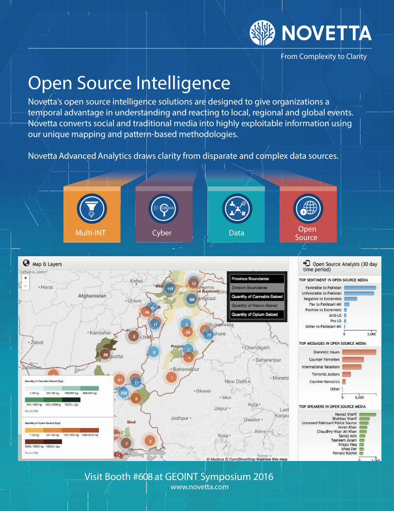
Cyber DataMulti-INTOpen
Source
+
+
From Complexity to Clarity
Open Source Intelligence Novetta’s open source intelligence solutions are designed to give organizations a
temporal advantage in understanding and reacting to local, regional and global events.
Novetta converts social and traditional media into highly exploitable information using
our unique mapping and pattern-based methodologies.
Novetta Advanced Analytics draws clarity from disparate and complex data sources.
Visit Booth #608 at GEOINT Symposium 2016www.novetta.com

» PA N E L R E C A P
10 | WEDNESDAY, MAY 18 GEOINT 2016 SYMPOSIUM
Regulation: a Double-edged SwordPANEL CONCLUDES RESTRICT IONS ON REMOTE SENSING ACTIVIT IES ARE NOT WITHOUT R ISKBy Warren Fers ter
The U.S. government should
adopt a new regulatory
approach to the commer-
cial space industry that is less
defensive in nature and instead
designed to incentivize innova-
tions from which it can benefi t,
according to a GEOINT 2016
panel that convened Tuesday
morning to discuss the revolution
in remote sensing.
Case in point: Commercial sat-
ellite operator DigitalGlobe must
discard three-fourths of the imagery
it collects in the short wave infra-
red (SWIR) spectral band because
government restrictions do not
permit its sale to commercial cus-
tomers, said panelist Walter Scott,
the company’s founder and chief
technical offi cer.
“We’ve got to get our heads out
of this Maginot Line mentality
that we can stop the advance of
technology around the world and
instead fi nd a way to embrace it,
because at the end of the day it’s
all a positive good,” Scott said.
DigitalGlobe’s SWIR sensor,
which is unique in the commer-
cial industry, was added to the
company’s WorldView-3 satellite
to capture data that might be of
interest in a variety of markets
such as agriculture. But because
given activity than reaping the
benefi ts. “So there’s a presump-
tion of guilt,” Loverro said.
“We can do things more
quickly than we have” to date, said
panelist Winston Beauchamp,
deputy under secretary of the Air
Force for space and director of
the Principal DoD Space Advisor
Staff. He referenced the similar
debate in the past about loosen-
ing restrictions on electro-optical
imagery, and that this required
convincing risk-averse offi cials
in the DoD and the Intelligence
Community.
Beauchamp called for a regu-
latory regime that incentivizes
industry to innovate and compete,
even if that makes some in the
national security realm uncom-
fortable, because the benefi ts
outweigh the risks. Finding the
right balance is key, but opinions
differ as to where that balance lies,
he said.
“The last thing we want to do
is fi ght a losing rear-guard battle
against the pace of technology,”
Beauchamp added.
Overregulation carries the
risk not just of stifl ing oppor-
tunities and innovation, but of
driving entire industries over-
seas—beyond the reach of U.S.
regulators, multiple panelists said.
Not approving a given activity
can have adverse national security
consequences, said panelist Lisa
Porter, executive vice president and
director of In-Q-Tel-funded Cos-
miQ Works. Those consequences
can include ceding technical
innovation and industry leadership
to other countries, she said.
“There seems to be a false
dichotomy between national secu-
rity and prosperity for American
industry,” said Robbie Schingler,
co-founder and chief strategy
offi cer of small satellite operator
Planet Labs. The U.S. govern-
ment is used to being the sole
driver of technology and innova-
tion, but this is no longer the case,
Schingler concluded.
SWIR is considered
a nontraditional
commercial remote
sensing capability,
the government has
placed spatial resolu-
tion restrictions on
the data, rendering
DigitalGlobe unable
to capture business
opportunities that
require higher-preci-
sion data.
The SWIR
sensor on World-
View-3, which was
launched 2014, is
capable of col-
lecting data with
3.7-meter spatial
resolution, accord-
ing to DigitalGlobe
spokesperson Turner Brinton. But
the company’s operating license
bars it from selling SWIR data
with better than 7.5-meter resolu-
tion to non-U.S. government
customers.
“We’re missing an opportu-
nity,” DigitalGlobe CEO Jeffrey
Tarr, who was not part of the
panel, said after the panel discus-
sion, which was moderated by
Kevin O’Connell, CEO of Inno-
vative Analytics and Training.
Such restrictions, currently a
subject of debate among U.S. poli-
cymakers, illustrate a weakness in
the approach to regulating com-
mercial capabilities that were, in
the not-too-distant past, the exclu-
sive province of governments.
Douglas Loverro, deputy
assistant secretary of defense
for space policy, said during the
panel discussion that commercial
space industry regulations have
traditionally been weighted more
toward minimizing the national
security risks associated with a
Tuesday’s general session featured a panel on the “Remote Sensing Revolution.” Pictured from left to right: Winston Beauchamp, Douglas Loverro, Dr. Lisa Porter, Robbie Schingler, and Dr. Walter Scott.
“ The last thing we
want to do is fi ght
a losing rear-guard
battle against the
pace of technology.”
—WINSTON BEAUCHAMP, DEPUTY UNDER SECRETARY OF THE AIR FORCE FOR SPACE

Join Today as an Individual MemberVisit Booth #901 to learn more
connect.usgif.org
BENEFITS INCLUDE:
• Be a part of your professional association dedicated
to the GEOINT community
• Significant discounts to all USGIF events
• Access to members-only events
• Participate in USGIF’s Committees and Working Groups
• Ability to submit proposals for presentation
opportunities at USGIF events
• And more…
INDIVIDUAL MEMBERSHIP LEVELS
3 year, 5 year and Lifetime memberships also available
Academic $35
First Responder/Law Enforcement $35
Government Employee/Active-Duty Military $35
Young Professional $35
Industry/Contractor $99

time, rather than just workforce
numbers.
“The people we want to bring
on board have good jobs already,
and I’ve got to talk them [into] it,”
Welby said. This new approach
is fundamentally different from
that in the past, which Welby
joked was “posting something on
USAJOBS and hoping a Nobel
Prize-winner is trolling and look-
ing for something to do.”
Within DoD research and
engineering, Welby said, a lack of
innovation doesn’t threaten the
department as much as a lack of
resources. In addition to delivering
more cost effi ciency than it has in
the past, he said, the department
is now looking at the culmination
of a 40-year run during which the
United States and its allies have
possessed technological capability
above and beyond that of other
nations. The access to technol-
ogy and talent other countries are
displaying, as well as the speed of
the development cycle, have put
the U.S. in the position of trying to
restore its advantage.
Welby said it’s not surprising
to see other countries investing
in modernizing their military
capabilities. “They are doing so at
a remarkably fast pace,” he said.
“We often fi nd ourselves on the
wrong side of the cost and capabil-
ity curve.”
To tackle these challenges,
including decreasing the speed
of time to market, Welby said it’s
essential the department not miss
commercial sector capabilities
that may help the DoD—which
he emphasized will come from
tech hubs around the country, not
just Silicon Valley. Furthermore,
he said, the department is refocus-
ing on internal innovation.
One of the critical themes in
the department is disrupting tech-
nological capabilities for potential
adversaries through science and
engineering, explained Welby, who
oversees everything from basic sci-
ence and prototyping to research at
the department labs. He formerly
held senior leadership positions at
the Defense Advanced Research
Projects Agency (DARPA).
“How do we begin to disrupt
ourselves before others can disrupt
us,” he asked the audience. The
disruptive technologies of the
1970s, for example, have shaped
today’s military in many ways.
Now, he said, the disruption will
be around autonomy.
“In almost any domain, we’re
assuming we’ll be able to take
advantage of data,” Welby said.
“It’s about systems that interact
with their environment.” These
include systems that facilitate
human-machine collaborative
decision-making, advanced
manned-unmanned systems
operations, and network-enabled,
autonomous weapons.
“There’s been a lot of push-
back on this from folks who’ve
imagined Arnold Schwarzeneg-
ger movies,” Welby said, noting
that removing humans from the
equation and allowing comput-
ers to take over is not the intent.
“Our focus is thinking about how
new, software-enabled capabilities
enable us to do things differently.”
Welby mentioned that
recently he was in Portland for
the christening of the Navy’s new
Anti-Submarine Warfare Con-
tinuous Trail Unmanned Vessel,
the naval equivalent of Google’s
self-driving car.
“It’s fully autonomous, triple
redundancy,” Welby said. “It
could leave port in the U.S. and
fi nd its way to Bahrain and radio
for a pilot to bring it to port. It’s
a fundamental game changer to
think about these capabilities.”
Innovative opportunities at
the DoD range from hypersonics
and biomedical—consider the
applications of a wearable device
to measure the health and alert-
ness of personnel in the fi eld—to
electronic warfare and micro-
electronics.
“These things will have
enormous implications on
military capabilities,” Welby
concluded.
12 | WEDNESDAY, MAY 18 GEOINT 2016 SYMPOSIUM
Innovating continued from cover
“ In almost any domain, we’re assuming
we’ll be able to take advantage of
data. It’s about systems that interact
with their environment.” —STEPHEN WELBY, ASSISTANT SECRETARY OF DEFENSE FOR RESEARCHAND ENGINEERING

STATE OF GEOINTREPORT
2016
Pick up your copy at USGIF booth #901 or Download at usgif.org
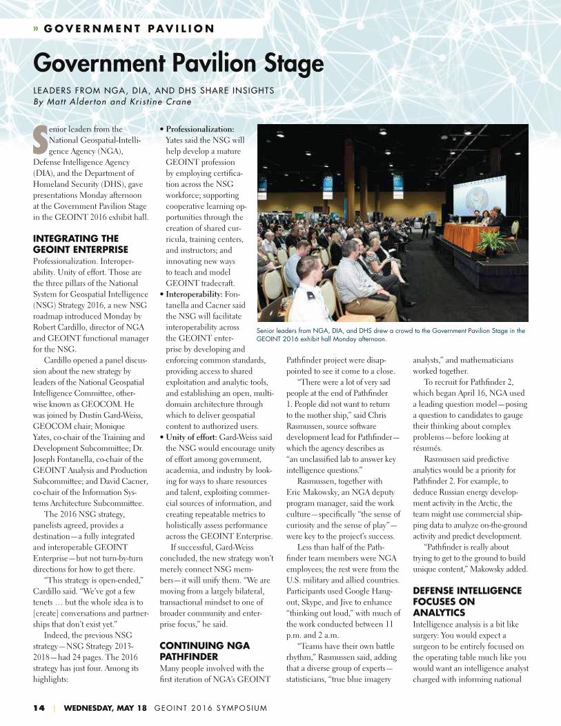
» G O V E R N M E N T PAV I L I O N
14 | WEDNESDAY, MAY 18 GEOINT 2016 SYMPOSIUM
Senior leaders from the
National Geospatial-Intelli-
gence Agency (NGA),
Defense Intelligence Agency
(DIA), and the Department of
Homeland Security (DHS), gave
presentations Monday afternoon
at the Government Pavilion Stage
in the GEOINT 2016 exhibit hall.
INTEGRATING THE GEOINT ENTERPRISEProfessionalization. Interoper-
ability. Unity of effort. Those are
the three pillars of the National
System for Geospatial Intelligence
(NSG) Strategy 2016, a new NSG
roadmap introduced Monday by
Robert Cardillo, director of NGA
and GEOINT functional manager
for the NSG.
Cardillo opened a panel discus-
sion about the new strategy by
leaders of the National Geospatial
Intelligence Committee, other-
wise known as GEOCOM. He
was joined by Dustin Gard-Weiss,
GEOCOM chair; Monique
Yates, co-chair of the Training and
Development Subcommittee; Dr.
Joseph Fontanella, co-chair of the
GEOINT Analysis and Production
Subcommittee; and David Cacner,
co-chair of the Information Sys-
tems Architecture Subcommittee.
The 2016 NSG strategy,
panelists agreed, provides a
destination—a fully integrated
and interoperable GEOINT
Enterprise—but not turn-by-turn
directions for how to get there.
“This strategy is open-ended,”
Cardillo said. “We’ve got a few
tenets … but the whole idea is to
[create] conversations and partner-
ships that don’t exist yet.”
Indeed, the previous NSG
strategy—NSG Strategy 2013-
2018—had 24 pages. The 2016
strategy has just four. Among its
highlights:
Pathfi nder project were disap-
pointed to see it come to a close.
“There were a lot of very sad
people at the end of Pathfi nder
1. People did not want to return
to the mother ship,” said Chris
Rasmussen, source software
development lead for Pathfi nder—
which the agency describes as
“an unclassifi ed lab to answer key
intelligence questions.”
Rasmussen, together with
Eric Makowsky, an NGA deputy
program manager, said the work
culture—specifi cally “the sense of
curiosity and the sense of play”—
were key to the project’s success.
Less than half of the Path-
fi nder team members were NGA
employees; the rest were from the
U.S. military and allied countries.
Participants used Google Hang-
out, Skype, and Jive to enhance
“thinking out loud,” with much of
the work conducted between 11
p.m. and 2 a.m.
“Teams have their own battle
rhythm,” Rasmussen said, adding
that a diverse group of experts—
statisticians, “true blue imagery
analysts,” and mathematicians
worked together.
To recruit for Pathfi nder 2,
which began April 16, NGA used
a leading question model—posing
a question to candidates to gauge
their thinking about complex
problems—before looking at
résumés.
Rasmussen said predictive
analytics would be a priority for
Pathfi nder 2. For example, to
deduce Russian energy develop-
ment activity in the Arctic, the
team might use commercial ship-
ping data to analyze on-the-ground
activity and predict development.
“Pathfi nder is really about
trying to get to the ground to build
unique content,” Makowsky added.
DEFENSE INTELLIGENCE FOCUSES ON ANALYTICS Intelligence analysis is a bit like
surgery: You would expect a
surgeon to be entirely focused on
the operating table much like you
would want an intelligence analyst
charged with informing national
Government Pavilion StageLEADERS FROM NGA, DIA, AND DHS SHARE INSIGHTS By Mat t A lder ton and Kr i s t ine Crane
• Professionalization:
Yates said the NSG will
help develop a mature
GEOINT profession
by employing certifi ca-
tion across the NSG
workforce; supporting
cooperative learning op-
portunities through the
creation of shared cur-
ricula, training centers,
and instructors; and
innovating new ways
to teach and model
GEOINT tradecraft.
• Interoperability: Fon-
tanella and Cacner said
the NSG will facilitate
interoperability across
the GEOINT enter-
prise by developing and
enforcing common standards,
providing access to shared
exploitation and analytic tools,
and establishing an open, multi-
domain architecture through
which to deliver geospatial
content to authorized users.
• Unity of effort: Gard-Weiss said
the NSG would encourage unity
of effort among government,
academia, and industry by look-
ing for ways to share resources
and talent, exploiting commer-
cial sources of information, and
creating repeatable metrics to
holistically assess performance
across the GEOINT Enterprise.
If successful, Gard-Weiss
concluded, the new strategy won’t
merely connect NSG mem-
bers—it will unify them. “We are
moving from a largely bilateral,
transactional mindset to one of
broader community and enter-
prise focus,” he said.
CONTINUING NGA PATHFINDER Many people involved with the
fi rst iteration of NGA’s GEOINT
Senior leaders from NGA, DIA, and DHS drew a crowd to the Government Pavilion Stage in the GEOINT 2016 exhibit hall Monday afternoon.

security decisions to focus on solv-
ing a big-picture problem. Most
of those decisions have multiple
facets, and visualizing them all at
once is helpful, said Terry Busch,
chief of DIA’s Integrated Analysis
and Methodologies Division.
“All data fuses best on a map,”
Busch said. “It’s the best way to
convey a complicated message.
It’s the best way to convey change
for any issue.”
Within the last year, according
to Busch, DIA focused on laying
out the architecture for dynami-
cally generated databases. Moving
forward, it is focused on analytics.
“Geo-based analytics remain
dependent on static data sets; we
do little to identify gaps in situ,”
Busch said, adding that identify-
ing those gaps is an increasing
priority with the explosion of data.
“Everything has sensors—even
your [conference] badge,” he said.
“We are living in a world of
ubiquitous data. The granularity
and fi delity of data is mind-numb-
ing,” Busch concluded. “We love
to take data and use it.”
APPLYING GEOSPATIAL DATA TO IMPROVE HOMELAND SECURITY Every time you board an airplane,
you’re benefi tting from geospatial
intelligence. Air travel is just one
example of how DHS uses geospa-
tial analysis. From border control
to support at sports events to cyber-
security, DHS uses geospatial infor-
mation to keep the public safe.
“What we do as a community
matters to the safety of our coun-
try,” said David Lilley Jr., deputy
director of the DHS Geospatial
Management Offi ce (GMO).
Lilley shared how his offi ce
is bridging the gap between the
Defense Department and DHS.
His offi ce also works with NGA,
the Department of the Interior,
and academic institutions and
organizations such as USGIF.
GMO priority areas include:
standardizing operating procedures,
advancing interoperability, develop-
ing safe geospatial architecture
and infrastructure, and promoting
geospatial governance. There is also
a big push to reduce IT duplication
and fragmentation in alignment with
goals set by Congress, Lilley said.
Additionally, in both the
private and public sectors, there
is a growing demand for 3D and
4D information and integrating
wearable devices with real-time
information delivery. There is also
a move away from desktop to web-
based software, he said.
While it’s “a struggle to
keep pace with commercial
technologies,” Lilley said, DHS
aims to inspire innovation in its
contracts.
NGA’s Chris Rasmussen (left) and Eric Makowsky discussed the agency’s GEOINT Pathfi nder projects Monday on the Government Pavilion Stage.
» F E AT U R E S T O R Y
16 | WEDNESDAY, MAY 18 GEOINT 2016 SYMPOSIUM
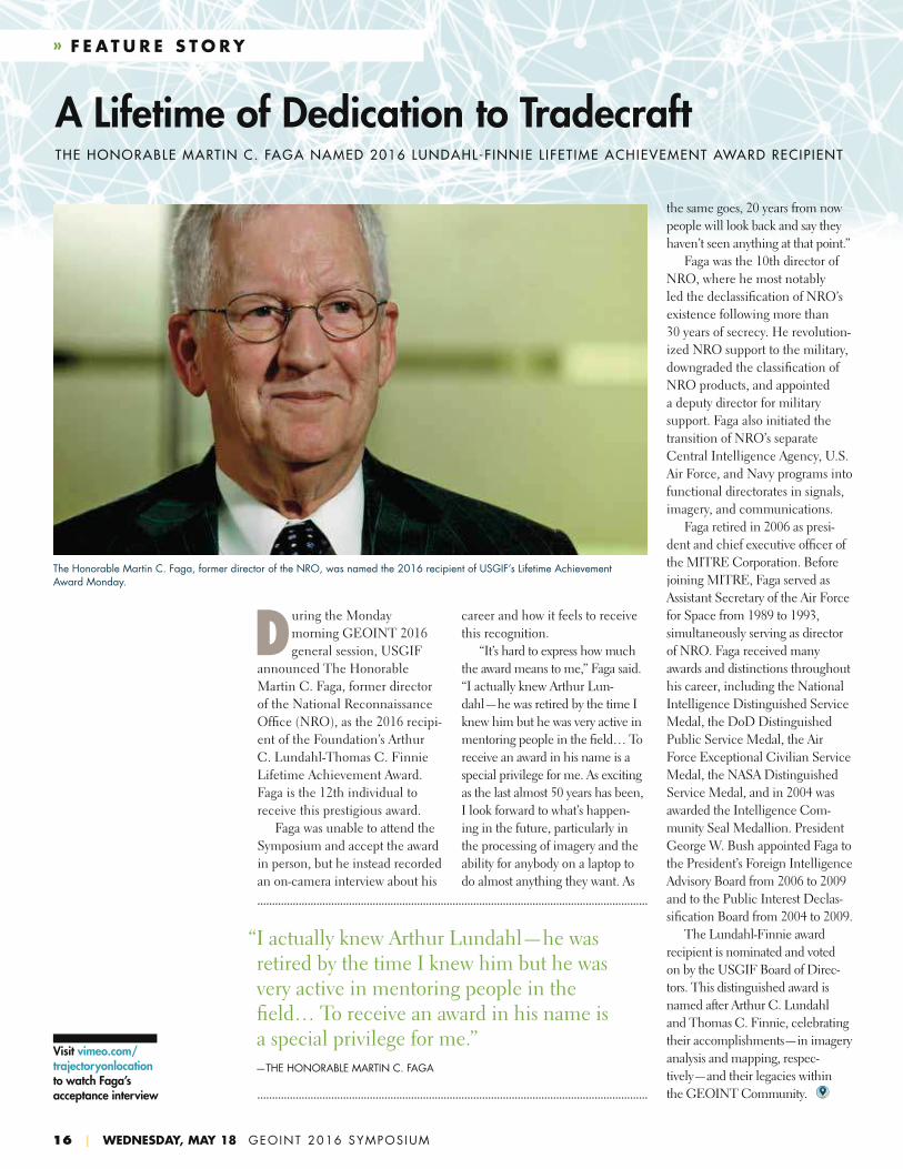
During the Monday
morning GEOINT 2016
general session, USGIF
announced The Honorable
Martin C. Faga, former director
of the National Reconnaissance
Offi ce (NRO), as the 2016 recipi-
ent of the Foundation’s Arthur
C. Lundahl-Thomas C. Finnie
Lifetime Achievement Award.
Faga is the 12th individual to
receive this prestigious award.
Faga was unable to attend the
Symposium and accept the award
in person, but he instead recorded
an on-camera interview about his
A Lifetime of Dedication to TradecraftTHE HONORABLE MARTIN C. FAGA NAMED 2016 LUNDAHL-F INNIE L IFET IME ACHIEVEMENT AWARD RECIP IENT
career and how it feels to receive
this recognition.
“It’s hard to express how much
the award means to me,” Faga said.
“I actually knew Arthur Lun-
dahl—he was retired by the time I
knew him but he was very active in
mentoring people in the fi eld… To
receive an award in his name is a
special privilege for me. As exciting
as the last almost 50 years has been,
I look forward to what’s happen-
ing in the future, particularly in
the processing of imagery and the
ability for anybody on a laptop to
do almost anything they want. As
The Honorable Martin C. Faga, former director of the NRO, was named the 2016 recipient of USGIF’s Lifetime Achievement Award Monday.
“ I actually knew Arthur Lundahl—he was retired by the time I knew him but he was very active in mentoring people in the fi eld… To receive an award in his name is a special privilege for me.”
—THE HONORABLE MARTIN C. FAGA
the same goes, 20 years from now
people will look back and say they
haven’t seen anything at that point.”
Faga was the 10th director of
NRO, where he most notably
led the declassifi cation of NRO’s
existence following more than
30 years of secrecy. He revolution-
ized NRO support to the military,
downgraded the classifi cation of
NRO products, and appointed
a deputy director for military
support. Faga also initiated the
transition of NRO’s separate
Central Intelligence Agency, U.S.
Air Force, and Navy programs into
functional directorates in signals,
imagery, and communications.
Faga retired in 2006 as presi-
dent and chief executive offi cer of
the MITRE Corporation. Before
joining MITRE, Faga served as
Assistant Secretary of the Air Force
for Space from 1989 to 1993,
simultaneously serving as director
of NRO. Faga received many
awards and distinctions throughout
his career, including the National
Intelligence Distinguished Service
Medal, the DoD Distinguished
Public Service Medal, the Air
Force Exceptional Civilian Service
Medal, the NASA Distinguished
Service Medal, and in 2004 was
awarded the Intelligence Com-
munity Seal Medallion. President
George W. Bush appointed Faga to
the President’s Foreign Intelligence
Advisory Board from 2006 to 2009
and to the Public Interest Declas-
sifi cation Board from 2004 to 2009.
The Lundahl-Finnie award
recipient is nominated and voted
on by the USGIF Board of Direc-
tors. This distinguished award is
named after Arthur C. Lundahl
and Thomas C. Finnie, celebrating
their accomplishments—in imagery
analysis and mapping, respec-
tively—and their legacies within
the GEOINT Community.
Visit vimeo.com/trajectoryonlocation to watch Faga’s acceptance interview

» A WA R D S
The USGIF Awards Program annually recognizes the exceptional
work of the geospatial intelligence tradecraft’s brightest minds and
organizations pushing the leading edge. The fi ve award categories
recognize GEOINT achievements in academia, community support,
government, industry, and military. Award winners are nominated by
their colleagues and selected by the USGIF Awards Subcommittee.
“The number and diversity of the nominations received for the
2016 USGIF Awards Program was outstanding,” said Kevin Jackson,
USGIF Awards Subcommittee Chair. “From year to year the quantity
of nominations may vary, but the number submitted this year sets an
all-time record, and the competition in all the categories was fi erce.
However, some things do remain constant. Underneath the outstanding
achievements of the individuals and teams that we honor each year at
the Symposium, are people of great character and commitment, each
with a true sense of purpose.”
THE 2016 USGIF AWARD WINNERS ARE: 1. Academic Achievement Award: The Geospatial Semester, James
Madison University
2. Community Support Achievement Award: Exemplar City Inc.
3. Government Achievement Award: iMAP Team, Santa Clara County
Fire Department
4. Industry Achievement Award: ABACO R&D Team, ABACO SpA
5. Military Achievement Award: Gunnery Sgt. Jesus M. Bocanegra,
Marine Special Operations Company, U.S. Special Operations
Command
Advancing the GEOINT Tradecraft2016 USGIF AWARD WINNERS ANNOUNCED
1
43 5
2
TRAJECTORYMAGAZINE.COM | 17

7:00-9:00a
Training and Education Sessions
(Osceola Rooms 1-6)
8:00-9:00a
USGIF Modeling & Simulation Working
Group Talk (Osceola A)
9:00-9:15a
Moderator: Jim Sciutto, Chief National
Security Correspondent, CNN
9:15-10:00a
Betty J. Sapp, Director, NRO
10:00-10:30a
A Conversation with the Honorable
Michael D. Lumpkin, Director of the
Global Engagement Center,
U.S. State Department
10:30-11:30a
Panel: Joint PED: The Services’
Approach
• Peter H. Devlin, Marine GEOINT
Offi cer, U.S. Marine Corps
• Maj. Gen. George J. Franz III,
Commanding General, INSCOM
• Lt. Gen. Robert P. “Bob” Otto,
Deputy Chief of Staff for Intelligence,
Surveillance and Reconnaissance,
U.S. Air Force
• Lt. Gen. John N.T. “Jack” Shanahan,
Director of Defense Intelligence for
Warfi ghter Support, Offi ce of the
Under Secretary of Defense for
Intelligence
• B. Lynn Wright, Deputy Director of
Naval Intelligence
11:00a– 12:00p
USGIF Tradecraft & Professional
Development Committee/NGA Advisory
Working Group Discussion (Osceola A)
12:00-1:30p
Lunch and Exhibit Hall (Florida Exhibit
Hall A-F)
12:30-1:45p
Government Pavilion Stage
(Florida Exhibit Hall)
• 12:30-12:45p – Presentation of
the IGAPP Grand Challenge Award
by Robert Cardillo, Director, NGA;
Sue Gordon, Deputy Director, NGA;
and Amanda Brownfi eld, SVP of the
National Intelligence Account for TASC,
an Engility Company
• 12:45-1:45p – NGA Acquisition by
Sue Gordon, Deputy Director; Mike
Geggus, Industry Innovation Advocate,
Offi ce of the Deputy Director; Karyn
Hayes-Ryan, Component Acquisition
Executive, Director of Plans and
Programs; and Nicole Pierce, Senior
Procurement Executive, Offi ce of
Contract Services, NGA
2:00-3:00p
USGIF Geospatial & Remote Sensing Law
Working Group Discussion (Osceola A)
6:00-8:00p
GEOINT 2016 Closing Reception
(Gaylord Palms Coquina Lawn)
» WEDNESDAY, MAY 18 GEOINT 2016 SYMPOSIUM AGENDA
18 | WEDNESDAY, MAY 18 GEOINT 2016 SYMPOSIUM
GEOGRAPHYSocio-Cultural Dynamics and Challenges to Global Security
Darryl G. Murdock,
Robert R. Tomes and
Christopher K. Tucker, editors
MONOGR A PH S E R I E SU S G I F V O LUME 1
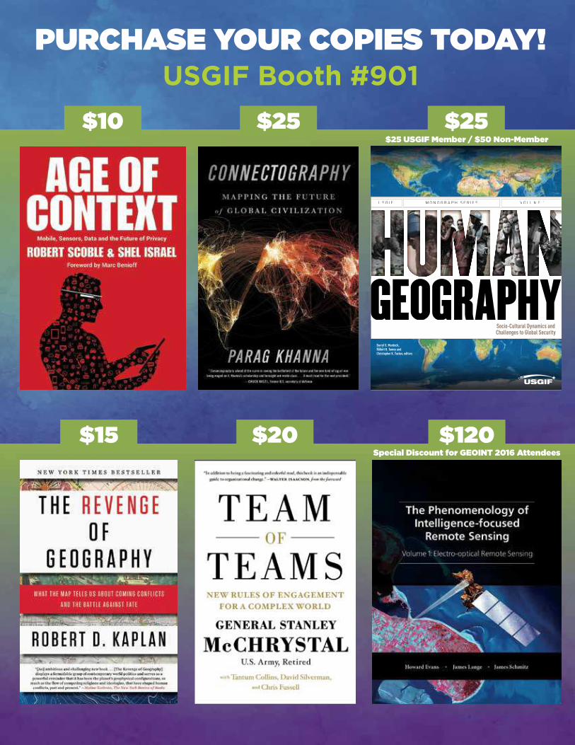
PURCHASE YOUR COPIES TODAY!
$120Special Discount for GEOINT 2016 Attendees
$25
$20
$25
$15
$10
USGIF Booth #901
$25 USGIF Member / $50 Non-Member

hpe.com
The future belongs to the fast.
And to help you accelerate, we’ve
created a new company.
One totally focused on what’s
next for your business.
A true partnership where col-
laborative people, empowering
technology and transformative
ideas push everyone forward.
Accelerating innovation.
Accelerating transformation.
Accelerating value.
Hewlett Packard Enterprise.
Accelerating next
© Copyright 2016 Hewlett Packard Enterprise Development LP.