burrill lake crossing - roads and waterways
TRANSCRIPT

Value Management Workshop Report
APRIL 2013
Burrill Lake Crossing
RMS 13.217 ISBN 978-1-922245-12-0

BURRILL LAKE CROSSING VALUE MANAGEMENT WORKSHOP REPORT

Burrill Lake Crossing—Value Management / Options Assessment Workshop Report
Hyder Consulting Pty Ltd-ABN 76 104 485 289
Hyder Consulting Pty Ltd
ABN 76 104 485 289
Level 5, 141 Walker Street Locked Bag 6503 North Sydney NSW 2060 Australia
Tel: +61 2 8907 9000
Fax: +61 2 8907 9001
www.hyderconsulting.com
ROADS AND MARITIME SERVICES NSW
BURRILL LAKE CROSSING
Value Management / Options Assessment Workshop Report
Author Nathan Chehoud
Checker Ken Lunty
Approver Nathan Chehoud
Report No F001-AA005507-AAR-04
Date 05 April 2013
This report has been prepared for Roads and Maritime
Services NSW in accordance with the terms and conditions
of appointment for Burrill Lake Crossing dated 22 October
2012. Hyder Consulting Pty Ltd (ABN 76 104 485 289)
cannot accept any responsibility for any use of or reliance
on the contents of this report by any third party.


Burrill Lake Crossing—Value Management / Options Assessment Workshop Report
Hyder Consulting Pty Ltd-ABN 76 104 485 289 Page i
f:\aa005507\f-reports\f001-aa005507-aar-04.docx
CONTENTS
1 Executive Summary ....................................................................................................................... 1
2 Workshop Objectives ..................................................................................................................... 2
3 Workshop Activities ....................................................................................................................... 3
3.1 Phase 1: Information ......................................................................................................................... 4
3.2 Phase 2: Functional Analysis ............................................................................................................. 5
3.3 Phase 3: Ideas Generation ................................................................................................................ 8
3.4 Phase 4: Evaluation ........................................................................................................................... 8
3.5 Phase 5: Action Plan ....................................................................................................................... 14
4 Cost Information .......................................................................................................................... 15
5 Conclusions and Recommendations ........................................................................................... 16
APPENDICES
Appendix A
Appendix B
Appendix C
Background Paper
Workshop Agenda AND List of Participants
Figures of Options Considered


Burrill Lake Crossing—Value Management / Options Assessment Workshop Report
Hyder Consulting Pty Ltd-ABN 76 104 485 289 Page 1
f:\aa005507\f-reports\f001-aa005507-aar-04.docx
1 EXECUTIVE SUMMARY
Background
The Princes Highway crossing of Burrill Lake is located approximately 4 kilometres south of
Ulladulla and 150 kilometres south of Wollongong. The Princes Highway is the primary
transport corridor serving coastal south-east NSW.
At 52 years, the Burrill Lake bridge is half way through its 100 year design life. It does not meet
the current Australian Standards loading requirements, and the load capacity of the bridge is
further affected by deterioration of the supporting concrete piles. Continuing deterioration could
ultimately lead to structural failure of the piles.
In 2003, a temporary supporting measure was installed to reduce the risk of potential bridge
failure. This temporary measure is nearing the end of its design life and a more permanent
solution will soon be required.
Strategic Concept and Options Study
In 2010 RMS commissioned Aurecon to conduct a high-level review of a number of permanent
solutions for this crossing.
The Strategic Concept and Options Study Burrill Lake Bridge report outlined how the options
were identified and the major constraints/potential impacts of each option.
While this report made a specific recommendation to RMS as to a way forward, RMS
recognised the need to undertake a Preliminary Environmental Investigation (PEI), to seek
further feedback from stakeholders, to further investigate geotechnical, hydraulic and socio-
economic issues and to undertake a value management/options assessment exercise prior to
finalising a preferred option.
Value Management / Options Assessment Workshop
In October 2012, Hyder Consulting was commissioned to facilitate a value management and
options assessment workshop and to prepare a workshop report. The full-day workshop was
held on December 6, 2012, and followed a systematic approach to value management.
After a presentation on the key technical, environmental and community issues relating to the
project, the workshop participants undertook a functional analysis of the project. This was
followed by a phase of ideas generation, whereby alternative means of fulfilling the necessary
functions were considered. Finally, the ideas generated by the participants were evaluated
against the required project functions and future actions were agreed upon.
After the workshop, additional costing information was sought by RMS for some of the ideas
generated at the workshop. These costings have informed the overall process to produce an
outcome that balances function with cost – the ‘best value’ option.
The ‘Best Value’ Option
The value management and options assessment process described by this report identified the
provision of a new crossing on a new alignment to the east of the existing crossing as the best
value option.

Burrill Lake Crossing—Value Management / Options Assessment Workshop Report
Hyder Consulting Pty Ltd-ABN 76 104 485 289 Page 2
f:\aa005507\f-reports\f001-aa005507-aar-04.docx
2 WORKSHOP OBJECTIVES
Value management is “a structured, analytical process for developing innovative, holistic
solutions to complex problem”1. This process was chosen to enable the crossing options
considered in the Strategic Concept and Options Study to be reassessed against the project
objectives and required functions.
Since the value management process allows considerable latitude for creative thinking, this
workshop encouraged participants to generate other crossing options that may not have already
been considered. These alternatives were likewise assessed against the project objectives and
required functions.
Underpinning the entire value management process is an understanding of the cost of
delivering the required functions through a variety of possible solutions. Although some costing
data was not available at the workshop, this information was later obtained and integrated into
the value management process.
To achieve the outcomes described above, the workshop participants discussed and agreed the
following workshop objectives:
To review and confirm project objectives and requirements.
To test the performance of different solutions against project objectives and requirements.
To identify and document a preferred option that meets the required performance at the
best value for money.
In relation to the third objective, the participants agreed that any preferred options
recommended from this workshop would be conveyed to RMS senior management for
consideration and a final decision on the preferred option (refer to Section 3.5).
1 NSW Treasury document Value Management Guideline (September 2004, TAM04-14)

Burrill Lake Crossing—Value Management / Options Assessment Workshop Report
Hyder Consulting Pty Ltd-ABN 76 104 485 289 Page 3
f:\aa005507\f-reports\f001-aa005507-aar-04.docx
3 WORKSHOP ACTIVITIES
The workshop agenda was structured into the five discreet phases shown in the figure below:
The following sections describe each workshop phase in detail.
1. Information
2. Functional analysis
3. Ideas generation
4. Evaluation
5. Action plan

Burrill Lake Crossing—Value Management / Options Assessment Workshop Report
Hyder Consulting Pty Ltd-ABN 76 104 485 289 Page 4
f:\aa005507\f-reports\f001-aa005507-aar-04.docx
3.1 PHASE 1: INFORMATION
The purpose of the information phase was to raise all workshop participants to the same level of
project knowledge. This phase began before the workshop with the preparation and distribution
of a background paper (see Appendix A).
Building on the background paper, the workshop began with presentations by the RMS Project
Development Manager and by specialists in the areas of social impact, environment and urban
design (see Appendix B for the workshop agenda and list of participants). They key issues
raised in these presentations are summarised in the following sections.
Engineering Issues
a Maintaining a crossing at this location is of vital importance to the Princes Highway
transport corridor since alternative routes, especially for heavy vehicles, are circuitous.
b The temporary measures to support the bridge should be replaced by a permanent
solution.
c Flooding and the impacts of climate change would affect the frequency and extent of
crossing closures.
d Pedestrian facilities along the crossing are sub-standard.
e The road geometry is sub-standard and this affects the efficiency and safety of this
section of road.
f There are a number of existing local road connections to the highway.
g There are a number of utilities (overhead and attached to the bridge) that require
consideration.
h Any solution to take into account the future Milton/Ulladulla Bypass.
Social Impact Issues
i The local suburbs are characterised by an older population that are more vulnerable to
noise, vibration and sub-standard amenity.
j The major economic driver for Burrill Lake is tourism.
k The social infrastructure in Burrill Lake (such as shops and other businesses)
predominantly service local residents and tourists, with some trade from passing
motorists.
Environmental issues
l Key ecological constraints within the project area include seagrass meadows, floodplain
and sand forests, and potential habitat for threatened species.
m The site has high cultural significance for Aboriginal people, and archaeological deposits
may be located within the project area.
n There are several residences and other noise-sensitive receivers within the project area.
o There is a potential for contaminated lands to be found within the project area.
p Community consultation to date reveals a perception that the causeway has a negative
impact on the lake’s ecology and hydraulics.
q A survey of local business owners and customers revealed a desire for the existing bridge
to be replaced with a crossing that allows boat passage, provides better flood immunity
and improves traffic efficiency.
Burrill Lake Crossing—Value Management / Options Assessment Workshop Report
Hyder Consulting Pty Ltd-ABN 76 104 485 289 Page 5
f:\aa005507\f-reports\f001-aa005507-aar-04.docx
Urban Design Issues
r Land uses in the locality include commercial, residential, tourist, recreational and other
public amenities.
s The existing bridge is a highly visible infrastructure element.
t The existing idyllic character of the area and the village centre will be impacted by a new
raised crossing.
u Local access and connectivity, east-west as well as north-south, will be impacted by the
crossing design.
v The crossing design can significantly impact on the functionality of the local village centre
and the quality of its public domain.
w The existing pedestrian amenities in the village centre along the Princes Highway are
poor and the project has the potential to create a better pedestrian environment with
higher amenity.
x Local access and connectivity between the two sides of the lake should be considered.
y Use of the waterway as an asset should be considered.
3.2 PHASE 2: FUNCTIONAL ANALYSIS
The purpose of the functional analysis phase was to determine the functions that the project
must fulfil in order to be successful. Once those functions have been defined, the participants
are encouraged to evaluate their relative importance.
Defining Functional Requirements
The workshop participants were divided into four groups and were encouraged to discuss and
document what they considered to be the essential functional requirements of the project. Each
group documented five or six functions that they believed the project must perform. The
findings of each group were presented back to the workshop for discussion.
A review of the key functions documented by the four groups revealed a number of similarities.
All four groups recognised the following as being primary project functions:
To provide safe and efficient movement of people and vehicles across the lake.
To provide an acceptable level of flood immunity.
To maintain local connectivity and business viability.
The function of providing flood immunity required additional discussion as to what would be
deemed an ‘acceptable’ level. The participants noted that providing flood immunity on the
crossing alone would not be practical, as the approach roads were likely to be inundated.
However raising the approach roads to a similar level of flood immunity as the crossing could
create high embankments and make local connectivity and sensitive urban design a challenge.
The participants finally concluded that, considering the absence of alternative routes for traffic
on the south coast of NSW that the minimum flood immunity should be for the 1 in 100 year
event for both the crossing and the approach roads.
After the remaining functions were reviewed and discussed, the participants agreed that the
project must fulfil at least six primary functions, namely:
FUNCTION 1: To provide safe and efficient regional movement of people and vehicles.
FUNCTION 2: To provide flood immunity in a 1 in 100 year event for the crossing and
approaches.

Burrill Lake Crossing—Value Management / Options Assessment Workshop Report
Hyder Consulting Pty Ltd-ABN 76 104 485 289 Page 6
f:\aa005507\f-reports\f001-aa005507-aar-04.docx
FUNCTION 3: To maintain local connectivity.
FUNCTION 4: To maintain community and business viability.
FUNCTION 5: To not detract from the local character and amenity.
FUNCTION 6: To minimise impacts on the natural and cultural environment.
The participants further agreed that these six functional requirements would also be appropriate
project objectives.
Evaluating Functional Requirements
Evaluating the relative importance of each of these primary functions would assist in the next
phases of the workshop. To that end the functions listed above were placed in a matrix and
their relative importance was assessed by comparing each function to the other. The ID
number of the function with the greater relative importance was input to the matrix and a
weighted score was obtained (e.g. if Function 1 was considered to be of greater relative
importance than Function 2, the number ‘1’ was inputted to the matrix).
Following the functional evaluation participants noted that “Not detract from local character and
amenity” had scored 0. This score did not indicate the requirement was unimportant, only that in
a series of paired analyses against each of the other functional requirements, it was considered
the less important requirement. The fact that “Not detract from local character and amenity” was
identified as a functional requirement of the project demonstrates its importance.
The matrix and weighted scoring are presented below:

Burrill Lake Crossing—Value Management / Options Assessment Workshop Report
Hyder Consulting Pty Ltd-ABN 76 104 485 289 Page 7
f:\aa005507\f-reports\f001-aa005507-aar-04.docx
2 3 4 5 6
Functional Requirements
1 1 1 1 1 1
1 Safe and efficient regional movement of people and vehicles 5
2 3 4 2 6
2 Flood immunity in a 1 in 100 year event for crossing/approaches
1
3 4 3 6
3 Maintain local connectivity 2
4 4 6
4 Maintain community and business viability 3
5 6
5 Not detract from local character and amenity 0
6 Minimise impact on natural & cultural environment 4

Burrill Lake Crossing—Value Management / Options Assessment Workshop Report
Hyder Consulting Pty Ltd-ABN 76 104 485 289 Page 8
f:\aa005507\f-reports\f001-aa005507-aar-04.docx
3.3 PHASE 3: IDEAS GENERATION
The purpose of the ideas generation phase was to conceive as many ideas as possible of how
the required functions could be performed.
The workshop participants were again divided into four groups and were encouraged to
generate and document ideas of how the six primary functions of the project could be achieved.
Each group documented five or six alternatives that they had ‘brainstormed’. These alternatives
could be known (i.e. similar to those documented in the Strategic Concept and Options Study)
or completely new alternatives. The ideas of each group were presented back to the workshop
for discussion.
A distinct effort was made during this phase to simply generate ideas without evaluating their
cost or practicality.
Alternatives means of achieving the required functions
A review of the alternatives generated by the four groups revealed a number of similarities. It
became evident that most ideas were variation on three common themes, namely:
Retaining the existing crossing; or
Providing a new crossing; or,
Providing a new crossing and retaining the existing crossing.
After the ideas prepared by each group were reviewed and discussed, the participants agreed
that seven distinct alternatives should be evaluated at the workshop, namely:
OPTION 1: Provide a complete bypass of Burrill Lake and upgrade the existing crossing,
retaining it for local traffic use.
OPTION 2: Maintain or upgrade the existing crossing.
OPTION 3: Provide a new highway crossing on a new alignment and maintain or upgrade the
existing causeway and bridge for pedestrian use only.
OPTION 4: Provide a new highway crossing on a new alignment and maintain or upgrade the
existing causeway and bridge for local traffic and pedestrian use only.
OPTION 5: Provide a new crossing on the existing alignment.
OPTION 6: Provide a new crossing on a new eastern alignment.
OPTION 7: Provide a new crossing on a new western alignment
Figures of each of these options are provided in Appendix C.
3.4 PHASE 4: EVALUATION
The purpose of the evaluation phase was to test the relative performance of the ideas
generated against the weighted functions identified in Phase 2.
Each option was reviewed against the six required functions and its performance graded on a
scale of 1 to 5 (1 being poor and 5 being excellent). The weighted score of the six functions
being used to test each option was also accounted for.
Typically, this phase would also include an analysis of cost for each option against the required
functions. Since cost and value information for all options was not available at the workshop,

Burrill Lake Crossing—Value Management / Options Assessment Workshop Report
Hyder Consulting Pty Ltd-ABN 76 104 485 289 Page 9
f:\aa005507\f-reports\f001-aa005507-aar-04.docx
the evaluation phase accounted for functional performance only with cost examined subsequent
to the workshop (see Chapter 4 of this report for an assessment of cost as a post-workshop
activity). The following table and sections present the outcome of the evaluation phase:

Burrill Lake Crossing—Value Management / Options Assessment Workshop Report
Hyder Consulting Pty Ltd-ABN 76 104 485 289 Page 10
f:\aa005507\f-reports\f001-aa005507-aar-04.docx
Functional
Requirement
Safe and efficient
regional movement of
people and vehicles
Flood immunity in a 1
in 100 year event for
crossing/approaches
Maintain local
connectivity
Maintain community
and business viability
Not detract from local
character and amenity
Minimise impact on
natural & cultural
environment
Weighted Score 5 1 2 3 0 4
Option
NumberOption Total
1 New bypass + new local crossing 5 5 5 1 5 1 3.13
2 Maintain/upgrade existing crossing 2 1 4 5 5 5 3.60
3
New crossing on new alignment +
maintain/upgrade existing crossing for
pedestrians only
4 4 4 3 3 3 3.53
4
New crossing on new alignment +
maintain/upgrade existing crossing for local
traffic and pedestrians only
5 4 5 4 3 3 4.20
5 New crossing on existing alignment 3 5 2 2 2 4 3.07
6 New crossing on east alignment 5 5 4 3 3 2 3.67
7 New crossing on west alignment 5 5 2 1 1 3 3.27
Performance Rating
(1 [poor] - 5 [excellent])

Burrill Lake Crossing—Value Management / Options Assessment Workshop Report
Hyder Consulting Pty Ltd-ABN 76 104 485 289 Page 11
f:\aa005507\f-reports\f001-aa005507-aar-04.docx
Option 1: Provide a complete bypass of Burrill Lake and upgrade the existing crossing, retaining it for local traffic use.
The workshop participants agreed that this option would perform best for regional traffic and
flood immunity. Improved regional traffic performance is typical of bypasses, and the new
infrastructure could be constructed well above the flooding constraints.
The preliminary environmental assessment (PEI) indicates that while a number of local
businesses cater to the tourism industry, several businesses such as cafes and supermarkets
rely on passing trade. As a consequence, allowing the majority of highway traffic to bypass the
suburb of Burrill Lake was seen as detrimental to maintaining the local community and business
viability.
The local topography provides no alignment for a feasible western bypass and very limited
opportunity for an eastern bypass alignment. The possible route discussed in very general
terms at the workshop was between the existing crossing and the ocean. This area currently
comprises coastal sand dunes, uncleared wooded land, the estuary entrance and ocean
foreshore. As a result, the impacts of a bypass on the natural and cultural environment were
considered to be significant and unacceptable, leading to a poor score in terms of minimising
impact on natural and cultural environment.
Upgrading the existing crossing as part of this option would maintain connectivity for local traffic.
It could be designed to complement the local character of the area.
Option 2: Maintain or upgrade the existing crossing.
The existing crossing is limited by its existing elevation and therefore exposure to flooding. Any
maintenance or refurbishments would also be constrained by the existing crossing elevation,
and so would provide no improvement to flood immunity.
Refurbishing the existing crossing would not allow for improvements to the existing sub-
standard highway geometry. Due to this limitation, Option 2 does not perform well against the
requirement to provide safe regional movement of people and vehicles.
Maintaining and refurbishing the existing crossing would retain local connectivity as well as the
local character. This was seen as a benefit of this option. Likewise, since the option would not
include changes to businesses access, the level of trade of the businesses would not be likely
to change.
As indicated in the Strategic Concept and Options Study, the impacts of this option on the
natural and cultural environment are likely to be short-term only. As a result, this option scored
best against the environmental functional requirement.
Option 3: Provide a new highway crossing on a new alignment and maintain or upgrade the existing causeway and bridge for pedestrian use only.
This option was proposed without detailed consideration of where the new highway crossing
would be located. It was assumed that the new crossing would be either to the east or west of
the existing alignment (similar to Options 6 and 7), and would thus inherit the same performance
scores against the functional requirements. These are discussed in further detail under Option
6 and Option 7 below.
This option is unique in that it proposes to retain the existing crossing for pedestrian use only.
The advantages of using the existing crossing in this way relate primarily to maintaining the
local character and connectivity within the area. It was also considered beneficial that
businesses relying on passing trade would have simple pedestrian traffic access across the

Burrill Lake Crossing—Value Management / Options Assessment Workshop Report
Hyder Consulting Pty Ltd-ABN 76 104 485 289 Page 12
f:\aa005507\f-reports\f001-aa005507-aar-04.docx
lake. This option would also avoid any contamination complications potentially associated with
the excavation and removal of the causeway.
Option 4: Provide a new highway crossing on a new alignment and maintain or upgrade the existing causeway and bridge for local traffic and pedestrian use only.
As with Option 3, this option was proposed without detailed consideration of where the new
highway crossing would be located. It was assumed that the new crossing would be either to
the east or west of the existing alignment (similar to Options 6 and 7), and would thus inherit the
same performance scores against the functional requirements. These are discussed in further
detail under Option 6 and Option 7 below.
Similar to Option 1, this option would also result in two crossings of Burrill Lake – one for
regional (highway) traffic and the other for local vehicular and pedestrian traffic. This would
essentially allow the existing crossing to continue functioning as it currently does, with local
connectivity, character and amenity remaining largely unchanged.
The presence of two crossings for vehicular traffic within relatively close proximity of each other
was considered a disadvantage, so the performance of this option against the local character
and environmental requirements was judged to be average only.
Option 5: Provide a new crossing on the existing alignment.
This option primarily involves providing a higher crossing on the existing alignment. As
discussed earlier, the existing road geometry is sub-standard and there would be limited
opportunity to improve this as part of Option 5. As a result, this option’s score against the safe
and regional movement requirement was only average.
This option could be constructed well above the flooding constraints and so it performed best
against this functional requirement.
A raised crossing would create challenges when it comes to providing intersections with local
roads at lower elevations. While this might allow more efficient traffic movement, it would
considerably hinder local connectivity and the higher structure would dominate the adjacent
buildings that currently front the existing highway. As a result, this option performed poorly
against the connectivity, local character, and business viability requirements. This same
difficulty of connecting local roads to the crossing would also reduce passing trade to
businesses that rely on such. This constraint also contributed to this option performing poorly
against the community and business viability requirement.
As with Option 2, the impacts of this option on the natural and cultural environment are likely to
be short-term only. As a result, this option scored well against the environmental functional
requirement.
This option may introduce contamination complications potentially associated with adjustments
to and/or excavations of the causeway.
Option 6: Provide a new crossing on a new eastern alignment.
The new crossing provided by this option would provide considerably enhanced safety and
efficient movement for regional (highway) traffic, as well providing improved flood immunity.
The impacts of this option on the natural and cultural environment are likely to relate to
biodiversity, heritage, and noise and vibration. While impacts on biodiversity (such as on the
seagrass meadows) are likely to be short-term only, the other impacts would continue beyond
the construction phase and would require further mitigation. As a result, the relative
performance of this option against the environmental requirement was scored low. This option

Burrill Lake Crossing—Value Management / Options Assessment Workshop Report
Hyder Consulting Pty Ltd-ABN 76 104 485 289 Page 13
f:\aa005507\f-reports\f001-aa005507-aar-04.docx
may introduce contamination complications potentially associated with the excavation and
removal of the causeway.
The alignment of this route would allow connections to local roads to be maintained, hence the
high score for the local connectivity requirement. In comparison with the existing crossing, the
new crossing in this option would be quite visible and could impact on the local character.
Integrating a higher structure into the local visual catchment would require careful design and
detailing.
Option 7: Provide a new crossing on a new western alignment.
As with Option 6, the new crossing provided by this option would provide considerably
enhanced safety and efficient movement for regional (highway) traffic, as well providing
improved flood immunity.
The impacts of this option on the natural and cultural environment are likely to be marginally
better than Option 6 in nature and mitigation. As a result, the relative performance of this option
against the environmental requirement was considered average.
The alignment, and especially the elevation, of this route would directly pass through most of
the existing businesses on both sides of the crossing. It would also introduce significant
difficulties with connections to local roads, hence the low score for the local connectivity
requirement. The poor performance of this option on the local connectivity requirement would
also translate into poor community and business viability in that the lack of connectivity would
further impact negatively on any remaining businesses that rely on passing trade. The proximity
of this option to dwellings alongside the lake would also increase its visual impact, and hence its
impact on the local character of the area. As a result this option scored very poorly against the
fourth and fifth functional requirements.
This option may introduce contamination complications potentially associated with the
excavation and removal of the causeway.
Local vs. regional considerations
The RMS Corporate Strategy 2012-2016 is mapped to the Transport for NSW and NSW
Transport Long-Term Masterplan. The corporate strategy sets out the RMS core business areas
as:
Planning and financing the transport system of the future.
Maintaining transport assets.
Improving transport services and operations.
Growing the transport system.
Developing the transport businesses of the future.
The community results set out in the same strategy are to impact on travel, assets, access,
safety and the environment
In light of this corporate strategic framework the balance between regional and local issues in
the functional analysis appears appropriate.
Commentary on evaluation
The worst performing overall option, in terms of the functional analysis, was Option 5 – new
crossing on existing alignment. This option scored “2 – below average” in three of the six
functional requirements, ranking it last of the seven options considered. As a consequence of
this poor functional assessment this option should be given no further consideration
Burrill Lake Crossing—Value Management / Options Assessment Workshop Report
Hyder Consulting Pty Ltd-ABN 76 104 485 289 Page 14
f:\aa005507\f-reports\f001-aa005507-aar-04.docx
Three of the remaining options (Options 1, 2 and 7) achieved scores of “1 – poor” against one or
more functional requirements, meaning they were unable to meet at least one of the functional
requirements of the project.
Option 1 scored “1 – Poor” against two of the five requirements, Option 2 scored “1 – Poor”
against one requirement and “2 - Below average” against another requirement, while Option 7
scored “1 – Poor” against two requirements, and “2 – Below average” against a third
requirement. In addition to these low individual scores against particular functional
requirements, these three options were sixth, fourth and fifth respectively in overall performance
of the seven options.
Due to their inability to meet at least one of the functional requirements of the project, as well as
their relatively poor overall functional performance, these three options (1, 2 and 7) should be
given no further consideration.
The three remaining options which should therefore move beyond the functional analysis and
into cost considerations are:
Option 3: Provide a new highway crossing on a new alignment and maintain or upgrade
the existing causeway and bridge for pedestrian use only.
Option 4: Provide a new highway crossing on a new alignment and maintain or upgrade
the existing causeway and bridge for local traffic and pedestrian use only.
Option 6: Provide a new crossing on a new eastern alignment.
3.5 PHASE 5: ACTION PLAN
The final phase of the workshop identified actions that would need to be undertaken to complete
the value management / options assessment process. The RMS Project Development Manager
was assigned to review and delegate these actions to the wider project team.
The outstanding actions were:
To seek sufficient preliminary costing information of the best functionally performing
options to complete the value management assessment.
Irrespective of the preferred option, to consult with the community and stakeholders to
develop and document a treatment for the existing causeway that addresses community
perceptions and concerns.
To undertake additional community consultation based on the results of the value
management / options assessment process.

Burrill Lake Crossing—Value Management / Options Assessment Workshop Report
Hyder Consulting Pty Ltd-ABN 76 104 485 289 Page 15
f:\aa005507\f-reports\f001-aa005507-aar-04.docx
4 COST INFORMATION
In 2010 strategic estimates and benefit cost analyses were undertaken on a number of potential
future options for the Burrill Lake crossing. It should be noted that although these estimates are
all strategic in nature and are in 2010 dollars, they are adequate for the purposes of comparing
options.
The options which were analysed in 2010 included various maintenance options, an option to
provide a new crossing on an eastern alignment and an option to provide a new crossing on the
existing alignment.
The December 2012 value management workshop also considered new options which were
similar to, or composites of, the 2010 options.
Preliminary costing information has been provided for the three best functionally performing
options, as follows:
Description Strategic Cost Estimate based on the Strategic Concept and
Options Study Burrill Lake Bridge 2010.
Option 3: Provide a new
highway crossing on a new
alignment and maintain or
upgrade the existing causeway
and bridge for pedestrian use
only.
Estimate is $17.5 million.
This assumes $1 million for the provision of a pedestrian
bridge in place of the existing road bridge, based on a 75
metre structure utilising existing abutment locations, with 3
metres of deck space and facility for retention of existing
utilities.
No cost estimate had previously been made for provision
of a pedestrian bridge in place of the existing road bridge.
Option 4: Provide a new
highway crossing on a new
alignment and maintain or
upgrade the existing causeway
and bridge for local traffic and
pedestrian use only.
Estimates range from $19 to $26 million.
This is based on the known 2010 estimated cost of
providing a new bridge on an eastern alignment ($16.5M)
and the range of known 2010 estimated costs for
maintaining or upgrading the existing bridge (between
$2.5M and $9.5M).
Option 6: Provide a new
crossing on a new eastern
alignment.
Estimate is $16.5 million.
Option 4 would be significantly more expensive than either Option 3 or Option 6 as it would
effectively involve the provision of two complete options i.e. a complete upgrade of the existing
bridge as well as the construction of a new bridge on a new alignment. This would be an
unviable and uneconomical investment which would not be acceptable to Roads and Maritime
Services or NSW Treasury. As a consequence Option 4 should be given no further
consideration.

Burrill Lake Crossing—Value Management / Options Assessment Workshop Report
Hyder Consulting Pty Ltd-ABN 76 104 485 289 Page 16
f:\aa005507\f-reports\f001-aa005507-aar-04.docx
5 CONCLUSIONS AND RECOMMENDATIONS
RMS should further investigate options three and six and consult with the community and
stakeholders before selecting a preferred option for the future of the Burrill Lake Crossing.
Either of these options would satisfactorily meet the required functional objectives of the project.
Subject to further appropriate design work and consultation either of these options could be
achieved in a cost-effective manner.
It should be noted that both options involve a new crossing to the east of the existing alignment,
and differ only in their proposed future of the existing bridge and causeway crossing. Given the
lengthy history of investigations and community interest in the causeway, RMS should consult
further with community and stakeholders in relation to the causeway itself.

Burrill Lake Crossing—Value Management / Options Assessment Workshop Report
Hyder Consulting Pty Ltd-ABN 76 104 485 289 Page 17
f:\aa005507\f-reports\f001-aa005507-aar-04.docx
APPENDIX A
BACKGROUND PAPER

BURRILL LAKE CROSSING Value management study Workshop background paper DECEMBER 2012
Page 2 of 34
Table of contents 1. Value Management Study……………………….……………………….……….…...p3 2. Burrill Lake………………………………………….…….……………..….……….…..p4 3. The problems we are seeking to address………………….……………………....p5
3a. Maintenance……………………………………………….………….…p5 3b. Flooding……………………………………………………………….…p6 3c. Climate change impacts…………………………………………….…p7 3d. Integrity and functionality of road network………………………..p8 3e. Poor pedestrian facilities……………………………………………...p9 3f. Substandard road geometry………………………………….….….p10
4. NSW Government frameworks………………………….………………………..…p11 4a. Draft NSW Long Term Transport Master Plan………….….……..p11 4b. RMS Frameworks………………………………………………..…….p13
5. Constraints and opportunities…………………………..………………………..…p14 5a. Socio-economic considerations………………………..……..……p14 5b. Visual amenity…………………………………………………….……p15 5c. Landscape context……………………………………………….……p16 5d. Hydraulics……………………………………………………………….p17 5e Land acquisition and property access impacts………..….…….p.20 5f. Biodiversity………………………………………………….…..……..p20 5g. Aboriginal cultural heritage……………………………..…….…….p21 5h. Non-aboriginal heritage……………………………………….……..p22 5i. Noise and vibration………………………………………………..….p22 5j. Contaminated lands………………………………………..…………p22 5k. Greenhouse gases………………………………………….…………p24 5l. Geotechnical considerations………………………….…………….p24 5m. Road safety considerations……………………….…………………p26 5n. Traffic efficiency……………………………………………………….p26 5o. Road Design…………………………………………………………….p27 5p. Local connections……………………………………………………..p29 5q. Utilities………………………………………………………….……..…p30 5r. Value for money…………………………..……………………………p31
6 Community Consultation……………………………………………………………..p31 Appendix one Property owner and zoning information Appendix two Cost Benefit Analysis Appendix three Burrill Lake Bridge Community Update May 2012

Page 3 of 34
1. Value Management Study This value management study is being conducted in accordance with Australian Standard 4183-2007 (Value Management) and the NSW Treasury Value Management Guidelines. Value Management is a structured, systematic and analytical process that seeks to achieve all the necessary functions at the lowest total cost consistent with required levels of quality and performance. Underlying the Value Management theory is the principle that there is always more than one way to achieve project objectives and that examination of the alternatives will produce the most acceptable conclusion. The objectives of the Burrill Lake Crossing value management study 2012 are:
• To review and confirm project objectives and requirements. • To test the performance of different solutions against project objectives and
requirements. • To identify and document a preferred option that meets the required performance at
the best value for money. Agenda
Item
Welcome and introductions / overview of the workshop
Phase 1 – Information
Confirm workshop objectives
Overview of the project
Preliminary Environmental Investigations
Socio-economic context
Urban design
Project assumptions and imperatives
Key issues and concerns
Phase 2 – Function Analysis
What does it do?
What must it do?
What does the function cost?
What is the function worth?
Phase 3 – Ideas Generation
How else may the required function be performed?
What else will perform the required function?
What will the alternatives cost?
Phase 4 – Evaluation
How do ideas perform against required functions?
Which ideas should be evaluated in detail?
Phase 5 – Action Plan
Agree next activities
Assign activity owners
Agree timeframes and finish dates

Page 4 of 34
2. Burrill Lake
Location of Burrill Lake relative to Ulladulla, Nowra and Wollongong. The Princes Highway crossing of Burrill Lake is located approximately 4 kilometres south of Ulladulla and 150 kilometres south of Wollongong. The Princes Highway is the key (only) transport corridor serving coastal south-east NSW. This corridor has widely spaced east-west connections to the Hume Highway and major population centres, making alternative routes very long.
Photograph of Burrill Lake causeway
The Burrill Lake crossing is approximately 210 metres long, with a low-level bridge approximately 55 metres long approached from the north on an even lower-level causeway approximately 153 metres long.

Page 5 of 34
3 The problems we are seeking to address 3a Maintenance
Diagram of key maintenance issue The current bridge structure was designed in 1956 and built in 1958. The bridge is 54.85 metres long and consists of six precast concrete spans, each 9.14 metres long, supported by seven piers within Burrill Lake. At 52 years, the bridge is half way through its 100 year design life. It has been identified that the original design loading does not meet the current AS5100: Bridge Design Code’s SM1600 loading requirements. Cracking and deterioration of concrete piles, partially due to exposure to the saline environment of the estuary, has also significantly reduced the load capacity of the bridge and ongoing deterioration could ultimately lead to structural failure of the piles. Up to 24 of the 35 piles are experiencing delayed ettringite formation (DEF). An investigation into the structure of the bridge in 2002 identified that the bridge would need upgrading and suggested alternative temporary measures that could be considered. In 2003, a system of temporary brackets was installed as a short-term measure to reduce the risk of potential failure. This temporary measure is near the end of its effective design life and an infrastructure intervention will be required in the very near future.

Page 6 of 34
3b Flooding
June 2007 – causeway flooded (behind houseboat in image). Photo courtesy of J Booler. Flooding - the existing crossing is prone to inundation during moderate frequency flood events (currently estimated at between 1 in 10 and 1 in 20 ARI) with recent known inundations in 2007 and 1991. Flood inundation has ramifications for the integrity of the state road network as well as to residents for whom the existing highway provides a flood evacuation route.
June 1991 - causeway and peninsula flooded. Photo courtesy of WBM BMT & Shoalhaven Council Draft Burrill Lake Floodplain risk management study and plan.
Page 7 of 34
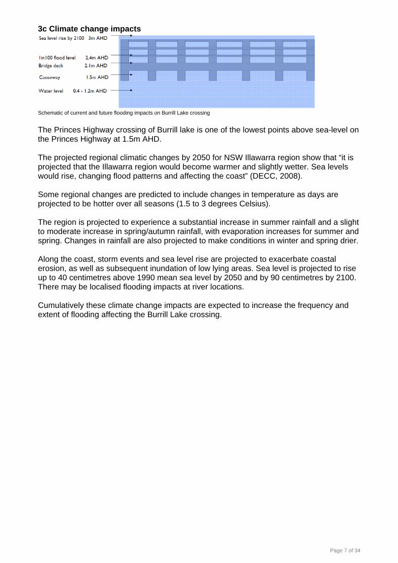
3c Climate change impacts
Schematic of current and future flooding impacts on Burrill Lake crossing The Princes Highway crossing of Burrill lake is one of the lowest points above sea-level on the Princes Highway at 1.5m AHD. The projected regional climatic changes by 2050 for NSW Illawarra region show that “it is projected that the Illawarra region would become warmer and slightly wetter. Sea levels would rise, changing flood patterns and affecting the coast” (DECC, 2008). Some regional changes are predicted to include changes in temperature as days are projected to be hotter over all seasons (1.5 to 3 degrees Celsius). The region is projected to experience a substantial increase in summer rainfall and a slight to moderate increase in spring/autumn rainfall, with evaporation increases for summer and spring. Changes in rainfall are also projected to make conditions in winter and spring drier. Along the coast, storm events and sea level rise are projected to exacerbate coastal erosion, as well as subsequent inundation of low lying areas. Sea level is projected to rise up to 40 centimetres above 1990 mean sea level by 2050 and by 90 centimetres by 2100. There may be localised flooding impacts at river locations. Cumulatively these climate change impacts are expected to increase the frequency and extent of flooding affecting the Burrill Lake crossing.

Page 8 of 34
3d Integrity and functionality of road network In the event of network disruptions such as unplanned incidents (crashes, flooding, maintenance intervention) at the Burrill Lake Crossing, the alternative routes are lengthy and sometimes unsuitable to perform the functions of the highway. Nowra to Bawley Point via the Princes Highway is 90 kilometres. The route via Main Road 92 is 219 kilometres - 129 kilometres longer. The route via the Hume Highway is 310 kilometres - 220 kilometres longer. Albion Park to Batemans Bay via the Princes Highway is 176 kilometres. The route via Main Road 92 is 242 kilometres – 66 kilometres longer. The route via the Hume Highway is 265 kilometres - 89km longer. Main Road 92 is not suitable for all heavy vehicles. In certain conditions it is not suitable for any heavy vehicles. It is not suitable for highway volumes of vehicles (7,000-8,000 AADT) on anything other than an emergency basis.
Direct route and Hume Highway detours There is an alternative route that uses local roads, is 25 kilometres longer, and in certain conditions may be suitable for light vehicles (from Milton along Woodstock Road through Woodburn Road and Wheelbarrow Road back to the Princes Highway). This route is not suitable for heavy vehicles nor for highway volumes of light vehicles on anything other than an emergency basis.

Page 9 of 34
3e Poor pedestrian facilities
Existing pedestrian path on western side of bridge deck (view looking south).
The existing pedestrian facilities on the crossing (bridge and causeway) are narrow (1.35 metres), have an uneven surface with numerous trip hazards, have no barrier protection between pedestrians and traffic and non-standard safety rails preventing pedestrians from falling into the water.
Page 10 of 34
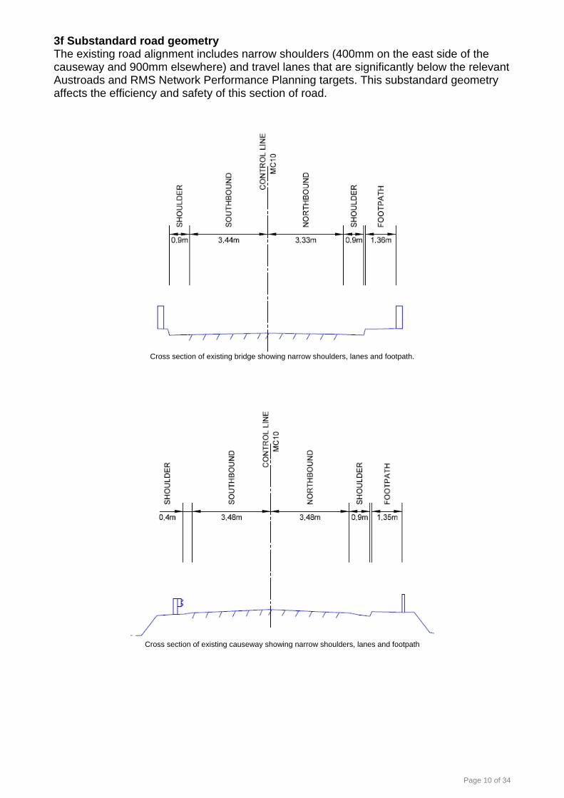
3f Substandard road geometry The existing road alignment includes narrow shoulders (400mm on the east side of the causeway and 900mm elsewhere) and travel lanes that are significantly below the relevant Austroads and RMS Network Performance Planning targets. This substandard geometry affects the efficiency and safety of this section of road.
Cross section of existing bridge showing narrow shoulders, lanes and footpath.
Cross section of existing causeway showing narrow shoulders, lanes and footpath

Page 11 of 34
4 NSW Government frameworks The following NSW Government plans provide frameworks through which the problems associated with the crossing should be examined. 4a Draft NSW Long Term Transport Master Plan Chapter 6 Providing Essential Access for Regional NSW.
Page 12 of 34
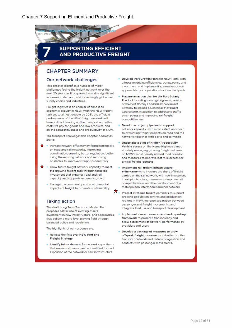
Chapter 7 Supporting Efficient and Productive Freight.

Page 13 of 34
4b RMS Frameworks Corporate Strategy 2012-2016
Burrill Lake crossing is specifically identified as an ongoing State Road network risk (maintenance and flood closures) within the Roads and Maritime Services Princes Highway Coastal Corridor Strategy (draft). It should also be noted that Burrill Lake crossing is identified as a risk to Emergency Service Response (flood closure) and to local residents (flood evacuation route) in Shoalhaven City Council’s Draft Burrill Lake Floodplain Risk Management Plan.

Page 14 of 34
5 Constraints and opportunities During 2009 and 2010 RMS investigated a number of engineering solutions to the problems described in section three of this background paper. These investigations are documented in the Aurecon Strategic Concept and Options Study Burrill Lake Bridge December 2010. Since the completion of this work RMS has conducted a range of further specialist investigations into the local area, to more fully explore the constraints and opportunities associated with the potential future options for the bridge. These investigations have included but not been limited to:
• Socio-economic conditions. • Environmental constraints including ecology, heritage, noise, contamination, visual
amenity. • Geotechnical considerations. • Flooding. • Road safety.
This section seeks to extract and highlight some of the key themes identified during these investigations. Full reports have been completed and should be referred to when a more detailed understanding of any particular matter is required. These reports will be available to workshop participants. 5a Socio-economic considerations The Burrill Lake Bridge plays an important role in the local community of Burrill Lake. Any future maintenance works or replacement will impact on the lives of community members, businesses, tourists and passing motorists. In 2011, the population of Burrill Lake suburb was 1,328 people. Burrill Lake is characterised by an older population, with almost half the population aged 50 years and over (48.8 per cent or 647 persons compared to 35.3 per cent for Shoalhaven LGA), reflecting the trend for many retirees making a ‘sea change’ to the area. As a small town located within five kilometres of a regional centre, the social infrastructure located in Burrill Lake services a small catchment of residents and tourists. Key social infrastructure such as schools, libraries, large shopping centres, childcare and so on are located to the north in Ulladulla or south in Batemans Bay. Key features of Burrill Lake include the recreational amenity provided by the lake and public open space, and shops and businesses. As a small and scenic town located on a lake, Burrill Lake provides opportunities for short pedestrian and bicycle trips for local residents and tourists. The Princes Highway is the only direct major coastal road which links Sydney to Melbourne. The highway is subject to relatively high traffic volumes including local, commercial and freight traffic and seasonal increases in recreational motorists. The major economic driver for Burrill Lake is tourism, which is also the key industry for the Shoalhaven City. Burrill Lake is a holiday destination for many families attracted to the recreational amenity provided by the lake and beach, and offers a range of tourist accommodation options. The businesses located in Burrill Lake service a small catchment of local residents, tourists and passing motorists. Burrill Lake’s retail and service businesses are located on either side of town, with a small shopping village on the western side, and another small row of businesses on the eastern side (see Figure 4). Both the groups of businesses front the Princes Highway, attracting trade from passing motorists as there is room on each shoulder of the highway for motorists to park their vehicles, either directly in front of the businesses or within a short distance.

Page 15 of 34
Potential socio-economic opportunities and constraints: The analysis of the socio-economic environment of Burrill Lake, as well as consultation with community members and businesses, has identified a number of potential socio-economic opportunities and constraints. Potential benefits of the proposal include:
• Strengthening of the regional road network • Improvements in the safety of road users • Improved traffic times • Improved pedestrian and cyclist safety and accessibility • Mitigation of flood risks • Potential improvement of the ecology of the lake
Potential socio-economic constraints which should be taken into consideration include:
• Older population which is more vulnerable to potential noise, vibration, amenity and accessibility impacts resulting from any maintenance and construction works.
• High reliance on motor vehicle travel and access to the highway and bridge for daily commuter travel.
• Access to recreational opportunities associated with the lake and the Lions Park for residents, tourists and passing motorists.
• Importance of the tourism industry to the local economy and the need to ensure that any potential impacts are minimised, particularly during peak tourist seasons.
• Reliance of businesses on trade from passing motorists and the need to ensure continued visibility and convenient access to reduce risk of a decrease in revenue.
• The local amenity and character of Burrill Lake and the risks to the tourism industry resulting from any maintenance and construction works which cause visual, vibration and noise impacts.
5b Visual amenity The dominant visual elements of the bridge are the carriageway and concrete safety railing and the regularly spaced concrete piles. The horizontal elements dominate the bridge’s appearance and complement the low-lying surrounding landform. The bridge sits low over the waterway and its visibility against the sky and above the skyline is limited due to its low visual profile.
Burrill Lake bridge viewed looking south-west.

Page 16 of 34
5c Landscape context The Burrill Lake bridge connects the Princes Highway across a causeway and the Burrill Lake estuary and inlet. The immediate surrounding landform is flat to gently undulating, The landscape setting is dominated by the water body of Burrill Lake and its coastal setting, limited built foreshore elements and the surrounding forested areas of Meroo National Park, Bungalow Park and Barnunj State Conservation Area. A small town centre sits on the highway on the western approach to the bridge. A number of caravan and holiday parks are present on the estuary foreshore. The eastern and western foreshore areas immediately adjacent to the bridge contain detached, single level dwellings interspersed by small areas of recreational open space. Lake foreshore infrastructure includes small timber jetties and boat ramps. Due to its location in a relatively undeveloped and open area, crossing an open expanse of water and within a visual environment dominated by natural characteristics, the bridge is a highly visible infrastructure element.
Burrill Lake landscape context viewed looking west from Dolphin Point The landscape character at the site of the bridge is defined predominantly by the lake and its associated ecological values, recreational and local commercial and social activity. The scenic qualities of the lake are a major asset for both residents and visitors with views of the lake itself, the beaches and foreshores, the existing townscape, boating and recreation and the vegetated ridges. The lake provides opportunities for a diverse range of recreational activities and it is an important holiday destination for many families who have been returning for many years (SCC 2002). The road infrastructure associated with the Burrill Lake crossing is constrained due to the sensitivity of adjacent landscape character zones and the sensitivity of visual receivers. The landscape character constraints are informed by the landscape’s level of sensitivity to change. The majority of the surrounding landscape character zones have the potential to be substantially impacted by changes to the bridge and any associated temporary works such as stockpiling or storage of equipment and materials. The level of impact would vary with the magnitude of change. The bridge is sited in an open area that is highly visible to a number of sensitive visual receivers and the character of the surrounding landscape contributes strongly to the attractive landscape qualities within the bridge’s visual envelope. Highly sensitive visual receivers within the vicinity of the bridge include residential and recreational users.

Page 17 of 34
Visitors, occupational and travelling receivers are rated as moderate to low sensitivity. The magnitude of possible visual impacts on these sensitive visual receivers caused as a result of changes to the bridge is again dependent on the level to which visible elements of the bridge change, the type, extent and duration of this change, and may range from negligible to high. The magnitude of any impact will be influenced by:
• The extent of potential physical changes to the bridge; • Any change in alignment and profile; • The compatibility of the these changes with the surrounding landscape character; • Whether the changes are permanent or temporary, as in the case of construction • staging works.
5d Hydraulics Hydrodynamic modelling was undertaken to determine the relative impact of various potential courses of action on the hydrodynamic and sediment transport regimes under tidal and flooding conditions. The principal findings of the study with respect to each potential course of action, as well as a stand alone summary of the modelled results of removing the causeway, are summarised below. Maintain existing bridge.
• The existing bridge and causeway configuration would be largely retained with some loss in waterway area through the bridge opening associated within an increase in pier and headstock area.
• The impact on flood conditions would be limited. Overall there would be no discernible change in peak flood level conditions.
• There would be only a minor increase in velocity through the bridge opening as a result of the flow constriction and therefore limited potential for increased flood scour.
• With existing causeway level retained, there would be no improvement in road flood immunity. The flood immunity of the road would further decrease in future with climate change impacts.
• There would be no discernible change on tidal flow exchange between the ocean and the Lake and accordingly unlikely to impact on the broader distribution of shoals within the entrance channel.
• Minor changes in tidal velocity distributions would be unlikely to cause significant changes in erosion and sedimentation patterns.
Replace the bridge and causeway on existing alignment.
• The existing bridge and causeway configuration would be largely retained though the bridge waterway opening characteristics would change through an increase in pier and headstock area which would be offset somewhat by increase in bridge span length. The causeway embankment would also be widened slightly on the downstream side.
• The impact of the option on flood conditions would be limited. Overall there would be no discernible change in peak flood level conditions.
• There would be a minor increase in velocity through the bridge opening as a result of the flow constriction and therefore potential (limited) for increased flood scour.
• With existing causeway levels retained, there would be no improvement in road flood immunity. The flood immunity of the road would further decrease in future with climate change impacts.
• There would be no discernible change on tidal flow exchange between the ocean and the Lake and accordingly would be unlikely to impact on the broader distribution of shoals within the entrance channel.

Page 18 of 34
• Minor changes in tidal velocity distributions would be unlikely to cause significant changes in erosion and sedimentation patterns.
Replace the bridge and causeway with a higher bridge crossing.
• Would allow removal of the existing bridge and causeway effectively resulting in no obstruction to flows across the full width of the inlet.
• The impact of the option on flood conditions would be limited. Overall there would be no discernible change in peak flood level conditions.
• There would be a significant change in the velocity distribution in the vicinity of the causeway as a result of the removal of the causeway flow obstruction. Increases in flow and velocity over the shoals adjacent to the existing causeway may mobilise sediments in these areas. The impacts of the changed flow distribution are limited to the local vicinity of the causeway.
• Would provide for improved road flood immunity, potentially above the 1% AEP flood level, incorporating also potential increases associated with climate change.
• There would be no discernible change on tidal flow exchange between the ocean and the Lake and accordingly it would be unlikely to impact on the broader distribution of shoals within the entrance channel.
• As with the flooding regimes, there would be changes in the tidal velocity distribution through reduced velocities in the existing main channel and increased velocities through the area currently in the lee of the existing causeway. Increases in velocity over the shoals near the causeway may provide potential scour of this finer siltation as the channel adjusts to a new equilibrium. This effect would be local to the causeway alignment and not affect broader areas along the inlet foreshore.
Causeway considerations. The principal hydraulic impacts of the causeway removal would be:
• Decreased flow through the existing bridge opening and main channel alignment; and
• Increased flow speeds on the eastern side of the channel upstream and downstream of the causeway.
The potential changes in erosion and sedimentation regimes would be:
• The causeway removal would have limited influence on broader shoaling patterns within the entrance channel with limited movement of marine sand beyond the immediate vicinity of the entrance;
• The changes in main channel velocities and hence sediment transport potential are relatively minor, particularly given the variability and range of existing velocities experienced under typical tidal and flooding regimes;
• The causeway removal would have no impact on the net tidal exchange between the ocean and the Lake which is predominantly controlled by than entrance conditions rather than the causeway;
• The reduced velocities in the lee of the existing causeway would tend to increase the rate of accumulation of fine sediments in the shoals immediately upstream and downstream of the causeway (perhaps indicated by reed and sedge growth in these zones). Removal of the causeway would result in increased velocity over these shoals which may provide potential scour of this finer siltation as the channel adjusts to a new equilibrium. This affect would be local to the causeway alignment and not affect broader areas along the inlet foreshore.
Any potential for long-term geomorphological change in the entrance channel as a result of the causeway removal would be predominantly related to:
• A decrease or increase in the flow and sand transport within the main channel (being the principal area of sediment flux);

Page 19 of 34
• Any changes to the overall tidal regime that may increase or inhibit the net flow of sand through the entrance; and
• Whether or not the flow over the shoals introduced by the causeway removal is sufficient to mobilise sediments in these areas.
Existing 1 in 100 flood levels

Page 20 of 34
5e Land acquisition and property access impacts The maintenance options available are generally not considered constrained by land acquisition and/or property access impacts. Any new construction option would be constrained by potential changes to property access for businesses located to the west of the existing highway approaches. New construction would also have the potential to impact on one residential property on the northern approach and crown lands on both approaches. Further investigations are needed to confirm there would be no other land acquisition impacts. See property owner and zoning mapping information at appendix one. 5f Biodiversity Ecological constraints identified in the study area have been classified as high, medium or low constraints based on the conservation significance of the vegetation or habitat resource. The key ecological constraints in the study area are:
• All areas of seagrass, saltmarsh, Swamp Oak Floodplain Forest and Bangalay Sand Forest. These are considered to be of high ecological constraint and where possible, impacts on these areas should be avoided.
• Areas of potential habitat for threatened species that are not identified in threatened ecological communities, are considered to be a medium constraint (refer to map below). These include drains and swampy areas that may be habitat for the Green and Golden Bell Frog, as well as Burrill Lake Bridge, which potentially may be used as roosting habitat by bats. These areas would be considered a low constraint if these fauna species are found not to be present in these areas.
• Areas of exotic grassland with planted trees and shrubs are considered to be of low ecological constraint.
Ecological constraint mapping

Page 21 of 34
5g Aboriginal cultural heritage Discussions with the Aboriginal community during the site survey suggest that the Burrill Lake area is highly significant to Aboriginal people. Although the field survey did not identify any Aboriginal sites with the study area, there is some potential for items to be discovered during construction. There is also potential for human remains to be located within the study area based on the information provided by ULALC. Evidence of burials may be discovered, particularly around areas around sandy soils, and sand dune formations and in association with midden deposits. It is likely that the proposal may impact on the PAD areas if the bridge is to be replaced. The level of constraint would therefore depend on the significance of the site, and would need to be assessed by further archaeological investigations. It is unlikely that maintenance of the bridge would impact on the PAD areas, in which case there would be no Aboriginal heritage constraints. If, following further archaeological investigations, the PAD areas were found to be of a low or archaeological significance, there would be no Aboriginal heritage constraints on the proposal. If the PAD areas were found to be of moderate or moderate archaeological significance, further mitigation measures such as salvage excavation and an AHIP may be recommended before impacts were to occur. If the PAD areas were shown to have high archaeological significance it is possible that the area may be recommended as a conservation zone to protect its cultural heritage values. This would then be a constraint on the bridge replacement option if it were to impact on the PAD. Further constraints may exist in regard to the cultural significance of the study area to Aboriginal people. These may be addressed by the ULALC in their report to RMS.
Location of potential archaeological deposits

Page 22 of 34
5h Non-aboriginal heritage The study area has low non-Aboriginal archaeological potential. Photos from the GHD field investigation show remnants of the former bridge pylons. The remains do not appear to be extensive, but if impacts were proposed, a further assessment would be required determine the significance of the remains. An assessment of heritage significance for the causeway and remains of the bridge has been prepared based on the seven assessment criteria. The causeway and remains of the former bridge have some historical significance as elements of the first crossing of the Burrill Lake inlet. If the causeway or remains of the former wooden bridge were to be impacted or removed as a result of any proposal, a comprehensive Statement of Heritage Impacts including a detailed archaeological assessment would be required. Maintenance of the bridge is not likely to result in impacts to remains of the former bridge, or the causeway. 5i Noise and vibration Increase in noise levels in the future is likely to be around 0.5 dB due to predicted traffic growth based on historical data, not a future bridge design. Operational noise levels at sensitive receivers are not predicted to result in a significant increase. A significant increase is an increase of 2 dB in accordance with the accepted application of the DECCW Road Noise Policy (2011). Changes in road alignment may cause significant variations in noise due to changes in road proximity and line of sight. Should any proposal introduce such changes an operational noise assessment should be undertaken to determine any predicted changes in noise levels. During construction, the proposal may cause vibration impacts and potentially impact on nearby building structures. It is possible that local sensitive receivers (such as residential properties located within close proximity to the study area) may perceive construction vibration at times. The level of annoyance, however, would depend on individuals. Based on typical vibration levels for different plant activities sourced from the RMS Environmental Noise Management Manual (ENMM) there would be adverse vibration impacts during construction work for dwellings located within 10 metres of the proposal. Within 10 metres from the proposal the vibration levels are likely to exceed the recommended acceptable levels. Properties that may potentially be within this proximity, depending on the option pursued, are:
• 39 Balmoral Rd. • 113 Princes Highway. • 122/124 Princes Highway.
Based on the British Standard BS5228:2009 Code of practice for noise and vibration control on construction and open sites – Part 2: vibration, it is possible that construction vibration may be noticeable at times at distance up to 100 metres from the works. 5j Contamination A search of the NSW OEH Contaminated Sites Register on 8 May, 2012 did not identify any premises listed within a one kilometre radius of the study area. The bridge and traffic barriers are reportedly made of precast plank concrete with old timber studs/timber piers remaining from former bridge structure. The scupper pipes contain asbestos and are over 10 m in length.
Page 23 of 34
There are no records of the fill material used to construct the causeway, and there is potential for the fill material to contain contaminants, for example heavy metals, petroleum products or asbestos. While the causeway remains undisturbed, there is minimal risk of environmental harm, however, if the causeway were to be removed or disturbed there is the potential for mobilising contaminants (if present). The constraints encountered during the proposal would depend on the specific scope of works. The potential environmental constraints likely to be encountered are discussed below. Soils and landscapes The unconsolidated nature of the soils in the study area would require consideration in the design and management of the proposal. Groundwater Based on the available data, excavations as part of the proposal may encounter groundwater. Additionally, if pumping or dewatering is required during the proposed construction this may adversely affect the water quality and yield of the aquifer and surrounding groundwater extraction bores. Dewatering of excavations may be required during construction of the proposal should groundwater be encountered. Given that groundwater is indicated to be present from approximately one metre below ground level, any excavations that are planned for below this depth should consider dewatering at the planning stages. The shallow quaternary groundwater system is considered to be a potentially sensitive resource that is used for municipal and domestic purposes and has the potential to be impacted by saltwater intrusion (associated with excessive drawdown). If extensive groundwater dewatering is required, this has the potential to affect the water levels in any nearby groundwater extraction bores. If the works are to include dewatering of the aquifer system additional investigations should be completed to assess the quality of the groundwater and the potential impacts on surrounding groundwater users and on the Quaternary aquifer resource. Any potentially adverse impacts identified should be managed, mitigated and monitored appropriately. Should a new bridge be proposed, the structure and the style of new foundations may change the surface, groundwater and tidal flow regime of the area which could result in undesirable impacts such as flooding or erosion. Contamination There are no records of the fill material used to construct the causeway. Therefore, there is potential for the fill material to contain contaminants. Pipes containing asbestos were identified as occurring within the study area. While the causeway remains undisturbed, there is minimal risk of environmental harm. Should the causeway be removed, any former contamination could be mobilised. Potential human exposure to contamination may include:
• Ingestion of soils and dust. • Indoor and outdoor inhalation of dust. • Dermal contact with soil and dust. • Indoor and outdoor inhalation of vapours.
Acid sulphate soils There is a low possibility for ASS to occur. Localised deposits however, could be present within the study area. If any excavation is conducted within the study area, ASS management practices would need to be implemented.

Page 24 of 34
5k Greenhouse gases Constraints associated with climate change mainly related to construction programming. Higher rainfall in the summer months may increase the chance of erosion and sedimentation from exposed soils within the study area and stockpiles. Lower winter temperatures have the potential to slow the rate at which soils dry out, and potentially affect accessibility to excavated zones. This can prolong the period of soil exposure, and again increase the risk of erosion. There is the opportunity to provide measures to accommodate additional stormwater levels to target potential increased rain events. The construction phase would potentially result in a small amount of greenhouse gas emissions being produced through:
• Land clearing that may be required to accommodate additional road width. • Liquid fuel use in plant and vehicles (diesel, petrol) during construction.
At this stage it is not possible to accurately estimate the emissions likely to be generated, as this is dependent on final construction methodology, materials and suppliers. The magnitude of these emissions would depend on the amount of earthworks required. Apart from the vehicle or plant emissions, emission sources during the construction phase would mostly be associated with the materials used and any potential vegetation clearing. The proposal may also have the effect of reducing emissions by having the opportunity to provide cycling and pedestrian facilities once in operation. This would reduce the need to depend on private vehicles and potentially reduce associated greenhouse gas emissions. 5l Geotechnical considerations Geotechnical investigations have been undertaken into the general foundation conditions at the site of the Burrill Lake Bridge. Previous investigations in 2008 were focused to the immediate west of the bridge. The 2012 investigations focused on the southern side of the bridge, causeway and approaches. The results of these investigations do have implications requiring consideration during concept and detailed structural design, however there was no meaningful geotechnical differentiation in terms of the options currently considered feasible. Further geotechnical investigations will be required once a preferred option is identified.

Page 25 of 34
Figure 5.k (1) showing locations of geotechnical investigations.
Figure 5.k (2) showing interpretive subsurface section.
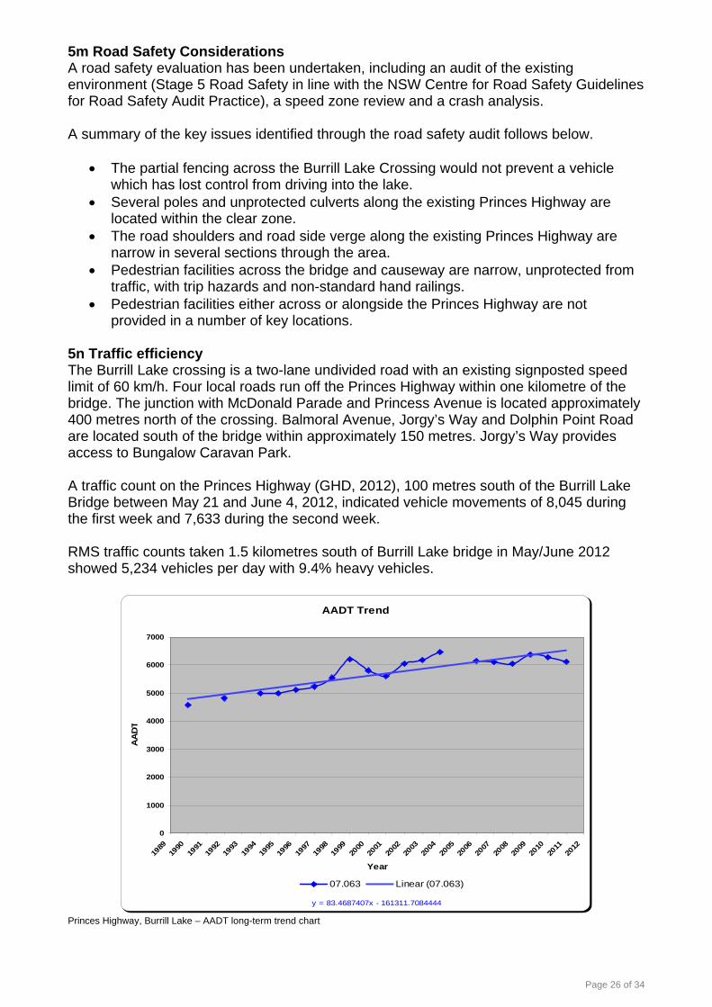
Page 26 of 34
5m Road Safety Considerations A road safety evaluation has been undertaken, including an audit of the existing environment (Stage 5 Road Safety in line with the NSW Centre for Road Safety Guidelines for Road Safety Audit Practice), a speed zone review and a crash analysis. A summary of the key issues identified through the road safety audit follows below.
• The partial fencing across the Burrill Lake Crossing would not prevent a vehicle which has lost control from driving into the lake.
• Several poles and unprotected culverts along the existing Princes Highway are located within the clear zone.
• The road shoulders and road side verge along the existing Princes Highway are narrow in several sections through the area.
• Pedestrian facilities across the bridge and causeway are narrow, unprotected from traffic, with trip hazards and non-standard hand railings.
• Pedestrian facilities either across or alongside the Princes Highway are not provided in a number of key locations.
5n Traffic efficiency The Burrill Lake crossing is a two-lane undivided road with an existing signposted speed limit of 60 km/h. Four local roads run off the Princes Highway within one kilometre of the bridge. The junction with McDonald Parade and Princess Avenue is located approximately 400 metres north of the crossing. Balmoral Avenue, Jorgy’s Way and Dolphin Point Road are located south of the bridge within approximately 150 metres. Jorgy’s Way provides access to Bungalow Caravan Park. A traffic count on the Princes Highway (GHD, 2012), 100 metres south of the Burrill Lake Bridge between May 21 and June 4, 2012, indicated vehicle movements of 8,045 during the first week and 7,633 during the second week. RMS traffic counts taken 1.5 kilometres south of Burrill Lake bridge in May/June 2012 showed 5,234 vehicles per day with 9.4% heavy vehicles.
AADT Trend
y = 83.4687407x - 161311.7084444
0
1000
2000
3000
4000
5000
6000
7000
1989
1990
1991
1992
1993
1994
1995
1996
1997
1998
1999
2000
2001
2002
2003
2004
2005
2006
2007
2008
2009
2010
2011
2012
Year
AA
DT
07.063 Linear (07.063)
Princes Highway, Burrill Lake – AADT long-term trend chart

Page 27 of 34
The attractiveness of the south coast to tourists results in substantial seasonal peaks in traffic volumes on the Princes Highway, particularly evident during the Christmas and New Year holidays and during long weekends and school holidays. During these periods the Princes Highway can experience traffic volumes up to twice the annual average daily traffic volumes. Conversely, during periods outside the seasonal peaks, daily traffic volumes can be well below the annual average daily traffic volumes.
Average Vehicles per Day by Month
01,0002,0003,0004,0005,0006,0007,0008,0009,000
10,000
Jan2011
Feb2011
Mar2011
Apr2011
May2011
Jun2011
Jul2011
Aug2011
Sep2011
Oct2011
Nov2011
Dec2011
Month
Aver
age
Daily
Tra
ffic
Volu
me
(veh
/day
)
Princes Highway, Burrill Lake – seasonal traffic chart, 2011 data 5o Road Design As previously described the existing alignment includes narrow shoulders (400mm on the east side of the causeway and 900mm elsewhere) and travel lanes (3.44m and 3.33m) that are significantly below standard, impacting on efficiency. The RTA Network Performance Measures and Network Planning Targets describes the Princes Highway south of the Jervis Bay Road turnoff as a class 4R road. In line with that classification the following road design network planning targets apply: Design speed
4R Urban Commercial
Urban Fringe Urban Rural Vegetation Conservation
By-pass 60 80 110 110 Maximimum grades
4R Flat (plains)
Rolling (slopes)
Steep (tableland or
coastal range)
Very Steep (pass,
escarpment or ravine)
6 6 8 8 Number of through lanes required
4R Two lanes generally, increased to four if required to provide Level of Service C
Lane width
4R 3.5 metres
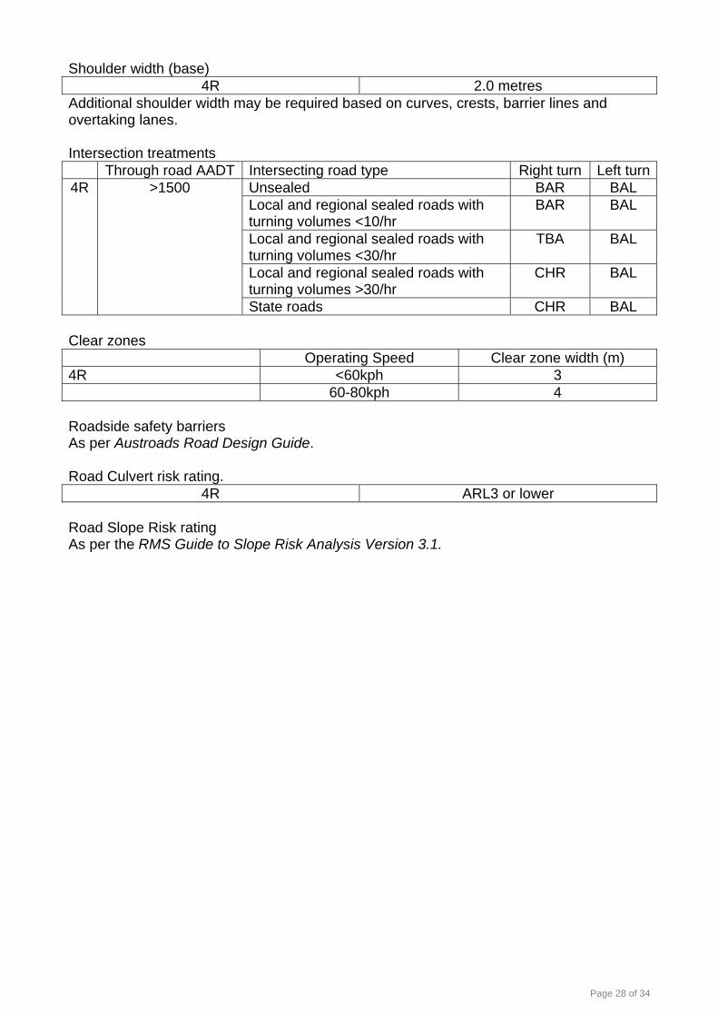
Page 28 of 34
Shoulder width (base)
4R 2.0 metres Additional shoulder width may be required based on curves, crests, barrier lines and overtaking lanes. Intersection treatments
Through road AADT Intersecting road type Right turn Left turnUnsealed BAR BAL Local and regional sealed roads with turning volumes <10/hr
BAR BAL
Local and regional sealed roads with turning volumes <30/hr
TBA BAL
Local and regional sealed roads with turning volumes >30/hr
CHR BAL
4R >1500
State roads CHR BAL Clear zones Operating Speed Clear zone width (m) 4R <60kph 3 60-80kph 4 Roadside safety barriers As per Austroads Road Design Guide. Road Culvert risk rating.
4R ARL3 or lower Road Slope Risk rating As per the RMS Guide to Slope Risk Analysis Version 3.1.

Page 29 of 34
5p Local connections A map of the local road network is shown below for reference.

Page 30 of 34
5q Utilities A number of services are present in the area and require consideration. There is overhead wiring (Endeavour Energy, power) located along both sides of the causeway and the highway, as well around the junctions with local roads to the north and south.
There are piped services (Shoalhaven Water, water and sewer) located on the western side of the bridge structure mounted on brackets. There are also services located under the walkway of the bridge. The exact nature and extent of these services are not fully known and will need to be confirmed during concept design.
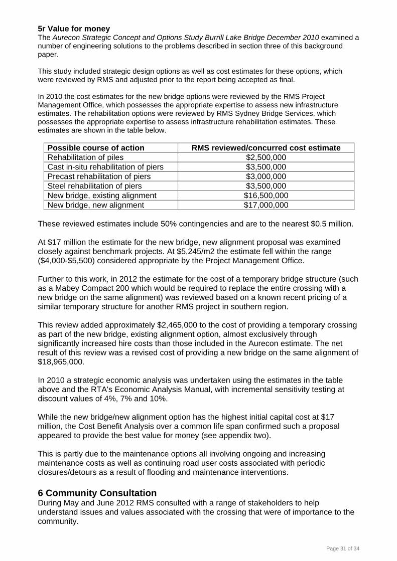
Page 31 of 34
5r Value for money The Aurecon Strategic Concept and Options Study Burrill Lake Bridge December 2010 examined a number of engineering solutions to the problems described in section three of this background paper. This study included strategic design options as well as cost estimates for these options, which were reviewed by RMS and adjusted prior to the report being accepted as final. In 2010 the cost estimates for the new bridge options were reviewed by the RMS Project Management Office, which possesses the appropriate expertise to assess new infrastructure estimates. The rehabilitation options were reviewed by RMS Sydney Bridge Services, which possesses the appropriate expertise to assess infrastructure rehabilitation estimates. These estimates are shown in the table below.
Possible course of action RMS reviewed/concurred cost estimate Rehabilitation of piles $2,500,000 Cast in-situ rehabilitation of piers $3,500,000 Precast rehabilitation of piers $3,000,000 Steel rehabilitation of piers $3,500,000 New bridge, existing alignment $16,500,000 New bridge, new alignment $17,000,000
These reviewed estimates include 50% contingencies and are to the nearest $0.5 million. At $17 million the estimate for the new bridge, new alignment proposal was examined closely against benchmark projects. At $5,245/m2 the estimate fell within the range ($4,000-$5,500) considered appropriate by the Project Management Office. Further to this work, in 2012 the estimate for the cost of a temporary bridge structure (such as a Mabey Compact 200 which would be required to replace the entire crossing with a new bridge on the same alignment) was reviewed based on a known recent pricing of a similar temporary structure for another RMS project in southern region. This review added approximately $2,465,000 to the cost of providing a temporary crossing as part of the new bridge, existing alignment option, almost exclusively through significantly increased hire costs than those included in the Aurecon estimate. The net result of this review was a revised cost of providing a new bridge on the same alignment of $18,965,000. In 2010 a strategic economic analysis was undertaken using the estimates in the table above and the RTA's Economic Analysis Manual, with incremental sensitivity testing at discount values of 4%, 7% and 10%. While the new bridge/new alignment option has the highest initial capital cost at $17 million, the Cost Benefit Analysis over a common life span confirmed such a proposal appeared to provide the best value for money (see appendix two). This is partly due to the maintenance options all involving ongoing and increasing maintenance costs as well as continuing road user costs associated with periodic closures/detours as a result of flooding and maintenance interventions. 6 Community Consultation During May and June 2012 RMS consulted with a range of stakeholders to help understand issues and values associated with the crossing that were of importance to the community.

Page 32 of 34
An information brochure was delivered to more than 5,000 properties in the Burrill Lake, Dolphin Point, Kings Point, Ulladulla, Mollymook and Milton areas. A copy of this brochure can be found at appendix three. The brochure provided a brief explanation of the maintenance issues associated with the bridge and advised the community that options for the future of the bridge, either replacement or significant maintenance in the next ten years, were being investigated. The brochure also advised that the Aurecon Strategic Concept and Options Study Burrill Lake Bridge December 2010 had been published as background information on the RMS website. This report included an introductory caveat advising the community that while the report had recommended RMS pursue the provision of a new bridge on a new alignment as the preferred option, RMS had not yet adopted this recommendation. RMS committed to identifying environmental constraints, examining technical issues in greater detail and seeking feedback from stakeholders and undertake a value engineering/options assessment exercise prior to finalising a preferred option. The consultation included static displays in Burrill Lake, Ulladulla and Nowra, as well as two staffed information sessions in Ulladulla. There were 49 written submissions received and more than 30 people attended the information sessions. The feedback received was broad however the key themes which emerged were:
• Broad support from local residents for removing the existing causeway; however business operators recognised the importance of the pedestrian connection provided by the causeway.
• Broad community support for construction of a new bridge. • Concern about the potential impact of changed access arrangements on residents
and small businesses on both sides of the bridge.
Summary of issues raised during May June 2012 consultation
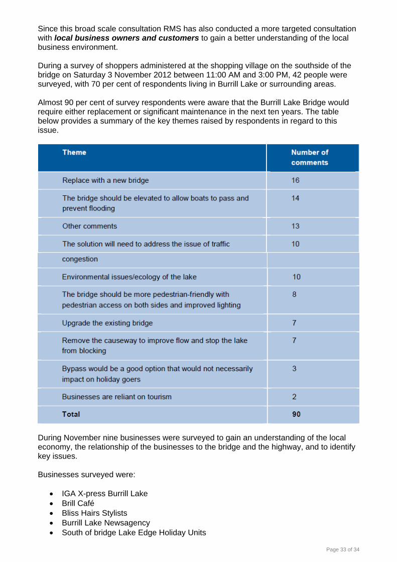
Page 33 of 34
Since this broad scale consultation RMS has also conducted a more targeted consultation with local business owners and customers to gain a better understanding of the local business environment. During a survey of shoppers administered at the shopping village on the southside of the bridge on Saturday 3 November 2012 between 11:00 AM and 3:00 PM, 42 people were surveyed, with 70 per cent of respondents living in Burrill Lake or surrounding areas. Almost 90 per cent of survey respondents were aware that the Burrill Lake Bridge would require either replacement or significant maintenance in the next ten years. The table below provides a summary of the key themes raised by respondents in regard to this issue.
During November nine businesses were surveyed to gain an understanding of the local economy, the relationship of the businesses to the bridge and the highway, and to identify key issues. Businesses surveyed were:
• IGA X-press Burrill Lake • Brill Café • Bliss Hairs Stylists • Burrill Lake Newsagency • South of bridge Lake Edge Holiday Units

Page 34 of 34
• Cowleys Harcourts RealEstate • Rob’s Bait and Tackle Fishing equipment • The Fish Shop • Burrill Lake Cellars
The business survey revealed that most of the businesses depend heavily on trade from tourists to the lake, as well as passing motorists. However the local shops such as those located in the shopping village, as well as those to the north of the bridge, also rely on trade from local residents, particularly during the low tourist season. Almost all the businesses identified a reliance on access to the bridge for their operations, including receiving or sourcing inventory, and for staff travelling to their place of work. The majority of business owners or managers surveyed are aware of the proposal by RMS to investigate the options for the bridge, however opinions on their preferred option are mixed. Some indicated support for a new bridge to replace the existing bridge, while there was some support to maintain the existing bridge. Respondents to the business survey identified a number of issues which RMS should consider when investigating the options for the future of the bridge, with a key focus being access to their businesses, both during and post any construction activities. Most respondents, particularly those who owned shops, commented on the need to ensure that passing motorists could continue to park in a location of convenience, and their businesses remain visible from the highway. Respondents were also concerned about the design of any new bridge, that it is designed in a way that is consistent with the local character of Burrill Lake, and that if the bridge is replaced, the old bridge be retained as local feature such as a pedestrian/cycle path and fishing platform. Shoalhaven City Council was formally consulted and advised RMS of council’s in principle support for the construction of a new bridge on a new alignment, with an improved level of flood immunity. NSW Department of Primary Industries (fisheries) informally advised RMS that the environmental investigations conducted to date were appropriate, and that any new works should minimise impacts on marine vegetation by being close to the existing road alignment. It was also indicated that any impacts on seagrasses and/or saltmarshes not able to be avoided would require offset compensation by RMS. No formal feedback was received from local emergency service providers. No feedback was received from road users (aside from those who are also local residents) who would be the principal beneficiaries of any improvements made to the existing crossing. RMS currently intends to conduct further community consultation following the value management process.

424344
4546
4748
49
PRINCES HIGHWAY
BALMORAL ROAD
DOLPHIN
POIN
T ROAD
MARIA AVENUEGEO
RG
E ST
REE
T
LAKEWOOD GROVE
7021DP1115776
2DP811329
7DP1123774
SP73138
7022DP1115777
12DP810738
10DP218555
177DP24916
4DP1123774
1DP210262
149DP24916
11DP81073874
DP21307
155DP755972
76DP21307
CDP366082
62DP21307
2DP210262
9DP2185557
DP218555
75DP21307
19DP812236
8DP218555
10DP812236
13DP218555
70DP21307
72DP21307
8DP812236
73DP21307
11DP812236
17DP812236
6DP218555
6DP807511
65DP21307
69DP21307
3DP218555
60DP20275 61
DP20275
1DP807511
7DP812236
12DP218555
9DP812236
11DP218555
4DP218555
20DP812236
2DP807511
67DP21307
5DP218555
59DP20275
14DP812236
71DP21307
13DP812236
18DP812236
4DP807511
5DP807511
58DP20275
66DP21307
15DP218555
15DP812236
14DP218555
12DP812236
3DP807511
16DP812236
63DP2130764
DP21307
2DP218555
68DP21307
150DP24916
1DP218555
17DP218555
57DP20275
3DP210262
16DP218555
151DP24916
56DP20275
4DP210262
55DP20275
5DP210262
137DP24916
54DP20275
5DP1123774
1DP811329

Lot Deposited Plan Surname First Names Initials Address Suburb Tel Mobile Postal Address
1 7041 DP 1059898 The State of NSW (Crown land) Princes Highway Burrill Lake 02 4428 9100 PO Box 3092 210 DP 15648 Heycox Eileen Margaret E.M. 7 Princess Avenue Burrill Lake 02 4454 4639 7 Princess Avenue3 211 DP 15648 Cameron Ronald Barton & Ruva R.B. & R 5 Princess Avenue Burrill Lake 02 4455 7698 5 Princess Avenue4 212 DP 15648 Webbe Pty Limited Scott Richard Matthews (Secretary) 3 Princess Avenue Burrill Lake 02 9531 7991 685 Port Hacking Road5 213 DP 15648 Webbe Pty Limited 3 Princess Avenue Burrill Lake6 214 DP 15648 Webbe Pty Limited 3 Princess Avenue Burrill Lake7 215 DP 15648 Webbe Pty Limited 3 Princess Avenue Burrill Lake8 216 DP 15648 Webbe Pty Limited McDonald Parade Burrill Lake9 A DP 382337 Jambrovic Marijan & Sherell Marie M & S.M. 113 Princes Highway Burrill Lake10 B DP 382337 Cunningham David Marshall D.M. 111 Princes Highway Burrill Lake11 357 DP 663873 Galton Mark Daniel & Kylie Marea M.D. & K.M. 109 Princes Highway Burrill Lake 02 4454 0981 109 Princes Highway12 D DP 384044 Praja Zoran Hermann & Helen Elizabeth Z.H. & H.E. 107 Princes Highway Burrill Lake 02 4455 2931 63 Nurrawallee Street13 356 DP 701900 Tait Ian Ross & Leigh Helen I.R. & L.H. 105 Princes Highway Burrill Lake 02 4455 5800 105 Princes Highway14 A DP 387121 Tozer Steven William & Debra June S.W. & D.J. 103 Princes Highway Burrill Lake 02 4455 7691 7 Moore Street15 B DP 387121 Pascoe-Webbe Super Pty Ltd Brian Maxwell & Kay Lynette (Directors) B.M. & K.L. 101 Princes Highway Burrill Lake 220 Macarthur Drive16 353 DP 15648 Shoalhaven City Council McDonald Parade Burrill Lake 02 4429 3111 PO Box 4217 371 DP 15648 RMS 126 Princes Highway Burrill Lake18 370 DP 15648 RMS 124 Princes Highway Burrill Lake19 369 DP 15648 Keating Thomas Michael T.M. 122 Princes Highway Burrill Lake 02 6259 3275 9 Joyner Crescent20 368 DP 15648 RMS 120 Princes Highway Burrill Lake21 367 DP 15648 RMS 118 Princes Highway Burrill Lake22 366 DP 15648 RMS 116 Princes Highway Burrill Lake23 365 DP 15648 RMS 114 Princes Highway Burrill Lake24 9 DP 814486 RMS 112 Princes Highway Burrill Lake25 10 DP 814486 RMS 110 Princes Highway Burrill Lake26 11 DP 814486 RMS 108 Princes Highway Burrill Lake27 12 DP 814486 RMS 106 Princes Highway Burrill Lake28 360 DP 15648 RMS 104 Princes Highway Burrill Lake29 259 DP 15648 RMS 102 Princes Highway Burrill Lake30 47 DP 1051945 Luke Ocean Pty Limited 1 Princess Avenue Burrill Lake 02 4455 2604 1 Princess Avenue South31 375 DP 15648 Newman Edward & Dorothy Irene E & D.I. 7 Princess Avenue South Burrill Lake 02 4454 0448 7 Princess Avenue South32 376 DP 15648 Meates Adrian Crossley A.C. 9 Princess Avenue South Burrill Lake 02 4455 6962 9 Princess Avenue South33 377 DP 15648 Whiting Gregory George & Jacqualene Denise G.G. & J.D. 11 Princess Avenue South Burrill Lake 02 6947 1761 15 Howick St34 378 DP 15648 Storey Noel James N.J. 13 Princess Avenue South Burrill Lake 02 4455 3289 13 Princess Avenue South35 5 DP 814486 Storey Noel James N.J. 13 Princess Avenue South Burrill Lake 02 4455 3289 13 Princess Avenue South36 379 DP 15648 Weekes Diana Lyn D.L. 15 Princess Avenue South Burrill Lake37 6 DP 814486 Weekes Diana Lyn D.L. 15 Princess Avenue South Burrill Lake38 7 DP 814486 RMS Princess Avenue Burrill Lake39 8 DP 814486 RMS Princess Avenue Burrill Lake40 365 DP 728040 The State of NSW (Crown land) 8 Princess Avenue South Burrill Lake 02 4428 9100 PO Box 30941 7002 DP 1050294 The State of NSW (Crown land) Princess Avenue South Burrill Lake 02 4428 9100 PO Box 30942 4 DP 210262 Murphy Rosalind Blair R.B. 37 Balmoral Road Burrill Lake 02 4455 1942 37 Balmoral Road43 5 DP 210262 Conran Terence William & Beverley Anne T.W. & B.A. 39 Balmoral Road Burrill Lake 02 4455 2355 39 Balmoral Road44 C DP 366082 Cafdeb Pty Limited Lesley June Duffy (Secretary) 119 Princes Highway Burrill Lake 02 4456 4214 136 Pointer Road45 1 DP 811329 Shoalhaven City Council Princes Highway Burrill Lake 02 4429 3111 PO Box 4246 2 DP 811329 Royal Australian Navy Central Canteens Board Phil Federick (General Manager Canteens) Princes Highway Burrill Lake 03 5931 5678 0414 836 21147 7022 DP 1115777 The State of NSW (Crown land) Dolphin Point Road Burrill Lake 02 4428 9100 PO Box 30948 155 DP 755972 The State of NSW (Crown land) Dolphin Point Road Burrill Lake 02 4428 9100 PO Box 30949 7021 DP 1115776 The State of NSW (Crown land) Dolphin Point Road Burrill Lake 02 4428 9100 PO Box 309

Burrill Lake Zoning Map 1
Shoalhaven City Council Generated on Mon Nov 19 2012 12:45:39 PM.

Burrill Lake Zoning Map 2
Shoalhaven City Council Generated on Mon Nov 19 2012 12:47:35 PM.

Burrill Lake Zoning Map 3
Shoalhaven City Council Generated on Mon Nov 19 2012 12:49:39 PM.


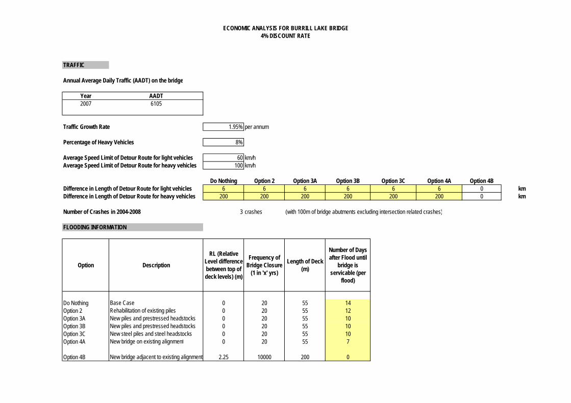
ECONOMIC ANALYSIS FOR BURRILL LAKE BRIDGE4% DISCOUNT RATE
TRAFFIC
Annual Average Daily Traffic (AADT) on the bridge
Year AADT2007 6105
Traffic Growth Rate 1.95% per annum
Percentage of Heavy Vehicles 8%
Average Speed Limit of Detour Route for light vehicles 60 km/hAverage Speed Limit of Detour Route for heavy vehicles 100 km/h
Do Nothing Option 2 Option 3A Option 3B Option 3C Option 4A Option 4B6 6 6 6 6 6 0 km
200 200 200 200 200 200 0 km
Number of Crashes in 2004-2008 3 crashes (with 100m of bridge abutments excluding intersection related crashes)
FLOODING INFORMATION
Option Description
RL (Relative Level difference between top of deck levels) (m)
Frequency of Bridge Closure
(1 in 'x' yrs)
Length of Deck (m)
Number of Days after Flood until
bridge is servicable (per
flood)
Do Nothing Base Case 0 20 55 14Option 2 Rehabilitation of existing piles 0 20 55 12Option 3A New piles and prestressed headstocks 0 20 55 10Option 3B New piles and prestressed headstocks 0 20 55 10Option 3C New steel piles and steel headstocks 0 20 55 10Option 4A New bridge on existing alignment 0 20 55 7
Option 4B New bridge adjacent to existing alignment 2.25 10000 200 0
Difference in Length of Detour Route for light vehiclesDifference in Length of Detour Route for heavy vehicles

ECONOMIC ANALYSIS FOR BURRILL LAKE BRIDGE4% DISCOUNT RATE
CONSTRUCTION COSTS
Description Do Nothing Option 2 Option 3A Option 3B Option 3C Option 4A Option 4BBridge Costs -$ 2,500,000.00$ 3,500,000.00$ 3,000,000.00$ 3,500,000.00$ 9,500,000.00$ 16,500,000.00$
2,500,000.00$ 3,500,000.00$ 3,000,000.00$ 3,500,000.00$ 9,500,000.00$ 16,500,000.00$ Salvage Value after 30 years 0 0 0 0 20% 75%
POST FLOOD REPAIRS AND MAINTENANCE COSTS
Option Description LengthAssumed Post-
Flood Repair Cost
Routine Maintenance
Costs (pa)
Do Nothing Base Case 200 100,000$ 15,000$ Option 2 Rehabilitation of existing piles 200 70,000$ 10,000$ Option 3A New piles and prestressed headstocks 200 70,000$ 10,000$ Option 3B New piles and prestressed headstocks 200 70,000$ 10,000$ Option 3C New steel piles and steel headstocks 200 70,000$ 12,000$ Option 4A New bridge on existing alignment 200 20,000$ 5,000$
Option 4B New bridge adjacent to existing alignment 200 5,000$ 2,000$
ECONOMIC PARAMETER COST (2007)
Average Value of Time Light vehicles $31.35 per veh/hr Discount Factor 4%Heavy vehicles $31.92 per veh/hr
Vehicle Operating CostsLight vehicles 29.75 cents/kmHeavy vehicles 133.1 cents/km
Average Accident Cost $160,400
Year of Opening of the Project 2011
Total Costs including 50% contingency
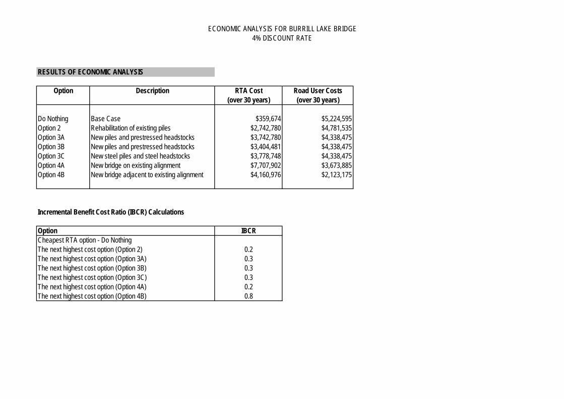
ECONOMIC ANALYSIS FOR BURRILL LAKE BRIDGE4% DISCOUNT RATE
RESULTS OF ECONOMIC ANALYSIS
Option Description RTA Cost Road User Costs(over 30 years) (over 30 years)
Do Nothing Base Case $359,674 $5,224,595Option 2 Rehabilitation of existing piles $2,742,780 $4,781,535Option 3A New piles and prestressed headstocks $3,742,780 $4,338,475Option 3B New piles and prestressed headstocks $3,404,481 $4,338,475Option 3C New steel piles and steel headstocks $3,778,748 $4,338,475Option 4A New bridge on existing alignment $7,707,902 $3,673,885Option 4B New bridge adjacent to existing alignment $4,160,976 $2,123,175
Incremental Benefit Cost Ratio (IBCR) Calculations
Option IBCRCheapest RTA option - Do NothingThe next highest cost option (Option 2) 0.2The next highest cost option (Option 3A) 0.3The next highest cost option (Option 3B) 0.3The next highest cost option (Option 3C) 0.3The next highest cost option (Option 4A) 0.2The next highest cost option (Option 4B) 0.8

ECONOMIC ANALYSIS FOR BURRILL LAKE BRIDGE7% DISCOUNT RATETRAFFIC
Annual Average Daily Traffic (AADT) on the bridge
Year AADT2007 6105
Traffic Growth Rate 1.95% per annum
Percentage of Heavy Vehicles 8%
Average Speed Limit of Detour Route for light vehicles 60 km/hAverage Speed Limit of Detour Route for heavy vehicles 100 km/h
Do Nothing Option 2 Option 3A Option 3B Option 3C Option 4A Option 4BLength of Detour 6 6 6 6 6 6 0 kmLength of Detour 200 200 200 200 200 200 0 km
Number of Crashes in 2004-2008 3 crashes (with 100m of bridge abutments excluding intersection related crashes)
FLOODING INFORMATION
Option Description
RL (Relative Level
difference between top of
deck levels) (m)
Frequency of Bridge Closure
(1 in 'x' yrs)
Length of Deck (m)
Number of Days after Flood until
bridge is servicable (per
flood)
Do Nothing Base Case 0 20 55 14Option 2 Rehabilitation of existing piles 0 20 55 12Option 3A New piles and prestressed headstocks 0 20 55 10Option 3B New piles and prestressed headstocks 0 20 55 10Option 3C New steel piles and steel headstocks 0 20 55 10Option 4A New bridge on existing alignment 0 20 55 7Option 4B New bridge adjacent to existing alignment 2.25 10000 200 0

ECONOMIC ANALYSIS FOR BURRILL LAKE BRIDGE7% DISCOUNT RATE
CONSTRUCTION COSTS
Description Do Nothing Option 2 Option 3A Option 3B Option 3C Option 4A Option 4BBridge Costs $ - 5,000,000$ 7,000,000$ 6,000,000$ 17,500,000$ 9,500,000$ 16,500,000$
5,000,000$ 7,000,000$ 6,000,000$ 17,500,000$ 9,500,000$ 16,500,000$ Salvage Value after 30 years 25% 25% 25% 0 20% 75%Note - Options 2, 3A and 3B have repeated costs in 2030, Option 3C has repeated costs in 2015, 2020, 2025, 2030 and 2035POST FLOOD REPAIRS AND MAINTENANCE COSTS
Option Description LengthAssumed Post-Flood Repair
Cost
Routine Maintenance
Costs (pa)
Do Nothing Base Case 200 100,000$ 15,000$ Option 2 Rehabilitation of existing piles 200 70,000$ 10,000$ Option 3A New piles and prestressed headstocks 200 70,000$ 10,000$ Option 3B New piles and prestressed headstocks 200 70,000$ 10,000$ Option 3C New steel piles and steel headstocks 200 70,000$ 12,000$ Option 4A New bridge on existing alignment 200 20,000$ 5,000$ Option 4B New bridge adjacent to existing alignment 200 5,000$ 2,000$
ECONOMIC PARAMETER COST (2007)
Average Value of Time Light vehicles $31.35 per veh/hr Discount Factor 7%Heavy vehicles $31.92 per veh/hr
Vehicle Operating CostsLight vehicles 29.75 cents/kmHeavy vehicles 133.1 cents/km
Average Accident Cost $160,400
Year of Opening of the Project 2011
Total Costs including 50% contingency
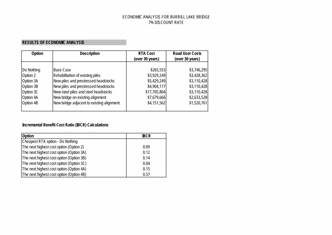
ECONOMIC ANALYSIS FOR BURRILL LAKE BRIDGE7% DISCOUNT RATE
RESULTS OF ECONOMIC ANALYSIS
Option Description RTA Cost Road User Costs(over 30 years) (over 30 years)
Do Nothing Base Case $265,553 $3,746,295Option 2 Rehabilitation of existing piles $3,929,249 $3,428,362Option 3A New piles and prestressed headstocks $5,429,249 $3,110,428Option 3B New piles and prestressed headstocks $4,904,117 $3,110,428Option 3C New steel piles and steel headstocks $17,705,804 $3,110,428Option 4A New bridge on existing alignment $7,679,666 $2,633,528Option 4B New bridge adjacent to existing alignment $4,151,562 $1,520,761
Incremental Benefit Cost Ratio (IBCR) Calculations
Option IBCRCheapest RTA option - Do NothingThe next highest cost option (Option 2) 0.09The next highest cost option (Option 3A) 0.12The next highest cost option (Option 3B) 0.14The next highest cost option (Option 3C) 0.04The next highest cost option (Option 4A) 0.15The next highest cost option (Option 4B) 0.57

ECONOMIC ANALYSIS FOR BURRILL LAKE BRIDGE10% DISCOUNT RATE
TRAFFIC
Annual Average Daily Traffic (AADT) on the bridge
Year AADT2007 6105
Traffic Growth Rate 1.95% per annum
Percentage of Heavy Vehicles 8%
Average Speed Limit of Detour Route for light vehicles 60 km/hAverage Speed Limit of Detour Route for heavy vehicles 100 km/h
Do Nothing Option 2 Option 3A Option 3B Option 3C Option 4A Option 4B6 6 6 6 6 6 0 km
200 200 200 200 200 200 0 km
Number of Crashes in 2004-2008 3 crashes (with 100m of bridge abutments excluding intersection related crashes)
FLOODING INFORMATION
Option Description
RL (Relative Level difference between top of deck levels) (m)
Frequency of Bridge Closure
(1 in 'x' yrs)
Length of Deck (m)
Number of Days after Flood until
bridge is servicable (per
flood)
Do Nothing Base Case 0 20 55 14Option 2 Rehabilitation of existing piles 0 20 55 12Option 3A New piles and prestressed headstocks 0 20 55 10Option 3B New piles and prestressed headstocks 0 20 55 10Option 3C New steel piles and steel headstocks 0 20 55 10Option 4A New bridge on existing alignment 0 20 55 7
Option 4B New bridge adjacent to existing alignment 2.25 10000 200 0
Difference in Length of Detour Route for light vehiclesDifference in Length of Detour Route for heavy vehicles

ECONOMIC ANALYSIS FOR BURRILL LAKE BRIDGE10% DISCOUNT RATE
CONSTRUCTION COSTS
Description Do Nothing Option 2 Option 3A Option 3B Option 3C Option 4A Option 4BBridge Costs $ - 5,000,000$ 7,000,000$ 6,000,000$ 17,500,000$ 9,500,000$ 16,500,000$
5,000,000$ 7,000,000$ 6,000,000$ 17,500,000$ 9,500,000$ 16,500,000$ Salvage Value after 30 years 25% 25% 25% 0 20% 75%Note - Options 2, 3A and 3B have repeated costs in 2030, Option 3C has repeated costs in 2015, 2020, 2025, 2030 and 2035POST FLOOD REPAIRS AND MAINTENANCE COSTS
Option Description LengthAssumed Post-
Flood Repair Cost
Routine Maintenance
Costs (pa)
Do Nothing Base Case 200 100,000$ 15,000$ Option 2 Rehabilitation of existing piles 200 70,000$ 10,000$ Option 3A New piles and prestressed headstocks 200 70,000$ 10,000$ Option 3B New piles and prestressed headstocks 200 70,000$ 10,000$ Option 3C New steel piles and steel headstocks 200 70,000$ 12,000$ Option 4A New bridge on existing alignment 200 20,000$ 5,000$
Option 4B New bridge adjacent to existing alignment 200 5,000$ 2,000$
ECONOMIC PARAMETER COST (2007)
Average Value of Time Light vehicles $31.35 per veh/hr Discount Factor 10%Heavy vehicles $31.92 per veh/hr
Vehicle Operating CostsLight vehicles 29.75 cents/kmHeavy vehicles 133.1 cents/km
Average Accident Cost $160,400
Year of Opening of the Project 2011
Total Costs including 50% contingency

ECONOMIC ANALYSIS FOR BURRILL LAKE BRIDGE10% DISCOUNT RATE
RESULTS OF ECONOMIC ANALYSIS
Option Description RTA Cost Road User Costs(over 30 years) (over 30 years)
Do Nothing Base Case $207,392 $2,853,155Option 2 Rehabilitation of existing piles $3,889,990 $2,610,859Option 3A New piles and prestressed headstocks $5,389,990 $2,368,564Option 3B New piles and prestressed headstocks $4,903,773 $2,368,564Option 3C New steel piles and steel headstocks $17,660,729 $2,368,564Option 4A New bridge on existing alignment $7,662,218 $2,005,120Option 4B New bridge adjacent to existing alignment $4,145,744 $1,157,084
Incremental Benefit Cost Ratio (IBCR) Calculations
Option IBCRCheapest RTA option - Do NothingThe next highest cost option (Option 2) 0.07The next highest cost option (Option 3A) 0.09The next highest cost option (Option 3B) 0.10The next highest cost option (Option 3C) 0.03The next highest cost option (Option 4A) 0.11The next highest cost option (Option 4B) 0.43

Burrill Lake Bridge
Roads and Maritime Services (RMS) is investigating options for the future of the bridge over Burrill Lake on the Princes Highway south of Ulladulla.
The bridge is a key link on this south-east transport route. It is expected that the bridge will require either replacement or significant maintenance in the next 10 years to retain its functionality.
RMS has not yet made a decision on whether replacement or maintenance is the preferred future option.
Roads and Maritime Services (RMS) is currently planning for the future of Burrill Lake crossing.
MAY 2012COMMUNITY UPDATE
Burrill Lake BridgePrinces Highway
View of Burrill Lake Bridge looking south down the Princes Highway
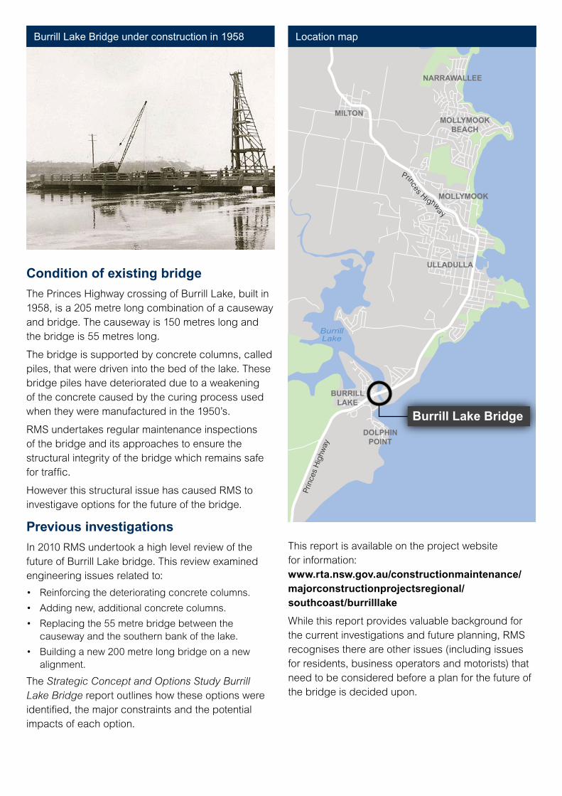
This report is available on the project website for information: www.rta.nsw.gov.au/constructionmaintenance/majorconstructionprojectsregional/ southcoast/burrilllake
While this report provides valuable background for the current investigations and future planning, RMS recognises there are other issues (including issues for residents, business operators and motorists) that need to be considered before a plan for the future of the bridge is decided upon.
Princes Highwa y
BurrillLake
Prin
ces
Hig
hway
NARRAWALLEE
MILTONMOLLYMOOK
BEACH
MOLLYMOOK
ULLADULLA
BURRILLLAKE
DOLPHINPOINT
Burrill Lake Bridge
Condition of existing bridge
The Princes Highway crossing of Burrill Lake, built in 1958, is a 205 metre long combination of a causeway and bridge. The causeway is 150 metres long and the bridge is 55 metres long.
The bridge is supported by concrete columns, called piles, that were driven into the bed of the lake. These bridge piles have deteriorated due to a weakening of the concrete caused by the curing process used when they were manufactured in the 1950’s.
RMS undertakes regular maintenance inspections of the bridge and its approaches to ensure the structural integrity of the bridge which remains safe for traffic.
However this structural issue has caused RMS to investigave options for the future of the bridge.
Previous investigations
In 2010 RMS undertook a high level review of the future of Burrill Lake bridge. This review examined engineering issues related to:
• Reinforcingthedeterioratingconcretecolumns.
• Addingnew,additionalconcretecolumns.
• Replacingthe55metrebridgebetweenthecauseway and the southern bank of the lake.
• Buildinganew200metrelongbridgeonanewalignment.
The Strategic Concept and Options Study Burrill Lake Bridge report outlines how these options were identified, the major constraints and the potential impacts of each option.
Burrill Lake Bridge under construction in 1958 Location map

Current investigations
RMS is currently undertaking technical investigations including:
1. Surveying the existing bridge, highway approaches and landforms.
2. Drilling to obtain geotechnical information about ground conditions around the bridge and highway approaches.
3. Flood and hydraulic modelling of the bridge and lake.
4. Investigating flora and fauna in the area around the existing bridge and highway approaches.
5. Building a picture of the local community that includes business, tourism, social, pedestrian and other community considerations.
RMS recognises the importance of addressing social, ecological, engineering and cost factors while planning for the future of the bridge as a key part of the regional transport network
Apreferredwayforwardhasnotbeenselectedatthis stage.
Anypreferredoption,eithermajormaintenanceora new bridge, will be developed by RMS in detail taking into consideration the factors listed above.
The preferred option will then be displayed by RMS for further comments and refinement.
Views of Burrill Lake Bridge

RoadsandMaritimeServices(“RMS”)issubjecttothePrivacyandPersonalInformationProtectionAct1998(“PPIPAct”)whichrequiresthatwecomplywiththeInformationProtectionPrinciplessetoutinthePPIPAct.
Allinformationincorrespondenceiscollectedforthesolepurposeof assistingintheassessmentof thisproposal.Theinformationreceived,includingnames and addresses of respondents, may be published in subsequent documents unless a clear indication is given in the correspondence that all or part of that information is not published. Otherwise the RMS will only disclose your personal information, without your consent, if authorised by the law. Your personal information will be held by the RMS at Roads and Maritime Services, 90 Crown Street, Wollongong, NSW 2500. You have the right to access and correct the information if you believe that it is incorrect.
Roads and Maritime Services
RMS 12.124
For further enquiriesAdam Berry, Project Development Manager
Phone: 02 4221 2586 (during business hours) Fax: 02 4221 2590 Mail: RMS Southern Regional Office, PO Box 477, Wollongong NSW 2520 Level 6, 90 Crown Street, Wollongong, NSW 2500 Information: 13 22 12 Website: www.rms.nsw.gov.au
Display locations
Shoalhaven City Council 36 Bridge Street, Nowra Monday to Friday from 9am to 5pm
Burrill Lake Burrill Lake Newsagency and Post Office 117 Princes Highway Burrill Lake
Ulladulla Ulladulla Library Ulladulla Civic Centre Building, Princes Highway Monday to Friday from 10am to 6pm Saturday 9am to 2pm
Drop in sessions
The project team will be available to discuss the issues in more detail.
Ulladulla Civic Centre Building meeting room Princes Highway Ulladulla Tuesday 22 May 4pm to 8pm Saturday 2 June 10am to 1pm
Have your say
RMS is interested in understanding issues related to the bridge that are important to the community.
Submissions are welcome and should be sent by close of business Friday 8 June 2012 to the RMS projectdevelopmentmanager,AdamBerry:
Mail: RMS Southern Regional Office, PO Box 477, Wollongong NSW 2520
Email: [email protected]
Phone: 02 4221 2586 (during business hours)
PREVIOUS INVESTIGATIONS
SELECT PREFERRED OPTION
MAINTENANCE OR CONSTRUCTION
DETAIL DESIGN
ENVIRONMENTAL, SOCIAL AND FIELD INVESTIGATIONS
REFINEMENT AND ANALYSIS OF OPTIONS
CONCEPT DESIGN AND ENVIRONMENTAL IMPACT ASSESSMENT
WE ARE
HERE

Burrill Lake Crossing—Value Management / Options Assessment Workshop Report
Hyder Consulting Pty Ltd-ABN 76 104 485 289 Page 19
f:\aa005507\f-reports\f001-aa005507-aar-04.docx
APPENDIX B
WORKSHOP AGENDA AND LIST OF PARTICIPANTS

AGENDA
Name of meeting: Burrill Lake Crossing – Value Management study – workshop.
Location of meeting: Mollymook Golf Club, Golf Avenue Mollymook, NSW, 2539.
Meeting facilitator: Nathan Chehoud, Hyder Consulting.
Date: 6 Dec 2012 Time: 9am – 4pm
Attendees: David Corry, Development Manager Southern, Infrastructure Development, RMS
Adam Berry, Project Development Manager Southern, Infrastructure Development, RMS
Nicole Stevenson, Strategic Network Planner Southern, Infrastructure Development, RMS.
Sarah Barker, Environment Officer, Environmental Planning & Assessment, RMS.
Graham Roche, Senior Environment Officer, Southern Network Management, RMS.
Angela Riepsamen, Environment Officer, Southern Network Management, RMS.
James Lette, Principal Consultant Social Sustainability, GHD.
Nadira Yapa, Urban Designer, Jackson Teece.
Renee Ridley, Communications Manager Southern, RMS.
Scott Fayers, Bridge Maintenance Planner, Southern Asset Management, RMS.
Robyn Lyster, Southern Asset Manager, RMS.
Graeme Birch, Senior Design Manager (Road), Southern, RMS.
Steve Harper, Design Manager (Road), Southern, RMS.
Wade Higgins, Road Designer, Southern, RMS.
John Harper, Manager Road Safety & Traffic Services, Southern, RMS.
Jayd Houguet, Road Safety & Traffic Services Officer, Southern, RMS.
Ian Archer, Project Services Manager, Southern, RMS
Pete Townsend, Project Manager, Southern Project Services, RMS.
Matt Boys, Geotechnical Officer, Southern Geotechnical Services, RMS.
Michael Sheridan, Urban Designer, Centre for Urban Design, RMS.
Peter Adams, Director Strategic Planning, Shoalhaven Council.
Martin Upitis, Infrastructure Manager, Shoalhaven Council.
Isabell Ghetti, Policy Planning Manager, Shoalhaven Council.
Greg Pullen, Economic Development Manager, Shoalhaven Council.
Ben Harnwill, Tourism Manager, Shoalhaven City Council.
Trevor Daly, Senior Conservation Manager, Fisheries, Department of Primary Industries
Agnes Donovan, Aboriginal Cultural Heritage Advisor Southern, RMS.
Bill Healy, Acquisitions Manager, Southern Property Services, RMS.
Ken Lunty, Hyder Consulting.
Please read: Value Management Study Background Paper – will be provided w/c Monday 26 Nov 2012
Please bring:
Agenda:
Nothing! Please revisit the Burrill Lake crossing immediately prior to the workshop to refresh your knowledge of the site.
Follows on the next page.

Time Item Lead
9:00am – 9:15am Welcome and introductions / overview of the workshop Nathan Chehoud
9:15am – 9:45am Phase 1 – Information
Confirm workshop objectives
Overview of the project
Preliminary Environmental Investigations
Socio-economic context
Urban design
Project assumptions and imperatives
Key issues and concerns
Nathan
Adam Berry
Sarah Barker & Adam
James Lette
Nadira Yapa
All
All
9:45am – 10:30am Phase 2 – Function Analysis
What does it do?
What must it do?
What does the function cost?
What is the function worth?
Nathan + All
10:45am – 11:30am Phase 3 – Ideas Generation
How else may the required function be performed?
What else will perform the required function?
What will the alternatives cost?
Nathan + Groups
11:30am – 1:00pm Phase 4 – Evaluation
How do ideas perform against required functions?
Which ideas should be evaluated in detail?
Nathan + All
1:30pm – 2:00pm Phase 5 – Action Plan
Agree next activities
Assign activity owners
Agree timeframes and finish dates
Nathan + All

Burrill Lake Crossing—Value Management / Options Assessment Workshop Report
Hyder Consulting Pty Ltd-ABN 76 104 485 289 Page 21
f:\aa005507\f-reports\f001-aa005507-aar-04.docx
APPENDIX C
FIGURES OF OPTIONS CONSIDERED

New localcrossing
New bypass
Burrill Lake Crossing
°
0 200m
LEGENDOption 1 - New bypass / new local crossing
Heritage areaPotential Archaeological Deposit - 1Potential Archaeological Deposit - 2
Ecological sensitivityHighMediumLow
ServicesExisting services
Date: 15/02/2013 Path: \\hc-aus-ns-fs-01\jobs\AA005507\L-GIS\A_Current\B_Maps\AA005507_001_Option1_r2v1.mxd
Option 1 - New bypass + new local crossing
Created by : DDQA by : NC
HYDER CONSULTING PTY LTDABN 76 104 485 289Level 5, 141 Walker StNorth Sydney NSW 2060AustraliaP: +61 (0) 2 8907 9000 F: +61 (0) 2 8907 9001
DATA SOURCES:RMS, Imagery from 2010
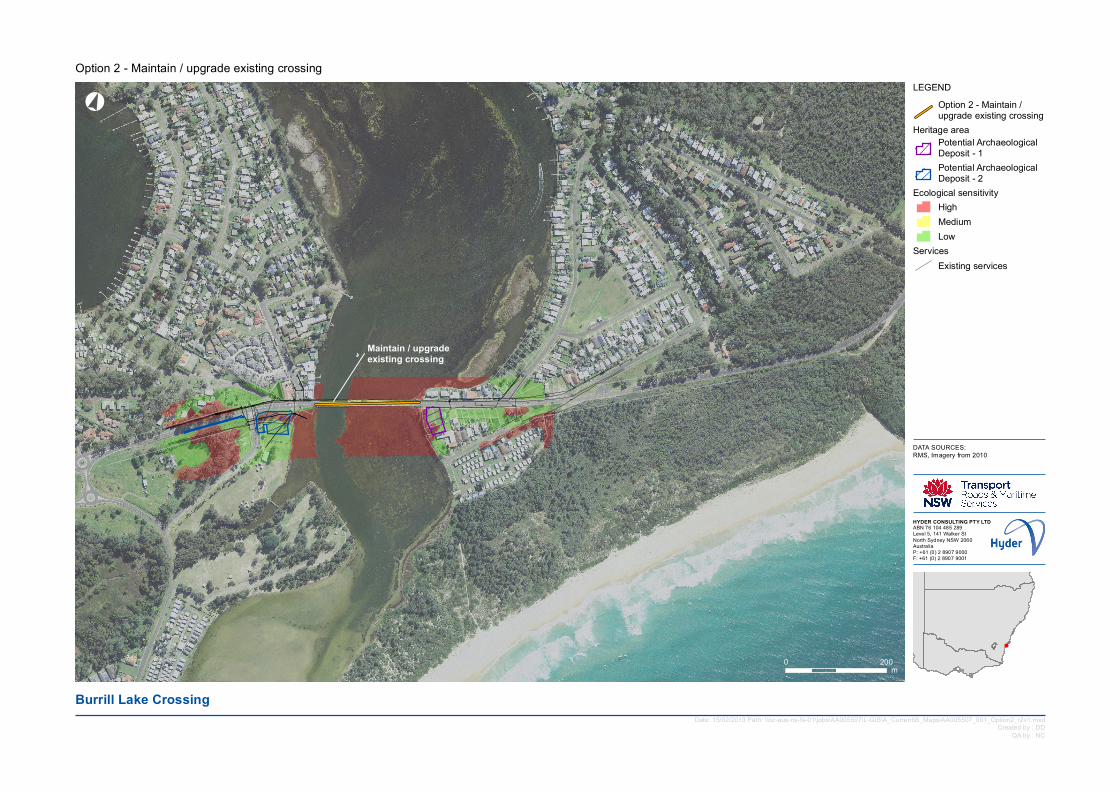
Maintain / upgrade existing crossing
Burrill Lake Crossing
°
0 200m
LEGENDOption 2 - Maintain / upgrade existing crossing
Heritage areaPotential Archaeological Deposit - 1Potential Archaeological Deposit - 2
Ecological sensitivityHighMediumLow
ServicesExisting services
Date: 15/02/2013 Path: \\hc-aus-ns-fs-01\jobs\AA005507\L-GIS\A_Current\B_Maps\AA005507_001_Option2_r2v1.mxd
Option 2 - Maintain / upgrade existing crossing
Created by : DDQA by : NC
HYDER CONSULTING PTY LTDABN 76 104 485 289Level 5, 141 Walker StNorth Sydney NSW 2060AustraliaP: +61 (0) 2 8907 9000 F: +61 (0) 2 8907 9001
DATA SOURCES:RMS, Imagery from 2010

New crossing on new alignment
New crossing on new alignment
Maintain / upgrade existing crossing for pedestrians only
Burrill Lake Crossing
°
0 200m
LEGENDOption 3 - New crossing on new alignmentOption 3 - Maintain / upgrade existing crossing for pedestrians only
Heritage areaPotential Archaeological Deposit - 1Potential Archaeological Deposit - 2
Ecological sensitivityHighMediumLow
ServicesExisting services
Date: 15/02/2013 Path: \\hc-aus-ns-fs-01\jobs\AA005507\L-GIS\A_Current\B_Maps\AA005507_001_Option3_r2v1.mxd
Option 3 - New crossing on new alignment + maintain / upgrade existing crossing for pedestrians only
Created by : DDQA by : NC
HYDER CONSULTING PTY LTDABN 76 104 485 289Level 5, 141 Walker StNorth Sydney NSW 2060AustraliaP: +61 (0) 2 8907 9000 F: +61 (0) 2 8907 9001
DATA SOURCES:RMS, Imagery from 2010

New crossing on new alignment
New crossing on new alignment
Maintain / upgrade existingcrossing for local traffic and pedestrians only
Burrill Lake Crossing
°
0 200m
LEGENDOption 4 - New crossing on new alignmentOption 4 - Maintain / upgrade existing crossing for local traffic and pedestrians only
Heritage areaPotential Archaeological Deposit - 1Potential Archaeological Deposit - 2
Ecological sensitivityHighMediumLow
ServicesExisting services
Date: 15/02/2013 Path: \\hc-aus-ns-fs-01\jobs\AA005507\L-GIS\A_Current\B_Maps\AA005507_001_Option4_r2v1.mxd
Option 4 - New crossing on new alignment + maintain / upgrade existing crossing for local traffic and pedestrians only
Created by : DDQA by : NC
HYDER CONSULTING PTY LTDABN 76 104 485 289Level 5, 141 Walker StNorth Sydney NSW 2060AustraliaP: +61 (0) 2 8907 9000 F: +61 (0) 2 8907 9001
DATA SOURCES:RMS, Imagery from 2010

New crossing on existing alignment
Burrill Lake Crossing
°
0 200m
LEGENDOption 5 - New crossing on existing alignment
Heritage areaPotential Archaeological Deposit - 1Potential Archaeological Deposit - 2
Ecological sensitivityHighMediumLow
ServicesExisting services
Date: 15/02/2013 Path: \\hc-aus-ns-fs-01\jobs\AA005507\L-GIS\A_Current\B_Maps\AA005507_001_Option5_r2v1.mxd
Option 5 - New crossing on existing alignment
Created by : DDQA by : NC
HYDER CONSULTING PTY LTDABN 76 104 485 289Level 5, 141 Walker StNorth Sydney NSW 2060AustraliaP: +61 (0) 2 8907 9000 F: +61 (0) 2 8907 9001
DATA SOURCES:RMS, Imagery from 2010

New crossing on east alignment
Burrill Lake Crossing
°
0 200m
LEGENDOption 6 - New crossing on east alignment
Heritage areaPotential Archaeological Deposit - 1Potential Archaeological Deposit - 2
Ecological sensitivityHighMediumLow
ServicesExisting services
Date: 15/02/2013 Path: \\hc-aus-ns-fs-01\jobs\AA005507\L-GIS\A_Current\B_Maps\AA005507_001_Option6_r2v1.mxd
Option 6 - New crossing on east alignment
Created by : DDQA by : NC
HYDER CONSULTING PTY LTDABN 76 104 485 289Level 5, 141 Walker StNorth Sydney NSW 2060AustraliaP: +61 (0) 2 8907 9000 F: +61 (0) 2 8907 9001
DATA SOURCES:RMS, Imagery from 2010

New crossing on west alignment
Burrill Lake Crossing
°
0 200m
LEGENDOption 7 - New crossing on west alignment
Heritage areaPotential Archaeological Deposit - 1Potential Archaeological Deposit - 2
Ecological sensitivityHighMediumLow
ServicesExisting services
Date: 15/02/2013 Path: \\hc-aus-ns-fs-01\jobs\AA005507\L-GIS\A_Current\B_Maps\AA005507_001_Option7_r2v1.mxd
Option 7 - New crossing on west alignment
Created by : DDQA by : NC
HYDER CONSULTING PTY LTDABN 76 104 485 289Level 5, 141 Walker StNorth Sydney NSW 2060AustraliaP: +61 (0) 2 8907 9000 F: +61 (0) 2 8907 9001
DATA SOURCES:RMS, Imagery from 2010