by p. f. w. beetz. - bgs resources...
TRANSCRIPT

GEOLOGY OF S, IV, ANGOLA, HETWEE::\ CeXENE ,\XD LU};DA AXIS, 137
GEOLOGY OF SOUTH VVEST ANGOLA, BETWEEN CUNENE
AND LUNDA AXIS.
(Read 4th September, 1833.)
By P. F. W. BEETZ.
[PLA'fE n.]
I. Uco/agi"a/ ;11ap of South lYes! .lngo/a.
CONTENTS. IN'l'RODUC1'ION .. ' PRlNIOUS EXPJ.ORATION 'W OUK ,.', .. )fAIN PHYSICAl> AND GEOLOQIC,\L FEATUHES
1. The Serra de Chella ' .. II. The Lunda Axis Ot' Rise (Schwelle)
III. The Namib Peneplain IV, The Coastal Belt
Sl'R;\1'IGJU,PHlC,\J. SCHl~)I.E. CJ,ASSn'JCATIO::-i :\ND DESClUPTJO:"l' 01.' HOCKS,
1. 'fable of Formations ... II. 'rhe Pre-Damara Gneiss
III. Damul'a System '" ........ . IV. The Muva-Ankole .system of South-"\Vestern Angola
V, Hocks Intrusive into the Damara and :.'Ifllva-Ankole
VI. VII.
VIII. IX.
Systems .".... .. a, The Chella Granite ... b, The Anorthosite-Gabbro SuitE'
The Konkip Formation The Chella Formation ......... ". Kanao Intrusions and Creta~eous Volcanics Cretaceons and Tertiary Formations ...
INTRODUCTION,
From June to the beginning 01 September, 1932, I had the opportunity of carrying out geological investigations in this territory on behalf of the Companhi" de Diamantes de Angola (Dinmang). As I had the assistance of all persons locally employed and could llse the Company's motor service. and had. in "ddition, the full benefit of the local Imowledge of the Company's employees find of all pre'dous research and prospecting ,"ork, it was possible to cover a wider area and to get much morc information about the geology of this part of Angola than would bave been possible if I had had to travel on lnvown .
• About 4,000 miles by motor and 250 miles on foot were made in various trips across the country behveen the Cunene mouth tlnd Benguelb in the west and the "Plnnallo" of the Chella in the east. 1Io1'e deta.iled investigations \Yere canied out in the CO,-1st,1l belt between the Cunene and Porto ..:ilexandl'e. Extensh'e walking in numerous trips \\'here motor trunspOl't failed, more especially towards the Cunene Riv(~r [lnd further inland. sen'eel for the more detailed exploration of the geologically interesting problems of that

138 TRANSACTIONS OF 'l'HE GEOLOGIC .. \L SOCIETY OF SOUTH AFRICA.
area.. I also visited the Planalto of .Jlossamedes, i.e., tbe country ,wound Lubango, Humpata and Huila, and the coastal belt near Chapeu Armado, 100 kIm. north of rdossmnedes.
It is with a· great deal of pleasur·e that the author acknowledges the valuable assistance rendered to him by the representatives of the Companhia de Diamante. de Angola, especially by the Board of Directors for giving permission to publish the results of these investigations, and to the consulting engineer, 1\11'. H. T. Dickinson; furthermore, to 1\11'. J. Hermans, \vho was in charge of the Company's prospecting work north of the Cunene mouth; from him most valuable information was received, while he always facilitated the vcry difficult problems of transport with never-tiring personal efforts.
The author would also like to thank Dr. A. L. du 'l'ait lor the assistance he has rendered and the criticism he has made of this paper.
PmwIOUS EXPLORA'l'ION \VOIm.
rrhe area described in the following p~1.ges extends from the Cunene mouth in the south-west and Chapen Annado on the coast 60 miles north of Mossamedes in the north-west, then inland to the l)lanalto of ~tfossamedes in the north-east and to the area around tbe 1-Iontenegro Falls in the south-east. I,\lhilst the country around l\10ssarnedes, and between lVfoss<1l11edes and the Planalto h<.1S been visited and ~lescribed by several explorers, the area further to the south, especially between the Coroca and Cunene, vvas probably -~l18 least" Imown and worse mttpped part of Angola befol'c the Diamang started prospecting,in 1930,
During the prospecting period numerous sketches of the coastal belt ,yore made b:y the Company's employees; furthermore, geological and topographical sketches of the inland portion by G. ScoutounoiI, a Bulgarian geologist who investig<.1tecl tbe interior for base and precious minerals, and topogl'flphicul sketches of the interior behveen the Coroea and Cunene bv a certain :J.fr. Adler, a South-\Vest African prospector, were placed at the writer's disposal.
J?l'CViOllSlv, the country between the Coroca and Cunene had been crossed by a "Portuguese ;~edical ofHccl' and explorer, J, Pereira do
. Nascimento;l also by an expedition equipped with motor cars trying to find a suitable route fol' a railway line frorD Tiger Bay inland to the Cassinga gold district; this expedition succeeded in reaching Otjinjou by motor cal' after H long and strenuous joun~ey.2
Systematic prospecting was done in this area by an expecHtion sent to southern Angoh1 about ten years ftgo by the South-\Vest .. Africa COlnpany of Gl'ootfontein, but no report thereon was published.
1 " Explorucno geologica e minel'alogica no Dish'iete de )lossamedes em 1894-1895,!) Lisbon, 1898.
2 PGl'"eil'a de 8011za, F. L.: "Contributions a l'etude Petrographique du sud-ouest d'Angola." Comptes rf'"lHlu<~ de ['.tcademie des Sciences. T. 162, pp. 692-694, Paris, 1916.
GIWLOGY OF t>. W. :\~nOLA, BE'l'WEEX CC'"SEXE .'I.:\D rXXDA AXI~. 139
·I\.fore geologicol rmd topographical work has, howe.yer, been curried out between iHossamedes and the Plunnlto 7;) rniles to the east. Scoutounoff covered this arca during his investigations 1931 to 1982, supplementing the most up-to-date previous geological research work of the Dutch geologist and mining engineer, 1<'. .J. Fabel',:J 11
pupil of niolengl'aaf. Both Scoutounoff and Faber contribute v<.'l..luabl e information about the geological problems of the arca in question, and I had the opp01'tunity of visiting most of their important critical sections and of fitting their observations in with my own and with the geology of the surrounding areas. The coas~al belt of about
. 50 miles in width between the Cunene mouth and Porto ..:Uexandre was visited by no other geologist before me.
Bebiano ·1 has made the most recent and exha usti ve contribution to the geology of the whole of Angola; however, in the area. betweell the Cunene mouth and lVrossamedes he relies solely on information that he received from others, and his representation of South-"\Vestel'n Angola on his geological rnap is, therofore, only of schematical "nIue.
Of geological invest.igations carried out in a.djoining areas, of specia.l value are. the investigations of J. \V. Gregor)~ and P. Choffat and their co-worhel's in the district of Benguella-Lobito, and of J. J\untz, C. Krause, J. Gcvcrs and A, Stahl in the Kaokofeld and the northern part of South-West Africa.
jiuch interesting infonnation about the working of coppor mines, ybout the natives and the life between 1iossamedes and Benguella in the carly cla.ys, can be gathered from the very readable book by the ]3ritish mining engineer, ?lionteiro,S appal'cnbly of Portuguese descent, who for many years lived and worked especially along the coast of Angola. Statham 6 gives a valuable compilation of the animals and plants of the dist.rict, but his own observations ilS gh'en in his book ,ll't?
not reliable and somewhat in reporter style. ' I,. P. Vageler 7 contributes some valuable observations about the
Cunene River and the zone of anortbosite·gabbro rocks in the southEast.ern part of the area.
11AIN PHYSICAL AND GEOLOGIC:\L FEA'l'UIms.
Special climatic and lllOrpholo,gical,. besides geological features, characterise the Iollo"\ving geographica.l sub-divisions within the flrea investigated :-
I. The Serra de Chella in the east. II. The Lunda Axis (Schwelle) in the north.
----:-c,--.,-,--.,-cc-: 3 Fabel', l!' ..• J.: n Bijdragc tot de Geolo~ie Vfln Zllid-Angola." Prof/
sehTilt, Tcchnische lioo(1eschool te Del/t. 1926. ·1 Bebiano, .Y. 13.: ({ Geologia e Riqu(>za ::\fineil'a de Angola, JJ Lisboa)
1923. 5 :l'IJonteil'o, J . .Y.: ,( .·\.ngola and the River Congo." Londou, 1876, two
vols. G Stat.ham, J. C. B.: "Throngh .-\.ngola, a Coming Colony," Edinburgh
and London, 1922 ; VaW·lpl'. 1.. P. I' Beohachtungen in Suedwestallgoia und im Am-
bolande, '1920.
140 'I'HANSAC1'lONS OF THE GEOLOGI(' . .\.L SOC1ETY OJ? SOl"l'H AFRICA,
III. 'rhe Namib peneplain \vest of the Chella- escarpment, IV. The coastal belt in the west.
I. In the east occurs the Serra c1a Chella. forming a high plateau breal{ing off abruptly in the \vest, but with a more gradual slope to the east. The steeper slope corresponds with the Great Escarpment of South Africa. The altitude of the escarpment above the N"mib peneplain in the west is over 1,000 metres east of :Mossamedes, where it forms the western limit of the well watered and fertile" Planalto de :Mossamedes." ~rowards the south the continuation of this escarp~ ment as preserved east of. 11ossnmec1es gradually diminishes in height, but is still 300 to 400 metres high east of the Otjitemi River, where it is called the " Tunda "; it disappears north of the Cunene near Ondambo on the outskirts of the Kalahari. Its continuation to the south is only a fCD.ture brought. about by denudation, which has ill the southern portion destroyed the greater part of the original updoming of the old bent surface, and has left.; a, de0ply~cut m.ountainous belt (referred to hereunder as the "~Iountain Belt") whose highest residuals in the Tschamalinc1i j.fountains are still covered by the same formation as the unbroken Che11a. further to the north~east. Erosion took place towards the Coroea, whose very extended drainage system had already originated during the Tertiary period, that l~ivel' having cut its bed straight across the escarpment, which is her8 1,700 m. above sea-level, into the margin of the Kalahari basin, so that the plain around the source of tlw Otjitemi River, one of the main tributaries of the Coroea, stands at less than 1,000 m. above sea-leyc!.
The crest line of the updomec1 country along the ol'-iginal escarpment turns west-south-\vest at the sixteenth parallel in a very conspicuous angle, and 1'\111S in tha.t direction for over 50 miles before it turns to the south again at the very point where the Coroca bends eastwards. The edge of the escarpment is about 1,700 to 1,900 m. high, east of ~Iossame(les, which altitude is also reue-hed in the Tjamalindi lIIount"ins, that form a relic of the old Chell a escarpment in the I\Iountnin Belt as mentioned above. This Belt does not persist north of the Coroca, where the X amib peneplain is as much as 130 kilometres wide.
The plateau of the Serra do. Chella is for the most part covered by fairly hOrlzonbl sediments (Chella. formation), consisting of grits, sandstones, qunrtzites, brcccifl.s, conglorncl'Btes and limestones "dth intercalated sills and intruded dvhes of dolerite. The Chella fOl'm,,tion can be correlated with the Otayj and Nama formation of South\Vest Africn, the Transvaal system of South Africa, the Serie SchistoCalcaire of the Lower Congo) nnd the Lower Kundelungu system of Katanga.
Ra.in \\"8tCl' sOl1king into the CheBa plateau becomes stored in the sediments and "olcnl1ics of the Chella formation, rmd numerous strong springs ,u'e hence found ,111 nIong the contl1ct of the Chella formation \vith the underlying granite 01' schists, so that the Chell a plate,HI

GEOLOGY OF S. W. :\SGOLA, BETWEEX CUNEXE AND LC'XDA AXIS. 141
presents features very si11111<:'.1' to those of the \Vatel'berg Ii1 South· \Vest Africa and in South Africa, <1ue1 the Kundelungu plateau in Katanga. Many rivers have their somee along the Chella escarpment, wherefore bOlllu.81'S ,m<l pebbles deriveci from rocks of the 011el];1 forma.tion arc common ill the Ct'ebtce0liS, TertiiH'Y al1tl Pleistocene gravels of the coastal belt.
The rough Mountain Delt is deeply cut into by numerous dry rivers (called" dambas " in Portuguese). Only in the south occur residuals of the Chella or the Otavi forma.tions covering the big massif of the Tjamalindi ]\fountains, which formation runs fro111 here through the Kaokoveld towards the south-east and is continued as far as Tsumeb in South-West Africa.
Otherwise the underlying schist formations are exposed in the Mountain l3elt. Of these the oldest known to me eonsists of various types of highly metamorphosed acid and basic gneissec with one or two bands of marble and quartzite. The main occurrence of this oldest- gneiss formation is in the Namib peneplain and the coastal desert south of Tiger l3ay.
The next younger formation occurs over wide areas in the southwestern portion 01 the Mountain Belt and at many places in the Namib peneplain, and consists of well stratified schists containing many thick la,Y-crs of reddish granulitic gneiss, quart-zites, luioa-schist, amphibolites, garnet-schists and marbles. Higher levels in this schist formation show a great development of marbles and limestones with interbedded mica- and garnet-schists. l\1al'ble la.yers form over 50 pel' cent. of the 200-400 metres of beds belonging to this formation as developed in the Ohungolwl'o (Zebra) l\Jollntains, 50 kilometres to the east of the Cunene mouth. The mat'ble is often of excellent quality. These rocks can be correlated with the si111ilar schistquartzite-marble formation of the Namib east of S"'nkopmund in South-\Vest Africo, whose mal'ble beds hayc been exploited for a lOI~g time in tl10 vicinit;y of Karibib. The latter has been called thA " Knribib formation " by the <1_utbor tlnd more recently the" D,UTHll'tl
system " by T. \V. G~VCl'S, who has inyestigntec1 tl;e type sections of t.his formntion in the ChUGS ~-fountains east of Swakopmund.
J .. third still younger schist formation which SeC111S within the investigated region to be confined to the :JIountain J3elt., in which it spreads oyer 'yer;)' extended areas, consists of phyllites, sericitic gritu, conglomerates, greyish greenish and reddish quartzites, chloriti(~ schists and thicl~ layers of amphibolites [mel granulite::::. The lower beds of this formation are intruded by granites, and the whole .formation from t.op to bottom is inyadecl b;.' numerous sills. dykes ;Jnd stoel~s of altered diabases, diorites and gabbros.
Similfll' formations ~ll'e ]mO'ivn to OCCllr in man,v parts of Central [ll1(l South _~£ric'-l; for instJnce. the Km·[(g'l,'e-.AnkoI0Jll rocks in Uganda, the ICabele s.'-r;stem of the Congo, the Chloriteschist and Phyllite formations of South--West Mrica, etc. The Sub-Commission

142 TIL\X8AC'J'IOXS OF TIlE GEOLOGICAL SOCIETY OF SOU'l'Il AFRICA.
of African Geological Surveys,S at their first meeting at Kigoma 111
July, 1931, decided that this ... system should in the future be referred to as the ?duva-Ankole system.
::\Iost of the conspi;uous realm and crests of the ranges in the Mountain J3clt arc fonned by the greyish-white basal quartzites or the very thick layers of hard red granulites of this formation, for insta.nce, the Tjirumbo, the peaks of the Raokahengombe 1iount8ins (hvo of them are called Capucettc and Lion respectively) and othel's.
North-east of the Montenegro Falls the Muva-Ankole system is intruded and broken up by enormous gabbro-anorthosite intrusions, ·which appear as the southern continuation of the gabbro-anorthosite belt lmov·m to occur 200 kilometres further to the north-east, north anel south of Gambos (Chibemba) on the Planalto de Mossamedes. Its continuation from Gambos to the Cunene was anticipated by other geologists (Fabel', Vageler and Pereira de Souza).
Numerous watering places exist in the eastern portion of the }Iountain Belt <.l.nd to the north along the foothills of the escarpment, but only a few in the western portion of the IVlountain Belt and on the Namib peneplain. In the former regions such is mostly underground water coming to the sul'face in the ri"e1' beds, especially where the latter are crossed by rock bars (Ovipako, Otjissengo, Pediva, Ondambo, Kahama, etc.). .Most of these places contain 'Ivater ranging fron1 bl'acldsh to salty. In the westcrll portions of the ::vIountain Belt and the );amib penephtin, a· few places a.re known where water can be obtained by digging in the river beds (Gal'iata, Bnracco); other. places contain water only after rains (Kurupiko); a few represent springs issuing along fallits (Kambeno) or along the contact of sedimentary formations with schists (Ujona, Gau 01' Tjamnrindi, Ovilmmbekambe, Chacuto, Binga), l:lnd these springs furnish excellent water. The Kambeno springs are thermal, giYing a luko\varm water with the odour of H,S. Another thermnl spring is reported by Nascimento from the foot of the escarpment north of Pediva (Coroca) ; two others, Ritewe and :Uontipu, 8,1'e Imown from the southern s.lopes of the 11lll1da Axis between ::\Iossamedes and Lubango.
II. The T"lmda Axis or R.isc (Schwclle) runs from west to enst from the coast inland, nOl'th of the :VIossamedes·Lubango railwny line. Tt is 1111l.l'ked geologically by a. projection towards the west of the ChelL, grnnites, and b~' the disappearance of the Chella formation on the Planitlto nOl'th of Vila _lriaga and I.ubango. No propel' escurpment occurs on the axis, ,15 the hard table fonnation of the Chella is missing, the slope of the country on it being more gradual. The country along the Lunch .:\..xis generally surmounts that to the north and south of it, ftr1cl this higher country is cut up by 8rosion into numerous gnmite hills within the limits of the iI1Yestigated area. The ~nmjb peneplain, although still in existence, is much narrower on the
II J'.m('arl·i·'ln.~ of the First ][reti71(] Equatorial Section, p. 12. Published Lou·yain, 1932. '
of A/"!'ican (~'eolo(Ji('al,7{lln'Pl/s. South InstItut Geologique de l'Universite
GEOLOGY OF :::,. W. AXGOL.·\, BETWEEX (T~EXE AXD LUNDA :\XlS. 14:-3
Jlunua. s\vell than further to the south. The belt of Cretaceous and Tertiary beels in the coastal desert gets nmrO\ver north of }Iossamcdes, until between Lucira and Cape St. ::daria the coastal formation disappears altogether and gneiss and granite form tho shore.
The rocks of the Lunda .his consist almost solely of Chella granite and gneisses within the inycstigated areH, fringoc(in the \\:est by a narrow band of schist and by Cretaceous and Tertiary beds. :F'ul'ther to the east the Luncb Swell forms the 'watershed between the Congo and the Kalahari basins; crystalline rocks-granite, gneisses and schists-occur on this important African divide and extend far into the interior. 1\lany other facts besides those mentioned ftbo\'e prove that the Lunda Axis is not only a geographical feature, i.e., 1-} higher strip of country comprising <l watershed, but that it existed since pre-Cambriiu1 times, and during later geologicol periods exerted an influence on the geological hist.ory of enormous areas both to north and south of it.
It may be mentioned that at its northern slope, south of Benguella, ot'~more closely-south of Dombe Grande, a sudden change takes place in the geological stl'UctUl'e of the country. As the Cretaceous beds rise slowly towards the Lunda Axis, the schists, whoso strike is north-south eust of the Cretaceous formation near Benguella, turn abruptly into an east-\\'cst direction and all the younger formations north of this line running paraliel thereto, whilst east-west faults are to be observed in that area. (j
Along the southern slope of the Lunda Swell \vithin the area of my investigations, between ::VIossamedes and Lubango, the olel schists (Damara system) are running east-\vest, i.e., parallel to tb;;lt risc. ,\There the Chella granite ascends towards the north, numerous isolated portions of the older Damaro.. s:ystem are still pl'esen'ecl as " roof pendants" partially enveloped by the granite.
Furthermore, the lower beds of the Chella COtavi) formation change their facies when followed towards the I;unda _\xis. ,Yhi]st in the southern Kaokoveld hardly any basal beels (grits or conglomel'ntes) a.nd quartzites occur between the dolomite and the underlying rocks, such coarser 0..11(1 siliceous stmta. increase in thickness pr'Ogl'essively to\'rards the nOl'th, i.e., towards the Lunda Axis, becoming oyer 600 metres thicl: east of 'Jlossflmcdes. ..:\ parqUel to this change of facies can be found in the thickening of the Black l1eef Series to\vards the north-cast (Rhodesian schist dome) in tIle Dl'llkensbl'rgen between Carol~n<l' Hnd Hflen8rtshul'~, .\ simiLH' change of 'facies is 1010\\'11 to OCCUl' within the Lower Kundelungu Series of E:i1tfmga,
III. The Xnmib peneplain is a remarkably leyel strip or count.ry lying below nnd to the \yest of the escarpment, and continues fr'Om tile> Cunene in the south to a point east of Chapell Armada 100 kilo
u \~0!e7, :'IfOHta, 1. S. T .. and A!ex;)ndre Borges: .j Sur Ie Cretace du V+.o:"al de l'Angol:!," Cum pte R"nrllls XTY COlla)'es (;eolo(Jique hdenwtiollo1, 1826,

144 'l'HANSACTlONS OF THE: GEOLOGICc\L SOCIE'I'Y OF SOUTH AFHICA,
meti'os north of lVlossamcdes, Its altitude is between 4'00 and 500 ~ne.tl'cs in the lar.ger eastel'n portion, but the peneplain slopes slightly III lts smnllcl' westom port.ion towards a monocline in the west, which marks the former Cretaceous and Tertiary coast line.
The escarpment or else the l\.fountain Belt forms the eastern limit of the peneplain, which is surprisingly abrupt; only t1 few isolated hills 01' lines of hills rising above the otherwise uniform plain, Its width varies considerably; between the Cunene and Co roo a it is about 50 Idlornetres wide, of whioh 15 kilometres in the west stands at behveen 200 and 400 metres, .. mel 35 kilometres in the east at between ,100 and 500 metres. \Vhel'c the escarpment turns eastwards along the COl'"Oca, the peneplain \videns to about 100 to 120 kilometres and continues at that \vidt.h from the Coroca towards the north to the southern limit of the Lunda Axis, i.e" to the hilly country along the l\.fossamedes-L1..lbango railway line. Nort.h of this l'nilway its width is not known to me, but the peneplain is well developed along the road between Pech'a Grande lind Chapeu _\rmado at about 400 metres" sloping to 300 metres towards the monocline of the old coast line. vvhich-at Chapeu Armaclo-is situnted at tl distance of only a fe·\\' kilometres back from the prescn t shore.
This peneplain has been recognised by most of the previous observers, although some of them (Vugeler, Jessen and Gregory) regard "'V cstern Angola c1S being built up in several distinct steps rising from the coast to the Planalto of the interior.
Jessen)O mentions as many as fivc steps bet.ween Loanc1a and the Lunda "xis at· altitudes of 300·400 m., at 900·1,000 m., at 1,200.1,300 m., e,t 1,GOO m., elne! 1,700·1,900 m., andrcpor!s that he found fh'c steps also in Southern Angola, although there arc differences in theit, extent and altitude in the sout.hern area as compared with those further to the north, ",Vithin the urea investigated by the author. Jessen only me,1s1..11'ed the nltit1..lcles along one section, i.D .. !l)ong the rond ::\)U[ ptihY1l.v line from -:\Icssamed0~ t.o Lubango, that is t.o say, in an area which is sittwtccl on the southern slope of the Lnllcln \~is. ::\0 steps exist in the area investigated by the <lnthor between the ;.Jamib peneplain at ·WO-:300 m. and the PL.-malto (l.iOO-1.000 m). ,Jessen pnl'ticuhnly mentions the absolutely level clw.rncter of the fiool' of his step at 300 to 400 m . ...-tItitudc between Loand,l ,md Benguella, such probably corresponding with t.he ~1.1mib penepbin of our area.
V,lgelcl'll is <11so of the opinion thClt Southern :\.ngob bebyeen tbe Kalahnl'i nnc1 the coast is built up in a step-like manner, but he leaves the (Illestion open ;lS to how many of these steps exist (loc. rit., p. 181); ag,lin he apparently conflnes llis "St1..lfenland JJ to the
10 Jessen, Prot Dr. 0.· "B0l"iehte ueber seine Forschungsreise nnch Angola." JIitt/" GeoOL Gcs. Jltlenrlieu. 1. Bcricht 1931, 2 Ilnd 3, Bericht Bel. XXV. 1932.
11 y(t~eler, Dl'. P.· "Beohachtun~en in Sud\\·e:-;tangola und im AmJ)olfl,Hlc.""> (:{'s. j. Frdh. (17. i:-:: 1918) ]0'20. pp. 179-193.

GEOLOGY OF S. W. AXGOLA, nEl'WEl~N Ct:);E:\E :\X1) LC\,DA AXIS. 1,:1:5
Planalto and its immediate neighbourhood, whilst he cnlls all country further \vest the "Kuestenvorland." This latter, according to Vageler, begins in the east at an average altitude of -4:50 to 500 m. <mel slopes gradutl.lly to\yards the west, i.e., to the coastal cliff or :Jlossamedes, \vhich is about 40 m. aboye sea-level.
It may be repeated that one of the main features of the peneplain as observed by the author bet"Yveen the Lunda Axis and the Cunene, iH the f;,ct tht,t for the grEater part it ker::!ps at '-' level at between 400 and 500 metres, that it ends abruptly against the steep escarpment in the east and slopes gradually towards the monocline in the ,,'est, \vhich fOl'lhs the old Tertiary and Cretaceous canst line, the slope dropping hom 400 to 150-200 m. in the south (Tiger Bay, lIIilungu, Vimpongos), or from 400 to 300 m. in the north (Chapeu Armada).
:Fa.ber, \2 \\'ho crossed the i'Jamib penephdn on seYcl'ai trips between the Coroea and the railWtly line, is mOre explicit in his description of the ::i'amib peneplain. .He calls it the" Schienlakte " between coastal belt and ::lena da Chell<:l, and described it as an almost level countl'V tr~,yel'sed bv shallow sanch,. ell'V 1'1Yer beds' the surface is covered bv 8.. laver of "sand witl~ iso]at~d o~'anite hills s'ticking out of their OW~1 deb;·is. Sometimes swarrns ~f hills give pmts of the peneplain a hilly appeal'nnce, although none of these hills exceeds 300 ft. in altitl.l(le. Through weathel'ing, local clenmhltion and sedimenta.tion, all inequalities or the 8Ul'face ha\'e been l'emoyed, and that is how, accol'ding to Ftlbel', the ht1'ge peneplnin or the Namib originated. He t1.1so mentions that this peneplnin rises grndllnlly from 2;")0 up to 550 m. t1.boye sea-leyeJ, beginning :2 to 20 Idlometl'es back hom the coast.
~~ccording to Fabel', a marine transgl'ession of the sea took plac.e probably in the Eocene. reaching as far ,-u, the Chell~\, and the origin of the Namib penepl<lin is ascribed by him as p<u,tly due to this transgression.
According to my inycst.igations. the 1e\-cl chnrllctel' of the Namib pencplD.in between Chapell } ... l'l1wdo nnc1 the Cunene is due to two factors :-
(1) To the exi~tence of ,Hl old pl'e-Cl'l'tacQolls peneplnin which is Pl'CSC1Ted in rnnny parbOIlS of this nrc,\. whkh ('OlTe· sponds with the prc-Crctnceous peneplnin cl.S known in the N<:lmib of South-\Vest _-\;£1'ic<1 lind in other p<l.l'ts of South Ah'ica, but cloes not show the 5<1n10' type of ,,·c<1.thel'ing (i.e., silicification, deeply penetrating lenchin,g of rocks. etc.) flS in South _.l..frict1., so that it h,lS pl'obnbly been fOJ'J11ec; undl':l' different r\im«(tic conditions. 1n Southern _.l"ngol,\ this penephlin h,1.s been dl~epl.\- Cllt into by numerOllS Cretaceous lmel Tel'tL_ll'~' 1'iY8rs.
, 12 Faber. F .. J.. ,: Bijdrage tot de Geologio ,-an Znid-Angola (Afrika) Delft," 1926.

146 'fUANS:\C'l'IOXS OF 'l'HE GEOLOGICAL SOCIETY OF SOliTH AFRfCA.
(2) To the infilling, lip to the peneplain level, 01 these Cretaceous and Tertia.ry valleys by shifting dune sands entering _1..ngola from the Kaokoveld previous to the existence of the Cunene 11.i\:er.
In the Cretaceous and Tertiary epochs the dunes entered Southern Angola, ilnd their l'em~lins ~ll'e to be found <.15 clune sandstones filling in a.ll valleys of the old land surface; a·thickness of over 150 m. ha.ving been observed on the banks of the Cunene Hiver and in gullies leading down to that river from the unbroken Namib peneplain, although a thickness 01 200 to 300 metres is probable in places. A similar ariel or desert infilling of valleys and depressions by dune sand, gravels and loca.l debris took place in the Cretaceous and Tertiary periods in South-West Africa and Namaqualand.
11'11e Cunene euts through. these dune sandstones, \\.'hieh proves that t.his rivel' originated at a· later period than these Tertiary sandstones, i.e., in the Pleistocene period. This, together with the juvenile chal'actel' of the Lower Cunene with its numerous rapids, cataracts and gorges, confirms the idea held by many eminent geologists that the present lower course of the Cunene must be quite young, as there exist many indications that its previous course was directed towards the Etosha Pan in South-\Vest Africa.
\Vatel' is very scarce in the Namib peneplnin, permanent water places being confined to the beds of the bigger rivers like the Cunene, Coreen, Bero and Giraul. Other watering places where the supply is stored up behind bars and in holes in gI'anite after rainfall are numerous and are kno\,'n as " cacimbas." Practically the whole of the Namib peneplain is under arid, and its western section under extremely arid climatic conditions \vith or without ven" scant\' Ycgetatia"n, WOrse indeed than the :Namib of South-\Ves't _·\fl'ica
v
•
Desert comprises the coastal belt and great parts of the Namib pene· plain, stretching from the Cunene to Chapeu Armado, its width being 7;'5 kIm. in the south and about 10 klm. ncal' Chapeu Armado.
B.·ocks occurring on the Nmnib peneplain [ire granite, gneisses, the schists of the Damal'fl s.vstem and the tel;rcstrial sandstones. gl'<1Ycls and cemented debris of the Cretaceolls, Tertiary and Pleistocene l.H~riorlS. Furthermore, shifting dune sand ('oyers ,t hl'l~e <ll'ea between the Coroca and Cunene.
IV. The coaslnl belt is which is pal'tl~c or entirely Pleistocene marine deposits.
the strip coYc1'e(l
of country o.long the coast. by CrE'L1CeOns, Tel'tit))'Y 01'
The character of the cOc1slnl belt respectiwl.v south or north of Tiger 13a~' is different. South of Tiger Bay it rises gradually from sea-level up to about :)0 metres aboyc high-water mark. Here the old cliff coast, \\'hich bounds the cO~lstnl peneplnin in the east, is very marked south·east of Tiger Bay along the western slope of :vIorro Vermelho, where it is ;')0 to 7:5 metres high, but it is much lower and partly hidden by dune sand further to the south. The marine pene-
Gl~OLOG\' OF S. W .. -\::\G01.A, nETWEEX CTXEXE AXD LtiXDA AXIS. 147
plain of the coastal b~t is from 3 to ;'5 kilometres broad, west and south-west of 11'l0rro Vermelho, but widens to about 10 kilometres north of the Cunene mouth.
North of Tiger Bay, for about 80 kilometres, the shifting dunes come close to the coast, hiding all geological features.
About 20 kilometres south of Porto Alexandre the western boundary of the dunes turns inland t.o the north-east, lenying free from sand a triangular area \vhich is covered bv more or less horizontal sandstones, marls, gra\?els and limestones of the Tertiary coastal formation, which attains several hundred metres in thickness. This desolate urea between the dunes, coast and the Co roe a. is swept by heavy sandstorms during a great part of the yenr, and shows D.S vegetation only a few shrub;;.;; it is called " ~dedos )) by local people, the meaning of the word being" be afr8.id."
The coastal Tertiary formation runs from here along the coast towards the north and is replaced at a point 50 kilomekes north of }fossamedes by Cret.aceous beds, and that formation is continued in a narrow belt to the north so far as Lucil'a Ba.y, where the gneiss and granite of the Lunda Axis comes to the coast. vVhilst ,1 continuous belt Ot Tertiary or Cretaceous beds is lac1dng south of Tiger Day, where gneiss prevails at the surface, this belt is 50. Idlometres wide east of l)orto Alexandre and 32 kilometres wide east of ~Iossamedes. "There the Cretaceous formation begins south of Rio Piambo. the belt of coastal formations is not more than 10 kilometres wide, and is even na1'1'Ovve1' close to Chapeu Al'mado, where-at one place-the distance between the coast and the granite is only 2 kilometres.
On account of the generally horizontal bedding of these young formations, plateD.ux predominnte in the coastal belt, and table-like mountains (lVIesas) hayc originated through erosion and denudD.tion, ,giving the landscnpe an ,lppearance quite different .tl'om tlwt of the gneiss country between Tiger Ray and the Cunene.
The disappearance 01 the coastal formations south 01 the 16th Parallel north of Tiger ]3(1)1 coincicres in the interior with the bending of the escarpment towarrls tl", W.S.W. as described above, which fact provides further proof of this bending of the escarpment being a main structural feature or the ilHestigatecl (t)'e<1. All <'lIang the \Vest African coast. from Capetown to Tigel' Bay, the direction of the unbroken coast line is consistently from 8.S.E. to ))'.N.\V. Again from Tiger Ba~' to the north, i.e~, north froln the 16th Parallel on which the escarpment protrudes '7:3 1dm. to the \yest. its direction changes to north <'mel even to X.:-;.E. for hundreds of kilometres, and the distribution of the eoashll Tel'tiul'v and Cretaceous formations shows that during those geologic<.ll l)eriocis the sea trespassed upon the continent e\'en further to the eD.st tlHn the present reel'dillg cn:lst liue <loes, forming <Ill en01'mous <'Ulcit'llt bay. interrupted only for [t shott distance b~' the pre-Cambrian Lunda ridge and rcncbing 200 kilometres inland flgnin in the Loando. embay¥ ment beyond.

148 THAN'SACTIONS OF THE GEOLOGICAL SOCIE'l'Y Ol~ SOUTH AFHICA.
}-i'l'Om Tiger Bay southwards, the eSC1.lrPY18nt keeps its distanoe from the S8<.1 of only 75 kilometres at' less, right through the Kaokoveld so far as the Ugab Hive!', where the 1,000 metre contour line again recedes for about 100 kilometres towards the east along the northern limit of the gneiss" swell" east of Swakopmund,13 from which the escarpment is also missing.
fJ.1he marine peneplain is nano\v south of Tiger Bay, and no development of Tertiary or Cretaceous beels of any thickness is known to occur between here and south of the Pomona area in South~ vVest Africa., where the vVittpuetz " trough valley" gave the Cretaceous and Tertiary sea. another opportunity of invading the continent.
The pJat-eaux of the coastal formations north of Tiger Bay end a.bruptly towards the west in a coastal cliff, which has an average altitude of about 40 metres Hud is continuous for hundreds of kilometres, to beyond Loonda-. This feature has played an important part in the distribution of the shifting dunes.
The Kaohoveld dunes, which to-day are moving from south to north in a belt 50 ldlometres 'wiele south-east of the Cunene mouth, end abruptly at the soutb bank of the Cunene in a steep slope of 50 to 150 metres in altitude. The vegetation at the south bank is often submerged by sand gliding down these slopes. On the other hand, the strong current of the juvenile 10\ver Cunene easily hansports all this sand into the sea. It is then thl'o\vn on to the beach north of the Cunene mouth, transported inbnd by the ,vinds and concentrated in a compact belt of shifting dunes, which increase in \vidth towards the nortE co'voring en01'1n011S areas between Tiger Bay and the Coroea. rrhis belt of dunes is out off <.1gain by t.he Coroca Hiver, which, although a dry river for! most of the .year, comes down in flood frequently enough to wash all the new sand into the scu, North of the mouth of the Coroea. begins the high coastal cliff of Tertian' beds, \vIlich is continuous for hundreds of ldlometres, uncI there i'~ no possibility of a. new belt of dunes being formed, althollgh desert conditions preyail for 100 kilometres nortll of jVIossall1ede~, i.c" as far as Chapeu Annada.
The coastnl cliff north of Porto ..:ilcxandl'e is capped by young Tertiary an(l Pleistocene marine deposits, which indicates thnt the C01.1St has been rising during recent times. This is confirmed by the fact that all 1'1\'e1'8 along this part of the ~'\ngola coast are engaged in cutting deep canyons into the coastnl belt. whereas their beds are sbnIJo\\' and sandy ncross the Xamib peneph1in. In the coastal belt, here and <11so to the north, 8rosion is dominant, nnd the variolls ri\'el's, from the Corocn to the Cnporollo, hnyc deposited scarcely any gnnel l'ece-ntly. In all the gra yel1y deposits (terl'estl'ial or marine) existing along the riycrs Or otherwise in the coastal belt, the. pebbles 11,-1\'e been transported from the interior to the CO<1St by Tertiary or
13Stahl, J..lfl'ed: <; Die Gnllldzuege del' Schollent('ktonik Sud west-afrikas Zei1..;:. rl. D.G.G," Bd. 79. 3/4. 1927) p. 64.
GEOLOGY or s. W . .\:\'GOLA, BET\VEEX ('t1XEXE AXD L'C"XDA .'\XI8. 149
Cretaceous rivers. The eastern limit of the coastal belt is formed either by an old coastal cliff or a monocline, as described belm\-".
STHA'l'IGH.APHrCAL SCHEME.-CLASSIFICATIO"X AXD DESCRJPTIOX
OF ROCKs.
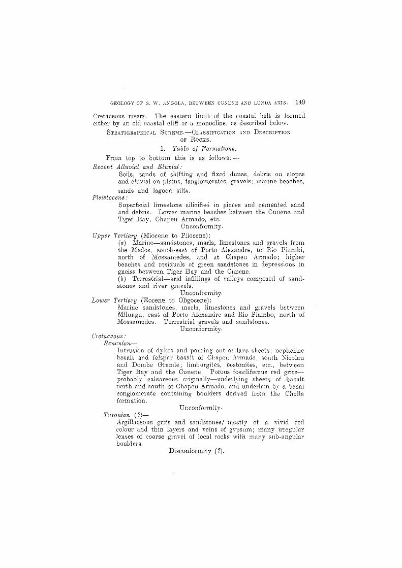
I. J'a.ble of F01'1na.tions. From top to bottom this is as follows:-
Recent All'uvial and Eluvial: Soils, sands of shifting and fixed dunes, debris on slopes and eluvial on plains, fanglorn.erates, gravels; mclrine be<.lches,
sands and la.goon silts. Pleistocene:
Superficial limestone silicified in places and cemented sand and debris. Lm'i'-el' marine beaches between the Cunene. and Tiger Bay, Chapeu Al'mado-, etc.
Unconformity.
Upper Tertiary (Miocene to Pliocene): (a.) 11arine-sandstones, marls, limestones and gl'u\"els from the Medos, south-east of Porto Alexandre, to Rio Piambi, north of Mossamedes, and at Chapen Armada; highel' beaches and residuals o-f green sandstones in depressions in gneiss bet\veen Tiger Bay and the Cunene. (b) Terrestria.l-arid infillings of va.lleys composed of sandstones and river gravels.
. Unconformity. Lower Tertia.ry (Eocene to Oligocene):
1v1a1'ine sa.ndstones, marls, limestones and gl'avels between Milungu, east of Porto Alexandre ~1l1cl Ilio Fiambo, north of 11ossamedes. 'Terrestrial gravels tmc1 sandstones.
Unconformity. CretncemLS .'
Senoninn-Intrusion of dykes and pouring out of lava sheets; nepheline basalt a.nd fe!spar basalt of Chnpeu Armado. south ~icolau and Dombc Gra.nde; limburgites, bostonites, etc., behreen Tiger Bay and the Cunene. Porous fossiliferous red gritsprobabl,y calcareous originally-underlying sheets or basalt north and south of Churcu Armado, and underlain by a basal conglomerate containing boulders derived from the Chella formation.
Unconfonnity. TU"I'onian (?)-
Argilbceous grits and sandstones,' mosHv of a ,"i·del reel colour and thin layers and veins of g~'ps~m; many irregular lenses of coarse gravel of local rocJ;:s with milny sub-<1ngular boulders.
DisconfOl'mity (').
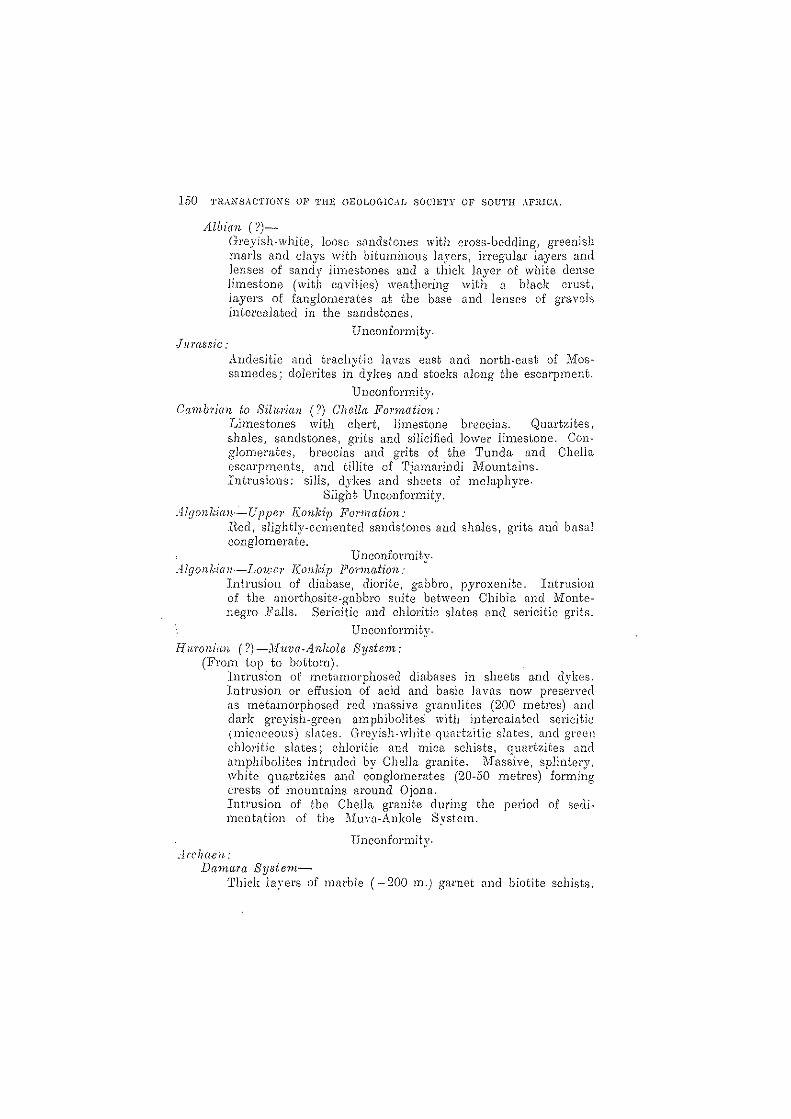
150 TRANSACTIOXS OF 'fHE C:'rEOLOGIC,lD SO('IE'l'Y OF SOUTH AFIUCA.
Albian (?)-Greyish-white, loose s,1ndstones with cross-bedding, greenish marls and clays \vith bituminous layers, il'l'egula.l' layers and lenses of sandy limest.ones and a thick layer of white dense lirnestone (with cavities) weathering with a black crust, layers of fanglomerates at the base and lenses of gravels intercala.ted in the sandstones.
JUTa-ssic,' Unconformity.
A .. ndesitic and traclrvtic lavas east and north-east of 1VIossamedes; dolerites in" dykes and stocks along the escarpment.
Unconformity.
CambJ'ian to Silu.1'ian (?) Ohella Ponnation: Limestones with chert, limestone breccias. Quartzites, shales, sandstones, gt'its and silicified }O\1/e1' limestone. Conglomerates, breccias and grits of the Tunela and Chell a escarpments, and tillite of Tjmrl_arinc1i Mountains. Intrusions: sills, dykes and sheets of mela.phyre.
Slight. Unco-nforllity.
Algonkian-Uppe1' J(onkip FOl"mation: H.ed, slightly-cemented sandstones and sha.les, grits and basal conglomerate.
Unconformity. Algol1 kian-L01t81' J(onkip P01'mation,'
Intrusion of diabase, diorite, gabbro, pyroxenite. Intrusion of the anorthosite-gabbro suite between Chibia and Mont·enegro Halls. Sericitic and chlol'itic slates and sel'icitic grits.
Unconformity.
Huronian (?}-Jhwa-Anhole System: (From top to bottom).
Intrusion of metamorphosed diabases in sheets and dykes. Intrusion or effusion of acid and basic lavas now preserved as meta.morphosed red massive granulites (200 metres) and dark greyish-green amphjbolites with interca.lated sericitic (mic;1ceous) s1il.tes. CTl'eyish-white qwu'bitic slnt0s, and green chlOl'itic slates; chlodtic and mica schists, qua.rtzites and ampbibolites intruded by Chella gra.nite. I\fassive, splintery, white quartzites and conglomerat.es (20-50 metres) forming crests of mounta.ins around Ojona. Intrusion of the CbeJla granite during the period of sedimentation of the Jiuva-Ankole System.
Unconformity. Jl'ch(wn:
Danwra Systern-Thiel~ layers of marble (-200 m.) garnet and biotite schists.

GEOLOGY OF S. W. :\:\GOL:\, BETWEEN CUNEXE ,\>.'1) LCNDA AXIS. 151
qURl'tzites. \Vell stratified gneissose qllfl..rtzites, granulites, mica schists, garnet schists, o.mphibolites, etc,
Unconformity. Pl'e*Damnra Gneiss-
Non*stratified acid and basic~gneiss, amphibolites, one or two marble layers, augengneiss.
II. The Pl'e~Damal'a Gneiss.
This forms the country rock over large areas of the Namib peneplain between the Ounene, Coroea. and the Lunda· Axis, and along the coast between 1V101'1'0 Vermelho and the Cunene. Furthermore, it occurs within the flfountain Belt in an anticline along the Kahama valley nOl,th-west of 1-Iontenegl'o l!"alls, which anticline seerns to be bounded by faults; another gneiss anticline occurs west of tile Tjamalindi ~Iountains_
It is difficult or impossible to say from a rock specimen alone whether it has been taken fro111 the pl'e-Damal'a gneiss, the ])am81'a system or certain rocks belonging to the 11uva*j.nkole system. However, in the field there arc marked differences in their modes of occurrence. The pre*Damaru gneiss is not stratified like the rocks of the Damara and the ::\{uva~Ankole svstems, and is much more intruded-mostly in lit*pal'-lit fashion~by basic and acid igneous rocks than that of the other systems. Furthermore, the strike of the old gneiss is persistently around true north along the coast, as well as further inland, whilst the general strike of the two other rock systems is N. 300 \V. The unconformit.y behreen Gneiss and DamC1.1'<1 system could be followed up in the field some 30 kilometres east of i''101'1'O Vermelho. Gneissose rocks also occur in the two other s;ystems, where they arc inyaded by the Chella granite and by the anorthosite-gabbro complex; in the field thCl'c is no lit-ptlr-lit intrusion in such CtlSes, but the rocks are broken up into bl'ecci<.ls with the fragments floating in, or in process of absorption by the elneloping granite or anorthosite_
Between the COl'oea and the Lunda Axis, amphibolites and biotite gneisses prcdominat,e, intruded by numerous veins of aplite, pegmatite anel granite_ Furthermore, dozens of JQ)'ge basic d:ykes arc very COl1* spicuous within this area, ·such being often oyer 10 metres \\'id.e and. running for man)'- kilometres straight tlCl'OSS country, weathering into steep ridges; most of them run from north to south, others have a morc nOl'th*westerlv dil'·ection. Their character is Yl.U'inble, and it is probable that not all of them belong to the same period of intrusion; some of them belong to the gneiss formation. Souza 1,1 mentions kersantites, diorites and quartz diorites; Faber 15 describes the dyke
J.I. SQuza, F_ L_ P. de: (( Contributions a l'etude Petrographique du Sud*ouest de l'Angola_" Comptes relldus d'..!cadcmie des Sc. Tome_ 162, pp. 692*694, Pnris, 1916.
15 F'alJPI', F .. J.: "Bijdra ge tot d~ Geologie van Zuick-\..ngola (Afrika) Delft," 1926.
162 THAXSACTIOXS OF THE GEOLuGrCAl" SOCIETY OF SO'[TH AFRICA.
of Vila Aringa ;-18 quartz-diorite-porphyrite, and dykes between Cba::uto <.111(1 Cahinde as olivine-dolerite. The l~ltter <seems to be absolutely fresh and may even belong to the Ennoo dol~rites, ~1S descl'ibed below. The Vila Ariaga clyhe does not cross the Chella formation and probably belongs to the intrusions of the :Muva-Ankole syst0m or t.o the Konkip formation. 8coutounoff 16 mentions dii.lbi.1Ses. dioritic a.nd gabbroid rocks and fine-grained ,greenstones.
In the belt of gneissose rocks in South-West Africa, also in the Conception Bay and Spencer Bay areas, the occurrence of simil,u' types of dyke rocks has been observed, and these have l~een described as diabases, diorites, dolerite, etc. In the Spencer Bay area· most of the dolerites are the deep-seated equivalents of the Konkip volcanics, which have been correlated with the lavas of the Ventel'sdorp system, and th,e same probably applies to most of the basic dykes of our area, especially as most of them have a comparatively fresh doleritic appearance. To settle this problem it would be necessary tD carry out a special investigation of all the dykes.
Biotite-gneisses \'rith aplitic veins ha\'8 been observed between Gal'iatu. RiveI' and Tiger Bay; reddish mylonitic gneisses occur on the north-eastern slopes [lnd Nlst of 1\101'1'0 Ve1'm01ho, also on the coast west of this hill. Going southwards along the coast from ~Iol'ro Vermclho t,o the Cunene one meets first" Zebra-gneiss," i.e., biotite gneisses intruded lit-pur-lit by aplitic and pegrnatitic material often shmving " eye " structure, that is to say, mQt'e or less rounded quartzfelspar aggregates; isolated lenses of greenish marble and lime·silic.ate hornfels with much garnet and other silieftte minerals are quite common in the zebra-gneiss. An area of several square miles composed of vel"}' compnct " c1.ugengneiss " showing felspnr-quartz eyes up to several inches across in n brownish matrix occurs half-wav between ?liorro Vermelho and the Cunene. This probnbly repl'esent~ a. hi,ghly metamorphosed porphyritic granite. LHrge pegmatite dykes, some of them contnining rose quartz and others ha\'ing gl"aphic structure, occur several kilometres nOl'th-e<1st of the Cunene mouth.
Remarkable is the occurrence of a marble band which is 20 to 40 metres thick and nms north-south, with only minor disturbances, for about 40 kilometres from ~lolTO Vel'rnelho to'the Cunene at a distance of about 10 kilomehes from the coast. This marble is partly silici£ecl and contains many impurities; occnsionally quartzites and gnrnetiferolls miCtl schists are connected with it, especinlly at its southern end. East of ~IolTO Vel'melho the band is 1ro];:en up into fragments floating in the gneiss ,-1nd metamorphosed into lime-silicate hornfels.
The gneiss in the corner between the dunes north-east of Tiger Bay is mostly ,1 dark basic \'ariety tr8\'crsed by amphibolitic dykes, probably kersantites.
The gneiss anticline north-'\\'8st of :'Iontenegro F<-111s shows basic. (dim'Hic) gneiss neal' the Cunene; further to tbe north zebra-gneiss
16 Scoutounoff. G. F.' Se\'el'al Hepol'ts, 1932. Not published.

GEOLOGY OF S. w. ",""",au, BETWEEX Ce'EXE AND LUNDA AXIS. 153
\vith ganlet-mica schists and nmpbibolite, and in the upper Kahilma vallev (1n8i88 ,r-ranite with a bOllv of ]ll'l'Oxcnitc. In this urea I cume
<J b~") •
[lCl'OSS several" Buck Reels," i.e .. zones of crushed, flinty roc1m, which show the faulted nature of this anticline.
III. Danul-Ta System.
Hocks belonging to this system form a strip of abo,lit 20 kilometres wiele, running from Otjinungwa. on the Cunene (OpposIte the mouth of the }Iatien Rivet of the Kaolwveld) in a north-nol'th-\ycsterly direction, disappear'ing in the dunes south-west of ?vlount Zangaia, \\1h01'8 they vanish the dune sand is coloured red and black bv garnets [mel magne'tite derived from the destruction of these schists. "Probably connected with this occurrence ,11'e the roc1{s cropping out below the Chella formation in the O'Nethu Valle, .. in the southern Tjamalinc1i :Jlountains, ,,,,here Scoutounoff reports" the OCCUl'l'ence of It\yel's of limestone in the gneiss.
Anothel' strip of rocl\'-20 kilometrcf:l wide-occurs east· of )fossamedes running east-\vest and forming the southern Emit of the Chella granites of the Lunda Axis. The beds of this strip turn to the north, follc\,'ing the etlstern limit of t,he coastal formation, and fOl'n1ing (1 band of varying width between it and the Chella· gl~anite for about 100 l~ilometres northwards.
The l'ocl;:s of the Damaro. systern consist in their presumed 10\ver portion of \vell-stratined gneissose quartzites, granulites, mica-schists, gametiferous-schists and amphibolites; a higher horizon contains thick hlyers of marble, besides gal'netiiel'ous and biotite sehists, quartzites a.nd other schists. In a sequence of over 200 metres of
. such beds in the Ohungokoro (Zebra) 11ountains, 45 blometres east of the Cunene mouth, oyer ;30 pel' cent. consist eel of thick marble layers.
1'he marbles arC mostly of high quality and often free from impurities, and occur in h1yers seH~ra,1 metres ·in thickness. The~- com
pare very well with tbe mm-bles of Karibib in South-West --'friea, which have been exploited for years, though unsuccessfully, despite the high quality of the marble, on account of the excessiye cosb; due to high wages and transport charges. The exploitation of the marbles bet,veen the Cunene and Co roc a \'\'ould be· impracticable, Us costs of transport would be still higher. The marbles south of the railway line, I\-fossamedes-Lubango, ate exploited at several places and burnt in lime-kilns for local use. These marbles occur in verY disturbed position, ,lild (;ontain too many impurities (silieH and" antinolite. p:nites) to be fitted for building pUl'poses or export.
The marble horizon behveen the Coroea and the Cunene contains in piflces limestones which shO'\\· to the naked eye hardh- ,111'crystallinity, and m<l}' bE' misL1ken for limestones~ of the 'Chella formilticn; I found tlwm intel'bedded with g[\rnet- nn(l Iniccl-sehitsts.
_\ppill'entl,v connected with water stored in those marbles is the suppi," of the so-caned Caeimba at the north-eastern shore of Tiger

1;14 TRANSAC'l'IO:\'S Ol~ TIlE GEOLOGIC.U, SOCIETY OF SOC'rII AfRICA.
Bay, 35 kilometres north of the settlemcnr: here ''"'-"{ter occurs in the sand close to the shoro, aIt-hough thete is no indication of any riYer bed nearby, but a hill of about 300 metres altitude, consisting of limestano, is close behind it in the dunes to the eu;;;t,
Nurnerous watering places with brackish :.>upplies deri\'ed from the marble horizon occur on the eastern slopes of the marble hills of the Ohungolwl'o Mountains in the Salt Ri'\er and the Damba. rIa Viboras, where plenty of game is still to bE: faunel, especially zebras, oryx antelope, spl'ingbok, koodoo, lions ancl a few rhinos,
lTt1.ber 1; mentions the marble used for the lime· kiln at the Dos lrmaus east of IVIossamedes as being coarsely crystalline and containing garnet., crystals of pyrites and ,,"alli.i.'stonite, and being associated wit.h quartzites. He also describe(l the rocks from the hills east of Cambonge as being traversed by aplitic: (l:,o]):es and consisting of quartzite and marble, the latter often silieified 01' containing nodules of cliopsicle and greenish or brownish g81'net. The same kind of garnet occurs in the marble of the Lulea hills.
Scoutounoff describes silicification of th(: marbles along numerous veins, 0,20 to 0·50 metres thick, traversing it in all directions. These veins are sometimes mineralised; certain -I)r them carry some coppet· ores, and gold occurs in many places around the marble hills south of the l'ailwa.y line, but never shows p,)yabJe y[tlues, Silicification, as -well as mineralisation, is confined to the I"ic-inity of the Chella graniteo Furtherrnol'c, mica (muscovite) schists, quartzites, grits and amphi. balites are mentioned to occur in conneetir)n \\'ith the marble beds; the amphibolite at ?dount Eimba contains ]c'l1ses of marblo.
IV. 'Phe }{II'/)((-Anho!c System of SIJllrh-lre.'.dcl'n Angola,
The strnto. correhltcd with this grr:;.,t c(::ntl.'<11 African system comprise bel'1s belonging apparently to t\\'rj ·Lstinct fOl'mations:-
(I.) ~\n oldt:l' and \'0!,~' thic·k SCI.-:b (jl -;,~r1jmr.nts Ge,ginning witil sl!\Oiu'ed ('onglonH!l'iltes :md ·.':h~t(.' splintery 11u;[l'tzitl~~,
followed by qUc1l'tzites, ,)mphi'l)r;iiu;.o; nnd gl'<111UJitCS, \\'ith intCl'l'lli<1te(l sel.'icitic '-tilll chlurit: c; :::(:hisI:;: nnd
(::n _-\n npp,-lr'cntly younger gl'OtlI:' ',<1' Ie'ss J11(o;h1lllorpilu.')l·d gT(,l"l1i~:;\) ph~'ljitic 0)' .sl'ricitic c:H'.'-_,-dnlc:-i, wilh occ;lsion,tl iL-llSl-'S of Iimc::::tollc nud ((olow:t:(:. :md be\llels of ':'cilistnst'· grit.
Thl:; lllain (Chelh) gnU1ite of _\ngoL J);_l:-; i)cen lntnHll'rI into the i-ll'st-llilme(i. thoup!l not, so fa!' as is yet lmr:"\\'ll, into the second, Both <1I.'C cut by bnsieintl'usiollS, but tlH;se in\'i:u1ill~ the olrler group JWI'l~ sl1ffel'l'd nnlL·h Hwtnmnrphism. cmd b,l\"E;' l)'~!.:'n com'C'nGel into nmphibolites <.111(1 granulites, \\'11e1'e<1s t.hose cutting the younger ,we much less altel~ec1, and are diabases ,-mel doleritf:~, Their mututd relations and correlation with the Konl~ip formation of South- \Vest Africa ,yill be deidi: with more fully belowo
I, l",tlwl'. :b~, J.' LGC~T:-: po 460"--
GEOLOGY OF S. 1\' .. \NGOLA, BETWEEX CUXEXE .-\XD LCXDA .,\:\18. 15;1
A similar twofold stratigraphical succession is represented in the X,unib in South-\Vest Africa, as described from south of Ludel'ib; by J{aiser 18 clnd from north of Aus by the author,19 the problems l'Clise~1 being the same us those reported hom the type-region sih.l/.'ltecl south and west of lAke Victoria. in Central Africa.
It was impossible for me in the time i.lt my disposal to Sepal'i.lte these two dh-jslons in the field in Southern AngoL'!., and to define t.he character of their contact line more exa.ctly. It 'will suffice to point out that this problem exists, ~1l1(1 would ho ve to be considered in any further investigations of these or similar occurrences.
A further ver;), interesting point is the intrusion of the AnorthositeGabbro suite, Ivhich occupies large areas in the south·eastern portion of the attached map. ~rhese arc younger than the gl'anulites of the ?liuva·Anlwle system, but aJ'c in part metamorphosed, no eyiclence, however) being found to show that they are younger than the Chella system. They probably correspond with the intrusions of the Sincla.ir SCI'ies 01' the Ventel'sdorp system. rThey seem to represent the deepseated equivalents of those \'olcanics, and with theil' hypersthene content, to gl'ude ove1' into the charnockite rocks described by Tyrrell 20 (p. 539) and by Lacroix"' from I,iberia and tbe Ivory Coast (p. 540).
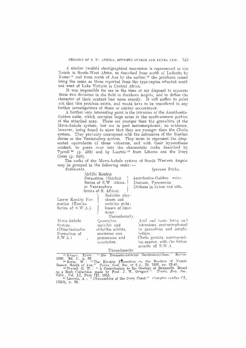
The rocks of the 1-1uva-Anlwle svstcm of South \Vestcl'n Angola. may be groupecl in t.he following ord~'l':-
Sedi11unts. Igneous Flocks. :lliddk Ronldp Formation (Sinchtil' ) Anorthosite,Gabbi\) suit..:'. Series of S.VlT .,\frica.. t or Ventersdol'p Series of S. Afri("l.
Lower Konkip Fol'- ~I. maticn (Kunia5 Series of S. W.,\.). J
8eticitic dD.\"· slates :lnd .. :octicitic gr:ts; lenses o(Jimesione.
Diabase, Pyroxenite. Diilb~\se in ~.l'ykcs cmel sills.
unconformity. "1[unl- ~\ nl~ole
Srst-em. (('Ii 100<t", I 1 ief er Fonnntion of S.W.,\.)
Q1Hlrtzitcs. sCl'icitic [md chlol'itie schists, £melssose eon,Q'lomel'ntes and (jll<ll'tzites.
Unconformity.
~\('iil ;lnd hasic lnYfl'; :Hl·l intrusions. meLlmol'pllOSec1 to gl'lllnliit-es nnrl nmphihf)lites. Chc,lL1 gl'flnite. rorrt~sp()ndin!! npj)l'ox. with the Sil!('111
Q"l'an'lte or S.\V .. -\.
\~ FniS('l' ]Sri!'h: (~Die Diamant(1)\\'l1Cste SnN\wcstnfj'ii;:ns." B.,rlin. 1926. Bd. r.. p. 88.. _ .
19 ]}'etz, \Y.: (I TIl(> KO'lkin Formation (\'1 tIlE' TInl'dN<; "f :\<lllllb D(>S0l't. NOl'th of .-\ns. l ! T)'n·1)s. Orol. Sou. nf S.A .. '25, 1922. pp. 23-W
20 Tyrrell, G. 'Y .. ".'\ Contl'ibution to tll(' Geolog:\' of Benguella. Based Oll a Rock Collection made b:,>~ Prof. J. W. Gl'f'gory.n TI'()11S. Ro!! .. )oc. Edi?! .. Vol. LT, Pnl't nI. 1915.
~l Lacroix, ·A.: "Charnockite of the Irory Coast.)) ('nmpfes rr;llrillS C'L. (1910), p. 20.

136 TRANS:\CTIOXS OF THE GEOLOGICAL SOCIETY OF SOL'TH AFRICA.
Dama1'a System,
'1'he Muva-Ankole svstem of South-Western Angola-with the exception of the AllOl:thosite-Gabbro suite-is confined to the Mountain Belt between the Cunene, Coroca anel Garinta Rivers. In the east it disappears below the Chella esearpment; it crosses the Cunene into the Kaokoveld in a. narrow band west and east of the l\1'ontenegro Falls. It forms several synclines and anticlines, which run N.N.W.-E.S.}<~., i,e" in the same direction as the beels of the Damara system ,"vest of the Gariata River.
The basal beds, i.e., white quartzites and conglomerates, have been founel only in the soulh-western portion of the Mountain Belt, north and nOl'lh-west of the Tjamalineli Mountains, Along the Gal'iata River the basal beds are covered bv alluvials; in the north they are intruded and metamorphosed into the condition of gneiss by the Chella granite; in the east they are hidden below the Chella formation, and in the southHcast they are brolwn up by the enormous anol'thosite.gabbro bodies.
Eruptive breccias arc found at the Coroca, where the granite has intruded Ihe jHu"a-Ankole system, and in the south-east, where, that formation has been broken up by the anorthosite-gabbro intrusions. In the latter case the very resistant massive red granulites are affected, and east of the 11ontenegro Falls one can see patches of red granulites as large as 500 metres across enveloped by white anorthosite. I,Vhero invaded by granite or anorthosite·gabbl'o, the beels often exhibit a gneissose structure. The mica.-schists, which form the }o\V81' pOl'bon of the }Iuva-Ankole system a.long the CorocD. ,~ranite contact, fall within the aureole of contact metamorphism of this granite. The metamorphism caused by the numerous bnsic inti'llsions of the ::\Iidcllc Ron].;ip formation, i.e., dykes an(l sills of less metarnorphosed diabnse, diorite and gabbro, has been less intense, only" hornfels ,! anel " gnrbenschicfcl' )' resulting.
OH;,rlying the basal beels cwe green sCl'icitic and chlol'itic schists, probably mostly nmphibolites of very fine gl'[lin; t.hen follow greyish· while fju<."ll'tzitic slates of o\,er 100 metres thichness, o\"erlnin by .Qreen chloritic slntes., find then massive (lark green to black ;""Imphibolites <111(1 impure quartz".ites. One of these dark massiyc l'oc]{s was im-esti· gnted unc1er the microscope: it represents a. true finc-grained urnphi. bolite, (~on'iijsting of oyer 50 pel' cent. green amphi401e, 40 pel" cent.. felspal' (mostly albite) nnd 10 pel' cent. (]lInl'tz; the structure is " homeobh'Stic, granoblastic, pnrnllel."
The highest beds of this schist formation consist of ycry l1HI.Ssiv8, fine-grained red rocks about 200 metres thick, 'which wer8 tnken in the field by Scoutouuoff and mys'l!f to be quartzites, but which under the microscope pl"'o\'ed to be granulites. They contain more felspar than qunrtz: fairly large plates of felspar (mostly micropcl'thite \vith less labmdol'itc and microcline) are set in a fine·gl'ained quartz felspar

GEOI~OGY OF S. W. ANGOLA, BETWEEN CUNENE ,,\XD LUNDA AXIS. 157
m:1trix resulting from the crushing of quartz and part of the felspar·. A typical mortar structure is developed. No biotite is present, but sericite is found filling numerous parallel clefts togethct wlth iron are, partly limonite, but mostly scales of hematite, which give the rock its red a.ppeara.nce.
'n18 succession and the types of rocks met with in this formation resemble closely those of certain beds observed west of the ldbatross, about 10 to 20 kilometres south of Luderitz in South-vVest Africa. li'or comparison, the following table is given;-
From top to bot.tom.
South-IVestern A·ngola. Sou.th- TVest A/rica, SO'1J .. th of L-udcritz.
Ci.1 200 m. granulites.
? amphibolites and chlorHie sla·{;es.
Ca 100 m. greyish-white quart7,itic slates.
(? amph;bolitcs) chloritic and sericitic slates.
20-40 m. splintery "\vhite) quartzites and quartz- t iUe gneissose c.ongIO-j me)'ut.es w~th small quartz pebbles.
140 m. granulites in the upper portion with intercalated amphibolites.
6·80 m. sandy greyish-white quartzitic slates with many fiattened pebbles.
94·00 m. greyish H white quartzitic shl.tes.
37 ·00 m. amphibolites and chlol'itic sla.tes.
11.·00 rn. gneissose conglomerates with flatt.ened smnll quartz pebbles, sericitic. chloritic scllists.
U nconfol'mity, ArclH"lon Schist" Formation. Schist :D'ormation (Archaen).
The. less metamorphosed sericitic clay shHl~S and sel"icitie grits ",hieh ha"\'(~ been corrolated with the similo.r LowC'r E.onkip formi'ttion of South-\Vcst Africa., CO\'CI' lnl'ge are;)::; ('lISt of the Gal'i,\tn HiYel' along the main 1'0[1(1; abo at the 10\\,('1' ~Il1elHlc .Hin:l' nnti south of Otjissengo in the \ cast. where lenses of limestone '\'(;l'e obsencd by ;)('.olltonnoJi <1n(l nwself. The thickness of these l)(~(ls must be ,)\-el' 100 metl'Cs. The ~intcs arc crossed h.Y numel""OUs qUflrtz H~ins, i):'; in 8outh-\Yest ).,..fl'ica. 'rhe slates and grits arc en»i1y destroyed by wCl.l.t.hering, an action facilitated b.v their splitting mosO,v alol1:<2: t,yO planes, i.e., {dong the bedding <11)(1 '11ong a srlfistosii:y cros-sing the latter at right an:gles. thus producing" slate pencils." The snll1C twofold clea\'age has affected as \yell the lower folded Chella fO),lD,'ttion nlong the ,,-estern slopes of the Tjmnnlindi, but is not met \\'ith in the cnstCl'n pnrt of these mounbins, nor nlonq the present ChelLI (~SC;ll'Pment cast of Otjitemi HiYcr, which \\'as not subjected to folding,
Basic intrusions ascribed t.o the Konkip system occur throughout the ~ful'fI-Anl::olc system. [lnd in pl[let's e,'en exceed the
158 TIL\NSACTlOXS OF THE GEOLOGICAL SOCIETY OF SOUTH AFRICA.
sedimentary material, though III the conspicuous massive red granulites they are comparatively scarce.
V. Rocks Ini-rusive into 1:he Damam and l1f'Uva-Anlwl-e Systems.
These intrusions belong to two periods. First came that of the Chella. granite (Salem gl'llllite) and certain basic intrusions conneded therewith, while it is likclv that the vcrv thick lavers of metamorphosed acid and basic la~,'as (i.e., granulites ~1l1d a~phibolitos) of the lower :J,fuva-Ankole systern are in part the effusive equivalents of the above-mentioned acid and basic intrusions, Secondly c<une the intrusion of certain less altered basic rocks, diabase, '-'diorite and gabbro, in sheets, dykes and stocks throughout the 2Iluva-Ankole system, and the n1fljority of the dykes and batholiths intruded into the gneiss and granite between the COl'Oca and the Lunda A_xis, Further, rnore, the <wthol' attributes to this period the anorthosite-gabbro bodies in the south-east and certa,in pyroxenites met with in the upper Kahama Valley north-west of the }fontenegl'o Falls,
(a) The CheUa Granite. Certain granites of the :\Iountain Belt arc; surrounded by gneisses,
which gradually P')SS outwards into the well-str-atifieil gneisses of thc: Damara system or into the quartzitcs and mica·schists of the lo\\'er ~Iuva-Ankole system, These \gneisses form metamorphic c'lul'eoles nrouncl the granite bodies. Again, there is a difference in the habit of their intrusion into the Dnmara and the :JIuva-~\nkole systems respectively. The <!ureole around the granite batholith of Ku~·upiko. south-west of 'l'jnnwlindi, begins with diol'itic rocks, which are the result of magmatic. differentiation; then follows a gradual transition into gneissose dioritie schists and at Inst into the well stratified
gncisseB of the Damm'n s;ystem, In the eLlse of the :1Iun1.-Ankole system. the conh\ct consists of an eruptil"c breccia, ,In<1 tlw adjoining ]o\\'el' beds of this system nrc meturnol'phosed into mic,l schists. --
\\"hi1st in small boclies ,mel close to its con Ltd with the oldel' },(lcli>;, the ChelL-t granite lMS a gneissosc character, it appeiU's quite fresh ;mrl lit-tle altered at :l greateJ' clistnl1ce from those contads. It eOI"(~n.:; el1Ol'mous 'l1.'enS, espccially on the Lunda ~\:xis and nlong the ('sCCll'pment; it also oecms townrcls the "inte)'im on the outskirts of the· I\<1hbaJ'i, e,lst of the escnrpnwnt.
The t~'pt' is mostly ;\ l10rrnnl biotite'granite of co:)rsc'1' OJ' finc']' grain: c(~l'tain ynrietics contain (lmpllibole, ns reported by Bebii1n()_~~ nt tlw foot of the CSCflrptnCnt, north of Cilncuto. nnd from lWW:" otlWl" pinecs lwt\\"(:t'n :Jloss;ll1wdes nnd Cnssingn. Fnbu' 2:1 mentions zircoll in biotite gl',lnitc of :JIorl'o Antonio CM.;t of C'i1p<tngombe. Tyrrell ~,I
describes \'1tl'iOllS types of Chell a gl'nnitc east of Bcnguclla, nnrl men, tions the assoeintion of ,Ql'illlodiol'itcs. --i~Bel)ial~r---h~'-· -.-, G-;;'o]ogia ~;-·Hi(\llezaSj'inrira'-(fe-:-\ngofa:-'-'-Lisboa·, 1923. p. 14S.
23 Fabol'. F . .T.' Lol' of, P 55 '2·' TYl'l"cll, G. W .. " \ ContllhlltlOll to the Pctl'o"raplw of B(;'llgnella,JJ
T)'O-IIS. Boy, .'-:""01', Edill, Yd. LT.. Part IlL ~(). 14-. EnG. p. 546,
GEOLOGY OF 8. W. AXGOLA, BE1'WEEX CCXEXE A:\,D Ll'XDA :\Xl~. 15U
The Chella granite is non-porphyritic, 1111(1 is the chief ,lcid intrusive in the schist formation of South~\Nestern .. Angola. The corresponding "Ho.uptgranit" of South-\Yest Africa, from Conception Bay to the J(aokoyelc1, is the porpbyritic " Salem granite," a grey porphyritic biotite gn:l.l1ite, with tabulul' phenocrysts of orthoclase and sometimes microcline. These phenocrysts usually exhibit flow structure, i.e., a, ptl.rnllel orientation, which is usually stricti}! parallel to the strike of the schist and granite contact. The Salem granite shows the greatest confol'ITwbility to the tectonic structure of the invaded sediments, forming concordant bodies of the nature of phacoliths. It shows its porphyritic structure even in veins of less than an inch thick, ancl the large orthoclase phenocrysts are well preseryed even in mixed rocks, i.e" in case of rocks assimilated by the granitic magma. A similar porphyritic granite bas been found in the investigated area· only once, forming the highest elevation of the ?l'1orro Vermelho south-east- of Tiger Bay and intruded into the surrounding schists, and showing all these characteristics of t.he Snlem granite in an excellent manner. The occurrence is the more remc1l'kable, since no further one could be found in Sonth-\Vestern Angola, although this is the most common granite in the Ninnib, south of the Cunene.
Under the microscope the ~Iorro Vermelho gl'anite shows mortar structure; it contains much quartz, partly broken, partly in large grains \vith undulating extinction; some rounded grains are enclosed in feispar. The orthoclase occurs in hU'ge plates, is mostly lmolinisec1 and olten exhibits a faint micl"ocline "gitter" structure: some fresher micropertbite; a little oligoelnse with fine cl.lbite-hyinning; a few large flakes of greenish-black biotite with strong pleochroism to light greenish yellow; and ilmenite, mostly thoroughly \yetl.t]H:'l't-'ll to leueoxene.
A dark clylw cutting the grnnite is <l hypicliornol'phic, fine-g:rilincd rock showing an ~lplitic struc:ture, but with a tendency to pnl'nllel <.urangement of the fclspnr laths; no quartz could be Sl'el1. Of the felspars a few are htbl"l.cloritc-; in irregulnr plates exhibiting fint~ t\\'in structure; the bulk of the feJ<.;r~'I1· is oligocbse-<llHlesine of ilT~gtll<lr outlines; then there cxist many more rectanguhn plates of (~rth')('lnse sUl'l"oundecl by a shell of plagioclase. Biotite is Pl';.1CtlC<.l11;y j;~!e only femic mineral, and forms about a third of the toLd rock; it l~ pently nlterecl to chlorite. The ilmenite is mostly SlllTouIHlecl by leuc~lx('ne . . -\patite OCCllrs in a fe,,' large graills. but aJ;.;o in l11fmy flue l1(>(,dles. :\0 mnphibole Ot' p:'-Toxene (:oul(1 be obseJ.'yed. The rock mily be (':111('(1 il kersantite. or, better, ;). tonnlitc-'lplite.
The Salem type represented in the .\I01'ro Vel'melho is intl'tlsi\'e in gneisses find in fl dark metflmol'pilosed (liorite or qu,lrtz d.iorite. which coyel'S <.1 large area flround this hill. but must not· be confuse(l with the large body of much youn.'~er b,l.sic and ultrflb,lSic rocks (peridotites, limburgites, etc.) in the coasLl.l plain west of :\Iorro Vermelho.

160 TRAl\'SACTIOXS OF THE GEOLOGICAL SOCIETY OF SOUTH AFRICA.
(b) The Ano1'thosite·G"bbl'O Suite, The OCCUl'rence of such intrusions c.ovcring large areas east of. the
.Planulto, sou"th or Chibia, has been mentioned by several authors; its continuation w\vards the Cunene has been anticipated by ot]1el'S, but not investigated. The bending of these intrusions t-owo.rds the west, i.e., towards the granite of Etampa-Viquoros in the· north and towards the :Montenogro Falls in the south ma.kes them occupy an arc concave to tho west. Similarly shaped anorthosite occurrences are mentioned from the Bergen dish-iet of Norway.25
Vageler 21) mentions that the ranges bordering the Kalahari Ul'e mostly fornled by anorthosite-gabbro typos, including very coarSegrained varieties containing lnuch garnet in the centre of the bodies near Xillengues (i, c" about- on the 16th Parallel), becoming fine· grainecl towards their contacts, where they become free of felspal'. li'urthermore, there occur large lenses of ilmenite-magnetite in the centre of the intrusions containing millions of tons of ore. Hills formed by them ha.ve a north-south orientation. The associated dykes traversing the surrounding format'ion have the character of diabase.
Vagelel' was of the opinion that these types represent the plutonic equivalents of the la.vas of the Kaoko forma.tion (Karroo), which form sheets many hundred metres in thickness· in the I{aokoveld of SouthWest Africa. rrhe quartzitic rock of the Table l\iountain, on which the Portuguese Post Gumbos is built, was recognised by Vageler as chalcedonic sandstone belonging to the Cretaceous or Tertiary, COtTO
sponding with the Botletle Beds of the Kalahari, It might be men· tioned that Vageler :,--vas thoroughly acquainted with these characteristic rocks from his extended trips through the Kalahari, but that Faber's 27 description of then1, as belonging to the Cholla quartzites and as being metamorphosed at their contact with the gabbro, is certainly a mista.ke.
Souza '8 28 account of these rocks is of importance, and is h01'0
translated: "From Nionga up to Tehitunguira. ga.bbros are developed traversed by veins of granulite and aplite with vermiculated quartz. At the contaet with the granite there crops out a quul'tz-norite, th(~n anorthosites, a gabbro-norito, and in Amuti a quartz-nol'itc. 'rho granite continues for 12 kilornetres nearly to the east of the fort of Quipongo, but includes outcrops of troctolite and hypersthene-diabase. Then in an easterlv direction to the Cunene, one finds moro or less basic rocks, diabas~, olivine-diabase, quartz-diabase, augite-porphyrite, associated with acid types: rhyolites, rocks carrying quartz, epidote
25 Daly, R. A.: (( Igneous Rocks and Their Origin.!> 1st Ed., New York, 19.14, p, 332,
26 Vagele!', P.: ;( Beobn.chtungen in Sned\\'estangola und im Ambolande." Ferh, liei, j, D1'dk, (17, IX, 1919), 1920, pp, 179·193,
27 FaLer, F . .T.: L()G. cit., )). 79. 28 Souza. F. L. Pereira de: "Contributions a l'etnde Petrographiqne
dn Sued-ouest de l'l\ngoia." ConI-pies 1·e7!d-us d'.4cademie des Sr. Tome. 162, S\':HlC/> du 1 :\1ai, Paris. 1916, p. 692.
GEOLOGY OF S. W. AXGOLA, BETWBEX CUXE:XE .-\ND LUXDA AXIS, 161
C1ncl pl'ehnite, etc. Going from Chibia towards Gambos, that is to say, in a south to south-east direction, ono finds beyond the granitc and t1t 5 kilometres from Scrradol'cs a great extent of gabbros wit.h olivine and biotite (troctolite) and anorthosite. The labradorite of these rod:s is generally saussuritised and calcified. These gabbros are traversed by veins of granulite and pegma.tite, and. before reaching Gambos, between Cachanga and Cantiates, by an alkali-syenite containing nlbitised orthoclase (mieroperthite), zircon and an amphibole close to hastingsite. The same syenite is again met with more to the west nea.r Pocollo. The gabbro continues to the south until Chabiqua. It is associated between Jucundja and Otjinjou with au alkali-granite containing orthoclase mottled by albite (mieroperthite), riebekite anel ilmenite.) ,
'This account is based on rock specimens collected by others, und I could not locate on any map some of the sites mentioned by Souza. His petrographical descriptions are, however, in agreement with those from specimens collected by me at the Cunene.
Faber 29 investigated the anorthosite-gabbro complex between Chibia and Gambos. He mentions olivine-gabbro, granophyre, anorthosite and biotite-olivine-nol'lte. He does not agree with Souza that the labl'ador·ite of the gabbro is saussuritised, nor that 111uch calcite has been formed by the weathering of the felspar. Again describing the granophyre, Fabel' mentions that the quartz shows undulatory extinction and that needles of apparently secondary amphibole occur, which facts certainly shm\' metamorphic influences.
'fhe anorthosite-gabbro body crosses the Cunene upstrean1 of the ~lontenegro Falls, the general trend of the frequent banding being ::1. 700 E. It was followec[ by the author 101' about 20 l<ilometres up the river, and extellds south-westwards into the Kaokoveld f.or nt least 10 kilometres.
The pl'cdominant rock along the Cunene is anorthosite of snow white to rosy colour. G,-,bbl'O forms only nanow bands on both sides of the anorthositic centre. 'Nhere the mt1ssiYe red granulites of the }Iuva-Ankole system have been broken up by the anorthosite group, t~cid types of syenitic and granitic character appear in two narrow strips parallel to the strike of these granulites, but diagonal to the anorthosite massif. The manv "floating reefs" of red ,oranulite included in the anorthosite body, ilnd the direction of stIChO granitic bands suggest that these acid kinds a.re hybrid 1'oeks, Ol'iginating through assimilation of the siliceous granulites by the anorthosite magma, the microscopic investigation showing tht1t they should be grouped 'with the" mangerites " of Hosenbusch. 30 Like them they contain as the dominant felspul' u micl'Operihite, besides micl'oline and oligoclase-andesine, also some orthoclase and microperthitic-microcline ; Qtl<1rtz occurs in grains with irregular outlines and undulatory ~'nber\ F . .r.' Loc. cit .. p.' 77.
30 Hosenbusch, H.: ;, :.\likroskopische Ph~'siographie dE'r :.\lassigell Gesteine n." Br!. 1. Hulfte 4. Auflage ID07, p. 358.

16:2 1'HANSAC'fWXS OF THE GEOLOGICAL SOCIE'rr OF SOUTH AFHICA.
extinction. The femic minerals are mostlv altered to chlorite often dotted with crystals of mugnetite, but 1'e1ios"0£ fresher pyroxenite show that monoclinic as well as rhombic pyroxene is present, while some of the rhombic pyroxene displays the pleocluoism of hypersthene. G-rains of leucoxene represent weathered ilmenite; there are also large nggl'eg;:ttes Of crystals of lnHgnetite. 'Two grains of orthite were observed in a rock slide from the mungel'ite ;) kilometres upstream of }Iontenegro E'alls; they show no cleavage, but a pronounced pleochroism from dark brown to lighter brown and high interference coloul's,31 Furthermore, a vivid green felsiJ<:ll' (amazon stone) has been found in a pegmatitic dyke in the same mangerite occurrence, Clnd in pla.ces abundant brown garnet.
The ma,ngerites show the influence of dynamo-metamorphism, the quartz and some felspur being partly crushed and secondary minerals like chlorite, sericite, epidote and zoisite having been formed, The "granite alcaline" and " syenite £llcaline," 'with their micropert-hite, as described by Souza, belong apparently to the mangel'ites ,-11so,
The anorthosites show fewer indications of crushing, though the ielspars are commonly epidotised with the formation of fresh epidote <:U1d microcline. They are hypidiomorphic rocks of coarse grain consisting entirely of felspar, mostly labradorite, also bytownite, which seems to be more kaolinisecl than the labradorite. Narrow veins tl'UV81'Se the rocks filled with labradorite, and in one case with a colourless mineral \vith high interfere~1ce colours and straight extinction-probably sea polite,
The ,gabbros are rrlOstly of comse grain, though fine-grained types (1180 occur, The pl'edornil1itllt felspnl' is Inbl'ndorite; bytownite and ,tnol·thite ,U"t', also ;"tbUll(Ltnt, Biotite oecul'S in small scales intergl'own \\'jtb the pyroxenes, ,18 nlso does the scnnty 011\'1ne, ::\Ionoclinie and rhombic p,vt'Oxenes ()(;_cur ill l.1lmost equJi 'amounts, Large irregularly ~hap(~d nl'cns of lUolloclinic pyroxene consist of diallt1ge mostly inter· .!.;l'O\\'1l with i!Jlll'Jlite; nlrnost. all !'!lombic pyroxene is hypel'stil6!1 P
\"itll pronolll)Ccd plt~ochroism, onl:--' 1I fel\\" pntches of enstntite and bronzite h,n'ing been nb::;er'\'c(L The ol'e is mtlgnetit(~ in lnl',.~e grains illld smnll cl'Ystnb, Some of these ~;lbbros OJ' llol'it('s me quite fresh, nthers sllo\\" ~igl\s of crushing itna ,llter;)tioll, :Jlixcd l'ocks of gneiS80Sl' ehnr:.1ctcl' OCCllr :'llon,!:; cont,lct~ \\'ith the gl'nnulites. a111phibolites and ph.-dlites of the \Im'(\-A,nkoJe system.
Two other b()di-(;~s of. i,<2:l'lL'oUS rocks \\'ithin the <11'1°a i!l\'0stignted pl'obnbl.-'(; belong to the snmt~- per,joel of intrllsion ,IS the alJon:', The Olle is it faitl~" large Inns€- of PYl'OxE.·nite or lIornblendite in the upper K<lhnm,l T:ll. north of :JloHtenegl'o F<llls: it consists mnillly of green hornblende ,H1<l (liallage in eflunl amounts. with a smaller proportion of hypersthene ,lnd enstatite and olivine, The hornblende occurs
31 Hosc>nbusch. II-· Loc, cit .. p. 358 mentions the OCCnlTPIlCe of ol'thite in <lcirl t~·pc~ of this group from Norway.

GEOLOGY OF S. W .. -\XGOLA) BETWEEX C-C>.'EXE .. \Xl) IXXDA .-\XIS. 163
partly in large plates with irregular outlines) partly in crystals; parallel strips of dusty inclusions chal'octerisc the hOl'nblende. PYl'oxenites and hornblenclites are associated with most of the anorthosite-gabbro intrusions elsewhere) and the described pyroxenite is very similar to cel'tain types of P3Toxellites investigated by the <luthoJ' south of Luderitz in S.\N .A.) '\"here they are also connect.ed with gabbros, periodotites and hornblendites, and are attributable to the same period of intrusion as the Angola anorthosites.
An interesting gabbro 01' olivine-norite has been found by the authol' 17 kilometres east of the Cunene mouth. It is, ho\Yevel\ very fresh, and may possibly be conneeted with the Mesozoic Kanoo intrusions) as describedlatcl'. On the other hand, its large hypersthene content suggests a closer connection \vith the anorthosite complex. The texture is ophitie, the spaces between the broad prisms of labradorite being occupied by pyroxene and olivine mninl;.-: that is to say, by large diallnges and fairly abundant hypersthene::;. partly in irl'egular areas, partly enclosing the olivine poikilitically. Fine reaction rims are present, those around the olivine consisting of radinl enstatite, those a.round the h;ypersthene of biotite, or else of enstatite and iron ores. 'rhe biotite is often intel'gl'o\vn with the other fernie minerals.
Furthermore, all the partially altered basic rocks intruded into the gneiss and the beds of the :Jiuva-Anlwle system as dykes) sheds nncl bodies) can be attributed to the period of intrusion of the Konkip formation (Ventersdorp system of South Africa), i. e., to the same period as the anorthosite-gabbro masses. They consist mostly of (liabasic and dolerite types. It can even be assumed tlwt. they ,\yere directl;y connected with the anorthosite-gabbro magma and that. they represent the hypabyssal fades- thereof. Daly .12 regards the ,,,tnol'thositc sills of the Thunder Bay district, Ontario) as c1iffcl'entbtions from n diabasic magma.
The l'Ock of the large dyke of Otj issengo is 11 trUG lli:l base with ophitic structure without signs of cl'lu,hing) but conr,-lins nmeh scricitisccl labi'nc1ol'ite and sorne oligoelase fl.nd p<U'tly ul'aliiisec1 diopside, ~ec{)nclnJ'y fibl'ou:s hOl'llbll~ncle (wd ilmenitc. Tht:. labl'<1(1crite o('C\1r::; in h11'120 ph0n()(~l'ysts rind l'fldifllly al'ranged ilggreg<.ue::; of bths.
The features of the anorthosite-gabbro bodies of South-"\Yestel'n Ang-ola conform '\vell with the peculiarities to be obserYt'c1 in other anorthm;ite occurrences. The _-\ngola rocks form a Y01',I" LH'ge bod;.·, :200 kilometres long and 26 Idlometl'es wide, coyering :'UJOO square bjometres. or neady 2.000 square miles in extent. comp<.uing- well \\"ith the Im'gest masses of Xorthel'll America Hnd Scandin,-"t\"ia. It:::. ,lg0 is pre-Cambrian, though seemingly· ;younger than most of tbe latter (see Daly, lac. cit., p. 322). A pseudo.stratifieation is dowloped in t.hese Angol~ intrusions by mineral banding and by Ja.Yet's of acid or basic types. jIasses of iron ores occur in the anorthosite-g<l.bbro of Anr<zolfl ns elsewhere, <l.TId. furthermore, according to SOUZfl.. nlkaline -:12 Daly, H. A.: « Igneolls Rocks fLlul-fheir Origin."-lsc lfd~i9'f4~
p. 325.
104 'rRANSACTIONS "OF 'l'HE GEOLOGICAL SOCIETY OF SOt,'TH AFRICA.
types are connected with it, though the \\'l'iter did not como acrosS any of the latter along the Cunene lliver east of the Montenegro Falls.
In one respect the Angola occurrence seems to differ in its southern portion from its normal habit, namely, in the way in which it breaks discordantly across the beds of the Muva-Anlwle system almost I.lt right angles, instelld of running concordantly as in most of the laccolithic bodies elsewhere. (See Daly, loco cit., p. 828_)
VI. The Konkip Formation, The Konkip formation has been described in South-West Africa ,,,
as consisting of three series of rocks, which are, separated from each other and from the underlying and overlying formation by unconformities. rllhe lo\ver or I\unjas Series comprises conglomerates, clny slates and limestones, the middle or Sinclair Series is composed almost entirely of basic and acid rocks, and is correla.ted with the Ventersdorp system of South Africa, and the upper or Auborus Series represents terrestrial deposits 01 au arid climate with thick layers 01 conglomerates, red grits, red sandstones or quartzites and red shales.
The less metamorphosed green sericitic clay slates and sericitic grits or the ·l\10untain Belt between the· Cunene and Coroca have been correlated with the similar rocks of the Kunjas Series, and the anorthosite-gabbro-volcanics and the partly metamorphosed diabases, etc., intrusive into the gneiss and the ::\luva-Ankole system of this area, with the dominantly igneous Sinclair Series of S.W.A. and the Ventersdorp system.
In South-West Africa the conglomerates, red grits, quartzites, sandstones and shales. of the Upper Konkip formation (Auborus Series) show no metamorphism ~lnd only a slight unconformity with the overlying Nurna system, at the base of which a tillite is known to be present loci.l11y. It is highly probable, therefore, that the similar reel grits, gutU'tzitcs, s~mdstones, shales ,mel conglomerates occurring in places bch\'cen the !';cilists below nnd the tillite above in the Tj,1ll1<,dindi :Mollntnins, <mel ilS a- fairly continuous bnnd nt the base of the Cholla i-Ol'nlation along the eSctlrpment between Ondambo and Lubnngo, bdong to the l~ppel' Konkip, .:\"0 beds ascribable to this fOl'nLltion 111.1\'8 b(~en fOUll(l in the 110l'thern ,l.neI "'estel'll slopes of the Tjnnllllindi ~loullL\ins, where the tillite rests directl.\" on gneiss, _\t Ovikam bd;:,Hnbe ;l. band of red slwle.s ;1 few metres thick is intel'e,'lL1tell behn.'l'll the tillite and schists, while a few kilometers further to the south 1 round 1'(>(1 grits nnd sandstones together with the red sbales. the \\'hole fOl'mntion being not rn01'8 tlwn 10 metres thick.
Etl.st of the Otjitemi llivcr, between Ondambo and PedivQ, this formation is considerably thicker, i.e., over 50 metres, flnel is interposed between the schists of the ~duva-Ankole system and the basal breccias or conglomerates of the Chell a formation. Here it is apparently conformable with the overlying Chella beds, but the --33 Bee{z:-\V.·~(: The'-Konldn 'Fo-J'mntion~on~the~Bo'i:del~ftJleNamib
Desert, North of Aus." l''l'a1!s. Oeor. Soc. oj S.A. XXV, 1933, pp. 23~40,
GEOLOGY OF S. W. ,\"GOLA, llETWEEX GUN"'IE .\ND LUNDA AXIS. 165
absence of these older beds elsewhere, their rapidl~" y,trying- thickness and their covering of conglomerate 01' tillite in the Tjamalindi Mountains, would suggest thnt fill unconformity relllly exists between them and the Chella. formation.
l.'he occurrence of the group in question along the escarpment has greatly puzzled previous investigators. Bebiano,31 de Souza 35 and Scoutounoff 36 attribut-ed the beds below and above the Chelia conglomerate to two different- formations, though the latter admit-ted that they seemed to be completely confol'ma,ble. Fabel' 37 found no ullconfor1nities within the Chella format-ion as mentioned by Bebiano and Souza; he ascribed the often non-horizontal attitude of the beds to faulting, and came to the conclusion that all the strata covering the Phmalto belonged to one-the CheBa system.
No basal conglomernte of the Upper Konhip formation vms observed bv Scoutounoff 01' Fabel'. The author, however, founel that the basal ~onglomerate of this formation is often missing, and is, when present (Ovipako and in the folded Chella formation north of Mucongo), only (1 few decimetl'cs thick, consisting of small quartz pebbles with (1, g)'oy or red sanely matrix, although grits at the base, or elBc overlying the conglomerate, and consisting of coarse grains of qua.rtz and felspar in a slightly cemented matrix of red sand, graclually changing into coarse red sandstones towfll'Cls the top, are occasionally {5 to 10' metres thick. The dominant strata are sandstones, qu;rtzites and shales tha.t are deep red and much softer and less consistent than the ovcriyinr1 beds of the Chella formation. Hipple marks and sun eracks arc" quite common on the bedding plane~. This, together with their deep red colour and sandy to gritty character, indicates that the;y represent terrestrial deposits fOl'nwd under an arid or desert. climate just lilw the corresponding ..:\uborlls tler'ies of South\Yest '/~.fricn .. The disconfol'mity bet\\'cen this ,group and the Chella form<1tion, nnel tIle absence of metamorphism constitute 'l.dditionnl eYidence for their COlTclntion with til(; A Ub01'llS SerilO!s.
It is ir; t.erest-ing to note thn t Fit bE'1' (l oc. cit., p. /.1') obserycd ely kes (If quartz-porphyry cutting thl'S(! beds sOllth of .L\lban~().
\"11. The Clldla ForlHoiion.
This is mostly horizontal or only slightly tilted ill the C<1st. \\·herc it (,oyers the (,hella and Tunda pli.ltei.1UX, but. is folded in the \\"est. The transition 1'1"Om the table-like to the folded :::.L"lte is well de\"l:lopcd in the west.ern slopes of the Tjnmnlinrli jlountnins. Furthermore. the folded beds bnyc' bu:n obscn-ed in se\"eral isol<.ltcd occurrences north-
3·\ BebiallO, J. B.' "Subsidios Para 0 Estudo Geolot>::ico e :.\lill.ciro tln Provincia de Angola.') BoleN-III d(l ..1U(·lIciu (;eral d(l.~ C~,I(iliias. An\,. 1l. Feyel'ei1'o de 1926, No.8, Lisbon.
35 Souza, Pe>reirn de: "Contrihution~ n J!Etude Petrographique du Sud-ouest d'Angoln." Comptes 1?endll.~ d'.-lc{uiemie des Scir'·1lCe8. TOllk. 162, pp. 692-694, Pn)"i~, 1916.
36 Scontonnoff. G.: Report 8, 1931. Not published. 37 Faber, F. J.: L(I(". (·it., pp. 69-71.
lOG 'l'R,\NSACTIO>lS OF TUE GEOLOGICAL SOCIETY OF SOUTH AFRICA.
east of :\'lossamecles. F{lulting and monoclinal structUl'CS have also affected it on the Chella pbteau.
'llhat the Chell a fonnation formerly extended farther west than the present esc<ll'pment is proved by h;l'ge outliers of this formation on the top of certain table mountl1ins plalueo neal' Vila Ariaga, Tjamalindi l\.founhlins) to the ,vcst of the escarpment, awl by the large outlicrs of such folded stl'flU\ north-east of :\Iossamedes. The main period of such denudation was not very remote, and probably coincided or started with the prolgressive uplift of the region since the Cretaceous, as all the old Tertiarv rivers are cro\wled with boulders derived from the Chella. Iormatio';l. The faults and the monoclinal stl'ucture affecting t.his formation are to be connected with the upheaval of the escarpment. On the othol' hand, the folding of the Cholla. formation in [t north·south direction towards the wost is much older, and, like the coc)stal folded Nama of South·\Vost Africa and furt.her south, may belong either to tlw period of folding of the Cape ranges (early Triassic) or to one still earlier. 'rIle sheets of mela.ph:yre occurring in the Chelh formation wore poured out previous to the folding, as they have shared in it.
These mO\'ements apparently pl'ccedc(l the breaking up of Gondwanaland, thus defining the line of subsequent separntion, 01' as du Toit 3S puts it: " Gondwanaland had gradually become weakened by the development of certain trough-like fen.tul'os acl'OSS it, that \yere bordered bv belts in which the otherwise horizontal strahl had been thrown int~ folds, and it was along these zones of wrinlding of the earth's Cl'llst that the scp<)t',)tion of the s8\"e1'al segments seems to have actually t<Jken place. ,-,
The bnsili beds are fOl'l1wd b? conglolllerates 1)1' bl'ecc:ias, when tlH; o\"erlying beds ,ne qij(1.)·tzites, or by tillite, ,,"bieb is then overlain <.-.·ithel' by qlwrtzite;; iOjon,l, l\:aJ11beno) 01' hy phyllitie slates. The l:tt~,t'ttl Ch'-)llgl~ i't'()ll) quartzite;; to sbte.s <.lh()\"(~ the tillite has been 1)!Js('t'Ycd in ::-;<Hnh·\Ye:-:;t. ,-\]')'i(';1. as \\"l,~ll. ,'1nll iB COl1l112cted 'lppnl'cntl.\" \\'i;:11 the ~'liH:iid ;lcti\'it'i' \\"hich took pbl'(' c1osL' to till.' l'onst· line \'i'hich l'XiS(hl rl~'lt'ing- that pe·l'iod. 1:'
The tillit(, hils been found in .\ngoLl ':;0 f.-tr onl\' <tr the' b,lse of the ('111'11<1 i'nrlll;-tti[)ll in tilt> Tj,llll;t1indi ·~[ol\nt'lills. \\-he)'L' folded in tlll~ \\',;-:tCl'n PI!l'til11l ,d thest.' 1111l11nLlins (Ujnlln.. EiUnheno) it is highly sl-'ril'iti;:: ;\lld :-;I]()\\'s n :-;cili:-;t'osity. but is l1'J,1Ssiyc ,lll.d compilei' where nM so iln\~{·t'ed i (hi].;n.llliw];;lmhe. O'~dhu Vi.111cy ;"\11(1 along the ('utlcnc upstrv;tlll of {)'~dhlli. It is .;in to H)O mc.--tl'L\S t.hick and shOYl"s nil the IwC'nlin.riti(>s nt' COlTl'Sponding glt\Cifd (h'posits ImO\nl in South·\\"l'st ;\fric;t llnd else\dH::re. It consists of ,t sbnly to snndy 01' e\·cn gritty m,ltrix. through \\·ltich inclusions of \',U'iOllS rocks [lJ'C
38 du 'foit, A. L.· .. The EvoJutioll of the S.~\.. Coast Liue." S.;1. o I! 0 (Fl' • .JoII J'1w/., Dec(~!llb('l', 19:22. p. :2. .
39 B{~etz, IV.: .. Celwl' GLlciah'hicht(>1l an del' Busts del' Namn und Konkipfol'lll;nion ill 11('1" Namih Suedwestdrikas," :-leu . .1(/11'1'. f. Jlill. B.B" ,'5G. Abt" B. pp .. 137~.J-S1, 19:26.

GEOLOGY OF S. W .. 'NGOLA, BET WEE" enE"E .,XD LT:XD, HIS. 167
scnttel'cd without any definite ulTangement. No stratification can be observed, and-seen from a distance~the mtlssive ul1shearc{l rock looks like granite. The inclusions are either ~mgulal', sub-angular or rounded; they Jrc of vnt-iolls si7,cs, boulders and blocks of oyer one metre across haying been observed, whilst the smallcl' ones form a gradual transition to the finer grained or slaty matrix. The ratio of inclusions to m<~trix differs greatly, whilst in places larger boulders are only found at intervals of several metres, one finds in otht:~l' phl.ees the rock to be packed to such a degree with angular Or l'Ounded inclusions a,s to give it the appearance of a breccia or conglomerate, in which case the matrix often becomes fairlv coarse.
Scoutounoff observed the tillite horiz"'on along the O'Nethu and Cunene yalley, but did not recognise it as glaciol, nor did he realise the identity of the corresponding rocks, where they are folded along tbe western slopef> of the Tjamolindi, which he describes ;:lS gneiss.
Nevertheless, his account of the unclistul'bed tillite of the O'Nethu valloy is illuminating, and may be quoted as giying the viewpoint of an independent observer, who \vas not aWQl'e of the morainic nature of the material in C]uestion: " The gritty conglomerate crops out all <lIong the O'Nethu IUver on bot.h sides, to 5-0 kilometres from the Cunene to disappear beneath the red quartzites. It is a rock indicating an excessivel;;> l'npid transgression. It is for the most p,nt ,1 breccia composed of inclusions of very unequal sizes. It is not rare to meet blocks of granite and diabase up to on8 cubic metre, together with liUle grains of coarse sand. The pebbles al'e of sandstone, granite, diabase, quartz; rounded ones are mixed with <.uigubr ones, the whole cemented by a coarse sandy material." ·10
The disco\'(;l'Y of the tillite in .:-\ngoL-l is (111 important link in the cOl'l.'ela,tion of the older South nnd Centl'~d Afl'ic,lll formations. ·Vel'.\' thick 1<.1\'(:01'5 of tillite rOl'm the bilse of tho ~t1mn S\'stem in lnl'~(> :1l'ens or South-\Yest ;\fdca,-li which the ,luthor has cOl:i'ehtted \yith- tlhlt nt the base of the SeJ'io Schisto-Cakrdre or tbe Lo\\'('}' Con~<:;o nnd in th(-; Kuuc1(:lungu system of .KnL1ng,I,!:! p()inting out the pl'obahiiity that it \\'mlld <llso be found in the Kno);;O\'eld LllHl in An~()la. At the first meeting of the ;\fl'ici1i1 Creologicnl ~ul'\'e.\'s I Snutil }~qU<ltol'j[d Section) ilt EigZmw ill 1D3L!:1 it wt\S SbtL'd by ])1' . .J. L .. ;mb,ll'fl that the . ( IZi'It'<1ll!!(\ s\'stem. \\·hic!J includes the wholo ::;L'histo-c:tlC,lil'l' 01 t lIt: Cono'o b'~lSill': cOllL1ins rocks tlHlt ,Ire ])1osl !2YidentlY of TI':ll1S\',1,d:\~un~l age." and Dr. D. :JI. Da\'i(15on lll~sc-ribcd the 1(;\\"('1' P,ll't' of the EnLmgn sys!'c·J1). which ]'(:sts lljJf:(/nfol'l1"!,1bly UpOI1 th(" :JIUYil -;ystem. ilS exposed in ;\ol'them Hhoc1esin in the LO\\'er <l1Hl CPPVl' ItOcUl
·HI ScoutounofL G.' Report 14" ID3:2. \'ot publi:->hed. ·!l Be('tz, 'Y.: Lnc. dt., 1926. ·J2 BecTz, 'Y.: "Uehel' clas \\'ahl'scheinlich ~\.ltkall1bl'ische odeI' Jungpl'O
tel'ozoische Alter del' Glazialschichten an del' Basis ell'S K\llld(~I\lllgU S.\·stellls \-Oll Ki.ltallga unt! am r:ltel'l1 I'{lngo." SC!! . .fall!'. f. Jlill. BH. 61, Abt. 131. pp. 61-82. 1023
·J3 PI(i('f:edi71os Fi)'.~t .1Iceti'l!u oj .-l/ric. G"'f). SUI'l'I'!JS (S. Equn. Section), Kigoma, July, 1931.
168 "fRA?\SACTIQ:\S OF TIlE GEOLOGICAL SOCIETY OF SOUTH AFlUCA.
Groups. The basal conglomerate (i.e., tillite) of the Kundelungu Series had been t.r<-1cen into Northern Rhodesia, and was known to pass eastwards nnderneath the dolomites near 13roken Hill. These dolomites must, therefore, be correlated ,vith the Lower JCundelungu.
Traced along the Chella esca.rpment between Ondambo and Lubango the character of the basal beds changes considerably, In the s0uth, between Ondambo and Otjissengo, basa.l breccias predominate, representing cemented debris consisting of fragments of the underlying schists in a matrix of red sand. Going north from Otjissengo the material becomes more and more rounded, and at l\1ount Hel'au, east of Pedh'a. (confluence of the Otjitemi HiveI' with the Ooroea.), true conglomerates occur with well rounded pebbles of quartz and of different kinds of schists, These conglomerates are found all along the escarpment further to the north as far as I.ubango, and have also been discovered in the folded beds north-east of IvIossarnedes, Overlying the basal beds nre coarse quartzites and quartzitic grits, finer graincd quartzites, c1nd in places towards the north silicified limestones. The latter nre often in laycrs broken up and l'ecemented, thus reprcsenting intrnfol'mation~tl brecciated silicified limestones, which sh~ws that they we1'C deposited in shallov.r water. In places the limestones of this horizon arc only partly silicified. and in the folded belt not,th-east of :::'IIossamedes still retain a high limc content. .:\ similar calcarcous horizon within the basal bcds of the corresponding Nama system occurs also in South-"Vest Africa along the coast, south of Luderitz, and has been described as the" Unterer Dolomit," .J.1
The bulk of the Chella formation is formed by quartzites, r'ed or grey sandstones, and ,indurated shaJes which overlie the basal beds. This division is about 1;30-200 metres thick in the Tjnmalindi JIollntains, fillel tIt least 400 l'netres, probably 600 metres, alollg the escarpment enst of ~loss'1!ncdf's.
The highest beds of the Chel"l fOrmi!tion, ns preserved in outliers from tll(~ Plan,llto de ~Ios~nmerlcs to the Tjnrn,lrindi ~Iountnins near thr· Cuneno, nJ'c lim(-~~toues with chert bands. Faber ·15 cles,cl'ilws 11'On1 Chh'inguiro sl)ndy limestOJw, marl, ~andy dolomite ,mel oolitiC' dolomite. Tho iimestoll(' of this horizon \\'<lS burnt in n lime-kiln <-Ibout ]2 kilo~ mdt'os sotlth·\rcst of Eftllnpnfn, but this has been abandoned n,ppnrently Ill] ,[(:COUllt of the high silic;! (chert) content. Other lirnc·kilns met. \\'ith in ;1l'l~il:-; co\'el'ccl hy this formation tUG using in~.te<ltl the Pll'istocone cnlcnre()us tuin contained ill SOIne C[lyes in the lin-Jestone forJll<:ltion, \\·bi(·h oft-en ('olltain!'; hones ;lnci teeth of zebl',!s ,111(1 nntelopes.
Tn the upper portion of the quartzite horizon, or right between the limestone and quart1.:ites, one oHen nnds b,lSic sills, the thickness of which increases towards the south where-east of OYipnkn-two sheets have been observed-sept1rated by quartzites-with a eombined
·H Beetz, ,V.: Die KOllkip unrl di0 )Tama Formation.: in E. Kaiser Die Diamante-uwueste Surtlwestafrikas," Berlin, 1926, p. 107.
·15 Faber, F, J.' Loc_ cit., p. 72,

GgOLOG-Y OF 8. \Y. :\J\'C;OLA, BETWEE:\ CCNX\'E AX]) LUNDA AXIS. 1()0
thickness of from 50 to 100 metres. The upper onc is a fresh ophitic oliyine-free dolerite consisting of h1ths of fclsp<H' (lnbradorite). often filled wit.h epidote and :wisite, <md of pyroxenes. 110110elinie p~'l'Oxcne (diopside) predominates, filling t.he interstices between the lnt,hs of felspar; some enstatite occurs with interpositions of ilmenite. while diallnge has also been observed. Ilmenite in large irregubu' grains is mostl;)' weathered to leucoxene.
The rock collected from the Jower sheet is not so fresh, its pyroxene being partly u1'alitiscc1. It is so i'ieh in monoclinic pyroxene and pOOl' in labradorite as to approach ,1 pyroxenite. The scanty dlOmbic p;yroxene and probably also diallage ,He disintegrated to such a degree that they can only be ident.ified by their fibrous structure and the inter-positions of ilmenite. Bmnl! scales of biotite are present. The sheets often exhibit it columnar structure. They must be placed behveen tho more altered basic rocks of the Konkip formation nnd the fresh Ka.rroo c1olel'ites. :Faber (loc. cit., p. 7~:) cnlls them clolcrites, but diel not investigate them unc1el' the microscope; he obser,'ed near Chiyinguiro on the Plnnalto sheets as well as dylres cutting t.he quartzites of the Chella form[(tion. Those basic intrusive sheets thnt have been folded in with the CheBa formation are much morc L1ltered tlH1H those which :we undisturbed,
It was pointed out that the thickness of the quartzites decreases towards the south, i.e., awn\' from the Lunda ~\xis. Across the Cunene thel"c is a further decrease i~1 thickness until in the southern Kaokovelc1 the dolomites with intercnlated shaJes rest with m<.l1'lwd unconfOl'mitv almost directly upon the schistS."16 Furthermore, the thielmess ~'f the dolomit.es increases considel'nbly to\yards the south, being I1S much as 8,000 metres in the Obl\'i ,fountains of South-West Afric:1,", ,\ thickenin,<:( of the dolomites tow<tl'ds the south is also report!?(l from Kabn.nga (}'ilbcr. lor.cit., p. f):1). These facts suggest that dUl'ill~ the deposition of the Chella formfltion there existhl n deep \H's.t·enst sreosyneline siretchin rr from tbe 1(;-101\01'0](1 to Uta\'i and furtlwr to t'he 'cast, but to\\'rlrd; the north its floor rose in th(; direction "f the Lundn ridge . .:\ simi}nr i)'()\l.:z:h mUf;t h,ll'C ('xisted nodh of thilt axis, fur thQ s,-I'llCl\' sedinwnts of 'the Bl'mhe system in tlwt regil")) me gl'ndunlly l'c'p']ileed b,Y thi.:' ilrgi1lnccolls nl1{l '<:nkil)'cnus deposits [\1' the 0erie Schisto-Ci1lcairc of the _Lo\\'('I' COllgn. Thl'r-eforc. the Lundn _\':;:13 must itll'C'udy hayc been in existl?llCC' 'in prc.(,hc,lln times. thi1.t is to ,:;a~', if the tillite 1)(-: hl};;e!1 as the equil'all'llt of the South Austr,tlian Sturtian tillite-in the late prc-Cnmbl'ian."ls
~~-,,-,-- -----------.j!; Kllnt%:. ,r.. "Vie Geologisciwl1 YCl'ha0ltnisse dC's J";:aokoi\~ld('s."
Zi'sch. d. D.O.O. Btl. ()4. No.7. 1912, pp. 808-300. ·17 S"hl!('ld('!·ho('hll. H.': .. Abh. d. S(~n('k('nher,~is('h('n Xntllrfol'sch. Ges.".
)(121. Bel. :37, '-f. 3 p. :2':20 . . [l) Bl'N1.. IY.: "{'pjH'1' Glncinj,;,:hit'htl'll fin dd' Basis dn Nama Ilncl
KonkiptOl'lllation in del' Xamib, S.,\Y.,A.·' Scucs .]ulir. j. Jliu. 1313 .36. _-\bt. H. 1926, p, '169,

170 'l'HANt;AC1'lON~ OF THE GBOLoGICAT, :)OClETY OF SOGTH AFHICA.
Analogous is the thiekening from ;}O to 2,500 feet of the arenaceous Black Reef Series between the Witwatersrand and the Drakensbergen north of Pilgrims H.est, that is to say, tDwards the Hhodcsian shield ;4n also can be mentioned the lateral passage frorn the cnlca-reous argilla.ceous Nama beels into the arenaceous"argillaceous ZWill'tmoddcl' beds with elimination of the limestone (SchwarzkalJ() when traced tOlval'ds the gneiss-granite shield stretcbing from Na.maqualanc1 to OOl'dania, as observed by du Toit 5I(l between Holoog and rpington, south of the l(hal'as jlountains in South-West Africa.
M"y roa-sons for c01'1'clating the Cho11n formation with the Otavi and Nam" of South-West Africa, the Serie Sehisto-Calcaire of the 1.,owe1' Congo and the Kundclungu system of lCatnnga con be summarised a s follows:-
(1) The existence of the very thick basal tillite in the 'l'jamalincll .:\10 unt.a.il1s , 'fhick la:yers of tillite 11<"1.vO been round at the base of corresponding formations in South· \Vest ..:-\fJ.'ic~\, Kutnng1.1 nnd the Lower Congo,
(2) rrhe existence of the threefold grouping of conglomerates, quortzites and limestones in the Chella formation.
(3) The unconformity below the basal conglomel't1.tes or tbe tillite.
(4) The oecurrenee of folded Chella. beels in the west. (5) The unbroken belt made bv this formation fl'Om the
Tjamalindi jJounbins tlll.'ough" the Kaolw'veld t.o Otavi. (6) In Angola and in Fatanga the facies in the Chclla and thc
Kundulungu formntion each chnnges from nn.'I1,1CGOUS to argillaeeol1s-cnlcal'cotls as it is trac-ed south"i",1.rclB-awn.\' from the Lunch Axis ;lIla from the Kunclelul1!.;'U Pbt-cnu l'cspectin;ly. '-
YIII. Eur1'oo Intrusions (lnd C/'cfacco"us Fo/l.:ullics.
Tt Ilt\~ been expl,lined that the X,lmib pencpbin is abruptly bOllllde(l in the cast by the grcnt escarpment of. the Pl<!lwlto Ol' the :"Iountnin J3Qlt, ;'l.nd thnt its ,,"estern limit is set by n monocline which marks the fonnel' Cr"l:L!cCOllS ,md TCl'timy COilst line. The ol'i,gillnl line o( the csc<ll'pment~the presL'nt lwing due to bnc!;:,y,u\l (>l'osion~
cnl1 ,llso be cOllcein'(1 ,18 ;"t monodillC, so that the cornprll'ntiyeiy leYE'] -:;nmib penephlin is bounded on both sidcs by monoclinnl structures.
_\long both monoeiincs O('CUl' younger fresh-looking iml'usiyc <lnd CffUSIH' rocks, connected npp,H'L'ntly with the updomin~ of the esc:ll'pment, and the bl'ncling down of the 01(1 co,lstnl m0]1oclin0s. These mon~ments of the crust coincided "'jth those tlwt affected the whole of South ~\friccl. and ]1;"1.\"8 been responsible for its present ll1ain surface features. It is lmown th,lt that period of uIl1'cst started in the Triassic and continued right thl'Oll,gh the Cretaceous ,mel Tcrtinl':-'
·In du Toit, A. L.· "G,'o!og,Y ot South Africa," p. 8.3. so dn Toit, A. L.: !( Geology of South Africa," pp. 118-119.

GEOLOGY OF S. IV. :\NGOLA~ BE'l'WEEX CVNEXE AXD JXXD:\ AXIS. 171
into the l)leistocene, and it is my opinion that. thQl'e were correspondences in the volcanicity ~ starting with the outpouring of the Karl'Oo lavas, continued bv Cretaceous btlS~tltS Ilnd bv intrusion of alkaline rocks nnd ltltrLlbusic pipe 1'ocks, and signalled to-day by thermal springs. 51
It is not often thai the exact age of the intrusion of such young volcanics Cftn be made ont, but the investigated urca gives two clues thereon. E'irstly, the volcanics of Chapeu Armado are intrusive into certain beds, which farther north have been recognised as being Cretaceous-Middle 01' Lower Albian-while certain basaltic lavas at Chapeu Armado overlie, and at San Nicolnu are intel'cah1tecl between fossiliferous beds of Senonian a.ge. 52 Secondly, certain andesitic lavas east of lUossamedes underlie Eocene beds and have furnished pebbles to Eocene conglomerates, ,vhile similar lan1s 11O.\'e been found to underlie Lower Cretaceolls beds in the Loanda. embayment, and can hence be regarded as Jurassic or ,1S equivalents of the Ka1'1'"oo lavas of the Kaokovcld and 13asutolancl. 53 The association of ;young volcanics 'with the Cl'et,1cCoUS 01' Tertiarv coast line has also been observed bv Bebiano. ."
The d'-'olerites are fresh looking rocks occurring in plugs and dykes, consist.ing of broad laths of felspur (labradorite and bytownite) -often darkened by mt\gnetitc dust like the felsp<l.l's of the g,1bbl'osthe pyroxene is mostly monoclinic <Higite, but enstatite and hypersthene also occur quite frequently disintegrated to chlorite and sericite. Get in the pyroxene arc a. few irregult1l' gl'u-ins of olivine peculiady darkened by l11<1gnetite dust, but otherwise quite fresh. Iron 01'C· is abuncbnt. The structure is ophitic.
It is intet'csting to note that- r:eYlTell :>-1 descl'ibes nC'l'Y similnr l'ocks from ,,'est. of Lepi along the Lobito l'uilway cIS "coarse.gt'Llinecl ophitic olivine dolerite, consisting of a plexus of bl'ond li.lths of labradorite in ophitic l'eli:\t.ions with il'l'cgulal' plates of brown augite. There is <-1lso sorne Jllhedml olivine, rrwgnctih~ blnekcncd.·' etc. " Their geologic,tl relations suggest. that they nre t,\lC youn.gest set of igneous t'Ocks in the region." He furthcrmore describe's " iwgitites " in connection ",ith the dolerites.
I anI inclillt'(l to ,18cribe them to ;.1 moro remote epoch. i.e., to the IClJ'l'oO (lolol'itcs. <.llthough cCl'i<:lin features, such a,s the rather' high content of olivine. nrc not typicnl of the bttcr. HO"'t'V01'. the chlorite l'epbcenwnt. of rhombic pyroxenes and the 0('ca81011nl bending or the fibres of the p:TOX(~ne point to i1 degree of itltel'<ltion ,,'hich hus not been ObSel'H'cl in ('ermin. probi1bly Cl'etilr{,lolls, llltrab,lsic <.In(1 i1lk_1line l'Ocks.
51 BC'0tz, ,,",' Disrus!;ion on Dr. 'V. GG\'ers'<; paper: "The Hot ::='1)llllgS of 'Yindhoek. ,13.\\".:\." l)I'IJ('(>f!liiu(js U('ol. Soc. S .. .J..~ rOl' 193:2, p. xl
,';2 Borges, \c. ::'Ilouta ct A.: <; SUI' 10 Cl'etnr(> <111 Littoral c]t> ]') .. ngola." C'omjJtl'.~ ,UC'llIllis TIre Conljres Uco/. hdcl'1wtio-nul-, H.l2G, p. 17.
;;:; Bebiclllo, J. B.' L(II'. cit., p. 184. Sol T~'n{'ll, G. 'Y.· T.I)('. cit., p. 5;3S.
172 'l'HANSAC'rIONS OF 'l'HE GEOLOGICAL S()CIE'l'y OF SOUTH .,urnWA.
One of the plugs occurring not far from the Gariata. R.ivel' confttins a fairly coarse olivine-norite with abundant olivine commonl v enclosed by a shell of pyroxene, sometimes in poildlitic fashion; the'"' pyroxene is either hypersthene 01' bl'onzite, but there may be some augite ns well. A very little biotite is attached to iron orc. The felspnl' is labradorite in broad laths. The texture is allotriomorphic to hypidiomorphic.
The volcanics east and north-east of ~IOSSi.lmedes have been described as ~lndesites and trachytes by li'abel' 55 and de Souza.. "I} They are dark red brown or greyish-green porphyritic rocks, the felspal' phenocrysts often weathered out, leaving cavities; in other places a true amygdaloidal structure occurs, the amygdales filled by calcite and chalcedony and at Catrona by heulandite as well, as described by Fabel' (loc. cit., p. 29). It is interesting to note that l\ionteiro 5; has mentioned from this region "basalt, containing in ph'wes small quantities of doubly refracting calcspar fmd heulandite."
Under the l'nicroscope one sees in a fine-grained matrix phenoel',ysts of felsp<.lr consisting or plagioclase, sanidine and microcline; quartz is abundant, according to Fnber, in needles and in veins, and probably not pr·imury. _i.gain the author observed quite abundant and appa.rently primary quartz in one of his rock slides; furthermore, in the ma.trix OCCllr many laths or rectangular crystals of orthoclase with a shell of plagioc.lase und hU'ge l)1'isms of ;[patite. Sonw iron ore and ehloJ'itic cdtel'ations ocLu)'.
The andesitic lava occurs in several flO\vs, some of them fairlv horizontal, others steeply inclined; red tuffs (,we connected \vith thm;l near Vimpongos and l\Incala-. .Faber estimates the thiclmGss. of the lava flows at Posto Giruul to be at least 200 metres.
Of apparently ;younger age than the dolerites ana andesites are the ultraba·sic ana alkaline intrusions between Tiger Bay and the Cunene mouth, and the basaltic rocks of Chapeu Ar·mado.
'rhe former, mainly ultl'abasic, are confined to a n<1lTO\V belt along the coast between the Cunene and Tiger Bay. The centre of these intrusions is situated on the coastal penepluin west ancl north of :MoJ'ro Vel'll1elho. A large intrusive body of six Idlometres lOlilg and 2 kilometres wide, consisting mainly of dunite and pyroxenite, exists here. This plutonic mass is accompunied by numerous dykes of varied composition. Besides limburgit.es there ooeur syeniteporphyries, tinguaites and bostonites, while de Souza, examining specimens, recorded dunite and dykes of ]imbul'gite and rnonchiquite. He commented on the intime t1ssociation of alkaline and cnlc-alb.11ine t-ypes, and suggested that the diamonds found more to the south ncar the coast may h,.\\"e come from ultl'abasic rocks like those in South Mrica .
. ~5 Faber, F. J.' Loe. cit., p. 27-29. 5G Sou~a, F. L. P. de: Ii Contributions a l'Etude Petrographique du Snd
OtH'st de j'AllOol:1." ('ulil/des Rendu.s. 'rome. IG2. pp. G92-G94, Paris. 1816. s-; 1Jontei'~o, J. J.: ;. Allgoln. ,1lHl Ri"er Congo." London, 1875, \~oL II,
p. 220.

GEOLOG\" OF S. W. ,\XGOLA, BETWEEN CUNENE AND LUNDA AXIS. 173
H is important to note that kimberlite d,ylies were actually found in the .Kaolwveld SQutll of the Cunene mouth as fnr btlCk as 1910, and there is every reason for believing that the\' also occur 'with the ultrabasic dyl{cs "between Tiget J3ay and the" Cunene. Diamonds huve ctctually been Iound in be;:tches of this urea, and IHl.YC probably been derived from such kimbel'lites. The diamonds rccon:rec1 were, however, fe,"v and small, <.1nd no pa.,!!ubJe deposit has ;yet been located ill CI"Cll the highly coneentl'<lted beach shingles. The few grains of platinum found during prospecting in beach deposits wost of l\10l'l'O
VCl'melho have probably been derived [1'-0111 the underlyin.g dunite, in which it must occur in such minute quantities as to be of no economic value. A more detailed description of the igneous rocks in question will be published later. _
The basaltic roc1<s of Chapeu Armado occur both as a dy1<e forming the crest of the Chapell Armado hill, and ,-1S extensive lava flO\\'8 cOi'ering certain Cretaceous beds nlong the coast. Other basaltic dykes probably occur wcst of the Chapcu "rmado hill, but are covered by sediments of the }Iiocene Inurine transgression, bl'>ing present <1S
derived pebbles in the }Iiocene beaches on the western ,slopes of the hill. Dykes are reported to occur further to the south, while Faber (lec. cit., p. 30) discovered a small basalt pipe only a few metres Hcross in granite in the valley ot the 1\.10 Piambo between Chapeu Armado and Nlucongo.
The Chapeu Armado dykes arc al1mline; the matrix being formed by nepheline packed ivith needles of greenish augite. The phenocrysts urG mostly btunaugitc, some large ones being beautifully fresh in the boulders occurring in the JIiocene beach. Faber did not Dnd any oliYine, and, therefore, describes this basult as <l nephelinite, though the author found so many small olivine crystals in one of his rock slides as to indicate the existence of true nepheline-b<1salt as \vell.
Quite different petrologically <u'e the lava flows, so that a connection between the Chapeu Armado dyke and h1Vt1 tio'\"S is improbable. The lay;} is a. normal 01ivinc·bus~11t consisting of laths of felspar, mostly showing tiO\V structure, and u. few smtdl crystals of <.1ugite. olivine and iron ore set in a ground mass of fresh, greyish-green ghlSS. The texture is hynIopilitic,
Here again it Seems that <.1lkaline 1'oc]I:s occur side by side Ii"jth calc.·t11li:aline types like those south of Tigel' Bay.
IX. Cretaceous and Tertiary Formations. Only a short description of the sediments of the cO<1stal fOl'nh1"
bons and the problems connected thercwith n-ill be given; more dehlils \\"ill be published 1"te1".
The c01.1stal belt of marine Cl'E:-tnceous, and further to the south, of Tertiary sediments is only 2 kilOlnetres ,vide at Clwpeu ..:-\.l'mado, 82 kilometres at :.'IIossmnec1es and oyer 50 hilometl'es at Porto j..lexandre, south of \"hich plHce the formation must end <.1bruptly \y!Jere the esccnpmcnt bends i"orr,nds the west- <11ong tht, 10th .P~11'(Jllel. Thence, i.e. from Tiger Bay to the C'llnclw, the mnrine Tertinl'y beds
174 TIUNSAC'l'IO!\S OF 'rI-IE GEOLOGICAL SOCIETY OF SOU~['II AFRICA.
are represented. as fossiliferous sandstone, 111<11'1 and conglorneratc filling holes in the gneiss penepluin belm\' beach deposits, and OCcur, furthermore, as gravels in raised beaches standing at between 20 and. 130 metres above sea-level.
Cretaceous beds oc'Cur only north and north-cast of l\Jossamedes; the road from :Mossamcdes to ?lIuquequcte-?lIucongo crosses certain white .sandstones \vhich are similar to those of the lowest Cretaceous at Chapeu Armado. The jIiocene transgression has cut its way to the foot of these sandstone hills south of Muquequete.
Good sections through Cretaceous beds were investigated along the Damba Grande, i.e., the dry river running dmvn to the bay of Chapeu Annada. (Damba Gl"ande must not be mistaken for Dombe Grande, a place 60-70 kilometres south of Benguella, "",hence Choffat described many Cretaceous fossils). Here the lowest Cretaceous beds se,em to be unfossiliferous; they are dipping ruttly at angles of over 20 degrees to\Ynt'ds the \\"est, .'\nrI show .:lIso n slight folding. They consist mostl}' of greyish-\Yhite loose sandstones \:rith cross-bedding and irregular calcareolls port.ions often extending down in veins into the underlying s1.1ncIstone \,cr·y much as a. snperikh·d limestone does; interbedded are lenses of coarse ul1strutified conglomerates and breccias, the inclusions being sometimes rounded, sometimes fl1\gular, but all of local origin. Of: similm' nature is the basnl bed. All these strata. may be of terrestrial ol'igin, O\'E~rlying the basal beel is a. thick la.yer of \vhite dense limestone full of cavities and wC<.l.thcring with a bLw);: Ct'lIst, so that from a dista.nce it \y<ls mistaken by the authm' for a oas<.11t. No fossils were fO\lnd in this limestone. It may h<1\"8 been a. bituminollS yariety hhc: simiLw blclCk limestones o(;elll"~'ing farther north, for on t\ certain horizon OCClll' Ql'(;(,llish marls and ("lars \'i·jth bituminous b1\'(~J's like tlH):-;c' Ckll"lcteri·sinQ" cC'l't..l.in sediments v east of Lonnc1n ,1.11d ·~bet,,"een Loand<l 'IlHl Bt:l;~tH;'lb, which lltl.n' been de:-;cl.'ibec1 as Alhi,1l1 b~' (tregor.,- ,mcl otill.'l"s.
Higher up in thi:; s<.'rie:-; ;dOllg tlll' ]");\1111.1<1 Gl'itnde thcl'(~ is :1 f.'lirly :-.;udtll'l1 ch'lllge to yi\·icl )"('<1 :ll'gill,\cco\lS grits ,,1nrl s,mdstol1es with tl1in l:\Yl:~rs :"In(l \"(:ins of gypSlllll. nls() in'l'gulnr 1e11S(':-; of eOilrSL' ,'.{1':1\"(·1 d(:'l'il"cd Ij"()m locnl rocks. lll:lllY of tIll" boul(let's. bc·ing sllb'lllgul:ir·.
:\"0 ll11COllforIllih· \\"<\:-; l)hsl'l'l"t,d bvt\\·C'vll tht's(~ l'l:d beds ,Illd the undl:'t"h·inu \,·hite sn;·ldstolll."S. :-\vdillll'llt:-; c)f SillliLw Cil,ll",ldvl', \\·hic!J nrl' pl'~)kl.'bly Tll l"Onin II , lWYl' lWl'n dt'sC'l'ii>l'd b.\· jj"oui"<l and n()l'gt~S :,~ from the Bvnglll'lh district :IS " gl"Oupe d(~s gl'C.'s et des C':d«!il""(~~ oolithiqnl'·~ i\ .\C-h'f.HW1Ll :lchil'tui d ~t')"ill(>~l Ci.l]wlloi,· but (1)'(' svpnr· tttcd by ul1eonformities. frOlll tlk _·\lbi,U} ;m(l th(., 8c.'noniHll.
Tl;en follO\n; 11llC(mJ:I)t"1ll'lbl~· at the ]);unbn GrnlHle :1 conglollWI'nte \\"11ieh for the first tirne contnins bonlders. dCl'i\'ed from the Chell:! formation, showing thnt erosion hMl su('ccedell in cutting b1.lch\\·nrdi; into the interiol' plttth1U. The conglomcrnte passes gruchwll;y into ,I
5$ :11outa V., alld B01·g('$:, A.: It Sill' h~ Cretace <111 Littoral de j'Angol::t." (';)lllpf('s RI'mllls .\'11"1' ('ur1(!,·(Jx (,'('(11. 1nfl'J'1iuiio-)!u/, 10:l(), .\JadJ"ld, 1928, p. 15.

(;EOLOny OF F>. W. A),'"GOLA, BE'l'WEEX CCXEXE .-\:\"0 LUXDA .-\X15. 175
conrsc fossiliferous, POl'OUS, reel grit., which \\'[IS probably cnlcnreolls originally, ,,,hile this grit is overlain b.y i~ sheet of basnlt, which is continuollS for many miles <,dong the coast, towards the south as well ~lS towfl-l'ds the north. SimiL-U' beds IHl.vC been described by I\Ioutn.59 and Borges from San XiC'OjilU, 25 kilometres farther to the north, as " Formation a BoncLlireia FOl'besiana et Honelaireia Drui " being Senonian in ;Jge.
\Vhilo the earlier Cl'eUlceous was Chal'<lc.tel'isecl by uphea.val during the Albian imel Cenomanian, the later Cretaceous was marked out by folding and faulting in ..:lngola just as in the coastal region of South Africa. OO
Then followed, probably in the early Eocene, a marine transgression that cut across the westerly dipping Cr2t~l.r:eous and extended in the. invest.igated area! farther inland tlUln any other Crestaceous or Tert.ial';Y marine ilnasion. It is just possible that Cretaceous beds exist between l\iossnmedcs and Porto Alexandre, hidden beneath the thick covering of Eocene beds, which form the bulk of the coastal formation Hl'ound :JIoss:unedes, being in turn concealed by only a compar;)tively thin top layer of :\Jiocenc and younger marine sediments. Every rivCl' cuts through this }.Iiocenc top layer into the Eocone beds, which also Appeal' idong the cliff coast north and south of l'Ilossamedes.
Thero \vas great river activit.y c1Ul'ing the eArly Tertiary, probably bec11use of upheaval and unsktbility, the resulting boulders be-ing brought clown to the sen and dist.ributed along the shore in beaches and marine gl'<1vcls. The mont.h of ono such l'iYer must have bin IWfll' t.ho pl'·csent o.<1n,\'on of the Gil.'aul, 25 kilometres eGst of :Jlossnmcdes, where [l grnn:l cone up to 200 metres thick occurs, and has been dcscribed ns the "Politiepost-conglomcrflnt ,'J by Fllb(~l'
(loc. cit., p. 10). Extcnsiyc mnl'ine gl'R"I.'elS I1p to 10 me-hes thick OCCIll' nlong the Coroca ;')() J.:iJol11ches cnst of Porto AJc.xnndJ'c. The highest EOCl'I1L' lllil!'illl: l.)(-'il(:hcs 0,1:-5t of JLC's.~llrnt'dl.'s ;~ltaln H lwight of uhout :2;j() mt't)'C'::;, tlln,;(' ("I.st of Porto -'lcxillldrv of "hom L")() mctlx~s
nbo\·e :-5(.'(\.J<:\.(,1. \\·hl'l't'<l:-5 ('i.'rulin. pl'ohnhly J:~nct·llt'. :~('dil1j(-'nb ens!: oj Ch:lpcl! .-\rmfHlo 1'011C11 f1.n nltitude of ovcr gOO l1ll'tl'C';';. The bcnrling of the surfncc ncnt" the C()ilS\ ,-tlOl1(; n nol'th-st~\lth ::-txis took plilce subsequently.
£:o('eno fossils ha\'(: bc'en dcscrihetl by ]3o(;hrn fjl and Pricm. 62
BOl'hm illYCstigatcd those: collected b.Y Fitlwr <lnd fOlln(1 nt Vimpongos. :2;') kilometre's ("lsi; of :Jloss\lmcd(~~: "Cardi{a. j)lullicosta" Lm. and "1'l/./,l'itella O-[((ustafo/'j illliJricail//'ill " 1.,111. both represented in the_ EOt'onc or i-he Pm'is bnsin, while from limestonE's- neal' PosLn Gir[lul, he mentions ll. nel\' species: "JIactra (Stiphol/ladl'(I) H.'chei/sehi "
,';9 .:'llama: \"., and Borges. _L: Loc. cit., p. 16. toO dn Talt, A. L.: "Geology of South Africa/' p. 319. t)! 1300.11m. Johalll](,:';: U Eocacne nnd .:'Iiiocaeno Versteinerullgen aus
_'\'llgola," D.G.G. 81, 9, 1929. 62 Pl'j(,lll, F.· "Poisson::; Tertiaire'S des Possess lOllS Afl'lqualllcs dll
Portugal." ('ommllni('("(c(lcs du Sr.!'vico Geol. de Poduoal, BeL \-II. pp. 74-79, Lisbon, 190i-1909.

17() THA"SM_'T!OXS OF TIm GEOJ,(}GIC,\L SOCIETY OF SOU'Tn AFJUCA.
1l.Sp. which resembles i3([rymacira Dernburgi from the Middle Eocene :)f 130genfels, in SOllth-\Vest Afric·a. A rolled fragment of" Ncndil'us " -proba-bhr Eocene-is mentioned from the vicinitv of 1liIossamedes, where m{l
V
ny fossils OCClH', worn dmvn to the state ~f pebbles through the destruction of the Eocent~ beds during the Miocene marine traJlsgl'cssion.
Priem describes fish-teeth from between kIm. 18,5 and 18·6 on the l\iossamedcs-I .. uba.ngo 1'ail\\":1)'" line as: Pristis; Odoniaspis cuspidata->' Odoniaspis elega:ns; Lantna macroi-a.; Oiad'us Obl.-iq1l.H8 8nd Sphiraenodus, <.111 characterising the ]~ocene.
The Oligocene is not known in the area investigated, The next fccltUl'e is anot-her marine tr'<.ll1sgl'cssion at the beginning of the :\Iiocene; this did not reach quite as far inland as tha.t of :Eocene times, and often shows a· distinct parallelism to the present coast linc, protruding feu·thor inland where ,1 bUJ exists to-day (Chapeu Al'maclo, Mossnmecles, .Porto Alexandre). The monoclinal bending of t:he surface in (t north-south direction between Chnpeu Annc1do and Tiger Bay mllst already have tnhen pIneo before the :\liocene, as the main extent of this formation, l'eiwhing as much ,lS 2{5 kilometres inland, is in the south, where the "'hole .:\{ec1os arCH and the cJjff coast from top to sell-joYed is form(~d by it: but at- :JIossamcdes only the top 1<-1,,),e1'
of the cliff is :\iiocene, while ,1t Chapeu ~\rmado the :Miocene ollly represents an enh1l'ged bay reaching to t.he foot of the Chapeu ..:il'mac1o hill, the cliff being Cretaceolls from bottom to top. The unconformit.y below tho ::\-liocene has been observed by the author at Chapeu ~-\rmad( as ,yell as al'Ound jlossamedes.
Fossils from eight sites l'irpuncl jIossalUcdcs \I"erc collected by itn
engineer ,Hego J..inl'l {i" ,mel inyt'stignted by :Berkclc;y Cottcr who considered. them to be of jIiOl'C'llt' age. Boehm 6·\ de~cribed oysters (·()jjccted by }'nbel' bet\\"C'cn :\I(':=;.samedcs Gild CHtrona. itS ('l'nssosil'ca :;i11.(7(,1I8is (Sellloth.) 08tren lu I!u:llosa. J3rocchi Yal'. boblayi Desh .. whicb oysters Hl'O kno\\'n fn.m the .Lon·or JIiocene of the "Vienna hasin.
~\ subsequent rise of thc l't';).st line to ilbout -J.O mrtrcs i1bo'l"c sen· Jcyel OCCUlTed during the Plei:-:uwcne period, resulting in the deYelopment of the consbl cliff from P:,)l'to --\lex{lndre nol'tln\'anls, and in the l:l'osiOl1 of riyer canyons in tlJ\..' t>merging cOilst'i11 strftta.
Pleistocene; and Terti(1)·.\·. pl'obabl.\' ('\'011 Cretnceolls, terl'cstl'iul rlC'posit~ 0(,C'1l), QYC)' extended ;ll'l'<1S on the ;\"nmib pC'llcpJnin, but their l'xnd age Ci111not be detcrmined. <.IS fO:3sils 11<.1\"(:' not H·t heen discOYcl'cfl in them:. The gl'::l\"cl l'uns, ,111(1 s'andstoncs of this ;lren. \\'hieh reach ;1 thiclmess of 0"\"(:1' :200 mctl'C'S. \\"Cl'e probably formed during periods of riYel' acth-ity fl11d arid infillin.e (hilt eorn:spond \\"ith those bid down in XamaC]ualand and the South·\Yestern ~i1mib in the Cretacoous and Tertiary periods.
G3 Hl'gO Lima, ,r. .n ... B('rk01~'_," Cottt'l" . .Y. C. A .. and de Souza. F. L. P. de: ".-\.lQ:tlllS Trcchos do Helatol'io do Eng0nheil'o Rego Lima. SOhl'8 a. Sua ..:'Ifissao ns ,\1 in as de Cassillg~l lS93. Rellnido'3, COlllpletad()s(' Pnblicados Postulll<lmente P(>]o Capitao Pel'(,ll'a de Souza." Rcvi$ta de Enge'llhe'il'ia JIilitor 16. pp. 289-291, 1911.
".j Bo('hm, J.: Loc. cit .. p. -!55.
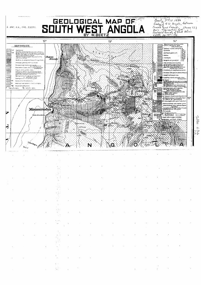
GEOLOGICAL MAP ,OF' /, sou. 8.,1., rOT, . .1'.\".\'1"[. SOUTH GDLA
V,c(.".~ "." '"' 9""""'''"' ,1·,', ~,.~',," "'."",",J.<-q."" ".,." " .... "',,,"
"-""""S "'.,""'":""-<-'-";-"''-,'''-'',. 'p r, U 11'3'",' G tJ. F1,y:/!&./ 6dl.J'(_~"'
[PL.~·I'I·; \'I.]
A/';,('>

r:~:·J
IC'2]
= C'05
= = e::m DO I),,,,,,,, '" ,\ E';,~!) ~"'-O ,"' ~d 0,_""'" Ell 09 "'",0'., v-"'" 9 ,-,,~ P ',g".;I." 'J'" Ke ,<',>c,"',' 0,;"
I
12' 13" '~MI of Greonwich
l' 1000000