cadastre in the context of sdi and inspire - clge · cadastre in the context of sdi and inspire dr....
TRANSCRIPT
Bavarian Agency for Suveying
and Geoinformation
Cadastre in the context of SDI and INSPIRE
Dr. Markus SeifertBavarian Administration for Surveying and Cadastre
Cadastre in the digital age – the approach in Germany3rd CLGE Conference, Hanover, 11.10.2012
Bavarian Agency for Suveying
and Geoinformation
1. Introduction, the development of the cadastre
2. Cadastre in a Spatial Data Infrastructure
Outline
3. Cadastre in INSPIRE
4. The German approach
5. Conclusions
Bavarian Agency for Suveying
and Geoinformation
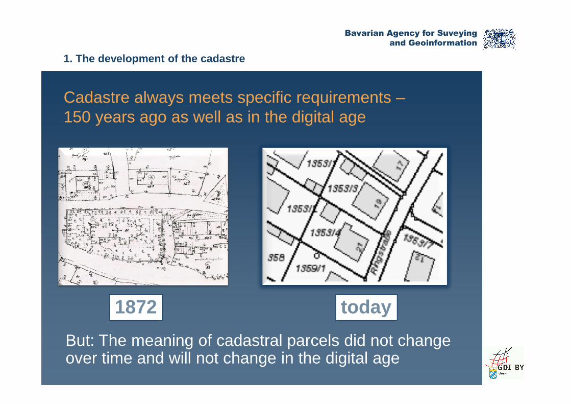
Cadastre always meets specific requirements –150 years ago as well as in the digital age
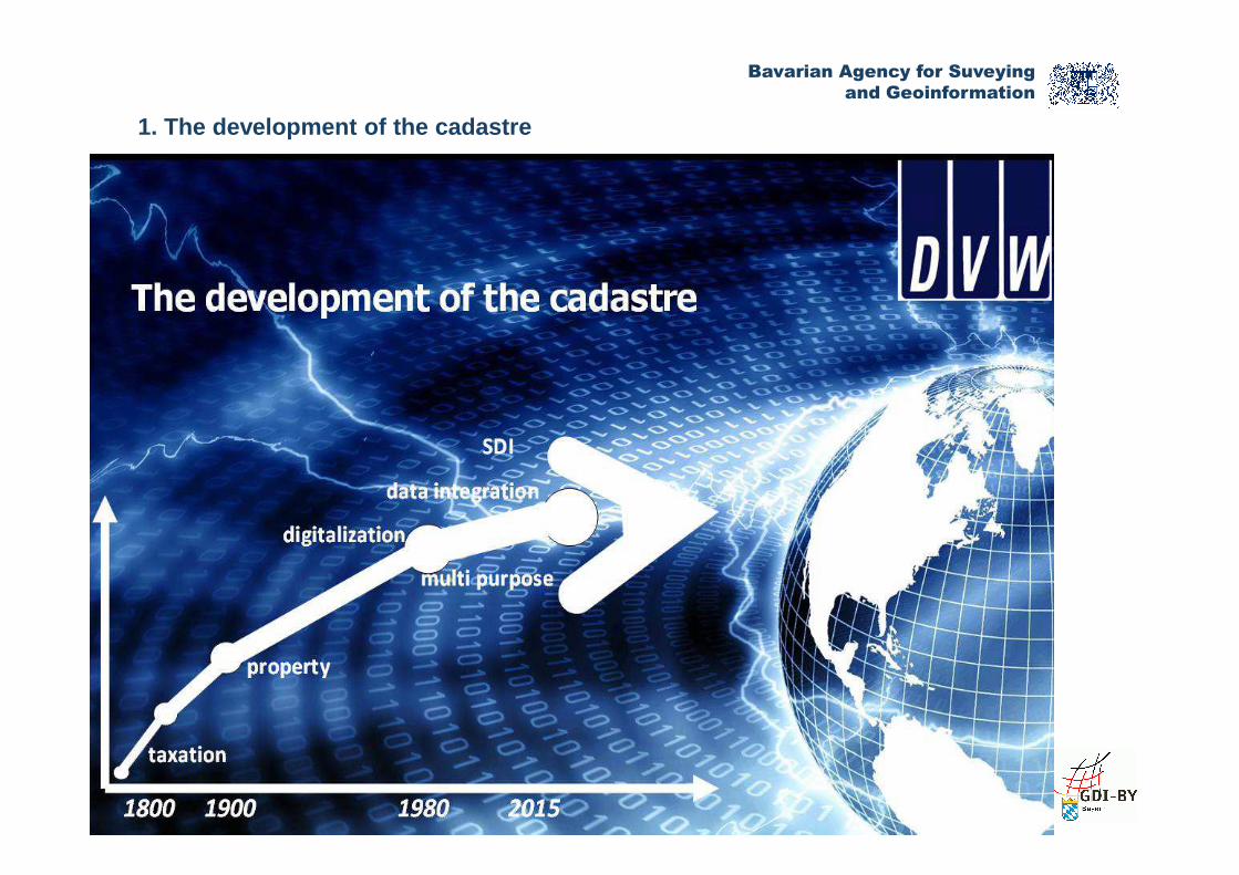
1. The development of the cadastre
But: The meaning of cadastral parcels did not changeover time and will not change in the digital age
1872 today

Bavarian Agency for Suveying
and Geoinformation
Advanced technology for cadastral information
in the 19th
century
1. The development of the cadastre
and today
Bavarian Agency for Suveying
and Geoinformation
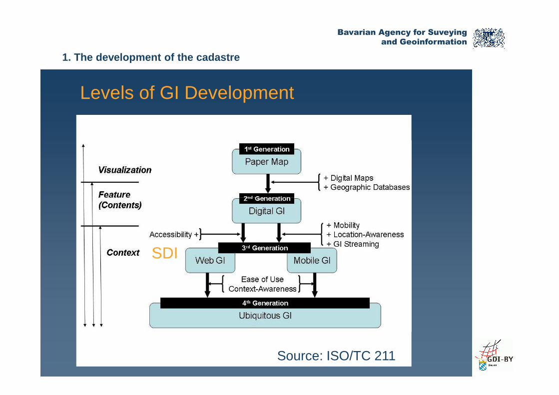
Levels of GI Development
1. The development of the cadastre
SDI
Source: ISO/TC 211
Bavarian Agency for Suveying
and Geoinformation
1. The development of the cadastre
Bavarian Agency for Suveying
and Geoinformation
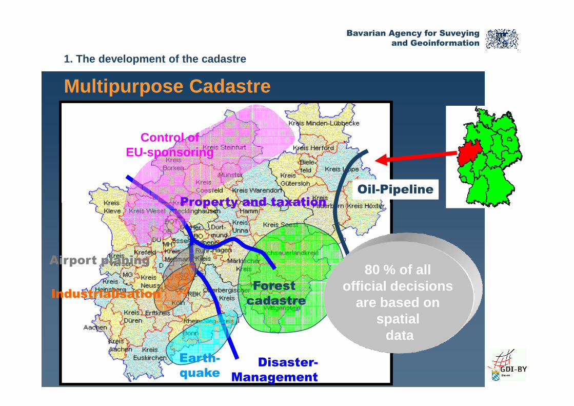
Oil-Pipeline
Control ofEU-sponsoring
Property and taxation
Multipurpose Cadastre
1. The development of the cadastre
Disaster-
Management
Airport planing
Industrialisation
Earth-
quake
Property and taxation
80 % of all official decisions
are based on spatial
data
Forest
cadastre

Bavarian Agency for Suveying
and Geoinformation
Projects of rural development Construction
permit
DistrictsMunicipalities
counties
ArchitectsConstruction
engineerGeographer
Urban planning
Grundstücksdatenbank- AGLB -
Urban renewal Land development
Multipurpose Cadastre todayMultipurpose Cadastre – data flow
1. The development of the cadastre
Road construction
Finance, banks
Notary Public
developmentpermit
Spatial planning, Environmental
protection
Agriculture and Forestry
Charted Surveyors
Land registerSOLUM-Star
CadastreALKIS
- AGLB -
ATKIS(DLM-DGM-DTK)
GRUBIS(ALB-DFK)
Real estatemanagement
Energy supplier,Post,
Water management,Military geograph. Survey

Bavarian Agency for Suveying
and Geoinformation
How can users access cadastral data today?
Client knowsdata provider
2. Cadastre in a Spatial Data Infrastructure
Data provider knows client
What do you have? Here you get the data(and pay)
Give me data That is what I have, what I can
• Data provides decide about the content to be provided• Communication by standardised web services
Bavarian Agency for Suveying
and Geoinformation
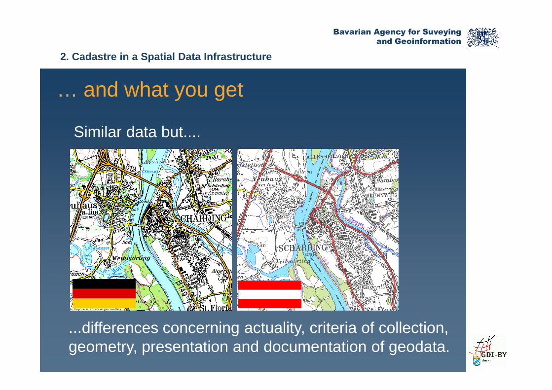
… and what you get
Similar data but....
2. Cadastre in a Spatial Data Infrastructure
...differences concerning actuality, criteria of collection, geometry, presentation and documentation of geodata.
Bavarian Agency for Suveying
and Geoinformation
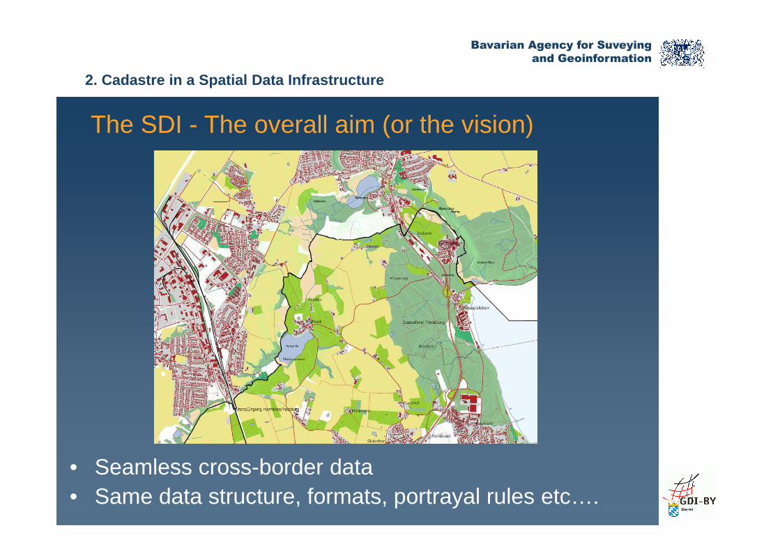
The SDI - The overall aim (or the vision)
2. Cadastre in a Spatial Data Infrastructure
• Seamless cross-border data • Same data structure, formats, portrayal rules etc….
Bavarian Agency for Suveying
and Geoinformation
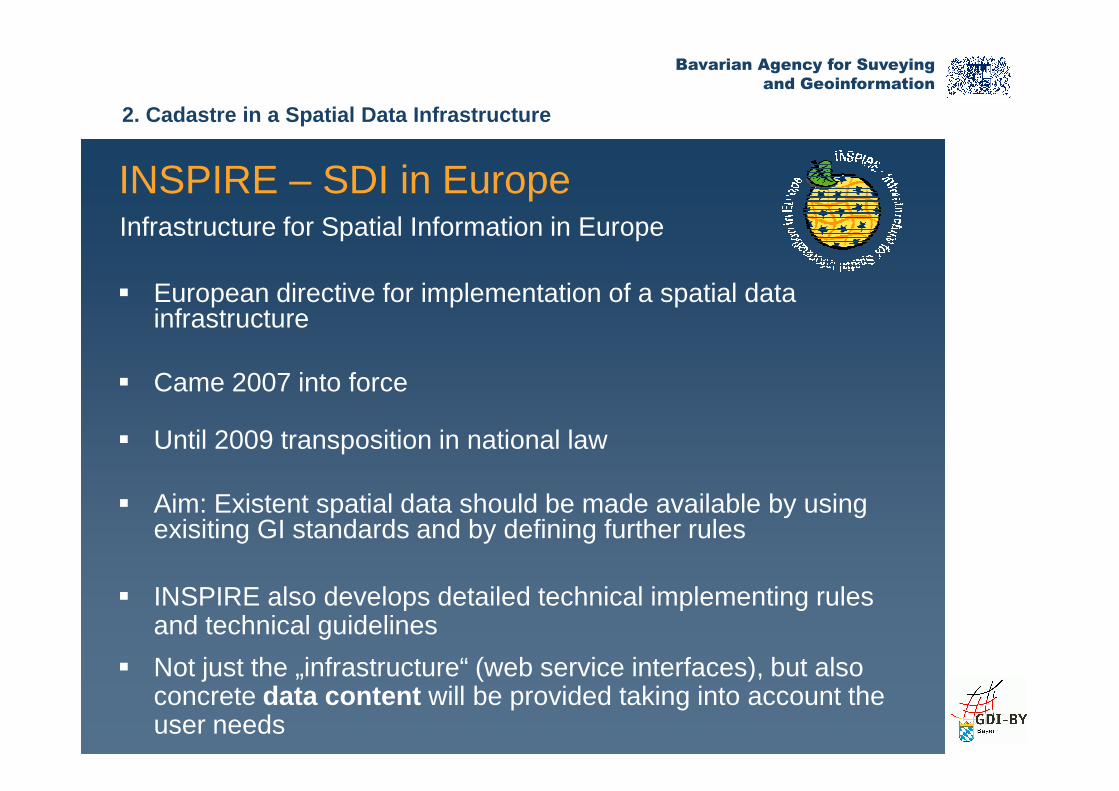
� European directive for implementation of a spatial datainfrastructure
� Came 2007 into force
INSPIRE – SDI in EuropeInfrastructure for Spatial Information in Europe
2. Cadastre in a Spatial Data Infrastructure
� Came 2007 into force
� Until 2009 transposition in national law
� Aim: Existent spatial data should be made available by usingexisiting GI standards and by defining further rules
� INSPIRE also develops detailed technical implementing rulesand technical guidelines
� Not just the „infrastructure“ (web service interfaces), but also concrete data content will be provided taking into account theuser needs

Bavarian Agency for Suveying
and Geoinformation
MetadataCatalogue
2. Cadastre in a Spatial Data Infrastructure
How can users access data in INSPIRE?
Regionalthematic data
Regionalcadastraldata
Internet
DataCountry A
Transformation
INSPIRE services
Transformation
INSPIRE services
Transformation
INSPIRE services

Bavarian Agency for Suveying
and Geoinformation
Metadata about cadastral information )
2. Cadastre in a Spatial Data Infrastructure
Bavarian Agency for Suveying
and Geoinformation
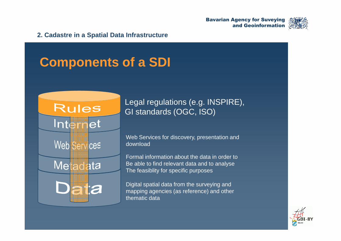
Components of a SDI
Legal regulations (e.g. INSPIRE),GI standards (OGC, ISO)
2. Cadastre in a Spatial Data Infrastructure
Digital spatial data from the surveying andmapping agencies (as reference) and otherthematic data
Formal information about the data in order toBe able to find relevant data and to analyseThe feasiblity for specific purposes
Web Services for discovery, presentation anddownload
Bavarian Agency for Suveying
and Geoinformation
Application and Geoportals
Internet
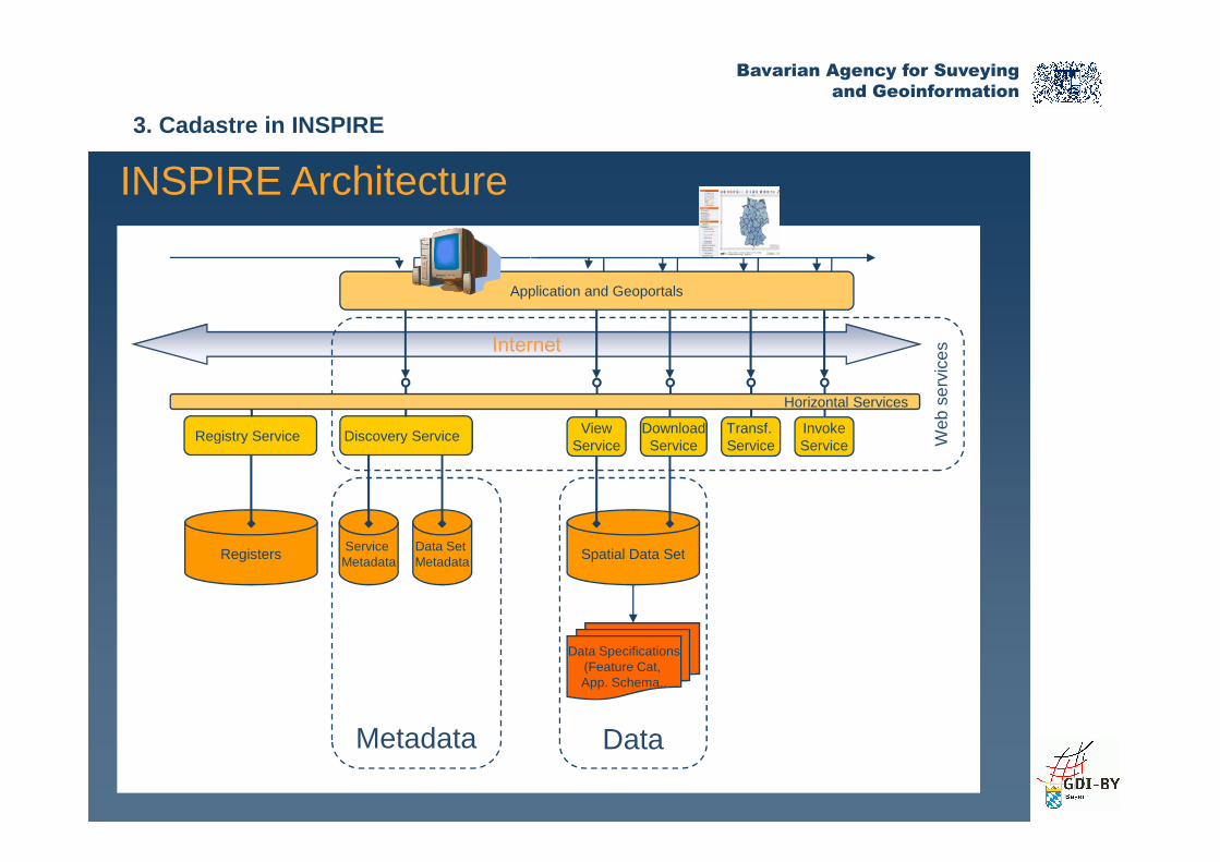
Registry Service Discovery Service View Transf. InvokeDownload
Web
ser
vice
s
Horizontal Services
INSPIRE Architecture
3. Cadastre in INSPIRE
RegistersService
MetadataData Set Metadata Spatial Data Set
Registry Service Discovery Service ViewService
Transf. Service
InvokeService
DownloadService
Data Specifications(Feature Cat, App. Schema..
Metadata Data
Web
ser
vice
s

Bavarian Agency for Suveying
and Geoinformation
Addressed data content to be harmonized
INSPIRE Annex I Annex II Annex III
• Coordinate reference systems
• Geographical grid systems
• Elevation
• Land cover
• Orthoimagery
• Statistical units
• Buildings
• Soil
• Land use
3. Cadastre in INSPIRE
systems
• Geographical names
• Administrative units
• Addresses
• Cadastral parcels
• Transport networks
• Hydrography
• Protected sites
• Orthoimagery
• Geology• Land use
• Human health and safety
• Utility and governmental services
• Environmental monitoring facilities
• Production and industrial facilities
• Agricultural and aquaculture facilities
• Demography
Etc.

Bavarian Agency for Suveying
and Geoinformation
INSPIRE specification for cadastral parcels
INSPIRE Directive
INSPIRE Technical Architecture Overview
COMMISSION REGULATION (EU) No 102/2011 of 4 February 2011 amending Regulation (EU) No 1089/2010 implementing Directive 2007/2/EC of the European Parliament and of the Council as regards interoperability of
3. Cadastre in INSPIRE
of the European Parliament and of the Council as regards interoperability of spatial data sets and services
Guidelines for Cadastral Parcels
UML Data Model
Bavarian Agency for Suveying
and Geoinformation
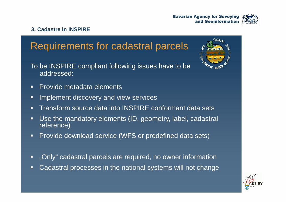
� Provide metadata elements
� Implement discovery and view services
Requirements for cadastral parcels
To be INSPIRE compliant following issues have to beaddressed:
3. Cadastre in INSPIRE
� Implement discovery and view services
� Transform source data into INSPIRE conformant data sets
� Use the mandatory elements (ID, geometry, label, cadastralreference)
� Provide download service (WFS or predefined data sets)
� „Only“ cadastral parcels are required, no owner information
� Cadastral processes in the national systems will not change
Bavarian Agency for Suveying
and Geoinformation
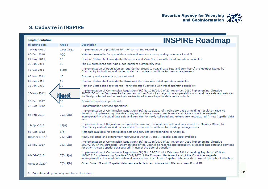
INSPIRE Roadmap
3. Cadastre in INSPIRE
Bavarian Agency for Suveying
and Geoinformation
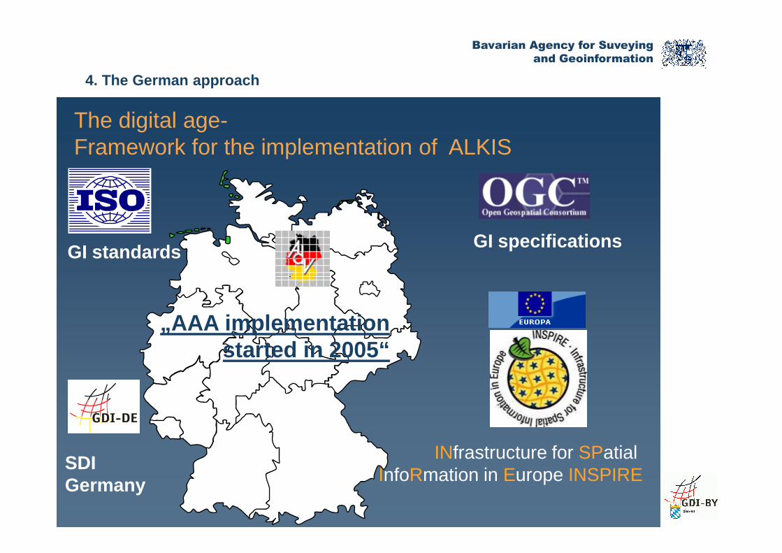
The digital age-Framework for the implementation of ALKIS
GI standards GI specifications
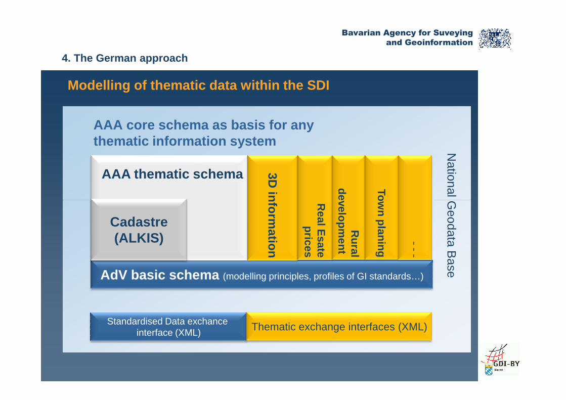
4. The German approach
„AAA implementation started in 2005“
INfrastructure for SPatial InfoRmation in Europe INSPIRE
SDI Germany
Bavarian Agency for Suveying
and Geoinformation
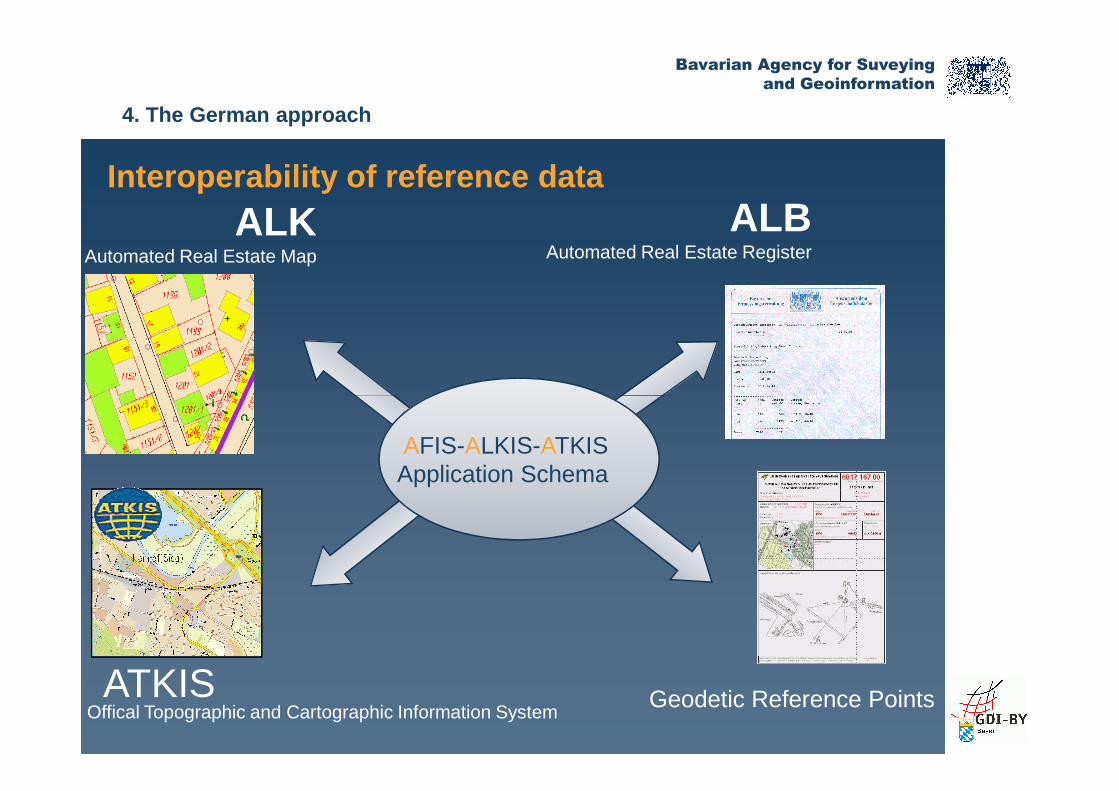
ALKAutomated Real Estate Map
ALBAutomated Real Estate Register
Interoperability of reference data
4. The German approach
Quite a lot of redundant
information
Offical Topographic and Cartographic Information System ATKIS Geodetic Reference Points
AFIS-ALKIS-ATKISApplication Schema
Bavarian Agency for Suveying
and Geoinformation
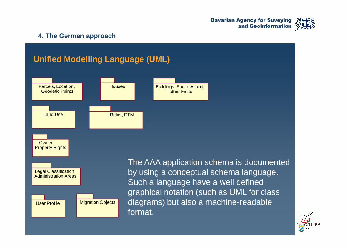
Unified Modelling Language (UML)
Parcels, Location, Geodetic Points
Houses
Land Use
Buildings, Facilities and other Facts
Relief, DTM
4. The German approach
The AAA application schema is documented by using a conceptual schema language. Such a language have a well defined graphical notation (such as UML for classdiagrams) but also a machine-readable format.
Owner, Property Rights
Legal Classification, Administration Areas
User Profile Migration Objects

Bavarian Agency for Suveying
and Geoinformation
Adoption of international GI Standards
For a maximum level of interoperability the AAA app lication schema is consequently based on ISO standards
NAS(XML-Schema)
Feature Catalogue
(HTML, RTF)
4. The German approach
19103 Conceptual schema language (UML)
19109Rules for
applicationschema
19110Feature
catalogue
19107 – 19111 Geometry, CRS
19112 – 19115 Metadata
AAA application schema
Feature Catalogue
(XML)19118 Level 1
19136 (GML) profile
Bavarian Agency for Suveying
and Geoinformation
AAA thematic schema 3D inform
ation
development
Town
AAA core schema as basis for anythematic information system
Modelling of thematic data within the SDI
National G
eodata Base
4. The German approach
AdV basic schema (modelling principles, profiles of GI standards…)
Standardised Data exchanceinterface (XML) Thematic exchange interfaces (XML)
Cadastre(ALKIS)
information
Real E
sateprices
Rural
development
Town planing
--
-
National G
eodata Base

Bavarian Agency for Suveying
and Geoinformation
Legal obligation
Current activities:Digitalization of Soil Classification
Collection of new data based on cadastre
4. The German approach
Users:
• Finance authorities
• Rural development
• …

Bavarian Agency for Suveying
and Geoinformation
Data Sources Scale 1:1 000
Current activities:Registration of land use information
4. The German approach
Data Sources
• Cadastre map, DOP
• Field units
• Topography(ATKIS)
Bavarian Agency for Suveying
and Geoinformation
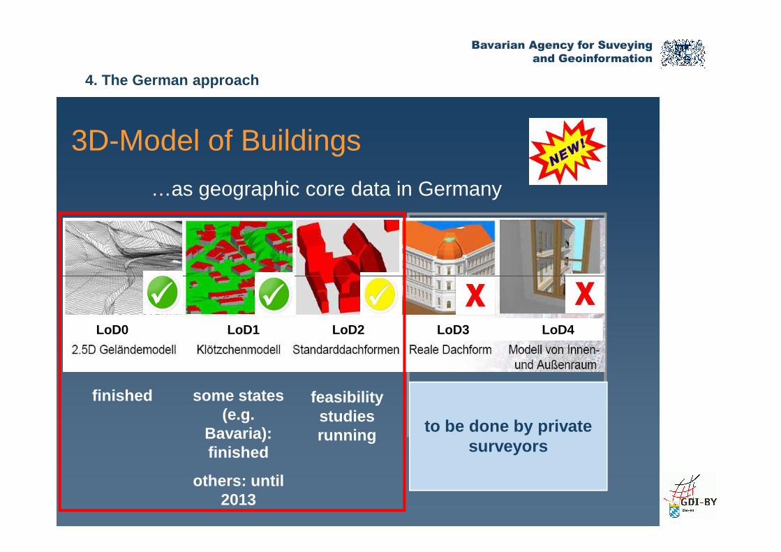
3D-Model of Buildings
…as geographic core data in Germany
4. The German approach
feasibilitystudiesrunning
finished
to be done by private surveyors
some states (e.g.
Bavaria):finished
others: until 2013
LoD0 LoD1 LoD2 LoD3 LoD4
Bavarian Agency for Suveying
and Geoinformation
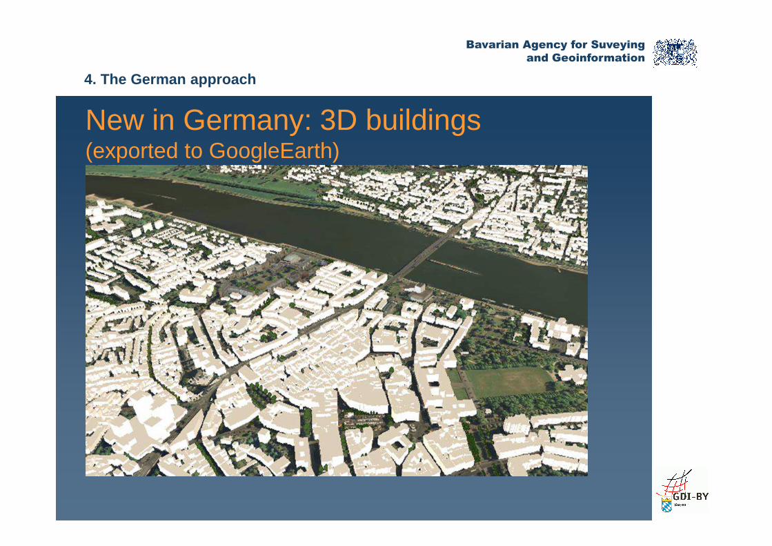
New in Germany: 3D buildings(exported to GoogleEarth)
4. The German approach
Bavarian Agency for Suveying
and Geoinformation
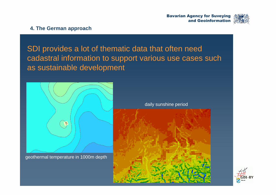
SDI provides a lot of thematic data that often needcadastral information to support various use cases such as sustainable development
4. The German approach
geothermal temperature in 1000m depth
daily sunshine period
Bavarian Agency for Suveying
and Geoinformation
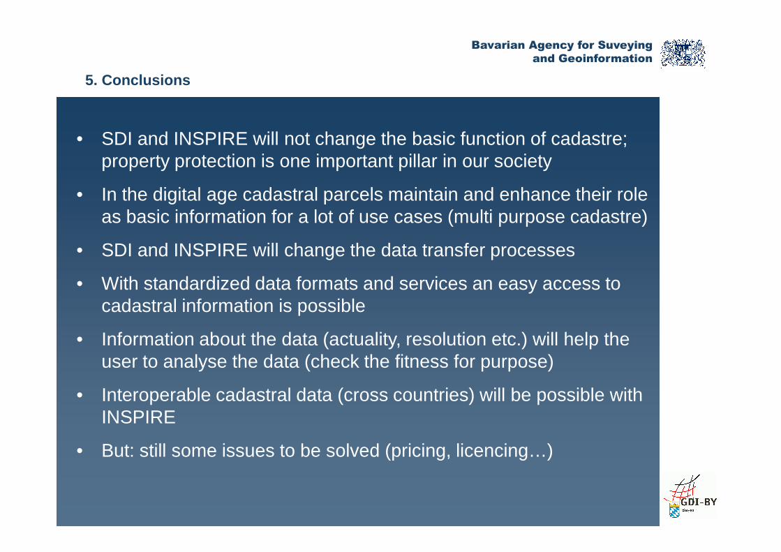
• SDI and INSPIRE will not change the basic function of cadastre; property protection is one important pillar in our society
• In the digital age cadastral parcels maintain and enhance their role as basic information for a lot of use cases (multi purpose cadastre)
• SDI and INSPIRE will change the data transfer processes
• With standardized data formats and services an easy access to
5. Conclusions
• With standardized data formats and services an easy access to cadastral information is possible
• Information about the data (actuality, resolution etc.) will help the user to analyse the data (check the fitness for purpose)
• Interoperable cadastral data (cross countries) will be possible with INSPIRE
• But: still some issues to be solved (pricing, licencing…)

Bavarian Agency for Suveying
and Geoinformation
Thank you for your kind attention!
Contact details:
Dr. Markus SeifertSDI Office Bavaria� Alexandrastr. 4, 80538 Munich, Germany� +49 89 2129 1002� [email protected]