catastro 2014 beyond
DESCRIPTION
Revisión de avances y tendencias tras la publicación original Catastro 2014TRANSCRIPT

FIG REPORT
CADASTRE 2014 and Beyond
FIG PUBLICATION NO 61
Editor
Daniel Steudler
International Federation of Surveyors (FIG)
Federal Office of Topography swisstopo, Wabern, Switzerland
SUPPORTED BY


CADASTRE 2014 and Beyond
Edited by Daniel Steudler

Copyright © The International Federation of Surveyors (FIG), May 2014.
All rights reserved.
International Federation of Surveyors (FIG) Kalvebod Brygge 31–33 DK-1780 Copenhagen V DENMARK
Tel. + 45 38 86 10 81 E-mail: [email protected] www.fig.net
Published in English
Copenhagen, Denmark
ISSN 1018-6530 (printed) ISSN 2311-8423 (pdf ) ISBN 978-87-92853-12-7 (printed) ISBN 978-87-92853-13-4 (pdf)
Published by International Federation of Surveyors (FIG)
Front cover: The Cadastre 2014 graphic by Werbegraphik Bruno Teucher, Rüdlingen, Switzerland. © Jürg Kaufmann and Daniel Steudler. Back cover: Cadastral reconstruction with overlay maps for field verification. Photo-graph by Alexander Kohli.
Editor: Daniel Steudler
Layout: Lagarto
Printer: 2014 Hakapaino, Helsinki, Finland

CONTENTS
LIST OF FIGURES AND TABLES ...................................................................................................... iv
FOREWORD .............................................................................................................................................. v
INTRODUCTORY REMARKS ..............................................................................................................1
1 THE CADASTRE 2014 JOURNEY ..........................................................................................2
2 CADASTRE 2014: A BEACON IN TURBULENT TIMES .................................................5
3 REVIEW AND IMPACT OF THE SIX STATEMENTS OF CADASTRE 2014 .................................................................................................................10
4 DEVELOPMENTS OUT OF CADASTRE 2014 INTERNATIONALLY AND IN SWITZERLAND IN PARTICULAR .......................................................................18
5 CASE STUDIES FROM NEWLY RENOVATED LAND ADMINISTRATION SYSTEMS IN THE EMERGING ECONOMIES ............24
6 CADASTRE 2014 – A CASE STUDY FROM SOUTH KOREA ....................................29
7 LADM AND ITS ROLE IN ESTABLISHING CADASTRAL SYSTEMS .....................34
8 IMPLEMENTATION OF LADM WITH INTERLIS ............................................................39
9 AN INTEGRATION PLATFORM FOR A SPATIALLY ENABLED SOCIETY ...........43
10 CADASTRE 2014 IN RELATION TO SPATIAL DATA INFRASTRUCTURE (SDI) .......................................................................49
11 CADASTRE 2014: WHAT LIES BEYOND? ........................................................................54
12 FROM CADASTRE TO LAND GOVERNANCE: A CADASTRE 2014 OUTLOOK ............................................................................................60
CONCLUDING REMARKS .................................................................................................................67
ABOUT THE CONTRIBUTING AUTHORS ...................................................................................68
ACKNOWLEDGEMENTS ....................................................................................................................72

iv
LIST OF FIGURES AND TABLES
Figure 1 The cadastral concept. 3
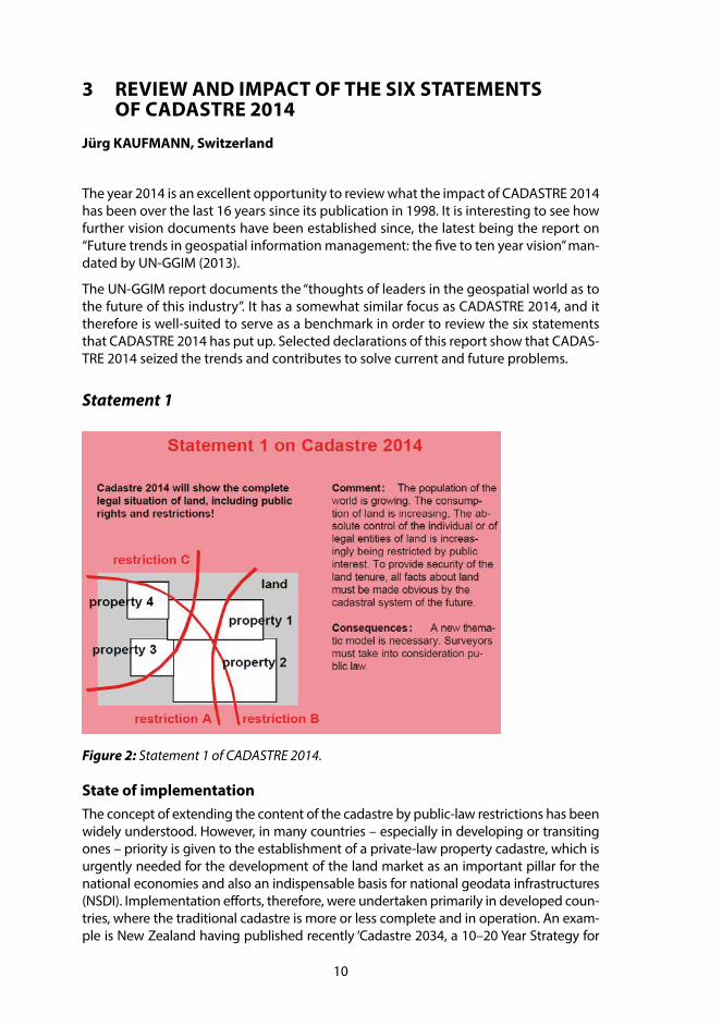
Figure 2 Statement 1 of CADASTRE 2014. 10
Figure 3 Statement 2 of CADASTRE 2014. 11
Figure 4 Statement 3 of CADASTRE 2014. 12
Figure 5 Statement 4 of CADASTRE 2014. 13
Figure 6 Statement 5 of CADASTRE 2014. 14
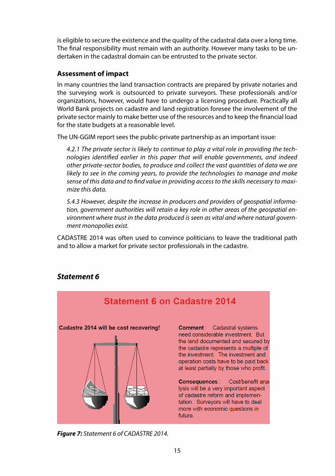
Figure 7 Statement 6 of CADASTRE 2014. 15
Figure 8 The four basic principles for a common data integration concept. 20
Figure 9 Concept of the Cadastre on Public-Law Restrictions (PLR-Cadastre) in Switzerland.
22
Figure 10 18 registers of the Real Estate Integrated Public Registration System. 30
Figure 11 The ratio of public and private work conducted in cadastral surveying in areas open for the free market.
32
Figure 12 The LADM International Standard. 35
Figure 13 The continuum of land rights (from UN-HABITAT, 2008, p. 8). 36
Figure 14 Class LA_Party as UML diagram and INTERLIS description. 41
Figure 15 Aggregation and inheritance in UML and INTERLIS. 41
Figure 16 Architecture of GeoApps. 44
Figure 17 Start window of PLR-Cadastre (http://map.gis-daten.ch/nw_oereb). 45
Figure 18 Dynamic extract with spatial and textual results. 46
Figure 19 Map with highlighted perimeter to easily identify the geometrical extent of a restriction.
46
Figure 20 The cadastre as core of SDI, SES and ultimately sustainable development. 52
Figure 21 A first attempt from 2010 – for the Australian context. 56
Figure 22 Delivering design, implementation and assessment tools that satisfy emerging societal drivers – a vision for future cadastres?
57
Figure 23 Evolution of Western cadastral system (developed from Williamson et al., 2010). 60
Figure 24 Key FIG publications include the FIG Statement on the Cadastre (FIG, 1995), The Bogor Declaration (FIG, 1996), Cadastre 2014 (Kaufmann and Steudler, 1998), and The Bathurst Declaration (FIG, 1999).
61
Figure 25 A CADASTRE 2014 outlook. 63
Table 1 Size of the Korean cadastral system. 29
Table 2 Annual progress of the joint execution project. 32

v
FOREWORD
What was a simple activity report of Working Group 1 within FIG Commission 7 “Cadas-tre and Land Management” in 1998, has over the years been translated into 28 languag-es and was a topic in many forums, panel discussions, roundtables and journal articles. This simple activity report became a visionary publication, found its way into confer-ence halls and lecture theatres, and became a reference publication in many teaching and research institutions. It triggered researches, promoted additional considerations on issues related to cadastral systems, including developments such as the “Cadastral Template” and in the field of “Spatial Data Infrastructures”. It also impacted and led to-wards the recently published FIG Report on “Spatially Enabled Societies” in May 2012. CADASTRE 2014 became a “brand” by itself.
Though CADASTRE 2014 represents the collective efforts and knowledge of many, con-gratulations are in order, especially to both Jürg Kaufmann and Daniel Steudler for their untiring efforts over those many years that led to this definitive publication. Also to be congratulated are Ian Williamson, the Chair of FIG Commission 7 at that time as well as the FIG Council presided by Peter Dale. CADASTRE 2014 represents not just ideas and concepts, but passion and abilities to better comprehend and apply evolving cadastral concepts.
We are on the threshold of the Post-2015 UN Development Agenda. Last year, the Unit-ed Nations High-level Panel of Eminent Persons in its report focusing on “New Global Partnership: Eradicate Poverty and Transform Economies through Sustainable Devel-opment” proposed how new goals and measurable targets could be framed in the wake of proposed transformative shifts. We do note that “Land” was mentioned some 23 times within this document. I trust “CADASTRE 2014 and Beyond” is the beginning of yet another collective and definitive efforts within FIG to contribute towards unlock-ing the potential of what “Land” is; by “Land” we also mean the seas and its natural resources, for the well-being and betterment of humanity. Our profession is tempted to look at our past and present achievements, but foresight is about considering the chal-lenges of the future, the evolving contribution and relevance of the cadastre towards the “World We Want”.
It is most fitting that at the silver jubilee Congress of FIG to be held in Kuala Lumpur, Malaysia this year with the theme “Engaging the Challenge: Enhancing the Relevance” that we celebrate the immense success of CADASTRE 2014 Vision and launch this new publication on “CADASTRE 2014 and Beyond”.
We congratulate all contributors and in particular, Daniel Steudler, the editor for all their efforts towards this publication. We extend our deep appreciation and gratitude to our Membership and the corps of volunteers within our Federation for their invalu-able and unselfish contributions in this publication and its related endeavours.
CheeHai Teo President FIG
April, 2014


1
INTRODUCTORY REMARKS
CADASTRE 2014 has been published in 1998 as a result of a working group of FIG-Commission 7. The working group, active from 1994–1998, had the mandate to identify trends in the cadastral field and to suggest whereto the cadastre might go for the next 20 years.
The working group carried out two questionnaires in order to identify the trends and came up with six vision statements, provocative for some, innovative for others. The publication presented and explained those six vision statements, suggested some new definitions in order to make the visions possible, and also made some recommenda-tions for action.
As the year 2014 has arrived, it is very appropriate to take the topic up once more, to review the statements, to evaluate them and to put them in context. The XXV FIG-Congress taking place in June 2014 is an excellent opportunity to do that: two special sessions are part of the congress program and the sections included in this publication will be presented and discussed.
2
1 THE CADASTRE 2014 JOURNEY
Ian WILLIAMSON, Australia
It is with regret that I cannot be in Kuala Lumpur to personally congratulate Jürg Kauf-mann and Daniel Steudler on their excellent work over many years on bringing the CADASTRE 2014 vision to fruition. Jürg was the Chair and Daniel the Secretary for the Commission 7 Working Group from 1994–98 that produced CADASTRE 2014. However their contribution was much more than coordinating the working group for the CA-DASTRE 2014 vision and concept. The resulting FIG report on CADASTRE 2014, co-au-thored by Jürg and Daniel, reflected many of their own ideas and concepts, but just as importantly showed their on-going passion to better understand the evolving cadas-tral concept. Thank you Jürg and Daniel for a job well done.
However an understanding of the CADASTRE 2014 journey requires an appreciation of the evolving nature of Commission 7 over a ten year period spanning the 1990s. This period saw the Commission evolve from being European centric concentrating on land consolidation to a global focus on cadastre, land administration and sustainable development in both the developed and less developed worlds. This evolution paral-leled the growth of the FIG itself from a Northern hemisphere focus to a truly global organisation with the election of an Australian President, Earl James and an Australian Bureau, the first in the Southern hemisphere and the first in the Asia and Pacific region, in the early 1990s.
Due to difficulties with the Bulgarian Chair of Commission 7 fulfilling his duties, I be-came acting Chair of Commission 7 in 1992 and was elected Chair for 1994–98. The sec-retariat of the Commission also changed from a permanent home in Paris to Australia, a change that initially caused some concerns but was welcomed over time. During this period, Commission 7 transitioned to having a global focus on cadastre, land adminis-tration, land management and sustainable development.
The first major step was changing the name and focus of the commission to “Cadastre and Land Management”. This was accompanied by a broadening of the mandate of the Commission, a change hotly debated in FIG. This was not an insignificant development since it reflected a change of focus from the “old world” to the “new world”. The change in name was also reflected in a major campaign to promote the Commission but also to clarify its role and consolidate its mandate.
It is important to acknowledge at this stage that this change and transition would not have been possible without the strong support of the President and Bureau of FIG, and particularly the support and vision of country delegates such as Professor Jo Henssen from The Netherlands and Professor Andrzej Hopfer from Poland, two of the fathers of Commission 7.
Another key step in the process was a request from the FIG Bureau to clarify the defi-nition of “cadastre”. This was critical since there were almost as many interpretations of what constituted a “cadastre” as there were FIG member countries. After many discussions spanning several Commission 7 meetings the FIG Statement on Cadas-tre was approved in 1995 as FIG Publication No. 11 (available in 11 languages). The graphic (Figure 1) that reflects the concept also gained a life of its own and has been universally used.

3
Commission 7 continued to explore the role of the cadastre in land management, land administration and in sustainable development, together with the United Nations. This resulted in the joint FIG-UN Bogor Declaration as part of a United Nations Interregional Meeting of Experts on the Cadastre in 1996 that set out a cadastral vision and listed a range of cadastral issues (FIG Publications No. 13A and 13B). This was followed by the joint FIG-UN Bathurst Declaration on Land Administration for Sustainable Develop-ment with the theme “Land Tenure and Cadastral Infrastructures for Sustainable Devel-opment” in 1999 (FIG Publication No. 21).
During this period the Commission continued to discuss and better understand the ca-dastral concept and the role of the cadastre globally. This included a major focus on benchmarking cadastral systems, again an initiative that Daniel Steudler and Jürg Kauf-mann were heavily involved. This initiative was the focus of the Commission 7 Annual Meeting in Malaysia in 1997 with the results causing considerable animated discussion. The work was continued by Daniel and Jürg with the Commission 7 Working Group re-port on “Benchmarking Cadastral Systems” being presented to the FIG General Assem-bly in 2002.
Figure 1: The cadastral concept.

4
The above are only some of the key reports and initiatives, on trying to better under-stand the role of cadastres globally. They reflect the changes that were occurring in Central and Eastern Europe in the 1990s with the move from command to market econ-omies and the role of the European Union in promoting sustainable and market driven land administration systems, with the UN-ECE Guidelines on Land Administration (ECE/HBP/96 ) being central. It also reflects a change in technology that saw the creation of state and national digital cadastral databases that eventually supported the growth of spatially enabled societies. It was in this context and environment that Commission 7 decided to establish a Working Group in 1994 to research and debate what a future cadastre would look like in 20 years i.e. in 2014. The Working Group was chaired by Jürg with Daniel providing critical support as secretary. It brought down its major report in 1998 at the FIG General Assembly in Brighton UK. CADASTRE 2014 has now been translated into 28 languages. However the concept and vision gained a life of its own and has gone from strength to strength, not least due to the drive and commitment of Daniel and Jürg (www.fig.net/cadastre2014).
Commission 7 continues to research and debate the role of the cadastre in both devel-oped and less developed countries. One ongoing initiative is the Cadastral Template where different countries complete a standardized template so that it is possible to compare and contrast strengths and weaknesses (www.cadastraltemplate.org). The cadastral template was mandated by a UN Resolution at the 16th United Nations Per-manent Committee for GIS Infrastructure for Asia and the Pacific at the time I was Chair of the Permanent Committee’s Working Group on Cadastre. To date 47 countries have completed the template (www.fig.net/cadastraltemplate/). The Cadastral Template has been jointly managed by the FIG and the Centre for Spatial Data Infrastructures and Land Administration, University of Melbourne, however a huge thank you must go to Daniel Steudler for maintaining the Template and keeping the vision alive. Thank you Daniel!
The above is just a snapshot that gives an insight into how the cadastral concept con-tinues to evolve and highlights the central role that the FIG and particularly Commis-sion 7 has played. This cadastral journey has been assisted by all delegates to Com-mission 7, past and present and is testament to the commitment of the chairs, office bearers and working group chairs and members, of the Commission. However there is no doubt that CADASTRE 2014 has played a central role in this evolution and in this regard Jürg Kaufmann and Daniel Steudler stand out as the key players providing the drive and commitment to allow the CADASTRE 2014 vision to come to fruition.
Thank you Jürg and Daniel!
5
2 CADASTRE 2014: A BEACON IN TURBULENT TIMES
Paul VAN DER MOLEN, The Netherlands
Since the publication of the booklet CADASTRE 2014 in 1998, the International Federa-tion of Surveyors (FIG) witnessed global developments making the quest for efficient and effective cadastres increasingly manifest. Although the term ‘cadastre’ became a bit maligned, because ‘cadastres’ were too much associated with Western type fully fledged and state guaranteed property titles; global trends indicate that still ‘some-thing’ is needed to provide land tenure security for unregistered owners or users of land. That ‘something’ has often been phrased as a ‘land administration system’, a ‘land recordation system’, a ‘land information system’ or alike, but when the origin of the word ‘cadastre’ (namely ‘list’) is considered we might also say that this ‘something’ is a ‘cadas-tre’. This section looks at these global developments with a focus on rapid urbanization, food security, climate change and informal economies, because these developments in particular are high on the global political agenda: that is to say, often within the overall goal of poverty eradication. Time and again, the solution – sometimes a major one, sometimes a minor one – is found to be related to providing tenure security for the poor, irrespective if they are slum dwellers (urbanization), farmers (food security), land users and forest dwellers (climate change) or unregistered citizens (informal econo-mies). But it is clear from a myriad of research that fully fledged property titles are not considered to be the appropriate solution to achieve that goal. The demand today is for the recognition of a variety of human-land relationships, adopted in the meantime by the UN as the ‘continuum of land rights’ (see also section 7 of this publication). The urge for low-cost information systems to provide for fast and cheap recording of these different types of rights has become pervasive over the last decades. The statements and principles of CADASTRE 2014 in the 20 years of existence after their publication did not lose strength in providing guidance to the design of such ‘fit-for-purpose’ cadastres.
Global developmentsThe first development to be highlighted is the rapid urbanization. With a world popu-lation of 6.9 billion people in 2011, it was for the first time in history that a majority of people live in urban areas. In 2050, the share of the urban population is estimated to be 67%. The population growth, therefore, mainly happens in the cities.
But also the share of the urban population living in slum conditions is increasing: while in 1990 the number of slum dwellers was 656 million, the number grew to 766 million in 2000 and to 827 million in 2010. Because of the growing urban population in general, the percentage as such declines: from 46% in 1990, to 39% in 2000 and to 32% in 2010.
To meet the requirements of sustainable cities, a twin track approach is needed, which consists of (a) prevention of future slum formation and (b) slum upgrading. Preven-tion of future slum formation is a matter of urban planning: it is widely observed that conventional ways of urban planning (the ‘master plan’ approach) completely fails to deliver appropriate livelihood for the growing number of inhabitants.
When upgrading slums, property rights are considered critical for sustainable approach-es, besides better governance, financial systems, and social frameworks. Although em-ployment remains of major importance, frequently, development of informal settle-
6
ments is hampered by conflicting and unrecorded ownership claims and double or multiple sale of the same plot of land. Providing jobs and improvements of the physical environment should create a social environment where slum residents can improve their livelihood with social and tenure security as a fundament. In addition to the need for new forms of spatial planning with their associated need for relevant spatial and non-spatial information, there is a manifest need to deliver quick and cheap ‘cadastres’ adopting methods of recording various types of land tenure, fitting into the modern approach to slum upgrading. So, urbanization requires ‘fit-for-purpose’ cadastres.
With regard to food security, the situation currently is that about 868 million people are undernourished, which corresponds to 12.5% of the world’s population. Problems are getting worse. Providing food for 9.5 billion people in 2050 requires a 70% increase of the global food production and up to 100% more in developing countries. This produc-tion growth can be realized for 80% by higher yields and increased cropping intensity and for 20% by land expansion: globally, it is estimated that in general 4.2 billion ha is suitable for agriculture, of which 1.6 billion ha already is being cultivated. Africa holds 60% of the area of uncultivated lands. Analyses show that another 120 million ha of cul-tivated land is required: in Latin America 52 million ha and in Africa 64 million ha; 32 mil-lion ha also need to be irrigated. The total yield increase is then potentially 68% in Africa, 89% in East/North Africa, 53% in Latin America, 86% in South Asia and 81% in East Asia.
To boost the agricultural production, two kind of measures are considered to be nec-essary, namely (a) a change of institutions and policies and (b) a change of technical approaches.
The technical approach assumes the availability of improved crop varieties, better use of water, more use of fertilizers, better control of pests and diseases, improve low mech-anisation, better roads, better electricity supply, and improvement of the currently very limited technology transfer and adoption.
From an institutional approach, constraints and barriers should be removed in the field of i) incentive structures, ii) land and water institutions and access to land and water resources, iii) collaboration, iv) services including knowledge exchange, research and finance, and v) access to markets. Especially the access to and management of land and water needs to be improved markedly; the lack of clear and stable land and water rights and weak regulations and enforcement has contributed to many conflicts over land access and competition for water use. In particular, the inclusion of customary and tra-ditional use rights in national legislation is urgently needed; land and water institutions can be strengthened and common property systems should be protected in order to providing secure land tenure.
Recognizing that many institutional and technical factors play a role, it remains that when the ‘land question’ is not brought to a proper solution, problems around land and water rights will severely obstruct the progress in achieving food security. The reg-istration of land and natural resource rights is critical to providing security to people in rural areas and to enable them to negotiate from a better position with both investors and government. However, levels of rights registration are very low in many parts of the world, especially in Africa. At the current rate of operation, such systems will take decades to cover the territory of many countries’, says FAO. This is the real challenge.
When it comes to climate change, it is noted that land makes up a quarter of the earth’s surface and its soil and plants hold three times as much carbon as the atmos-
7
phere. More than 30% of all greenhouse gas emissions (GHG) arise from the land use sector. Livestock-related emissions of carbon and methane account for 14% of the total GHG emissions, more than the transport sector. Deforestation, agriculture and livestock grazing are the major land use changes that increase the release of carbon into the at-mosphere (31% of human-induced GHG emissions). Land use changes and the burning of fossil fuels such as oil and coal are the two dominant elements. At the same time, it is essential to recognize that agriculture has the largest sequestration potential, which makes it unique. Other sectors can only reduce their emissions, while agriculture also can remove carbon from the atmosphere.
As said in the paragraphs on urbanization and food security, there are many measures needed but amongst them ‘land tenure’ and ‘land use management’ are expected to contribute significantly. Unspecified property rights in forest areas and the allocation of forest land to commercial users by governments have led to widespread deforestation as a result of uncontrolled logging and conversion of forest land to other use.
Tenure security is central to the sustainable management of land and other natural resources and should be mainstreamed into climate change mitigation and adaptation schemes.
In conclusion, sustainable monitoring systems, land management systems and ‘fit-for-purpose’ cadastres should serve as a basis for climate change mitigation and adapta-tion as well as for prevention and management of related natural disasters.
Currently, the informal economy is still substantially present in many countries. Eco-nomic activities require good rules; these rules include rules which establish and clarify property rights, reduce the costs of conflicts, increase the predictability of economic interactions, and provide contractual partners with protection against abuse. The in-tegration of the informal and the formal economy is therefore steady UN-policy. This means, that informal settlements inevitably will be connected to the formal economy in the future. Leaving informal economic transactions unrecorded is unsatisfactory: how can we maintain that a country shows economic growth when a major part of the economy is unrecorded? How can we speak about GDP per capita when countries don’t know the number of citizens? But the problem of informality is worse: most poor peo-ple in Asia and Africa render unseen because of the lack of up to date civil registration systems. By consequence they are born and die without ever being counted. Bringing informality to formality therefore has an aspect of being counted, being registered.
Bringing the informal into the formal systems has always been the goal of land re-form. Although experiences in the past are not always encouraging, the debate was reopened 10 years ago by de Soto, urging for the creation of a legal property system that does justice to the way people in the informal sector deal with possessions, their attitudes and their informal arrangements. Linking informality and formality is to a cer-tain extent a matter of recording. When it comes to immovable things, ‘fit-for-purpose’ cadastres should contribute.
In conclusion, the demand is clear: more than ever before, sustainable monitoring sys-tems, land management systems, and land administration systems (‘cadastres’) need to serve as a basis for tackling rapid urbanization, food insecurity, climate change, and informality. The way how governments deal with the land issue is increasingly phrased as ‘land governance’. Land surveyors should develop the capacity to address a broad range of people-to-land relationships and provide low cost methods for quick record-

8
ing processes, including safeguarding sustainability through sound maintenance and updating mechanisms.
Brief reflection on the statements of CADASTRE 2014It will be difficult to achieve the above mentioned social goals without innovative ‘ca-dastres’. Let’s review the statements of CADASTRE 2014 with regard to their future role in this innovation, beginning with the first one. In ‘The Economist’ (11 January 2014) we can read what we also know from scientific publications, namely that in general state owned lands are not well managed; also an inventory of such lands is often missing. The same counts for public-law restrictions imposed on private land. As many govern-ments own large tracts of land, the solution of many societal problems depends on how these lands and other public interests are managed. Therefore, the first statement, that CADASTRE 2014 includes both private and public rights to lands, has had great predictive value.
The separation of maps and registers still hampers the development of information infrastructures, which are needed to streamline information-based governance. Thus the second statement, linking maps and registers equally remains true.
The quest for innovative systems cannot be answered without digital technology. The demand for systems that are ‘cheap’, ‘easy to operate’, ‘quickly perform’, to be handled by ‘low educated’ people, requires high-tech solutions. Often ‘low-cost’ is associated with ‘low-technology’, but the reverse is true: without high-tech, no good and at the same time simple systems are possible, and without high-tech it will not be possible to employ operators with limited vocational education. The widespread use of mobile technology and location devices is one example. Therefore we need high-tech, which means technical system design based on conceptual cadastral modelling, as expressed by the third statement.
In this context, the adoption of the land administration domain model by the ISO as a worldwide standard is significant, meanwhile embraced by many countries and adopt-ed by the UN/Habitat as a precondition for future ‘cadastres’ (see also section 7). Work-ing manually has proven to be cumbersome when it comes to ‘big data’: working with ‘pen and pencil’ as the fourth statement says, is not sustainable.
Statements 5 and 6, about the ‘privatized cadastre’ and the ‘cost recovering’ cadastre’ are statements of an organizational nature, which might guide political decisions when ap-propriate. Reckoning that globally the majority of lands (‘parcels’) is not surveyed or re-corded, a prediction is that land surveyors – both from public and private sectors – need to work together to get the job done (‘all hands on deck’), which does not necessarily create a ‘privatized cadastre’, but at least a robust private sector involvement. Further pri-vatization will anyhow be considered within the framework of public tasks (governance issue). Cost recovery of at least the maintenance costs is definitely on the global agenda, although the financial crisis from 2008 also reveals the darker side of the coin, as can be seen in Annual Reports and Accounts from various EuroGeographics members in Europe.
In sum, CADASTRE 2014 is a fundament for solving societal problem as described in the previous paragraphs. For designers of these future cadastres CADASTRE 2014 will remain a guiding set of statements and principles to take care of.

9
Conclusions and laudatioIndeed, with so many global issues developing at full scale during the last twenty or so years, the quest for purposeful land information and land information systems or ‘ca-dastres’ is manifest: whether we review policy documents on urbanization, food short-age, climate change or economic growth, one way or another security of land tenure is mentioned as a prerequisite for tackling the problems. Recognizing that concepts of land information systems (‘cadastres’) and other land related services is an urgent need, CADASTRE 2014 has been a beacon in this turbulent world, providing the general statements and principles for thinking about ‘cadastres’ and guiding governmental and non-governmental organizations to getting their things right. The translation of the document in some 28 languages is an unparalleled performance. The global survey-ing community honours the lead-authors Jürg Kaufmann and Daniel Steudler for their excellent work.
ReferencesAugustinus, C. (2009). Improving access to land and shelter. World Bank, 2009.
de Soto, H. (2000). The Mystery of Capital. Basic Books, Perseus Books Group.
FAO (2012). Voluntary Guidelines on Responsible Governance of Tenure. Rome, Italy.
HLPE (2011). Land tenure and international investments in agriculture. FAO, Rome, Italy.
Jerven, M. (2013). Poor Numbers. Cornell University Press, London, UK.
Payne, G. (2005). Getting ahead of the game: a twin track approach to improving exist-ing slums and reducing the need for future slums. Environment and Urbaniza-tion, Vol. 17, No.1.
Quan, J. and N. Dyer (2008). Climate Change and Land Tenure. IIED/FAO Land Tenure Working Paper No. 2.
Schneider, F. (2002). Size and measure of the informal economy in 110 countries around the World. Canberra, Australia.
UN (2011). World Population Prospects: The 2010 Revision. New York, USA.
UN (2012). World Urban Prospects 2011 Revision. April 2012, New York, USA.
UN/Ecosoc (2012). Ministerial Declaration on promoting productive capacity.
UN/Habitat (2008). State of the World’s Cities. Nairobi Kenya.
10
3 REVIEW AND IMPACT OF THE SIX STATEMENTS OF CADASTRE 2014
Jürg KAUFMANN, Switzerland
The year 2014 is an excellent opportunity to review what the impact of CADASTRE 2014 has been over the last 16 years since its publication in 1998. It is interesting to see how further vision documents have been established since, the latest being the report on “Future trends in geospatial information management: the five to ten year vision” man-dated by UN-GGIM (2013).
The UN-GGIM report documents the “thoughts of leaders in the geospatial world as to the future of this industry”. It has a somewhat similar focus as CADASTRE 2014, and it therefore is well-suited to serve as a benchmark in order to review the six statements that CADASTRE 2014 has put up. Selected declarations of this report show that CADAS-TRE 2014 seized the trends and contributes to solve current and future problems.
Statement 1
Figure 2: Statement 1 of CADASTRE 2014.
State of implementationThe concept of extending the content of the cadastre by public-law restrictions has been widely understood. However, in many countries – especially in developing or transiting ones – priority is given to the establishment of a private-law property cadastre, which is urgently needed for the development of the land market as an important pillar for the national economies and also an indispensable basis for national geodata infrastructures (NSDI). Implementation efforts, therefore, were undertaken primarily in developed coun-tries, where the traditional cadastre is more or less complete and in operation. An exam-ple is New Zealand having published recently ‘Cadastre 2034, a 10–20 Year Strategy for

11
developing the cadastral system: Knowing the ‘where’ of land-related rights’ (LINZ, 2014). Another example is Switzerland, where the cadastre for public-law restrictions on land-ownership rights (PLR-Cadastre) is currently being implemented. It follows the principles of CADASTRE 2014 and contains a subset of data restricting landownership rights.
Assessment of impactThe traditional cadastral procedures are applied to secure the high quality needed for the management of legal arrangements concerning the land and the land tenure, including the restrictions stipulated by the public laws. The necessary information to handle these aspects must be reliable and authoritative. CADASTRE 2014 initiated the process of inclusion of restrictions into the cadastre, which is shown by prominent ap-proaches in the domain of RRR (rights, responsibilities and restrictions).
The UN-GGIM report addresses the problem of data quality as follows:
2.6.1 The issue of liability for the quality and accuracy of data is likely to grow in promi-nence over this period. Historically, NMCAs and other providers of geospatial informa-tion have largely been able to avoid this issue, publishing disclaimers that strive to ab-solve them from any litigation risk.
2.6.3 The response to this increasing risk over the next few years seems likely to take one of two forms: a continued acceptance of the risk, with government legislation to mini-mise the litigation risk; or the development of a ‘warranted’ data model, where at least some attributes of data will contain a form of guarantee.
CADASTRE 2014 aims exactly at collecting and delivering liable information concern-ing all types of boundaries (Kaufmann, 2008) to support land management and sus-tainable development.
Statement 2
Figure 3: Statement 2 of CADASTRE 2014.

12
State of implementationIn many countries especially in those where the cadastre has been re-activated or re-es-tablished, unified organizations combining the cadastral surveying and the land registry functionality were implemented. Quite often, also a topographic mapping functionality has been included. In countries, where information technology is well advanced the re-spective services can now be offered to customers with combined web-based solutions providing services for both, ‘maps’ and ‘registers’.
Assessment of impactThis convergence of the two functionalities of cadastral systems was often ventured into based on the recommendation by CADASTRE 2014. The UN-GGIM report speaks there-fore of national mapping and cadastral authorities NMCAs.
The efficiency of institutions according to the UN-GGIM report is an important issue:
5.1.4 In some countries, a major trend will be to replace obsolete data collected many decades ago as the economic benefits of up-to-date data can now be quantified; in other countries a major trend will be adapting business models and access regimes to meet the changing expectations of an ever-more demanding customer base accustomed to easy access to online mapping in a user-friendly environment.
Many countries have re-engineered their cadastral services in this sense and the stakehold-ers in the land market can address a one-stop-shop to settle their land and property affairs.
Statement 3
Figure 4: Statement 3 of CADASTRE 2014.
State of implementationIn the field of data modelling the implementation work took place rather hesitant. A first step, the description of data sets in UML diagrams was executed and models therefore exist. But the use of tools with computer-readable conceptual model descriptions and

13
automatic format and database generation as the example INTERLIS shown in the CA-DASTRE 2014 brochure seems only to be well developed in Switzerland.
However, our Dutch colleagues worked hard to make the land administration domain model LADM an international standard ISO 19152.
Assessment of impactCADASTRE 2014 started the process to overcome the map paradigm and replace it by a data paradigm. This effort seems still to be painful for many cadastral professionals. It is expected that the work on the LADM has a positive impact on the understanding of the advantages of data modelling. Machine-processability, which will make data handling much easier will experience a breakthrough in the near future.
The UN-GGIM report underlines the need for machine-processable data modelling:
1.3.2 Semantic technologies will play an important role when it comes to publishing and making sense of this data, offering the opportunity to create rich machine-process-able descriptions of data. This will enable knowledge sharing and re-use in addition to data sharing and re-use.
CADASTRE 2014 identified the trend early and cadastre as the most important base for GDIs will play a leading role in this field.
Statement 4
Figure 5: Statement 4 of CADASTRE 2014.
State of implementationIn 1994, it was not clear how information technology (IT) would develop in the field of cadastre. In developed countries IT of course started to play a major role. Based on the experiences in Switzerland and not opposed by colleagues from Europe and the rest of the world, the trend towards modern IT cadastres was considered to be sustain-

14
able. This proved to be true and nowadays there are no cadastral development projects without extensive IT component. The process of IT implementation took place step by step and for a long time the view of the IT developers remained rather traditional. IT solutions until today are often handling the textual and graphical cadastral data sepa-rately and the term cadastral map is still used frequently. Meanwhile the notion spatial data is introduced and cadastral objects are understood as normal data with param-eters, describing the form and the location.
Assessment of impactThe implementation of IT in the cadastral field was driven by the fact that the penetra-tion of the market took place in every field of administration. And cadastre is a typical process of the administration.
The UN-GGIM report emphasizes the important role of information technology
1.3.4 We are increasingly likely to see geospatial information needed to assist the evolu-tion of this connected ecosystem over the next five to ten years. The emergence and use of precise location information in this way offers great opportunities and will see it form a core part of information technology infrastructure. Nevertheless, use in this way will also present geospatial management challenges over the coming years.
Due to CADASTRE 2014 the profession was well prepared for this new technology with new opportunities to improve the services of the cadastral organizations.
Statement 5
Figure 6: Statement 5 of CADASTRE 2014.
State of implementationThe implementation of this statement has to respect the fact, that cadastral data is authoritative and has a long live cycle. Only an organization with a long term existence
15
is eligible to secure the existence and the quality of the cadastral data over a long time. The final responsibility must remain with an authority. However many tasks to be un-dertaken in the cadastral domain can be entrusted to the private sector.
Assessment of impactIn many countries the land transaction contracts are prepared by private notaries and the surveying work is outsourced to private surveyors. These professionals and/or organizations, however, would have to undergo a licensing procedure. Practically all World Bank projects on cadastre and land registration foresee the involvement of the private sector mainly to make better use of the resources and to keep the financial load for the state budgets at a reasonable level.
The UN-GGIM report sees the public-private partnership as an important issue:
4.2.1 The private sector is likely to continue to play a vital role in providing the tech-nologies identified earlier in this paper that will enable governments, and indeed other private-sector bodies, to produce and collect the vast quantities of data we are likely to see in the coming years, to provide the technologies to manage and make sense of this data and to find value in providing access to the skills necessary to maxi-mize this data.
5.4.3 However, despite the increase in producers and providers of geospatial informa-tion, government authorities will retain a key role in other areas of the geospatial en-vironment where trust in the data produced is seen as vital and where natural govern-ment monopolies exist.
CADASTRE 2014 was often used to convince politicians to leave the traditional path and to allow a market for private sector professionals in the cadastre.
Statement 6
Figure 7: Statement 6 of CADASTRE 2014.

16
State of the implementationThe aspect of cost recovery is still heavily discussed and no final and broadly accept-ed solution is implemented yet. In addition the matter depends on politics and state budgets. Before the global financial crisis, a majority was in favour of free of charge data. The crisis caused a swing back to cost-recovery of state services.
Assessment of impactCADASTRE 2014 has initiated many discussions concerning licenses and fees. It, how-ever, proved to be too ambitious to recover all the cost including the investment in data acquisition. Therefore, the implementation of Statement 6 concentrates on recovering on-going costs and if possible a small part of the investment.
The UN-GGIM report deals with the cost recovery as follows:
2.1.7 Because of the fundamental nature of the data, funding will come from central government sources, supported in some cases by additional funding from global or na-tional development the process of establishing reliable geospatial information bases is in its early stages.
2.1.8 In many countries the difficult economic climate has already seen reductions in central government funding. The accompanying increasing pressure and expectation for free availability of core datasets will also provide a challenging environment.
2.1.9 As such, one of the major challenges of the next five to ten years will be finding the funding and business models required to maintain accurate and quality-assured geo-spatial information, whilst growing the user community for high-quality, accurate and maintained geospatial information.
CADASTRE 2014 considered the cost recovery aspect at an early stage of development and has contributed to a better understanding.
Fundamental principles and justification for CADASTRE 2014Besides the six statements, CADASTRE 2014 also mentions seven fundamental princi-ples for future cadastres: The most important of them are the principle of legal inde-pendence and the principle of location of all land objects in a common reference frame.
In addition a justification for the future cadastral systems is given. CADASTRE 2014 sup-ports sustainable development, creates political stability, omits conflicts of public and private interests, supports the economies, and offers flexibility and effectivity for future development.
Finally the CADASTRE 2014 publication makes some recommendations: for surveyors to undergo the necessary mental change, for FIG to promote and sponsor a compe-tence centre, and the national professional organizations to prepare the successful re-alization of modern cadastral systems.
ConclusionsCADASTRE 2014 interpreted trends correctly and made feasible proposals to adapt the cadastral systems to modern requirements. It made the step away from a map-centric

17
view and laid the basis for a data-centric view and thus initiated the discussions to-wards Spatially Enabled Societies. The UN-GGIM report confirms that CADASTRE 2014 was on the right track, but also that it will take some more time to spread the word of modern cadastral systems around the globe.
However, the comparison with the UN-GGIM Future trend analysis shows that CADASTRE 2014 did not deviate from the trends it identified at the time.
ReferencesKaufmann, J. and Steudler, D. (1998). Cadastre 2014 – A Vision for a Future Cadastral
System. Rüdlingen and Bern, Switzerland, July 1998.
Kaufmann J. (2008). The Boundary Concept: Land Management Opportunities for Sustainable Development Provided by the Cadastre 2014 Approach. FIG Working Week 2008, Stockholm, Sweden.
LINZ (2014). Cadastre 2034, A 10–20 Year Strategy for developing the cadastral system: Knowing the ‘where’ of land-related rights. Land Information New Zealand, February 2014. <www.linz.govt.nz>.
Steudler, D. and Rajabifard, A. (2012). Spatially Enabled Society. FIG Publication No. 58, April 2012.
UN-GGIM (2013). Future trends in geospatial information management: the five to ten year vision. United Nations Committee of Experts on Global Geospatial Information Management, July 2013.

18
4 DEVELOPMENTS OUT OF CADASTRE 2014 INTERNATIONALLY AND IN SWITZERLAND IN PARTICULAR
Daniel STEUDLER, Switzerland
In the first few years after the publication of CADASTRE 2014 in 1998, there were many activities in quite a few countries discussing the six vision statements. This section looks briefly into some of the activities, what further developments took place, and what the effect has been in Switzerland.
Translations and initiativesWithin the first two years after its publication, CADASTRE 2014 has been translated by FIG members into nearly 20 languages. Over the following years, more translations be-came available; the most recent translation was added in 2013. CADASTRE 2014 is to-day now available in 28 languages (FIG, 2014).
A very relevant initiative has been taken by Bennett et al. (2010), who published an article confronting the international community of cadastral surveyors with sugges-tions of how the cadastre might further develop in the next 20 years. They argue that over the last thirty years issues such as “multipurpose cadastres, CADASTRE 2014, and sustainable land administration have radically altered the understanding of cadastres and their potential”. They continue to be relevant, but as the global context is develop-ing, cadastral science must anticipate and facilitate emerging change. Bennett et al. (2010) present six design elements relating to the role and nature of future cadastres as a starting point for further dialogue (compare also section 11 of this publication).
This dialogue has been followed up by the magazine “GIM International” (Lemmens, 2010a and 2010b), who invited international experts to reflect on Cadastre 2014 and Bennett’s suggestions. This was followed by a panel discussion at the FIG Working Week in Marrakech (FIG, 2011). GIM International honoured the event with a dedicated spe-cial FIG issue (GIM, 2011). This special issue includes an interview with Hernando de Soto, the paper of Bennett et al. (2010), and the two articles with the reflections of the international experts (Lemmens, 2010a and 2010b).
Most recently in October 2013, the FIG-Commission 7 together with UN-Habitat and the Fédération des géomètres francophones (FGF) organized an International Sym-posium and Workshop on Land Policies and Land Governance in Yaoundé, Cameroon. Along with other issues such as fit-for-purpose land administration, CADASTRE 2014 was presented again and discussed, potentially playing an important role in the devel-opment of cadastres in the African context.
A most prominent initiative has been taken by Lemmen (2012) (compare also section 7 of this publication), who brought Statement 3 on data modelling onto the global agenda. With the establishment of the Land Administration Domain Model (LADM), he made a significant contribution to the recognition and application of standardized data models in the cadastral field. The LADM was also adopted as an ISO standard in 2012 (ISO, 2012).

19
CADASTRE 2014 is also given a lot of attention in Australia and New Zealand, where strategic initiatives by the title of Cadastre 2034 are being taken. New Zealand (LINZ, 2014) recently published a 10–20 year strategy for developing its cadastral system; this new strategy also builds on CADASTRE 2014 elements. In Australia, the Intergovern-mental Committee on Surveying and Mapping (ICSM, 2013) is recognizing the impor-tance of the cadastral system and its role in the changing nature and increased com-plexity of urbanisation, rapid technological development and public expectations of public services. The five goals for Cadastre 2034 also include elements such as “broader legal and social interests on land”, “survey accurate representation”, and a “federated cadastre based on common nationwide standards”.
Four principles of the common data integration conceptAnother initiative that strongly built on the CADASTRE 2014 statements, was the publication of the FIG-Task Force on Spatially Enabled Society (Steudler and Rajabi-fard, 2012). It defined six basic elements, without which a society cannot call itself spatially enabled. One of those basic element has been the definition of the “com-mon data integration concept”, which ensures that spatial data can be shared and integrated across institutions and organizations for the benefit of all members of the society at large.
This common data integration concept stems in principle from the original CADASTRE 2014 statement on data modelling, which also included the definition of layering of data topics by the principle of legal independence. This definition has not really been given a lot of attention, as it was considered too much on the technical side. However, it has a huge conceptual implication.
In order to benefit on a macro-economic level, spatial data need to be organized in such a way that it can be integrated and shared among stakeholders. Interoperability is key to make best use of geographic information. This can be achieved by establishing a spatial data infrastructure, which respects the following four basic principles of the common data integration concept as illustrated in Figure 8.
The first principle is to respect the legal and institutional independence of data providers and stakeholders. Spatial data that have to be integrated in a national or subnational infrastructure often originate from different stakeholders. The first natural reactions of stakeholders, when being asked to open or share their data, is a reaction of protection and defence. In order to overcome the stakeholders’ fear of loosing control over their own data, it is important to respect their legal and institutional independ-ence and to recognize it as a crucial element for cooperation and data interoperabil-ity. Technocrats often neglect this effect and blockages are provoked, which then take months or even years to overcome.
There is a simple mechanism that helps to guarantee the independence of stake-holders. This is that data are to be organized in independent topics, each defined by separate data models. Each data model deals with only one (legal) topic without interference or logic implications from other topics. This topical separation of infor-mation can also be applied for cadastral data, where for example in Switzerland the domain model for cadastral surveying consists of 11 different topics, i.e. 11 separate data models.

20
There are several benefits when this principle is being respected:
– topics from different legal domains can be dealt with independently;
– the legal, institutional and organizational independence of stakeholders can be respected;
– topics/layers can be added or removed – according to needs – without affecting the whole system or infrastructure;
– responsibilities and workflow for each topic can clearly be defined and assigned;
– data models remain lean and manageable, and modular and flexible data qual-ity tools can be applied.
The second principle of the common data integration concept is to use a standard-ized data modelling concept. This is useful for the clear definition, description and exchange of data and information. This conceptual element has been reinforced by the Land Administration Domain Model (LADM), which provides basic principles for estab-lishing data models for land tenure systems. The standardized data modelling concept ought to be used not only for the cadastral domain, but for all other information do-mains of local, national or regional SDIs.
The third principle is that in the data models for each data topic, there are no logic rela-tions to objects in different topics. The only link between objects of different topics is through the geographic location. When this principle is applied, it becomes possible not only to manage all data in a common system, but also to rely on the geographic
Stakeholders, Institutions
Examples of legal topics
Spatial dataTextual data
Collective land rights Corporations, tribes, clan
Land-use planning Planning dept.
Water/noise protection Local government
Spatial datainfrastructure
Environ. dept.Environ. protection
Land valuation Government
Land registry,cadastre
National governmentState governmentLocal government
Public-law restrictions Government
Four basic principles for a common data integration concept:
1) to respect the legal/institutional independence of stakeholders2) to use a standardized data modelling concept3) no logic relations to objects in di�erent topic except through
geographic location4) to use a common geodetic reference framework
Figure 8: The four basic principles for a common data integration concept.

21
location as the sole logic link between independent land objects. It will become possi-ble to store and maintain spatial data without explicit care of the logic relation between objects, which extremely simplifies data management. The use of specific algorithms – e.g. drilling through the information layers – instead of logic relations allows to keep the data models lean, flexible and efficient.
The advantage of this principle is that a rather complex system – such as a spatial data infrastructure – can be managed in a very modular and lean way, and that it is rather flexible to allow future changes in the structure.
The fourth principle of the common data integration concept is that all spatial data have to use a common geodetic reference framework. This is a precondition for the third principle, as only with a common reference, it becomes possible to not only man-age all data in a common system, but also to rely on the geographic location as the sole logic link between independent land objects.
When the above four principles are respected, an SDI can be operated in either a cen-tralized or decentralized federated environment. It is beneficial for a national SDI to adopt a common data integration concept at an early stage. This allows for the early introduction of future interoperability and linkage between data sets. It is crucial to overcome isolated data silos, but requires a strong commitment and communication among the potential players within an SDI.
The mentioned four principles seem to be rather technical and to focus mainly on devel-oped countries. They need, however, to be discussed on a conceptual level and can and should be applied by developing countries as well, mainly because the concept is basic enough to be tailored and adapted to a ‘fit-for-purpose’ land administration system and because it leaves full flexibility to develop and extend the system at a later stage.
Developments in SwitzerlandAfter CADASTRE 2014 has been translated into German and French and published in Switzerland, the private sector initiated a project investigating and proposing the in-tegration of public-law restrictions in the cadastre. The public authorities eventually followed a bit later, and the legal basis for integrating public-law restrictions (PLR) into the cadastre was laid with the enactment of the new “Act on Geoinformation” in 2007.
In order to have a political argument for the inclusion of PLRs, a study was commis-sioned to estimate the potential benefit of a cadastre on public-law restrictions (PLR-Cadastre). The presumption was made that a more complete and more transparent cadastre will have an overall positive effect on the real estate values. The increase was assumed to be at least 0.01% of the total real estate value. Based on the total value of all real estate in the country of some EUR 2,000 billion, the value-added benefit of a PLR-Cadastre then was estimated to be some EUR 200 million, which helped to convince decision-makers to go forward with the PLR-Cadastre.
The project to set up such a PLR-Cadastre has been started in 2012. Eight cantons now participate in a first pilot project phase, which is to be finished in 2015. The remaining other 18 cantons will start the project in 2016 with the aim to accomplish full coverage by 2020. Administratively, the project is a joint task between the federal and cantonal administrations, as the traditional cadastre already is (Wicki et al., 2010; Nicodet, 2012).

22
Preliminary studies identified some 150 possible sorts of PLRs, which potentially restrict full landownership. For reasons of technical and political feasibility, the PLR-Cadastre project is for now limited to 17 PLRs. Technically and conceptually the PLR-Cadastre is based on the same principles as the traditional cadastre. For each of the 17 PLRs, a data model had to be agreed upon and to be defined. Each PLR is administered in a separate data layer, which allows a clear definition of the work flow and responsibilities. The con-ceptual elements of the PLR-Cadastre follow the four principles of the “common data integration concept” as described above (see also Figure 9).
In Switzerland, the development and integration of public-law restrictions was initiated and is in the process of being realized. Due to the basic principles that were set out in CADASTRE 2014 – data modelling, layering, and independent responsibilities – the pro-cess is on good tracks and will constitute a sound basis for an even more transparent and complete cadastral system.
ReferencesBennett, R., Kalantari, M., and Rajabifard, A. (2010). Beyond Cadastre 2014 – Let the
Dialogue Begin. GIM International, July 2010, Volume 24, Number 7, <www.gim-international.com/issues/articles/id1561-Beyond_Cadastre.html>, last accessed on 12 Feb. 2014.
FIG (2011). Proceedings of FIG Working Week in Marrakech, Morocco. <www.fig.net/pub/fig2011/techprog.htm>, last accessed on 12 Feb. 2014.
FIG (2014). Cadastre 2014 webpage at FIG. <www.fig.net/cadastre2014>, last accessed on 12 Feb. 2014.
GIM (2011). International FIG Special issue. <www.gim-international.com/news/id5799-GIM_International_FIG_Special.html>, last accessed on 12 Feb. 2014.
PLR-Cadastre
Zoning map
Water protection
…further PLRs …
Cadastral surveying
Zoning map
Water protection
…further PLRs …
Cadastral surveying
Original data User
Copy
CopyRequest
Consolidated
results
quest
onsolidated
results
Figure 9: Concept of the Cadastre on Public-Law Restrictions (PLR-Cadastre) in Switzerland.

23
ICSM (2013). Cadastre 2034. ICSM Newsletter, December 2013. <www.icsm.gov.au/publications/icsm_news/>, last accessed on 4 Mar. 2014.
ISO (2012). ISO 19152:2012 Geographic Information – Land Administration Domain Model. Edition 1, 118 p. Geneva, Switzerland.
Lemmen, Ch. (2012). A Domain Model for Land Administration. PhD thesis, ITC dis-sertation number 210, ISBN/EAN 978-90-77029-31-2, 244p., <http://www.itc.nl/library/papers_2012/phd/lemmen.pdf>, last accessed on 4 Mar. 2014.
Lemmens, M. (2010a). Towards Cadastre 2034 – International Experts Speak Out: Part I. GIM International, Sep. 2010, Volume 24, Number 9, <www.gim-international.com/issues/articles/id1587-Towards_Cadastre.html>, last accessed on 12 Feb. 2014.
Lemmens, M. (2010b). Towards Cadastre 2034 – International Experts Speak Out: Part II. GIM International, Oct. 2010, Volume 24, Number 10, <www.gim-international.com/issues/articles/id1604-Towards_Cadastre__Part_II.html>, last accessed on 12 Feb. 2014.
LINZ (2014). Cadastre 2034, A 10–20 Year Strategy for developing the cadastral system: Knowing the ‘where’ of land-related rights. Land Information New Zealand, February 2014. <www.linz.govt.nz>.
Nicodet, M. (2013). Kataster der öffentlich-rechtlichen Eigentumsbeschränkungen. Geomatik Schweiz, 6/2013, pp. 301–302.
Steudler, D. and Rajabifard, A. (2012). Spatially Enabled Society. FIG Publication No. 58, April 2012.
Wicki, F., Nicodet, M., and Reis, O. (2010). Le nouveau cadastre Suisse des restrictions de droit public à la propriété foncière. Revue XYZ, No. 122, 1er trimestre 2010.

24
5 CASE STUDIES FROM NEWLY RENOVATED LAND ADMINISTRATION SYSTEMS IN THE EMERGING ECONOMIES
Gavin ADLINGTON, The World Bank
The countries of the former socialist block to the east of the old ‘iron curtain’ are unique in that they began establishing, or re-establishing, land administration sys-tems about the same time as CADASTRE 2014 was being researched and published. Every country of the region (about 30 countries often referred to as the ‘transition economies’) had to consider what they wanted to achieve in their land administration systems given the change to market based economies. In 2000 De Soto, in his book The Mystery of Capital, compared the status of land administration systems in transi-tion economies with developing countries and stated that: “… today they look as-tonishingly similar: strong underground economies, glaring inequality, pervasive mafias, political instability, capital flight and flagrant disregard for law. … most people cannot participate in an expanded market because they do not have access to a legal property rights system that represents their assets in a manner that makes them widely transfer-able and fungible, …”. However, since this period, virtually every transition country has a fully functioning cadastre and registration system with flourishing land mar-kets and a vibrant mortgage market. The World Bank Doing Business report for 2014 shows 11 countries from this region are in the top 20 countries worldwide as the most business friendly and efficient for registering property. It is an incredible turn around in less than 15 years.
Taking each of the six statements of CADASTRE 2014, we can assess the transition econ-omies in the region meet the expectation from CADASTRE 2014.
Statement 1: CADASTRE 2014 will show the complete legal situation of land, including public rights and restrictionsThe initial focus in the transition countries was on privatization and the break-up of large agricultural holdings so that individual title could be established. In excess of 400 million titles to dwellings, land and business units have been registered across the re-gion. However, the focus has been on private real estate, and few countries have in-cluded public lands in their cadastre and even fewer have recorded public rights of way or other public easements (such as utility lines over private land). The most advanced in this respect include smaller countries with fully automated systems, such as in Bal-tics, but this has not been a priority for most countries as the priority was to register land that is subject to transactions. For example, Moldova, which is one of the most advanced countries in the region with regard to land records, has only 12% of state public lands and 15% of public lands owned by local government bodies registered in the cadastre. Kyrgyzstan has recorded all public lands, but it is an exception. Several countries of the former Yugoslavia, plus Albania and Azerbaijan have very large areas of informal development (where people have built on land designated for agricultural use or have built without the necessary building or occupation permits) and these are usually not included in the cadastre.
25
All countries in the region are now moving onto the next stage of recording the pub-lic lands and informally occupied lands in order to have a complete cadastre. On the whole, however, Statement 1 has not been achieved in all countries.
achieved in progress
Statement 2: The separation between ‘maps’ and ‘registers’ will be abolishedAs new ideologies led to policies encouraging market economic activity, which in turn required land administration systems to function efficiently, several transition countries took the opportunity to unify their registration and cadastre offices into one agency. Even countries with a history of a dual agency model, such as the Czech Republic, Hun-gary, Slovakia, Romania and Serbia established a single agency approach, and most of the countries of the former Soviet Union combined their building, land and property rights functions into one agency. Even those countries that retain dual systems, such as Croatia, Slovenia, Bulgaria and Ukraine, have linked their cadastre and registration systems so that common parcel identifiers are used and professional users have ac-cess to both systems without problem. However, in several countries the data itself is problematic and a process of ‘harmonization’ of records to ensure that the records in the cadastre match the record in the legal register is underway. This includes Croatia, Russia, Ukraine and Bosnia and Herzegovina.
Thus, the principle that the separation between maps and registers will be abolished has generally been accepted by all countries of the region, although for some it entails the joining of these records through electronic means rather than physically unifying offices. Some data harmonization is still required in several countries, but in principle Statement 2 is valid for the region.
achieved in progress
Statement 3: Cadastral mapping will be dead! Long live modellingVirtually every transition country has fully automated registration and cadastre records, with most based on a logical data model encompassing both registration and cadas-tre data. However, in reality, surveyors have proven to be extremely conservative and embraced CAD systems and GIS systems primarily as a means of recording and amend-ing data rather than adopting procedures that are independent of scale or utilizing remotely sensed information, LIDAR technology or unmanned aerial vehicles in any major way. GNSS equipment has been adopted quite well and most countries have installed Continuously Operating Reference Networks. In Eastern European countries, the ‘survey regulation’ continues to rule, often without taking into account new tech-nology, and there has been little relaxation in licensing requirements for people that effectively only ‘measure’ using simple equipment. In countries of the former Soviet Un-ion, cadastral surveyors were traditionally more focused on soil surveys for a cadastre focusing on land use and productivity, and the new cadastral surveyor was not as re-stricted in their work methodology as the typical cadastral surveyor in Eastern Europe whose qualifications were based on their qualifications in geodesy. Consequently, the

26
systematic registration and cadastre development work was completed much more quickly and cheaply in the countries of the former Soviet Union. There have been no noticeable problems with the use of these systems that were based on much faster and cheaper surveys.
On the whole, it may be true to state that the traditional cartographer working on pa-per maps is not often seen, but many of the advantages relating to the methodology for undertaking survey work ‘fit-for-purpose’, and the distribution and publication of digital cadastre data to be used by other government or private sector bodies has yet to materialize. Thus, there is only moderate progress towards meeting the expectations of Statement 3.
achieved in progress
Statement 4: ‘Paper and pencil - cadastre’ will have gone!Virtually every country in the region now utilizes automated systems for registering legal rights and for keeping their cadastre maps. It is still quite rare to have a paper-less environment, with only Lithuania and Russia really embracing the full electronic environment. In most countries legal documents are still delivered on paper, but then the registration may be done electronically and, if books or ledgers are still kept, they will be printed from the automated system rather than being maintained in parallel to the automated system. Survey records are more commonly delivered in electronic form and then stored and maintained electronically. There is an ever increasing ability, now common in most countries of the region, to view cadastre records on line, and e-ser-vices for extracts, reports, etc. is becoming very common. E-signatures are increasingly being used by registration authorities too. This trend is growing rapidly. Thus, there is good conformity to the principles of Statement 4.
achieved in progress
Statement 5: CADASTRE 2014 will be highly privatized! Public and private sector are working closely togetherThe government sector rarely had the capacity to do the mass privatization and sys-tematic registration work that has been completed in the region. In most countries of the region, the private sector started from scratch, where no private sector existed before, and in several projects funded by donors it was a condition of funding to out-source the work to the fledgling private sector, for example in Estonia, Macedonia and Moldova. The region generally utilizes notaries for the legal processes, and these have also been generally converted to the private sector. Even where notaries do not exist, lawyers from the private sector will prepare legal documentation.
There was an anomaly in the early years of the reforms in the region for several coun-tries, where the public sector were not allowed to charge fees for services, but the government did not have the funds to give to the agencies responsible for providing the services. Many then created State owned companies, which had to function on a self-funding basis, in order to provide services in mapping, cadastre and registration

27
(Ukraine, Russia (initially), Moldova, Azerbaijan, et al.). The State organization retained, and still retains the overall responsibility for quality control and provides State guaran-tee of the quality of the records either specifically for the registration service or their more general laws on government administration. Thus, there is good conformity to the principles of Statement 5.
achieved in progress
Statement 6: CADASTRE 2014 will be cost recoveringNearly every country of the region collects more in fees for service than their operat-ing costs. An exception is the Czech Republic where fees appear to be kept artificially low in order to encourage registration. Several countries (including Albania, Lithuania, Hungary, Georgia) are fully self-funding and others (including Azerbaijan, Moldova, Kyrgyzstan) are funded centrally for their headquarters but local offices are self-fund-ing. Countries with dual systems (cadastre and registration separately) sometimes have more problem covering their costs. This is certainly true for Bulgaria where the cadastre is underfunded and cannot complete all the tasks to complete systematic registration and providing an electronic cadastre, while the registration service is fully self-funding without any problems in supporting its services.
If the transaction tax that is charged as a government tax for any transaction is added to the fees for service, the registration service in every country is seen to be fully cost recovering. Thus, there is good conformity to the principles of Statement 6.
achieved in progress
Some additional thoughts and ConclusionsIn the text of the booklet on CADASTRE 2014 the distinction between ‘deeds’ and ‘title’ systems is made, and whether the system is parcel-based, deed-based or person-based. In the transition economies all of these distinctions have disappeared from a practical – if not legal – perspective. All systems are automated and have unique identifiers for the property, therefore it is possible to search, get records and make changes simply and the traditional discussions about the type of system used become irrelevant. Even where a person-based approach exists, it does so in parallel with a parcel-based approach and no system in the region is based solely on deeds. The big change in the region that has led to the very high standing in ‘Doing Business’ reports and the huge increase in the numbers of users and the real estate markets is primarily because the agencies have focused on the ‘customer’ and their needs when improving their systems.
The transition countries started a long way behind many of their neighbours in 1998 when CADASTRE 2014 was published. As a first step they had to establish laws and or-ganizations, privatize and register land rights, and establish the professional functions that would maintain the systems. Other countries already had registers with populated data bases, even if they were not yet in electronic form. Thus, it is not surprising that there is still a long way to go in registering public land rights or easements or incor-porating systems into larger information systems that incorporate all of government

28
services. On the other hand they had the advantage that they were often not held back by legacy systems that were hard to change because of tradition or resistance from vested interest groups. On the whole, it has been a fantastic achievement to get to the current stage when it is considered from where they started, and the governments of the transition countries can take great credit from the achievements.
It is clear that in the coming years – certainly within the next decade – most, if not all, aspects of the vision in CADASTRE 2014 will be implemented in practice. For most eastern European countries, integration in the EU systems is also a target that is rapidly being achieved.

29
National area [km2]
No. of parcels
No. of land categories
No. of au-thorities
No. of cadas-tral public officers
No. of KCSC employees
No. of em-ployees in private sector
100,037 37,530,000 28 258 3,404 3,599 1,746
Table 1: Size of the Korean cadastral system.
6 CADASTRE 2014 – A CASE STUDY FROM SOUTH KOREA
Bong-Bae JANG and June-Hwan KOH, S. Korea
CADASTRE 2014 was published in 1998 and provided six vision statements for a future cadastral system. For South Korea, all six statements are consistent with the existing cadastral system and many Korean cadastral experts are under the impression that CA-DASTRE 2014 might have been written exactly for Korea as target country.
Over the last 20 years, many countries experienced a lot of changes and technical de-velopments in the cadastral domain. Most of the developments and achievements came along the same lines as stated in CADASTRE 2014. The case study from South Korea will focus mainly on Statements 2 and 5, which are:
– Statement 2: The separation between maps and registers will be abolished.
– Statement 5: Cadastre 2014 will be highly privatized. Public and private sectors are working closely together.
Real Estate Integrated Public Registration SystemThe current Korean cadastral information service was established by the Land Survey Law enacted as the 7th Korean law in 1910. Since then, cadastral information has been managed for over 100 years on the basis of this law and the revised Cadastral Law en-acted in 1950. The responsibility for the information is with the Ministry of Land, Infra-structure, and Transport.
Cadastral information is registered and managed by KLIS (Korea Land Information Sys-tem) and includes 37.5 million parcels. It is controlled by 258 competent authorities. Cadastral surveying is conducted by the Korea Cadastral Survey Corporation (KCSC) in cooperation with private sector companies.
KCSC’s main role is to upload the parcel data to the KLIS. KCSC also operates the Cadas-tral Training Institute and the Spatial Information Research Institute for the develop-ment of the Korean cadastral system. KLIS, on the other hand, primarily registers and manages parcel information. Moreover, the system includes appraised value of land, housing price, district planning information etc.
In contrast, the Korean land registry system was established by the Joseon Real Estate Registration Ordinance in 1912. Since then, the land registry system has been managed by the Korean Government on the basis of the Real Property Registration Act enacted in 1960. Today the information is managed by the Ministry of Justice in the Registra-

30
tion Information System of the Supreme Court; it contains parcels, real estate, building information of 60 million records and corporation information of 1.6 million records.
Consequently, the Korean cadastral and land registry systems were established by dif-ferent laws in the early 1910s and operated by different ministries for over 100 years. Mainly due to that fact, both these systems face severe problems. The biggest problem is the inconsistency between the data bases. Inaccurate information incurs damage to the users and the public. The purpose of the land registry system is to protect the rights of landowners. However, discordance between two information bases significantly lowers the reliability of the administration. Other problems are the increasing adminis-trative costs and the inconveniences for the users.
In 1973, the Korean Government discussed a unified policy of the two data sources from cadastral and land registration information; this was the first time that repre-sentatives from the two services ever met. However, due to the lack of understanding between the two ministries, the policy failed to be finalized. In 1999, after a series of discussions, the Real Estate Administrative Information Unified Project started and, fi-nally the Real Estate Integrated Public Registration System was developed in 2013 and started its service in early 2014.
The Real Estate Integrated Public Registration System combines 18 types of real estate related public ledgers into one official ledger including cadastral maps, building reg-istries, land-use planning, land registration and real estate price, etc. As illustrated in Figure 10, all 18 types of registers can now be issued in one unified document for the general public upon request.
In 2013, 15 types of real estate related public ledgers were integrated by the Ministry of Land, Infrastructures and Transport Affairs in order to provide a custom real estate comprehensive information service for the nation’s 37.5 million land parcels and 7 mil-lion neighbourhood buildings.
However, for the accuracy of real estate information, the structure of the basic data must be pursued first.
Figure 10: 18 registers of the Real Estate Integrated Public Registration System.
Improve
18 Registers
One Uni�ed Certi�cateCadastre7
1 Parcels -register for site2 Parcels -register for forest area3 Cadastral Map4 Forestry Map5 Site Register6 Boundary/Coordinate Register7 Joint Signature Book of Public Land
Registered Building Data8 General Building9 Total Identi�cation
10 Set Identi�cation11 Set Appropriation
12 Land-Use Planning Con�rmation13 O�cial Land Price Con�rmation14 Individual Housing Price Con�rmation15 Multi -family Housing Price Con�rmation
16 Copy of Land Registrar17 Copy of Building Register18 Copy of Set of Building Register
Building4
Land 1Price 3
Register3

31
Accordingly, the Ministry of Land, Infrastructure and Transport Affairs initiated the ca-dastral based real estate administrative information data organization. Hence, for each error type, through the full utilization of data organization standardization system, the costs are expected to drop. Not only spatial information based on real estate informa-tion management, but also the development of a consistent real estate policy and the enforcement of comprehensive management for the real estate public ledger are pos-sible. The necessity to file a complaint individually is now obsolete, and every complaint can be done at once.
Figure 10 outlines the Real Estate Integrated Public Registration System. The benefits of such an integrated system are as follows:
– by developing a single real estate information system (cadastral, building, and land information), the time spent working was reduced;
– to reinforce the real estate industry, new growth mechanisms could be devel-oped;
– the quality of information used for land-use planning and for policy support in-creased considerably;
– through the distribution of digital cadastral based real estate information, the spatial information industry became more active;
– a more accessible way for citizens to register real estate complaints.
Reflections on Statement 2 – The separation between maps and registers will be abolishedIn Korea, the Ministry of Justice and the Ministry of Land, Infrastructure, and Transport have administered cadastral and land registry information respectively since the early 1910s. Those national data sets have been managed independently for a long period of time, which created many problems such as inconsistent data bases, increased costs for management, and inconveniences for users and society.
In 2013, in order to solve these shortcomings, the Korean Government established a sys-tem called the “Real Estate Integrated Public Registration System”, which consolidates 18 official registers – managed by two ministries in four different systems – into one document. Although it did not achieve the integration of the two ministries, the new system can now issue 18 different types of information in one unified document online and offline. In other words, the cadastral information (maps) and registers have now been integrated into one system, the Real Estate Integrated Public Registration System, which started its service early 2014.
Joint execution of cadastral surveyingIn 2004, the market to carry out cadastral surveying has been opened, however only for the digital format. Areas, which are still kept in the graphical format, have not been opened to the private sector mainly because of the requirement of homogeneous surveying results.
With the introduction of the free market for cadastral surveying, many private compa-nies started their business. In the year 2005, 49 companies became active with a total of 444 employees. Today in 2014, there are 164 private companies with 1,746 employees.
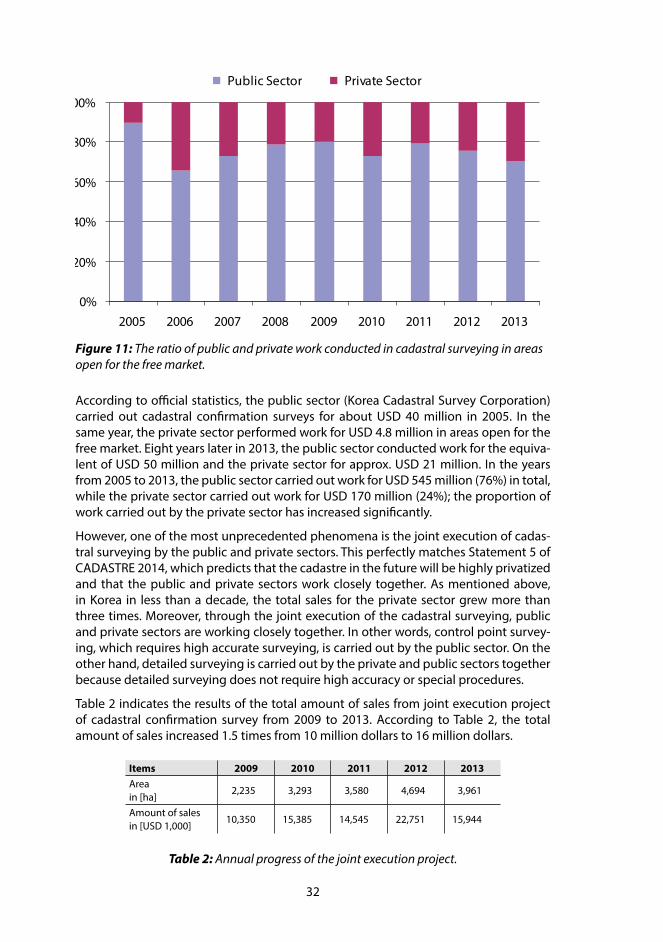
32
According to official statistics, the public sector (Korea Cadastral Survey Corporation) carried out cadastral confirmation surveys for about USD 40 million in 2005. In the same year, the private sector performed work for USD 4.8 million in areas open for the free market. Eight years later in 2013, the public sector conducted work for the equiva-lent of USD 50 million and the private sector for approx. USD 21 million. In the years from 2005 to 2013, the public sector carried out work for USD 545 million (76%) in total, while the private sector carried out work for USD 170 million (24%); the proportion of work carried out by the private sector has increased significantly.
However, one of the most unprecedented phenomena is the joint execution of cadas-tral surveying by the public and private sectors. This perfectly matches Statement 5 of CADASTRE 2014, which predicts that the cadastre in the future will be highly privatized and that the public and private sectors work closely together. As mentioned above, in Korea in less than a decade, the total sales for the private sector grew more than three times. Moreover, through the joint execution of the cadastral surveying, public and private sectors are working closely together. In other words, control point survey-ing, which requires high accurate surveying, is carried out by the public sector. On the other hand, detailed surveying is carried out by the private and public sectors together because detailed surveying does not require high accuracy or special procedures.
Table 2 indicates the results of the total amount of sales from joint execution project of cadastral confirmation survey from 2009 to 2013. According to Table 2, the total amount of sales increased 1.5 times from 10 million dollars to 16 million dollars.
0%
20%
40%
60%
80%
100%
2005 2006 2007 2008 2009 2010 2011 2012 2013
Public Sector Private Sector
Figure 11: The ratio of public and private work conducted in cadastral surveying in areas open for the free market.
Items 2009 2010 2011 2012 2013Area in [ha]
2,235 3,293 3,580 4,694 3,961
Amount of sales in [USD 1,000]
10,350 15,385 14,545 22,751 15,944
Table 2: Annual progress of the joint execution project.

33
Reflections on Statement 5 – Cadastre 2014 will be highly privatized. Public and private sectors are working closely togetherThe Korean cadastral system has a unique history. The Korean Government decided in 1938 to form the Joseon cadastral association to exclusively carry out cadastral survey-ing over the whole country. However, in 2004, the Korean Government allowed pri-vate organization to implement cadastral surveying in areas with numerical data. In this sense, the cadastral surveying market has been opened to the private sector as predicted by Statement 5 of CADASTRE 2014.
In the years from 2005 to 2013, the proportion of the private sector work has increased significantly and has now a share of 30%. It is expected that the private sector will con-tinue to expand and that the joint execution model will provide a win-win situation with benefits for both sectors.
ReferencesDirector of the Cadastral Training Institute (2013). Text book for real estate integrated
public registration system training course. Cadastral Training Institute, p. 5–15 & p. 121–134.
Director of the Cadastral Training Institute (2013). Text book for the Korea cadastral reform project training course. Cadastral Training Institute, p. 469–497.
Hyun Moon Gil, Chae Hyeon Gil and Chung Jae Ho (2013). A study on the Effects of Real Estate Agents’ Job Characteristics on Job Satisfaction and Organizational Commitment. Korea Real Estate Research Institute, Vol.23 No.3, p. 75–292.
Ministry of Land, Infrastructure and Transport (2013). Completion Report of the Real Estate Administrative Information Unified Project. p. 573–626.

34
7 LADM AND ITS ROLE IN ESTABLISHING CADASTRAL SYSTEMS
Christiaan LEMMEN and Peter VAN OOSTEROM, The Netherlands
“The Land Administration Domain Model (LADM) makes a significant contribution to understanding the importance of data modelling in the domain of land, land adminis-tration and land management. The ‘Cadastre 2014’ vision of the International Federa-tion of Surveyors (FIG) stated back in 1998: “Cadastral mapping will be dead! Long live modelling!”. While one might think that this message was clear enough, few profession-al colleagues took it seriously. The editorial team of the LADM were the first to undertake action to get to the bottom of this important issue. Now that the LADM has become an official ISO standard, that statement is strongly underpinned”.
This is how Jürg Kaufmann (2013) opened his review of the LADM in GIM International. And this is how one should look at the LADM: it is basically a conceptual model cov-ering basic information-related components of land administration. The term ‘land’ should be interpreted in the broad sense, also including water bodies (rivers, lakes, seas, oceans) and spaces above and below the surface, that is, air space and subsurface spaces. One of the main goals of LADM is to provide an extensible basis for the de-velopment and refinement of efficient and effective land administration systems. The LADM is also a language, which can support in development of tools for data exchange in and environment of spatial data infrastructure. It is important to see that all people to land relationships – tenure can be represented in the model.
What is the role of LADM in establishing cadastral systems? Let’s have a look.
Implementation of CADASTRE 2014First of all the LADM supports the implementation of CADASTRE 2014. The LADM mod-el can show the complete legal situation of land, including public rights and restric-tions and this can be based on the principle of legal independence from CADASTRE 2014. The LADM model integrates the essential data such as party names, ownership & use rights, and spatial units. There is no “separation” between maps and register in LADM as stated in CADASTRE 2014. LADM supports the implementation in distributed organisational environment because the model integrates the essential data such as party names, ownership & use rights, and spatial units. There are “packages” of informa-tion to support this; those packages are:
– parties (people and organizations);
– basic administrative units, rights, responsibilities, and restrictions (ownership rights);
– spatial units (parcels, and the legal space of buildings and utility networks), in-cluding a subpackage for spatial sources (surveying) and spatial representations (geometry and topology).
This means that implementations are possible where different public and private ac-tors sector co-operate as stated in CADASTRE 2014. See Figure 12 for an overview.

35
The LADM is implemented in digital format by default, its use will encourage a move away from a paper based legal and registration process as predicted in CADASTRE 2014. Provision of a solution that is compliant with international standards and best practice will make it easier for a traditionally conservative legal profession to adopt new practices which will enhance services and reduce costs. The LADM can potentially be used to support organizational integration, for example, between often disparate land registry and cadastral agencies.
UN-Habitat’s Continuum of Land Rights Second, and in extension to this, it is relevant to observe that the LADM can be used in support to the implementation of the UN Habitat’s Continuum of Land Rights (UN-Habitat, 2008; see Figure 13). According to LADM land administration is the process of determining, recording and disseminating information about the relationship between people and land. The LADM deals with both real rights and personal rights. Rights may be formal ownership, apartment right, usufruct, free hold, lease hold, or state land. It can also be social tenure relationships like occupation, tenancy, non formal and in-formal rights, customary rights (which can be of many different types with specific names), indigenous rights, and possession. There may be overlapping claims, disagree-ment and conflict situations. This is an extensible list to be filled in with local tenancies. A restriction is a formal or informal entitlement to refrain from doing something; for example a situation where it is not allowed to have ownership in indigenous areas. There may be a temporal dimension, e.g. in case of nomadic behaviour when pastoral-ists cross the land depending on the season. Apart from land rights different types of credit rights – micro credit, group loan, mortgage – all can be with a formal or informal basis. The term ‘continuum’ applies, apart for land rights, for other dimensions relevant
class Classes of LADM
LA_SpatialUnit
LA_Party
LA_RRR
LA_BAUnit
LA_GroupParty
LA_PartyMember
LA_Right
LA_Restriction LA_Responsibility
LA_Mortgage
LA_Administrativ eSource
LA_SpatialUnitGroupLA_LegalSpaceBuildingUnit
LA_LegalSpaceNetw ork
LA_Lev el
LA_Source
LA_BoundaryFaceString
LA_BoundaryFace
LA_Point
LA_SpatialSource
Figure 12: The LADM International Standard.

36
in fit-for-purpose cadastres. Great variations in methods and results are possible – there is a ‘continuum in continuums’ – with a continuum of parties, of land and credit rights, of spatial units, of data acquisition methods/technologies (with a related continuum of geometric accuracy), of recordation/contents/quality, of information management/organisation an a continuum of purposes.
FAO’s Voluntary Guidelines on the Responsible Governance of Tenure of Land, Fisheries and Forests in the Context of National Food Security (FAO, 2012) outline principles and practices that governments can refer to when making laws and administering land, fisheries and forests rights. This very comprehensive set of guidelines includes ‘deliv-ery of services’ and ‘records of tenure rights’. In those areas some of the guidelines are highlighted here:
– national standards should be developed for the shared use of information, tak-ing into account regional and international standards,
– where possible, States should ensure that the publicly-held tenure rights are recorded together with tenure rights of indigenous peoples and other com-munities with customary tenure systems and the private sector in a single re-cording system, or are linked to them by a common framework. Systems should record, maintain and publicize tenure rights and duties, including who holds those rights and duties, and the parcels or holdings of land, fisheries or forests to which the rights and duties relate.
This is in alignment to the continuum approaches.
2D and 3D spatial representationsThird, LADM recognizes that the majority of spatial units is today represented in 2D, while recognizing that in the future, with growing pressure on space, there is more and more need for 3D representations. LADM supports integrated modelling and representation of 2D and 3D spatial units while making sure that there is a good fit between the two. A key role is played by various innovative concepts such as ‘boundary facestrings’ and ‘liminal spatial units’. Boundary face strings are used to represent the boundaries of spatial units by means of line strings in 2D. In a 3D land administration system it represents a series of ver-
Figure 13: The continuum of land rights (from UN-HABITAT, 2008, p. 8).

37
tical boundary faces where an unbounded volume is assumed, surrounded by boundary faces which intersect the Earth’s surface (such as traditionally depicted in the cadastral map). Liminal spatial units are spatial units on the threshold between 2D and 3D repre-sentations. Further, as in 2D, also in 3D a range of spatial representations is supported, from text and point representations to full 3D topology based representations and also spatial representations based on spatial source documents.
Application softwareFourth, LADM can support to the development of the application software for LA. The data model is the core here. Support in the development of a LAS means provision of an extendable and adaptable fundament for efficient and effective LAS development based on a Model Driven Architecture (MDA), as promoted by the Object Management Group. Implementations so far are in INSPIRE (cadastral parcels as part of a bigger SDI in European Union), FLOSSOLA (software for LA from FAO), STDM (software from UN Habitat). The Social Tenure Domain Model is a spin-off of LADM. The LADM in Unified Modelling Language (UML) is published by ISO. This UML model in EA (Enterprise Ar-chitecture) format can be used to set up and create databases. LADM is capable of supporting the progressive improvement of cadastres, including both the geographic and other elements.
Data exchangeFifth, LADM can facilitate cadastral data exchange with and from a distributed LAS. This can be between cadastres, land registries and municipalities and between countries in a federal state or between countries. In an environment of spatial data infrastructure external links from LADM are possible to databases with; Addresses, Persons, Valuation, Taxation, Land cover, Land use, Documents and with Utility networks. It is interesting to see that LADM can help to reconcile superfluous government databases and reduce the large amount of data redundancy that currently exists.
Quality managementSixth, LADM can support to data quality management in LA. The use of standards helps to reduce inconsistencies between data maintained in different organisations, mainly because data duplication can be avoided. It should be noted here that a standardised data model, which will be implemented, can be supportive in the detection of existing inconsistencies. Quality labels are important.
AgendaThe LADM user community did set the future agenda during a LADM Workshop in Kua-la Lumpur in Malaysia in September 2013:
– the need for exploration of whether, and how, LADM can contribute to the Post-2015 global development agenda;
– LADM can be integrated, and should be integrated, with other geo-information encoding standards;

38
– LADM code lists could provide the basis for establishing a complete catalogue of global land-people relationships; and
– whilst ISO maintains its own maintenance approach, another form of govern-ance structure – potentially included a reference group – is needed to further progress the refinement and maintenance of the standard (e.g. code lists, new items).
ConclusionWe have to thank the authors, Jürg Kaufmann and Daniel Steudler not only for the development of CADASTRE 2014. We have to thank them too for the way in which this Vision has been brought to the profession and the users of products and services from the profession. This vision and way of thinking has been a key to the development of modern cadastres.
ReferencesFAO (2012). Voluntary Guidelines on the Responsible Governance of Tenure of Land,
Fisheries and Forests in the Context of Food Security. FAO, Rome, Italy.
Gilroy, S. (2013). LADM: A Blueprint for Enterprise Level Land Administration Systems. In: Proceedings, 5th Land Administration Domain Workshop, 24–25 September 2013, Kuala Lumpur, Malaysia, published by FIG.
ISO (2012). ISO 19152:2012 Geographic Information – Land Administration Domain Model. Edition 1, 118 p. Geneva, Switzerland.
Kaufmann, J. and Steudler, D. (1998). Cadastre 2014 – A vision for a future cadastral system. Published by FIG.
Kaufmann, J. (2013). Long Live Modelling! An Assessment of the LADM from the Cadastre 2014 Perspective. In: GIM International, June 2013, Volume 27, Number 6.
Lemmen, C.H.J. and Van Oosterom, P.J.M. (2013). The Land Administration Domain Standard. In: Proceedings, 5th Land Administration Domain Workshop, 24–25 September 2013, Kuala Lumpur, Malaysia, published by FIG.
Teo, CH. and Lemmen, C.H.J. (2013). The LADM and the Continuum of Land Rights. In: Proceedings, 5th Land Administration Domain Workshop, 24–25 September 2013, Kuala Lumpur, Malaysia, published by FIG.
UN-Habitat (2008). Secure land rights for all. Nairobi, Kenya, United Nations Human Settlements Programme.

39
8 IMPLEMENTATION OF LADM WITH INTERLIS
Michael GERMANN, Switzerland
As the year 2014 has arrived, it is time to reflect what has been achieved in terms of CA-DASTRE 2014. One of the noteworthy achievements in recent time is certainly the final release of the Land Administration Domain Model (LADM) as ISO 19152 standard in December 2012. The LADM standard directly supports statement 3 of CADASTRE 2014 (“cadastral mapping is dead, long live modelling”), but for many administrations and organizations it is still unclear how this new standard can efficiently be implemented. This section attempts to show that the data modelling standard INTERLIS – in wide-spread use in Switzerland – can be used to also implement the LADM standard by a modern computer assisted tool chain.
What is INTERLIS?The first version of the data modelling language INTERLIS was introduced in Swit-zerland in the late 1980s (EJPD, 1987) and has become a Swiss standard in 1998 (SN 612030). INTERLIS (COGIS, 2006) is an object-oriented conceptual schema language (CSL), which is being used to precisely define (spatial) data models in textual form with a rigid computer processable syntax. A characteristic of the language is that it can eas-ily be understood by application and IT experts, thereby bridging the gap between application and IT domains.
As the first version of the INTERLIS standard is older than the original CADASTRE 2014 paper, it has inspired to some degree the work of CADASTRE 2014. Some features of the language directly support the CADASTRE 2014 concepts, for example the “principle of legal and institutional independence” can easily be implemented with the TOPIC con-struct of the language.
While INTERLIS was originally designed and used mainly for land administration, it is not restricted to land administration data modelling. In fact INTERLIS is a general pur-pose modelling language. Due to its flexibility it has become part of the Swiss Act on Geoinformation (Swiss Confederation, 2007) and is currently being used to describe the 160+ data models of the Swiss national data infrastructure (NSDI).
INTERLIS has a unique set of features which sets it well apart from other modelling standards (i.e. UML, XML-Schema or EXPRESS):
– INTERLIS can be used to describe relational or object-oriented data models in a system neutral way;
– INTERLIS can be easily understood by application and IT experts, therefore bridging the gap between IT and application domains;
– INTERLIS is precise enough to be directly processed by modern software tools;
– each INTERLIS data model automatically defines a system neutral XML based data exchange format;
– the language has built-in geometric data types (point, poly-line, polygon), mak-ing it especially suitable for models in the geoinformation domain;

40
– it is possible to quality check INTERLIS data against INTERLIS data models, there-by enabling fully automated quality control of spatial data including geometric attributes;
– INTERLIS is compatible with the most relevant international standards (UML, XML Schema, XML, GML).
But INTERLIS has not only an interesting set of features; it is also supported by a wide range of free and commercial tools for many years:
– the INTERLIS compiler checks the syntactical correctness of an INTERLIS data model (free);
– the INTERLIS checker (infoGrips, 2006) can quality check INTERLIS XML data against INTERLIS data models (free);
– the INTERLIS UML editor is used to create INTERLIS models from UML diagrams or to visualize existing INTERLIS data models as UML diagrams (free);
– data translators can convert data sets from many GIS systems / databases to and from INTERLIS XML (free and commercial);
– schema tools can generate database schemata directly from INTERLIS data mod-els (free and commercial);
– there is even a web based data server / map server based on INTERLIS (commercial).
More information, also in English, about the INTERLIS language and its tools are avail-able at the official INTERLIS web site www.interlis.ch.
Implementing LADM with INTERLISAfter the short introduction of INTERLIS, it should be obvious that LADM and INTER-LIS are a perfect match. By applying the INTERLIS data modelling language to the ISO 19152 standard, we get computer processable model descriptions, which can be used to initialize databases or transfer LADM data via XML. Using INTERLIS for LADM also means that all free available INTERLIS tools such as compiler, checker, UML editor, etc. can be directly applied to LADM derived country profiles.
To test the feasibility of a LADM implementation in INTERLIS, the Swiss Land Manage-ment foundation (SLM) started to describe the LADM ISO 19152 standard with INTER-LIS. The work was completed in February 2014 and the full model can be download-ed freely from the SLM web site www.swisslm.ch. Figures 14 and 15 each illustrate a LADM-UML diagram translated into INTERLIS:
The main lessons learned during the implementation process are:
– all UML diagrams, classes, associations and types found in LADM ISO 19152 standard can be modelled with INTERLIS;
– country profiles can be given a more CADASTRE 2014 compatible structure (“principle of legal and institutional independence”) by using the INTERLIS TOP-IC construct;
– even some of the constraints / invariants of the LADM model can be formally defined by the INTERLIS constraint language.
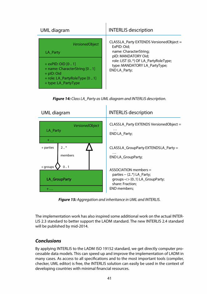
41
CLASS LA_Party EXTENDS VersionedObject =ExPID: Oid;name: CharacterString;pID: MANDATORY Oid;role: LIST {0..*} OF LA_PartyRoleType;type: MANDATORY LA_PartyType;
END LA_Party;
UML diagram INTERLIS description
VersionedObject
LA_Party
+ exPID: OID [0 .. 1] + name: CharacterString [0 .. 1]+ pID: Oid+ role: LA_PartyRoleType [0 .. 1]+ type: LA_PartyType
CLASS LA_Party EXTENDS VersionedObject =…
END LA_Party;
UML diagram INTERLIS description
CLASS LA_GroupParty EXTENDS LA_Party =…
END LA_GroupParty;
ASSOCIATION members =parties -- {2..*} LA_Party;groups -<> {0..1} LA_GroupParty;share: Fraction;
END members;
members
+ parties
+ groups
2 .. *
0 .. 1
VersionedObjectLA_Party
+ …
LA_GroupParty
+ …
LA_GroupParty
Figure 14: Class LA_Party as UML diagram and INTERLIS description.
Figure 15: Aggregation and inheritance in UML and INTERLIS.
The implementation work has also inspired some additional work on the actual INTER-LIS 2.3 standard to better support the LADM standard. The new INTERLIS 2.4 standard will be published by mid-2014.
ConclusionsBy applying INTERLIS to the LADM ISO 19152 standard, we get directly computer pro-cessable data models. This can speed up and improve the implementation of LADM in many cases. As access to all specifications and to the most important tools (compiler, checker, UML editor) is free, the INTERLIS solution can easily be used in the context of developing countries with minimal financial resources.

42
AcknowledgmentsThe author would like to thank the Swiss Land Management foundation (SLM) for their inspiration and support in developing this contribution.
ReferencesCOGIS (2006). INTERLIS 2.3 Reference Manual. Coordination, Geo-Information and
Services (COGIS), a division of the Swiss Federal Office of Topgraphy, swisstopo, Switzerland. <www.interlis.ch/interlis2/docs23/ili2-refman_2006-04-13_e.pdf>, last accessed on 21 Feb. 2014.
EJPD (1987). Detailkonzept: Reform der amtlichen Vermessung RAV. <www.cadastre.ch/internet/cadastre/de/home/docu/publication/P075.html>, last accessed on 12 Feb. 2014.
infoGrips (2006). iG/Check for INTERLIS 2, infoGrips LTD, Switzerland, <www.interlis.ch/interlis2/download23_e.php>
Kaufmann, J. and Steudler, D. (1998). Cadastre 2014: A Vision for a Future Cadastral System. International Federation of Surveyors FIG, <www.fig.net/cadastre2014/>, last accessed on 12 Feb. 2014.
Swiss Confederation (2007). Federal Act on Geoinformation. <www.admin.ch/opc/en/classified-compilation/20050726/index.html>, last accessed on 11 Feb. 2014.

43
9 AN INTEGRATION PLATFORM FOR A SPATIALLY ENABLED SOCIETY
Jürg Hans LÜTHY, Switzerland
For the implementation of a “Cadastre of Public-law Restrictions on Landownership” (PLR-Cadastre), it was not possible to consider the current IT infrastructure as applica-tion basis, mainly for two reasons: first, the information is not captured as spatial only, but also as “textual” data with no direct link between the data sets. Second, federal structures in Switzerland preclude a centralised monolithic application. In addition, most users and citizens have difficulties searching, querying or using a specialised sys-tem. In order to take such facts into account, the application platform GeoApps has been designed as generic data integration system. The first implementation using Geo-Apps is the PLR-Cadastre for two Swiss cantons. In the pilot phase, the advantages and effectivity of the architecture has successfully been tested.
GeoApps as an integration platform The two cantons Nidwalden and Obwalden are participating in the pilot phase for the implementation of the PLR-Cadastre in Switzerland (see also section 4 of this publica-tion). Both cantons decided that a generic platform for the access of integrated spatial and textual data should be realised. The requirements for such an application middle-ware include:
– Minimal extension of established structures and processes is desired; existing information infrastructures (spatial and non-spatial) should be used.
– Use of open-source components: standardised modules should be based on open-source components such as OpenLayers (presentation layer) or GDAL (logical layer for spatial analysis).
– Real-time access: all information items should be accessible in real-time.
– Use of web-technologies, wherever feasible, not only because of the state-of-the-art technology, but also because of the distributed information infrastruc-tures and the established client platforms.
– Flexibility and scalability: the integration platform should support a variety of information infrastructures as data sources, various end applications and user access devices (PC, smart phone, tablets).
System architectureThe architecture of GeoApps was designed as classical 3-tier architecture: data stor-age and access layer, business logic layer (GAServer) and presentation (GAClient). Each tier was developed independently and they communicate through clearly defined in-terfaces. Such architecture supports continuous modernisation since each tier can be enhanced or even be replaced whenever technological trends require it.
The 3-tier architecture allows the differentiation between server and client. Data stor-age and most of the logical layer run on the server consuming resources in the data

44
centre. This is because the server-side infrastructure is better connected to the data storage and because it is easier to scale than the client infrastructure. The presentation layer and minimal parts of the logical layer are included in the client (compare Figure 16).
The distributed architecture requires the separation of data storage and access. Data gets exposed through web services on behalf of GeoApps. To support a wide range of data sources and types, ad-hoc adapters are used to convert the web services to a generic internal data model.
The business logic layer requests information from the data layer, which it issues in order to handle the presentation layer’s queries. The data is combined, evaluated and translated into a form suitable for presentation by the client.
One of the server’s core modules is the Rule Engine. It links data from separate sources, either directly (based on joint keys) or indirectly (by applying heuristics). For the in-direct linking, spatial and non-spatial ontologies are supported. Essentially, our Rule Engine for merging textual and spatial data realizes the Common Data Integration Con-cept for a spatially enabled society, proposed by Steudler and Rajabifard (2012) and discussed in section 4 of this publication.
User interactionUsers should not have to read a manual before using GeoApps. Therefore, only basic mapping functions (zoom, pan) are provided: search for geocoded objects (cities, ad-dresses, places, parcels); and limited application functions.
In the OpenLayers-based client, the integrated views are rendered as maps, dashboards and simple textual data or as combination. The only functionality that the client must be capable of is the handling of common web-standards.
Figure 16: Architecture of GeoApps.

45
Implementation of the PLR-Cadastre based on GeoApps
Adaptation of GeoApps platform for PLR-Cadastre
Data access layer
For the initial phase of the project in Nidwalden, the federal agencies were unable to provide spatial data in sufficient quality. All cantonal and communal data sources were integrated into the system by web-services. While web-services are well established for spatial data, it was difficult to integrate legal information over the web. The relevant e-government standard (CHLexML) was published in 2008, but has not yet been broadly adopted by the software industry. In the beginning, legal data was provided as low-structured data (PDF, HTML) for which adaptors had to be written.
User interface
The user interface (Figure 17) provides minimal functionality: map rendering (1) such as zoom and pan; search (2); requesting extracts (3); and map customisation (4).
Dynamic extracts
Users can request dynamic extracts for a land parcel or an area. The client will forward such queries to the server. To handle this type of query, the logical layer intersects the requested land parcel (area) with the (spatially indexed) PLR layers. For each overlap-ping object, the logical layer then retrieves and evaluates relevant legal restrictions.
Figure 17: Start window of PLR-Cadastre (http://map.gis-daten.ch/nw_oereb).
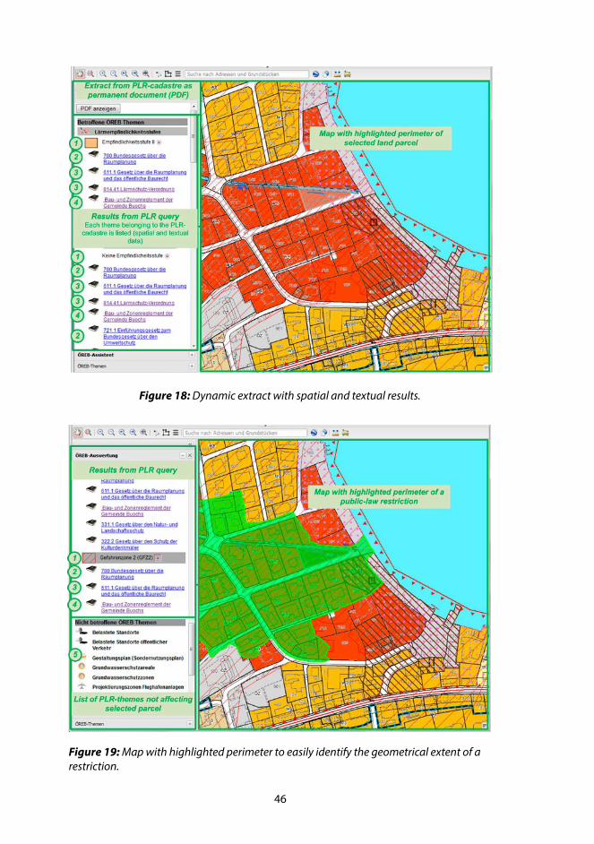
46
Figure 18: Dynamic extract with spatial and textual results.
Figure 19: Map with highlighted perimeter to easily identify the geometrical extent of a restriction.
47
The results are sent back to the client in structured form, using a custom XML encoding. Finally, the client presents the results to the user.
For each overlapping spatial layer, the legend (1) indicates legal information from fed-eral (2), cantonal (3) and communal (4) laws (see Figures 18 and 19). If the selected land parcel is not affected by some PLR layer, the layer is listed for reference (see Figure 19, bullet 5).
Since the client has full information about the selected object, it can support interac-tion between the map and result panes. In Figure 19 for example, when a user clicks on the legend entry for a legal restriction (1), its geometric extent gets highlighted on the map.
Static report
In addition to dynamic extracts, the system also supports static reports that indicate what restrictions apply to a given land parcel or geographic location. The static report serves as official document, and may be notarised if needed. For auditing purposes, each static report carries a global unique identifier, and the report has to be kept by the cadastral organisation. Since the reports merely refer to legal data (instead of a verba-tim copy), special attention had to be paid on data historization.
BenefitsThe GeoApps platform facilitates a simple and straightforward solution for the provi-sion of a PLR-Cadastre. The project boards and users found the GeoApps platform a convincing solution for the needs of a PLR-Cadastre. Reasons include:
– The simple user interface allows citizens to access the PLR-Cadastre without any training (confirmed in user feedback).
– Interaction between dynamic extract (result pane) and map helps understand-ing the geometrical impact of a PLR to a land parcel. This is particularly useful in the (quite common) case when a land parcel is only partially covered by a PLR.
– Overall system performance, in particular the time to generate reports, exceed-ed expectations (although acceptable response time not yet specified).
– The real-time design allows preserving data ownership; the owners remain in control.
– The uniform treatment of spatial and textual data enables impact analysis: it is easy to see what land parcels are affected by a given law (reversed query).
Conclusion and outlookSES has imposed stringent requirements for a Common Data Integration Concept. The GeoApps platform proofs that these requirements can be implemented in practice.
Until the end of 2014, the PLR-Cadastre for the cantons of Nidwalden and Obwalden will be subject to further testing. The cadastre will be extended with additional data sets from the federal administration. Also, more information of general interest to citi-zens will be provided, such as construction permits and construction restrictions (Kauf-mann et al., 2006).

48
In parallel to the implementation of the PLR-Cadastre, other applications are being developed on the base of the GeoApps platform. These solutions range from winter sports (increasing the efficiency of snow production) over spatially enabled document archives to a cockpit for a holistic management of communal infrastructure (supply, waste water).
The presented solution can be accessed at http://map.gis-daten.ch/nw_oereb.
ReferencesKaufmann, J., Flückiger, U. and Bänninger, P. (2006). Cadastre 2014: The Practical
Realization of a Comprehensive Documentation of the Complex Legal Situation of Land Using a Simple Data Model and Sophisticated Information Technology (0398). FIG Congress 2006, Munich, Germany, 8–13 October 2006. <www.fig.net/pub/fig2006/papers/ts12/ts12_01_kaufmann_etal_0398.pdf>, last accessed on 22 Feb. 2014.
Steudler, D. and Rajabifard, A. (Editors) (2012). Spatially Enabled Society. FIG Publica-tion No. 58.

49
10 CADASTRE 2014 IN RELATION TO SPATIAL DATA INFRASTRUCTURE (SDI)
Abbas RAJABIFARD, Australia
20 years ago, CADASTRE 2014 provided a simple yet effective framework for support-ing the evolution of cadastral systems for the future. With the relationship between cadastres and spatial data infrastructures (SDIs) formally recognised by the Bogor Dec-laration, it was inevitable that CADASTRE 2014 would impact upon SDIs as well. SDIs have emerged as both a fundamental network infrastructure, as well as an enabling platform to help achieve the vision of a spatially enabled society as it aims to connect people to data to facilitate decision-making. In this context SDIs together with land administration, which typically generates information about places, can provide the unique ability to produce important and fundamental information about the places people create and use – the cornerstone for supporting the development of a spatially enabled information environment. The emphasis of CADASTRE 2014 on information integration and shifts in collaboration dynamics across stakeholders carved a greater role for SDIs in connecting people and data.
The realisation of spatially enabled societies has been driven by the cadastre providing a foundation in land and property information and SDIs providing an enabling plat-form for facilitating location-based information and services – together, they present a powerful paradigm for building capacity for addressing the global agenda and achiev-ing sustainable development goals.
IntroductionThe publication of CADASTRE 2014 provided a framework comprising six statements that aimed to provide a model for cadastral development that was anticipated to be sufficiently robust as to meet the needs of the future.
This framework essentially established a set of universal principles that all countries could work towards, and indeed, continue to aspire to do so even till this day. The im-portance of CADASTRE 2014 cannot be overstated within the domain of land admin-istration; however, given that the cadastre underpins fundamental information about land and property for every nation, its impact has been far-reaching. With a formal rela-tionship between cadastres and SDIs endorsed by the Bogor Declaration on Cadastral Reform in 1996, it was inevitable that CADASTRE 2014 would impact on the function of SDIs. This section considers the impact of CADASTRE 2014 in relation to spatial data infrastructures, and their twin roles in helping to realise spatially enabled societies. Par-ticularly the relationships between cadastre and SDI have been well presented in the diagram showing the significance of the cadastre, and it is called “butterfly diagram” (Williamson et al., 2010), which shows the cadastre as the engine of LAS that forms a key component within the SDI as it supports the land administration functions for de-livery of sustainable development. Once the cadastral data (cadastral or legal parcels, properties, parcel identifiers, buildings, legal roads, etc.) is integrated within the SDI, the full multipurpose benefit of LAS, so essential for sustainability, can be achieved.
50
SDI as a network and an enabling platformThe creation of economic wealth, social stability and environmental protection objec-tives can be facilitated through the development of products and services based on spatial information collected by all levels of societies including governments, private sectors, and citizens. In this context, spatial data and information, land administration, land management, and land governance play crucial roles in this.
With this in mind, since the early 1990s, the concept of a spatial data infrastructure (SDI) has progressively entered into the lexicon of governments all around the world and gained an increasingly prominent profile as an enabling infrastructure, critical to devel-opment by linking information to location. The SDI concept facilitates the sharing, access and utilisation of spatial data across different communities to better achieve their objec-tives. It has emerged as a key network infrastructure, which provides a mechanism to facilitate the integration of cadastral and topographic data to support decision-making.
As the concept of SDIs gained traction, the concept has evolved to the extent that SDIs are now regarded more as an enabling platform: an integrated, multi-level hierarchy of interconnected SDIs based on partnerships at corporate, local, state/provincial, nation-al, multi-national (regional) and global levels. This has enabled effective management, networking and sharing of spatial information and services across agencies and even national boundaries, which has resulted in information being used more efficiently and effectively, enabling users to save on resources, time and effort when seeking to acquire new datasets by avoiding expenses associated with duplications in the genera-tion and maintenance of data; as well, their integration with other datasets has led to the creation of new services.
SDIs are now being used in many different capacities – particularly in the coordination, analysis and use of large-scale, people relevant data. Indeed, the importance of this relationship was underscored in the Bogor Declaration on Cadastral Reform in 1996, which stated that the spatial cadastral framework – usually a cadastral map – should be a fundamental layer within a national SDI (FIG, 1996). Land administration typically generates information about places while SDIs organise spatial information. CADASTRE 2014 emphasised information integration and shifts in collaboration dynamics across stakeholders – key aspects that SDIs have become well regarded for. Together, they can provide the unique ability to produce important and fundamental information about the places people create and use – the cornerstone for supporting the development of a spatially enabled information environment.
Spatially Enabled SocietiesSpatial enablement is a concept that adds location to existing information, thereby un-locking the wealth of existing knowledge about land and water, its legal and econom-ic situation, its resources, access, and potential use and hazards. It uses the concept of place and location to organise information and processes and is now consistently part of broader government strategies. This promotes innovation, transparency and democracy by enabling citizens and we are therefore, potentially at the start of a spa-tial information revolution. Societies and their governments need to become spatially enabled in order to have the right tools and information at hand to take the right deci-sions. The concept of Spatially Enabled Societies (SES) is offering new opportunities for government and the wider society.
51
At its heart, the concept of SES depends on the effective use and delivery of data and services. This effectiveness is a consequence of legislation that mandates its use, and implicitly deals with issues of data quality and liability (Onsrud, 2010). One of the ways in which an SDI, as an enabling platform, can support the legal framework is to provide an avenue for governance.
In considering the role of governance as applied to SDIs, Box and Rajabifard (2009) high-lighted the importance of considering the nature of SDIs to arrive at a more appropriate conceptualisation of governance. They noted that governance is traditionally considered a ‘steering’ function because it provides leadership and an enabling framework for col-lective decision-making; however, as applied to SDI, governance has become shorthand for the institutional arrangements that enable an SDI, and therefore includes functions such as co-ordination and management. These ‘rowing’ functions extend the scope of governance to include decision implementation. Governance plays a central role in SDI, and therefore SES, by enabling the creation of agreements that bind together the people and geospatial resources (data and technology) involved. A range of other functions are however necessary to channel collective efforts towards common goals.
SES is one that makes use, and benefits from, a wide array of spatial data, information, and services as a means to organise its land and water related activities. SES is now part of the objectives of governments in many countries, highlighting the importance of spatial information and strategies in policy development and decision-making in the public sector. SES increasingly operates in a virtual world but they need to be coupled with real world institutional and structural reforms in the use of spatial information and SDI as an enabling platform.
Land Administration Systems underpin efforts to realising Spatially Enabled Societies Land Administration Systems (LAS) including cadastre as a base and core component enable the management of land information, which is fundamental for informing deci-sions about economic, environmental and social issues of priority. In today’s modern society, LAS also underpins efforts in realising SES, where location and spatial informa-tion are regarded as common goods and made available to citizens and businesses to encourage creativity and product development.
Developments in LAS, and consequently momentum behind SES, have only been pos-sible due to the increasing ubiquity of spatial data and location information. This ubiq-uitous characteristic is reliant on a variety of technical infrastructure not only for dis-semination and use, but for supporting the entire lifecycle of spatial information. Fun-damental to the genesis of any type of spatial information is the accuracy and reliability of the positioning network. Many jurisdictions have adopted satellite-based position to improve accuracy and transparency in their LAS but there are still challenges that need to be overcome such as applicability in built environments, and more integrated information to deliver a better-connected government and society. As well, research into different dimensions and utilisation of positioning including 3D land and property management and indoor positioning are providing new aspects to LAS, improving its relevancy to modern land administration requirements.
There are six fundamental elements which have been introduced as the requirements to realize the vision of a SES (Steudler and Rajabifard, 2012). These elements are un-

52
derpinned by the CADASTRE 2014 model, which was originally proposed for cadastre development. This is one of the impacts of CADASTRE 2014 on the evolution in how we manage our land and property information. Without these elements, progressing the spatial enablement of a society or government would be seriously curtailed.
These elements for the delivery of SES are: a legal framework to provide the insti-tutional structure for data sharing, discovery, and access; a sound data integration concept to ensure multi-sourced data integration and interoperability; a positioning infrastructure to enable and benefit from precise positioning possibilities; a spatial data infrastructure to facilitate data sharing, to reduce duplication and to link data producers, providers and value adders to data users based on a common goal of data sharing; land ownership information, as the dominant issue in the interactions be-tween government, businesses and citizens relating to land and water resources; and data and information to respect certain basic principles and to increase the availabil-ity and interoperability of free to re-use spatial data from different actors and sectors.
Looking to the futureAdvances in ICT and, in particular, in mobile communications and devices have vast-ly improved the efficiency and use of spatial information. And yet, ongoing research shows there is still much progress to be made, even as we simultaneously continue to establish new developments in positioning technology. There will be ongoing chal-
Figure 20: The cadastre as core of SDI, SES and ultimately sustainable development.
SUSTAINABLE DEVELOPMENT
SES
SDI
Spatial data/info
CadastreCadastre
SES
SDI
Spatial data/info
CadastreCadastreCadastre
SES
SDI
Spatial data/info
CadastreCadastre
soci
al
envi
ronm
ent
econ
omic
53
lenges in communicating these developments to users and helping them to interpret and understand this information to facilitate their purposes and also to maximise the return of their investments and realisation of SES.
In this move towards SES, SDIs have become a key infrastructure. However, the realisa-tion of spatial enablement is still being impacted by the existence and perpetuation of data silos both within, and between, organisations that contribute to SDI initiatives. This makes the discovery, access, use and sharing of spatial data and services still a significant challenge. More recently, the convergence of many economic, social and en-vironmental drivers with location has provided spatial enablement with an increasingly prominent profile both on local and global stages. In light of the emerging importance of location as the fourth driver in decision-making, alongside the role of the cadastre and land administration in spatial enablement, there is also a continued need for good land governance to facilitate spatially enabled governments, so as to build capacity for addressing the global agenda as well contributing to the primacy of spatially enabled governments in achieving sustainable development and a spatially enabled society.
To this end, CADASTRE 2014 has been an important platform in helping to shape the future of SES, in particular in shaping the cadastre as a foundation for modern land administration systems and as an important component for SDI and the basis for the delivery of SES as illustrated in Figure 20. On the event of its twentieth year since con-ception, I wish the driving team the very best and continued success in its endeavours.
ReferencesBox, P. and Rajabifard, A. (2009). SDI Governance: To Steer or Row. GIM International,
Vol. 23 (2). <www.gim-international.com/issues/articles/id1276-SDI_ Governance_to_Steer_or_Row.html>, last accessed on 8 Mar. 2012.
FIG (1996). The Bogor Declaration on Cadastral Reform. <http://www.fig.net/ commission7/reports/bogor/BogorDeclaration.html>, last accessed on 17 Mar. 2012.
Onsrud, H. (2010). Legal interoperability in support of spatially enabling society. In A. Rajabifard, J. Crompvoets, M. Kalantari, B. Kok (eds.), Spatially Enabling Society: Research, Emerging Trends and Critical Assessment, Belgium: Leuven University Press pp. 163–172.
Steudler, D., and Rajabifard, A. (Eds.) 2012. ‘Spatially Enabled Society’. ISBN 978-87-90907-97-6, FIG Publication No. 58, Copenhagen, FIG Press, Denmark, 68 pp.
Williamson, I.P, Enemark, S., Wallace, J., Rajabifard, A. (2010). Land Administration for Sustainable Development, ISBN 978-1-58948-041-4, ESRI Press, 487 pp.

54
11 CADASTRE 2014: WHAT LIES BEYOND?
Rohan BENNETT, The Netherlands
CADASTRE 2014 is a unique phenomenon in the land administration domain. Its strik-ing simplicity enables it to speak to policy makers, managers and technicians alike. It enjoys an almost unprecedented role in guiding global land administration discourse, and has done so for almost two decades. In countless countries its impact upon land administration design is profound. The previous sections of this book reflected on these achievements.
Kaufmann and Steudler’s (1998) date of inspiration for CADASTRE 2014 arrives. The land administration community pauses for reflection, but also gazes forward. Does CA-DASTRE 2014 remain relevant? What about the decade ahead? Is a new Cadastre 2014 required? What might drive such a vision? What would it include? Answering these questions is no small task: input from the broader discipline is needed. Here, a humble start is made: each of the questions is addressed from the viewpoint of the writer. The aim is to kick start a discourse for the post-2014 era: a discussion that should be of inter-est to land administration researchers and practitioners alike.
Does CADASTRE 2014 remain relevant today and tomorrow?At the heart of CADASTRE 2014 lie six visionary statements. Most observers would agree these remain relevant in 2014. Statement 1, relating to the breadth and nature of rights recorded in cadastres, remains a central point of discussion in most developed economies. Likewise, many contexts are still grappling at a strategic level with State-ment 2: the need and requirement to merge mapping and registration components. The bold declarations in Statement 3 and 4, regarding the death of mapping, pen and paper, are largely correct for many contexts; however, many emerging economies con-tinue to use manual approaches. Discussions focus on how and when a sustainable move to modelling and computerization might be achieved. Meanwhile, in this post-New Public Management era, the relative benefits of utilizing the private sector in land administration activities, outlined in Statement 5, remains hotly contested. The same applies to the need for cost recovery as mentioned in Statement 6. Whilst examples of self-financed ‘business-like’ cadastres can be cited, many organizations continue to be funded through conventional means.
The continuing relevance of CADASTRE 2014 appears indisputable; however, the as-suredness of the original statements is clearly up for debate. For various reasons, not all countries have achieved the statements. Moreover, many contexts may have no desire to implement them (yet). This tension represents strength in CADASTRE 2014: the con-viction in the statements provokes land administrators to a take a position. This pro-motes robust and critical discussion on the nature and design of the land administra-tion system in question. Avoiding implementation of CADASTRE 2014 neither implies failure for a country nor irrelevance for CADASTRE 2014. Merely, it demonstrates that context matters. Since its publication in the late 1990s, increasing acknowledgement has been afforded to the importance of recognizing local circumstances in land admin-istration design. This philosophy, now embedded in the concepts like ‘fit-for-purpose’ and the ‘continuums of land rights and recording’ (Zevenbergen et al., 2013), can par-

55
tially be ascribed to the provocative nature of CADASTRE 2014. In this regard, CADAS-TRE 2014 will continue to retain relevance.
Meanwhile, CADASTRE 2014 should not be reduced to its mere six statements. Behind the statements lie significant amounts of data capture and analysis. This work focused on synthesizing the nature and design of many national and state land administration systems. It remains one of the more comprehensive efforts to benchmark global land administration activities. It acts as a touchstone for the range of new land administra-tion evaluation tools being developed in the contemporary era: ones that go beyond the strategic, managerial, and operational aspects of cadastres, and consider actual so-cietal outcomes. This development is perhaps the most important legacy of CADASTRE 2014.
Is a new ‘CADASTRE 2014’ needed?If CADASTRE 2014 remains relevant, is there need of a new vision? When work on CA-DASTRE 2014 was initiated by FIG in 1994, the overarching aim was to forecast ahead the role and nature of cadastres in the year 2014. Presumably, the vision was intended as one that all countries could aspire to, however, the idea of a definitive vision for cadastres is perhaps now outdated: efforts to consolidate a cadastral vocabulary, if not philosophy in the post-Cold War period, appear to have limitations when the complexi-ties of any national system are unpacked. The idea that a vision could enjoy a shelf life of twenty, or even ten years, can even be questioned: in practical terms, most organiza-tions don’t bother attempting to strategically plan beyond five. In this frame, the moti-vation for a new CADASTRE 2014 appears thin.
There appears stronger incentive if the vision is recast as a means for enabling global discourse. The value of a vision becomes clearer: strategic planning within countries; international and regional comparison; and the plotting future research activities are all enhanced. The content of CADASTRE 2014 perhaps wasn’t so important as its eas-ily accessible graphical presentation and six-statement format. A globally shared lan-guage for discussing cadastral systems was created: a long-held and defining feature of the FIG agenda. From this perspective, there is a good argument for developing new visions.
With this ideal in mind, a group of researchers instigated discussions at the 2010 FIG International Congress in Sydney (Bennett et al., 2010). The scope was limited to Aus-tralian cadastral systems. Future drivers of change were hypothesized using political, legal, economic, social, technical, and environmental analytical lenses: urbanization, unbundling of property rights, climate change, emergency and disaster response, and global economic integration were all forecast. In response, and in deliberate homage to CADASTRE 2014, six design elements were drafted. From the Australian perspective, fu-ture cadastres would be: 1) eventually upgraded to survey-accuracy; 2) object-oriented allowing incorporation of unbundled property rights, restrictions, and responsibilities; 3) capable of 3D storage and visualization, and integrating with building information; 4) updated in real-time; 5) more standardized and interoperable both nationally and internationally; and 6) required to capture and represent ecologically inspired bounda-ries or green property rights (Figure 21).
The preliminary vision sparked response, most prominently channelled through a se-ries of articles and invited replies in GIM International (Lemmens, 2010a; 2010b). Re-

56
sponses were invited from key representatives of the World Bank, UN-Habitat, FAO, FIG, academia, and national land administration officials, amongst others. Some com-mented on the relevance of the design elements, but implied the vision was too con-temporary: more innovation was necessary. More generally, the preliminary vision was misinterpreted as applying globally – not only to Australia – as intended by the authors. Those from international agencies tended to criticize the vision for its focus on techno-logical possibility, rather than the humanitarian demands of food security, clean water provision, adequate shelter, and good land governance. In these contexts ‘pro-poor’ and more ‘fit-for-purpose’ visions were required.
From a global perspective, the criticisms were entirely relevant. There is little doubt that the largest challenges for land administration lie beyond the more developed con-texts. A cadastral or land administration divide exists (Bennett et al., 2013): estimates suggest only thirty to fifty of the world’s two hundred countries maintain complete land administration systems. Four billion of the world’s six billion land tenures remain outside formal governance arrangements (Roberge, 2012; Zevenbergen et al., 2013). In these cases, information about people and the land they use remains unrecorded and obscure to governments and citizens alike. This situation is argued to impede all sorts of development activities: land tenure insecurity enables land grabbing and promotes land disputes; land value uncertainty impedes markets and tax governance; land use and development activities (e.g. land readjustment and consolidation) for food security and climate change can neither be designed nor implemented properly.
With regards to the vision, this cadastral divide begs the question: Can or should these two land administration discourses, the more developed and the developing, be merged? Could or would a new CADASTRE 2014 play a uniting role? Or alternatively, as they often do, will these discourses remain in disparate rooms in our conference venues? That is, will distinct Kyoto Protocol-esque visions for specific country groupings prevail? It appears there is room for debate: the future vision of cadastres is up for grabs.
Post-2015: a new playing field for the cadastre?At the 2013 World Bank Conference on Land and Poverty in Washington D.C., Michael Anderson, Special Envoy for the U.K. Prime Minister on the UN High Level Panel of Emi-nent Persons for the post-2015 development agenda, outlined the new framework for
Figure 21: A first attempt from 2010 – for the Australian context.

57
international development (Post-2015 UN Millennium Development Goals) (McLaren et al., 2013). In the new framework, land and especially transparency on land own-ership, were identified as a key issue. He argued that allocating ‘polygons to people’ ought to be a straight forward exercise. The gap between these expectations and cur-rent land administration output in many countries could not be starker. Nonetheless, Anderson lays the challenge for the international land administration sector: deliver innovative ideas for accelerating land information to developing countries, and do it fast, cheap, and fair.
What role can cadastres play in all this? The short answer: potentially plenty. However, there may need to be changes to the focus on existing cadastral designs and research. Existing developments in cadastres can be understood as being driven by two forc-es: 1) technological advancements in geoinformatics (e.g. UAVs, GNSS, HRSI, webGIS); and 2) emerging societal problems that land administration, or cadastres, can help to solve (e.g. rapid urbanization, land grabbing, food security, and climate change). Ad-ditionally, two broad application areas are evident as identified by Lemmens (2010b): 1) countries maintaining complete land administration systems (e.g. OECD countries); and 2) those with incomplete or emerging systems (e.g. much of sub-Saharan Africa).
These existing cadastral discourses are the seeds of the innovations called for by Ander-son. However, now a new wave of geoinformatics innovations and conceptual devel-opments await application in the domain of land administration: UAVs, crowdsourcing (via GNSS), laser point clouds, wireless sensor networks (WSNs), geospatial analytics tools, and so forth. Additionally, land administration systems are being asked to better inform responses to the emerging issues of land grabbing, food insecurity, and climate change by supporting equity, dispute prevention, and other pro poor land activities.
Figure 22: Delivering design, implementation and assessment tools that satisfy emerging societal drivers – a vision for future cadastres?

58
The post-2015 development agenda provides a new impetus to fuse research relat-ing to these new societal demands and technologies (Figure 22). A specific focus is needed to further develop and operationalize the concepts of green cadastres (or eco-logically driven property boundaries), crowdsourced cadastres, and globally integrated cadastres. All are underpinned by the new technologies, and may be important tools for responding to land grabbing, food insecurity, and climate adaptation. New global commercial software and hardware providers emerge in these areas (e.g. Thomson-Reuters), whilst existing players intensify their focus and restructure product offerings (e.g. Trimble). A strong argument can be made for independent research programs of design, application, and evaluation: ones that use cadastres to better inform responses to land grabbing, food security, and climate change.
Conclusion: six new questionsIn summary, this short discussion hopes to provoke a wider discourse for the post-CADASTRE-2014 era. Whilst most of CADASTRE 2014’s six visionary statements remain highly relevant today, the assuredness in them is clearly up for debate. Discourse has moved from CADASTRE 2014’s one-size-fits-all approach to discussions on ‘fit-for-purpose’ and the ‘continuum of land rights’. Whether any new vision could enjoy the twenty year shelf-life of CADASTRE 2014 is quite uncertain. If the vision is considered as a tool for generating a global discourse then motivation appears quite strong. Mean-while, any new vision must go beyond mere technical and organizational possibilities. It must comprehensively consider the role of cadastres in pressing humanitarian de-mands including those described in the post-2015 global development agenda. Fusing these societal demands with technological possibility is a challenge for all countries, if not all cadastres. To help gets things started another set of six starting points is offered. All land administrators and cadastral experts are welcomed to ponder, criticize or con-tribute further:
1. Land Grabbing: Should cadastres play a role in recording spatially the land rights conflicts generated by large scale land acquisitions? If yes, how?
2. Food Security: Does the right to food (use, access, and availability) have a spa-tial footprint and should cadastres be used to record it?
3. Climate Change: How might cadastres be used to record climatic dependent land rights?
4. Crowd-sourced Cadastre: Which cadastral procedures can be provided by the crowd? Which cannot? Why? How?
5. Green Cadastre: How can the ecological boundaries of green property rights be adjudicated, surveyed, and recorded? Do cadastres have a role?
6. Global Cadastre: What are the infrastructure requirements of a global cadas-tral network?
AcknowledgmentThe author would like to acknowledge the support of colleagues at the UNU School for Land Administration Studies at ITC Faculty of the University of Twente for their as-sistance in the development of this paper. Specific thanks go to Paul van der Molen. Ad-ditionally, the author would also like to acknowledge that sections of the discussion are derived from earlier works, including conference reports published in GIM Internation-al and also papers presented at FIG Congresses and Working Weeks during 2010–2013.

59
ReferencesBennett, R.M. Rajabifard, A., Kalantari, M., Wallace, J., and Williamson, I.P. (2010b). Ca-
dastral futures: building a new vision for the nature and role of cadastres. In: XXIV FIG International Congress 2010, 11–16 April 2010, Sydney, Australia, tech-nical programme and proceedings, 15 p. + 21 slides.
Bennett, R.M., van Gils, H.A.M.J., Zevenbergen, J.A., Lemmen, C.H.J. and Wallace, J. (2013). Continuing to bridge the cadastral divide. In: proceedings of Annual World Bank Conference on Land and Poverty 2013, 8–11 April 2013, Washing-ton DC, United States of America. 22 p.
Kaufmann, J. and Steudler, D. (1998). Cadastre 2014 – A Vision for a Future Cadastral System. International Federation of Surveyors, Switzerland.
Lemmens, M., (2010a). Towards Cadastre 2034: International Experts Speak Out. GIM International, 24(9), September 2010.
Lemmens, M., (2010b). Towards Cadastre 2034: Part II. GIM International, 24(10), Octo-ber 2010.
McLaren, R., Bennett, R.M. and Lemmen, C.H.J. (2013). World Bank conference on land and poverty 2013. In: GIM International, 27 (2013)7 pp. 38–39.
Roberge, D. (2012). Land Governance Key to Sustainability: GIM International Inter-views Daniel Roberge. GIM International 26 (March (3)).
Zevenbergen, J.A., Augustinus, C., Antonio, D. and Bennett, R.M. (2013). Pro-poor land administration: principles for recording the land rights of the underrepresent-ed. In: Land use policy, 31 (2013) pp. 595–604.

60
12 FROM CADASTRE TO LAND GOVERNANCE: A CADASTRE 2014 OUTLOOK
Stig ENEMARK, Denmark
This section facilitates an understanding of how the cadastral concept has evolved over time into the broader concepts of land administration and governance in support of the global agenda. The role of land professionals and FIG is underlined in this regard. The paper also looks ahead towards the role of the cadastre within the wider concept of concept of spatially enabled society, and, on the other hand, towards the need for a more flexible approach to cadastral concepts as a basis for building adequate systems of land governance in developing countries with very limited cadastral coverage.
In most countries, the cadastral system is just taken for granted, and the impact of the system in terms of facilitating an efficient land market and supporting effective land-use administration is not fully recognised. The reality is that the impact of a well-func-tioning cadastral system can hardly be overestimated. A well-tailored cadastral system is in fact acting as a backbone in society. The famous Peruvian economist Hernando de Soto has put it this way: “Civilized living in market economies is not simply due to great-er prosperity but to the order that formalized property rights bring” (de Soto, 1993). The point is that the cadastral system provides security of property rights. The cadastral systems thereby paves the way for prosperity – provided that basic land policies are implemented to govern the land issues, and provided that sound institutions are in place to secure good governance of all issues related to land and property.
Evolution of cadastral systemsThe human kind to land relationship is dynamic and is changing over time as a re-sponse to general trends in societal development. In the same way, the role of the ca-dastral systems is changing over time, as the systems underpin these societal develop-ment trends. In the so called Western world this dynamic interaction may be described in four phases as shown in Figure 23.
Over the last few decades land is increasingly seen as a community scarce resource. The role of the cadastral systems has then evolved to be serving the need for compre-
Figure 23: Evolution of Western cadastral system (developed from Williamson et al., 2010).
Feudalism
–1800
Industrial revolution1800–1950
Post-war reconstruction
1950–1980
Information revolution
1980–
Human kind to land evolution
Land as wealth Land as acommodity
Land as a scarce resource
Land as a community scarce resource
Evolution of cadastral applications
Fiscal CadastreLand valuation and taxation paradigm
Legal CadastreLand market paradigm
Managerial CadastreLand management
paradigm
Multi-purpose CadastreSustainable development
paradigm

61
hensive information regarding the combination of land-use and property issues. New information technology provides the basis for this evolution. This forms the new role of the cadastral systems: the multi-purpose cadastre.
The international development in the area of Cadastre has been remarkable with FIG taking a leading role. Throughout the last 20 years a number of initiatives have been taken with a focus to explain the importance of sound cadastral and land administra-tion systems as a basis for achieving “the triple bottom line” in terms of economic, so-cial and environmental sustainability. International organizations such as UN, FAO, UN-HABITAT and especially the World Bank have been key partners in this process. A range of publications is presented in Figure 24 showing the scope of the FIG agenda.
The impact of these publications has been remarkable by setting the course for the FIG journey from the original European focused organisation specialising in cadastral sur-veying and mapping to an organisation with a broad international vision. In this vision the cadastre was seen as a major infrastructural tool for national governments in their efforts to deliver sustainability. This new understanding also transformed the discipline of surveying from a primarily measurement science activity into a foundation for sound land management. The booklet CADASTRE 2014 has played a key role in this process by providing a visionary but easily accessible guidance on cadastral development to be followed by countries throughout the world – as proven by translations into some 28 languages.
Figure 24: Key FIG publications include the FIG Statement on the Cadastre (FIG, 1995), The Bogor Declaration (FIG, 1996), Cadastre 2014 (Kaufmann and Steudler, 1998), and The Bathurst Declaration (FIG, 1999).
International Federation of Surveyors
Fédération Internationale des Géomètres
Internationale Vereinigung der Vermessungsingenieure
The Bathurst Declaration on Land Administration for
Sustainable Development
NO 21December 1999
in co-operation withthe United Nations
International Federation of Surveyors
Fédération Internationale des Géomètres
International Vereinigung der Vermessungsingenieure
62
Towards Land GovernanceThe UN-ECE Guidelines on Land Administration (UN-ECE, 1996) was sensitive to there being too many strongly hold views in Europe of what constituted a cadastre. Another term was needed to describe these land-related activities. It was recognized that initia-tives that primarily focused on improving the operation of land markets had to take a broader perspective to include land-use planning as well as land tax and valuation is-sues. As a result, the publication replaced “cadastre” with the term “land administration”. An updated version of the guidelines was published in 2005: “Land administration in the UNECE region: Development trends and main principles”.
“For the first time, efforts to reform developing countries, to assist countries in eco-nomic transition from a command to a market-driven economy, and to help developed countries improve LAS could all be approached from a single disciplinary standpoint, at least in theory. That is, to manage land and resources “from a broad perspective rather than to deal with the tenure, value, and use of land in isolation” (Dale and McLaughlin, 1999, preface).
UN-ECE viewed land administration as referring to “the processes of determining, re-cording, and disseminating information about the ownership, value, and use of land, when implementing land management policies” (UN-ECE, 1996). The emphasis on in-formation management served to focus land administration systems on information for policy makers, reflecting the computerization of land administration agencies after the 1970s. The focus on information remains in the 2000s but the need to address land management issues systematically and more holistically pushes the design of land ad-ministration systems toward “an enabling infrastructure for implementing land policies and land management strategies in support of sustainable development” (Williamson et al., 2010).
The term Land Governance emerged in the late 2000s as a more holistic term covering the policies, processes and institutions by which land, property and natural resources are managed e.g. in support of the global agenda such as the Millennium development Goals (FIG/WB, 2010). Land governance covers all activities associated with the man-agement of land and natural resources that are required to fulfil political objectives and achieve sustainable development. This includes decisions on access to land, land rights, land use, and land development.
Future directionsIn the Western cultures it would be hard to imagine a society without having property rights as a basic driver for development and economic growth. Property is not only an economic asset. Secure property rights provide a sense of identity and belonging that goes far beyond and underpins the values of democracy and human freedom. There-fore, property rights are normally managed well in modern economies where cadastral information provides the basic layer of interactive systems in support of building spa-tially enabled societies.
In contrast, most developing countries have a cadastral coverage of less than 30 per cent of the country. The cadastral systems normally operate with western procedures for cadastral surveys and land registration as introduced (mainly for the elite) in colo-nial times, and the systems do not recognise the range of more informal or customary

63
types of tenure. This means that over 70 per cent of the land in many developing coun-tries, such as the sub-Sahara region, is generally outside the formal land administration system. In these countries there is a the need for a more flexible and fit-for-purpose ap-proach to building cadastral concepts as a basis for building adequate systems of land governance in developing countries with very limited cadastral coverage.
Furthermore, the spatial information revolution, through platforms such as Goog-le Earth, has raised discussion around the use of crowd-sourcing for data collection (McLaren, 2013) and, on the other hand discussions about the need for data to be Ac-curate, Assured, Authoritative (AAA) Land Information (Williamson et al., 2012). These discussions are driven by technology development that enables push-button access to a variety of data from various sources. These future directions are shown in Figure 25.
Spatially Enabled Society“Place matters! Everything happens somewhere. If we can understand more about the nature of ‘place’ where things happen, and the impact on the people and assets on that location, we can plan better, manage risk better, and use our resources better.” (Com-munities and Local Government, 2008.) This statement can be seen as a justification of spatially enabled government that is achieved when governments use place as the key means of organising their activities in addition to information, and when location and spatial information are available to citizens and businesses to encourage creativity.
New web-based distribution concepts such as Google Earth provide user friendly infor-mation in a very accessible way. We should consider the option where spatial data from such concepts are merged with “hard-core” built and natural environment data. This unleashes the power of both technologies in relation to emergency response, taxation assessment, environmental monitoring and conservation, economic planning and as-sessment, social services planning, infrastructure planning, etc. This also include design and implementation of a suitable service oriented IT-architecture for organising spatial information that can improve the communication between administrative systems and also establish more reliable data based on the use of the original data instead of copies (Enemark, 2010).
It is important to acknowledge that spatial enablement cannot emerge without a sup-porting infrastructure. The understated, non-visible nature of this infrastructure often means it is taken for granted. Spatial enablement cannot hope to be achieved without
Figure 25: A CADASTRE 2014 outlook.
CadastreLand
administrationLand
governance
Spatially enabled society
Fit-for-purposeland administration
1990s 2000s 2010s Future directions
Crowdsourcing
AAA LandInformation

64
some form of coordinated spatial data infrastructures (SDIs) and reformed land admin-istration system. These managing metadata, building complete national digital cadas-tres, modelling and building blocks, established over decades, make possible spatially enabled societies. The importance of promoting these building blocks is a challenge for the international spatial community. In particular the Global Spatial Data Infrastructure (GSDI) association and the International Federation of Surveyors (FIG) are undertaking work programs to meet this challenge (Rajabifard et al., 2010; FIG, 2012).
Fit-for-purpose land administrationThis concept “fit-for-purpose” indicates that land administration should be designed to meet the needs of people and their relationship to land, rather than being guided by requirements imposed through rigid regulations, demands for spatial accuracy and systems that may be unsustainable for developing countries dependent on donor funding. When considering the resources and capacities required for building such sys-tems in developing countries the western concepts may well be seen as the end target but not as the point of entry. When assessing the technology and investment choices the focus should be on building a fit-for-purpose system that will meet the needs of society today and that can be incrementally improved over time.
Land administration systems – whether highly advanced or very basic – require a large scale spatial framework to operate. This framework, or large scale mapping, should identify the spatial units such as land parcels as a basis for dealing with the land admin-istration functions such as recordation of legal and social tenure; assessment of land value and taxation; identification of current land use; planning for future land use and development; delivery of utility services; and administration and protection of natural resources.
In many developed countries this countrywide spatial framework has been developed over centuries as large scale cadastral mapping and maintained through property boundary surveys conducted to a high accuracy according to long standing regula-tions and procedures. In developing countries with very limited cadastral coverage there is an urgent need to build cost effective and sustainable systems to identify the way land is occupied and used. Using a flexible, affordable, and inclusive approach to building such systems should enable security of tenure for all and sustainable manage-ment of land-use and natural resources. This challenge of building fit-for-purpose land administration systems in developing countries is now being addressed by FIG and the World Bank (FIG/WB 2014).
Concluding remarksThe impact of CADASTRE 2014 can hardly be overestimated and the authors Jürg Kauf-mann and Daniel Steudler should be congratulated on making the modern cadastral concept and its outreach understandable and accessible at a global scale.
Cadastral systems are normally understood as a parcel based and up-to-date land in-formation system containing identification of the individual land parcels and a record of interests in land such as land ownership. Land governance is a broader term that relates to policies, processes and institutions by which land, property and natural re-sources are managed. This includes decisions on access to land, land rights, land use, and land development.

65
The evolution of cadastral systems and their role in society has been remarkable over recent decades with FIG taking a leading role in cooperation with UN-agencies, includ-ing the World Bank. This evolution now points at two different future directions towards building spatially enabled societies (developed countries) and towards building basic fit-for-purpose land administration systems (developing countries). Importantly, the role of the cadastral systems is seen as the core component within both directions and they are both impacted by the discussions around crowd sourcing as well the quest for AAA land Information.
ReferencesCommunities and Local Government (2008). Place matters: the Location Strategy
for the United Kingdom. <http://data.gov.uk/sites/default/files/uk-location-strategy _10.pdf>
Dale, P. and McLaughlin, J. (1999). Land Administration. Oxford Press.
de Soto, H. (1993). The Missing Ingredient. The Economist, September 1993, pp 8–10.
Enemark, S. (2010). Land Governance: Responding to Climate Change, Natural Disas-ters, and the Millennium Development Goals. Surveying and Land Information Science (SALIS), Vol. 70, No. 4, 2010, pp. 197–209.
FIG (1995). FIG Statement on the Cadastre. FIG Policy Statement, FIG Publication No. 11.
FIG (1996). The Bogor Declaration. United Nations Interegional Meeting of Experts on the Cadastre. Bogor, Indonesia, 18–22 March 1996. FIG Policy Statement, FIG Publication No. 13A.
FIG (1999). The Bathurst Declaration. FIG Policy Statement, FIG Publication No. 21.
FIG (2012). Spatially Enabled Society. FIG Publication No. 58. FIG Office, Copenhagen. <www.fig.net/pub/figpub/index.htm>
FIG/WB (2010). Land Governance in Support of the Millennium Development Goals. FIG Publication No. 45. FIG Office, Copenhagen. <www.fig.net/pub/figpub/index.htm>
FIG/WB (2014). Fit-for-Purpose Land Administration. FIG Publication No 60. FIG Office Copenhagen. <www.fig.net/pub/figpub/index.htm>
Kaufmann, J. and Steudler, D. (1998). Cadastre 2014 – A Vision for a Future Cadastral System. <www.fig.net/cadastre2014>.
McLaren, R. (2013). Engaging the Land Sector Gatekeepers in Crowdsourced Land Administration. Proceedings of World Bank Land and Poverty Conference, Washington, 8–12 April 2013. <www.conftool.com/landandpoverty2013/ sessions.php>
Rajabifard, A., Crompvoets, J., Kalantari, M., Kok, B. (Eds.) (2010). Spatially Enabled Society: Research, Emerging Trends, and Critical Assessment, Leuven University Press, Belgium.
UN-ECE (1996). Land Administration Guidelines with Special Reference to Countries in Transition. United Nations Economic Commission for Europe ECE/HBP/96,

66
New York and Geneva. <www.unece.org/fileadmin/DAM/hlm/documents/ Publications/land.administration.guidelines.e.pdf>
Williamson, I., Rajabifard, A., Kalantari, M., Wallace, J. (2012). AAA Land Information: Accurate, Assured and Authoritative. Proceedings of 8th FIG Regional Con-ference, Montevideo, Uruguay, 26–29 November 2012. <www.fig.net/pub/ uruguay/papers/ts01c/TS01C_williamson_abbas_et_al_6278.pdf>
Williamson, I.P., Enemark, S., Wallace, J. and Rajabifard, A. (2010). Land Administra-tion for Sustainable Development. ESRI Press Academic, Redlands, California. <www.esri.com/landing-pages/industries/land-administration/e-book#sthash.Lp4BYcKW.xlJsrwte.dpbs>

67
CONCLUDING REMARKS
The Cadastre 2014 journey – as Ian Williamson puts it in his contribution – has been a long and successful one. The twelve contributions in this booklet are testament to this and provide a good overview and insight in the achievements of Cadastre 2014, their effects on several national cadastral systems and initiatives and issues discussed in the international cadastral community. Examples are the Spatial Data Infrastructure, LADM, Spatially Enabled Society or the Cadastral Template.
As some contributions also point out, those effects will still go on for some more years, but will also have to be amended and complemented by new issues and topics. Ro-han Bennett in his contribution asks six new questions, which the cadastral community ought to consider in finding answers to the challenges that our societies are facing today. Those six questions are:
1. Land Grabbing: Should cadastres play a role in recording spatially the land rights conflicts generated by large scale land acquisitions? If yes, how?
2. Food Security: Does the right to food (use, access, and availability) have a spa-tial footprint and should cadastres be used to record it?
3. Climate Change: How might cadastres be used to record climatic dependent land rights?
4. Crowd-sourced Cadastre: Which cadastral procedures can be provided by the crowd? Which cannot? Why? How?
5. Green Cadastre: How can the ecological boundaries of green property rights be adjudicated, surveyed, and recorded? Do cadastres have a role?
6. Global Cadastre: What are the infrastructure requirements of a global cadas-tral network?
It is important to recognize the relevance of the “geographical and temporal context” for all information where the cadastre is a fundamental cog towards unlocking the wealth of information and potential within society, environment and economy.
On a global level, the UN has initiated the discussion of what follows after the Millen-nium Development Goals (MDG), which had the target year 2015. These discussions for the new “Post-2015 UN Development Agenda” (see also www.worldwewant2015.org) cannot be ignored and the cadastral community and professional surveyors will have to carefully follow and participate actively.

68
ABOUT THE CONTRIBUTING AUTHORS
Ian Williamson is an Emeritus Professor in the Centre for Spatial Data Infrastructures, Department of Infrastructure Engineering, University of Melbourne, Australia. He has researched, published and consulted on cadastre, land administration, spatial data in-frastructures and spatially enabled society for over 30 years. He is a Member of the Order of Australia (AM), a Fellow of the Acad-emy of Technological Sciences and Engineering Australia (FTSE) and was awarded theCentenary Medal by the Prime Minister of Australia in 2003. He is an Honorary Member of the International Federation of Surveyors (FIG). He was Chairperson of FIG Commis-
sion 7 (Cadastre and Land Management) from 1994–1998 and Director United Nations Liaison for the FIG from 1998–2002. He was awarded an Honorary Doctor of Surveying from the University of Melbourne in 2013.
Address: Emeritus Professor Ian P. Williamson AM, FTSE, Centre for Spatial Data Infra-structures and Land Administration, Department of Infrastructure Engineering, The University of Melbourne, Victoria 3010, Australia, [email protected], www.geom.unimelb.edu.au
Paul van der Molen (64) is former head of Kadaster International, the international branch of the Dutch Kadaster. He is professor of cadastre and land administration at the University Twente Faculty ITC. He acted as chairman of FIG Commission 7 (2002–2006), as FIG Vice President (2007–2008), and is an Honorary Member of FIG.
Address: Prof. Paul van der Molen, c/o Twente University, Fac-ulty ITC, PO Box 217, 7500 AE Enschede, The Netherlands, [email protected].
Jürg Kaufmann is a senior advisor in the domains of cadastre, land management and NSDI, active extensively in Switzerland and internationally. Jürg was President of geosuisse, the Swiss As-sociation for Geomatics and Land Management from 2003–2010. He was chair of several working groups within the FIG-Commis-sion 7 and co-author of CADASTRE 2014. He is an Honorary Mem-ber of FIG since 2006.
Address: KAUFMANN CONSULTING, Hauffeld 109, CH-8455 Rüdlingen, Switzerland, [email protected].
Daniel Steudler holds a PhD degree from the University of Melbourne, Australia and is a scientific associate with the Swiss Federal Office of Topography swisstopo, working for the Federal Directorate for Cadastral Surveying. He is active in FIG-Commis-sion 7 for many years and was chair of the FIG-Task Force on «Spa-tially Enabled Society». He published widely in the cadastral field and consulted internationally in land administration and cadas-tral issues.
Address: Swiss Federal Office of Topography swisstopo, CH-3084 Wabern, Switzerland, [email protected], www.swiss-topo.ch, www.cadastre.ch.
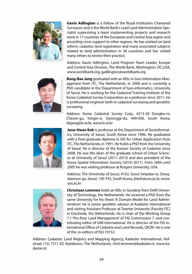
69
Gavin Adlington is a Fellow of the Royal Institution Chartered Surveyors and is the World Bank’s Lead Land Administration Spe-cialist supervising a team implementing projects and research work in 17 countries of the European and Central Asia region and providing cross-support to other regions. He has worked on land reform, cadastre, land registration and many associated subjects related to land administration in 36 countries and has visited many others to review their practice.
Address: Gavin Adlington, Land Program Team Leader, Europe and Central Asia Division, The World Bank, Washington, DC,USA, www.worldbank.org, [email protected]
Bong-Bae Jang graduated with an MSc in Geo-Information Man-agement from ITC, The Netherlands, in 2008 and is currently a PhD candidate in the Department of Geo-informatics, University of Seoul. He is working for the Cadastral Training Institute of the Korea Cadastral Survey Corporation as a professor since 2011. He is professional engineer both in cadastral surveying and geodetic surveying.
Address: Korea Cadastral Survey Corp., #213-20 Dongbu-ro, Cheoin-gu, Yongin-si, Gyeonggi-do, 449-050, South Korea, [email protected], www.lx.or.kr
June-Hwan Koh is professor at the Department of Geoinformat-ics, University of Seoul, South Korea since 1996. He graduated with a Post-graduate diploma in GIS for Urban Application from ITC, The Netherlands, in 1991. He holds a PhD from the University of Seoul. He is director of the Korean Society of Cadastre since 2008. He was the dean of the graduate school of Urban Scienc-es at University of Seoul (2011–2013) and also president of the Korea Spatial Information Society (2010–2011). From 2004 until 2005 he was visiting professor at Rutgers University, USA.
Address: The University of Seoul, #163, Seoul Siripdae-ro, Dong-daemun-gu, Seoul, 130-743, South Korea, [email protected], www.uos.ac.kr
Christiaan Lemmen holds an MSc in Geodesy from Delft Univer-sity of Technology, the Netherlands. He received a PhD from the same University for his thesis ‘A Domain Model for Land Admin-istration’. He is senior geodetic advisor at Kadaster International and visiting Assistant Professor at Twente University (Faculty ITC) in Enschede, the Netherlands. He is chair of the Working Group 7.1 ‘Pro Poor Land Management’ of FIG Commission 7, and con-tributing editor of GIM International. He is director of the FIG In-ternational Office of Cadastre and Land Records, OICRF. He is one of the co-editors of ISO 19152.
Address: Cadastre, Land Registry and Mapping Agency, Kadaster International, Hof-straat 110, 7311 KZ Apeldoorn, The Netherlands, [email protected], www.ka-daster.nl.

70
Peter van Oosterom obtained an MSc in 1985 from Delft Uni-versity of Technology, the Netherlands, and in 1990 he received a PhD from Leiden University. From 1985–1995 he worked at the TNO-FEL laboratory in The Hague, the Netherlands as a computer scientist. From 1995 until 2000 he was senior information manag-er at the Dutch Cadaster, where he was involved in the renewal of the Cadastral (Geographic) database. Since 2000, he is professor at Delft University of Technology, Faculty of Architecture and the Built Environment, Department OTB and head of the ‘GIS Technol-
ogy’ Section. He is the current chair of the FIG working group on ‘3D-Cadastres’. He is one of the co-editors of ISO 19152.
Address: Delft University of Technology, Faculteit Bouwkunde, Julianalaan 134, 2628 BL Delft, The Netherlands, [email protected], www.otb.tudelft.nl.
Michael Germann is co-founder and CEO of infoGrips LTD, Zürich Switzerland and member of the Swiss Land Aministration Foun-dation (SLM). In 1988, he received a master’s degree in computer science from ETH Zürich. His main interests are software develop-ment, data modelling, data quality control and the implementa-tion of spatial data infrastructures. He worked on several Swiss standards including INTERLIS and was part-time member of the Swiss delegation to ISO TC211.
Address: Michael Germann, infoGrips GmbH, Technoparkstrasse 1, CH-8005 Zürich, Switzerland, [email protected], www.infogrips.ch.
Jürg H. Lüthy is member of the Management Board at SWR Geo-matik AG, one of the largest geomatics companies in Switzerland. He has many years of experience in spatial data management, transition from paper maps to data centric systems and the op-eration of Spatial Data Infrastructures. He is the Swiss delegate to FIG Commission 3.
Address: SWR Geomatik, Wagistrasse 6, CH-8952 Schlieren, Swit-zerland, [email protected], www.swr-geomatik.ch
Abbas Rajabifard is Professor and Head of the Department of Infrastructure Engineering and Director of the Centre for Spatial Data Infrastructures and Land Administration, both at the Uni-versity of Melbourne. He is immediate Past-President of Global Spatial Data Infrastructure (GSDI) Association and is an Executive Board member of this Association. He is also a member of the Joint Board of Geospatial Information Societies (JBGIS) and was Vice Chair, Spatially Enabled Government Working Group of the
UN supported Permanent Committee on GIS Infrastructure for Asia and the Pacific. Prof Rajabifard has authored/co-authored over 250 publications including 9 books. He has been also consulted widely on spatial data management, SDI, land administration and spatial enablement, to many national government agencies and ministries.
Address: Department of Infrastructure Engineering, The University of Melbourne, Victo-ria 3010, Australia, [email protected], www.geom.unimelb.edu.au

71
Rohan Bennett is based in the Netherlands and works as an As-sistant Professor at the UNU School for Land Administration with-in the ITC Faculty of University of Twente. Previously he worked at the University of Melbourne as Lecturer and Research Fellow. From the same institution he holds a PhD in Land Administra-tion, along with degrees in Geomatics Engineering and Informa-tion Systems. His research, education, and capacity development work focuses on land informatics: assessing and assisting the alignment of emerging technological opportunities with the land
related challenges of specific communities. Recent focus areas include parts of Viet-nam, Bhutan, Kenya, Ethiopia, Rwanda and Uganda.
Address: ITC, Faculty of Geo-Information, Science and Earth Observation of the Univer-sity of Twente, PO Box 217, 7500 AE Enschede, The Netherlands, [email protected], www.itc.nl/PGM.
Stig Enemark is Professor of Land Management at Aalborg Uni-versity, Denmark. He is Honorary President of the International Federation of Surveyors, FIG (President 2007–2010) and Past Pres-ident and Honorary Member of the Danish Association of Char-tered Surveyors (DdL). He worked for 12 year as a licensed survey-or in private practice before entering the academic world. He is a well-known international expert in the areas of land administra-tion systems, land management and spatial planning, and related educational and capacity building issues. He has consulted and published widely in these areas.
Address: Aalborg University, Department of Development and Planning, Skibbroga-de 3 A1, DK 9000 Aalborg, Denmark, [email protected], http://personprofil.aau.dk/100037

72
ACKNOWLEDGEMENTS
The initial idea for special CADASTRE 2014 sessions at the FIG-Congress 2014 in Kuala Lumpur came from Rudolf Staiger, FIG Vice President, on that memorable evening in May 2012 in Rome. I am very grateful for his encouragement to do so.
I would like to thank the FIG-Office and the chair of Commission 7 to have accepted the proposal for these special sessions and to have supported us in preparing and holding it during the XXV FIG-Congress.
I also would like to thank all members and friends of FIG-Commission 7 who contrib-uted to the original booklet of CADASTRE 2014 and its success and translations. To the authors who now contributed – without hesitation – to this new special booklet, I also would like to extend my most sincere thanks.
Most of all, I would like to thank Jürg Kaufmann for his ongoing and never waning commitment to the cause for the last 20 years. Without him, we would not have the opportunity to discuss the cadastre as we do it today, and we would not have learned as much as we did over the last 20 years.
Lastly, layout and printing was made possible by the sponsorship of FIG. I would like to thank Louise Friis-Hansen for her special effort, who made it all come together in the end. I also would like to thank my employer, the Swiss Federal Office of Topography swisstopo to have allowed me to work on this project.
To all of these kind supporters, I give my most cordial thanks.
Dr. Daniel Steudler

73
FIG PUBLICATIONS
The FIG publications are divided into four categories. This should assist members and other users to identify the profile and purpose of the various publications.
FIG Policy StatementsFIG Policy Statements include political declarations and recommendations endorsed by the FIG General Assembly. They are prepared to explain FIG policies on important topics to politicians, government agencies and other decision makers, as well as sur-veyors and other professionals.
FIG GuidesFIG Guides are technical or managerial guidelines endorsed by the Council and record-ed by the General Assembly. They are prepared to deal with topical professional issues and provide guidance for the surveying profession and relevant partners.
FIG ReportsFIG Reports are technical reports representing the outcomes from scientific meetings and Commission working groups. The reports are approved by the Council and include valuable information on specific topics of relevance to the profession, members and individual surveyors.
FIG RegulationsFIG Regulations include statutes, internal rules and work plans adopted by the FIG or-ganisation.
List of FIG publicationsFor an up-to-date list of publications, please visit www.fig.net/pub/figpub
ABOUT FIG
International Federation of Surveyors is the premier international or-ganization representing the interests of surveyors worldwide. It is a fed-eration of the national member associations and covers the whole range of professional fields within the global surveying community. It provides an international forum for discussion and development aiming to pro-mote professional practice and standards.
FIG was founded in 1878 in Paris and was first known as the Fédération Internationale des Géomètres (FIG). This has become anglicized to the International Federation of Sur-veyors (FIG). It is a United Nations and World Bank Group recognized non-government organization (NGO), representing a membership from 120 plus countries throughout the world, and its aim is to ensure that the disciplines of surveying and all who practise them meet the needs of the markets and communities that they serve.


FIG PUBLICATION 61
ISBN 978-87-92853-12-7 (printed) • ISBN 978-87-92853-13-4 (pdf)
CADASTRE 2014 has originally been published in 1998 as a result of a working group of FIG Commission 7. The working group had the mandate to identify trends in the cadastral field and to suggest where the cadastre might be in 20 years time. It came up with six vision state-ments on technical, institutional, conceptual and financial issues, which were provocative for some, innovative for others. The translation into 28 languages, however, is testament to its role in the cadastral journey and the commitment of the whole Commission 7.
With the approach of the year 2014, it is a fitting occasion to reflect on CADASTRE 2014 once more. This publication with the title “CADASTRE 2014 and Beyond” not only reviews and evalu-ates the six statements, but puts them in a present-day context. Twelve authors give their views on CADASTRE 2014, on what has been achieved, on what can be learned from, and also on what is beyond the year 2014. Some contributors point out that the effects of the original six statements will still go on for some more years, but will also have to be amended and com-plemented by new issues and topics. One author in particular suggests six new questions, which the cadastral community ought to consider in finding answers to the challenges that our societies are facing today. Namely the discussions recently initiated by the UN to develop a “Post-2015 Global Development Agenda” will be very relevant and crucial to follow and to participate in.
In that sense, CADASTRE 2014 resembles a Swiss army knife: it has many tools to offer, from a conceptual as well as a technical point of view, and still provides a sound basis for discussion.
Boundary identification for cadastral reconstruction in Kosovo.