caverns water system coverletter - montana...
TRANSCRIPT

1400 South 19th Avenue Bozeman, MT 59718 August 18, 2011
To: Governor's Office, Mike Volesky, State Capitol, Room 204, P.O. Box 200801, Helena, MT 59620-0801 Environmental Quality Council, State Capitol, Room 106, P.O. Box 201704, Helena, MT 59620-1704
Dept. of Environmental Quality, Metcalf Building, P.O. Box 200901, Helena, MT 59620-0901 Dept. of Natural Resources & Conservation, P.O. Box 201601, Helena, MT 59620-1601 Montana Fish, Wildlife & Parks:
Director's Office Parks Division Lands Section FWP Commissioners Fisheries Division Legal Unit Wildlife Division Design & Construction
MT Historical Society, State Historic Preservation Office, P.O. Box 201202, Helena, MT 59620-1202 MT State Parks Association, P.O. Box 699, Billings, MT 59103 MT State Library, 1515 E. Sixth Ave., P.O. Box 201800, Helena, MT 59620 James Jensen, Montana Environmental Information Center, P.O. Box 1184, Helena, MT 59624 Janet Ellis, Montana Audubon Council, P.O. Box 595, Helena, MT 59624 George Ochenski, P.O. Box 689, Helena, MT 59624 Jerry DiMarco, P.O. Box 1571, Bozeman, MT 59771 Montana Wildlife Federation, P.O. Box 1175, Helena, MT 59624 Wayne Hurst, P.O. Box 728, Libby, MT 59923
Al Anderson, MT Rt. 287, Three Forks, MT 59752 Bert Hopeman, 1420 East 6th Avenue, Helena, MT Cardwell Store & RV Park, PO Box 55, Cardwell, MT 59721 Maxine Molenda, PO Box 2, Whitehall, MT 59759 Senator Terry Murphy, 893 Boulder Cutoff Rd., Cardwell, MT 59721 Greg Strohecker, KG Ranch, PO Box 178, Three Forks, MT 59752 Jack Dawson, 1672 Hwy 69, Boulder, MT 59632 Diane Rice, PO Box 216, Harrison, MT 59735 Steve Wendall, Lahood Park, Hwy 2, Cardwell, MT 59721 Jefferson County Weed Coordinator, PO Box H, Boulder, MT 59632 Arlene Weber, 1 Sunny Slope Rd., Whitehall, MT 59759 Nita Latimer, PO Box 971, Whitehall, MT 59759
Susan Stout, PO Box 481, Whitehall ,MT 59759
Ladies and Gentlemen:
The enclosed Environmental Assessment (EA) has been prepared for the proposed Lewis & Clark Caverns State Park Water System Improvement Project. This project proposes to update and improve the water system in the Park that services the upper visitor center and concession buildings. This Draft EA is available for review in Helena at FWP’s Headquarters, the State Library, and the Environmental Quality Council. It also may be obtained from FWP at the address provided above, or viewed on FWP’s Internet website: http://www.fwp.mt.gov .

Montana Fish, Wildlife & Parks invites you to comment on the attached proposal. The public comment period will be accepted until 5:00 p.m. September 19, 2011 Comments should be sent to the following:
Montana Fish, Wildlife & Parks
C/O Caverns Water System Improvements P.O. Box 489
Whitehall, MT 59759
Or e-mailed to: [email protected]
Sincerely,
Jerry Walker Regional Park Manager Attachment

DRAFT ENVIRONMENTAL ASSESSMENT
LEWIS & CLARK CAVERNS STATE PARK
PROPOSED WATER SYSTEM IMPROVEMENT PROJECT
August 2011
2
Lewis & Clark Caverns State Park
Proposed Water System Improvement Project Draft Environmental Assessment
MEPA, NEPA, MCA 23-1-110 CHECKLIST PART I. PROPOSED ACTION DESCRIPTION 1. Type of proposed state action:
Lewis and Clark Caverns State Park is Montana’s first and best-known park, featuring one of the largest known limestone caverns in the Northwest. The park hosts over 60,000 visitors annually and is a popular destination for visitors from all over the country. Water for the park is currently supplied by a spring along Greer Gulch, which is then piped from the spring cistern to the storage cistern below the main park road, treated, and then pumped to an 18,000-gallon storage tank above the upper parking lot. Water is then gravity-fed to the upper visitor center, concessions building, restrooms, picnic areas, and fire hydrant. The water supply from the spring has become unreliable over the years, the 50-year old delivery system is inefficient, and the pump, water storage, and water treatment facilities are outdated. FWP proposes to update and improve the water supply, treatment, and delivery system to ensure safe, uninterrupted water service to the park. The key elements of the water system improvement project include removal of the existing spring cistern, pump house, storage cistern, water treatment facilities, and pipeline from the pump house to the upper storage tank; installation of a new spring cistern, pipeline from the spring cistern to the storage cistern, storage cistern, and pipeline from the pump house to the upper storage tank; and construction of a new pump house with new water treatment facilities, and 100-foot access road from the main park road to the pump house.
2. Agency authority for the proposed action: The 1977 Montana Legislature enacted Sections 23-1-105, 23-1-106, 15-1-122, 61-3-321, and
87-1-303, Montana Code Annotated (MCA), which authorizes Montana Fish Wildlife and Parks (FWP) to collect fees and charges for the use of state park system units and fishing access sites, and contain rule-making authority for their use, occupancy, and protection. Furthermore, Section 23-1-110, MCA, and Administrative Rules of Montana (ARM) 12.2.433 guides public involvement and comment for the improvements at state parks, which this document provides.
ARM 12.8.602 requires the Department to consider the wishes of the public, the capacity of the
site for development, environmental impacts, long-range maintenance, protection of natural features and impacts on tourism as these elements relate to development or improvement to fishing access sites or state parks. This document will illuminate the facets of the proposed project in relation to this rule. See Appendix A for HB 495 qualification.
3. Name of project:
Lewis and Clark Caverns State Park Proposed Water System Improvement Project 4. Project sponsor: Montana Fish, Wildlife and Parks, Region 3 1400 South 19th Ave Bozeman, MT 59718 (406) 994-4042

3
5. Anticipated Schedule: Estimated Public Comment Period: September 2011 Estimated Decision Notice: October 2011 Estimated Construction/Commencement Date: Mid Fall 2011 Estimated Completion Date: Late Fall/Early Winter 2011 Current Status of Project Design (% complete): 65%
6. Location: Lewis and Clark Caverns State Park covers 2,920 acres and is located along the Jefferson River, 19 miles west of Three Forks and 15 miles east of Whitehall on Montana Highway 2, in Jefferson County, Montana in portions of Sections 7, 8, 16, 17, 18, 20, and 21, Township 1 North, Range 2 West and portions of Sections 12 and 13, Township 1 North, Range 3 West.
Figure 1. Lewis and Clark Caverns State Park General Location.
Figure 2. Lewis and Clark Caverns State Park Highway Map Location.
4
Figure 3. Lewis and Clark Caverns State Park Parcel Map.
7. Project size: Acres Acres (a) Developed: (d) Floodplain (100 year) 0 Residential 0 Industrial 0 (e) Productive: Irrigated cropland 0 (b) Open Space/ 0 Dry cropland 0 Woodlands/Recreation Forestry 0 (c) Wetlands/Riparian 3 Rangeland 0 Areas Other 0

5
Figure 4. Lewis and Clark Caverns State Park
Proposed Water Improvement Project Site Concept Plan
G

6
8. Local, State or Federal agencies with overlappin g or additional jurisdiction: (a) Permits: Agency Name Permit Montana Fish, Wildlife and Parks 124 MT Stream Protection Act Montana Dept. of Environmental Quality 318 Short-Term Water Quality Standard
for Turbidity Stormwater Discharge Permit U.S. Army Corps of Engineers 404 Federal Clean Water Act (b) Funding: 2009 Parks Earned Revenue Account $50,000 Federal Land and Water Conservation Fund $130,000 2011 Montana Bed Tax $270,000 $450,000 (c) Other Overlapping or Additional Jurisdictional Responsibilities: Agency Name Type of Responsibility Natural Heritage Program Species of Concern (Appendix B) State Historic Preservation Office Cultural Clearance (Appendix E) Jefferson County Weed District Weed Management Coordination and
Approval of Weed Management Plan
9. Narrative summary of the proposed action: Lewis and Clark Caverns State Park is Montana’s first and best-known park and features
one of the largest, most colorful, and highly decorated limestone caverns in the Northwest. The caverns were carved from the Madison Limestone Formation, a rock layer that formed 350 million years ago when the land was covered by a shallow tropical sea. Later, the melting of the great ice sheets on the land provided a water supply that began to carve through the limestone and create the caverns.
In 1805, the Lewis and Clark Expedition passed just below the caverns on the Jefferson
River never knowing the caverns existed. 103 years later, President Theodore Roosevelt named them Lewis and Clark Caverns in honor of the Corps of Discovery, creating our 15th National Monument. The Civilian Conservation Corp developed the caverns and surrounding area for visitor use during the New Deal era of the 1930’s and 1940’s. Montana Fish, Wildlife and Parks (FWP) now manages the caverns and the 2,920 acres that comprise Lewis and Clark Caverns State Park.
The park hosts over 60,000 visitors annually and is a popular destination for visitors from all
over the country. The park offers guided tours of the caverns from May through September. In addition, the park offers a variety of other activities and facilities including hiking and biking on the park’s extensive 10-mile trail system, interpretive programs, ranger programs and guided hikes, year-round camping facilities, year-round cabin and tipi rentals, deli and gift shop, and two visitor centers.
Vegetation found on Lewis and Clark Caverns State Park consists of Rocky Mountain Lower
Montane, Foothill and Valley Grassland, Montane Sagebrush Steppe, Rocky Mountain Montane Douglas-Fir Forest and Woodland, Northern Rocky Mountain Lower Montane Riparian Woodland and Shrubland, and Rocky Mountain Montane-Foothill Deciduous Shrubland. Common grass species found in the park include rough and Idaho fescue, western needlegrass, western and thickspike wheatgrass, pinegrass, prairie junegrass, and

7
basin wildrye. Common shrub species found on the park include chokecherry, big, tri-tip, and silver sagebrush, Rocky Mountain maple, mountain mahogany, Wood’s rose, serviceberry, snowberry, wax and golden currant, skunkbush sumac, and mock orange. Common tree species found on the park include black cottonwood, Douglas-fir, limber pine, aspen, and Rocky Mountain juniper. The property has an active weed control program. The most common weed species found on the park include spotted knapweed, leafy spurge, houndstongue, and common mullein.
Wildlife species observed at Lewis and Clark Caverns State Park include mule deer, elk, black bear, mountain lion, bobcat, golden eagle, magpie, mountain bluebird, western tanager, and various small mammals and songbirds. The Montana Natural Heritage Program identified ten Species of Concern within 5 miles of the proposed project area (Appendix B – Native Species Report). The arctic grayling is a candidate for listing as a threatened species by the U.S. Fish and Wildlife Service (USFWS). The peregrine falcon is classified as recovered, has been delisted by the USFWS, and is being monitored. The great blue heron, Clark’s nutcracker, fringed myotis, hoary bat, Townsend’s big-eared bat, a springtail, and a cave obligate harvestman are listed as Species of Concern. Limestone larkspur, a vascular plant, has also been observed within 4 miles of the project area and is listed as a Species of Concern. The water supply system for Lewis and Clark Caverns State Park is 50 years old and over time has become increasingly unreliable. The system has been repaired and patched many times and no longer functions as originally designed. The controls to monitor the system also do not function properly. If no action were taken and the water supply system was not updated and reconstructed, the park would be left with an inconsistent supply of water to operate the park and would eventually fail, leaving the park no means of providing a safe supply of water to the upper visitor center, concessions, restrooms, picnic areas, and hydrants, jeopardizing the health and safety of both staff and visitors. Neither the café nor restrooms could operate without water. Without available restrooms, cave tours could not be offered. In addition, an unreliable water supply and delivery system leaves the park at risk of having insufficient water to control a structure or wildland fire. FWP attempted to find an alternate water supply source to address some of the water supply problems. After exploring potential alternative water sources, a well was drilled at the location that was determined to be the most convenient for construction and maintenance, most cost-effective, least disruptive to visitors, and would minimize impacts to the environment. After drilling the well, FWP discovered that this well could not provide sufficient quantity or quality of water to meet the needs of the park. As a result, FWP decided to update and replace the park’s existing water supply and treatment system. The key elements of the water system improvement project include removal of the existing spring cistern, pump house, storage cistern, water treatment facilities, and pipeline from the pump house to the upper storage tank; installation of a new spring cistern, pipeline from the spring cistern to the storage cistern, storage cistern, and pipeline from the pump house to the upper storage tank; and construction of a new pump house with new water treatment facilities and 100-foot access road from the main park road to the pump house. FWP Parks Maintenance staff would continue implementing the FWP Statewide Integrated Noxious Weed Management Plan to mitigate the spread of noxious weeds on the property.The property would continue to be managed under exisiting FWP public use regulations and would be routinely maintained. Protection of the natural resources and the

8
health and safety of visitors would be considered and incorporated into the water system improvement plans. Reconstruction and improvement of the water system would provide safe, reliable, and consistent water service to the upper portions of Lewis and Clark Caverns State Park.
PART II. ENVIRONMENTAL REVIEW
1. Description and analysis of reasonable alternati ves: Alternative A: No Action The water supply system for Lewis and Clark Caverns State Park is 50 years old and over time has become increasingly unreliable. The system has been repaired and patched many times and no longer functions as originally designed. The controls to monitor the system also do not function properly. If no action were taken and the water supply system was not updated and reconstructed, the park would be left with an inconsistent supply of water to operate the park and would eventually fail, leaving the park no means of providing a safe supply of water to the upper visitor center, concessions, restrooms, picnic areas, and hydrants, jeopardizing the health and safety of both staff and visitors. Neither the café nor restrooms could operate without water. Without available restrooms, cave tours could not be offered. In addition, an unreliable water supply and delivery system leaves the park at risk of having insufficient water to control a structure or wildland fire. Alternative B: Proposed Action Water for the park is currently supplied by a spring along Greer Gulch, which is then piped from the spring cistern to the storage cistern below the main park road, treated, and then pumped to an 18,000-gallon storage tank above the upper parking lot. Water is then gravity-fed to the upper visitor center, concessions building, restrooms, picnic areas, and hydrants located in various areas of the park. FWP proposes to update and improve the water supply, treatment, and delivery system to ensure safe, uninterrupted water service to the park. The key elements of the water system improvement project include: removal of the existing spring cistern, pump house, storage cistern, water treatment facilities, and pipeline from the pump house to the upper storage tank; installation of a new spring cistern, pipeline from the spring cistern to the storage cistern, storage cistern, and pipeline from the pump house to the upper storage tank; and construction of a new pump house with new water treatment facilities and 100-foot access road from the main park road to the pump house.
2. Evaluation and listing of mitigation, stipulatio n, or other control measures enforceable
by the agency or another government agency: FWP employs Best Management Practices, which are designed to reduce or eliminate sediment delivery to waterways during construction. FWP would develop the final design and specifications for the proposed project. All county, state, and federal permits listed in Part I 8(a) above would be obtained by FWP as required. A private contractor selected through the State’s contracting processes would complete the construction.
* Include a narrative explanation under Part III describing the scope and level of impact. If the impact is unknown, explain why the
unknown impact has not or cannot be evaluated.
** Include a narrative description addressing the items identified in 12.8.604-1a (ARM).
*** Determine whether the described impact may result and respond on the checklist. Describe any minor or potentially significant
impacts.
**** Include a discussion about the issue in the EA narrative and include documentation if it will be useful.
9
PART III. ENVIRONMENTAL REVIEW CHECKLIST
Evaluation of the impacts of the Proposed Action including secondary and cumulative impacts on the Physical and Human Enviro nment. A. PHYSICAL ENVIRONMENT
1a. Soil and geologic substructure would remain stable during and after the proposed work. 1b. No elements of the existing or proposed water system are located in areas under agricultural production, and the
proposed project would not affect soil productivity or fertility. Construction of the pump house and 100-foot access road, and installation of the new cisterns and pipelines would disturb and compact soils in the immediate vicinity of construction. However, the proposed project would be located in areas previously disturbed by the existing water system minimizing impacts to undisturbed areas. Temporary erosion and sediment control measures would be used including limiting construction on wet soils to minimize soil compaction and installing temporary structural control measures to reduce soil erosion and the transport of sediment offsite during construction. Following construction, disturbed soils would be reseeded to minimized erosion and sedimentation and FWP Best Management Practices (BMP’s) would be followed (Appendix D – Best Management Practices).
1d. Most of the work for the proposed project would be done in or near Greer Gulch, a perennial stream. The existing spring-cistern, located in Greer Gulch, would be replaced and a new pipeline running from the spring cistern along Greer Gulch to the storage cistern would be installed. The pump house, storage cistern, and water treatment facility, located near Greer Gulch in the riparian area, would be replaced in the same location. The pipeline from the pump house to the upper 18,000-gallon storage tank would also be replaced. The proposed project would primarily replace and repair existing facilities. Disturbance of previously undisturbed land and riparian vegetation would be limited. The new 100-foot access road would also be constructed over a pioneered access trail, a previously disturbed location. Best Management Practices would be followed to minimize minor and temporary soil erosion and sedimentation of Greer Gulch that could result during construction. Upon completion of construction, the project is not expected to have any impact on erosion or sedimentation.
1. LAND RESOURCES Will the proposed action result in:
IMPACT ∗∗∗∗
Unknown ∗∗∗∗ None Minor ∗∗∗∗ Potentially Significant
Can Impact Be
Mitigated ∗∗∗∗
Comment Index
a. ∗∗Soil instability or changes in geologic substructure?
X 1a.
b. Disruption, displacement, erosion, compaction, moisture loss, or over-covering of soil, which would reduce productivity or fertility?
X X 1b.
c. ∗∗Destruction, covering or modification of any unique geologic or physical features?
X
d. Changes in siltation, deposition or erosion patterns that may modify the channel of a river or stream or the bed or shore of a lake?
X Yes 1d.
e. Exposure of people or property to earthquakes, landslides, ground failure, or other natural hazard?
X .

* Include a narrative explanation under Part III describing the scope and level of impact. If the impact is unknown, explain why the
unknown impact has not or cannot be evaluated.
** Include a narrative description addressing the items identified in 12.8.604-1a (ARM).
*** Determine whether the described impact may result and respond on the checklist. Describe any minor or potentially significant
impacts.
**** Include a discussion about the issue in the EA narrative and include documentation if it will be useful.
10
2a. Minor and temporary amounts of dust may be generated during demolition and removal of the pump house,
spring cistern, storage cistern, and pipeline to the upper storage tank; construction of the new pump house and access road; and installation of the new storage cistern, spring cistern, and pipeline. Construction would be timed to minimize disturbance to park visitors. The contractor would follow BMP’s during all phases of construction to minimize risks and reduce dust (Appendix D - BMP’s). FWP also requires contractors to limit disturbance of surrounding vegetation thus reducing dust and erosion.
2. AIR Will the proposed action result in:
IMPACT ∗∗∗∗
Unknown ∗∗∗∗ None Minor ∗∗∗∗ Potentially Significant
Can Impact Be
Mitigated ∗∗∗∗
Comment Index
a. ∗∗Emission of air pollutants or deterioration of ambient air quality? (Also see 13 (c).)
X Yes 2a.
b. Creation of objectionable odors?
X
c. Alteration of air movement, moisture, or temperature patterns or any change in climate, either locally or regionally?
X
d. Adverse effects on vegetation, including crops, due to increased emissions of pollutants?
X
e. ∗∗∗For P-R/D-J projects, will the project result in any discharge, which will conflict with federal or state air quality regs? (Also see 2a.)
NA

* Include a narrative explanation under Part III describing the scope and level of impact. If the impact is unknown, explain why the
unknown impact has not or cannot be evaluated.
** Include a narrative description addressing the items identified in 12.8.604-1a (ARM).
*** Determine whether the described impact may result and respond on the checklist. Describe any minor or potentially significant
impacts.
**** Include a discussion about the issue in the EA narrative and include documentation if it will be useful.
11
3a. Removal of the spring cistern, pump house and storage cistern, installation of the new spring cistern, pipelines,
and storage cistern, and construction of a new pump house and access road would cause a temporary, localized increase in turbidity in Greer Gulch. Erosion control measures that would minimize soil erosion and sedimentation are specified in the contractor’s project plan. Construction would take place during a time of naturally low stream water levels to minimize the impacts to surface water quality. FWP would obtain a Montana Department of Environmental Quality (DEQ) 318 Authorization Permit for Short Term Water Quality Standard for Turbidity. FWP BMP’s would be followed (Appendix D – BMP’s). Upon project completion, the stream is expected to return to pre-construction water quality levels.
3b. Surface runoff may increase slightly during construction due to excavation and vegetation removal for removal of
the storage and spring cisterns, pipeline, and pump house, installation of the new cisterns and pipelines, and construction of the pump house and access road. Erosion control techniques outlined in the contractor’s project
3. WATER Will the proposed action result in:
IMPACT ∗∗∗∗
Unknown ∗ None Minor ∗ Potentially Significant
Can Impact Be
Mitigated ∗∗∗∗
Comment Index
a. ∗Discharge into surface water or any alteration of surface water quality including but not limited to temperature, dissolved oxygen or turbidity?
X Yes 3a.
b. Changes in drainage patterns or the rate and amount of surface runoff?
X Yes 3b.
c. Alteration of the course or magnitude of floodwater or other flows?
X
d. Changes in the amount of surface water in any water body or creation of a new water body?
X Yes 3d.
e. Exposure of people or property to water related hazards such as flooding?
X Yes 3e.
f. Changes in the quality of groundwater?
X
g. Changes in the quantity of groundwater?
X
h. Increase in risk of contamination of surface or groundwater?
X Yes 3h.
i. Effects on any existing water right or reservation?
X
j. Effects on other water users as a result of any alteration in surface or groundwater quality?
X
k. Effects on other users as a result of any alteration in surface or groundwater quantity?
X
l. ∗∗∗∗For P-R/D-J, will the project affect a designated floodplain? (Also see 3c.)
NA
m. ∗∗∗For P-R/D-J, will the project result in any discharge that will affect federal or state water quality regulations? (Also see 3a.)
NA

* Include a narrative explanation under Part III describing the scope and level of impact. If the impact is unknown, explain why the
unknown impact has not or cannot be evaluated.
** Include a narrative description addressing the items identified in 12.8.604-1a (ARM).
*** Determine whether the described impact may result and respond on the checklist. Describe any minor or potentially significant
impacts.
**** Include a discussion about the issue in the EA narrative and include documentation if it will be useful.
12
plan would minimize runoff and only slightly change drainage patterns. The new facilities would be constructed in areas already disturbed by the existing water system. The proposed work would be designed to minimize any effect on surface water, surface runoff, and drainage patterns. In addition, soils disturbed during construction would be reseeded following construction to minimize the impacts of surface runoff. FWP BMP’s would be followed (Appendix D – BMP’s).
3d. A minor, temporary increase in runoff could occur due to the hardened surfaces created during construction,
such as from the access road and around the new pump house. This impact would be mitigated by re-vegetating soils disturbed during construction. Overall, the change in surface water would be negligible.
3e. The proposed project would be constructed in the riparian area along Greer Gulch and the facilities could be
subject to damage during times of exceptionally high flows. No visitor facilities are located in the vicinity of the proposed project and the project would not create a safety hazard to visitors, campgrounds, trails, concessions, picnic areas, or roads.
3h. The use of heavy equipment during construction may result in a slight risk of contamination from petroleum
products and an increase in sediment delivery to Greer Gulch. FWP BMP’s would be followed during all phases of construction to minimize these risks. (Appendix D – BMP’s). The application of herbicides to manage noxious weeds would be applied according to the guidelines in the FWP Statewide Integrated Noxious Weed Management Plan.

* Include a narrative explanation under Part III describing the scope and level of impact. If the impact is unknown, explain why the
unknown impact has not or cannot be evaluated.
** Include a narrative description addressing the items identified in 12.8.604-1a (ARM).
*** Determine whether the described impact may result and respond on the checklist. Describe any minor or potentially significant
impacts.
**** Include a discussion about the issue in the EA narrative and include documentation if it will be useful.
13
4a./4b. The proposed project would slightly affect the abundance of plants in the project area, but the majority of
construction would take place in areas where existing facilities are already located. Construction would be planned to minimize tree removal and limit disturbance to vegetation. Disturbed soils would be re-vegetated with native species following construction. In the long-term, impacts to the plant communities from construction would be minor.
Vegetation found on Lewis and Clark Caverns State Park consists of Rocky Mountain Lower Montane, Foothill
and Valley Grassland; Montane Sagebrush Steppe; Rocky Mountain Montane Douglas-Fir Forest and Woodland; Northern Rocky Mountain Lower Montane Riparian Woodland and Shrubland; and Rocky Mountain Montane-Foothill Deciduous Shrubland. Common grass species found in the park include rough and Idaho fescue, western needlegrass, western and thickspike wheatgrass, pinegrass, prairie junegrass, and basin wildrye. Common shrub species found on the park include chokecherry, big, tri-tip, and silver sagebrush, Rocky Mountain maple, mountain mahogany, Wood’s rose, serviceberry, snowberry, wax and golden currant, skunkbush sumac, and mock orange. Common tree species found on the park include black cottonwood, Douglas-fir, limber pine, aspen, and Rocky Mountain juniper. The most common weed species found on the park include spotted knapweed, leafy spurge, houndstongue, and common mullein.
4c. A search of the Montana Natural Heritage Program’s (MNHP) Species of Concern database found that the plant
limestone larkspur, a species of concern, was observed within 4 miles of the project area as recently as 1993. The proposed project would not impact limestone larkspur since the project would be located in the riparian area of Greer Gulch, and limestone larkspur is found in short-grass prairie and grass-sagebrush communities on rocky, limestone soils.
4d. The proposed project area is not used for agricultural production. 4e. Soils disturbed during construction would likely colonize with weeds. Disturbed areas would be re-seeded with
native grasses where necessary to reduce the establishment of weeds. In conjunction with the Jefferson County Weed Control Board, FWP would continue implementing the Statewide Integrated Weed Management Plan using chemical, biological, and mechanical methods to control weeds on the property. Weed management would facilitate the establishment of native vegetation and prevent the spread of weeds. Service vehicles would be restricted to the pump house access road, which would be maintained as weed-free, and vehicles would not be allowed on undisturbed areas of the site to minimize the spread of noxious weeds. FWP estimates that weed control for the project area would cost an additional $1000 per year.
4. VEGETATION Will the proposed action result in?
IMPACT ∗∗∗∗
Unknown ∗ None Minor ∗ Potentially Significant
Can Impact Be
Mitigated ∗∗∗∗
Comment Index
a. Changes in the diversity, productivity or abundance of plant species (including trees, shrubs, grass, crops, and aquatic plants)?
X Yes 4a
b. Alteration of a plant community?
X Yes 4b.
c. Adverse effects on any unique, rare, threatened, or endangered species?
X 4c.
d. Reduction in acreage or productivity of any agricultural land?
X 4d.
e. Establishment or spread of noxious weeds?
X Yes 4e.
f. ****For P-R/D-J, will the project affect wetlands, or prime and unique farmland?
NA 4f.

* Include a narrative explanation under Part III describing the scope and level of impact. If the impact is unknown, explain why the
unknown impact has not or cannot be evaluated.
** Include a narrative description addressing the items identified in 12.8.604-1a (ARM).
*** Determine whether the described impact may result and respond on the checklist. Describe any minor or potentially significant
impacts.
**** Include a discussion about the issue in the EA narrative and include documentation if it will be useful.
14
4f. No wetlands designated by Montana Natural Heritage Program or prime farmlands are found on Lewis and Clark
Caverns State Park.
Overall, the proposed project would have no substantial, long-term impact on fish or wildlife. 5a,b,c. Wildlife species that are at least occasionally found at Lewis and Clark Caverns State Park include mule deer,
elk, black bear, mountain lion, bobcat, red fox, golden eagle, great horned owl, mountain bluebird, western tanager, and various small mammals, waterfowl, and songbirds. Because the proposed project area is already developed and disturbed by the existing water system components, the proposed project is not expected to have any impact on the game or non-game species that frequent the property. The area is also not considered critical habitat for any wildlife or fish species.
Based upon a review of Montana Fisheries Information System (MFISH), no data is available for fish species or angler days per year for Greer Gulch, though information is available for the Jefferson River, located 1.5 miles from the project area. Mountain whitefish is abundant in the Jefferson River; brown trout, rainbow trout, common carp, longnose dace, longnose sucker, and mottled sculpin are common; and arctic grayling, burbot, mountain sucker, northern pike, redside shiner, and stonecat are rare. According to FWP surveys, the number of angler days per year on the Jefferson River between 2001 and 2009 averaged 9,270, with a low of 6,994 in 2001 and a high of 13,606 in 2009. The state ranking for this stretch of river ranged from 59 to 82 during this same period. Common game fish in the Jefferson River include brown trout, rainbow trout, and mountain whitefish.
∗∗∗∗∗∗∗∗ 5. FISH/WILDLIFE Will the proposed action result in:
IMPACT ∗∗∗∗
Unknown ∗∗∗∗ None Minor ∗∗∗∗ Potentially Significant
Can Impact Be
Mitigated ∗∗∗∗
Comment Index
a. Deterioration of critical fish or wildlife habitat?
X
b. Changes in the diversity or abundance of game animals or bird species?
X Yes 5b.
c. Changes in the diversity or abundance of nongame species?
X 5c.
d. Introduction of new species into an area?
X
e. Creation of a barrier to the migration or movement of animals?
X
f. Adverse effects on any unique, rare, threatened, or endangered species?
X 5f.
g. Increase in conditions that stress wildlife populations or limit abundance (including harassment, legal or illegal harvest or other human activity)?
X 5g.
h. ∗∗∗∗For P-R/D-J, will the project be performed in any area in which T&E species are present, and will the project affect any T&E species or their habitat? (Also see 5f.)
NA
i. ∗∗∗For P-R/D-J, will the project introduce or export any species not presently or historically occurring in the receiving location? (Also see 5d.)
NA
* Include a narrative explanation under Part III describing the scope and level of impact. If the impact is unknown, explain why the
unknown impact has not or cannot be evaluated.
** Include a narrative description addressing the items identified in 12.8.604-1a (ARM).
*** Determine whether the described impact may result and respond on the checklist. Describe any minor or potentially significant
impacts.
**** Include a discussion about the issue in the EA narrative and include documentation if it will be useful.
15
5f. The Montana Natural Heritage Program identified ten Species of Concern within 5 miles of the proposed project area (Appendix B – Native Species Report). Arctic grayling, a candidate for listing as a threatened species by the U.S. Fish and Wildlife Service (USFWS), has been observed in the Jefferson River. Because the Jefferson River is 1.5 miles from the project site and the proposed project would have only minor, localized, and temporary impacts on Greer Gulch, the proposed project would have no impact on arctic grayling. The peregrine falcon is classified as recovered, has been delisted by the USFWS, and is being monitored and was observed within 2 miles of the project area in 2006. In addition, a peregrine falcon nest with a nesting pair is located on the cliffs above the caverns. Because the proposed project would only have temporary, localized, and minor impacts to Greer Gulch; the area is already disturbed by existing facilities and by heavy visitor use; peregrine falcon habitat is found on vertical cliffs in undisturbed areas; and the construction activities would be done in fall when the falcons have migrated out of the area, the proposed project would not impact peregrine falcon. The great blue heron, Clark’s nutcracker, fringed myotis, hoary bat, Townsend’s big-eared bat, a springtail, and a cave obligate harvestman are listed as Species of Concern. Because the proposed project would have only minor, temporary, and localized impacts to Greer Gulch, the project area is not near nor would affect the caverns; and the area is already disturbed by the existing water system and by heavy visitor use, these Species of Concern would not be impacted by the proposed project. Limestone larkspur, a vascular plant, has also been observed within 4 miles of the project area and is listed as a Species of Concern. Because this species has not been observed since 1993 and is 4 miles from the proposed project area, the proposed project also would have no impact on the limestone larkspur.
According to Nathan Lance, FWP wolf biologist, gray wolves do not frequent the area, and there are no documented packs in the area. Even though it is possible for a wolf to move through the vicinity, wolves would not be affected by the proposed project.
5g. The proposed project would not contribute to additional use or disturbance of the area and would have no impact
on the existing wildlife or wildlife habitat.

* Include a narrative explanation under Part III describing the scope and level of impact. If the impact is unknown, explain why the
unknown impact has not or cannot be evaluated.
** Include a narrative description addressing the items identified in 12.8.604-1a (ARM).
*** Determine whether the described impact may result and respond on the checklist. Describe any minor or potentially significant
impacts.
**** Include a discussion about the issue in the EA narrative and include documentation if it will be useful.
16
B. HUMAN ENVIRONMENT
6a. Construction equipment would cause a temporary increase in noise levels at the project sites during construction. 6b. The minor and temporary increases in noise levels occurring during construction may disturb some visitors, but
FWP would attempt to complete construction during periods of low visitation, therefore limiting the number of people annoyed by the noise.
The proposed property area is currently located within a state park and used for the existing water system. The proposed project would not alter or interfere with the productivity or profitability of the existing land use of the park.
6. NOISE/ELECTRICAL EFFECTS Will the proposed action result in:
IMPACT ∗∗∗∗
Unknown ∗∗∗∗ None Minor ∗∗∗∗ Potentially Significant
Can Impact Be
Mitigated ∗∗∗∗
Comment Index
a. Increases in existing noise levels?
X Yes 6a.
b. Exposure of people to severe or nuisance noise levels?
X Yes 6b.
c. Creation of electrostatic or electromagnetic effects that could be detrimental to human health or property?
X
d. Interference with radio or television reception and operation?
X
7. LAND USE Will the proposed action result in:
IMPACT ∗∗∗∗
Unknown ∗∗∗∗ None Minor ∗∗∗∗ Potentially Significant
Can Impact Be
Mitigated ∗∗∗∗
Comment Index
a. Alteration of or interference with the productivity or profitability of the existing land use of an area?
X
b. Conflict with a designated natural area or area of unusual scientific or educational importance?
X
c. Conflict with any existing land use whose presence would constrain or potentially prohibit the proposed action?
X
d. Adverse effects on or relocation of residences?
X

* Include a narrative explanation under Part III describing the scope and level of impact. If the impact is unknown, explain why the
unknown impact has not or cannot be evaluated.
** Include a narrative description addressing the items identified in 12.8.604-1a (ARM).
*** Determine whether the described impact may result and respond on the checklist. Describe any minor or potentially significant
impacts.
**** Include a discussion about the issue in the EA narrative and include documentation if it will be useful.
17
8a. Physical disturbance of the soil during construction may introduce noxious weeds to the site. In conjunction with
Jefferson County Weed District, FWP would implement an integrated approach to control any new occurrence of noxious weeds, as outlined in the FWP Statewide Integrated Noxious Weed Management Plan. The integrated plan uses a combination of biological, mechanical and herbicidal treatments to control noxious weeds. The use of herbicides would be in compliance with application guidelines to minimize the risk of chemical spills or water contamination and applied by people trained in safe handling techniques.
8c. FWP proposes to update and improve the water supply, treatment, and delivery system. The proposed project
would improve public safety by providing safe, reliable, and uninterrupted water service to the visitor center, restrooms, concessions, picnic area, and fire hydrants in the park.
8. RISK/HEALTH HAZARDS Will the proposed action result in:
IMPACT ∗∗∗∗
Unknown ∗∗∗∗ None Minor ∗∗∗∗ Potentially Significant
Can Impact Be
Mitigated ∗∗∗∗
Comment Index
a. Risk of an explosion or release of hazardous substances (including, but not limited to oil, pesticides, chemicals, or radiation) in the event of an accident or other forms of disruption?
X Yes 8a.
b. Affect an existing emergency response or emergency evacuation plan, or create a need for a new plan?
X
c. Creation of any human health hazard or potential hazard?
X Yes
Positive 8c.
d. ∗∗∗For P-R/D-J, will any chemical toxicants be used? (Also see 8a)
NA
9. COMMUNITY IMPACT Will the proposed action result in:
Unknown ∗∗∗∗ None Minor ∗∗∗∗ Potentially Significant
Can Impact Be
Mitigated ∗∗∗∗
Comment Index
a. Alteration of the location, distribution, density, or growth rate of the human population of an area?
X
b. Alteration of the social structure of a community?
X
c. Alteration of the level or distribution of employment or community or personal income?
X Yes
Positive 9c.
d. Changes in industrial or commercial activity?
X
e. Increased traffic hazards or effects on existing transportation facilities or patterns of movement of people and goods?
X

* Include a narrative explanation under Part III describing the scope and level of impact. If the impact is unknown, explain why the
unknown impact has not or cannot be evaluated.
** Include a narrative description addressing the items identified in 12.8.604-1a (ARM).
*** Determine whether the described impact may result and respond on the checklist. Describe any minor or potentially significant
impacts.
**** Include a discussion about the issue in the EA narrative and include documentation if it will be useful.
18
9c. The proposed project could slightly improve tourism in the area by providing a safe, reliable water supply, though the existing water system has not yet failed. Any increased tourism to the park would benefit local retail and service businesses in Three Forks and Whitehall (Appendix C - Tourism Report).
The proposed development would have no impact on public services, taxes or utilities.
10b. There would be no change in the tax base since FWP would continue to pay property taxes in an amount equal to that of a private individual.
10c. No additional utilities would be required to operate the new water system since the proposed project would only
replace, repair, and update the existing water system. 10f. Projected annual operating, maintenance, and personnel expense for fiscal year 2011 is estimated to be
approximately $2500. FWP projects that noxious weed control for the project area would cost an additional $1000 annually.
Total costs to develop the proposed water system improvement project are estimated to be approximately $450,000, which would be paid for through the 2009 Parks Earned Revenue Account, Federal Land and Water Conservation Fund, and the 2011 Montana Bed Tax.
10. PUBLIC SERVICES/TAXES/UTILITIES Will the proposed action result in:
IMPACT ∗∗∗∗
Unknown ∗∗∗∗ None Minor ∗∗∗∗ Potentially Significant
Can Impact Be
Mitigated ∗∗∗∗
Comment Index
a. Will the proposed action have an effect upon or result in a need for new or altered governmental services in any of the following areas: fire or police protection, schools, parks/recreational facilities, roads or other public maintenance, water supply, sewer or septic systems, solid waste disposal, health, or other governmental services? If any, specify:
X
b. Will the proposed action have an effect upon the local or state tax base and revenues?
X 10b.
c. Will the proposed action result in a need for new facilities or substantial alterations of any of the following utilities: electric power, natural gas, other fuel supply or distribution systems, or communications?
X
d. Will the proposed action result in increased use of any energy source?
X
e. ∗∗Define projected revenue sources
X 10e.
f. ∗∗Define projected maintenance costs.
X 10 f.

* Include a narrative explanation under Part III describing the scope and level of impact. If the impact is unknown, explain why the
unknown impact has not or cannot be evaluated.
** Include a narrative description addressing the items identified in 12.8.604-1a (ARM).
*** Determine whether the described impact may result and respond on the checklist. Describe any minor or potentially significant
impacts.
**** Include a discussion about the issue in the EA narrative and include documentation if it will be useful.
19
11a. Heavy equipment necessary for completion of the proposed project would be visible from the park’s main road
during construction. Upon completion, the new access road and pump house would be the only components of the proposed project that would be visible to the public from the main park road. After re-vegetation of the disturbed soils, the access road and pump house would be less visible. No scenic vistas would be affected by the proposed project.
11c. The proposed project could result in slightly higher visitor use by creating a more reliable supply of water,
improving the recreational opportunities of the park. Visitor use would not be affected by the proposed project because construction would occur during a time when the main park road is already closed for the season. Deer and upland bird hunting would continue to be allowed during the general hunting season in the undeveloped, western portion of the park. Fishing access to the Jefferson River would continue to be available from the park.
∗∗∗∗∗∗∗∗ 11. AESTHETICS/RECREATION Will the proposed action result in:
IMPACT ∗∗∗∗
Unknown ∗∗∗∗ None Minor ∗∗∗∗ Potentially Significant
Can Impact Be
Mitigated ∗∗∗∗
Comment Index
a. Alteration of any scenic vista or creation of an aesthetically offensive site or effect that is open to public view?
X Yes 11a.
b. Alteration of the aesthetic character of a community or neighborhood?
X
c. ∗∗Alteration of the quality or quantity of recreational/tourism opportunities and settings? (Attach Tourism Report.)
X
X
Positive 11c.
d. ∗∗∗For P-R/D-J, will any designated or proposed wild or scenic rivers, trails or wilderness areas be impacted? (Also see 11a, 11c.)
NA
12. CULTURAL/HISTORICAL RESOURCES Will the proposed action result in:
IMPACT ∗∗∗∗
Unknown ∗∗∗∗ None Minor ∗∗∗∗ Potentially Significant
Can Impact Be
Mitigated ∗∗∗∗
Comment Index
a. ∗∗Destruction or alteration of any site, structure or object of prehistoric historic, or paleontological importance?
X
b. Physical change that would affect unique cultural values?
X
c. Effects on existing religious or sacred uses of a site or area?
X
d. ∗∗∗∗For P-R/D-J, will the project affect historic or cultural resources? Attach SHPO letter of clearance. (Also see 12.a.)
NA

* Include a narrative explanation under Part III describing the scope and level of impact. If the impact is unknown, explain why the
unknown impact has not or cannot be evaluated.
** Include a narrative description addressing the items identified in 12.8.604-1a (ARM).
*** Determine whether the described impact may result and respond on the checklist. Describe any minor or potentially significant
impacts.
**** Include a discussion about the issue in the EA narrative and include documentation if it will be useful.
20
A clearance from the State Historic Preservation Office (SHPO) has been obtained, stating that the proposed project would not affect archaeological or historical sites (Appendix E – State Historic Preservation Office Clearance). If cultural materials are discovered during the project, work would cease and SHPO will be contacted for a more in depth investigation.
SIGNIFICANCE CRITERIA
During construction of the proposed project, there may be minor and temporary impacts to the physical environment but the impacts would be short-term and the improvements would benefit the recreational opportunities of Lewis and Clark Caverns State Park over the long-term. The proposed development would have no negative cumulative effects on the biological, physical, and human environments. When considered over the long-term, the proposed development positively impacts the public’s enjoyment of Montana’s first and most popular state park.
13. SUMMARY EVALUATION OF SIGNIFICANCE Will the proposed action, considered as a whole:
IMPACT ∗∗∗∗
Unknown ∗∗∗∗ None Minor ∗∗∗∗ Potentially Significant
Can Impact Be
Mitigated ∗∗∗∗
Comment Index
a. Have impacts that are individually limited, but cumulatively considerable? (A project or program may result in impacts on two or more separate resources that create a significant effect when considered together or in total.)
X
b. Involve potential risks or adverse effects, which are uncertain but extremely hazardous if they were to occur?
X
c. Potentially conflict with the substantive requirements of any local, state, or federal law, regulation, standard or formal plan?
X
d. Establish a precedent or likelihood that future actions with significant environmental impacts will be proposed?
X
e. Generate substantial debate or controversy about the nature of the impacts that would be created?
X
f. ∗∗∗For P-R/D-J, is the project expected to have organized opposition or generate substantial public controversy? (Also see 13e.)
NA
g. ∗∗∗∗For P-R/D-J, list any federal or state permits required.
NA

21
PART III. NARRATIVE EVALUATION AND COMMENT During construction of the proposed project, there may be minor and temporary impacts to the physical environment but the impacts would be short-term and the improvements would benefit the recreational opportunities of Lewis and Clark Caverns State Park over the long-term. The proposed development would have no negative cumulative effects on the biological, physical, and human environments. When considered over the long-term, the proposed development positively impacts the public’s enjoyment of Montana’s first and most popular state park. The minor impacts to the environment that were identified in the previous section are small in scale and would not influence the overall environment of the immediate area. The natural environment would continue to provide habitat to transient and permanent wildlife and aquatic species. The most common weeds found at Lewis and Clark Caverns State Parks include leafy spurge, spotted knapweed, houndstongue, and common mullein. FWP actively manages weeds on the park property and would continue implementing the Statewide Integrated Weed Management Plan using biological, chemical, and physical methods of weed control to prevent the establishment or spread of noxious weeds. The proposed development would have no lasting negative impact on the local wildlife species that frequent the property, would not increase negative conditions that stress wildlife populations, and the property is not considered critical habitat for any species. Ten species of concern have been observed within 5 miles of the project area including arctic grayling, peregrine falcon, great blue heron, Clark’s nutcracker, fringed myotis, hoary bat, Townsend’s big-eared bat, a springtail, a cave obligate harvestman, and limestone larkspur. It is unlikely that the proposed project would impact any of these Species of Concern since most of these species were observed at least .5 miles from the project site at least six years ago, the proposed project would have only minor, localized, and temporary effects on Greer Gulch, and the area is already disturbed by the existing facilities and by heavy visitor use of the park. While it is possible for wolves to travel through the project area, none have been sighted and there is no pack located in the area so it is unlikely that the proposed development would impact gray wolves. The Lewis and Clark Caverns State Park Proposed Water System Improvement Project would include reconstruction and improvement of the water system, allowing FWP to provide reliable, consistent, and safe water service for sanitation and fire protection to the upper portions of Lewis and Clark Caverns State Park, Montana’s oldest and most popular state park. PART IV. PUBLIC PARTICIPATION 1. Describe the level of public involvement for thi s project, if any, and, given
the complexity and the seriousness of the environme ntal issues associated with the proposed action, is the level of public in volvement appropriate under the circumstances? The public will be notified in the following manners to comment on the Lewis and Clark Caverns Proposed Water System Improvement Project: • Two public notices in each of these papers: the Whitehall Ledger, the Bozeman Daily Chronicle, the Montana Standard, and the Helena Independent Record. • Public notice on the Fish, Wildlife & Parks web page: http://fwp.mt.gov. • Direct notice will be given to adjacent landowners. • Draft EA’s will be available at the FWP Region 3 Headquarters in Bozeman and the FWP

22
State Headquarters in Helena. • A news release will be prepared and distributed to a standard list of media outlets
interested in FWP Region 3 issues. • Copies of this environmental assessment will be distributed to the neighboring
landowners and interested parties to ensure their knowledge of the proposed project. This level of public notice and participation is appropriate for a project of this scope having limited impacts, many of which can be mitigated. If requested within the comment period, FWP will schedule and conduct a public meeting on this proposed project.
2. Duration of comment period.
The public comment period will extend for (30) thirty days following the publication of the second legal notice in area newspapers. Written comments will be accepted until 5:00 p.m., September 19, 2011 and can be e-mailed to [email protected] or mailed to the address below: Lewis and Clark Caverns Proposed Water System Improvement Project Lewis and Clark Caverns State Park P.O. Box 489 Whitehall, MT 59759
PART V. EA PREPARATION 1. Based on the significance criteria evaluated in this EA, is an EIS required? NO
If an EIS is not required, explain why the EA is the appropriate level of analysis for th is proposed action. Based on an evaluation of impacts to the physical and human environment under MEPA, this environmental review revealed no significant negative impacts from the proposed action: therefore, an EIS is not necessary and an environmental assessment is the appropriate level of analysis. In determining the significance of the impacts, Fish, Wildlife and Parks assessed the severity, duration, geographic extent, and frequency of the impact, the probability that the impact would occur or reasonable assurance that the impact would not occur. FWP assessed the growth-inducing or growth-inhibiting aspects of the impact, the importance to the state and to society of the environmental resource or value effected, any precedent that would be set as a result of an impact of the proposed action that would commit FWP to future actions; and potential conflicts with local, federal, or state laws. As this EA revealed no significant impacts from the proposed actions, an EA is the appropriate level of review and an EIS is not required.
2. Persons responsible for preparing the EA:
Lynette Kemp Andrea Darling Lewis and Clark Caverns State Park Manager FWP EA Contractor P.O. Box 489 39 Big Dipper Drive Whitehall, MT 59759 Montana City, MT 59634 [email protected] [email protected] (406) 287-3541
3. List of agencies consulted during preparation of the EA:

23
Montana Department of Commerce – Tourism Montana Fish, Wildlife & Parks Parks Division Design and Construction Section Fish and Wildlife Division Fisheries Bureau Wildlife Bureau Lands Unit
Legal Unit Montana Natural Heritage Program – Natural Resources Information System (NRIS)
APPENDICES A. MCA 23-1-110 Qualification Checklist B. Native Species Report - Montana Natural Heritage Program (MNHP) C. Tourism Report – Department of Commerce D. Fish, Wildlife and Parks Best Management Practices E. State Historic Preservation Office Clearance
24
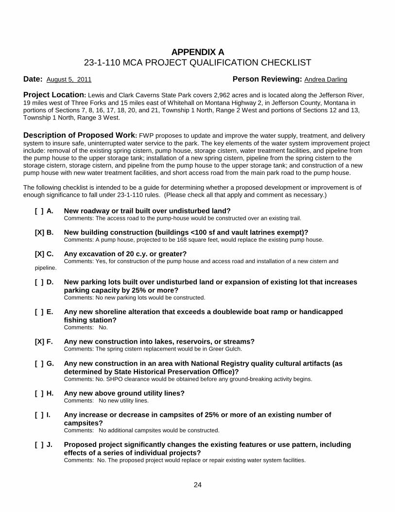
APPENDIX A 23-1-110 MCA PROJECT QUALIFICATION CHECKLIST
Date: August 5, 2011 Person Reviewing: Andrea Darling
Project Location : Lewis and Clark Caverns State Park covers 2,962 acres and is located along the Jefferson River, 19 miles west of Three Forks and 15 miles east of Whitehall on Montana Highway 2, in Jefferson County, Montana in portions of Sections 7, 8, 16, 17, 18, 20, and 21, Township 1 North, Range 2 West and portions of Sections 12 and 13, Township 1 North, Range 3 West. Description of Proposed Work : FWP proposes to update and improve the water supply, treatment, and delivery system to insure safe, uninterrupted water service to the park. The key elements of the water system improvement project include: removal of the existing spring cistern, pump house, storage cistern, water treatment facilities, and pipeline from the pump house to the upper storage tank; installation of a new spring cistern, pipeline from the spring cistern to the storage cistern, storage cistern, and pipeline from the pump house to the upper storage tank; and construction of a new pump house with new water treatment facilities, and short access road from the main park road to the pump house. The following checklist is intended to be a guide for determining whether a proposed development or improvement is of enough significance to fall under 23-1-110 rules. (Please check all that apply and comment as necessary.)
[ ] A. New roadway or trail built over undisturbed land? Comments: The access road to the pump-house would be constructed over an existing trail. [X] B. New building construction (buildings <100 sf and vault latrines exempt)? Comments: A pump house, projected to be 168 square feet, would replace the existing pump house. [X] C. Any excavation of 20 c.y. or greater? Comments: Yes, for construction of the pump house and access road and installation of a new cistern and pipeline. [ ] D. New parking lots built over undisturbed lan d or expansion of existing lot that increases
parking capacity by 25% or more? Comments: No new parking lots would be constructed. [ ] E. Any new shoreline alteration that exceeds a doublewide boat ramp or handicapped
fishing station? Comments: No. [X] F. Any new construction into lakes, reservoirs, or streams? Comments: The spring cistern replacement would be in Greer Gulch. [ ] G. Any new construction in an area with National Regis try quality cultural artifacts (as
determined by State Historical Preservation Office) ? Comments: No. SHPO clearance would be obtained before any ground-breaking activity begins. [ ] H. Any new above ground utility lines? Comments: No new utility lines. [ ] I. Any increase or decrease in campsites of 25 % or more of an existing number of
campsites? Comments: No additional campsites would be constructed. [ ] J. Proposed project significantly changes the existing features or use pattern, including
effects of a series of individual projects? Comments: No. The proposed project would replace or repair existing water system facilities.

25
APPENDIX B
NATIVE SPECIES REPORT – MONTANA NATURAL HERITAGE PROGRAM
Sensitive Plants and Animals in the Vicinity of Lewis and Clark Caverns State Park
Species of Concern Terms and Definitions A search of the Montana Natural Heritage Program (MNHP) element occurrence database (http://nris.mt.gov) indicates occurrences of the federally listed threatened bald eagle within 2.5 miles of the proposed development site. No other occurrences of federally listed endangered or threatened animal or plant species have been found within the vicinity of the proposed development site. The search indicated that the project area is within the habitat for the greater short-horned lizard and gray wolf. More information on these species is included below. Montana Species of Concern. The term “Species of Concern” includes taxa that are at-risk or potentially at-risk due to rarity, restricted distribution, habitat loss, and/or other factors. The term also encompasses species that have a special designation by organizations or land management agencies in Montana, including: Bureau of Land Management Special Status and Watch species; U.S. Forest Service Sensitive and Watch species; U.S. Fish and Wildlife Service Threatened, Endangered and Candidate species.
Status Ranks (Global and State) The international network of Natural Heritage Programs employs a standardized ranking system to denote global (G -- range-wide) and state status (S) (Nature Serve 2003). Species are assigned numeric ranks ranging from 1 (critically imperiled) to 5 (demonstrably secure), reflecting the relative degree to which they are “at-risk”. Rank definitions are given below. A number of factors are considered in assigning ranks -- the number, size and distribution of known “occurrences” or populations, population trends (if known), habitat sensitivity, and threat. Factors in a species’ life history that make it especially vulnerable are also considered (e.g., dependence on a specific pollinator).

26
MFWP Conservation Need . Under Montana’s Comprehensive Fish and Wildlife Conservation Strategy of 2005, individual animal species are assigned levels of conservation need as follows:
Tier I. Greatest conservation need. Montana FWP has a clear obligation to use its resources to implement conservation actions that provide direct benefit to these species, communities and focus areas.
Tier II. Moderate conservation need. Montana FWP could use its resources to implement conservation actions that provide direct benefit to these species communities and focus areas.
Tier III. Lower conservation need. Although important to Montana’s wildlife diversity, these species, communities and focus areas are either abundant or widespread or are believed to have adequate conservation already in place.
Tier IV. Species that are non-native, incidental or on the periphery of their range and are either expanding or very common in adjacent states.
SENSITIVE PLANTS AND ANIMALS IN THE VICINITY OF LEWIS AND CLARK CAVERNS STATE PARK
1. Ardea herodias (Great Blue Heron)
Vertebrate animal Natural Heritage Ranks Federal Agency Status: State: S3 U.S. Fish and Wildlife Service: Global: G5 U.S. Forest Service: U.S. Bureau of Land Management: FWP CFWCS Tier: 3 Element Occurrence data was reported of great blue heron within 2 miles of the project area. Last observation date was 2006.
2. Falco peregrinus (Peregrine Falcon)
Status Ranks
Code Definition
G1
S1
At high risk because of extremely limited and/or rapidly declining numbers,
range, and/or habitat, making it highly vulnerable to global extinction or
extirpation in the state.
G2
S2
At risk because of very limited and/or declining numbers, range, and/or habitat,
making it vulnerable to global extinction or extirpation in the state.
G3
S3
Potentially at risk because of limited and/or declining numbers, range, and/or
habitat, even though it may be abundant in some areas.
G4
S4
Uncommon but not rare (although it may be rare in parts of its range), and
usually widespread. Apparently not vulnerable in most of its range, but possibly
cause for long-term concern.
G5
S5
Common, widespread, and abundant (although it may be rare in parts of its
range). Not vulnerable in most of its range.

27
Vertebrate animal Natural Heritage Ranks Federal Agency Status: State: S3 U.S. Fish and Wildlife Service: DM Global: G4 U.S. Forest Service: Sensitive U.S. Bureau of Land Management: Sensitive FWP CFWCS Tier: 2 Element Occurrence data was reported of peregrine falcon within 2 miles of the project area. No observation date was reported.
3. Nucifraga columbiana (Clark’s Nutcracker)
Vertebrate animal Natural Heritage Ranks Federal Agency Status: State: S3 U.S. Fish and Wildlife Service: Global: G5 U.S. Forest Service: U.S. Bureau of Land Management: FWP CFWCS Tier: 3 Element Occurrence data was reported of Clark’s nutcracker within 2 miles of the project area. Last observation date was 2003.
4. Thymallus arcticus (Arctic Grayling)
Vertebrate animal Natural Heritage Ranks Federal Agency Status: State: S1 U.S. Fish and Wildlife Service: C Global: G5 U.S. Forest Service: Sensitive U.S. Bureau of Land Management: Sensitive FWP CFWCS Tier: 1 Element Occurrence data was reported arctic grayling within 2 miles of the project area. No observation date was reported.
5. Myotis thysanodes (Fringed Myotis)
Vertebrate animal Natural Heritage Ranks Federal Agency Status: State: S3 U.S. Fish and Wildlife Service: Global: G4G5 U.S. Forest Service: U.S. Bureau of Land Management: Sensitive FWP CFWCS Tier: 2 Element Occurrence data was reported of fringed myotis within the project area. Last observation date was 1965
6. Lasiurus cinereus (Hoary Bat)
Vertebrate animal Natural Heritage Ranks Federal Agency Status: State: S3 U.S. Fish and Wildlife Service: Global: G5 U.S. Forest Service: U.S. Bureau of Land Management: FWP CFWCS Tier: 2

28
Element Occurrence data was reported of hoary bat within .5 miles of the project area. Last observation date was 2009.
7. Corynorhinus townsendii (Townsend’s Big-eared Ba t) Vertebrate animal
Natural Heritage Ranks Federal Agency Status: State: S2 U.S. Fish and Wildlife Service: Global: G4 U.S. Forest Service: Sensitive U.S. Bureau of Land Management: Sensitive FWP CFWCS Tier: 1 Element Occurrence data was reported of Townsend’s big-eared bat within the project area. Last observation date was 2003.
8. Oncopodura cruciata (A Springtail)
Invertebrate animal Natural Heritage Ranks Federal Agency Status: State: S1S2 U.S. Fish and Wildlife Service: Global: G1G2 U.S. Forest Service: U.S. Bureau of Land Management: FWP CFWCS Tier: Element Occurrence data was reported of a springtail within .5 miles of the project area. Last observation date was 1960.
9. Cryptobunus cavicolus (A Cave Obligate Harvestma n)
Invertebrate animal Natural Heritage Ranks Federal Agency Status: State: S1S2 U.S. Fish and Wildlife Service: Global: G1G2 U.S. Forest Service: U.S. Bureau of Land Management: FWP CFWCS Tier: Element Occurrence data was reported of a cave obligate harvestman within .5 miles of the project area. Last observation date was 1997.
10. Delphinium bicolor ssp. calcicola (Limestone La rkspur)
Vascular plant Natural Heritage Ranks Federal Agency Status: State: S3S4 U.S. Fish and Wildlife Service: Global: G4G5T3T4 U.S. Forest Service: U.S. Bureau of Land Management: FWP CFWCS Tier: Element Occurrence data was reported of limestone larkspur within 4 miles of the project area. Last observation date was 1993.

29
APPENDIX C TOURISM REPORT
MONTANA ENVIRONMENTAL POLICY ACT (MEPA) & MCA 23-1-110
The Montana Department of Fish, Wildlife and Parks has initiated the review process as mandated by MCA 23-1-110 and the Montana Environmental Policy Act in its consideration of the project described below. As part of the review process, input and comments are being solicited. Please complete the project name and project description portions and submit this form to:
Carol Crockett, Visitor Services Manager Travel Montana-Department of Commerce 301 S. Park Ave. Helena, MT 59601
Project Name: Lewis & Clark Caverns Water Improvement Project Project Description: Water for the park is currently supplied by a spring along Greer Gulch, which is then piped from the spring cistern to the storage cistern below the main park road, treated, and then pumped to an 18,000-gallon storage tank above the upper parking lot. Water is then gravity-fed to the upper visitor center, concessions building, restrooms, picnic areas, and hydrants located in various areas of the park. FWP proposes to update and improve the water supply, treatment, and delivery system to insure safe, uninterrupted water service to the park. The key elements of the water system improvement project include: removal of the existing spring cistern, pump house, storage cistern, water treatment facilities, and pipeline from the pump house to the upper storage tank; installation of a new spring cistern, pipeline from the spring cistern to the storage cistern, storage cistern, and pipeline from the pump house to the upper storage tank; and construction of a new pump house with new water treatment facilities, and 100-foot access road from the main park road to the pump house. 1. Would this site development project have an impact on the tourism economy?
NO YES If YES, briefly describe:
Yes, as described, the project has the potential to positively impact the tourism and recreation industry economy if properly maintained. We are assuming the agency has determined it has necessary funding for the on-going operations and maintenance once this project is complete. 2. Does this impending improvement alter the quality or quantity of recreation/tourism
opportunities and settings? NO YES If YES, briefly describe:
Yes, as described, the project has the potential to improve quality and quantity of tourism and recreational opportunities if properly maintained. We are assuming the agency has determined it has necessary funding for the on-going operations and maintenance once this project is complete. Signature: Carol Crockett, Visitor Services Manager Date July 15, 2011

30
APPENDIX D MONTANA FISH, WILDLIFE AND PARKS
BEST MANAGEMENT PRACTICES 10-02-02
Updated May 1, 2008 I. ROADS
A. Road Planning and location 1. Minimize the number of roads constructed through comprehensive road planning,
recognizing foreseeable future uses. a. Use existing roads, unless use of such roads would cause or aggravate an
erosion problem. 2. Fit the road to the topography by locating roads on natural benches and following
natural contours. Avoid long, steep road grades and narrow canyons. 3. Locate roads on stable geology, including well-drained soils and rock formations that
tend to dip into the slope. Avoid slumps and slide-prone areas characterized by steep slopes, highly weathered bedrock, clay beds, concave slopes, hummocky topography, and rock layers that dip parallel to the slope. Avoid wet areas, including seeps, wetlands, wet meadows, and natural drainage channels.
4. Minimize the number of stream crossings. a. Choose stable stream crossing sites. “Stable” refers to streambanks with
erosion-resistant materials and in hydrologically safe spots.
B. Road Design 1. Design roads to the minimum standard necessary to accommodate anticipated use and
equipment. The need for higher engineering standards can be alleviated through proper road-use management. “Standard” refers to road width.
2. Design roads to minimize disruption of natural drainage patterns. Vary road grades to reduce concentrated flow in road drainage ditches, culverts, and on fill slopes and road surfaces.
C. Drainage from Road Surface
1. Provide adequate drainage from the surface of all permanent and temporary roads. Use outsloped, insloped or crowned roads, installing proper drainage features. Space road drainage features so peak flow on road surface or in ditches will not exceed their capacity. a. Outsloped roads provide means of dispersing water in a low-energy flow
from the road surface. Outsloped roads are appropriate when fill slopes are stable, drainage will not flow directly into stream channels, and transportation safety can be met.
b. For insloped roads, plan ditch gradients steep enough, generally greater than 2%, but less than 8%, to prevent sediment deposition and ditch erosion. The steeper gradients may be suitable for more stable soils; use the lower gradients for less stable soils.

31
c. Design and install road surface drainage features at adequate spacing to control erosion; steeper gradients require more frequent drainage features. Properly constructed drain dips can be an economical method of road surface drainage. Construct drain dips deep enough into the sub-grade so that traffic will not obliterate them.
2. For ditch relief/culverts, construct stable catch basins at stable angles. Protect the inflow end of cross-drain culverts from plugging and armor if in erodible soil. Skewing ditch relief culverts 20 to 30 degrees toward the inflow from the ditch will improve inlet efficiency.
3. Provide energy dissipators (rock piles, slash, log chunks, etc.) where necessary to reduce erosion at outlet of drainage features. Cross-drains, culverts, water bars, dips, and other drainage structures should not discharge onto erodible soils or fill slopes without outfall protection.
4. Route road drainage through adequate filtration zones, or other sediment-settling structures. Install road drainage features above stream crossings to route discharge into filtration zones before entering a stream.
D. Construction/Reconstruction
1. Stabilize erodible, exposed soils by seeding, compacting, riprapping, benching, mulching, or other suitable means.
2. At the toe of potentially erodible fill slopes, particularly near stream channels, pile slash in a row parallel to the road to trap sediment. When done concurrently with road construction, this is one method to effectively control sediment movement and it also provides an economical way of disposing of roadway slash. Limit the height, width and length of these “slash filter windrows” so not to impede wildlife movement. Sediment fabric fences or other methods may be used if effective.
3. Construct cut and fill slopes at stable angles to prevent sloughing and subsequent erosion.
4. Avoid incorporating potentially unstable woody debris in the fill portion of the road prism. Where possible, leave existing rooted trees or shrubs at the toe of the fill slope to stabilize the fill.
5. Place debris, overburden, and other waste materials associated with construction and maintenance activities in a location to avoid entry into streams. Include these waste areas in soil stabilization planning for the road.
6. When using existing roads, reconstruct only to the extent necessary to provide adequate drainage and safety; avoid disturbing stable road surfaces. Consider abandoning existing roads when their use would aggravate erosion.
E. Road Maintenance
1. Grade road surfaces only as often as necessary to maintain a stable running surface and to retain the original surface drainage.
2. Maintain erosion control features through periodic inspection and maintenance, including cleaning dips and cross-drains, repairing ditches, marking culvert inlets to aid in location, and clearing debris from culverts.
3. Avoid cutting the toe of cut slopes when grading roads, pulling ditches, or

32
plowing snow. 4. Avoid using roads during wet periods if such use would likely damage the road
drainage features. Consider gates, barricades or signs to limit use of roads during wet periods.
II. RECREATIONAL FACILITIES (parking areas, campsites, trails, ramps, restrooms)
A. Site Design 1. Design a site that best fits the topography, soil type, and stream character, while
minimizing soil disturbance and economically accomplishing recreational objectives. Keep roads and parking lots at least 50 feet from water; if closer, mitigate with vegetative buffers as necessary.
2. Locate foot trails to avoid concentrating runoff and provide breaks in grade as needed. Locate trails and parking areas away from natural drainage systems and divert runoff to stable areas. Limit the grade of trails on unstable, saturated, highly erosive, or easily compacted soils
3. Scale the number of boat ramps, campsites, parking areas, bathroom facilities, etc. to be commensurate with existing and anticipated needs. Facilities should not invite such use that natural features will be degraded.
4. Provide adequate barriers to minimize off-road vehicle use B. Maintenance: Soil Disturbance and Drainage
1. Maintenance operations minimize soil disturbance around parking lots, swimming areas and campsites, through proper placement and dispersal of such facilities or by reseeding disturbed ground. Drainage from such facilities should be promoted through proper grading.
2. Maintain adequate drainage for ramps by keeping side drains functional or by maintaining drainage of road surface above ramps or by crowning (on natural surfaces).
3. Maintain adequate drainage for trails. Use mitigating measures, such as water bars, wood chips, and grass seeding, to reduce erosion on trails.
4. When roads are abandoned during reconstruction or to implement site-control, they must be reseeded and provided with adequate drainage so that periodic maintenance is not required.
III. RAMPS AND STREAM CROSSINGS
A. Legal Requirements 1. Relevant permits must be obtained prior to building bridges across streams or boat
ramps. Such permits include the SPA 124 permit, the COE 404 permit, and the DNRC Floodplain Development Permit.
B. Design Considerations
1. Placement of boat ramp should be such that boats can load and unload with out difficulty and the notch in the bank where the ramp was placed does not encourage bank erosion. Extensions of boat ramps beyond the natural bank can also encourage erosion.

33
2. Adjust the road grade or provide drainage features (e.g. rubber flaps) to reduce the concentration of road drainage to stream crossings and boat ramps. Direct drainage flow through an adequate filtration zone and away from the ramp or crossing through the use of gravel side-drains, crowning (on natural surfaces) or 30-degree angled grooves on concrete ramps.
3. Avoid unimproved stream crossings on permanent streams. On ephemeral streams, when a culvert or bridge is not feasible, locate drive-throughs on a stable, rocky portion of the stream channel.
4. Unimproved (non-concrete) ramps should only be used when the native soils are sufficiently gravelly or rocky to withstand the use at the site and to resist erosion.
C. Installation of Stream Crossings and Ramps
1. Minimize stream channel disturbances and related sediment problems during construction of road and installation of stream crossing structures. Do not place erodible material into stream channels. Remove stockpiled material from high water zones. Locate temporary construction bypass roads in locations where the stream course will have a minimal disturbance. Time the construction activities to protect fisheries and water quality.
2. Where ramps enter the stream channel, they should follow the natural streambed in order to avoid changing stream hydraulics and to optimize use of boat trailers.
3. Use culverts with a minimum diameter of 15 inches for permanent stream crossings and cross drains. Proper sizing of culverts may dictate a larger pipe and should be based on a 50-year flow recurrence interval. Install culverts to conform to the natural streambed and slope on all perennial streams and on intermittent streams that support fish or that provide seasonal fish passage. Place culverts slightly below normal stream grade to avoid culvert outfall barriers. Do not alter stream channels upstream from culverts, unless necessary to protect fill or to prevent culvert blockage. Armor the inlet and/or outlet with rock or other suitable material where needed.
4. Prevent erosion of boat ramps and the affected streambank through proper placement (so as to not catch the stream current) and hardening (riprap or erosion resistant woody vegetation).
5. Maintain a 1-foot minimum cover for culverts 18-36 inches in diameter, and a cover of one-third diameter for larger culverts to prevent crushing by traffic.

34
APPENDIX E STATE HISTORIC PRESERVATION OFFICE CLEARANCE
Lewis and Clark Caverns State Park