cdua supplement informatio·n required … master plan accompanying this application presents the...
TRANSCRIPT
CDUA SUPPLEMENT
INFORMATIO·N REQUIRED
FOR
CONDITIONAL USE ONLY
..FEBRUARY 1982
TABLE OF CONTENTS
Section
1 - Area Plan
2 - Site Plan
3 - Construction Plan
4 - Maintenance Plans
5 - Management Plans
6 - Historic or Archaeological Site Plan
7 - Consistency With Subzone Objective
LIST OF FIGURES
FIGURE 1 Abutting Lands
FIGURE 2 Tax Map
FIGURE 3 State Land Use Districts and Subzones
FIGURE 4 Land Use Map - County of Hawaii
FIGURE 5 Site Development Plan, Kahauale1a Project
LIST OF TABLES
TABLE 1 Names and Addresses of Adjacent Property Owners
Page
1
5
6
10
12
13
14
3
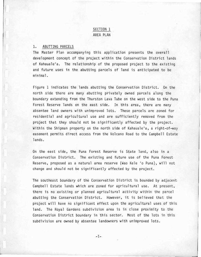
SECTION 1
AREA PLAN
1. ABUTTING PARCELSThe Master Plan accompanying this application presents the overalldevelopment concept of the project within the Conservation District landsof Kahauale1a. The relationship of the proposed project to the existingand future uses in the abutting parcels of land is anticipated to beminimal.
Figure 1 indicates the lands abutting the Conservation District. On thenorth side there are many abutting privately owned parcels along theboundary extending from the Thurston Lava Tube on the west side to the PunaForest Reserve lands on the east side. In this area, there are manyabsentee land owners with unimproved lots. These parcels are zoned forresidential and agricultural use and are sufficiently removed from theproject that they should not be significantly affected by the project.Within the Shipman property on the north side of Kahauale'a, a right-of-wayeasement permits direct access from the Volcano Road to the Campbell Estatelands.
On the east side, the Puna Forest Reserve is State land, also in aConservation District. The existing and future use of the Puna ForestReserve, proposed as a natural area reserve (Wao Kele '0 Puna), will notchange and should not be significantly affected by the project.
The southeast boundary of the Conservation District is bounded by adjacentCampbell Estate lands which are zoned for agricultural use. At present,there is no existing or planned agricultural activity within the parcelabutting the Conservation District. However, it is believed that theproject will have no significant effect upon the agricultural uses of thisland. The Royal Gardens subdivision area is in close proximity to theConservation District boundary in this sector. Most of the lots in thissubdivision are owned by absentee landowners with unimproved lots.
-1-

The south and west boundaries of the Conservation District abut the FederalVolcanoes National Park which will remain a National Park in the future.It is believed that the project will preclude further park expansion intoKahauale1a. In 1927, 2,526 acres of Campbell Estate lands of Kahauale'a
were added to the national park through land exchange with the Territory of·Hawaii (see Figure 1).
2. EXISTING FACILITIESThe Campbell Estate lands within the Conservation
any major existing facility at the present time.unused and is in fact without any facilities.
District do not include
The land is essentially
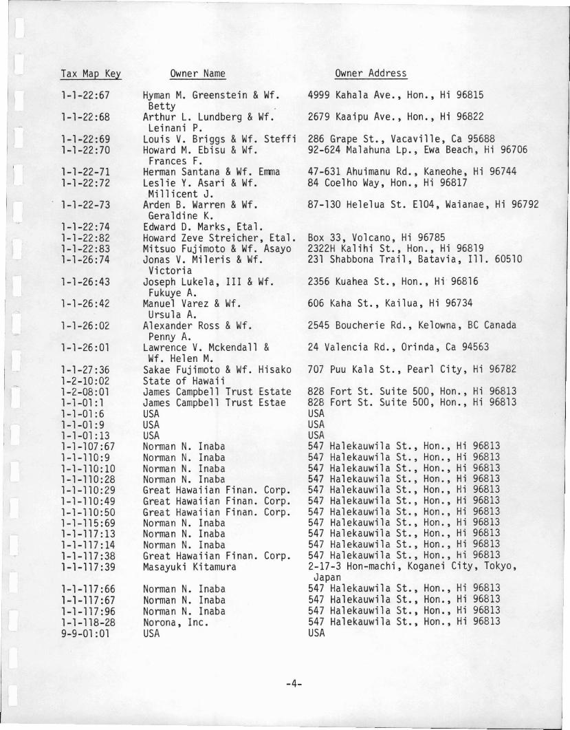
3. ADJACENT PROPERTY OWNERSFigure 2 indicates the tax map identification of the adjacent properties.Table 1 lists the names and addresses of the adjacent property owners in
sequence, beginning with the lands north of the Thurston Lava Tube andproceeding eastward and around the Conservation District lands.
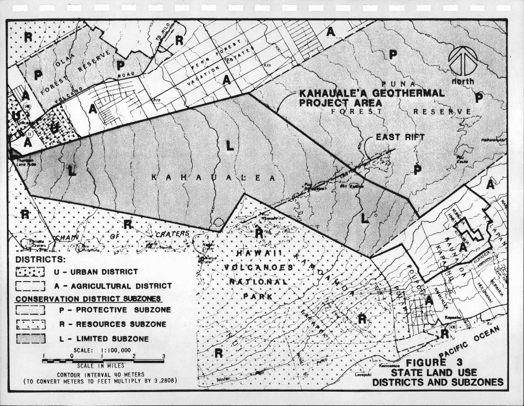
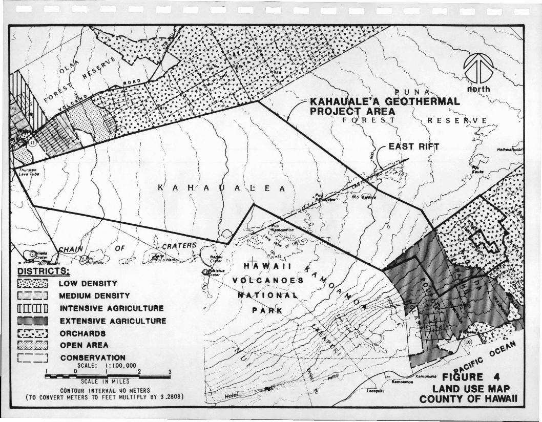
4. LAND PLANNINGFigure 3 indicates the existing State Land Use Districts and Subareas forthe project area and surrounding lands. Figure 4 indicates the existingCounty of Hawaii land use map for the same land area.
-2-
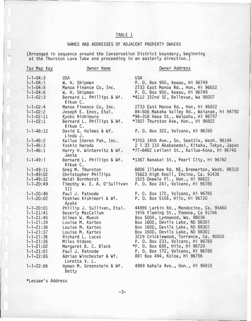
TABLE 1
NAMES AND ADDRESSES OF ADJACENT PROPERTY OWNERS
(Arranged in sequence around the Conservation District boundary, be9inningat the Thurston Lava Tube and proceeding in an easterly direction.)
Tax Map Key
1-1-04:31-1-04: 11-1-04:51-1-04:61-1-02:3
1-1-02:41-1-02:21-1-02: 111-1-02:1
1-1-48:12
1-1-48: 21-1-48:31-1-48:1
1-1-49: 1
1-1-49: 111-1-49:021-1-49: 221-1-20:49
1-1-20:481-1-20:02
1-1-20:011-1-21:411-1-21:401-1-21:391-1-21:381-1-21:371-1-21 :361-1-21:351-1-21:021-1-21:011-1-22:65
1-1-22:66
Owner Name
USAW. H. ShipmanManoa Finance Co, Inc.W. H. ShipmanBernard L. Phillips &Wf.
Kikue C.Manoa, Finance Co, Inc.Joseph E. Enos, Eta1.Kyoko NishimuraBernard L. Phillips &Wf.Kikue C.
David G. Holmes &Wf.Li nda J.
Kailua Stereo Pak, Inc.Yoshio HaradaHarry H. Winternitz &Wf.Jenta
Bernard L. Phillips &Wf.Kikue C.
Greg M. ThurstonChristopher PhillipsHeidi BornhorstTimothy W. E. A. 0'Su11ivan
IIIPaul J. PatnodeYoshiwo Kishimori &Wf.Ayako
Phillip J. Sullivan, Eta1.Beverly MacCallumGilman W. MueckLouise M. KartesLouise M. KartesLouise M. KartesRichard L. LucasMiles HidanoMargaret B. C. BlackPaul J. PatnodeAdrian Winchester &Wf.Loretta V. L.
Hyman M. Greenstein &Wf.Betty
Owner Address
USAP. O. Box 950, Keaau, Hi 967492733 East Manoa Rd., Hon, Hi 96822P. O. Box 950, Keaau, Hi 96749
*4112 152nd SE, Bellevue, Wa 98007
2733 East Manoa Rd., Hon, Hi 9682284-506 Makaha Valley Rd., Waianae, Hi 96792
*94-318 Haaa St., Waipahu, Hi 96797*1501 Thurston Ave, Hon., Hi 96822
P. O. Box 322, Volcano, Hi 96785
*3703 14th Ave., So. Seattle, Wash. 981442 133 110 Akabanedai, Kitaku, Tokyo, Japan
*77-6482 Leilani St., Kailua-Kona, Hi 96740
*1367 Nanakai St., Pearl City, Hi 96782
8806 I11ahee Rd. NE, Bremerton, Wash. 9831015623 High Knoll, Encino, Ca. 914361525 Onee1e Pl., Hon., Hi 96822P. O. Box 241, Volcano, Hi 96785
P. O. Box 172, Volcano, Hi 96785P. O. Box 5106, Hi10, Hi 96720
44990 Larkin Rd., Mendocino, Ca. 954601916 Fleming St., Pomona, Ca 91766Box 5004, Lynnwood, Wa. 98036Box 1600, Devils Lake, NO 58301Box 1600, Devils Lake, NO 58301Box 1600, Devils Lake, NO 583013229 Crick1ewood, Torrance, Ca. 90505P. O. Box 233, Volcano, Hi 96785
*P. O. Box 695, Hi10, Hi 96720P. O. Box 172, Volcano, Hi 96785RR1 Box 494, Koloa, Hi 96756
4999 Kaha1a Ave., Hon., Hi 96815
*Lessee's Address
-3-
Tax Map Key
1-1-22:67
1-1-22:68
1-1-22:691-1-22:70
1-1-22-711-1-22: 72
1-1-22-73
1-1-22:741-1-22:821-1-22:831-1-26:74
1-1-26:43
1-1-26:42
1-1-26:02
1-1-26:01
1-1-27:361-2-10:021-2-08:011-1-01: 11-1-01: 61-1-01:91-1-01:131-1-107:671-1-110:91-1-110:101-1-11 0: 281-1-110:291-1-110:491-1-110:501-1-115: 691-1-117: 131-1-117: 141-1-117: 381-1-117: 39
1-1-117:661-1-117:671-1-117 :961-1-118-289-9-01:01
Owner Name
Hyman M. Greenstein &Wf.Betty
Arthur L. Lundberg &Wf.Leinani P.
Louis V. Briggs &Wf. SteffiHoward M. Ebisu &Wf.Frances F.
Herman Santana &Wf. EmmaLeslie Y. Asari &Wf.Millicent J.
Arden B. Warren &Wf.Geraldine K.
Edward D. Marks, Etal.Howard Zeve Streicher, Eta1.Mitsuo Fujimoto &Wf. AsayoJonas V. Mileris &Wf.Victoria
Joseph Luke1a, III &Wf.Fukuye A.
Manuel Varez &Wf.Ursul a A.
Alexander Ross &Wf.Penny A.
Lawrence V. Mckendall &Wf. Helen M.
Sakae Fujimoto &Wf. HisakoState of HawaiiJames Campbell Trust EstateJames Campbell Trust EstaeUSAUSAUSANorman N. InabaNorman N. InabaNorman N. InabaNorman N. InabaGreat Hawaiian Finan. Corp.Great Hawaiian Finan. Corp.Great Hawaiian Finan. Corp.Norman N. InabaNorman N. InabaNorman N. InabaGreat Hawaiian Finan. Corp.Masayuki Kitamura
Norman N. InabaNorman N. InabaNorman N. InabaNorona, Inc.USA
-4-
Owner Address
4999 Kahala Ave., Hon., Hi 96815
2679 Kaaipu Ave., Hon., Hi 96822
286 Grape St., Vacaville, Ca 9568892-624 Malahuna Lp., Ewa Beach, Hi 96706
47-631 Ahuimanu Rd., Kaneohe, Hi 9674484 Coelho Way, Hon., Hi 96817
87-130 Helelua St. E104, Waianae, Hi 96792
Box 33, Volcano, Hi 967852322H Kalihi St., Hon., Hi 96819231 Shabbona Trail, Batavia, Ill. 60510
2356 Kuahea St., Hon., Hi 96816
606 Kaha St., Kailua, Hi 96734
2545 Boucherie Rd., Kelowna, BC Canada
24 Valencia Rd., Orinda, Ca 94563
707 Puu Kala St., Pearl City, Hi 96782
828 Fort St. Suite 500, Hon., Hi 96813828 Fort St. Suite 500, Hon., Hi 96813USAUSAUSA547 Halekauwila St., Hon., Hi 96813547 Halekauwila St., Hon., Hi 96813547 Halekauwila St., Hon., Hi 96813547 Halekauwila St., Hon., Hi 96813547 Halekauwila St., Hon., Hi 96813547 Halekauwila St., Hon., Hi 96813547 Halekauwila St., Hon., Hi 96813547 Halekauwila St., Hon., Hi 96813547 Halekauwila St., Hon., Hi 96813547 Halekauwila St., Hon., Hi 96813547 Halekauwila St., Hon., Hi 968132-17-3 Hon-machi, Koganei City, Tokyo,Japan
547 Halekauwila St., Hon., Hi 96813547 Halekauwila St., Hon., Hi 96813547 Halekauwila St., Hon., Hi 96813547 Halekauwila St., Hon., Hi 96813USA

APUA-KAHAUALEA 8 KeAAU O' PfJNA HAWAII
)
[I :'..I••. .
, ,v
TAX MAl'
3 2~_=_=.."";...tii"co;.........
' •••ftON .APS aUhAU
FIGURE 2
TAX MAP
Q
~
I>
•~
"
..Q
t•
)
SUB I! CT TO CHANGE
•
• .. ~...&
o L..~:' I...~.______ I'll!
,.... /,'0'"
-'<.. ".
~
•
"' .~
,.1-
~ I)
....~
...~
"",Jo
"'- ~....,....~ ~"'"
~ "\.
.'
/
I
/I
,- t...';' ..
(, ", ,0 J
f- .. b<<\ / ~. 'IIV
1· ~
J /J /r , ,.f
~
• I' ff
,. ~
,.f
LEGEND:
3I: 100,000I 2
LIMITED SUBZONE
RESOURCES SUBZONE
SCALE:o
L
-
U
Il""liii
SCALE 1M MILESCOMTOUR IMTERVAL qO METERS
(TO COMVERT METERS TO FEET MULTIPLY BY 3.2808)
r-·--a-"rll::._a_a.J
"---:1~...:.:...I
JI. ~"""... ..... .... ...
, Jr. i ........ \.IL f._-a "a " a;. a..... .. ( ..
a , afa ... .., ....
a ."
/' (
~r I\\ (
/j
\ ,
,"-\
I,
\
"-I "
\
,. {\}
, }I K)( 1 A H/ AI
I (I I. \
I \~
I\
[J~,W1JJ
[IIITII]1llllllmmO
~/\:
Y'--C\f\C
FI~'URE 4LAND USE MAP
COUNTY OF HAWAII
v"K"'"o.....
/-Kim';;;""",
3
SCALE IN MILESCONTOUR INTERVAL qO METERS
(TO CONVERT METERS TO FEET MULTIPLY BY 3.2808)
[&:&2r--,L __.J
SECTION 2SITE PLAN
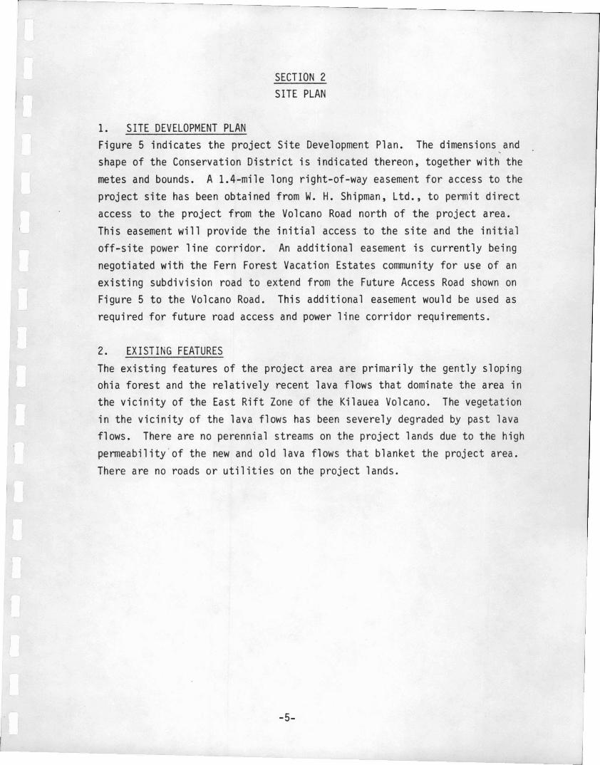
1. SITE DEVELOPMENT PLANFigure 5 indicates the project Site Development Plan. The dimensions,andshape of the Conservation District is indicated thereon, together with themetes and bounds. A 1.4-mile long right-of-way easement for access to theproject site has been obtained from W. H. Shipman, Ltd., to permit directaccess to the project from the Volcano Road north of the project area.This easement will provide the initial access to the site and the initialoff-site power line corridor. An additional easement is currently beingnegotiated with the Fern Forest Vacation Estates community for use of anexisting subdivision road to extend from the Future Access Road shown onFigure 5 to the Volcano Road. This additional easement would be used asrequired for future road access and power line corridor requirements.
2. EXISTING FEATURESThe existing features of the project area are primarily the gently slopingohia forest and the relatively recent lava flows that dominate the area inthe vicinity of the East Rift Zone of the Kilauea Volcano. The vegetationin the vicinity of the lava flows has been severely degraded by past lavaflows. There are no perennial streams on the project lands due to the highpermeability'of the new and old lava flows that blanket the project area.There are no roads or utilities on the project lands.
-5-

LEGEND:
II POWER PLANT SITE
ACCESS ROAD
WELL FIELD AND PIPELINE CORRIDOR
• DRILLING SITE
SCALE IN FEET
CONSERVA nON DISTRICT BOUNDARYFOR KAHAUALE'A
EASEMENTo 4000 8000 12O.Xl
i4000
i
..............

SECTION 3CONSTRUCTION PLAN
1. CONSTRUCTION PLANSThe project Master Plan includes plans with critical dimensions for,themain facilities to be developed. These include the typical drilling site,the initial 12.5 MWe power plant and the typical 55/110 MWe power plant.Figure 5 is the Site Development Plan which indicates the site layout asnow conceived, with the planned locations of the access roads, power plantsand well fields.
2. CONSTRUCTION DETAILSActual construction details will not be available until the design phase ofthe project. However, the following design guidelines have been developedfor use during the design phase and are provided herein to meet the initialrequirements of the CDUA.
a. Existing and Proposed Changes in ContoursThe existing contours present a gentle downhill slope ofapproximately 3 percent generally throughout the site.Construction of power plants, well fields and access roads willbe designed to minimize cut and fill operations to the extentpracticable.
b. Buildings and StructuresThe actual location, number and size of the buildings andstructures indicated in the Master Plan will primarily dependupon the evaluation of the geothermal energy resources. However,the upper limit of the power plants in these areas will be asindicated in the Master Plan.
c. Open Space and Recreation AreasClearing for open space will be limited to that actually requiredfor the planned facilities, with the objective of minimizing theenvironmental impacts of construction. Due to the nature of this
-6-
project, recreation areas are not planned at this time. Projectpersonnel will reside off-site in established residential/touristareas. Their on-site presence will be limited to the regularworking hours, with recreation an off-site activity.
d. Landscaping, Including BuffersLandscaping requirements will be limited since forested areaswill be cleared only in those areas essential for constructionand continued use. Buffers will not be required since theDevelopment Plan does not site any facility immediately adjacentto any project boundary.
e. RoadwaysRoadways will initially be limited to the minimum single lanewidth (12 to 14 feet plus 3-foot shoulders) required for accessto the drilling sites. If and when the geothermal resource isproven and developed, the roadways will be further developed.Ultimately, it is planned that a two-lane access road withprovision for a power line corridor will be required. Well fieldroads will be limited to single lanes with turnouts and apipeline corridor for pipes to carry the influent and spentgeothermal fluids.
f. Offstreet Parking AreaDuring construction, it is anticipated that the offstreet parkingarea requirements will be minimized by providing bustransportation to and from the work sites. During plantoperation, offstreet parking areas will be provided for shiftpersonnel vehicles as required.
g. Existing and Proposed DrainageThere are no established water courses in the area despite therelatively heavy rainfall of approximately 140 inches/year. Theexisting excellent drainage of the site derives from thepermeable lava flows that characterize the project site. It is
-7-
not anticipated that drainage structures, including ditches, willbe required except perhaps in very localized areas of thin, muckyhumus.
h. Proposed Utilities and Other Improvements..
Water supply to the project site will initially be limited towater tank trucks drawi ng upon exi sti ng water di stributi onsystems in the Mountain View area. The requirement for off-sitewater will be limited to the well drilling operation whereapproximately 25,000 gallons of water is initially required foreach drilling site. To minimize drawing upon the Mt. View watersystem, it is intended that a temporary catchment area of lessthan one acre be developed to collect rain for constructionpurposes. This catchment area would be on a flat sloping openlava field and not involve any vegetative clearing. The water iscontinually reused in the mud drilling operation. Withdevelopment of the power plant structures, rainfall catchmentsystems will be included in the roof design for the long term,low level of potable water supply required on site.
Sewerage systems will be 1imited to chemi ca 1 toi 1ets duri ngconstruction and cesspools during plant operation. Cesspoolperformance is assured because of the permeable rock surface andthe low sewage flows anticipated from the limited operatingstaff. There are no potable water wells in the area that wouldbe affected by the planned use of cesspools.
Electricity for on-site use will be derived from the operationof the on-site geothermal power plants. Approximately 10 percentof a power plant's gross capacity would be used for on-site powerrequirements.
-8-

The only improvements planned are as described in the Master Planand Environmental Assessment. There are no other improvementsplanned at this time.
i. Revegetation PlansThere are no revegetation plans at present. However, in theunforeseen circumstance where a land area is cleared and laterabandoned (e.g., an abandoned drilling site), there will be aplan to revert it to the native vegetation. Hopefully, thisrevegetation will occur by natural means. If not, a plan torevegetate with native type vegetation will be implemented.
j. Drainage Plans, Including Erosion Sedimentation ControlsThe non-erodible nature and penneable rock structure of theground areas will minimize the need for drainage plans, includingerosion sedimentation controls, except in those poorly drainedbog areas that are found in some sectors of Kahauale'a.
k. Ea rthworkAll grading, trenching, fi.lling, soil disposal and/or otherearthwork requirements will be in compliance with current Countyregulations and in accordance with good engineering practice.
-9-
SECTION 4MAINTENANCE PLANS
1. POWER TRANSMISSIONThe initial 25 MWe power plant will require a 69 KVA transmission linewhi ch wi 11 be located along the access road corri dor. Thi s wi 11 e'vo1veinto a 138 KVA transmission line as the available power increases to the 80MWe capability. All power transmission line construction and maintenancewill be performed by HELCO using its existing standards.
2. FUEL LINES, INCLUDING GEOTHERMAL FLUID PIPELINESThere are no oil or gas fuel lines planned for the project area. Each wellfield will be connected by a gathering system of heavily insulated steelpipes leading from the drilling sites to the power plant. The steel pipeswill be aboveground to facilitate construction inspection and maintenance.Another piping system will be employed to carry spent geothermal fluids tothe injection wells. The design, operation and maintenance of thepipelines for the geothermal fluids will use standards that have beensuccessfully developed for use on the mainland. Some special precautionsmay be required due to the presence of volcanic hazards at Kahauale'a.These will be addressed during the design phase to ensure fail-safeperformance.
3. DRAINAGE SYSTEMSThere are no drainage systems planned for the project due to the permeable,well-drained characteristics of the ground.
4. UNMANNED COMMUNICATIONS FACILITIESThere will be no unmanned communication facil ities on the site sinceoperating and maintenance personnel will be available at each power plantat all times. An exception may be the use of telemetering equipment toremotely monitor the well field performance at each power plant. Operatingpersonnel will be able to continuously monitor the performance of suchequipment and to promptly identify and correct any deficiencies that mayarise.
-10-

5. ROADWAYS
It is planned that the project roadways will be designed, constructed andmaintained by the developer. Adequate maintenance is assured in order tominimize operational costs. The initial roadway development will belimited to that required for access to the drilling sites. The subsequent construction and operation of the power plants will require access roadsthat will be designed to accepted engineering standards.
-11-

SECTION 5MANAGEMENT PLANS
1. ANIMAL AND PLANT RESOURCESThere is no appropriative use planned for animal or plant resources on theproject site at this time. It may be desirable at a later time to developa management plan to reduce the population of wild pigs and wild cattle.They are reportedly present in the Kahauale'a forest in significant numbersand may have to be reduced.
2. MINERAL RESOURCESThe project Development Plan is essentially a management plan forexploration, development and use of the geothermal energy resources whichare the basis for the project. The underground geothermal fluids are theonly known mineral resource in the project area.
-12-

F--~-~~~~~~~~~~~-----~- ---..,
SECTION 6HISTORIC OR ARCHAEOLOGICAL SITE PLAN
There are no historic or archaeological sites on the State or FederalRegister which are identified with the project area. In addition, ~ recentliterature search by a qualified archaeologist has indicated no evidence ofany historic or archaeological significance associated with the projectsite. The relatively recent lava flows and forests which cover the groundsurface are generally less than 500 years old, indicating that significantarchaeological sites are unlikely in the area.
It is planned to conduct all construction activity with an awareness of thepossible presence of historic or archaeological sites which, if found, willbe surveyed by a qualified archaeologist after notification to the StateHistoric Preservation Office.
-13-
SECTION 7CONSISTENCY WITH SUBZONE OBJECTIVE
The stated subzone objective for the Limited (L) subzone which isapplicable to the Conservation District of Kahaua1e ' a is lito limit useswhere natural conditions suggest constraints on human activities. II ' Theboundary for the subzone encompasses IILands necessary for the protection ofthe health and welfare of the public by reason of the landis susceptibilityto .•. vo1canic activity ... 11 Permitted uses within the Limited Subzoneinclude all permitted uses for the Protective Subzone plus emergencywarning systems or emergency telephone systems; flood, erosion or siltationcontrol projeCts; and the growing and harvesting of forest products.Clearing of project sites for roads and power plant sites will require someremoval of vegetation. Earlier activities in Kahaua1e l a have included fernharvesting for commercial use.
The East Rift Zone of the Kilauea Volcano traverses the Kahaua1e ' a landsand is characterized by relatively recent lava flows, cinder cones andcracks in the ground surface. These are rough surface features which canbe hazardous to the general public, especially since the ohia forest tendsto make the deep cracks difficult to detect. There is also the significantprobability of future lava flows within the East Rift Zone. This has beenrecognized by careful placement of drilling sites, roadways, power plantsand transmission lines so as to minimize the effects of future lava flowsto the extent practicable. It is anticipated that 24 hours advance noticeof impending volcanic activity would be obtained from the USGS VolcanoObservatory within the National Park. The HVO USGS scientists haveindicated their desire to carry out field studies utilizing the Kahaua1e ' aproject roads. This close coordination will be maintained.
Access to the project site will be limited to on-duty project personnel whowill be informed of the volcanic hazards. It is not intended at this timeto make any portion of the project site open to the pubiic altho gh thismay later be possible through the control mechanism of a visitor center.
-14-