central kenya national schools joint mock - … · central kenya national schools joint mock ......
TRANSCRIPT
www.eeducationgroup.com
CENTRAL KENYA NATIONAL SCHOOLS JOINT MOCK - 2015 312/1 – GEOGRAPHY PAPER 1 –MARKING SCHEME
SECTION A 1. (a) The relationship between Geography and Physics
- Physics deal with matter, energy, light, heat, sound, gravity and magnetism while studying the atmosphere; Geography focuses on heat from the sun as its responsible for movement of air, evaporation or water and distribution of moisture in the atmosphere.
- Physics is a branch of Science concerned with study of matter and its properties; Physics is important in Geography as it is used to explain how important process such as faulting, folding and vulcanicity happen.
(1 x 2 = 2mks) (b) Three main layers of he atmosphere from the earth’s surface upwards.
- Troposphere - Stratosphere - Mesosphere (3 x 1 = 3mks)
2. (a) Three types of coral reefs. - Barrier reefs - Fringing reef - Atoll reef (3 x 1 = 3mks)
(b) Benefits of reefs in the areas they have developed - Sheltered water encourages growth of planktons / fish food. - Shallow corals are a tourist attraction earning a country foreign exchange. - Corals from a base of mining of limestone used in cement manufacture. (2 x 1 = 2mks)
3. (a) (i) Type of rainfall shown on the diagram - Convectional (1 x 1 = 1mk) (ii) Type of cloud marked (a) - Cumulonimbus clouds (1 x 1 = 1mk)
(b) Two weather conditions associated with the above (a) rainfall. - Thunderstorm and lightening - Hailstones - Warm air near surface in the afternoon hours. (1 x 1 = 1mk)
4. (a) (i) State the plate tectonic theory.. Plate tectonic theory states that the continental crust is made of blocks called plates which are mobile and move either; away from each other, forwards each other or past each other. (1 x 1 = 1mk) (ii) a) Features formed when plates move towards each other
- Fold Mountains - Formation of trenches - Destruction of plates along their margins. (1 x 1 = 1mk)
b) Features formed when plates move away from each other at the boundary - Faults - Extension boundary farming - Mid ocean ridges (1 x 1 = 1mk)
(b) Effects of climate change - The global warming due to increase of greenhouse gases. - Widespread changes in natural ecosystems. - Rise in temperatures and increase in evaporation rates. - Possible drought might increase in some countries e.g. China, Africa, Brazile etc. - Wetter and warmer conditions increase pests and diseases which affect humans crops and livestock. - May lead to Elnino /floods. - May bring wetter and direr summers in temperate regions/melting of polar glaciers. (3 x 1 = 3mks)
5. (a) What is a lake A lake refers to an accumulation / body of water occupying a hollow or a depression on the surface of the earth. (2 x 1 = 2mks)
(b) Why most of Rift Valley lakes are salty - Some lakes lack outlets. - Rocks over which they lie / in contact with may contain mineral salts.
www.eeducationgroup.com
- Some rivers pouring in them may contain salts. - Surface runoffs and rivers may dissolve a lot of salts on rocks while they flow. - Excess evaporation in areas where the temperatures are high. (2 x 1 = 2mks)
SECTION B 6. Hydrographic features
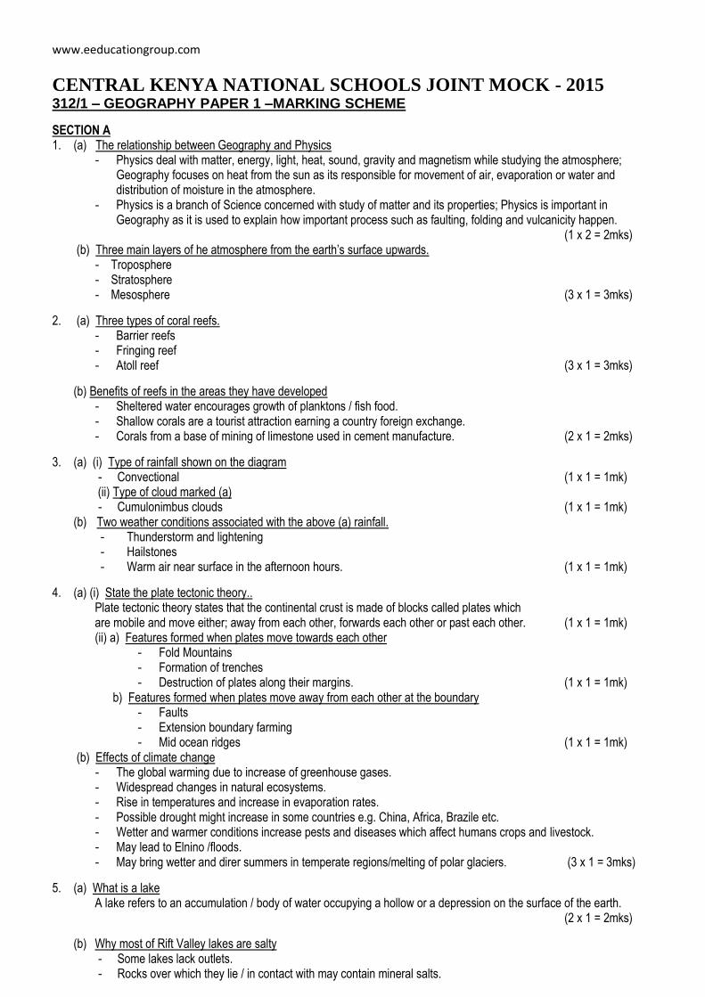
(a) (i) Rivers ……… River Mui (3 x 1 = 3mks) Dams ……….. Iloleni Dam Borehole ……….. grid square 0769
(b) (1 x 4 = 4mks)
(c) (i) The relief of the area covered by the map - The lowest altitude is 660m / the highest altitude is 1515 above sea level. - The land rises from the East to the West. - To the Easting 08, the landscape is generally hilly / has many hills. - There are many interlocking spurs along River valleys. - The landscape is dissected by river valleys. - There are some abroad valleys in the South East. - There are many narrow river valleys in the highlands. - The land is gently sloping in the east. - Thee are steep slopes in the hilly areas / to the west. - Some areas in the East are flat. - There are ridges in the central and south Western part. (4 x 1 = 4mks) (ii) - Education – schools - Health services – Health centre - Administrative – Chief office - Recreation – Rest house - Legal services – Court house (3 x 1 = 3mks)
(d) (i) - All weather road (loose surface) - Dry weather Road (2 x 1 = 2mks) (ii) A dam (1 x 1 = 1mk) Function Evidence (iii) - Trading centre - Shop
- Transport - Roads - Administrative centre - Chiefs officer - Communication - Post office (3 x 1 = 3mks)
(e) - River Ikoo flows to the South East. - The river has many meanders. - The river becomes wider from grid square 0769. - Here are interlocking spurs along the course of the river. - The river has many small tributaries that form a dendritic pattern along the course. - Some parts of the long profile have steep gradient. - There are sand / mud deposits downstream. - The river is permanent. (3 x 1 = 3mks)
7. (a) (i) Difference between rocks and minerals.
www.eeducationgroup.com
- Rocks are hard substances made up of mineral particles forming the earths crust while minerals are naturally occurring inorganic substances with definite chemical composition and physical properties. (2 x 1 = 2mks)
(ii) Ways in which rocks can be classified. - By mode of formation - By physical and chemical characteristics. - By age. (3 x 1 = 3mks)
Geography Paper 1MS 2 Cekenas Joint Mock (b) (i) One example of each of the following types of sedimentary rocks.
- Chlorides – rock salt / sodium chloride - Arenaceous – sandstone / grit - Carbonaceous – coal (3 x 1 = 3mks) (ii) How sedimentary rocks are formed through physical processes. - Pre-existing rocks of sedimentary and igneous types undergo weathering and erosion. - The weathered and eroded rock materials are then transported and deposited over the land or in the
sea / ocean by wind, water or ice. - The deposited weathered materials accumulate over time, become compacted and cemented for
sedimentary rocks. (4 x 1 = 4mks)
(c) (i) Changes that occur in rocks during metamorphism - New minerals are formed. - The rocks are hardened / become more resistant. - The rock may recrystalize. - The chemical composition of the rocks change. - Physical characteristics / appearance of the rock changes is altered. (3 x 1 = 3mks) (ii) Two reasons why sedimentary rocks are dominant along he Kenyan coasts - Some parts of the coastal plain emerged from the sea where sedimentation occurred. - The coastal plain is lowland which has facilitated deposition of weathered rock materials. - He shallow continental shelf provides favourable environment for he coral polyps whose skeletons
are deposited and accumulate to form rocks. (2 x 1 = 2mks) (d) (i) Reasons for conducting a reconnaissance
- To be familiar with study area / authorities. - To estimate the cost / budget of the study. - To assist / help in designing a working schedule. - To determine study areas suitability. - To identify in advance likely problems to be encountered during the study and suggest possible ways
of coping with / solving them. - To enable decision making on data collection methods. (2 x 1 = 2mks) (ii) Methods used to record data - Photographing / taking photographs / tape / video recording - Taking notes - Labeling samples - Filling in questionnaires (2 x 1 = 2mks) (iii) Importance of rocks they identified - Weathered rocks form rich agricultural soils for crop cultivation. - Some rocks are used in building and road construction. - Granite tars form spectacular / beautiful scenery that attracts tourists thus earning foreign exchange. - Some rocks form water reservoirs that are exploited for domestic uses. - Rocks mined in quarries provide income and improve living standards. - Some valuable minerals may be mined from the rocks. (2 x 1 = 2mks)
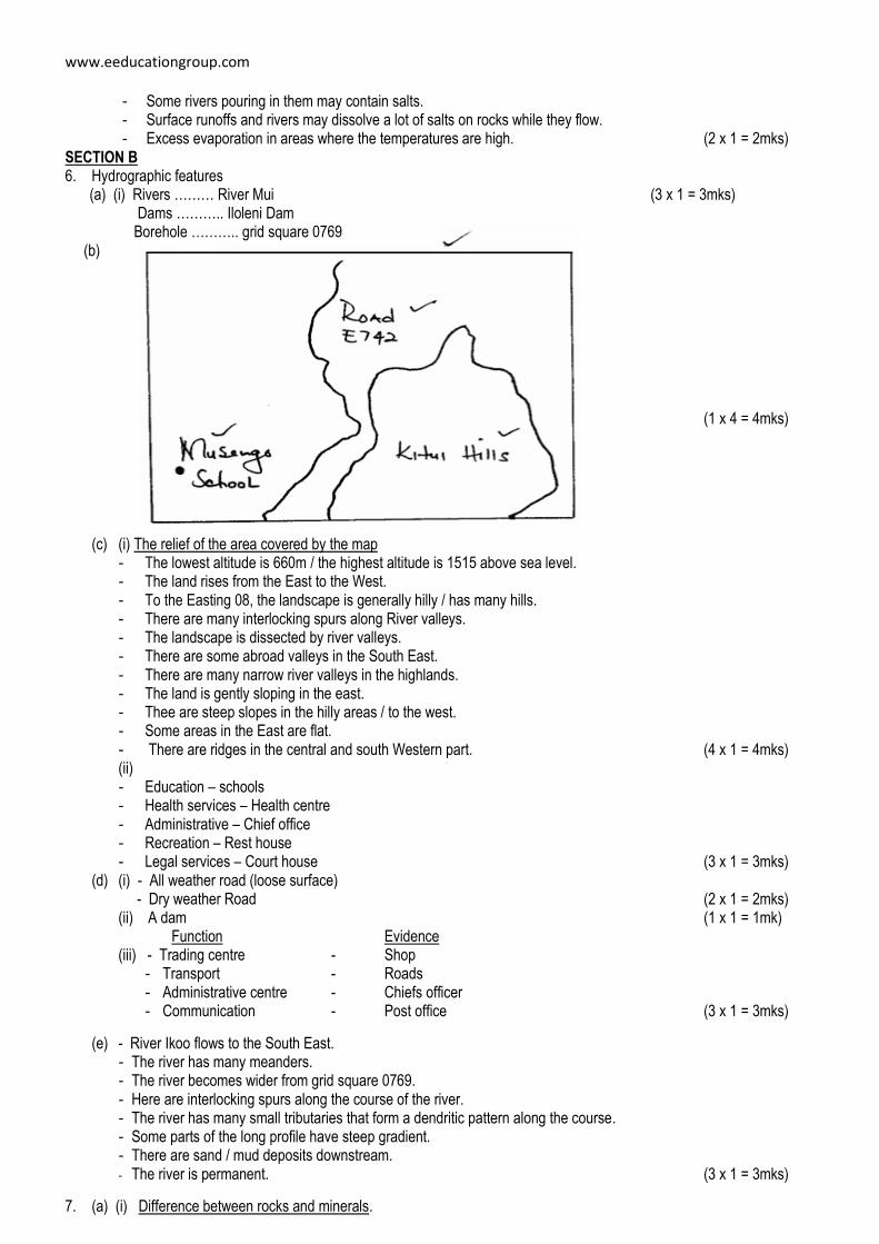
8. (a) Formation of the Rift Valley
Layers of rocks are subjected to Tensional forces which pull away from each other (2mks)
www.eeducationgroup.com
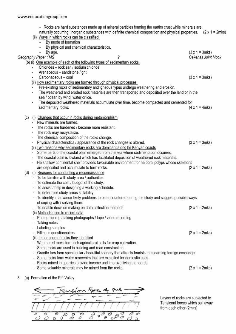
Lines of weaknesses appear
Leading to development of adjacent normal faults (2mks)
Geography Paper 1MS 3 Cekenas Joint Mock
The side blocks are pushed apart. The middle block sinks leading to the formation of the Rift valley. (2mks)
(Diagrams – 2 marks) Total – 8 marks NB: - Illustrations should be accompanied by description. - A diagram without description can earn a mark but description without a diagram cannot.
(b) (i) Features represented by the diagram
- A tilt block (ii) Formation of the feature - Form when a block of land between two faults is uplifted due to compressional forces. - The middle block experiences greater uplift on one side. - As a result the fault block is not flat at the top but tilted. - The resultant feature is shown as a tilt block since it’s tilted on one side. (5 marks)
(c) (i) Features that may form as a result of faulting.
- Fault scarps / Escarpments - Block / Horst Mountain - Tilt block (3 x 1 = 3mks) (ii) Methods to collect data - Administering questionnaires - Including interviews - Through direct observation - Through content analysis (2 x 1 = 2mks) (iii) Economic benefits of faulting - Lakes associated with faulting are good fishing grounds / mining etc. - Hot water coming through faults are utilized o produce geothermal power. - Scarp springs on foot of scarps provides water for domestic use. - Features associated with faulting form beautiful scenery for both local and foreign tourists hence foreign exchange. - Rivers from faulting provide water for irrigation, domestic and generation of energy. - Faulting has exposed minerals which have been mined hence providing foreign exchange for the country.
(3 x 2 = 6mks) 9. (a) (i) What is a desert?
- It is an arid area with scarcity of rainfall and with little or no vegetation cover. (2mks) (ii) Desert landscapes
- Sandy deserts / Erg / Koum - Rocky desert / Hamad - Stony desert / Reg / Semr - Batkabds any 2 (2 x 1 = 2mks)
(b) (i) Surface creep
www.eeducationgroup.com
- Heavy pebbles / stones pushed / rolled by wind currents for short distances. (2mks) (ii) Saltation - Medium sized particles rolled along the ground and then lifted by wind currents to the air and then
dropped – moved in a series of short jumps along the desert surface. (1 x 2 = 2mks)
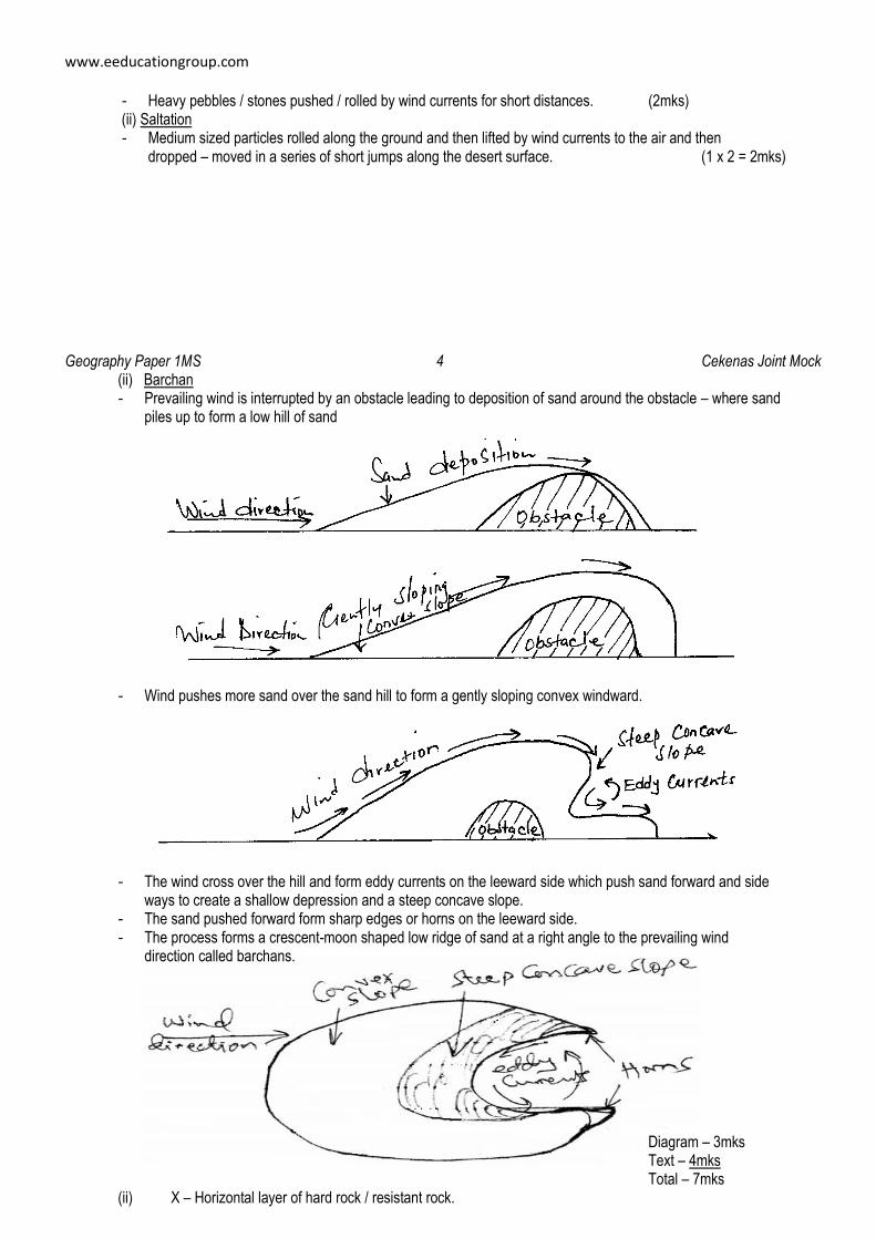
Geography Paper 1MS 4 Cekenas Joint Mock (ii) Barchan - Prevailing wind is interrupted by an obstacle leading to deposition of sand around the obstacle – where sand
piles up to form a low hill of sand - Wind pushes more sand over the sand hill to form a gently sloping convex windward.
- The wind cross over the hill and form eddy currents on the leeward side which push sand forward and side ways to create a shallow depression and a steep concave slope.
- The sand pushed forward form sharp edges or horns on the leeward side. - The process forms a crescent-moon shaped low ridge of sand at a right angle to the prevailing wind
direction called barchans. Diagram – 3mks
Text – 4mks Total – 7mks
(ii) X – Horizontal layer of hard rock / resistant rock.
www.eeducationgroup.com
Y – plunge pool Z – Rock boulders
(d) Field study
(i) Reasons for a pre-visit - Familiarize with the area of the study. - Determine routes to follow - Decide on the methods of data collection and recording. - Know materials / equipment to carry. - Identify likely problems and seek for solution. - Helps formulate relevant objectives and hypothesis. - Helps draw a working schedule.
(ii) Depositional features. - Self dunes. - Transverse dunes. - Drass. - Coess.
Geography Paper 1MS 5 Cekenas Joint Mock
(iii) Positive effects of desert features to man identified. - A scenery that attracts tourists. - Extreme ground for testing bombs / films development. - Sand harvested for building and construction industry. - Loess deposit areas rich for agriculture. - Oasis provide water for settlement / livestock. - Salts from playas / salines exploited for income. - Strong winds tapped for energy / hot sun for solar energy. - Loess deposits curved into cool dwellings in summer. (4 x 1 = 4mks)
10. (a) (i) Definition of soil conservation
- It is careful management / protecting of soil against erosion and exhaustion. (2mks) (ii) Methods hat assist in soil conservation. - Ploughing across the contours / slopes - Stripping cropping - Controlled grazing. (2 x 1 = 2mks)
(b) How they influence soil formation (i) Climate
- It influences types and rate of weathering. - High rainfall influences leaching process run offs resulting from high rainfall increases rate of erosion. - It influences rate of decomposition. - High temperature increases rate of weathering / occelanate bacterial activity. - Water transports and deposits soil particles on other areas hence new soils. (3 x 1 = 3mks)
(ii) Topography - Bottom valley / gentle slopes encourage formation of deep soils (fertilizers) due to deposition /
accumulation of minerals, steep slopes encourages soil erosion of top layers hence soil erosion of soils. - Flat plains are associated with water hence slow down soil formation - Slopes influence management of soil catena. - Some slopes are more exposed to rain / sun hence influencing weathering of parent rock.
(3 x 1 = 3mks) (c) (i) Laterisation
- During wet season, mineral salts in the top layers of soils dissolves rain water. The dissolved minerals percolates downwards to lower layers. The dissolved minerals are deposited further downwards to he lower layers. Insoluble minerals e.g. iron and alluminium are left on the upper layers to form a curst of laterite soils. (4 x 1 = 4mks)
(ii) How humus improves quality of soil - Helps improve soil porosity by operating the soils. - Improves moisture-retention capacity of the soils. - Humus provides essential minerals to the soil. - Improves the soil texture. (2 x 1 = 2mks)
(iii) Characteristic of desert soils
www.eeducationgroup.com
- They are thin and shallow generally saline. - Hey are stony / sandy – they are coarse textured and quite porous. - Lack humus / low organic matter content. - Have low moisture content. (4 x 1 = 4mks)
(d) (i) How Gulley erosion occurs - Occurs on steep slopes - Rain water cuts deep groves / channels / rills on the slopes. - Channels are widened and deepened to form gullies through which soils are carried away. (3 x 1 = 3mks)
(ii) Economic uses of soils - They are sources of valuable minerals. - Soils are used as raw materials for pottery. - They are used for agriculture. - Some soils are mixed with herbs for medicinal purposes e.g. clay / soil directly for food.
(2 x 1 = 2mks)
Geography Paper 1MS 6 Cekenas Joint Mock
www.eeducationgroup.com
CENTRAL KENYA NATIONAL SCHOOLS JOINT MOCK - 2015 312/2 – GEOGRAPHY PAPER 2 –MARKING SCHEME 1. (a) Define the term transhumance.
It is seasonal movement of people and their animals from place to place, in search of water and pasture for their animals. (2mks)
(b) Characteristics of nomadic pastoralism. - Reared in areas receiving low and unreliable rainfall. - Animals are grazed communally. - Animals are kept for subsistence / sign of wealth. - Nomadic herders make use of natural pasture. - Different types of animals are kept e.g. sheep, goats and cows. - Quantity as opposed to quality is emphasized. - Man’s social positions and prestige determined by number of animals kept. - Poor marketing of animals and their products. - Lack of organized land tenure where land is owned communally. (3 x 1 = (3mks)
2. Factors influencing nucleated settlement pattern. - Farming – irrigation farming e.g. Mwea Tebere. - Limitations of site, lack of space for expansion. - Presence of water sources e.g. Oasis in desert. - Exploitation of natural resources e.g. mining. - A prime area for defence / cluster together for strength. - Government policy – settlement schemes. - Ownership of land in small plots. - Presence of an industrial plan. - Security leading to cluster in a more secure area. (5 x 1 = (5mks)
3. (a) What is a cottage industry?
It is a small scale industry which uses local raw materials and requires little capital to start and operate. (2 x 1 = (2mks) (b) Reasons why government encourages the establishment of Jua Kali.
- It requires little capital investment. - It decentralizes industries reducing rural urban migration. - Requires little skills. - Encourages innovation. - To diversify export goods. - To cater for local needs / save on foreign exchange, - To produce cheap consumer goods. - To make use of locally available raw materials. - To create employment opportunities. (3 x 1 = (3mks)
4. (a) What is air pollution? It is the contamination of air with additional material in solid or gaseous form causing injury or harm to human health or property. (2 x 1 = (2mks)
(b) Negative effect of uncollected garbage. - Garbage heaps are unattractive. - Garbage produces foul smell. - Garbage washed into water surfaces causes pollution. - Organisms that thrives in garbage may transmit diseases. - Some matter may cause injuries. (3x1 = (3mks)
5. (a) Two main reclamation projects in Netherlands.
- The Zuider Zee project – 5 polders - The Delta Plan Project – 5 polders (2 x 1 = (2mks)
(b) Three reasons for reclaiming swamps in Kenya. - To free area from pest / water borne diseases. - To reduce flooding and associated effects. - To acquire agricultural land with profitable farming / settlements. - To develop the remote areas with infrastructure and social amenities. (3 x 1 = (3mks)
www.eeducationgroup.com
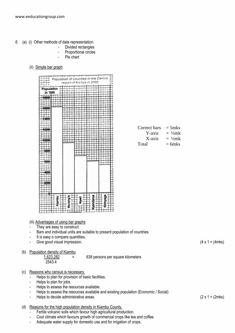
6. (a) (i) Other methods of data representation. - Divided rectangles - Proportional circles - Pie chart
(ii) Simple bar graph (iii) Advantages of using bar graphs
- They are easy to construct. - Bars and individual units are suitable to present population of countries. - It is easy o compare quantities. - Give good visual impression. (4 x 1 = (4mks)
(b) Population density of Kiambu
1,623,282 = 638 persons per square kilometers 2543.4
(c) Reasons why census is necessary.
- Helps to plan for provision of basic facilities. - Helps to plan for jobs. - Helps to assess the resources available. - Helps to assess the resources available and existing population (Economic / Social) - Helps to decide administrative areas. (2 x 1 = (2mks)
(d) Reasons for the high population density in Kiambu County.
- Fertile volcanic soils which favour high agricultural production. - Cool climate which favours growth of commercial crops like tea and coffee. - Adequate water supply for domestic use and for irrigation of crops.
Correct bars = 5mks
Y-axis = ½mk
X-axis = ½mk
Total = 6mks
www.eeducationgroup.com
- Nearness to Nairobi. - Availability of health facilities- reduced death rates and improved nutrition. - The county receives high rainfall in most areas which support agriculture and livestock farming. (4 x 2 = (8mks)
Geography Paper 2MS 2 Cekenas Joint Mock 7. (a) (i) What is reafforestation?
This is the planting of trees in areas where forests have been cleared / deforestation has taken place. (2 x 1 = (2mks) (ii) Four reasons why afforestation should be encouraged in Kenya.
- To ensure continuous supply of wood fuel (timber) / herbal medicine / raw materials for paper making. - To protect water catchment areas / create micro-climates to maintain hydrological cycle. - To create scenic beauty. - To expand the habitat for wildlife / conservation of wildlife. - To create employment opportunities. - To reduce importation of forest products / foreign exchange. (4 x 1 = (4mks)
(b) (i) Main exotic softwood trees grown in Kenya. - Cypress - Pine (2 x 1 = (2mks) (ii) Characteristics of softwood forests in Canada. - The trees are conical in shape. - Trees occur in pure stands. - Trees are tall. - Trees have straight trunks. - Trees bear cones. - The forests have no undergrowth. - The trees have thick barks. - Trees have shallow roots. (5 x 1 = (5mks)
(c) Problems which hinder the Kenya government effort to manage and conserve forests. - Rapid increase in population has led to encroachment into forest land hence destruction of trees. - Occurrence of forest fires which have led to destruction of large areas under forest. - Illegal logging / indiscriminate cutting of trees thereby reducing / depleting indigenous species. - Attacks by pests / diseases lead to destruction of trees. - Some wild animals damage trees through uprooting / trampling debarking. - Prolonged drought leads to drying of some trees. (3 x 2 = (6mks)
(d) Comparison between forestry in Kenya and Canada. (i) Transportation of logs - In Canada, logs are transported using melt water rivers while in Kenya transportation is by road. - In Canada, logs are transported using melt water / Rivers while in Kenya transportation is by road. (2 x 1 = (2mks) (ii) Felling trees - In Canada felling is done in winter while in Kenya it takes place throughout he year. - In Canada harvesting is done through clear cutting while in Kenya it is selective cutting. - In both countries, commercial logging is mechanized. (2 x 1 = (2mks) (iii) Tree species - In both countries some tree species are similar e.g. pine. - In Canada softwood tree species are indigenous while in Kenya they are both exotic / indigenous. (2 x 1 = (2mks)
8. (a) (i) Sedentary farming Is the cultivation of crops and rearing of livestock for subsistence or commercial reasons where people have permanent settlements.
(ii) Main types of agriculture. - Arable / crop farming / subsistence or commercial crop farming. - Livestock farming / dairy or beef farming. - Mixed farming – crops and livestock farming. (3 x 1 = (3mks)
(b) (i) Four horticultural crops in Kenya.
- Delmonte - Kakuzi Ltd
www.eeducationgroup.com
- Dalmena holdings - Shah Karuturi flowers - Oserian - Finley Ltd - Vegpro Kenya - Beauty Line flowers - Suera flowers (4 x 1 = (4mks)
Geography Paper 2MS 3 Cekenas Joint Mock
(ii) Five reasons for growing flowers under green houses. - To reduce destruction of plants by excessive rainfall and hailstones / excessive sunlight. - For easy control of pests and diseases. - To protect plants from damaging winds and air borne diseases. - Helps grow plants throughout the year as irrigation water can be supplied / intensive farming. - To regulate temperatures / warmth required by flowers / crops. - To control moisture for plants growth. (5 x 1 = (5mks)
(c) Three types of vegetable horticultural crops grown in Kenya. - Carrots - Cabbages - Onions - Peas - French beans - Broccoli - Cauliflower - Chillies - Capsicum - Kales (3 x 1 = (3mks)
(d) Four reasons why Horticulture farming is more developed in Netherlands than in Kenya. - There is higher local demand (market) for horticultural crops in the Netherlands than in Kenya. - The Netherlands has a long history of horticulture than Kenya. - Netherlands farmers are well organized making it easy to access loans. - There is more advanced and appropriate technology in Netherlands while Kenya has low level
advancement of technology. - Netherlands has well-developed and efficient transport network is poor. - The Netherlands has highly skilled labour for production whereas Kenya has a shortage of skilled labour. - In Netherlands there is advanced research in the industry while in Kenya research is less advanced. (4 x 2 = (8mks)
9. (a) (i) Modes of transport
- Land - Water - Air (3 x 1 = (3mks)
(ii) Problems facing communication in Kenya. - Inadequate capital to install communication equipment. - Language barriers due to diverse ethnic backgrounds / low levels of education. - Inadequate communication facilities. - Vandalism of communication equipment / wars. - Inefficient communication systems /Networks failure. (4 x 1 = (4mks)
(b) Advantages of rail transport over road transport. - Railways are more reliable and efficient because they follow fixed time schedules unlike roads which have
no fixed timetable. - Railways can be used to move heavy and bulky goods at low rates over distance compared to roads which
are expensive over short distances. - Once built, railways do not require frequent relaying unlike roads which are frequent resurfaced. - Railways are normally narrow hence economical in terms of landscape used by rails. Roads take a lot of
space on some area very wide. - Railways are less susceptible to traffic jams unlike roads which usually have traffic jams. - Trains are less prone to accidents than roads
www.eeducationgroup.com
- Passenger trains have facilities like accommodation, dining and tolls which makes passengers comfortable while traveling unlike in road transport. (4 x 2 = (8mks)
(c) (i) Highways X – Trans Saharan highway Y – Trans Africa highway (ii) M – Dakar (iii) S – Chad
(d) (i) Reason for difficulties in transporting goods from Mombasa to Lagos. - Traffic charged at border points increase transportation costs. - There is long distance between he two parts which would take a long time. - Some parts of the highway are impassable during wet seasons. - There are evil wars / banditry along the way e.g. DRC - There are political differences and hostilities between some countries through which the highway passes. (2 x 1 = (2mks)
Geography Paper 2MS 4 Cekenas Joint Mock (ii) Effort made - Construction of highways across the continents. - Construction of international railways with similar gauge. - Construction of natural and international airport. - Establishment of regional / economic - Cooperation e.g. COMESA, EAC etc. - Sourcing of funds from external lending bodies e.g. World Bank, IMF. - Diversifying form of transport. - Invest in training to equip citizen with the technical skills linked with transport section. - Reservoir have been constructed across source rivers to improve navigation e.g. L. Kariba along River Zambezi.
(4 x 1 = (4mks) 10. (a) (i) International trade is the exchange of goods and services between different countries.
(ii) Major imports from Europe to Kenya. - Machinery - Capital equipment - Fertilizers - Automobiles - Medicine / pharmaceutical products. (3x 1 = (3mks)
(b) Factors that influence imports and exports to Kenya. - Government policy / government legislation / imposition of tariffs on imports. - Demand for goods both locally and outside Kenya. - Variation of natural resources / quality of goods. - Availability of transport / communication. - Purchasing power. - Level of industrialization. - Quota system. (4 x 1 = (4mks)
(c) Ways in which Kenya benefit from renewed EAC
- Improved access to raw materials for industries. - Expanded market which attract investors. - Exchange of research findings. - Improved negotiating powers in international areas. - Improved transport links between East Africa. - Increased employment opportunities. - Mutual political understanding between Kenya and its neighbours. (4 x 2 = (8mks)
(d) Negative effects of international trade.
- Overspecialization / overdependence on a particular item is risky incase of a fall in price. - Imported items may be a threat to local industries. - Some imported products are sub-standard. - May result to over exploitation to natural resources leading to depletion. (4 x 2 = (8mks)
www.eeducationgroup.com Geography Paper 2MS 5 Cekenas Joint Mock