central waterfront contextstatement - planning...
TRANSCRIPT

Central Waterfront Cultural Resources Survey San Francisco Planning Department
October 2000–September 2001, Page 1
Central Waterfront Cultural Resources Survey Summary Report and Draft Context Statement
The activity which is the subject of this Cultural Resources Survey has been financed in part with Federal funds from the National Park Service, Department of the Interior, through the California Office of Historic Preservation. However, the contents and opinions do not necessarily reflect the views or policies of the Department of the Interior or the California Office of Historic Preservation, nor does mention of trade names or commercial products constitute endorsement or recommendation by the Department of the Interior or the California Office of Historic Preservation.
October 2000 – October 2001
Prepared by: San Francisco Planning Department
Acknowledging the contributions of:
Central Waterfront Survey Advisory Committee San Francisco Architectural Heritage Dogpatch Neighborhood Association
Page and Turnbull, Architects
Figure 1: View from Jones and California Streets, looking toward Mission Bay, c. 1867.

Central Waterfront Cultural Resources Survey San Francisco Planning Department
October 2000–September 2001, Page 2
ACKNOWLEDGEMENT
Mayor Willie L. Brown, Jr.
Planning Commission Anita Theoharis, President William Fay, Vice-President Roslyn Baltimore Hector Chinchilla Cynthia Joe Myrna Lim Jim Salinas, Sr.
Landmarks Preservation Advisory Board Tim Kelley, President Suheil Shatara, Vice-President Ina Dearman Paul Finwall Nancy Ho-Belli Jeremy Kotas Penney Magrane Daniel Reidy Elizabeth Skrondal
Planning Department Gerald Green, Director of Planning Neil Hart, Chief of Neighborhood Planning Jeffrey Tully Mary Koontz Hashemi N. Moses Corrette Leigh Kienker Anne Gailliot, Intern Amber Grady, Intern
Survey Advisory Committee Catherine Bauman Planning Department Charles Chase San Francisco Architectural Heritage Rick Cooper Planning Department Elizabeth Gordon Planning Department Neil Hart Planning Department Tim Kelley Landmarks Preservation Advisory Board Michael Kometani Planning Department Jeremy Kotas Landmarks Preservation Advisory Board Bridget Maley Architectural Resources Group Mark Paez Port of San Francisco Mark Ryser San Francisco Beautiful Jan Wooley California Office of Historic Preservation Christopher VerPlanck Page and Turnbull, Architects

Central Waterfront Cultural Resources Survey San Francisco Planning Department
October 2000–September 2001, Page 3
Central Waterfront Cultural Resources Survey Summary Report and Draft Context Statement
Table of Contents Project Description.............................................................................................4
Purpose..............................................................................................................4 Methodology ......................................................................................................6 Evaluation Criteria..............................................................................................7 Historical Overview and Context ........................................................................7
Central Waterfront -- Early Years .......................................................................7 Pioneer Industries ..............................................................................................8 Early Shipyards ..................................................................................................7 Central Waterfront's Iron Industry.......................................................................9 Central Waterfront’s Residential Enclaves .......................................................13 Central Waterfront and War Production ...........................................................15 First World War ................................................................................................15 Second World War ...........................................................................................15 Central Waterfront’s Post-War Activity .............................................................16
Later Central Waterfront Development ............................................................17 Central Waterfront’s Modes of Transportation .................................................18 Central Waterfront's Historical Significance .....................................................17 Central Waterfront's Phases of Development ..................................................17 Historic Property Types....................................................................................18 Integrity ......................................................................................................22 Central Waterfront's potential historic districts ................................................23 Conclusion ......................................................................................................25 Recommendations ...........................................................................................25 Bibliography .....................................................................................................26 List of Images...................................................................................................29 Appendix A DPR 523 Forms -- Central Waterfront Historic Resource Survey Appendix B Central Waterfront Historic Resource Survey -- NR Status Code
Matrix Appendix C Central Waterfront Maps Appendix D Station A, Potrero Power Plant, DPR 523 Forms Appendix E General Periods of Development -- Central Waterfront Appendix F Central Waterfront National Register Status Codes -- Summary Appendix G Context Statement and DPR 523 Forms -- Dogpatch Historic
Resource Survey Appendix H Dogpatch Historic Resource Survey -- NR Status Code Matrix

Central Waterfront Cultural Resources Survey San Francisco Planning Department
October 2000–September 2001, Page 4
Project Description
Introduction In October 2000, the California Office of Historic Preservation selected the City and County of San Francisco, through the San Francisco Planning Department (Department), as recipient of a 2000-2001 Certified Local Government Grant in the amount of $15,000. The matching grant was used to fund historic resource survey efforts in the Central Waterfront area of San Francisco. Between September 2000 and June 2001, the Department worked with several community partners to survey cultural resources located in the Central Waterfront. Community partners included the Survey Advisory Committee, San Francisco Architectural Heritage (Heritage), Christopher VerPlanck of Page and Turnbull, Architects and the Dogpatch Neighborhood Association (DNA). A list of the Survey Advisory Committee is given below: Catherine Bauman Planning Department, Citywide Planning Division Charles Chase San Francisco Architectural Heritage Rick Cooper Planning Department, Environmental Planning Division Elizabeth Gordon Planning Department, Neighborhood Planning Division Neil Hart Planning Department, Neighborhood Planning Division Tim Kelley San Francisco Landmarks Preservation Advisory Board Michael Kometani Planning Department, Neighborhood Planning Division Jeremy Kotas San Francisco Landmarks Preservation Advisory Board Bridget Maley Architectural Resources Group Mark Paez Port of San Francisco Mark Ryser San Francisco Beautiful Jan Wooley California Office of Historic Preservation Christopher VerPlanck Page and Turnbull, Architects With assistance from survey advisors, the Department surveyed the predominantly industrial and commercial areas of the Central Waterfront. Christopher VerPlanck, with assistance from Heritage and the DNA, surveyed the Central Waterfront’s extant residential neighborhood, Dogpatch. Both efforts have jointly produced the Central Waterfront Cultural Resources Survey and Draft Context Statement. Survey boundaries are provided in Appendix C. Purpose The Department initiated the Central Waterfront Cultural Resources Survey for a number of reasons. First, the Department sought to begin implementation of its Citywide Cultural Resources Survey Program commencing with the Central Waterfront Survey project. Second, a concentration of new development in the Central Waterfront area may impact existing cultural resources. Third, as a graduate student and subsequently an employee of Heritage, survey advisor Christopher VerPlanck had prepared historic resource survey forms and written a draft context statement of the Dogpatch neighborhood. Finally, the Department believes the survey findings can support the on-going creation of a specific plan for the Central Waterfront as a component of the City’s Better Neighborhoods 2002 project. During the course of the survey, the Planning Department found a new partner

Central Waterfront Cultural Resources Survey San Francisco Planning Department
October 2000–September 2001, Page 5
in the Dogpatch Neighborhood Association. This group funded the later stages of Mr. VerPlanck’s survey work. The goals of the Central Waterfront Cultural Resources Survey are the same as those of the Citywide Cultural Resources Survey Program. They are:
� Assemble data pertinent to land use and preservation decisions. A resource’s historic status, or lack thereof, can impact development proposals and review of building permit applications. Survey data also facilitates the Department’s review of projects under Section 106 of the National Historic Preservation Act ant he California Environmental Quality Act.
� Increase property owner’s potential for tax credits, grants and other preservation
incentives by encouraging nomination of significant resources to local, state and national historic registers.
� Facilitate protection of significant resources using the provisions of Article 10 of
the Planning Code.
Survey Boundaries The boundaries of the Central Waterfront survey area are 16th Street to the north, Interstate 280 to the west, Islais Creek to the south and San Francisco Bay to the east. The survey area consists of approximately 500 acres, is one and one-third miles long (north-south) and about two-thirds of a mile wide (east-west). It is largely located in the Potrero Hill neighborhood and encompasses just a few blocks of the Bayview and Hunters Point neighborhoods at its southern end. The boundaries run along the city’s eastern waterfront, midway between the head of Market Street and Hunters Point. The topography is flat and low, averaging between 10 feet to 20 feet above sea level. Industrial uses monopolize the length of the waterfront and begin to mix with retail,
Figure 2: Central Waterfront survey area pictured between 1929 and 1934. Planning Department photograph.
Central Waterfront Cultural Resources Survey San Francisco Planning Department
October 2000–September 2001, Page 6
commercial and office spaces further inland along 3rd Street. A modest residential neighborhood, commonly referred to as Dogpatch, is tucked behind the 3rd Street corridor and is otherwise bordered by industrial buildings. The overall boundaries of the Central Waterfront survey area along with the boundaries of the Dogpatch neighborhood are shown on the attached map (Appendix C). Survey Products The products of the survey are as follows: 1) A draft context statement and DPR 523 (A and B) State survey forms for the survey area outside of the Dogpatch neighborhood; and 2) Mr. VerPlanck’s more specific context statement with his DPR 523 (A and B) forms for the Dogpatch Historic Resource Survey. Schedule Between July and September 2001, the Survey Advisory Committee, property owners, the Landmarks Preservation Advisory Board, the Planning Commission and the California Office of Historic Preservation reviewed the survey products for accuracy, consistency and completeness. The Landmarks Preservation Advisory Board will, in the course of their review, issue a recommendation to the Planning Commission regarding adoption of the survey. This recommendation will then be reviewed and acted upon by the Planning Commission. Once the survey is adopted and considered finalized, the Department will send the survey to the California Office of Historic Preservation for inclusion in the State Inventory of Historic Resources. Methodology Field Methodology Planning Department staff (Staff), with assistance from the Survey Advisory Committee conducted an intensive survey of the predominantly industrial and commercial areas of the Central Waterfront. Staff and advisors first toured the survey area on October 8, 2000. Over the next few months, Staff recorded notes and took photographs of buildings, structures and landscape features. Staff utilized historic and current Sanborn Maps, aerial photographs and building permit records to further research the survey area. Subsequently, Staff completed individual State of California Department of Parks and Recreation forms (DPR 523 A) and (DPR 523 B) forms for each property, excluding the Dogpatch area. Mr. VerPlanck’s description of field methodology for the Dogpatch survey is included in his report, Appendix F of this document. Research Methodology Staff conducted primary research at the Planning and Building Departments. Water service records were checked with the Water Department. Research was also conducted at the San Francisco Main Library’s History Room. The Potrero Hill Archives Project also provided research assistance. Internet searches of library holdings were also conducted. San Francisco City Directories dating from 1907 through the 1960s were also used. Mr. VerPlanck’s description of research methodology for the Dogpatch survey is included in his report, Appendix F of this document.

Central Waterfront Cultural Resources Survey San Francisco Planning Department
October 2000–September 2001, Page 7
Evaluation Criteria The Department conducted the survey according to the California Office of Historic Preservation’s Instructions for Recording Historic Resources and the National Register of Historic Places criteria. The State recommends the recordation of buildings 45 years or older. The National Register for Historic Places (National Register) criteria were used to evaluate the historical significance of buildings, structures, objects, districts and sites. The following information provides the National Register criteria and is quoted from National Register Bulletin No. 24, Guidelines for Local Surveys. “The quality of significance in American history, architecture, archeology, engineering, and culture is present in districts, sites, buildings, structures, and objects that possess integrity of location, design, setting, materials, workmanship, feeling, and association, and:
• that are associated with events that have made a significant contribution to the broad patterns of history; or
• that are associated with the lives of persons significant in our past; or • that embody the distinctive characteristics of a type, period, or method of
construction, or that represent the work of a master, or that possess high artistic values, or that represent a significant and distinguishable entity whose components may lack individual distinction; or
• that have yielded or may likely yield information important in prehistory or history.”
Historical Overview and Context Introduction The Department has written a draft context statement for the Central Waterfront survey area that is provided below. Christopher VerPlanck has written a very detailed history of the Dogpatch neighborhood (originally known as Dutchman’s Flat). Excerpts from his document are incorporated below and can also be found in Appendix F of this document. Note: Existing buildings found at the Pier 70-area are denoted with parenthesis. The building number refers to a map of Pier 70 provided in Appendix C. VerPlanck’s report goes well beyond a simple architectural history of Dogpatch. As he describes the development of this residential neighborhood, he identifies the industries that employed its residents and the commercial operations and institutions that served them. Central Waterfront -- Early Years The recorded history of the Central Waterfront/Potrero Hill area begins with the establishment of Mission San Francisco de Asis (Mission Dolores) by Junipero Serra in 1776. Once grazing land for the Mission’s cattle herds, Potrero Hill was originally known as Potrero Nuevo, or “new pasture.” With its natural boundaries, including San Francisco

Central Waterfront Cultural Resources Survey San Francisco Planning Department
October 2000–September 2001, Page 8
Bay to the east and Islais Creek to the south, the grazing land needed little fencing.1 Following the secularization of the missions in 1833, Potrero Hill became part of a vast rancho, known as Rancho Potrero de San Francisco, which was granted by the Mexican government to the sons of Francisco de Haro, the first alcalde of San Francisco. In the years following the American conquest of California in 1846, the settlement of Yerba Buena (renamed San Francisco in 1847) was largely confined to a several-block area surrounding the original Spanish/Mexican settlement at Portsmouth Square.2 Settlement of Potrero Hill was generally limited by a wide expanse of shallow tidal flats known as Mission Bay, located north of the Central Waterfront survey area. Historically known as Potrero Hill and Potrero Point, the Central Waterfront originally extended beyond Potrero Hill to the San Francisco Bay. Potrero Point was bordered by Mission Bay to the north and Islais Creek Basin to the south. Only five years after California’s admission to the Union in 1850, Potrero Point’s destiny as the most important zone of heavy industry on the West Coast had already been established. Due to its relatively remote location, combined with its deep-water anchorage, Potrero Point was identified as the ideal location for black powder manufacturing operations.3 A city ordinance also forbade dangerous industries from being located anywhere near settled areas.4 Pioneer Industries In the years following the California Gold Rush, local sources of gunpowder manufacturing were increasingly necessary due to the need for immense amounts of black powder, which was used for hard rock mining in the Sierras and later for street grading in San Francisco.5 In 1854, the E.I. du Pont de Nemours Company, one of the largest manufacturers of black powder in the United States, constructed the first powder magazine on the West Coast near what is now the corner of Maryland and Humboldt Streets, on the south shore of Potrero Point. Gunpowder manufacturers remained at Potrero Point for about 25 years until the expanding city limits of San Francisco and encroaching residential districts compelled relocation to a more hospitable location.6 San Francisco Cordage Manufactory Before the completion of Long Bridge in 1867, maritime-related industries in search of large tracts of vacant land and direct access to deep-water anchorage began moving to Potrero Point. The earliest of these industries was the San Francisco Cordage Manufactory; a pioneer rope-making factory established by brothers Alfred and Hiram Tubbs in 1857. Included in the project was a 1500-foot ropewalk that extended into the Bay and probably served a secondary purpose as a loading wharf.7 Later renamed Tubbs Cordage Company, it became one of the largest employers in the area from the 1870s until the arrival of Union Iron Works in 1883.8
1 “Genesis of Our Hill,” Potrero View, (September 1976), p. 1.
2 Christopher VerPlanck, Dogpatch Historic District Context Statement, (San Francisco: 2001).
3 Coast Survey Map of 1857.
4 Ibid.
5 Ibid., pp. 294-5.
6 Christopher VerPlanck, Dogpatch Historic District Context Statement, (San Francisco: 2001).
7 The rope walk, built to suit the terrain and not the City grid, was built parallel to the shoulder of Potrero Hill
that has since been leveled. The few remaining lot lines on this angle are the ghost of the Point.

Central Waterfront Cultural Resources Survey San Francisco Planning Department
October 2000–September 2001, Page 9
Pacific Rolling Mills In July 1868, Pacific Rolling Mills began producing rolled steel, the first time the product had been produced on the West Coast.9 From 1868 onward, Pacific Rolling Mills turned out approximately 30,000 tons of iron and 10,000 tons of steel annually. The company also manufactured rails, locomotive parts, marine and engine forgings, bolts, nuts, railroad spikes, track nails, washers and coil chains.10 Early Shipyards Following the establishment of Tubbs Cordage Company, the industrialization of Potrero Point began in earnest as boat and ship builders in search of large parcels of land with deep-water access made the move from the older and more congested South of Market district to Potrero Point. In 1862, John North, San Francisco’s most prominent shipbuilder led the way by relocating his shipyard from Steamboat Point, 1.5 miles to the north (present-day Pac Bell Park), to a large site near the foot of Sierra Street (now 22nd Street) on Potrero Point. Other shipbuilders such as Henry Owens, William E. Collyer and Patrick Tiernan followed North to Potrero Point.11 The early shipyards illustrated the potential of the district as a major shipbuilding center; a realization not lost on the owners of Union Iron Works and other major San Francisco manufacturers. The shipyards and other industries provided jobs for nearby residents of the Irish Hill and Dogpatch neighborhoods, both settled sometime after 1870. Single and multi-family houses, boarding houses and hotels were built, which were followed by saloons, restaurants and groceries. The rise of industry and residential development were concurrent up to the first decade of the 20th century.12 Towards the turn of the century, smaller enterprises at Potrero Point included commercial fish processing, ship supply warehouses, the Potrero Compressed Yeast and Vinegar Works and N. Ohlandt & Co. Bone Black and Fertilizer Works. A small settlement of Chinese, likely fisherman, were located on the shore of the Bay13. San Francisco Gas & Electric The City Gas Company Works, a forerunner to Pacific Gas & Electric, also relocated to Potrero Point. Construction began in 1870 on “four blocks of land fronting the bay and lying between Humboldt and Sierra (22nd) Streets.” In 1873, the City Gas Company merged with the Metropolitan Gas Company and the San Francisco Gas Company to form the San Francisco Gas Light Company.14 In 1899, the company expanded its physical presence in Potrero Point by constructing a large powerhouse, machine shop,
8 Christopher VerPlanck, Dogpatch Historic District Context Statement, (San Francisco: 2001).
9 J.S. Hittell, Commerce and Industry of the Pacific Coast, (San Francisco: A.L. Bancroft, 1882), p. 682.
10 William Issel and Robert W. Cherny, San Francisco: 1865-1932, (Berkeley: UC Press, 1986), p. 30.
11 Roger and Nancy Olmsted, San Francisco Bayside Historical Cultural Resource Study, (San Francisco:
1982), p. 191. 12
It is a common misconception that the residential uses of part of the survey area were eclipsed by industry for the production of ships for World War I. Sanborn Map information indicates a strong decline as of 1915. 13
The ten buildings of this settlement were located in Block 4229 of what is now Minnesota Street between 23
rd and 24
th Streets. Given the limited change in grade, archeological deposits may exist.
14 Charles M. Coleman, P. G. & E. of California: the Centennial Story of Pacific Gas and Electric Company
1852-1952, (New York: McGraw-Hill, 1952), p. 29.

Central Waterfront Cultural Resources Survey San Francisco Planning Department
October 2000–September 2001, Page 10
meter house and purifying house on Humboldt Street (extant).15 During much of the early 20th century, San Francisco Gas & Electric Company employed anywhere between five percent to ten percent of Dogpatch residents.16 California/Western Sugar Refinery In 1881, prominent San Francisco industrialist Claus Spreckels purchased a five-block site on the south shore of Potrero Point from gunpowder manufacturers and commenced construction of the California Sugar Refinery. The massive brick buildings that comprised the plant included a “melt/filter house,” a “wash house” and a “char house.” All were designed by a New York architect named Hepworth in 1881. The California Sugar Refinery was purchased by the American Sugar Refining Company in 1891 and renamed the Western Sugar Refinery by its new owners. The refinery remained one of the top five employers in the Central Waterfront until the early 1950s, employing 1,000 men and between 10 percent and 15 percent of local residents.17 In 1949, California & Hawaiian Sugar Refining Corporation bought the refinery and after coming to the conclusion that the plant was too antiquated to be profitably modernized, demolished the buildings and sold the machinery for scrap in 1951.18 The last remaining buildings from the Western Sugar Refinery plant stand at the foot of 23rd Street and date from a later expansion to the site. Note: Extant P.G. & E. and Western Sugary Refinery resources should be examined as contributors to a potential Pier 70 historic district or as resources within a potential stand-alone historic district. American Barrel Company Another early industry at Potrero Point was the American Barrel Company. First established in 1884 on Louisiana Street, between Humboldt and Nevada Streets, the company was one of the earliest barrel manufacturers in San Francisco.19 In 1900, the factory was relocated to Sierra (22nd) and Illinois Streets, where it remained in operation until 1956. The site is now a P.G. & E. parking lot. American Can Company By 1910 there were few large industrial parcels remaining in Dogpatch or elsewhere in Potrero Point. Early in 1915, the American Can Company, the largest manufacturer of tin cans in the United States, purchased a large two-square block tract of land bounded by Kentucky Street (now 3rd Street) on the west, 20th Street on the north, Illinois Street on the east and 22nd Street on the south for $172,000.20 The last major industry to construct a large-scale industrial plant in the largely built-out Potrero Point industrial zone, the factory was started in June 1916 and expanded in size through the early 1950s. In the 1930s, the company employed 1,200 workers, becoming one of the largest employers in the Central Waterfront. Following World War II, the company became the single-largest employer of Dogpatch residents.
15
Sanborn Fire Insurance Company map, (1899). 16
Twelfth, Thirteenth and Fourteenth US Census, (1900, 1910 and 1920). 17
Ibid. 18
Dan Gutleben, Western Sugar Refinery records, Special Collections, Bancroft Library, Berkeley. 19
Franklin Coyne, Development of the Cooperage Industry in the United States, 1620-1940, (Chicago: Lumber Buyers Publishing Company, 1940), pp. 69-70. 20
“S.F. Tract Bought for Can Plant,” San Francisco Examiner, (January 22, 1915), p. 7.

Central Waterfront Cultural Resources Survey San Francisco Planning Department
October 2000–September 2001, Page 11
1906 Earthquake and Fire The Central Waterfront area suffered little damage from the 1906 Earthquake and Fire. Residents of the adjacent South of Market neighborhood were not as lucky as most of their homes and businesses were destroyed. Following the catastrophe, many of the homeless found shelter in temporary refugee camps constructed on empty lots within the Central Waterfront. A City refugee camp was established on a large vacant parcel in Dogpatch belonging to the Santa Fe Land Improvement Company, which was bounded by 18th Street to the north, Kentucky Street (3rd Street) to the east, Kentucky Place to the south and Indiana Street to the west. By the Autumn of 1906, the Army tents were replaced with temporary but more substantial two-and-three-room wood prefabricated cabins. These structures were euphemistically called “cottages” by the government but quickly earned the name of “earthquake shack.” After 1906, the South of Market district was rebuilt almost entirely as an industrial neighborhood and the residential population declined significantly, from 62,000 to 24,000. Working-class immigrant families who had dominated the district before 1906 were largely squeezed out. As a result, many South of Market refugees decided to remain in the Potrero environs, either taking up residence in the older industrial neighborhoods of Dogpatch or Irish Hill or moving their earthquake shacks to the underdeveloped expanses of Potrero Hill.21 Central Waterfront’s Iron Industry The iron works business grew into one of Central Waterfront’s largest industries between the 1880s and the early 20th century. These mills provided iron for the railroads, I-beams for bridges, and iron rails for streetcars and San Francisco's cable cars. Union Iron Works In 1883, Union Iron Works opened its factory adjacent to Pacific Rolling Mills (Buildings 113 and 114). Though originally known for machinery production, Union Iron Works was also active in shipbuilding.22 In 1902, United States Shipbuilding Company acquired Union Iron Works, as well as seven other major shipyards in the nation.23 After the company went into receivership in 1905, Charles Schwab personally bid $1,000,000 for Union Iron Works on behalf of Bethlehem Steel. Schwab appointed Joseph J. Tynan as the new superintendent of Union Iron Works and renamed it the San Francisco Yard.24 In 1911, Bethlehem Steel purchased the neighboring Risdon Iron & Locomotive Shipbuilding Works (formerly Pacific Rolling Mills) and added the company to the San
21
Interview with Edward Cicerone, conducted by Cheryl and Clark Taylor, (May 1964). 22
Union Irons Works built several of the battleships of the “Great White Fleet” and was therefore significantly associated with the Spanish American War and the building of an American overseas empire. 23
“Receiver for Union Works,” San Francisco Chronicle, (August 18, 1903), p. 16.
24 “Iron Works Preparing for Increased Business,” San Francisco Call, (October 24, 1905).
Figure 3: Potrero Point Refugee Camp, 1906.

Central Waterfront Cultural Resources Survey San Francisco Planning Department
October 2000–September 2001, Page 12
Francisco Yard. The following year, the San Francisco firm of Weeks & Day was hired by Tynan to design a new powerhouse (Building 102) for the shipyard on a site on 20th Street. Charles Schwab, who had been appointed director-general of the Emergency Fleet Corporation by President Wilson, steered several major Navy contracts to the San Francisco Yard in the years leading up the First World War.25 In 1916, the shipyard was expanded with a $100,000 reinforced-concrete foundry building (Buildings 116 and 117). This project necessitated the demolition of Irish Hill and indirectly led to the growth of Dogpatch as displaced Irish Hill residents moved to Dogpatch.26 The next year, a new administration building (Building 101) was constructed on the northeast corner of Illinois and 20th Streets. In 1918, one year after the United States entered the First World War, the San Francisco Yard constructed 18 submarines, 10 of which were for Britain, and 66 destroyers. On July 4, 1918, eight destroyers were launched in one day to join the U.S. Navy. By 1918, the San Francisco Yard employed 10,000 workers and with the total sum of laborers employed at all of Bethlehem Steel’s yards in the entire Bay area at 25,000, the San Francisco Yard was the single largest ship producing complex in the world.27 With peace in 1918 came a collapse in shipbuilding at Bethlehem Steel’s San Francisco Yard, which lapsed into semi-dormancy. Nevertheless, business revived in the mid-1920s and by 1938 the shipyard had constructed 142 vessels, including submarines, oil tankers, freighters and ferries, as well as passenger and freight ships. With the revival of interest in the Merchant Marine, the plant was modernized in 1938. During the interwar period there was also some limited warship construction, including two destroyers: the McCall and the Maury. 28 In 1938, the shipyard was renamed the Potrero Yard. At the outbreak of World War II in 1941, the shipyard began operating at full capacity, employing 18,500 workers in round-the-clock shifts. During the Second World War, Bethlehem Steel again expanded the Potrero Yard facilities in order to facilitate the construction of 52 warships, troop transports and other war-related vessels constructed during the next four years. The Potrero Yard was also responsible for 2,500 repaired or converted vessels, ranging from tugs to battleships.29 Some of the ships overhauled included the SS Nieu Amsterdam, the Navy troop transport Monticello (formerly the captured Italian luxury liner Conte di Savoia), the 25,000-ton aircraft carrier Essex as well as several battleships damaged at Pearl Harbor, including the USS California, USS Maryland, USS Mississippi, USS Nevada and the USS Pennsylvania. The Union Iron Works plant at Bethlehem Steel represents San Francisco’s original maritime-oriented industrial base. Most of these buildings exemplify 19th century design concern for quality architecture, even in an industrial complex. The history of the Union Iron Works as a supplier of equipment to mining ventures and railroad construction in the 19th century, through construction and maintenance of naval and merchant vessels, reflects the major economic patterns that shaped the development of San Francisco and American expansion into the Pacific.
25
Victor S. Clark, History of Manufactures in the United States, 1893-1928, (New York: 1949), p. 141. 26
“Iron Works is to Build an Addition,” San Francisco Examiner (January 16, 1916), p. 1. 27
“Maritime News,” San Francisco Chronicle, (June 3, 1918). 28
Bethlehem Steel Company, A Century of Progress, (San Francisco: Bethlehem Steel Company, Shipbuilding Division, 1949), p. 17. 29
Ibid., p. 24.

Central Waterfront Cultural Resources Survey San Francisco Planning Department
October 2000–September 2001, Page 13
Central Waterfront’s Small Oil Companies Within the survey boundaries, the intersection of 3rd and 18th Streets represents a cluster of small oil companies built circa 1930. While relatively small in scale, the resources retain contextual significance to the development of smaller-type businesses created to support the larger industry of the Central Waterfront area. Examples of this resource type can be found at 550 18th Street and 2075 3rd Street. Central Waterfront’s Small Industrial Buildings Along 3rd Street is a cluster of small, Art Deco-styled industrial buildings built circa 1938-1946. In the late 1930s, 3rd Street was widened by as much as twenty feet, necessitating either new construction or façade improvements to existing buildings. While relatively small in scale, the resources retain contextual significance to the development of smaller-type businesses created to support the larger industry of the Central Waterfront area. Examples of this resource type can be found at 2130 3rd Street and 2360-2364 3rd Street. Central Waterfront’s Residential Enclaves The development of Central Waterfront’s residential enclaves, Irish Hill and Dogpatch, began in earnest after the completion of Long Bridge in 1867.
Figure 5: Aerial view of Bethlehem Steel's San Francisco shipyard, April 1958.
Figure 4: Bethlehem Steel Company's Union Iron Works yard at 20th and Illinois Streets, January 1941.

Central Waterfront Cultural Resources Survey San Francisco Planning Department
October 2000–September 2001, Page 14
Irish Hill Irish Hill was the first residential district at Potrero Point. Flattened in 1917, Irish Hill was a large knoll located in an area bounded by Illinois Street to the west, Pacific Rolling Mills/Union Iron Works to the north, San Francisco Bay to the east and San Francisco Gas & Electric Company to the south. It was the first residential enclave to develop at Potrero Point, predating Dogpatch by a few years. Irish Hill, which began developing around 1870, consisted of two separate areas: a district of approximately 60 cottages huddled on the crest of an outcropping south of Union Iron Works and a compact district of approximately 40 lodging houses surrounding the intersection of Illinois and 20th Streets. According to the 1880 U.S. Census schedules, almost exclusively unskilled and semi-skilled Irish male laborers who worked at Pacific Rolling Mills or Union Iron Works inhabited Irish Hill.30 There was also a prevalence of residential hotels and saloons in Irish Hill.
Dogpatch Dogpatch developed essentially as an isolated “company town” that grew up around the fringes of the heavy industries of Potrero Point. Dogpatch and Irish Hill retained very separate identities during the 1880s and 1890s. Most of the first residents of what is now Dogpatch were American-born skilled craftsmen in the boatyards or as foremen at San Francisco Cordage or Pacific Rolling Mills.31
30
Tenth Census, 1880. 31
Robert O’Brien, “Riptides,” Scrapbook, Oral History of San Francisco, Bancroft Library, p. 14.
Arrow #2
Arrow #1
Figure 6: Irish Hill c. 1929-1934. Planning Department Photo. Note the large section of Irish Hill identified by Arrow #1, which was cleared for commercial development by 1941. Arrow #2 identifies what remains of Irish Hill today.

Central Waterfront Cultural Resources Survey San Francisco Planning Department
October 2000–September 2001, Page 15
Several of the oldest surviving dwellings in Dogpatch, such as 718 22nd Street or 707 18th Street reflect the early history of the neighborhood. Frederick S. Castner, a gardener and carpenter, constructed the Italianate-style dwelling at 707 18th Street in 1876 and the dwelling at 718 22nd Street (formerly Sierra Street) was constructed in 1872 by William J. Thompson, an American-born boat builder employed by Locke & Montague, one of the oldest boat yards in Potrero Point.32 The oldest surviving residential structure outside of Dogpatch but in the Central Waterfront survey area (circa 1875) is located at 2636-2638 3rd Street (originally 1564 Kentucky). Central Waterfront and War Production First World War The outbreak of the First World War in Europe and the resulting expansion of Bethlehem Steel’s San Francisco Yard were major factors behind the growth and development of the Central Waterfront between 1910 and 1920. Early in the war, the San Francisco Yard constructed several submarines for the Royal British Navy, which were shipped through Canada to the Atlantic. By 1918, the San Francisco Yard had become the largest shipbuilder in the United States. During the war, the shipyard launched hundreds of freighters and destroyers and employed as many as 10,000 men.33 Following World War I, production for many of the Central Waterfront’s largest employers slowed and was almost at a standstill during the Great Depression. Additionally, the automobile allowed residents of Central Waterfront’s neighborhoods to physically separate themselves from their current residential/industrial neighborhoods for more suburban housing. As a result, in the 1920s and 30s, more homes were demolished as large parcels were redeveloped for machine shops and warehouses. Second World War During World War II, Bethlehem Steel Corporation regained its pre-Depression momentum. Many new buildings were constructed at the San Francisco Yard (Pier 70) to accommodate the production of war vessels, which operated on a 24-hour production schedule. Following World War II, the demand for war ships all but vanished and the company’s production decreased dramatically. The American Can Company, however, continued heavy operations even as activity at the adjacent steel company waned. The military build-up of the late 1930s and subsequent American involvement in World War II in 1941 profoundly influenced the Central Waterfront area more than any other event, bringing in new residents and businesses to what had become a dilapidated area. The influx of defense workers into the neighborhood and to the rest of the Bay area was the single largest population increase ever registered in the city. Workers were recruited from many different areas and populations, ranging from Dust Bowl refugees from Oklahoma and Texas to African-Americans from Louisiana, to Spanish-speaking
32
Christopher VerPlanck and San Francisco Architectural Heritage, “DPR 523B forms for 707 18th
Street and 118 22
nd Street,” on file at San Francisco Architectural Heritage.
33 “Maritime News,” San Francisco Chronicle, (June 3, 1918).

Central Waterfront Cultural Resources Survey San Francisco Planning Department
October 2000–September 2001, Page 16
immigrants from Mexico. Members of these ethnic groups and others doubled and tripled in the flats and workers’ cottages of Dogpatch.34 Central Waterfront’s Post-War Activity Following World War II, the character of the Central Waterfront area changed once again as jobs dried up at the shipyard and as industries such as Western Sugar Refinery and Tubbs Cordage Company began closing shop and moving overseas. Between 1965 and 1980, jobs in the Central Waterfront area dropped from 16,304 to 11,004, with most of the loss occurring in manufacturing and ship repair.35 By the late 1960s, the Dogpatch neighborhood gradually deteriorated to the point where the San Francisco Planning Department considered razing the area and rezoning the land for industrial uses. Industrial development in the blocks immediately north of Islais Creek was generally delayed until after World War II when empty lots were used for temporary military housing. The housing was demolished after the war and the area was developed as an industrial park with single story concrete buildings. Food and oil processing plants were developed south of Army Street (now Cesar Chavez Street). The rise of the trucking industry lessened the Central Waterfront’s dependence on rail during the 1940s and 50s. To accommodate an increase in vehicular traffic through the Central Waterfront area, 3rd Street was widened in 1938 and became a thoroughfare from downtown to the southeastern section of the city. In the mid-1960s, Interstate 280 was built over the existing Bayshore Cutoff. A survey completed by the Potrero Central Waterfront Committee in 1999 reported the Central Waterfront area as maintaining a strong industrial and commercial base. The study showed the existence of the following businesses in the area: professional services, transportation, vehicle repair, food services, construction, manufacturing, textiles, design, multimedia, photography, wholesale sales, storage, retail, maritime, energy, waste management and biotechnology. Within the past two decades, the Dogpatch neighborhood has experienced a renaissance as homes and businesses have been restored. Today, Dogpatch is one of San Francisco’s most vibrant neighborhoods. Changes to the Landscape Changes to the landscape played an important role in the physical development of the Central Waterfront survey area. The first major leveling of Potrero Point occurred in conjunction with the construction of the Union Iron Works in the 1880s. By the beginning of the 20th century, industry and railroad companies had excised most of Potrero Point -- commonly known as Irish Hill -- to create the industrial coastline seen today. Shallow waters and salt marshes adjacent to Irish Hill were filled to create new lands contiguous to the leveled hillside. Of the total land in the Central Waterfront survey area, approximately one-third consists of solid, undercut ground with two-thirds representing
34
Christopher VerPlanck, Dogpatch Historic District Context Statement, (San Francisco: 2001). 35
San Francisco Department of City Planning, “Central Waterfront, An Area Plan of the Master Plan of the City and County of San Francisco,” (1990), p. II.8.5.
Central Waterfront Cultural Resources Survey San Francisco Planning Department
October 2000–September 2001, Page 17
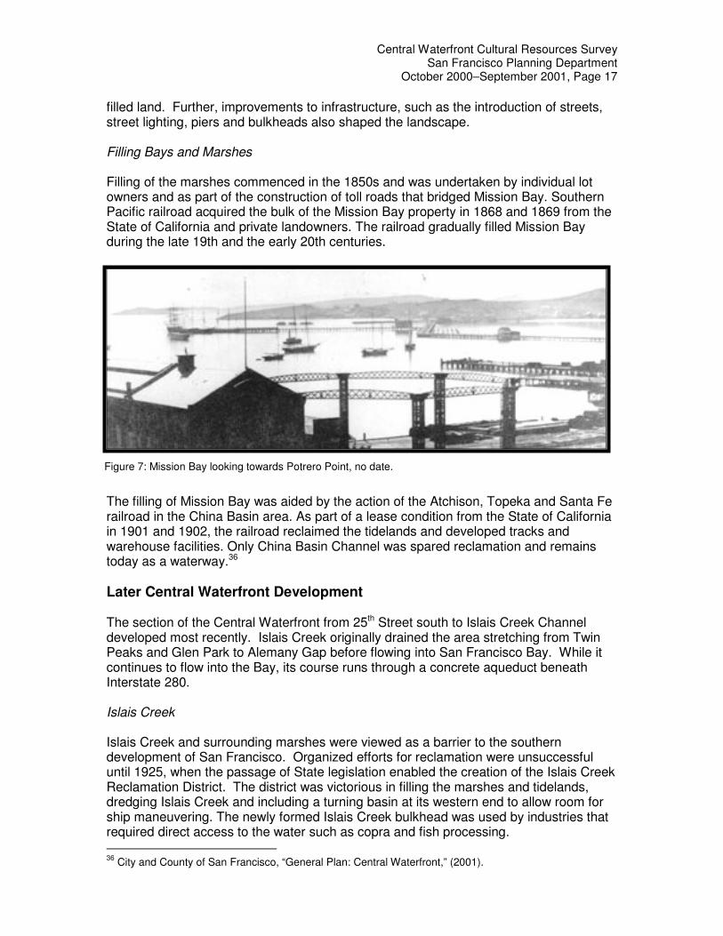
filled land. Further, improvements to infrastructure, such as the introduction of streets, street lighting, piers and bulkheads also shaped the landscape. Filling Bays and Marshes Filling of the marshes commenced in the 1850s and was undertaken by individual lot owners and as part of the construction of toll roads that bridged Mission Bay. Southern Pacific railroad acquired the bulk of the Mission Bay property in 1868 and 1869 from the State of California and private landowners. The railroad gradually filled Mission Bay during the late 19th and the early 20th centuries.
The filling of Mission Bay was aided by the action of the Atchison, Topeka and Santa Fe railroad in the China Basin area. As part of a lease condition from the State of California in 1901 and 1902, the railroad reclaimed the tidelands and developed tracks and warehouse facilities. Only China Basin Channel was spared reclamation and remains today as a waterway.36 Later Central Waterfront Development The section of the Central Waterfront from 25th Street south to Islais Creek Channel developed most recently. Islais Creek originally drained the area stretching from Twin Peaks and Glen Park to Alemany Gap before flowing into San Francisco Bay. While it continues to flow into the Bay, its course runs through a concrete aqueduct beneath Interstate 280. Islais Creek Islais Creek and surrounding marshes were viewed as a barrier to the southern development of San Francisco. Organized efforts for reclamation were unsuccessful until 1925, when the passage of State legislation enabled the creation of the Islais Creek Reclamation District. The district was victorious in filling the marshes and tidelands, dredging Islais Creek and including a turning basin at its western end to allow room for ship maneuvering. The newly formed Islais Creek bulkhead was used by industries that required direct access to the water such as copra and fish processing. 36
City and County of San Francisco, “General Plan: Central Waterfront,” (2001).
Figure 7: Mission Bay looking towards Potrero Point, no date.

Central Waterfront Cultural Resources Survey San Francisco Planning Department
October 2000–September 2001, Page 18
The most recent filling of Islais Creek basin occurred during the construction of Pier 80, formerly the Army Street Ship Terminal. Financed by a bond issued approved by California voters in 1958, the terminal opened in 1967. Remaining Landscape Features Water-related landscape features include the abandoned remains of piers and Warm Water Cove; so named for the industrial run-off of the Potrero Station “A” power plant and the bulkheads that formed the shoreline, as well as Islais Creek Channel. Land-based features include remains of Irish Hill and the city’s last open creek run/trench under Interstate 280; cut from Potrero Hill for the railroads. Central Waterfront’s Modes of Transportation The first industries to locate at Potrero Point in the 1850s required travel by boat to other parts of the city. At the time, the only connection to the land was a trail that led from Potrero Point to Mission Dolores. Potrero Point first connected to downtown San Francisco via the Long Bridge in 1867. The following year, Kentucky Street (3rd Street), the first platted street in the area was scored from Long Bridge through Potrero Point to Islais Creek. Both Long Bridge and the bridge subsequently built over Islais Creek were constructed with tracks for horse-drawn trolleys that brought day-trippers from the city out to the countryside and to Bayview Race Track, south of the Central Waterfront area. A Market Street trolley line ran along 3rd Street, but catered instead to commuters. Between 1903 and 1907, pedestrian bridges were constructed to connect the Potrero Hill area with the factories and jobs below the hill at Potrero Point. These footbridges were later removed for the construction of Interstate 280. 3rd Street In 1867, the first cut into Potrero Point resulted in the lowering of the grade and the creation of 3rd Street. Leaving the early costs of maintaining the road to its users, the length of 3rd Street was accepted by the Board of Supervisors as a municipally maintained road in 1893, having been paved in basalt blocks.37 By 1928, most of the Central Waterfront area was still largely unpaved. Street Plans Following the platting of 3rd Street, the rest of the area was formally platted. Streets running north-south were named for states in the Union and east-west streets were named for California counties.38 As the railroad companies’ filled-in Mission Bay to the north, Long Bridge became 3rd Street and Potrero Point became less pronounced. West of 3rd Street, the northern and southern boundaries of the original Potrero Point were generally recognized as 18th and 22nd Streets. The decision by Western Pacific Rail Road to infill its property south of the Gas Works (Potrero Power Plant) finalized the elimination of Potrero Point as a peninsula. The Potrero Point shoreline was thus united with that of the Islais Creek Basin.
37
Tables showing changes in names of streets also open, closed and accepted streets and widths of streets of the City and County of San Francisco, Board of Supervisors City and County of San Francisco, The Hinton Printing Co., San Francisco, 1895. 38
The east-west streets were renamed to numbered streets in the first years of the 20th century.

Central Waterfront Cultural Resources Survey San Francisco Planning Department
October 2000–September 2001, Page 19
Railroad Companies, Roads and Tunnels Railroad companies, the area’s largest landowner in the late 19th and early 20th centuries, laid tracks throughout the Potrero area to connect with the city’s existing rail service, which began in 1862. Between 1905 and 1907, railroad companies built tunnels under Iowa Street between 18th and 22nd Streets and between 23rd and 25th Streets, to create the Bayshore Cutoff, a rail system designed to provide greater rail accessibility both in and out of San Francisco. The railroad companies also constructed two extant bridges that connected Potrero Hill and the Central Waterfront area for vehicular and pedestrian traffic.
Railroad companies that operated in the survey area included the national lines of Southern Pacific Rail Road, Western Pacific Rail Road and the Atchison, Topeka and Santa Fe Rail Road. The San Francisco & San Joaquin Rail Road was a regional railroad that ran through the Bayshore Cutoff. The Potrero Bayview Rail Road and the Market Street Railway were local lines.
Historical Significance The Central Waterfront area, which includes the Dogpatch neighborhood, is historically significant as a mixed-use industrial and residential district; its period of significance spans from 1854 to 1948. While the area’s period of significance represents close to 100 years of history, it is important to discuss these “layers of time” in summary form.
Phases of Development – Central Waterfront Early Manufacturing, 1854-1867 Earliest manufacturing businesses, which included gunpowder and cordage production. In 1854, the E.I. du Pont de Nemours Company, one of the largest manufacturers of black gunpowder in the United States, constructed the first powder magazine on the south shore of Potrero Point. The earliest cordage industry was the San Francisco Cordage Manufactory; a pioneer rope-making factory established by brothers Alfred and Hiram Tubbs in 1857.
Figure 8: Construction of Bayshore Cutoff, no date.

Central Waterfront Cultural Resources Survey San Francisco Planning Department
October 2000–September 2001, Page 20
Central Waterfront’s Iron Works Industry, 1867 – 1945 Pacific Rolling Mills/Risdon Iron Works/U.S. Steel; Atlas Iron/Thorneycroft Boilermakers; Union Iron Works; U.S. Shipbuilding; and Bethlehem Steel Corp. There are no known surviving buildings, structures or objects from the U.S. Shipbuilding or Atlas Iron/Thorneycroft years of operation, although there may be archeological remains. Buildings conformed to the block pattern and were not built in the path of unopened streets. Union Iron Works Period, 1883 to 1902. From 1883 until the end of World War II, Union Iron Works remained the most important industry in the Central Waterfront area and the largest employer of local residents, employing anywhere between a quarter to half of local residents.39 First Bethlehem Steel Period, 1905-1940. The First Bethlehem Steel Period from 1905-1940 is a continuation of the Union Iron Works period. After 1915, Bethlehem Steel doubled in size with the acquisition of Pacific Rolling Mills, Risdon Iron and U.S. Steel. Bethlehem Steel/World War II Period, 1940-1945. This period was one of cooperation between the federal government and Bethlehem Steel. The buildings were, in most cases, designed, built and owned by the government on joint-Bethlehem Steel and government-owned land. In 1940, the City and County of San Francisco Board of Supervisors vacated streets within Block 4052 with Resolution #1376, there by allowing the construction of more buildings on vacant land for the increased production of military vessels during World War II. Of Pier 70’s approximately 50 remaining historic resources, half date from the Bethlehem Steel/WWII period of significance, 1940-1945. Post War Industry Following World War II, the character of the Central Waterfront area changed once again as industries began closing-up shop or moving overseas. Between 1965 and 1980, jobs in the Central Waterfront area dropped from 16,304 to 11,004, with most of the loss occurring in manufacturing and ship repair.40
Historic Property Types Property Types The area outside of Dogpatch but within the overall Central Waterfront survey area includes 114 industrial and commercial buildings, 10 retail, mixed-use buildings seven residential buildings and eight structures and objects, which includes railroad tracks, railroad tunnels, and cranes. The surveyed buildings 45 years or older (and outside Dogpatch) were constructed between the mid-1870s and the mid-1950s. Most of the survey area’s earliest surviving resources have been heavily altered over the years, perhaps to accommodate a change in use or because of modifications to the original structure. Examples of resources that retain a high degree of integrity are mostly found at Bethlehem Steel Corporation’s San Francisco Yard/Pier 70.
39
Twelfth, Thirteenth and Fourteenth United States Census (1900, 1910 and 1920). 40
San Francisco Department of City Planning, “Central Waterfront, An Area Plan of the Master Plan of the City and County of San Francisco,” (1990), p. II.8.5.
Central Waterfront Cultural Resources Survey San Francisco Planning Department
October 2000–September 2001, Page 21
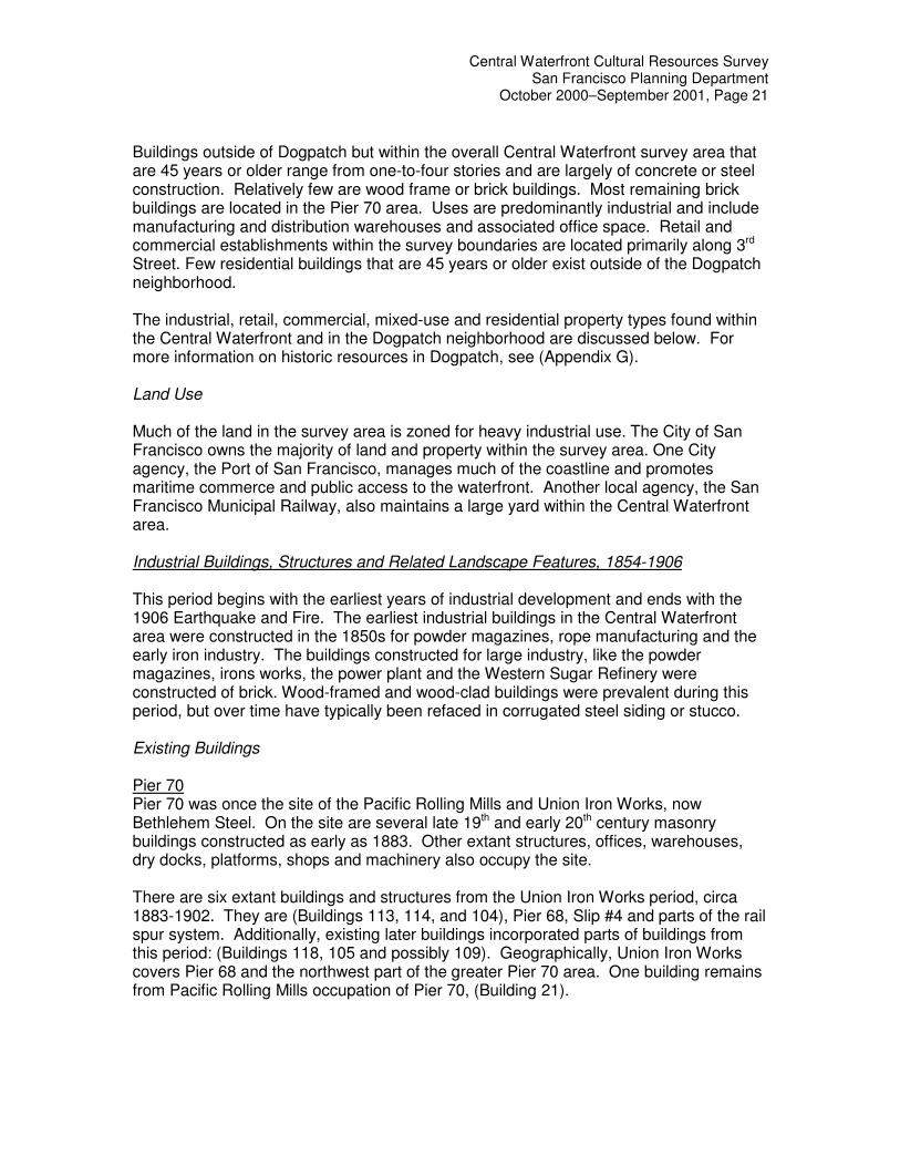
Buildings outside of Dogpatch but within the overall Central Waterfront survey area that are 45 years or older range from one-to-four stories and are largely of concrete or steel construction. Relatively few are wood frame or brick buildings. Most remaining brick buildings are located in the Pier 70 area. Uses are predominantly industrial and include manufacturing and distribution warehouses and associated office space. Retail and commercial establishments within the survey boundaries are located primarily along 3rd Street. Few residential buildings that are 45 years or older exist outside of the Dogpatch neighborhood. The industrial, retail, commercial, mixed-use and residential property types found within the Central Waterfront and in the Dogpatch neighborhood are discussed below. For more information on historic resources in Dogpatch, see (Appendix G). Land Use Much of the land in the survey area is zoned for heavy industrial use. The City of San Francisco owns the majority of land and property within the survey area. One City agency, the Port of San Francisco, manages much of the coastline and promotes maritime commerce and public access to the waterfront. Another local agency, the San Francisco Municipal Railway, also maintains a large yard within the Central Waterfront area. Industrial Buildings, Structures and Related Landscape Features, 1854-1906 This period begins with the earliest years of industrial development and ends with the 1906 Earthquake and Fire. The earliest industrial buildings in the Central Waterfront area were constructed in the 1850s for powder magazines, rope manufacturing and the early iron industry. The buildings constructed for large industry, like the powder magazines, irons works, the power plant and the Western Sugar Refinery were constructed of brick. Wood-framed and wood-clad buildings were prevalent during this period, but over time have typically been refaced in corrugated steel siding or stucco. Existing Buildings Pier 70 Pier 70 was once the site of the Pacific Rolling Mills and Union Iron Works, now Bethlehem Steel. On the site are several late 19th and early 20th century masonry buildings constructed as early as 1883. Other extant structures, offices, warehouses, dry docks, platforms, shops and machinery also occupy the site. There are six extant buildings and structures from the Union Iron Works period, circa 1883-1902. They are (Buildings 113, 114, and 104), Pier 68, Slip #4 and parts of the rail spur system. Additionally, existing later buildings incorporated parts of buildings from this period: (Buildings 118, 105 and possibly 109). Geographically, Union Iron Works covers Pier 68 and the northwest part of the greater Pier 70 area. One building remains from Pacific Rolling Mills occupation of Pier 70, (Building 21).
Central Waterfront Cultural Resources Survey San Francisco Planning Department
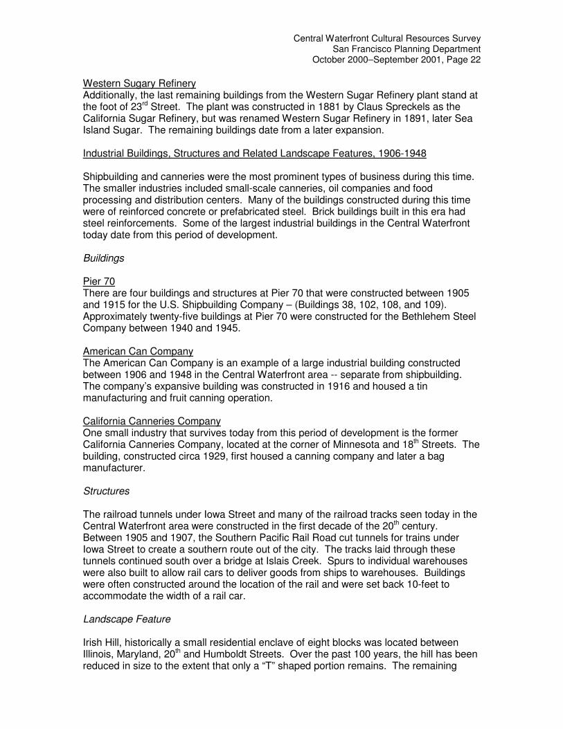
October 2000–September 2001, Page 22
Western Sugary Refinery Additionally, the last remaining buildings from the Western Sugar Refinery plant stand at the foot of 23rd Street. The plant was constructed in 1881 by Claus Spreckels as the California Sugar Refinery, but was renamed Western Sugar Refinery in 1891, later Sea Island Sugar. The remaining buildings date from a later expansion. Industrial Buildings, Structures and Related Landscape Features, 1906-1948 Shipbuilding and canneries were the most prominent types of business during this time. The smaller industries included small-scale canneries, oil companies and food processing and distribution centers. Many of the buildings constructed during this time were of reinforced concrete or prefabricated steel. Brick buildings built in this era had steel reinforcements. Some of the largest industrial buildings in the Central Waterfront today date from this period of development. Buildings Pier 70 There are four buildings and structures at Pier 70 that were constructed between 1905 and 1915 for the U.S. Shipbuilding Company – (Buildings 38, 102, 108, and 109). Approximately twenty-five buildings at Pier 70 were constructed for the Bethlehem Steel Company between 1940 and 1945. American Can Company The American Can Company is an example of a large industrial building constructed between 1906 and 1948 in the Central Waterfront area -- separate from shipbuilding. The company’s expansive building was constructed in 1916 and housed a tin manufacturing and fruit canning operation. California Canneries Company One small industry that survives today from this period of development is the former California Canneries Company, located at the corner of Minnesota and 18th Streets. The building, constructed circa 1929, first housed a canning company and later a bag manufacturer. Structures The railroad tunnels under Iowa Street and many of the railroad tracks seen today in the Central Waterfront area were constructed in the first decade of the 20th century. Between 1905 and 1907, the Southern Pacific Rail Road cut tunnels for trains under Iowa Street to create a southern route out of the city. The tracks laid through these tunnels continued south over a bridge at Islais Creek. Spurs to individual warehouses were also built to allow rail cars to deliver goods from ships to warehouses. Buildings were often constructed around the location of the rail and were set back 10-feet to accommodate the width of a rail car. Landscape Feature Irish Hill, historically a small residential enclave of eight blocks was located between Illinois, Maryland, 20th and Humboldt Streets. Over the past 100 years, the hill has been reduced in size to the extent that only a “T” shaped portion remains. The remaining
Central Waterfront Cultural Resources Survey San Francisco Planning Department
October 2000–September 2001, Page 23
portion is located within three areas: the unopened Michigan Street, Assessor’s block 4111 and block 4120. Irish Hill represents two major significant themes. First, it represents the extent to which industry has made the land in the survey area conform to its needs through a system of quarrying and filling-in of the San Francisco Bay – primarily in the Pier 70 area. Further, gravel and soil taken from Irish Hill over the years was also used as fill material for the reclamation of land from the Bay at Islais Creek Basin and Mission Bay. Second, Irish Hill represents the last testament of an entire residential neighborhood. Irish Hill was by all accounts a solid working-class district comprised mostly of single, Irish male immigrants. Examples of Existing Buildings, Structures, and Landscape Features, 1948-1956 The period begins with the slow-down of production following World War II and the end of the Central Waterfront Period of Significance, but ends in approximately 1956; the construction date of the “youngest” property within the survey boundaries. This period of development represents the transition from the Central Waterfront’s dependency on water transport and railroads to its reliance on highways. The rise of the trucking industry is visible in distribution warehouses that have rails along one side and loading docks for trucks on the other. Growth of both the trucking industry and the use of standard containers for trucks led to the downfall of rail service. As a result, trucking- oriented business began in the Central Waterfront area, as did truck and auto repair facilities. To accommodate the increase in vehicular traffic through the Central Waterfront area, 3rd Street was widened in 1938 and became a thoroughfare from downtown to the southeastern section of the city. The development of southern portions of the survey area occurred largely after World War II. Food and oil processing plants were constructed south of Army Street (Cesar Chavez Street). In 1948, Cargill Inc., constructed a plant and refinery for coconut oil. In 1956, an administration building was added. The Granex Corp., a copra processing plant, erected the copra-loading crane in 1965. A report by the Copra Crane Labor Landmark Association states that the crane is significant as purportedly the last remaining piece of machinery on the port of San Francisco hand operated by longshoreman working bulk cargo. The crane also represents the ties of San Francisco’s economy with those of the South Pacific Islands. 41 Serving as visual icons to the Pier 70 area, a number of other cranes used in the outfitting of naval and merchant vessels exist today. After World War II, many buildings were demolished to make way for single story, concrete buildings and the overall development of the area as an industrial park. The buildings constructed for industrial and office uses during this time continued to be built of reinforced concrete or prefabricated steel. These buildings tended to be smaller and almost entirely devoid of ornamentation. Butler Buildings -- prefabricated steel buildings that could be ordered from catalogs -- were erected in great numbers in the area.
41
In the 1960s, copra imports to San Francisco were valued at about $18 million annually. Additional research may find the crane as the only remaining property representative of the copra processing industry in San Francisco.
Central Waterfront Cultural Resources Survey San Francisco Planning Department
October 2000–September 2001, Page 24
Retail and Mixed-use Buildings Restaurants, bars, groceries and other neighborhood services have operated within the Central Waterfront since its earliest days. Many of these building types were constructed as two-story buildings with commercial uses on the ground floor and residences above. The existing retail and mixed-use buildings are generally located along 3rd Street and within the Dogpatch neighborhood. They are characteristically small-scale buildings constructed of wood, brick or concrete and have been substantially altered over time. Residential Buildings There are seven residential buildings outside of the Dogpatch neighborhood and within the overall Central Waterfront survey area. These wood frame-constructed houses were largely constructed between the late 19th century and the early 20th century as housing for workers employed at nearby factories. The majority of housing that continues to exist outside Dogpatch is part of mixed-use structures (ground floor commercial with residential above) or are single and multi-family residential buildings that have been heavily altered. The oldest residential building outside of Dogpatch (circa 1875), but within the survey boundaries is located at 2636-2638 3rd Street. A two-story frame house at 670-674 Tennessee Street was constructed circa 1884. It appears to have been heavily altered. Another two-story frame building at 2476-2478 3rd Street was constructed in 1900, but also appears to have been altered. Integrity One of the touchstones of determining the perceived value and importance of buildings, structures, sites and objects that result from a historic resource survey can be found in the concept of historic integrity. To be listed in the National Register of Historic Places, a historic resource or resources contained within a historic district must be significant under the Register’s established criteria. But the resources must also possess historic integrity. According to the National Park Service, integrity is defined as “the ability of a property to convey its significance,” and is grounded in an understanding of a property’s physical features and how they relate to that significance. To further clarify the concept of integrity, the National Register criterion recognizes seven aspects or qualities that, in various combinations, define integrity. Determining which of these aspects are most important to a particular property requires knowing why, where, and when the property is significant. The seven aspects of integrity are location, design, setting, materials, workmanship, feeling and association. Ultimately, the question of integrity is answered by whether a historic resource retains the identity for which it is significant. To aid in that determination, Department staff has assigned National Register Status Codes to all 139 buildings, structures and objects in the Central Waterfront survey boundaries. A summary of these codes can be found in Appendix B. National Register Status Codes assigned to Dogpatch resources can be found in Appendix G.

Central Waterfront Cultural Resources Survey San Francisco Planning Department
October 2000–September 2001, Page 25
Note: Resources assigned with NR Status Codes of 5N, 5D1, or 5S3, appear ineligible for the National Register, but should be considered for local historic designation or in local planning issues. Surveyed properties designated as 6Z1 are found ineligible for listing in the National Register and possess no particular cultural or historical value.
Central Waterfront’s potential historic districts Pier 70 Integrity of Resources: It appears that the largest concentration of resources with the highest degree of integrity can be found at Pier 70 (for boundary information see map in Appendix C). Assigned NR Status Codes: The majority of resources at Pier 70 have been identified with the following NR Status Codes: 3B -- properties that contribute to a historic district that has been fully documented; 3D -- by contributing to a historic district that has been fully documented; or 4R -- may become eligible for listing in the National Register when the resource meets: 1) Is located within the boundaries of a fully documented district and 2) May become a contributor to the district when it is restored to its appearance during the district’s period of significance. Proposed Period of Significance: 1882-1945. This period encompasses the construction of the oldest resources for Union Iron Works through the Bethlehem Steel/World War II period of use. Significance: Pier 70 is historically significant for its role in the rehabilitation and manufacturing of military vessels for the Spanish American War, World War I and World War II. Pier 70 is potentially eligible as a National Register historic district that is significant at the national level under Criterion A: Resources that are associated with events that have made a significant contribution to the broad patterns of our history; and Criterion C: Design and Construction, as a district embodying “distinctive characteristics of a type and period of construction.” Dogpatch Integrity of Resources: The majority of historic resources within the Dogpatch neighborhood appear to retain sufficient integrity so as to be contributors to a designated local historic district (for boundary information see Appendix F). Assigned NR Status Codes: The majority of resources in the Dogpatch neighborhood have been identified as 5D1 -- ineligible for the National Register but of local interest as a contributor to a fully documented district that is designated or eligible for designation as a local historic district. Proposed Period of Significance: 1867-1945. The period of significance ranges from 1867, the approximate age of the oldest residential construction in the neighborhood to 1945, the date at which the neighborhood had been completely built-out and no longer the primary residential district for shipyard workers. Significance: Dogpatch is significant at the local level under Criterion C: Design and Construction, as a district embodying “distinctive characteristics of a type and period of

Central Waterfront Cultural Resources Survey San Francisco Planning Department
October 2000–September 2001, Page 26
construction.” Dogpatch is significant as the oldest and most intact surviving concentration of Victorian-era industrial workers’ housing in San Francisco. Bridges and Tunnels Integrity of Resources: Two vehicular and pedestrian bridges and two tunnels -- all constructed by the Southern Pacific Railroad at its Bayshore Cutoff -- retain significant integrity (located at Iowa Street between 18th and 22nd Streets and between 23rd and 25th Streets). Assigned NR Status Codes: These resources have been identified with 3D -- by contributing to a historic district that has been fully documented according to the California Office of Historic Preservation. Proposed Period of Significance: 1904-1948. The period of significance begins when the resources were constructed at the height of rail transport through the Central Waterfront area, but ends in 1945 as the trucking industry lessened reliance on the railroads. Significance: These resources are potentially eligible as a National Register historic district that is significant at the local level under Criterion A: Resources that are associated with events that have made a significant contribution to the broad patterns of our history through the growth of San Francisco’s modes of transportation -- from water to rail to roads. Industrial-type Buildings Integrity of Resources: This potential district, located primarily along 3rd Street (within the survey boundaries) features various levels of integrity based on modifications to the resources. However, more research should be conducted on the significance of the buildings and structures as they relate to the development of the Central Waterfront area and to the rest of San Francisco. Assigned NR Status Codes: The majority of resources have been identified as 4D2 -- resources that are a contributor to a fully documented historic district that may become eligible for listing in the National Register when more historical or architectural research is conducted. Proposed Period of Significance: 1900-1948. This period encompasses multiple themes that include: construction of small oil industry-related businesses; construction of Art Deco-styled buildings to accommodate industrial uses; modifications to resources through street widening or other infrastructure improvements to accommodate the burgeoning trucking industry. Significance: The Industrial-type Buildings proposed historic district is historically significant at the local level under Criterion A: Resources that are associated with events that have made a significant contribution to the broad patterns of our history through the growth of San Francisco’s modes of transportation -- from water to rail to roads.

Central Waterfront Cultural Resources Survey San Francisco Planning Department
October 2000–September 2001, Page 27
Conclusion The Central Waterfront Survey area, which includes the Dogpatch neighborhood, is a large geographic area that is historically significant as a mixed-use industrial and residential district, 1854 to 1948. In simplest terms, land modification and Bay infill, both implemented to accommodate the needs of economic activities, epitomize the historical development of the Central Waterfront. From the earliest industries of the mid-1850s through today, the Central Waterfront area has represented a dramatically changing landscape that has continuously maintained its mixed-used character. A survey completed in 1999 by the Potrero Central Waterfront Committee revealed that the area maintains a strong industrial and commercial base -- offering a diverse environment for commercial and creative enterprises.42 New industrial uses continue to locate in the Central Waterfront area, and the prospect of more than 8,000 housing units and over six million square feet of office and commercial space also signal the redevelopment of the area. Recommendations The greatest protection afforded a community’s historic resources is typically at the local level -- through codes and ordinances that govern the identification, documentation and preservation of these resources. Using the Central Waterfront Survey data as a planning tool, individual resources and sections of the Central Waterfront area should be considered for designation through Article 10 of the Code of the City of San Francisco. Section 1004 directs the Board of Supervisors to, “…by ordinance, designate an area containing a number of structures having a special character or special historical, architectural or aesthetic interest or value, and constituting a distinct section of the city, as a historic district.” At the very minimum, the Central Waterfront area’s historic resources should be given special consideration in planning issues that may involve the rezoning of land or the demolition of identified historic buildings, structures or objects within the survey boundaries.
42
San Francisco Central Waterfront: Community Land Use Recommendations Report, Potrero Central Waterfront Committee: October 15, 1999.

Central Waterfront Cultural Resources Survey San Francisco Planning Department
October 2000–September 2001, Page 28
Bibliography
Primary Sources: Aerial Photography: c. 1934, 1941, 1948, 1959, 1964. San Francisco Planning Department. Bethlehem Steel Company. “A Century of Progress.” San Francisco: Bethlehem Steel Company, Shipbuilding Division, 1949. Coast Survey Map of 1857. Map of the City of San Francisco Showing Paved Streets. M.M. O’Shaughnessy, City Engineer, 1928. (San Francisco Public Library) Sanborn Maps: 1886, 1899, 1900, 1915, 1920, 1998. San Francisco Block Books: 1935, 1948, 1964, 2001. San Francisco Planning Department. San Francisco Call, October 24, 1905. San Francisco Chronicle, August 18, 1903 and June 3, 1918. San Francisco Examiner, January 16, 1916. Tables Showing Changes in Names of Streets, Also Open, Closed and Accepted Streets and Widths of Streets of the City and County of San Francisco. The Hinton Printing Co. 536 Clay Street, San Francisco, 1895. (San Francisco Public Library) Works Progress Administration Land use maps 1940 (updated through 1957) San Francisco Planning Department Victor S. Clark. “History of Manufactures in the United States, 1893-1928.” New York: 1949. Government Documents: “Central Waterfront Plan: An Area Plan of the General Plan of the City and County of San Francisco.” Planning Department, September 27, 1990. “Port of San Francisco Waterfront Design & Access, an Element of the Waterfront Land Use Plan.” June 24, 1997. “San Francisco Central Waterfront: Community Land Use Recommendations Report.” Potrero Central Waterfront Committee: October 15, 1999. Tenth, Twelfth, Thirteenth and Fourteenth US Census, (1880, 1900, 1910 and 1920).

Central Waterfront Cultural Resources Survey San Francisco Planning Department
October 2000–September 2001, Page 29
Secondary Sources: Brian T. McWilliams. “The Changing San Francisco Waterfront.” Sea Letter, National Maritime Museum Association. Summer 2000, Number 58. Bruce Nelson. “Workers on the Waterfront: Seamen, Longshoremen, and Unionism in the 1930s.” Urbana, University of Illinois Press, 1988. Carey & Co., Inc. “Southern Waterfront Historic Structures Report.” December 1994. Carl Nolte; “The Working Waterfront.” Sea Letter, National Maritime Museum Association. Summer 2000, Number 58. Charles M. Coleman. “P. G. & E. of California: the Centennial Story of Pacific Gas and Electric Company 1852-1952.” New York: McGraw-Hill, 1952. Christopher VerPlanck, “Dogpatch Historic District Context.” San Francisco, April, 2001. Christopher VerPlanck and San Francisco Architectural Heritage. “DPR 523B forms for 707 18th Street and 118 22nd Street.” San Francisco Architectural Heritage. Dames & Moore. “Historic Architecture Report, Station A, Potrero Power Plant.” San Francisco, CA 94105-1917. December 1999 Dan Gutleben, Western Sugar Refinery records, Special Collections, Bancroft Library, Berkeley. Gerald Robert Dow. “Bay Fill in San Francisco: A History of Change,” Master’s Thesis Cal. State, San Francisco. July 1973. J.S. Hittell. “Commerce and Industry of the Pacific Coast.” San Francisco: A.L. Bancroft, 1982. Kneass Boat works, research folder. Potrero Hill Archives Project, Potrero Branch Public Library. Nancy Olmstead. “Vanished Waters: a History of San Francisco’s Mission Bay.” San Francisco, Mission Creek Conservancy, 1986. Nancy Olmstead. “Walking on Water: a History of Mission Bay.” UCSF Magazine (April 1999). Potrero View, September 1976. Robert O’Brien. “Riptides.” Scrapbook, Oral History of San Francisco, Bancroft Library, Berkeley. Roger and Nancy Olmsted. “San Francisco Bayside Historical Cultural Resource Study.” San Francisco: 1982. Wendy Zane. “On the Waterfront of San Francisco,” Master’s Thesis, Wellesley College, n.d. c. 1991.
Central Waterfront Cultural Resources Survey San Francisco Planning Department
October 2000–September 2001, Page 30
William Issel and Robert W. Cherny. “San Francisco: 1865-1932.” Berkeley: UC Press, 1986. Wirth Associates, Inc. “Potrero 7: Phase 1. Cultural Resources Overview and Inventory.” March, 1979. OTHER Interview with Edward Cicerone, conducted by Cheryl and Clark Taylor, (May 1964).
Central Waterfront Cultural Resources Survey San Francisco Planning Department
October 2000–September 2001, Page 31
List of Images
Cover Page: Photograph Number: AAC-8916 San Francisco Historical Photograph Collection, San Francisco Public Library Page 3: Central Waterfront survey area pictured between 1929 and 1934. Planning Department photograph. Page 9: Photograph Number: AAC-3091 San Francisco Historical Photograph Collection, San Francisco Public Library Page 11: Photograph Number: AAC-6368 San Francisco Historical Photograph Collection, San Francisco Public Library Page 12: Central Waterfront survey area pictured between 1929 and 1934. Planning Department photograph. Page 15: Photograph Number: AAC-2291 San Francisco Historical Photograph Collection, San Francisco Public Library Page 17: Photograph Number: AAB-2880 San Francisco Historical Photograph Collection, San Francisco Public Library

Central Waterfront Cultural Resources Survey San Francisco Planning Department October 2000–September 2001
Appendix A: DPR 523 Forms -- Central Waterfront Historic Resource Survey

Central Waterfront Cultural Resources Survey San Francisco Planning Department October 2000–September 2001
Appendix B: Central Waterfront Historic Resource Survey -- NR Status Code Matrix

Central Waterfront Cultural Resources Survey San Francisco Planning Department October 2000–September 2001
Appendix C: Maps
Map 1. City and County of San Francisco and the Central Waterfront Survey Area.

Central Waterfront Cultural Resources Survey San Francisco Planning Department October 2000–September 2001
Map 2. The Central Waterfront Survey Area with boundaries, major street names and boundaries of the Dogpatch Neighborhood, the P.G. & E. area and Pier 70 / The Bethlehem Steel San Francisco Yard. For more information on the Dogpatch survey boundaries, see Appendix G.

Central Waterfront Cultural Resources Survey San Francisco Planning Department October 2000–September 2001
Map 3. 1899 Sanborn Map showing Central Waterfront Survey Area.

Central Waterfront Cultural Resources Survey San Francisco Planning Department October 2000–September 2001
Map 4. The Bethlehem Steel San Francisco Yard, showing ages of structures and building numbers, from the Bethlehem Steel General Plan of 1957.

Central Waterfront Cultural Resources Survey San Francisco Planning Department October 2000–September 2001
Appendix D: Station A, Potrero Power Plant, DPR 523 Forms

Central Waterfront Cultural Resources Survey San Francisco Planning Department October 2000–September 2001
Appendix E: General Periods of Development – Central Waterfront Gunpowder production 1854-1881 Rope 1857-1962 Boatyards 1862- Irish Hill development and destruction 1867-1916 Pacific Rolling Mills 1868-1890s Infill Tidal Flats 1869-1903 Cut down hills 1869-1903 Bust period 1869-1883 Dogpatch residential 1870s-present Power Generating Plant 1870 Sugar 1881-1951 Union Iron Works 1883 – 1902 Barrel making 1884-1956 Ridson Iron Works (acquisition of Pacific Rolling Mills) 1890s-1911 Bethlehem Steel (acquisition of Union Iron works) 1905-1949 American Can Company 1910-late 1940s at least Slower period 1918-1941 Decline in residential populations 1920s-1930s Large parcels redeveloped for machine shops and warehouses 1920s Bethlehem Steel (back up to full capacity) 1941-1945 San Francisco Yard shuts down. Sugar, rope and other industries close or move overseas After 1945 (WWII)

Central Waterfront Cultural Resources Survey San Francisco Planning Department October 2000–September 2001
Appendix F: Central Waterfront National Register Status Codes -- Summary
National Register of Historic Places (NRHP) Status Codes noted on the Building, Structure, And Object Record form
CODE Summary Explanation Specific Explanation
1S Listed in the National Register
This property is already individually listed in the National Register of Historic Places.
2 Determined eligible for listing in the National Register
Official action by the State is required to make this structure eligible for listing in the National Register.
3B The property contributes to a historic district that has been fully documented according to the California Office of Historic Preservation. The resource also appears eligible for separate listing in the National Register.
3D The property contributes to a historic district that has been fully documented according to the California Office of Historic Preservation. The resource also appears eligible for district listing in the National Register.
3S
Appears eligible for listing in the National Register in the judgment of the person(s) completing or reviewing the form
This property appears eligible for separate listing in the National Register.
4D2 This property is a contributor to a fully documented historic district that may become eligible for listing in the National Register when more historical or architectural research is performed on the district.
4D5 This property may be a contributor to a fully documented district that may become eligible for listing when registration requirements for the property type are clarified.
4R This property may become eligible for listing in the National Register when it meets both of the following two conditions: 1) Is located within the boundaries of a fully documented district that is listed in, determined eligible for, or appears eligible for the National Register; and 2) May become a contributor to the district when it is restored to its appearance during the district’s period of significance.
4S1 May become eligible for separate listing in the National Register when the property becomes old enough to meet the Register’s 50-year requirement.
4S2 This property may become eligible for separate listing in the National Register when more historical or architectural research is performed.
4X
May become eligible for listing in the National Register in the judgment of the person(s) completing or reviewing the form
This property may become eligible as a contributor to a district that has not been fully documented.
5S3 Ineligible for the National Register but of local interest
This property is not eligible for separate listing in the National Register or designation under local ordinances but is eligible for special consideration in local planning.

Central Waterfront Cultural Resources Survey San Francisco Planning Department October 2000–September 2001
5D1 This property is a contributor to a fully documented district that is designated or eligible for designation as a local historic district.
5N This property has experienced significant changes but should be given consideration in local planning.
5B1
This property is eligible as a local historic landmark or as a contributor to a fully documented local district that is designated or eligible for designation as a local historic district.
6Z1 Not of local interest or potentially eligible for the National Register
This property appears not to have particular cultural or historical value.

Central Waterfront Cultural Resources Survey San Francisco Planning Department October 2000–September 2001
Appendix G: Context Statement and DPR 523 Forms -- Dogpatch Historic Resource Survey

Central Waterfront Cultural Resources Survey San Francisco Planning Department October 2000–September 2001
Appendix H: Dogpatch Historic Resource Survey -- NR Status Code Matrix