chapter 5 - mozambique lng€¦ · afungi and cabo delgado peninsulas. figure 5.2 shows the five...
TRANSCRIPT

Chapter 5 Consideration of Alternatives

CONTENTS
5 CONSIDERATION OF ALTERNATIVES 5-1
5.1 INTRODUCTION 5-1 5.2 SITE ALTERNATIVES 5-1 5.2.1 Terrestrial Ecological Assessment 5-9 5.2.2 Marine Ecological Assessment 5-9 5.2.3 Socio-economic Assessment 5-10 5.3 LAYOUT ALTERNATIVES 5-11 5.3.1 Routing of the Gas Pipeline Corridor to the Project Site 5-11 5.3.2 The Siting of Various Onshore Infrastructure 5-14 5.4 TECHNOLOGY AND PROCESS ALTERNATIVES 5-14 5.4.1 Pretreatment Technologies 5-14 5.4.2 Liquefaction 5-15 5.4.3 LNG Tanks 5-15 5.4.4 Cooling Systems 5-15 5.4.5 Discharge Management 5-16 5.5 NO-GO ALTERNATIVE 5-16 5.5.1 Alignment with Government Policy 5-16 5.5.2 Economic Benefits not Realised 5-17 5.5.3 Unmet Local Expectations 5-17 5.5.4 Negative Socio-economic Impacts Averted 5-18 5.5.5 Negative Biophysical Impacts Averted 5-18 5.6 CONSIDERATION OF ALTERNATIVES THROUGH FEED 5-18

ERM & IMPACTO AMA1 & ENI
5-1
5 CONSIDERATION OF ALTERNATIVES
5.1 INTRODUCTION
This section describes the alternatives considered during the course of the Project design and the EIA process. As a result of ongoing consultation between the EIA Team, the Project technical team and the Pre-FEED Contractors, the EIA process itself has already contributed significantly to the evaluation and selection of alternatives and enabled mitigation to be incorporated into the Project design. The following alternatives have been considered: • site alternatives; • layout alternatives; • technology and process alternatives; and • no-go alternative.
5.2 SITE ALTERNATIVES
AMA1’s Engineering Team analysed the northern Mozambique coastline of Cabo Delgado Province between Pemba and the Tanzanian border in early 2011 to identify potentially suitable locations (1) for an LNG Facility. From this exercise, seven potential locations along the coast were identified (labelled A to G in Figure 5.1). For various technical, environmental, financial and security reasons, four locations were subsequently determined to be not suitable. Three broad geographic location alternatives were identified as potentially suitable: Londo Peninsula in Metuge District, and Afungi Peninsula and Cabo Delgado Peninsula in Palma District. These three options were then presented to the EIA Team to investigate further from an environmental and social perspective. The EIA Team undertook a desktop study and initial field visits in May 2011 to all three localities to support their analysis.
(1) For the site selection process, the term ‘location’ refers to a broad area (eg the Afungi Peninsula) on which one or more LNG sites could fit.

41°0'0"E
41°0'0"E
40°30'0"E
40°30'0"E
40°0'0"E
40°0'0"E
39°30'0"E
39°30'0"E
39°0'0"E
39°0'0"E
38°30'0"E
11°0
'0"S
11°0
'0"S
11°3
0'0"
S
11°3
0'0"
S
12°0
'0"S
12°0
'0"S
12°3
0'0"
S
12°3
0'0"
S
13°0
'0"S
13°0
'0"S
SIZE:
TITLE:
DATE: Oct 2013
DRAWN: AB
CHECKED: KG
APPROVED: KG
PROJECT: 0133576
DRAWING: REV:
A3
Figure 5.1:Seven Initial Locations Considered
Seven Initial Locations Considered.mxd A
CLIENT:
±MAIN MAP SCALE:
T:\G
IS P
roje
cts\
0133
576_
Anad
arko
_Moz
_LN
G\M
appi
ng\M
XD
\ES
IA\C
hapt
er5\
Sev
en In
itial
Loc
atio
ns C
onsi
dere
d.m
xd
Projection: UTM Zone 37 S Datum: WGS84Source: Bing Maps ©2010 Microsoft Corporation.AMA1, 2011. Inset Map: Esri Data & Maps
SCALE: 1 : 1 500 000
It is unlawful for any firm or individual to reproduce copyrighted maps, graphics or drawings, in whole or in part, without permission of the copyright owner, ERM Southern Africa (Pty) Ltd ·
Legend!. Towns
Regional Roads
District Boundary
Boundary with Tanzania
Afungi Project Site
Initial Locations Considered
0 20 40 60
Kilometers
#*
I n d i a n O c e a n
Zambia
Angola
Tanzania
Mozambique
Botswana
Madagascar
Na mibia
Zimbabwe
South Africa
Congo (DRC)
Malawi
Swaziland
Comoros
Seychelles
Kenya
Project Area
!.
E
B
D
A
CPalma
Source: Esri, DigitalGlobe, GeoEye, i-cubed,USDA, USGS, AEX, Getmapping, Aerogrid, IGN,IGP, swisstopo, and the GIS User Community
!.
F
G
Source: Esri, DigitalGlobe, GeoEye, i-cubed,USDA, USGS, AEX, Getmapping, Aerogrid, IGN,IGP, swisstopo, and the GIS User Community
ERMGreat Westerford Building240 Main RoadRondebosch, 7725Cape Town, SOUTH AFRICATel: +27 21 681 5400Fax +27 21 686 073

ERM & IMPACTO AMA1 & ENI
5-3
During this process, the Londo Peninsula location was eliminated by AMA1, ERM and Impacto for various environmental and technical reasons including, but not limited to: • proposed location is below the international flight path to the Pemba
airport; • proximity to the Quirimbas National Park; • proximity to a large population centre (ie Pemba); • distance from the offshore gas field; • technical difficulties associated with the potential subsea pipeline route
(numerous subsea canyons); and • environmental sensitivity associated with a potential onshore pipeline
route. This narrowed the EIA Team’s focus to two alternative broad locations: Afungi Peninsula and Cabo Delgado Peninsula. A marine ecology specialist then evaluated both locations, based on the following criteria (1): • seagrass beds; • shallow coral reef structures; • sand beaches; • mangroves; • estuaries; • linked biotopes; • shore and near shore modification (dredging); • pipeline shore landing; • export facility – trestle jetty and dolphin berth; and • possible discharges from the LNG Facility. A terrestrial ecology specialist evaluated the two locations according to the following criteria(2): • protected areas (legislative issue); • wetlands; • regionally important woodlands; • coastal forests; • mangroves; • estuaries; • mammals; • avifauna; and
(1) The evaluation included a consideration of sensitivity and ecological value of the various criteria. (2) The evaluation included a consideration of sensitivity and ecological value of the various criteria.

ERM & IMPACTO AMA1 & ENI
5-4
• herpetofauna. A socio-economic specialist considered the following criteria for the evaluation of the two potential locations: • local government support of the Project; • human settlements within site; • number of inhabitants; • proximity to a large population centre; • community migration/seasonal use; • marine access routes; • subsistence agriculture; • presence of fishing centres; • overlap with land uses (other than subsistence agriculture); • adjacent land uses; • cultural, religious and/or historical importance of the sites; • tourism ventures; • recreational activities and sites; and • ecotourism uses (community benefit). An absolute scoring system (1) was used to rate the two alternative locations (Afungi and Cabo Delgado peninsulas) according to the above range of environmental and social criteria. The locations were scored between 1 and 5 where 1 was usually a sensitive and important environmental or social criterion and 5 was less sensitive or disturbed. Thus higher scores indicated a preference for development. This allowed the specialists to determine the suitability of the locations for the LNG Facility, and to develop a ranking of potential localities from the perspective of the subject areas (marine, terrestrial and socio-economic). The EIA Team was then tasked with identifying preferred sites within the Afungi and Cabo Delgado peninsulas. Figure 5.2 shows the five potential sites considered within the two peninsula locations. The marine ecology preliminary results indicated that Cabo Delgado South and Afungi South were preferred (Figure 5.2). Afungi North was added as an option for consideration, on the basis of the two estuary areas identified in the extreme east and west of Afungi North being protected (excluded) from the development. Thus, of the five sites considered, three potential sites were selected by the marine ecologist for further investigation: Cabo Delgado South, Afungi South and Afungi North.
(1) An absolute scoring system allows the two locations to be assessed independently (ie they are not compared to each other).

40°42'0"E
40°42'0"E
40°40'0"E
40°40'0"E
40°38'0"E
40°38'0"E
40°36'0"E
40°36'0"E
40°34'0"E
40°34'0"E
40°32'0"E
40°32'0"E
40°30'0"E
40°30'0"E
40°28'0"E
40°28'0"E
40°26'0"E
40°26'0"E40°24'0"E
10°3
8'0"
S
10°3
8'0"
S
10°4
0'0"
S
10°4
0'0"
S
10°4
2'0"
S
10°4
2'0"
S
10°4
4'0"
S
10°4
4'0"
S
10°4
6'0"
S
10°4
6'0"
S
10°4
8'0"
S
10°4
8'0"
S
10°5
0'0"
S
10°5
0'0"
S
10°5
2'0"
S
10°5
2'0"
S
SIZE:
TITLE:
DATE: Oct 2013
DRAWN: AB
CHECKED: KG
APPROVED: KG
PROJECT: 0133576
DRAWING: REV:
A3
Figure 5.2:Potential LNG Sites on Cabo Delgado and Afungi Peninsula
Potential LNG Sites.mxd A
CLIENT:
±MAIN MAP SCALE:
T:\G
IS P
roje
cts\
0133
576_
Anad
arko
_Moz
_LN
G\M
appi
ng\M
XD
\ES
IA\C
hapt
er5\
Pot
entia
l LN
G S
ites.
mxd
Projection: UTM Zone 37 S, Datum: WGS84Source: Bing Maps ©2010 Microsoft CorporationAMA1, 2011. Inset Map: Esri Data
SCALE: 1 : 115 000
It is unlawful for any firm or individual to reproduce copyrighted maps, graphics or drawings, in whole or in part, without permission of the copyright owner, ERM Southern Africa (Pty) Ltd ·
#*
I n d i a n O c e a n
Zambia
Angola
Tanzania
Mozambique
Botswana
Madagascar
Na mibia
Zimbabwe
South Africa
Congo (DRC)
Malawi
Swaziland
Comoros
Seychelles
Kenya
Legend!. Villages / Settlements
Regional Roads
Potential LNG Sites
Project Area
0 1 2 3 4 5
Kilometers
ERMGreat Westerford Building240 Main RoadRondebosch, 7725Cape Town, SOUTH AFRICATel: +27 21 681 5400Fax +27 21 686 073

ERM & IMPACTO AMA1 & ENI
5-6
Table 5.1 Marine Ecology Scoring
Biotope/Sand Beaches/Attribute
Cabo Delgado North
Cabo Delgado South
Cabo Delgado East
Afungi North
Afungi South
Seagrass 5 3 4 2 2 Shallow coral reef structures
3 4 1 5 5
Sand beaches 5 5 5 5 5 Mangroves 5 4 5 3 5 Estuary 5 4 5 3 5 Dredging scale 1 3 4 1 1 Blasting/excavation scale
1 4 1 5 5
Maintenance dredging
1 4 4 3 3
Score 26 31 29 27 31
The terrestrial ecologist indicated a preference for Cabo Delgado South (particularly the western portion, further away from the coral rag forest) and Afungi Peninsula (with a preference for the northern portion as it avoided the wetlands to the south and is more disturbed by human activity). Table 5.2 shows the terrestrial ecology scores.
Table 5.2 Terrestrial Ecology Scoring
Habitat/Attribute Cabo Delgado North
Cabo Delgado South
Cabo Delgado East
Afungi
Protected areas 3 3 3 3 Wetlands 2 2 3 2 Woodlands 3 4 1 3 Coastal forest 4 5 3 4 Mangrove 1 3 3 2 Estuary 1 4 5 1 Mammals 1 1 1 4 Avifauna 1 1 1 3 Potential herpetofauna habitat 1 1 1 1 Score 17 25 22 23
The socio-economic specialist preferred Afungi South and the western portion of Cabo Delgado South.
Table 5.3 Socio-economic Scoring
Aspect Cabo Delgado North
Cabo Delgado South
Cabo Delgado East
Afungi North
Afungi South
Local government support of project
3 3 3 3 3
Human settlements 3 4 4 2 4 Number of inhabitants 2 5 5 1 5 Proximity to a large population centre
3 3 3 1 2

ERM & IMPACTO AMA1 & ENI
5-7
Aspect Cabo Delgado North
Cabo Delgado South
Cabo Delgado East
Afungi North
Afungi South
Community migration/seasonal use
1 1 1 1 1
Marine access routes 1 2 2 1 2 Subsistence agriculture 2 3 3 1 3 Presence of fishing centres
3 3 3 1 3
Overlap with land uses other than subsistence farming
1 3 3 1 4
Adjacent land use 2 1 1 1 2 Cultural/religious and historical importance of the site
1 2 1 1 2
Tourism ventures 1 2 2 2 3 Recreational activities and sites
2 2 1 2 2
Ecotourism use (community benefit)
0 0 0 0 0
Score 25 34 32 18 36 A site selection workshop was then held in June 2011, where the above results were shared with the Engineering Team, and the EIA Team was updated with the technical considerations for site selection. The Afungi South site was screened out due to technical reasons associated with the construction of a harbour and jetty and excessive dredging requirement. One of the main outcomes of this workshop was the selection and delineation of the south-western Cabo Delgado and northern Afungi sites (referred to as the Cabo Delgado and Afungi Sites, Figure 5.3) as the two alternative sites to be analysed further. These two sites were then visited by the specialists for more detailed fieldwork in July 2011, and were subjected to a comparative analysis (assigned a value of 1 or 0 for each criterion (1)) to determine which site was preferable from the marine ecology, terrestrial ecology and socio-economic perspective. This new evaluation method allowed the team to compare the two sites to see which was better than the other (2). The results of the comparative analysis are presented in the following sections.
(1) 1 indicates that for a particular criterion, one site is preferred over the other. The least preferred site is assigned a 0. (2) This evaluation method is slightly different from that used in the first round. In the first round, each site was assessed independently of the others, ie the potential existed for all sites to be deemed unsuitable. In the second round, once two suitable sites were selected, the purpose was to see which site was preferred from an integrated environmental, social and technical perspective.

"/
!.
!.
!.
!.
!.
!.
!.
!.
!.
!.
Cabo DelgadoPeninsula
Afungi Peninsula
Vamizi Island
Rongui Island
Tecomaji Island
Queramimbi Island
Palma Bay
R762
R763
R764
R1260
NC
NC
R775
Mute
Palma
Olumbi
Quionga
O l u m b eO l u m b e
P a l m aP a l m a
Q u i o n g aQ u i o n g a
R. Maca
nga
R. Rovuma
R. Mecumbi
R. Mipama
R. Quigode
NsengaNkumbi
Macala
Quitupo
Maganja
Manguna
Nkalanga
Matapata
40°40'0"E
40°40'0"E
40°35'0"E
40°35'0"E
40°30'0"E
40°30'0"E
40°25'0"E
40°25'0"E
40°20'0"E
40°20'0"E
10°4
0'0"
S
10°4
0'0"
S
10°4
5'0"
S
10°4
5'0"
S
10°5
0'0"
S
10°5
0'0"
S
10°5
5'0"
S
10°5
5'0"
S
11°0
'0"S SIZE:
TITLE:
DATE: Oct 2013
DRAWN: AB
CHECKED: IE
APPROVED: KG
PROJECT: 0133576
DRAWING: REV:
A3
Figure 5.3:Afungi and Cabo Delgado Sites
Afungi and Cabo Delgado Sites.mxd A
CLIENT:
±MAIN MAP SCALE:
T:\G
IS P
roje
cts\
0133
576_
Anad
arko
_Moz
_LN
G\M
appi
ng\M
XD
\ES
IA\C
hapt
er5\
Afu
ngi a
nd C
abo
Del
gado
Site
s.m
xd
Projection: UTM Zone 37 S Datum: WGS84Source: Bing Maps ©2010 Microsoft Corporation.AMA1, 2011. Inset Map: Esri Data & Maps
SCALE: 1 : 160 000
It is unlawful for any firm or individual to reproduce copyrighted maps, graphics or drawings, in whole or in part, without permission of the copyright owner, ERM Southern Africa (Pty) Ltd ·
Legend"/ Administrative Post Centre
!. District Centre
!. Locality Centre!. Villages
Rivers
RoadsTertiaryLocalNon Classified
District BoundaryAdministrative Post BoundaryPalma DistrictQuionga District
Project Areas
0 5 10
Kilometers
#*
I n d i a n O c e a n
Zambia
Angola
Tanzania
Mozambique
Botswana
Madagascar
Na mibia
Zimbabwe
South Africa
Congo (DRC)
Malawi
Swaziland
Comoros
Seychelles
Kenya
Project Area
ERMGreat Westerford Building240 Main RoadRondebosch, 7725Cape Town, SOUTH AFRICATel: +27 21 681 5400Fax +27 21 686 073

ERM & IMPACTO AMA1 & ENI
5-9
5.2.1 Terrestrial Ecological Assessment
From a terrestrial ecology perspective, Afungi was strongly preferred (Afungi scored 10 while Cabo Delgado scored 2) for the development of the LNG Facility (Table 5.4). Afungi presented fewer concerns related to sensitive areas, wetlands, regionally important woodlands, mammals, avifauna and herpetofauna. In addition, the Cabo Delgado site would require an onshore pipeline routed from Afungi Peninsula around the town of Palma to supply the gas from the offshore well field. Cabo Delgado was less disturbed and exhibited greater integrity and areas of intact wetland systems, as well as higher habitat diversity which supported a variety of mammals, avifauna and herpetofauna. Areas close to the site were also ecologically significant with sensitive habitats and biodiversity, thus raising a concern about increasing disturbances to these areas as a result of improved access and/or people moving to the area looking for work.
Table 5.4 Terrestrial Ecology Comparison
Criteria Cabo Delgado Afungi Protected areas 0 1 Wetlands 0 1 Woodlands 0 1 Coastal forests 0 0 Mangroves 1 0 Estuaries 1 0 Mammals 0 1 Avifauna 0 1 Herpetofauna 0 1 Health and safety 0 1 Current impact levels 0 1 Future effects of in-migration 0 1 Pipeline 0 1 Score 2 10
5.2.2 Marine Ecological Assessment
From a marine ecology perspective, there was a slight preference for Afungi over Cabo Delgado (Table 5.5 shows that Afungi scored 1 while Cabo Delgado scored 0). This is due to risks to a larger area of seagrass at Cabo Delgado, together with possible dredging issues. Where a site is indistinguishable from the other for a particular criterion, a ‘0’ is assigned to both. One of the important points influencing site selection was the potential impacts on the mangroves to the east and west of the Afungi site. All information from the Engineering Team to date has indicated that there will be no impacts (direct footprint impacts or indirect effluent impacts) on these mangroves.
Table 5.5 Marine Ecological Comparison
Criteria Cabo Delgado Afungi Shallow coral reefs 0 0 Sand beaches (turtles nesting) 0 0 Mangroves 0 0
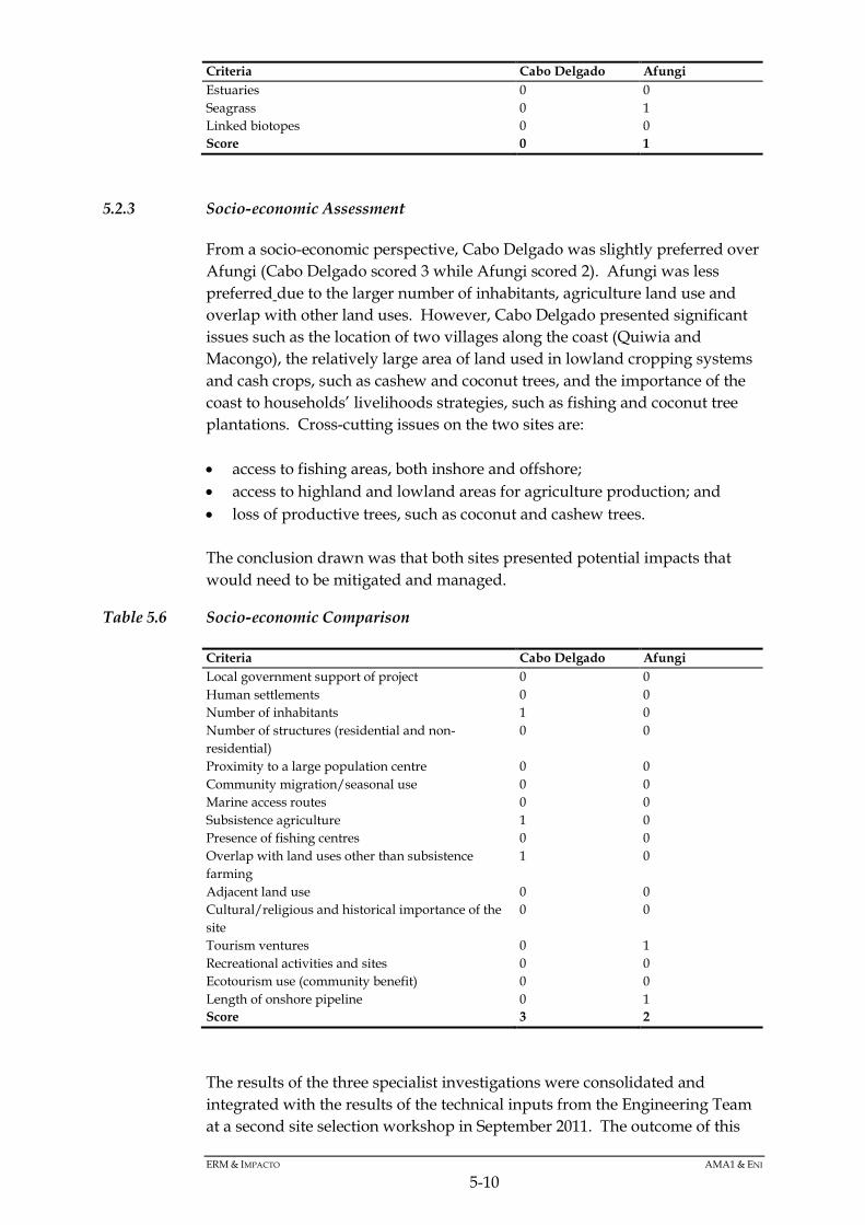
ERM & IMPACTO AMA1 & ENI
5-10
Criteria Cabo Delgado Afungi Estuaries 0 0 Seagrass 0 1 Linked biotopes 0 0 Score 0 1
5.2.3 Socio-economic Assessment
From a socio-economic perspective, Cabo Delgado was slightly preferred over Afungi (Cabo Delgado scored 3 while Afungi scored 2). Afungi was less preferred due to the larger number of inhabitants, agriculture land use and overlap with other land uses. However, Cabo Delgado presented significant issues such as the location of two villages along the coast (Quiwia and Macongo), the relatively large area of land used in lowland cropping systems and cash crops, such as cashew and coconut trees, and the importance of the coast to households’ livelihoods strategies, such as fishing and coconut tree plantations. Cross-cutting issues on the two sites are: • access to fishing areas, both inshore and offshore; • access to highland and lowland areas for agriculture production; and • loss of productive trees, such as coconut and cashew trees. The conclusion drawn was that both sites presented potential impacts that would need to be mitigated and managed.
Table 5.6 Socio-economic Comparison
Criteria Cabo Delgado Afungi Local government support of project 0 0 Human settlements 0 0 Number of inhabitants 1 0 Number of structures (residential and non-residential)
0 0
Proximity to a large population centre 0 0 Community migration/seasonal use 0 0 Marine access routes 0 0 Subsistence agriculture 1 0 Presence of fishing centres 0 0 Overlap with land uses other than subsistence farming
1 0
Adjacent land use 0 0 Cultural/religious and historical importance of the site
0 0
Tourism ventures 0 1 Recreational activities and sites 0 0 Ecotourism use (community benefit) 0 0 Length of onshore pipeline 0 1 Score 3 2
The results of the three specialist investigations were consolidated and integrated with the results of the technical inputs from the Engineering Team at a second site selection workshop in September 2011. The outcome of this

ERM & IMPACTO AMA1 & ENI
5-11
second and final workshop was the selection of the Afungi North site from an integrated environmental, social and technical perspective.
5.3 LAYOUT ALTERNATIVES
Once the Afungi North site was selected, the layout alternatives that were considered further were: • the routing of the gas pipeline corridor to the Project site; and • the siting of the various onshore Project components.
5.3.1 Routing of the Gas Pipeline Corridor to the Project Site
Three potential alignments were initially considered for the gas pipeline corridor in Palma Bay. The corridor is wide enough to accommodate pipelines for up to 6 trains. Option 1 was to route the corridor north of Tecomaji Island. Option 2 was to route the corridor between Tecomaji and Rongui islands, while option 3 routed the corridor south of Rongui Island, making landfall on the southern shoreline of Afungi Peninsula (Figure 5.4). All three options were screened from a technical and ecological perspective.

40°40'0"E
40°40'0"E
40°30'0"E
40°30'0"E
10°4
0'0"
S
10°4
0'0"
S
10°5
0'0"
S
10°5
0'0"
S
SIZE:
TITLE:
DATE: Oct 2013
DRAWN: AB
CHECKED: KG
APPROVED: KG
PROJECT: 0133576
DRAWING: REV:
A3
Figure 5.4:Pipeline Corridor Alternatives
Pipeline Corridor Alternatives.mxd A
CLIENT:
±MAIN MAP SCALE:
T:\G
IS P
roje
cts\
0133
576_
Anad
arko
_Moz
_LN
G\M
appi
ng\M
XD
\ES
IA\C
hapt
er5\
Pip
elin
e C
orrid
or A
ltern
ativ
es.m
xd
Projection: UTM Zone 37 S, Datum: WGS84.Source: Bing Maps ©2010 Microsoft Corporation.AMA1, 2012. Inset Map: Esri Data & Maps
SCALE: 1 : 125 000
It is unlawful for any firm or individual to reproduce copyrighted maps, graphics or drawings, in whole or in part, without permission of the copyright owner, ERM Southern Africa (Pty) Ltd ·
#*
I n d i a n O c e a n
Zambia
Angola
Tanzania
Mozambique
Botswana
Madagascar
Na mibia
Zimbabwe
South Africa
Congo (DRC)
Malawi
Swaziland
Comoros
Seychelles
Kenya
Legend!. Villages / Settlements
Regional Roads
Jetty
Onshore Layout
Afungi Project Site
Alternative Pipeline RouteOption 1
Option 2
Option 3
Project Area
0 2 4 6 8
Kilometers
ERMGreat Westerford Building240 Main RoadRondebosch, 7725Cape Town, SOUTH AFRICATel: +27 21 681 5400Fax +27 21 686 073

ERM & IMPACTO AMA1 & ENI
5-13
Option 1 presented technical concerns associated with crossing deep offshore canyons as well as with routing the corridor within the proposed shipping channel. Crossing canyons would make pipe-laying difficult and may be unstable, risking the integrity of the pipes. Pipes within the shipping lane would need to be armoured to protect them from potential damage by ship anchors. This would increase costs and introduce a safety concern. The reef north of Tecomaji is extensive, with coral cover increasing with depth. Therefore, from a marine ecology perspective, a corridor north of Tecomaji would require extensive mitigation. Closer to the island, the reef base comprises masses of dead coral rubble. In places, the coral rubble is barren and devoid of obvious recolonisation by macrobenthos (1), while in some areas there is prolific overgrowth by a foliose algae and healthy regrowth of both massive and branched hard coral forms. In the deeper water further north of the island, there are is a high diversity of coral forms. Option 2 presented a relatively shallow gradient moving from deep water into Palma Bay. Shallow gradients are preferred from a technical perspective, as more intensive engineering design and construction is required to traverse steep gradients. Steep slopes can be unstable and avoiding them minimises risks to the pipelines. Sand seafloor dominates the area between Tecomaji and Rongui islands, with a semi-continuous stretch extending more than 1.1km across the centre of the transect. Isolated bommies (columns of coral reef on sand or on a platform of reef) are concentrated on the northern portion of the surveyed area, close to Tecomaji Island. Coral reef can be found closer to Rongui Island. The hard substrata between Tecomaji and Rongui are low relief clusters of what appears to be a dead coral base. Option 3 presented significant constraints from a construction perspective. The pipeline corridor would have to negotiate a reef wall and then cross the head of a submarine canyon before reaching the sand flats south of Afungi. The pipeline would have to rise from depths of 350m up to the reef wall, about 30m deep, then abruptly drop off to an approximately 280m depth. Thereafter, the corridor would have to transition a second slope to shallow water before crossing over to the Afungi Peninsula. The depth variation happens within approximately 2km, which means that laying pipes would be difficult and, even if they could be laid, could incur stabilisation and flow assurance issues. After making landfall, the pipeline corridor would have to cross the southern portion of Afungi Peninsula to access the LNG Facility on the north of Afungi. From a terrestrial/surface water ecology and social perspective, this would have entailed crossing wetland areas, disturbance of terrestrial habitats and potential disturbance to homes and/or agricultural fields. From a marine ecology perspective, the reef towards the seaward drop-off south of Rongui Island was significantly more extensive than at the inshore areas. While the reef is dominated by large expanses of coral rubble, regrowth of branched, massive and encrusting coral forms, as well as a diversity of soft coral and encrusting sponge, was evident.
(1) Large organisms that live at the bottom of the sea (on the seafloor or on coral).

ERM & IMPACTO AMA1 & ENI
5-14
From the above analysis, Option 2 stood out as being acceptable (and preferred) from both a technical and a marine ecology perspective. It was therefore selected as the projected route for the pipeline corridor.
5.3.2 The Siting of Various Onshore Infrastructure
The placement/layout of some of the onshore infrastructure was influenced by recommendations from the specialist studies, as described later in the EIA impact chapters (see Chapter 10 for more details). The FEED process will also involve detailed design and layout of the facilities, taking into account the recommendations from this EIA. External factors could also influence the final Project design. Should the Government of Mozambique decide to create an Industrial Development Zone (IDZ) in Palma District, it may request that the Project locate the airstrip or housing area within the IDZ’s spatial plan. These alternatives are outside the scope of this EIA and, should these components need to be relocated, the EIA will be amended or a new environmental assessment process followed.
5.4 TECHNOLOGY AND PROCESS ALTERNATIVES
5.4.1 Pretreatment Technologies
There are currently several gas pretreatment technologies and proprietary design options used at various LNG facilities worldwide. The technical evaluation of each of these processes will be undertaken during the ongoing engineering design of the Project, as part of the FEED process. However, some commitments regarding pretreatment have been made. • An activated methyldiethanolamine (MDEA) system will remove acid gas
(CO2). • The gas will be dehydrated via molecular sieve and possibly refrigeration. • A mercury removal system will be implemented as a precaution, even
though there is as yet no evidence of mercury in the gas. • A system to remove pentane and heavier hydrocarbons will be
implemented. The FEED process will entail detailed process design to assess the best available technology options and the most cost-effective approach, and to minimise environmental and social impacts. The FEED process is projected to last just over a year, from late 2012 to early 2014.

ERM & IMPACTO AMA1 & ENI
5-15
5.4.2 Liquefaction
As discussed in Chapter 4, liquefaction of natural gas into LNG will likely be performed using one of two proprietary liquefaction process technologies. While the desired technology is at present undecided, the processes are similar to the extent that neither introduces a new aspect into the Project that would result in the potential for additional impacts – therefore, any potential impacts will not be dependent on the liquefaction process technologies. The decision on the preferred technology will be a product of the ongoing competitive FEED studies. The two technologies being considered are: • the Air Products and Chemicals Incorporated process, which uses propane
and multi-component refrigerants (1) and a main cryogenic heat exchanger to liquefy the gas into the LNG product; and
• the ConocoPhillips Optimized Cascade™ process, which uses a cascade process where natural gas is chilled in successively colder heat exchangers that use propane, ethylene and methane as refrigerants.
5.4.3 LNG Tanks
The types of LNG tanks include single containment, dual containment and full containment. Based on a technical risk assessment of equipment layout, the Engineering Team has taken a precautionary approach and committed to full containment. Full-containment tanks typically feature a primary liquid containment open-top inner tank and a concrete outer tank. The outer tank provides primary vapour containment and secondary liquid containment. In the unlikely event of a leak, the outer tank contains the liquid and provides controlled release of the vapour. The number of tanks required will be determined during FEED, but the current estimate is that four tanks will be required to support the operation of up to six 5 MMtpa (2) liquefaction Trains. Actual phasing of the tanks will depend on the sequencing of the Trains and their final design capacity.
5.4.4 Cooling Systems
The LNG plant process systems could be air or water cooled. From an environmental perspective, air-cooled systems reduce the facility’s water requirements, which is in keeping with the international good practice of reducing natural resource use wherever possible. Moreover, air cooled system avoid the need to discharge heated water into receiving environments onshore or off shore. The Engineering Team has decided that air cooling will be the primary cooling method for all processes. There is a possibility that water cooling may be used
(1) Within the Air Products and Chemicals Incorporated suite of technologies, there are several options: Single Mixed Refrigerant (SMR), Dual Mixed Refrigerant (DMR) and Propane pre-cooled Mixed Refrigerant (C3MR). (2) Million metric tonnes per annum.

ERM & IMPACTO AMA1 & ENI
5-16
in limited situations (eg closed loop oil cooling processes) depending on the final facility design. The current assumption is that any water cooling (if it cannot be avoided or is required by special process or mechanical systems) would be done with an open recirculating system utilising cooling tower(s). Priority will be given to sea water instead of freshwater sources. Process design during FEED will work to minimise water consumption.
5.4.5 Discharge Management
The current project base case allows for discharge of treated effluents into Palma Bay. Through the course of FEED, the optimal solution for treatment and disposal of effluents will be investigated.
5.5 NO-GO ALTERNATIVE
The no-go alternative implies that the proposed Project would not be executed. Assessment of the no-go alternative will require an evaluation of the relative trade-offs between the economic and social development benefits associated with the Project against the environmental and social costs of the Project. Assuming that the offshore wells and onshore LNG Facility would not be developed, the onshore and offshore environment would remain in its current state and there would be no negative environmental and social impacts associated with the development. All assessments in Chapters 11 to 15 are made against the current baseline conditions ie against the ‘no-go’. Thus, should the Project not go ahead, the identified positive and negative impacts will not materialise and the status quo will continue. A high-level no-go analysis is provided in the following sections.
5.5.1 Alignment with Government Policy
The Government of Mozambique has embarked on a concerted growth strategy to address a number of social and economic challenges faced by the country. Included in this strategy are policies to exploit its mineral resources (including natural gas). Hydrocarbon exploration in Cabo Delgado Province in northern Mozambique, and specifically in the Mocímboa da Praia and Palma districts, started in the 1980s. The natural gas discoveries made to date in the offshore gas fields of Area 1 and Area 4 are among the world’s most significant discoveries in the last 20 years. To guide the development of gas reserves in the country, Mozambique has compiled a Natural Gas Master Plan for Mozambique (currently in draft form). As presented at a Stakeholder Workshop in September 2012, the vision of the Plan is to develop natural gas resources in a manner that maximises benefits to Mozambique society by supporting: • growth in domestic public and private sector institutional competencies;
ERM & IMPACTO AMA1 & ENI
5-17
• growth in domestic industry and businesses, especially small and
medium-scale industries; • increased employment across the country, especially in less-developed
provinces; • infrastructure to support expanded economic activities, especially in less-
developed provinces; and • expanded access to training and education. In addition, the vision is to improve the quality of life for the people of Mozambique, while minimising adverse social and environmental impacts. Not proceeding with the Project, while taking all due consideration of potential environmental and social impacts, runs counter to the vision of the country’s Natural Gas Master Plan.
5.5.2 Economic Benefits not Realised
For the initial LNG development (two trains estimated 10mtpa), the Project could result in an overall investment of up to US$25 -30 billion, making this potentially the largest investment project in Mozambique to date. Assuming export of the LNG to the premium markets, such as Japan and the Far East, the Government of Mozambique should see a significant increase in Gross Domestic Product (GDP) and through its royalty, tax and equity gas rights. Mozambique will benefit from a substantial increase in Government revenue for the next several decades. This economic benefit could be used to improve the health, education and quality of life of the people of Mozambique. As the number of trains and volume of LNG export, increases the economic benefits can be compounded several times, provided that the natural gas resources are fully developed over time. It has been the stated intention of the Government of Mozambique to encourage industrial development using natural gas in the area of the Project, further expanding the social and economic benefits derived from development of Mozambique’s offshore natural gas resources in the Rovuma Basin. The no-go alternative would result in status quo conditions and the loss of substantial and long lasting social and economic benefits for the people of Mozambique.
5.5.3 Unmet Local Expectations
To date, local communities have expressed support for the Project and have voiced the need for socio-economic development in the form of training, employment and community development projects. Should the Project not go ahead, the local communities in Palma District would feel disappointed as

ERM & IMPACTO AMA1 & ENI
5-18
significant investment in local human resources and the local economy would not occur. Potential positive socio-economic impacts are described and assessed in Chapter 13.
5.5.4 Negative Socio-economic Impacts Averted
Chapter 13 also details the potential negative socio-economic impacts associated with the Project. At a high level, these impacts relate to people who would need to be relocated; to a decrease in, or loss of access to, natural resources; to the disruption of normal land and sea transport routes; to the potential or perceived land-use conflict with tourism investments in the area; to the potential for conflict with local communities and increased pressure on local social services and infrastructure as a result of in-migration; and to the perceived ‘sense of place’. Should the Project not go ahead, these potential negative impacts would be avoided.
5.5.5 Negative Biophysical Impacts Averted
Potential impacts on the marine and terrestrial biophysical environments are detailed in Chapters 11 and 12. Potential biological impacts are associated with the degradation or loss of habitats and with a disturbance to, or loss of, sensitive or conservation-worthy plant and animal species. These impacts range from a local scale (eg loss of a wetland) to a regional scale (potential impacts on migratory birds). In addition, the potential in-migration of people into Palma District would also place additional pressure on natural resources (water, plants and animals) in the area. From a physical perspective, the Project will affect air quality and ambient noise levels, and will increase Mozambique’s contribution to global greenhouse gas emissions. Should the Project not go ahead, these potential negative biophysical impacts would be avoided.
5.6 CONSIDERATION OF ALTERNATIVES THROUGH FEED
Various other technological and process alternatives will be evaluated as part of the FEED processes in alignment with the EIA philosophy of avoidance, minimisation and mitigation and with Good International Industry Practice.