chapter 6 cenozoic pecos alluvium aquifer
TRANSCRIPT

133
Chapter 6
Cenozoic Pecos Alluvium Aquifer Ian C. Jones1
Introduction The Cenozoic Pecos Alluvium aquifer is located in the Pecos River valley of western Texas and southeastern New Mexico (Figure 6-1). This alluvium aquifer underlies parts of Crane, Ector, Loving, Pecos, Reeves, Upton, Ward, and Winkler counties and extends north into Eddy and Lea counties in New Mexico.
The Cenozoic Pecos Alluvium occurs in an arid region characterized by average annual precipitation of 10 to 20 inches and average annual evaporation rates approaching 70 inches (Boghici, 1999). These climatic conditions play an important role in determining the amount of water available for recharge to the aquifer. Climate, together with crop selection, also play a role in determining the water demand for irrigation pumping. In arid areas and especially during drought periods, irrigation pumping is increased to compensate for the absence of precipitation. The Cenozoic Pecos Alluvium aquifer is of primary importance as a source of irrigation water, especially in Reeves and northwestern Pecos counties (Ashworth and Hopkins, 1995; TWDB, 1997). Irrigation pumping accounts for approximately 75 percent of water withdrawal from the aquifer. Some groundwater from this aquifer is also exported to the City of Odessa by the Colorado River Municipal Water District (TWDB, 1997). Groundwater extraction for irrigation and municipal uses has multiple effects on the Cenozoic Pecos Alluvium aquifer including historic water-levels declines and progressive deterioration of groundwater quality. These effects will be discussed in more detail later in this paper.
Geology The Cenozoic Pecos Alluvium aquifer is composed of Tertiary and Quaternary age alluvium, more than 1,500 feet thick (Figure 6-2). This alluvium unconformably overlies older Permian, Triassic, and Cretaceous age rocks (Figure 6-3; White, 1971). The alluvium is mostly composed of unconsolidated or poorly cemented clay, sand, gravel, and caliche (White, 1971). North of the Pecos River, the alluvium is overlain in places by windblown sand deposited in dunes. This windblown sand was derived from the Pleistocene Blackwater Draw Formation, an older, extensive eolian deposit that crops out east of the study area (White, 1971; Muhs and Holliday, 2001). The sand dunes are
1 Texas Water Development Board

134
Figure 6-1: The Cenozoic Pecos Alluvium aquifer is located along part of the Pecos River Valley of Texas and New Mexico. This alluvium aquifer underlies parts of Crane, Ector, Loving, Pecos, Reeves, Upton, Ward, and Winkler counties in Texas and Eddy and Lea counties in New Mexico.
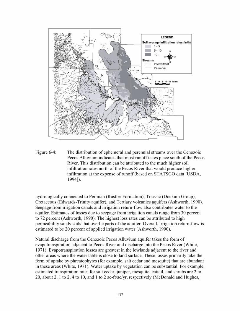
composed of fine quartz sand up to 250 feet thick (Garza and Wesselman, 1959; White, 1971). These dunes are potentially important sites for recharge due to relatively high infiltration rates (Figure 6-4). This is indicated by the scarcity of perennial or ephemeral streams north of the Pecos River because rapid infiltration of precipitation into the dune sand produces little runoff.
The Cenozoic Pecos Alluvium aquifer consists of two main north-south oriented basins or troughs: the Pecos Trough and the Monument Draw Trough (Figure 6-5). The aquifer is composed of alluvial sediments deposited in two major depressions during the Cenozoic Era (Ashworth, 1990). These troughs formed due to subsidence that resulted from dissolution of underlying evaporites (rock salt, anhydrite, and gypsum), especially but not exclusively in the Salado and Castile formations (Figure 6-3; Ashworth, 1990).

135
Figure 6-2: The Cenozoic Pecos Alluvium aquifer is composed of two main basins that are more than 1,500 feet deep in places (based on data from USGS, 2002).
Hydrogeology The Cenozoic Pecos Alluvium aquifer is unconfined, although clay beds may produce local artesian conditions (Ashworth and Hopkins, 1995). In some areas, perched aquifers occur on clay beds located above the main water table (Boghici, 1998; 1999). This alluvium aquifer overlies, and in some places is hydrologically connected to, underlying aquifers. These aquifers are: (1) the Edwards–Trinity (Plateau) aquifer in Pecos and Reeves counties, (2) the Dockum Group in Ward and Winkler counties, (3) the Tertiary volcanics in Reeves County, and (4) the Rustler aquifer (Ashworth and Hopkins, 1995). Well yields in the Cenozoic Pecos Alluvium aquifer are generally moderate to high (Ashworth and Hopkins, 1995). In the Pecos River Valley, depths to groundwater are 10 to 20 feet increasing to about 50 feet away from the river (Boghici, 1998; 1999). Depths to groundwater are much greater in cones of depression.
Recharge to the Cenozoic Pecos Alluvium aquifer takes the form of infiltration of precipitation, seepage from ephemeral streams, cross-formational flow, and irrigation return-flow (Figure 6-6; Ashworth, 1990). Recharge only occurs after soil moisture is

136
Figure 6-3: The stratigraphic units that underlie the study area. The Cenozoic Pecos Alluvium aquifer overlies and potentially interacts with aquifers occurring Tertiary through Paleozoic age stratigraphic units.
high enough to overcome the effects of surface tension that would otherwise adhere the water to sand grains. High soil moisture allows water to infiltrate through to the water table (Ashworth, 1990). Consequently, natural recharge is episodic and associated with heavy rainfall. Recharge is only likely to occur during long-duration rainfall events or periods of frequent smaller rainfall events. Otherwise, the water is lost to the effects of evapotranspiration. The most favorable sites for natural recharge of precipitation are the dune sands that overlie the Monument Draw Trough (Figure 6-4; Richey and others, 1985). These sand dunes are highly permeable and in some places sparsely vegetated (White, 1971). High permeability and sparse vegetation result in rapid infiltration of precipitation because together they minimize losses to evapotranspiration (White, 1971). It is possible that due to the occurrence of these highly permeable sand dunes recharge rates may be higher to the Monument Draw Trough than to the Pecos Trough. Recharge due to infiltration from ephemeral streams is also episodic, requiring sufficient precipitation to generate runoff through these streams. Cross-formational flow primarily enters the Cenozoic Pecos Alluvium aquifer in the south and west where the aquifer is
137
Figure 6-4: The distribution of ephemeral and perennial streams over the Cenozoic Pecos Alluvium indicates that most runoff takes place south of the Pecos River. This distribution can be attributed to the much higher soil infiltration rates north of the Pecos River that would produce higher infiltration at the expense of runoff (based on STATSGO data [USDA, 1994]).
hydrologically connected to Permian (Rustler Formation), Triassic (Dockum Group), Cretaceous (Edwards-Trinity aquifer), and Tertiary volcanics aquifers (Ashworth, 1990). Seepage from irrigation canals and irrigation return-flow also contributes water to the aquifer. Estimates of losses due to seepage from irrigation canals range from 30 percent to 72 percent (Ashworth, 1990). The highest loss rates can be attributed to high permeability sandy soils that overlie parts of the aquifer. Overall, irrigation return-flow is estimated to be 20 percent of applied irrigation water (Ashworth, 1990).
Natural discharge from the Cenozoic Pecos Alluvium aquifer takes the form of evapotranspiration adjacent to Pecos River and discharge into the Pecos River (White, 1971). Evapotranspiration losses are greatest in the lowlands adjacent to the river and other areas where the water table is close to land surface. These losses primarily take the form of uptake by phreatophytes (for example, salt cedar and mesquite) that are abundant in these areas (White, 1971). Water uptake by vegetation can be substantial. For example, estimated transpiration rates for salt cedar, juniper, mesquite, cattail, and shrubs are 2 to 20, about 2, 1 to 2, 4 to 10, and 1 to 2 ac-ft/ac/yr, respectively (McDonald and Hughes,

138
Figure 6-5: The basins of the Cenozoic Pecos Alluvium were formed by subsidence that resulted from dissolution of evaporites in underlying stratigraphic units, such as Permian Salado and Castile formations (modified from Hiss, 1976; Ashworth and Hopkins, 1995).

139
Figure 6-6: Processes that contribute recharge to the Cenozoic Pecos Alluvium aquifer. Precipitation and infiltration from perennial and ephemeral stream contribute fresh water while water from irrigation return-flow and cross-formational flow from adjacent aquifer may be saline.
1968; Ansley and others, 1998; Dugas and Hicks, 1998; Gatewood and others, 1950; Van Hylckama, 1970; Weeks and others, 1987; Devitt and others, 1997).
Water levels Groundwater flow in the Cenozoic Pecos Alluvium aquifer generally converges on the Pecos River, the main discharge zone, except where pumping forms cones-of-depression (Boghici, 1998; 1999). This suggests that there is no groundwater flow between the Pecos and Monument Draw troughs. Consequently, it can be concluded that the two troughs are separate groundwater flow systems.
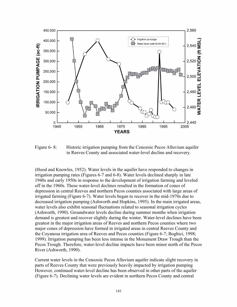
The Cenozoic Pecos Alluvium aquifer has experienced historic water-level declines of more than 200 feet in parts of south-central Reeves and northwest Pecos counties (Figure 6-7). One of the results of this water-level decline has been reduced baseflow to the Pecos River. Water-level variations over time in the aquifer have been associated with varying intensity of irrigation pumping (Ashworth and Hopkins, 1995). Irrigation farming developed in Reeves and Pecos counties in the 1940s. Irrigation pumping peaked in the 1960s and has been declining since then (Figure 6-8; TWDB, 1997). In Reeves County, the number of irrigation wells increased ten-fold, from 35 to 355, between 1940 and 1950

140
Figure 6-7: Water-level elevations in the Cenozoic Pecos Alluvium aquifer pre-development (pre-1950), in the 1960s, and present-day. These maps show the development of a cone of depression in central Reeves County in the 1960s in response to irrigation pumping. Under present conditions, this cone of depression has recovered slightly, and a smaller cone has developed in central Ward County due to municipal pumping.
141
Figure 6- 8: Historic irrigation pumping from the Cenozoic Pecos Alluvium aquifer in Reeves County and associated water-level decline and recovery.
(Hood and Knowles, 1952). Water levels in the aquifer have responded to changes in irrigation pumping rates (Figures 6-7 and 6-8). Water levels declined sharply in late 1940s and early 1950s in response to the development of irrigation farming and leveled off in the 1960s. These water-level declines resulted in the formation of cones of depression in central Reeves and northern Pecos counties associated with large areas of irrigated farming (Figure 6-7). Water levels began to recover in the mid-1970s due to decreased irrigation pumping (Ashworth and Hopkins, 1995). In the main irrigated areas, water levels also exhibit seasonal fluctuations related to seasonal irrigation cycles (Ashworth, 1990). Groundwater levels decline during summer months when irrigation demand is greatest and recover slightly during the winter. Water-level declines have been greatest in the major irrigation areas of Reeves and northern Pecos counties where two major cones of depression have formed in irrigated areas in central Reeves County and the Coyanosa irrigation area of Reeves and Pecos counties (Figure 6-7; Boghici, 1998; 1999). Irrigation pumping has been less intense in the Monument Draw Trough than the Pecos Trough. Therefore, water-level decline impacts have been minor north of the Pecos River (Ashworth, 1990).
Current water levels in the Cenozoic Pecos Alluvium aquifer indicate slight recovery in parts of Reeves County that were previously heavily impacted by irrigation pumping However, continued water-level decline has been observed in other parts of the aquifer (Figure 6-7). Declining water levels are evident in northern Pecos County and central

142
Figure 6-9: Cenozoic Pecos Alluvium aquifer groundwater salinity. Groundwater salinity tends to be greater along and south of the Pecos River. The lowest salinity is associated with the sand dunes in the eastern part of the aquifer.
Ward County (Figure 6-7). Unlike the water-level declines in Reeves and Pecos counties that are attributable to continued irrigation, the water-level declines in Ward County are associated with pumping related to public supply and industrial uses (Boghici, 1998; 1999).
Water Quality Groundwater quality in the Cenozoic Pecos Alluvium aquifer is variable with groundwater ranging from fresh to very saline water (Figure 6-9). Brine occurs locally in this aquifer. Groundwater quality is generally better in the Monument Draw Trough portion of the aquifer than in the Pecos Trough. Pecos Trough groundwater is generally slightly to moderately saline while Monument Draw Trough groundwater varies from fresh to moderately saline. In the Monument Draw Trough, the fresh water generally occurs in the east, while more saline groundwater tends to occur on the western side of the trough adjacent to the Pecos River. Fresh water (total dissolved solids less than 1000 mg/l) in the aquifer is generally associated with dune sands.
The geochemical composition of groundwater on either side of the Pecos River is generally similar (Figure 6-10). However, the range of groundwater compositions in the Monument Draw Trough is wider, ranging from bicarbonate- to sulfate-chloride-dominated compositions while Pecos Trough groundwater compositions are predominantly sulfate-chloride-dominated. Bicarbonate-dominated groundwater

143
Figure 6-10: Piper diagram showing groundwater geochemical compositions north in the Monument Draw Trough area (open circles) and south in the Pecos Trough area of the Pecos River (closed circles).
compositions are typically fresh water in the eastern Monument Draw Trough. The most saline groundwater in the Cenozoic Pecos Alluvium aquifer occur in shallow wells, less than 300 feet deep (Figure 6-11). At depths greater than 300 feet, groundwater salinity is generally uniform.
Saline groundwater that occurs in this aquifer is mostly the result of natural processes. However, in some areas, poor water quality may result from anthropogenic activity (Ashworth and Hopkins, 1995). Groundwater quality in the Cenozoic Pecos Alluvium is potentially influenced by several factors including: (1) the presence of underlying evaporite beds, (2) evaporation, (3) recharge of irrigation return-flow, (4) pumping, and (5) past oil-field practices.
The range of groundwater compositions in the Cenozoic Pecos Alluvium aquifer suggest varying influences of evaporite dissolution (Figure 6-10). Sulfate- and chloride-dominated groundwater compositions are attributable to gypsum and halite dissolution. Neither gypsum nor halite occurs within the Cenozoic Pecos Alluvium. However, these minerals do occur in underlying Permian stratigraphic units. Consequently, the occurrence of sulfate- and chloride-dominated groundwater in the Cenozoic Pecos Alluvium aquifer can be attributed to cross-formational flow contributing minor amounts of saline groundwater from the underlying Permian aquifers.

144
Figure 6-11: Groundwater salinity in the Cenozoic Pecos Alluvium aquifer is highest in shallow wells and relatively uniform at depths greater than 300 feet.
Shallow saline groundwater, especially along the Pecos River, can not necessarily be attributed to cross-formational flow. Decreasing salinity with depth can be attributed partially to evaporation in areas where the water table is shallow (Figure 6-11). Shallow saline groundwater may also result from activities related to agriculture. Salinity may result from recharge of irrigation return-flow, especially in Reeves County (Ashworth, 1990). Irrigation return-flow may explain higher groundwater salinity observed in central Reeves County (Figure 6-9). This zone of higher salinity approximately coincides with a large area of irrigated farmland in Reeves County (Figure 6-12). Irrigation return-flow water becomes saline due to evaporation at land surface, or by dissolution of salts accumulated in the soil. In some areas, nitrate derived from fertilizers may impact groundwater quality (Ashworth, 1990). In these areas, fertilizer nitrogen is leached from the soil by infiltrating precipitation or irrigation return-flow.
Groundwater salinity may increase because heavy pumping draws in more saline groundwater that occurs at depth. This can explain the association of declining water levels and increasing salinity observed in three wells in central Ward County (Figure 6-13). These wells are located in an area that has experienced water-level decline due to municipal pumping. Declining hydraulic heads in the Cenozoic Pecos Alluvium aquifer with respect to hydraulic heads in underlying saline aquifer can produce increased cross-formational flow. This increased cross-formational flow can have detrimental impacts on water quality due to the increased influx of saline groundwater. This process may also be a contributing factor for the elevated salinity in central Reeves County, an area that has also experienced historic water-level decline.

145
Figure 6-12: The main irrigated farmland areas overlying the Cenozoic Pecos Alluvium aquifer.
Figure 6-13: Declining water levels are accompanied by increasing groundwater salinity in parts of central Ward County.

146
Locally, saline groundwater occurs due to contamination by oil-field brine, especially in Winkler and Loving counties (Ashworth, 1990). Most of this contamination is related to past disposal of large quantities of brine in unlined pits or from improperly cased oil wells (Ashworth, 1990). Brine contamination is the likely explanation for the occurrence of brine in the Monument Draw Trough (Figures 6-9 and 6-11).
Conclusions The Cenozoic Pecos Alluvium aquifer is located in the Pecos River valley of western Texas and southeastern New Mexico. This aquifer is composed of unconsolidated to poorly cemented alluvium, caliche, and windblown sand. The Cenozoic Pecos Alluvium aquifer is an unconfined aquifer in hydrologic connection with many adjacent aquifers. Recharge takes the form of infiltration of precipitation, water from ephemeral streams, cross-formational flow from adjacent aquifers, and irrigation return flow. There is potential for higher recharge rates in the Monument Draw Trough. Discharge from the Cenozoic Pecos Alluvium aquifer takes the form of baseflow to the Pecos River and evapotranspiration adjacent to the river. Historic water-level fluctuations observed in the Cenozoic Pecos Alluvium aquifer are in response to irrigation, municipal, and industrial pumping. Water quality in the Cenozoic Pecos Alluvium aquifer varies from fresh to very saline with local brine occurrence. Water quality is generally better in the Monument Draw Trough. The most saline groundwater is found in shallow wells. Groundwater salinity in the Cenozoic Pecos Alluvium aquifer results from natural and anthropogenic processes including cross-formational flow, evaporation where the water table approaches land surface, irrigation, pumping, and oil-field brine contamination. The Cenozoic Pecos Alluvium aquifer groundwater displays geochemical evidence of anthropogenic impacts on water quality based on relationships between the occurrence of saline groundwater and land use or water-level decline. Saline groundwater can be attributed to irrigation return-flow and oil-field brine contamination when associated with irrigated farmland and oil fields, respectively. Groundwater salinity due to enhanced cross-formational flow that is the result of pumping is associated with areas of historic water-level decline.
References Ansley, R. J., Trevino, B. A., and Jacoby, P. W., 1998, Intraspecific competition in honey
mesquite: Leaf and whole plant responses: Journal of Range Management, v. 51, no. 3, p. 345-352.
Armstrong, C. A., and McMillion, L. G., 1961, Geology and ground-water resources of Pecos County, Texas: Texas Water Development Board, Bulletin 6106, v. 2, 295 p.
Ashworth, J. B., 1990, Evaluation of ground-water resources in parts of Loving, Pecos, Reeves, Ward, and Winkler counties, Texas: Texas Water Development Board, Report 317, 51 p.
Ashworth, J. B., and Hopkins, J., 1995, Aquifers of Texas: Texas Water Development Board Report 345, 69 p.

147
Boghici, R., 1998, Updated evaluation of groundwater resources in parts of Trans-Pecos, Texas: Texas Water Development Board, Open-File Report 98-03, 29 p.
Boghici, R., 1999, Changes in groundwater conditions in parts of Trans-Pecos Texas, 1988-1998: Texas Water Development Board, Report 348, 29 p.
Devitt, D. A., Sala, A., Mace, K. A., and Smith, S. D., 1997, The effect of applied water on the water use of saltcedar in a desert riparian environment: Journal of Hydrology, 192 (1-4), p. 233-246.
Dugas, W. A., Hicks, R. A., and Wright, P., 1998, Effect of removal of Juniperus ashei on evapotranspiration and runoff in the Seco Creek watershed: Water Resources Research, v. 34, no. 6, p. 1499-1506.
Garza, S., and Wesselman, J. B., 1959, Geology and ground-water resources of Winkler County, Texas: Texas Board of Water Engineering, Bulletin 5916, 200 p.
Gatewood, J. S., Robinson, T. W., Colby, B. R., Hem, J. D., and Halpenny, L. C., 1950, Use of water by bottom-land vegetation in lower Safford Valley, Arizona: U. S. Geological Survey Water-Supply Paper, W 1103, p. 210.
Hiss, W. L., 1976, Structure of the Permian Ochoan Rustler Formation, southeast New Mexico and West Texas: New Mexico Bureau of Mines and Mineral Resources, Resource Map No. 7, 1 sheet.
Hood, J. W., and Knowles, D. B., 1952, Summary of ground-water development in the Pecos area, Reeves and Ward Counties, Texas 1947-51: Texas Board of Water Engineers, Bulletin 5202, 11 p.
McDonald, C. C., and Hughest, G. H., 1968, Studies of consumptive use of water by phreatophytes and hydrophytes near Yuma, Arizona: U. S. Geological Survey Professional Paper, P 0486-F, p. F1-F24.
Muhs, D. R., and Holliday, V. T., 2001, Origin of late Quaternary dune fields on the Southern High Plains of Texas and New Mexico: Geological Society of America Bulletin, v. 113, no. 1, p. 75-87.
Richey, S. F., Wells, J. G., and Stephens, K. T., 1985, Geohydrology of the Delaware Basin and vicinity, Texas and New Mexico: U.S. Geological Survey, Water Resources Investigation Report 84-4077, 99 p.
Texas Water Development Board, 1997, Cenozoic Pecos Alluvium aquifer: in Water for Texas, A consensus-based update to the State Water Plan. Volume II: Technical planning appendix, p. 3-236 - 3-237.
United States Department of Agriculture, 1994, State soil geographic (STATSGO) data base: data use information: U. S. Department of Agriculture, Natural Resources Conservation Service, National Soil Survey Center, Miscellaneous Publication 1492, 113 p.
United States Geological Survey, 2002, Base of the Cenozoic Pecos Alluvium aquifer: U.S. Geological Survey Digital data, Austin, TX.

148
Van Hylckama, T. E. A., 1970, Water use by saltcedar: Water Resources Research, v. 6, p. 728-735.
Weeks, E. P., Weaver, H. L., Campbell, G. S., and Tanner, B. D., 1987, Water use by saltcedar and by replacement vegetation in the Pecos River floodplain between Acme and Artesia, New Mexico: U. S. Geological Survey, Professional Paper 491-G, 33 p.
White, D. E., 1971, Water resources of Ward County, Texas: Texas Water Development Board, Report 125, 235 p.