chapter a2 - dredge material placementeisdocs.dsdip.qld.gov.au/cairns shipping development/eis/part...
TRANSCRIPT

Draft : Environmental Impact Statement
Chapter A2 Dredge Material Placement Options
A2.1 Introduction 3
A2.2 Assessment Methodology 3
A2.2.1 Multi Criteria Analysis (MCA) 3
A2.3 History of Dredge Material Placement in Cairns 5
A2.3.1 Dredge Material Placement Locations 5
A2.3.2 History of Dredging Campaigns 6
A2.3.3 History of Land Reclamation in Cairns 6
A2.4 Review of Previous Dredge Material Placement Studies in Cairns 7
A2.4.1 Connell Wagner (1990, 1991) 7
A2.4.2 GHD (2000) 10
A2.4.3 Carter et al. (2002) 10
A2.4.4 Environment North (2005) 11
A2.4.5 WorleyParsons (2009) 11
A2.4.6 WorleyParsons (2010) 11
A2.4.7 SKM (2013) 12
A2.4.8 SKM/APASA (2013a) 12
A2.4.9 SKM/APASA (2013b) 14
A2.4.10 Summary of Previous Studies 14
A2.5 Characteristics of the Dredge Material 15
A2.5.1 Physical Characteristics 15
A2.5.2 Sediment Chemistry 15
A2.6 Dredging and Placement Logistics 16
A2.6.1 Material Quantities and Qualities 16
A2.6.2 Dredge Timing 17
A2.6.3 Pumping of Dredge Material 17
A2.6.4 Treatment of Dredge Material 17
A2.6.5 Dewatering of Dredge Material 18
A2.7 Beneficial Reuse Options 19
A2.8 Potential Land Placement Options 20
A2.8.1 Site Criteria 20
A2.8.2 Intended Final Use and Treatment Time 22
A2.8.3 Description of Potential Land
Placement Sites 22
A2.8.4 East Trinity 24
A2.8.5 Cane Land Development 26
A2.8.6 Admiralty Island 28
A2.8.7 Cairns Airport 30
A2.8.8 Cairns Esplanade 32
A2.9 Assessment of Land Placement Sites 34
A2.9.1 Methodology 34
A2.9.2 Water Quality Impacts
(Tailwater and Groundwater) 34
A2.9.3 ASS Issues and Management 37
A2.9.4 Habitat Values / Habitat Loss
(Marine and Terrestrial) 40
A2.9.5 Air/Noise/Odour Impacts 57
A2.9.6 Pest Introduction/Attraction 59
A2.9.7 Cultural Heritage/Native Title 60
A2.9.8 Traffic 62
A2.9.9 Community Benefit 65
A2.9.10 Visual Amenity Issues 66
A2.9.11 Land Use Planning/Approvals/Tenure 72
A2.9.12 Area Available/Volume Able
to be accepted 75
A2.9.13 Pumping Equipment and Distances 75
A2.9.14 Project Cost 77
A2.9.15 Impact on Length of Dredge Campaign 82
A2.9.16 Land Placement Evaluation 82
A2.9.17 Sensitivity Analysis 84
Cairns Shipping Development Project
A2.10 Description of Potential Marine Placement Sites 85
A2.10.1 Option 1A – Optimisation of Option 1 87
A2.10.2 Option 2 – Inshore Site 88
A2.10.3 Option 3 – Midshore Site 88
A2.10.4 Option 4 – Offshore Site 88
A2.10.5 Option 5 – Northern Site 88
A2.11 Assessment of Marine Placement Sites 89
A2.11.1 Methodology 89
A2.11.2 Re-suspension Potential and Water Quality
Impacts 89
A2.11.3 Potential Impact to Sensitive
Ecological Receptors and World
Heritage Values 97
A2.11.4 Seabed Substrate and
Benthic Ecology 99
A2.11.5 Fisheries 103
A2.11.6 Amenity and Tourism 106
A2.11.7 Marine Park Planning 106
A2.11.8 Bathymetry and Capacity 108
A2.11.9 Shipping and Navigation 109
A2.11.10 Distance from Dredge Area 111
A2.11.11 Project Cost 111
A2.11.12 Marine Placement Evaluation 112
A2.12 Conclusion 116
References 117
Cairns Shipping Development Project
Draft EIS : Chapter A2 Dredge Material Placement Options
Cairns Shipping Development Project
Draft EIS : Chapter A2 Dredge Material Placement Options
A2 : Page 3November 2014
A2.1 IntroductionThis chapter provides an assessment of potential dredge material placement area (DMPA) options, and has informed the scope of this EIS. Using a Multi-criteria Analysis (MCA) approach, it assesses both marine and land dredge material placement options for the project against environmental, social, planning, economic and logistical criteria. Five marine and five land options were examined; these locations were chosen based on a number of previous studies that have investigated potential placement options - Connell Wagner (1990, 1992), Environment North (2005), WorleyParsons (2010) and SKM (2013). The assessment concludes with the selection of a preferred land placement site (East Trinity option) and a preferred marine placement site (Option 1A, upon which Parts B and C of this EIS are based).
The ‘appropriateness’ of the preferred land placement site is assessed in Chapter A3, Appropriateness of Preferred Land Placement Site at East Trinity in accordance with the assessment process outlined in the National Guidelines for Dredging (2009). Part D of this EIS provides a more detailed review of the environmental values of the preferred land placement site.
The objectives of the Sea Dumping Act, which implements Australia’s obligations under the 1996 Protocol to the Convention on the Prevention of Marine Pollution by Dumping of Wastes and Other Matter, 1972 (the London Protocol) include minimising pollution caused by ocean placement. Evaluating alternatives to ocean placement and identifying and implementing measures to prevent pollution are important first steps in the assessment process. This chapter meets these objectives by providing an assessment of alternative locations to ocean placement.
Furthermore, the National Assessment Guidelines for Dredging 2009 (NAGD) provides the framework to manage dredge material placement, and also specifically requires the evaluation of alternatives to marine placement. The EIS Guidelines and Terms of Reference (TOR) require options for placement of the dredge material, both land and marine, to be assessed.
A2.2 Assessment MethodologyThe assessment of dredge material placement options involved the following key steps:
• Review the history of dredge material placement in Cairns to understand the basis for decisions regarding placement options and the parameters for future placement (Section A2.3)
• Review previous dredge material placement studies undertaken in Cairns – these studies identified and assessed a range of dredge material placement options in the Cairns area (Section A2.4)
• Assess beneficial reuse options through an understanding of the dredge material characteristics along with logistics of dredging and placement (Section A2.9)
• Identification of potential land and marine dredge material placement options (Section A2.8)
• Assessment of identified placement options using a MCA process to determine a preferred land placement option and a preferred marine placement option (Section A2.9).
A2.2.1 Multi Criteria Analysis (MCA)MCA is a decision tool that allows the analysis of various options by assigning scores and weightings to criteria used to assess the various placement options. The MCA process used multiple criteria to determine the most suitable land and marine placement areas in terms of environmental, social, economic, logistical and planning issues. MCA provides a robust and transparent decision making structure, making explicit the key considerations and the values attributed to them.
The key steps undertaken in the MCA process include:
• Develop and agree on the list of criteria for evaluating the placement options
• Determine the relative importance and weighting of the assessment criteria
• Score each placement option with respect to each criterion
• Combine the scores for each criterion with the criterion weighting to provide an overall score for each option
• Select the preferred marine and land placement area option.

Cairns Shipping Development Project
Draft EIS : Chapter A2 Dredge Material Placement Options
November 2014 A2 : Page 4
The MCA assessment process, including derivation of criteria and adopted weightings for both land and marine placement options, was developed and agreed upon in consultation with key project stakeholders and government regulators at a two-day stakeholder workshop held in February 2014. This workshop included representatives from regulatory agencies (Great Barrier Reef Marine Park Authority (GBRMPA), Department of Environment (DoE), the Department of Environment and Heritage Protection (DEHP) and The Department of State Development, Infrastructure and Planning (DSDIP)), Ports North, Arup and BMT WBM. Refer to Appendix B for further details of stakeholder consultation.
A2.2.1.1 Assessment Categories and CriteriaThe broad assessment categories used for land and marine placement options were similar (environmental, social, legislative/planning, economic/logistical). However, the criteria within these categories differed slightly as some are applicable to land options but may not be applicable to marine options, and vice versa. The MCA categories and criteria used for land and marine options are presented in Table A2.2.1.1a.
Table A2.2.1.1a MCA Assessment Categories and Criteria
MCA Category
Environmental
Social
Legislative/Planning
Economic/Logistics
MCA Criteria
Land Placement
Water quality impacts (tailwater and groundwater)
Habitat values/habitat loss,
Acid Sulfate Soil (ASS) issues, Air/noise/odour impacts,
Pest introduction/attraction
Cultural heritage/native title
Traffic
Community benefit
Amenity issues
Land use planning/approvals/tenure
Area available/volume able to be accepted
Pumping equipment and distance
Impact on length of dredge campaign
Costs
Marine Placement
Water quality impacts/Re-suspension potential
Sensitive ecological receptors and world heritage values
Seabed substrate and benthic ecology
Fisheries
Amenity and tourism
Marine Park Planning
Bathymetry/capacity
Shipping and navigation
Distance from dredge area
Costs
MCA Scoring
The MCA process assesses a range of options by assigning scores and weightings to criteria, with the weightings representing the importance of each criterion. The objective is to identify a preferred land and a preferred marine placement site.
The scoring comprised a semi-quantitative/qualitative scoring system ratio scoring system as outlined in Annandale and Lantzke (2000). This scoring method assigns scores to each option based on the performance against the other options. That is, a score of 4 indicates that the option is two times better than an option with a score of 2. This is in contrast to an ordinal scoring method, which simply assigns a ranking of options (e.g. 1, 2, 3, 4, 5, etc.). Where possible, quantitative data was used to derive scores for each option. Where quantitative data was not available, a qualitative assessment was undertaken to derive scores.

Cairns Shipping Development Project
Draft EIS : Chapter A2 Dredge Material Placement Options
A2 : Page 5November 2014
The scoring method assigned scores between one and six depending on performance. A score of one represents the worst possible performance while a score of six represents excellent performance. The scoring system provided three scores in the poor performance range and three scores in the good performance range. That is, scores of one-three generally represent poor performance where adverse impacts are likely and not easily managed, while scores of four-six generally represent good performance where any adverse impacts are either minimal or readily managed. Descriptions of these scores are provided in Table A2.2.1.1b.
Table A2.2.1.1b Description of Scores
Score
1
2
3
4
5
6
Description of Scores
Worst possible performance – e.g. unacceptable, unmanageable adverse impacts on criterion.
Very poor performance – e.g. long-term adverse major impacts on criterion, not easily managed
Poor performance – e.g. short-term adverse impacts on criterion, not easily managed
Sound performance – e.g. manageable short-term adverse impacts on criterion
Good performance – e.g. minor short-term adverse impacts on criterion
Excellent performance – e.g. no impacts on criterion
The specific description of scores in Table A2.2.1.1b varied slightly for each criterion, however the rating will remain consistent, i.e. 1 = worst performance and 6 = excellent performance. In regards to economic criteria where costs were assessed, each option was scored based on the relative economic performance compared to other options. For example, the most cost effective solution was scored high, while the least economical option was scored low.
MCA scoring was initially undertaken by technical experts from the core EIS project team. The MCA process and scoring was presented and discussed at a two day stakeholder workshop (discussed in Section A2.2.1 above). Prior to this workshop, participants were provided with the presentation material and feedback was sought and received from participants during the workshop.
Once the workshop was complete, and final scores had been assigned, the weighted scores were calculated based on category and criteria weightings. Feedback on criteria weightings were received from stakeholders during the two day workshop mentioned above. Finally, a sensitivity analysis was undertaken with different category weightings to determine whether this has any significant effect on the final ranking of options.
A2.3 History of Dredge Material Placement in Cairns A2.3.1 Dredge Material Placement LocationsThe existing Cairns Port DMPA is located at S16°47’24” E145°48’48” which is approximately 14km north of the Port of Cairns entrance. The DMPA diameter is one nautical mile (1,852 m) and covers approximately 269ha. This site has been in use since 1991 for placement of mainly maintenance dredge material and minor volumes of capital dredge material from the port.
Initially, the existing DMPA was located outside the Great Barrier Reef Marine Park; however, the park boundaries were expanded in 2001 by the Great Barrier Reef Marine Park Authority (GBRMPA) and now include the existing DMPA which is located within a General Use Zone (WorleyParsons 2010).
Prior to 1991, the DMPA was located approximately two km to the south west (S16°48’12” E145°48’00”) of the existing DMPA. This site was used between 1978 and 1990. Use of this previous DMPA ceased in 1990 when an overlying depth of seven m was reached. Following a detailed material ground site selection study by Connell Wagner (1991), the DMPA was re-located to the existing site. One of the key parameters in selecting the existing DMPA over the historical DMPA was that of increased depth and the reduction in wind-derived subsurface currents (Connell Wagner 1991).
Prior to 1978, dredge material was placed at a DMPA to the east of the channel, approximately eight km to the south-east of the DMPA used from 1978 to 1990.

Cairns Shipping Development Project
Draft EIS : Chapter A2 Dredge Material Placement Options
November 2014 A2 : Page 6
Worley Parsons (2010) indicated that the existing DMPA would have remaining capacity to store the maintenance and contingency dredging requirements of the existing channel geometry beyond 2020. Preliminary analysis shows that there is approximately 7.6 M m3 remaining capacity at the existing DMPA. This could potentially accommodate the capital dredge material from the proposed project (approximately 4.4 M m3) but would provide limited capacity for future annual maintenance. In this context another DMPA or an expansion of the existing site would ultimately be required for the maintenance dredging material resulting from the proposed improved navigational channel which is estimated to be in the order of 450,000 m3 and the investigations for a ‘new’ site have been undertaken on that basis.
The raised bathymetry within the current and former DMPAs indicates that they are significantly retentive of placed dredge material in the short and long term (refer to Chapter B3, Coastal Processes for further information on the retentiveness of the current and former DMPAs). The former DMPA is located in the vicinity of the surrounding -12 m AHD contour and rises locally to around -9 m AHD, while the existing DMPA is centred around the surrounding -13.5 m AHD contour and rises to around -10.0 m AHD along its inshore extent.
The ongoing monitoring and assessment of the performance of the existing Dredge Material Placement Area (DMPA) has been overseen by the Technical Advisory Consultative Committee (TACC) consisting of representatives from relevant Queensland Government Departments (Department of Environment and Heritage Protection, Department of Agriculture, Fisheries and Forestry, Department of National Parks, Recreational Sport and Racing and Maritime Safety Queensland), Commonwealth Government Departments (Department of Environment and the Great Barrier Reef Marine Park Authority) as well as community and industry stakeholders. Surveys of the existing DMPA have been undertaken to investigate potential impacts and indicate that placing dredged material over the years has not had any significant long term environmental effects (Carter et al 2002, Neil et al 2003 and Worley Parsons 2009). Hydrographic surveys undertaken by Ports North as part of their monitoring program similarly indicates that the topographic profiles of the DMPA areas have remained consistent over time, demonstrating retention of the deposited material.
A2.3.2 History of Dredging CampaignsThe history of capital dredging is summarised in Worley Parsons (2010) as follows:
Following the ports declaration in 1876, the first capital dredging works were undertaken within the access channel and berths by the Platypus dredge in 1887. Unable to keep up with the task of maintaining required depths, the Trinity Bay dredge took up operations from 1913, deepening the channel and increasing its width to 45 m by 1929. By the early 1940s the channel had been widened progressively to 60 m. During the 1970s a dredging contractor undertook a further widening of the channel (75 m) and deepened the entrance to 8.2 m. The Sir Thomas Hiley dredge replaced the Trinity Bay dredge during the early 1970s, and conducted the most recent capital dredging expansion during 1990, widening the channel to 90 m and a design depth of 8.3 m.
The Brisbane dredge replaced the Sir Thomas Hiley dredge in 2001 and has continued to provide dredging to the Port of Cairns annually since that time. Maintenance dredging by The Brisbane has been augmented with the Willunga dredge (stationed in Cairns) since 1989 to dredge the berthing pockets and others areas constrained by space.
Maintenance dredging is undertaken annually at Port of Cairns. Average annual in-situ quantity dredged is approximately 350,000 m3 of which 90 percent is removed from the channel and 10 percent is removed from the inner port area.
A2.3.3 History of Land Reclamation in CairnsThe Cairns Port Authority owned and operated its own dredge The Trinity Bay from around 1913 to 1974. This dredge was routinely used for land reclamation projects within the inner port and Portsmith areas. In general, dredge material would be placed onshore ‘when required’ with the majority still being placed at sea. Records indicate that around 100,000 tonnes of dredge material would be brought ashore annually, out of a total annual volume of 600,000–700,000 tonnes, when land reclamation projects were in progress. This material would be placed in dredge ponds ranging in size from five–20 ha with a typical fill depth of 1.5 m. After settlement, the final fill depth would be around 1.1–1.2 m. No known treatment of PASS material was undertaken to mitigate the effects of acid runoff.
It is estimated that the volume of dredge material placed for land reclamation projects in Cairns over the past 100 years is between two million and three million cubic metres. The reclamation projects were undertaken over a number of decades and even after completion of the filling, using a capping layer of sand or other suitable fill to complete the reclamation, considerable time was still required for settlement of the material prior to site development.

Cairns Shipping Development Project
Draft EIS : Chapter A2 Dredge Material Placement Options
A2 : Page 7November 2014
A2.4 Review of Previous Dredge Material Placement Studies in CairnsThe existing marine placement site and a number of alternative placement options, both land and marine, have been investigated as part of previous studies for maintenance and capital dredging projects in the Cairns area. This review is necessary to understand why certain options have been previously dismissed and to determine which options should be further assessed as part of the MCA process.
The character of the accumulated (maintenance dredging) and in-situ (capital dredging) dredge material in Cairns is generally similar and consists of fine muds and clays with only a small proportion of sand (<10 percent). Key studies include the following:
• Connell Wagner (1990) – Cairns Harbour and Channel Spoil Disposal Study - Phase 1 – Site Selection
• Connell Wagner (1992) – Cairns Harbour and Channel Spoil Disposal Study - Phase 2 – Site Selection
• GHD (2000) – HMAS Cairns Dredge Spoil Disposal Options
• Carter et al. (2002) – The Environmental Sedimentology of Trinity Bay
• Environment North (2005) – Cairns Harbour Dredging Long Term Dredge Spoil Disposal Management Plan
• WorleyParsons (2009) – Cairns Port Ocean Disposal Site Benthic Macro-invertebrate Infauna and Introduced Pest Monitoring Survey 2009
• WorleyParsons (2010) – Cairns Port Long Term Management Plan Dredging and Dredge Spoil Management (2010-2020)
• SKM (2013) – Literature Review and Cost Analysis of Land-based Dredge Material Re-use and Disposal Options
• SKM/APASA (2013a) – Identification of Alternative Sites for the Placement of Dredge Material at Sea
• SKM/APASA (2013b) – Sensitive Receptor Risk Assessment of Alternative and Current Dredge Material Placement Sites.
A2.4.1 Connell Wagner (1990, 1991)These studies (Connell Wagner 1990 and 1992) addressed the history of and need for dredging, the nature and quantity of dredge material, and a major commission to search for on-shore and off-shore placement sites. Associated with this work was a suite of modelling and monitoring studies in support of the site selection process for marine sites.
In regard to site selection, Phase 1 and Phase 2 site selection works by Connell Wagner (1990, 1992) are the most comprehensive of all previous studies. Subsequent studies have summarised the Connell Wagner work, provided some updated comments, and then concluded similar findings to Connell Wagner.
For site selection, Connell Wagner employed a two-stage screening process. The first stage screening involved a review of the entire study area, which resulted in nine terrestrial sites and 11 marine sites identified. Each of these 20 sites was then subjected to a second stage screening which involved a more rigorous application of acceptance/rejection tests. The second stage screening resulted in the selection of two terrestrial sites (T5 and T7) and three marine sites (M3, M4 and M5) (refer to Figure A2.4.1a).
Key conclusions from the Connell Wagner (1990, 1992) studies include the following:
• Modern dredge material placement has been largely off-shore while in earlier years material was used for reclamation of urban areas and future industrial land
• Dredge material is chemically benign for both sea and land placement, although acidification following land placement has potential to release heavy metals of elevated concentrations (but still below threshold values)
• Dredge material is weak and difficult to handle on land, consolidates slowly, and contains large volumes of water which, together with runoff from rainfall, would require treatment prior to discharge in sensitive areas
• Due to significant wet season rainfall, the Cairns climate is only marginally suitable for evaporative drying of dredge material and site drainage is critical
1 Sediment testing undertaken since the Connell Wagner (1990,1992) reports has indicated the dredge material is potential acid sulfate soil (PASS) and would require significant treatment for land disposal.
Cairns Shipping Development Project
Draft EIS : Chapter A2 Dredge Material Placement Options
November 2014 A2 : Page 8
• Limited beneficial uses of dredge material exist because of material properties and restrictions on land use and availability within the study area
• Rehabilitation options exist, although the material does not represent an attractive agricultural or structural medium
• The onshore areas available in the Cairns area for placement of dredge material are heavily constrained by:
- Residential development
- Habitat, heritage, and resource protection areas
- Aboriginal land
- High value agricultural land
- Scenic and recreational areas
- Flood-prone land
• Further investigations were found to be warranted, particularly on the marine sites which appear the more favourable.
In terms of placement sites, the Connell Wagner reports determined that the preferred land and marine sites were as follows:
• The preferred marine site was in the M1/M2/M3 area (similar to the existing DMPA area)
• The preferred terrestrial site was T5 (East Trinity site)
• The marine site was preferred to the terrestrial site.
In July 1992, the Queensland Government provided comments on the Connell Wagner (1992) study findings. In regard to the identification of T5 (East Trinity) as the preferred terrestrial site, the Queensland Department of the Premier, Economic and Trade Development and Office of the Cabinet advised that ”the dumping of spoil with engineering characteristics indicated in the report could render the site unsuitable for urban development for very many years. For this reason the use of site T5 could not be supported”.

Cairns Shipping Development Project
Draft EIS : Chapter A2 Dredge Material Placement Options
A2 : Page 9November 2014
Figure A2.4.1a Placement Sites Investigated by Connell Wagner (1990, 1992)

Cairns Shipping Development Project
Draft EIS : Chapter A2 Dredge Material Placement Options
November 2014 A2 : Page 10
A2.4.2 GHD (2000)GHD were commissioned in 2000 to undertake an investigation into options for land placement of dredge material from dredging of the outer and inner basins at HMAS Cairns. Key findings from this study include the following:
• Placement of dredge material will continue to pose a problem particularly if a land-based option is sought
• Land-based placement sites require pre-treatment before final end use. This includes mechanical dewatering, passive or solar drying or encapsulation
• Overall the most cost effective option for dredge material placement is marine placement followed by placement at the East Trinity site. Land placement costs incur considerable additional costs to those of marine placement
• Continued marine placement at the current or a nearby site is the most feasible and cost effective option
• Deep sea placement is also more cost effective than land placement
• Land placement options incur considerable extra costs and studies as well as a significant timeframe to implement
• There are limited land sites in the Cairns area available for placement of dredge material
• There are limited existing potential sites outside the Cairns area.
Based on the above conclusions, GHD concluded that marine placement of dredge material is the preferred option.
A2.4.3 Carter et al. (2002)Carter et al. (2002) presents the findings of a study aimed at describing the environmental sedimentology of Trinity Bay. This was a five-year Australian Research Council funded joint scientific study between James Cook University (JCU) and Cairns Port Authority to determine the “sedimentology of Trinity Bay and address many of the contemporary issues around sediment movement, including dredge material management”. Carter et al. (2002) reviewed adverse anthropogenic changes which have been claimed to affect the Cairns region, including:
• Seabed chemical pollution
• Beach damage (erosion, mud pollution)
• Dredge material ground contamination
• Mud suffocation of offshore coral reefs.
Key findings from Carter et al. (2002) included:
• Pollutant levels for most sediment samples from Trinity Bay and Inlet fall within currently recommended environmental limits
• Tidal flows through the mouth of Trinity Inlet are ebb-dominated, which results in the transport into Trinity Bay of potentially polluted sediments from the Smith’s Creek/Port of Cairns area, and their dispersion within the natural system
• There is no significant threat to Green Island or other offshore reefs by coast-derived sediment from the Trinity Bay area
• The Cairns Esplanade beach-mudflat system is “stable”, apart from naturally encroaching sand (and mud trapped behind it) from Ellie Point, and its vulnerability to erosion during a major cyclone
• Neither the high turbidity in coastal waters nor the presences of mud-lumps on the Northern Beaches are related to the presence of the offshore Dredge Material Grounds (current or disused)
• Material deposited at the existing DMPA forms a lensoid mass on the seafloor
• Transport of the dredge material is largely long-shelf to the north, or seawards
• Sediment which is reworked from the present Dredge Material Ground has no discernible geochemical effect at distant locations, and its volume is insignificant compared with the natural sediment flux through the system
• The location of the current dredge material placement area is close to optimum.

Cairns Shipping Development Project
Draft EIS : Chapter A2 Dredge Material Placement Options
A2 : Page 11November 2014
A2.4.4 Environment North (2005)In 2005, the Cairns Port Authority (CPA) commissioned Environment North to develop the Long Term Dredge Material Disposal Management Plan (LTDMDMP). The purpose of the document was to guide CPA in future management of dredge material placement, and to support applications for on-going dredging and dredge material placement activities.
Key conclusions from the Environment North (2005) study include the following:
• Robust environmental and other assessments have been undertaken at the marine DMPA and these confirm the suitability of the current site
• Comprehensive studies have confirmed that there is no practical alternative to marine placement and that the current DMPA is well-located
• Studies at the current DMPA suggest that it is showing only small signs of adverse impacts (such as subtle evidence of impact on benthic assemblage). While it is likely that the area will recover following cessation of dumping, monitoring of the previous Material Ground was recommended to confirm this.
A2.4.5 WorleyParsons (2009)WorleyParsons (2009) investigated impacts of dredge material placement on benthic macro-invertebrate assemblages at the current DMPA relative to reference locations radiating from the DMPA in the direction of prevailing currents.
The study concluded that the benthic macro-invertebrate assemblage and the sediment particle size is generally homogenous throughout the areas studied. Only minor structural differences were evident in the benthic macro-invertebrate assemblage at the DMPA compared to areas outside the DMPA.
WorleyParsons (2009) went on to conclude that the assemblage at the DMPA should not be considered depauperate as the diversity and abundance of the assemblage did not differ significantly from areas outside the DMPA, and the common species present were generally similar. The observed differences principally related to the presence/absence of some specific taxa inside and outside the DMPA.
There was, however, some evidence to support subtle impacts of dredge material placement on benthos:
• A gradient was detected in taxonomic richness between control sites and the DMPA, consistent with predictions made by Carter et al. (2002), which suggested that removal of dredge material from the DMPA as a result of long-shore drift would result in dredge material being deposited offsite, almost exclusively to the north of the DMPA
• There was greater between-sample variability in taxonomic richness at the DMPA compared to the two control locations (which may have been due to differential impacts of dredge material placement across the DMPA due to placement patterns or the creation of mosaic of benthic habitat types at the DMPA)
• Deposit-feeding polychaetes belonging to families known to be opportunistic rapid colonisers of dredge material placement sites were more common at the DMPA than at either of the two control sites (though this was not tested for statistically)
• There were relatively more taxa with reduced burrowing capabilities at a southern control location compared with the DMPA and a northern control location (which suggests that sediment overburden resulting from dredge material placement might have led to a decline in such taxa at the DMPA and, to a lesser extent, the northern control location).
A2.4.6 WorleyParsons (2010)WorleyParsons (2010) developed the Long Term Management Plan - Dredging and Dredge Spoil Management to guide dredging and dredge material management. This plan included a review of existing environment and dredging activities, an evaluation of monitoring results, and a description of impacts and management actions for a subsequent Sea Dumping Permit period.
Key findings presented by WorleyParsons (2010) include:
• Monitoring surveys undertaken identify that the DMPA is functioning well, with minimal apparent environmental impact. The rate of deposition and accumulation of dredge material between the five year period of 2004 and 2008 (inclusive) at the DMPA was very consistent across the site
• The accumulation rate for the five years is approximately 0.5-0.6 m, equating to an average annual maximum of 0.12 m (12 cm). Such minor changes are evident in the consistency of hydrographic survey results between pre- and post-dredging surveys in 2007 and 2008
• Future management options to maximise the life of the DMPA, particularly if the DMPA is approaching capacity, could include placement only in the deeper sectors of the DMPA, or through selective placement of dredge material within each sector. However, this management would not be required within the 2010-2020 LTMP period

Cairns Shipping Development Project
Draft EIS : Chapter A2 Dredge Material Placement Options
November 2014 A2 : Page 12
• Constraints on further development (where dredge material could possibly be used as fill) within low lying areas are now further enhanced due to the impending implementation of the Queensland Coastal Plan in 2010 which recognises the need for planning to account for coastal hazards and has greater recognition of coastal zone environmental values.
A2.4.7 SKM (2013)SKM and Asia-Pacific Applied Science Associates (APASA) were commissioned to complete the ‘Improved Dredge Material Management for the Great Barrier Reef Region’ project, which encompasses three tasks:
• Task 1: Perform a literature review and cost-benefit analysis that synthesises the available literature on the environmental and financial costs associated with land-based re-use and land-based placement options for dredge material at six locations (Port of Gladstone, Rosslyn Bay Boat Harbour, the Port of Hay Point, the Port of Abbot Point, the Port of Townsville, and the Port of Cairns)
• Task 2: Develop a generic water quality monitoring framework that can be applied to developing a water quality monitoring and management program for any dredge material placement site
• Task 3: Identify potential alternative dredge material placement areas within 50km based on environmental, economic, operational, and social considerations and hydrodynamic modelling, and conduct hydrodynamic sediment migration and plume modelling for 13 model placement sites to assess risks to environmental values.
The SKM (2013) draft report presents the findings of Task 1. A review of the types of beneficial re-use of dredge material that have successfully or unsuccessfully been employed in Australia and overseas was undertaken with a view to identifying the considerations that need to be taken into account in evaluating each option.
SKM (2013) found that the only land-based use of dredge material considered feasible in Cairns is construction fill. SKM (2013) also noted however that this option would only be suitable if there was a requirement, if any ASS had been treated and if there were no contaminants present. SKM (2013) found that other land-based options are highly constrained due to a lack of available land and due to the nature of sediments to be dredged, which are unsuitable for beach nourishment or construction purposes.
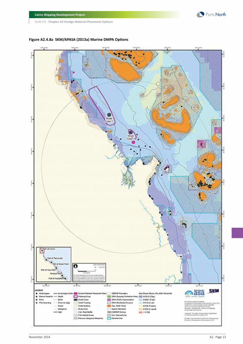
A2.4.8 SKM/APASA (2013a)The SKM/APASA (2013a) draft report presents the findings of Task 3 as mentioned above, that is, the identification of potential alternative dredge material placement areas. The assessment took into consideration expected future capital and maintenance dredging requirements.
Selection criteria for the identification of dredge material placement sites included:
• Resistance to re-suspension based on results of bed shear stress modelling
• Dredge material placement sites would only be within the ‘General Use’ of the Marine Park
• A buffer of two km was placed around reefs, within which dredge material placement sites would not be located
• A buffer of five km was placed around important turtle feeding and breeding zones areas, within which dredge material placement sites would not be located
• Dredge material placement sites would not be placed on existing shipping channels, and should avoid pilot boarding locations, anchorage sites
• Dredge material placement sites would not be placed such that material transport vessels would need to cross major shipping lanes
• The composition of material to be placed should match that of the existing seabed, as much as possible
• Dredge material placement sites should not be placed in Special Management Areas or Fish Habitat Areas (FHA)
• Areas of known environmental, tourism, recreational or commercial value should be avoided, including seagrass habitat and areas of comparatively high commercial fisheries value as indicated by catch per unit effort (CPUE) in the trawl fishery.
For the Port of Cairns, two preferred areas for material placement were identified (Figure A2.4.8a), both to the north-east of the port near the 20 m depth contour. Options for dredge material placement sites at Cairns are found to be very constrained due to reefs, non-General Use marine park zones, and shipping activity. Both of the preferred areas avoid interactions with sensitive environmental receptors and navigational routes.
Cairns Shipping Development Project
Draft EIS : Chapter A2 Dredge Material Placement Options
A2 : Page 13November 2014
Figure A2.4.8a SKM/APASA (2013a) Marine DMPA Options
Cairns Shipping Development Project
Draft EIS : Chapter A2 Dredge Material Placement Options
November 2014 A2 : Page 14
A2.4.9 SKM/APASA (2013b)The SKM/APASA (2013b) draft report assessed the risk to sensitive ecological receptors from placement of dredge material in the current and alternative DMPAs. It should be noted that SKM/APASA (2013b) acknowledge that there are limitations in their modelling, and that results should only be used to compare placement areas and not for quantitative impact assessment. That is, the magnitude and extent of turbid dredge plumes may not be accurately represented.
Notwithstanding the above limitations, the key findings for the Port of Cairns include the following:
• The two alternative material placement sites were assessed as having similar levels of environmental risk to the current site, with the exception of short-term sediment deposition rates
• Model Case 2 presents an option to reduce sediment deposition arising from material placement activities along the inshore coastal environments north of Cairns, with sediment predicted to drift further north to the Cape Kimberley region before reaching the near shore depositional environment
• However, monitoring of previous dredging projects utilising the current material placement site has revealed minimal impacts on sensitive receptors surrounding the Port of Cairns.
SKM/APASA (2012b) found that any environmental benefit of using Model Cases 1 or 2 for material placement sites instead of the current material placement site may be marginal. For Model Case 2, such benefits would relate to a reduced risk of impacts upon sensitive receptors of the near shore environment in the coastal region within 50 km to the north of Cairns.
A2.4.10 Summary of Previous StudiesConnell Wagner completed detailed dredge material placement and dredge option studies between 1990 and 1992. A detailed review of these placement options and predictions on the longevity of marine placement at the present DMPA was undertaken by Environment North (2005). In summary, the Connell Wagner investigations provided an evaluation of dredge material placement options both onshore and offshore. Dredge material re-use was considered, but the quality of the material failed suitability tests for agricultural or other purposes. Of the 20 sites considered for placement, only one onshore (T5) and three marine sites (M1-M3) were recommended for additional consideration. Marine placement was recommended over onshore placement.
Use of the one onshore site (T5 – East Trinity) recommended by Connell Wagner was not supported by the Queensland Government in comments provided by various departments in 1992.
GHD (2000) completed a specific dredge material placement assessment as part of a review of options for placement of dredge material from HMAS Cairns Navy Base. The results of their investigation concluded that while land placement options did exist (e.g. at East Trinity), the most cost effective, efficient and long-term management solution remained unconfined ocean placement. Furthermore, Environment North (2005) recommended that further contemplation of dredge material for land placement or re-use is not warranted.
Since the Environment North study in 2005, constraints on local land-based placement options have increased significantly, with all port authority reclamation works complete, the Queensland Government declaring the East Trinity Reserve, closure of the CRC Portsmith Landfill, and amendments to the local government Cairns Plan.
Alternative DMPA identification and sediment modelling was also recently undertaken by SKM/APASA (2013a, 2013b) which identified two potential alternative marine DMPA locations for the Port of Cairns maintenance dredge material. Sediment modelling and risk assessment of sensitive ecological receptors found that any environmental benefit of using these alternative DMPAs for material placement sites instead of the current material placement site may be marginal.
Further to these previous studies, the State Party Report on the state of conservation of the Great Barrier Reef World Heritage Area (Commonwealth of Australia 2014) has recently noted that beneficial reuse and land placement is unlikely to be viable for overall management of dredge material in the long term for the six major ports in the GBRWHA. This is largely because much of the dredge material is dominated by silts and clays which are similar to the area in which they are being placed (p68 Commonwealth of Australia 2014).

Cairns Shipping Development Project
Draft EIS : Chapter A2 Dredge Material Placement Options
A2 : Page 15November 2014
A2.5 Characteristics of the Dredge MaterialA2.5.1 Physical CharacteristicsDetailed sediment quality characterisation studies have been undertaken within Port of Cairns since 1995 in association with the planning and approval of yearly maintenance dredging and sea placement.
Data from these previous sediment studies indicate the shipping channel and inner port are dominated by silt and clay fractions with medium to high plasticity.
Based on a review of previous geotechnical studies, Golder (2012) found that the materials within the proposed zone of widening and deepening are anticipated to consist of a majority of silt and clay materials with minor zones of sand. The clay and silts are of variable strength, with a hard clay ridge close to Trinity Inlet. Within the proposed dredge area, soft to firm clays are anticipated to extend to approximately -10 m to -11 m LAT, underlain by stiff to very stiff clay. Further offshore, between one m and three m of fine soft mud overlies very soft clay.
Preliminary geotechnical investigations undertaken by Golder (described in detail in Chapter A4, Project Description) of the proposed channel upgrade indicated that overlaying material in the channel was sandy-clayey silt (down to a maximum of two m below the channel bed). Under this material was silty clay extending down to below proposed dredge depths. Further testing by Golder (2013) confirmed the preliminary findings in 2012, indicating that the dredge material consists of an overlaying layer of soft silty clay with varying fine sand content, underlain by stiff to very stiff silty clays below the proposed dredge depths in most areas. However, in some areas such as near the channel bend, the proposed dredge depth will penetrate into the stiff clay material.
In total, 4.4 M m3 of in-situ material will be dredged, which is comprised of:
• 3.57 M m3 of very soft to soft clays and silts
• 0.46 M m3 of firm clays
• 0.32 M m3 of stiff clays.
A2.5.2 Sediment ChemistryAn extensive program of sediment contamination assessment has been implemented by the operators of Port of Cairns since 1995.
Sediments within the Port of Cairns are typically uncontaminated, with the majority of contaminant substances not exceeding NAGD screening levels at 95 per cent UCL. The few exceptions involve arsenic, tributylin (TBT), copper and diuron (WorleyParsons 2010). Additional testing has been undertaken during the implementation of past Sampling and Analysis Plans (SAPs) and levels present in elutriate and porewater tests have indicated that no significant impact to water quality or benthic communities was likely.
Similar to other parts of Eastern Australia, arsenic is naturally elevated in the Cairns region due to the presence of natural mineralisation in metamorphic rocks. As such, arsenic has exceeded the NAGD screening level in most Port of Cairns dredge areas except Marlin Marina within the past five years. Any exceedances have tended to be marginal over the screening level and further testing using DAE and elutriate analysis has indicated that impacts to water quality and benthic communities are highly unlikely. Therefore, the local arsenic screening level has been increased by the Determining Authority from 20 mg/kg to 30 mg/kg (WorleyParsons 2010).
For all studies undertaken between 1995 and 2013, dredge material has been considered suitable for unconfined sea placement on the basis of contaminant levels.
Further sediment quality testing was undertaken as part of the SAP developed for the project. The findings of the SAP have confirmed that the dredge material is considered suitable for unconfined sea placement. Sampling was undertaken in accordance with the NAGD, and details are provided in Chapter B4, Marine Sediment Quality.
Cairns Shipping Development Project
Draft EIS : Chapter A2 Dredge Material Placement Options
November 2014 A2 : Page 16
A2.5.2.1 Acid Sulfate Soil (ASS)Based on preliminary geotechnical investigations by Golder (2012 and 2013, contained in Appendix D1), and further sediment testing undertaken by BMT WBM (Refer to Chapter B4, Marine Sediment Quality), the likely ASS characteristics of the proposed dredged material has been summarised by Golder (2014) as follows:
• Potential acid sulfate soil (PASS) have been identified to more likely be present in the very soft to soft clay and silt materials (about 3.67 M m3). Firm, stiff and very stiff materials are unlikely to be PASS or require lime treatment if the material was placed on land
• The majority of samples tested by BMT WBM indicated self-neutralizing PASS within the top one metre along most of the channel (i.e. these samples had shell or other neutralising material). However, Golder (2014) notes that on other dredging projects involving self-neutralizing materials, there has been some acidity released and therefore nominal lime treatment of about three to five kg lime/m3 would still be required if this material was placed on land. Also, separation of materials of varying PASS during the dredging process may not be practical or indeed possible and hence separation of the top one metre is considered problematic
• PASS materials that are not self-neutralising were detected in 17 samples results from all investigations to date. These positive samples were typically from depths of more than one metre below the existing surface. This material would require substantial lime treatment of between 30 to 270 kg lime/m3 if placed on land.
A2.6 Dredging and Placement LogisticsThe following section describes the characteristics of the dredge material and provides a general overview of the logistics required to place such dredge material on land or at sea associated with the project (including dredging and land placement methodology, pumping, and ground treatment).
A2.6.1 Material Quantities and QualitiesThe in-situ material to be dredged is understood to be mainly of three main types:
• Marine mud and silt (i.e. very soft, soft and firm clay and silt)
• Smaller portion of stiff clay
• Very minor amounts of sand.
The dredging process will fluidise the marine mud, clay and/or sand into a slurry form as a result of the trailer suction hopper dredger (TSHD) operation. The stiff clay is proposed to be dredged using a backhoe dredger or else by a TSHD (refer to Chapter A4, Project Description).
A2.6.1.1 Marine Mud and SiltThe volume of marine mud and silt (comprising very soft, soft and firm clay and silt) is expected to be approximately 4.1 M m3. The re-use of soft to firm marine clay and silt on land would require extensive handling, improvement and time. For land based placement, it is anticipated that dredge slurry would be pumped directly from a moored dredge barge to the preferred land placement site. The material would need to be drained, consolidated and treated to enable it to be handled for re-use onshore. Even after a long period of drainage and consolidation, which would be expected to take years, the silt/clay would form a soft, weak material unsuitable for re-use as engineered fill without additive stabilisation or in-situ ground improvement. For marine placement, the material would be placed directly at sea at a preferred location from the dredge. Further discussion on the treatment and dewatering of the dredge material is included in Sections A2.6.4 and A2.6.5.
A2.6.1.2 Stiff ClayThe stiff clay from a small area of the channel could potentially be used for fill if it were brought onshore. However, this stiff clay would still require some drying out and consolidation. Should this material be placed on land, it is likely that initially it would be stockpiled close to the Port of Cairns and then transported overland by truck to its final destination at the land placement site. There will be approximately 0.32 M m3 of stiff clay to be dredged from the channel area, representing six percent of the total volume of dredge material.
A2.6.1.3 SandSand may have practical beneficial re-use if found in useful quantities. However, based on preliminary geotechnical studies (Refer to Chapter B4, Marine Sediment Quality), no or very little sand material is expected to be dredged as part of the project and any sand present would be expected to be mixed with fine silty material.

Cairns Shipping Development Project
Draft EIS : Chapter A2 Dredge Material Placement Options
A2 : Page 17November 2014
A2.6.2 Dredge TimingFor marine placement of dredge material, dredge cycle times have been calculated to range from between 36 and 108 minutes. Based on a dredge volume of 4.4 M m3, placement at the existing marine DMPA (which is roughly central to the key marine DMPA options being investigated) has been calculated to take approximately 23 weeks.
For onshore placement, the TSHD dredge cycle time would be extended due to the need to connect to pumping pipeline and to commence pumping operations. Onshore placement is estimated to take anywhere between 29 weeks and 44 weeks depending on the land placement site location.
A2.6.3 Pumping of Dredge MaterialIf the dredge material were to be brought onshore, it would likely need to be hydraulically pumped from a moored dredge into a contained, bunded area on the land to allow the dredge material to dewater, consolidate and be treated. Such a bunded area would need to be within pumping distance from the dredge anchorage/mooring site, as this would be the only practical way to bring the material onshore. The dredge material would need to be pumped via pipelines from vessel to shore in a water-based slurry form. This slurry form helps the pumping operations but also results in a significant volume increase from the original dredge cut volume.
The maximum pumping distance for the TSHD is between 2,500 m and 3,000 m, without an additional booster. This means that for all land placement sites one or more booster stations will be needed to facilitate the pumping operations. Booster stations typically reduce the efficiency of the TSHD by approximately 7.5 hours per week per booster station (Pro Dredging, 2014).
In terms of practicality, the maximum number of booster stations along a single pipeline is approximately three. This would result in a maximum pumping distance of approximately 11 km.
It is estimated that a factor of two to four would need to be applied to account for the volume of water required to facilitate dredging and offloading for very soft to soft cohesive material of the type anticipated in the project. For firm clay, the volume of process water required is double that required for very soft to soft clay.
With increasing pumping distance there is an associated increase in the water required to pump the material which could potentially double the volume of process water required for distant sites.
Stiff clay may be dredged by a backhoe dredger and transported to the placement site with minimum process water or alternatively by a cutter suction dredge which will require significant volumes of process water similar to that for firm clay.
A2.6.4 Treatment of Dredge MaterialAs described in Section A2.5, preliminary geotechnical investigations by Golder (2012, 2013 and 2014), and sediment testing undertaken by BMT WBM in 2013, indicate that the very soft to soft clay and silt dredge material below one m depth is likely to be PASS.
Based on the lime treatment rates recommended by Golders, approximately 275,000 tonnes of lime would be required to effectively neutralise the PASS. This amount of lime would equate to:
• 6,875 B-double truck movements (capacity of 40 tonnes)
• 9,170 semi-trailer movements (30 tonnes capacity).
In-line addition of lime slurry into pumped dredge material is not typically feasible as a treatment method at rates above about 5 kg/m3. At higher rates the lime is unlikely to mix uniformly throughout the deposited dredge material and may result in alkaline tailwater discharges.
It has been noted by Golder (2014) that the volume of dredge material proposed, and the liming rates required, is at least an order of magnitude higher than that previously attempted in Queensland. Additionally, the production rates indicated may be ambitious and difficult to achieve in reality.
Golder (2014) advised that the risk of releasing saltwater and leaching of acid will need to be considered for the design and construction of the dredged material containment ponds. These issues may require construction of low permeable (or lined) base and walls. The cost of a compacted clay liner would be dependent upon the availability of a suitable material. There was insufficient economically viable clay material available in the Cairns area two years ago to provide a source of low permeable capping for the Portsmith Landfill (about a 10 ha area). Alternatively geosynthetic liners (LLDPE or HDPE) will cost about $15/m2 to $20/m2. It is assumed that geosynthetic liners will be required.

Cairns Shipping Development Project
Draft EIS : Chapter A2 Dredge Material Placement Options
November 2014 A2 : Page 18
A2.6.5 Dewatering of Dredge MaterialPumped material would be delivered to site in a slurry form with a moisture content of approximately 90 percent. It would need to be dewatered to a moisture content of approximately 40-60 percent to enable rehandling by machinery (excavators and trucks). Specialised areas would need to be constructed to enable efficient dewatering.
The period required to dewater the material from a moisture content of 90 percent to 60 percent using natural solar processes alone would depend upon the thickness of the dredge material placed and the rainfall experienced during the period of the drying process.
The majority of the dredge material is very soft to soft clay, with an approximate fine content of 96 percent. This material will not dewater easily and reduce in volume. Traditional methods to accelerate the drying process include the following:
• Horizontal drains embedded in the bottom of the placement area in a layer of drainage sand
• Wick drains
• Combination of wick drains and horizontal drains whereby the horizontal drains are connected to the vertical drains and to a pumping system
• Sandwiching of layers of clay and sand, combined with horizontal or vertical drains.
Dewatering dredge material typically requires a layer of sand on top of the layers to be drained to provide pressure and accelerate the drying process. Systems exist also whereby the layers are covered with plastic foil and a pumping system creates a vacuum in the package (i.e. vacuum consolidation). However, previously, large scale projects have not been executed successfully with this method (Refer to Appendix D1).
In regard to the implementation of dewatering acceleration methods in the Cairns region, the following constraints have been identified:
• When filled with dredge material, the land placement sites would not be accessible with earth moving equipment such as bulldozers, excavators, etc. This makes it very difficult, inefficient and very expensive to install wick or horizontal drains
• Due to the low bearing capacity of the placed dredge material, installing a layer of sand on top as an accelerator would not be possible
• Installing a vacuum consolidation system would be very difficult and expensive, due to the fact that traditional land equipment could not be used to handle the large sheets of foil needed to seal off the surface.
Other projects with similar land placement issues are using the sandwiching method (Port of Brisbane, Singapore) in combination with a drainage system. The clay is pumped in a thin layer by the TSHD or CSD, and on top of this layer a sand layer with an approximate thickness of 2 m is pumped. The sand layer partially stays on top of the clay layer, partly mixes with the underlying clay layer and partly pushes soft material as a wave in front of the face to the end of the placement area. The result is in general a reclamation that can be accessed by traditional land equipment which can install drainage systems. For the Cairns area, very limited sand is available from dredging for installing the sandwich layers.
The only system that may be partly feasible is a horizontal drainage system, with the drains embedded in a layer of drainage sand, and constructed before the filling of the placement area. The principal challenge would be due to the composition of the dredge material it is likely that the drains could become easily clogged by the fine clay particles, and that new drains would need to be regularly reinstalled during the period of dewatering.
Golder (2014) suggests that a land farming process similar to that used for the treatment of PASS could be adopted to aid drying of dredge material.
A new technique commonly known as ‘mud farming’ is also potentially an option for more rapid dewatering. It involves repeated scrolling, or machine passes, to more rapidly drain water and consolidate material. Whilst this option has potential, it has not been trialled on this broad a scale or for fine dredged material such as that which would be placed on land.
Further investigations would be required to determine the most appropriate dewatering method, and its timing, but estimates are that it will take five to 10 years for dewatering to occur without land treatment and strengthening.

Cairns Shipping Development Project
Draft EIS : Chapter A2 Dredge Material Placement Options
A2 : Page 19November 2014
A2.7 Beneficial Reuse Options As directed by NSGD, alternatives to placement at sea were examined, which include beneficial reuse options, as described below.
Potentially, there are a range of land-based beneficial re-use options for dredge material. There is a wider range of re-use options available for dredge material with a higher sand content compared to dredge material with a high fine sediment content (such as occurring in the Cairns area).
Possible beneficial re-uses of dredge material include beach nourishment, habitat development, levee maintenance and rehabilitation, construction fill, construction material (e.g. brick making) and cover at existing sanitary landfills. A common form of habitat development using dredge material is the creation or restoration of tidal wetlands (SFBRWQCB, 2000). However, surrounding habitats are in prime condition with no known degraded areas (apart from East Trinity), and there are no known areas where constructed tidal wetlands would be beneficial. This was confirmed through consultation with relevant Queensland Government agencies.
It is noted that construction material, beach nourishment and shore/erosion protection require separation of the sand fraction from the clay/silt fraction. With respect to Cairns, without separation, the high fines content of the dredge material renders the proposed dredge material unsuitable for beach nourishment as the majority of material would not be stable under the moderate wave climate typical of the shallow waters of Trinity Bay. Furthermore, if sand could be separated from the silt (theoretically possible using separation techniques, but highly unlikely to be feasible due to the volume of material), the volume of sand in the dredge material is too minimal to be of any practical use. The added process of sand separation would yield a relatively small quantity of high cost material that would need to be transported to the final use site.
In their assessment of land-based dredge material and placement options, SKM (2013) concluded that for Cairns the only option that could feasibly be considered for land-based use of dredge material is construction fill. However, SKM (2013) noted that this option would only be suitable if there was a requirement for construction fill, if any ASS had been treated, and if there were no other contaminants present. SKM (2013) concluded that other land-based options are highly constrained due to a lack of available land and due to the nature of sediments to be dredged, which are unsuitable for beach nourishment or other construction purposes.
Shoreline protection with rock was noted in the SKM (2013) report as not being a feasible option in the Cairns area. Regardless of this, based on results of previous geotechnical investigations, there is little likelihood that any rock would be recovered in the dredge material anyway.
The characteristics of the sediments (i.e. high fines content) also make the material unsuitable for use as fill or other purposes. Most topsoils comprise at least 70 to 80 percent sand by weight due to drainage requirements and sediment from the dredge areas would require blending with additional large quantities of sand, for use as a soil product, e.g. a topsoil. Consequently for every one tonne of dredged sediment, around three tonnes of clean sand would need to be blended with the material. The high salt content of the dredge material would likely require extensive irrigation (salt leaching) of the sediments before use.
Dredge material has been used overseas (e.g. in the United States) as a cover for landfill. The quality of the material for use as a liner depends upon its clay content. Importantly, the material needs to be prepared for such use by drying (must have a low moisture content) and screened to remove all debris greater than 30 mm in diameter. This adds to costs significantly. Furthermore, in the Cairns area, landfill capping is not currently an option due to landfills already being capped.
Therefore, as the only feasible beneficial re-use of dredge material in Cairns has been identified as construction fill, the following sections discuss land placement sites where dredge material could potentially be used as construction fill. It is noted however that quarry resources and cut to fill operations currently adequately meet demand for fill material and are less expensive than dredged

Cairns Shipping Development Project
Draft EIS : Chapter A2 Dredge Material Placement Options
November 2014 A2 : Page 20
A2.8 Potential Land Placement OptionsA2.8.1 Site CriteriaThe land placement site would need to be capable of providing an area to dewater material and establish associated infrastructure (including transport access). This area would be required to have the following characteristics:
• On relatively flat land
• Close to existing tidal drainage or creek lines to enable saline tailwater discharge
• Distant from areas subject to coastal erosion or storm surge, or capable of being otherwise engineered to be resistant to such impacts
• Within a reasonable distance (<1 km) to enable pumping of the dredged material from a mooring site (Figure A2.8.1a)
• Secure dewatering areas need to be fenced and made secure as there are inherent public safety issues with the soft nature of the material while it is in the process of dewatering.

Cairns Shipping Development Project
Draft EIS : Chapter A2 Dredge Material Placement Options
A2 : Page 21November 2014
Figure A2.8.1a Land Placement Sites and Pumping Distances
Cairns Shipping Development Project
Draft EIS : Chapter A2 Dredge Material Placement Options
November 2014 A2 : Page 22
A2.8.2 Intended Final Use and Treatment TimeEach site was assessed based on the intended final end use of the site. That is, for each site the final end use could either be long term land development and/or primarily as a placement area only.
For sites with land development as the final end use, the time required to treat the dredge material is also an important factor. As traditional dewatering acceleration methods are not considered feasible for the placement areas in Cairns (due to the composition of material and the large quantity involved), dewatering using land farming is proposed (refer to Section A2.6.5). This typically has a timeframe of about five years before the material is able to be used as construction fill. Therefore, all land placement options proposed as developable land are assumed to have a five year treatment timeframe.
A2.8.3 Description of Potential Land Placement SitesBased on previous dredge material placement studies in Cairns (Section A2.4) and after consideration of the limitations discussed in the above section, five potential placement sites were identified for further assessment. Each of the five placement sites, shown in Figure A2.8.1a, could potentially be used for either ‘disposal’ or ‘future development’ purposes. The project team assessed the most appropriate end use for each of the sites below and the concept design for each site was developed accordingly:
• East Trinity Site – Connell Wagner (1990, 1992) site T5 – potential for both placement only site or a future development (urban use) site
• Cane land development near to Connell Wagner (1990, 1992) site T7 – most suitable for future urban use
• Admiralty Island - most suitable for ‘placement only’ site. Future development of this site would require major geotechnical improvements which would be a separate project
• Airport – potential for future expansion of existing development area
• Esplanade potential for land reclamation for future development or use as public open space.
It should be noted that the assessment process outlined below could potentially be applied to other sites that meet the site limitations, i.e. the cane land site represents potential placement areas with similar characteristics in the region.
The investigation did not identify any unconstrained sites other than those above however, within reasonable proximity of the project area that could provide the required area of undeveloped land to accommodate the volume of dredge material from the Project.
In order to understand the spatial requir ements for each site, a concept design for each of the five land placement areas was developed and is described in the following sections.
A2.8.3.1 Placement Site CapacityBased on an analysis of the pumping distance/process water requirements for placing the dredge material (refer Section A2.6.3), the fill capacities for each DMPA option have been calculated and are presented in Table A2.8.3.1a. With a contingency allowance, it is considered that East Trinity, Admiralty Island and the Cairns Esplanade will require a fill capacity of 12 M m3, and Cane Land Development requires a fill capacity of 17 M m3.

Cairns Shipping Development Project
Draft EIS : Chapter A2 Dredge Material Placement Options
A2 : Page 23November 2014
Site
East Trinity, Admiralty Island, Esplanade
Cane Land Development
Material
Very soft to soft clay
Process water for very soft to soft clay
Firm clay
Process water for firm clay
Water for flushing
Stiff clay
Total
Fill volume at other sites
Additional water for longer pump distance
Total
Volume (m3)
3,570,495
3,570,495
459,405
939,111
1,179,951
320,100
10,039,557
10,039,557
4,800,000
14,839,557
Table A2.8.3.1a Estimated Fill Capacities
A2.8.3.2 Concept Bund DesignFor the purpose of a high-level cost estimate of the bunds required for the DMPA sites, a concept bund design has been established for both the perimeter and internal bunds.
Generic assumptions for the design have been made and these are as follows:
• Bunds will be constructed with clay where construction can be undertaken in dry areas, except for the Esplanade foreshore option where rock bunds will be required
• For clay bunds, a one in three side slope has been assumed. For rock bunds a one in two side slope is assumed
• Bund crest width varies with the need for vehicular access, which is required for most bunds except for Cairns Airport and Cane Land Development options, where it is assumed that the ground condition is competent for construction vehicular access. For bunds providing vehicular access, the average crest width is assumed at five m. The need for passing/turning areas will be determined during the detailed design stage. For bunds that are not providing vehicular access the width is assumed to be three metres
• For the perimeter bunds, the crest level has been designed to withstand a storm tide level of two metre HAT (source: Queensland Government Coastal Hazard Areas Map Storm Tide Inundation Areas Version 2 - February 2013 8064-234 CAIRNS). This level includes a sea level rise allowance of 0.8 m over the next 100 years. At present day the storm tide level is therefore 1.2 m HAT, which equates to 4.7 m LAT or 3.06 m AHD
• For the purpose of this study, the crest level of the perimeter bunds will be set at present day storm tide level plus nominal freeboard allowance for external waves, totalling 3.5 m AHD. Should the site be developed at a later date, the design of the perimeter bunds should take into account the future predicted sea level rise allowance as outlined above, by use of flood wall or raising the bund height.
Internal bunds are to cater for the initial fill level. At this concept design stage, a freeboard allowance of 0.3 m, for internal wind induced waves, above the design fill levels is assumed for the internal bunds.

Cairns Shipping Development Project
Draft EIS : Chapter A2 Dredge Material Placement Options
November 2014 A2 : Page 24
A2.8.4 East TrinityThe site known as ‘East Trinity’ was bought by CSR Pty Ltd in the 1970s to grow sugar cane. A bund wall (rock levee) was constructed through foreshore mangroves to prevent salt water entering the site and floodgates were installed to allow water to leave the site (but not enter) and the enclosed area was drained. Draining of the area exposed acid sulfate soils (ASS) leading to acidification of onsite soils and discharges of sulphuric acid and heavy metals to Trinity Inlet following rainfall. Sugar cane production was not successful (as a result of the soil becoming acidic) and the remaining natural vegetation onsite was seriously degraded. Fish kills in, and near the site, were reportedly common (Lord, 2006).
Various unsuccessful plans for development were proposed during the 1980s and 1990s, whilst the site was left largely unmanaged (Smith et al, 2003). In the early 1990s a proposal to develop a satellite city on the site attracted community attention, but failed to gain approval.
In 2000, the Queensland Government purchased the site with the intent of preserving the scenic rim of Cairns and for remediating the acid sulphate problems. It was designated an Environmental Reserve (the East Trinity Reserve) and rehabilitation measures to reduce acidic discharges to Trinity Inlet and improve its environmental values have been ongoing. In order to maintain pH levels at East Trinity and prevent the release of acidic waters, a large portion of the site is tidally inundated daily, via flood gates (Lord, 2006). Ninety per cent of East Trinity Reserve lies below two m above mean sea level.
The site is currently maintained by the Department of National Parks, Recreation, Sport and Racing (NPRSR) who undertake pest management and acid sulfate remediation on site. Site investigations undertaken by Fisheries Queensland and the Department of Employment, Economic Development and Innovation (DEEDI) indicate that remediation works have substantially improved the water, soil, vegetation and the diversity and quantity of native fauna (DNPRSR, 2014). The site has also attracted some international scientific interest as a successful case study for the remediation of acidic soils.
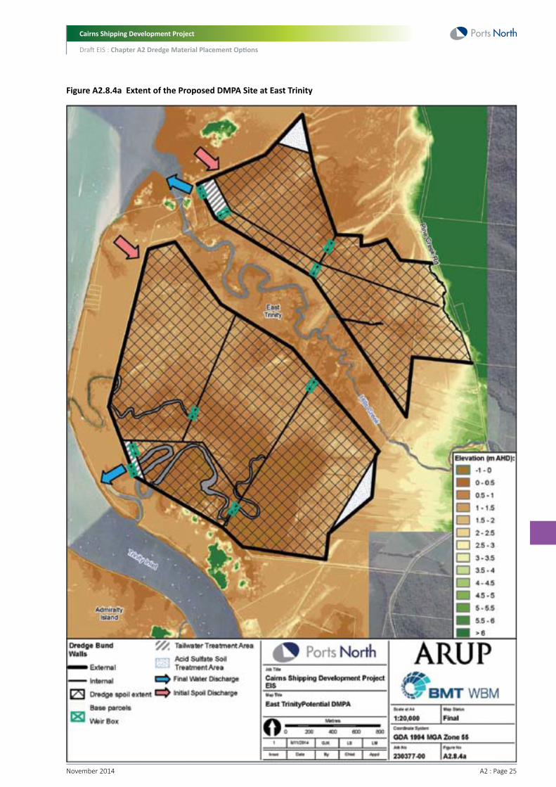
As a conceptual measure to minimise environmental impacts, the area available for placement has assumed the following restrictions:
• A buffer of at least 100 m would be provided either side of Hills Creek (middle of the site) to retain its environmental values. Hills Creek has been extensively rehabilitated and has the highest quality of native fauna and flora; the tidal areas of the creek are also part of the Great Barrier Reef World Heritage Area. Magazine and Firewood Creeks would be consumed by the proposed placement areas in this conceptual design
• A wetland in the northern section of the site is protected under state legislation and provides habitat for an existing migratory bird population. Placement of material in this location would be restricted
• The northernmost part of the site, which contains endangered and ‘of concern’ vegetation communities protected under the Vegetation Management Act 1999 would also be avoided.
Based on the above, the areas available to receive the dredge material are indicated in Figure A2.8.4a, and total approximately 520 ha. This shows two sites, East Trinity North and East Trinity South, which would be filled initially to a level of 3.2 m AHD. The bunded area would provide sufficient volume to take the required 12 million m3 fill volume, with additional areas allowed as set down areas and for treatment of the dredge material. It is estimated that the average finished surface level, once the dredge material has dried, will be in the order of 1.6 – 1.7 m AHD
Cairns Shipping Development Project
Draft EIS : Chapter A2 Dredge Material Placement Options
A2 : Page 25November 2014
Figure A2.8.4a Extent of the Proposed DMPA Site at East Trinity

Cairns Shipping Development Project
Draft EIS : Chapter A2 Dredge Material Placement Options
November 2014 A2 : Page 26
A2.8.5 Cane Land Development This potential option is a nominal selection of land that is suitable for assessment purposes but currently has no level of interest or approval from current land owners. Currently, the area comprises existing sugarcane farms approximately 18 km south of Cairns CDB (near Edmonton). Refer to Figure A2.8.5a for location of this proposed site. It is possible that another similar placement area could be utilised that has similar characteristics to the site described here.
The dredge material would need to be pumped directly here and used for construction fill after dewatering and treatment. The existing topsoil could be stripped from within the bunded area and stockpiled for later use as capping of the dredge material.
The area is located a considerable distance from the dredge area – approximately 10 km direct line from the dredge area, further via road or pipeline. Direct pumping via a pipeline may be achievable along Trinity Inlet. Alternatively, dredging of Trinity Inlet could be considered to provide closer access for the TSHD but could incur significant additional impacts within these upper reaches, including direct impact to seagrass beds in the area. For the purposes of this study the pumping option has therefore been assumed.
The terrain at the Cane Land Development site rises from about one metre AHD at the southern boundary to >10 m AHD at the northern boundary, which is not ideal for land placement. As a result the majority of the material will be deposited at the lower part of the site (i.e. dredge material extent), without making use of the fullest extent of the site. Based on 17 M m3 of required fill capacity (additional capacity required due to additional pumping water required), the fill level will need to be 7.6 m AHD (refer to Figure A2.8.5a).
It is noted that only the development option is considered as it presents the best use for the cane land site. The placement option is not considered appropriate as it would diminish the current agricultural value of this land and not provide a final land use of economic value. Cane land Development is assessed as a long term development site only. The site was therefore assessed based on two treatment times – five years and 10 years.

Cairns Shipping Development Project
Draft EIS : Chapter A2 Dredge Material Placement Options
A2 : Page 27November 2014
Figure A2.8.5a Extent of the Proposed DMPA Site at Cane Land Development

Cairns Shipping Development Project
Draft EIS : Chapter A2 Dredge Material Placement Options
November 2014 A2 : Page 28
A2.8.6 Admiralty IslandAdmiralty Island is an island located within Trinity Inlet just upstream of the Port of Cairns and Cairns CBD. Admiralty Island is low lying island which is subject to regular tidal inundation. It is dominated by mangrove forest with areas of salt pan and estuarine wetland.
Admiralty Island is currently owned by the Queensland Government and managed as part of the State reserve system by the Department of National Parks, Recreation, Sport and Racing. It was once vested by the former Cairns Port Authority (now Ports North) and considered for possible port expansion. Management of the land was transferred to the Queensland Government for conservation purposes in 1989, and declared as a component of the Trinity Inlet Fish Habitat Area in 1998.
With a fill level of 3.2 m AHD, the area shown in Figure A2.8.6a is able to cater for the 12 M m3 of fill material.
Admiralty Island is assessed as a placement site only. Existing ground conditions are very poor and lack of access would make any general ground improvement extremely expensive as well as potentially ineffective for future development.

Cairns Shipping Development Project
Draft EIS : Chapter A2 Dredge Material Placement Options
A2 : Page 29November 2014
Figure A2.8.6a Extent of the Proposed DMPA Site at Admiralty Island

Cairns Shipping Development Project
Draft EIS : Chapter A2 Dredge Material Placement Options
November 2014 A2 : Page 30
A2.8.7 Cairns AirportThe Cairns Airport was recently identified as a potential onshore placement option. The potential area which could be used to accept dredge material as fill is located in the south-west of the airport site (Figure A2.8.7a).
The area within the Cairns Airport site available for the dredged material is limited (refer to Figure A2.8.7b). Discussion with the airport operator generally confirmed the extent, level and volume of fill for the development.
A major limitation of the Cairns Airport site option is that it can only accept up to 700,000 m3 of material, and the material is required to be of adequate engineering properties. The stiff clay from the Inner Port, which has the best engineering properties of the dredge material, does not meet the Airport’s specification requirements. Even so, for the purposes of the assessment, it is assumed that the stiff clay is used in lower fill layers on the development site.
The offloading methodology would be by barge and trucks instead of pumping ashore. For the remainder of the dredge material (approximately 4.1 M m3), a secondary land placement site would be required. It is assumed that the remaining material would be pumped ashore to the Esplanade site for the purposes of this assessment.
The volume of stiff clay is 320,100 m3. With contingency allowance a fill level of 2.5 m AHD would be required.
The Cairns Airport site has not been assessed as a placement site as the airport has indicated it would require these lands for development in the short to medium term. The airport site has therefore been assessed as a development site only and the assessment is based on a relatively quick treatment time of two-five years.
Figure A2.8.7a Cairns Airport Potential Dredge Material Placement Site
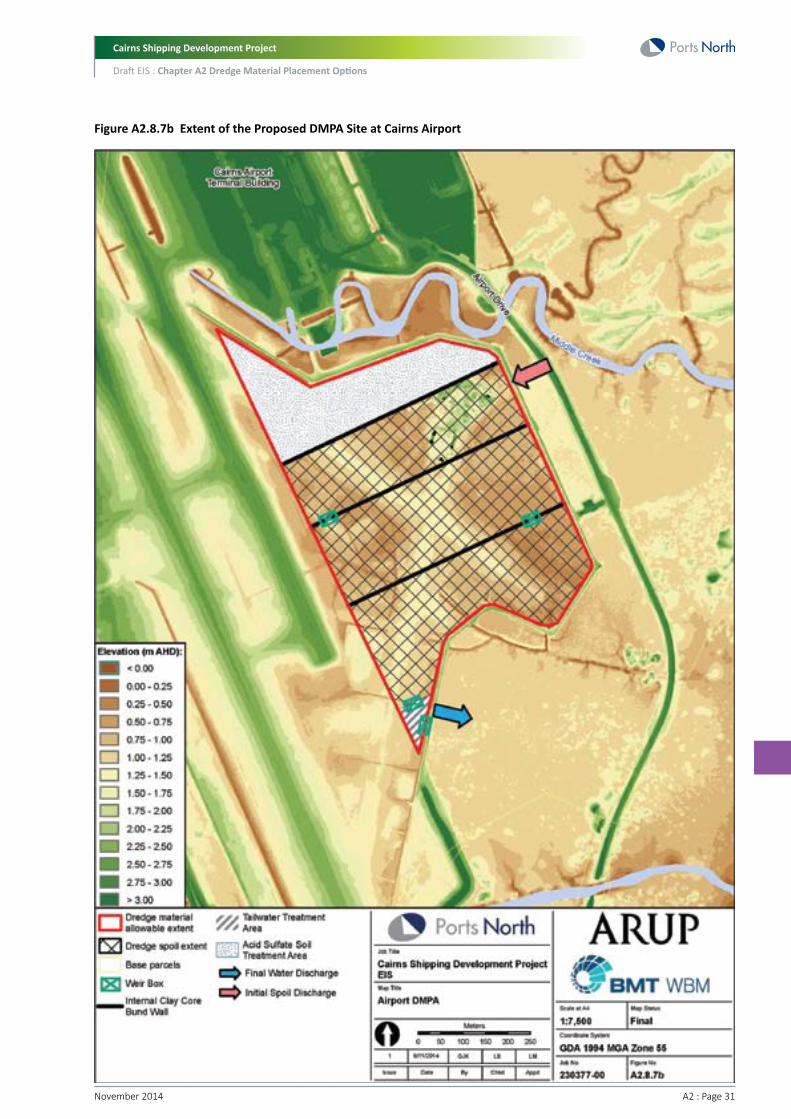
Cairns Shipping Development Project
Draft EIS : Chapter A2 Dredge Material Placement Options
A2 : Page 31November 2014
Figure A2.8.7b Extent of the Proposed DMPA Site at Cairns Airport

Cairns Shipping Development Project
Draft EIS : Chapter A2 Dredge Material Placement Options
November 2014 A2 : Page 32
A2.8.8 Cairns EsplanadeThe Cairns Esplanade option involves the use of dredge material to extend the existing esplanade out into the foreshore area and marine environment. This could provide a valuable recreational and tourist area, similar to the Strand in Townsville.
The existing level at the Esplanade frontage is about 2-2.5 m AHD. Without detailed bathymetric survey, the existing level of the foreshore levels are derived from the sea chart as approximately 0 m LAT (-1.6 m AHD). The site extent, as shown in Figure A2.8.8a, is able to receive the full 12 M m3 of fill material. This assumes a fill level of 2.5 m AHD to match the existing levels along the Esplanade frontage.
The Cairns Esplanade site is assessed as both a long-term development site and a placement site (as a placement site, the Esplanade could still be used for light land uses such as parkland). The site was assessed based on a quick aspirational treatment time of less than two years.
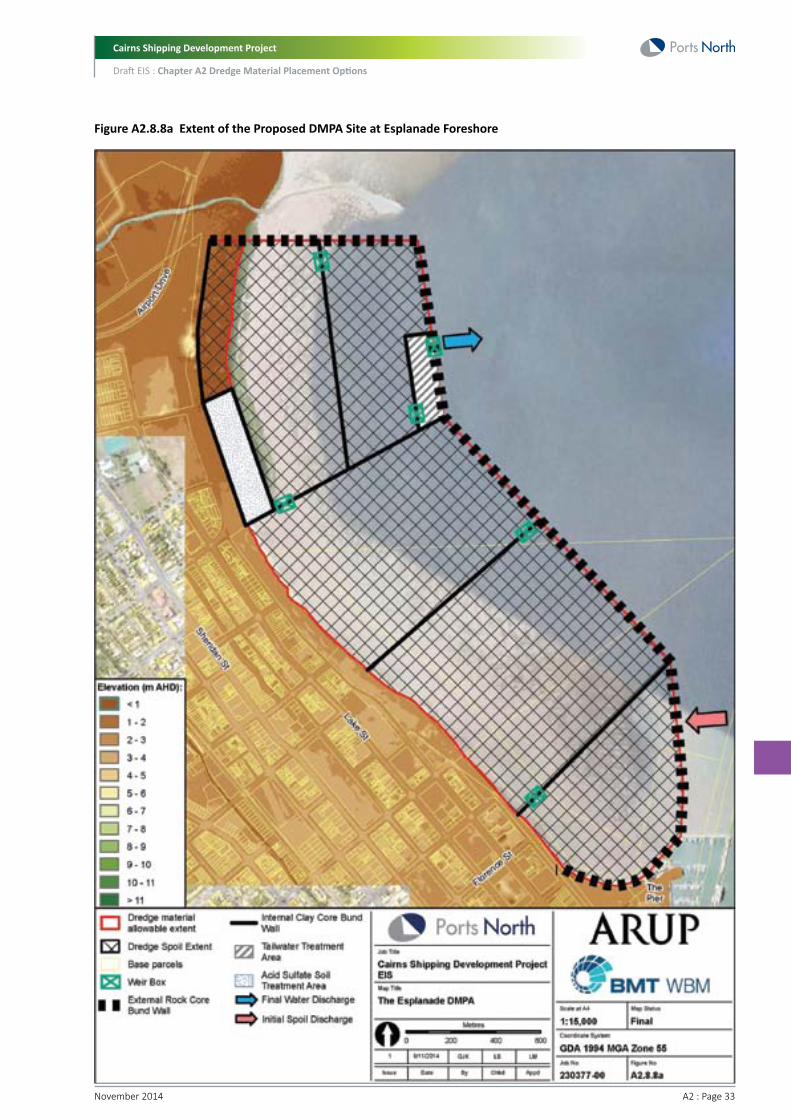
Cairns Shipping Development Project
Draft EIS : Chapter A2 Dredge Material Placement Options
A2 : Page 33November 2014
Figure A2.8.8a Extent of the Proposed DMPA Site at Esplanade Foreshore

Cairns Shipping Development Project
Draft EIS : Chapter A2 Dredge Material Placement Options
November 2014 A2 : Page 34
A2.9 Assessment of Land Placement SitesA2.9.1 MethodologyThe assessment of the land placement sites considered placement of the total volume of dredge material (4.4 M m3) to land. Partial placement (i.e. portion of material to land with the remainder placed at sea) was also considered for the preferred land placement site and is discussed in Chapter A3, Appropriateness of Preferred Land Placement Site at East Trinity. The desktop study of the five land placement options involved review of Geographical Information System (GIS) mapping, database information, reports and literature relevant to environmental, social and planning values in the study area. A site visit of each option was also undertaken on 31 October and 1 November 2013 with the aim of identifying key environmental issues.
A multi criteria assessment (MCA) was then undertaken using the methodology as described in Section A2.2.1.
For the MCA assessment, the Airport site option includes partial placement of the dredge material at the airport site to capacity and the remainder of material (4.1 M m3) placed at the Esplanade site.
MCA assessment criteria used are presented in Table A2.2.1.1a in Section A2.2.1.1.
A2.9.2 Water Quality Impacts (Tailwater and Groundwater)A2.9.2.1 TailwaterAs part of dewatering of the dredge material, tailwater would be discharged from the bunded area within each land-based DMPA. While the discharge of tailwater would be strictly controlled to ensure it is maintained within acceptable quality standards, there is potential for this tailwater to impact upon nearshore marine environment. The inherent risk with tailwater discharge is the potential for environment impacts to the receiving waterways if tailwater quality is not managed properly or as result of extreme weather conditions or infrastructure failures.
Further potential water quality impacts can arise from the pumping of dredge material in slurry form from the TSHD coupling point to the land placement site. This activity has the potential for spills/leakages causing sediment deposition and turbid plumes during pumping operations.
Preliminary conceptual designs of the bunded areas for each land placement site have been developed. These conceptual designs include indicative locations for tailwater discharge. These tailwater discharge points are presented in Figure A2.9.2.1a, along with the locations of sensitive ecological receptors (previously mapped seagrass meadows).
Based on an understanding of the hydrodynamic regime in Trinity Inlet, and the locations of sensitive ecological receptors, the potential impacts from tailwater discharge from each placement option have been identified as follows:
• Esplanade and Airport – both sites would be discharging tailwater into the western portion of Cairns harbour. This area has seagrass meadows in close proximity, and there is limited flushing in this area due to shallow bathymetry and distance from the channel
• East Trinity – tailwater would discharge at two locations into Trinity Inlet. While some seagrass meadows have been mapped at the northern discharge point previously, there is good tidal flushing at both discharge locations due to close proximity to the channel and the ebb tide jet stream
• Admiralty Island and Cane Land Development – both these sites would discharge tailwater into the upper reaches of Trinity Inlet where there is limited flushing (water movement in Trinity Inlet is dominated by tidal water exchange). This may allow suspended sediments to accumulate, potentially impacting on seagrass meadows and other sensitive ecological receptors in Trinity Inlet.
In regard to scoring, the Esplanade and Airport sites would score low due their close proximity to sensitive receptors and potential lack of good flushing in shallow waters. Admiralty Island and Cane Land Development would also score low due to the limited flushing of tailwater and proximity to sensitive receptors. East Trinity would score the best due to good tidal flushing near the discharge points, and some separation from sensitive receptors.

Cairns Shipping Development Project
Draft EIS : Chapter A2 Dredge Material Placement Options
A2 : Page 35November 2014
Figure A2.9.2.1a Indicative Tailwater Discharge Locations

Cairns Shipping Development Project
Draft EIS : Chapter A2 Dredge Material Placement Options
November 2014 A2 : Page 36
A2.9.2.2 GroundwaterPlacement of dredge material on land has the potential to impact on underlying and/or adjacent groundwater resources. Impacts to groundwater could eventuate due to the weight of the dredge material compressing the underlying soil structure (affecting groundwater and surface water exchange), and also due to the large proportion of saline and potentially acidic water (if allowed to oxidise) within the pumped dredge material. Placement of dredge material on land could impact on groundwater resources in the following ways:
• Change groundwater levels – most likely raising groundwater levels temporarily during and immediately after the landfarm dewatering, due to the large volume of overlying water
• Change groundwater quality – potentially increasing the salinity of groundwater resources, and changing the chemical composition of groundwater due to a shift in the groundwater/surface water dynamic
• Effects on ecology– changes in groundwater levels and quality may impact on flora and fauna reliant on groundwater resources in close proximity to the placement site
• Effects on adjacent land uses (e.g. agriculture) – changes in groundwater levels and quality may impact on adjacent land uses reliant on groundwater resources in close proximity to the placement site.
In placement sites which have intertidal zones (i.e. East Trinity, Admiralty Island and the Esplanade), the groundwater resource is especially vulnerable. Groundwater and soil chemistry in intertidal environments is complex and highly dynamic over small spatial and temporal scales. In these areas, the groundwater resources are effectively subterranean estuaries with oscillating hydraulic gradients. There is dynamic exchange of groundwater with surface water, which has been observed at East Trinity by Johnson et al (2010) - where groundwater seepage was observed via surface-connected pores along the intertidal slope during the ebb tide.
Of the placement sites with intertidal areas, the East Trinity site is perhaps the most vulnerable. Previous landform modification at this site involved construction of more than 27km of drains and levelling of the land surface in order to reduce water-logging and leach salt out to enable sugar cane production. The lowering of the natural groundwater table created a highly acidified landscape and releasing acid and toxic levels of iron, aluminium and other heavy metals from the soil into the waterways (Ahern 2010).
In recent years, East Trinity has been slowly rehabilitated through active floodgate management which has reinstated tidal inundation throughout the area. While great success is reported to have been achieved at East Trinity using this method (Ahern 2010), this is only a permanent solution to the acid sulfate soil problem if the site is kept perpetually wet (using tidal exchange). Any reversion to former drained conditions without regular tidal inundation would allow oxidation of the reformed sulfides and would reverse the gains, allowing re-creation of an environmental hazard (Ahern 2010). Johnson et al (2006) support this conclusion, stating that due to the formation of high concentrations of pyrite in intertidal surficial sediments during the rehabilitation of East Trinity, there is potential for long term adverse consequences if tidal inundation is ceased at East Trinity.
Placement of dredge material at East Trinity and other intertidal sites would involve the construction of bunds which would prevent tidal inundation and tidal flushing of the areas. This may have significant adverse consequences, especially for East Trinity. It is unknown at this stage the extent to which the wet dredge material would alleviate any potential adverse impacts by minimising further oxidisation of underlying soils. The suitability of the existing or proposed bund walls to retain groundwater that would arise from the dredge material itself, plus the subsequent large inputs of rainfall across such a large site, would require further detailed investigation. Consequently, the extent of potential impacts would require further detailed investigations if land placement was the preferred option.
Land placement options which do not have intertidal areas include Cane Land Development and the Airport. These sites are located in higher elevations, and therefore are likely to have lower groundwater tables. Notwithstanding the likely lower groundwater table at the Cane Land Development site, there are possibly groundwater users in this rural area which may potentially be affected by changes to groundwater levels and quality.

Cairns Shipping Development Project
Draft EIS : Chapter A2 Dredge Material Placement Options
A2 : Page 37November 2014
The site with the least likely impact to groundwater resources would be the Airport site, as only relatively dry material from backhoe dredging would be placed there. However, as the remainder of material for the Airport option is assumed to go to the Esplanade, the Airport option is assumed to have the same potential impacts to groundwater as the Esplanade (and hence the same scoring).
Therefore, based on the above, the options which have the greatest potential for impacts to groundwater resources would be those which contain intertidal areas (East Trinity, Admiralty Island and the Esplanade). Of these, East Trinity is likely to have the most vulnerable groundwater resource due to previous works at this site, and would therefore score the least. Admiralty Island and the Esplanade (which is included in the Airport option) would only score slightly better as groundwater resources at those sites are also likely to be vulnerable. While there are some potential impacts to rural groundwater users at the Cane Land Development site, it would score slightly better than the other options in terms of potential impacts to groundwater.
Land Placement Option Scoring (Scoring: 1=poor performance, 6=excellent performance)
Criterion
Water quality - tailwater
Water quality - groundwater
Average score
East Trinity
Placement
4
2
3
Develop
4
2
3
Cane Land
Develop
2
4
3
Admiralty Island
Placement
2
3
2.5
Airport
Develop
2
3
2.5
Esplanade
Placement
2
3
2.5
Develop
2
3
2.5
A2.9.3 ASS Issues and ManagementFigure A2.9.3a shows the predicted prevalence of Acid Sulfate Soils (ASS) over all of the proposed material placement sites. All five sites are identified by DSITIA mapping (2013) as containing Potential Acid Sulfate Soil (PASS). Further in-situ testing would be required to confirm the presence and amount of PASS within the potential DMPAs.

Cairns Shipping Development Project
Draft EIS : Chapter A2 Dredge Material Placement Options
November 2014 A2 : Page 38
Figure A2.9.3a Potential Acid Sulphate Soils in the Region (2009). Data from DSITIA

Cairns Shipping Development Project
Draft EIS : Chapter A2 Dredge Material Placement Options
A2 : Page 39November 2014
The East Trinity site in particular has a history of acidity issues and fish kills, due to changes in the tidal regime from past agricultural uses. The site was purchased by the Queensland Government, who has undertaken substantial treatment of the site over a number of years to neutralise this acidity and manage potential environmental harm to waterways and its ecological attributes from the ongoing release of acid. Flood gates and lime dosing equipment have been installed which allow tidal inundation and acid neutralisation of areas up to one m AHD. Based on investigations undertaken over a number of years, the Queensland Government determined that this tidal regime needs to be maintained to manage acidity on site (Smith et al. 2009). This inundation regime is also considered optimal for maintaining the current mangrove and wetland communities. The placement of dredge material on this site has the potential to change the existing treatment regime and cause further disturbance of the existing acidity on site, particularly if the material is acidic. As discussed in Section A2.5, preliminary sediment sampling has indicated that PASS is present in the proposed dredge material in the very soft to soft clay and silt materials.
Any excavations associated with the potential DMPAs (e.g. site levelling or access) will need to consider the occurrence and treatment of ASS. Whilst this is unlikely to preclude the site being utilised for placement or development purposes, additional soil treatment may be required, at an additional cost.
The effects of bund construction or any fill on soft potential acid sulfate soils has a tendency to displace and expose the surface of the existing soil which leads to oxidation and acidification. This “mud-wave” effect requires careful design and management and may include a requirement for staged construction and monitoring. These effects have not yet been quantified and would require further assessment.
If this dredge material is disposed in the marine environment whilst still waterlogged (typically within 24 hours), no oxidisation would occur and the material would remain inert. However, if this material is placed onshore and allowed to oxidise, it could potentially cause significant impacts to terrestrial and marine environments from acidic leaching if not properly treated.
ASS, and the associated leachate and runoff have the potential to create both chronic (low-level, long term) and acute (severe, short term) ecosystems effects. Depending on the pH of soil and runoff, plant life usually shows a marked decline in health in affected areas. High acidity reduces plant productivity due to the lowered availability of soil nutrients. Similarly, waterways receiving ASS leachate or runoff often show reduced biological health and reduced function.
Reductions in pH associated with ASS leachate or runoff provides a clear risk to ecosystems, as most aquatic life requires a pH of at least six to survive. High acidity can cause skin damage to fish, increasing their susceptibility to disease and fungal infection (e.g. red spot disease). Damage to gills from the acidity also affects respiration.
In regard to MCA scoring, while all proposed land placement sites are situated in identified PASS areas, the East Trinity site would be the least preferred site (scoring the least) in terms of ASS issues and management due to the significant existing ASS issues. Conversely, sites such as Cane Land Development and Esplanade do not have current ASS management issues in their present unaltered state, however if they were disturbed and the tidal and oxygenation regime altered, then additional management would be required, along with the need to manage the acidity in the dredge material itself which would still require treatment, and would therefore score better in terms of ASS issues and management.
Land Placement Option Scoring (Scoring: 1=poor performance, 6=excellent performance)
Criterion
ASS Issues
East Trinity
Placement
2
Develop
2
Cane Land
Develop
4
Admiralty Island
Placement
3
Airport
Develop
4
Esplanade
Placement
4
Develop
4

Cairns Shipping Development Project
Draft EIS : Chapter A2 Dredge Material Placement Options
November 2014 A2 : Page 40
A2.9.4 Habitat Values/Habitat Loss (Marine and Terrestrial)The below section outlines the habitat values and impact on habitat loss from dredge material placement at each of the land sites.
A2.9.4.1 AirportThe site borders a large area of mapped Regional Ecosystem (RE) associated with Ellie Point to the east, though no remnant or regrowth vegetation exists with the Airport DMPA site itself. Vegetation communities surrounding the site include mangrove forests, estuarine wetlands, salt pans and melaleuca forest and are further described in Table A2.9.4.1a below. Sections of this habitat would require removal for pumping access to the placement site. The site lies in close proximity to the Trinity Inlet Fish Habitat Area (FHA).
Water quality impacts due to potential ASS issues are also likely at adjacent seagrass communities, which are some of the last remnant patches in the Cairns area.
The proposed Airport DMPA site also provides habitat value for bird species that prefer open wetlands and pasture areas (e.g. Egrets), though it is expected that the habitat value of this area would be limited by the implementation of Cairns Airport’s Bird and Wildlife Management Program.
Table A2.9.4.1a Descriptions of Mapped RE surrounding the Cairns Airport Study Area
RE Code and Classification
7.1.1 Least concern
7.1.2a Of concern
7.2.8 Endangered
Description
Mangrove closed-scrub to open-forest. Sheltered coastlines, estuaries, and deep swales between dunes, on fine anaerobic silts, inundated with saline water at high tide.
Estuarine wetlands (e.g. mangroves). Samphire flats with open forbland to sparse forbland of Tecticornia spp., and Suaeda australis. Includes bare saltpans. Occurs in extremely saline situations adjacent to mangroves, usually in slight depressions which form salt scalds after the accumulated seawater evaporates. Soils are fine anaerobic saline silts.
Floodplain (other than floodplain wetlands). Melaleuca viridiflora (broad leaf tea tree) +/- Eucalyptus spp. +/- Lophostemon suaveolens (swamp mahogany) open-forest to open-woodland. Humic gleyed texture contrast soils with impeded drainage, on alluvial plains.
Location within Study Area
Predominantly along the eastern and southern boundary of the airport site.
Patches to the east of the site.
Patches to the north-east of the site.

Cairns Shipping Development Project
Draft EIS : Chapter A2 Dredge Material Placement Options
A2 : Page 41November 2014
Figure A2.9.4.1a Mapped Remnant and Regrowth Vegetation at and surrounding the Cairns Airport (numbers on figure represent RE codes)
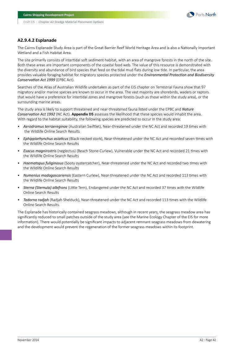
Cairns Shipping Development Project
Draft EIS : Chapter A2 Dredge Material Placement Options
November 2014 A2 : Page 42
A2.9.4.2 EsplanadeThe Cairns Esplanade Study Area is part of the Great Barrier Reef World Heritage Area and is also a Nationally Important Wetland and a Fish Habitat Area.
The site primarily consists of intertidal soft sediment habitat, with an area of mangrove forests in the north of the site. Both these areas are important components of the coastal food web. The value of this resource is demonstrated with the diversity and abundance of bird species that feed on the tidal mud flats during low tide. In particular, the area provides valuable foraging habitat for migratory species protected under the Environmental Protection and Biodiversity Conservation Act 1999 (EPBC Act).
Searches of the Atlas of Australian Wildlife undertaken as part of the EIS chapter on Terrestrial Fauna show that 97 migratory and/or marine species are known to occur in the area. The vast majority are shorebirds, waders or raptors that would have a preference for intertidal zones and mangrove forests (such as those within the study area), or the surrounding marine areas.
The study area is likely to support threatened and near-threatened fauna listed under the EPBC and Nature Conservation Act 1992 (NC Act). Appendix D5 assesses the likelihood that these species would inhabit the area. With regard to the habitat suitability, the following species are predicted to occur in the study area:
• Aerodramus terraereginae (Australian Swiftlet), Near-threatened under the NC Act and recorded 19 times with the Wildlife Online Search Results
• Ephippiorhynchus asiaticus (Black-necked stork), Near-threatened under the NC Act and recorded seven times with the Wildlife Online Search Results
• Esacus magnirostris (neglectus) (Beach Stone-Curlew), Vulnerable under the NC Act and recorded 21 times with the Wildlife Online Search Results
• Haematopus fuliginosus (Sooty oystercatcher), Near-threatened under the NC Act and recorded two times with the Wildlife Online Search Results
• Numenius madagascariensis (Eastern Curlew), Near-threatened under the NC Act and recorded 113 times with the Wildlife Online Search Results
• Sterna (Sternula) albifrons (Little Tern), Endangered under the NC Act and recorded 37 times with the Wildlife Online Search Results
• Tadorna radjah (Radjah Shelduck), Near-threatened under the NC Act and recorded 113 times with the Wildlife Online Search Results.
The Esplanade has historically contained seagrass meadows, although in recent years, the seagrass meadow area has significantly reduced to small patches outside of the study area (see the Marine Ecology Chapter of the EIS for more information). There would potentially be significant impacts to adjacent remnant seagrass meadows from dewatering and the development would prevent the regeneration of the former seagrass meadows within its footprint.

Cairns Shipping Development Project
Draft EIS : Chapter A2 Dredge Material Placement Options
A2 : Page 43November 2014
Figure A2.9.4.2a Nationally Important Wetlands and World Heritage areas for Esplanade Site
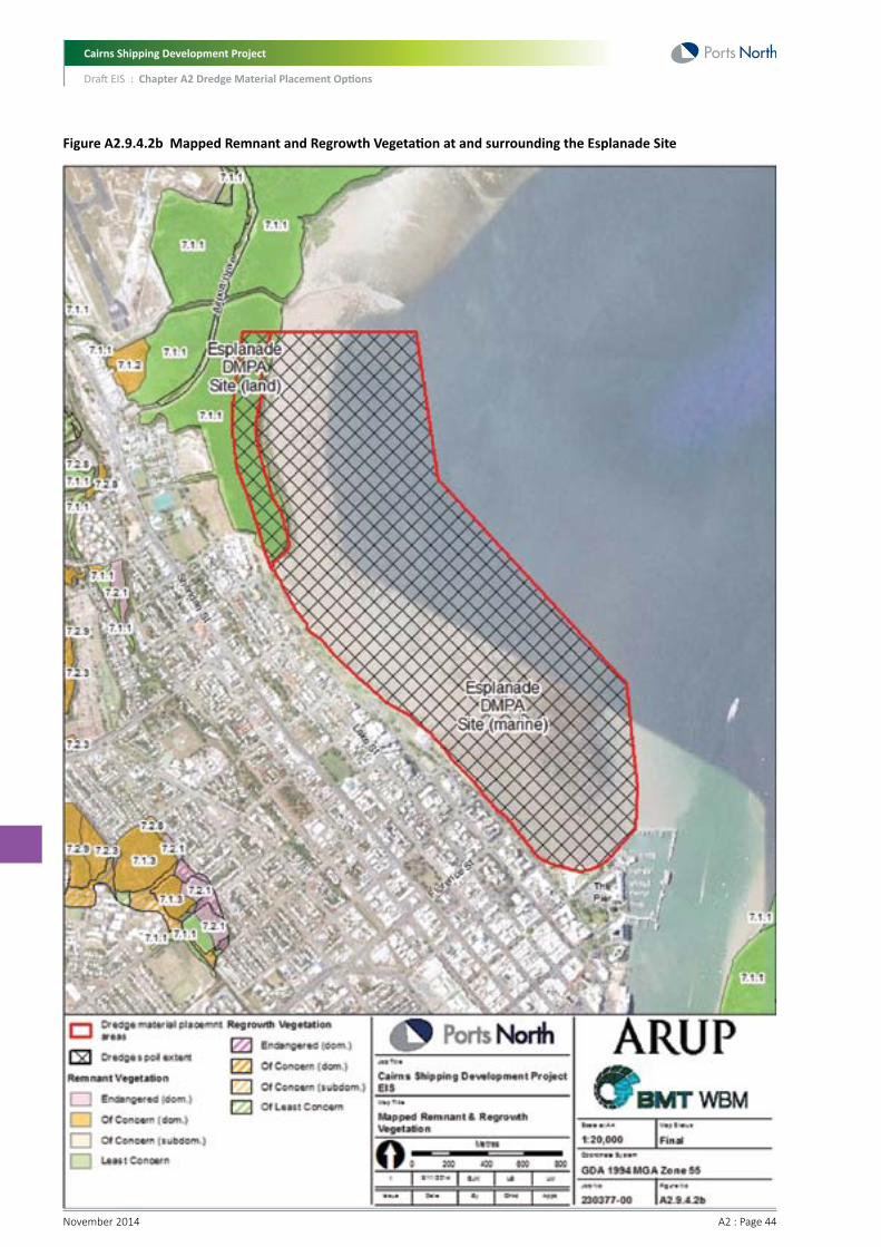
Cairns Shipping Development Project
Draft EIS : Chapter A2 Dredge Material Placement Options
November 2014 A2 : Page 44
Figure A2.9.4.2b Mapped Remnant and Regrowth Vegetation at and surrounding the Esplanade Site
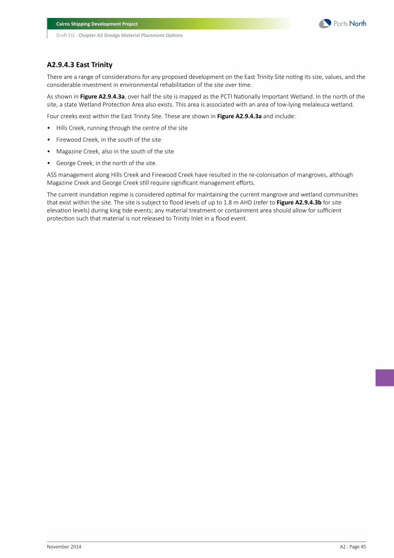
Cairns Shipping Development Project
Draft EIS : Chapter A2 Dredge Material Placement Options
A2 : Page 45November 2014
A2.9.4.3 East TrinityThere are a range of considerations for any proposed development on the East Trinity Site noting its size, values, and the considerable investment in environmental rehabilitation of the site over time.
As shown in Figure A2.9.4.3a, over half the site is mapped as the PCTI Nationally Important Wetland. In the north of the site, a state Wetland Protection Area also exists. This area is associated with an area of low-lying melaleuca wetland.
Four creeks exist within the East Trinity Site. These are shown in Figure A2.9.4.3a and include:
• Hills Creek, running through the centre of the site
• Firewood Creek, in the south of the site
• Magazine Creek, also in the south of the site
• George Creek, in the north of the site.
ASS management along Hills Creek and Firewood Creek have resulted in the re-colonisation of mangroves, although Magazine Creek and George Creek still require significant management efforts.
The current inundation regime is considered optimal for maintaining the current mangrove and wetland communities that exist within the site. The site is subject to flood levels of up to 1.8 m AHD (refer to Figure A2.9.4.3b for site elevation levels) during king tide events; any material treatment or containment area should allow for sufficient protection such that material is not released to Trinity Inlet in a flood event.
Cairns Shipping Development Project
Draft EIS : Chapter A2 Dredge Material Placement Options
November 2014 A2 : Page 46
Figure A2.9.4.3a Nationally Important Wetlands and World Heritage Areas, East Trinity site

Cairns Shipping Development Project
Draft EIS : Chapter A2 Dredge Material Placement Options
A2 : Page 47November 2014
Figure A2.9.4.3b Digital Elevation Model of East Trinity
Cairns Shipping Development Project
Draft EIS : Chapter A2 Dredge Material Placement Options
November 2014 A2 : Page 48
The site is dominated by grasslands, and regrowth RE, although a patch of remnant mangrove forest (RE 7.1.1) also exist to the north of the site (see Figure A2.9.4.3c). The site is also bordered by large areas of mangrove forest associated with Trinity Inlet and melaleuca wetland. Some of the surrounding mangrove forest is likely to be disturbed in order to gain access to the site from the dredge.
Based on site observation, DEHP RE mapping and vegetation mapping by 3D Environmental (2009), the regrowth RE across the site predominantly consists of:
• Mangrove forest, as represented as the least concern regrowth RE in Figure A2.9.4.3c
• Large areas of melaleuca forest, though ASS management has meant that some areas of melaleuca forest have experienced die-back due to tidal influence
• Coastal vine forest and thicket
• Fernland (Acrostichum aureum).
Many of the elevated areas in the eastern part of the site are also covered by exotic grasses such as Pasapalum spp, and Megathyrsus maximum (Guinea Grass) although large areas of the native Imperata cylindra (Blady Grass) also exist.
Although conservation objectives are not a specific goal of the current ASS management program for the site, ASS management has significantly contributed to the restoration of ecosystems. Restoration of mangrove communities and other lands have contributed to the return of aquatic life and bird life, whilst management for wild pigs has also reduced land degradation.
Results of recent bird survey (Venables 2011) show that 125 species utilise the area, including:
• 46 species that are listed as migratory and/or marine under the EPBC Act
Five species that are classified as Near Threatened under the NC Act, including:
• Numenius madagascariensis (Eastern Curlew)
• Tadorna radjah (Radjah Shelduck)
• Aerodramus terraereginae (Australian Swiftlet)
• Melithreptus gularis (Black-chinned Honeyeater)
• Ephippiorhynchus asiaticus (Black-necked Stork).
One species is classified as Vulnerable under the NC Act – Cyclopsitta diophthalma macleayana (Double-eyed Fig-parrot).
As per Appendix E3, the following additional significant species have also been observed in the area, or are expected to occur in the area:
• Crocodylus porosus (Salt-water Crocodile, Estuarine Crocodile), which is vulnerable under the NC Act, and migratory and marine under the EPBC Act
• Durabaculum (Dendrobium) mirbelianum (Mangrove Orchid), which is endangered under the EPBC Act and NC Act
• Durabaculum (Dendrobium) nindii (Blue Orchid), which is endangered under the EPBC Act and NC Act
• Erythrotriorchis radiatus (Red Goshawk), which is vulnerable under the EPBC Act and endangered under the NC Act
• Esacus magnirostris (neglectus) (Beach Stone-Curlew), which is vulnerable under the NC Act and listed as marine under the EPBC Act
• Haematopus fuliginosus (Sooty oystercatcher), which is near threatened under the NC Act
• Hypochrysops apollo (Apollo jewel -Wet Tropics subspecies) which is vulnerable under the NC Act
• Lewinia pectoralis (Lewin’s Rail), which is near threatened under the NC Act
• Lophoictinia isura (Square-tailed Kit), which is near threatened under the NC Act and has been recorded in the area
• Myrmecodia beccarii (Ant Plant), which is vulnerable under the EPBC Act and NC Act and was observed during the site visit
• Rostratula australis/Rostratula benghalensis (sensu lato) (Australian Painted Snipe), which is vulnerable under the NC Act and listed as endangered, marine and migratory under the EPBC Act
• Sterna (Sternula) albifrons (Little Tern), which is endangered under the NC Act and listed as migratory and marine under the EPBC Act

Cairns Shipping Development Project
Draft EIS : Chapter A2 Dredge Material Placement Options
A2 : Page 49November 2014
In addition, a 16-month fish, crustacean and water quality monitoring program in 2003-2005 has shown that fish and crustacean diversity and populations within Hill’s and Firewood Creeks have recovered to levels considered to represent healthy populations (Russell and Preston, 2005). It is likely that the populations have continued to recover due to the progress of ASS treatment since 2005.
There is also suitable habitat for a range of reptiles and mammal fauna; though no recent surveys have been undertaken for any types of fauna.
The mangrove habitat along the site’s waterways supports marine fauna such as fish, migratory birds, crocodiles, mudskippers, molluscs, crustaceans, worms and other benthic animals (Joyce 2005). Furthermore, the sheltered nature of mangrove forest and the calmer waters of the estuary provide for an array of species that require calmer conditions, generally, or for breeding or protection of juveniles.
Use of the site as a dredge material placement area would result in the removal of large areas of habitat should the full amount of material be placed on site.

Cairns Shipping Development Project
Draft EIS : Chapter A2 Dredge Material Placement Options
November 2014 A2 : Page 50
Figure A2.9.4.3c Remnant and Regrowth Vegetation on East Trinity Site (numbers on figure represent RE codes)

Cairns Shipping Development Project
Draft EIS : Chapter A2 Dredge Material Placement Options
A2 : Page 51November 2014
A2.9.4.4 Admiralty IslandAdmiralty Island is mapped within the PCTI Nationally Important Wetland, within the GBRWHA, and the GBRMP Estuarine Conservation Zone, and is a FHA.
Admiralty Island is low lying and most of the island is subject to regular tidal inundation. It is dominated by mangrove forest with areas of salt pan and estuarine wetland. Linear beach ridges dominated by Corymbia clarksoniana woodland also exist on the island. Table A2.9.4.4a describes the mapped RE across the site whilst Figure A2.9.4.4a shows its location. Due to the extent of remnant vegetation, and the absence of development and conflicting land uses, the habitats across Admiralty Island are in good ecological condition. The Island would provide foraging, breeding and roosting habitat values for a range of species. Specifically, a flying fox roost is known to exist on the Island (DEHP 2013) and the Wildlife Online search results show that Pteropus conspicillatus (Spectacled Flying Fox) has been observed in the area. This species is listed as vulnerable under the EPBC Act.
As per Appendix E4 the following significant species have also been observed in the area, or are expected to occur in the area:
• Aerodramus terraereginae (Australian Swiftlet), which is near threatened under the NC Act
• Crocodylus porosus (Salt-water Crocodile, Estuarine Crocodile), which is vulnerable under the NC Act, and migratory and marine under the EPBC Act
• Durabaculum (Dendrobium) mirbelianum (Mangrove Orchid), which is endangered under the EPBC Act and NC Act
• Durabaculum (Dendrobium) nindii (Blue Orchid), which is endangered under the EPBC Act and NC Act
• Ephippiorhynchus asiaticus (Black-necked stork), which is near threatened under the NC Act
• Erythrotriorchis radiatus (Red Goshawk), which is vulnerable under the EPBC Act and endangered under the NC Act.
• Esacus magnirostris (neglectus) (Beach Stone-Curlew), which is vulnerable under the NC Act and listed as marine under the EPBC Act
• Haematopus fuliginosus (Sooty oystercatcher), which is near threatened under the NC Act
• Hypochrysops apollo (Apollo jewel -Wet Tropics subspecies) which is vulnerable under the NC Act
• Lewinia pectoralis (Lewin’s Rail), which is near threatened under the NC Act
• Lophoictinia isura (Square-tailed Kit), which is near threatened under the NC Act and has been recorded in the area
• Myrmecodia beccarii (Ant Plant), which is vulnerable under the EPBC Act and NC Act and was observed to be common during the site visit
• Numenius madagascariensis (Eastern Curlew), which is near threatened under the NC Act and listed as migratory and marine under the EPBC Act
• Rostratula australis / Rostratula benghalensis (Australian Painted Snipe), which is vulnerable under the NC Act and listed as endangered, marine and migratory under the EPBC Act
• Sterna (Sternula) albifrons (Little Tern), which is endangered under the NC Act and listed as migratory and marine under the EPBC Act
• Tadorna radjah (Radjah Shelduck), which is near threatened under the NC Act and listed as marine under the EPBC Act.
Cairns Shipping Development Project
Draft EIS : Chapter A2 Dredge Material Placement Options
November 2014 A2 : Page 52
Description
Mangrove closed-scrub to open-forest. Sheltered coastlines, estuaries, and deep swales between dunes, on fine anaerobic silts, inundated with saline water at high tide.
Estuarine wetlands (e.g. mangroves). Samphire flats with open forbland to sparse forbland of Tecticornia spp., and Suaeda australis. Includes bare saltpans. Occurs in extremely saline situations adjacent to mangroves, usually in slight depressions which form salt scalds after the accumulated seawater evaporates. Soils are fine anaerobic saline silts.
Corymbia clarksoniana woodland to open forest. Beach ridges, predominantly of Holocene age.
In addition to this, it is expected that Admiralty Island provides habitat for many species of EPBC Act listed migratory and marine birds.
Table A2.9.4.4a Descriptions of Mapped RE within the Admiralty Island Site
RE Code and Classification
7.1.1 Least concern
7.1.2a Of concern
7.2.3g Of concern
Location within Study Area
The majority of the island.
Large patches throughout the northern half of the island.
Small, linear strips through the western centre of the island.
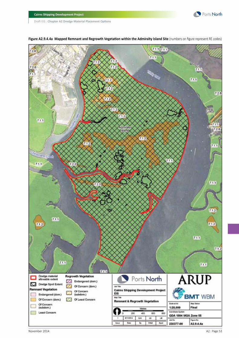
Cairns Shipping Development Project
Draft EIS : Chapter A2 Dredge Material Placement Options
A2 : Page 53November 2014
Figure A2.9.4.4a Mapped Remnant and Regrowth Vegetation within the Admiralty Island Site (numbers on figure represent RE codes)

Cairns Shipping Development Project
Draft EIS : Chapter A2 Dredge Material Placement Options
November 2014 A2 : Page 54
A2.9.4.5 Cane Land DevelopmentThe study area borders, and partially overlaps with estuary wetlands associated with the Port of Cairns and Trinity Inlet (PCTI) Nationally Important Wetland. Parts of these wetlands would be traversed to access the site, involving substantial removal of mangrove habitat associated with these wetlands. The proposed DMPA area does not allow for a buffer to these wetlands, which is required under current legislation.
The Cane Land Development site is bordered to the east by Mackey Creek and to the west by Wrights Creek and is considered a floodplain. Due to potential ASS leachate, treatment of runoff from the DMPA will be required before it is discharged into the creeks of Trinity Inlet.
The site borders a large area of RE associated with the estuary area to the north. The site is dominated by agriculture with fringing areas of RE. These are described in Table A2.9.4.5a and shown in Figure A2.9.4.5a below.
Table A2.9.4.5a Mapped RE within the Cane Land Development Site
Description
Floodplain (other than floodplain wetlands). Eucalyptus tereticornis, Corymbia tessellaris, E. pellita, C. intermedia, Melaleuca dealbata and Lophostemon suaveolens woodland to open forest, often with a secondary tree layer of Acacia mangium and A. crassicarpa, and with a very well developed vine forest understorey. Alluvial plains of lowlands.
Mesophyll vine forest. Moderately to poorly-drained alluvial plains, of moderate fertility. Lowlands of the very wet and wet zone.
Mangrove closed forest to open shrubland of areas subject to regular tidal inundation
Estuarine wetlands (e.g. mangroves). Mesophyll vine forest/mangrove complex. Canopy species include Heritiera littoralis, Bruguiera gymnorhiza, Sonneratia alba, Barringtonia racemosa, Archontophoenix alexandrae, Elaeocarpus grandis, Melicope elleryana, Acacia mangium and Syzygium tierneyanum. Inland margins of mangroves and estuaries.
RE Code and Classification
7.3.12b Endangered
7.3.10a Of Concern
7.1.1 Least Concern
7.1.4a Of Concern
Location within Study Area
Along Wrights Creek, along the eastern border of the site.
A small patch exists in the east of the site. It is part of a larger patch along Mackeys Creek.
Patches exist on the eastern and northern borders of site.
A small patch exists in the north west of the site.
A Threatened Ecological Community (TEC) known as the ‘Broad Leaf Tea-tree (Melaleuca viridiflora) Woodlands in High Rainfall Coastal North Queensland’ may exist within a five km radius of the DMPA. No mapped REs in the area correspond with this community however and it was not identified as being present during the site visit, though no thorough survey for this TEC was conducted.
The site generally provides limited habitat value for native flora and fauna, due to the extent of agricultural land use. Certain types of vertebrate fauna (particularly snakes and birds) do utilise agricultural land as habitat however, and Pheasant Coucal (Centropus phasianinus), Masked Lapwing (Vanellus miles) and Cockatoo (Cacatua galerita) were observed to be utilising the agricultural land during the site visit. The Wildlife Online Search Results for the site do not contain any records of fauna.

Cairns Shipping Development Project
Draft EIS : Chapter A2 Dredge Material Placement Options
A2 : Page 55November 2014
Appendix D5 assesses the likelihood that migratory, threatened and near-threatened species protected under the EPBC Act and/or NC Act would inhabit the potential DMPA. Although it has been identified that 38 migratory, threatened or near-threatened flora and fauna species are either known to exist within the PMST search area or have the possibility of existing in the area, most of these species would be limited to the areas of remnant vegetation and wetland that fringe the site.
Nonetheless, the following species may utilise habitat within the agricultural areas:
• Ardea alba (Great Egret), listed as a migratory and marine species under the EPBC Act
• Ardea ibis (Cattle Egret), listed as a migratory and marine species under the EPBC Act
• Ephippiorhynchus asiaticus (Black-necked stork), listed as near-threatened under the NC Act
• Haliaeetus leucogaster (White-bellied Sea-Eagle), listed as migratory and marine under the EPBC Act
• Hirundo rustica (Barn Swallow), listed as migratory and marine under the EPBC Act
• Merops ornatus (Rainbow Bee-eater), listed as migratory and marine under the EPBC Act.
Some of the mapped remnant vegetation is identified as essential habitat for Cassowary (see Appendix D5), though the habitat areas are unlikely to represent core habitat for this species due to the fragmented nature of the site, the presence of barriers between larger, more suitable habitat areas (e.. the Bruce Highway), the existence of an urban/rural matrix, and the size of habitat patches.
The project also has the potential to indirectly impact riverine and marine habitat values beyond the site boundary via the release of ASS leachate or tailwater in the event that it is not adequately managed, and the removal of wetland habitat in order to access the site.
Overall, the use of the Cane Land site itself is unlikely to directly result in significant loss of terrestrial habitat; however, there will be substantial loss of wetland vegetation associated with gaining site access for the pumping of material to the storage area.

Cairns Shipping Development Project
Draft EIS : Chapter A2 Dredge Material Placement Options
November 2014 A2 : Page 56
Figure A2.9.4.5a Remnant and Regrowth Vegetation on Cane Land Development site (numbers on figure represent RE codes)

Cairns Shipping Development Project
Draft EIS : Chapter A2 Dredge Material Placement Options
A2 : Page 57November 2014
A2.9.4.6 Summary of Habitat ValuesSignificant habitat values exist across the East Trinity, Esplanade and Admiralty Island sites, whilst the Cane Land Development and Airport site provide limited habitat values due to their current land uses.
East Trinity provides a large area of rehabilitating native forests and estuary environments, which form part of the PCTI Nationally Important Wetland. This provides habitat for numerous threatened and migratory species, with habitat value expected to increase as the site’s ASS management progresses.
The Esplanade is also part of the PCTI Nationally Important Wetland. In addition, it is part of the Trinity Inlet Fish Habitat Area and the GBRWHA. Importantly, the Esplanade DMPA footprint has historically contained seagrass meadows. Also, the mudflats are known to be important habitat for threatened and migratory species, and are an easy to access and popular bird watching location by international visitors for this reason. There is also a small patch of mangroves in the north of the study area, which would provide some habitat value for flora and fauna (including threatened and migratory species).
Admiralty Island is also mapped within the PCTI Nationally Important Wetland, is within the GBRWHA and the GBRMP Estuarine Conservation Zone, and is a FHA. As remnant vegetation exists across the island, it provides an important and large stretch of habitat within Trinity Inlet.
Despite the current land uses, the Cane Land Development and Airport sites provide some (limited) habitat value for native fauna, particularly birds that commonly utilise open habitats. Both areas also exist in close proximity to the PCTI Nationally Important Wetland, remnant vegetation and GBRWHA, and will require some clearing to allow dredge material to be piped to the site.
In terms of scoring, the land area required and the habitat values within each land placement site require consideration. For this reason, East Trinity, Esplanade and Admiralty Island sites would score lower than the Cane Land Development and Airport sites due to the important habitat values existing at these sites which would be lost due to dredge material placement. However, as the Airport site also includes the Esplanade as a secondary placement site, it would score the same as the Esplanade.
Land Placement Option Scoring (Scoring: 1=poor performance, 6=excellent performance)
Criterion
Habitat
East Trinity
Placement
2
Develop
2
Cane Land
Develop
3
Admiralty Island
Placement
2
Airport
Develop
1
Esplanade
Placement
1
Develop
1
A2.9.5 Air/Noise/Odour ImpactsA2.9.5.1 Air QualityAmbient air quality in Cairns is generally considered to be within acceptable limits (as defined by the Environmental Protection (Air) Policy 2008, which sets air quality objectives for Queensland), to the extent that the DEHP do not consider that monitoring of air pollutants is necessary. Engine exhaust emissions are likely to be the predominant anthropogenic source of air pollution in the region.
The placement of dredge material on land is likely to generate emissions from a number of sources during the transport and placement of the material. The works are likely to generate particulate and dust emissions through vehicle movements on-site and to-site via haul roads, disturbance of soils, materials handling and wind erosion of exposed surfaces. When material is initially placed at site, it will be very wet and dust generation would be minimal. As it dries however over time, dust generation will increase and will be difficult to control as the material will be too soft for machinery to gain access. In windy conditions, a significant amount of dust may be generated. Once stabilised and treated, the contribution of dust to the surrounding environment should be significantly reduced.
Under Queensland legislation, the impacts of air quality are measured through the likely exceedance of air quality limits at sensitive receivers. This is defined under the State Planning Policy (2013) as a child care centre, community care centre, community residence, dual occupancy, dwelling house, educational establishment, health care services, hospital, hostel, multiple dwelling, relocatable home, residential care facility, retirement facility, short-term accommodation or tourist park.
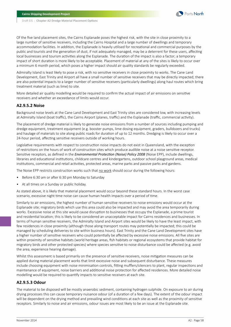
Cairns Shipping Development Project
Draft EIS : Chapter A2 Dredge Material Placement Options
November 2014 A2 : Page 58
Of the five land placement sites, the Cairns Esplanade poses the highest risk, with the site in close proximity to a large number of sensitive receivers, including the Cairns Hospital and a large number of dwellings and temporary accommodation facilities. In addition, the Esplanade is heavily utilised for recreational and commercial purposes by the public and tourists and the generation of dust, if not adequately managed, may be a deterrent for these users, affecting local businesses and tourism activities along the Esplanade. The duration of the impact is also a factor; a temporary impact of short duration is more likely to be acceptable. Placement of material at any of the sites is likely to occur over a minimum 6 month period, which poses a higher impact should air quality standards be regularly exceeded.
Admiralty Island is least likely to pose a risk, with no sensitive receivers in close proximity to works. The Cane Land Development, East Trinity and Airport all have a small number of sensitive receivers that may be directly impacted; there are also potential impacts to a larger number of sensitive receivers (particularly dwellings) along haul routes which bring treatment material (such as lime) to site.
More detailed air quality modelling would be required to confirm the actual impact of air emissions on sensitive receivers and whether an exceedance of limits would occur.
A2.9.5.2 NoiseBackground noise levels at the Cane Land Development and East Trinity sites are considered low, with increasing levels at Admiralty Island (boat traffic), the Cairns Airport (planes, traffic) and the Esplanade (traffic, commercial activity).
The placement of dredge material is likely to generate noise emissions from a number of sources including pumping and dredge equipment, treatment equipment (e.g. booster pumps, lime dosing equipment, graders, bulldozers and trucks) and haulage of materials to site along public roads for duration of up to 12 months. Dredging is likely to occur over a 24-hour period, affecting sensitive receivers outside of working hours.
Legislative requirements with respect to construction noise impacts do not exist in Queensland, with the exception of restrictions on the hours of work of construction sites which produce audible noise at a noise sensitive receptor. Sensitive receptors, as defined in the Environmental Protection (Noise) Policy 2008 (Noise EPP), include dwellings, libraries and educational institutions, childcare centres and kindergartens, outdoor school playground areas, medical institutions, commercial and retail activities, protected areas, marine parks and passive parks and gardens.
The Noise EPP restricts construction works such that no work should occur during the following hours:
• Before 6:30 am or after 6:30 pm Monday to Saturday
• At all times on a Sunday or public holiday.
As stated above, it is likely that material placement would occur beyond these standard hours. In the worst case scenario, excessive night time noise can cause human health impacts over a period of time.
Similarly to air emissions, the highest number of human sensitive receivers to noise emissions would occur at the Esplanade site; migratory birds which use this area could also be impacted and may avoid the area temporarily during works. Excessive noise at this site would cause disruption to businesses that occupy the Esplanade, a prime tourist and residential location; this is likely to be considered an unacceptable impact for Cairns residences and businesses. In terms of human sensitive receivers, the Admiralty Island and Airport sites would be likely to have the least impact, with few residences in close proximity (although those along transport routes may potentially be impacted; this could be managed by scheduling deliveries to site within business hours). East Trinity and the Cane Land Development sites have a higher number of sensitive receivers who could potentially be affected by excessive noise emissions. All five sites are within proximity of sensitive habitats (world heritage areas, fish habitats or regional ecosystems that provide habitat for migratory birds and other protected species) where species sensitive to noise disturbance could be affected (e.g. avoid the area, experience hearing damage).
Whilst this assessment is based primarily on the presence of sensitive receivers, noise mitigation measures can be applied during material placement works that limit excessive noise and subsequent disturbance. These measures include choosing equipment with noise minimisation controls, fitting mufflers/silencers to plant, regular inspections and maintenance of equipment, noise barriers and additional noise protection for affected residences. More detailed noise modelling would be required to quantify impacts to sensitive receivers at each site.
A2.9.5.3 OdourThe material to be disposed will be mostly anaerobic sediment, containing hydrogen sulphide. On exposure to air during drying processes this can cause temporary nuisance odour (of a duration of a few days). The extent of the odour impact will be dependent on the drying method and prevailing wind conditions at each site as well as the proximity of sensitive receptors. Similarly to noise and air emissions, odour issues are most likely to be an issue at the Esplanade site.

Cairns Shipping Development Project
Draft EIS : Chapter A2 Dredge Material Placement Options
A2 : Page 59November 2014
A2.9.5.4 Summary of Air, Noise and Odour IssuesThe proposed Esplanade site is located in close proximity to sensitive receptors including public parkland, commercial activities, Cairns Hospital and a large number of dwellings and temporary accommodation facilities. Any medium to long-term air, noise or odour nuisance during placement and drying is likely to be viewed as unacceptable by the community.
The Cane Land Development, East Trinity and Airport all have a small number of sensitive receivers nearby that may be directly impacted by air, noise and odour issues; though there are also potential noise impacts to a larger number of sensitive receivers (particularly dwellings) along haul routes which bring treatment material (such as lime) to site.
Admiralty Island is likely to have the lowest impact of all options due to the small number of sensitive receivers in the area.
With all sites, there is potential that noise will cause disturbance to wildlife, with birds species (e.g. reduced foraging times) likely to be most disturbed.
In terms of scoring, those sites which result in the greatest air, noise and odour impacts (and hence the lowest performance) will score the lowest. Therefore, the Esplanade will score the lowest, with Cane Land Development, East Trinity and Airport scoring slightly higher. However, as mentioned previously, the Airport option includes the Esplanade as a secondary placement site, so would therefore score the same as the Esplanade. Admiralty Island will score the highest due to its distance from sensitive receivers.
Land Placement Option Scoring (Scoring: 1=poor performance, 6=excellent performance)
Criterion
Air/Noise/Odour
East Trinity
Placement
3
Develop
3
Cane Land
Develop
3
Admiralty Island
Placement
4
Airport
Develop
2
Esplanade
Placement
2
Develop
2
A2.9.6 Pest Introduction/AttractionLand-based placement of dredge material will involve large bunded areas where dredge material in slurry form will initially be placed. These placement areas would represent modified habitats and large areas of ponding water would be present during the dewatering and treatment of tailwater. As a result, these areas may become attractive to a range of pest species due to the modified nature of the placement areas and the exposed areas of water.
In regard to the land-based placement areas, the following pests may potentially create a nuisance to surrounding land uses. These pests include:
• Birds attracted to areas containing open water bodies within and surrounding the airport – this represents a safety risk to aircraft landing and taking off from the airport
• Mosquitoes – due to the modified nature of the placement site, and areas of open water, additional mosquito breeding habitat could be unintentionally created
• Weeds – disturbed land may lead to the colonisation of weed species.
The only placement site where birds would be of greater concern would be the Airport site. The other sites are located far enough away from air traffic to be of less concern. Therefore, for this criterion, the airport site would score less than the other sites.
In terms of creating additional mosquito breeding habitat, sites which are used for placement purposes only would represent a higher risk as the area would be less disturbed (i.e. sites used for development would be undergoing ongoing treatment works). Furthermore, placement sites located in closer proximity to the urban population would pose a greater risk from an increase in mosquito breeding areas. Therefore, the site with the highest risk would be Admiralty Island (placement site located close to Cairns urban centre), followed by the Esplanade and then East Trinity. The sites posing the least risk would be the airport (small site being developed) and then the Cane Land Development due to its distance from urban population.

Cairns Shipping Development Project
Draft EIS : Chapter A2 Dredge Material Placement Options
November 2014 A2 : Page 60
In regard to weeds, initially the dredge material may be largely unsuitable for the colonisation of vegetation due to potential in situ salinity, acidity and soil stability. However, as the dredge material dries and leaches acids and salts, salt tolerant weeds are likely to be the first to colonise the crust due to site soil conditions as well as their pioneering nature as weeds. Other native salt tolerant vegetation may also colonise (e.g. Salt couch), though this will depend on competition from weed species and other environmental conditions. Weed management will be largely unfeasible until the DMPA is safe to walk on. Placement sites where weeds would pose the greatest risk to adjoining areas would include East Trinity and Cane Land Development. At the other sites, the surrounding land use would potentially limit the spread of weed species.
Land Placement Option Scoring (Scoring: 1=poor performance, 6=excellent performance)
Criterion
Pests
East Trinity
Placement
3
Develop
4
Cane Land
Develop
3
Admiralty Island
Placement
2
Airport
Develop
2
Esplanade
Placement
2
Develop
4
A2.9.7 Cultural Heritage/Native TitleOnshore placement of dredge material needs to take into consideration potential impacts to cultural heritage values and potential native title.
Native title is recognised and protected in accordance with the Native Title Act 1993 (NTA). The NTA establishes a regime by which it can be determined whether native title exists in respect of land and waters, or whether native title has been extinguished. Indigenous cultural heritage is protected under the Aboriginal Cultural Heritage Act 2003 (QLD) and non-indigenous heritage by the Queensland Heritage Act 1992.
A2.9.7.1 Non-indigenous Cultural HeritageThere are three sites listed on the Queensland Heritage Register within proximity of the Esplanade site. These include the Cairns War Memorial, Floriana (a boarding house constructed in 1939) and the Mulgrave Shire Council Chambers. None of these listed premises would be directly impacted by works. There are no other non-indigenous cultural heritage sites in close proximity to the other potential placement locations.
A2.9.7.2 Indigenous Cultural HeritageThe indigenous history of the Cairns region is rich, and its environs have been extensively used by Aboriginal people and continue to hold cultural significance. Consultants who have conducted surveys in the Cairns southern corridor region have all noted the importance of the landscape as a whole to the Aboriginal people they consulted (Converge, 2013). There is specific mention of Trinity Inlet as an important sacred site and birthing place. Admiralty Island is associated with a number of women’s stories and noted as a sacred and significant place. The foot of the hills in the vicinity of Hills Creek (East Trinity site) is also noted. Further the importance of the area as a food resource in both pre-contact and historic periods is emphasised (Fourmile, H. & W. Mundraby, 1995, p. n.p.).
Consultancies relating to the proposed East Trinity Development of 1995 note Aboriginal sites were located:
• On the sand ridges in East Trinity; Pandanus resources site, deposit of shell fragments and stone flakes and an isolated flake
• In the West Trinity area; a modern shell scatter, two contemporary fishing and crabbing sites
• On Admiralty Island (two possible sites on a chenier)
• Along the Bund Wall (five shell scatters of possible recent origin).
Aboriginal cultural heritage (shell middens and scattered artefacts) have been recorded and are registered in the Aboriginal Cultural Heritage Register at Admiralty Island and the Airport sites. The database is not likely to reflect a complete picture of the Aboriginal cultural heritage values of each site however, and further consultation with indigenous parties would be required to confirm potential impacts to cultural heritage. These finds do provide an indication that further cultural heritage values may be present at these sites.

Cairns Shipping Development Project
Draft EIS : Chapter A2 Dredge Material Placement Options
A2 : Page 61November 2014
Based on present known values, the East Trinity, Airport and Admiralty Island sites are all likely to hold cultural heritage significance which may be affected by material placement. Although not well documented, it is also possible that the Cane Land Development and Esplanade sites retain indigenous cultural heritage value that may be affected by works given their coastal location. Further consultation with aboriginal parties (and potentially archaeological surveys and negotiation of a Cultural Heritage Management Plan) would be required to determine the significance of the potential impact and whether this can be protected from harm through the avoidance or removal of items of significance.
A2.9.7.3 Native TitleThe following native title claims have been made across the five sites:
• The Gimuy Walubara Yidinji people (QC2012/017) have a registered claim over Admiralty Island, the Cane Land Development, The Esplanade and Cairns Airport
• The Yirrganydji (Irukandji) People (QC2012/017) have a registered claim over Admiralty Island
• The Mandingalbay Yidinji people have been granted native title over coastal land immediately adjacent to the East Trinity site; this land would need to be traversed to gain access to East Trinity.
In accordance with the Commonwealth Native Title Act 1993, native title is extinguished on freehold property, therefore is likely to be extinguished over the airport and East Trinity (the DMPA site is freehold, however, access to the site would need to traverse land over which native title has been granted), but is likely to continue to exist on the other sites which are leasehold or unallocated state lands.
In addition, there is an Indigenous Land Use Agreements (ILUA) in place (QIA2000/001) over the southern portion of the Esplanade site between Cairns City Council, Jeanette Singleton (on behalf of the Yirrganydji People), and Seith Fourmile (Snr) and Seith Fourmile (Jnr) (on behalf of the Gimuy Walubara Clan of the Yidinji People).
Use of the Admiralty Island, Cane Land Development, East Trinity, the Esplanade and potentially Cairns Airport would require further consideration of native title interests and may involve the negotiation of an ILUA. Whilst this is not in itself likely to pose a barrier to the placement of material, negotiations can have time and cost implications
Native Title and Aboriginal Cultural Heritage Advice
In March 2014, Converge Heritage and Community (Converge) and King and Wood Mallesons (KWM) provided advice to Ports North in relation to native title and ICH issues associated with the land placement options. A summary of their advice is provided below.
Airport
Based on native title and Aboriginal cultural heritage considerations only, Cairns Airport Site is a good option. Native title is extinguished within the lot that comprises the site, there is one Aboriginal Party for cultural heritage purposes within the site, and whilst there are numerous instances of registered Aboriginal cultural heritage within the site, it is likely that as an airport site the prevalence of these is directly connected to the fact that surveys have been previously conducted and what was identified has been reasonably well documented. There is also a possibility that what is registered is no longer representative of what is located on the site as the register may not have been updated for management measures previously carried out.
Esplanade
Based on native title and Aboriginal cultural heritage considerations only, Cairns Esplanade Site is a fair option. Native title in the site is not extinguished by tenure but may be extinguished by public works. There are two registered native title claimants over all or part of the site lots. Similarly, there are two Aboriginal Parties for cultural heritage purpose over the site. There is no registered cultural heritage within the site. The Project may also be able to take the benefit of consents under an existing ILUA in relation to the site, entered into by Cairns Regional Council, subject to further investigations.
East Trinity
Based on native title and Aboriginal cultural heritage considerations only, East Trinity Site is a poor option. Whilst native title has been extinguished on the placement area (as the land was formerly freehold in tenure), native title has been granted to land over which access is required to the seaward boundary. The site is also complicated by the overlay with an Indigenous Protected Area. There is registered Aboriginal cultural heritage within the site, and overall, the site is of such a nature that it is very likely to include intangible and resource areas of cultural heritage significance.

Cairns Shipping Development Project
Draft EIS : Chapter A2 Dredge Material Placement Options
November 2014 A2 : Page 62
Admiralty Island
Based on native title and Aboriginal cultural heritage considerations only, Admiralty Island Site is a poor option. There is no immediate basis to conclude native title may be extinguished within the single lot that comprises this site. Subject to confirming the correct lot on plan number, there is a single registered native title claim over the area and a single Aboriginal Party for cultural heritage purposes, and there is no registered Aboriginal cultural heritage within the area. However, it is considered that the nature of this site is such that it is very likely to include intangible and resource areas of cultural heritage significance, and any use of this site for the Project is likely to draw active interest from a number of traditional owner groups.
Cane Land Development
Based on native title and Aboriginal cultural heritage considerations only, Cane Land Development Site is a fair option, subject to which parts of the area are ultimately utilised. Native title is extinguished in some lots within the site, may be extinguished in other lots within the site and is unlikely to be extinguished within a number of lots within the site. There is one registered native title claim and one registered Aboriginal Party over parts of the site, although this should be further confirmed having regard to lack of data in relation to some lots and anecdotal evidence in relation to the area. There is no registered Aboriginal cultural heritage within the site. However, anecdotal evidence, together within the expanse of land involved and previous land use not triggering the need for surveys suggest that the site has a high likelihood of Aboriginal cultural heritage, particularly around Wrights Creek.
A2.9.7.4 Summary of Cultural Heritage/Native TitleBased on the above, East Trinity and Admiralty Island would score the lowest in the MCA due to potential issues with native title and high potential for cultural heritage values to exist. The Esplanade and Cane Land Development sites are ‘fair’ options and would score slightly better than East Trinity and Admiralty Island due to fewer potential issues with native title and cultural heritage values. The Airport site would score the best as native title is extinguished, and cultural heritage values within the site have been well documented and likely no longer represent what is located on the site.
Land Placement Option Scoring (Scoring: 1=poor performance, 6=excellent performance)
Criterion
Cultural Heritage
East Trinity
Placement
2
Develop
2
Cane Land
Develop
3
Admiralty Island
Placement
2
Airport
Develop
4
Esplanade
Placement
3
Develop
3
A2.9.8 TrafficA2.9.8.1 Estimated Traffic VolumesPlacement of dredge material on land would involve the transport of materials for treatment of the dredge material and for construction purposes. To provide an indication of potential traffic issues which may result from transport of this material, a high level estimate of heavy vehicle use has been determined for each land placement option.
This high level traffic assessment is based on the concept designs of the land placement options, and includes consideration of the delivery of materials such as lime, clay, stone and geo-synthetic liner to the placement site. It should be noted that to accurately determine the full traffic impact associated with the use of each land placement option, a more detailed Road Impact Assessment would be required.
Table A2.9.8.1a presents the expected number of total truck loads, total vehicle trips, and daily vehicle trips based on the delivery of materials for the each land placement option. This assumes a truck load capacity of 25 tonnes.

Cairns Shipping Development Project
Draft EIS : Chapter A2 Dredge Material Placement Options
A2 : Page 63November 2014
Table A2.9.8.1a Estimated Delivery vehicle trips
Delivery Vehicle Trips
Total truck loads
Total vehicle trips
Daily vehicle trips
East Trinity
Placement
83,783
183,513
512
Develop
94,186
207,785
612
Cane Land
Develop
191,331
446,084
1,265
Admiralty Island
Placement
74,676
173,889
486
Airport
Develop
12,272
28,632
81
Esplanade
Placement
67,067
154,224
431
Develop
77,470
178,496
531
A2.9.8.2 Potential Traffic IssuesGeneral
Based on a high level estimate of heavy vehicle generation, there is the potential for impacts to the external traffic network from an operational and safety perspective. These include:
• Operation of existing road network – impacts on traffic volumes at intersections and pavement impacts
• Hazard and safety impacts from an increase in heavy vehicle traffic
• Amenity and nuisance, including noise and dust
• Environmental issues related to potential spillage of dredge material on roads
• This section outlines the potential traffic issues for each land placement option.
Airport
Potential traffic issues for the Airport site include the following:
• Potential safety issues at the Airport Avenue/Site Access intersection. This will be dependent on entry treatment and access geometry
• Operation to the Captain Cook Highway/Airport Avenue intersection could be outside of acceptable limits of operation
• Potential for pavement impacts on Airport Avenue/Captain Cook Highway in the vicinity of the site
• Potential for localised traffic impacts at the quarry or borrow pit location of materials for construction and operation (i.e. clay, lime).
East Trinity
Potential traffic issues for the East Trinity site include the following:
• Potential safety issues at the Bruce Highway/Warner Road intersection due to queuing on the Warner Road Leg and Bruce Highway (south) right hand turn movement
• Potential for safety issues on the Warner Road link and Pine Creek Road link based on increase to traffic volumes and existing road geometry
• Operation to the Bruce Highway/Warner Road intersection could be outside of acceptable limits of operation
• Potential for pavement impacts on Bruce Highway, Warner Road and Pine creek road in the vicinity of the site
• Potential for localised traffic impacts at the quarry or borrow pit location of materials for construction and operation (i.e. clay, rock, lime).

Cairns Shipping Development Project
Draft EIS : Chapter A2 Dredge Material Placement Options
November 2014 A2 : Page 64
Admiralty Island
In determining potential issues for the Admiralty Island option, it was assumed that trucks would be barged across to Admiralty Island from the Tingira Street barge ramps, Portsmith. Potential traffic issues for the Admiralty Island site include the following:
• Potential safety issues at the Bruce Highway/Aumuller Street intersection due to queuing on the Aumuller Street Leg and Bruce Highway (south) right hand turn movement
• Potential for safety issues on the Aumuller Street link and Tingira Street link based on increase to traffic volumes and existing road geometry
• Operation to the Bruce Highway/Aumuller Street intersection and Aumuller Street/Cook Street Roundabout could be outside of acceptable limits of operation
• Potential for pavement impacts on Bruce Highway, Aumuller Street and Tingalpa Street road in the vicinity of the site
• Potential for localised traffic impacts at the quarry or borrow pit location of materials for construction and operation (i.e. clay, rock, lime)
• Potential for queuing and safety issues at the barge ramp facility
• Impediments to transit of trading vessel traffic along Smith’s Creek due to the cross creek transit of barges carrying the trucks.
Cane Land Development
Potential traffic issues for the Cane Land Development site include the following:
• Potential safety issues at the Bruce Highway/Thompson Road and/or Bruce Highway/Hill Road intersection due to queuing on Bruce Highway (south) right hand turn movement and side road queuing
• Potential for safety issues on the Thompson Road link and/or Hill Road link based on increase to traffic volumes and existing road geometry
• Operation to the Bruce Highway/Thompson Road and/or Bruce Highway/Hill Road intersection could be outside of acceptable limits of operation
• Potential for pavement impacts on Bruce Highway, Thompson Road and Hill Road in the vicinity of the site
• Potential for localised traffic impacts at the quarry or borrow pit location of materials for construction and operation (i.e. clay, rock, lime).
Esplanade
Potential traffic issues for the Esplanade site include the following:
• Potential safety issues at numerous intersections within the CBD along haulage route
• Operation of numerous intersections within the CBD could be outside of acceptable limits of operation along haulage route
• Potential for pavement impacts on CBD intersections along haulage route
• Potential safety issues due to conflict between haulage vehicles and pedestrians at site entry location and intersections along haulage route
• Potential for localised traffic impacts at the quarry or borrow pit location of materials for construction and operation (i.e. clay, rock, lime).
A2.9.8.3 Summary of Traffic IssuesIn terms of potential traffic issues, each placement site would likely cause potential impacts at various intersections due to queuing of vehicles. There is also the potential for pavement impacts due to increased heavy vehicle numbers, and the potential for localised traffic impacts at the material source (e.g. quarry or borrow pit location).
The magnitude of potential traffic issues, including issues related to road network, safety, amenity (noise/dust) and environmental issues related to spillage of dredge material from trucks, is somewhat in proportion to the expected numbers of heavy vehicles, along with the haulage route considerations. The placement option with the most number of truck loads (and vehicle trips) is the Cane Land Development site. Therefore, for MCA scoring purposes, the Cane Land Development site would score relatively low.

Cairns Shipping Development Project
Draft EIS : Chapter A2 Dredge Material Placement Options
A2 : Page 65November 2014
The placement option with least number of truck loads, and potentially the best MCA score, is the Airport site. However, as the Esplanade is assumed to be a secondary placement site for this option, traffic impacts for the Airport would be similar to the Esplanade site (development option). While the Esplanade has fewer number of total vehicle trips compared to other options, the haulage route through the CBD would exacerbate traffic issues, resulting in a lower MCA score for the Esplanade.
Land Placement Option Scoring (Scoring: 1=poor performance, 6=excellent performance)
Criterion
Traffic
Criterion
Community Benefit
East Trinity
Placement
4
East Trinity
Placement
2
Develop
3
Develop
4
Cane Land
Develop
2
Cane Land
Develop
3
Admiralty Island
Placement
3
Admiralty Island
Placement
2
Airport
Develop
3
Airport
Develop
5
Esplanade
Placement
3
Esplanade
Placement
2
Develop
2
Develop
3
A2.9.9 Community BenefitLand-based placement of dredge material may potentially provide some benefit to the community in terms of valuable land use, depending on the final proposed end use for the placement site.
If the land-placement area can later be developed for residential, commercial or industrial uses, the land would represent an economic value to the community. This land would also provide social benefits to the community in the form of additional areas for housing and industry, or as public recreation areas.
Land placement areas used merely as placement areas would have limited economic value and would incur ongoing maintenance costs. These costs can include lost opportunity costs and costs to maintain infrastructure associated with the placement area, such as bunding, seepage control and public safety (e.g. fencing).
In terms of scoring, land placement sites proposed for development would therefore score higher than those proposed for placement only. Furthermore, sites located in closer proximity to the Cairns city centre would score higher than those located further away as they represent higher economic and social value. In this regard, the developed Esplanade and Airport options would score higher than the developed East Trinity option which would then score higher than the Cane Land option. However, as the Esplanade site is located close to the city centre there would likely be some level of community disruption which would detract from the scoring for this site.
Note that this criterion does not consider the existing environmental value that would be lost due to placement, e.g. the habitat value of the Cairns foreshore where the Esplanade site is proposed. This is addressed in other criteria such as habitat values/habitat loss. Also, the loss of intertidal habitat along the Esplanade would significantly impact on the wader bird population which could have adverse loss of income from international bird watching visitors, as well as the potential adverse international media amongst the bird watching community.
Land Placement Option Scoring (Scoring: 1=poor performance, 6=excellent performance)

Cairns Shipping Development Project
Draft EIS : Chapter A2 Dredge Material Placement Options
November 2014 A2 : Page 66
A2.9.10 Visual Amenity Issues A2.9.10.1 Cane Land DevelopmentThe Cane Land Development site comprises several farms currently cultivating sugar cane. They exist on a flood plain that is relatively flat, giving wide views of sugar cane fields under different cultivation stages, remnant vegetation and riverine corridors. Scattered rural buildings and houses occur in the study area, giving the area a feel typical of similar sugar cane cultivation areas in the region. A typical view of the area is shown in Figure A2.9.10.1a and Figure A2.9.10.1b.
There are limited external views of the site, though the site can be viewed from the surrounding hinterland (including Walsh’s Pyramid) and the surrounding road network.
A DMPA would cause a significant temporary visual impact, as the placement of dredge material will require the employment of trucks and earthmoving equipment on a continual basis, with night lighting, thus impacting the rural landscape character of the site. In the longer term after placement is complete, the site will appear as a raised platform of marine sediment and will appear largely incongruous within the surrounding landscape. However the visual impact will be limited as views of the site are minimal from the surrounding areas.
Figure A2.9.10.1a View within the Cane Land Development (looking north)

Cairns Shipping Development Project
Draft EIS : Chapter A2 Dredge Material Placement Options
A2 : Page 67November 2014
Figure A2.9.10.1b View within the Cane Land Development (looking east)
A2.9.10.2 EsplanadeSeaward views from and along the Esplanade are characterised by the intertidal area and ocean scapes. Views of the Esplanade include parkland and foreshore walkways, and multi-level hotels, offices and retail buildings. Additionally the site can be readily viewed from high rise city buildings, upper decks of cruise liners entering port and from aircraft landing or taking off from Cairns Airport.
Views of the intertidal area and foreshore development are shown in Figure A2.9.10.2a and Figure A2.9.10.2b.
The placement of dredge material in this area will result in impacts to visual amenity during and after the dredge campaign. During the dredge campaign, plant required for the delivery and pumping and management of dredge material will be in clear view from the Esplanade, with particular impacts at night with night lighting. Upon completion of the DMPA, the intertidal area will be covered in dredge material and is likely to appear as a raised platform of material until sufficient drying can occur and a top layer of vegetation or other landscaping can be established.
Due to the smothering of intertidal habitat, the existing wader bird population that utilise this area for foraging will be impacted thus changing visual experiences of the foreshore associated with bird watching.
In the long term, and with respect to potential engineering constraints, the placement area may be utilised as reclaimed land, specifically for use as parkland or other foreshore development. This has the potential to provide a positive improvement to visual amenity compared to an undeveloped dredge material placement area. It is noted that public perceptions of scenic amenity between baseline (undeveloped) and a developed foreshore may vary, however.

Cairns Shipping Development Project
Draft EIS : Chapter A2 Dredge Material Placement Options
November 2014 A2 : Page 68
Figure A2.9.10.2a Views of the Intertidal Area along the Esplanade (looking west towards the Cairns CBD)
Figure A2.9.10.2b Views of the Intertidal Area along the Esplanade (looking east towards the Marina)
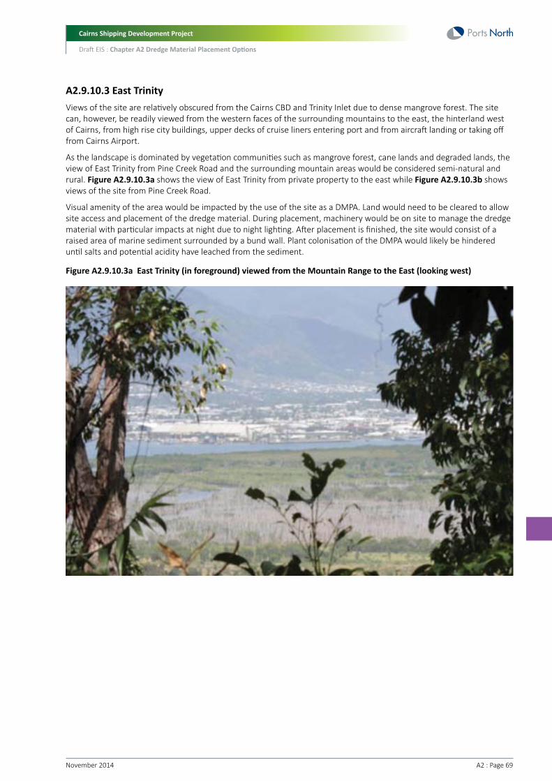
Cairns Shipping Development Project
Draft EIS : Chapter A2 Dredge Material Placement Options
A2 : Page 69November 2014
A2.9.10.3 East TrinityViews of the site are relatively obscured from the Cairns CBD and Trinity Inlet due to dense mangrove forest. The site can, however, be readily viewed from the western faces of the surrounding mountains to the east, the hinterland west of Cairns, from high rise city buildings, upper decks of cruise liners entering port and from aircraft landing or taking off from Cairns Airport.
As the landscape is dominated by vegetation communities such as mangrove forest, cane lands and degraded lands, the view of East Trinity from Pine Creek Road and the surrounding mountain areas would be considered semi-natural and rural. Figure A2.9.10.3a shows the view of East Trinity from private property to the east while Figure A2.9.10.3b shows views of the site from Pine Creek Road.
Visual amenity of the area would be impacted by the use of the site as a DMPA. Land would need to be cleared to allow site access and placement of the dredge material. During placement, machinery would be on site to manage the dredge material with particular impacts at night due to night lighting. After placement is finished, the site would consist of a raised area of marine sediment surrounded by a bund wall. Plant colonisation of the DMPA would likely be hindered until salts and potential acidity have leached from the sediment.
Figure A2.9.10.3a East Trinity (in foreground) viewed from the Mountain Range to the East (looking west)

Cairns Shipping Development Project
Draft EIS : Chapter A2 Dredge Material Placement Options
November 2014 A2 : Page 70
Figure A2.9.10.3b Trinity, viewed from Pine Creek Road (looking south-west)
A2.9.10.4 AirportThe Airport DMPA study area is predominantly mown grass and bitumen as part of the runway strip and associated infrastructure. This area can be viewed from parts of Airport Drive or from aircrafts landing or taking off from the Cairns Airport. Figure A2.9.10.4a shows the view of this area from Airport Drive.
As the airport could use the dredge material as fill for future development, visual amenity would be influenced by the construction of aviation-related services and industrial buildings. The Cairns Airport Land Use Plan (Cairns Airport 2012) states that the area would be designed to positively contribute to the visual character and streetscape of the area. The airport’s acceptance of dredge material would be contingent on the feasibility of using it as fill for construction.
Figure A2.9.10.4a The planned Western Mixed Aviation Area at Cairns Airport (looking south from Airport Drive)
Cairns Shipping Development Project
Draft EIS : Chapter A2 Dredge Material Placement Options
A2 : Page 71November 2014
A2.9.10.5 Admiralty IslandAdmiralty Island can be viewed from vessels within Trinity Inlet and from aircraft taking off and landing at Cairns Airport. Currently, views of the island encompass mudflats, sandflats, saltpans and mangrove forest, which fringe the entire coastline of the island. Views of the island from a vessel in Trinity Inlet are shown in Figure A2.9.10.5a.
Use of Admiralty Island as a DMPA would require significant clearing of mangroves for site access and to provide an area for dredge material to be placed. The impact to visual amenity as viewed from Trinity Inlet can be reduced by using the centre of the island whilst maintaining fringing mangroves as a visual shield. Despite this, dredge material would be able to be viewed from aircraft material with particular impacts at night due to night lighting.
Figure A2.9.10.5a A Typical View of the Edge of Admiralty Island
A2.9.10.6 Summary of Visual Amenity IssuesLand placement of dredge material would potentially cause the greatest impact on visual amenity during the construction phase. For developed sites, the visual amenity impacts after ground treatment and development will likely to be somewhat reduced. For placement sites, visual amenity impacts would likely be more prolonged. MCA scoring has been undertaken considering the placement/ground treatment phase and the developed phase (where relevant).
During the construction phase, placement of dredge material at the Esplanade would be likely to provide the highest impact to visual amenity out of the five land placement sites. This is due to the high level of visual exposure from the surrounding land uses and the current visual amenity significance associated with the seascape and parkland views. However, once developed, the visual amenity at the Esplanade option would likely be enhanced, if developed as a larger landscaped public open space compared to the existing.
Placement of dredge material at the Cane Land Development or East Trinity sites would impact visual amenity for those using the surrounding road network or for the small number of local residences that have views of the area. This is considered to represent a relatively low impact on visual amenity. Once developed, the visual amenity at these options would be enhanced.
There is potential that the visual amenity of Admiralty Island would be impacted due to the vegetation clearing that is required, though the impact can be significantly reduced with the use of visual screening (i.e. retaining fringing mangroves).

Cairns Shipping Development Project
Draft EIS : Chapter A2 Dredge Material Placement Options
November 2014 A2 : Page 72
At the Airport site there would be limited impact on visual amenity as the airport intends to develop the area as part of the Cairns Airport Land Use Plan. However, as the airport option includes placement at the Esplanade as a secondary placement site, this site would score similar to the Esplanade.
For these reasons, the Esplanade placement option (and airport) will score the lowest in regard to potential visual amenity impacts, while the Cane Land Development and East Trinity sites will score higher. Admiralty Island, East Trinity and the Esplanade development option would score the highest due to the isolation of Admiralty Island and East Trinity and the benefits to visual amenity from the developed Esplanade site.
Land Placement Option Scoring (Scoring: 1=poor performance, 6=excellent performance)
Criterion
Amenity
East Trinity
Placement
3
Develop
4
Cane Land
Develop
4
Admiralty Island
Placement
4
Airport
Develop
2
Esplanade
Placement
2
Develop
4
A2.9.11 Land Use Planning/Approvals/TenureThe Queensland Government provides strategic direction and guides land use planning in Queensland to achieve state interests through regional plans. The Cairns Local Government Area is included in the Far North Queensland Regional Plan 2009-2013 (DIP 2009) (FNQ Regional Plan). The FNQ Regional Plan is a central planning document designed to guide development in the region in a manner that achieves key environmental, social, economic and urban objectives. It was prepared jointly by all levels of government and key community stakeholders.
Specifically, the FNQ Regional Plan designates areas as ‘Urban Footprint’, ‘Regional Landscape and Rural Production’ (RLRP) and ‘Rural Living’. The designation of the urban footprint assists in providing the region’s urban development needs to 2031 by managing the growth of the region through limiting urban sprawl and out-of -centre growth. The RLRP designation identifies lands that have regional landscape, rural production or other non-urban values, and protects these areas from encroachment by inappropriate development, particularly urban or rural residential development.
Future urban growth will be accommodated in clearly defined areas, immediately adjacent to existing centres, whilst limiting coastal development which is vulnerable to a range of natural hazards. The greatest proportion of growth is earmarked for the Mount Peter Master Planned Area, immediately east of Edmonton, the area west of the Bruce Highway between Edmonton and Gordonvale and Smithfield. Expansion into areas with significant regional landscape or rural production values or land use constraints is to be avoided. Potential urban growth in the identified DMPAs is not supported by the FNQ Regional Plan, limiting the potential for future development on these land parcels within the short to medium term.
At a local government level, the Cairns Regional Council (CRC) details their planning intent for the City of Cairns through the Cairns Plan 2009 (the Cairns Plan). The Cairns Plan applies to the entire City, with the exception of areas identified as Strategic Port Land (SPL), for which Land Use Plans prepared and approved under the Transport Infrastructure Act 1994, apply. Cairns Airport and Cairns Port (including areas extending from Portsmith to Cairns North, tidal waters and East Trinity) are identified as SPL.
The Cairns Plan divides the city into 12 districts, each of which is subject to a detailed District Plan that provides information on the preferred pattern of development. The Cairns Plan also divides the City into 19 Planning Areas (herein referred to as ‘zones’) which identify the preferred dominant land uses. The zones for each of the DMPA options are identified in the following pages.
It is noted that Cairns Regional Council is in the process of drafting a new planning scheme for the region. It is currently being reviewed by the Queensland Government and is likely to be finalised at the end of 2014.
A2.9.11.1 Cane Land DevelopmentThe Cane Land Development site is made up of 33 properties, 29 of which are freehold properties currently used for residential living and cane farming. There is also a single area of State Land in the east of the site boundary. This area is owned by the State of Queensland, represented by the Department of Natural Resources and Mines.
The entire site is zoned as ‘Rural 1’ under the Cairns Planning Scheme and is a designated a Regional Landscape and Rural Production Area under the Far North Queensland Regional Plan. This designation includes lands that have regional landscape, rural production or other non-urban values, and protects these areas from encroachment by inappropriate development, particularly urban or rural residential development.

Cairns Shipping Development Project
Draft EIS : Chapter A2 Dredge Material Placement Options
A2 : Page 73November 2014
The protection of good agricultural land is one of the key fundamentals of the Cairns Planning Scheme and is a central pillar of the State’s targets in respect to economic productivity and employment, with the current State policy seeking to double agricultural production by 2040. Conversion of this existing agricultural land to a development site will have the following adverse consequences to the sugar industry:
• Loss of 637ha of cane land which represents approximately five percent of the total cane land in the Mulgrave Mill catchment. This results in an estimated loss of 51,000 tonnes of cane from the annual mill production of 1.1 M tonnes
• Loss of up to 10 farms out of the 200 farms located within the Mulgrave mill catchment
• Loss of approximately $3 M annually to the economy.
In order for this site to be utilised by the project, resumption of freehold property would be required, and a planning application for a ‘material change of use’ to reclassify its future use to ‘urban’ would be needed if the site was to be developed. This planning application could take some time to prepare, and may ultimately not receive approval from Cairns Regional Council.
For this site, areas of marine plants (e.g. mangroves) in the wetland area to the north would be required to be disturbed to provide access for pipeline installation and maintenance. The area of disturbance has not been quantified for this assessment, but this activity would require a number of approvals, including a permit to removal marine plants under the Fisheries Act 1994. Other required approvals are listed below.
A2.9.11.2 East TrinityEast Trinity is designated as Rural Land, under the Cairns Plan. It is also held in trusteeship by the Queensland Government as a Reserve for Environmental Purposes, under the Land Act 1994. There are two parcels of land on East Trinity. Under the provisions of the Land Act, changes to the site may not be undertaken which are not consistent with the purpose of the reserve, unless that use is deemed not to diminish the amenity of the area. Approval to utilise the site cannot be granted unless it is:
• Appropriate for the purpose and qualities of the trust land
• In the public interest
• Not substantially commercial in nature.
Any placement of dredge material at East Trinity will need to consider the designated conservation values of the site related to its current land tenure and zoning.
There are mechanisms available to change the tenure for some or all of the land to facilitate development which could include changing the purpose of the trust land; however, approval for a change in tenure would be required.
For this site, areas of marine plants (e.g. mangroves) would be required to be disturbed to provide access for pipeline installation and maintenance, construction of DMPA footprint (including bund walls), and vehicle access roads. The area of disturbance has not been quantified for this assessment, but this activity would require a number of approvals, including a permit to removal marine plants under the Fisheries Act 1994.
A2.9.11.3 The EsplanadeThe Esplanade is comprised of Leasehold land and Reserve land that exist above and below the high water mark. The Leasehold land is held by Far North Queensland Ports Corporation. Above the high tide mark the area is zoned as Open Space with the Cairns Regional Council Planning Scheme. Below the high tide mark, the planning scheme does not apply, and hence the area has no zoning.
Parts of the site above the high water mark are part of the Urban Footprint established by the Far North Queensland Regional Plan, which intends to provide for the region’s urban development needs to 2031, assisting in managing the growth of the region through limiting urban sprawl and out of centre growth.
The Port Land Use Plan 2006 also identifies the possible future use of this area to be Public & Tourist Facilities.
If the dredge material is used to extend the current foreshore area, the development will be consistent with the current intent under the Cairns Regional Council Planning Scheme, the North Queensland Regional Plan and the Port Land Use Plan.
Areas of marine plants (e.g. mangroves, salt couch and seagrass) would be required to be disturbed for the construction of DMPA footprint (including bund walls). The area of disturbance has not been quantified for this assessment, but this activity would require a number of approvals, including a permit to removal marine plants under the Fisheries Act 1994.

Cairns Shipping Development Project
Draft EIS : Chapter A2 Dredge Material Placement Options
November 2014 A2 : Page 74
A2.9.11.4 Cairns AirportThe site exists on a single freehold property, owned by Cairns Airport Property Holding Pty Ltd and is the only one of the five potential DMPA sites that is within the Urban Footprint. The site is classified as Strategic Port Land and is therefore excluded form zoning under the Cairns Plan. The site is also part of the Coastal Zone and Coastal Management District under the CPM Act, though development approval under the CPM Act will not be required.
As it is proposed that the dredge material will be used for the construction of an airport expansion, placement of dredge material would be considered consistent with Planning Scheme and Regional Plan zoning. The use of the site as a DMPA is also consistent with the proposed possible future uses for the land identified in the Port Land Use Plan 2006.
The following potential planning constraints are adjacent to the site, though are not directly impacted:
• The GBRWHA (which includes the waterways directly adjacent to the site)
• The waterways are also mapped within the GBRMP area, though no zoning exists for the area. In addition, an Estuarine Conservation Zone (as part of the marine park) lies to the east of the site; however, this area will not be directly impacted
• The Trinity Inlet FHA
• There are no state forests, reserves or national parks on the site, though the Mount Whitfield Conservation Park is just to the west of the site
• Areas of marine plants (e.g. mangroves, salt couch and seagrass) would be required to be disturbed for the pipeline access route and construction of DMPA footprint (including bund walls). The area of disturbance has not been quantified for this assessment, but this activity would require a number of approvals, including a permit to removal marine plants under the Fisheries Act 1994.
A2.9.11.5 Admiralty IslandAdmiralty Island is a single property (Lot 92 NR3051) owned by the Queensland Government and managed as part of the State reserve system by the Department of National Parks, Recreation, Sport and Racing. It was once vested by the former Cairns Port Authority (now Ports North) and considered for possible port expansion. Management of the land was transferred to the Queensland Government for conservation purposes in 1989, and declared as a component of the Trinity Inlet Fish Habitat Area in 1998.
The whole of Admiralty Island has been zoned for Conservation according to the Cairns Planning Scheme. This means that the area has been identified has having significant biological diversity, ecological integrity and scenic amenity and that the values are protected from the effects of development.
For this site, areas of marine plants (e.g. mangroves) would be required to be disturbed to provide access for pipeline installation and maintenance, construction of DMPA footprint (including bund walls), and vehicle access roads. The area of disturbance has not been quantified for this assessment, but this activity would require a number of approvals, including a permit to removal marine plants under the Fisheries Act 1994.
A2.9.11.6 Summary of Land Use Planning and TenureIn terms of scoring, those sites that have the highest constraints to approval (e.g. inconsistency with the relevant planning schemes and the number of approvals combined with the difficulty in obtaining approvals) will score the lowest. As it is likely that all sites will require a number of state and local planning approvals, all sites will score fairly low.
Sites such as the Esplanade and Admiralty Island will score low due to the environmental and planning constraints (which would require offsets). East Trinity would score slightly higher as it is state land and there is some support in the community for its development. The Cane Land Development site scores the lowest as it may require significant approvals due to the removal of remnant vegetation and marine plants (which would require offsets) to allow piping of dredge material to the site. Furthermore, the Cane Land Development site may be difficult to acquire as it comprises a number of freehold properties. The Airport option will score the same as the Esplanade as it would use this site as a secondary placement site.
Land Placement Option Scoring (Scoring: 1=poor performance, 6=excellent performance)
Criterion
Planning
East Trinity
Placement
4
Develop
4
Cane Land
Develop
2
Admiralty Island
Placement
3
Airport
Develop
2
Esplanade
Placement
2
Develop
2

Cairns Shipping Development Project
Draft EIS : Chapter A2 Dredge Material Placement Options
A2 : Page 75November 2014
A2.9.12 Area Available/Volume Able to be acceptedThe area available at each land placement option is an important consideration. Where possible, the areas for each option were optimised so that each site would be able to accept all the dredge volume (i.e. 4.4 M m3).
There was sufficient area available at each site for the entire dredge material volume to be accommodated, except for the Cairns Airport site. The area within the Cairns Airport site available for the dredged material is limited. Calculations were undertaken using the area available, and assumed fill levels required, and it was determined that only the volume of stiff clay material (270,100 m3) could be placed at the Cairns Airport site. Therefore, a secondary land placement site would be required, and for the purpose of this assessment it is assumed that this would be the Esplanade site.
Based on the assumption that all dredge material will be accepted at each site (except the airport), the footprint of the placement sites are as follows:
• Cairns Airport – 36 ha
• Cairns Esplanade – 29 ha
• East Trinity – 518 ha
• Admiralty Island – 592 ha
• Cane Land Development – 525 ha.
Therefore, in terms of scoring, all options would achieve a similar score except for the airport which would score low due to the limited area available for dredge material.
Land Placement Option Scoring (Scoring: 1=poor performance, 6=excellent performance)
Criterion
Area/Volume
East Trinity
Placement
6
Develop
6
Cane Land
Develop
6
Admiralty Island
Placement
6
Airport
Develop
2
Esplanade
Placement
6
Develop
6
A2.9.13 Pumping Equipment and DistancesThe dredge material in slurry form would need to be pumped from the TSHD to the land placement site. This would require the TSHD to anchor at a coupling site to connect to a pipeline.
Equipment required would include the pipeline assembly (both floating and submerged) with a 0.8 m diameter and booster stations (the number of booster stations would depend on the pumping distance). The greater the pumping distance, the higher the equipment and environmental costs (e.g. potential damage to marine plants and burning of fossil fuels). Furthermore, significant civil works would also be required for management of surface water, including redirection of natural flow paths away from the placement area. Dredge material containment bunds would be anticipated to significantly alter the natural flow paths. In addition, separate civil works would be required to channel tailwater from dredge material dewatering for treatment prior to discharge.
For each land placement option, indicative TSHD coupling sites have been determined based on bathymetry/navigation considerations. These sites are shown in Figure A2.9.13a. For the Cane Land site, while the sea chart Aus 264 indicates sufficient water depth for the TSHD to sail closer to the site (thus reducing the pumping distance), the map indicates for this route an accuracy of two metres + five percent and that “depth anomalies may be expected”. For this reason, a TSHD coupling point of known water depth (similar to that for Admiralty Island) was chosen for the Cane Land site. If the Cane Land site becomes the preferred option, a detailed hydrographic survey would need to be undertaken to investigate if the pumping distance can be shortened.
As discussed in Section A2.8.7, only the stiff clay would be placed at the Airport site using backhoe dredge and dump trucks (i.e. no pumping via pipeline). The remaining dredge material would be pumped from a TSHD to the Esplanade. Therefore, for the purpose of this assessment, the pumping equipment and distance for the Airport option is assumed to be similar to the Esplanade option.

Cairns Shipping Development Project
Draft EIS : Chapter A2 Dredge Material Placement Options
November 2014 A2 : Page 76
Based on the TSHD coupling sites, indicative minimum and maximum pumping distances were determined. The minimum distance represents the approximate distance to the closest point in the DMPA footprint, while the maximum distance represents the approximate distance to the furthest point in the DMPA footprint. The pipeline routes are shown in Figure A2.9.13a, and the minimum and maximum pumping distances are presented in Table A2.9.13a.
Table A2.9.13a Indicative Pumping Distances
Option
East Trinity
Cane Land
Admiralty Island
Esplanade / Airport
Pumping distance
Min
1,000 m
9,000 m
300 m
500 m
Max
4,000 m
11,800 m
4,300 m
3,100 m
The maximum pumping distance for the TSHD is between 2,500 m and 3,000 m without the assistance of a booster station. This means that for all land placement sites, one or more booster stations will need to be installed in the pipeline. East Trinity, Admiralty Island and the Esplanade/Airport sites would require one booster station each, while the Cane Land Development site would require three booster stations.
Figure A2.9.13a Indicative Pumping Distances (minimum and maximum)

Cairns Shipping Development Project
Draft EIS : Chapter A2 Dredge Material Placement Options
A2 : Page 77November 2014
Based on the above, the site with the longest pumping distance and hence the most pumping infrastructure is the Cane Land Development site. Therefore, this site would have a lower score than the other options. While East Trinity and Admiralty Island have similar maximum pumping distances, Admiralty Island has a shorter minimum pumping distance and therefore scores slightly better than East Trinity (which will also require the pipeline to be moved between the north and south sites). The Esplanade/Airport sites have the shortest pumping distances, and therefore a higher score is assigned to these sites.
Land Placement Option Scoring (Scoring: 1=poor performance, 6=excellent performance)
Criterion
Pumping Distance
East Trinity
Placement
2
Develop
2
Cane Land
Develop
1
Admiralty Island
Placement
3
Airport
Develop
4
Esplanade
Placement
4
Develop
4
A2.9.14 Project CostIn comparison to marine placement, onshore placement of dredge material has additional costs associated with an extended dredging campaign, additional equipment and infrastructure required, the pumping of material from vessel to shore, dewatering of the material, and the treatment and stabilisation of material.
The costs in this section are divided into ‘dredging costs’ (i.e. dredging and dredge material offloading) and ‘onshore costs’ (i.e. bunds, liners and treatment).
A2.9.14.1 Cost AssumptionsThis preliminary cost estimate has been undertaken based on the preliminary design of the placement area together with the following assumptions and limitations:
• Construction rates were derived from previous project experience/records and rates provided to Ports North by local contractors
• At this early stage of planning and without detailed geotechnical investigation, it is assumed that the bund construction material will be imported
• The construction costs are indicative estimates only and will depend on a number of factors that are liable to vary including construction methods, plant availability, contractor methods and prevailing market conditions, in particular for marine works
• Only concept design has been established without detailed information and analysis of on ground conditions. The construction methodology has only been assessed at a conceptual level and further investigation of working in tidal areas is required
• The top one m of the channel/seabed sediments are considered to have low PASS potential from the limited ASS testing undertaken to date. A lime treatment rate of four kg lime/m3 has been assumed for treatment of this low PASS material, in line with Golder (2014) recommendations, even though separation of this low PASS material during the dredging process may be problematic. It is assumed that lime dosage at this rate can be achieved by direct injection into the pumping pipeline
• The soft sediments in lower layers (>one m) are considered PASS and will require lime treatment to neutralise the material. A dosage rate of 90 kg lime/m3 has been adopted in line with Golder (2014) recommendations for treatment of PASS. Using the ‘land farming’ method, the assumed cost is $31/m3 (inflated from the $25/m3 price in 2005 provided by Golder Associates)
• The firm and stiff clay underlying the soft sediments are considered unlikely to be PASS and no lime treatment has been assumed
• Separation of the dredge materials into the various categories outlined above is extremely optimistic and may not be possible or practical during the dredging and land placement processes. If unable to achieve separation, then the lime dosing rate and application process will need to be similar to that used for the development option
• The land development option uses a nominal lime dosing rate of 75 kg/m3 (for both PASS treatment and strength gain) for all material to be applied by land farming techniques

Cairns Shipping Development Project
Draft EIS : Chapter A2 Dredge Material Placement Options
November 2014 A2 : Page 78
• All options can accept the entire volume of dredge material (i.e. 4.4 M m3), except for Cairns Airport where it is assumed the stiff clay will be placed at the airport site and the remaining material placed at Cairns Esplanade. To calculate the onshore costs for the airport option, the onshore costs for the Esplanade were added directly to the airport cost estimate (it is considered that due to the minimal volume able to be placed at the airport, there is not much savings in the cost of the Esplanade site)
• The cost estimates presented in this section are for the purpose of comparison of land and marine placement options and therefore are exclusive of the following items:
- Wharf and services upgrade
- Detailed design
- EIS costs
- Relocation/upgrade of utility services and public recreational facilities
- Traffic management, including road upgrades
- Land and property acquisitions and compensation costs for loss of amenity and land value
- Planning and permit processes
- Environmental studies and community consultation
- Engineering and other professional fees
- Management fees
- Environmental offset costs
- Monitoring
- Cultural heritage/native title costs
- Risk allowance (contingency) - at this early stage of planning a risk allowance of up to 50 percent is recommended
- Operation of the weir boxes
- Application of chemical flocculent
- Treatment of any site contamination (if required)
- Ongoing site maintenance and management
- GST.
A2.9.14.2 Dredging CostsDredging costs include the cost for dredging and equipment required to offload dredge material on land. Additional to costs involved with dredging, additional cost items for land placement (that are not required for marine placement) include the following:
• Floating pipe line
• Submerged pipeline
• Land pipeline
• Dredge mooring point
• Reclamation crew, including excavator and loaders
• Dump trucks for transporting the excavated materials
• Additional supervision.
Dredging costs for land placement are presented in Table A2.9.14.2a. Note that as the Cairns Airport site cannot accept all the dredge material, costs have been calculated based on the assumption that the remaining material would be placed at the Esplanade.

Cairns Shipping Development Project
Draft EIS : Chapter A2 Dredge Material Placement Options
A2 : Page 79November 2014
Table A2.9.14.2a Dredging Costs for Land Placement
Option
East Trinity
Admiralty Island
Esplanade
Cane Land
Airport (+ Esplanade)
TSHD
30.1 wks
34.5 wks
29.3 wks
44.3 wks
29.3 wks
Backhoe
11.8 wks
11.8 wks
11.8 wks
11.8 wks
11.8 wks
Mob/Demob
$16,100,000
$16,100,000
$14,800,000
$20,300,000
$15,000,000
Total
$98,200,000
$106,400,000
$94,500,000
$172,200,000
$98,100,000
Operations
$82,100,000
$90,300,000
$79,700,000
$1,51,900,000
$83,100,000
Unit rate
($/m3)
$22.32
$24.18
$21.48
$39.14
$22.30
Execution time
A2.9.14.3 Onshore CostsPreliminary cost estimates have been undertaken for the land-based placement options as summarised in Table A2.9.14.3a below.
It is noted that at the Cairns Airport site, only the stiff clay is to be placed. Stiff clay is not expected to have acid sulfate content and thus does not require lime application, but will still require land farming for strength gain. As the remainder of material (soft clays and silts) for the airport option were assumed to go to the Esplanade, the onshore costs for the Esplanade were added to the onshore costs for the Airport in Table A2.9.14.3a below.
Table A2.9.14.3a Preliminary Land Placement Cost Estimates
Option
Esplanade
End Use
Development
Placement
Work Element
Perimeter bund (rock)
Internal bund (rock)
Weir box
Geotextile for rock bund
Land farming
Geosynthetic liner
Total Cost
Perimeter bund (rock)
Internal bund (rock)
Weir box
Geotextile for rock bund
Lime application
Land farming
Geosynthetic liner
Total Cost
Rate
$200
$200
$50,000
$10
$31
$15
$200
$200
$50,000
$10
$90
$31
$15
Unit
m3
m3
Allow
m2
m3
m2
m3
m3
Allow
m2
t
m3
m2
Quantity
379,775
250,780
six
109,772
4,400,000
2,913,460
379,775
250,780
six
109,772
6,400
2,000,000
2,913,460
Cost
$75,956,000
$50,157,000
$300,000
$1,098,000
$136,400,000
$43,702,000
$307,613,000
$75,956,000
$50,157,000
$300,000
$1,098,000
$576,000
$62,000,000
$43,702,000
$233,789,000

Cairns Shipping Development Project
Draft EIS : Chapter A2 Dredge Material Placement Options
November 2014 A2 : Page 80
Option
East Trinity
Admiralty Island *
Cane Land
Cairns Airport
Airport (+ Esplanade)
End Use
Development
Placement
Placement
Development
Development
Development / Placement
Work Element
Site clearance
Perimeter bund (clay)
Internal bund (clay)
Weir box
Land farming
Geosynthetic liner
Total Cost
Site clearance
Perimeter bund (clay)
Internal bund (clay)
Weir box
Lime application
Land farming
Geosynthetic liner
Total Cost
Site clearance
Perimeter bund (clay)
Internal bund (clay)
Weir box
Lime application
Land farming
Geosynthetic liner
Total Cost
Site clearance
Perimeter bund (clay)
Internal bund (clay)
Weir box
Land farming
Geosynthetic liner
Total Cost
Perimeter bund (clay)
Internal bund (clay)
Weir box
Land farming
Total Cost
Rate
$3,000
$65
$65
$50,000
$31
$15
$3,000
$65
$65
$50,000
$90
$31
$15
$4,500
$80
$80
$50,000
$115
$31
$15
$3,000
$65
$65
$50,000
$31
$15
$65
$65
$50,000
$31
Unit
ha
m3
m3
Allow
m3
m2
ha
m3
m3
Allow
t
m3
m2
ha
m3
m3
Allow
t
m3
m2
ha
m3
m3
Allow
m3
m2
m3
m3
Allow
m3
Quantity
518
624,468
386,323
10
4,400,000
5,179,700
518
624,468
386,323
10
6,400
2,000,000
5,179,700
592
607,024
343,317
five
6,400
2,000,000
5,918,600
525
1,594,404
814,464
six
4,400,000
5,248,600
120,104
36,830
four
320,100
Cost
$1,554,000
$40,591,000
$25,112,000
$500,000
$136,400,000
$77,696,000
$281,853,000
$1,554,000
$40,591,000
$25,112,000
$500,000
$576,000
$62,000,000
$77,696,000
$208,027,000
$2,664,000
$48,562,000
$27,465,000
$250,000
$736,0000
$62,000,000
$88,779,000
$230,456,000
$1,575,000
$103,637,000
$52,941,000
$300,000
$136,400,000
$78,729,000
$373,582,000
$7,807,000
$2,394,000
$200,000
$9,923,000
$20,324,000
$254,113,000
Total Cost (Airport plus Esplanade placement combined)
* Note: Rates for Admiralty Island have been increased to allow for barging of plant and materials to site.

Cairns Shipping Development Project
Draft EIS : Chapter A2 Dredge Material Placement Options
A2 : Page 81November 2014
A2.9.14.4 Total CostsBased on both the dredging costs and the onshore costs, the total costs for each land placement option is presented in Table A2.9.14.4a.
Table A2.9.14.4a Total Costs
Option
East Trinity
Esplanade
Admiralty Island
Cane Land
Airport (+ Esplanade)
End Use
Development
Placement
Development
Placement
Placement
Development
Development
Dredging Costs
$98,200,000
$98,200,000
$94,500,000
$94,500,000
$106,400,000
$172,200,000
$98,100,000
Onshore Costs
$281,853,000
$208,027,000
$307,613,000
$233,789,000
$230,456,000
$373,582,000
$254,113,000
Total Cost
$380,053,000
$306,227,000
$402,113,000
$328,289,000
$336,856,000
$545,782,000
$352,213,000
A2.9.14.5 Comparison to Marine PlacementAs per Table A2.9.14.4a, land placement would require a dredging budget in the range from $306 M (placement at East Trinity site) to $545 M (development of Cane Land site). The cost for the capital dredging works based on placing the dredge material at the existing marine DMPA has been calculated at approximately $60 M subject to the approved overflow conditions and type of dredge used. Therefore land placement is in the region of 500 – 900 percent greater than marine based placement. This difference is estimated to be even greater if the cost exclusions described in Section A2.9.14.1 are included.
A2.9.14.6 SummaryIn terms of total cost for each land-placement option, the Cane Land Development option is the most costly, primarily due to the distance from the dredge area. The Esplanade and East Trinity development options are the next most expensive options and are similar in terms of costs. The placement option for each of these two sites represents an approximate cost saving of $70 -75 M.
As a placement option, Admiralty Island is similar in terms of cost to the Esplanade and East Trinity placement options.
The most cost-effective option is placement at the East Trinity site. An assessment was undertaken to determine whether the ‘improved’ land value for the East Trinity development option would offset the additional treatment costs. The analysis showed that, in the context of current market conditions, the sale value following development of the site for urban use is less than the development cost (without factoring in the dredge material placement costs) due to the massive infrastructure costs and competition with better located and better serviced land. Refer to Chapter A3, Appropriateness of Preferred Land Placement Site at East Trinity for further information.
Land Placement Option Scoring (Scoring: 1=poor performance, 6=excellent performance)
Criterion
Cost
East Trinity
Placement
3
Develop
2
Cane Land
Develop
1
Admiralty Island
Placement
3
Airport
Develop
3
Esplanade
Placement
3
Develop
2

Cairns Shipping Development Project
Draft EIS : Chapter A2 Dredge Material Placement Options
November 2014 A2 : Page 82
A2.9.15 Impact on Length of Dredge CampaignAs a baseline and for comparison purposes, the duration for marine placement of dredge material, based on a dredge volume of 4.4 M m3, at the existing marine DMPA has been calculated to take approximately 23 weeks.
For land placement, the TSHD dredge cycle time would be extended due to the extended sailing times, pipeline connection time, and pumping time. Table A2.9.15a summarises the duration of the TSHD dredge campaign for each land placement option, and taking into consideration various overflow scenarios.
It should be noted that as a backhoe dredge (with barges and transfer to trucks) would be placing dredge material (stiff clay) at the Airport site, TSHD times would be similar to that of the Esplanade site (as the remaining material would be placed at the Esplanade).
Table A2.9.15a Length of Dredge Campaign for Each Land Placement Option
Material Type
V. Soft to Soft clay
Firm clay
Total
V. Soft to Soft clay
Firm clay
Total
V. Soft to Soft clay
Firm clay
Total
V. Soft to Soft clay
Firm clay
Total
Option
East Trinity
Admiralty Island
Esplanade
Cane Land
No overflow
25.4 weeks
4.7 weeks
30.1 weeks
29.1 weeks
5.4 weeks
34.5 weeks
24.7 weeks
4.6 weeks
29.3 weeks
37.3 weeks
7.0 weeks
44.3 weeks
10 minutes overflow
24.8 weeks
4.5 weeks
29.3 weeks
28.2 weeks
5.2 weeks
33.4 weeks
24.2 weeks
4.5 weeks
28.7 weeks
36.0 weeks
6.7 weeks
42.7 weeks
20 minutes overflow
24.3 weeks
4.4 weeks
28.7 weeks
27.4 weeks
5.0 weeks
32.4 weeks
23.7 weeks
4.4 weeks
28.1 weeks
34.8 weeks
6.4 weeks
41.2 weeks
As the durations in the table above suggest, dredging with onshore placement would take anywhere from 29-30 weeks for the Esplanade and East Trinity sites, and up to 44 weeks for the Cane Land Development site. Admiralty Island would be in between, taking approximately 35 weeks.
In comparison to the duration of the dredge campaign with marine placement (i.e. 23 weeks), the dredge campaign would be extended by a minimum of six weeks and a maximum of 21 weeks, depending on the land placement site.
Land Placement Option Scoring (Scoring: 1=poor performance, 6=excellent performance)
Criterion
Dredge campaign
East Trinity
Placement
3
Develop
3
Cane Land
Develop
1
Admiralty Island
Placement
2
Airport
Develop
3
Esplanade
Placement
3
Develop
3
A2.9.16 Land Placement EvaluationA summary of the evaluation of land placement options according to the discussed selection criteria is provided in Table A2.9.16a. The weighting given to each criterion was selected based on input from the core project team and from stakeholder feedback during the two-day DMPA workshop (Section A2.2).

Cairns Shipping Development Project
Draft EIS : Chapter A2 Dredge Material Placement Options
A2 : Page 83November 2014
Land
Pla
cem
ent O
ption
sCr
iteria
W
eigh
ting
Cate
gory
and
crit
eria
Envi
ronm
enta
l
Wat
er q
ualit
y im
pact
s
ASS
issu
es
Hab
itat v
alue
s/ha
bita
t los
s
Air/
nois
e/od
our i
mpa
cts
Pest
s
Sub-
tota
l
Soci
al
Cultu
ral h
erita
ge/n
ative
title
Traffi
c
Com
mun
ity b
enefi
t
Amen
ity is
sues
Sub-
tota
l
Legi
slati
ve/P
lann
ing
Land
use
pla
nnin
g/te
nure
/ap
prov
als
Sub-
tota
l
Econ
omic
/Log
istics
Area
ava
ilabl
e/vo
lum
e
Pum
ping
equ
ipm
ent/
dist
ance
Cost
s
Leng
th o
f dre
dge
cam
paig
n
Sub-
tota
lO
vera
ll Sc
ore
3 4 3 3 3 3.20
3 2 3 4 2.95
2 2.00
6 1 1 1 2.00
2.79
3 2 2 3 3 2.40
2 4 2 3 2.70
4 4.00
6 2 3 3 3.40
2.82
2.5
4 1 2 2 2.15
4 3 5 2 3.55
2 2.00
2 4 3 3 3.00
2.59
Crite
ria
Wei
ghtin
g
2.5
3 2 4 2 2.45
2 3 2 4 2.65
3 3.00
6 3 3 2 3.40
2.74
3 2 2 3 4 2.45
2 3 4 4 3.05
4 4.00
6 2 2 3 3.00
2.84
50%
20%
10%
20%
100%
30%
10%
50%
5% 5% 100%
35%
25%
20%
20%
100%
100%
100%
20%
20%
40%
20%
100%
2.5
4 1 2 2 2.15
3 3 2 2 2.60
2 2.00
6 4 3 3 3.80
2.56
Adm
iralty
Is
land
Plac
emen
t
Deve
lop
Espl
anad
e
Plac
emen
t
East
Trin
ity
Plac
emen
t
Airp
ort
Deve
lop
Cane
Lan
d
Deve
lop
Deve
lop
2.5
4 1 2 4 2.25
3 2 3 4 2.95
2 2.00
6 4 2 3 3.40
2.60
Tabl
e A2
.9.1
6a
Eval
uatio
n of
Lan
d Pl
acem
ent O
ption
s
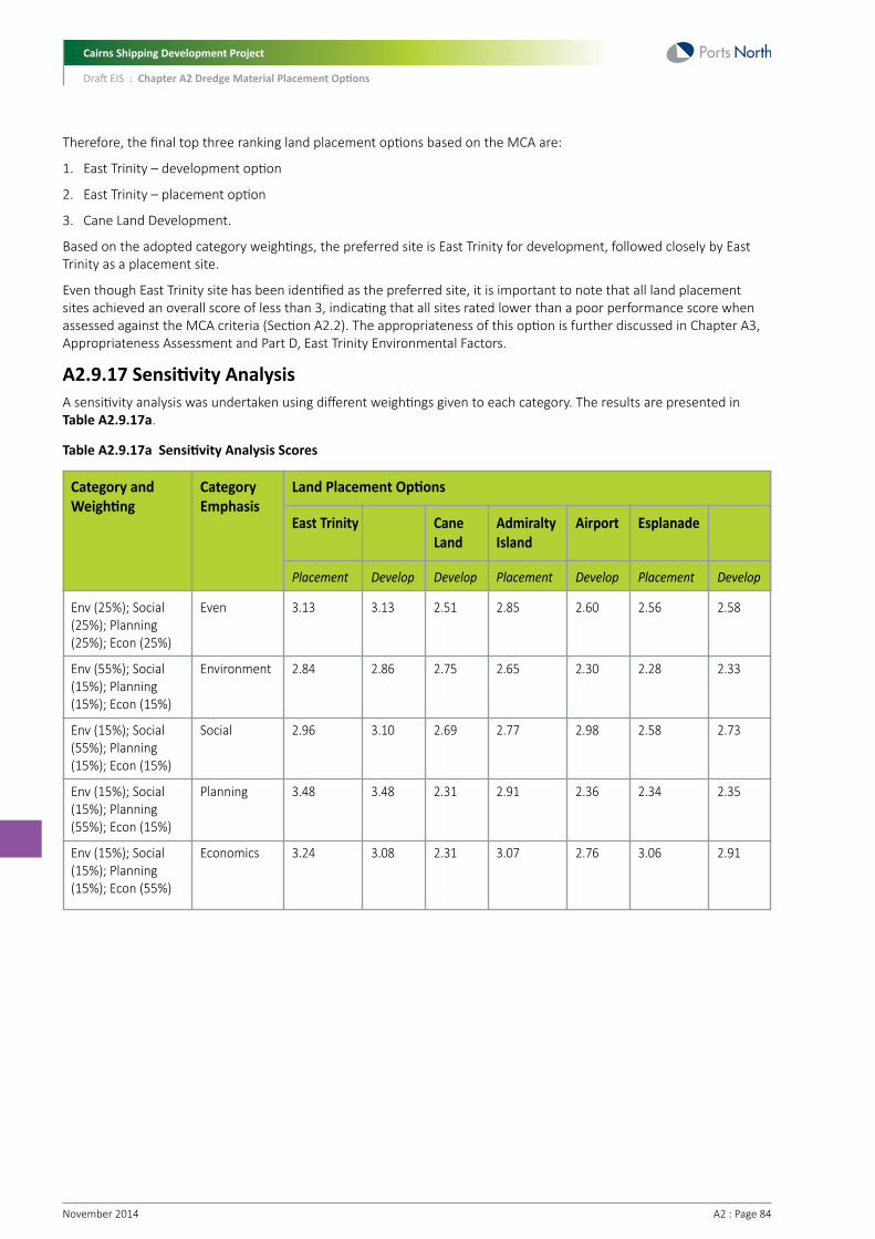
Cairns Shipping Development Project
Draft EIS : Chapter A2 Dredge Material Placement Options
November 2014 A2 : Page 84
Therefore, the final top three ranking land placement options based on the MCA are:
1. East Trinity – development option
2. East Trinity – placement option
3. Cane Land Development.
Based on the adopted category weightings, the preferred site is East Trinity for development, followed closely by East Trinity as a placement site.
Even though East Trinity site has been identified as the preferred site, it is important to note that all land placement sites achieved an overall score of less than 3, indicating that all sites rated lower than a poor performance score when assessed against the MCA criteria (Section A2.2). The appropriateness of this option is further discussed in Chapter A3, Appropriateness Assessment and Part D, East Trinity Environmental Factors.
A2.9.17 Sensitivity AnalysisA sensitivity analysis was undertaken using different weightings given to each category. The results are presented in Table A2.9.17a.
Table A2.9.17a Sensitivity Analysis Scores
Category and Weighting
Env (25%); Social (25%); Planning (25%); Econ (25%)
Env (55%); Social (15%); Planning (15%); Econ (15%)
Env (15%); Social (55%); Planning (15%); Econ (15%)
Env (15%); Social (15%); Planning (55%); Econ (15%)
Env (15%); Social (15%); Planning (15%); Econ (55%)
Category Emphasis
Even
Environment
Social
Planning
Economics
Land Placement Options
East Trinity
Placement
3.13
2.84
2.96
3.48
3.24
Develop
3.13
2.86
3.10
3.48
3.08
Cane Land
Develop
2.51
2.75
2.69
2.31
2.31
Admiralty Island
Placement
2.85
2.65
2.77
2.91
3.07
Airport
Develop
2.60
2.30
2.98
2.36
2.76
Esplanade
Placement
2.56
2.28
2.58
2.34
3.06
Develop
2.58
2.33
2.73
2.35
2.91

Cairns Shipping Development Project
Draft EIS : Chapter A2 Dredge Material Placement Options
A2 : Page 85November 2014
Depending on the weighting given to each category, the following options were preferred:
• Even weighting: East Trinity (develop and placement options)
• Environment: East Trinity (develop)
• Social: East Trinity (develop)
• Legislative/Planning: East Trinity (develop and placement options)
• Economic/Logistics: East Trinity (placement).
The sensitivity analysis shows that the East Trinity development option still scores well regardless of weighting. The exception to this is when the weighting is biased towards the economics category, where the placement option at East Trinity scores slightly better due to its lower treatment costs.
A2.10 Description of Potential Marine Placement SitesAlong with the land placement options discussed and assessed in the above sections, marine placement options were also assessed using the MCA process.
Based on previous studies (Section A2.4), five marine placement options were identified for further assessment to determine a preferred marine placement option. These options include:
• Option 1A – Optimisation of Option 1, which was an extension to existing DMPA
• Option 2 – Inshore site
• Option 3 – Midshore site - SKM/APASA Model Case 1
• Option 4 – Offshore site – Connell Wagner (1990, 1992) site M5
• Option 5 – Northerly site - SKM/APASA Model Case 2.
The locations of the marine placement options are shown in Figure A2.10a and are discussed in the following sections.

Cairns Shipping Development Project
Draft EIS : Chapter A2 Dredge Material Placement Options
November 2014 A2 : Page 86
Figure A2.10a Marine Placement Options

Cairns Shipping Development Project
Draft EIS : Chapter A2 Dredge Material Placement Options
A2 : Page 87November 2014
A2.10.1 Option 1A – Optimisation of Option 1Option 1A represents an optimisation of a preliminary option (i.e. Option 1). Option 1 was an extension to the existing DMPA, located in an area which originated from the Preliminary Environmental Assessment (PEA) (Arup 2012) undertaken as part of the Cairns Cruise Shipping Strategy project. In that study, a kidney shaped broad investigation area was identified (Figure A2.10.1a).
After some preliminary re-suspension modelling, it was determined that an almost fully retentive site could be found in deeper water in close proximity to Option 1. Therefore, Option 1A represents an optimised site with water depth similar to Option 3, while minimising distance from the proposed dredge works and also maintaining distance from sensitive receptors (refer to Figure A2.10.1a).
A number of studies of the existing DMPA have previously been undertaken, which is near to this site. Therefore, the environmental values in the general area are considered to be relatively well understood.
Key characteristics of this site are discussed further in the following sections, and can be summarised as follows:
• Water depth of approximately -18 to -22 m LAT (similar to Option 3)
• Within the Commonwealth GBRMP General Use Area
• More retentive than preliminary Option 1 (refer to Section A2.11.2)
• Closer to dredge works than Option 3 (minimised dredge steaming time)
• Substrate in area is somewhat similar to substrate in proposed dredge area (i.e. like for like)
• Maintains a distance from sensitive receptors (e.g seagrass meadows).
Figure A2.10.1a Location of Preliminary Option 1 and Optimised Option 1A, along with Depth Contours (m LAT)
Cairns Shipping Development Project
Draft EIS : Chapter A2 Dredge Material Placement Options
November 2014 A2 : Page 88
A2.10.2 Option 2 – Inshore SiteOption 2 is an inshore site in a similar location to historical DMPA sites (prior to existing DMPA). Although this site has not been investigated as part of previous studies, it is included as a potential alternative marine placement option that, unlike other options, is located outside of the Great Barrier Reef Marine Park.
Key characteristics of this site are discussed further in the following sections, and can be summarised as follows:
• Water depth of approximately -9 m LAT (which may be problematic for some larger TSHD)
• Outside of the Commonwealth Great Barrier Reef Marine Park (but within the State Marine Park)
• Likely to be more dispersive than other options due to reduced water depth
• In closer proximity to nearshore sensitive receptors (e.g. seagrass meadows) and Northern Beaches
• Substrate in area is likely to be very similar to substrate in proposed dredge area
• Marginally cheaper to use due to location closer to dredge area.
A2.10.3 Option 3 – Midshore Site Option 3 is a midshore site which matches the SKM/APASA (2012b) Model Case 1 and also the Connell Wagner (1990-1992) preferred option M3.
Key characteristics of this site are discussed further in the following sections, and can be summarised as follows:
• Water depth of approximately -18 to -22 m LAT
• Within the Commonwealth GBRMP General Use Area
• Likely to be more retentive than inshore site Option 2 and marginally more so than Option 1 due to greater water depth
• Greater cost compared to Options 1 and 2 due to location further from dredge area.
A2.10.4 Option 4 – Offshore SiteThe location of the Option 4 site matches site M5 from the Connell Wagner studies (1990-1992) as shown in Section A2.4 of this report. M5 was originally rejected by Connell Wagner because the placement of terrigenous material in that environment (on the 30 m contour) was thought likely to be of concern to the GBRMPA. Nevertheless, this site has been included in this marine placement options assessment to represent a deeper water offshore option.
Key characteristics of this site are discussed further in the following sections, and can be summarised as follows:
• Water depth of approximately -30 m LAT
• Within the Commonwealth GBRMP General Use Area
• Potentially more retentive
• Likely to be different sediment type to proposed dredge area (offshore sites likely to have higher sand content)
• Closer proximity to shallow reef areas to the northeast
• More expensive than other inshore options due to greater distance from dredge area
• Partially within/adjacent to shipping lanes in and out of the port.
A2.10.5 Option 5 – Northern SiteOption 5 is a site which matches the SKM/APASA (2012b) Model Case 2. This site is located further north than the other placement sites.
Key characteristics of this site are discussed further in the following sections, and can be summarised as follows:
• Water depth of approximately -15 m LAT
• Within the Commonwealth GBRMP General Use Area
• Likely to be different sediment type to material being dredged
• More expensive than all other options due to greater distance from dredge area
• Close to green zone (GBRMP zoning).

Cairns Shipping Development Project
Draft EIS : Chapter A2 Dredge Material Placement Options
A2 : Page 89November 2014
A2.11 Assessment of Marine Placement SitesA2.11.1 MethodologyThe desktop study of the five marine placement options involved review of Geographical Information System (GIS) mapping, review of previous studies and literature relevant to environmental, social and planning values in the study area, and hydrodynamic modelling, Findings from the marine ecology baseline field surveys (Chapter B7, Marine Ecology) were also incorporated into the assessment.
A2.11.2 Re-suspension Potential and Water Quality Impacts An assessment of the re-suspension potential and impacts to water quality was undertaken by modelling re-suspension from each of the five marine placement options over a 12-month period. The assessment is not intended to definitively determine environmental impacts of re-suspending placed dredged material. The main purpose of this assessment is to allow comparison of the marine placement sites.
This assessment was undertaken using the same calibrated TUFLOW-FV hydrodynamic model used to undertake the modelling of the capital dredging campaign for the EIS. The modelling simulated the resuspension of ‘ambient’ surficial seabed material as well as the resuspension of ‘dredge’ material that had been placed at the DMPAs (95th percentile and 50th percentile modelled ambient turbidity is shown in Figure A2.11.2a and Figure A2.11.2b). The use of a validated hydrodynamic and sediment transport model including the consideration of both ambient turbidity conditions and dredge material represents a more advanced and robust assessment than most other similar studies.
Figure A2.11.2a 95th Percentile of Modelled Ambient Turbidity

Cairns Shipping Development Project
Draft EIS : Chapter A2 Dredge Material Placement Options
November 2014 A2 : Page 90
Figure A2.11.2b 50th Percentile of Modelled Ambient Turbidity
For the modelling simulations, dredge material was initially placed at the DMPAs in a series of accelerated placement simulations, which represented the sequence of TSHD and Hopper Barge bottom dumping events. The DMPA dispersion simulations were performed for a 12-month modelling period, running from July 2011 to August 2012. While the modelling simulations allowed for tracking of both ambient and dredge material both in suspension and deposited on the seabed, the results shown relate to the dredge material ‘above ambient’ amount.
Plots shown are based on the following percentile values:
• 95th percentile = infrequent periods (occurring five percent of the time) of high turbidity/sedimentation. This metric is used to identify infrequent periods of elevated turbidity/sedimentation
• 50th percentile plots = typical (median) turbidity/sedimentation levels, which occur 50 percent of the time. This is relevant to determining typical turbidity/sedimentation levels generated by resuspension of DMPA material.
Note that the scales used on the 50th percentile and the 95th plots are different, so as to be generally consistent with the natural variation of turbidity at these percentiles.

Cairns Shipping Development Project
Draft EIS : Chapter A2 Dredge Material Placement Options
A2 : Page 91November 2014
A2.11.2.1 Option 1A
Figure A2.11.2.1a Option 1A - 95th Percentile of Modelled Dredge Material Placement Related Turbidity
Figure A2.11.2.1b Option 1A - 50th Percentile of Modelled Dredge Material Placement Turbidity

Cairns Shipping Development Project
Draft EIS : Chapter A2 Dredge Material Placement Options
November 2014 A2 : Page 92
A2.11.2.2 Option 2
Figure A2.11.2.2a Option 2 - 95th Percentile of Modelled Dredge Material Placement Turbidity
Figure A2.11.2.2b Option 2 - 50th Percentile of Modelled Dredge Material Placement Turbidity

Cairns Shipping Development Project
Draft EIS : Chapter A2 Dredge Material Placement Options
A2 : Page 93November 2014
A2.11.2.3 Option 3
Figure A2.11.2.3a Option 3 - 95th Percentile of Modelled Dredge Material Placement Turbidity
Figure A2.11.2.3b Option 3 - 50th Percentile of Modelled Dredge Material Placement Turbidity

Cairns Shipping Development Project
Draft EIS : Chapter A2 Dredge Material Placement Options
November 2014 A2 : Page 94
A2.11.2.4 Option 4
Figure A2.11.2.4a Option 4 - 95th Percentile of Modelled DMPA Material Placement Turbidity
Figure A2.11.2.4b Option 4 - 50th Percentile of Modelled Dredge Material Placement Turbidity

Cairns Shipping Development Project
Draft EIS : Chapter A2 Dredge Material Placement Options
A2 : Page 95November 2014
A2.11.2.5 Option 5
Figure A2.11.2.5a Option 5 – 95th Percentile of Modelled Dredge Material Placement Turbidity
Figure A2.11.2.5b Option 5 - 50th Percentile of Modelled Dredge Material Placement Turbidity
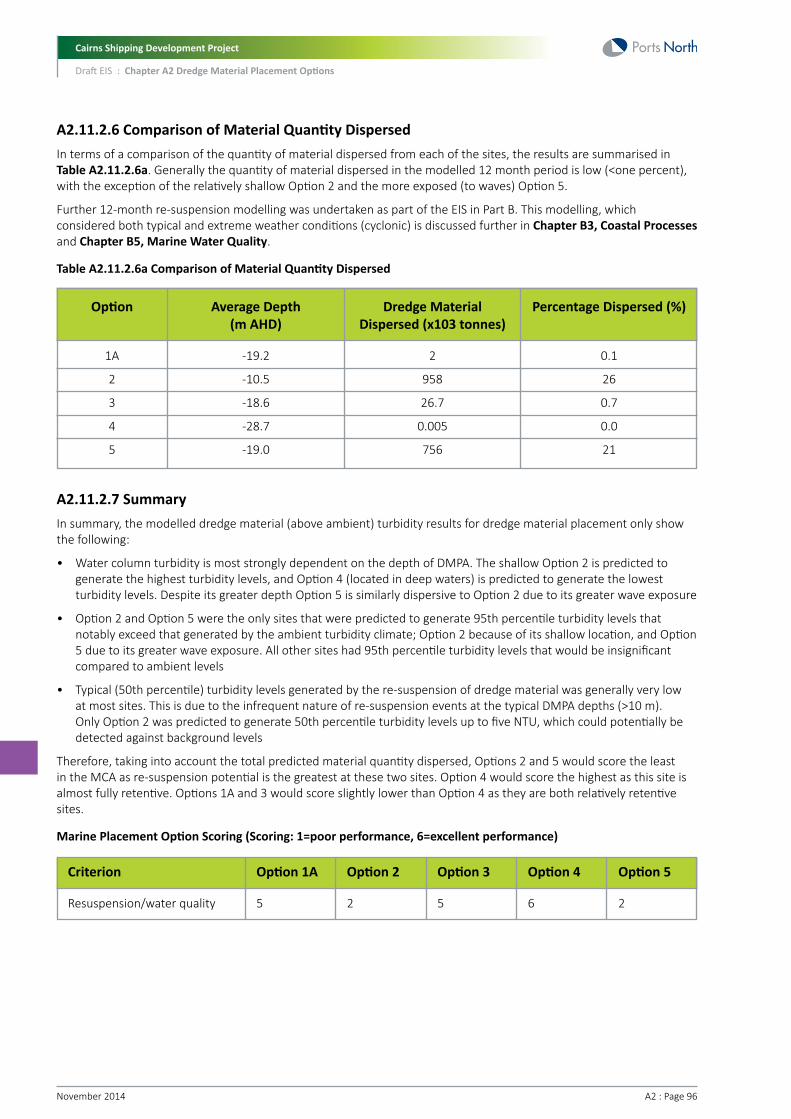
Cairns Shipping Development Project
Draft EIS : Chapter A2 Dredge Material Placement Options
November 2014 A2 : Page 96
A2.11.2.6 Comparison of Material Quantity DispersedIn terms of a comparison of the quantity of material dispersed from each of the sites, the results are summarised in Table A2.11.2.6a. Generally the quantity of material dispersed in the modelled 12 month period is low (<one percent), with the exception of the relatively shallow Option 2 and the more exposed (to waves) Option 5.
Further 12-month re-suspension modelling was undertaken as part of the EIS in Part B. This modelling, which considered both typical and extreme weather conditions (cyclonic) is discussed further in Chapter B3, Coastal Processes and Chapter B5, Marine Water Quality.
Table A2.11.2.6a Comparison of Material Quantity Dispersed
A2.11.2.7 Summary In summary, the modelled dredge material (above ambient) turbidity results for dredge material placement only show the following:
• Water column turbidity is most strongly dependent on the depth of DMPA. The shallow Option 2 is predicted to generate the highest turbidity levels, and Option 4 (located in deep waters) is predicted to generate the lowest turbidity levels. Despite its greater depth Option 5 is similarly dispersive to Option 2 due to its greater wave exposure
• Option 2 and Option 5 were the only sites that were predicted to generate 95th percentile turbidity levels that notably exceed that generated by the ambient turbidity climate; Option 2 because of its shallow location, and Option 5 due to its greater wave exposure. All other sites had 95th percentile turbidity levels that would be insignificant compared to ambient levels
• Typical (50th percentile) turbidity levels generated by the re-suspension of dredge material was generally very low at most sites. This is due to the infrequent nature of re-suspension events at the typical DMPA depths (>10 m). Only Option 2 was predicted to generate 50th percentile turbidity levels up to five NTU, which could potentially be detected against background levels
Therefore, taking into account the total predicted material quantity dispersed, Options 2 and 5 would score the least in the MCA as re-suspension potential is the greatest at these two sites. Option 4 would score the highest as this site is almost fully retentive. Options 1A and 3 would score slightly lower than Option 4 as they are both relatively retentive sites.
Marine Placement Option Scoring (Scoring: 1=poor performance, 6=excellent performance)
Option
1A
2
3
4
5
Average Depth (m AHD)
-19.2
-10.5
-18.6
-28.7
-19.0
Dredge Material Dispersed (x103 tonnes)
2
958
26.7
0.005
756
Percentage Dispersed (%)
0.1
26
0.7
0.0
21
Option 3
5
Option 1A
5
Criterion
Resuspension/water quality
Option 4
6
Option 5
2
Option 2
2

Cairns Shipping Development Project
Draft EIS : Chapter A2 Dredge Material Placement Options
A2 : Page 97November 2014
A2.11.3 Potential Impact to Sensitive Ecological Receptors and World Heritage ValuesWith respect to marine dredging placement activities, sensitive ecological receptors are generally considered to be the primary producer habitats, particularly seagrasses and corals, which have the potential to be adversely affected by dredge plumes through light attenuation and sedimentation.
As the world’s most extensive coral reef ecosystem, the GBR is a globally outstanding and significant entity, and was inscribed as World Heritage in 1981. The world heritage values which ensure the GBR remains listed as World Heritage are required to be protected. That is, the GBR is required to be maintained as a healthy ecosystem.
While none of the proposed placement options are immediately located within or adjacent to key sensitive receptors, seagrass and reef communities do occur in the wider vicinity. These include, for example, seagrass meadows in Trinity Bay and reef communities occurring nearshore (i.e. consolidated shores along the coastline and inshore islands, and inshore reefs such as those at Double Island and Unity Reef), as well as the offshore reefs of the GBR. Refer to Figure A2.11.3a for locations of sensitive ecological receptors in relation to the marine placement options. Seagrass receptors illustrated are a composite of all recorded seagrass locations from 1984 – 2013.
Seagrass communities in Trinity Bay are the most intensely studied sensitive ecological receptors in the area, with regular long-term monitoring undertaken by the Queensland Government (DAFF, DEEDI), and most recently by TropWater (James Cook University’s Centre for Tropical Water and Aquatic Ecosystem Research). Similarly intensive monitoring data are not available for the reefal communities; however, the location and extent of the reefs is relatively static in comparison to the local seagrass communities, which vary considerably on an inter-annual and intra-annual basis. They are currently very sparse.
Potential effects on such receptors are determined by factors such as the direction and extent of dredge plumes, noting that this will vary with climatic conditions, and taking into account water quality, sedimentation and re-suspension considerations. For the purpose of this analysis, past assessments (SKM/APASA 2013, 2012; Connell Wagner 1992) provide a general indication of direction and extent of dredge plumes (indicative only), along with turbidity modelling outputs (Refer to Section A2.11.2 – re-suspension modelling plots).
In general terms, Options 1A and 3 would be considered to have the lowest potential for adversely affecting significant seagrass or reef communities as the distance to these receptors (>10 km) exceeds the likely plume extent. Conversely, Option 2 would be least preferred, given i) it is likely most dispersive, ii) it is in closest proximity to sensitive receptors (i.e. Trinity Inlet seagrasses, coastal rocky shores), and iii) disposing near these receptors would likely cause cumulative stress to communities already subject to plumes during channel dredging. Option 4 and 5 are in moderate (<10 km) proximity to reef communities, although Option 4 will be the least dispersive of the two, given its offshore position.
Marine Placement Option Scoring (Scoring: 1=poor performance, 6=excellent performance)
Option 3
5
Option 1A
5
Criterion
Sensitive Receptos
Option 4
4
Option 5
4
Option 2
3

Cairns Shipping Development Project
Draft EIS : Chapter A2 Dredge Material Placement Options
November 2014 A2 : Page 98
Figure A2.11.3a Sensitive Ecological Receptors

Cairns Shipping Development Project
Draft EIS : Chapter A2 Dredge Material Placement Options
A2 : Page 99November 2014
A2.11.4 Seabed Substrate and Benthic EcologyA2.11.4.1 Seabed substrateIt is understood that benthic communities are typically impacted to a lesser extent, and are able to recover faster, when the seabed substrate at the placement area is similar to the donor dredge material (i.e. like for like).
Comprehensive studies of seabed substrate type at each marine placement option have not previously been undertaken. Nevertheless, an approximate estimation of substrate type at each site can be made using regional data analysed as part of the Geoscience Australia (2007) spatial mapping analysis of the geomorphology of the GBR.
Using data from over 3,000 sediment samples available in Geoscience Australia’s national marine samples database, Geoscience Australia (2007) undertook a regional scale spatial analysis of the sediments and geomorphology of the GBR. This spatial analysis offers a synthesis of inter-reefal environments in the GBR, to better understand the nature and distribution of seabed habitats at a regional scale.
Sample data collected as part of the Geoscience Australia (2007) study included percent bulk carbonate and particle size distribution (PSD) data at a number of sample sites offshore from the Port of Cairns in the general vicinity of the marine placement options (refer to Figure A2.11.4.1a for locations of sample sites).
This data was used to develop contours of percent bulk carbonate (Figure A2.11.4.1b), along with an indication of mud, sand and gravel composition at sample sites using the PSD data. A grid of mud, sand and gravel distribution was developed using interpolated Geoscience Australia (2007) data, with the sand interpolated grid presented in Figure A2.11.4.1a. This provides a general indication of the changes in substrate type at each marine placement option, going from least sandy at the channel and Option 2, out to the sandiest at Option 4.
Based on the interpolated data, and the PSD data from the Geoscience Australia (2007) sample sites, Table A2.11.4.1a presents the indicative substrate type at the channel and each marine placement option. This indicates that the option most likely to be similar (i.e. like for like) to the dredge material (i.e. channel area) would be Option 2. Options 1A and 3 and also fairly similar, although comprise a little more sand and less mud. Option 5, and to a lesser extent Option 4, are the least similar to the dredge material comprising a greater proportion of sand and less mud.
Table A2.11.4.1a Indicative Substrate Type at each Marine Placement Option
Marine Placement Option
Option 1A
Option 2
Option 3
Option 4
Option 5
Channel Area
Mud
70
79
71
23
47
82
Sand
28
20
28
66
51
16
Gravel
2
1
1
10
2
2

Cairns Shipping Development Project
Draft EIS : Chapter A2 Dredge Material Placement Options
November 2014 A2 : Page 100
Figure A2.11.4.1a Interpolated Grid of Sand Distribution using Geoscience Australia (2007) PSD Data

Cairns Shipping Development Project
Draft EIS : Chapter A2 Dredge Material Placement Options
A2 : Page 101November 2014
In addition to the above assessment of PSD data, each marine placement option was assessed in terms of percent bulk carbonate contours. Bulk carbonate provides an indication of the skeletal carbonate grains derived from reefal environments. High concentrations of bulk carbonate generally occur in areas of high reef density and in areas with negligible influence of fluvial sediments on the outer shelf. Low carbonate concentrations of <40 percent on the inner shelf denote high terrigenous compositions.
The percent bulk carbonate contours were overlayed over the marine placement options and the results are presented in Figure A2.11.4.1b. This indicates that the areas with the least amount of bulk carbonate (i.e. the most amount of terrigenous sediment) is the channel area and the inshore option (Option 2). The midshore sites (Options 1A, 3 and 5) contain some bulk carbonate (25-45 percent), representing areas where a mixture of terrigenous and reefal sediment occur. Option 4, closer to the reefal environments, contains the greatest amount of bulk carbonate. These results are consistent with the assessment of PSD data discussed above.

Cairns Shipping Development Project
Draft EIS : Chapter A2 Dredge Material Placement Options
November 2014 A2 : Page 102
Figure A2.11.4.1b Contours of Percent Bulk Carbonate
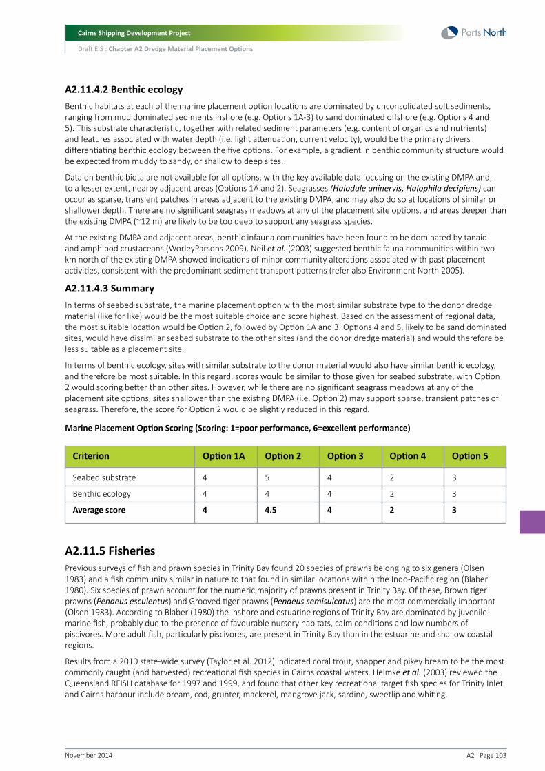
Cairns Shipping Development Project
Draft EIS : Chapter A2 Dredge Material Placement Options
A2 : Page 103November 2014
A2.11.4.2 Benthic ecologyBenthic habitats at each of the marine placement option locations are dominated by unconsolidated soft sediments, ranging from mud dominated sediments inshore (e.g. Options 1A-3) to sand dominated offshore (e.g. Options 4 and 5). This substrate characteristic, together with related sediment parameters (e.g. content of organics and nutrients) and features associated with water depth (i.e. light attenuation, current velocity), would be the primary drivers differentiating benthic ecology between the five options. For example, a gradient in benthic community structure would be expected from muddy to sandy, or shallow to deep sites.
Data on benthic biota are not available for all options, with the key available data focusing on the existing DMPA and, to a lesser extent, nearby adjacent areas (Options 1A and 2). Seagrasses (Halodule uninervis, Halophila decipiens) can occur as sparse, transient patches in areas adjacent to the existing DMPA, and may also do so at locations of similar or shallower depth. There are no significant seagrass meadows at any of the placement site options, and areas deeper than the existing DMPA (~12 m) are likely to be too deep to support any seagrass species.
At the existing DMPA and adjacent areas, benthic infauna communities have been found to be dominated by tanaid and amphipod crustaceans (WorleyParsons 2009). Neil et al. (2003) suggested benthic fauna communities within two km north of the existing DMPA showed indications of minor community alterations associated with past placement activities, consistent with the predominant sediment transport patterns (refer also Environment North 2005).
A2.11.4.3 SummaryIn terms of seabed substrate, the marine placement option with the most similar substrate type to the donor dredge material (like for like) would be the most suitable choice and score highest. Based on the assessment of regional data, the most suitable location would be Option 2, followed by Option 1A and 3. Options 4 and 5, likely to be sand dominated sites, would have dissimilar seabed substrate to the other sites (and the donor dredge material) and would therefore be less suitable as a placement site.
In terms of benthic ecology, sites with similar substrate to the donor material would also have similar benthic ecology, and therefore be most suitable. In this regard, scores would be similar to those given for seabed substrate, with Option 2 would scoring better than other sites. However, while there are no significant seagrass meadows at any of the placement site options, sites shallower than the existing DMPA (i.e. Option 2) may support sparse, transient patches of seagrass. Therefore, the score for Option 2 would be slightly reduced in this regard.
Marine Placement Option Scoring (Scoring: 1=poor performance, 6=excellent performance)
Option 3
4
4
4
Option 1A
4
4
4
Criterion
Seabed substrate
Benthic ecology
Average score
Option 4
2
2
2
Option 5
3
3
3
Option 2
5
4
4.5
A2.11.5 FisheriesPrevious surveys of fish and prawn species in Trinity Bay found 20 species of prawns belonging to six genera (Olsen 1983) and a fish community similar in nature to that found in similar locations within the Indo-Pacific region (Blaber 1980). Six species of prawn account for the numeric majority of prawns present in Trinity Bay. Of these, Brown tiger prawns (Penaeus esculentus) and Grooved tiger prawns (Penaeus semisulcatus) are the most commercially important (Olsen 1983). According to Blaber (1980) the inshore and estuarine regions of Trinity Bay are dominated by juvenile marine fish, probably due to the presence of favourable nursery habitats, calm conditions and low numbers of piscivores. More adult fish, particularly piscivores, are present in Trinity Bay than in the estuarine and shallow coastal regions.
Results from a 2010 state-wide survey (Taylor et al. 2012) indicated coral trout, snapper and pikey bream to be the most commonly caught (and harvested) recreational fish species in Cairns coastal waters. Helmke et al. (2003) reviewed the Queensland RFISH database for 1997 and 1999, and found that other key recreational target fish species for Trinity Inlet and Cairns harbour include bream, cod, grunter, mackerel, mangrove jack, sardine, sweetlip and whiting.

Cairns Shipping Development Project
Draft EIS : Chapter A2 Dredge Material Placement Options
November 2014 A2 : Page 104
In terms of potential impacts to fisheries, dredge material placement activities may smother benthic fauna, resulting in the temporary loss of food resources of most economically significant species. While most fish and shellfish species of fisheries significance are not known to have highly selective diets, it is possible that the loss of food resources would result in the temporary avoidance of affected habitat patches. Case-studies undertaken in other dredge material placement areas in Queensland indicate that benthic ‘recovery’ typically occurs at time scales measured in months. Major, long-term impacts to fisheries due to loss of benthic fauna are therefore not expected.
Despite the potential for short-term impacts to commercial fisheries, in the long term some fisheries values may increase at dredge material placement areas. Commercial fishers have been noted to frequently net at the existing DMPA as there is good supply of grey mackerel, bait fish, shark and other species at the site (stakeholder consultation meeting 25/2/2014; pers comm. Bruce Batch). Commercial fishers also noted that they would be keen to fish at any new DMPA (pers comm. Bruce Batch).
Notwithstanding the above, it is important that the selection of an offshore marine placement site should take into account commercial fisheries values. In particular, longer term changes in habitat type (i.e. change in sediment type, sediment mobilisation dynamics), or changes in bed topography that result in a change in operators ability to trawl an area, need to be considered in the site selection and dredging planning processes.
The value of commercial fisheries in the Cairns area was assessed using the Coastal Habitat Resources Information System (CHRIS) developed by the former Department of Primary Industries and Fisheries (DPI&F). CHRIS assigns fisheries value to quadrants (quadrant size of 10 km2), and a commercial value was assigned to quadrant in the Cairns area, with results presented in Chapter B9, Socio-Economic and Figure A2.11.5a.
This indicates that Option 2 and Option 5 are located in less valuable fisheries area (in terms of catch value) compared to mid-shore sites (Options 1A, 3 and 4) which are generally located in a more valuable area. However, Option 2 is less retentive than other sites and during re-suspension events turbid plumes would potentially mobilise into high value fisheries areas such as the area around Cape Grafton.
Further to this, commercial fishing representatives indicated that placement of dredge material in water deeper than about 17 m may impact on prawn trawling grounds (stakeholder consultation meeting 19 September 2013). This issue was also raised previously by the Queensland Commercial Fishermen’s Organisation during consultation in 1992 (Connell Wagner 1992). In stakeholder consultation, commercial fishers indicated that trawlers do not fish close to the existing DMPA given the high risk of losing their boards or gear on the hump and the debris (stakeholder consultation meeting 25 February 2014; pers comm. Bruce Batch). Therefore, Options 1A, 3, 4 and 5 (water depths greater than 17 m) would score less than Option 2.
In terms of potential impacts to recreational fisheries, while unvegetated soft sediment habitats represent important habitats for some species of recreational fish (e.g. grunter/javelin fish, nannygai and flathead), the fish species which dominate local recreational catches, coral trout and snapper, are typically reef-associated species. Therefore, placement of dredge material at any of the marine placement options is not expected to impact on key recreational target species.
Marine Placement Option Scoring (Scoring: 1=poor performance, 6=excellent performance)
Option 3
2
Option 1A
2
Criterion
Fisheries
Option 4
2
Option 5
3
Option 2
3

Cairns Shipping Development Project
Draft EIS : Chapter A2 Dredge Material Placement Options
A2 : Page 105November 2014
Figure A2.11.5a Average Value of Fisheries per Quadrant

Cairns Shipping Development Project
Draft EIS : Chapter A2 Dredge Material Placement Options
November 2014 A2 : Page 106
Option 3
5
3
4
Option 1A
5
3
4
Criterion
Amenity
Tourism
Average score
Option 4
3
2
2.5
Option 5
3
2
2.5
Option 2
3
4
3.5
A2.11.6 Amenity and Tourism In regard to amenity issues, it is likely that the perception of impact by the local community on overall amenity (such as the presence of dredge plumes) will need to be considered. In this context, the selection and operation of a new marine placement site further inshore may be questioned by some of the community. Furthermore, the use of a new marine placement site further offshore in clearer waters, and closer to reef areas, may also be perceived negatively from an amenity perspective.
Dredge material placement in the marine environment also has the potential to influence perceptions of the reef amenity and tourism values in the area. The major tourism drawcards to the area in terms of marine activities include fishing and the Great Barrier Reef (GBR). As impacts to recreational fisheries have been addressed in the criterion above (Section A2.11.4.2), potential impacts to GBR-related tourism are assessed in this criterion. While placement at any of the marine placement options is not expected to directly impact on the GBR, there may be indirect negative impacts to tourism from the perception of at-sea placement in the Great Barrier Reef Marine Park (GBRMP).
All marine placement options are located within the Queensland Great Barrier Reef Coast Marine Park and the GBR World Heritage Area. However, Option 2 is the only option which is not located within the Commonwealth GBRMP (refer Figure A2.11.7a). In terms of public perception, placement of material outside of the Commonwealth GBRMP (i.e. Option 2) may have a perceived better outcome for management and amenity of the GBR and its ongoing tourism attracting potential.
Furthermore, sites located closer to reef areas (Options 4 and 5) may also be perceived as having greater negative impact to the GBR, and consequently a greater negative indirect impact on tourism.
Therefore, in terms of amenity, midshore marine placement options (Options 1 and 3) score the highest in the MCA as they strike a balance between the amenity of the coastline and offshore reef areas. In terms of tourism, Option 2 outside of the marine park would score the highest, while Options 4 and 5 closer to the reef areas would score the lowest.
Marine Placement Option Scoring (Scoring: 1=poor performance, 6=excellent performance)
A2.11.7 Marine Park PlanningThe Great Barrier Reef Marine Park (GBRMP) surrounds the Cairns area. There is a number of planning areas or zones within the GBRMP, with varying levels of restrictions on activities applied to each zone. The Port of Cairns is surrounded by a designated port area which is outside of the Commonwealth GBRMP, however it is still within the Queensland GBR Coast Marine Park. The Commonwealth GBRMP zones and marine park boundary are shown in Figure A2.11.7a.
All of the marine placement options, except for Option 2, are located within the ‘General Use’ zone of the Commonwealth GBRMP. The General Use zone is the least restrictive of the GBRMP zones, and the objective is to provide opportunities for reasonable use of the GBRMP while still allowing for the conservation of these areas.
In regard to dredge material placement in the GBRMP, the Great Barrier Reef Marine Park Authority (GBRMPA) has a Dredging and Spoil Disposal Policy which states that:
• Dredge material placement proposals will be assessed in accordance with the GBRMPA’s policy for Environmental Impact Management
• Proponents must comply with the National Assessment Guidelines for Dredging 2009
• Material placement must not damage sensitive environments
• Placement of dredge material is to only occur at a GBRMPA approved area.
Annual maintenance dredge material volumes will be capped to a limit.
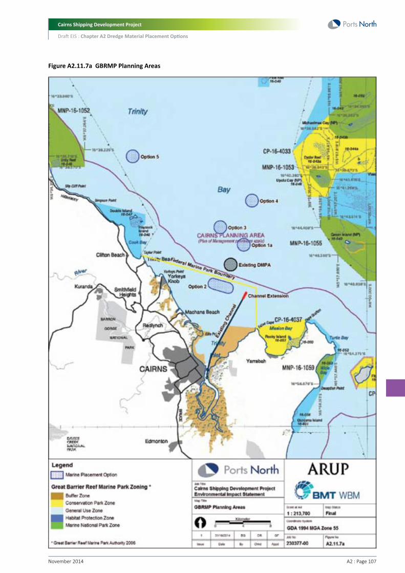
Cairns Shipping Development Project
Draft EIS : Chapter A2 Dredge Material Placement Options
A2 : Page 107November 2014
Figure A2.11.7a GBRMP Planning Areas

Cairns Shipping Development Project
Draft EIS : Chapter A2 Dredge Material Placement Options
November 2014 A2 : Page 108
Historically it has been that case that approvals for any new marine placement sites in the GBRMP would be more difficult to obtain than a nearshore site (Option 2), which is located outside of the Commonwealth GBRMP. Approvals would only be required from GBRMPA if potential impacts affected the GBRMP.
Marine Placement Option Scoring (Scoring: 1=poor performance, 6=excellent performance)
Option 3
2
Option 1A
2
Criterion
Marine Park planning
Option 4
2
Option 5
2
Option 2
5
A2.11.8 Bathymetry and Capacity The volume of capital dredging material that will be dredged as part of the project is expected to be approximately 4.4 M m3.
The preferred method of dredging for the channel dredging works involves the use of a medium sized TSHD. The preference for this dredge type and capacity is based on a number of practical considerations, including:
• The dredging power required for excavation of the firm, stiff and very stiff clay materials that comprise a small proportion of the channel, whereby a medium size dredge is required to provide sufficient power
• The operational constraints for dredging within an active navigation channel, whereby the dredge type must be mobile so that it can vacate the channel to allow for passage of vessels arriving and departing the Port of Cairns
• The efficiency and economy of dredging operations, whereby a medium size dredge is required to provide efficient and economical dredging of the volume of material to be removed during channel dredging works.
Based on these considerations, preferably a medium-sized TSHD with a hopper capacity of 5,000 to 5,500 m3 and a loaded draft of approximately seven metres is ideally suited for the execution of the works. With an empty draft of approximately 4.5 m, this dredger could do a large portion of the widening of the channel as well as making use of the tidal conditions.
A backhoe dredger will be used for some of the inner port dredging. This will be used in conjunction with one of the below hopper barge configurations:
• Towed split barges with hopper (approximately 1,000 m3 capacity)
• Self-propelled hopper barges (approximately 3,700 m3 capacity)
• Split hopper-barges propelled by a pusher tug (approximately 3,800 m3 - type 510, or approximately 2,300 m3 – type 301).
The dredge vessel capacities and water depth requirements are included in Table A2.11.8a. This indicates that a medium TSHD would typically have a laden draft of approximately seven m and require a minimum water depth of approximately 10 m for effective placement of dredge material from the underside of the vessel. Self-propelled hopper barges would have a laden draft of five m and require a water depth of approximately eight metres for effective placement.
Table A2.11.8a Dredge Vessel Capacities and Marine Placement Depth Requirements
Vessel
Medium TSHD
Self-propelled hopper barge
Capacity (m3)
5,000 - 5,500
2,500
Max. Draft (m)
7
5.0
Minimum Water Depth at Placement Site (m)
10
8.0
Accordingly, as the TSHD requires the greatest depth for placement, any offshore placement location is required to provide sufficient water depth for effective and efficient operation of a medium-sized TSHD. A minimum depth of 10 m is required, but the ideal depth is likely to be greater than 10 m to allow for dredge material stockpiling within the placement area. It is noted that if a larger TSHD is required, greater water depth would be required.

Cairns Shipping Development Project
Draft EIS : Chapter A2 Dredge Material Placement Options
A2 : Page 109November 2014
The approximate water depth at each marine placement option is presented in Table A2.11.8b. The above mentioned characteristics potentially establish a physical constraint to the use of the Option 2 placement area, which has a depth of approximately -10 m LAT, and is therefore on the verge of being too shallow for placement of material with a medium-sized TSHD. All other sites are located in a water depth sufficient for dredge material placement from a medium-sized TSHD.
Table A2.11.8b Marine Placement Option Water Depths
Marine Placement Option
Option 1A
Option 2
Option 3
Option 4
Option 5
Approx. Water Depth (LAT)
-19 m
-10 m
-19 m
-29 m
-19 m
In terms of capacity, based on the anticipated volume of material from the project, an overall capacity of approximately 5.5 M m3 would be required for a marine placement site (excluding any contingent capacity for potential long-term use of the site). This allows for the predicted in situ volume of 4.4 M m3 of dredge material with an assumed bulking factor of 1.2. Placement of the dredge material within a site of one nautical mile (1.85 km), having an area of approximately 265 ha, results in a depth of material of approximately two metres. It is noted that there will be some degree of consolidation of the disposed dredge material on the seabed, so ultimately the placement height may not be two metres. While most marine placement options are in sufficient water depths to accommodate the dredge material, Option 2 is in a relatively shallow water depth and would require material to be spread thinner across a larger footprint.
In summary, while all marine placement options would have sufficient capacity, Option 2 may be physically constrained due to the shallower depth of water restricting the use of a TSHD, and requiring a larger footprint. The other sites would have no such limitations, and as such score better in the marine placement ratings.
Marine Placement Option Scoring (Scoring: 1=poor performance, 6=excellent performance)
Option 3
6
Option 1A
6
Criterion
Bathymetry and capacity
Option 4
6
Option 5
6
Option 2
2
Option 3
6
Option 1A
6
Criterion
Bathymetry and capacity
Option 4
6
Option 5
6
Option 2
2
A2.11.9 Shipping and NavigationCommercial shipping into and out of the Port of Cairns, and along the coast, uses dedicated shipping lanes within the offshore area. Furthermore, there are dedicated anchorage areas within Trinity Bay. As such, the locations of the marine placement options were assessed in terms of the potential impact to shipping and navigation.
Anchorage areas were sourced from the Port of Cairns Pilotage Plan (March 2013), and are shown in Figure A2.11.9a. This indicates that Option 2 is located adjacent to an anchorage area. Dredge placement activities in the vicinity of an anchorage area may create undesirable interactions between vessels at sea.
Commercial shipping would enter and depart the Port of Cairns via the shipping channel. Once outside of this channel there is a major shipping lane offshore, generally running parallel to the coastline. The location of this shipping lane was derived from the Aus 262 Admiralty Chart, indicated on this chart as the two-way route (i.e. route indicating the best and safest route for all vessels having regard to charted depths and dangers). This shipping lane is shown in Figure A2.11.9a and indicates that the offshore site (Option 4) is located within this shipping lane. Any placement site located in the deeper waters in the vicinity of the Option 4 site would be subject to commercial shipping traffic, and is therefore a less suitable option.
Marine Placement Option Scoring (Scoring: 1=poor performance, 6=excellent performance)

Cairns Shipping Development Project
Draft EIS : Chapter A2 Dredge Material Placement Options
November 2014 A2 : Page 110
Figure A2.11.9a Anchorage Areas and Major Shipping Lanes

Cairns Shipping Development Project
Draft EIS : Chapter A2 Dredge Material Placement Options
A2 : Page 111November 2014
A2.11.10 Distance from Dredge AreaAn increase in distance from the dredge site to placement site would result in longer sailing times for the TSHD and self-propelled barges. Associated with longer sailing times is an extended length of the dredge campaign, which results in increased project cost (which is accounted for in the following criterion). Also, the further away a DMPA is from the dredge area, the less flexibility the dredge has to time runs to avoid shipping in the channel
In terms of potential environmental impacts, longer sailing times associated with placement sites further offshore increase the risk of spills (dredge material and fuels/oils) due to greater exposure to unfavourable weather conditions. Furthermore, extended dredge campaigns would lead to increased length of exposure of turbid dredge plumes to sensitive receptors. Taking all these aspects into consideration, the marine placement options located closer to the dredge area were given a higher score than options located further offshore.
Marine Placement Option Scoring (Scoring: 1=poor performance, 6=excellent performance)
Option 3
4
Option 1A
5
Criterion
Distance from dredge site
Option 4
3
Option 5
1
Option 2
6
Option 3
4
Option 1A
5
Criterion
Project cost
Option 4
3
Option 5
1
Option 2
6
A2.11.11 Project CostThe cost for dredging and placing of the dredge material at the existing marine DMPA has been calculated at approximately $60 M, subject to approved overflow conditions and type of dredge used.
The distance between the dredge area and the marine placement site is a key economic constraint as sailing time for the dredge increases, but there are also environmental implications in the context of a greater fuel requirement and greenhouse gas emissions as the overall duration of the dredge campaign increases.
As such, the distance from the dredge area to any one of the marine placement options constitutes the main economical evaluation criterion. Following this principle, the inshore site (Option 2) would be the most economical as it is located closest to the dredge area. Option 1A would be the next best option in terms of project cost, followed by Option 3 and then Option 4. Option 5, located a substantial distance further north, would be the least economical option.
With increased distance between the dredge area and the marine placement site, the overall dredging time period would increase due to more time being lost travelling between the dredge area and the marine placement site.
Marine Placement Option Scoring (Scoring: 1=poor performance, 6=excellent performance)

Cairns Shipping Development Project
Draft EIS : Chapter A2 Dredge Material Placement Options
November 2014 A2 : Page 112
A2.11.12 Marine Placement EvaluationA summary of the evaluation of marine placement options according to the discussed selection criteria is provided in Table A2.11.12a. The weighting given to each criterion was selected based on input from the core project team, and is considered the most appropriate weighting for the project.
Table A2.11.12a Evaluation of Marine Placement Options
Category and Criteria
Environmental
Re-suspension/water quality
Water quality/world heritage values
Seabed substrate/benthic ecology
Sub-total
Social
Fisheries
Amenity and tourism
Sub-total
Legislative/Planning
Marine park planning
Sub-total
Economic/Logistics
Bathymetry/capacity
Shipping and navigation
Distance from dredge area
Project cost
Sub-total
Overall Score
Criteria Weighting
50%
20%
10%
20%
100%
Criteria Weighting
40%
40%
20%
100%
50%
50%
100%
100%
100%
30%
10%
10%
50%
100%
Option 1A
5
5
4
4.8
2
4
3.0
2
2.0
6
6
5
5
5.4
4.28
Option 2
2
3
4.5
2.9
3
3.5
3.3
5
5.0
2
3
6
6
4.5
3.50
Option 3
5
5
4
4.8
2
4
3.0
2
2.0
6
6
4
4
4.8
4.16
Option 4
6
4
2
4.4
2
2.5
2.3
2
2.0
6
3
3
3
3.9
3.63
Option 5
2
4
3
3.0
3
2.5
2.8
2
2.0
6
6
1
1
3.0
2.85
Marine Placement Options
Therefore, the final top three ranking marine placement options based on the MCA are:
1. Option 1A (Near existing DMPA).
2. Option 3 (Midshore site).
3. Option 4 (Offshore site).
Based on the MCA scoring and adopted criteria weighting, the findings therefore indicate a preference for Option 1A. The overall score for this option represents a sound to good performance on the MCA scoring scale (Section A2.2).

Cairns Shipping Development Project
Draft EIS : Chapter A2 Dredge Material Placement Options
A2 : Page 113November 2014
A2.11.12.1 Sensitivity AnalysisA sensitivity analysis was undertaken using different weightings given to each category. The results are presented in the Table A2.11.12.1a.
Table A2.11.12.1a Sensitivity Analysis Scores
Option 1A
3.80
4.20
3.48
3.08
4.44
Category Emphasis
Even
Environment
Social
Planning
Economics
Category and Weighting
Env (25%); Social (25%); Planning (25%); Econ (25%)
Env (55%); Social (15%); Planning (15%); Econ (15%)
Env (15%); Social (55%); Planning (15%); Econ (15%)
Env (15%); Social (15%); Planning (55%); Econ (15%)
Env (15%); Social (15%); Planning (15%); Econ (55%)
Option 3
3.65
4.11
3.39
2.99
4.11
Option 2
3.91
3.51
3.65
4.35
4.15
Option 4
3.14
3.64
2.78
2.68
3.44
Option 5
2.69
2.81
2.71
2.41
2.81
Depending on the weighting given to each category, the following options ranked in the top 3:
• Even weighting: Option 2, Option 1A and Option 3
• Environment: Option 1A, Option 3, Option 4
• Social: Option 2, Option 1A, Option 3
• Legislative/Planning: Option 2, Option 1A, Option 3
• Economic/Logistics – Option 1A, Option 2, Option 3.
Option 1A still scores well when weighting is biased towards environment or economics. When the legislative/planning or the social category is given greater weighting, Option 2 scores better. Option 2 scores better in these categories due to the fact that it is located outside of the Commonwealth GBRMP. Options 4 and 5 do not score well regardless of weightings.
A2.11.12.2 Changing CircumstancesThe Federal Minister for the Environment announced in November 2014 that legislation would be put in place using the Great Barrier Reef Marine Park Act to ban all capital dredging disposal into GBRMP.
As a consequence of this announcement, the shortlisted marine option (Option 1A) as well as Options 3, 4 and 5 could, in the future, no longer be available.
Option 2 is not impacted by the recent announcements as it is outside of the GBRMP. The Multi Criteria Assessment (MCA) identified the following key characteristics of Option 2.
• Water depth of approximately -9.0 m LAT compared to -18 to -22 m LAT for Option 1A
• Outside of the Great Barrier Reef Marine Park but within the State Marine Park
• In closer proximity to nearshore sensitive receptors (eg, seagrass meadows) and the Northern Beaches
• More dispersive site relative to other options due to lack of water depth to accommodate the proposed capital dredging volume at sufficient depth to avoid resuspension. The preliminary two dimensional modelling predicted 26 percent of the capital dredge material would be dispersed (1.14M cubic metres of material leaving the dredge material placement site) compared to 0.1 percent from Option 1A
• Likely to cause cumulative stress on sensitive receptors (seagrass/coastal corals)
• Similar seabed benthic ecology and substrate material as the dredge material but the site may support sparse seagrass which would be lost using this site
• Less valuable commercial fisheries area due to water depth relative to Option 1A

Cairns Shipping Development Project
Draft EIS : Chapter A2 Dredge Material Placement Options
November 2014 A2 : Page 114
• Larger footprint required due to need to spread the material thinner due to reduced water depth
• Located adjacent to Port of Cairns anchorage area and minor impacts on shipping
• Close to dredging area which will reduce sailing time and dredging costs
• Risk of re-suspension of dredge material migrating back into the channel.
A2.11.12.3 Appropriateness of Option 2As the sensitivity analysis scores Option 2 highest when increased weighting is given to legislative / planning criteria (i.e. it is located outside the GBRMP) some further preliminary investigation was considered warranted.
In response to the Federal Ministers announcement in November 2014, further assessment of potential impacts on water quality and ecological receptors from the Option 2 site has been undertaken. In contrast to the detailed modelling undertaken of dredging, placement and long term fate of dredged material based on placement at marine site Option 1A, this high level assessment of Option 2 focused solely on the fate of material following placement (e.g. over a 12 months period following placement) and did not extend to include re-modelling of the full six month capital dredging and placement programme, or the effect of extreme weather events such as a cyclone on the dispersive characteristics of the Option 2 DMPA.
A comparison of the Zone of Impact of Option 1A (including all processes) and Option 2 (excluding the dredging and placement processes), as shown in Figure A2.11.12.3a below, indicates significantly larger Zones of Influence from Option 2 relative to Option 1A, with some Zones of Low to Moderate Impact extending along the coast.
In comparing these plots it is noted that the zones of impact for Option 1A result from the dredging and placement processes only due to the site being almost fully retentive of placed material (refer to Section A2.11.2.1). In contrast the zones of impact shown for Option 2 are only those resulting from the modelled resuspension of placed material.

Cairns Shipping Development Project
Draft EIS : Chapter A2 Dredge Material Placement Options
A2 : Page 115November 2014
Figu
re A
2.11
.12.
3a
Com
paris
on o
f Zon
es o
f Im
pact
for O
ption
1A
(left
) and
Opti
on 2
(rig
ht)

Cairns Shipping Development Project
Draft EIS : Chapter A2 Dredge Material Placement Options
November 2014 A2 : Page 116
In reviewing the zones of impact for Option 2, as presented in Figure A2.11.12.3a, the following conclusions were made:
• While the ‘Zone of Influence’ is - by definition - not indicating an unacceptable environmental impact will occur, the geographic extent of measurable turbidity above background predicted by the model for Option 2 extends over a very large area both north and south of the DMPA. This includes nearshore islands and headlands (as far north as Snapper Island), areas around Port Douglas, habitats in and adjacent to Double Island, the Northern Beaches of Cairns and coastal areas around Cape Grafton to Deception Point near Fitzroy Island. This compares very unfavourably to the more localised ‘Zone of Influence’ for Option 1A.
• The ‘Zone of Low to Moderate Impact’ for Option 2 encroaches on marine habitats around Double Island where seagrass and corals are known to be present. Based on the impact assessment methodology, elevated turbidity is likely to result in observable, sub-lethal effects to these habitats. While the turbidity impacts predicted are temporary, there is considerable uncertainty around likely recovery times given the resilience of these systems to impact. In addition, there is no practical mitigation that could be applied to reduce these impacts further given the turbidity is being generated by the resuspension of material following placement. On this basis, these impacts would likely equate to ‘moderate’ residual risks under the impact assessment scale used throughout the EIS. By contrast impact levels predicted from Option 1A for Double Island from dredge placement are ‘low’ to ‘negligible’.
• If further model simulations were undertaken on Option 2 to take account of the additional impacts of the intensive six month capital dredging and placement campaign and the effect of extreme weather events (such as a cyclone) on resuspension it would be expected to result in greater predicted impacts than those shown in Figure A2.11.12.3a. This would likely manifest itself as larger and/or more ‘Zones of Low to Moderate Impacts’ and possible further encroachment of the Impact Zone into sensitive receptor areas such as Double Island.
As such, it is considered unlikely that a more detailed assessment of Option 2 for capital dredge placement (similar to that undertaken in the EIS for Option 1A) would show that this option is appropriate from an environmental impact perspective. A full EIS assessment of Option 2 against the Terms of Reference could be undertaken, however this will require additional field studies and technical investigations. Based on the preliminary assessments undertaken of Option 2, it is considered unlikely that a full EIS of Option 2 would show that this option is appropriate for capital dredging material placement of the quantity proposed by the project.
A2.12 ConclusionBased on an assessment of five land placement options using various selection criteria, and using the category and criteria weightings determined by the core project team and feedback from regulators, the most suitable land-placement option was found to be the East Trinity site. With weightings biased toward other categories (except social and economic), East Trinity remains the preferred land-based option. The appropriateness of placing dredge material at this location is further considered in Chapter A3 of this EIS.
Based on an assessment of five marine placement options, the most suitable marine placement option was found to be Option 1A. With weightings biased toward environment or economic, Option 1A remains the preferred option. The sensitivity analysis scored Option 2 highest when increased weighting is given to legislative / planning criteria (i.e. it is located outside the GBRMP). A full EIS assessment of Option 2 against the Terms of Reference could be undertaken, however this will require additional field studies and technical investigations. Based on the preliminary assessments undertaken of Option 2, it is considered unlikely that a full EIS of Option 2 would show that this option is appropriate for capital dredging material placement.
Therefore, the two preferred dredge material placement options are as follows:
• Land placement option – East Trinity site (Refer to Part D of this EIS for a Review of Environmental Factors at this site)
• Marine placement option – Option 1A, subject to Government legislative changes (Refer to Part B of this EIS for a full environmental impact assessment against the TOR and EIS Guidelines)
Further assessment of the appropriateness of placing material at the preferred land site (East Trinity) is undertaken in Chapter A3, Appropriateness of Preferred Land Placement Site at East Trinity of this EIS.

Cairns Shipping Development Project
Draft EIS : Chapter A2 Dredge Material Placement Options
A2 : Page 117November 2014
ReferencesAnnandale, D and R Lantzke (2000). Making good decisions: a guide to using decision-aiding techniques in waste facility siting. Institute for Environmental Science, Murdoch University, Perth, Australia.
Aurecon (2013). Western Basin Dredging and Disposal (Onshore and Offshore) Project Water Quality Management Plan Rev 10.
Carter, R.M., Larcombe, P., Liu, K., Dickens, J., Heron, M.L., Prytz, A., Purdon, R. and Ridd, P. 2002. The Environmental Sedimentology of Trinity Bay, Far North Queensland. June 2002.
Commonwealth of Australia (2014). State Party Report on the state of conservation of the Great Barrier Reef World Heritage Area.
Department of Sustainability, environment, Water, Population and Communities (DSEWPaC) (2012). ASSAY – Acid Sulfate Soils Newsletter – March 2012.
DEWHA (2009) National Assessment Guidelines for Dredging. Department of Environment, Water, Heritage and the Arts, Commonwealth of Australia, Canberra.
DPI&F (2007) Coastal Habitat and Resources Information System. Queensland Government Department of Primary Industries and Fisheries online database. http://chrisweb.dpi.qld.gov.au/chris/
Department of Sustainability, Environment, Water, Population and Communities (DSEWPC) (2013). Guidelines for Environmental Impact Statement for the Cairns Shipping Development Project.
GHD (2013). Environmental Best Practice Port Development: An Analysis of International Approaches.
Golder (2012). Geotechnical Review – Cairns Cruise Ship Development Strategy. Report prepared for Ports North.
Golder (2013). Preliminary Geotechnical Investigation – Factual Report. Cairns Shipping Development Project. Prepared for Ports North.
Golder (2014). Assessment of DMPA Land Based Options – Cairns Shipping Development Project EIS. Letter report prepared for Ports North.
Helmke, S., Bailey, S., Garrett, R., Maccoll, K. (2003) Fisheries resources in Trinity Inlet, north-eastern Australia. Annual Assessment from 1997 to 2000, Project Report. Queensland Government Department of Primary Industries.
INPEX (2012). Dredging and Spoil Disposal Management – East Arm Rev 1.
INPEX (2013). Dredging and Spoil Disposal Management Plan – Gas Export Pipeline Rev 4.
Neil, K.M., Stafford, H., Rose, C., Thomas, R. (2003) Flora and fauna survey: Cairns Port Authority ocean disposal site. CRC reef Research Centre and Queensland Department of Primary Industries, report to Cairns Port Authority.
Oceania Consulting (2013). Fremantle Ports Inner Harbour Deepening Project, Compliance Assessment Report.
Port of Melbourne Corporation (POMC) (2008). Channel Deepening Project Newsletter No. 9.
Pro Dredging (2014). Cairns EIS Land Placement Options Budget. Prepared for Arup and Ports North.
Stanton, D.J. (2006). Vegetation Survey of the East Trinity Reclamation Site. A report to the Queensland Environmental Protection Agency.
SFBRWQCB, (2000). Beneficial Reuse of Dredged Materials: Sediment Screening and Testing Guidelines. San Francisco Bay Regional Water Quality Control Board. Draft Report, May 2000.
Taylor, S., Webley, J., McInnes K. (2012) 2010 Statewide Recreational Fishing Survey. Queensland Government Department of Agriculture, Fisheries and Forestry.
WorleyParsons (2009). Cairns Port Ocean Disposal Site: Benthic Macro-Invertebrate Infauna and Introduced Marine Pest Monitoring Survey 2009. Report prepared for Far North Queensland Ports Corporation by WorleyParsons Services Pty Ltd. August 2009.
WorleyParsons (2010). Cairns Port Long Term Management Plan – Dredging and Dredge Spoil Management. Report prepared for Ports North.
Cairns Shipping Development Project
Draft EIS : Chapter A2 Dredge Material Placement Options
November 2014 A2 : Page 118