chapter kosciuszko national park
TRANSCRIPT

KOSCIUSZKO NATIONAL PARK
5.2C H A P T E R
EXPLORATORY WORKS FOR SNOWY 2.0 - ENVIRONMENTAL IMPACT STATEMENT 5.2-1
5.2 Kosciuszko National Park
5.2.1 Overview
KNP is managed by NPWS with its planning and management documented through the KNP PoM (NPWS 2006). All activities proposed within the KNP must be consistent with the objects of the NPW Act and the provisions of the KNP PoM.
The protection of the surrounding KNP environment and its values was intrinsic within the guiding design principles employed in Exploratory Works to avoid and minimise impacts. The iterative design process was informed by the following matters:
• amenity, recreational and conservation values of KNP;
• visual impacts of the project for visitors to KNP; and
• NPWS park operations.
Significant consultation with NPWS has been undertaken since the initial announcement of Snowy 2.0 in March 2017. Specific consultation regarding the design processes for Exploratory Works, potential impacts and management measures has been an ongoing process as detailed in Chapter 4.
This section sets out potential impacts on KNP with respect to the provisions of the KNP PoM, with these matters addressed by a number of the technical studies and assessments supporting this EIS. Some of these are outlined below.
• Terrestrial and Aquatic ecology assessments, prepared by EMM (Appendix F) and Cardno (Appendix G) respectively – providing detailed land based fauna and flora investigations covering representative habitats across the potential disturbance area and aquatic ecological assessments of Talbingo Reservoir, Yarrangobilly River, Wallaces Creek, Lick Hole and Sheep Station creeks.
• Social assessment containing a Recreational Users assessment, prepared by TRC Tourism (Appendix R) – identifying recreation precincts and facilities, analysing existing visitation numbers and collecting additional data, undertaking a site-based park user survey to determine short and medium term impacts on the use of recreational facilities that may be directly and indirectly impacted by Exploratory Works.
• Aboriginal and non-Aboriginal cultural heritage assessments, prepared by NSW Archaeology (Appendix O and P) – providing desktop research, site-based investigations and (in the case of the Aboriginal cultural heritage assessment), details of the consultation process, to provide an assessment of direct and indirect impacts on sites and provide an assessment of their significance.
• Soil and land assessment, prepared by EMM (Appendix H) – providing desktop and site investigations to identify potential direct and indirect impacts on land capability resulting from Exploratory Works.
• Geodiversity review, prepared by EMM (Appendix I) – providing a description of the KNP geodiversity features within the Exploratory Works project area to assess potential impacts.
• Regulatory Framework, prepared by EMM (Appendix C) – identifying the policy obligations, statutory mechanisms and agreements that allow Snowy Hydro and its operations within the KNP.

EXPLORATORY WORKS FOR SNOWY 2.0 - ENVIRONMENTAL IMPACT STATEMENT 5.2-2
5.2.2 Existing environment
i The values of the Australian Alps and Kosciuszko National Park
KNP is part of the 1.6 million ha chain of national parks and reserves across parts of NSW and Victoria that capture and conserve much of Australia’s sub-Alpine environments. KNP is unique in Australia as it contains Australia’s highest mountains, unique glacial landscapes and unusual assemblages of plants and animals.
KNP has a rich Aboriginal and European history. The existence of older homesteads, farming and mining activity within KNP as well as current debates about conservation and heritage activities within the park are testimony to the importance of these values to local communities and our definition of national identity.
However, to many people the primary attractions of KNP are the snowfields and the opportunities provided by the existence of a series of alpine resorts that make KNP Australia’s pre-eminent skiing destination.
ii The project area and Kosciuszko National Park values
As previously introduced, Exploratory Works is mostly proposed for locations in the Ravine region, with additional barge facilities proposed at the northern end of Talbingo Reservoir, near Tumut 3 power station and outside the KNP boundary.
The Ravine region is relatively isolated at the north-western extremity of the KNP. The location is accessed from the Snowy Mountains Highway that links Tumut and Cooma. However, once off the highway, the area is serviced by minor roads and tracks that have no through road or network function. These roads provide access for park operations and to low key recreational destinations only.
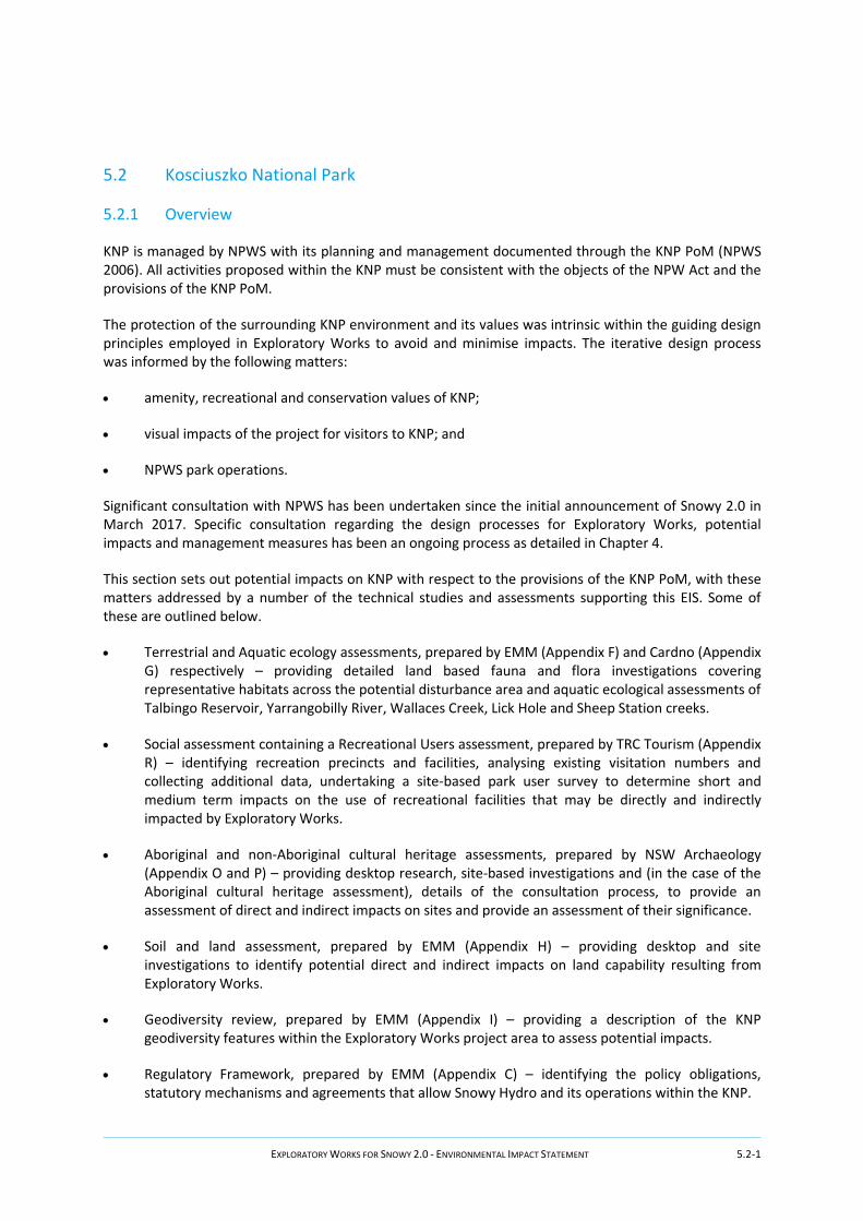
While the values of the project area are clear (and discussed further below), many of the more popular locations within KNP are well to the south of the project area and include the main skiing areas, alpine resorts and associated villages; all of which are close to Mount Kosciuszko, about 150 to 200 km by road from the project area. Visitors and tourists to these locations are more likely to arrive via Cooma, the Snowy Mountains Highway, Jindabyne and Kosciuszko roads. Figure 5.4 shows the KNP visitor facilities and roads in proximity to the project area.
Further, the project area is separated from the major alpine resorts and villages by a large Wilderness Area (the Jagungal Wilderness Area, comprising 67,432 ha of high country) that contains no access for public vehicles. Apart from the Snowy Mountains Highway, road linkages between the northern and southern parts of the park are limited, with most of these back roads providing a low level of service during summer, while during winter months most of these roads are closed to the public.
")
")
")
")
!B
!B
!B
!B
!B
!B
!B
!B
!B
!B
!B
!B
!B
!B
!B
!B
!B
!B
Tumut 2 Power Station
Tumut 3 Power Station
Cabramurra
Selwyn SkiResort
SNOWYMOUNTAINSHIGHWAY
YarrangobillyCaves
Old KiandraGoldfields
Talbingo Damboat ramp
Fishing
Bullocks HillCampground
LongPlain Hut
Rocky Plain
TalbingoReservoir
Tumut 2Reservoir
JounamaPondage
KOSCIUSZKO NP
Ravine Campground
O'HaresRest Area
Coonara Point
YarrangobillyVillage
Campsite
Four MileTrail
EucumbeneRiver
Black PerryRest Area
Buddong Falls
´
\\emm
svr1\
EMM\
Jobs
\2017
\J171
88 - S
nowy
Hyd
ro 2.0
\GIS
\02_M
aps\_
EIS_
EW\EI
SEW0
58_K
NPVis
itorFa
cilitie
s_20
1807
14_0
2.mxd
16/07
/2018
0 2.5 5km
GDA 1994 MGA Zone 55Source: EMM (2018); Snowy Hydro (2018); DFSI (2017); LPMA (2011)
Recreational use areas!B Camping!B Camping - horses permitted!B Fishing and boating!B Place of interest!B Ski resort!B Township
Scheme storage
") Existing power stationExisting pipeline tunnelMain roadLocal road or trackWatercourseExploratory tunnelDisturbance footprintAvoidance footprint
! ! ! ! !
! ! ! ! !
! ! ! ! ! Kosciuszko National ParkState forest
KEY Kosciuszko National Park: visitorfacilities and roadsSnowy 2.0Environmental Impact StatementExploratory WorksFigure 5.4
EXPLORATORY WORKS FOR SNOWY 2.0 - ENVIRONMENTAL IMPACT STATEMENT 5.2-4
As for the values and importance of the Ravine region to the KNP, the area has not been included in a Wilderness Area within the PoM, neither has it been recognised as possessing places and values of exceptional significance (NPWS 2006).
Wilderness Areas are:
• across the northern parts of KNP (on the northern side of the Snowy Mountains Highway);
• through the centre of the park (the Jagungal Wilderness area mentioned above); and
• across the south western and southern parts of the park (near the Victorian state border).
There are three areas identified in the PoM that contain significant natural and cultural values but that are considered highly vulnerable to human-induced disturbance and require specific management measures to ensure their protection. These are:
• the alpine landscapes of the Main Range –around the concentration of alpine resorts near Mount Kosciuszko;
• the Yarrangobilly karst catchment – about 30 km by road north east of the project area; and
• the Cooleman Plain karst catchment – about 70 km north east of the project area.
There are an additional four management units identified as significant for their recreational values. These are the alpine skiing areas of:
• Charlotte Pass – within the Main Range Management Unit, in the southern part of KNP;
• Thredbo - within the Main Range Management Unit, about 2 hours and 40 minutes drive (152 km) by road south east of the project area;
• Selwyn – on the south side of Kings Cross Road, about 40 minutes drive (22 km) from Lobs Hole; and
• Perisher Range –within the Main Range Management Unit, about 3 hours 30 minutes (210 km) by road, south of the project area.
The locations of Management Units and Wilderness Areas closest to the project area are shown on Figure 3.1 in Chapter 3. None of these areas are potentially directly affected by Exploratory Works.
iii Project area values
The KNP PoM also contains Schedules (at Part C of the KNP PoM) that address more site-specific matters, including features and items that may be potentially directly or indirectly affected by Exploratory Works.
Schedule 1, in particular, comprises a schedule of ‘Significant Natural and Cultural Features’ of the KNP, including species and communities of flora and fauna, rocks and landforms and cultural heritage items that may be within or close to the project area.
Not surprisingly, many of these same features have been identified in the preparation of this EIS. These features are summarised in Table 5.3, discussed further elsewhere in Chapter 5 and detailed in the respective technical studies and assessments.
EXPLORATORY WORKS FOR SNOWY 2.0 - ENVIRONMENTAL IMPACT STATEMENT 5.2-5
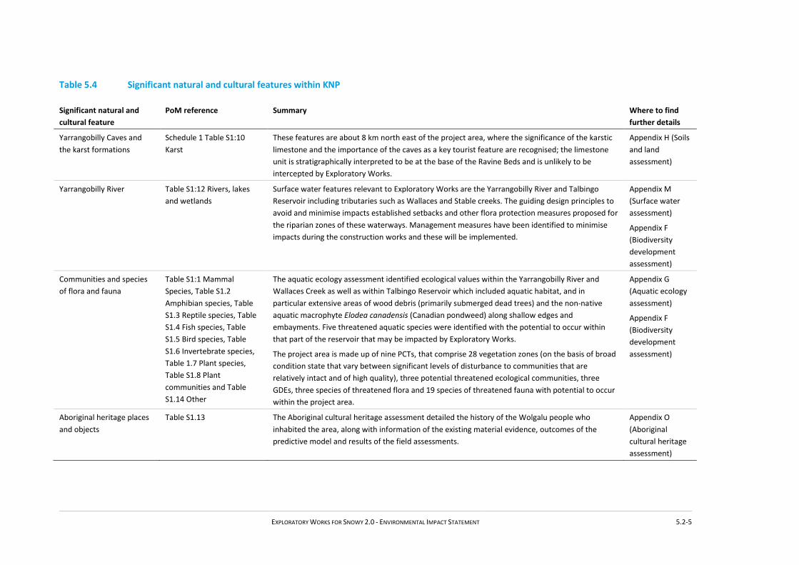
Table 5.4 Significant natural and cultural features within KNP
Significant natural and cultural feature
PoM reference Summary Where to find further details
Yarrangobilly Caves and the karst formations
Schedule 1 Table S1:10 Karst
These features are about 8 km north east of the project area, where the significance of the karstic limestone and the importance of the caves as a key tourist feature are recognised; the limestone unit is stratigraphically interpreted to be at the base of the Ravine Beds and is unlikely to be intercepted by Exploratory Works.
Appendix H (Soils and land assessment)
Yarrangobilly River Table S1:12 Rivers, lakes and wetlands
Surface water features relevant to Exploratory Works are the Yarrangobilly River and Talbingo Reservoir including tributaries such as Wallaces and Stable creeks. The guiding design principles to avoid and minimise impacts established setbacks and other flora protection measures proposed for the riparian zones of these waterways. Management measures have been identified to minimise impacts during the construction works and these will be implemented.
Appendix M (Surface water assessment)
Appendix F (Biodiversity development assessment)
Communities and species of flora and fauna
Table S1:1 Mammal Species, Table S1.2 Amphibian species, Table S1.3 Reptile species, Table S1.4 Fish species, Table S1.5 Bird species, Table S1.6 Invertebrate species, Table 1.7 Plant species, Table S1.8 Plant communities and Table S1.14 Other
The aquatic ecology assessment identified ecological values within the Yarrangobilly River and Wallaces Creek as well as within Talbingo Reservoir which included aquatic habitat, and in particular extensive areas of wood debris (primarily submerged dead trees) and the non-native aquatic macrophyte Elodea canadensis (Canadian pondweed) along shallow edges and embayments. Five threatened aquatic species were identified with the potential to occur within that part of the reservoir that may be impacted by Exploratory Works.
The project area is made up of nine PCTs, that comprise 28 vegetation zones (on the basis of broad condition state that vary between significant levels of disturbance to communities that are relatively intact and of high quality), three potential threatened ecological communities, three GDEs, three species of threatened flora and 19 species of threatened fauna with potential to occur within the project area.
Appendix G (Aquatic ecology assessment)
Appendix F (Biodiversity development assessment)
Aboriginal heritage places and objects
Table S1.13 The Aboriginal cultural heritage assessment detailed the history of the Wolgalu people who inhabited the area, along with information of the existing material evidence, outcomes of the predictive model and results of the field assessments.
Appendix O (Aboriginal cultural heritage assessment)

EXPLORATORY WORKS FOR SNOWY 2.0 - ENVIRONMENTAL IMPACT STATEMENT 5.2-6
Table 5.4 Significant natural and cultural features within KNP
Significant natural and cultural feature
PoM reference Summary Where to find further details
Mining sites and remnants of earlier European activity
Table S1.13 The historic heritage assessment detailed the alpine region and high country’s rich history from the early explorer-settlers in the 1820s, the establishment of pastoralism and summer grazing in the 1830s and the gold rush at Kiandra in 1859-60 and early scientific exploration. The assessment includes details of the copper mine in the Lobs Hole area established in the late nineteenth century through to 1916, the remains of both surface and below ground works from the mine and the settlement of Ravine associated with the mining boom.
Appendix P (Historic cultural heritage assessment)
Rocks and landforms Table S1.9 A geodiversity review identified the glacial and peri-glacial features of KNP within proximity to the project area. These included scree slopes and block streams and boulder fields along Lower Lobs Hole Ravine Road.
Appendix I (Geodiversity review)

EXPLORATORY WORKS FOR SNOWY 2.0 - ENVIRONMENTAL IMPACT STATEMENT 5.2-7
Also included in the KNP PoM are schedules of:
• appropriate recreational activities - Schedule 4;
• information on visitor facilities – Schedule 5; and
• implementation priorities – Schedule 11.
Of specific interest to the project area are the recreation values of the area. The project area, which includes Talbingo Reservoir provides low-key land-based recreational values and uses that include bushwalking, mountain biking, horse riding, boating, fishing, water skiing and canoeing (Appendix R).
Schedule 4 Table S4.1 of the PoM contains a list of recreation activities considered appropriate for land located within each of the management zones that cover the KNP. The project area is included in the Back Country Zone. The existing and proposed recreation facilities within or close to the project area have been listed in the KNP PoM as Appropriate Recreational Activities (Schedule 4 Table S4.1).
5.2.3 Assessment of impacts
i Potential impacts
Amenity
Exploratory Works will require facilities that will result in:
• clearing of existing vegetation within a pre-defined disturbance footprint;
• bulk earthworks using a balanced cut-and-fill construction to provide horizontal surfaces that are of sufficient size for the required compounds and laydown areas;
• construction of a haul road between the portal construction pad, Lobs Hole and Middle Bay and roadworks to specified minor roads including passing lanes, roadside barriers and other modifications and several bridges;
• construction of barge infrastructure at Middle Bay;
• installing buildings such as an accommodation camp, site administration buildings and workshops;
• stockpiling of construction material and the storage of construction equipment; and
• the placement of excavated rock material in one or more locations at Lobs Hole or subaqueously within Talbingo Reservoir.
These are all facilities that will result in changes to amenity for the duration of Exploratory Works. Amenity impacts will be a consequence of Exploratory Works construction activities to establish these facilities in the short term, primarily:
• Noise and vibration impacts as discussed in Section 5.8 and in detail in Appendix T, including:
- the 24 hour continuous drill and blast operation required for the construction of the exploratory tunnel;

EXPLORATORY WORKS FOR SNOWY 2.0 - ENVIRONMENTAL IMPACT STATEMENT 5.2-8
- haul truck movements of extracted rock between the exploratory tunnel portal and the excavated rock emplacement locations;
- the loading and unloading of extracted rock at the tunnel portal and the excavated rock emplacement locations;
- the shaping and grading of extracted rock at the excavated rock emplacement locations;
- the 24 hour barge operation between Middle Bay barge ramp and Talbingo barge ramp;
- outdoor activities at the accommodation camp; and
- increase in traffic movements within KNP.
• Air quality impacts as discussed in Section 5.8 and in detail in Appendix U including:
- hauling spoil on unsealed roads;
- loading and unloading of spoil;
- dozer shaping excavated rock emplacement areas; and
- machinery exhausts and plant and equipment.
• Lighting impacts including:
- flood lighting at the portal construction pad, excavated rock emplacement locations and at the barge facilities and laydown area at Middle Bay from the 24 hour operations required for the drill and blast operations;
- impacts from the headlights of the trucks using the haul route between the exploratory tunnel portal, the excavated rock emplacement locations at Lobs Hole and facilities at Middle Bay barge ramp;
- navigation and flood lighting on the barge traversing Talbingo Reservoir; and
- flood lighting and building lighting associated with the accommodation camp.
Other potential amenity matters are discussed elsewhere, such as Section 5.8 where public safety matters are addressed. These impacts are considered temporary in the context of Exploratory Works, as facilities would be removed and the area rehabilitated (should Snowy 2.0 not proceed).
Public access to Lobs Hole will be restricted during Exploratory Works, however some construction activities (such as Talbingo barge ramp, Spillway Road upgrade and Upper Lobs Hole Ravine Road) are near areas of public access and use. Short term amenity changes are anticipated at these areas but are considered manageable and acceptable provided appropriate management and mitigation is implemented.

EXPLORATORY WORKS FOR SNOWY 2.0 - ENVIRONMENTAL IMPACT STATEMENT 5.2-9
Recreational users
For the duration of Exploratory Works public use of Lobs Hole Ravine Road will be restricted. In addition, a number of minor roads and walking, biking and horse-riding tracks at Lobs Hole will be closed off to the public (where the access way may interact with a construction site, such as a compound or laydown area). In these circumstances existing recreational tracks and trails may not be available for use by the public camping at the Ravine campground will not be available.
This will affect a relatively small number of local and regular visitors to the existing camping facilities as well those that enjoy the more isolated environs provided in this part of KNP.
Overall, the impact on recreational users is likely to be low in the short term and positive in the long term given that:
• direct impacts will be temporary and will affect a relatively low number of users of KNP;
• most long term impacts, once mitigation strategies are implemented, will be low;
• some long term impacts will be positive such as improved access and facilities to/at Lobs Hole and at Talbingo Reservoir; and
• displacement, both temporary and long term, is not expected to occur at high levels and will be to sites that generally have the capacity to absorb some extra visitation.
Therefore, on balance, the impact on recreational users is considered acceptable.
Visual
Lobs Hole is within a steeply incised ravine, along the western fringe of the Long Plains fault escarpment. Elevations typically range from around 550 m AHD (near Talbingo Reservoir) to 1,400 m AHD (the elevation of the high plains). Most of the project area is characterised by deep gorges and steep sloping ridges, the product of incision from watercourse flows and glaciations, with localised areas of lower grade, such as ridgelines, saddles, benches, and alluvium beside watercourses. The steep slopes and complexity of the landforms over the project area are evident on Figure 5.5.
Also evident on this figure are areas free of tree cover, some of which reflects the long history of occupation in the area. Previous land uses and activities that occurred close to or within the project area are detailed in Appendix P that describes the early grazing activities in the early 1800s, followed by mining, prospecting, settlement, as a refuge from the winters of Kiandra, gardening and agriculture. From the 1860s to approximately 1917, Lobs Hole was the site of copper mining, while during the construction of the Snowy Scheme, the area was well used during surveying work. Lobs Hole is now an isolated and remote public camping area with an unformed boat launching area used to access the southern reaches of Talbingo Reservoir.
These activities and past land uses have resulted in significant clearing and disturbance of vegetation in the area. Substantial regrowth has occurred throughout Lobs Hole; however, Blackberry, a weed of national significance, has established itself to the point of infestation within the area, particularly in gullies and along the Yarrangobilly River towards the exploratory tunnel.
EXPLORATORY WORKS FOR SNOWY 2.0 - ENVIRONMENTAL IMPACT STATEMENT 5.2-10
Despite past land clearing and land use the re-established vegetative cover provides high connectivity for terrestrial and arboreal mammals, birds and reptiles and the various waterways provide suitable river corridors for aquatic and semi-aquatic species (such as fish and amphibians) and species (such as birds and bats) which use linear features to navigate.
Some of the proposed Exploratory Works within the KNP will be close to the flood plain associated with the Yarrangobilly River and at Middle Bay. This includes the barge access facilities, bridges, associated laydown areas and excavated rock emplacement areas. Other facilities will require more elevated sites, such as the accommodation camp which is above the flood plain. The location of the exploratory tunnel has been determined so as to optimise the drill and blast operation. There are no Exploratory Works proposed on mountain tops or the high plains.
An analysis has been undertaken to determine the visibility of Exploratory Works from outside the project area, referred to as a visibility analysis. This included use of a digital surface model (DSM) created from LiDAR flown in late 2017. The DSM integrates vegetation cover and structures into the Earth’s surface for modelling. Two representative infrastructure points were entered into the DSM, one at the accommodation camp at 6 m high and one at the portal entrance at 9 m high. A viewshed was run to determine visibility of these points from the surrounding area. This has been supplemented with qualitative analysis of other Exploratory Works elements.
Limited public vantage points of Exploratory Works have been identified. Recreational facilities or users are not close enough in proximity to see the modelled infrastructure. In addition, the heavy and tall vegetation outside of the disturbance footprint, as well as valleys and low points in which the works will take place, will largely screen the Exploratory Work elements from key park user locations as well as from Snowy Mountains Highway or Selwyn’s snowfield.
Road works will result in closure of access roads to the public (including some recreational lookouts such as Wallaces Creek look out) therefore these are not expected to be visible. The exception is recreational users of Talbingo Reservoir, who will be able to see barge access infrastructure when boating or doing other recreational activities near Talbingo Spillway, as well as road works for Spillway Road. However, the Talbingo barge ramp is consistent with existing facilities at this location so is not expected to result in visual impacts.
The results of this visibility analysis are shown on Figure 5.5 and highlights that visibility of the modelled infrastructure points is contained to the immediate working areas which will be closed to the public during construction. Effective rehabilitation of the site post-construction will ensure that these impacts remain minimal once the area is made available to the general public.

!!
!!
INDICATIVE INFRASTRUCTURE- ACCOMMODATION CAMP (6 m high)
INDICATIVE INFRASTRUCTURE- PORTAL (9 m high)
´0 0.5 1
kmSource: EMM (2018); Snowy Hydro (2018); NearMap (2018); SMEC (2018); Robert Bird (2018)GDA 1994 MGA Zone 55
Snowy 2.0Environmental Impact StatementExploratory WorksFigure 5.5
Visibility analysis
!
[
WALLACES CREEKLOOKOUT
(9 KM TO LOBS HOLE)
!! Modelled infrastructure viewpointPermanent bridgeAccess road upgradeAccess road extensionPortal construction pad andaccommodation camp conceptuallayoutExploratory tunnelWatercourseArea where infrastructure is visible fromDisturbance footprintAvoidance footprint
KEY\\e
mmsv
r1\EM
M\Jo
bs\20
17\J1
7188
- Sno
wy H
ydro
2.0\G
IS\02
_Map
s\_EIS
_EW\
EISEW
052_
Mode
lledV
isibility
_201
8071
4_03
.mxd
16/07
/2018

EXPLORATORY WORKS FOR SNOWY 2.0 - ENVIRONMENTAL IMPACT STATEMENT 5.2-12
Conservation
Given the values associated with the sub-Alpine environment and the location of most of Exploratory Works within the KNP, detailed assessments were undertaken to determine biological diversity of the area and to ensure that the design of Exploratory Works maintains the ecological integrity of the receiving environment. The results of these assessments are reported in this EIS and detailed at Appendix F and Appendix G.
The biodiversity and aquatic assessments included:
• desktop assessments to identify threatened species requiring further assessment and consideration;
• preliminary assessment, including detailed vegetation mapping and habitat assessment;
• targeted flora, fauna and fish surveys, either meeting or exceeding NSW and Commonwealth survey guidelines;
• a robust impact avoidance and minimisation strategy through avoidance of key constraints identified during the process outlined above; and
• a commitment to a substantive list of controls to ensure any unavoidable impacts are further minimised and mitigated.
The overall findings were that Exploratory Works is unlikely to result in a significant impact to threatened species. Any residual biodiversity impacts will be offset using a biodiversity offset strategy, with its intent to provide direct management actions and conservation outcomes for the values of KNP.
ii Avoidance and minimisation of impacts
Amenity
Through the design process for Exploratory Works, Snowy Hydro, in consultation with EMM and the project design team, has undertaken significant steps to avoid, minimise and mitigate impacts. The objective was to locate, design and construct Exploratory Works in such a way that it avoids and minimises impacts to the receiving environment and retains the existing dominant, natural character of the area. This was embedded from the outset by targeting existing disturbed areas at Lobs Hole for the siting of specific Exploratory Works elements.
Design features such as the 50 m setback from Yarrangobilly River and minimising and refining the Exploratory Works footprint as well as the noise and air quality mitigation measures (refer to Section 5.8) will result in a minimisation of potential impacts to the amenity of the project area.
Whilst the majority of Exploratory Works will not be visible to the public, appropriate standards and guidelines will be implemented, including adopting internationally accepted standards for marine and light sensitive locations, and consideration given to implementing available guidelines for outdoor lighting in dark-sky reserves where it can be shown that to do so will not compromise safety.

EXPLORATORY WORKS FOR SNOWY 2.0 - ENVIRONMENTAL IMPACT STATEMENT 5.2-13
Recreational users
Some local roads will be restricted from public use during Exploratory Works, restricting access to the camping and recreation facilities at Lobs Hole. These impacts can be mitigated by ensuring that visitors are aware of other opportunities for similar experiences and the remediation of the site at the conclusion of the works.
Displacement of visitors from Lobs Hole may impact other sites in KNP, and there is a need to ensure that these sites will be able to absorb the additional visitation. Snowy Hydro has been working with NPWS to determine appropriate measures to offset the closure of Lobs Hole, and this includes upgrade of other recreational areas such as Yarrangobilly Village and O’Hares campgrounds.
Visual
Measures have been identified that minimise impacts on amenity (such as reducing light spill and minimising vegetation clearance where possible), and result in new and improved recreational facilities (such as is proposed to offset recreational in consultation with NPWS, refer Appendix R). These measures have been considered in the design process and carried through as mitigation measures to ensure outcomes are consistent with the values and actions set out in the KNP PoM, being:
• the need to protect and enhance the natural environment;
• recognising KNP’s important cultural heritage places and landscapes; and
• the park as venue for outdoor recreation pursuits, recognising the importance of human contact with nature for human health and wellbeing.
The end result will be development that retains the natural character of the existing environment in a manner that is compatible with the intent of the Back Country Zoning, and proposed infrastructure that is compatible with the character of development associated with the existing Snowy Scheme.
Conservation
Many of the changes to location and design have been driven by the need to avoid and minimise biodiversity impacts, and have resulted in the adoption of the following avoidance and minimisation principles on the location and design of Exploratory Works:
• applying an exclusion buffer of 50 m around the Yarrangobilly River, to avoid and minimise impacts to threatened frog species and threatened fish habitat;
• minimising and refining the Exploratory Works footprint where feasible to minimise the extent of clearing required;
• limiting and minimising clearing along Upper Lobs Hole Ravine Road, in the areas of known Smoky Mouse habitat;
• limiting the proposed hours of use along Upper Lobs Hole Ravine Road, in the areas of known Smoky Mouse habitat;
• excluding as far as possible activities on the former Lobs Hole Mine to minimise risks of Exploratory Works on contaminated land;
EXPLORATORY WORKS FOR SNOWY 2.0 - ENVIRONMENTAL IMPACT STATEMENT 5.2-14
• designing a rock emplacement area that will treat potential acid forming properties of the excavated material, to ensure there are no detrimental impacts to the downstream environment;
• identifying water management principles that can be adopted through design to minimise impacts; and
• consulting with relevant stakeholders, in particular NPWS and OEH, to ensure desired management outcomes are understood.
These measures are further described at Appendix F.
In addition, the geodiversity features along Lower Lobs Hole Ravine Road have largely been avoided with the exception of one location (block stream/ boulder scree) where the existing road surface is to be widened to enable safe passage of vehicles. It is considered that this minor impact is acceptable.
iii Residual impact summary
Amenity
As detailed in Chapter 2, the Exploratory Works facilities will be built and used for the duration of the Exploratory Works, after which they will be removed and the respective sites rehabilitated, subject to Snowy 2.0 proceeding. Facilities to be removed include construction buildings, compounds and the western rock emplacement area, subject to ongoing consultation with NPWS.
However Exploratory Works will result in residual impacts, including as a result of the required improvements to the minor road network and the provision of a haul-road standard route between the exploratory tunnel portal, Lobs Hole and Middle Bay. As discussed below, this may result in an increase in the number of visitors to the area and potentially alter the isolated character of the area in the longer term.
Recreational users
On completion of Exploratory Works, temporary road closures will be removed and access to the Ravine Campground and any closed tracks and trails will be reopened, subject to the requirements of the Snowy 2.0 main project should it proceed.
The road upgrades and extensions provided by Exploratory Works may result in Lobs Hole becoming more accessible and result in increased visitation to the area, which will increase demands for a higher level of visitor facilities (such as toilets and picnic tables). At the same time, increased visitation numbers may also alter the character of the site and reduce the appeal of it for some current users.
There may also be some impacts on recreational users from increased traffic, particularly on visitors to Selwyn Snowfields in the ski season. These impacts are likely to be minor and can be mitigated through traffic management and the use of exclusion windows for heavy traffic during peak traffic periods.
Visual
As stated elsewhere, most of the facilities provided during construction of Exploratory Works, including the construction compound, site facilities and accommodation camp, will be removed and the respective sites rehabilitated, should Snowy 2.0 not proceed.

EXPLORATORY WORKS FOR SNOWY 2.0 - ENVIRONMENTAL IMPACT STATEMENT 5.2-15
The visual impacts of any residual impacts will be minimised through the development of a detailed rehabilitation strategy, including the inclusion of appropriate slope design and use of structures (as required), the implementation of erosion and sediment controls, the preparation of a landscape management plan and provisions for maintenance and monitoring.
Conservation
Through the location and design process there has been significant effort on avoiding and minimising impacts to key biodiversity features (as previously discussed in Section 5.1). This has resulted in positive outcomes for conservation by reducing impacts to threatened species and habitat and minimising vegetation clearance needed for Exploratory Works. Long term management programs will be agreed with NPWS to offset residual impacts.
Significant controls will be implemented to avoid impacts to water quality and quantity in the Yarrangobilly River and Talbingo Reservoir. No water will be taken from or released to the Yarrangobilly River, reducing the potential for water quantity impacts resulting from Exploratory Works. Implementing the controls referred to above will result in low to negligible risk of water quality impacts to aquatic species and the aquatic environment.
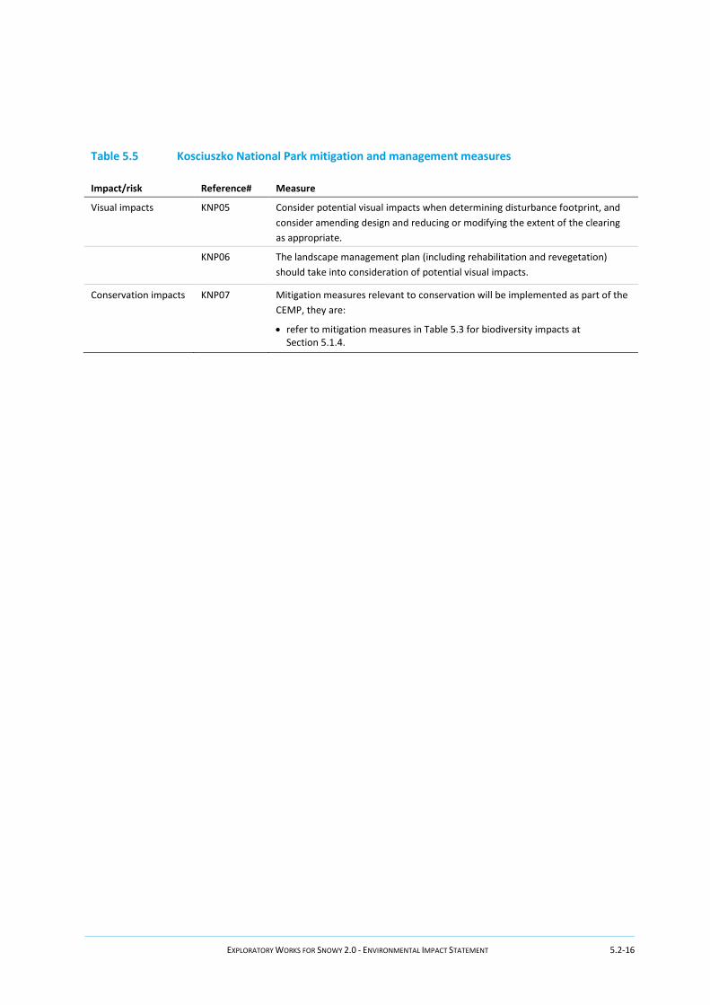
5.2.4 Mitigation and management
Exploratory Works will include short term and temporary impacts to KNP in addition to residual impacts that need to be considered as part of a longer term management strategy. Management of impacts within KNP need to align to the management objectives identified in the KNP PoM administered by NPWS. Snowy Hydro has been working with NPWS to ensure opportunities for contributory measures are identified where needed.
A summary of the recommended mitigation and management measures to address impacts to KNP associated with the Exploratory Works is provided in Table 5.5. A number of mitigation measures are specific to other assessments carried out for this EIS, and these have not been repeated here but are referenced for completeness. These measures will be incorporated into detailed design and the CEMP. The long term management strategy for KNP, including compensatory measures, is detailed in Chapter 6.
Table 5.5 Kosciuszko National Park mitigation and management measures
Impact/risk Reference# Measure
Impacts to amenity
KNP01
Mitigation measures relevant to noise and air quality will be implemented as part of the CEMP, including:
• refer to mitigation measures in Table 5.19 for noise impacts at Section 5.8.1.
• refer to mitigation measures in Table 5.20 for air quality at Section 5.8.2.
KNP02 Construction contractor should minimise construction lighting and resulting glare to the maximum extent possible where it can be shown that to do so would not compromise safety. .
KNP03
All lighting should incorporate cut-off shields and be directed downward toward work activities, away from the night sky and away from known locations of light-sensitive habitat.
Recreational users
KNP04
Mitigation measures relevant to recreational users will be in line with the Recreational Users assessment (Appendix R) and include:
• refer to mitigation measures in Table 5.18 for social impacts at Section 5.7.4.
EXPLORATORY WORKS FOR SNOWY 2.0 - ENVIRONMENTAL IMPACT STATEMENT 5.2-16
Table 5.5 Kosciuszko National Park mitigation and management measures
Impact/risk Reference# Measure
Visual impacts
KNP05
Consider potential visual impacts when determining disturbance footprint, and consider amending design and reducing or modifying the extent of the clearing as appropriate.
KNP06
The landscape management plan (including rehabilitation and revegetation) should take into consideration of potential visual impacts.
Conservation impacts
KNP07
Mitigation measures relevant to conservation will be implemented as part of the CEMP, they are:
• refer to mitigation measures in Table 5.3 for biodiversity impacts at Section 5.1.4.