chf 20th anniversary book
TRANSCRIPT

Department of the Interior
Central Hazardous Materials Fund
Celebrating 20 Years Supporting the Cleanup of Department
Managed Lands

The Central Hazardous Materials Fund (CHF) is the U.S. Department of the Interior’s (Department) principal source of funds for the cleanup of the most highly contaminated sites
located within national parks, national wildlife refuges, and other Department-managed
lands. The CHF is used to help fund the cleanup of contaminated sites using Comprehensive
Environmental Resource and Liabilities Act (CERCLA). CHF sites typically pose potential
risks to employees, public health and welfare, and the environment. They generally require
resources and technical expertise when there are insufficient bureau resources.
The CHF pursues potentially responsible parties for cost reimbursement, or for them to
perform work so that the Department can avoid paying for the cleanup costs. The CHF has
recovered $87 million from responsible parties. CHF can use the recovered costs to cleanup
sites where there is not a party responsible for the damage. Where responsible parties have
decided to perform work, their efforts have avoided $476.9 million in potential costs to
Department. To date, the CHF has received approximately $217 million in appropriations.
Since 1995, the Department has used the CHF to undergo CERCLA response actions at more
than 65 sites and completed cleanup at 20 sites. The sites include abandoned hard rock mines
and property transferred to or acquired by the Department that were contaminated by past
industrial, military and other uses.
The CHF is managed by the Office of Environmental Policy and Compliance (OEPC). The
CHF currently funds projects in the following bureaus: Bureau of Indian Affairs (BIA), Bureau
of Land Management (BLM), Bureau of Reclamation (BOR), U.S. Fish and Wildlife Service
(FWS), National Park Service (NPS), and the U.S. Geological Survey (USGS).
To learn more about the CHF, visit: www.doi.gov/pmb/oepc/eclm/index.cfm
Central Hazardous Materials Fund
NPS’ Krejci Dump site after remediation
Cover Photos: Before and after the cleanup of the Bureau of Reclamation's Matheson Mill Site
Laysan albatross at Midway Atoll
2

Bureau of Indian Affairs
The Bureau of Indian Affairs (BIA) was established in 1824. BIA provides
services to approximately 1.9 million American Indians and Alaskan
Natives. There are 566 federally recognized American Indian Tribes and
Alaska Natives in the United States. BIA is responsible for the administration of 55 million
surface acres and 57 million acres of subsurface minerals estates held in trust by the United
States for America Indian, Indian Tribes, and Alaska Natives.
To date, the CHF has provided BIA
$8.9 million to support nine projects
managed by the bureau. Of the funding
provided, $367,000 has been recovered.
The primary project that the CHF has
funded for BIA is the Tar Creek
Superfund Project.
The Tar Creek Superfund Project (Site) is
located in northeastern Oklahoma. It is part of the Tri-State Mining District (Oklahoma,
Kansas, and Missouri), which had some of the richest deposits of lead and zinc ore in the
United States. Most of the rich deposits of ore are gone, and active large-scale mining that
spanned from the late 1800s to 1970 no longer exists. In 1984, the 40 square mile Site was
placed on the National Priorities List (NPL). The Site remains one of the most challenging
cleanup projects in the U.S. on the NPL due to the extent of disturbance and contamination
including: volumes of contaminated waters, sediments, waste materials, and soil. The Site is
located on or in close proximity to, Native American lands and communities.
The CHF began funding the Site in 1995
to support BIA as the technical lead for
the cleanup on BIA managed land.
The BIA supports the Tribe, the state, and
federal agencies in the remedial efforts for
several Operable Units (OU) at Tar Creek.
At OU 1, impacts to ground and surface
water were studied. At OU 2, the focus
was on remediating contamination on
residential properties and elevated lead levels in children’s blood.
Mission: “to enhance the quality of life, to promote economic
opportunity, and to carry out the
responsibility to protect and
improve trust assets of American
Indians, Indian Tribes, and
Alaska Natives”
Chat removal activities at Tar Creek
3

Bureau of Indian Affairs
The OU3, was an emergency removal action at the Eagle-Pitcher plant.
BIA was not involved in OU3. At OU 4, leftover mine tailings, or chat piles,
were fenced to prevent illegal removal and unauthorized access to the Site.
Also, mine waste, mill waste, smelter waste, and floatation ponds.
At OU 5, the ongoing study considers sediment as well as water contamination at all levels. In 2003, a Memorandum of Understanding among the Department, the EPA, the U.S.
Army Corps of Engineers, and co-chaired by all agencies, was developed to provide
government coordination and support for the cleanup efforts.
The CHF continues to support BIA’s ongoing work including contaminant migration prevention activities. BIA and the other agencies are focusing on establishing a long-term
land use program using the Geographical Information System to develop mapping data that
will aid in land-use decisions.
The BIA’s Eastern Oklahoma Region continues to work toward the remediation of the site
and supports the Tribe, the state, and federal agencies working toward the same goals.
For more information about BIA please visit: www.bia.gov
Accomplishments
At the Tar Creek Site:
To date, approximately
3,747,434 tons of chat have
been removed from the Site
2,927 properties have been
remediated under OU 2
Children with elevated lead
levels in blood have been
reduced from 35% to 2%
The CHF has provided
approximately $3.5 million
to BIA to support the Tar
Creek project
Chat piles at Tar Creek
4

Bureau of Land Management The Bureau of Land Management (BLM) was established in 1946 through
the consolidation of the 1812 General Land Office, and the 1934 U.S.
Grazing Service.
The BLM is responsible for carrying out a variety of
programs for the management and conservation of
resources on 258 million surface acres as well as 700
million acres of subsurface mineral estate. The public
lands BLM manages make up approximately 13% of the
total land surface of the United States and more than
40% of all land managed by the Federal Government.
To date, the CHF has provided BLM $62.1 million to
support 43 projects. Of the funding provided, $8.25 million has been recovered, which has
been able to support additional cleanup work at CHF sites.
Some of the sites funded by the CHF include the Formosa Mine, Ute Ulay, Manning Canyon
Mill, Saginaw Hill Abandoned Mine Land, and Lee Acres Landfill.
The Formosa Mine National Priorities List site is located in Southwest Oregon, approximately
25 miles south of the city of Roseburg. This is a mixed ownership site where the EPA is the
lead on privately owned land, and BLM is the lead regulatory agency on BLM land. The site is
situated in the Coast Range Klamath Mountains at elevations ranging between 3,200 and
3,600 feet. The site is in the South Umpqua Basin, and is situated near the top of a mountain
ridge that divides several sub-watersheds.
The mine is approximately 700 feet deep and consists of a network of underground workings
and mineral processing areas. The site was left with a legacy of acid mine drainage (AMD) that
formed in the network of underground workings.
Mission: “to sustain the health, diversity, and
productivity of America’s public lands for the use and
enjoyment of present and
future generations”
Formosa 1 adit temporary AMD treatment View from the Formosa NPL site
5

AMD flows into Middle Creek, South Fork Middle Creek, and might flow
into other streams from the Formosa 1 and Silver Butte Adits, numerous
groundwater springs, and areas containing surface mine waste. AMD
from the Formosa 1 Adit has severely degraded Middle Fork Creek and the South Fork of
Middle Fork Creek which affects resident fish, coastal steelhead trout, and Oregon coastal
coho salmon. The site is also located in the municipal watershed for the City of Riddle.
The Formosa 1 Adit is located on BLM land, and the Silver Butte Adit is on private land. Since
the 1930s, approximately 5 to 20 gallons per minute of AMD has flowed out of the Formosa 1
Adit, and up to 10 gallons per minute has flowed out of the Silver Butte Adit. BLM is
implementing a removal action to control the AMD from the Formosa 1 Adit, and EPA is
implementing a remedial action for the entire site. BLM is participating in the full site
remedial action to ensure that the remedy will be suitable for the impacted BLM land. To
date, the CHF has provided the Formosa project approximately $3.8 million. The project has
received some support from the EPA and the U.S. Department of Agriculture that has resulted
in cost savings to the Department.
BLM also supports the Ute Ulay Mine-Mill Area (Ute Ulay). Ute Ulay consisted of five mine/
mill tailings sites located along a seven mile stretch of Henson Creek, within the Henson Creek
watershed west of Lake City, Colorado. The mine was established in 1871, and the mill was
erected in 1882. Gold, silver, lead and zinc mining/milling took place at the site. The non-
economic mill tailings were transported in slurry form via a wooden flume to the unlined set-
tling impoundments at the Upper Tailings Impoundments Area. The Upper Tailings Im-
poundments Area consisted of five unlined tailings impoundments and two tailings overflow
areas. The site is on both private and BLM land.
The site consists of two projects in which BLM is working in partnership with the State of
Colorado. The first project has been completed. It consisted of the installation of monitoring
wells, excavation of mill tailings from the Upper
Tailings Impoundment Area and consolidation of the
tailings in an onsite repository, re-grading and
re-vegetating of the excavated site along with annual
inspection and groundwater monitoring. Re-vegetation
was completed in 2010. Ongoing work on this project
includes groundwater monitoring and maintenance on
the repository cap. The CHF has provided BLM
approximately $1 million to support the site.
For more information about BLM, please visit:
www.blm.govUte Ulay Mine
Bureau of Land Management
6
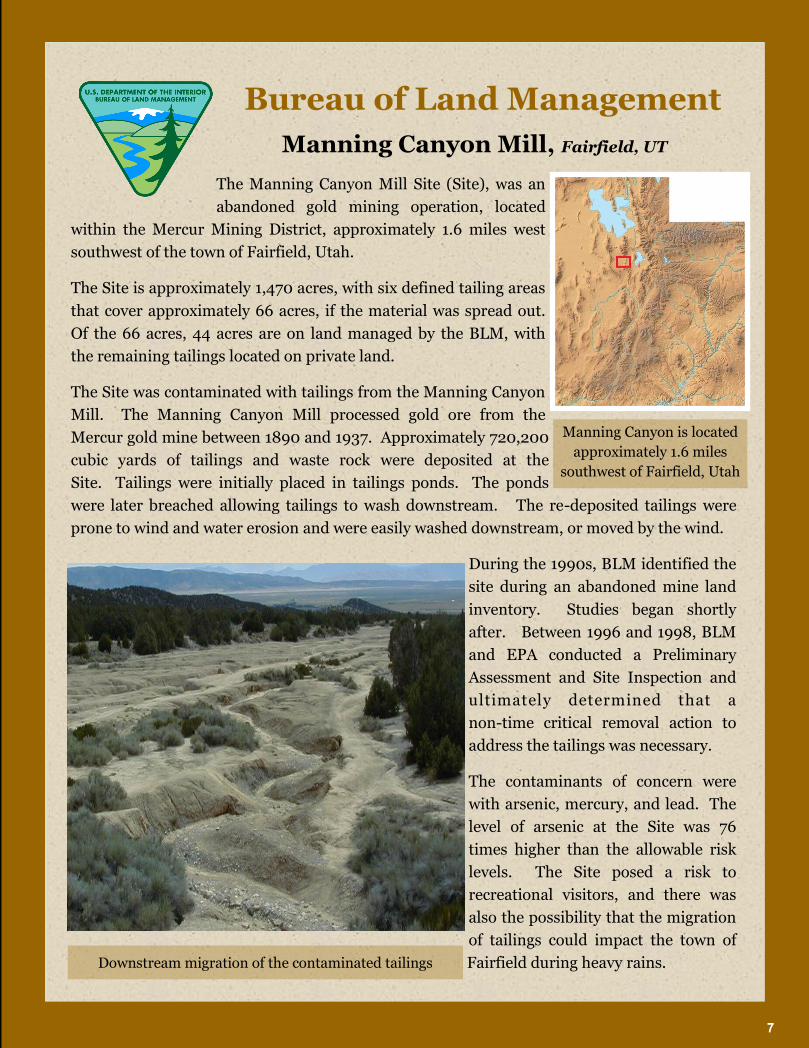
The Manning Canyon Mill Site (Site), was an
abandoned gold mining operation, located
within the Mercur Mining District, approximately 1.6 miles west
southwest of the town of Fairfield, Utah.
The Site is approximately 1,470 acres, with six defined tailing areas
that cover approximately 66 acres, if the material was spread out.
Of the 66 acres, 44 acres are on land managed by the BLM, with
the remaining tailings located on private land.
The Site was contaminated with tailings from the Manning Canyon
Mill. The Manning Canyon Mill processed gold ore from the
Mercur gold mine between 1890 and 1937. Approximately 720,200
cubic yards of tailings and waste rock were deposited at the
Site. Tailings were initially placed in tailings ponds. The ponds
were later breached allowing tailings to wash downstream. The re-deposited tailings were
prone to wind and water erosion and were easily washed downstream, or moved by the wind.
During the 1990s, BLM identified the
site during an abandoned mine land
inventory. Studies began shortly
after. Between 1996 and 1998, BLM
and EPA conducted a Preliminary
Assessment and Site Inspection and
ultimately determined that a
non-time critical removal action to
address the tailings was necessary.
The contaminants of concern were
with arsenic, mercury, and lead. The
level of arsenic at the Site was 76
times higher than the allowable risk
levels. The Site posed a risk to
recreational visitors, and there was
also the possibility that the migration
of tailings could impact the town of
Fairfield during heavy rains.
Manning Canyon Mill, Fairfield, UT
Manning Canyon is located
approximately 1.6 miles
southwest of Fairfield, Utah
Bureau of Land Management
Downstream migration of the contaminated tailings
7

The removal action took approximately 5 years to complete. There were
four phases. Phase 1 began in 2002. During this phase, surface division channels were
constructed and the tailings were consolidated into a repository. Phase 2 involved the
construction of the repository and cap. During Phase 3, the tailings from the lower tailings
area were moved, placed into the repository, and capped with impermeable fabric. Phase 4
consisted of removing the additional tailings identified during the earlier phases and placing
them into an extension of the repository.
Upon completion of the four phases, BLM added top soil and reintroduced native vegetation
on the repository. The site is currently fenced and remains closed to visitors to ensure that
the remedy remains protected.
Remediation cost approximately $18.7 million. The CHF provided $11.2 million and
the responsible party provided approximately $7.5 million of support, including allowing the
placement of part of the repository on the adjoining private land.
To learn more about Manning Canyon Mill, please visit: www.blm.gov/ut/st/
en/fo/salt_lake/more/hazardous_materials/manning_canyon.html
Manning Canyon Mill, Fairfield, UT (cont.)
Bureau of Land Management
Primary Mill tailings pile at the site
Accomplishments
Consolidated approximately
66 acres of tailings in an
on-site repository
Site is currently in long
term monitoring
The CHF has provided
approximately $11.2 million
to support the project
The project has received
approximately $7.5 million
of support from the
responsible party
8

Saginaw Hill (Site), an abandoned mine, is
located approximately 10 miles southwest
of Tucson, Arizona. The Site is located on BLM property, and
consists of two areas of contamination: the Saginaw Mine
(approximately 5 acres) and the Palo Verde Mine
(approximately 1 acre).
The Site is located on a 540 acre parcel of BLM land that is
surrounded by private land. The private land surrounding
Saginaw Hill experienced an increase in residential
development.
Saginaw Hill was part of the Amole Mining District. During
the early 20th Century gold, silver, and base metals were
mined within the District. As a result of the history of mining,
the soil and groundwater at the Site were contaminated with
arsenic, lead, and mercury. The Site contained waste rock, tailings, and smelter slag.
In 2003, a Preliminary Assessment identified high levels of metal contaminants from the
residual mine wastes. There was potential for exposure to the residential community
surrounding the Site, as well as to the people who drove all terrain vehicles around and within
the Site. There are two species found on the Site that are threatened or endangered: the lesser
long-nosed bat and the cactus ferruginous pygmy owl.
Saginaw Hill, Tucson, AZ
Saginaw Hill is located
ap p r o ximat e ly 1 0 mi les
southwest of Tucson, AZ
Bureau of Land Management
Saginaw Hill completed cap Saginaw Hill completed cap
9

The final design and cost estimate was completed in 2007, and work to
implement the selected remedy began in 2009.
The first phase of the remedy involved the following actions: 1) excavation and stabilization of
an on-site arroyo which served as a means of transport of contaminants from the property
boundary, 2) consolidation of several auxiliary waste piles at the repository location,
3) installation of ground cover at excavated areas, and 4) installation of monitoring wells. The
second phase of the removal action focused on excavating and consolidating tailings, waste
rock, and other contaminated materials in an on-site repository. Once the repository was
completed, BLM graded and capped it to prevent future migration of the tailings. The
removal action was completed in 2006. BLM has installed fencing to protect the remedy, and
closed part of the area to the public. The Site is currently in operations and maintenance.
The CHF provided BLM approximately $2.27 million to complete the remedy.
To learn more about Saginaw Hill, please visit: www.blm.gov/az/st/en/fo/
tucson_field_office.html
Saginaw Hill, Tucson, AZ (cont.)
Bureau of Land Management
Saginaw Hill completed cap
Accomplishments
BLM consolidated tailings
and waste piles in an
on-site repository
Site is in operations and
maintenance
The area has been fenced
to protect the remedy
The CHF has provided
approximately $2.27
million to support the
project
Saginaw Hill completed cap
10

Lee Acres Landfill Superfund Site (Site) is
located approximately 4.5 miles east of
Farmington, New Mexico in San Juan County. BLM manages
the 60 acre Site near where an arroyo meets the San Juan River.
In 1962 the BLM leased 20 acres to San Juan County to operate
a county landfill. An additional 40 acres were added to the lease
in 1980. The landfill operated between 1962 and 1986. In 1985,
the landfill was closed to liquid waste disposal after a berm on
the northern lagoon was breached, resulting in a release of
liquid contents and hydrogen sulfide gas.
In 1997, BLM withdrew 134.6 acres of public land, including the
Lee Acres Landfill and a surrounding buffer from settlement,
sale, location or entry for a period of 50 years (62 FR 2177,
Public Land Order No. 7234). The portion of the withdrawal that contains the landfill is
fenced and locked to prevent public access.
In 1990 the EPA added the area to the National Priorities List. The BLM, EPA and the State of
New Mexico have been actively involved in the remediation of the Site.
The contaminants of concern (COCs) for the site were: 1,2-cisdichloroethene,
1,2-trans-dichloroethene, tetrachloroethene (PCE), trichloroethene (TCE), vinyl chloride,
manganese, and nickel. A release of hydrocarbon constituents such as benzene was found in
the Lee Acres residential subdivision located
approximately 2,000 feet south and down-
gradient to the landfill.
The primary concern was the potential for leach-
ing of the residual contamination from the landfill
soils into groundwater. The remedy included
placing a landfill cover (capillary barrier cover)
with lysimeters and surface water run-on and run
-off controls; monitoring natural attenuation of
the groundwater. Also, placing the institutional
controls of BLM’s withdrawal in 1997; and realigning County Road 5569 to allow for a fence
to isolate the highway from the landfill.
Lee Acres Landfill is located
approximately 4.5 miles east
of Farming, New Mexico
Bureau of Land Management
Lee Acres Landfill, Farmington, NM
Lee Acres cap construction
11

Lee Acres Landfill, Farmington, NM (cont.)
Construction of the remedy began in October 2004, and ended in April
2005. BLM continues to monitor the ground water to ensure that the
capillary barrier cap and natural attenuation remedy are effective. CERCLA requires that
sites where there are restrictions placed on the potential uses of land or other natural
resources review the remedy’s effectiveness and ability to protect human health and the environment on a five year basis. The first Five-Year Review (5YR) of the site was performed
in 2009 and the cover was rated to be in excellent condition. The 2009 (5YR) demonstrated
that the remedy was protective in the short-term. The most recent Cover Inspection Report
dated October 13, 2013, found the cover to be in excellent condition. The site’s second 5YR for 2014 is currently in progress.
The CHF provided Lee Acres approximately $1.73 million to fund the cleanup. EPA
performed approximately $9 million worth of work at the site to implement the remedy.
For more information about the Site and cleanup status, please visit:
www.blm.gov/nm/st/en/fo/Farmington_Field_Office.html
Bureau of Land Management
Accomplishments
Completed the final remedy,
including the installation of
capillary barrier cap
The first 5YR demonstrated
that the remedy was
performing as intended.
Currently completing the
second 5YR
The CHF provided
approximately $1.73 million
to fund the cleanup and EPA
performed approximately $9
million worth of work to
support the remedy Inspection during 2009 5YR
12

Bureau of Reclamation The Bureau of Reclamation (BOR) was established in 1902 and is best
known for the dams, power plants, and canals it has constructed in the
western states. These water projects supported homesteading and
promoted economic development of the West.
BOR has constructed more than 600 dams
and reservoirs, including Hoover Dam on
the Colorado River and Grand Coulee on the
Columbia River, and brings water to more
than 31 million people. In so doing, the
BOR provides one out of five Western
farmers with irrigation water for 10 million
acres of farmland that produce 60% of the nation's vegetables and 25% of its fruits and nuts.
Furthermore, the BOR is the second largest producer of hydroelectric power in the western
United States with 53 power plants annually providing more than 40 billion kilowatt hours,
thus generating nearly a billion dollars in power revenues and producing enough electricity
to serve 3.5 million homes.
To date, the CHF has provided $5.07 million to support BOR’s activities in cleanup projects. These projects include the PG&E Topock Compressor Station Site located on the Arizona and
California border and the Lake Roosevelt Site located in Washington as well as the Matheson
Ore Transfer Station. While BOR has only had three CHF funded projects, the bureau has
provided technical support services to many of the other land managing bureaus’ CHF projects.
The Matheson Ore Transfer Station (Site) is part of the Iron Mountain Mine (IMM)
Superfund Site. The Site is located approximately nine miles north of Redding, CA.
Mission: “manage, develop, and protect water and related resources in an environmentally and economically sound manner in the interest of the American public”
Matheson in operation—1924 Matheson in 2001
13

Bureau of Reclamation From the 1860s through 1963, the 4,400 acre IMM was mined for iron,
silver, gold, copper, zinc, and pyrite. These historic mining activities
resulted in metal contamination and acid mine drainage that impacted
drinking water sources and the aquatic ecosystem.
The settlement with the responsible party did not
cover the Site’s full remediation costs. The Site was considered low risk and was not granted any
money from the settlement fund. As a result, the
CHF provided BOR $1.98 million to cleanup the
site. BOR identified creative ways to reduce the
costs since none of this funding was able to be
recovered. Cost saving measures included
“piggybacking” off of existing contracts EPA held for the IMM. The Site has been successfully
cleaned up, and visitors can safely enjoy the Shasta
Area Rails to Trails system that travels through the Site.
BOR also supported EPA’s cleanup of the IMM as a technical advisor. BOR assisted the federal land manager who is responsible for operating the Central Valley Project. The Central
Valley Project consists of the Shasta, Keswick, and Spring Creek Debris dams that contribute
to the remedy of the IMM.
For more information about BOR, please visit: www.usbr.gov
Accomplishments
At the Matheson Site:
Pyrite ore from the Site no
longer enters the Sacramento
River
Visitors can safely enjoy the
Site as part of a Shasta Area
Rails to Trails System
The CHF has provided
approximately $1.98 million to
BOR to support the project
Matheson in 2005—Prior to hydro seeding
Matheson in 2006—Grass is beginning to grow
14

U.S. Fish and Wildlife Service
The U.S. Fish and Wildlife Service (FWS) was established in 1956 through the
Fish and Wildlife Act and is best known for managing the 150 million acre
National Wildlife Refuge (NWR) System, 70 National Fish Hatcheries, along
with over 150 fishery resource offices and ecological field stations combined.
FWS is responsible for guiding the conservation, development and management of the
Nation’s fish and wildlife resources.
In order to meet this objective, FWS is
responsible for enforcing federal wildlife laws,
protecting endangered species, managing
migratory birds, restoring nationally
significant fisheries, conserving and restoring
wildlife habitat, helping foreign governments
with international conservation efforts, and distributing hundreds of millions of dollars
through the bureau’s Wildlife Sport Fish and Restoration Program to State fish and wildlife agencies. Because the majority of fish and wildlife habitat is on non-Federal lands, FWS works
with partners to foster conservation and restoration of habitat.
To date, the CHF has provided FWS $95.8 million to support over twenty five projects within
the bureau. Of the funding provided, the bureau has been able to recover $17.9 million to
support projects. In many instances the FWS projects are led by the EPA or the Department
of Defense (DOD) with FWS oversight and support.
Some of the sites funded by the CHF include the Prime Hook NWR, Vieques and Culebra
NWR, the Crab Orchard NWR, Midway Atoll NWR, and Sachuest Point NWR.
The Prime Hook NWR is
located in Milton, Delaware.
The Broadkiln Sportsman’s Club has been shooting trap on
a property adjacent to Prime
Hook for almost 40 years, and
approximately 22 acres of
refuge property fall within the
shooting trajectory. As such,
portions of this area have
received significant amounts of
lead shot deposition through
the years.
Mission: “working with others, to conserve, protect and enhance fish, wildlife, and plants and their habitats for the continuing benefit of the American people”
Prime Hook National Wildlife Refuge
15

U.S. Fish and Wildlife Service In 1999, it was found that surface soils contained quantities of lead shot that
greatly exceed the density of 1 shot/ft2. Pellet counts from samples collected
within the shooting trajectory ranged from 49 to 57,868 shot/ft2 with a mean
of 6,673 shot/ft2. This is of particular ecological concern because birds ingest
lead shot into their gizzards as grit to aid in the digestion of food, and this lead ingestion is a
significant cause of mortality and sublethal effects in many avian species. Using Refuge
Cleanup funds, delineation activities were completed in May 2000, and liner emplacement
was completed in early July 2000. A PA/SI report was completed in March 2001 and cleanup
goals were established. The cleanup footprint consists of 4-5 acres of uplands and wetlands,
and in 2002-2003, the geotextile from .8 upland acres was removed. Using the CHF funds,
eight inches of soil and lead shot were excavated and landfilled, a soil stabilizer was added,
and the area was backfilled with clean soil and re-seeded. The project is now in the
Operations and Maintenance Phase.
The Atlantic Fleet Weapons Training Area (AFWTA) included the eastern and western
portions of the island of Vieques and numerous portions of the Culebra Archipelago and
associated waters. The EPA and DOD are leading the cleanup of the AFWTA, with support
and oversight of the FWS who is involved to ensure that the interests of the Vieques and
Culebra NWR are being met with the cleanup. Activities that took place on the islands
included marine amphibious landings, small arms and artillery firing, close air support
training exercises, shore bombardment, air-to-ground bombing, and others that have
contaminated the Refuge and surrounding land. The land that makes up the NWR was
transferred to FWS from DOD in 2001 and 2003.
Approximately 900 acres of the Refuge is
considered a wilderness area. It is also the
largest Refuge in the Caribbean and
provides habitat to at least two plants and
eight animals on the Federal endangered
species list, including the West Indian
manatee, the brown pelican, the Hawksbill
sea turtle, the Leatherback sea turtle,
Atlantic green sea turtle, and the Atlantic
loggerhead sea turtle. The Refuge includes
a subtropical dry forest, mangrove lagoons,
wetland salt flats and a bioluminescent bay.
For more information about FWS,
please visit: www.fws.gov
Vieques National Wildlife Refuge
16

U.S. Fish and Wildlife Service Crab Orchard NWR, Marion, IL
The Crab Orchard National Wildlife Refuge (Refuge) is
located in Southern Illinois and is centered on Crab
Orchard Lake, a nine mile long, 7,000 acre man-made
reservoir. The Refuge is 43,500 acres. The Refuge was established in
1947 to support wildlife conservation, agriculture, recreation, and
industry. The Refuge is managed by FWS.
Crab Orchard Superfund Site (Site) comprises approximately 22,000
acres within the Refuge. In 1987, the EPA added the area to the
National Priorities List. The FWS, EPA, Department of the Army, and
the Illinois EPA are actively involved in the Site’s remediation. Contamination from the many sites occurred from past military use and
subsequent reuse of the industrial areas by private companies.
Types of contaminants include solvents, PCBs, heavy metals, and
munitions chemicals. At the end of WWII, Congress wanted to maintain
the munitions manufacturing capacity as well as protect the local habitat, which resulted in
the establishment of the Refuge.
As remediation at the Refuge has been completed,
several of its operable units (OUs), have been
closed. The Department's CHF has provided
approximately $56.7 million for Site cleanup. The
CHF is authorized to recover money from
responsible parties, and has received approximately
$23.6 million in cost recoveries. In addition, the
responsible parties have performed work at the Site,
resulting in approximately $78.5 million in cost
savings for the Department. These types of savings
allow CHF funding to be used at other cleanup
projects.
The cleanup of the Site supports the values and uses
for which the Refuge was designated. Presently,
the Refuge is primarily used for wildlife habitat and
recreation. About 20% of the Refuge is covered by
open water, serving as habitat for fish, waterfowl
and other birds.
The Crab Orchard
National Wildlife
Refuge is located in
Southern Illinois
The former wastewater treatment plant
that received contaminated industrial
wastes before cleanup
17

U.S. Fish and Wildlife Service
The Refuge's three man-made lakes, which together exceed 8,700 acres,
provide the public opportunities for boating and fishing. Other activities the
public can enjoy at the Refuge include: hunting, camping, swimming,
environmental education, and wildlife observation.
The FWS continues to work with the EPA, and other federal and state partners in addressing
the human health and environmental risks at the Site.
For more information about the Site and cleanup status, please visit:
www.fws.gov/refuge/Crab Orchard and www.fws.gov/midwest/
craborchardcleanup/
Accomplishments
Reforestation of 84 disrupted acres
Removal of five water towers and
soils contaminated with lead
Cleanup completed at three Sites,
which included the excavation of:
2,800 cubic yards of lead
contaminated soils
40,000 cubic yards of soil
contaminated with heavy metals
117,000 tons of soils
contaminated with PCBs, heavy
metals and trichloroethylene
The CHF has provided approximately
$56.7 million to FWS to support the
project
To date, the project has recovered
$23.6 million
The responsible parties have
performed work at the Site, resulting
in approximately $78.5 million in
cost savings for the DepartmentThe former wastewater treatment plant after
remediation
Preparing for planting at the former wastewater
treatment plant after cleanup
Crab Orchard NWR, Marion, IL (cont.)
18

U.S. Fish and Wildlife Service Midway Atoll NWR, Midway Atoll
Midway Atoll National Wildlife
Refuge (Refuge) is located at the
northwest end of the Hawaiian Islands archipelago,
and is comprised of two main islands, Sand and
Eastern, and a smaller islet. The Refuge is a part of
the Papahānaumokuākea Marine National Monument (Monument). The Refuges’ CHF project’s focus is on Sand Island.
Starting in 1903, several buildings were constructed
as part of a surface way-station for the trans-Pacific
telegraph cable. Later that year, President Theodore
Roosevelt placed the atoll under the control of the United States Navy to protect the cable
station. The Navy managed Midway until 1996, when the Atoll was transferred to the FWS.
All the property and structures on Midway Atoll were transferred to the FWS, including more
than 133 structures, of which 95 structures contained lead-based paint (LBP).
The Refuge is home to the largest Laysan Albatross nesting colony. More than 450,000
nesting pairs return to Midway annually to breed and raise their young. Studies conducted
by the FWS and others at Sand Island between the late 1980s and 2009 showed that Laysan
Albatross nestlings (chicks) exhibited symptoms of lead toxicity and that their exposure is
likely related to ingestion of LBP chips and soil contaminated with LBP chips. The birds often
pick-up and place the chips into their nests. LBP debilitates the chicks so they will not be able
to fly and will not survive. Based on these reports, existing information concerning the
release or threatened release of hazardous
substances, pollutants, or contaminants at
Midway Atoll was compiled in a Preliminary
Assessment/Site Inspection (PA/SI) report
in 2010.
From FY 2010 through the current
construction season, the CHF has provided
approximately $15 million to examine the
extent of contamination, develop removal
alternatives and cleanup costs, and complete
remediation activities at the 18 buildings
and the surrounding soils with the highest
potential to affect wildlife.
Midway Atoll National Wildlife Refuge
(Refuge) is located at the northwest end of
the Hawaiian Islands archipelago
Nesting Laysan Albatross at Midway
19

U.S. Fish and Wildlife Service
The FWS has spent an additional $1M of its own funding, demolishing, and
remediating buildings containing LBP and asbestos.
Biologists on Midway have noticed a significant decrease in albatross chick mortality resulting
from LBP in the remediated areas. Previous reports indicated that LBP affected as many as
10,000 chicks annually. In FY 2013 biologists are finding few or no crippled chicks in the
areas where the lead remediation work has been completed.
For more information about the Site and cleanup status, please visit:
www.fws.gov/refuge/Midway_Atoll
Accomplishments
To date 45 buildings have beenabated :
26 abated by FWS ARRA
funds
19 abated by CHF funds
Significant decrease in alba-tross chick mortality resultingfrom LBP in remediated areas
On the Atoll there are
roughly 450,000 nesting
pairs
Before remediation an esti-
mated 10,000 chicks were
affected by LBP annually
The CHF has provided
approximately $15 million to
FWS to support the project
To date, FWS has spent
$992,000 of its own funding on
remedial activities at the site
Excavation of contaminated soil around the
Carpenter Shop
Clean fill around the Carpenter Shop
Midway Atoll NWR, Midway Atoll (cont.)
20

U.S. Fish and Wildlife Service Sachuest Point NWR, Middletown, Rhode Island
The Sachuest Point National Wildlife Refuge
(Refuge) consists of 242 acres of former farmland,
which was transferred to the FWS in 1972. Two areas of the
transferred land were used as a municipal landfill for the town of
Middletown, Rhode Island, from 1958 to 1973. FWS completed
remediation of these areas in 2004, by removing waste from one
area of concern and consolidating and capping it in the other area
of concern. This action addressed potential risk to human health
and the environment presented by inorganic compounds (lead,
antimony, arsenic, manganese) and organic compounds (benzene
and chrysene).
When site remediation was decided upon, FWS partnered with
several public and private groups, including the state of Rhode
Island and the town of Middletown, to implement a cost-effective
remedy. Restoration of the site was completed with the assistance
of the NOAA Coastal Restoration Center, State of Rhode Island Coastal Resource
Management Council, and the Natural Resource Conservation Service, University of Rhode
Island, Norman Bird Sanctuary, Rhode Island Department of Environmental Management,
and Saint George’s School. Remediation
of the 21 acre municipal landfill within
the refuge boundary was completed in
2004.
In addition, FWS restored 17 acres of the
site to salt marsh habitat to provide
additional water control as part of the
selected remedy. This action created 15
acres of habitat, increased inter-tidal
foraging areas for migratory birds,
controlled invasive phragmites, promoted
the establishment of native species, and
increased biodiversity. The final steps in
transforming the remediated Middletown
landfill into coastal grassland were
completed in May 2006.
The Sachuest Point Site is
located in Middetown,
Rhode Island
Road that was replaced after Hurricane Sandy. Landfill
is on the right side of the photo adjacent to the road
21

U.S. Fish and Wildlife Service
The Department’s CHF provided FWS approximately $5.4 million between
1999 and 2014. The CHF has been able to recover $1.45 million of the
funding spent on the project, and the responsible parties have performed approximately
$250,000 worth of services.
The remediation included creation of wetlands, recycling of tons of materials including tires,
stumps, and metals, and use of beneficial dredge spoils. As a result of this innovative
approach, the Sachuest Point Landfill Remediation team was awarded a U.S. Department of
Interior Environmental Achievement Award in 2005.
For more information about the Site and cleanup status, please visit:
www.fws.gov/refuge/sachuest_point
Landfill after remediation
Landfill prior to remediation
Sachuest Point NWR, Middletown, Rhode Island (cont.)
Accomplishments
15 acre habitat created
17 acres of new salt marsh
including a new inlet
A total of 55 water bird species
and several birds of prey have
been documented on the marsh
since fall of 2004
Hurricane Sandy impacted the
area in 2012, and while the
Sachuest Point Road was
severely damaged and closed for
over 5 months, the landfill cap
came through the storm largely
unscathed
22

National Park Service The National Park Service (NPS) was established in 1916 to preserve the
national parks of the United States. NPS safeguards more than 400 places
which share their stories with more than 275 million visitors every year.
With 28,000 employees and 2,482,104 volunteers, NPS manages over
84,000,000 acres of land, 4,502,644 acres of
oceans, lakes, reservoirs, 85,049 miles of
perennial rivers and streams, 43,162 miles of
shoreline, 68,561 archeological sites, 27,000
historic structures, 2,461 national historic
landmarks, and 49 national heritage areas. NPS
also assists tribes, local governments, nonprofit
organizations, businesses, and individual
citizens to help in revitalizing their
communities, preserving local history, celebrating local heritage, and creating close-to-home
opportunities for kids and families to get outside, be active, and have fun.
To date, the CHF has provided NPS $78 million to support the remediation of 26
contaminated sites. Through the work of the Office of Solicitor and NPS, $50.3 million has
been recovered from the responsible parties. Also, the responsible parties have performed
work at NPS’ sites, resulting in approximately $140 million in cost savings.
Some of the sites funded by the CHF include the Washington Gas Site, Curry Landfill, Krejci
Dump Site, Palmerton Zinc Pile Site, and Valley Forge Asbestos Release Site.
An example of one such project is the
Washington Gas Site (Site) in Washington
D.C. (DC) on the banks of the Anacostia
River. The Washington Gas Light Company
(“WGL”) manufactured gas at its privately-
owned facility, continuously from 1888 to
1948, and intermittently until the
mid-1980s, after which time the plant was
demolished. Operation of the facility
resulted in contamination of the facility
itself, as well as soil and groundwater in the
vicinity of the facility, including the adjacent
4.2-acre portion of Anacostia Park, part of,
National Capital Parks-East, a unit of NPS. Looking across the Anacostia River to the
Washington Gas Site
Mission: “to preserve unimpaired the natural and cultural resources
and values of the national park
system for the enjoyment,
education, and inspiration of this
and future generations.”
23

While the EPA is the lead agency for the cleanup efforts on the privately-
owned WGL property, NPS is the lead agency for the cleanup efforts on the
government property, and will remain in that role through the completion of
remedial action although the land has been transferred to DC.
Investigations conducted confirmed the presence of heavy metals, polycyclic aromatic
hydrocarbons (PAHs), volatile organic compounds, and coal tar in soils and groundwater.
WGL is the responsible party liable for the cost of Site investigation and cleanup. WGL has
participated cooperatively with NPS, including a 2005 administrative settlement in which
WGL paid NPS $285,000 in reimbursement for NPS's past response costs incurred as of that
date. In 2012, a Consent Decree was entered in Federal Court among NPS, EPA, DC, and
WGL wherein WGL agreed to pay NPS for all past and future response costs. WGL will clean
up contaminated soil adjacent to the Anacostia River and investigate and evaluate cleanup
alternatives to address contaminated groundwater and sediments in the Anacostia River.
Several community groups have shown a great deal of interest in the Site cleanup. NPS issues
annual “status reports” and holds annual meetings to advise the community on the status of the cleanup and investigation of the site.
Since 1999, the CHF has provided NPS approximately $1.9 million for the Site. To date, NPS
has recovered $1.38 million from the responsible party, plus 100% of future response costs.
WGL has performed approximately $5 million worth of work at the Site, reducing the amount
of funding needed to be spent by NPS at the Site. More information on the Site can be found
at: http://www.nps.gov/nace/parkmgmt/washingtongas.htm
Another example of the work NPS is performing using CHF funding is at the 1.5 acre Curry
Landfill Site (Site) located in Yosemite National Park. From the 1920s to the 1980s, the Site
was used to dispose household and municipal waste (including incinerator ash), as well as a
temporary storage location to transfer solid waste. Land farming, a technique performed to
treat petroleum contaminated soil, also took place at the site. Most recently it was used as a
parking lot for back-county hikers. The Site is located near a popular campground, seasonal
employee housing, and the Curry Village. It is approximately 1,500 feet northeast of the
Merced River, a designated Wild and Scenic River.
Subsurface soil sampling indicated the presence of total petroleum hydrocarbons, PAHs,
pesticides, PCBs, and metals at concentrations exceeding screening criteria. NPS and
California Department of Toxic Substances Control are working together to investigate this
Site and 10 other sites within Yosemite National Park. The CHF has provided NPS a total of
$1.4 million for the Site since 2010.
For more information about NPS, please visit: www.nps.gov
National Park Service
24

National Park Service
The 48-acre Krejci Dump Site (Site) was a
privately owned and operated industrial and
municipal dump and salvage yard that operated from
approximately 1950 to 1980. During the active years of
operation, a large volume of industrial waste materials were
disposed at the dump, including metal castings and drums;
paint; solvents; tars; oils, fuels, and degreasers; slag; fly ash;
nickel oxide; and pressurized gas cylinders. Hazardous
substances identified at the Site included PCBs, dioxin/furan,
PAHs, pesticides, benzene, and numerous metals including
cadmium, copper and lead.
In 1980, the Site was acquired by NPS as an addition to the
Cuyahoga Valley National Park (Park), though the property was not transferred to the NPS
until 1985. Shortly after NPS took over control of the Site, NPS and the EPA investigated the
Site and determined that the risks posed by Site contamination were sufficient to necessitate
an emergency removal action. Extensive litigation against the Site’s responsible parties ensued, resulting in a successful trial, cost damage awards to NPS, and settlements with
various parties. Under the 2002 Consent Decree, the responsible party agreed to implement
the Site remediation, subject to NPS oversight. By 2012, comprehensive post-excavation soil
sampling confirmed that the rigorous soil remediation goals were attained, and re-vegetation
began. To achieve these goals, approximately 375,000 tons of contaminated soils and debris
were excavated and disposed at an appropriate off-site facility.
The dump and salvage yard when it was transferred to NPS
After completion of contaminant excavation and
initial re-vegetation of the Site
Krejci Dump Site is located in Cuyahoga Valley National Park
in Northeast Ohio
Krejci Dump Site, Breckfville, OH
25

The Department’s CHF has provided NPS approximately $14.9 million dollars from FY 1994 through FY 2013 to manage the Site and assist Department of
Justice in preparation for enforcement activities.
The litigation was successful and, combined with subsequent negotiations, resulted in the
recovery of approximately $24 million from all of the responsible parties. The cost recoveries
both restored the CHF and provided NPS oversight money for the Site’s cleanup. The respon-sible parties also agreed to perform work at the Site including implementing the remedial ac-
tion, subsequent monitoring, and re-vegetation efforts, totaling an estimated $48 million. Not
included in the above total, the responsible parties also agreed to pay over $2 million in
natural resource damages.
The remediation of the Krejci Dump Site has benefitted the Park and the public. This has
become a model remediation in NPS, by taking a contaminated former industrial site,
restoring the ecology to its native condition (including three acres of wetland and wet meadow
habitats) for unrestricted use by Park visitors, animals, and plants alike, and transforming the
additional open space that can be used for recreation near a very urban environment.
The responsible parties continue to control erosion and invasive plants until the re-vegetation
performance standards are met, and NPS continues to monitor surface and ground water.
For more information about the Site and cleanup status, please visit: www.nps.gv/cuva/parknews/krejci
National Park Service
Three acres of wetland and wet meadow habitats have been created
Accomplishments
Excavation and removal of
approximately 375,000 tons of
contaminated soils and debris
Achievement of rigorous soil
remediation goals
The CHF has provided
approximately $14.9 million to
support the Site
Total recovery of approximately
$24 million from responsible
parties, and cost avoidance of
approximately $48 million
Krejci Dump Site, Cuyahoga Valley National Park, OH (cont.)
26

National Park Service
The Palmerton Zinc Pile Superfund Site
(Site) is located in and around the town of
Palmerton, Pennsylvania. The site consists of more than
4,000 acres of land that has been impacted by the
phytotoxic effects of airborne emissions from two primary
zinc smelting facilities operating from 1898-1980.
During the years of operation, smelting operations
deposited around 33 million tons of slag at the Site, creating
a cinder bank that extends 2 ½ miles and measures over
100 feet high and 500 to 1,000 feet wide. The smelting operations also emitted heavy metals
throughout the valley. As a result, approximately 2,000 acres on the adjacent Blue Mountain,
was defoliated, leaving a barren mountain side. Surface water, ground water, and soil were
contaminated and airborne dust remains a concern. Contaminants identified included zinc,
cadmium, copper, sulfur dioxide, and lead. Shallow ground and surface water are affected by
elevated levels of heavy metals on Blue Mountain. Aquashicola Creek flows through the
impacted area and has been contaminated from leachate and surface runoff.
NPS manages approximately 800 of the 2,000 acres impacted on Blue Mountain, as a part of
the Appalachian National Scenic Trail (AT). In the impacted area, the AT runs across the
crest of Blue Mountain and crosses the Lehigh River at the Lehigh Gap. Heavy metal
contamination may pose unacceptable risk in springs used by hikers along the AT.
The EPA placed the Site on the National Priorities List in 1983. The EPA is the lead
regulatory agency for the larger Site. NPS has review and approval authority for work
performed on NPS-managed lands.
The Site is divided into four OUs. NPS-managed
land is part of OU 1 and OU 4. OU 1, Blue
Mountain, focuses on re-vegetating defoliated acres
from historical operations. OU 4, is in the
Remedial Investigation Phase, and is comprised of
surface water, groundwater, and site-wide
ecological risk.
NPS implemented a Time-Critical Removal Action
(TCRA) to address imminent and substantial risks
to public health, welfare, and the environment
presented by site conditions in a 71 acre area in
OU1.
The Palmerton Zinc Pile Superfund Site is located in and around the town of Palmerton, Pennsylvania
Palmerton Zinc Pile Site, Palmerton, PA
AT along Palmerton showing impacts from smelter deposition
27

This action focused on the stabilization of the areas of the Lehigh Gap
identified as posing the greatest risk of rock-fall to the State Highway below.
The measures were to reduce the on-going release of hazardous substances
from the unstable area and improve the long-term effectiveness and permanence of the OU1
remedy. The TCRA was funded through the American Recovery and Reinvestment Act.
At OU 1, aerial application of native seed, fertilizer, and lime was completed in 2012. Resource
island construction and planting was completed in 2014. Monitoring of the success of the
re-vegetation effort and management of invasive species will continue through a ten-year
period. Early indications suggest that the re-vegetation effort is successful in reestablishing a
native Eastern hardwood forest on the former moonscape of Blue Mountain.
To facilitate remedial action, it was necessary to temporarily re-route approximately 5 miles of
the AT from Little Gap to Lehigh Gap. The Design and permanent realignment of this section
will be reimbursed by the PRP as part of the remedial action. Trail design is underway and
installation may begin as early as 2015. Remediation efforts on the Site have facilitated the
enhancement of natural habitat. Reopening of the re-vegetated and realigned segment of the
AT will transform this back into an Eastern hardwood forest, providing for the enjoyment of
this land and the experience it brings for future generations.
The CHF provided NPS approximately $2,175,776 for the project beginning in FY 2002. The
Department has recovered $729,000, and has received approximately $22.4 million worth of
work performed by the responsible parties. Also, NPS received approximately $7 million in
funding from ARRA to support the project and is pursuing cost recovery from the PRPs.
For more information about the Site and cleanup status, please visit:
http://www.nps.gov/appa/parkmgmt/upload/May-2010-LehighGapProject-
FactSheet.pdf
National Park Service
Accomplishments
Remediation efforts at the Site have
enhanced natural habitat and NPS’long-term stewardship of the trail
The CHF has provided approximately
$2.2 million to the project
Approximately $730,000 has been
recovered, and approximately $22.4
million has been cost avoided
Palmerton Zinc Pile Site, Palmerton, PA (cont.)
18 months after aerial application
28

National Park Service
The Valley Forge National Historical Park
(VFNHP) is located approximately 21
miles northwest of Philadelphia,
Pennsylvania in Chester and Montgomery Counties and has
been managed by the NPS since 1976. VFNHP was the site
of the 1777-78 winter encampment of the Continental
Army, and the purpose of the park is to commemorate the
sacrifices and perseverance of the Revolutionary War
Generation. Prior to becoming a National Park, it was a
State Park in the Commonwealth of Pennsylvania (Commonwealth). VFNHP is approximately
3,466 acres, one of the largest open spaces in southeast Pennsylvania. The Asbestos Release
Site (ARS) is approximately 112 acres. It is currently closed to the public, and will be
re-opened for recreation and historic preservation use once the site has been remediated.
In January 1997, VFNHP encountered asbestos contamination in soil while constructing a
fiber optic cable through the Amphitheater Quarry. From the early 1890s to the 1970s, an
asbestos manufacturer disposed of waste in the State Park. The Commonwealth permitted the
company to dispose of manufacturing waste by pumping it through a pipeline into the former
limestone quarries in the State Park. This process caused soil and air on the site to become
contaminated with asbestos semi-volatile organic compounds: specifically, PAHs and three
metals (lead, mercury, and arsenic).
In 1997, at the request by NPS, the EPA conducted an emergency response to address the
immediate risks to public health, welfare, and the environment posed by the airborne
asbestos. The action closed and fenced the contaminated area conducted air monitoring and
soil sampling, maintained the asbestos in a wet condition to avoid friability, excavated and
removed asbestos contaminated soil for off-site disposal, and covered exposed asbestos
in-place with soil, grass seed, and a cement-like soil binding agent. Following EPA’s response, NPS undertook interim
response measures
such as maintaining the
fencing, putting up
signage, conducting
additional soil sampling
and air monitoring, and
covering and seeding
exposed asbestos.
VFNHP is located approximately 21 miles northwest of Philadelphia,
Pennsylvania
Valley Forge Site, King of Prussia, PA
The Keen Quarry, before ownership was transferred to NPS
29
NPS and the Commonwealth entered into an agreement in 1999 by which
the Commonwealth, under NPS direction and oversight, conducted a
CERCLA Remedial Investigation and Feasibility Study for the ARS. The
remedial action selected for the site is shallow excavation and off-site disposal of
contaminated soils that exceed Remediation Goals. NPS issued a Record of Decision in 2007.
In 2010, a cost-sharing agreement was reached with Pennsylvania and funds were dedicated
for the remediation of the site to be undertaken by NPS.
NPS initiated the remedial action in 2013. It is anticipated that the excavation of
contaminated soil for off-site disposal will be completed in 2015, and re-vegetation of the area
will continue for an additional one to 2 years. Once the re-vegetation performance standards
are met, the site will be re-opened for public use and the enjoyment of future generations
consistent with the purposes for which the park was established.
The CHF has provided the project $14.9 million dollars, of which, $12.5 million has been
recovered as a result of the settlement agreement. The responsible parties have also
performed work at the site, resulting in an additional approximately $1.3 million in cost
savings.
For more information about the site and cleanup status, please visit:
http://www.nps.gov/vafo/parkmgmt/asbestos.htm
National Park Service
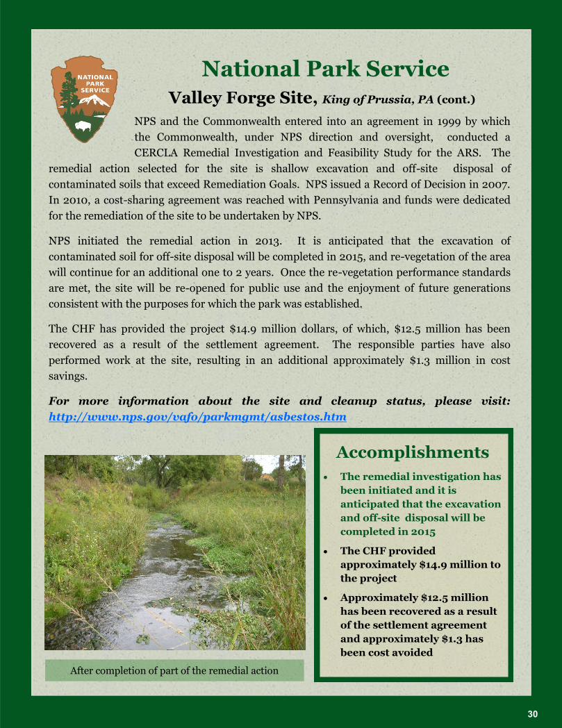
After completion of part of the remedial action
Accomplishments
The remedial investigation has
been initiated and it is
anticipated that the excavation
and off-site disposal will be
completed in 2015
The CHF provided
approximately $14.9 million to
the project
Approximately $12.5 million
has been recovered as a result
of the settlement agreement
and approximately $1.3 has
been cost avoided
Valley Forge Site, King of Prussia, PA (cont.)
30

U.S. Geological Survey The U.S. Geological Survey (USGS) was established in 1879. It is the
Nation's largest water, earth, and biological science and civilian
mapping agency, and is the sole science agency for the Department of the Interior. The
primary role of the bureau is to collect, monitor, analyze, and support the scientific
understanding about natural resource conditions, issues, and problems.
The USGS is made up of seven regions and
has over fifty science centers. USGS provides
support to other federal agencies,
international agencies, academia, and other
organizations.
USGS does not manage much land, and
therefore does not have many projects
funded by the CHF. USGS does provide
technical support for many of the other land
managing bureaus’ projects. Bureaus will provide USGS with funding to conduct scientific research and studies for their projects.
The CHF has provided USGS approximately $1.7 million in funding to support the Lake
Roosevelt and Government Hill projects. Approximately $600,000 of this funding has been
recovered at the Lake Roosevelt project.
The Lake Roosevelt National
Recreation Area project is led
for the Department by NPS. The
project is supported by the
BIA, BLM, BOR, and USGS.
EPA is also involved at the site.
In the early 1980s, water
quality concerns were identified
- primarily that there were
elevated levels of arsenic,
cadmium, lead, and zinc in fish.
Follow up studies identified the
source located upstream in
Canada conducting lead-zinc
smelting operation.
Mission: “serves the Nation by providing reliable scientific
information to describe and
understand the Earth; minimize loss
of life and property from natural
disasters; manage water, biological,
energy, and mineral resources; and
enhance and protect our quality of
life”
Lake Roosevelt National Recreation Area
31

U.S. Geological Survey As part of the CHF funded project, USGS has conducted sediment and
water quality analysis and assessed the impacts the contaminants on
fish, primarily sturgeon.
The bureau also supports a number of other CHF funded projects including the Idaho
Phosphates Project. This project, located in the southwest corner of Idaho, consists of
mitigation of environmental impact from phosphate mining operations. In 1996, selenium
toxicosis was identified in six horses grazing on private land downstream of the South Maybe
Canyon Mine, one of several mines making up this project. Subsequent studies conducted in
1997, 1998, 2001, 2003, 2010 and 2012 identified elevated selenium levels in sheep and
horses. USGS supports the EPA, BLM, FWS, and the U.S. Department of Agriculture’s U.S. Forest Service (FS) on this project.
USGS’ main focus for the Idaho Phosphates project is to operate the Blackfoot River Gauging Station. The Gauging Station monitors the total amount of selenium in the Blackfoot River
which establishes the health of the watershed and verifies the status of the cleanup efforts.
BLM, FWS, EPA, FS, Idaho Department of Environmental Quality, and the responsible par-
ties utilize the data provided by USGS. USGS has been and continues to be a very valuable
resource for CHF funded projects.
For more information about USGS, please visit: www.usgs.gov
Accomplishments
USGS has provided their technical
expertise to the Department’s landmanaging bureaus and other federal
agencies
The CHF has provided approximately
1.7 million to USGS and 3.8 million to
the rest of the bureaus to support the
Lake Roosevelt project
The project has recovered over $7.4
million and received in-kind support
saving additional money to the
Department
Lake Roosevelt National Recreation Area
32
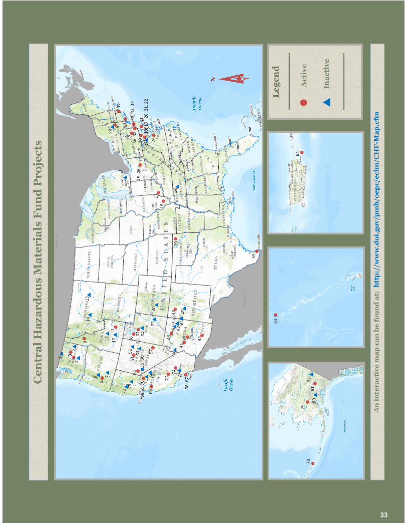
33

1.
O
rovi
lle L
andf
ill–
BLM
2.
Wap
ato
Irri
gati
on—
BIA
3.
Lake
Roo
seve
lt—
BIA
, BO
R, N
PS,
and
USG
S
4.
Leav
enw
orth
Fis
h H
atch
ery—
FWS
5.
Mid
nigh
t Min
e—B
LM
6.
Form
osa
Min
e—B
LM
7.
Kla
mat
h M
arsh
—FW
S
8.
Poor
man
Bal
m C
reek
Mill
Sit
e—B
LM
9.
Cou
r d’
Ale
ne—
BLM
10.
Mur
taug
h La
ndfil
l—B
LM
11.
Idah
o Ph
osph
ates
—B
IA, B
LM, a
nd
FWS
12.
Triu
mph
Min
e—B
LM
13.
Mos
by J
et F
uel R
efin
ery–
BLM
14.
Gra
nt-K
ohrs
Ran
ch N
atio
nal
His
tori
c Si
te–
NPS
15.
Gra
ssy
Isla
nd–
FWS
16.
Cra
b O
rcha
rd N
PL S
ite—
FWS
17.
Geo
rge
Rog
ers
Cla
rk F
orm
er
M
anuf
actu
red
Gas
Sit
e—N
PS
18.
Popl
ar P
oint
—N
PS
19.
Was
hing
ton
Gas
and
Lig
ht—
NPS
20.
Oxo
n C
ove—
NPS
21.
Ana
cost
ia S
edim
ent S
ite—
NPS
22.
Ken
ilwor
th L
andf
ill—
NPS
23.
Bar
ney
Cir
cle
Land
fill—
NPS
24.
Fort
Dar
ling
Land
fill—
NPS
25.
Kre
jci D
ump
Site
—N
PS
26.
Ja
ite
Pape
r M
ill—
NPS
27.
G
reat
Kill
s La
ndfil
l—N
PS
28.
C
orte
se L
andf
ill—
NPS
29.
H
udso
n R
iver
PC
Bs—
NPS
30.
Patu
xent
Res
earc
h N
WR
—FW
S
31.
Prim
e H
ook
NW
R—
FWS
32.
Gre
at S
wam
p N
WR
Asb
esto
s O
U3—
FWS
33.
Gre
at S
wam
p N
WR
Rol
ling
Kno
lls—
FWS
34.
Gre
at S
wam
p N
WR
Har
ding
La
ndfil
l—FW
S
35.
Palm
erto
n Zi
nc P
ile—
NPS
36.
John
Hei
nz N
WR
—FW
S
37.
Sach
uest
Poi
nt—
FWS
38.
Val
ley
Forg
e A
sbes
tos
Rel
ease
Si
te—
NPS
39.
Tar
Cre
ek N
PL S
ite—
BIA
40. U
te-U
lay—
BLM
41.
Hill
side
—B
LM
42.
Wic
kenb
urg—
BLM
43.
Orp
han
Min
e—N
PS
44.
Sagi
naw
Hill
—B
LM
45.
Tuba
Cit
y—B
IA
46.
Tyro
Mill
—B
LM
47.
Hop
i Dip
Vat
s—B
IA
48.
Lee
Acr
es—
BLM
49.
Gra
nts
Ura
nium
Bel
t—B
LM
50.
Nav
ajo
Dip
Vat
s—B
IA
51.
Tybo
Tai
lings
—B
LM
52.
Rip
Van
Win
kle—
BLM
53.
Nor
se W
indf
all—
BLM
54.
Yeri
ngto
n—B
LM
55.
Vet
a G
rand
e—B
LM
56.
Mon
ite
Dyn
amit
e Si
te—
BLM
57.
Cas
elto
n Ta
iling
s—B
LM
58.
Red
oubt
Bra
nnan
—N
PS
59.
Palo
Alt
o B
attl
efie
ld—
NPS
60.
U.S
. Mag
nesi
um—
BLM
61.
Silv
er M
aple
Cla
ims—
BLM
62.
Man
ning
Can
yon—
BLM
63.
La S
al C
reek
—B
LM
64.
Jaco
bs S
mel
ter—
BLM
65.
Kla
u B
uena
Vis
ta—
BLM
66.
Swee
twat
er M
arsh
—FW
S
67.
Gun
pow
der
Poin
t—FW
S
68.
El C
apit
an D
ump—
NPS
69.
Cur
ry L
andf
ill—
NPS
70.
Cas
cade
Cre
osot
e D
ip T
ank—
NPS
71.
El P
orta
l Min
e an
d M
ill S
ite—
NPS
72.
Mat
heso
n O
re T
rans
fer
Stat
ion—
BO
R
73.
Bla
ck R
ock
Min
e—B
LM
74.
Mor
ning
Sta
r M
ine—
NPS
75.
Cal
iforn
ia H
isto
ric
Mer
cury
Sit
es—
BLM
76.
Ran
d H
isto
ric
Min
ing
Dis
tric
t
Com
plex
—B
LM
77.
Atl
as A
sbes
tos
Site
—B
LM
78.
Ala
ska
Mar
itim
e—FW
S
79.
Red
Dev
il M
ine—
BLM
80. G
over
nmen
t Hill
—U
SGS
81.
Nab
esna
—N
PS
82.
Fort
Egb
ert D
ump—
BLM
83.
Mid
way
Ato
ll—FW
S
84.
Vie
ques
and
Cul
ebra
NW
R—
FWS
Not
e, th
ere
are
site
s on
this
map
that
ha
ve n
ot r
ecei
ved
CH
F fu
ndin
g, b
ut
have
had
the
site
’s co
st r
ecov
erie
s
subm
itte
d to
the
CHF’
s ac
coun
t.
For
mor
e de
tails
on
the
fund
ing
prov
ided
to a
spe
cific
sit
e, o
r
as
soci
ated
cos
t rec
over
ies,
ple
ase
vi
sit:
htt
p:/
/ww
w.d
oi.g
ov/p
mb
/oe
pc/
eclm
/CH
F-M
ap.c
fm
Last
upd
ated
, Dec
embe
r 20
14
U.S
. Dep
artm
ent
of t
he
In
teri
or
htt
p:/
/ww
w.d
oi.g
ov
C
entr
al H
azar
dou
s
M
ater
ials
Fu
nd
h
ttp
://w
ww
.doi
.gov
/pm
b/
oep
c/ec
lm/i
nd
ex.c
fm
1.O
rovi
lle
La
nd
fill
–B
LM
2.
Wa
pa
toIr
rig
ati
on
—B
IA
3.
La
ke
Ro
ose
vel
t—B
IA,
BO
R,
NP
S,
an
dU
SG
S
4.
Lea
ven
wo
rth
Fis
hH
atc
her
y—
FW
S
5.
Mid
nig
ht
Min
e—B
LM
6.
Fo
rmo
saM
ine—
BL
M
7.
Kla
ma
thM
ars
h—
FW
S
8.
Po
orm
an
Ba
lmC
reek
Mil
lS
ite—
BL
M
9.
Co
ur
d’A
len
e—B
LM
10.
Mu
rta
ug
hL
an
dfi
ll—
BL
M
11.
Ida
ho
Ph
osp
ha
tes—
BIA
,B
LM
,a
nd
FW
S
12.
Tri
um
ph
Min
e—B
LM
13.
Mo
sby
Jet
Fu
elR
efin
ery
–B
LM
14.
Gra
nt-
Ko
hrs
Ra
nch
Na
tio
na
l
His
tori
cS
ite–
NP
S
15.
Gra
ssy
Isla
nd
–F
WS
16.
Cra
bO
rch
ard
NP
LS
ite—
FW
S
17.
Geo
rge
Ro
ger
sC
lark
Fo
rmer
Ma
nu
fact
ure
dG
as
Sit
e—N
PS
18.
Po
pla
rP
oin
t—N
PS
19.
Wa
shin
gto
nG
as
an
dL
igh
t—N
PS
20
.O
xo
nC
ove
—N
PS
21.
An
aco
stia
Sed
imen
tS
ite—
NP
S
22
.K
enil
wo
rth
La
nd
fill
—N
PS
23
.B
arn
eyC
ircl
eL
an
dfi
ll—
NP
S
24
.F
ort
Da
rlin
gL
an
dfi
ll—
NP
S
25
.K
rejc
iD
um
pS
ite—
NP
S
26
.J
ait
eP
ap
erM
ill—
NP
S
27
.G
rea
tK
ills
La
nd
fill
—N
PS
28
.C
ort
ese
La
nd
fill
—N
PS
29
.H
ud
son
Riv
erP
CB
s—N
PS
30
.P
atu
xen
tR
esea
rch
NW
R—
FW
S
31.
Pri
me
Ho
ok
NW
R—
FW
S
32
.G
rea
tS
wa
mp
NW
RA
sbes
tos
OU
3—
FW
S
33
.G
rea
tS
wa
mp
NW
RR
oll
ing
Kn
oll
s—F
WS
34
.G
rea
tS
wa
mp
NW
RH
ard
ing
La
nd
fill
—F
WS
35
.P
alm
erto
nZ
inc
Pil
e—N
PS
36
.J
oh
nH
ein
zN
WR
—F
WS
37
.S
ach
ues
tP
oin
t—F
WS
38
.V
all
eyF
org
eA
sbes
tos
Rel
ease
Sit
e—N
PS
39
.T
ar
Cre
ekN
PL
Sit
e—B
IA
40
.U
te-U
lay—
BL
M
41.
Hil
lsid
e—B
LM
42
.W
ick
enb
urg
—B
LM
43
.O
rph
an
Min
e—N
PS
44
.S
ag
ina
wH
ill—
BL
M
45
.T
ub
aC
ity—
BIA
46
.T
yro
Mil
l—B
LM
47
.H
op
iD
ipV
ats
—B
IA
48
.L
eeA
cres
—B
LM
49
.G
ran
tsU
ran
ium
Bel
t—B
LM
50
.N
ava
joD
ipV
ats
—B
IA
51.
Tyb
oT
ail
ing
s—B
LM
52
.R
ipV
an
Win
kle
—B
LM
53
.N
ors
eW
ind
fall
—B
LM
54
.Y
erin
gto
n—
BL
M
55
.V
eta
Gra
nd
e—B
LM
56
.M
on
ite
Dy
na
mit
eS
ite—
BL
M
57
.C
ase
lto
nT
ail
ing
s—B
LM
58
.R
edo
ub
tB
ran
na
n—
NP
S
59
.P
alo
Alt
oB
att
lefi
eld
—N
PS
60
.U
.S.
Ma
gn
esiu
m—
BL
M
61.
Sil
ver
Ma
ple
Cla
ims—
BL
M
62
.M
an
nin
gC
an
yon
—B
LM
63
.L
aS
al
Cre
ek—
BL
M
64
.J
aco
bs
Sm
elte
r—B
LM
65
.K
lau
Bu
ena
Vis
ta—
BL
M
66
.S
wee
twa
ter
Ma
rsh
—F
WS
67
.G
un
po
wd
erP
oin
t—F
WS
68
.E
lC
ap
ita
nD
um
p—
NP
S
69
.C
urr
yL
an
dfi
ll—
NP
S
70
.C
asc
ad
eC
reo
sote
Dip
Ta
nk
—N
PS
71.
El
Po
rta
lM
ine
an
dM
ill
Sit
e—N
PS
72
.M
ath
eso
nO
reT
ran
sfer
Sta
tio
n—
BO
R
73
.B
lack
Ro
ckM
ine—
BL
M
74
.M
orn
ing
Sta
rM
ine—
NP
S
75
.C
ali
forn
iaH
isto
ric
Mer
cury
Sit
es—
BL
M
76
.R
an
dH
isto
ric
Min
ing
Dis
tric
t
Co
mp
lex
—B
LM
77
.A
tla
sA
sbes
tos
Sit
e—B
LM
78
.A
lask
aM
ari
tim
e—F
WS
79
.R
edD
evil
Min
e—B
LM
80
.G
ove
rnm
ent
Hil
l—U
SG
S
81.
Na
bes
na
—N
PS
82
.F
ort
Eg
ber
tD
um
p—
BL
M
83
.M
idw
ay
Ato
ll—
FW
S
84
.V
ieq
ues
an
dC
ule
bra
NW
R—
FW
S
No
te,
ther
ea
resi
tes
on
this
ma
pth
at
ha
ve
no
tre
ceiv
edC
HF
fun
din
g,
bu
t
ha
ve
ha
dth
esi
te’s
cost
reco
ver
ies
sub
mit
ted
toth
eC
HF
’sa
cco
un
t.
Fo
rm
ore
det
ail
so
nth
efu
nd
ing
pro
vid
edto
asp
ecif
icsi
te,
or
ass
oci
ate
dco
stre
cov
erie
s,p
lea
se
vis
it:
htt
p:/
/ww
w.d
oi.
go
v/p
mb
/
oe
pc
/ec
lm/C
HF
-Ma
p.c
fm
La
stu
pd
ate
d,
Dec
emb
er2
014
U.S
.D
ep
ar
tme
nt
of
the
Inte
rio
r
htt
p:/
/ww
w.d
oi.
go
v
Ce
ntr
al
Ha
za
rd
ou
s
Ma
ter
ials
Fu
nd
htt
p:/
/ww
w.d
oi.
go
v/p
mb
/
oe
pc
/ec
lm/i
nd
ex
.cfm
34