chichester district council housing and economic land
TRANSCRIPT

Chichester District Council
Housing and Economic Land
Availability Assessment
Appendix 4
Detailed site assessment forms
www.chichester.gov.uk August 2018

Chichester District Council Housing and Economic Land Availability Assessment 2018
2

Chichester District Council Housing and Economic Land Availability Assessment 2018
1
Appendix 4 Assessments of potential sites by parish
Apuldram
HELAA ID Site Address Settlement Parish
HAP0003 South West of Chichester Chichester Apuldram
Site size (hectares) Existing Use Proposed Use
118.4 Agriculture/meadow/grassland Housing Mixed-use
Site Description
Very extensive agricultural land and meadows south-west of Chichester and south-east of Fishbourne. Apuldram lies to the east. The harbour is to the west.
Suitability
The site is mostly unsuitable due to the impact on the setting of the Chichester Harbour AONB. The northern part of the site adjacent to the A27 and east of Donnington may be suitable for employment uses subject to access and other considerations. The part of the site adjacent to Deer Close may be suitable for an element of housing development.
Availability
The site was submitted during the Call for Sites 2017 and is therefore considered available.
Achievability
There is a reasonable prospect that development would be achievable during the Plan period.
Yield Estimated timescales for delivery
Proposed (or estimated) Source 1 – 5 years 6 – 10 years 11 – 16 years
200 CDC derived 100 100 0
Employment Uses

Chichester District Council Housing and Economic Land Availability Assessment 2018
2
B1, B2, B8 uses

Chichester District Council Housing and Economic Land Availability Assessment 2018
3
Birdham
HELAA ID Site Address Settlement Parish
HBI0009 Land at Common Piece Birdham Birdham
Site size (hectares) Existing Use Proposed Use
0.41 Vacant hardstanding Housing
Site Description
The site is adjacent to the existing settlement boundary of Birdham. Appears to be comprised of hardstanding for storage with small workshop building.
Suitability
Suitable, as the site is adjacent to existing development.
Availability
The site was submitted during the Call for Sites 2017 and is therefore considered available.
Achievability
There is a reasonable prospect that development would be achievable during the Plan period.
Yield Estimated timescales for delivery
Proposed (or estimated) Source 1 – 5 years 6 – 10 years 11 – 16 years
12 Promoter 12 0 0
Chichester District Council Housing and Economic Land Availability Assessment 2018
4
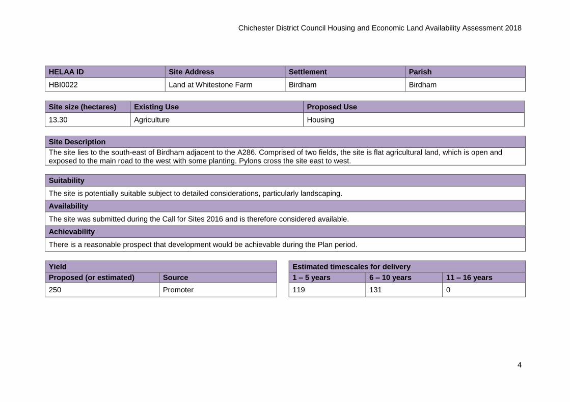
HELAA ID Site Address Settlement Parish
HBI0022 Land at Whitestone Farm Birdham Birdham
Site size (hectares) Existing Use Proposed Use
13.30 Agriculture Housing
Site Description
The site lies to the south-east of Birdham adjacent to the A286. Comprised of two fields, the site is flat agricultural land, which is open and exposed to the main road to the west with some planting. Pylons cross the site east to west.
Suitability
The site is potentially suitable subject to detailed considerations, particularly landscaping.
Availability
The site was submitted during the Call for Sites 2016 and is therefore considered available.
Achievability
There is a reasonable prospect that development would be achievable during the Plan period.
Yield Estimated timescales for delivery
Proposed (or estimated) Source 1 – 5 years 6 – 10 years 11 – 16 years
250 Promoter 119 131 0

Chichester District Council Housing and Economic Land Availability Assessment 2018
5
Bosham
HELAA ID Site Address Settlement Parish
HBO0002a Highgrove Farm, Main Road Broadbridge Bosham
Site size (hectares) Existing Use Proposed Use
15.07 Agriculture Housing
Site Description
Large open field north of the A259 and south of the railway line. The site lies to the east of the Highgrove Farm housing allocation and west of Ham Farm.
Suitability
Site is potentially suitable subject to detailed further consideration.
Availability
The site was submitted during the Call for Sites 2017 and is therefore considered available.
Achievability
There is a reasonable prospect that development would be achievable during the Plan period.
Yield Estimated timescales for delivery
Proposed (or estimated) Source 1 – 5 years 6 – 10 years 11 – 16 years
215 Promoter 107 108 0

Chichester District Council Housing and Economic Land Availability Assessment 2018
6
Boxgrove
HELAA ID Site Address Settlement Parish
HBX0003 Land south of Crouch Cross Lane Boxgrove Boxgrove
Site size (hectares) Existing Use Proposed Use
1.48 Agriculture/grazing land Housing
Site Description
The site is located to the south of residential properties along Crouch Cross Lane, west of Priors Acre, north of a farm and east of agricultural land. The site is irregular in shape and relatively flat and open on all sides.
Suitability
The site is potentially suitable subject to detailed consideration.
Availability
The site was submitted during the Call for Sites 2017 and is therefore considered available.
Achievability
There is a reasonable prospect that development would be achievable during the Plan period.
Yield Estimated timescales for delivery
Proposed (or estimated) Source 1 – 5 years 6 – 10 years 11 – 16 years
115 Promoter 115 0 0

Chichester District Council Housing and Economic Land Availability Assessment 2018
7
Chichester
HELAA ID Site Address Settlement Parish
HCC0015 Land south of Clay Lane Chichester Chichester
Site size (hectares) Existing Use Proposed Use
1.10 Vacant paddock Housing
Site Description
The site is a large area of grassland to the west of Chichester. The site is bounded to the west by the A27, to the north by Clay Lane, to the south by the railway line and by some residential properties to the east.
Suitability
The site is suitable subject to detailed consideration of further constraints.
Availability
The owners of the site confirmed the site's availability in 2017.
Achievability
There is a reasonable prospect that development would be achievable during the Plan period.
Yield Estimated timescales for delivery
Proposed (or estimated) Source 1 – 5 years 6 – 10 years 11 – 16 years
33 Promoter 33 0 0

Chichester District Council Housing and Economic Land Availability Assessment 2018
8
HELAA ID Site Address Settlement Parish
HCC0035 Land at the Tannery, Westgate Chichester Chichester
Site size (hectares) Existing Use Proposed Use
0.66 Former office building and car park Housing
Site Description
The site incorporates a number of former office buildings and car parking areas, and is located adjacent south of Westgate.
Suitability
The site is suitable subject to detailed consideration of further constraints.
Availability
The owners of the site confirmed the site's availability in 2017.
Achievability
There is a reasonable prospect that development would be achievable during the Plan period.
Yield Estimated timescales for delivery
Proposed (or estimated) Source 1 – 5 years 6 – 10 years 11 – 16 years
30 Promoter 30 0 0

Chichester District Council Housing and Economic Land Availability Assessment 2018
9
HELAA ID Site Address Settlement Parish
HCC0041 Land adjacent to Police Station Chichester Chichester
Site size (hectares) Existing Use Proposed Use
0.69 Grassland, police building, car parking Housing
Site Description
The site comprises a large area of green open space to the east of the existing police station, as well as some ancillary buildings, hardstanding and parking areas. The site fronts onto Kingsham Road to the north.
Suitability
The site is suitable for development in line with the adopted Southern Gateway Masterplan SPD.
Availability
The site was submitted during the Call for Sites 2016 and is therefore considered available.
Achievability
There is a reasonable prospect that development would be achievable during the Plan period.
Yield Estimated timescales for delivery
Proposed (or estimated) Source 1 – 5 years 6 – 10 years 11 – 16 years
28 Promoter 28 0 0

Chichester District Council Housing and Economic Land Availability Assessment 2018
10
Chidham & Hambrook
HELAA ID Site Address Settlement Parish
HCH0003 Land north of Aviary Close Hambrook Chidham & Hambrook
Site size (hectares) Existing Use Proposed Use
1.15 Paddock Housing
Site Description
Scrub field to the south of the A27. Access from Hambrook Hill south.
Suitability
The site is suitable subject to detailed consideration of further constraints.
Availability
The site was submitted during the Call for Sites 2017 and is therefore considered available.
Achievability
There is a reasonable prospect that development would be achievable during the Plan period.
Yield Estimated timescales for delivery
Proposed (or estimated) Source 1 – 5 years 6 – 10 years 11 – 16 years
39 Promoter 39 0 0

Chichester District Council Housing and Economic Land Availability Assessment 2018
11
HELAA ID Site Address Settlement Parish
HCH0004 Land east of Broad Road Hambrook Chidham & Hambrook
Site size (hectares) Existing Use Proposed Use
3.91 Agriculture Housing Employment
Site Description
A27 to the north-east with screening. Residential to south (within settlement boundary of Hambrook). Easy access from Broad Road.
Suitability
The site is suitable subject to detailed consideration of further constraints.
Availability
The site was submitted during the Call for Sites 2017 and is therefore considered available.
Achievability
There is a reasonable prospect that development would be achievable during the Plan period.
Yield Estimated timescales for delivery
Proposed (or estimated) Source 1 – 5 years 6 – 10 years 11 – 16 years
120 Promoter 40 40 40
Employment Uses
A1, D2

Chichester District Council Housing and Economic Land Availability Assessment 2018
12
HELAA ID Site Address Settlement Parish
HCH0008 Land south of The Avenue and east of Broad Road
Hambrook Chidham & Hambrook
Site size (hectares) Existing Use Proposed Use
1.10 Paddocks and stables Housing
Site Description
Residential house with paddocks. Access from Broad Road. Housing to the north and south.
Suitability
The site is suitable subject to detailed consideration of further constraints.
Availability
The site was submitted during the Call for Sites 2016 and is therefore considered available.
Achievability
There is a reasonable prospect that development would be achievable during the Plan period.
Yield Estimated timescales for delivery
Proposed (or estimated) Source 1 – 5 years 6 – 10 years 11 – 16 years
35 Promoter 35 0 0

Chichester District Council Housing and Economic Land Availability Assessment 2018
13
HELAA ID Site Address Settlement Parish
HCH0009 Land at Springfield House Hambrook Chidham & Hambrook
Site size (hectares) Existing Use Proposed Use
0.80 Garden/field Housing
Site Description
Curtilage of Springfield House. Well-wooded on north and eastern boundaries. South of the A27 and west of Broad Road. Well planted.
Suitability
The site is potentially suitable subject to development of HELAA site HCH0003.
Availability
The site was submitted during the Call for Sites 2016 and is therefore considered available.
Achievability
There is a reasonable prospect that development would be achievable during the Plan period.
Yield Estimated timescales for delivery
Proposed (or estimated) Source 1 – 5 years 6 – 10 years 11 – 16 years
25 Promoter 25 0 0

Chichester District Council Housing and Economic Land Availability Assessment 2018
14
HELAA ID Site Address Settlement Parish
HCH0011 Flatt Farm, Land east of Broad Road
Nutbourne Chidham & Hambrook
Site size (hectares) Existing Use Proposed Use
4.28 Agriculture Housing
Site Description
Extensive open flat agricultural field, bounded by Broad Road on the west and to the north by the railway line. Site includes farm buildings and farmhouse.
Suitability
The site is suitable subject to detailed consideration of further constraints.
Availability
The owners of the site confirmed the site's availability in 2017.
Achievability
There is a reasonable prospect that development would be achievable during the Plan period.
Yield Estimated timescales for delivery
Proposed (or estimated) Source 1 – 5 years 6 – 10 years 11 – 16 years
200 Promoter 66 66 68

Chichester District Council Housing and Economic Land Availability Assessment 2018
15
HELAA ID Site Address Settlement Parish
HCH0015 Pottery Field (East), Land west of Nutbourne East
Nutbourne Chidham & Hambrook
Site size (hectares) Existing Use Proposed Use
2.46 Agriculture/stables Housing
Site Description
Extensive flat agricultural field with drainage ditch running north to south. Railway line lies to north and A259 to the south.
Suitability
The site is suitable subject to detailed consideration of further constraints.
Availability
The site was submitted during the Call for Sites 2016 and is therefore considered available.
Achievability
There is a reasonable prospect that development would be achievable during the Plan period.
Yield Estimated timescales for delivery
Proposed (or estimated) Source 1 – 5 years 6 – 10 years 11 – 16 years
115 Promoter 38 38 39

Chichester District Council Housing and Economic Land Availability Assessment 2018
16
HELAA ID Site Address Settlement Parish
HCH0019b Land at Flat Farm Nutbourne Chidham & Hambrook
Site size (hectares) Existing Use Proposed Use
1.30 Agriculture/grazing land Housing
Site Description
Open agricultural field with a caravan park to the north.
Suitability
The site is suitable subject to detailed consideration of further constraints.
Availability
The site was submitted during the Call for Sites 2017 and is therefore considered available.
Achievability
There is a reasonable prospect that development would be achievable during the Plan period.
Yield Estimated timescales for delivery
Proposed (or estimated) Source 1 – 5 years 6 – 10 years 11 – 16 years
31 CDC-derived 31 0 0

Chichester District Council Housing and Economic Land Availability Assessment 2018
17
Earnley
HELAA ID Site Address Settlement Parish
HE0002 Land south of Clappers Lane East Wittering Earnley
Site size (hectares) Existing Use Proposed Use
9.30 Agriculture Housing
Site Description
Large agricultural field north of East Wittering.
Suitability
The site is potentially suitable, subject to the impact on Medmerry and other environmental constraints.
Availability
The site was submitted during the Call for Sites 2016 and is therefore considered available.
Achievability
There is a reasonable prospect that development would be achievable during the Plan period.
Yield Estimated timescales for delivery
Proposed (or estimated) Source 1 – 5 years 6 – 10 years 11 – 16 years
250 Promoter 0 250 0

Chichester District Council Housing and Economic Land Availability Assessment 2018
18
East Wittering & Bracklesham
HELAA ID Site Address Settlement Parish
HEWB0001 Land at Bracklesham Lane (south)
East Wittering East Wittering & Bracklesham
Site size (hectares) Existing Use Proposed Use
8.00 Agriculture Housing Mixed-use Employment
Site Description
Several agricultural fields divided by Stubcroft Lane, adjacent to the settlement boundary on the west, south and east. There is an arbitrary boundary to the north.
Suitability
The site is potentially suitable, subject to detailed consideration.
Availability
The owners of the site confirmed the site's availability in 2017.
Achievability
There is a reasonable prospect that development would be achievable during the Plan period.
Yield Estimated timescales for delivery
Proposed (or estimated) Source 1 – 5 years 6 – 10 years 11 – 16 years
192 CDC-derived 192 0 0
Employment Uses
A1, A2, A3, A4, B1, B2, B8, D2
Chichester District Council Housing and Economic Land Availability Assessment 2018
19
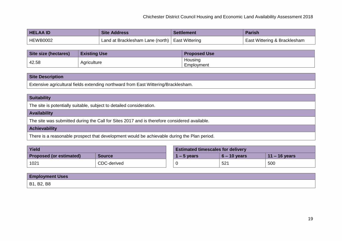
HELAA ID Site Address Settlement Parish
HEWB0002 Land at Bracklesham Lane (north) East Wittering East Wittering & Bracklesham
Site size (hectares) Existing Use Proposed Use
42.58 Agriculture Housing Employment
Site Description
Extensive agricultural fields extending northward from East Wittering/Bracklesham.
Suitability
The site is potentially suitable, subject to detailed consideration.
Availability
The site was submitted during the Call for Sites 2017 and is therefore considered available.
Achievability
There is a reasonable prospect that development would be achievable during the Plan period.
Yield Estimated timescales for delivery
Proposed (or estimated) Source 1 – 5 years 6 – 10 years 11 – 16 years
1021 CDC-derived 0 521 500
Employment Uses
B1, B2, B8

Chichester District Council Housing and Economic Land Availability Assessment 2018
20
Fishbourne
HELAA ID Site Address Settlement Parish
HFB0003 Crooked Mead Farm, A27 Chichester Bypass
Chichester Fishbourne
Site size (hectares) Existing Use Proposed Use
1.96 Scrapyard/storage Employment
Site Description
The site adjoins the A27. The site is brownfield land, formerly in scrapyard/storage uses.
Suitability
The site is potentially suitable for employment uses as it has access onto the A27, subject to detailed consideration.
Availability
The site was submitted during the Call for Sites 2016 and is therefore considered available.
Achievability
There is a reasonable prospect that development would be achievable during the Plan period.
Employment Uses
B1, B2, B8

Chichester District Council Housing and Economic Land Availability Assessment 2018
21
HELAA ID Site Address Settlement Parish
HFB0004 Land west of Blackboy Lane Fishbourne
Site size (hectares) Existing Use Proposed Use
3.4 Agriculture Housing Mixed-use Employment
Site Description
Large, flat, open agricultural land in operational use as a farm. The site comprises three large fields. The railway line is to the south and Blackboy Lane to the east.
Suitability
Part of the site is suitable; however the remainder is not suitable as development would impact upon the landscape setting and long distance views.
Availability
The site was submitted during the Call for Sites 2017 and is therefore considered available.
Achievability
There is a reasonable prospect that development would be achievable during the Plan period.
Yield Estimated timescales for delivery
Proposed (or estimated) Source 1 – 5 years 6 – 10 years 11 – 16 years
81 CDC-derived 81 0 0
Employment Uses
D1

Chichester District Council Housing and Economic Land Availability Assessment 2018
22
HELAA ID Site Address Settlement Parish
HFB0006 Land rear of South Barn Fishbourne Fishbourne
Site size (hectares) Existing Use Proposed Use
0.34 Agriculture/grazing land Housing
Site Description
The site is a triangular-shaped parcel of land to the west of Fishbourne. The site fronts onto the A259 with playing fields to the north and east. Residential properties lie to the west.
Suitability
The site is potentially suitable, subject to detailed consideration.
Availability
The site was submitted during the Call for Sites 2017 and is therefore considered available.
Achievability
There is a reasonable prospect that development would be achievable during the Plan period.
Yield Estimated timescales for delivery
Proposed (or estimated) Source 1 – 5 years 6 – 10 years 11 – 16 years
8 CDC-derived 8 0 0

Chichester District Council Housing and Economic Land Availability Assessment 2018
23
HELAA ID Site Address Settlement Parish
HFB0007 Land at Clay Lane Fishbourne Fishbourne
Site size (hectares) Existing Use Proposed Use
0.96 Grazing land Housing
Site Description
The site is used for horse grazing with paddocks. Clay Lane is to the west and the A27 to the east with a strong line of buffering.
Suitability
The site is potentially suitable, subject to detailed consideration.
Availability
The site was submitted during the Call for Sites 2017 and is therefore considered available.
Achievability
There is a reasonable prospect that development would be achievable during the Plan period.
Yield Estimated timescales for delivery
Proposed (or estimated) Source 1 – 5 years 6 – 10 years 11 – 16 years
23 CDC-derived 23 0 0

Chichester District Council Housing and Economic Land Availability Assessment 2018
24
HELAA ID Site Address Settlement Parish
HFB0012 Land at Clay Lane Fishbourne Fishbourne
Site size (hectares) Existing Use Proposed Use
1.25 Scrubland Housing Mixed-use Employment
Site Description
Triangular-shaped parcel of land, bounding Clay Lane to the eastern side and residential development on the western side.
Suitability
The site is suitable as it is adjacent to development, subject to noise assessment.
Availability
The site was submitted during the Call for Sites 2017 and is therefore considered available.
Achievability
There is a reasonable prospect that development would be achievable during the Plan period.
Yield Estimated timescales for delivery
Proposed (or estimated) Source 1 – 5 years 6 – 10 years 11 – 16 years
70 Promoter 70 0 0
Employment Uses
B1, D1

Chichester District Council Housing and Economic Land Availability Assessment 2018
25
HELAA ID Site Address Settlement Parish
HFB0018 Land west of Clay Lane Fishbourne Fishbourne
Site size (hectares) Existing Use Proposed Use
3.67 Scrubland Housing
Site Description
Irregular-shaped scrubland to the east of Fishbourne. Bounded to the south by the railway line, Clay Lane to the east and scrubland to the north and east.
Suitability
The site is suitable, subject to detailed consideration.
Availability
The site was submitted during the Call for Sites 2016 and is therefore considered available.
Achievability
There is a reasonable prospect that development would be achievable during the Plan period.
Yield Estimated timescales for delivery
Proposed (or estimated) Source 1 – 5 years 6 – 10 years 11 – 16 years
65 Promoter 65 0 0

Chichester District Council Housing and Economic Land Availability Assessment 2018
26
HELAA ID Site Address Settlement Parish
HFB0021 Land north of Godwin Way Fishbourne Fishbourne
Site size (hectares) Existing Use Proposed Use
0.80 Paddocks Housing
Site Description
The site is a small grazing/paddock area which forms part of a smallholding.
Suitability
The site is suitable as it is adjacent to the settlement.
Availability
The site was submitted during the Call for Sites 2017 and is therefore considered available.
Achievability
There is a reasonable prospect that development would be achievable during the Plan period.
Yield Estimated timescales for delivery
Proposed (or estimated) Source 1 – 5 years 6 – 10 years 11 – 16 years
19 CDC-derived 19 0 0

Chichester District Council Housing and Economic Land Availability Assessment 2018
27
HELAA ID Site Address Settlement Parish
HFB0023 Land at Four Ways, Clay Lane Fishbourne Fishbourne
Site size (hectares) Existing Use Proposed Use
0.37 Dwelling and curtilage Housing
Site Description
The site comprises a dwelling and its domestic curtilage. The site lies to the north of Fishbourne. There is a thick tree screen to the A27 to the north, and residential properties to the west.
Suitability
The site is suitable as it is adjacent to the settlement.
Availability
The site was submitted during the Call for Sites 2016 and is therefore considered available.
Achievability
There is a reasonable prospect that development would be achievable during the Plan period.
Yield Estimated timescales for delivery
Proposed (or estimated) Source 1 – 5 years 6 – 10 years 11 – 16 years
14 Promoter 14 0 0

Chichester District Council Housing and Economic Land Availability Assessment 2018
28
HELAA ID Site Address Settlement Parish
HFB0024 98 Fishbourne Road, Fishbourne Fishbourne Fishbourne
Site size (hectares) Existing Use Proposed Use
0.33 Dwelling and curtilage Housing
Site Description
The site comprises the dwelling and its curtilage, fronting onto the A259.
Suitability
The site is potentially suitable, subject to detailed consideration.
Availability
The site was submitted during the Call for Sites 2017 and is therefore considered available.
Achievability
There is a reasonable prospect that development would be achievable during the Plan period.
Yield Estimated timescales for delivery
Proposed (or estimated) Source 1 – 5 years 6 – 10 years 11 – 16 years
11 Promoter 11 0 0

Chichester District Council Housing and Economic Land Availability Assessment 2018
29
HELAA ID Site Address Settlement Parish
HFB0027 Land at Lawrence Farm Chichester Fishbourne
Site size (hectares) Existing Use Proposed Use
3.67 Agriculture Housing
Site Description
The site is irregular-shaped, lying adjacent to the Fishbourne roundabout, the A27 and the A259.
Suitability
The site is remote from the settlement so not suitable for housing, but may have potential for employment uses subject to further consideration.
Availability
The site was submitted during the Call for Sites 2017 and is therefore considered available.
Achievability
There is a reasonable prospect that development would be achievable during the Plan period.

Chichester District Council Housing and Economic Land Availability Assessment 2018
30
Hunston
HELAA ID Site Address Settlement Parish
HHN0003 Reedbridge Farm Hunston Hunston
Site size (hectares) Existing Use Proposed Use
0.36 Agriculture Housing
Site Description
The site comprises an area of agricultural land with a large barn. Selsey Road to the north and west. Agricultural land to the east and Reedbridge Farm to the south.
Suitability
The site is potentially suitable, subject to detailed consideration.
Availability
The site was submitted during the Call for Sites 2016 and is therefore considered available.
Achievability
There is a reasonable prospect that development would be achievable during the Plan period.
Yield Estimated timescales for delivery
Proposed (or estimated) Source 1 – 5 years 6 – 10 years 11 – 16 years
6 Promoter 6 0 0

Chichester District Council Housing and Economic Land Availability Assessment 2018
31
HELAA ID Site Address Settlement Parish
HHN0007 Land east of Foxbridge Drive Hunston Hunston
Site size (hectares) Existing Use Proposed Use
2.72 Agriculture Housing
Site Description
Large area of flat, open agricultural land. Selsey Road lies to the north. The site lies to the east of Hunston
Suitability
The site is potentially suitable, subject to detailed consideration.
Availability
The site was submitted during the Call for Sites 2016 and is therefore considered available.
Achievability
There is a reasonable prospect that development would be achievable during the Plan period.
Yield Estimated timescales for delivery
Proposed (or estimated) Source 1 – 5 years 6 – 10 years 11 – 16 years
80 Promoter 0 80 0

Chichester District Council Housing and Economic Land Availability Assessment 2018
32
HELAA ID Site Address Settlement Parish
HHN0008 Land south of Meadow Close Hunston Hunston
Site size (hectares) Existing Use Proposed Use
2.50 Agriculture Housing
Site Description
The site lies to the east of Hunston, comprising an open agricultural field with the land sloping gently to the east. Selsey Road is to the west, residential to the north. There is an arbitrary boundary to the east and south.
Suitability
The site is potentially suitable, subject to detailed consideration.
Availability
The site was submitted during the Call for Sites 2017 and is therefore considered available.
Achievability
There is a reasonable prospect that development would be achievable during the Plan period.
Yield Estimated timescales for delivery
Proposed (or estimated) Source 1 – 5 years 6 – 10 years 11 – 16 years
90 Promoter 0 90 0

Chichester District Council Housing and Economic Land Availability Assessment 2018
33
Loxwood
HELAA ID Site Address Settlement Parish
HLX0003 Land at Hawthorn Cottage Loxwood Loxwood
Site size (hectares) Existing Use Proposed Use
0.57 Dwelling and curtilage with paddock Housing
Site Description
The site comprises Hawthorn Cottage, its curtilage and a paddock to the rear of the property.
Suitability
The site is suitable as it is adjacent to the settlement.
Availability
The owners of the site confirmed the site's availability in 2017.
Achievability
There is a reasonable prospect that development would be achievable during the Plan period.
Yield Estimated timescales for delivery
Proposed (or estimated) Source 1 – 5 years 6 – 10 years 11 – 16 years
8 Promoter 8 0 0

Chichester District Council Housing and Economic Land Availability Assessment 2018
34
HELAA ID Site Address Settlement Parish
HLX0005 Land to rear of Black Hall Loxwood Loxwood
Site size (hectares) Existing Use Proposed Use
0.86 Curtilage of dwelling Housing
Site Description
The site forms the curtilage of Black Hall, including a swimming pool. It is located on the west of Loxwood, with residential properties to the north and south, and agricultural fields to the west.
Suitability
The site is suitable as it is adjacent to the settlement.
Availability
The site was submitted during the Call for Sites 2016 and is therefore considered available.
Achievability
There is a reasonable prospect that development would be achievable during the Plan period.
Yield Estimated timescales for delivery
Proposed (or estimated) Source 1 – 5 years 6 – 10 years 11 – 16 years
10 Promoter 10 0 0

Chichester District Council Housing and Economic Land Availability Assessment 2018
35
HELAA ID Site Address Settlement Parish
HLX0006 Land north of Little Garton Loxwood Loxwood
Site size (hectares) Existing Use Proposed Use
0.44 Paddock Housing
Site Description
The site forms the curtilage of Black Hall, including a swimming pool. It is located on the west of Loxwood, with residential properties to the north and south, and agricultural fields to the west.
Suitability
The site is suitable as it is adjacent to the settlement.
Availability
The site was submitted during the Call for Sites 2016 and is therefore considered available.
Achievability
There is a reasonable prospect that development would be achievable during the Plan period.
Yield Estimated timescales for delivery
Proposed (or estimated) Source 1 – 5 years 6 – 10 years 11 – 16 years
6 Promoter 6 0 0

Chichester District Council Housing and Economic Land Availability Assessment 2018
36
HELAA ID Site Address Settlement Parish
HLX0007 Land south of Loxwood Place Farm
Loxwood Loxwood
Site size (hectares) Existing Use Proposed Use
1.10 Agriculture Housing
Site Description
The site comprises an open agricultural field on the south-west of Loxwood. It is bounded by the B2133 to the east, residential dwellings to the north and agricultural land to the south and west.
Suitability
The site is potentially suitable subject to the detailed considerations.
Availability
The owners of the site confirmed the site's availability in 2017.
Achievability
There is a reasonable prospect that development would be achievable during the Plan period.
Yield Estimated timescales for delivery
Proposed (or estimated) Source 1 – 5 years 6 – 10 years 11 – 16 years
25 Promoter 25 0 0

Chichester District Council Housing and Economic Land Availability Assessment 2018
37
HELAA ID Site Address Settlement Parish
HLX0013 Land east of Pond Copse Lane Loxwood Loxwood
Site size (hectares) Existing Use Proposed Use
2.50 Grazing land Housing
Site Description
The site comprises part of an agricultural field to the west of Loxwood. Residential properties lie to the east, agricultural fields to the west, with an arbitrary boundary to the north, and dwelling curtilage to the south.
Suitability
The site is potentially suitable subject to access and other considerations.
Availability
The site was submitted during the Call for Sites 2017 and is therefore considered available.
Achievability
There is a reasonable prospect that development would be achievable during the Plan period.
Yield Estimated timescales for delivery
Proposed (or estimated) Source 1 – 5 years 6 – 10 years 11 – 16 years
60 Promoter 0 60 0

Chichester District Council Housing and Economic Land Availability Assessment 2018
38
North Mundham
HELAA ID Site Address Settlement Parish
HNM0005 Land to the south of Lowlands (Pigeon House Farm)
North Mundham North Mundham
Site size (hectares) Existing Use Proposed Use
7.95 Dwelling and grassland Housing
Site Description
Large open area of farmland south-west of North Mundham. Small element of residential to the south-east corner. Glasshouses to the south.
Suitability
The site is potentially suitable subject to detailed considerations, particularly landscape and access.
Availability
The site was submitted during the Call for Sites 2016 and is therefore considered available.
Achievability
There is a reasonable prospect that development would be achievable during the Plan period.
Yield Estimated timescales for delivery
Proposed (or estimated) Source 1 – 5 years 6 – 10 years 11 – 16 years
278 Promoter 90 188 0

Chichester District Council Housing and Economic Land Availability Assessment 2018
39
HELAA ID Site Address Settlement Parish
HNM0007 Land north of Brook Cottage and south of Lagness Road
Runcton North Mundham
Site size (hectares) Existing Use Proposed Use
0.50 Grazing land Housing
Site Description
Agricultural land to the east of Runcton, adjacent to the settlement.
Suitability
The site is potentially suitable subject to detailed consideration.
Availability
The owners of the site confirmed the site's availability in 2017.
Achievability
There is a reasonable prospect that development would be achievable during the Plan period.
Yield Estimated timescales for delivery
Proposed (or estimated) Source 1 – 5 years 6 – 10 years 11 – 16 years
15 Promoter 15 0 0

Chichester District Council Housing and Economic Land Availability Assessment 2018
40
HELAA ID Site Address Settlement Parish
HNM0009 Land east of the Spinney North Mundham North Mundham
Site size (hectares) Existing Use Proposed Use
0.25 Woodland Housing
Site Description
Wooded plot of land south of Runcton Road, between Runcton and North Mundham.
Suitability
The site is potentially suitable subject to detailed consideration.
Availability
The site was submitted during the Call for Sites 2016 and is therefore considered available.
Achievability
There is a reasonable prospect that development would be achievable during the Plan period.
Yield Estimated timescales for delivery
Proposed (or estimated) Source 1 – 5 years 6 – 10 years 11 – 16 years
8 Promoter 8 0 0

Chichester District Council Housing and Economic Land Availability Assessment 2018
41
HELAA ID Site Address Settlement Parish
HNM0012 Land at Lowlands North Mundham North Mundham
Site size (hectares) Existing Use Proposed Use
2.11 Dwelling, agriculture and glasshouses Housing
Site Description
Disused nursery with residential dwelling on site south of main road.
Suitability
The site is potentially suitable for development subject to detailed considerations.
Availability
The site was submitted during the Call for Sites 2016 and is therefore considered available.
Achievability
There is a reasonable prospect that development would be achievable during the Plan period.
Yield Estimated timescales for delivery
Proposed (or estimated) Source 1 – 5 years 6 – 10 years 11 – 16 years
74 Promoter 74 0 0

Chichester District Council Housing and Economic Land Availability Assessment 2018
42
HELAA ID Site Address Settlement Parish
HNM0020 Vinnetrow Business Park North Mundham North Mundham
Site size (hectares) Existing Use Proposed Use
2.50 Vacant business units and site of Chichester Free School
Housing Employment
Site Description
Existing employment units and the site of the Chichester Free School.
Suitability
The site is unsuitable for housing as it is too remote but the site may be suitable for employment once the Chichester Free School has relocated.
Availability
The site was submitted during the Call for Sites 2017 and is therefore considered available.
Achievability
There is a reasonable prospect that development would be achievable during the Plan period.
Employment Uses
B1

Chichester District Council Housing and Economic Land Availability Assessment 2018
43
Oving
HELAA ID Site Address Settlement Parish
HOV0005 Drayton Manor Former Landfill Site
Chichester Oving
Site size (hectares) Existing Use Proposed Use
19.00 Vacant Housing Mixed-use
Site Description
The site is comprised of restored landfill/scrubland. It is bounded to the west by the A27, to the south by the railway line and to the north by housing.
Suitability
The site is potentially suitable for a strategic allocation subject to inclusion of land to north and north-east of the site.
Availability
The site was submitted during the Call for Sites 2016 and is therefore considered available.
Achievability
There is a reasonable prospect that development would be achievable during the Plan period.
Yield Estimated timescales for delivery
Proposed (or estimated) Source 1 – 5 years 6 – 10 years 11 – 16 years
500 Promoter 0 250 250

Chichester District Council Housing and Economic Land Availability Assessment 2018
44
Selsey
HELAA ID Site Address Settlement Parish
HSY0010 Land north of Selsey Selsey Selsey
Site size (hectares) Existing Use Proposed Use
11.00 Agriculture Housing Mixed-use
Site Description
Agricultural land to the north of Selsey, including a packing house and offices.
Suitability
The site has potential for development subject to detailed flood, transport and landscape considerations.
Availability
The site was submitted during the Call for Sites 2017 and is therefore considered available.
Achievability
There is a reasonable prospect that development would be achievable during the Plan period.
Yield Estimated timescales for delivery
Proposed (or estimated) Source 1 – 5 years 6 – 10 years 11 – 16 years
250 Promoter 250 0 0

Chichester District Council Housing and Economic Land Availability Assessment 2018
45
Southbourne
HELAA ID Site Address Settlement Parish
HSB0001 Land at Willowbrook Riding Centre
Hambrook Southbourne
Site size (hectares) Existing Use Proposed Use
4.00 Riding centre Housing
Site Description
Open field incorporating riding centre on eastern side. Access from Hambrook Hill South
Suitability
The site is suitable subject to detailed consideration.
Availability
The site was submitted during the Call for Sites 2016 and is therefore considered available.
Achievability
There is a reasonable prospect that development would be achievable during the Plan period.
Yield Estimated timescales for delivery
Proposed (or estimated) Source 1 – 5 years 6 – 10 years 11 – 16 years
96 CDC-derived 96 0 0

Chichester District Council Housing and Economic Land Availability Assessment 2018
46
HELAA ID Site Address Settlement Parish
HSB0005 Land at Wayside Cottage Hermitage Southbourne
Site size (hectares) Existing Use Proposed Use
0.66 Curtilage of dwelling Housing
Site Description
Dwelling with main curtilage. Well-treed.
Suitability
The site is suitable subject to detailed consideration.
Availability
The site was submitted during the Call for Sites 2017 and is therefore considered available.
Achievability
There is a reasonable prospect that development would be achievable during the Plan period.
Yield Estimated timescales for delivery
Proposed (or estimated) Source 1 – 5 years 6 – 10 years 11 – 16 years
15 CDC-derived 15 0 0

Chichester District Council Housing and Economic Land Availability Assessment 2018
47
HELAA ID Site Address Settlement Parish
HSB0007 Land north of Penny Lane South Hermitage Southbourne
Site size (hectares) Existing Use Proposed Use
5.37 Agriculture Housing
Site Description
Large open field, railway to the north and Southbourne to the south.
Suitability
The site is suitable subject to detailed consideration.
Availability
The site was submitted during the Call for Sites 2017 and is therefore considered available.
Achievability
There is a reasonable prospect that development would be achievable during the Plan period.
Yield Estimated timescales for delivery
Proposed (or estimated) Source 1 – 5 years 6 – 10 years 11 – 16 years
170 Promoter 70 100 0

Chichester District Council Housing and Economic Land Availability Assessment 2018
48
HELAA ID Site Address Settlement Parish
HSB0009 Land at Hamcroft between Nutbourne West and East
Nutbourne Southbourne
Site size (hectares) Existing Use Proposed Use
6.00 Paddocks with dwelling Housing
Site Description
Scrubby agricultural land, with dwelling and stables. Railway to the north. Wooded strip along northern boundary. Access from the A259.
Suitability
The site is suitable subject to detailed consideration.
Availability
The site was submitted during the Call for Sites 2016 and is therefore considered available.
Achievability
There is a reasonable prospect that development would be achievable during the Plan period.
Yield Estimated timescales for delivery
Proposed (or estimated) Source 1 – 5 years 6 – 10 years 11 – 16 years
120 Promoter 0 0 120

Chichester District Council Housing and Economic Land Availability Assessment 2018
49
HELAA ID Site Address Settlement Parish
HSB0015 Land south of Cooks Lane (The Paddocks)
Southbourne Southbourne
Site size (hectares) Existing Use Proposed Use
4.84 Paddocks Housing
Site Description
Large agricultural field with some subdivision. North of the railway line, and adjacent to the western end of the settlement boundary of Southbourne. Bounded by Cooks Lane to the north.
Suitability
The site is suitable subject to detailed consideration.
Availability
The site was submitted during the Call for Sites 2017 and is therefore considered available.
Achievability
There is a reasonable prospect that development would be achievable during the Plan period.
Yield Estimated timescales for delivery
Proposed (or estimated) Source 1 – 5 years 6 – 10 years 11 – 16 years
112 Promoter 112 0 0

Chichester District Council Housing and Economic Land Availability Assessment 2018
50
HELAA ID Site Address Settlement Parish
HSB0016 Land north of Cooks Lane and east of Kelsey Avenue
Southbourne Southbourne
Site size (hectares) Existing Use Proposed Use
5.56 Agriculture Housing
Site Description
Large open agricultural field. The site adjoins the settlement boundary. Access could be achieved via Cooks Lane. Large mobile mast in south-west corner.
Suitability
The site is suitable subject to detailed consideration.
Availability
The site was submitted during the Call for Sites 2017 and is therefore considered available.
Achievability
There is a reasonable prospect that development would be achievable during the Plan period.
Yield Estimated timescales for delivery
Proposed (or estimated) Source 1 – 5 years 6 – 10 years 11 – 16 years
150 Promoter 0 150 0

Chichester District Council Housing and Economic Land Availability Assessment 2018
51
HELAA ID Site Address Settlement Parish
HSB0018 Four Acres Nursery, North of Cooks Lane
Southbourne Southbourne
Site size (hectares) Existing Use Proposed Use
1.44 Agriculture Housing
Site Description
Agricultural land with small-scale glasshouses on eastern side.
Suitability
The site is suitable subject to detailed consideration.
Availability
The site was submitted during the Call for Sites 2017 and is therefore considered available.
Achievability
There is a reasonable prospect that development would be achievable during the Plan period.
Yield Estimated timescales for delivery
Proposed (or estimated) Source 1 – 5 years 6 – 10 years 11 – 16 years
55 Promoter 0 55 0

Chichester District Council Housing and Economic Land Availability Assessment 2018
52
HELAA ID Site Address Settlement Parish
HSB0026 Land at Cooks Farm Southbourne Southbourne
Site size (hectares) Existing Use Proposed Use
2.79 Dwellings and disused glasshouses
Site Description
The site comprises a bungalow fronting onto Cooks Lane, with glasshouses - some of which is in operation, some derelict.
Suitability
The site is suitable subject to detailed consideration.
Availability
The site was submitted during the Call for Sites 2017 and is therefore considered available.
Achievability
There is a reasonable prospect that development would be achievable during the Plan period.
Yield Estimated timescales for delivery
Proposed (or estimated) Source 1 – 5 years 6 – 10 years 11 – 16 years
66 CDC-derived 0 66 0

Chichester District Council Housing and Economic Land Availability Assessment 2018
53
HELAA ID Site Address Settlement Parish
HSB0027 Land south of West View Cottages
Southbourne Southbourne
Site size (hectares) Existing Use Proposed Use
0.79 Scrub/woodland Housing
Site Description
Small area of land comprised of woodland and scrub. Linear sporadic houses to the north.
Suitability
The site is suitable subject to detailed consideration.
Availability
The owners of the site confirmed the site's availability in 2017.
Achievability
There is a reasonable prospect that development would be achievable during the Plan period.
Yield Estimated timescales for delivery
Proposed (or estimated) Source 1 – 5 years 6 – 10 years 11 – 16 years
31 Promoter 31 0 0

Chichester District Council Housing and Economic Land Availability Assessment 2018
54
HELAA ID Site Address Settlement Parish
HSB0033 Land north of Priors Leaze Lane Southbourne Southbourne
Site size (hectares) Existing Use Proposed Use
0.72 Paddocks Housing
Site Description
Large agricultural open field east of Southbourne.
Suitability
The site is potentially suitable subject to wider comprehensive development.
Availability
The site was submitted during the Call for Sites 2017 and is therefore considered available.
Achievability
There is a reasonable prospect that development would be achievable during the Plan period.
Yield Estimated timescales for delivery
Proposed (or estimated) Source 1 – 5 years 6 – 10 years 11 – 16 years
17 CDC-derived 0 17 0

Chichester District Council Housing and Economic Land Availability Assessment 2018
55
HELAA ID Site Address Settlement Parish
HSB0034 Land south of Inlands Barn Southbourne Southbourne
Site size (hectares) Existing Use Proposed Use
2.86 Agriculture Housing
Site Description
Large agricultural field. The railway line is to the south.
Suitability
The site is potentially suitable subject to wider comprehensive development of HELAA site HSB0037a.
Availability
The site was submitted during the Call for Sites 2017 and is therefore considered available.
Achievability
There is a reasonable prospect that development would be achievable during the Plan period.
Yield Estimated timescales for delivery
Proposed (or estimated) Source 1 – 5 years 6 – 10 years 11 – 16 years
85 Promoter 85 0 0

Chichester District Council Housing and Economic Land Availability Assessment 2018
56
HELAA ID Site Address Settlement Parish
HSB0037a Land between Southbourne and Hambrook
Southbourne Southbourne
Site size (hectares) Existing Use Proposed Use
85.12 Agriculture with farm buildings and paddocks Housing Mixed-use Employment
Site Description
Large open agricultural fields, with some buildings. Flat with open views. Some horse paddocks. Stretches from A27 southwards to the A259.
Suitability
The site is suitable subject to detailed consideration.
Availability
The site was submitted during the Call for Sites 2017 and is therefore considered available.
Achievability
There is a reasonable prospect that development would be achievable during the Plan period.
Yield Estimated timescales for delivery
Proposed (or estimated)
Source 1 – 5 years 6 – 10 years 11 – 16 years 16+ years
2000 Promoter 0 0 1000 1000
Employment Uses
A1, A2, A3, A4, A5, B1, B2, B8, C1, D1, D2

Chichester District Council Housing and Economic Land Availability Assessment 2018
57
HELAA ID Site Address Settlement Parish
HSB0039 Land west of Oaks Farm Southbourne Southbourne
Site size (hectares) Existing Use Proposed Use
1.28 Agriculture Housing
Site Description
Rectangular shaped field north of the A259.
Suitability
The site is suitable subject to detailed consideration.
Availability
The site was submitted during the Call for Sites 2017 and is therefore considered available.
Achievability
There is a reasonable prospect that development would be achievable during the Plan period.
Yield Estimated timescales for delivery
Proposed (or estimated) Source 1 – 5 years 6 – 10 years 11 – 16 years
33 Promoter 33 0 0

Chichester District Council Housing and Economic Land Availability Assessment 2018
58
West Wittering
HELAA ID Site Address Settlement Parish
HWW0002 Land west of Church Road East Wittering West Wittering
Site size (hectares) Existing Use Proposed Use
11.78 Agriculture Housing
Site Description
Large irregular-shaped site comprised of two agricultural fields subdivided by a hedgerow. Scrubland to the south, agricultural fields to the west and east and residential dwellings to the north.
Suitability
The site is potentially suitable as it is located adjacent to the settlement boundary, subject to detailed consideration
Availability
The site was submitted during the Call for Sites 2016 and is therefore considered available.
Achievability
There is a reasonable prospect that development would be achievable during the Plan period.
Yield Estimated timescales for delivery
Proposed (or estimated) Source 1 – 5 years 6 – 10 years 11 – 16 years
230 Promoter 230 0 0

Chichester District Council Housing and Economic Land Availability Assessment 2018
59
HELAA ID Site Address Settlement Parish
HWW0004 Land at Eli’s Lodge East Wittering West Wittering
Site size (hectares) Existing Use Proposed Use
0.65 Dwelling and curtilage Housing
Site Description
Rectangular site to south of Scotts Farm caravan and camping site, north of Cakeham Road. Site includes dwelling and curtilage and large area of grassland.
Suitability
The site is suitable as it is adjacent to the existing settlement, subject to detailed consideration.
Availability
The site was submitted during the Call for Sites 2017 and is therefore considered available.
Achievability
There is a reasonable prospect that development would be achievable during the Plan period.
Yield Estimated timescales for delivery
Proposed (or estimated) Source 1 – 5 years 6 – 10 years 11 – 16 years
14 Promoter 14 0 0
Westhampnett

Chichester District Council Housing and Economic Land Availability Assessment 2018
60
HELAA ID Site Address Settlement Parish
HWH0007 Land west of Overnoons Westhampnett Westhampnett
Site size (hectares) Existing Use Proposed Use
1.18 Paddocks Housing
Site Description
Rectangular site to south of Stane Street portioned into parcels. Open to north onto Stane Street with trees and hedgerow to southern boundary.
Suitability
The site is potentially suitable subject to detailed consideration.
Availability
The site was submitted during the Call for Sites 2016 and is therefore considered available.
Achievability
There is a reasonable prospect that development would be achievable during the Plan period.
Yield Estimated timescales for delivery
Proposed (or estimated) Source 1 – 5 years 6 – 10 years 11 – 16 years
17 Promoter 17 0 0

Chichester District Council Housing and Economic Land Availability Assessment 2018
61
HELAA ID Site Address Settlement Parish
HWH0009 Land west of The March CE School
Westhampnett Westhampnett
Site size (hectares) Existing Use Proposed Use
3.09 Paddocks Housing
Site Description
Large site to the south of Madgwick Lane and east of the The March CoE School. Site screened to north by treeline along Madgwick Road, open and exposed to the west. Site portioned into paddocks.
Suitability
The site is potentially suitable subject to detailed consideration relating to noise from Goodwood.
Availability
The site was submitted during the Call for Sites 2017 and is therefore considered available.
Achievability
There is a reasonable prospect that development would be achievable during the Plan period.
Yield Estimated timescales for delivery
Proposed (or estimated) Source 1 – 5 years 6 – 10 years 11 – 16 years
74 CDC-derived 46 28 0

Chichester District Council Housing and Economic Land Availability Assessment 2018
62
Wisborough Green
HELAA ID Site Address Settlement Parish
HWG0011 Land east of St Peter’s Church Wisborough Green Wisborough Green
Site size (hectares) Existing Use Proposed Use
5.50 Agriculture Housing
Site Description
Large site to the north-east of Wisborough Green, adjacent to Wisborough Green Primary School and St Peter's Church. The site comprises a series of fields. A PROW runs up the western side of the site, cutting west to east through the middle of the site and linking to a PROW on the eastern boundary. The site slopes gently upwards from the south. A hedge runs through the middle of the site subdividing the fields.
Suitability
The site is potentially suitable subject to detailed consideration of the impact of development on designated heritage assets.
Availability
The site was submitted during the Call for Sites 2016 and is therefore considered available.
Achievability
There is a reasonable prospect that development would be achievable during the Plan period.
Yield Estimated timescales for delivery
Proposed (or estimated) Source 1 – 5 years 6 – 10 years 11 – 16 years
20 Promoter 20 0 0