circulationinthemediterraneansea - ifremer c. millot · i. taupier-letage overall, and due to the...
TRANSCRIPT

Hdb Env Chem Vol. 5, Part K (2005): 29–66DOI 10.1007/b107143© Springer-Verlag Berlin Heidelberg 2005Published online: 20 June 2005
Circulation in the Mediterranean Sea
Claude Millot · Isabelle Taupier-Letage (�)
Antenne du Laboratoire d’Océanographie et de Biogéochimie,Université de la Méditerranée et Centre National de la Recherche Scientifique(UMR 6535), BP 330, 83505 La Seyne/mer, [email protected]
1 Introduction . . . . . . . . . . . . . . . . . . . . . . . . . . . . . . . . . . . 311.1 The Overall Functioning . . . . . . . . . . . . . . . . . . . . . . . . . . . . 311.2 The Problems Concerning Circulation . . . . . . . . . . . . . . . . . . . . . 32
2 The Data Sets . . . . . . . . . . . . . . . . . . . . . . . . . . . . . . . . . . 342.1 The Remotely Sensed Data Sets . . . . . . . . . . . . . . . . . . . . . . . . 342.2 The in situ Data Sets . . . . . . . . . . . . . . . . . . . . . . . . . . . . . . 36
3 The Circulation of the Surface Water . . . . . . . . . . . . . . . . . . . . . 383.1 AW in the Western Basin . . . . . . . . . . . . . . . . . . . . . . . . . . . . 403.2 AW in the Eastern Basin . . . . . . . . . . . . . . . . . . . . . . . . . . . . 44
4 The Circulation of the Intermediate and Deep Waters . . . . . . . . . . . . 484.1 LIW . . . . . . . . . . . . . . . . . . . . . . . . . . . . . . . . . . . . . . . 494.2 AeDW, AdDW, TDW and WMDW . . . . . . . . . . . . . . . . . . . . . . . 51
5 Discussion . . . . . . . . . . . . . . . . . . . . . . . . . . . . . . . . . . . . 535.1 The Dynamical Phenomena . . . . . . . . . . . . . . . . . . . . . . . . . . 555.1.1 Similarities and Differences at Basin Scale . . . . . . . . . . . . . . . . . . 555.1.2 Similarities and Differences at Subbasin Scale . . . . . . . . . . . . . . . . 565.1.3 The Offshore Dense Water Formation Process . . . . . . . . . . . . . . . . 585.1.4 Another Way to Consider the Mediterranean Sea . . . . . . . . . . . . . . . 585.1.5 Circulation in the Black Sea . . . . . . . . . . . . . . . . . . . . . . . . . . 595.1.6 Other Types of Currents . . . . . . . . . . . . . . . . . . . . . . . . . . . . 605.2 Some Implications for Environmental Chemistry . . . . . . . . . . . . . . . 60
6 Conclusion . . . . . . . . . . . . . . . . . . . . . . . . . . . . . . . . . . . . 62
References . . . . . . . . . . . . . . . . . . . . . . . . . . . . . . . . . . . . . . . 64
Abstract The overall functioning of the Mediterranean Sea, which transforms AtlanticWater (AW) into Mediterranean Waters (MWs), has been comprehended for a while, andthe process of dense water formation, which leads AW to sink offshore in specific north-ern zones of the Western and the Eastern Basins, has been studied in the world ocean.However, the circulation of the various waters from/to the basins openings to/from thezones of sinking is still debated in the Western Basin, while a similar debate is only beinginitiated in the Eastern Basin. The differences between the circulation schemas publishedup to now can be large and they have already been commented upon in papers pub-lished recently. To provide a coherent introductory chapter, only the authors’ analysis ispresented hereafter.

30 C. Millot · I. Taupier-Letage
Overall, and due to the Coriolis effect, all waters (AW and MWs) that circulate at basinscale tend to follow, in the counterclockwise sense, the isobaths at their own level. Hencethey tend to describe, in both the Western and the Eastern Basins, quasi permanent gyresa few 10s km thick and a few 1000s km long along the continental slope. This simpleschema is complicated by the fact that the southern parts of both gyres described byAW are markedly unstable, the AW inflow being hence identified with the so-called Alge-rian Current and Libyo-Egyptian Current and generating specific systems over the wholedepth. Indeed, these currents (100–200 m deep) meander and generate, a few times peryear, anticyclonic eddies that can reach diameters of 100–200 km (and even more), propa-gate downstream (i.e. eastward) at speeds up to a few km/day, and sometimes extenddown to the bottom (2–3000 m). Hence, these eddies follow the deeper isobaths, separatefrom their parent current where these isobaths diverge from the upper continental slope,and drift for years (up to 3 at least) in the central part of the basins, possibly comingback shoreward where they interact with their parent current, sometimes in a dramaticway. These eddies entrain AW and MWs from the peripheral part of the basins towardstheir central part, together with eddies induced by the wind in the Eastern Basin onlyand having similar characteristics. In both basins, the northern parts of the gyres dis-play specific features linking them to the zones of AW sinking, hence being identified(more easily in the Western Basin than in the Eastern one due to the topography) withthe so-called Northern Currents. In addition to these circulation features, and because thevarious openings are only a few 100s m deep, the deeper MWs must be uplifted beforeoutflowing. This is achieved permanently and more or less everywhere through continu-ous mixing with less dense waters and uplifting by newly formed denser waters. This isalso achieved when and where intense mixing with other waters (cascading from sills orsinking) and sucking upward straits occur.
Keywords Mediterranean Sea · Western and Eastern basins · Water masses ·General circulation · Mesoscale
AbbreviationsADCP acoustic Doppler current profilerAW Atlantic waterAdDW Adriatic deep waterAeDW Aegean deep waterAVHRR advanced very high resolution radiometerCTD conductivity (to compute salinity) temperature depth (actually pressure) probeLIW Levantine intermediate waterMWs Mediterranean watersNOAA national oceanic and atmospheric administrationPOEM physical oceanography of the Eastern MediterraneanSST sea surface temperatureTDW Tyrrhenian dense waterWMDW Western Mediterranean deep waterXBT EXpendable BathyThermograph probeXCTD EXpendable Conductivity Temperature Depth probe

Circulation in the Mediterranean Sea 31
1Introduction
1.1The Overall Functioning
The semi-enclosed Mediterranean Sea is characterised by evaporation ex-ceeding precipitation and river runoff (the specific case of the Black Sea willbe addressed later). Millot [1], supported by Le Vourch et al. [2], consideredthat this was a characteristic not only of both the Western and the Easternbasins1, but also of the Japan Sea, and proposed a preliminary analysis ofthe differences and—generally not agreed upon to date—similarities betweenthese three “medi-terranean” seas. Hence, any reference to rotation specifiedhereafter is for the northern hemisphere.
Would the Strait of Gibraltar be closed, the level of the sea woulddecrease by 0.5–1 m year–1. The tendency for a difference in level be-tween the sea and the Atlantic Ocean leads the Atlantic Water (AW,http://www.ciesm.org/events/RT5-WaterMassAcronyms.pdf) encountered atthe surface just west of Gibraltar to flow into the sea at a rate of ∼ 1Sverdrup (1 Sv = 106 m3 s–1). With respect to the geoid, that is the sur-face of a theoretical fluid at rest modified only by gravity, the level ofthe easternmost part of the sea is a few metres below that of the ocean.For the time being, inaccuracies in quantifying the various parametersand natural variability do not allow a more precise estimation of thesequantities.
Typical values for AW at Gibraltar are T ∼ 15–16 ◦C, S ∼ 36–37 andσ ∼ 26–27 (densities of 1.026–1.027). While progressing within the sea, theincoming AW is continuously modified, firstly due to interactions with the at-mosphere, but also due to mixing with older AW remaining at the surface andwith the waters underneath. All along its course, AW is seasonally warmed(up to 20–28 ◦C in the mixed layer) or cooled (down to ∼ 13 ◦C, or locallyless) but, overall, its salt content increases (up to 38–39) and it is thus madedenser (up to 28–29). In the autumn, in the northern parts of both basins, AWis markedly modified but it remains at the surface. In winter, cold and dry airmasses entrained by relatively brief episodes of strong northerly winds inducemarked evaporation (increase of salinity and loss of latent heat) and directcooling (loss of sensible heat) of AW, resulting in a dramatic increase in itsdensity (above 29) which makes it sink. Sinking occurs in a series of specificzones, generally located in the northern parts of the basins, according to twodifferent processes.
A secondary process occurs on the shelves. It results from the fact that wa-ters there are markedly cooled because the reduced depth does not represent
1 The term “basin” is assigned exclusively to the two major parts of the Mediterranean Sea

32 C. Millot · I. Taupier-Letage
a large reservoir of heat, that is of buoyancy, i.e. the shallower the depth thecooler the temperature can become and the higher the density can becometoo. However, shelf waters are relatively fresh in general (due to river runoff)so that they cannot obtain a density allowing them to sink down to morethan ∼ 1000 m. Although such waters are identified wherever adequate con-ditions are encountered, they represent relatively low amounts and, generally,they are rapidly lost due to mixing induced by the relatively intense circula-tion along the slope. Hence, we consider that their circulation is not markedlydifferent from that of AW.
The major process (regarding the volumes involved) occurs offshore insome subbasins2. Fundamentally, densified AW sinks and mixes with thedenser waters underneath, so that the mixture continuing to be densified willreach relatively high densities. Details concerning this process which formsthe largest amounts of dense waters are given hereafter, especially in Sect. 5.Now, depending on the subbasin, the mixture will have specific characteris-tics, leading to a set of more or less dense MWs that will be thus qualifiedeither as intermediate or deep. The Levantine Intermediate Water (LIW, seeSect. 4.1) is the warmest and saltiest intermediate water, and the MW pro-duced with the largest volume. Because of its characteristics and amount,LIW is recognised more or less everywhere in the sea. Due to its relativelylow density, it is found just below AW and hence it mixes with AW as soonas AW starts sinking. If the mixture of AW and LIW, evaporated and cooledmore and more, reaches densities larger than σ ∼ 29, it can sink down to thebottom and form the deep waters (see Sect. 4.2). The overall formation rateof intermediate and deep MWs is estimated to be ∼ 90% of the AW inflow atGibraltar (10% being evaporated), among which ∼ 3/4 and ∼ 1/4 are formedin the Eastern and Western basin, respectively. These values lead to an averageresidence time of 50–100 years3.
1.2The Problems Concerning Circulation
These intermediate and deep MWs then circulate and can still be identifiedat greater or lesser distances from their zone of origin. They continuouslymix and, finally, outflow at Gibraltar as a rather homogeneous water (“the”Mediterranean Water), which is colder (13.0–13.5 ◦C), saltier (38.0–38.5) anddenser (28.0–28.5) than AW in that location. Therefore, the MediterraneanSea is a machine that transforms AW present at the surface just west of the
2 We assign the term “subbasin” to all parts of the Western and Eastern Basins of the MediterraneanSea that are usually referred to as seas, basins or passages. For instance, the parts of the Easternbasin commonly named Ionian Sea, Cretan Passage or Levantine Basin, being not basically different,will all be qualified as “subbasins”. We omit the term subbasin when self-explanatory.3 As previously noted and for the time being, inaccuracies in quantifying the various parametersand natural variability do not allow a more precise estimation of these quantities.

Circulation in the Mediterranean Sea 33
Strait of Gibraltar into denser water that is recognised at 1000–1200 m inmost of the northern Atlantic Ocean.
Apart from this well accepted overall process, the circulation of the var-ious waters from/to Gibraltar to/from the zones of sinking is still debated.There are several reasons for this. First, oversimplified schemas, and evensurface current “maps” (i.e. schemas with wind effects and/or seasonal vari-ability quantified, although based on data sets markedly insufficient), werepublished relatively early and trusted. Second, different forcings can induceroughly similar circulation patterns, hence making difficult any discrimina-tion and the understanding of the actual processes. In a semi-enclosed basinfor instance, winds blowing seawards, evaporation and dense water forma-tion all induce a counterclockwise circulation of the surface water. Third,although a large amount of satellite information has been available in the visi-ble and infrared bands for about three decades, it has generally been regardedas unreliable and representative of the very superficial layer only; hence, ithas not been widely used. Fourth, the oceanic/marine domain is effectivelymuch more variable (at mesoscale, some 10s to a few 100s km) than initiallyexpected, it is hostile to human activity (surface agitation, lack of visibility,pressure, corrosion, etc.) and in situ work is relatively expensive. Last but notleast, although field oceanographers need modellers to solve equations andcheck the hypotheses they put forward from the analysis of their data sets,most of the modellers rely more on their simulations (encompassing up toseveral annual/decadal cycles!) than on the analysis of “such small amountsof in situ data”!
However, the debate concerning the major features of the circulation inthe Western basin might soon become a debate of the past while, for theEastern basin, it is just being initiated. Indeed, intensive experiments in-volving numerous and sophisticated instrumentation, as well as theoreticaland numerical studies, have been conducted in the Western basin for sev-eral decades since major research groups were from the (northern) ripariancountries; overall features in this region are better described and under-stood. Moreover, some of the key hypotheses that had remained controver-sial for about two decades have recently been fully validated by dedicatedin situ measurements [3]. In the Eastern basin, intensive operations haveonly been initiated in the last two decades, mainly in the northern and cen-tral parts of the basin. In addition, most of these operations were part ofthe POEM programme, whose leaders have proposed a circulation schema(e.g. [4, 5]) that ignores earlier ones (especially [6]) and completely obliteratesthe southern part of the basin. Indeed, Nielsen [6] argues for an along-slope counterclockwise circulation due to the Coriolis effect around the wholebasin, while the POEM schema suggests major currents meandering acrossmost of its central part. Recently, both our data analysis [7] and numeri-cal works done by other teams (e.g. [8]) converged to support the analysiswe provided about 10 years ago [1, 2]. Our analysis is consistent with the

34 C. Millot · I. Taupier-Letage
one by Nielsen [6], mainly adding information concerning the mesoscale fea-tures, and is thus dramatically different from—if not opposed to—the POEManalysis!
It is therefore impossible to present a view of the circulation synthesisedfrom all the published papers, would it have been the aim of such a handbookvolume and introductory chapter. Furthermore, such a review has recentlybeen done for both the Western Basin [9] and the Eastern one [7]. To providethe reader with a coherent analysis (even though there is no consensus yet),the presentation hereafter is thus restricted to the authors’ analysis. Only themost recent or major references are indicated, the reader being asked to re-fer to references by Millot [9] (easily accessible via the Internet) and Hamadet al. [7] (accessible via http://www.ifremer.fr/lobtln) for a more detailed anddocumented presentation of the phenomena. The remotely sensed and in situdata sets used for this analysis are described in Sect. 2. The circulation of AWis presented in Sect. 3 and that of MWs in Sect. 4. Specific aspects of the cir-culation and consequences for chemistry (and biology) are envisaged in thediscussion Sect. 5 and a conclusion is drawn in Sect. 6.
2The Data Sets
Although the most recent numerical simulations now support the schematiccirculation schemas that are proposed hereafter, these schemas are mainlybased on the analysis of all the available data sets; and these are briefly dis-cussed first.
2.1The Remotely Sensed Data Sets
Several physical parameters can be measured from space. The first one (interms of precedence, space and time intervals adequacy, availability and pro-cessing easiness, usefulness) is the sea surface temperature (SST), since anybody emits in the thermal infrared, mainly at a specific wavelength that isrelated to the temperature of that body. Images are also provided in thevisible during daytime, the back-scattered signal (colour) being integratedover a layer up to a few 10s m thick in a way that depends on the watertransparency. The sea surface height is measured along the satellite trackwith a nadir-directed radar. The sea surface salinity starts being estimated(although too roughly for circulation purposes yet) from the emission ata specific frequency. As done worldwide (although not by all teams workingon the Mediterranean Sea!), our team has made an extensive use of satellitemeasurements in the thermal infrared for several reasons.

Circulation in the Mediterranean Sea 35
The major reason is that, from a dynamical point of view, geophys-ical fluids are mainly characterised by their density, which depends ontemperature, salinity and pressure (the latter having a negligible effect atthe surface). In addition, although temperature and salinity ranges varyseparately in both time and space, their spatial variations have to be re-lated, at least on average. More specifically, temperature and salinity fronts(and gradients that are perpendicular to them) have to be parallel4, atleast locally and on average, not considering any spurious effect (seebelow).
Parallel temperature and salinity gradients can either have the same sense(temperature and salinity thus compete and the density gradient can notbe defined a priori) or be opposed (thus clearly defining the sense of thedensity gradient). The incoming AW is always fresher than the resident AW,but it is warmer (by a few ◦C) in winter and cooler (by up to 10–15 ◦C) insummer. Therefore, SST gradients are particularly informative about dens-ity gradients in winter. In spring and autumn, the SST can be locally andtemporally homogeneous, hence uninformative. In summer, the tempera-ture of the surface layer might not be representative of that of the mixedlayer (see below), which requires experience for its analysis. In any case,dealing with dynamical features does not require considering absolute SSTvalues as long as salinity values (hence density ones) remain unknown.We personally pay attention to even weak SST gradients that are signifi-cant (see below), and we infer circulation features just focusing visuallyon the spatial SST distribution5 at a given time (plus from time to time,obviously).
The second reason that makes infrared data valuable is their space andtime sampling interval, as collected for instance from the NOAA/AVHRR ra-diometers. Images are collected by a scanner (pixel of about 1 km×1 km), onboth sides of the track (swath of ∼ 3000 km), a few times per day at mid lat-itudes, and in several frequency bands (allowing computation of SST valueswith an accuracy of ∼ 0.1 ◦C). A third reason is that, being easily processed(for the last three decades), products are now made easily available by somereceiving centres (e.g. http://eoweb.dlr.de).
Problems due to warm spots, which develop during calm and sunny daysat the very near surface, are definitely avoided by considering nighttime im-ages only. However, as in the case of haze or dust clouds that can decrease
4 Indeed, one can hardly imagine a temperature front (representative of a water changing in onedirection mainly) permanently crossing a salinity front (representative of the same water changingin another direction). Such crossing fronts, each schematised as an interface between two differ-ent waters at the surface for instance, would lead, on a temperature-salinity schema, to four pointsdefining a rectangle, thus having different densities while all being at the surface (not consideringwhat would occur at the intersection)!5 We thus usually represent SST data with a grey or colour table that is suitable (visually) to ev-idence the phenomena of interest; colour tables are thus advantageously different in winter andsummer and, in fact, specific to each image.

36 C. Millot · I. Taupier-Letage
the measured SST, these spurious effects are generally detected easily be-cause they have “non-oceanographic” patterns. In addition, patterns due towarm spots, haze and dust, rapidly change from one image to the next.The fact that the infrared signal is emitted by the very near surface is gen-erally not a problem, due to the frequent occurrence of waves that formthe mixed layer and its associated thermocline. Moreover, this signal of-ten represents much more than the temperature of the mixed layer sinceit is now demonstrated that, for instance, an eddy 100–200 km in diam-eter, seen from space for years, can extend down to the bottom over sev-eral 1000s m. The only unavoidable problem is the occurrence of cloudsthat completely mask the sea surface. Building composite (daily, weekly,monthly) images reduces this problem and appears to be efficient for study-ing circulation features since they vary markedly in space but slowly intime.
Inferring circulation from the visual analysis of infrared images (i.e. fromindications about the density gradients) obviously relies on a theoreticalbase. According to what is known as geostrophy (most of the current isproportional to the horizontal pressure gradient and perpendicular to it),this consists practically of assuming that (most of the) surface currents areroughly parallel to those isotherms that do not change much over time.When isotherms are rapidly evolving, i.e. in some specific places such asat the nose of a propagating jet, the current has a significant componentperpendicular to the isotherms. In any case, and as will be shown later,the visual analysis is very intuitive and efficient, since it allows the prelim-inary analysis of phenomena from the lab, more or less everywhere andall year long, thus helping in the definition of efficient in situ samplingstrategies.
2.2The in situ Data Sets
Most of the available physical oceanography data sets are vertical profiles oftemperature and salinity now collected with ship-handled CTDs, as well asXBTs and XCTDs to a lesser extent. Although they are generally of the ut-most quality (CTD sensors can be calibrated easily), they are often collectedwith too large a sampling interval (a few 10s km) according to pre-definedregular grids. This has led to misleading interpolations, so that we personallyposition our CTD stations with a ∼ 5-km spacing based on SST data receivedonboard in near real time (http://www.com.univ-mrs.fr/ELISA/). Anotherproblem is that these data sets, generally available easily from all data centres,have been pooled to compute average values, which can be totally mislead-ing about actual processes. For instance in the Algerian subbasin, LIW flowsalong the continental slope (especially northward along Sardinia) while piecesof it are occasionally pulled away and transported toward the central part of

Circulation in the Mediterranean Sea 37
the subbasin by mesoscale features passing by. Averaging all values availablein the central subbasin leads to a smoothing of the large spatial and tempo-ral variability of the temperature and salinity fields, hence figuring spuriousgradients that suggest a permanent seaward (i.e. westward) flow of this wa-ter [3]. Autonomous CTDs that can be set on moorings allow the collectionof a time series of the hydrological parameters, possibly over the long term toderive trends (http://www.ciesm.org/marine/programs/hydrochanges.htm).
Another large data set is provided by moored (Eulerian) currentmetersthat are the only means of obtaining locally accurate statistics concerning cir-culation. The largest experiments now involve a few tens of currentmetersset on up to ∼ 10 moorings for periods up to 1–2 years. Only a few instru-ments are maintained in specific places on isolated moorings for periods ofyears up to decades. In any case, deploying open-sea moorings requires someexperience as well as a relatively large amount of equipment and fittings.In addition, moorings cannot be deployed for a long time on continentalshelves due to fishing activity, and setting them on the continental slope toget measurements up to the near surface in these zones that are critical forthe circulation is not easy. This is why only ∼ 200 point × year time series areavailable in the Western Basin, with some tens of percents coming from ourgroup. Time series available in the Eastern Basin are ∼ 10 times less, nearlyall having been collected in the northern part. Therefore, one must considerthat there are relatively few in situ direct measurements concerning the circu-lation, especially in some critical zones.
Another way to collect measurements of the circulation is to use free-drifting (Lagrangian) currentmeters that are now localised worldwide withthe ARGOS system (embarked on the NOAA satellites). To measure surfacecurrents, these currentmeters are floating buoys that are positioned severaltimes per day and are equipped with a drogue, to prevent them from slip-ping with respect to the water due to the wind drag. To measure currents atintermediate depths, these currentmeters are floats, generally ballasted to re-main on some iso-density surface or equipped with active devices, which arepositioned with respect to moored acoustic sources. To measure currents atgreater depths, ballasted floats are programmed to periodically (about onceevery week) surface, remain there a few hours for being ARGOS-positioned,and then sink again to their specific depth (the distance between two pos-itions being considered as the drifting distance at depth). The advantage ofthese Lagrangian currentmeters is that they generally require reduced lo-gistics and that they provide a very descriptive image of the circulation.However, they are not adequate for providing significant statistics about thecurrents in a given area.
Finally, ships of opportunity crossing the Mediterranean Sea can be, asthe research ships, equipped with profiling currentmeters (such as ADCPs)and/or a set of autonomous sensors (mainly for temperature and salinity,hence forming an instrument called the thermosalinometer); they can also be

38 C. Millot · I. Taupier-Letage
used to launch expendable probes (such as XBTs). Practically, they are usedonly from time to time during specific operations to launch XBTs, none isequipped with an ADCP yet and, hopefully, one in the Western Basin will beequipped this year with a thermosalinometer.
To conclude, the limited use that has been made of the remotely senseddata sets and the difficulty in collecting in situ ones have prevented re-searchers, up to now, from obtaining a consensus on the major features ofthe circulation. The analysis hereafter—although not fully shared yet—aimsat providing a consistent analysis of the available data sets, all being consid-ered as correct (i.e. only the interpretation of a data set can be questioned,not the data set itself), and thus at obtaining a correct understanding of thecirculation.
3The Circulation of the Surface Water
The monthly composite image of January 1998 (Fig. 1) gives an overview ofthe SST in the Mediterranean Sea with the same colour table and without anycloud, which allows the description of the general circulation of AW in thewhole sea. This image is representative of the winter months for what con-cerns the SST values that range from ∼ 18 ◦C (red, Eastern basin) to 15–16 ◦C(orange-yellow near Gibraltar) to ∼ 13 ◦C (light blue, dense water forma-tion zones of the Provençal (Pro) and Ligurian (Lig) subbasins) to ∼ 10 ◦Cor less (dark blue, the river outflows (green arrows) in the Adriatic (Adr),and the Black Sea that has its own colour scale). It is also representative ofall months and years for what concerns most of the general circulation fea-tures of AW (100–200 m) that do not vary seasonally in a significant way.Although this image provides indications about mesoscale features that havea large vertical extent (see below), it gives a blurred vision of those that arefast moving.
Figure 2 schematises the AW circulation features, that is surface currents,described in Sects. 3.1 and 3.2. When possible, more precise terms will beused and defined in due time. For instance, the AW circulation at basin scaledescribes along-slope counterclockwise gyres that can bifurcate into veins orform branches. In the south of each basin, parts of these gyres are markedlyunstable and are identified as the Algerian Current and as the Libyo-EgyptianCurrent, respectively. These currents generate mesoscale anticyclonic eddies(we clearly differentiate the terms gyres and eddies by their generation pro-cesses and dynamical features) that sometimes follow specific circuits and/orform specific systems. Note that “current” is also used for the vector thatrepresents the speed and direction of a water particle at a given time andplace.

Circulation in the Mediterranean Sea 39
Fig. 1 SST composite image for January 1998 (the Black Sea has its own colour scale) fromthe DLR. See text for comments and abbreviations

40 C. Millot · I. Taupier-Letage
Fig. 2 Circulation of AW, inferred from [9] for the Western Basin and from [7] for theEastern one, and of fresh waters in the Black Sea. The thin line represents the 200-misobath. See text for the definition of
∑AE,
∑LW and
∑LE
3.1AW in the Western Basin
It is first clear that AW west of the Strait of Gibraltar is warmer than in theAlboran (Alb), due to intense mixing within the strait. The inflow of AW, firstdirected northeastwards due to the orientation of the strait, then generally de-scribes a clockwise gyre6 (clearly seen on Fig. 1) in the west of the Alboranbetween Spain and Morocco. The inflow usually describes a second clockwisegyre in the east of the Alboran, between Spain and Algeria, but it can alsoproceed more or less directly toward Algeria, or describe a third more or lessorganised gyre. Out of the Alboran, the AW flow restructures itself along theAlgerian coast (generally near 0◦), mainly due to the Coriolis effect. There,the Western Basin gyre starts to be clearly identified and it displays featuresthat have justified the identification of an “Algerian Current” and of a specificassociated system [10].
When the current appears as relatively stable, it is a few 10s km wide and100–200 m thick, and it has maximum speeds of several 10s cm/s. However,the current is often unstable. Most of the time, it remains along slope andgenerates relatively small (up to few 10s km in diameter, a few 100s m indepth) short-lived (a few weeks/months) eddies78. A few times per year, how-
6 Gyres are circulation features induced by wind and/or thermohaline forcing and/or topographicfeatures (such as straits) that are clearly constrained by the bathymetry (at basin and subbasinscales). They are characterised as clockwise in the Alboran (mainly due to the orientation of theStrait of Gibraltar) and everywhere else as counterclockwise (due to the Coriolis effect). Parts ofthe gyres can be unstable.7 Eddies are phenomena generated either by processes that destabilise along-slope currents (such asthe Algerian Current) or by the wind stress curl locally induced by orographic effects (as described

Circulation in the Mediterranean Sea 41
ever, it generates a meander growing up to 50–100 km in both amplitude andwavelength, hence embedding an anticyclonic eddy 50–100 km in diameter(of AW only). Millot and Taupier-Letage [3] have definitively demonstratedthat these surface features induce an anticyclonic eddy 100–200 km in diam-eter in the whole deeper layer of MW (i.e. down to ∼ 3000 m); since currentsin this layer (several cm/s) can be similar over the whole depth, they mightbe forced by a pressure effect. The whole feature named “event” generallypropagates downstream (eastwards) at a few km/day9 (it can also remainstationary for weeks/months). One can note in Fig. 1 how large are the twoeddies (in fact events) that are present at that time and how efficient theyare in spreading AW seawards, in this case mainly towards the Balearic Is-lands (Bal); after the westernmost eddy will have propagated more to theeast, the Balearic Islands will no longer be concerned by recent AW. Becausethe events are too large and deep, the spreading of the Tunisian and Sar-dinian shelves prevents them from continuing through the Channel10 (south)of Sardinia (Sar), so that they drift seawards, guided by the topography. Theyseparate from their parent current, become “open-sea eddies” and remaintrapped in the Algerian. Most of these open-sea eddies, which can have life-times up to ∼ 3 years [11], follow a counterclockwise circuit along the deeperisobaths in the eastern Algerian [12]. By analogy with the notations pro-posed by Hamad et al. [7] (see Sect. 3.2), this zone where eddies tend to betrapped and markedly interact can be named
∑AE (accumulation area of
eddies in the eastern Algerian). Some eddies can propagate more or less di-rectly in the western Algerian [11, 13]. Others can reach diameters larger than∼ 250 km so that only 2 of them fill the Algerian, leading the Algerian Currentupstream of them to spread seawards for months [14]. Hence, mesoscale fea-tures induced by the Algerian Current form an actual “system” and are oftencomplex. To easily deal with these features, the largest ones (events and open-sea eddies) are called Algerian Eddies (AEs) and numbered according to theyear and order of apparition (the AEs seen in Fig. 1, i.e. in January 98, are 96-1 and 97-1). The markedly unstable character of the flow of AW along mostof the southern coasts, and the trapping of the induced mesoscale features bythe deep topography is a characteristic of all the medi-terranean seas [1, seeSect. 3.2].
AW dispersed and amassed in the Algerian in such ways will spread to-wards the Provençal and the Catalan, forming the North-Balearic front in-
later on). They are characterised as cyclonic/anticyclonic, not constrained by the bathymetry andcan move.8 Eddies are mesoscale (some 10s to a few 100s km) features that will be characterised as small (upto ∼ 50 km), medium (50–150 km) or large (150–250 km).9 Although km/day is a unit roughly equivalent to cm/s, it provides a more realistic quantificationof propagation phenomena.10 We consider that, among the major passages, only Gibraltar is sufficiently narrow to be consid-ered as a strait, all the others being thus considered as channels (except minor narrow passages asfor example Bonifacio and Messina).

42 C. Millot · I. Taupier-Letage
between. In summer, the Catalan is relatively protected from the northwester-lies: it is the warmest subbasin of the Western Basin while a small anticycloniceddy is often wind-induced in its northern part by the Pyrenees. Yearlong,AW flows along the western coast of Corsica (Cor), hence forming the west-Corsica vein11 of AW (which is relatively unstable [15]).
Part of the AW flow that has progressed through the Channel of Sardinia inits southern part (the north-Tunisia vein) continues along slope, i.e. throughthe Channel of Sicily into the Eastern Basin, thus feeding the Eastern Basingyre. Another part (the Tyrrhenian vein) continues flowing counterclockwisearound the Tyrrhenian (Tyr) along Sicily and the Italian peninsula before en-tering the Channel of Corsica. Then, it joins the west-Corsica vein so that theflow of AW reorganises itself again as the Western Basin gyre. This gyre con-tinues along slope in the Ligurian, the Provençal and the Catalan, up to theAlgerian and the entrance of the Alboran where it closes. Several aspects ofthis gyre deserve to be mentioned:
• Although the wintertime dense water formation process drives the func-tioning of the sea, the basin-wide gyre of AW that is subsequently createddoes not display a marked (i.e. easily evidenced) seasonality everywhere.The fact that no marked seasonality of the Algerian Current system hasbeen evidenced yet might be due to the distance from the zones of densewater formation, which could attenuate the signal, and/or to the narrow-ness of the Strait of Gibraltar, which could limit the inflow and reduceseasonal variations there.
• Numerical models (e.g. [16]) consider that the bifurcation of the AW flowat the entrance of the Channel of Sicily is driven by the channel topogra-phy. However, one can also consider that surface waters in the north of theWestern Basin are denser -leading to a sea level lower- than in the south.Hence, AW in the south can tend to flow northwards, obviously along slopedue to the Coriolis effect, hence forming the Tyrrhenian vein whatever thetopography of the Channel of Sicily.
• In the Ligurian, the Provençal and the Catalan, AW flows north of the zoneswhere it will finally mix with LIW (see below) and sink (to form the West-ern Mediterranean Deep Water, WMDW), so that these zones are away fromthe coast (a better description of the links between the various processes isprovided in Sect. 5.1.3). This is a characteristic of all medi-terranean seasso that the generic name of “Northern Current” was proposed [1], with thesecondary aim to show that what were called “Ligurian Current”, “Liguro-Provençal Current” and “Catalan Current”, were only parts of a uniqueentity and, more generally, of the western gyre. In addition, Fig. 1 clearlyshows that what is called the Northern Current can in fact be identifiedcontinuously from the southern Tyrrhenian up to the Alboran.
11 The term “vein” is used to show a bifurcation of the gyre that follows a specific route and/orencounters a specific process, and can eventually join other veins downstream.

Circulation in the Mediterranean Sea 43
• In the Ligurian and the Provençal, the Northern Current is characterisedby maximum speeds of several 10 cm/s in its core, a width of a few 10s kmand a thickness of a few 100s m. Since AW is denser there than in thesouth, the Northern Current is narrower and deeper than the AlgerianCurrent [15]. However, it displays a marked seasonal variability (due tothe links with the dense water formation process mentioned above), beingmore intense, narrower and deeper in winter [17]. The Northern Currentdoes not develop marked instabilities in either the Tyrrhenian or the Cata-lan while small eddies have been described west of Corsica [12, 15]. In theLigurian and the Provençal, it only develops, in winter mainly, meandersthat have never been observed to evolve into structured eddies [15](seeSect. 3.2). Episodically, it can generate, at the border between the Lig-urian and the Provençal, a branch12 first evidenced by Wald [18]. The zonewhere dense water forms is characterised by mesoscale currents that arerelatively weak in summer and intense (a few 10s cm/s over the wholedepth) in winter [19]. Dense water sinks within small-scale (a few km indiameter) plumes can be of ∼ 10 cm/s (so that less dense waters are up-lifted), but the overall sinking speed is ∼ 1 mm/s only [20]. Sinking waterreaching the bottom can lead (at ∼ 2000 m) to horizontal currents as largeas several 10s cm/s [21].
• The Gulf of Lions itself is in fact a semi-circular continental shelf so thatmost of the Northern Current flows as a major vein along the upper partof the continental slope, i.e. along its diameter [22]. When the Mistral (Mi)does not prevent its upper part from following the coast and partly pene-trating over the shelf, this part tends to flow as a minor vein around thewhole gulf (both veins join at the exit of the gulf). In such a situation,the Northern Current combines with the natural tendency (again due tothe Coriolis effect) of any river outflow to be deflected to the right, sothat waters from the Rhône are entrained around the whole gulf. Whenthe Mistral and the Tramontane (Tr) blow, they mix and spread seawardsthe Rhône waters (similar effects occur with westerly winds on the Ebrowaters, as opposed to the Bora/Pô interactions, see below). In the north-ern and northwestern parts of the gulf, these winds induce six upwellingcells during stratified conditions [23] and, in winter, shelf dense waterformation (maybe occurring with a similar discontinuity). It must be em-phasised that the canyons that cut the continental slope do not “attract”dense water formed in the coastal zone: they only operate as “sedimenttraps”, allowing dense water entrained over the shelf whatever its direc-tion to be trapped and set in position to reach greater depths.
• Where AW closes its western gyre, i.e. along the Spanish coast near theborder between the Alboran and the Algerian, the (old) water that has
12 The term “branch” is used to figure a flow spreading seawards, ramifying as a tree branch, andfinally vanishing in the central part of a subbasin (contrary to a vein that follows the topography).
44 C. Millot · I. Taupier-Letage
skirted the whole basin (and is thus markedly modified) encounters thewater that has just flowed in. Hence, large horizontal gradients occurthere. When incoming AW forms a second clockwise gyre in the easternAlboran, it entrains older AW, roughly from Almeria, Spain, to Oran, Al-geria. Since the incoming flow is more intense, it forms the Almeria-Oranjet that is well delimited on its left-hand side by the Almeria-Oran front.
• The various islands and their associated shelves have significant effects.The Algerian eddies blocked by the Sardinian and Tunisian convergingshelves often entrain AW southwards off western Sardinia (together withother anticyclonic eddies [12] and with the northwesterlies-induced drift),while AW released by the eddies’ decaying in the north is constrained toflow northwards off western Corsica. The marked orography of both Sar-dinia and Corsica also protects most (the remainder) of the Tyrrhenian,and reduces there the mixing and cooling by the westerlies. In winter, theBalearic Islands first protect from the northwesterlies AW entrained bythe AEs, so that AW can progress northwards quite easily up to the is-lands which somehow fix the position of the North Balearic front in thewest [24]; they also lead part of the Northern Current to form a vein flow-ing north of them in the Catalan.
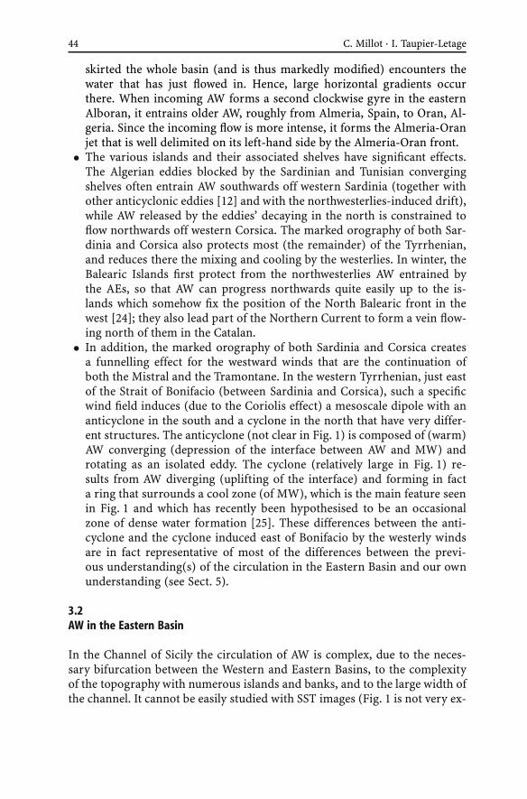
• In addition, the marked orography of both Sardinia and Corsica createsa funnelling effect for the westward winds that are the continuation ofboth the Mistral and the Tramontane. In the western Tyrrhenian, just eastof the Strait of Bonifacio (between Sardinia and Corsica), such a specificwind field induces (due to the Coriolis effect) a mesoscale dipole with ananticyclone in the south and a cyclone in the north that have very differ-ent structures. The anticyclone (not clear in Fig. 1) is composed of (warm)AW converging (depression of the interface between AW and MW) androtating as an isolated eddy. The cyclone (relatively large in Fig. 1) re-sults from AW diverging (uplifting of the interface) and forming in facta ring that surrounds a cool zone (of MW), which is the main feature seenin Fig. 1 and which has recently been hypothesised to be an occasionalzone of dense water formation [25]. These differences between the anti-cyclone and the cyclone induced east of Bonifacio by the westerly windsare in fact representative of most of the differences between the previ-ous understanding(s) of the circulation in the Eastern Basin and our ownunderstanding (see Sect. 5).
3.2AW in the Eastern Basin
In the Channel of Sicily the circulation of AW is complex, due to the neces-sary bifurcation between the Western and Eastern Basins, to the complexityof the topography with numerous islands and banks, and to the large width ofthe channel. It cannot be easily studied with SST images (Fig. 1 is not very ex-

Circulation in the Mediterranean Sea 45
plicit), due to the intense mixing by the topography and the northwesterlies,to the upwelling these winds induce off Sicily, and to the southward head-ing of the flow that rapidly warms. In addition, it cannot be easily studiedwith in situ data because of the intense fishing activity and the existence ofhalf-channel national economic waters. Therefore, AW within the channel hasbeen said to flow mainly either in the eastern side (as a Sicilian vein, e.g. [26])or in the western side (as a Tunisian vein, e.g. [27, 28]).
At the exit of the channel, SST images suggest (although not clear on Fig. 1)that three kinds of processes occur or have occurred, so that the eastern gyreat its beginning is split into several components. One is a northeastward-spreading branch that we associate with interannual variability (it disap-peared in early 1998), while it has been qualified as a permanent meanderingstream by e.g. [5]. The second is the generation of mesoscale eddies that tendto drift in the central part of the Ionian. The third is a more regular flow(the south-Tunisia vein) that, for most of it, follows the edge of the Tunisianshelf and, for a minor (and upper) part of it, follows the Tunisian coast (asin the Gulf of Lions); both parts of this vein join off Libya, the Tunisian veinhence becoming a Libyan vein. The term of vein(s) is justified by the fact thatAW spread in the central part of the Ionian (as a branch and/or eddies) willjoin it downstream to form the eastern gyre stricto sensu. Note that the fa-mous tourist places that are the Kerkennah and Djerba Islands are among thecoldest spots in winter, due to the very shallow shelf there (somewhere a fewmetres only). As first hypothesised by E. Salusti (pers. com.), these shelf wa-ters most probably tend to sink, as indicated for the Gulf of Lions and as it willbe shown for the northern parts of both the Aegean and the Adriatic. From∼ 15◦E, the Libyan vein continues along slope eastwards and appears unsta-ble, generating mesoscale eddies that are smaller and less well organised thanthe Algerian ones and that rapidly detach from the coast, due to the topogra-phy (isobaths spreading seawards). These eddies, together with those createdjust at the channel exit that drift in the central Ionian, form a complex eddyfield in the whole southern Ionian. The Libyan vein continues along slope inthe Gulf of Syrta (GoS) without developing large mesoscale instabilities there(maybe due to a flow too reduced and/or to a topography too shallow).
Since most of the eddies are trapped within the southern Ionian whileonly few of them drift into the Cretan (Cre), it might be that they decay inthe southern Ionian before joining the Libyan vein, together with the wa-ter spread in the interannual branch and then released. The eastern gyrehence restructures itself along the northern Cirenaïca (Cir), in the same wayas the western gyre near 0◦ (the parallel with Alboran and western Alge-ria, and more generally between the Western and Eastern Basins, is detailedin Sect. 5.1). From northern Cirenaïca to the western part of the Nile delta,what can be named the “Libyo-Egyptian Current” (the counterpart of theAlgerian Current) generates well structured and energetic eddies that ap-pear very similar to the Algerian ones. These anticyclonic eddies can be large

46 C. Millot · I. Taupier-Letage
(150–250 km), and they propagate downstream not faster than ∼ 3 km/day,i.e. generally slower than the Algerian eddies. As already shown off Algeria,it is expected that the Libyo-Egyptian eddies sometimes extend down to thebottom and can be guided, at least for the largest and most energetic ones, bythe deep isobaths (∼ 3000 m) associated with the Herodotus trough southeastof Crete (see Fig. 4).
There, they can interact with Ierapetra, the anticyclonic eddy generated bythe Meltem13 (Me) southeast of Crete together with Pelops generated south-west of the Peloponnese (Pel). Both eddies are clearly recognised in Fig. 1,Ierapetra having drifted south from where it was created ∼ 6 months earlier.We have shown that Ierapetra is actually created every summer by the Meltemclose to the southeastern tip of Crete. It can then remain stationary for oneyear (being thus reinforced the year after), drift southwards as far as theLibyo-Egyptian continental slope (hence interacting with the Libyo-EgyptianCurrent), or drift westwards as far as the western tip of Crete. Hence, Ierape-tra can survive for years, successive Ierapetra’s can coexist, possibly merge,and often interact with the Libyo-Egyptian eddies. As evidenced from SST im-ages, the shadowing effect of Crete (high relief) on the Meltem is sensed asfar as Africa. Hence, the surface waters entrained southwards on both sidesof Crete by this northerly wind tend to flow backward in between and feedIerapetra. The along-slope circulation of AW can also feed Ierapetra from thesouth through the Libyo-Egyptian eddies via a paddle-wheel effect (and fromthe northeast as well, see below).
We mainly hypothesise that the spreading seaward of the deep isobathsin the western Levantine leads the (deep) Libyo-Egyptian eddies to separatefrom their (shallow) parent current that remains along slope, and that theHerodotus trough traps them. Such a trapping can also apply to Ierapetra.To emphasise the fact that the zone corresponding to the Herodotus troughis characterised by the accumulation and interaction, frequently resulting inmerging, of eddies originated from outside the zone, and not by some perma-nent gyre or eddy created there (previously named Mersa-Matruh), we nameit
∑LW (accumulation in the western Levantine).
Eddies that decay in the∑
LW zone release AW that, at least partly, re-joins the remainder of the along-slope Libyo-Egyptian Current. Up to the Niledelta, the restructured Eastern Basin gyre generates medium (50–150 km)anticyclonic eddies that are similar to, although smaller than, the Libyo-Egyptian ones. From the Nile delta up to the southern and central Mid-dle East, instability processes only generate small (up to 50 km) eddiesand mushroom-like features that rapidly propagate downstream (up to10 km/day). Such characteristics might be due to the shallower topographythat prevents larger and better-organised features to develop. In any case,
13 The Meltem is a northerly wind blowing almost continuously in summer, hence also named “theEtesians”.

Circulation in the Mediterranean Sea 47
these features spread AW seaward and feed what was known as the Shikmonazone that we name
∑LE, for reasons similar to those invoked earlier for
∑LW
and∑
AE (accumulation in the eastern Levantine). When these features de-cay, the released AW re-feeds, at least partly, the Eastern Basin gyre along thenorthern Middle East slope. Then, along the Turkish slope up to Rhodes, thegyre (previously named Asia Minor Current there) mainly generates sharpmeanders, some of which can evolve into medium (50–150 km) anticycloniceddies that propagate at up to ∼ 3 km/day. Although a parallel will be madein Sect. 5 with the Northern Current in the Western Basin, it has been stressedthat the latter never generates such eddies.
Then, the Rhodes Island divides the Eastern Basin gyre into a northwest-ern vein and a southwestern one. The northwestern vein flows along theTurkish slope most of the year, except maybe in summer when the Meltemblows against it, and penetrates into the Aegean. There, the complex topog-raphy induces a second bifurcation with a sub-vein that continues into theNorthern-Aegean (Nor-Aeg) and a sub-vein that tends to skirt the wholeSouthern-Aegean (Sou-Aeg). The former sub-vein joins with the Black Seaoutflow and will be densified in winter, hence forming shelf water that willnot reach large densities, furthermore since the northward propagation ofLIW is mostly prevented by the complex topography (see below). The lattersub-vein is associated with the dense water formation process that involvesAW and LIW (see below) to form the Aegean Deep Water (AeDW). Althoughmost of the AW exits the Aegean through the western Cretan Arc (i.e. westof Crete), some of it flows north of Crete, as evidenced by medium-sized an-ticyclonic eddies propagating eastwards (i.e. downstream) before decaying.Then, AW that has skirted the Southern-Aegean in such a way feeds, throughthe passages between the islands that constitute the eastern Cretan Arc, thesouthwestern vein that continuously flows along the southern slope of theseislands. In winter, the southwestern vein is associated with the formation ofLIW southwards of Rhodes, as is the Northern Current with WMDW. In sum-mer, when the Meltem prevents AW from flowing markedly into the Aegean(and induces a marked upwelling zone off Turkey), the southwestern veinconstitutes most of the Eastern Basin gyre. It can be identified as far as Crete,sometimes clearly feeding Ierapetra. But then, it is generally entrained in∑
LW and again around the eastern Levantine. Therefore, whatever the sea-son and the balance between the northwestern and southwestern veins, theEastern Basin gyre is generally not encountered along the southern slope ofCrete, so that most AW definitively exits the Levantine via the Aegean west ofCrete.
AW then skirts the Peloponnese. In summer, part of it forms the wind-induced Pelops that can later drift up to a few 100s km westwards. Theremainder, and most AW during the rest of the year, continues northwardsin the northeastern Ionian where it re-constitutes the eastern gyre before bi-furcating into a northern and a western vein at the entrance of the Adriatic.

48 C. Millot · I. Taupier-Letage
The northern vein penetrates into the Adriatic and is partly associated withthe formation of the Adriatic Deep Water (AdDW, see below) in the southernpart of the subbasin (Sou-Adr), while the remainder continues northwardsand mixes there (Nor-Adr) with the Pô and other rivers runoff. There are sim-ilarities between the Aegean and the Adriatic, since less dense water is formedon the shelf in the north and denser water is formed offshore in the south.There are differences between the Bora effect on the Pô outflow (similar to theMeltem effect on the Nile outflow) and that of the Meltem on the Black Seaoutflow (similar to the Mistral and westerlies effects on the Rhône and Ebrooutflows), since the Bora pushes the Pô outflow towards the coast, so that itremains well structured along most of the Italian peninsula. AW exiting theAdriatic rejoins the westward vein that bypassed the Adriatic, both continu-ing along the southern tip of the Italian peninsula and Sicily, before closingthere the circuit of the Eastern Basin gyre. The Maltese filament, formed bycold water upwelled off southwestern Sicily, then separates the incoming AWfrom the older one. It can be detected in the whole southern Ionian and can beconsidered as a tracer of the front that is the counterpart of the Almeria-Oranfront.
4The Circulation of the Intermediate and Deep Waters
To our knowledge, recent schemas of the circulation of the intermediateand deep waters have been proposed (and validated) for the Western Basinonly [9]. Those proposed hereafter for the Eastern Basin must hence be con-sidered as a first attempt to analyse the available in situ data sets with generalideas validated in the Western Basin only. These general ideas attribute a ma-jor role to the Coriolis effect and to mesoscale eddies, be these eddies eitherwind-induced or generated by the instability of the along-slope AW circula-tion. The in situ data collected in the Eastern Basin (mainly in the north) havebeen analysed to date with concepts that are very different from ours, so thatthe analysis hereafter is not consistent with the previous ones14. Even thoughthis analysis describes features in the south of the Eastern Basin that cannotbe supported by data unavailable yet, so that these features are hypothetical,the present tense is used and adverbs such as “probably” are mostly omittedfor convenience. In addition, we consider that the circulation of intermedi-ate and deep waters necessarily displays a seasonal variability more or lessfar away from the zones of formation; however, due to the lack of data, thisseasonal variability is not represented in the schemas.
Several places and processes of formation have been hypothesised for LIW,including the interior of mesoscale anticyclonic eddies all year long in the
14 In any case, there are a lot of discrepancies between these previous analyses too!

Circulation in the Mediterranean Sea 49
Fig. 3 Circulation of LIW extrapolated from [9] for the Western Basin. The thin linerepresents the 500-m isobath
southern Levantine. However, it is formed mainly south-southeast of Rhodesin the northern Levantine, according to the offshore wintertime processesdescribed in Sect. 1 (see also Sect. 5). As already stated, LIW is the MW pro-duced with the largest volume. Since it is the warmest and saltiest waterformed in the whole sea, it can easily be tracked up to Gibraltar just belowAW. Other intermediate waters formed together with denser waters, as forexample in the Aegean (named Cretan Intermediate Water) or in the Liguro-Provençal (named Winter Intermediate Water), cannot be differentiated soeasily from waters above or below and they represent much lower amounts.We thus only discuss hereafter (Sect. 4.1) the circulation of LIW, i.e. the inter-mediate water produced in the northern Levantine (Fig. 3).
Some deep waters might be occasionally produced in specific places. Thiswas said [29] for a water that reached ∼ 2000 m in the northern Levantinewhere most of LIW forms. This was also said [25] for water denser than TDW(see Sect. 4.2) that could be formed east of Bonifacio (cool zone in Fig. 1)and could fill the deep Tyrrhenian (down to ∼ 3500 m). However, we do nothave enough data concerning these deep waters so we restrict ourselves to thediscussion (Sect. 4.2) of AeDW, AdDW, TDW and WMDW (Fig. 4).
4.1LIW
LIW formed in the northern part of the Levantine flows, due to the Cori-olis effect, along the southern continental slope of the Cretan Arc islands,from Rhodes to Crete and to the Peloponnese. Because the sills between theseislands reach depths larger than the 100–500 m LIW level, some LIW pene-

50 C. Millot · I. Taupier-Letage
trates into the Southern-Aegean where it mixes with AW in winter to formAeDW (it hardly penetrates into the Northern-Aegean, due to the complextopography). However, the section of the openings does not allow the wholevolume of LIW to go through so that most LIW flows along slope south ofCrete. Ierapetra and Pelops wind-induced eddies entrain LIW where theyform (i.e. close to the coast and just above the continental slope where LIWflows) and then transport it seawards, potentially over 100s km, releasing itaway from the slope, in a process similar to the one mentioned in Sect. 2.2for the entrainment of LIW from the slope of Sardinia by the Algerian eddiespassing by. The occurrence of LIW within such eddies when in the south-ern Levantine might have been misinterpreted as a formation of LIW withinoffshore eddies. Note that the Libyo-Egyptians eddies (counterparts of the Al-gerian eddies) are in a position too far south to allow them to entrain newlyformed LIW. Part of the LIW that continues circulating along the northeast-ern slope in the Ionian penetrates into the Southern-Adriatic where it mixeswith AW in winter to form AdDW. The remainder bypasses the Southern-Adriatic and continues along slope as far as the Channel of Sicily, where mostof it (sill at ∼ 400 m) outflows into the Western Basin. However, any part ofLIW that has bypassed the entrance of the channel and is still associated withan along-slope pressure gradient will continue along slope around most ofthe Eastern Basin. In other words, waters are generally not “attracted” by theopenings and they do not “feel” them; they circulate along slope, as long asthey are forced to do so by an along-slope pressure gradient, and hence theycan “miss” the openings.
Within the Channel of Sicily, LIW flows along the Sicilian slope and thenskirts Sicily. This path, initially suggested by Millot [30], is now generallyagreed and supported by theoretical analyses (e.g. [31]). Then, LIW mainlycirculates around the Tyrrhenian, roughly at 200–600 m. A vein flows outthrough the Channel of Corsica (sill at ∼ 400 m) while the remainder con-tinues and flows out through the Channel of Sardinia. When this vein entersthe Algerian, part of it can be entrained seawards by Algerian eddies pass-ing by and then be released in the central subbasin. The remainder of thevein continues along slope along western Sardinia and Corsica, joins with thevein issued from the Channel of Corsica, and then participates with AW in thewintertime formation of WMDW in the Ligurian and the Provençal. The still-recognisable LIW continues along the Spanish slope and most of it outflowsthrough the Strait of Gibraltar (sill at ∼ 300 m), where it can still be recog-nised along the Spanish slope, while the remainder that bypassed the openingthen progresses along slope off Africa (as discussed for the entrance of theChannel of Sicily).
Therefore, LIW appears to play a major role in the functioning of theMediterranean Sea. First, because it is the warmest and saltiest MW formedwith the largest amount. Second, because it mainly flows along the north-ern continental slopes of both basins just below AW, thus being involved

Circulation in the Mediterranean Sea 51
there in the offshore formation of all deep MWs (AeDW, AdDW, WMDW).Because the immersion of LIW allows it to flow rather easily through the ma-jor openings, its path is almost one-way, from the northern Levantine to theChannel of Sicily and the Strait of Gibraltar. However, the parts of LIW thathave bypassed either the Channel of Sicily or the Strait of Gibraltar continueflowing along slope around the basins. In addition, being involved in winter-time processes all along its path, one expects that LIW displays everywhere anincreasingly complex seasonal variability (see also Sect. 4.2).
4.2AeDW, AdDW, TDW and WMDW
AW is warmer and saltier in the Aegean than in the Adriatic since norther-lies are less cold (the Adriatic is surrounded by the Alps) and it just startsto be diluted (by the Black Sea mainly; it will be more and more dilutedby river outflows). Moreover, LIW is warmer and saltier in the Aegean thanin the Adriatic since it is closer to its formation zone and hence has un-dergone less mixing. Therefore, AeDW is saltier and warmer than AdDW.However, both waters have roughly similar densities. Up to the 1980s, andpresently, AdDW was and is denser than AeDW while, during what has beencalled “the transient” (see [32], for a review), the reverse occurred. Thesetwo deep waters first accumulate in the troughs (1000–1500 m) over whichthey are formed (in the Southern-Aegean and Southern-Adriatic, resp.) be-fore outflowing through the various openings. From there, they cascade in thenorthern Levantine, northern Cretan and northern Ionian, down to depthswhere the density they have due to mixing is that of the resident waters. Then
Fig. 4 Circulation of AeDW, AdDW, TDW and WMDW extrapolated from [9] for theWestern Basin. The thin lines represent the 1000-m and 2750-m isobaths

52 C. Millot · I. Taupier-Letage
they circulate along slope, due to the Coriolis effect, as long as they are forcedby an along-slope pressure gradient, hence tending to describe a counter-clockwise basin-wide gyre. Note that these cascadings of AeDW and AdDWoccur from sills at ∼ 1000 m that are markedly below the LIW mean level (theLIW gyre is not disturbed by these outflows).
Two sources of deep waters, located in two relatively enclosed and shal-low subbasins (the Aegean and the Adriatic), thus compete to fill the greatestdepths of the Eastern Basin (4000–5000 m) that must hence be considered asa trap for the densest waters. However, since these deep waters are producedevery winter, their upper (i.e. less dense) part must outflow through the Chan-nel of Sicily. Deep water that initially cascaded down to a given level will reachupper levels (years or decades later) only after having mixed all over the basinwith the waters above or after having been uplifted by denser waters, what-ever their origin. It is generally assumed that the deeper the level the weakerthe stratification and the circulation, which is verified only on average andaway from the zones of dense water formation due to a long-lasting mixing.However, the densest waters formed in any of these zones, even during shortperiods and in small amounts, can reach the bottom, hence being preventedfrom intense mixing with surrounding waters and circulating significantly tofind their equilibrium level; these bottom waters [33] have hydrological char-acteristics that vary interannually.
The upper part of AeDW and/or AdDW that outflows through the Chan-nel of Sicily is located in the deeper part of the channel, mainly on theTunisian side. As suggested by Millot [30] and demonstrated later by Astraldiet al. [31], this results from differences in density and amount between thesedeep waters and LIW. In any case, the AeDW/AdDW outflow is much denserthan the waters residing in the Tyrrhenian, so that it permanently cascadesdown to depths of 1900–2000 m [34], mixing itself with the resident watersbefore skirting the Tyrrhenian, hence initiating a basin-wide gyre, and en-tering the Channel of Sardinia (sill at ∼ 2000 m) close to Sardinia. The flowfrom the Tyrrhenian to the Algerian (Tyrrhenian Dense15 Water, TDW), al-though being partially composed of waters having entered the Tyrrhenianfrom the Algerian (see below), is thus mainly composed of waters from theEastern Basin. The origin(s) of the waters found in the deep Tyrrhenian(2000–3500 m) is/are still debated since none of those hypothesised up tonow (the Algerian subbasin, the Eastern Basin or the zone east of Bonifacio)has been supported by definitive data sets. From the Channel of Sardinia, ei-ther TDW is entrained seawards (as LIW) by Algerian eddies passing by or itcontinues along slope towards the Ligurian and the Provençal. WMDW beingformed there over relatively great depths (2000–2500 m), then mixes or flows
15 The term dense is used instead of deep to specify that (i) this water is not the deepest one foundin the Tyrrhenian and/or that (ii) it is not essentially formed by a classical offshore wintertimeformation process such as the one hypothesised in the east of the Strait of Bonifacio.

Circulation in the Mediterranean Sea 53
together with TDW as a continuation of the basin-wide gyre in the Catalan,the Alboran and the Algerian.
WMDW describes a basin-wide gyre that is strongly dependent on its dens-ity and on the topography. Where depths are as large as 2700–2900 m, whichoccurs only in the western and eastern parts of the Algerian (not consideringthe Tyrrhenian), the densest WMDW is trapped, thus possibly describing twosub-gyres that have recently been evidenced there [3, 36]. These sub-gyres aregenerally associated with speeds of several cm/s that can be locally larger due tothe topography since annual means of ∼ 10 cm/s were measured at ∼ 2700 moff Algeria [3]. Note that a link probably exists between the counterclockwisecircuit followed by the Algerian eddies in the eastern Algerian mainly [12]and this deep topography. For depths of 2000–2700 m, the Channel of Sardiniatraps the less dense WMDW in the western part of the basin, thus forcing it toskirt the whole Algerian before possibly flowing back into the Ligurian and theProvençal. At depths shallower than ∼ 2000 m, WMDW preferably exits the Al-gerian through the Channel of Sardinia into the Tyrrhenian, possibly togetherwith TDW that has skirted the whole Western Basin.
In the southern Tyrrhenian, and at less than ∼ 2000 m, these western wa-ters will possibly, and maybe intensively, mix with, and/or be uplifted by,those cascading permanently from the Channel of Sicily, hence having onemore possibility than the deep eastern waters to reach shallower levels (thelatter only having the possibility to mix over the whole basin and be up-lifted by recently formed denser waters). In addition, Kinder and Parrilla [35]have hypothesised that waters can be sucked by a Bernoulli effect at theStrait of Gibraltar (sill at ∼ 300 m) from depths down to ∼ 700 m, a processthat probably does not occur at the wider Channel of Sicily. Therefore, boththe cascading from the Channel of Sicily and the sucking from the Strait ofGibraltar account for a conveyor belt in the Western Basin (not consideringthe deepest part of the Tyrrhenian) shorter and more intense than in theEastern Basin. In any case, the densest waters are found on the deeper andleft-hand (Moroccan) side of the Strait of Gibraltar while LIW is found on theright-hand (Spanish) side, probably for reasons similar to those invoked forthe Channel of Sicily.
5Discussion
Most of the physical oceanographers see more differences than similitudesbetween the two basins of the Mediterranean Sea. Because we have believed inthe contrary for more than one decade [1] and think that specifying the simil-itudes (and differences!) can lead to a better understanding of the phenomenain both basins, we focus our discussion on this point.

54 C. Millot · I. Taupier-Letage
Before that, we think it instructive to specify what are, according to us, thereasons that led to overviews of the circulation in the sea so different and,more especially, to views of the circulation in the Eastern Basin so different,with AW said to mainly cross [4, 5] or skirt [6, 7] that basin. The main rea-son, we believe, is that although we use average remotely sensed (e.g. Fig. 1)and in situ (e.g. [3]) data as most of our colleagues, we take care of visuallyanalysing individual satellite images (day after day if not track after track,e.g. [7]), of locating CTD stations only few km apart based on images receivedonboard in near real time (e.g. [3]), and of simultaneously collecting currenttime series as numerous (up to 30–40) and long (up to ∼ 1 year) as possible(e.g. [3, 17, 37]).
Just looking at one single (good and representative) image evidences, forinstance, the fact that important dynamical processes are occurring in thesouth of the basins, which had motivated our former interest in the Algeriansubbasin, and now motivates our interest in the southwestern Levantine ...and explains how surprised we have been not to see any information speci-fied along most of the African coast in the Eastern Basin by for example [4]and [5]. In addition, looking at series of daily images allows mesoscale phe-nomena to be followed over years (which is not possible with e.g. altimetricdata) and analysing small-scale features (e.g. shear eddies, filaments, gra-dients), which gives us a “specific-although-maybe-subjective feeling” thatcan hardly be achieved with the analysis of CTD data and/or numericalsimulations. To better explain the other disagreements that exist about theEastern Basin, let us specify our personal understanding of these mesoscalephenomena.
For us, a mesoscale anticyclone (be it wind-induced, as Ierapetra andPelops, or generated by the instability of an along-slope current of AW, as theLibyo-Egyptian eddies) is basically an isolated rotating piece of (warm) AW“floating” on MW and able to move, interact up to merge with others and fi-nally decay, hence releasing the piece of AW. Such an anticyclonic eddy of AWcan create an associate anticyclonic eddy of MW as in the Algerian (via pres-sure, we believe) and possibly over the whole depth [3], making it sensitiveto the deep topography (not felt by the 100–200 m deep along-slope circula-tion of AW). On the contrary, a mesoscale zone cooler than the surroundingsand induced by the wind is nothing else than MW (or denser/cooler AW)locally reaching the surface, potentially associated with AW flowing cycloni-cally (due to the Coriolis effect and geostrophic adjustment) more or lessall around it as a ring (what we believe is a characteristic of what is calledthe “western Cretan eddy”) or, more probably, along its coastal side mainly(what we believe is a characteristic of what is called the “Rhodes gyre”). Inany case, we do not consider such cool zones as isolated pieces of any kindof water able to move, although they can have specific dynamics (as wheredense water is formed), so that such zones are neither eddies nor gyres (aswe defined them). In addition, note that these cool zones are associated with

Circulation in the Mediterranean Sea 55
an upwelling just when they are created, in relation with the uplifting of theinterface between AW and MWs. Then, they are just more and more ho-mogenised, and surface water there is densified, possibly up to sinking in latewinter (see Sect. 5.1.3), so that the average speed there is downwards; thesenutrient-enriched zones start to be productive (spring blooms) as soon asstratification takes place, thus allowing light to be available for a sufficientperiod of time. Other cyclonic features such as the eddies induced by the in-stability of a current [10, 27] or by the shear on its edge [14] are in fact small(up to a few 10s km) and short-lived (up to a few weeks). Therefore, insteadof considering that the variability at mesoscale is due to alternated cyclonesand anticyclones (as commonly done up to now by for example analyses ofaltimetric data), we consider that the mesoscale eddy field is mainly com-posed of anticyclones that are often juxtaposed (hence roughly twice as largeas defined according to altimetry!).
5.1The Dynamical Phenomena
Although the Western and Eastern basins are different, they display markedsimilarities, not only at basin scale (Sect. 5.1.1) but also at subbasin scale(Sect. 5.1.2). After having analysed the offshore dense water formation pro-cess (Sect. 5.1.3), it appears that there might be another way to consider thefunctioning of the sea (Sect. 5.1.4). In any case, the Coriolis effect and themesoscale variability are basic mechanisms that also allow explanation ofthe circulation in the Black Sea (Sect. 5.1.5). However, observing the circula-tion is complicated everywhere by the occurrence of other types of currents(Sect. 5.1.6).
5.1.1Similarities and Differences at Basin Scale
First, both basins act as machines that essentially salt and additionally cool(i.e. densify) AW to form several types of MWs. The along-slope counter-clockwise circulation of AW describes two basin-wide gyres. Parts of bothgyres are markedly unstable in the south, leading to specific current systems,while they are more stable in the north where AW sinks in winter, mainlyoffshore. MWs formed in both basins must outflow over relatively shallowsills.
However, the two basins are different with respect to AW, mainly becausethey are located in series, i.e. one after the other. The Western Basin is a tran-sitory domain for most (∼ 3/4) of the AW, including some AW first entrainedin the western gyre without sinking that can then enter the Eastern Basin,while the Eastern Basin is a definite cul-de-sac for that AW. The two basins arealso different with respect to MWs because the eastern MWs that must exit

56 C. Millot · I. Taupier-Letage
the basin can be only the shallowest ones (a few 100s m), so that the densestcan be trapped for a long time. On the contrary, most of the dense westernMWs (down to ∼ 2000 m) continuously mix and/or are uplifted by the east-ern MWs that cascade from the Channel of Sicily, both having to exit theWestern Basin at Gibraltar. Therefore, the deep (down to ∼ 2000 m at least)circulation is more intense in the Western Basin than in the Eastern one.
5.1.2Similarities and Differences at Subbasin Scale
In this subsection, we consider the Eastern Basin without the Aegean andAdriatic subbasins.
The basin entrance (i.e. before a relatively structured basin-wide gyreforms) can be considered as narrower in the west (the Strait of Gibraltar andthe Alboran,) than in the east (the Channel of Sicily and the Ionian). Hence,constrain of the AW inflow is more intense at the western entrance and leadsto circulation features in the Alboran that, although complex, are simplerthan in the Ionian. However, although the Alboran and the Ionian are verydifferent in shape and size, they are paralleled because they are (i) locatedupstream from where the basin-wide gyres start to be structured (even if un-stable), i.e. off western Algeria and Cirenaïca and (ii) not concerned by thedense water formation process that occurs offshore in the north.
Then, we see marked similarities between the Algerian and the Cretan +western Levantine. Indeed, the AW flow, rather well defined along slope inthe western parts of these subbasins, then creates specific current systems(the Algerian and the Libyo-Egyptian) that generate large (up to 150–250 km)long-living (several months/years) deep (several 1000s m, sometimes down tothe bottom) anticyclonic eddies that first propagate (at a few km/day) down-stream (i.e. eastward). Probably because these eddies are deep and tend tobe guided by the deepest isobaths, while their thinner parent current flowsalong the upper part of the continental slope, they generally follow a circuit inthe eastern Algerian (where the deeper part can accommodate several eddies)and accumulate up to merging over the Herodotus trough (width is hardlylarger than a typical eddy diameter). Together with not so deep eddies thatmight be entrained southwestwards by the β-effect (variation of the Corio-lis effect with the latitude) and non-linearities [14], they possibly come backtowards the southern coast and interact with their parent current.
The similarity between the Tyrrhenian and the eastern Levantine is moti-vated by the fact that the circulation in these far eastern zones is clearly alongslope. It is relatively stable in the Tyrrhenian and only slightly unstable in theeastern Levantine (as compared to the Cretan + western Levantine). Most ofboth subbasins are protected from the westerly/northerly winds, either by theSardinia and Corsica orography and/or by the distance from the windy areas,so that offshore waters are relatively light (not too cooled) and unmixed there.

Circulation in the Mediterranean Sea 57
We see a marked similarity between the Northern Current in the Ligurian,the Provençal and the Catalan, and what was named the Asia Minor Current(and its prolongation as far as Crete at least), even though the former onlymeanders while the latter can generate medium anticyclonic eddies. Anothermajor similarity is obviously the zone of formation of WMDW in the WesternBasin and that of LIW in the Eastern one.
These overall similarities between the western and eastern gyres and theirstability/instability characteristics are hidden mainly by the complexity ofthe northern coastlines in the Eastern Basin that prevents from having, as inthe Western Basin, an Eastern Basin-wide Northern Current (that would flowcontinuously along slope from Middle East to Sicily). These similarities arealso hidden by the fact that Algerian eddies are prevented from exiting theAlgerian Basin by Sardinia and Corsica, so that the northward spreading ofAW they induce has a major importance in the Western Basin: a significantamount of AW is maintained close to the zone where WMDW forms, whichleads to the North Balearic Front and then to a significant vein of AW west ofCorsica. Comparatively, AW first spread northward by the Libyo-Egyptian ed-dies is not forced to accumulate there and not maintained close to the zonewhere LIW forms, so that it can be entrained southward by the Etesians andthen re-feed the basin-wide gyre (without forming any front and vein westof Cyprus). Therefore, although the latitudinal extent of the Algerian, theProvençal and the Ligurian is larger than that of the Levantine, the studies ofthe major processes occurring in the south (generation of mesoscale eddies)and in the north (dense water formation and associated circulation) can bemore easily decoupled in the Eastern Basin than in the Western one.
There might also be similarities for MWs at subbasin scale. Circulation canbe intense at greater depths in both the Western and the Eastern Basins wheredense waters recently produced spread, even away from the zones where theywere formed. Significant time series have not been collected in all subbasinsyet but yearly means of several cm/s might not be exceptional values. Thedeepest parts of both basins (3000–3500 m in the Tyrrhenian, 4000–5000 min the Ionian and the Levantine) are certainly the quietest (as demonstratedby the occurrence of brine lakes in the east). Densest waters in these sub-basins stagnate there for a long time, until they are either mixed throughdiffusion (permanent but moderate) or uplifted by denser water (occasionalbut efficient).
Finally, let us comment on the similarities and differences of the dipoles in-duced by orography and wind funnelling that essentially consist of an actualanticyclonic eddy (of AW) associated with a cool zone (of MW or denser AW).The northwesterlies blowing through the Gulf of Lions (between the Pyre-nees and the Alps) generate a small eddy (in the Catalan) and a large coolzone (in the Provençal and the Ligurian where WMDW forms). The westerliesblowing through the Strait of the Bonifacio (between Sardinia and Corsica)generate a small eddy (northeast of Sardinia) and a limited although perma-

58 C. Millot · I. Taupier-Letage
nent cool zone (where dense water formation has been hypothesised). Thenortherlies blowing through the channel west of Crete (between the Pelo-ponnese and Crete) generate a large eddy (Pelops) and a limited cool zone(often named incorrectly western Cretan eddy). These northerlies blowingthrough the channel east of Crete (between Crete and Turkey) generate a largeeddy (Ierapetra) and a large cool zone (in the northern levantine where LIWforms). The differences between the basins (zones in the east less cool than inthe west, eddies in the east larger and more long-lived than in the west) andwithin the basins (zones known as major places for dense water formation ornot) must not hide the similarities between these wind-induced phenomena.
5.1.3The Offshore Dense Water Formation Process
Let us now discuss the links we make between the zones where AW sinks andthe currents in the northern parts of the basins that surround these zones“just north” of them. Let us imagine the theoretical case of a basin originallyfilled with a unique homogeneous water mass. When winter comes, northerlywinds cool and evaporate this original water mainly off the northern coasts.Indeed, air masses becoming warmer and wetter while transported over thesea become less and less efficient leeward for dense water formation. Thewater being made denser mainly in the north of the basin tends to sinkthere, a process named convection (not downwelling although opposed toupwelling), and the surrounding (still original) water tends to fill the gap.However, because of the Coriolis effect and as for a meteorological low-pressure system, this original water flows counterclockwise around the gapfor some time (at least one year according to Crépon et al. [38]). Now, becauseof the asymmetry induced by winds blowing from the coast, the surround-ing flow of original (less dense) water is always narrower, more intense andhence deeper in the coastal zone, just north of the zone of dense water for-mation. This latter zone being always less stratified will be, in our theoreticalcase, a preferential zone for dense water formation during the next winter ...and the following ones as well! Practically, original water can be consideredas the water encountered before winter in most of the basin, i.e. as AW perse. Since actual AW is continuously stratified, stratification will be maintainedin the northern currents, even where meteorological conditions are the mostsevere.
5.1.4Another Way to Consider the Mediterranean Sea
Instead of separating the Mediterranean Sea into two basins usually thoughtof as having more differences than similarities, let us consider the sea asa three-level association of machines that, although being different in size and

Circulation in the Mediterranean Sea 59
efficiency, are fundamentally similar. The third level could be formed by boththe Aegean and the Adriatic (AA), the second level by the Levantine, the Cre-tan and the Ionian, i.e. the remainder of the Eastern Basin (EB), the first levelby the whole Western Basin (WB). Each machine:
• receives AW from the preceding level: from EB for AA, from WB for EB,from the Atlantic Ocean for WB;
• is characterised by an overall propagation of AW as an along-slope coun-terclockwise gyre;
• is such that the AW gyre is markedly unstable in the south with mesoscaleanticyclonic eddies propagating downstream (eastwards): off Crete only(nothing adequate for the Adriatic) for AA, off eastern Libya and westernEgypt for EB, off Algeria for WB;
• receives intermediate and/or dense waters from outside: LIW for AA,AeDW and AdDW for EB, the outflow from the Channel of Sicily for WB;
• forms its own dense water according to offshore processes: AeDW andAdDW for AA, LIW for EB, WMDW for WB;
• forms less dense waters over continental shelves: in the northern parts ofAA, in the Gulf of Lions for WB (nothing adequate for EB, not consideringthe shelf off southern Tunisia);
• is such that AW surrounds the offshore zone of dense water formationjust north of it: in the north of the Southern-Aegean and of the Southern-Adriatic for AA, in the north of the Levantine for EB, in the north of theLigurian and the Provençal for WB;
• has topography (a more or less large trough or pit) so that densest wa-ters must flow over a sill before cascading at lower levels: the Cretan andOtranto sills for AA, the Sicily sill for EB, the Gibraltar sill (probably afterthe Sardinia sill) for WB.
This analysis of the functioning of the sea could be used for analytical com-putations or simple numerical simulations.
5.1.5Circulation in the Black Sea
To illustrate the fact indicated in the introduction that different forcingsinduce a roughly similar along-slope counterclockwise circulation, let us con-sider the case of the Black Sea. There, precipitation and river runoff exceedevaporation so that surface water outflows through the Bosphorus and theDardanelles while deep waters are schematically at rest, not considering theslight inflow of MW from the Northern-Aegean (e.g. [39]). It is now clearlydemonstrated, from both remotely sensed (see Fig. 1) and in situ data sets,that fresh waters mainly issued from the surrounding terrestrial areas circu-late all around the sea and form an unstable current that generates mainlymesoscale anticyclonic eddies (e.g. [40]).

60 C. Millot · I. Taupier-Letage
5.1.6Other Types of Currents
In addition to the currents associated with the circulation features describedin this paper, be they associated with the major/named currents, gyres, veins,branches or mesoscale eddies, other types of currents must be considered, inparticular for environmental purposes. First, oscillatory currents do not en-train any significant circulation of water particles and dissolved compounds,but significantly contribute to mixing and, in any case, complicate the in situobservation. Well-known tidal currents must be considered in most of themajor passages (e.g. the Strait of Gibraltar, the Channel of Sicily), in someminor ones (e.g. the Strait of Messina) as well as in all coastal pond outletswhere they can reach a few m/s. Except in some very specific zones wherethese tidal currents are associated with few-metre sea-level oscillations (e.g.the Northern-Adriatic) and/or several 10s-m internal waves (e.g. the Straitof Gibraltar), they can be neglected since they are a few mm/s only (but stillmeasurable, [41]). This is not the case for the less-known inertial currentsthat oscillate at the Coriolis frequency (∼ 17 h and ∼ 24 h, in the far north andsouth of the sea, respectively) and are mainly induced by gusts of wind understratified conditions. Although inertial currents reach maxima of a few 10scm/s only, they can be encountered more or less in all seasons, everywhereand at greatest depths, even in almost homogeneous waters [42]. In addition,they markedly vary in time and space, both on the horizontal and the ver-tical, and can be associated with several 10s-m internal waves. Finally, large(several 10s to 100s m) vertical oscillations with periods of a few hours canbe encountered in the zones of dense water formation. Contrary to the dis-solved compounds that strictly follow the water particles and are submittedto the phenomena described up to now, floating compounds (e.g. oil releasedby tankers) are more directly submitted to the wind drag effect. The induceddrift, not mentioned up to now since it was not thought important from a cir-culation point of view, is generally estimated to be some percents of the windspeed, roughly downwind (slightly on the right).
5.2Some Implications for Environmental Chemistry
At large scale, an object theoretically able to keep the density that AW hasbefore sinking (and not beaching!) will follow the circulation schema de-scribed in Fig. 2 and will never escape from the Mediterranean Sea. On thecontrary, any dissolved compound will follow one or the other of the circu-lation schemas in Figs. 2, 3 and 4, and will finally escape from the sea. Ingeneral, it can be considered that the lower the depth within MWs the lowerthe residence time. Just dividing the volume of the sea by the outflow givesan average residence time for a dissolved compound of 50–100 years. How-

Circulation in the Mediterranean Sea 61
ever, the actual residence time at any given level ranges from less than a fewhours/days to more than several centuries!
Any compound introduced into the sea by rivers will be preferentiallytransported, without any wind or marine current, along the coast on the righthand side, as a direct consequence of the Coriolis effect on the river plume(as for other waters). This tendency will be increased by winds blowing shore-ward and decreased by winds blowing seaward (not considering the Corioliseffect on the drift current that induces a small component to the right). Theoverall circulation of AW as a gyre generally increases this tendency, as longas indentations of the coastline (in fact of the upper continental slope) are suf-ficiently large (several 10s km, i.e. gulfs) for allowing the Coriolis effect to beefficient in maintaining the circulation along the topography. When inden-tations are small (few-km, i.e. bays), the Coriolis effect cannot maintain theoverall circulation along the topography; most of the circulation bypasses thebay where only part of the circulation can loop (e.g. [43]).
However, this overall circulation is not directly sensed everywhere in thecoastal zone (up to a few km wide). This is because a basin-wide gyre hasa width (a few to several 10s km) and a thickness (a few 100s m) that causeit to follow the largest topographic features only. Its core (maximum speedsof several 10 cm/s) is always located a few 10s km seawards at least, and it caninfluence the circulation in the coastal zone through its inner (i.e. right-hand)edge only (e.g. [17]). Natural turbulence on the edges of any major currentand interaction of the current itself with smaller topographic features willmake the circulation in the coastal zone relatively complex. In this respect, theturbulent character of the actual along-slope currents, i.e. the turbulent diffu-sion they induce, facilitates the seaward spreading of compounds originatedin the coastal zone. Therefore, the gyre of AW does not act as a barrier foron-offshore exchanges (which would be the case for laminar currents).
Once coastal compounds have entered the gyre (of AW or MWs, i.e.whatever the depth), they can be entrained either mainly along slope (over100s km) if in the northern part of the basin (where currents are relativelystable) or in any direction if in the southern part. More specifically, a com-pound released from Algeria for instance is entrained, most of the time andhence on average, eastwards. However, an anticyclonic eddy located just off-shore can entrain it westwards. It can also be entrained directly northwards,when a large eddy located just downstream strongly interacts with the Alge-rian Current itself and causes it to leave the coast at a right angle [14]. Finally,it can be constrained along the coast when an anticyclonic eddy is locatedjust upstream and induces a current impinging the coast southwards (thissituation is temporary since the compound will sooner or later be entrainedeither westwards or eastwards).
Direct links are often made between Saharan dusts transported over thesea by southerly winds, as seen on visible satellite images, and their inputinto the sea itself. However, it might not be trivial to note that compounds

62 C. Millot · I. Taupier-Letage
originated from atmospheric sources have to enter the sea! Indeed, dust canbe seen from space mainly in the absence of clouds, and hence precipitation;therefore, only a part of that dust will directly reach the sea, the remainderfalling elsewhere, i.e. on land, before being transported later on into the sea byrivers. It might be (we believe!) that most of the Saharan dust is transporteddirectly into the sea by rainy, hence cloudy meteorological events duringwhich dust cannot be seen. Note that the circulation modifies a spatiallyhomogeneous sowing of dust just slightly (due to stratification and verticalcurrents), while it distorts a patchy sowing (due to the heterogeneity of thecurrent field).
When dealing with suspended particles, or chemical compounds associ-ated in aggregates, one must keep in mind the dramatic difference betweenthe intensity of the horizontal currents (a few to several tens of cm/s) withingyres and mesoscale eddies, and that of mean falling speeds (of the order ofthe mm/s). Any suspended particle found along slope (where more or lesspermanent circulation occurs) could thus have been introduced at the sur-face of the sea 10s or 100s km upstream. In the central part of the basins, theorigin is generally even more uncertain.
6Conclusion
Climatic conditions are such that the two basins of the semi-enclosedMediterranean Sea are characterised by an excess of evaporation over precip-itation and river runoff. Just because the level of the sea is thus decreased,water is coming in from the Atlantic to compensate for the deficit; the factthat AW is coming in at the surface only needs the comments hereafter tobe understood. Due to these climatic conditions, the incoming surface wateris essentially made saltier, hence denser, all along its course within the sea.In winter cool (and dry) air masses transported by northerly winds blowingstrongly in a few specific zones make surface water denser and denser. Thiswater is finally densified so much that it sinks in these specific zones. Be-cause it has been continuously transformed, due to the climatic conditionsand the mixing with surrounding waters, this surface water sinks with char-acteristics that depend on the zone and are relatively typical, leading to a setof more or less dense Mediterranean waters. These waters then circulate inthe different subbasins, and mix more or less up to a certain amount beforeoutflowing through the Strait of Gibraltar (mixing is completed during theoutflow and consecutive sinking). Fundamentally, the sea is thus a machinethat transforms Atlantic surface water encountered just west of Gibraltar intodenser (essentially saltier and additionally colder) water that is recognised at1000–2000 m in most of the northern Atlantic Ocean.

Circulation in the Mediterranean Sea 63
Apart from this well agreed functioning, the circulation of the various wa-ters from/to the Strait of Gibraltar and the Channel of Sicily to/from thezones of sinking, is becoming more or less agreed upon in the Western Basinand is just beginning to be debated (this will last for a while!) in the EasternBasin. Since the differences between the circulation schemas published up tothe present have already been commented upon for both basins [7, 9, 30], andsince this introductory chapter must provide a coherent—although not fullyagreed on—analysis, the presentation was restricted to the authors’ analysis.
Due to the Coriolis effect, which deflects to the right in the northern hemi-sphere any movement having relatively large space and time scales, all watersthat are forced to circulate at basin scale (at all depths!) tend to follow, in thecounterclockwise sense, the isobaths corresponding to their own level. Sim-ply considering that waters hence form basin-wide gyres a few tens of kmwide following mainly the continental slope at all depths provides a relativelysimple overall circulation schema.
For the flow of surface water, this schema is complicated first at the en-trance of the basins, mainly due to the complexity of the topography thatextends its influence to greater or lesser distance downstream (the Alboranand the Ionian, resp.). Then, the flow tends to structure itself as a basin-widegyre (off western Algeria and off Cirenaïca, resp.). However, it is much lessdense than the water below, hence markedly unstable, so that southern por-tions of the gyres have received specific names (the Algerian Current and theLibyo-Egyptian Current, resp.). These currents are unstable all year long and,a few times per year, they generate especially large (up to 250 km) anticy-clonic eddies that propagate downstream (at up to a few km/day) and canextend down to the bottom (2–3000 m). Hence, these eddies follow the deeperisobaths, thus being led by topographic features (the Tunisian and Sardinianshelves, the Herodotus trough, resp.) to separate from their parent current.They can drift for years (up to three at least) in the central part of the basins,and be more or less trapped by the deep topography. Together with not sodeep eddies that might be entrained southwestwards by the β-effect (varia-tion of the Coriolis effect with the latitude) and non-linearities, they possiblyinteract with their parent current. Other large mesoscale eddies are inducedby some wind regimes, especially in the Eastern Basin. Together they tend toexport AW seawards and they entrain both intermediate and deeper watersaway from the continental slopes. Hence, the middle and southern parts ofboth basins (off Algeria, off eastern Libya and western Egypt, resp.) displaysimilar characteristics resulting from similar processes.
Downstream from these specific zones characterised by intense mesoscalevariability, the flow of surface water restructures itself as a basin-wide gyre. Inthe southeastern, eastern and northeastern parts of the basins, both gyres arecharacterized by a mesoscale activity that is reduced in the Western Basin andstill significant, although of smaller scale, in the Eastern Basin. In the north-ern part of both basins (and in the southern part of the Aegean and in the

64 C. Millot · I. Taupier-Letage
Adriatic), the gyres are closely linked to the offshore zones of dense water for-mation that they partly surround. Although the term of Northern Current wasproposed for both basins [1], it is more easily identified in the Western Basin(from southern Italy to France and southern Spain) than in the Eastern Basin(due to a more complex topography and a seasonality of the wind regime moremarked there). However, the portion of the eastern gyre formerly named AsiaMinor Current can be considered as the counterpart of the Northern Currentfor the western gyre, although more unstable (up to generating medium scaleeddies). In any case, the northern parts of both basins display (we believe!)similar characteristics resulting from similar processes too.
Therefore, and although the actual circulation in the whole MediterraneanSea is relatively complex, it can be thought of as mainly resulting from a fun-damental driving mechanism, the water deficit, and two major phenomena,the Coriolis effect and the mesoscale variability (be it induced by the insta-bility of along-slope currents or by the wind). Whatever the validity of ouranalysis about the similarities and differences between the different parts ofthe sea, the circulation schemas we propose are consistent with (i) our ori-ginal hypotheses [1, 2]; (ii) all available data sets; and (iii) the most recentnumerical simulations.
Acknowledgements This overall analysis is based on a series of works done in collabo-ration with many colleagues that are all warmly thanked and intimately associated. Wewould also like to thank all the crews and organisations that have made possible thecollection of what starts to be a significant amount of data sets, collected either in situ(mainly thanks to the CNRS, the “Centre National de la Recherche Scientifique”, andIFREMER, the “Institut Français pour la Recherche et l’Exploitation de la Mer”) remotelysensed (mainly thanks to the SATMOS/CMS, the “Centre de Météorologie Spatiale” ofMétéo-France, and the DLR, the “Deutsches Zentrum für Luft- und Raumfahrt”).
References
1. Millot C (1992) Are there major differences between the largest Mediterranean seas?A preliminary investigation. Bulletin de l’Institut Océanographique, Monaco 11:3–25
2. Le Vourch J, Millot C, Castagné N, Le Borgne P, Olry JP (1992) Atlas of ThermalFronts of the Mediterranean Sea Derived From Satellite Imagery. Mémoires del’Institut Océanographique, Monaco, 16, 146p
3. Millot C, Taupier-Letage I (2005) Additional evidence of LIW entrainment across theAlgerian Basin by mesoscale eddies and not by a permanent westward-flowing vein.Prog Oceanogr (in press)
4. Robinson AR, Golnaraghi M (1993) Circulation and dynamics of the EasternMediterranean Sea; quasi-synoptic data-driven simulations. Deep Sea Res 40(6):1207
5. Malanotte-Rizzoli P, Manca BB, Ribera d’Alcala M, Theocharis A, Bergamasco A,Bregant D, Budillon G, Civitarese G, Georgopoulos D, Michelato A, Sansone E,Scarazzato P, Souvermezoglou E (1997) A synthesis of the Ionian Sea hydrography,circulation and water mass pathways during POEM-Phase I. Prog Oceanogr 39:153

Circulation in the Mediterranean Sea 65
6. Nielsen JN (1912) Hydrography of the Mediterranean and adjacent waters. Rep DanOceanogr Exp Medit 1:77
7. Hamad N, Millot C, Taupier-Letage I (2005) A new hypothesis about the surface cir-culation in the eastern basin of the Mediterranean Sea. Prog Oceanogr (in press)
8. Alhammoud B, Béranger K, Mortier L, Crépon M, Dekeyser I (2004) Surface circu-lation of the Levantine Basin: comparison of model results with observations. ProgOceanogr (in press)
9. Millot C (1999) Circulation in the Western Mediterranean sea. J Mar Sys 20(1–4):423–442
10. Millot C (1985) Some features of the Algerian Current. J Geophys Res 90(C4):7169–7176
11. Puillat I, Taupier-Letage I, Millot C (2002) Algerian eddies lifetimes can near 3 years.J Mar Sys 31(4):245–259
12. Fuda J-L, Millot C, Taupier-Letage I, Send U, Bocognano JM (2000) XBT monitor-ing of a meridian section across the Western Mediterranean Sea. Deep Sea Res I47:2191–2218
13. Ruiz S, Font J, Emelianov M, Isern-Fontanet J, Millot C, Taupier-Letage I (2002) Deepstructure of an open sea eddy in the Algerian Basin. J Mar Sys 33–34:179–195
14. Taupier-Letage I, Millot C (1988) Surface circulation in the Algerian Basin during1984. Oceanol Acta, sp. no. 9:119–131
15. Millot C (1991) Mesoscale and seasonal variabilities of the circulation in the WesternMediterranean. Dyn Atm Oceans 15:179–214
16. Béranger K, Mortier L, Crépon M (2005) Seasonal variability of transports throughthe Gibraltar, Sicily and Corsica straits from a high resolution Mediterranean model.Prog Oceanogr (in press)
17. Albérola C, Millot C, Font J (1995) On the seasonal and mesoscale variabilities of theNorthern Current during the PRIMO-0 experiment in the Western MediterraneanSea. Oceanol Acta 18(2):163–192
18. Wald L (1985) Apport de la télédétection spatiale en infrarouge proche et moyenà la connaissance du milieu marin: relations entre le champ de températures et lechamp de courant, observations de l’état de surface et mesures de la vitesse du vent,la dynamique de la couche superficielle en Mer Ligure. Thèse de Doctorat d’Etat,Université de Toulon et du Var, France
19. Taupier-Letage I, Millot C (1986) General hydrodynamical features in the LigurianSea inferred from the DYOME experiment. Oceanol Acta 9(2):119–131
20. Schott F, Leaman K (1991) Observations with moored acoustic Doppler current pro-filers in the convection regime in the Golfe du Lion. J Phys Oceanogr 21:558–574
21. Millot C, Monaco A (1984) Deep intense currents and sedimentary transport in theNorthwestern Mediterranean Sea. Geo-Marine Letters 4(1):13–17
22. Millot C (1990) The Gulf of Lions’ hydrodynamics. Continental Shelf Res 10(9–11):885–894
23. Millot C (1979) Wind induced upwellings in the Gulf of Lions. Oceanol Acta2(3):261–274
24. Lopez-Garcia MJ, Millot C, Font J, Garcia-Ladona E (1994) Surface circulation vari-ability in the Balearic Basin. J Geophys Res 99(C2):3285–3296
25. Fuda J-L, Etiope G, Millot C, Favali P, Calcara M, Smriglio G, Boschi E (2002) Warm-ing, salting and origin of the Tyrrhenian Deep Water. Geophys Res Letters29(18):1886, doi:10.1029/2001GL014072, 2002

66 C. Millot · I. Taupier-Letage
26. Lermusiaux PFJ, Robinson AR (1997) Features of dominant mesoscale variability,circulation patterns and dynamics in the Strait of Sicily. Deep Sea Res 48(9):1953–1997
27. Salas J, Millot C, Font J, García-Ladona E (2002) Analysis of mesoscale phenomena inthe Algerian Basin observed with drifting buoys and infrared images. Deep Sea Res49(2):245–266
28. Pierini S, Rubino A (2001) Modelling the oceanic circulation in the area of the straitof Sicily: the remotely forced dynamics. J Phys Oceanogr 31(6):1397–1412
29. Ovchinnikov I, Popov Y, Gertman I (1990) Investigation of the formation of deepwaters in the Eastern Mediterranean sea during the 36th cruise of the R/V Ya.Oceanology 30(6):769–771
30. Millot C (1987) Circulation in the Western Mediterranean. Oceanol Acta 10(2):143–149
31. Astraldi M, Gasparini G-P, Gervasio L, Salusti E (2001) Dense water dynamics alongthe Strait of Sicily (Mediterranean Sea). J Phys Oceanogr 31(12):3457–3475
32. Klein B, Roether W, Manca B, Bregant D, Beitzel V, Kovacevic V, Lucchetta A (1999)The large deep water transient in the Eastern Mediterranean. Deep Sea Res 46:371–414
33. Lacombe H, Tchernia P, Gamberoni L (1985) Variable bottom water in the WesternMediterranean basin. Prog Oceanogr 14:319–338
34. Sparnocchia S, Gasparini GP, Astraldi M, Borghini M, Pistek P (1999) Dynamics andmixing of the Eastern Mediterranean outflow in the Tyrrhenian Basin. J Mar Syst20:301–317
35. Kinder T, Parrilla G (1987) Yes, some of the Mediterranean outflow does come fromgreat depths. J Geophys Res 92:2901–2906
36. Testor P, Gascard J-C (2004) Large scale flow separation and mesoscale eddy forma-tion in the Algerian Basin. Prog Oceanogr (in press)
37. Millot C, Taupier-Letage I, Benzohra M (1997) Circulation off Algeria inferred fromthe Médiprod-5 current meters. Deep Sea Res 44(9–10):1467–1495
38. Crépon M, Boukthir M, Barnier B, Aikman III F (1989) Horizontal ocean circula-tion forced by deep water formation: Part I. An analytical study. J Phys Oceanogr19:1781–1792
39. Ozsoy E, Rank D, Salihoglu I (2002) Pycnocline and deep mixing in the Black Sea:stable isotope and transient tracer measurements. Estuarine, Coastal and Shelf Sci54(3):621–629
40. Ginzburg A, Kostianoy A, Nezlin N, Soloviev D, Stanichny S (2002) Anticyclonic ed-dies in the northwestern Black Sea. J Mar Sys 32:91–106
41. Albérola C, Rousseau S, Millot C, Astraldi M, Garcia-Lafuente JJ, Gasparini GP,Send U, Vangriesheim A (1995) Tidal currents in the Western Mediterranean Sea.Oceanol Acta 18(2):273–284
42. van Haren H, Millot C (2005) Rectilinear and circular inertial motions in the WesternMediterranean Sea. Deep-Sea Res I 51(11):1441–1455, 10.1016/j.dsr.2004.07.009
43. Albérola C, Millot C (2003) Circulation in the French Mediterranean coastal zonenear Marseilles: the influence of the wind and the Northern Current. Cont Shelf Res23(6):587–610