city of cape town nature reservesresource.capetown.gov.za/documentcentre/documents/graphics...
TRANSCRIPT

CITY OF CAPE TOWN
Nature ReservesA network of amazing biodiversity

CITY OF CAPE TOWN NATURE RESERVES
Published by the City of Cape TownSecond edition February 2010First edition June 2008
More information available from:Environmental Resource Management Department7th Floor44 Wale StreetCape Town, 8001South AfricaTel: 021 487 2284Fax: 012 487 2578E-mail: [email protected]: www.capetown.gov.za/environment
ISBN 978-0-9802784-4-6
This book is printed on SAPPI Triple Green paper, an environmentally-friendly paper stock made from chlorine-free sugar cane fibre tosupport sustainable afforestation in South Africa.
Every effort has been made to ensure the accuracy of information inthis book at the time of publication and to correctly acknowledgephotographs. The City of Cape Town accepts no responsibility for, andwill not be liable for, any errors or omissions contained herein.
For the latest updates on entrance fees and opening hours, pleasevisit www.capetown.gov.za/environment and click on 'Nature reserves'(fees and opening hours given in this book are subject to change).
PAGE 2
CITY OF CAPE TOWN
Nature ReservesA network of amazing biodiversity

PAGE 2 PAGE 3
City of Cape Town Nature Reserves
Icons used in this bookletThese icons will guide you to the activities and facilities you can enjoy in the reserves.Please contact the reserve management for more details and remember to enjoy responsibly.
Malgaslelie (Ammocharis longifolia)
Bird Hide Birdwatching Boating Braai Area Camping
Environmental Education
Fishing Hiking/Walking
4 x 4
Picnic Site
Café
HorseRiding
Gift Shop
Swimming Whale Watching
WheelchairAccess
Windsurfing

City of Cape Town nature reserves (map) . . . . . . 2A network of amazing biodiversity . . . . . . . . . . . . 6
ECOSYSTEMS AND BIODIVERSITYA global biodiversity hot spot . . . . . . . . . . . . . . . . . . 8The Biodiversity Network . . . . . . . . . . . . . . . . . . . . . . 9Vegetation types 400 years ago (map) . . . . . . . . 10Vegetation types today (map) . . . . . . . . . . . . . . . . . 11Mountain fynbos . . . . . . . . . . . . . . . . . . . . . . . . . . . . . . . 12Lowlands fynbos . . . . . . . . . . . . . . . . . . . . . . . . . . . . . . . 14Strandveld . . . . . . . . . . . . . . . . . . . . . . . . . . . . . . . . . . . . . . 16Renosterveld . . . . . . . . . . . . . . . . . . . . . . . . . . . . . . . . . . . 18Wetlands . . . . . . . . . . . . . . . . . . . . . . . . . . . . . . . . . . . . . . . 20
CITY OF CAPE TOWN NATURE RESERVESNORTH 1. Mamre Nature Garden. . . . . . . . . . . . . . . . . . . . . . 23 2. Witzands Aquifer Conservation Area . . . . . . . 243. Blaauwberg Conservation Area . . . . . . . . . . . . 264. Diep River and Fynbos Corridor . . . . . . . . . . . . 285. Milnerton Racecourse Nature Reserve . . . . . 296. Rietvlei Wetland Reserve . . . . . . . . . . . . . . . . . . . 30 7. Zoarvlei Wetlands . . . . . . . . . . . . . . . . . . . . . . . . . . 32
SOUTH8. Raapenberg Bird Sanctuary . . . . . . . . . . . . . . . . 339. Rondebosch Common . . . . . . . . . . . . . . . . . . . . . . 3410. Kenilworth Racecourse Conservation Area. 36
False Bay Ecology Park (FBEP) . . . . . . . . . . . . . . 3811. Rondevlei Nature Reserve (FBEP). . . . . . . . . . . 4012. Zeekoevlei Nature Reserve (FBEP) . . . . . . . . . . 4213. Zandvlei Estuary Nature Reserve . . . . . . . . . . . 4414. De Hel Nature Area . . . . . . . . . . . . . . . . . . . . . . . . . 46 15. Meadowridge Common. . . . . . . . . . . . . . . . . . . . . 4716. Die Oog Conservation Area. . . . . . . . . . . . . . . . . 4817. Lower Silvermine Wetlands . . . . . . . . . . . . . . . . . 5018. Glencairn Wetland . . . . . . . . . . . . . . . . . . . . . . . . . . 5119. Edith Stephens Wetland Park . . . . . . . . . . . . . . . 52
Contents
PAGE 4
CENTRAL20. Durbanville Nature Reserve . . . . . . . . . . . . . . . . 5321. Tygerberg Nature Reserve . . . . . . . . . . . . . . . . . 5422. Bracken Nature Reserve . . . . . . . . . . . . . . . . . . . . 5623. Uitkamp Wetlands . . . . . . . . . . . . . . . . . . . . . . . . . . 58
EAST24. Wolfgat Nature Reserve . . . . . . . . . . . . . . . . . . . . 5925. Macassar Dunes Conservation Area . . . . . . . . 6026. Helderberg Nature Reserve . . . . . . . . . . . . . . . . 6227. Silwerboomkloof Natural Heritage Site . . . . 6328. Lourens River Protected Natural
Environment . . . . . . . . . . . . . . . . . . . . . . . . . . . . . . . . 6429. Dick Dent Bird Sanctuary . . . . . . . . . . . . . . . . . . . 6530. Harmony Flats Nature Reserve . . . . . . . . . . . . . 6631. Kogelberg Nature Reserve . . . . . . . . . . . . . . . . . 68
OTHER ORGANISATIONS AND NATURAL AREAS . . . . . . . . . . . . . . . . . . . . . . . . . . . . . 71
MANAGEMENT CHALLENGESUrbanisation and agriculture . . . . . . . . . . . . . . . . . . . 73Invasive and problem species. . . . . . . . . . . . . . . . . . . 74Water pollution and changes to water flows . . 75Inappropriate fire . . . . . . . . . . . . . . . . . . . . . . . . . . . . . . . 76Controlled burning . . . . . . . . . . . . . . . . . . . . . . . . . . . . . . 76Mowing . . . . . . . . . . . . . . . . . . . . . . . . . . . . . . . . . . . . . . . . . 77Over-exploitation of marine resources. . . . . . . . . . 78Grazing . . . . . . . . . . . . . . . . . . . . . . . . . . . . . . . . . . . . . . . . . 78Crime . . . . . . . . . . . . . . . . . . . . . . . . . . . . . . . . . . . . . . . . . . . 78
WORKING TOGETHERGood planning . . . . . . . . . . . . . . . . . . . . . . . . . . . . . . . . . 79The City of Cape Town works with many partners to achieve its goals . . . . . . . . . . . . . . . . . . . 79What you can do . . . . . . . . . . . . . . . . . . . . . . . . . . . . . . . 82
Further reading . . . . . . . . . . . . . . . . . . . . . . . . . . . . . . . . . 83Acknowledgements . . . . . . . . . . . . . . . . . . . . . . . . . . . . . 84
PAGE 5
Disa lugens
Gladiolus alatus
Hessea cinnamomea
Ixia scillaris
Trachyandra sp.
King protea (Protea cynaroides)

PAGE 7PAGE 6
Cape Town is a remarkable city – a sophisticatedurban centre of international importance, right in the middle of one of the world’s biodiversityhot spots.
In June 2004, the Cape Floristic Region (CFR)was declared a Natural World Heritage Siteof “universal significance to humanity”.The CFR includes sections of theEastern Cape as well as theWestern Cape.
The CFR is the smallest andrichest of the world’s sixfloral kingdoms, and itsentire area is home to 9 000 plant species, ofwhich about 80% arefynbos plants. Many of theseplants are endemic to South Africa –in other words, they occur nowhereelse on earth. About 1 700 of thesespecies are threatened; 900 plantsare endangered or critically endangered,and 29 plant species are already extinct.
The CFR does not merely surround Cape
Town; it is part of the city’s urban fabric, withcritically endangered plants found on roadverges, indigenous gardens, pavements, sportsfields and public open spaces. Cape Town, witha third of the CFR’s plants, has 319 threatenedand 13 extinct plant species on the IUCN’s RedData List – a list of species that are either alreadyextinct or at risk of extinction in the near future.
However, these remnant habitats aredecreasing as Cape Town grows and develops
at a rapid pace. To date, the City of CapeTown has set aside 31 areas within the
metro boundary to be managed asnature reserves. Together with anumber of private, provincial and
national reserves in the region, thesenatural areas contribute towards con-
serving this biodiversity heritage for our andfuture generations’ enjoyment.
However, for more effective protection, thearea under conservation needs to be doubled.
Conservation of additional areas is therefore apriority in the City of Cape Town’s BiodiversityNetwork.
A network of amazing biodiversity
Cluster disa (Disa ferruginea)
Open spaces and gardens with indigenousvegetation and wetlands are vital for any urban area.
Vegetation removes much of the carbon dioxidefrom the air. Carbon dioxide, produced by vehicleemissions, industries and even our own breathing,is one of the primary causes of climate change.
Wetlands help to control flooding, managestormwater runoff, and clean river water.
These spaces also offer the opportunity forenvironmental education and recreation.
The city’s outdoors and tourism-based economylargely depends on Cape Town’s biodiversity andnatural habitats.
Natural environments and urban open spacesoffer valuable recreational areas, where adults andyoung people can relax, destress and play.
The conservation of our unique natural andcultural heritage is crucial to Cape Town.
Conservation requires cooperation – we need your help …Residents and community organisations, alongwith national, provincial and local government,play an important role in ensuring that naturalareas are identified, proclaimed and protected.
Friends of the reserves and other local interestgroups help maintain and fund reserves. Theyparticipate in alien vegetation hacks, fire control,plant and animal monitoring, talks and walks, andalso encourage others to care for nature.
Everyone can help tackle littering and wastedumping. By reducing the waste we produce, andreusing and recycling as far as possible, we canhave cleaner and greener natural areas.
Anyone can plant and nurture an indigenousgarden, no matter how small, which will offer ahome to the insects, birds and other animals ofthe CFR.
Aristea lugens
Disa atricapila
THE VALUE OF BIODIVERSITY
We need to conserve biodiversity – not only for itsown sake and for current and future generations,but because intact natural habitats offer manybenefits to us, including an improved quality of lifeand health, through the many ecosystem goodsand services they provide.
Well-managed natural areas offer recreationaland educational, as well as sustainable harvestingand nature-based tourism, opportunities, and areknown to enhance adjacent property values. InCape Town, tourism is one of the most importantindustries to create jobs.
The conservation of natural and semi-naturalareas has many benefits. Some of these include:• reducing the force and effect of floods;• filtering runoff and air pollution;• replenishing groundwater;• serving as an atmospheric carbon sink;• producing oxygen;• offering tourism, recreational and educational
opportunities and cultural/spiritual spaces;• providing food, raw materials, medicines and
genetic stock for horticultural cultivars;• controlling erosion; and• future use (e.g. new research).In addition, well-managed conservation and publicopen space areas are associated with improvedurban community relationships and reduced levelsof violent crime in adjacent areas.

The Cape Floristic Region (CFR) is richer in plant species than anyother site of the same size in the world, with 70% of its plantsbeing endemic to the area (in other words, they occur nowhereelse on earth). The CFR is divided into five ecosystem groups:fynbos, strandveld, wetlands, renosterveld and forest. Each groupis subdivided into vegetation types depending on soil type andrainfall.
ECOSYSTEMS AND BIODIVERSITY
A global biodiversity hot spot
PAGE 8
In this first decade of the 21stcentury, more than 3,5 millionpeople have made Cape Towntheir home, within the CapeFloristic Region.
Ecologically, this region is of such internationalvalue that it has been declared a United NationsWorld Heritage Site. All three tiers of South Africangovernment – local, provincial and national –therefore have the responsibility to preserve theregion for future generations worldwide.
Yet, as more people are drawn here because of the city’s biodiversity-based economic andrecreational opportunities, less of this biodiversityremains. As more land is used for housing, facilitiesand farming, less of the natural vegetation can befound amid the urban and agricultural sprawl.
The City of Cape Town – as the local governmentresponsible for this region – is determined topreserve this biodiversity to meet national andlocal conservation targets through a BiodiversityNetwork, a representative set of sites calledCritical Biodiversity Areas and Critical EcologicalSupport Areas, the latter including corridors. TheCity of Cape Town’s 31 nature reserves andnatural areas form part of this network of repre-sentative sites.
Corridors allow the movement of animals andthe dispersal of plant seeds between the conser-vation areas, which will prevent the reserves frombecoming genetically isolated. These corridorsinclude indigenous remnants, commons, roadsideverges, servitudes for power lines and undevelopedland on farms.
The Biodiversity Network
Cape francolin (Pternistes capensis)
Strandveld spring flowers on the edge of a Phragmites wetland
PAGE 9Cape of Good Hope

Today – the faceof urbanisation
Rapid development andurban sprawl haveforever changed theflora and fauna in CapeTown. Some species havealready been lost forever,and more are at risk ofbecoming extinct. Withincreasing urban sprawlit becomes even moreimportant to protectand manage theremaining natural areasin Cape Town.
400 years ago –covered in naturalvegetation
Before modern CapeTown was founded inthe 17th century, wildplants grew in profusion,creating a patchwork of19 distinctly differentvegetation types dictatedby soil type and rainfall.
PAGE 10 PAGE 11

Fynbos is the ultimate vegetation type for anywater-wise gardener. It was so named becauseof one of its most important characteristics – itssmall, fine leaves, which are adapted to surviveand flourish in hot, dry, windy summers. (‘Fynbos’means ‘fine bush’ in Afrikaans and Dutch.)
Fynbos is also able to cope with fires – regularsummer fires are in fact critical in ensuring thatthe vegetation remains healthy and species-rich.It is important that fynbos does not burn toofrequently, though: An eight-year to 25-year firecycle is considered normal for most fynbos types.
Fynbos types vary according to rainfall, aspect,elevation and soil type.
Mountain fynbosMountain fynbos comprises the following 7 types:• Peninsula sandstone fynbos• Kogelberg sandstone fynbos
• Cape Winelands shale fynbos• Elgin shale fynbos• Peninsula granite fynbos• Boland granite fynbos• Cape Peninsula shale fynbos
SANDSTONE FYNBOS TYPESThe sandstone fynbos types are the best preservedof all vegetation types in the Cape Floristic Regionbecause they grow in misty, mountainous areas,not suited to farming or urban development.Sandstone fynbos is so named because it grows onacid soil derived from Table Mountain sandstone.
Many species of protea, such as the treepincushion (Leucospermum conocarpodendron),king protea (Protea cynaroides) and geelbos(Leucadendron xanthoconus), are a commonfeature of sandstone fynbos types. Shrubs withericoid (small and sharply pointed) leaves areplentiful, and species of erica, and shrubs suchas the blombos, are abundant.
GRANITE AND SHALE FYNBOS TYPESGranite and shale fynbos vegetation types are notso well preserved, as they grow on lower mountainslopes more likely to be developed for humanhabitation or farmland.
Granite fynbos grows on the lower slopes ongranite derived material. Wabooms (Protea nitida)and silver trees (Leucadendron argenteum) occuron the wetter slopes.
Two types of fynbos are found on shales inhigher rainfall areas, Cape winelands shale fynbos(which includes peninsula shale fynbos) and Elginshale fynbos. Shale fynbos is found on rollingplains and steep mountain slopes, and prefersacidic and moist clay-loams.
It largely consists of proteoid, asteraceous andclosed-scrub fynbos, with ericaceous fynbos in thewetter sites.
Mountain Fynbos
A Proteoids – shrubs from the protea family, with large, waxy leaves,e.g. king proteas (Protea cynaroides), waboom (Protea nitida), sugar-bushes and pincushions. – are common.B Geophytes – bulbous plants, particularly from the iris, lily andorchid families C Silver trees (Leucadendron argenteum)
PAGE 12
Lions Head (granite fynbos), looking towards Signal Hill (shale renosterveld)
A
A
C
B

PAGE 15
Lowlands fynbos is the fynbos type most affectedby human development. In fact, lowlands fynboshas more species threatened with extinction perarea than anywhere else in the world. This fynboscomprises the following five types:• Cape Flats sand fynbos• Atlantis sand fynbos • Hangklip sand fynbos • Lourensford alluvium fynbos• Swartland alluvium fynbos
Sand fynbos typesSand fynbos grows on the deep, acid sands of thecoastal plain. This habitat is low in nutrients, butit supports an amazing variety of plants, many ofthem endemic, that have adapted to the harshconditions of summer drought and winter rain.
Lowlands Fynbos
A Proteoids are shrubs in the protea family. They usually have broad, waxy leaves, e.g. the thistle sugarbush (Protea scolymocephala). Spiderheads (Serruria sp.) are smaller members of the protea family, with finely divided leaves. The Cape Flats cone bush (Leucadendron levisanus) iscritically endangered. B Ericoids are plants with fine leaves, such as this Erica verticillata. C Restioids are Cape reeds with small, scale leaves.D Geophytes are bulbous plants, which flower particularly in spring and after fires. These include many members of the lily and iris families.
A
CB
D
Restionaceae sp.
Protea repens
Erica verticillataThistle sugarbush
(Protea scolymocephala)
PAGE 14
Sand fynbos includes many different ericas andrestios, but the once common Cape Flats erica(Erica verticillata) is now extinct in the wild.
Less than 1% of sand fynbos is conserved onthe Cape Flats, and of the 208 threatened lowlandfynbos species, at least 84 occur in Cape Flats sandfynbos. Its best protected habitat is the KenilworthRacecourse, although roadside verges, commonsand gardens could all house important species.
Hangklip sand fynbos occurs in the South Penin-sula, in the valley linking Fish Hoek and Kommetjie.Atlantis sand fynbos is found along the WestCoast in the Atlantis region. This area forms thesouthern core of the Cape West Coast BiosphereReserve, and there is potential to further developthe conservation area.
Alluvium fynbos typesAlluvium fynbos occurs on fine sedimentadjacent to mountains in wetter areas, and isassociated with rivers and streams.
Lourensford alluvium fynbos, found atHarmony Flats and Helderberg Nature Reservegrows on soils derived from the granite andMalmesbury shale materials washed down bythe river. It is dominated by restios andAsteraceaous fynbos, and is especially rich ingeophytes (plants with underground bulbs or corms).
Two small remnants of Swartland alluviumfynbos are found near Wellington and Paarl,but only 4 ha remains in the city.

PAGE 17PAGE 16
The Cape Flats dune strandveld (‘strandveld’means ‘beach scrub’ in Afrikaans) covers thedunes that overlook the bays of Cape Town, andbursts into flower each spring.
The coastal dune sand is alkaline, and rich inphosphorus and calcium. Beneath the sand is alayer of limestone. In places such as Wolfgat, the
limestone is exposed as spectacular coastal cliffs.More than half of the strandveld vegetation has
been lost to urbanisation during the last 30 years,leaving only about 14% conserved.
Fire is not as regular in strandveld vegetationas in fynbos vegetation, as the fleshy leaves arenot as flammable as that of fynbos species.
A Thicket includes broad-leaved shrubs with berries that attract birds, insects and animals. Examples include bietou or tickberry,(Osteospermum monilifera), the white milkwood (Sideroxylon inerme) and the sea guarri (Euclea racemosa). B Succulents include sour figs(Carpobrotus acinaciformis and Carpobrotus edulis) and other vygies. C Restios D The rose-scented geranium (Pelargonium capitatum) E Masses of daisies grow from seeds in spring. These include purple wild cineraria (Senecio elegans), yellow senecio (Senecio burchellii) andwhite or salmon rain daisies (Dimorphotheca pluvialis).
A
CE
B
D
Strandveld
The arum lily frog (Hyperolius horstockii) is often found in arum lily flowers.
Teeringbos (Orphium frutescens)
Guided walk in Blaauwberg Conservation AreaGuided walk in Blaauwberg Conservation Area
View of Table Mountain from the coast of the Blaauwberg Conservation AreaView of Table Mountain from the coast of the Blaauwberg Conservation Area

Renosterveld, Afrikaans for ‘rhinoceros scrub’,used to be rich in grasses, and supported herdsof livestock and game – hence its name.
Today, however, some of this game (such asblue buck and quagga) is extinct.
Renosterveld is among the most threatenedvegetation types in the world, with less than 3%of some types remaining. Far less than this isactually conserved, having been transformed intowheat, fruit and wine farms, or utilised for urbandevelopment. The little that remains has beenovergrazed, leaving the unpalatable, low-growinggrey renosterbos (Elytropappus rhinocerotis) asthe dominant small shrub, along with grasses,geophytes and annuals.
PAGE 18
Renosterveld
A Low-growing grey bushes of renosterbos (Elytropappus rhinocerotis) B The iris, lily and orchid are geophytes.C Wild rosemary (Eriocephalus africanus) and daisies belong to the aster family. D Wild olive (Olea europea, subsp. africana) and taaibos(Rhus laevigata) are examples of bushes with berries that attract birds.
A
C
B
D
Flower crab spider (Thornsidae family) in a Felicia daisy
PAGE 19
Renosterveld grows on clay soils, which arefairly rich in nutrients, formed from the weatheringof Malmesbury shale and Cape granite, in areasthat receive between 250 mm and 600 mm ofrainfall annually.
Swartland shale renosterveldSwartland shale renosterveld, historically the mostwidespread form of renosterveld in Cape Town,grows on the West Coast lowlands of the WesternCape. Tall and open shrublands, interspersed with‘heuweltjies’ (round hummocks created by termitemounds), are its most prominent feature.
Peninsula shale renosterveldPeninsula shale renosterveld is found on theslopes of Signal Hill and Devil’s Peak, and is verygrassy due to frequent fires.
Swartland granite renosterveld This vegetation type grows on granite outcrops,and is especially rich in geophytes and succulents.
ForestIn the fynbos biome, forests (areas with acontinuous tree layer) are largely confined tomountain kloofs and valleys. While these forestsmight look beautiful, they are the most species-poor vegetation type within the city.
Forests are home to long-lived tree species, suchas the true yellowwood (Podocarpus latifolius),Cape beech (Rapanea melanophloeos) and stink-wood (Ocotea bullata). The forests within CapeTown are found on shale, granite, or sandstonesoils, and the largest examples are on the easternslopes of the Peninsula, and above Hout Bay, atOrangekloof.
Many of the larger timber trees were exploitedwhen the Cape was first colonised by the Dutchin the early 1700s. However, the extent of theforests within Cape Town are not thought to havebeen reduced by human activity, and in fact thereis good evidence to show that the forests actuallyexpanded in many areas due to a lack of fire inthe neighbouring fynbos communities.
WHAT’S IN A NAME?The system of protected areas in South Africa isregulated by the National EnvironmentalManagement: Protected Areas Act (NEMPAA). Thefive kinds of protected areas are as follows:
• Special nature reserves, national parks, nature reserves (including wilderness areas) and protected environments
• World Heritage Sites• Marine Protected Areas• Specially protected forest areas, forest nature
reserves and forest wilderness areas• Mountain catchment areas
Many of the sites in this booklet (nature reserves,conservation areas, etc.) are 'local protected areas'as defined by NEMPAA or 'local authority naturereserves' as defined by the Nature Conservation
Ordinance 19 of 1974, and they are managed by themunicipality. Some are however managed as naturalpublic open spaces by the City of Cape Town.
The sites' names (conservation area, sanctuary,wetlands reserve, satellite site, etc.) describe what theparticular sites feature. Some of the names used to belegal definitions, but when the definitions laterchanged, the names remained.
Apart from the City of Cape Town's reserves, theWestern Cape has other protected areas, which areeither managed by provincial, national or privateorganisations. National parks situated in the province,e.g. Table Mountain National Park, are administered bySouth African National Parks (SANParks) and DriftsandsNature Reserve is managed by CapeNature. CapeNaturealso manages a Conservation Stewardship Programme,where private landowners are encouraged to maintainimportant biodiversity found on their land.
Oedera daisy

PAGE 21
The term ‘wetland’ incorporates a wide range ofwetland types, including rivers and their estuaries,and even shallow coastal marine areas.
The Convention on Wetlands of InternationalImportance, also known as the Ramsar Con-vention, defines wetlands as “areas of marsh,fen, peatland or water, whether natural orartificial, permanent or temporary, with waterthat is static or flowing, fresh, brackish or salt,including areas of marine water the depth ofwhich at low tides does not exceed 6 m. Wetlands
are areas where water is the primary factor con-trolling the environment, and therefore, wetlandsdevelop in areas where soils are saturated orinundated with water for varying lengths of timeand at different frequencies.”
The impact of urban development (both throughinfill and new development) has transformed themajority of seasonal wetlands into permanentvleis. These vleis are now popular areas for fishing,boating and other water sports.
While these vleis do provide a home to a variety
PAGE 20
of water birds and frogs, the wider range of speciesthat relied on seasonal wetlands have been lost.Seasonal wetlands are dynamic, and provide avariety of habitats to a number of species, whilepermanent vleis create a uniform habitat, wherea few common (often invasive) species dominate.
Wetlands provide a natural filter as silt settlesout of water, and excess fertilisers are removed byreeds and floating water plants. However, wetlandsare vulnerable to pollution and eutrophication(nutrient loading) as a result of runoff from thesurrounding areas. This may lead to low oxygenlevels, which kill fish and smother plant life. Ifthe algae multiply and become toxic, the watercould become unsafe for recreational use. Thecontrol of the invasive alien species, such as thewater hyacinth (Eichhornia crassipes), is anongoing task.
Rivers need to be managed by an entity suchas a catchment management forum – from theirsource to where they enter the sea.
The type of management depends on theimpacts on the river higher up in the catchment(i.e. water quality or silt). At the estuary, where theriver water mixes with the ocean, salt marshes linethe shores, and wading birds probe for food onthe mud banks exposed at low tide. While manymarine fish breed in the ocean, their juvenilesenter estuaries, where they can grow and maturein relative safety, before returning to the sea.
Historically, estuaries in Cape Town were closed
during the dry season, and only broke open to thesea after heavy rain. It is important to managewater flow and silt build-up, so that estuariescontinue to function. Nowadays, most estuariesare artificially opened to reduce the risk of floods.
A Reeds and bulrushes B Floating water plants C Frogs D Water birds, pelicans, flamingos, ducks, coots, herons, etc E Crabs and waterinsects, such as dragonflies and midges
A
C
E
B
D
Wetlands
Groot stinkkruid (Oncosiphon grandiflorum) Red-billed teal (Anas erythrorhyncha)
WESTERN LEOPARD TOAD – A FLAGSHIP FOR URBAN CONSERVATION The Western leopard toad (Amietophrynus pan-therinus), which occurs only in the coastal regionfrom the Cape Flats to the Agulhas Plain, is indanger of extinction. It is particularly vulnerablebecause many toads die crossing busy roads ontheir annual migration to wetlands, vleis andrivers to breed.
You can play an important part in protectingthese toads. If you are driving (or a passenger),be on the lookout for them on the roads duringbreeding season (usually spring).
If you have a garden, make sure it is ‘toad-friendly’ by growing indigenous plants, avoidingpesticides, and creating ‘escape routes’ from yourpool or garden wall. Visit www.leopardtoad.co.za,or e-mail [email protected] formore information.

PAGE 23
The Mamre Nature Garden is not onlyrich in biodiversity, but has aninteresting cultural history. In thepast, the people of Mamre calledthis area ‘Geelvlei’ (‘Yellow Vlei’)after the small, yellow flowers –‘Boesman myre’ – which grew around adam that was located there. The flowers grewso abundantly around the dam, that the wholearea appeared yellow. The dam no longer exists,and the flora has since changed.
The locals used the Mamre Nature Garden tocollect wild flowers for the annual Mamre Mora-vian Church ‘Kinderfees’ (‘Children’s Festival’)and the Spring Flower Festival, which takes placein September each year.
The Mamre Nature Garden is 254 ha in extent,with a core area of 13 ha.
The vegetation type on the reserve is theendangered Atlantis sand fynbos, and more than150 plant species have been recorded. These
include vleiblom (Lachnia capitata),rotstert (Babiana ringens), suikerkan
(Protea repens), bloupypie (Gladiolusgracilis), rooisalie (Salvia lanceolata)and klokkiesheide (Erica decora).Small mammals, such as the bat-
eared fox (Otocyon megalotis), Capegrysbok (Raphicerus melanotis), Cape dwarf
chameleon (Bradypodion pumilum), caracal (Feliscaracal), small grey mongoose (Galerella pulveru-lenta) and porcupine (Hystrix africaeaustralis), canstill be found roaming around, as well as a hostof birds, reptiles and amphibians.
Mamre was established in 1701, when CapeGovernor Willem Adriaan van der Stel sent a groupof soldiers to set up a military post. The area wasthen known as Groenekloof. In 1806, a Moravianmission was established here, and the first sermonswere held at Louwskloof, which is at the base ofthe Dassenberg hills.
ADDRESS: Head Office: Cnr. of R27 and Dassenberg Drive, AtlantisOPENING HOURS: By prior arrangement onlySIZE: 254 haENTRANCE FEE: NonePUBLIC TRANSPORT: Taxi or busACTIVITIES AND FACILITIES: Picnic site, short trail, 1,5-hourhiking trail to Louwskloof - a National Heritage Site (by priorarrangement only), alien clearing, woodcutting (alien trees) ENVIRONMENTAL EDUCATION: By prior arrangement onlyCONTACT: Tel 021 577 5000/2/3/4; fax 021 577 5001 E-MAIL: [email protected]
Mamre Nature Garden 1 CITY OF CAPE TOWN NATURE RESERVES
Cape grysbok (Racipherus melanotis) Small spotted genet (Genetta genetta)
Vygie
Serruria faciflora & common metallic long horns (Promeces longipes)
The City of Cape Town’sNature ReservesCape Town is unique amongstworld cities due to its highconcentration of speciesfound only within the cityboundaries and nowhereelse in the world. A visit to theCity’s nature reserves and natural areas will take you througha diverse network of spectacular flora and fauna, all part ofthe daily lives of Cape Town’s citizens and visitors.

PAGE 24
Witzands Aquifer ConservationArea includes the AtlantisDunefields and the Silwer-
stroomstrand ConservationArea. Both are priority nature sites
located about 50 km north of Cape Town,and form part of the City of CapeTown’s Biodiversity Network.
The conservation area protects notonly the Atlantis Aquifer, the main water supplyfor Atlantis, Mamre and Pella, but also more
than 163 plant species and a rich natural andcultural heritage.
The mobile dunes (without vegetation andtherefore unstable) and the rocky outcrops are
the two outstanding features of Witzands AquiferConservation Area, whilst Silwerstroomstrandalso features rocky shores and a sandy beach.
Cape Flats dune strandveld and Atlantis sandfynbos are the two main vegetation types. Morethan 50 species of water birds roost, breed andfeed in the many natural and artificial wetlandsfound here. Lizards, amphibians, and mammals
such as steenbok (Raphicerus campestris), Capegrysbok (Raphicerus melanotis), the small greymongoose (Galerella pulverulenta), Cape mole rat(Georychus capensis) and caracal (Felis caracal)have all been recorded in the area. Of specialsignificance is the globally threatened blackharrier (Circus maurus), which is successfullyconserved in both the Atlantis Dunefields andSilwerstroomstrand Conservation Area.
ADDRESS: Corner of R27 and Dassenberg Drive, AtlantisOPENING HOURS: For activities in the Atlantis Dunefields:07:00-19:00 (with pre-arranged permits) SIZE: Approximately 3 000 haENTRANCE FEE: R9.00 per person on foot, R100.00 per 4X4vehicle (incl. 4 people), R60.00 per quad-bike/motorcycle (forannual permits, special rates and updates, visitwww.capetown.gov.za/environment)PUBLIC TRANSPORT: TaxiACTIVITIES AND FACILITIES: Sand-boarding, beach-walking, rockpools, filming, 4x4 driving, camping (caravans, chalets & tents),picnic sites, braai areas, birdwatching, whale watching and fishing(permit required). Guided hikes are available upon request.ENVIRONMENTAL EDUCATION: Formal programmes by appointmentFILMING: Small companies (still shoots) with a maximum of tenvehicles and 25 people pay one rate, with a higher rate applyingfor commercials and film shootsCONTACT: Tel 021 577 5000/2/3/4; fax 021 577 5001 E-MAIL: [email protected]
Witzands Aquifer Conservation Area2 CITY OF CAPE TOWN NATURE RESERVES
White-tailed mouse (Mystromys albicaudatus)
Common dotted border (Mylothris agathina)on Senecio burchellii flower
Cape weed (Arctotheca calendula)Brunsvigia orientalis

PAGE 26
The Blaauwberg ConservationArea (BCA) was proclaimeda local and provincial
nature reserve in 2007. Thereserve has a spectacular viewdown fynbos slopes, across the
city, to 7 km of rocky, sandycoastline, the ocean and
beyond. It is the only viewpointin the world from where you cansee two proclaimed World
Heritage Sites, namely Table Mountain andRobben Island.
The BCA conserves three threatened vegetationtypes: Cape Flats dune strandveld (endangered),Swartland shale renosterveld (critically endan-gered), and Cape Flats sand fynbos (criticallyendangered). The rich biodiversity embraces awetland, 558 plant species, 42 mammals(including whales, dolphins and seals), 140 birdspecies, 28 reptiles and five amphibians. The BCAis the only City of Cape Town nature reserve whereyou can still find the white-tailed mouse (Mystro-mys albicaudatus), the ant bear (‘aardvark’;Orycteropus afer) and a bird known as Layard’stitbabbler (Parisoma layardi).
The BCA will eventually conserve about 2 000
hectares, and will be stocked with larger animals,such as eland and red hartebeest.
Within the current 953 ha is evidence of earlyhuman occupation – with shell middens datingback 15 000 years.
The reserve also conserves the site of the 1806Battle of Blaauwberg, when the British tookpossession of the Cape from the Dutch for thesecond time. On Blaauwberg Hill, several buildingswere constructed during World War II. These includea radar station, a lookout and a mess room.
Since the BCA’s proclamation, conservation inthe area has progressed rapidly. Simple bollardsat the coastal parking areas have stopped 4x4sfrom driving on the beach, and already, theendangered vegetation is recovering and theblack oystercatchers (Haematopus moquini) havereturned. Illegal vehicles had not only endangeredthe vegetation and black oystercatchers, but haddestroyed a number of the shell middens.
Management is limiting the population of Capegerbils (Tatera afra), whose population explodedfollowing alien vegetation clearing. Conserva-tionists encourage the introduction of barn owls(Tyto alba), which eat the gerbils, by providing barnowl nesting boxes. The owl pellets are howevercarefully monitored to ensure that they are not
eating the endangered white-tailed mice.An initiative of the Friends of BCA, involving the
closure of 4x4 tracks and the judicious clearingof alien vegetation, has shown that the strandveldvegetation can be restored.
Partners of the BCA include CapeNature, theWestern Cape Provincial Government, the CapeWest Coast Biosphere Reserve, the Table Moun-tain Fund, the Botanical Society of South Africa,the South African Heritage Resources Agency,the Development Bank of South Africa, theCritical Ecosystem Partnership Fund, C.A.P.E., theWildlife & Environment Society of South Africa,and the Friends of BCA.
Blaauwberg Conservation Area 3 CITY OF CAPE TOWN NATURE RESERVES
PAGE 27
ADDRESS: Bloubergstrand and Eerstesteen Resort, Otto duPlessis Drive, BloubergOPENING HOURS: Coastal section: Sunrise to sunset (seven daysa week); Eerstesteen braai and picnic facility: 08:00-19:00 (Nov-Apr), 08:00-17:00 (May-Oct)SIZE: 953 haBLAAUWBERG HILL: By prior arrangement onlyENTRANCE FEE: For Eerstesteen Resort only; adults R 10.00,children (3-13 years) and senior citizens R5.00, children under 3years free (for annual permits, special rates and updates, visitwww.capetown.gov.za/environment)PUBLIC TRANSPORT: Taxi or busACTIVITIES AND FACILITIES: Picnic sites, braai areas, hiking trails,historic buildings, surfing, windsurfing, birdwatching, whalewatching and fishing (permit required)ENVIRONMENTAL EDUCATION: Classes on history, archaeology,geography and geology, as well as on the plants and animals inthe local ecosystems (booking essential)FRIENDS GROUP: The Friends of BCA host monthly activities CONTACT: Tel/fax 021 554 0957 E-MAIL: [email protected] WEBSITE: www.bca.org.za
NEW LIZARD FIND ADDS TO BCA’S ALLUREIn 2002, two Americans discovered the first specimenof a new lizard species in the Blaauwberg Con-servation Area (BCA).
Given the spectacular views of Table Mountainfrom the reserve, the animal was named Scelotesmontispectus. ‘Montispectus’ means ‘to beholdthe mountain’ and ‘Scelotes’ refers to the genus ofdwarf burrowing skinks to which this animal belongs.
The presence of this species within the BCA is ofimmense conservation importance, and to date,only six specimens of this enigmatic lizard haveever been found. The fact that this lizard was solong undiscovered while occurring so close to CapeTown, emphasises the need for more intensive anddetailed sampling.
Ixia dubia
Suurvy (Carpobrotus acinaciformis)
White-tailed mouse (Mystromys albicaudatus) April fool (Haemanthus coccineus)
Strandroos (Afrolimon perigrinum) Cape cobra (Naja nivea)
The Diep River and FynbosCorridor is a tract of land running
north from the Blaauwberg RoadBridge, between Parklands and DuNoon informal settlement, all the
way to Blaauwberg Hill. The riverpart of the corridor is
owned by the municipality and isa unique example of a natural
floodplain in the city. Theterrestrial area consists of
privately owned land, which hasbeen set aside to connect the Rietvlei WetlandReserve with the Blaauwberg Conservation Area.When the corridor is completed, it will become avaluable scenic feature in the Parklands landscape,as well as a vital ecological linkage between thetwo nature reserves. The Diep River and FynbosCorridor protects remnants of the critically
endangered Cape Flats sand fynbos and theendangered Cape Flats dune strandveldvegetation types.
ChallengesThe corridor is often exposed to too frequentand unseasonal fires, illegal waste dumping andlittering, unauthorised off-road driving, cattlegrazing and invasive alien vegetation. The foot-paths are also frequently used to access therapidly developing Parklands suburb.
ADDRESS: Gie Road, Parklands OPENING HOURS: Not applicableSIZE: 216 haENTRANCE FEE: NonePUBLIC TRANSPORT: Taxi or busACTIVITIES: By prior arrangementENVIRONMENTAL EDUCATION: NoneCONTACT: Tel 021 550 1086 E-MAIL: [email protected]
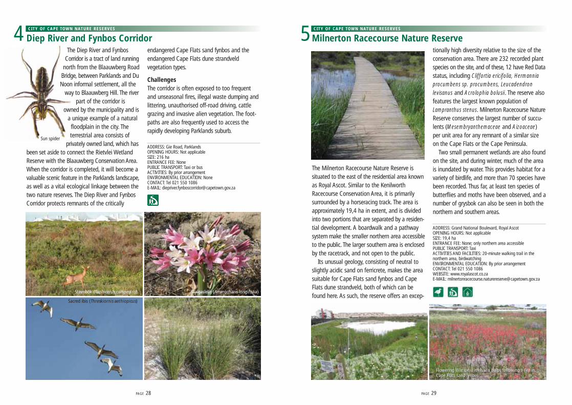
The Milnerton Racecourse Nature Reserve issituated to the east of the residential area knownas Royal Ascot. Similar to the KenilworthRacecourse Conservation Area, it is primarilysurrounded by a horseracing track. The area isapproximately 19,4 ha in extent, and is dividedinto two portions that are separated by a residen-tial development. A boardwalk and a pathwaysystem make the smaller northern area accessibleto the public. The larger southern area is enclosedby the racetrack, and not open to the public.
Its unusual geology, consisting of neutral toslightly acidic sand on ferricrete, makes the areasuitable for Cape Flats sand fynbos and CapeFlats dune strandveld, both of which can befound here. As such, the reserve offers an excep-
tionally high diversity relative to the size of theconservation area. There are 232 recorded plantspecies on the site, and of these, 12 have Red Datastatus, including Cliffortia ericifolia, Hermanniaprocumbens sp. procumbens, Leucadendronlevisanus and Acrolophia bolusii. The reserve alsofeatures the largest known population ofLampranthus stenus. Milnerton Racecourse NatureReserve conserves the largest number of succu-lents (Mesembryanthemaceae and Aizoaceae)per unit area for any remnant of a similar sizeon the Cape Flats or the Cape Peninsula.
Two small permanent wetlands are also foundon the site, and during winter, much of the areais inundated by water. This provides habitat for avariety of birdlife, and more than 70 species havebeen recorded. Thus far, at least ten species ofbutterflies and moths have been observed, and anumber of grysbok can also be seen in both thenorthern and southern areas.
ADDRESS: Grand National Boulevard, Royal AscotOPENING HOURS: Not applicableSIZE: 19,4 haENTRANCE FEE: None; only northern area accessiblePUBLIC TRANSPORT: TaxiACTIVITIES AND FACILITIES: 20-minute walking trail in thenorthern area, birdwatchingENVIRONMENTAL EDUCATION: By prior arrangementCONTACT: Tel 021 550 1086 WEBSITE: www.royalascot.co.zaE-MAIL: [email protected]
PAGE 28 PAGE 29
Diep River and Fynbos Corridor 4 CITY OF CAPE TOWN NATURE RESERVES
Milnerton Racecourse Nature Reserve 5 CITY OF CAPE TOWN NATURE RESERVES
Malgaslelie (Ammocharis longifolia)Steenbok (Raphicerus campestris)
Sacred ibis (Threskiornis aethiopicus)
Sun spider
Flowering Watsonia meriana bulbs following a fire inCape Flats sand fynbosFlowering Watsonia meriana bulbs following a fire inCape Flats sand fynbos

Rietvlei is a large wetland in the floodplain of theDiep River between Milnerton and Table View. This663,27 ha reserve comprises mainly permanentand seasonal wetlands surrounded by Cape Flatsdune strandveld vegetation, with more than 220plant species having been recorded. The vleidrains into Table Bay via the Milnerton Lagoon.
The reserve offers a variety of habitats, includinga permanent freshwater lake, shallow marshesthat flood in winter, reed beds, a river, and anestuarine lagoon with salt marshes that is opento the sea. A strip of coastal dunes separates thereserve from Table Bay.
This is a birder’s paradise, especially in springand summer, when migrant birds arrive from thenorthern hemisphere. Some 180 bird species arelisted, including pelicans, flamingos, ducks, coots,herons, plovers, weavers and swallows. There aretwo bird hides that offer views of the southernwater body and the large seasonal pan. Fourtimes a year, a water bird census is taken, andoften thousands of birds are counted. SANCCOB
– the coastal bird rehabilitation centre, whereoiled penguins and gannets are cleaned – isadjacent to the reserve.
Many small mammals, reptiles and insects livehere, along with several frog species. The lagoonacts as a nursery to several coastal fish, such asharder and mullet which occur in safety alongsidefreshwater fish. From the coastal dunes, dolphinsand whales are visible in season.
ChallengesWater pollution and invasive alien plants, especiallyPort Jackson (Acacia saligna), rooikrans (Acaciacyclops) and kikuyu grass (Pennisetum clandes-tinum), are a challenge. People who live nearbycan help by planting indigenous gardens, gettingrid of the kikuyu, and preventing oil, poison andfertiliser from running into the vlei.
ADDRESS: Grey Avenue, Table ViewOPENING HOURS: 07:30-17:30 (daily); water sports hours10:00-17:00 (weekdays), 09:00-17:00 (weekends)SIZE: 663,27 haENTRANCE FEE: Adults R 10.00, children (3-13 years) and seniorcitizens R5.00, children under 3 years free (for annual permits,special rates and updates, visitwww.capetown.gov.za/environment)PUBLIC TRANSPORT: Taxi or busACTIVITIES AND FACILITIES: Boating, picnic and braai areas,fishing, hiking and two bird hidesENVIRONMENTAL EDUCATION: Rietvlei Education CentreFRIENDS GROUP: Friends of Rietvlei, www.friendsofrietvlei.co.zaCONTACT: Tel 021 557 5509 & 021 550 1086; fax 021 550 1003E-MAIL: [email protected]
PAGE 30
Rietvlei Wetland Reserve 6 CITY OF CAPE TOWN NATURE RESERVES
Cape River Frog (Amietia fuscigula)
Aerial view of Rietvlei Wetland Reserve
Winter rains swell the Rietvlei Wetlands

Zoarvlei Wetlands are situated between the PaardenEiland Industrial Centre and the suburbs of Rugbyand Brooklyn. Most of the 140 ha of wetland is adense mat of tall reeds, with a small stretch of openwater near Brooklyn Chest Hospital. Here, 87 plantspecies and many birds are protected, and a greatmany water birds and gulls congregate.
The open water can be reached along a sandypath from Donegal Road, Rugby – look out forgiant molehills, a selection of spring flowers andmany annual flowers.
ChallengesZoarvlei has the potential to be an attractive area,as it is home to so many plant and bird species. Atpresent, though, it is not visitor-friendly and furtherspoiled by illegal waste dumping. However, fundingfrom CoastCare has been obtained, and the area isbeing rehabilitated. Also, the West Coast Field StudiesCentre runs popular environmental education pro-grammes at Zoarvlei to enhance the area’s value tothe public.
ADDRESS: Between Donegal Street, Rugby; and Milner Street, MetroIndustrial TownshipOPENING HOURS: Not applicableSIZE: 140 haENTRANCE FEE: NonePUBLIC TRANSPORT: Taxi or busACTIVITIES: Walking, birdwatchingENVIRONMENTAL EDUCATION: West Coast Field Studies Centre. Forbookings, contact Frank Wygold on 021 511 2384, 083 338 9319 [email protected]: City Parks Tel 021 689 8935 / 021 689 4184 E-MAIL: [email protected]
The Raapenberg Bird Sanctuary is a section ofthe Liesbeek River between the Hartleyvale foot-ball ground and the South African AstronomicalObservatory. This stretch of the river is parkland,with grassy picnic sites and shady trees along thebusy Liesbeek Parkway. The sounds of seagulls,sacred ibis (Threskiornis aethiopicus) and Egyptiangeese (Alopochen aegyptiacus) compete with thenoise of traffic as they squabble over scraps offood. The more secretive herons, coots, ducks andsmaller birds hide in the reeds across the river.Raapenberg is recognised as an importantbreeding site for many duck species.
Raapenberg Bird Sanctuary is part of the newTwo Rivers Urban Park (TRUP), which is destinedto be an important open space within the city. The
park is located at the confluence of the Liesbeekand Black River, and is managed by the City ofCape Town. All the landowners and stakeholderswithin the TRUP will work together to integratethe sensitive river and wetland systems, richcultural background and developed areas of theparkland to make it a people’s place of note.
The park includes the Provincial Heritage Sitesof the South African Astronomical Observatory(erected in 1827), Valkenberg homestead (1830)(now the Courtyard Hotel), Valkenberg Hospital(1899), the Nieuwe Molen windmill, and theOude Molen farmhouse complex. Large sportingfacilities, such as Hartleyvale, Malta Park and theRiver Club, are also part of the TRUP.
ChallengesManagement priorities are to rehabilitate thepolluted rivers for recreational activities, tocontrol alien vegetation, and create walkwaysalong the rivers.
ADDRESS: Between Liesbeek Parkway and Station Rd, ObservatoryOPENING HOURS: Not applicableSIZE: 10 haENTRANCE FEE: NonePUBLIC TRANSPORT: Taxi, bus or trainACTIVITIES: Birdwatching, walking, picnickingFRIENDS GROUP: Friends of the Liesbeek, www.fol.org.zaCONTACT: City Parks Tel 021 689 9141
Zoarvlei Wetlands 7 CITY OF CAPE TOWN NATURE RESERVES
Raapenberg Bird Sanctuary 8 CITY OF CAPE TOWN NATURE RESERVES
PAGE 32
Sacred ibis (Threskiornis aethiopicus)
Kelp gull (Larus dominicanus)
Grey heron (Ardea cinera)
PAGE 33 The confluence of the Liesbeeck and Black rivers

Rondebosch Common has a long historyas an open space for public use.
This valuable 40 ha block lies ina built-up area surrounded byestablished homes, schoolsand hospitals. The areasupports a natural remnant of
the critically endangered CapeFlats sand fynbos, with patches of
renosterveld, and is also a seasonal wetland.Over 300 plant species have been verified on the
site, of which nine appear in the Red Data List, whilst110 different bird species have also been recorded.
The common is very popular among locals, whocan be seen jogging, walking their dogs, exercisingand enjoying the open space every day.
ADDRESS: Park and Campground Roads, RondeboschOPENING HOURS: Not applicableSIZE: 40 haENTRANCE FEE: NonePUBLIC TRANSPORT: Taxi, bus or trainACTIVITIES: Spring flower-spotting, history rambles, running, dog-walkingENVIRONMENTAL EDUCATION: No formal programmes, but suitablefor nature and history lessonsFRIENDS GROUP: The Friends of Rondebosch Common keep the areaclean, safe and free from litter and fire. The group controls the spreadof alien vegetation, organises spring walks, keeps information boardsupdated, and has compiled a book on the common’s history, faunaand flora.CONTACT: City Parks Tel 021 689 9141
Rondebosch Common 9 CITY OF CAPE TOWN NATURE RESERVES
A rundown on Rondebosch CommonWhen the Dutchsettled in the Capein the 1600s, theynoted that the earlyinhabitants, theGoringhaiqua,migrated throughthe area every year with their herds, using thevegetation for animal grazing.
In 1805 to 1806, the common was a rallyingplace for the Batavian (Dutch) farmers before theBattle of Blaauwberg, and for the conqueringBritish forces after the battle. Troops also usedthe area during the Anglo-Boer War in 1899, andWorld War I and II.
In 1855, the rector of St Paul’s Church wasgiven permission to graze his cattle on the land,on the condition that it would remain open forpublic use. Over the years, bits and pieces of theland were lopped off and put to various uses, forexample the building of the Red Cross Children’sHospital. Pine trees were planted to surroundpatches of land used for cemeteries. Today thecemeteries are gone, but the pine trees remain.
Rugby, football, cricket and golf have all beenplayed in Rondebosch Common, starting as farback as 1860. Today, formal sports have moved tobetter facilities, but cricket pitches, raised golfgreens and a grassy rugby field can still be foundnear the car park.
In 1961, Rondebosch Common was proclaimeda National Monument.
Today, this large stretch of common landenjoys conservation status, and is administeredby the City of Cape Town.
PAGE 34
African pipit (Anthus cinnamomeus) Heady maidens (Syntomis sp.)Heady maidens (Syntomis sp.)Heliophila sp.
Aurora house snake (Lamprophis aurora sp.)
Bobartia indica with spotted blisterbeetles (Cerotic capensis sp.)Bobartia indica with spotted blisterbeetles (Cerotic capensis sp.)
Ixia monadelpha
Cape dune mole rat (Bathyergus suillus) moundKukumakranka (Gethyllis afra)
Heady maiden (Syntomis sp.)

The Kenilworth RacecourseConservation Area (KRCA) consistsof approximately 52 ha, and isconsidered the best protected
example of Cape Flats sand fynbosin the Cape Peninsula. Due to itslocation – in the middle of a
racecourse – the vegetation has not beendisturbed for over 100 years, and it was identifiedas a core botanical site and established as aconservation area in 1985.
The KRCA is the largest stretch of naturalvegetation remaining in Cape Town’s southernsuburbs, with 283 indigenous plant species, ofwhich 20 are endangered and two endemic. TheErica verticillata and Erica turgida, both listed asextinct in the wild, were reintroduced in the KRCAin 2005.
A small but healthy reptile, bird and mammalpopulation can be found in the KRCA, and itsseasonal wetland hosts the critically endangeredmicro frog (Microbatrachella capensis) population– the last of its kind on the Cape Flats andendemic to the south-western part of theWestern Cape.
Although the area is managed by the City ofCape Town, it is owned by Gold Circle.
ChallengesThe KRCA has become infested with alienvegetation and domestic garden escapees. Staffand volunteers remove litter, and spend timehacking out the alien Port Jackson (Acacia saligna)trees and seedlings. The natural vegetation some-times has to be cropped so as not to obscurethe horse racing.
Part of the reserve was rejuvenated by acontrolled burn in March 2005.
ADDRESS: Rosmead Avenue, KenilworthOPENING HOURS: By prior arrangement onlySIZE: 52 ha ENTRANCE FEE: NonePUBLIC TRANSPORT: Taxi, bus or trainACTIVITIES: Walks, and Friends of the KRCA activities ([email protected] for bookings.)ENVIRONMENTAL EDUCATION: Programmes and presentationsavailable upon requestCONTACT: Tel 021 700 1843; fax: 021 797 6008 E-MAIL: [email protected]: www.krca.co.za
PAGE 36
Kenilworth Racecourse Conservation Area 10 CITY OF CAPE TOWN NATURE RESERVES
Diastella proteoides Restionaceae sp.
Serruria glomerataSerruria glomerataSerruria glomerata Micro frog (Microbatrachella capensis) Erica margaritacea
Felicia daisy

PAGE 38
The FBEP includes Rondevlei and ZeekoevleiNature Reserves, the coastal strip betweenSunrise Circle at Muizenberg and Strandfontein,the Cape Flats Wastewater Treatment Works, theCape Flats Development Association (CAFDA)and the Coastal Park landfill site. CAFDA’sstables complex is located next to RondevleiNature Reserve, and central to the vision of theFBEP. Additional land in Pelican Park will also beincorporated into the area in the near future. TheFBEP is an excellent example of how ecosystemsand social systems function interdependently.
A new environmental education centre waslaunched here in late 2006, and quality environ-mental education is provided to the many nearbyschools. Day trips to Rondevlei Nature Reserveare popular and fully booked months in advance.
The Cape Town Environmental Education Trust(CTEET) runs two overnight camps with pro-grammes for learners focusing on ecology,human-related environmental issues andpersonal and social development.
The area has enormous conservation, recre-ational and eco-tourism value. A disused pump-house at the centre of the maturation ponds ofthe treatment works has been renovated intothe Strandfontein Information Centre, which willprovide information about birding and fishingactivities, and the area in general. A tearoom atRondevlei Nature Reserve is planned to be openedto the public shortly, and a new headquartersnode for the FBEP has been constructed on thesouthern shore of Zeekoevlei.
False Bay Ecology Park
False Bay Ecology Park (FBEP) is a multi-use area of about 1 200 ha. It includes a variety of ecologically linked sites, which form an important ecosystem andunique platform for conservation and partnerships in Cape Town.
Malachite kingfisher (Alcedo cristata)
Freshwater aquarium at Rondevlei Nature Reserve
Western leopard toad (Amietophrynus pantherinus) Erica verticillata
ZORRO THE HIPPOIn February 2009, a hippo named Zorro escaped fromRondevlei Nature Reserve after a section of the reserveboundary fence had been stolen. Zorro made a temporaryhome for himself in one of the retention pans of the CapeFlats Wastewater Treatment Works. Living comfortably in theretention pan, feeding on invasive alien kikuyu grass(Pennisetum clandestinum), Zorro has been confined toone of the pans. However, once captured he will move to anew home and join a free-roaming herd of hippos.
Hippos, or rather hippopotami (Hippopotamusamphibius), are listed as vulnerable on the InternationalUnion for Conservation of Nature’s Red Data List. It istherefore important to maintain genetic diversity amongcurrent hippo herds to ensure a healthy population for thefuture. Zorro will add to the genetic strain of his new herd,will contribute to the conservation of his own species, andhopefully will live happily ever after.

Concerned bird lovers established Rondevlei as abird sanctuary in 1952. Today, it is a well-runnature reserve, 290 ha in extent, with a museum,an auditorium, a network of footpaths, viewingtowers, and several hides named after well-known birders.
There is a permanent wetland with Cape Flatssand fynbos to the north, and seasonal wetlandsand Cape Flats dune strandveld in the south.About 278 species of indigenous plants grow inthe Rondevlei Nature Reserve. Rare and endan-gered plants are strongly nurtured: These includethe Cape Flats cone bush (Leucadendron levi-sanus), the Rondevlei spiderhead (Serruria aemulafoeniculaceae) and the Cape Flats erica (Ericaverticillata), which became extinct in the wild. TheCape Flats erica was discovered in a botanicalgarden, and has since been propagated andreplanted at Rondevlei.
In addition, there are 237 bird species, fromducks to herons, ibises, pelicans, weavers andmore. Hippopotami (Hippopotamus amphibius)have been reintroduced, and there are 20 othermammal species, including Cape grysbok(Raphicerus melanotis), porcupine (Hystrixafricaeaustralis), Cape dune mole rat (Bathyergussuillus), Cape clawless otter (Aonyx capensis) andsmall-spotted genet (Genetta genetta). Twenty-
nine types of reptiles and eight frog specieshave been seen. The only indigenous fish presentis the Cape galaxias (Galaxias), while introducedalien fish include common carp (Cyprinus carpio),banded tilapia (Tilapia sparrmanii) and sharp-tooth catfish (Clarias gariepinus).
ADDRESS: Corner of Perth Road and Fisherman’s Walk, GrassyParkOPENING HOURS: 07:30-17:00 (seven days a week); 07:30-19:00 (on Saturdays and Sundays from December to Februaryonly); closed on Christmas DaySIZE: 290 haENTRANCE FEE: Adults R7.00, children (3-13 years) and seniorcitizens R4.00, children under 3 years free (for annual permits,special rates and updates, visitwww.capetown.gov.za/environment)PUBLIC TRANSPORT: Taxi or busACTIVITIES AND FACILITIES: Picnicking, bird hides, lookouttowers, museum, lecture theatre, aquarium, fishing platforms,boat trips, overnight island bush camp, a boma and conferencefacilitiesENVIRONMENTAL EDUCATION: Rondevlei EnvironmentalEducation Centre and Leonard Gill Field Museum (bookingessential)ACCOMMODATION: Island bush camp, run by Imvubu NatureToursFRIENDS GROUP AND BIRDERS: The Friends of Zeekoevlei andRondevlei consist of local community members who support thereserve. The Cape Bird Club and A Rocha International runbirding and bird-ringing programmes.CONTACT: Tel 021 706 2404; fax 021 706 2405For accommodation, contact Imvubu Nature Tours onwww.imvubu.co.za or 021 706 0842.For environmental education camps, phone Cape TownEnvironmental Education Trust on 021 706 8523.E-MAIL: [email protected] WEBSITE: www.rondevlei.co.za
PAGE 40
Rondevlei Nature Reserve 11 CITY OF CAPE TOWN NATURE RESERVES | FALSE BAY ECOLOGY PARK
Leonotis leonurus
Purple swamphen (Porphyrio porphyrio) Purple swamphen (Porphyrio porphyrio) Purple swamphen (Porphyrio porphyrio) Purple swamphen (Porphyrio porphyrio) African darter (Anhinga melanogaster)
Erica verticillata
Hippopotamus (Hippopotamus amphibius)
Orphium frutescens

PAGE 42
Zeekoevlei is the largest natural inland waterbody in the city. The vlei is a popular picnicking,sailing and fishing spot. Pelicans, flamingos andmany other birds can be seen within the 344 hasite. Houses line the northern and western shores,and the Zeekoevlei Yacht Club is situated on thewest bank. The new headquarters for the FBEPare located on the southern shore. 23 sportingclubs use the vlei with two overnight environ-mental education centres along its shores.
Southern Birding Area and Cape FlatsWastewater Treatment WorksThe Cape Flats Wastewater Treatment Workshandles approximately 40% of Cape Town’ssewage effluent. Ironically, the high nutrient levelsin the maturation ponds encourage the growth ofplankton, making them an excellent feeding groundfor birds. This is therefore an important birdingarea, attracting an amazing diversity of species –some 20 000 birds gather here, including 200water bird and nine Red Data bird species.
Coastal Park landfill siteThe waste cycle is an essential part of environ-mental management. False Bay Ecology Parkincludes a large general waste landfill site to thesouth of Rondevlei. An integrated waste manage-ment concept is practised in Cape Town, wherebyresidents are encouraged to reduce waste and toreuse and recycle where possible. The site is usedto educate learners about landfills and how poorwaste management can damage the environment.Garden waste is mixed with manure and soil tomanufacture compost. The landfill site willeventually be closed and rehabilitated withnatural vegetation.
PAGE 43
ADDRESS: Zeekoevlei Road, Pelican Park OPENING HOURS: 07:30-19:30 (summer), 07:30-18:00 (winter)SIZE: 344 haENTRANCE FEE: Only for power boats, payable to the CapePeninsula Aquatics Club (for updates, visitwww.capetown.gov.za/environment)PUBLIC TRANSPORT: TaxiACTIVITIES: Picnicking, fishing, boating, birdwatchingENVIRONMENTAL EDUCATION: Zeekoevlei EnvironmentalEducation Centre, tel 021 396 1272ACCOMMODATION: School camps, tel 021 706 8523FRIENDS GROUP AND BIRDERS: The Friends of Zeekoevlei andRondevlei consist of local community members who support thereserve. The Cape Bird Club runs birding and bird-ringingprogrammes.CONTACT: Tel 021 706 2404; fax 021 706 2405 E-MAIL: [email protected]
Zeekoevlei Nature Reserve 12 CITY OF CAPE TOWN NATURE RESERVES | FALSE BAY ECOLOGY PARK
Great white pelican (Pelecanus onocrolatus)
Greater flamingo (Phoenicopterus ruber)

Zandvlei is a recreational area at Lakeside, wherewindsurfers entertain picnickers with their antics.It is one of the most accessible reserves, as it isnext to Lakeside Station and close to Main Road.The Zandvlei Environmental Education Centre onthe northern side is reached from SteenbergStation or Coniston Avenue, off Military Road inMarina da Gama.
Zandvlei is the only functioning estuary on theFalse Bay coast, and supports a variety of indig-enous fish. Juvenile marine fish use the estuaryas a nursery, where they can grow in safety. It isimportant that the estuary mouth is open for atleast a part of the year, to enable young fish toenter the estuary and older fish to return to theocean. It is opened artificially by the City of Cape
Town’s Catchment Management Departmentwhen a high spring tide is expected. Southernmullet (Liza richardsonii), leervis (also known asgarrick; Lichia amia), the critically endangeredwhite steenbras (also known as pignose grunter;Lithognathus lithognathus), white stumpnose(Rhabdosargus globiceps) and elf (Pomatomussaltatrix) are among the 25 types of fish found inthe estuary. Strict recreational fishing regulationsapply, including minimum size catch and baglimits, to protect young fish and allow them tobreed. Many sport anglers now prefer to ‘catch,tag and release’ fish, so that they can enjoyfishing without threatening fish populations. Localanglers are encouraged to remove alien invasivefish species, such as common carp (Cyprinuscarpio) and barbel (also known as sharptoothcatfish; Clarias gariepnus).
Wetlands like Zandvlei are important habitatsfor birds, both those that live here year round andthose that migrate from Europe, Asia and otherparts of Africa. There are about 150 species here,including great crested grebe (Podiceps cristatus),African fish eagles (Haliaeetus vocifer), Caspianterns (Sterna caspia), ducks, coots, herons, ibises,pelicans, kingfishers, swallows and weavers.
Eighteen different reptiles have been recordedin the reserve, including the marsh terrapin
(Pelomedusa subrufa), brown water snake (Lyco-donomorphus rufulus) and mole snake (Pseudaspiscana), as well as 210 different plant species.Residents of neighbouring Lakeside and MarinaDa Gama enjoy the sound of birds and thecroaking of frogs. They sometimes see Capeclawless otter (Aonyx capensis), porcupines(Hystrix africaeaustralis) and small grey and watermongoose (Galerella pulverulenta and Atilaxpaludinosus), whilst their gardens are oftenvisited by Cape dune mole rats (Bathyergus suillus).
ChallengesFarming, urban development, invasive alienplants and dredging of the vlei have destroyedmuch of the natural vegetation around Zandvlei.The City of Cape Town, Working for Wetlands, andvolunteers from the area are slowly restoring thenatural Cape Flats dune strandveld vegetation.They collect indigenous plants before bulldozerscreate new developments, and transplant themat Zandvlei. The extensive reed beds are animportant part of the river, as they filter out siltand remove nutrients so that the water does notbecome thick and green with algae. The invasivewater hyacinth (Eichhornia crassipes) is a problem,as it clogs large areas of the vlei.
ADDRESS: Coniston Avenue, Marina Da GamaOPENING HOURS: 07:30-16:00 (weekdays), closed on weekendsSIZE: 200 haENTRANCE FEE: NonePUBLIC TRANSPORT: Taxi, train or bus (within walking distanceof Steenberg and Lakeside Station as well as Main Road)ACTIVITIES AND FACILITIES: Jetty, bird hides, picnic sites,boating, walking, windsurfingENVIRONMENTAL EDUCATION: Zandvlei EnvironmentalEducation Centre is within walking distance of SteenbergStation, and offers field trips for primary learners. (Book inadvance for live reptile displays.)FRIENDS GROUP: The Friends of the Zandvlei Trust help withconservation, education and awareness projects.CONTACT: Tel 021 701 7542; fax 021 701 7542 E-MAIL: [email protected]
Zandvlei Estuary Nature Reserve13 CITY OF CAPE TOWN NATURE RESERVES
PAGE 44 PAGE 45
Great white pelican (Pelecanus onocrolatus)Salvia africana-lutea
Painted lady (Gladiolus angustus)
Angulate tortoise (Chersina angulata)

De Hel Nature Area is a riverine valley adjoiningTable Mountain below Rhodes Drive to the north-east of Constantia Nek. The upper reaches of theSpaanschemat River runs through this 21,3 hanatural area, and environmental surveys of DeHel show that the site remains in a near naturalcondition. The land is designated as zoned publicopen space, and is owned by the City of CapeTown. A management partnership has beenarranged between the municipality and the Friendsof Constantia Valley Greenbelts (FOCVGB).
De Hel has not been dubbed ‘the jewel in thecrown’ of Constantia’s riverine open spaceswithout good reason. Its steep slopes, denselycovered in trees, run down to the riverbed, andat the bottom, a flat piece of land known as ‘theMeadow’ is still home to pockets of fruit treesand garden plants, as the Meadow was culti-vated in the past. The site has also been declareda Provincial Heritage Site.
De Hel is linked to ancient cattle tracks origi-nating from the Khoi-Khoi pastoralists in theCape. The Dutch East India Company also estab-lished one of their four woodcutters’ posts in thearea, and because of this and its associationswith slave labour and slave runways, De Hel is aheritage site of significance.
A plant survey identified 250 plant species; athird of these being alient to the site. Theindigenous vegetation is Afrotemperate forest andfynbos (i.e. species common to the mountains ofAfrica), and is home to the endangered silvertree (Leucadendron argenteum) and the Ericaphylicaefolia.
Some 16 species of mammals have beenobserved, and a bird count yielded 72 species todate, with 17 reptiles and amphibians recorded.Notable endangered species include the Knysnawarbler (Bradypterus sylvaticus) and the Westernleopard toad (Amietophrynus pantherinus).
ChallengesInvasive alien species are a threat to the granitefynbos, and controlling the spread of alien treeswithout affecting the indigenous forest proves adifficult task.
ADDRESS: Between Southern Cross Drive and Constantia NekRoad, Constantia OPENING HOURS: Sunrise to sunsetSIZE: 21,3 haENTRANCE FEE: NonePUBLIC TRANSPORT: TaxiACTIVITIES: Walking, jogging, birdwatching and photographyENVIRONMENTAL EDUCATION: NoneFRIENDS GROUP: Friends of Constantia Valley GreenbeltsCONTACT: City Parks Tel 021 689 9141
Meadowridge Common is a small protected areaof approximately 8 ha – a valuable remnant ofthe critically endangered Cape Flats sand fynbos.It contains as many as 137 different floweringplant species, of which four are listed as endan-gered. These plants are representative of thealmost 600 species that were collected by DrWilliam Frederick Purcell on the Bergvliet Farmbetween 1914 and 1919, and this collection cantoday be viewed in the Compton Herbarium atKirstenbosch National Botanical Garden.
Floral displays are at their best in spring, fromSeptember to October, and a number of insects,birds and amphibians, including the endangeredCape rain frog (Breviceps gibbosus), have beenobserved. Meadowridge Common is managedby the City of Cape Town, with the help of theFriends of Meadowridge Common.
ChallengesDue to its small size, isolated location and lownumbers of some plants species, the risk ofextinction is high. The invasion of kikuyu grass(Pennisetum clandestinum), pine trees (Pinus sp.),and annual weeds, together with a lack ofnatural fires, suppress the natural vegetation.Other problems are uncontrolled dogs and soilthat was dumped on the site over 20 years ago.
ADDRESS: Accessible from Edison Drive and Faraday Way,MeadowridgeOPENING HOURS: Not applicableSIZE: 8 haENTRANCE FEE: NonePUBLIC TRANSPORT: Bus or taxi ACTIVITIES: Dog-walking, wild flowers, recreationENVIRONMENTAL EDUCATION: Illustrated talks given upon requestFRIENDS GROUP: The Friends of Meadowridge assist withkeeping the site clean and tidy, and controlling invasive alienspecies. The group keeps detailed botanical records, arrangesspring walks, provides signage, and monitors the activities onthe common. Contact them on 021 715 9206.CONTACT: City Parks Tel 021 762 9180
PAGE 46 PAGE 47
De Hel Nature Area14 CITY OF CAPE TOWN NATURE RESERVES
Meadowridge Common15 CITY OF CAPE TOWN NATURE RESERVES
Botterblom (Sparaxis bulbifera)

Die Oog is a small conservation area located onwhat was once a dam on Bergvliet Farm. The damwas built sometime between 1716 and 1764 asa link to the Spanschemat furrow. It was laterconverted into a recreational lake owned by theEksteen family, who used it to entertain theirguests. The Eksteens even introduced swans tothe lake, and created an artificial island.
Bergvliet Farm originally occupied most of theConstantia Valley, but was repeatedly subdividedinto smaller patches of land. In 1982, a smallremnant was designated a zoned public open
space and named Die Oog. The City of Cape Townand the Bergvliet and Meadowridge Ratepayers’Association provided fences, benches and plantedindigenous trees and shrubs, and the Friends ofDie Oog Conservation Area were formed to helpmaintain and improve the site. The Friends groupsuccessfully secured funding for signage, wheel-chair-friendly paths, a viewing platform, andimprovement of the amenities. They have alsoinitiated environmental education programmes,and are managing a website about Die Oog.
Die Oog is one of the few remaining breedingsites for the endangered Western leopard toad(Amietophrynus pantherinus), and the ‘roaring’of the toads when they arrive in Die Oog inAugust to breed, is one of the true wonders ofnature. The site has five different biodiverse areas:granite fynbos, which turns into a sea of colour inspring; the dam itself; the artificial island, whichis a major roosting site for cattle egret (Bubulcusibis), reed cormorant (Phalacrocorax africanus) andsacred ibis (Threskiornis aethiopicus); a seasonalwetland below the dam wall that leads to theKeyser River; and sanctuary and recreational areasplanted with silver trees (Leucadendron argenteum)and ericas.
At night, the island sometimes hosts over 1 000birds, such as coots, dabchicks (also known aslittle grebe; Tachybaptus ruficollis), moorhens,yellow-billed ducks (Anas undulata) and Egyptiangeese (Alopochen aegyptiacus). Black sparrow-hawks (Accipiter melanoleucus) are fairlycommon, whilst the Cape weaver (Ploceuscapensis), the hadeda ibis (Bostrychia hagedash),reed cormorant and the dikkop are all breedingresidents.
The Cape clawless otter (Aonyx capensis), watermongoose (Atilax paludinosusis) and porcupine(Hystrix africaeaustralis) have also been observed,
and besides the famous Western leopard toad, thecommon clawed frog (platanna; Xenopus laevis)and the clicking stream frog (Strongylopus grayii)add to the amphibians of Die Oog.
ChallengesInvasive alien species are the main challenge forthe site. The growth of aquatic weeds has to becontained, and indigenous geophytes and otherplants are being re-established. Common carp(Cyprinus carpio), which is an alien fish species, hadalso presented a problem, but have been removed,and attempts are being made to reintroduce theindigenous Cape galaxias (Galaxias zebratus)and Cape kurper (Sandelia capensis).
ADDRESS: Lakeview and Midwood Avenues, BergvlietOPENING HOURS: 07:00-19:00 dailySIZE: 1,2 haENTRANCE FEE: NonePUBLIC TRANSPORT: TaxiACTIVITIES: Walking, birdwatching and quiet recreation. (Dogs,sports games and swimming are not allowed.) Guided visits canbe arranged through the Friends of Die Oog.ENVIRONMENTAL EDUCATION: For school learner programmes,contact the Friends of Die Oog.FRIENDS GROUP: Friends of Die OogCONTACT: City Parks Tel 021 762 9180 & Friends of Die OogTel/fax 021 715 8665E-MAIL: [email protected] (Friends of Die Oog) WEBSITE: www.dieoog.org.za
PAGE 48 PAGE 49
Die Oog Conservation Area16 CITY OF CAPE TOWN NATURE RESERVES Western leopard toad (Amietophrynus pantherinus)
Cape weaver (Ploceus capensis)Cape weaver (Ploceus capensis)

Glencairn Wetland is located between the Glen-cairn Expressway (M6), Simon’s Town Road (M4),Glen Road and Gordon’s Camp, and is easilyreached from Glencairn Station.
The Else River runs through the site, andtransforms into a wetland as it approaches thesea. Footpaths in the shape of the number 8take hikers around the site, and the hour-and-a-bit-long hike leads to Glencairn Beach and theascent of Elsie’s Peak.
The Glencairn Education and EnvironmentSupport Enthusiasts (GEESE) manage the sitetogether with the City of Cape Town. Improve-ments to the site take place regularly, the mostrecent being the laying of stepping stones acrossthe causeway, the construction of benches, andthe development of a new pathway.
Owners are most welcome to bring their dogsalong, provided they clean up after their animals,and prevent them from chasing the birds orentering the water. Common carp (Cyprinus carpio)can be found in both the top and bottom pans,which provide excellent training ground for
would-be young fishermen. Schools and clubsfrequently visit the site on exploratory andeducational outings.
Glencairn Wetland is home to several birdspecies, many of which return each year to breed.Evidence of otter, porcupine and mongoose isfrequently recorded, although the nocturnalanimals themselves are rarely spotted.
Members of GEESE strive to keep the wetlandfree of litter, and several municipal litter bins areprovided for visitors’ convenience.
ADDRESS: Glen Road, GlencairnOPENING HOURS: 24 hoursSIZE: 20 haENTRANCE FEE: None PUBLIC TRANSPORT: Bus or train ACTIVITIES: Walking, birdwatching, guided hikesENVIRONMENTAL EDUCATION: School programmes; booking isessential. (Contact Rob Erasmus on [email protected]) FRIENDS GROUP: Glencairn Education & Environment SupportEnthusiasts (GEESE)CONTACT: City Parks Tel 021 701 1233 & GEESE tel 021 7826400; fax 021 782 5016E-MAIL: [email protected] (GEESE)WEBSITE: www.geeseglencairn.org
Situated between Clovelly and Fish Hoek, theLower Silvermine Wetlands are a rehabilitatedfloodplain featuring Hangklip sand fynbos, sanddunes, and aquatic and wetland areas. The rehabi-litation was initiated eight years ago, and tooktwo years to complete. The floodplain was initiallyplanned to be canalised due to the flooding ofnearby houses during the winter season, but agroup of nature conservationists managed toensure its rehabilitation instead. Remains of over100-year-old dykes are found next to the wetlandsas well as on Clovelly Beach. The nearly pristineSilvermine River is unique, as its natural state isalmost intact, running from its source in theSilvermine Mountains to the sea in False Bay.
A plant inventory has been compiled, andsince the vegetation consisted mostly of alienplants, many indigenous plant species have beenreintroduced. However, more species are stillbeing rediscovered, and a photographic recordof the species that existed in the area before itwas developed has proven very useful for therehabilitation.
The area is a breeding ground for the endan-gered Western leopard toad (Amietophrynuspantherinus), the arum lily frog (Hyperoliushorstockii), the Cape river frog (Amietia fuscigula)
and the clicking stream frog (Strongylopus grayii).It was also the type site for the Cape platanna(Xenopus gilli), which now unfortunately seemsto be extinct in the area.
Around 50 bird species are seen here, althoughmany of the waders have disappeared due to theTypha (commonly known as bulrush) invasion.Painted snipe (Rostratula benghalensis) andEthiopian snipe (Gallinago nigripennis) have bredin the area, but are no longer seen.
The area has a small mammal population ofotter (Aonyx capensis), porcupine (Hystrix africae-australis) and Cape grysbok (Raphicerus melanotis).Water mongoose (Atilax paludinosusis) has alsobeen observed.
ChallengesTypha, although an indigenous species, is over-stimulated due to excess nutrients in stormwaterrunoff, and becomes a threat to other species.Also, despite plastic bags being available fordog-walkers to clean up after their animals, noteveryone cooperates. The dog-walkers, however,contribute greatly to making the Lower SilvermineWetlands a safe area for the enjoyment of youngand old. A minor decline in the pond’s waterquality has also been observed.
ADDRESS: Clovelly Road, Clovelly OPENING HOURS: 24 hours SIZE: Not applicableENTRANCE FEE: None PUBLIC TRANSPORT: Train or taxi. A 15-minute walk from FishHoek Station, or free parking just off Clovelly Road, at the trafficlights on Main Road ACTIVITIES AND FACILITIES: Walking, birdwatching, self-guidedtrail for the blind, cycling.ENVIRONMENTAL EDUCATION: None FRIENDS GROUP: The Riverine Rovers are a subgroup of theFriends of Silvermine Nature Area (FOSNA) CONTACT: City Parks Tel 021 701 1233 & The Riverine Rovers tel021 782 6144; fax 086 603 7554E-mail: [email protected] (The Riverine Rovers)
PAGE 51PAGE 50
Lower Silvermine Wetlands17 CITY OF CAPE TOWN NATURE RESERVES
Glencairn Wetland18 CITY OF CAPE TOWN NATURE RESERVES
Ferraria crispa Cape sand frog (Tomopterna delalandii)Cape sand frog (Tomopterna delalandii)

In 1955, Edith Stephens, an eccentric and far-sighted botanist, donated 3,7 ha of land to theKirstenbosch National Botanical Garden to protecta rare plant species called Isoetes capensis, arelic plant found nowhere else in the world.
In 2000, the City of Cape Town added thesurrounding conservation-worthy land to extendthe wetland park to 39 ha, and named the parkafter Ms Stephens.
The vegetation type at the Edith Stephens Wet-land Park is a transition from Cape dune strand-veld to Cape Flats sand fynbos, both of which arehighly threatened. The site supports 7 Red Dataplant species, and some 95 bird species have beenrecorded. An important heronry is located here,and 5 water bird species breed on the islands inthe detention pond.
The large seasonal wetland provides animportant habitat for breeding waterfowl, suchas Cape shoveller (Anas smithii), yellow-billedduck (Anas undulata) and African snipe (Gallinagonigipennis). There are 5 amphibians, including theeasternmost population of the endangered West-ern leopard toad (Amietophrynus pantherinus),
that start their mass-breeding in the first weeksof August.
12 reptiles and 10 mammals can be foundhere, including the Cape clawless otter (Aonyxcapensis) that still move along the Lotus Rivercanal.
The wetland park works in partnership withmany organisations in the surrounding commu-nities, and is home to Cape Flats Nature and thePrimary Science Programme.
Public facilities include an environmentaleducation centre, a wetland boardwalk trail, apicnic area, a medicinal garden and a bird hide.
ADDRESS: Lansdowne Road, PhilippiOPENING HOURS: 07:30-16:00 (weekdays); bookings essentialfor weekendsSIZE: 39 haENTRANCE FEE: NonePUBLIC TRANSPORT: Taxi or busACTIVITIES AND FACILITIES: Picnic sites, birdwatching, Workingfor Wetlands nursery, urban agriculture garden, medicinal gardenENVIRONMENTAL EDUCATION: The environmental educationcentre provides local residents and schools with conservation,recreational and educational opportunities, from teacher'sworkshops to children's holiday programmes.CONTACT: Tel 021 691 8070; fax 021 691 7375 E-MAIL: [email protected]
PAGE 52 PAGE 53
Edith Stephens Wetland Park19 CITY OF CAPE TOWN NATURE RESERVES
Next to the Durbanville Racecourse is a specialtriangle of land. This 6 ha reserve is where criti-cally endangered Swartland shale renosterveldand Cape Flats sand fynbos meet. The areabecame a nature reserve in 1966, after localresidents had found a rare plant, Aristea lugens,growing there and persuaded what was then theDurbanville Town Council to set aside the landfor conservation purposes.
Alien vegetation was cleared, an indigenousgarden was planted, and an education centrewas developed. The reserve also manages apatch of critically important natural vegetation inthe centre of the Durbanville Racecourse.
There are about 130 plant species, threeendemic to Cape Town and ten threatened withextinction. The small grey mongoose (Galerellapulverulenta), angulate tortoise (Chersina angulata)and the endangered Cape rain frog (Brevicepsgibbosus) can also be seen.
ADDRESS: Racecourse Road, DurbanvilleOPENING HOURS: 07:30-16:00 (weekdays), closed on weekendsSIZE: 6 haENTRANCE FEE: NonePUBLIC TRANSPORT: Taxi or busACTIVITIES AND FACILITIES: Picnic sites, wheelchair-friendlypathways, birdwatching, gazebo for meetingsENVIRONMENTAL EDUCATION: Educational activities forchildren in partnership with Cape for Kids (booking essential)CONTACT: Tel 021 970 3097; fax 021 979 0093 E-MAIL: [email protected]
Durbanville Nature Reserve20 CITY OF CAPE TOWN NATURE RESERVES
Acacia pied barbet (Tricholaemaleucomelas) being ringed
Aristea lugens
Aerial view of Durbanville Nature ReserveAerial view of Durbanville Nature Reserve

The Tygerberg Nature Reserve lies in the northernsuburbs. Proclaimed in 1973, it supports one ofthe last remnants of the highly threatened Swart-land shale renosterveld vegetation.
Its 300 ha area boasts 429 different plantspecies. Of these, 12 are threatened withextinction, eight are endemic to Cape Town, andthree endemic to Tygerberg itself.
The diversity of species found here is vast, withsome 21 different mammals, 131 bird species, 22different reptiles, 7 types of frogs, and numerousdifferent butterfly species.
On the western side of the mountain, thePlattekloof Dam is being restored to a naturalwetland with the addition of indigenous waterplants and fish. This will help to improve the waterquality, and provide food, shelter and nestingmaterial for animals.
Tygerberg Nature Reserve21 CITY OF CAPE TOWN NATURE RESERVES
Renosterveld vegetation in spring
Western sorrel copper (Lycaena orus)
Felicia sp.
Katnael (Hyobanche sanguinea)
Chasmanthe floribunda
The view from the top of the reserve’s hill ismagnificent, and emphasises just how meagrethe patches of natural vegetation are amid theurban sprawl. The hill is covered in renosterveld,and spotted with paler circles of grass in summer.
PAGE 54 PAGE 55
A SPOTTED TIGER?From a distance, the blotches visible on the hills ofthe Western Cape reminded Dutch settlers of aleopard’s skin, and in 1657, the hills becameknown as Luipaerts Berghen (‘Leopard’s Mountain’).This was changed to Tijgerberghen (‘Tiger Mountain’)in 1661, and is now known as Tygerberg.
These regular round patches are called ‘heuwel-tjies’ or small hills. Many scientists think that thesehills are the remains of ancient termite nests. Harves-ter termites bring plant material into their burrows,and over time, they change the nature of the soil. Asa result, the plants growing on the hills differ fromthose in the surrounding veld. Animals such as antbears (‘aardvark’; Orycteropus afer), porcupines (Hys-trix africaeaustralis) and bat-eared foxes (Otocyonmegalotis) often make their burrows in these hills.
ADDRESS:Main gate: Totius Street, Welgemoed; Secondary gate:Meyboom Street, PlattekloofOPENING HOURS: Summer 07:30-18:00 (weekdays), 07:30-19:00 (weekends and public holidays)Winter 07:30-17:00 (weekdays), 07:30-18:00 (weekends andpublic holidays)SIZE: 300 haENTRANCE FEE: Adults R10.00, children (3-13 years) and seniorcitizens R5.00, children under 3 years free (for annual permits,special rates and updates, visitwww.capetown.gov.za/environment)PUBLIC TRANSPORT: Taxi or busACTIVITIES AND FACILITIES: Hiking, picnic sites, birdwatching,panoramic viewsENVIRONMENTAL EDUCATION: The Kristo Pienaar Environ-mental Education Centre is a well-run, popular venue, andcontains a resource centre with a library and a herbarium.Lessons on a variety of topics, including geography, townplanning and ecology, are offered. Booking is essential (e-mail:[email protected]).FRIENDS GROUP: Join the Tygerberg Bird Club, the Friends ofthe Tygerberg Hills or CREW (Custodians of Rare andEndangered Wild Flowers) for lectures, hikes, birdwatching, rareplant surveys and alien plant hacks. E-mail [email protected] more information.CONTACT: Tel 021 913 5695; fax 021 913 6268 E-MAIL: [email protected]
Lepilochrysops sp. Kristo Pienaar Environmental Education CentreKristo Pienaar Environmental Education Centre

The 36 ha Bracken Nature Reserve is a corebotanical site located in the heart of the Bracken-fell residential and industrial area.
The hill overlooking Brackenfell from the reserveis called Kanonkop (‘Cannon Hill’), as in the 1700s,a cannon would signal from the hill to the farmerswhen ships were approaching. The farmers tookthis as their cue to bring their produce to theharbour.
Between 1950 and 1970, a granite quarry wasoperating on the hill, and when it closed, thequarry was turned into a landfill site.
An indigenous garden is being developed atthe main entrance. Footpaths are designed toenhance visitors’ experience with breathtakingviews and a vibrant birdlife.
The vegetation types conserved in this reserveconsist mainly of Swartland granite renosterveldand Cape sand fynbos. Both vegetation types arepoorly conserved and severely threatened withspecies extinction. Bracken Nature Reserve has arich and unique diversity of succulents, geophytes,orchids, mosses and lichens.
More than 160 different indigenous plants havebeen listed, 10 of which are endemic to CapeTown and threatened with extinction. Importantspecies include: Antimima aristulata, cowslip(Lachenalia aloides), canary yellow vygie (Lampran-thus glaucus) and carrion flower (Orbea variegate).
Plenty of small mammals live on the site, likethe Cape dune mole rat (Bathyergus suillus), thesmall grey mongoose (Galerella pulverulenta) and
PAGE 56 PAGE 57
Bracken Nature Reserve22 CITY OF CAPE TOWN NATURE RESERVES
Pseudoselago sp. Liparia splendens
Chasmanthe floribunda
a myriad of rodents. Birds like the black-shoulderedkite (Elanus caeruleus), sacred ibis (Threskiornisaethiopicus), peregrine falcon (Falco peregrinus),red-capped lark (Calandrella cinerea) and the grey-winged francolin (Francolinus africanus) arefrequently sighted in the reserve. Reptile speciesinclude the Cape dwarf chameleon (Bradypodionpumilum), the parrot-beaked tortoise (Homopusareolatus), the Cape skink (Trachylepis capensis)and the Cape cobra (Naja nivea).
The reserve also supports amphibians like theCape sand frog (Tomopterna delalandii) and thevulnerable Cape rain frog (Breviceps gibbosus).
ChallengesThe former landfill is being rehabilitated withsuitable soils from nearby sites, and planted withindigenous plants. Gas extraction pipes have to belaid down under the covered waste, to allow thepotentially hazardous methane to escape as thewaste decomposes. Habitat degradation,agriculture and urban sprawl remain constantthreats to the reserve.
ADDRESS: 2 Reservoir Road, BrackenfellOPENING HOURS: 07:30-16:00 (weekdays only)SIZE: 36 haENTRANCE FEE: NonePUBLIC TRANSPORT: TaxiACTIVITIES AND FACILITIES: Picnic areas, walking trails,birdwatching, wheelchair-friendly trailENVIRONMENTAL EDUCATION: Brackenfell EnvironmentalEducation Centre (booking essential)FRIENDS GROUP: The Friends of Bracken and CREW (Custodiansof Rare and Endangered Wild Flowers) arrange walks,birdwatching, plant surveys and alien clearing.CONTACT: Tel 021 982 1323; fax 021 982 7135E-MAIL: [email protected]: www.brackenfell.org/bnr
Watsonia marginata
PERDEKOP – A WORLD OF BIODIVERSITY IN ONE PRECIOUS PATCHThis jewel of 2,2 ha is a satellite site to Bracken NatureReserve. It is well renowned among botanists and conserva-tionists for its rich biodiversity and high number of endemicspecies. Perdekop is situated east of the Brackenfell suburb, adjoiningProtea Village. More than 240 plant species have been recorded on thesite, which conserves the severely threatened Swartland granite fynbosand Cape sand plain fynbos.
It is also home to the rare, protected shrub mountain dahlia, whichhad never been seen on the Cape Flats until City of Cape Town staffdiscovered it there in 2006. Also known as the orange nodding head (Lipariasplendens), the plant is protected under the Western Cape Nature Conservation LawsAmendment Act, 2000. It grows to 2,5 m tall, with simple, oval leaves. The flowers areorange and densely clustered into round flower heads, which nod downwards at the end of the branches.
Perdekop can be accessed from Kruin Street in Brackenfell upon prior arrangement, and thesite also offers a short walking trail. Each year, Perdekop hosts a spring festival on the firstSaturday of September. For more information, send an e-mail to Thea Weyers [email protected], or phone the management of Bracken Nature Reserve on 021 982 1323.

PAGE 58
This site was proclaimeda nature reserve in 2001.Residents formed theUitkamp Action Group in2006 to help conservethis precious 32 ha wet-
land valley in a renosterveld region, with its 140different plants and many rare species.
In spring, masses of arum lilies (Zantedeschiaaethiopica) and pink watsonias (Watsonia meriana)flower in the waterlogged central valley amidrestios, besemriet and the rare Ischyrolepisduthieae. The dryer edges are home to moeder-kappie orchids (Disperis capensis), babianas,sparaxis, moraeas, sundews and purple-and-redwine cups (Geisshoriza radians) as well as avariety of bushes.
The wetland valley is also home to the Capecaco frog (Cacosternum capense) and the Caperain frog (Breviceps gibbosus), both of which areconsidered as threatened.
ChallengesThe wetlands are threatened by invasive alienport jackson (Acacia saligna) trees, kikuyu grass(Pennisetum clandestinum) and other gardenplants. Pollution by stormwater from thesurrounding D’Urbanvale residential area alsoposes a challenge.
ADDRESS: Mosselbank Road, DurbanvilleOPENING HOURS: 24 hoursSIZE: 32 ha ENTRANCE FEE: NonePUBLIC TRANSPORT: Taxi or busACTIVITIES: Nature walks amid a small wetland; interestingplants, birds and frogsFRIENDS GROUP: Uitkamp Action Group, e-mail:[email protected]: Tel 021 970 3097; fax 021 979 0093E-MAIL: [email protected]
PAGE 59
Uitkamp Wetlands23 CITY OF CAPE TOWN NATURE RESERVES
Crassula dichotomaCrassula dichotoma
Moraea bellendenii Geissorhiza radiansGeissorhiza radians
Drosera cistiflora Moraea villosa
Sparaxis bulbiferaSparaxis bulbifera Babiana stricta
Wolfgat Nature Reserve, covering 248 ha, wasdeclared a reserve in 1986. It protects spectacularcoastal limestone cliffs along Baden Powell Drive.Still covered with Cape Flats dune strandveldvegetation, this reserve conserves more than150 different plant species. Evergreen shrubs,annual and perennial daisies, vygies and arumlilies are common.
A colony of kelp gulls (Larus dominicanus vetula)nest on the limestone cliffs, and African blackoystercatchers (Haematopus moquini) scurry alongthe rocky and sandy shores.
ChallengesAlien rooikrans (Acacia cyclops) trees haveinvaded large areas of the False Bay coast.
Littering also remains a problem. However,Wolfgat Nature Reserve works with youthorganisations in Khayelitsha and Mitchells Plain,supporting youth development through conser-vation activities, such as beach and litter clean-ups. The reserve was one of the pilot sites forthe Cape Flats Nature project.
RUNNING WITH WOLVESWolfgat is named after the brown hyena orstrandwolf (Hyaena brunnea), which occurred inCape Town around the 1840s. A fossil den site ofa brown hyena was found in the Wolfgat cliffs in1962, dating back to about 45 000 years ago.
ADDRESS: Baden Powell Drive, Mitchell’s PlainOPENING HOURS: 07:30-16:00 (weekdays)SIZE: 248 haENTRANCE FEE: NonePUBLIC TRANSPORT: Taxi or busACTIVITIES: Picnicking, fishing in designated areas (permitrequired), watching coastal birds, swimming, paraglidingENVIRONMENTAL EDUCATION: An education officer assistsschools with field trips for groups of 30-40 learners. Largergroups could take part in special programmes, like coastal hikesand clean-up campaigns.CONTACT: Tel 021 392 5134/5; fax 021 392 8878 E-MAIL: [email protected]
Wolfgat Nature Reserve 24 CITY OF CAPE TOWN NATURE RESERVES
Restionaceae sp. Fishing along the Wolfgat coastline

The Macassar Dunes Conservation area, with itsspectacular view across False Bay to Kogelbergand Hangklip, is an important site in the Bio-diversity Network. The area contains 178 plantspecies, and an area of more than 1000 ha isplanned to be set aside as a nature reserve. Inspring, the thicket vegetation is ablaze with wildflowers, and a pleasant walk through the dunesleads to False Bay Beach, where coastal birds,whales and dolphins can be seen.
The white milkwood trees (Sideroxlyon inerme)growing in the Macassar Dunes area are protectedby law, and already, these dunes benefit membersof the Khayelitsha and Macassar communities intangible ways. The Traditional Healers’ Associ-ation, for example, harvests plants for medicinalpurposes. A partnership between Cape FlatsNature, the Macassar Dunes Co-managementAssociation (MDCA) and iLitha Lomso (anenvironmental youth organisation) uses the site
as an outdoor classroom for environmentaleducation, attracting hundreds of learners fromsurrounding schools each year.
ChallengesUrban development is creeping closer, andthreatens to engulf the Macassar Dunes and itsendangered Cape Flats dune strandveldvegetation. There is huge pressure from sandmining (legal and illegal) in areas neighbouringMacassar Dunes.
PAGE 60 PAGE 61
Macassar Dunes Conservation Area 25 CITY OF CAPE TOWN NATURE RESERVES ADDRESS: Macassar Road, Khayelitsha; Baden Powell Drive,MacassarOPENING HOURS: 07:30-16:00 (weekdays); closed onweekendsSIZE: 1 116 haENTRANCE FEE: NonePUBLIC TRANSPORT: Taxi or busACTIVITIES: Picnicking, fishing in designated areas (permitrequired), hiking, swimming, birdwatchingENVIRONMENTAL EDUCATION: Outdoor educationalprogrammes are offered to mark special environmental events,such as Arbor Day, Water Week and Marine Week.CONTACT: Tel 021 392 5134/5; fax 021 392 8878 E-MAIL: [email protected]
Sand mining in the dunes Arum lily (Zantedeschia aethiopica)
School coastal clean-up along Macassar beach

Bontebok (Damaliscus pygarus pygarus)Babiana sp.
PAGE 63
Helderberg Nature Reserve was proclaimed in1960. It covers an area of 398 ha and extends upthe Helderberg Mountain to a height of 1 137 m.
Kogelberg sandstone fynbos is the predominantvegetation type, with almost 600 plant species,including sugar bushes (Protea sp.), pincushions(Leucospermum sp.) and cone bushes (Leuca-dendron sp.).
On the northern side, in the deep, more fertilegranite soil, there are also patches of Bolandgranite fynbos, including the waboom (Proteanitida), forming a fairly dense, closed shrubland.
In wetter areas, one finds restios and a varietyof ericas, as well as other shrubs and watsonias.
A small group of tame bontebok (Damaliscuspygarus pygarus) often grazes on the grass in theshady picnic area. The bontebok, along withsome of the shade trees, have been introducedto the reserve. Naturally occurring grey duiker(Sylvicapra grimmia), Cape grysbok (Raphicerusmelanotis), steenbok (Raphicerus campestris),
small grey mongoose (Galerella pulverulenta),angulate (Chersina angulata) or padloper tortoises(Homopus sp.) and even an occasional snakecan be seen. More than 170 bird species havebeen recorded.
ADDRESS: Verster Avenue, Somerset WestOPENING HOURS: 07:30-17:30, May-October; 07:30-19:00,November-April SIZE: 398 haENTRANCE FEE: Adults R10.00, children (3-13 years) and seniorcitizens R5.00, children under 3 years free (for annual permits,special rates and updates, visitwww.capetown.gov.za/environment)PUBLIC TRANSPORT: TaxiACTIVITIES AND FACILITIES: Picnic area, Oak Café, hiking trails,summer sunset concerts, information centre, gift shop, museumdisplays in the Maskew Miller Herbarium (10:00-16:00)ENVIRONMENTAL EDUCATION: Mike Woods EnvironmentalEducation Centre (bookings: 021 852 8831)FRIENDS GROUP: The Friends of the Helderberg Nature Reserveare active, and support the reserve manager by runningprogrammes for environmental education, fundraising, mainte-nance, upgrades and promotions. They also run a museum, ashop and an indigenous nursery.CONTACT: Tel 021 851 6982; fax 021 851 2148 E-MAIL: [email protected] WEBSITE: www.helderbergnaturereserve.co.za
PAGE 62
This beautiful 4,9 ha kloof in Somerset West, justnorthwest of the Helderberg Nature Reserve, wasproclaimed a Natural Heritage Site in 1988. Thesite conserves a fine forest of silver trees (Leuca-dendron argenteum), as well as granite fynbosand renosterveld, with 220 plant species.
ChallengesThe vegetation is old, and the silver trees arestarting to die. The veld needs to burn, butbecause the site is surrounded by houses, it isdifficult to get permission for a controlled burn.
SILVER TREES – NATURE’S SILVER LININGThere are male and female silver trees. They are wind-pollinated, and the seeds float on fluffy parachutesfrom the sweetly scented female silver tree’s cones.Silver trees belong to the protea family, and are thelargest cone bush species. They are spectacular, andare found only on the eastern slopes of Table Moun-tain. Therefore, this population at Silwerboomkloofis an anomaly – outlying and isolated.
ADDRESS: Van Gogh Road, Somerset WestOPENING HOURS: Open accessSIZE: 4,9 haENTRANCE FEE: NonePUBLIC TRANSPORT: TaxiACTIVITIES AND FACILITIES: Hiking trails, birdwatchingENVIRONMENTAL EDUCATION: No formal programmeCONTACT: Tel 021 851 6982; fax 021 851 2148 E-MAIL: [email protected] WEBSITE: www.helderbergnaturereserve.co.za
Helderberg Nature Reserve26 CITY OF CAPE TOWN NATURE RESERVES
Silwerboomkloof Natural Heritage Site27 CITY OF CAPE TOWN NATURE RESERVES
Cape rock-jumper (Chaetops frenatus)
Silver tree (Leucadendron argenteum)

PAGE 64
The Dick Dent Bird Sanctuary was once a waste-water treatment works near the estuary of theLourens River. Today, the site is home to manycoastal and wetland birds.
It is conserved as part of the Lourens RiverProtected Natural Environment.
The Somerset West Bird Club helps to look afterthe sanctuary, which falls under the managementof Helderberg Nature Reserve.
ChallengesWhile enormous potential exists within thisreserve, it is often under threat from vandalsdue to its isolated location.
ADDRESS: Broadway Boulevard, StrandOPENING HOURS: Not applicableSIZE: 10 haENTRANCE FEE: NonePUBLIC TRANSPORT: Taxi ACTIVITIES: The site offers a bird hide, and birdwatchers areadvised to visit in groups.ENVIRONMENTAL EDUCATION: None CONTACT: Tel 021 851 6982; fax 021 851 2148E-MAIL: [email protected]
From its source in theHottentots Holland
Mountains to its mouth atStrand, the Lourens Riverextends over 23 km. It
travels through fynbos, alienplantations and farmland, aswell as residential, commercialand light industrial areas.
The pristine mountain catchment area andupper reaches are not freely accessible, as theyare on private estates. The estuary at the mouthis not accessible to the public, but may beviewed through the fence from Strand Beach.
ChallengesInvasive alien plants, such as the black wattle(Acacia mearnsii) and kikuyu grass (Pennisetumclandestinum), as well as dumping, littering,squatting and illegal abstraction of water, areongoing challenges.
In the lower reaches, the river passes the golfcourse on its way to the estuary at Strand,where interesting birds may be spotted. Sadly,the river is often cluttered with unsightly rubbish,and the banks are overgrown with thick grass.
Lourens River Protected Natural Environment28 CITY OF CAPE TOWN NATURE RESERVES
Dick Dent Bird Sanctuary 29 CITY OF CAPE TOWN NATURE RESERVES
PAGE 65
Red-veined dropwing (Trithemis arteriosa)
Striped toktokkie (Psammodes striatus) INDIGENOUS FISH FIRST
Two indigenous fish species, the Cape galaxias(Galaxias zebratus) and Cape kurper (Sandeliacapensis), live in the mountain streams. CapeNatureis helping the Helderberg Nature Reserve to rid itsdams and ponds of alien freshwater fish, such asbass, carp and Mozambique tilapia. They will thenintroduce Cape galaxias from the Helderbergmountain streams, and Cape kurper from thenearby Lourens River to make sure that the naturereserve conserves local indigenous fish, and notfish from other catchment areas.
ADDRESS: Somerset West to StrandOPENING HOURS: Not applicableSIZE: The river is 23 km long.ENTRANCE FEE: NonePUBLIC TRANSPORT: Taxi ACTIVITIES AND FACILITIES: Picnic area, hiking trails,birdwatchingENVIRONMENTAL EDUCATION: No formal programmeCONTACT: Tel 021 851 6982; fax 021 851 2148E-MAIL: [email protected] WEBSITE: www.helderbergnaturereserve.co.za
Pied kingfisher(Ceryle rudis)
Sacred ibis (Threskiornis aethiopicus)

PAGE 67PAGE 66
Harmony Flats Nature Reserve 30 CITY OF CAPE TOWN NATURE RESERVES
Ixia versicolor
Spider orchid (Bartholina burmanniana) Pelargonium triste
Thistle sugarbush (Protea scolymocephala)
TORTOISE TALESSouth Africa, and especially the Cape, has the most tortoise species in the world. Of the 40 tortoise species thatexist, 12 are found in South Africa, and six of these are endemic to the Western Cape. This is because of thevariety of habitats that are found here. Fossil records show that tortoises already existed 200 million years ago.
All South African tortoise species are protected by law: This means one cannot collect, keep, sell or removeany tortoises from their habitat, and that they must be left alone.
Tortoises have no teeth, but they use their sharp-edged, horny beaks to tear and chew food. They are mostlyherbivores, but can also eat bones, snails, insects and faeces. As tortoises do not completely digest their food,tortoise droppings often contain seeds, which in turn are important for plant generation.
PadlopersPadloper tortoises (Homopus sp.) are endemic to Southern Africa.The four types of padlopers found in the Western Cape are thesmallest tortoises in the world; they never grow longer than 15 cm.They have flat shells, and their scutes do not have knobs. Theparrot-beaked tortoise (Homopus areolatus) of HarmonyFlats belongs to this group of tortoises. The otherthree padlopers are the Karoo padloper (Homopusboulengeri), the greater padloper (Homopusfemoralis) and the Southern speckledpadloper (Homopus signatus).
If padlopers accidentally end up on theirbacks, they can quickly turn themselves overagain because of their strong legs and lightweight. Other tortoises usually cannot do this,and could even die if they are left lying in the sun and heat.
This 9 ha plot is located on the Cape Flats, bet-ween Strand and Gordon’s Bay. It is surroundedby low-cost housing, and contains criticallyendangered Lourensford alluvium fynbos. Localssometimes refer to the reserve as a hiddentreasure because of its spectacular flora. Eachspring, the reserve bursts into flower.
The reserve contains nearly 220 plant species,many of which are rare and endangered. Plantspecies include lang-steelvygie (Lampranthusfilicaulis), peacock moraea (Moraea villosa),blouoog-kalossie (Ixia versicolor), spider orchid(Bartholina burmanniana), thistle sugarbush(Protea scolymocephala) and chincherinchee(Ornithogalum thyrsoides).
The land was once home to the rare geometrictortoise (Psammabtes geometricus), which is nowextinct at this site. The parrot-beaked tortoise(Homopus areolatus) and a number of insects andsnakes, like mole snake (Pseudapsis cana), commonslugeater (Duberiia lutrix) and spotted skaapsteker(Psammophylax rhombeatus), can however still befound in the reserve. A variety of bird specieshave also been observed in the area, like clapperlark (Mirafa apiata), orange-throated longclaw(Macronyx capensis), zitting cisticola (Cisticolajuncidis) and white-rumped swift (Apus caffer).
WORKING IN HARMONYThe Harmony Flats Working Group (HFWG) startedout as a group of volunteers from the nearby areaCasablanca. The group was awarded a certificateby the Cape Action for People and the Environ-ment (C.A.P.E.) in appreciation for their good work in helping to manage and conserve the area.They remove litter and clear alien vegetation aswell as assist with environmental education andawareness raising.
The annual Arbor Week programme near theend of August reaches over 400 learners. Childrenfind special plants, participate in a competition,and plant trees on the edges of the reserve.Cape Flats Nature and the Custodians of Rare and Endangered Wild Flowers (CREW) alsoorganise ecology courses on plant and animalinteractions, and how fynbos has adapted todrought, fire and other environmental conditions.Plans for the future include a resource centre,nursery structure, a children’s park, and an upgrade of the fence and paths.
ADDRESS: 11th Avenue, StrandOPENING HOURS: Sunrise to sunset (no controlled access)SIZE: 9 haENTRANCE FEE: NonePUBLIC TRANSPORT: TaxiACTIVITIES AND FACILITIES: Plant monitoring, spring flowers,walking trailENVIRONMENTAL EDUCATION: The Harmony Flats WorkingGroup, supported and trained by CREW and Cape FlatsNature, organises lessons and plant monitoring.CONTACT: Tel 021 856 5605; fax 021 851 2148 E-MAIL: [email protected]

The majestic Verreaux’s eagle (Aquila verreauxii),klipspringer (Oreotragus oreotragus) and baboons(Papio ursinus) are common sightings in thereserve, and whales and dolphins can be viewedfrom the road verges.
The mountain slopes are strictly controlled andclosed to the public, except for the hike alongthe Steenbras River Gorge, taking visitors pastcrystal clear mountain pools and cascadingwaterfalls, to the Steenbras Dam.
ADDRESS: Gordon’s Bay - 8 km along the R44 (Clarence Drive)OPENING HOURS: 07:30-16:00 SIZE: Approximately 3 000 haENTRANCE FEE: R15.00 per person for hiking permit to enterSteenbras River Gorge (for updates, visitwww.capetown.gov.za/environment)PUBLIC TRANSPORT: TaxiACTIVITIES AND FACILITIES: Hiking trail, abseiling, kloof jumping(run by external company), whale watching, scenic drive andfishing (permit required)ENVIRONMENTAL EDUCATION: NoneACCOMMODATION: The Kogel Bay Resort offers camping andcaravanning facilities on the beachfront (reservations: 021 8561286)CONTACT: Tel 021 856 5605; fax 021 851 2148E-MAIL: [email protected]
PAGE 68
The R44, a mountain drive from Gordon’s Bay tothe Bot River mouth, is one of the most sceniccoastal routes in the world, and skirts the largeKogelberg Nature Reserve.
The Kogelberg itself is often referred to as theheart of the fynbos. With 1 600 plant species itboasts a floral diversity per unit area higher thananywhere else in the world.
The primary vegetation type is Kogelberg sand-stone fynbos, comprising a low, closed shrubland,scattered with tall shrubs. There are many protea
species and their relatives, hundreds of ericaspecies, and a host of endemic species andfamilies. There are numerous seeps and seasonallysaturated wetlands, dominated by bruniaceaeand restios.
Kogelberg Nature Reserve 31 CITY OF CAPE TOWN NATURE RESERVES
CONSERVING NATURE – ZONE BY ZONE
Kogelberg Nature Reserve forms part of the 100 000 ha Kogelberg Biosphere Reserve. A bio-sphere reserve is an area of terrestrial and coastalecosystems recognised by the United NationsEducational, Scientific and Cultural Organisation(UNESCO). It is zoned to benefit both nature andpeople. The core area of a biosphere reserve isstrictly conserved.
The buffer zone supports eco-friendly recreationalactivities, wild-flower farms and private properties,where natural vegetation is nurtured.
The transition zone has towns, farms andfactories that are also environmentally aware, andminimise the impact of their activities and waste.
Dassie (Procaria capensis)HONEY BADGERS’ BATTLE FOR SURVIVAL
The home range for a single honey badger (Mellivoracapensis) would exceed the total area of all theCity of Cape Town’s reserves put together!
Honey badgers do visit and live in some reserves,but they leave to forage or look for mates. This iswhy it is critical that our reserves do not becomeislands of nature surrounded by seas of development.Honey badgers have a sweet tooth, and often raidbeehives. Farmers can badger-proof hives quiteeasily – keeping them out of reach of the badgers.Unfortunately, many beekeepers still use gin trapsto protect their hives – an action that results in theunnecessary death of many badgers.
To help the honey badgers survive, make sure thatyou buy only ‘badger-friendly’ honey, and drive care-fully at night to avoid these animals on the road.
Chacma baboon (Papio ursinus)Chacma baboon (Papio ursinus) Red hot poker (Kniphofia uvaria)

PAGE 71
Table Mountain National Park & SANParksThe southern tip of the Cape Peninsula was thefirst area of the Western Cape to be formallyprotected. Initially known as the Cape of GoodHope Nature Reserve, the area was proclaimedin 1930. In 1998, this area and the rest of thePeninsula mountain chain was declared a nationalpark, and managed by SANParks (South AfricanNational Parks). This national park was initiallycalled the Cape Peninsula National Park, but wasrenamed Table Mountain National Park in 2004.Today, it also includes the coastal and offshoreareas.
The City of Cape Town works closely withSANParks through a bilateral forum, where theorganisations jointly tackle issues that are relevantto both the park and the city.
Table Mountain National Park conserves eightvegetation types.
Peninsula sandstone fynbos is the dominantvegetation, of which 90% is preserved. Other
vegetation types include Peninsula granite fynbos,which is divided into Southern Peninsula granitefynbos around Miller’s Point, and NorthernPeninsula granite fynbos from Camps Bay throughto Hout Bay. Peninsula shale fynbos grows onDevil’s Peak, as does Peninsula shale renosterveld,which can also be found on Lion’s Head. CapeFlats dune strandveld occurs at Kommetjie’sSlangkop Dunes and in patches on the westcoast of the Peninsula.
Tokai State Forest is part of Table MountainNational Park. As the pine plantation is graduallyharvested, this area will contribute to the conser-vation of the highly threatened Cape Flats sandfynbos and Peninsula granite fynbos. As the pinesare removed, the natural vegetation regeneratesfrom the seed bank, which is still viable in thesoil after decades.
Fire is an important process in this regener-ation. The other two major vegetation typesconserved in Table Mountain National Park are
Other organisations and natural areas
King protea (Protea cynaroides) in the Table Mountain National Park
Nature conservation in an urban environment –linking people and natureConservation in an urban context offersboth challenges and opportunities forlinking people and nature. The benefits ofour natural environment and the resourcesit provides us with are invaluable assets tothe people of Cape Town. Thanks to manypartnerships, organisations and voluntary efforts, Cape Townhas become a vibrant place for new ideas and approaches toconservation – born out of peoples’ concern for their precious natural environment.

Urbanisation and agricultureLow-density urban development (urban sprawl) isthe greatest threat to the remaining biodiversityin the city. This causes the transformation andfragmentation of natural habitats, making theplants and animals vulnerable to disturbance,alien species and pollution.
In terms of agriculture, although most of theproductive land in the city has already beendeveloped, some marginal land is still ploughed– particularly for the extension of wine farms.
An environmental impact assessment (EIA) andpermits are now required for all new develop-ments, even for the seemingly simple action ofploughing new agricultural fields.
The City of Cape Town’s Biodiversity Manage-ment Branch is responsible for guiding develop-ment away from areas of important naturalbotanical remnants. If the site is not a priority
biodiversity remnant, search and rescue teamswill find and remove rare plants from sitesbefore building starts. During the construction ofroads and dams, the topsoil, which containsbulbs and seeds, should be stored and used torehabilitate the area.
The City of Cape Town’s Spatial Planning andUrban Design Department has prepared a SpatialDevelopment Framework (SDF), which will guidethe way in which the municipality managesCape Town’s spatial growth and development.This overarching framework will be accompaniedby Spatial Development Plans for each of the eightplanning districts in the municipal area, whichwill provide a further level of detail to the SDF.
For more information about the City of CapeTown’s spatial planning process, visitwww.capetown.gov.za/en/sdf, or e-mail [email protected]
southern Afrotemperate forest andCape lowland freshwater wetlands.
For more information, visitwww.sanparks.org, or phoneSANParks head office in CapeTown on 021 701 8692.
Robben Island World HeritageSiteRobben Island has a rich history,and is most famous for being the prison home ofSouth Africa’s first democratically electedpresident, Nelson Mandela, for 18 years. Thispopular tourist destination, which lies 11 kmfrom Cape Town, is an important breeding sitefor many bird species.
For more information, visit www.robben-island.org.za, or phone the Robben Island Museumon 021 413 4220/1.
CapeNature CapeNature is the conservation authority for theWestern Cape Provincial Government, andmanages a large number of provincial reservesacross the province. It also works with privatelandowners through the Conservation Steward-ship Programme with maintaining biodiversityon private land.
In Cape Town itself, CapeNature manages theDriftsands Nature Reserve on the Cape Flats, andthe large eastern portion of the Kogelberg Bio-sphere Reserve. (The western section is managedby the City of Cape Town.) A portion of theCapeNature-managed Hottentots Holland NatureReserve also lies within the boundaries of theCity of Cape Town (above Somerset West).
For more information, visit www.capenature.org.za or phone the CapeNature head office on021 659 3400.
University of the Western CapeCape Flats Nature Reserve is a private reserve
that falls under the administrationof the University of the WesternCape (UWC). Although thereserve was created to protectCape Flats dune strandveld andCape Flats sand fynbos, it alsoserves as a base for ecologicalteaching, environmentaleducation and research.
For more information, visitwww.botany.uwc. ac.za/eeru/CFNR or phoneUWC’s Environmental Education and ResourceUnit on 021 959 3891.
Eskom Plattekloof Natural Heritage Site belongs to Eskom,the national electricity utility. The site conservescritically important Cape Flats sand fynbos.
The Koeberg Nature Reserve, which surroundsthe Koeberg Nuclear Power Station, was pro-claimed in 1991. It is a well-managed reserve,with an active alien-clearing programme, andprotects Cape Flats dune strandveld, wetlandsand Atlantis sand fynbos.
So far, 301 plant species have been identifiedhere.
Trails lead to the beach, where white mussels(Donax serra) and plough snails (Bullia sp.) canbe seen. The reserve is about 3 000 ha in extent,with a spectacular display of wild flowers in spring.
There is an abundance of introduced wildlife,such as springbok, bontebok, blue wildebeest,zebra and eland. There are occasional sightingsof the African wild cat (Felis libyca), small greymongoose (Galerella pulverulenta), genet (Genettasp.) and caracal (Felis caracal). The area is alsohome to the angulate tortoise (Chersina angulata)and a variety of other reptiles, and as many as197 different bird species.
For more information, phone 021 550 4021/553 2466, e-mail [email protected], orvisit www.eskom.co.za
PAGE 72 PAGE 73
Management challenges

Water pollution and changes to water flowsRivers and vleis become polluted by the storm-water system and failing sewerage systems.Nutrient enrichment of wetlands causes the lossof indigenous biota, and the subsequent coloni-sation by less sensitive, often alien species. Thewater hyacinth (Eichhornia crassipes), for example,spreads rapidly and clogs waterways.
Urbanisation, particularly on the Cape Flats,has brought with it changes to hydrology, whichcould in turn lead to loss of species. These changesto hydrology are caused by:• the infilling of wetlands;• alien vegetation• the canalisation of streams; and• large-scale hardening of catchment areas.
Invasive andproblem speciesThe second mostimportant threat tobiodiversity afterhabitat destructionis invasive species.Trees, particularly theAustralian acacia,
hakea and eucalyptus species as well as pinesfrom the northern hemisphere, outcompeteindigenous vegetation. These invasive specieschange the ecosystem processes, such as nutrient-cycling, fire and water retention.
In the city, pines and hakea are to a largeextent being successfully controlled. This,however, is not the case in the lowlands andriparian habitats, where the Australian acaciasdominate.
Here, control of alien acacias is costly and time-consuming, due to their ability to produce vastamounts of seed at a young age and to re-sproutvigorously. Woody alien species burn ferociously,and damage indigenous seed banks. The mosteffective method of clearing these species is tocut down the trees, treat the stumps with poison,
and follow up with rigorous seedling control forseveral years. Biological control is also used. Aliengrasses, such as kikuyu, are killed with chemicalsprays.Other invasive and problem species are:• the Argentine ant (Linepithema humile), which
disrupts the dispersal of fynbos seeds by indigenous ants;
• the mallard duck (Anas platyrhynchos), which hybridises with the indigenous yellow-billed duck (Anas undulata);
• the Indian house crow (Corvus splendens),which is aggressive and preys on small indigenous animals;
• feral and domestic cats; and• introduced fish, such as common carp
(Cyprinus carpio), trout (Salmoninae sp.) and barbel (Clarias gariepnus), which prey on indigenous fish.
The City of Cape Town has responded to thesechallenges by developing a strategy and actionplan for controlling invasive alien species. For moreinformation, visit the Environmental ResourceManagement website, www.capetown.gov.za/environment and click on ‘Publications’ then‘Policies and strategies’.
PAGE 74 PAGE 75
Having a crow to pluck with the CorvussplendensThe Indian house crow (Corvus splendens) is aninvasive alien species, and a threat to other speciesand their habitats. It travels on ships, spreading allover the world. It first appeared in Africa in the late1800s, and in Cape Town in the 1980s.
Its aggressive behaviour and omnivorous habitsmake it a severe threat to indigenous insects andbirds, and it often carries diseases such as salmo-nella, cholera, entamoeba, dysentery and typhoid,making it a threat to human health as well.
The Indian house crow’s wings and tail as wellas its forehead, crown, throat and upper breast areall glossy black. Its neck and lower breast are lightgrey-brown. The Indian house crow should not bemistaken for the pied crow (Corvus albus), which isfound throughout sub-Saharan Africa. The maindifference between the house crow and the largerpied crow is the pied crow’s large white area fromits shoulders to the lower breast.
Common carp (Cyprinus carpio)
Cluster pines (Pinus pinaster)
Indian house crow (Corvus splendens)

Inappropriate fireFynbos requires summer fires for the long-termconservation of its species, but these fires needto be neither too frequent nor too infrequent.When fires are too frequent, slower-growingspecies may be eliminated. If fires are notfrequent enough, forest species start to invade.However, not all vegetation types in Cape Townare fire-prone.
Cape Flats dune strandveld, for example, doesnot require fire to persist, because it has a highsucculent and/or thicket component. While it canwithstand the occasional fire, it may become aspecies-poor and weedy grassland if it is burnttoo often.
Controlled burningManagers try to prevent frequent fires, but longperiods without fire lead to loss of some annualsand bulbous plants. A controlled burn every fourto seven years is considered optimal for renos-terveld, but mountain fynbos needs on average10 to 20 years between the burns.
On well-managed reserves, the City of CapeTown’s conservation team is often faced withthe problem that the vegetation has not beenburnt for many years.
The vegetation here becomes ‘senescent’, whichmeans that it is unproductive, and many of theplants are dead or dying (there is a lot of dead
plant material).The species diversity on such sites decreases,
and it is essential that the land be burnt.The reserve managers not only revive the
natural vegetation, but they also remove the wild-fire risk by burning under controlled conditions.The manager must make sure that the plants have
set seed before carrying out a controlled burn.Burning should not take place in winter or spring,as this destroys sprouting bulbs and seedlings,and endangers nesting birds.
Fire is also an essential tool when managinginvasive vegetation. After manually clearinginvasive plants, fire is used to remove deadmaterial and stimulate the indigenous seed banksto germinate. Fire also stimulates the seeds ofexotic plants, and the growth of these plantstherefore needs to be controlled after the burn.
Ironically, the use of fire is the most criticaltool in managing the risk of wildfires in naturalvegetation.
MowingThe City of Cape Town’s City Parks Departmentmows all public open spaces and road vergesthree times a year. Even though this is a criticalfunction, some sites should in fact be restored tonatural vegetation rather than be mowed. Inother sites, a detailed mowing plan ensures thatareas are not mowed before the attractiveannual flowers have flowered and set seed.
In higher-rainfall areas, mowing leads to grassdomination, while it reduces plant cover in drierareas. Residents often complain about unsightly
PAGE 76 PAGE 77

GOOD PLANNING The City of Cape Town has a Biodiversity Strategy,which falls under its Integrated MetropolitanEnvironmental Policy (IMEP). The strategy hasresulted in the municipality’s Biodiversity Net-work, which is the fine scale conservation planfor the Cape Town area.
The City of Cape Town also hosts the LocalAction for Biodiversity (LAB) project. LAB is aglobal urban biodiversity initiative, with 21Pioneer local governments in 16 countriesworldwide, and five additional local govern-ments participating (and many more expected tojoin). LAB assists local governments with conser-vation and sustainable management of theirbiodiversity. For more information on LAB, visitwww.iclei.org/lab
THE CITY OF CAPE TOWN WORKS WITHMANY PARTNERS TO ACHIEVE ITS GOALS
C.A.P.E.The Cape Action for People and the Environment(C.A.P.E.) programme is a partnership of organisations that works together to strengtheninstitutions, support education, develop tourismbenefits, involve people in conservation
road verges and open spaces, and insist on moreregular mowing. Yet, regular mowing is in factone of the causes of the problem, as mowingpromotes fast-growing, unsightly, fire-pronegrasses. When natural vegetation remnants arecontinually mowed, they progressively becomeunsightly, species-poor grasslands.
Some vegetation types persist mainly in thesepockets, and portions of these sites could poten-tially be restored for biodiversity conservation ifindigenous seed banks remain and conservation-friendly management replaces mowing.
Over-exploitation of marine resourcesMarine resources are important for recreation,employment and food. However, severe over-exploitation and poaching have seen many fish,such as white steenbras (Lithognathus lithog-nathus), geelbek (Atractoscion aequidens) andabalone (Haliotis midae), being listed as endan-gered species. The marine and coastal ecosystemsaround Cape Town need to be protected andallowed an opportunity to replenish themselves.This could be achieved by educating the public,and by enforcing closed seasons and bag andsize limits.
GrazingWhen livestock graze all year round on low-nutrient vegetation types, such as strandveld,the vegetation becomes degraded, allowing low-diversity alien grassland to take over.
Although it is difficult to change people’sapproaches to farming, the City of Cape Town istrying to educate the public, and influence farmingpractices (such as correct stocking densities,correct species and rotational grazing).
CrimeOften, people are afraid to venture into naturalopen spaces in case criminals are hiding in bushyor secluded areas. Alien invasive vegetation inparticular grows in dense stands, creating a hidingplace for scoundrels. This has resulted in an urgentand ongoing call by local communities to cleardense alien invasive vegetation.
The City of Cape Town’s Sustainable LivelihoodsProgramme and Invasive Species Programme, aswell as the Expanded Public Works Programmes(Working for Water, Working for Wetlands,Working on Fire and CoastCare), are working toaddress these issues by job creation, skills transferprojects and training.
PAGE 78 PAGE 79
Working together

stewardship, and manage watersheds.Funding sources include the Critical
Ecosystem Partnership Fund, the GlobalEnvironment Facility, the Worldwide Fund forNature, and the Table Mountain Fund. For moreabout C.A.P.E., visit www.capeaction.org.za
The South African National BiodiversityInstitute (SANBI) is the project managementagency for C.A.P.E., and is housed atKirstenbosch National Botanical Garden.
The Biodiversity GIS (Geographic InformationSystems) Unit of SANBI collects and managesthe spatial information database.
To read more about SANBI and its BiodiversityGIS Unit, visit www.sanbi.org andhttp://bgis.sanbi.org
The Urban Conservation Unit at SANBI tacklesbiodiversity conservation from a communitydevelopment and poverty alleviation perspective,via Working for Wetlands, the Useful PlantsProject and Cape Flats Nature.
The Fynbos ForumThe Fynbos Forum consists of conservation stake-holders working in the Cape Floristic Region. Thestakeholders work towards the conservation and
PAGE 80 PAGE 81
sustainability of fynbos ecosystems. The Forummeets annually to discuss biodiversity manage-ment issues, to share their research, and toprioritise future efforts and actions.
The Fynbos Forum is funded by theConservation and Management of Ecosystemsand Biodiversity Focus Area of the NationalResearch Foundation (NRF). The UCT's BotanyDepartment facilitates the NRF funding, whilethe Botanical Society of South Africa hosts theForum.
For more information, contact the FynbosForum secretariat on 072 625 0274, [email protected]
Cape Flats NatureCape Flats Nature is a partnership projectbetween the City of Cape Town, the SouthAfrican National Biodiversity Institute, the TableMountain Fund, and the Botanical Society ofSouth Africa. The project aims to build goodpractice in sustainable management of the Cityof Cape Town nature conservation sites, in a waythat benefits the people of the surroundingtownships as well.
The Primary Science Programme is aneducation organisation focusing on improvedquality of teaching and learning natural sciencesin disadvantaged schools.
For further details, visit www.capeflatsnature.org
CTEETThe Cape Town Environmental Education Trust(CTEET) partners with organisations, companiesand communities in bringing environmentaleducation and management to nature siteswithin the city. CTEET introduces children fromcommunities surrounding the nature sites to thewealth and wonder of our natural heritage, andas its slogan “Changing lives through nature”reflects, it aims to change peoples’ idea of nature.
For more information, visit www.zeep.co.za orphone 021 706 8523.
Tertiary institutions The University of Cape Town, University of theWestern Cape and Cape Peninsula University ofTechnology provide valuable education andresearch on a wide range of environmentaltopics. Visit www.uct.ac.za; www.uwc.ac.za;www.cput.ac.za

WHAT YOU CAN DO
Visit the reservesVisit these nature reserves, and enjoy thescenery and outdoor activities they offer. Walkthrough the aromatic vegetation, and discoverthe variety of colourful flowers that attract birds,insects and other small creatures. Spend timealong the coast; look out for whales anddolphins; find shells or enjoy a swim.
For the latest updates on entrance fees andopening hours, please visitwww.capetown.gov.za/environment and click on“Nature reserves” (fees and opening hoursgiven in this book are subject to change).
Join a Friends groupFriends are volunteers, who liaise with theadministrator of 'their' natural area, and:• educate themselves and the public about the
wildlife, archaeology, or history and conservation of the area;
• promote the natural assets by establishing interpretive centres, producing information brochures, planning and constructing trails,conducting outings, and arranging talks;
• help to eradicate aliens, remove litter, combat soil erosion and many more hands-on activities; and
• raise funds for approved projects.
To find details of a Friends group near you, visitthe Wildlife and Environment Society of SouthAfrica (WESSA). WESSA members also receiveAfrican Wildlife and Envirokids magazines.
The WESSA Western Cape Region's physicaladdress is The Sanctuary, off Pollsmoor Road,Kirstenhof. Alternatively, phone them on 021 701 1397, send a fax to 021 701 1399, orvisit www.wessa.org.za
Join the CREWThe Custodians of Rare and Endangered WildFlowers (CREW) undergo training in plant identi-fication, and then collect much-needed data onrare and endangered plants in their local areas.
CREW is organised by the Threatened SpeciesProgramme (TSP) at the South African NationalBiodiversity Institute (SANBI).
For more information on CREW, visitwww.sanbi.org
Join the Botanical SocietyFor more information about the BotanicalSociety of South Africa (BotSoc) and their guided walks, talks and other activities, visitwww.botanicalsociety.org.za
Join the Cape Bird ClubThe Cape Bird Club is the largest bird club inAfrica. It conducts regular bird counts, organisesoutings, raises funds, and drives important initia-tives. Visit www.capebirdclub.org.za
Reduce your carbon footprintUse less of the earth's resources by driving less;conserving water, electricity and fossil fuels, andby reducing, reusing and recycling waste.
For tips on how to cut your carbon footprint,visit www.capetown.gov.za/environment orwww.footprintnetwork.org
PAGE 83PAGE 82
FURTHER READING
Kirstenbosch Botanical Garden has an excellent bookshop with general and specialist books. Thereis also a scientific library as well as a herbarium at the South African National Biodiversity Institutehoused at Kirstenbosch.
FIELD GUIDESFloraManning, J.P. (2007). Field Guide to Fynbos. Struik Publishers.Manning, J.P. & Goldblatt, P. (1996), South African Wild Flower Guide 7 West Coast. BotanicalSociety of South Africa.Trinder-Smith, T. (2006), ‘Wild flowers of the Table Mountain National Park’. South African WildFlower Guide 12. Botanical Society of South Africa.Yeld, J. (2003). Mountains in the Sea. Table Mountain to Cape Point. South African National Parks.
FaunaBranch, G.M., Griffiths, C.L., Branch, M.L. & Beckley, L.E. (2007). Two Oceans: A guide to the MarineLife of Southern Africa. Struik.Picker, M., Griffiths, C. & Weaving, A. (2002). Field Guide to the Insects of Southern Africa. Struik.Sinclair, I., Hockey, P. & Tarboton, W. (1993). Sasol Birds of Southern Africa. Struik.
EcologyBranch, M.L. (1999). Explore the Cape Flora. Cambridge University Press.Cowling, R. & Richardson, D. (1995). Fynbos South Africa’s Unique Floral Kingdom. Fernwood Press.Pauw, A. & Johnson, S. (1999). Table Mountain A Natural History. Fernwood Press.Mucino, L., Rutherford, M.L. & Powrie, L.W. (eds.). (2005). Vegetation Map of South Africa, Lesothoand Swaziland. SANBI, Pretoria.
ENVIRONMENTAL EDUCATION City of Cape Town & Botanical Society of South Africa. (2007). E-Kapa: Cape Town’s Lowlands - aGlobal Treasure. Visit www.ekapa.ioisa.org.za
Also visit www.capetown.gov.za/environment and click on ‘Publications’.

PAGE 84
This publication was prepared by the City of Cape Town Environmental Resource ManagementDepartment in collaboration with the Communication Department, as well as other City linefunctions, consultants and partners.
The City of Cape Town acknowledges and appreciates the contributions of these various organisations and individuals.
Project managersJenny JosefssonShona Young
DesignJenny YoungRunette Louw
TextGail JenningsMargo Branch
IllustrationsTobie Beele
PhotographyAnton PauwBruce SutherlandCity of Cape Town staffClifford DorseGeert SprangersGeorge BranchHestelle MelvilleSuretha Dorse
ACKNOWLEDGEMENTS
For more information, or to download a copy of the City of Cape TownBiodiversity Report 2008, please visit www.capetown.gov.za/environment
and click on 'Publications', and 'Reports and scientific papers'.

A comprehensive and colourful resource showcasing the City of Cape Town’s nature
reserves and natural areas.