city of san antonio limited purpose 10 east planning study and regulatory plan september 29, 2015 1...
TRANSCRIPT

IH‐10 East Planning Study and Regulatory Plan September 29, 2015 1
CITY OF SAN ANTONIO
LIMITED PURPOSE ANNEXATION PLANNING STUDY THE IH‐10 EAST/LOOP 1604 AREA
I N T RODUC T ION
In areas annexed for limited purposes, cities may extend planning, health and safety ordinances, including building and zoning codes. City sales and property taxes are not assessed. The City is not required to provide municipal services in areas annexed for limited purposes. Residents may vote in City Council and Charter elections but may not vote on proposals to issue bonds. Areas annexed for limited purposes must convert to full purpose jurisdiction prior to the end of the third year of limited purpose annexations. Upon full purpose annexation, an area becomes part of the city for all purposes. City property and sales taxes are assessed, all city ordinances are enforced, and the city provides services as required by state law. The City of San Antonio Department of Planning and Community Development (City) has prepared a “Planning Study” and “Regulatory Plan,” for the limited purpose annexation of the IH‐10 East/Loop 1604 area, as required by the Texas Local Government Code, (TX LGC) Section 43‐123.
Area Description
The IH‐10 East Area (Annexation Area) consists of approximately 12.67 square miles (8.113 acres) of San Antonio’s Extraterritorial Jurisdiction (ETJ) generally within IH 35‐North, Loop 1604 East and IH‐ 10 East. The area is located within and bounded as follows: on the north by the east city limit line of Windcrest, Crestway Road (west of Kitty Hawk), and Kitty Hawk Road; on the east by the west city limit line of Converse, and Loop 1604 East, on the south by IH‐10 East; and on the west by Ackerman Road, Gibbs Sprawl Road (to Woodlake Parkway), Woodlake Parkway, Walzem Road (north of Woodlake Parkway) and the east city limit line of Windcrest. It abuts the municipal boundaries of neighboring cities. In addition, Randolph
Map 1: The IH‐10 East Area

IH‐10 East Planning Study and Regulatory Plan September 29, 2015 2
Air Force Base, which is located to the east to Loop 1604, is situated in close proximity to the Annexation Area.
The Annexation Area consists of highly dense neighborhoods and undeveloped parcels. FM 78‐Segiun Road, North Foster and Walzem Roads are emerging commercial corridors. A large amount of commercial and light industrial uses are associated with the freight trucking industry are located along IH‐10 East corridor. Per the 2010 U.S. Census, there are approximately 40,352 residents in the Annexation Area. Its population is projected to grow to 54,810 in 20 years based on Master Development Plans.
PLANN ING STUDY
As required by State of Texas law, the planning study must:
Project the ten‐year development with or without limited purpose annexation;
Describe the issues supporting limited purpose annexation and public benefits;
Analyze economic, environmental, and other impacts of limited purpose annexation; and
Identify the proposed zoning and inform the public of the opportunity to comment regarding the proposed zoning at the limited‐purpose annexation public hearings.
PROJECTED TEN ‐YEAR DEVELOPMENT WITH AND WITHOUT L IMITED PURPOSE ANNEXAT ION Existing Development
The IH‐10 East/Loop 1604 area consists of planned and developed neighborhoods. Commercial and light industrial uses oriented towards the freight truck industry are mostly are located along IH‐10 East, FM 1516 and Loop 1604. The area also contains water dams and two solar arrays. While approximately 57% of the annexation area is developed land, 43% consists of agricultural or vacant land. Approximately 14% of the total area is located in the FEMA 100 year floodplain; which is generally undevelopable.
1 2010 U.S. Census 2 Based on Master Development Plans 3 Based on 2014 Bexar Appraisal District Data 4 Based on 2014 Bexar Appraisal District Data 5 Based on 2014 Bexar Appraisal District Data 6 Based on 2014 Bexar Appraisal District Data 7 Based on 2014 Bexar Appraisal District Data
Table1: Profile of IH‐10 East Area
Annexation Area Existing Projected 20 Yr.
Population 40,3521 54,8102
Single Family Units 13,8313 18,375
Commercial Acres 1,2674 1,432
Multifamily Acres 765 77
Median Home Value (current)6 north of Gibbs Sprawl Rd.
$67,315 ****
Median Home Value (current)7 south of Gibbs Sprawl Rd.
$108,415 ****

IH‐10 East Planning Study and Regulatory Plan September 29, 2015 3
Schools
The Annexation Area is served by three school districts: Judson Independent School District (JISD), Northeast Independent School District (NEISD), and East Central Independent School District (ECISD). JISD currently has Wagner High School, Metzger Middle School, and five elementary schools (Candlewood, Elolf, Master, Spring Meadow, and Woodlake) situated in the Annexation Area. Other JISD schools such as Judson High School and Converse Elementary serve the student population in the Annexation Area. JISD is anticipating new residential development along Binz‐Engleman Road area and has long range plans to construct two new elementary schools. NEISD has Montgomery Elementary School located within the area and currently has no plans to add schools. Other NEISD schools serve the student population in the northeastern part of the Annexation Area. ECISD does not have a school located within the IH‐10 East /1604 area. It currently transports students from subdivisions, situated along FM 1516 and IH‐10 East, to school campuses located in southeast Bexar County. East Central ISD anticipates growth within the area and surrounding areas, but has no immediate plans for a school bond project. There are no public or private colleges located within the planning area. The closest community colleges are St. Philips College located on Martin Luther King Drive, and Northeast Lakeview College located near Kitty Hawk Road and IH‐35 North. Transportation
IH‐10 East serves as a gateway into San Antonio. It is also the main expressway from Houston to San Antonio. The North America Free Trade Alliance (NAFTA) related trade as well as freight and good movements from the East and West coasts along IH ‐10 will continue to impact the San Antonio metropolitan area. Other primary transportation corridors in the Annexation Area are Binz‐Engleman Road, Crestway Drive, North Foster Road, FM 1516, FM 78‐Seguin Road, Gibbs‐Sprawl Road, Loop 1604 and Walzem Road. Most arterials are of considerable length thus providing connectivity and mobility in the area. However, only a few of these arterials provide direct access to Loop 1604 or IH‐10 East. The majority of the arterials are currently built as rural cross sections, 2‐lane roads, without curbs.
Bexar County maintains public streets, which are not state designated roads, located within unincorporated areas of the county. In addition Bexar County accepts the maintenance of residential streets that have met their road standards. Generally, Home Owner Associations (HOAs) are responsible for maintaining private streets within gated communities.
The Union Pacific rail line, which runs parallel to Gibbs Sprawl Road – FM 1976, bisects the Annexation Area. This freight railroad (Flatonia subdivision) once was part of the Southern Pacific system and runs from San Antonio to Houston. At‐grade rail road crossings are located at the intersections of the rail line with Walzem Road and Crestway Drive. Grade separated railroad crossings are located at Loop 410 and Loop 1604. At‐grade crossings at the major intersections may contribute to traffic congestion and impede mobility during peak hour commute times.

IH‐10 East Planning Study and Regulatory Plan September 29, 2015 4
VIA Metropolitan Transit Authority serves the Annexation Area with several routes. The FM 78 route provides services between the Cities of Kirby and Converse. VIA also serves portions of the Cities of Cibolo, Schertz, and Selma. There is no bus service south of Binz‐Engleman Road except for a small segment on Foster Road. Transportation planning within the San Antonio metropolitan area involves federal, state, regional and local agencies. The San Antonio Major Thoroughfare Plan (MTP) is a long range plan for the City and Bexar County. It shows the future location, dimension and right‐of way dedication of major roadways. The Major Thoroughfare Plan has designated arterials including, IH‐10 East, Loop 1604, Binz‐Engleman Road, Crestway Drive, Foster Road, FM 1516, FM 78/Seguin Road, Gibbs‐Sprawl Road, and Walzem Road throughout the area. As part of the Federal urban transportation planning process, the Texas Department of Transportation (TxDOT), and the Alamo Area Metropolitan Organization (MPO) are required to submit proposed transportation projects through a Unified Planning Work Program, Metropolitan Transportation Plan and a Transportation Improvement Plan (TIP). The Unified Planning Work Program identifies a budget and planning studies over a two year timeframe. The Metropolitan Transportation Plan forecasts transportation needs, provides goals and strategies, and identifies transportation projects for the next 25 years. This long range plan will help guide decisions about which transportation projects to fund and implement in the short range plan. For instance, one of the long‐term projects is improving capacity of the San Antonio‐ Austin corridor on IH‐35 North. TxDOT, along with other governmental agencies are conducting the Austin ‐ San Antonio Commuter Rail Feasibility Study. The study will determine if the commuter rail is a practical and cost‐effective option to alleviate traffic on IH‐ 35, from San Antonio to Georgetown. In addition, the Loop 1604 Expansion and Tollway Project is currently undergoing a new environmental review and study. The Transportation Improvement Plan (TIP) is a four‐year transportation plan approved for federal and state funding by the MPO Transportation Policy Board. The TIP is updated every two years and amended quarterly.
Following is a summary FY 2013‐FY16 and FY 2015 ‐ FY 2019 TIP projects within and near the proposed Annexation area:
Table 2: FY 2013‐FY16 and FY 2015 ‐ FY 2019 Transportation Improvement Plan (TIP) Projects
Entity Project Description Location ProjectCost
Texas Department of Transportation (TXDoT)
Construct grade separation, reconfiguring of ramps at various intersections and converting the frontage road from a two‐way to a
one‐way
IH‐10 East from Loop 1604 to Foster Rd.
$38,000,000
Texas Department of Expand Loop 1604 from a Loop 1604 from IH 35 $40,000,000

IH‐10 East Planning Study and Regulatory Plan September 29, 2015 5
Transportation (TXDoT) two‐lane to a four‐lane divided highway
North to FM 78
Texas Department of Transportation (TXDoT)
Expand from a two‐lane to a four‐lane road with a center left turn lane,
sidewalk and bike lane; realign intersection of FM
1516 and FM 1976
FM 1516 from FM 78 to FM 1976
$8,403,801
Bexar County Road improvements Glenmont Drive from Crestway Drive to Old
Walzem Road $5,321,400
TOTAL $91,725,201
In conjunction with the TIP Loop 1604 project, Bexar County approved $23.5 million of 2014 Capital Improvement Projects to expand the remainder of Loop 1604. This project will widen a segment of Loop 1604, from IH‐10 East to Lower Seguin Road (FM 78), from a two‐lane to four‐lane divided highway. It began in the spring of 2014 and is expected to be completed by the end of 2015. Other Bexar County projects include residential street reconstruction in the Candlewood Subdivision and improvements along Walzem Road.
Water and Wastewater Utilities
San Antonio Water System (SAWS) is the primary water service provider in area, which is located in the SAWS certificate of convenience and necessity (CCN) service area. SAWS has extended approximately 18 water Utility Service Agreements (USA) and several waste water USAs to new subdivisions and MDPs, located between Binz‐Engleman Road and IH‐ 10 East. SAWS’s FY 2017 Capital Improvement Projects (CIP) totals to approximately $2,001,644, which includes a water main extension from the IH‐10 East frontage road to Binz‐Engleman Road adjacent to the Horizon Pointe and Binz‐Engleman subdivisions. In addition, new SAWS waste water lines have been extended in the Escondido and Escondido North subdivisions near Walzem Road, and the Miller Ranch and Miller Tract subdivisions to the east of Foster Road. The City of Converse Water CCN extends a block or two to the west of its municipal boundaries into the Annexation Area.
SAWS and the San Antonio River Authority (SARA) Utilities are the wastewater service providers in area. SAWS‘s waste water CCN covers the western portion of the Annexation Area and SARA Utilities covers the eastern portion. SARA has three permitted active wastewater treatment plants (Salatrilllo, Upper Martinez and Martinez II). To service future development within the Annexation Area, SARA has two permitted, but not yet operational, wastewater facilities (Martinez III and Graytown).

IH‐10 East Planning Study and Regulatory Plan September 29, 2015 6
Although sanitary sewer service appears to be available throughout the annexation area, there are permitted septic systems located along North Foster Road, Montgomery Road, Crestway Drive, and FM 78 and randomly scattered in developed areas. A few rural residents, located along Weichold Road, Bruck Street and FM 1516, rely on septic systems. Several manufactured houses located with mobile home community in the vicinity of Montgomery Road and Villa Drive also use septic systems. Annexation will not require owners of properties with permitted wells and septic tanks to connect to SAWS water and SARA or SAWS wastewater services.
New Development
A significant amount of the Annexation Area has been developed or has been approved for development. There are 25 Master Development Plans (MDPs) in the Annexation Area. The majority of the new MDPs are located between IH‐10 East and Gibb Sprawl Road. New upscale subdivisions including Binz‐Engleman Development, Escondido Creek, Parc of Escondido, and Woodlake Farm Ranch are being developed. Due to the proximity to Randolph Air Force Base, a major employment center, and convenient access to IH‐10 East, the area will likely see the continuation of new residential development over the next 10 years with or without limited purpose annexation.
Table 3: Subdivisions and Master Development Plans (MDP)
Subdivision/ MDP
Completed %age Total
AcresSF. Res. Acres
SF Res. Units
Comm. Acres
Multi family Acres
Alta Business Partners Park 25% 21 6 135 8 0
Ashby Park (Woodlake Golf Course) 100% 139 70 255 0 0
Binz‐Engleman Development 50% 138 138 330 0 0
Candlewood Park (POAPD) 100% 195 190 934 5 0
Converse Height Mobile Home Park 25% 131 131 404 0 0
Crestway Commercial 100% 11 0 0 7 0
Escondido Creek 100% 92 92 393 0 0
Escondido North 15% 162 162 696 0 0
Miller Ranch 33% 133 132 635 0 0
Notting Hill 0% 154 96 515 6 0
O’Connor 172 80% 161 154 610 7 0
Parc of Escondido 40% 129 129 450 0 0
Valley View 100% 155 155 620 0 0
Ventura (POAPD No. 10) 20% 85 77 330 8 2
Ventura Spring Meadows (POAPD No. 193)
100%950 778 991 116 0
Walzem 78 Commercial 0% 23 0 0 23 0
Walzem Partners Business Park 25% 10 0 0 10 0
Woodlake Commercial 100% 17 0 0 17 0
Woodlake Farm Ranch A 25% 518 516 2,324 0 0
Woodlake GVH 65% 44 44 163 0 0
Woodlake Park Base (Units 1‐5) 100% 58.34 58.34 495 0 0

IH‐10 East Planning Study and Regulatory Plan September 29, 2015 7
A major development at the South Foster Industrial Park, south of the Annexation area, is the Dollar General Corporation’s 900,000 square‐foot distribution center. At full capacity, the Dollar General facility is expected to employ more than 530 people. Dollar General plans to operate the center by October 2015. Other distribution centers and warehouses are found adjacent to IH‐10 East. It is anticipated that freight trucking, logistics and distribution industries will continue to expand along the IH‐10 East Corridor and commercial uses will continue to locate on major roadways to service new residential developments in the area in the next 10 years with or without limited purpose annexation.
I S SU E S SUPPORT ING AND PUB L I C BENE F I T S OF L IM I T ED PURPOS E ANNEXAT I ON
The proposed Limited Purpose Annexation would address the rapidly growing areas in the unincorporated county to protect public health and safety and ensure higher minimum residential and commercial development standards through the extension of zoning and city codes, expand the city’s economic vitality as a regional center by providing certainty and predictability, preserve the U.S. military missions through land use controls, facilitate long range planning in environmentally sensitive areas and growth centers, and enhance the City’s overall regional economic position in bringing new jobs, population, and investment to the region. Limited purpose annexation will establish a regulatory framework for the area to protect public health and safety. Limited purpose annexation provides the tools to regulate the type and character of development and redevelopment through the application of zoning, site development standards, building codes and other regulatory tools not available in unincorporated areas. Annexation will allow the extension of more stringent International Building Codes to all construction projects. The proposed annexation area north of Gibbs Sprawl Road has several lower income neighborhoods that have a history of public health and safety issues that the county has been unable to address because of statutory or other constraints. This area requires a higher level of urban‐level services to ensure public health and safety is addressed. Furthermore, the application of development standards, building codes, and zoning to the entire annexation area will help ensure quality development or redevelopment and protect property values by
Woodlake Park Units 6A, 6B, 7A ‐ 7C 100% 88.6 88.6 417 0 0
Woodlake Park Units 8A & 8B 100% 43.82 43.82 170 0 0
Woodlake Park Unit 9 100% 14.9 14.9 110 0 0
Woodlake Park Units 10 & 11 100% 29 29 167 0 0
Total 3502.66 3,105 11,144 207 2
Note: Planned Unit Development (PUD); Preliminary Overall Activity Development Plan (POAPD); Assumes a 20 year build out for Master Development Plans. Current built out is approximately 6600 sf units; 1 multifamily acre and 42 commercial acres.

IH‐10 East Planning Study and Regulatory Plan September 29, 2015 8
ensuring that new development and redevelopment meets higher standards than would otherwise be enforced. In Texas, counties issue only building permits for a commercial establishment or a multifamily dwelling. The State does not enable a county to require an approval prior to the beginning of new residential construction (Local Government Code, Sec. 233.0615). Permits are not required for single family or duplex residential construction by Bexar County. For commercial and multifamily projects, Bexar County utilizes and references the 2015 International Code Series and amendments found in the Bexar County Rules for the Enforcement of the International Fire Code and International Building Codes. In additional, references are made to the National Fire Protection Association standards and other pertinent state laws. The application of Building Codes regulating minimum construction standards and inspections referenced in Chapter 6 and 10 of the City of San Antonio Municipal Code will ensure that new residential and non‐residential buildings are safe for habitation, meet minimum standards to secure financing from lenders, and hold value over the long term. This includes application of the 2015 International Building Code, 2015 International Existing Building Code, 2015International Residential Code, 2015 International Mechanical Code, 2014 National Electric Code of the National Fire Protection Association, the 2015 International Plumbing Code, the 205 International Fuel Gas Code, and the 2015 International Energy Conservation Code. The 2015 International Fire Code with local amendments referenced in Chapter 11 of the Municipal Code will be extended through Limited Purpose Annexation.
In Texas, counties are prohibited from zoning, and in particular regulating: the use of any building or property for business, industrial, residential, or other purposes; the bulk, height, or number of buildings constructed on a particular tract of land; the size of a building that can be constructed on a particular tract of land, including without limitation and restriction on the ratio of building floor space to the land square footage; and the number of residential units that can be built per acre of land (Local Government Code 232.101(b)). Zoning is an important tool for land use management in urbanizing areas. San Antonio proposes the extension of zoning to the limited purpose annexation area. Zoning allows for the segregation of uses that are incompatible, and can provide transitional uses between more intense and less intense uses. Zoning regulates use intensity and density. With zoning legal nonconforming uses may continue; however, as these non‐conforming uses are vacated, incompatible uses are gradually eliminated through the zoning of future development.
The extension of zoning is important in preserving the military missions of Joint Base San Antonio (JBSA) Randolph by encouraging compatible development adjacent to the Base as recommended in the draft of the Joint Land Use Study (JLUS) for JBSA‐Randolph. Bexar County is one of the few counties in Texas, authorized to regulate lighting in the unincorporated portions of the county. It successfully enacted an Order for Regulation of Outdoor Lighting for the unincorporated areas near Camp Bullis. However, a similar regulation for JBSA‐Randolph has not enacted. Furthermore Bexar County does not have development regulatory and

IH‐10 East Planning Study and Regulatory Plan September 29, 2015 9
planning authority to implement land uses and zoning to protect both the JBSA‐Randolph‘s mission and the surrounding community’s needs. Zoning can be extended to undeveloped land before development occurs, ensuring compatible uses adjacent to the military installation, and can prohibit changes in use on developed land that would be incompatible. The Airport Hazard Overlay District (AHOD) will extend height and use restrictions for development near airports and military airfields. San Antonio’s Military Lighting Overlay District (MLOD‐1) can establish outdoor lighting requirements within five (5) miles of military operations perimeters. Industrial and commercial uses continue to locate along IH‐10 East and the area’s arterials. Zoning and development standards can buffer incompatible land uses between residential and non‐residential uses, or provide for transitional or compatible use to encourage orderly development in the area. After the Annexation Area is annexed for limited purposes, the City will begin planning for the delivery of full City services in anticipation of full purpose annexation. Upon full purpose annexation, the City would extend a comprehensive set of codes, including animal control, nuisance, health, and business regulations, in addition to zoning and development codes. Public streets and parks would be maintained by the City. The City would provide police protection, fire and emergency response, and solid waste collection services such as recycling, dead animal pick up, brush and bulky item collection, and illegal dump clean ups. This comprehensive set of city services will improve the public health and safety of the the entire area, and specifically will address the issues identified in several low income neighborhoods north of Gibbs Sprawl Road. During the three‐year period between limited purpose annexation and full purpose annexation, the City will plan for needed capital improvements. The City is proposing to build one fire station to cover the Annexation Area, and the area’s boundaries were based on travel response times. After annexation, the City would be able to partner with other agencies with capital improvements and bond projects in the Annexation Area. Property owners in the area will have three years to plan for the financial impact of full purpose annexation.
ECONOM I C , ENV I RONMENTA L AND OTHER IMPAC T S OF L IM I T ED PURPOS E ANNEXAT ION
Limited purpose annexation will contribute to the economic growth of the area, while protecting neighborhoods, and environmental and historic resources. It extends zoning and land development regulations and provides for coordinated land use, transportation and infrastructure planning to protect public health and safety. Annexation promotes orderly development patterns and a more efficient provision of physical infrastructure and public services. Zoning in conformance with the adopted land use plan provides certainty and predictability for business and industry wanting to locate, operate or expand its operations in the area. Lenders and insurance providers can be assured that higher standards of development are being undertaken for new development projects. Zoning also provides protection from the
IH‐10 East Planning Study and Regulatory Plan September 29, 2015 10
encroachment of incompatible uses that may negatively affect the property’s value or the ability to continue the use on the property. The adopted land use plan identifies areas that are appropriate for neighborhood and community‐level commercial uses in proximity to residential uses, and typically relegates more intense regional commercial or industrial uses to the intersections of major roadways or along highways. Traffic impact analysis guides the level of infrastructure improvements required to mitigate the impact of traffic generated by future development. Building codes will ensure a higher standard of development than otherwise be enforced. Limited purpose annexation will contribute to the long range planning and protection of environmental and historical resources. The extension of zoning and development codes to the area will prevent uses that could have negative impacts to surface water resources and prevent unauthorized uses and construction within the floodplain; thereby, improving water quality, riparian habitat, and public safety. Parks and open space uses will be zoned to allow for the continuation of the use as community assets. Historic resources could be protected by historic landmark or historic district designation. Thus, limited purpose annexation will extend zoning regulations and building codes to this established area that is experiencing growth within the unincorporated county to improve the overall quality of development while protecting environmental and historic resources. Furthermore, limited purpose annexation will provide a voice to area residents in future development through the zoning public hearing process and public hearing notice procedures. Should the areas be annexed for full purposes, property owners and residents will benefit from an urban level of public services. Limited purpose annexation will provide a three year period to prepare the area to receive full city services, and provide time to identify needed public projects in the capital improvements plan. The City will not impose ad valorem tax during the limited purpose annexation period.
Economic Impacts
The oil and gas industry is having a dramatic impact on San Antonio's economy with the extraction of oil and natural gas from the Eagle Ford Shale in southwest Texas. Since San Antonio is the closest metro area to the Eagle Ford Shale, San Antonio has become the desired location for corporate, professional, and distribution activities related to the Eagle Ford Shale. IH‐10 East serves as one of the gateways from the Eagle Ford Shale area. These activities as well as local manufacturing have increased the overall level of freight logistics, distribution related activities and truck traffic in the San Antonio region, specifically along IH‐10 East. Commercial trucks dealerships with full services for heavy duty trucks include Freightliner, Rush and Grande Mack, which are located on IH‐10 East. Several large scale truck stops mark IH‐ 10 East. Growth of light and general industrial uses and logistics activities along IH‐10 East and FM 1516 is juxtaposed against the existing communities and new residential developments. Although many of these businesses are for the most part located within the San Antonio City

IH‐10 East Planning Study and Regulatory Plan September 29, 2015 11
Limits, it is likely that these uses will expand into the proposed limited purpose annexation area. There are several regional commercial nodes located at the intersections of North Foster Road at Binz Engleman Road and FM 78 at Woodlake Parkway (The Woodlake Crossing Shopping Center). Most of the regional commercial uses include large scale retail along with shopping centers or strips. Community Commercial uses are found along North Foster Road, FM 78, Walzem Road, FM 1516 and Crestway Drive. Community commercial uses are located along arterial roads and consist of drug stores, retail stores, convenience stores, auto repair shops, storage units, gas stations and fast food restaurants. Neighborhood commercial uses are found along segments of Montgomery Road and Binz Engleman Road. Most of neighborhood commercial use consists of small retail stores, convenience stores, and small scale businesses. Some intense commercial uses have encroached into residential areas along Montgomery Road. The future land use plan will delineate the areas that are most appropriate for regional commercial and industrial uses with access to the interstate highway, near intersections on arterial roadways, and railroads. The extension of zoning will enable an orderly transition and buffering of these uses adjacent to existing and planned commercial and residential developments. Developments standards such as parking minimum and maximums, lighting, screening, hours of operation, and performance standards will promote public safety and control potential nuisances adjacent to neighborhoods. A major employer situated outside of the Annexation Area is Joint Base San Antonio (JBSA), Randolph which had a tremendous impact to the physical and economic structure to the Annexation Area. As of September 2010, JBSA‐Randolph has a permanent population of 2,867 military personnel. Associated with the permanent military personnel are 4,409 dependent family members. JBSA ‐ Randolph Economic Impacts total almost $1.4 billion. 8 The primary mission of JBSA‐Randolph is to provide basic flight training and specialized fighter pilot training for student pilots and train experienced pilots to become flight instructors. Test and evaluation of aviation‐related training systems is also conducted as part of the overall mission. The host mission organizations at JBSA‐Randolph include the 902d Mission Support Group (MSG), the 902d Comptroller Squadron, and other staff agencies associated with the 502d Air Base Wing (ABW). Other major mission organizations at JBSA‐Randolph include the 12th Flying Training Wing (FTW) and the 359th Medical Group.9 JBSA‐Randolph also played a major role in the transformation of the Annexation Area. Over the years, as JBSA‐Randolph grew, its presence also expanded within the surrounding area. Approximately 89 percent of JBSA‐Randolph personnel live off base in local housing and rental
8 JBSA – Randolph Joint Land Use Study, Background Report Public Draft, May 2015 9 JBSA – Randolph Joint Land Use Study, Background Report Public Draft, May 2015

IH‐10 East Planning Study and Regulatory Plan September 29, 2015 12
units. The Department of Defenses (DOD) civilian population almost doubles the number of active duty and reserve military personnel. Most civilians do not have access to military amenities, and thus shop and buy within local economies. In addition, DOD retirees, whom have grown accustomed to the JBSA‐Randolph area, chose to settle in the general area. As a result, several cities surrounding JBSA‐Randolph that once were considered bedroom communities have become regional commercial and employment centers. The population of these communities grew tremendously, increasing by 60 percent from nearly 82,000 to over 131,000 during the 2000 to 2010 decade. The JBSA‐Randolph area is anticipated to grow at faster rate than the rest of the region in the next 20 years. As a result, new and future development could unintentionally jeopardize the installation’s training operations and mission. Bexar County and adjacent municipalities are participating in the development of a Joint Land Use Study (JLUS) for JBSA‐Randolph. The purpose of the JLUS is to promote cooperation between the communities, achieve a balance the economic development viability of communities while sustaining the missions at JBSA‐Randolph, and encourage compatible development.
In terms of compatibility planning, the City of San Antonio can apply zoning ordinances and regulations that promote an orderly transition between community and military land uses while maintaining the operational capabilities of JBSA‐Randolph. Through Limited Purpose Annexation, zoning can be extended to undeveloped land before development occurs, ensuring compatible uses adjacent to the military installation, and can prohibit changes in use on developed land that would be incompatible.
The City of San Antonio has several development codes that specifically contribute to compatibility planning between military operations and the City of San Antonio. The Airport Hazard Overlay District (AHOD) (Section 35‐331 of the UCD) includes height and use restrictions for development near airports and military airfields. The AHOD also regulates uses that may create potential bird air strike hazards (BASH) which may adversely affect military operation. This overlay district will be extended to the limited purpose annexation area. The draft JLUS study recommends extending other zoning overlay districts that provide standards related to outdoor lighting. The Military Lighting Overlay District (MLOD‐1) (Section 35‐339.04) establishes regulations that apply to all outdoor lighting within five (5) miles of the military operations perimeter. The MLOD‐1 ordinance also regulates gas filling stations, parking lot and parking structure lighting, outdoor sign lighting, street lighting, tower and structure lighting, and unmanned ATM lighting. It prohibits the use of laser sources of light or any similar high intensity light when projected above the horizontal plane. The broad scope of outdoor lighting regulations reduces potential light and glares issues that affect JBSA. Approximately 5.4% or 437 acres of the Annexation Area has received agricultural valuation from the Bexar County Appraisal District. The Annexation Area is located in the Blackland Prairie region, named for the deep, fertile black soils that characterize the area. Blackland

IH‐10 East Planning Study and Regulatory Plan September 29, 2015 13
Prairie soils once supported a tall grass prairie dominated by tall‐growing grasses such as big bluestem, little bluestem, indiangrass, and switchgrass. However, because of the fertile soils, much of the original prairie has been plowed to produce food and forage crops. Typically, soils are uniformly dark‐colored alkaline clays, often referred to as "black gumbo," interspersed with some gray acidic sandy loams. Crop production and cattle ranching are the primary agricultural industries of the Blackland Prairie region. In accordance with state code, owners of properties that are appraised for agricultural or wildlife management use or as timber land may postpone annexation through a development agreement until such time that a development plat or other document is filed. (Local Government Code 43.035). Environmental and Historical Resource Impacts The Annexation Area is located within the Lower Salado Creek and Martinez Creek water sheds. The water sheds contain several waterways including Ackerman, Escondido, Martinez, and Salatrilllo Creeks and flood plains. Approximately 14.2% of land is located in the FEMA 100 year floodplain. There are significant drainage ways that affect the area therefore requiring an area wide drainage strategy. SAWS promotes water quality by enforcing federal permit requirements for treatment of storm water runoff. The extension of zoning and development codes to the area will prevent uses that could have negative impacts to surface water resources and prevent unauthorized uses and construction within the floodplain; thereby, improving water quality, riparian habitat, and public safety. Several subdivisions including Candlewood, Meadowbrook, Spring Meadows and Woodlake in the Annexation Area have neighborhood parks. Community parks such as Lou Kardon, Converse, and Friendship Parks are located in close proximity to the Annexation Area. The Woodlake Country Club Golf Course is located in the Annexation Area. Parks and natural areas will be zoned “Resource Protection” and golf courses will be zoned “Golf”, and will be able to continue to operate as community assets. San Antonio River Authority (SARA) is leasing land to OCI Solar Power for two solar farms. OCI Solar Power has completed construction of the Alamo II solar farm, which sits on 45 acres near the SARA Upper Martinez waste water treatment plant along Binz‐Engleman Road. Alamo II is
Map 2: Creeks and Floodplains

IH‐10 East Planning Study and Regulatory Plan September 29, 2015 14
the second phase of the 400 megawatts project to deliver clean, renewable energy to CPS Energy as part of a 25‐year power purchase agreement. The 4.4 megawatt solar farm will be owned by the San Antonio River Authority (SARA). OCI Solar Power will begin construction of Alamo III which is located on 5.5 acres land near Loop 1604 and IH‐10 East. Construction on the 105‐megawatt Alamo III should be completed by the end 2015. These solar farms will be zoned to allow their operations to continue. These facilities will contribute to the protection of the environment by reducing air emissions through clean energy production. The area has two cemeteries by identified by the Texas Historic Commission as historic assets. 10 The Gate of Heaven Cemetery is located near the intersection of IH‐ 10 East and Weichold Road and the Colonial Chapel Hills Cemetery is located Gibb Sprawl Road near Converse, Texas. Although no other sites are listed on local or state inventories, historic sites could be afforded protection through zoning. The application of historic landmark and district designations through zoning offers protections that require development projects meet standards for the exterior rehabilitation of historic properties and appropriate site design by review of a Historic Design Review Commission. Presently, counties are unable to offer these protections related to local landmarks and districts. Historic designation could be applied to sites and landmarks within in the Annexation Area in the future to protect historic resources.
PROPOSED ZONING FOR THE AREA
The zoning plan was developed based on the future land use plan for the area, and current land uses identified through Bexar County Appraisal District data, aerial maps, and field surveys. The area will be zoned in accordance with the procedures required by state law and the Unified Development Code (UDC), Chapter 35 of the City Code. Notice to property owners and by publication, public hearing or hearings and recommendation by the zoning commission shall be followed, and further, notice shall be mailed to adjacent property owners, both inside and outside the corporate limits of the city, whose property is within two hundred (200) feet of the subject property. Comments regarding the proposed zoning will be considered at the public hearings held by the Zoning Commission and City Council.
The proposed based zoning is detailed in Map 3. To determine the proposed zoning for a parcel, consult the City of San Antonio Planning and Community Development Department’s Proposed Annexation interactive map program at: http://www.sanantonio.gov/Planning/PlanningUrbanDesign/Annexation/AnnexationProgram.aspx
10 Source Texas Historical Commission Atlas Website http://atlas.thc.state.tx.us/

IH‐10 East Planning Study and Regulatory Plan September 29, 2015 15
Map 3: Proposed Base Zoning Plan

IH‐10 East Planning Study and Regulatory Plan September 29, 2015 16
Two overlay districts are proposed as part of the zoning plan and are depicted in Maps 4 and 5: the Airport Hazard Overlay District (AHOD) and the Military Lighting Overlay District (MLOD‐1).
Map 4: Airport Hazard Overlay District (AHOD)

IH‐10 East Planning Study and Regulatory Plan September 29, 2015 17
Map 5: Military Lighting Overlay District (MLOD‐1)

IH‐10 East Planning Study and Regulatory Plan September 29, 2015 18
CITY OF SAN ANTONIO
LIMITED PURPOSE ANNEXATION REGULAROTY PLAN for IH‐10 EAST/LOOP 1604 AREA
This section constitutes the regulatory plan, prepared in accordance with §43.123 (d) of the Local Government Code. The regulatory plan identifies:
Land Use and Development Regulations
Future Full Purpose Annexation.
LAND USE
Existing Land Use The IH‐10 East Area (Annexation Area) consists of approximately 12.67 square miles (8,083.9 acres) of San Antonio’s Extraterritorial Jurisdiction (ETJ) generally within IH 35‐North, Loop 1604 East and IH‐10 East. The area is located within and bounded as follows: on the north by the east city limit line of Windcrest, Crestway Road (west of Kitty Hawk), and Kitty Hawk Road; on the east by the west city limit line of Converse, and Loop 1604 East, on the south by IH‐10 East; and on the west by Ackerman Road, Gibbs Sprawl Road (to Woodlake Parkway), Woodlake Parkway, Walzem Road (north of Woodlake Parkway) and the east city limit line of Windcrest. The annexation area consists of planned and
developed neighborhoods. There are 25 Master Development Plans (MDPs) in the Annexation Area. Most neighborhoods consist primarily of low density single family use. However there are a few neighborhoods comprise of medium density residential uses. Emerging commercial corridors include FM 78‐Seguin Road, North Foster Road, and Walzem Road. While 57% of the annexation area is developed land, approximately 43% of the area consists of agricultural or vacant land. Approximately 14.2% of the total area is located in the FEMA 100 year floodplain; which is generally undevelopable. Existing land uses based on 2014 Bexar Appraisal District data are depicted in the map and table below.
Map 1: Existing Land Use Plan

IH‐10 East Planning Study and Regulatory Plan September 29, 2015 19
Comprehensive Plan and Adopted Future Land Use Plan The IH‐10 East Corridor Perimeter Plan, adopted in February 2001, and updated in 2008, encompasses a significant portion of the Annexation Area to the south of FM 78. The Plan is a component of the Comprehensive Master Plan of the City. The IH‐10 East Corridor Perimeter Plan satisfies the requirements of §43.127 (b) of the Local Government Code as a land use and intensity plan and will continue to serve as a basis for services and capital improvement project planning. The adopted future land use plan is depicted in the following map.
Table 1: Existing Land Use
Existing Land Use Acreage Percentage
Single Family 2,659.00 32.8%
Multi‐Family 75.8 1.0%
Vacant Land 2,996.60 37.0%
Farm and Ranch 437.0 5.4%
Commercial 1,267.3 15.4%
Utility 0.4 0%
Exempt 30.6 0.4%
Right of‐Way (ROW)/Other 646.3 8.0%
Total 8,113 100%
Flood Plain 1,149.04 14.2%

IH‐10 East Planning Study and Regulatory Plan September 29, 2015 20
Map 2: Adopted Land Use Plan

IH‐10 East Planning Study and Regulatory Plan September 29, 2015 21
The IH‐10 East Corridor Perimeter Plan has designated a range of commercial land use intensities. Neighborhood Commercial Node (2 ‐ 5 acres), Community Commercial Node (5 ‐ 10 acres), and Regional Commercial Node (20 ‐ 40 acres) designations are found along major roadways, highways and at major intersections. Low Density Residential use has been designated for single‐family residential developments and undeveloped land with Master Development Plans (MDPs). Residential patterns are typical suburban style developments with densities of approximately six to seven units per acre. The densities within these areas are possible through the provision of an organized water and sewer system. Loop 1604 generally serves as the outer limit of suburban development with new residential and commercial construction. Parks/Open Space and Resource Protection uses are designated along floodplain areas. Commercial and industrial uses are designated along IH‐10 East at Loop 1604, FM 1516, Foster Road. The majority of development located along the IH ‐10 East corridor is oriented toward freight trucking businesses, and leasing and rental establishments. During the development of the IH‐10 East Perimeter Plan and its subsequent update, the community expressed concern related to the evolving adjacency of industrial uses in close proximity to residential uses. The Plan recommends against locating industrial uses in close proximity to single‐family uses. The Plan also recommends that areas with agricultural uses maintain their rural character as agriculture or be developed as a conservation or resource protection subdivision.
Plan Amendments If a future land use amendment is required, the proposed amendment from the adopted future land use category to the proposed future land use category must be consistent with the City’s Comprehensive Plan. The proposed future land use categories are complimentary to the existing land uses and future land use classifications throughout the annexation area. The proposed land use plan considers the following policies from the City of San Antonio Master Plan Policies adopted in 1997 and the IH‐10 East Corridor Perimeter Plan: City Master Plan Policies:
Distribute land uses to meet physical, social, cultural, economic, and energy needs of present and future populations.
Encourage patterns of urban development that provide a full range of housing choices and promote a sense of community, urban vitality and the efficient provision of infrastructure.
Support and promote residential development that will include a mix of multi‐family units and single family homes in varying sizes, types and price ranges.
Define, preserve and promote neighborhood centers which include schools, libraries, stores, transit centers and community service facilities in accessible, pedestrian friendly environments.

IH‐10 East Planning Study and Regulatory Plan September 29, 2015 22
Plan, locate and maintain infrastructure and utilities to facilitate and maintain safe, healthy and sustainable environments for human activity.
Locate police, fire and emergency medical facilities to provide effective and efficient services.
Preserve the unique, rare, and significant features of San Antonio’s natural environment. IH‐10 East Corridor Perimeter Plan:
Encourage greater mixed‐use development including a variety of quality housing options to address the range of household incomes within the Corridor.
Employ incentives such as tax‐increment financing to generate mixed income housing developments.
Provide for incremental annexations to City of Antonio to adequately service neighborhoods and ensure the compatibility of land uses.
Improve the quality of life and safety of residents of the IH‐10 East Perimeter Planning area by addressing incompatible land uses
Concentrate commercial facilities at designated locations, particularly intersections, in order to reduce unsightly strip development and adverse traffic impact upon residential areas
The area north of Gibbs Sprawl Road was not included in the Perimeter Plan. As such, a plan amendment is being recommended to expand the boundary of the Perimeter Plan to designate future land use to guide the zoning plan for this area. There are additional amendments to the IH‐10 East Perimeter Plan proposed for the annexation area. Among these proposed changes is the expansion of “Business Park” and “Community Commercial” uses along IH‐10 East. Other proposed land use changes include adding “Regional Commercial” nodes at the intersections of North Foster Road at Binz Engleman Road and FM 78 at Woodlake Parkway, “Community Commercial” uses along North Foster Road, FM 78, Walzem Road, FM 1516, Gibbs‐Sprawl Road and Crestway Drive; and “Neighborhood Commercial” uses along certain segments of Montgomery Road and Binz Engleman Road. In addition, a retirement development near Eisenhauer and Walzem Roads is designated as Urban Living to support mixed use developments. A greenfield area near the intersection of FM 1516 and Binz Engleman Road has a node consisting of a mix of high density residential and community commercial uses, in anticipation of development. Residential units with zero lot lines are designated as Medium Density Residential use. The future land use plan amendments for the annexation area are detailed on the following map. To determine the proposed land use for a parcel, consult the City of San Antonio Planning and Community Development Department’s Proposed Annexation interactive map program at: http://www.sanantonio.gov/Planning/PlanningUrbanDesign/Annexation/AnnexationProgram.aspx
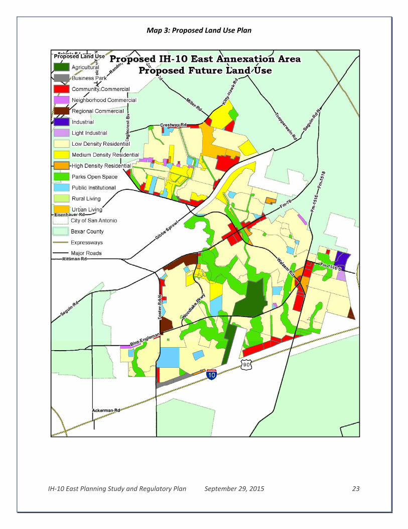
IH‐10 East Planning Study and Regulatory Plan September 29, 2015 23
Map 3: Proposed Land Use Plan

IH‐10 East Planning Study and Regulatory Plan September 29, 2015 24
DEVE LOPMENT REGU LAT ION S
The following planning, zoning, health and safety ordinances in the San Antonio, Texas, Code of Ordinances will be enforced in the areas upon completion of annexation for limited purposes:
Chapter 6 – Buildings
Chapter 10 – Building Related Codes
Articles II, III and IV of Chapter 11‐ Fire Prevention, including references to Chapter 16 (Licenses and Business Regulations) pertaining to Hazardous Materials Permits
Article VII‐Used Automotive Parts Recyclers and Metal Recycling Entities of Chapter 16‐ Licenses and Business Regulations
Chapter 28‐Signs
Chapter 34‐Water and Sewers
Chapter 35 – Unified Development Code, including, but not limited to, zoning regulations and all subsequent amendments, replacement ordinances, and related technical and illustrative manuals to these ordinances.
Notwithstanding the Municipal Code references above, the following exceptions shall be established if this area is annexed for limited purposes:
Fees will be waived for a 180 day period for property owners seeking to register existing uses as non‐conforming rights, to rezone a property, or to apply for a plan amendment associated with a proposed rezoning of a property.
Excluding services and fees for Drainage Utility Services authorized by the Texas Local Government Code, Section 552.044(4)(A) and adopted in Chapter 34 – Water and Sewers
Both the City of San Antonio and Bexar County will have dual review and will assess fees for subdivision plats in the Limited Purpose Annexation area in accordance with the procedures within the ETJ as outlined in the most recently executed Inter Local Agreement (ILA) between the City of San Antonio and Bexar County.
Bexar County will continue its procedures for streetlights (35‐506.i) continue the maintenance and acceptance of streets and drains and continue to use its own requirements and procedures for pavement design in the Limited Purpose Annexation area as outlined in the most recent ILA. Right‐of‐way permits and flood development permits will continue to be the responsibility of Bexar County during Limited Purpose Annexation.
Property owners will be allowed to erect, maintain, and repair traditional barbed wire or electric fences used in conjunction with agricultural, farming or ranching operations.
Property owners within the limited purpose annexation area will be allowed 180 days to bring their property into compliance with City Codes.

IH‐10 East Planning Study and Regulatory Plan September 29, 2015 25
FUTURE FU L L PURPOS E ANNEXA T ION The areas subject to this Limited Purpose Annexation will be included within the City’s full purpose jurisdiction within three (3) years of the effective date of the limited purpose annexation ordinance unless the date for full purpose annexation is postponed by written agreement between the City and a majority of the affected landowners of a tract of land. Planning Milestones
State law requires specific steps be completed by the City for each of the three years after an area is annexed for limited purposes leading toward the full‐purpose annexation of the areas.
By the end of the first year, the City must prepare a land use and intensity plan to be a basis for services and capital improvement project (CIP) planning.
By the end of the second year, the City must include the area in the long‐range financial forecast and in the City’s program to identify future CIP projects.
By the end of the third year, the City must include CIP projects intended to serve the area in the adopted CIP program and identify potential sources of funding.
Development Agreements
Pursuant to Section 43.035 of the Local Government Code, the City of San Antonio is obligated to offer a Non‐annexation Agreement to owners of properties appraised for ad valorem tax purposes as agricultural, wildlife management, or timber management. If the offer is accepted by the property owner and a signed and notarized copy of the agreement is returned to the City, the agreement will be presented to City Council for consideration. Upon acceptance by City Council, the property will be excepted from the proposed annexation.
Disclaimer
The City has made a good‐faith effort to provide accurate references to the Municipal Code sections in which the ordinances described above are codified. In the event that a portion of the Municipal Code listed above contains a reference to a portion of the Municipal Code or another City Ordinance that
Map 4: Agriculture Valued Land

IH‐10 East Planning Study and Regulatory Plan September 29, 2015 26
is not listed above then, to the extent necessary to either provide meaning to or to carry out the meaning of the listed portions, the referenced portions of the Local Government Code, Municipal Code or other City Ordinances shall also apply. Any failure to list all relevant Municipal Code references is inadvertent and will not affect enforcement of the ordinances by the City. Further, any and all exhibits contained herein are intended for reference purposes only and shall not be construed to be final. All exhibits shall be deemed “final” upon adoption of this draft Limited Purpose Annexation proposal. The adopted regulatory plan must be the same as the proposed regulatory plan unless the San Antonio City Council finds and states in the ordinance the reasons for adoption of a different regulatory plan. The City of San Antonio City Council, by ordinance, may change an adopted regulatory plan if, in the ordinance making the change, the City Council finds and states the reasons for the adoption of the change.