climate: outlook and operational planning jayantha obeysekera (’obey’), ph.d.,p.e.,d.wre...
TRANSCRIPT

Climate: Outlook and Operational Planning
Jayantha Obeysekera (’Obey’), Ph.D.,P.E.,D.WRE
Department Director
Hydrologic & Environmental Systems Modeling

Mean AnnualRain (cm)
48
505560
Orlando
Ft. Pierce
WestPalmBeach
Miami
Naples
Spatial Pattern of Rainfall

6566
676869
707172 73
7475
76 7778
7980 81
8283
8485
8687
88
9091
92 93
95
89
94
-15
-10
-5
0
5
10
15
20
Rainfall Deviations from Annual Average of 52 inches
1965-1995
Rai
nfa
ll D
evia
tio
n (
inch
es)
MonthlyDistribution Ja
n
Feb Mar
Apr
May
Jun
Jul
Aug
Sep
Oct
Nov
Dec
0
1
2
3
4
5
6
7
8
9
10Wet
inch
es
months
Dry

Weather vs. Climate
• Weather pertains to occurrences from hour to hour, or day to day, in a specific location Forecasting: Typical lead time up to few hours to
a week
• Climate pertains to average weather over an extended period of time Outlook: Typical lead time ranges from weeks to
multiple seasons (e.g. remainder of the wet season + dry season)
Based on “Teleconnections”: El Niño-Southern Oscillation (ENSO) and Atlantic Multidecadal Oscillation (AMO)
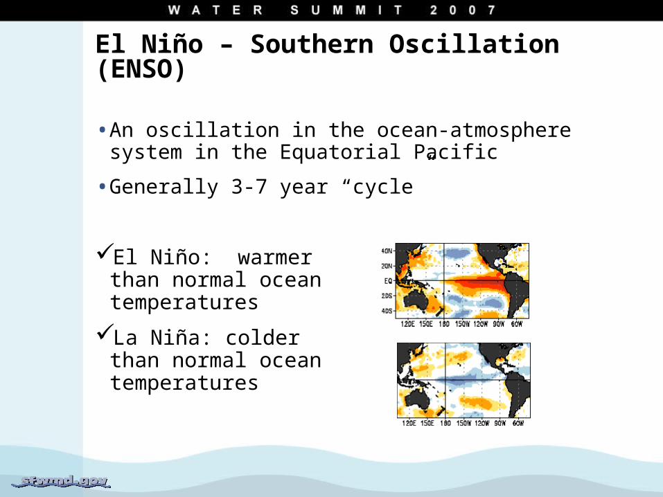
El Niño – Southern Oscillation (ENSO)
• An oscillation in the ocean-atmosphere system in the Equatorial Pacific
• Generally 3-7 year “cycle”
El Niño: warmer than normal ocean temperatures
La Niña: colder than normal ocean temperatures
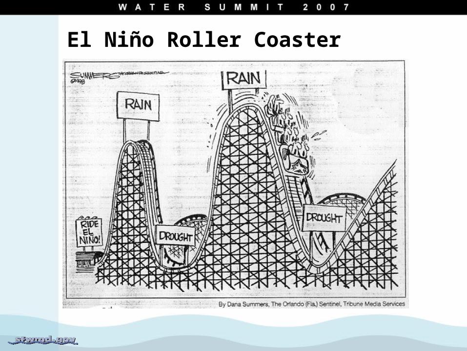
El Niño Roller Coaster

El Niño / La Niña Effects inSouth Florida
• El Niño: Greater chance of wetter than normal rainfall during dry season months
• La Niña: Greater chance of drier than normal rainfall during dry season months
• No clear tendency in wet season months
• Less Atlantic tropical storm activity during El Niño and more during La Niña

warm
cold
warm
cold
• Decadal to multi-decadal scale fluctuations in the sea surface temperature (only about 1º F) in the North Atlantic Ocean
Cold Phase (~1900-1925, 1970-1994)
Warm Phase (1926-1969, 1995-???)
Atlantic Multidecadal Oscillation (AMO)
Effect of AMO on South Florida
• Warm Phase
Wet season rainfall appears to be generally greater. Severe droughts are still possible (remember 2000-2001)
The number of tropical storms that mature into major hurricanes is greater
ENSO effect is reinforced during Feb-March period
• Cold Phase
Rainfall generally below the long term average. Wet years are still possible
• Unknown: When will it switch from the current warm phase to cold phase?

Summary of What We Know(These are tendencies and not absolutes!)
Rainfall Atlantic HurricanesWet Season Dry Season
El Niño No clear pattern
Wetter Less activity
La Niña No clear pattern
Drier More activity
AMO Warm Phase
Wetter decades; drought still possible
Greater # of major storms
AMO Cold Phase
Drier decades; wet years still possible
Lesser # of major storms

Operational Planning
• Operational decisions today may significantly influence the system conditions months from now. Tools are needed to look ahead.
• Tools of Operational Planning
Climate Outlook and associated uncertainties
Operating rules which incorporate climate outlooks
Computer models to simulate future possible scenarios
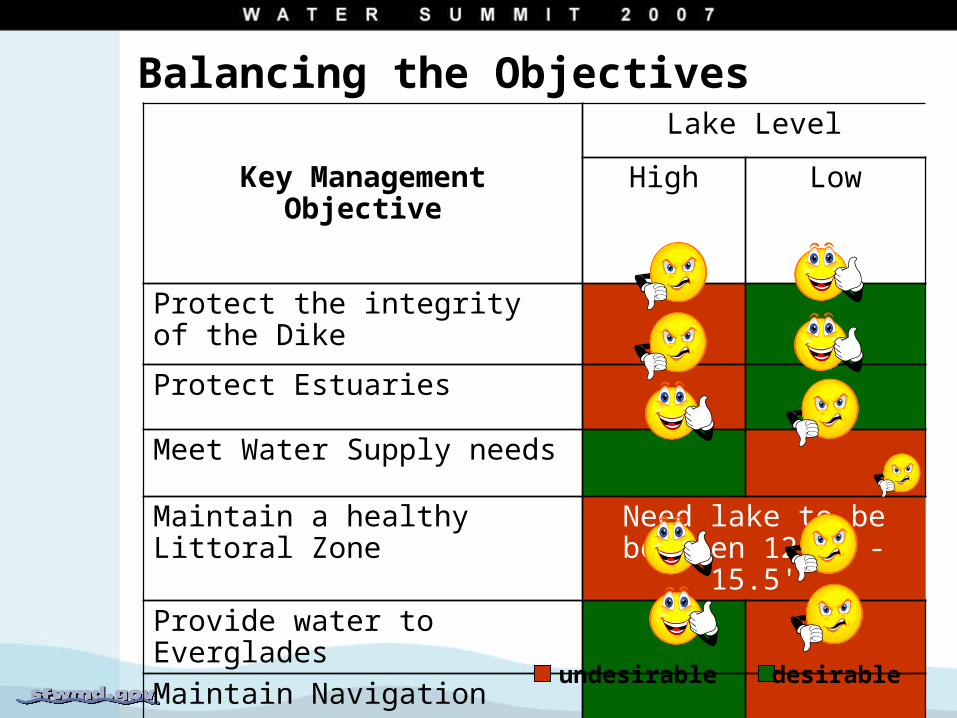
Balancing the Objectives
Key Management Objective
Lake Level
High Low
Protect the integrity of the Dike
Protect Estuaries
Meet Water Supply needs
Maintain a healthy Littoral Zone Need lake to be between 12.5' -15.5'
Provide water to Everglades
Maintain Navigation
undesirable desirable

Achieving Balance:Tools for Managing Lake Okeechobee
• Water Supply and Environment (WSE) Regulation Schedule
Manages high stages
Designed to preserve flood protection and balance competing objectives
• Water Shortage Plan
Manages low lake stages
Designed to ration water supplies during extended dry periods

Flood Control
Water Shortage
Lake Okeechobee Management Zones

WSE Regulation ScheduleOperational Elements
• Lake Okeechobee Water Level
• Tributary Hydrologic Condition
30 Day Net Rainfall
Average Kissimmee River (Tributary watershed) inflow
• Lake Okeechobee Net Inflow Outlook
Seasonal Outlook (6 month)
Multi-seasonal Outlook (7 to 12 months)

& MeteorologicalForecast
Seasonal Climate Outlook
TributaryHydrologicConditions Multi-
SeasonalClimateOutlook
No Dischargeto Tidewater
Up to Maximum Pulse Release
to the Estuaries
No Dischargeto Tidewater
Up to Maximum Discharge Capacity
To Tidewater
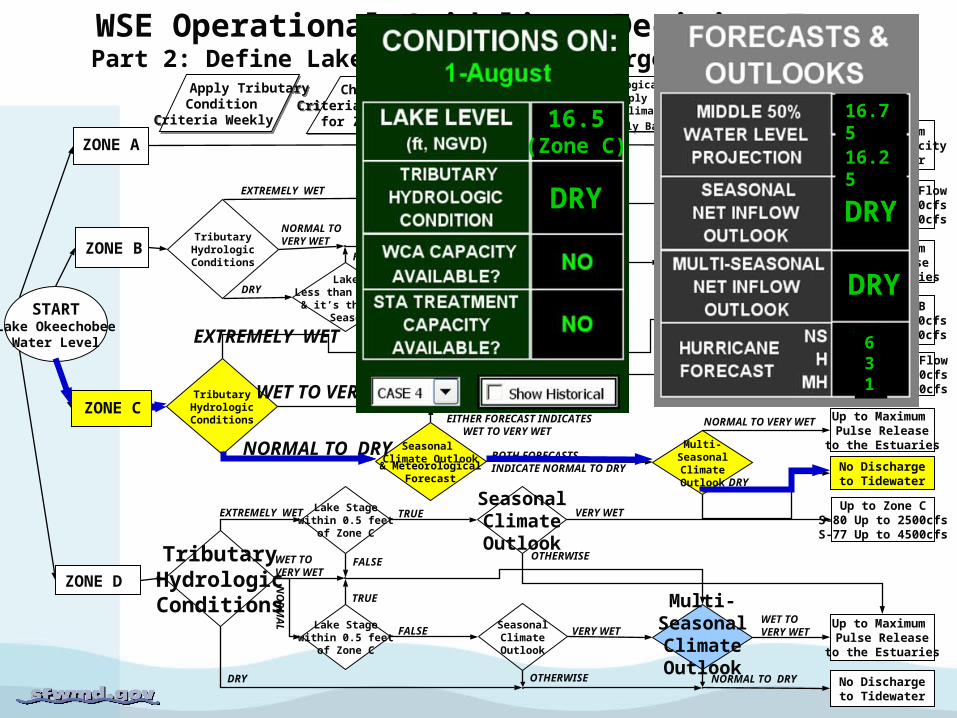
WSE Operational Guidelines Decision TreePart 2: Define Lake Okeechobee Discharges to Tidewater (Estuaries)
Apply TributaryCondition
Criteria Weekly
Apply TributaryCondition
Criteria Weekly
Apply Meteorological Forecasts on aWeekly Basis; apply Seasonal and Multi-Seasonal Climate Outlooks
on a Monthly Basis
Apply Meteorological Forecasts on aWeekly Basis; apply Seasonal and Multi-Seasonal Climate Outlooks
on a Monthly Basis
Check Special LakeCriteria daily as needed
for Zones B & D
Check Special LakeCriteria daily as needed
for Zones B & D
STARTLake Okeechobee
Water Level
ZONE A
DRY
VERY WET
ZONE B
ZONE C
ZONE D
TributaryHydrologicConditions
TributaryHydrologicConditions
Lake Stagewithin 0.5 feet
of Zone C
Lake Stagewithin 0.5 feet
of Zone C
SeasonalClimateOutlook
SeasonalClimateOutlook
Multi-SeasonalClimateOutlook
Zone C Steady FlowS-80 Up to 2500cfsS-77 Up to 4500cfs
Up to Maximum Pulse Release
to the Estuaries
Zone B Steady FlowS-80 Up to 3500cfsS-77 Up to 6500cfs
Up to 30 dayMeteorological
Forecast
LakeLess than 17.5’ & it’s the Dry
Season
Up to 30 dayMeteorological
Forecast
Up to Zone BS-80 Up to 3500cfsS-77 Up to 6500cfs
Up to Zone CS-80 Up to 2500cfsS-77 Up to 4500cfs
Up to Maximum Pulse Release
to the Estuaries
SeasonalClimateOutlook
Up to 30 dayMeteorological
Forecast
WET TO VERY WET
NO
RM
AL
EXTREMELY WET TRUE
FALSE
FALSE
TRUE
OTHERWISE
WET TO VERY WET
NORMAL TO DRY
VERY WET
OTHERWISE
NORMAL TO DRY
WET TO VERY WET
EXTREMELY WETWET TO VERY WET
NORMAL TO DRY
EITHER FORECAST INDICATES WET TO VERY WET
BOTH FORECASTS INDICATE NORMAL TO DRY
NORMAL TO VERY WET
DRY
EXTREMELY WET
NORMAL TO VERY WET
DRY TRUE
FALSE NORMAL TO VERY WET
DRY
WET TO VERY WET
NORMAL TO DRY
& MeteorologicalForecast
Seasonal Climate Outlook
TributaryHydrologicConditions Multi-
SeasonalClimateOutlook
No Dischargeto Tidewater
Up to Maximum Pulse Release
to the Estuaries
No Dischargeto Tidewater
Up to Maximum Discharge Capacity
To Tidewater
WSE Operational Guidelines Decision TreePart 2: Define Lake Okeechobee Discharges to Tidewater (Estuaries)
Apply TributaryCondition
Criteria Weekly
Apply TributaryCondition
Criteria Weekly
Apply Meteorological Forecasts on aWeekly Basis; apply Seasonal and Multi-Seasonal Climate Outlooks
on a Monthly Basis
Apply Meteorological Forecasts on aWeekly Basis; apply Seasonal and Multi-Seasonal Climate Outlooks
on a Monthly Basis
Check Special LakeCriteria daily as needed
for Zones B & D
Check Special LakeCriteria daily as needed
for Zones B & D
STARTLake Okeechobee
Water Level
ZONE A
DRY
VERY WET
ZONE B
ZONE C
ZONE D
TributaryHydrologicConditions
TributaryHydrologicConditions
Lake Stagewithin 0.5 feet
of Zone C
Lake Stagewithin 0.5 feet
of Zone C
SeasonalClimateOutlook
SeasonalClimateOutlook
Multi-SeasonalClimateOutlook
Zone C Steady FlowS-80 Up to 2500cfsS-77 Up to 4500cfs
Up to Maximum Pulse Release
to the Estuaries
Zone B Steady FlowS-80 Up to 3500cfsS-77 Up to 6500cfs
Up to 30 dayMeteorological
Forecast
LakeLess than 17.5’ & it’s the Dry
Season
Up to 30 dayMeteorological
Forecast
Up to Zone BS-80 Up to 3500cfsS-77 Up to 6500cfs
Up to Zone CS-80 Up to 2500cfsS-77 Up to 4500cfs
Up to Maximum Pulse Release
to the Estuaries
SeasonalClimateOutlook
Up to 30 dayMeteorological
Forecast
WET TO VERY WET
NO
RM
AL
EXTREMELY WET TRUE
FALSE
FALSE
TRUE
OTHERWISE
WET TO VERY WET
NORMAL TO DRY
VERY WET
OTHERWISE
NORMAL TO DRY
WET TO VERY WET
EXTREMELY WETWET TO VERY WET
NORMAL TO DRY
EITHER FORECAST INDICATES WET TO VERY WET
BOTH FORECASTS INDICATE NORMAL TO DRY
NORMAL TO VERY WET
DRY
EXTREMELY WET
NORMAL TO VERY WET
DRY TRUE
FALSE NORMAL TO VERY WET
DRY
WET TO VERY WET
NORMAL TO DRY
16.5(Zone C)
DRY DRY
DRY
631
16.75
16.25

Weekly Implementation
• Tributary Hydrologic Condition
Based on past 4-week net rainfall and past 2-week mean inflows from Kissimmee Basin
6 Classes: Very Dry to Extremely Wet
• Climate Outlook
Net Inflow = Inflow + Rainfall – Evapotranspiration converted to equivalent depth
Outlook classes: Dry, Normal, Wet, Very Wet
6 month Seasonal Outlook
7-12 month Multi-seasonal Outlook

9.0
11.0
13.0
15.0
17.0
19.0
J-98 A-98 S-98 O-98 N-98 D-98 J-99 F-99 M-99 A-99 M-99
Current State
POSITION ANALYSIS
1969
19841975
1970
1989
Stage simulated by a model
95%
50%
25%

Lake Okeechobee August 1st, 2007 Position Analysis (preliminary)

Questions?