coal resource classification system of the u.s. · pdf filec.891 geological survey circular...
TRANSCRIPT
C.891
GEOLOGICAL SURVEY CIRCULAR 891
Coal ResourceClassification Systemof the U.S. Geological Survey
Coal ResourceClassification Systemof the U.S. Geological Survey
By Gordon H. Wood, Jr., Thomas M. Kehn,
M. Devereux Carter, and William C. Culbertson
GEOLOGICAL SURVEY CIRCULAR 891
1983
U.S. DEPARTMENT OF THE INTERIOR
MANUEL LUJAN, Jr., Secretary
U.S. GEOLOGICAL SURVEY
Dallas L. Peck, Director
Any use of trade, product, or firm names in this publication is for descriptive purposes only and does not imply endorsement by the U.S. Government
First printing 1983 Second printing 1992
UNITED STATES GOVERNMENT PRINTING OFFICE: 1983
Free on application to Book and Open-File Report Sales U.S. Geological Survey Federal Center, Box 25425 Denver, CO 80225

FOREWORD
In order to use coal resource terms with precision and common understanding and to compare resource data effectively, the authors developed a standardized, definitive, broadly applicable classification system to derive uniform, coordinated coal resource estimates. The principles of the system for all mineral resources ape given in USGS Cir cular 831. Personnel engaged in coal resources work are to use the definitions, criteria, guidelines, and instructions incorporated in this coal resource classification system in all U.S. Geological Survey publications.
Director, Geological Survey
CONTENTS
Page.introduction _ _ __ _ ___ __ jHistory of the classification system 1Coal resource classification system 2Glossary of coal classification system and supplementary terms 4Criteria for coal resource classification 23Applications of criteria 23opcciiic criteria _______ __________ _____ _________ _ ______« .___« ____________________ _^Guidelines for estimating coal resources 32General guidelines for classification of coal resources 32
Specific Instructions 331 P anlf nf r-nal 331 > JCVoIln Ul IXKU j j
2 Overburden _____________________________________________ 333. Thickness of coal categories 34T\ &ize or unit area *~ __________ ___ ____<__ ________ _______ _________ _____________ __ ^^5. Major categories of resources 34
S f'nsil Vu»r1 mana __ ___ . ^4.* VrftUcii ucu iiui|J3 » _________ __ »__ ________ __ _____ ______ _____ j-j.
7. Thickness of coal measurements 358. Distribution of coal bed thickness measurements 35
10. Weight of coal per unit volume 3611. Calculation of coal resources 3612. Rounding of tonnage estimates 36
13. Estimation of resources in the vicinity of where a coal bed bifurcates into two or moretongues "~ ~~ » _ _ _ _ _ _ _ _ _ __ _ ___ _ ___ __ ___ __ __ __ __ __ _ _ __ _ JQ
Estimation of hypothetical resources 37Extrapolated bed map method 37Extrapolated coal zone method 38
Examples illustrating the basic geometric principles of constructing coal resource bed maps 38Geophysical logs as a source of coal bed data 46
Focusing-electrode and induction logs 51.L/iscussion or electric logs ~ » ~ ____ __ _ ~_ __ ___ _ __ __ ____ ___ QJ
\jrainfna ray log ~~~~~~~~ ~~~~ ~-~-~~~ _ » jjuensity log *. »___ _________ ___________»___ _______ __________ __ ^^Neutron loff 55A.COUSQC velocity log ~ __________ ____«._ ________ __________________ ____________ ___ QQMeasurement of the coal bed thickness 55Composition and rank of coal 61kMT3.ogra.jxry ano structure ~ __ ____ ________ ̂ ______«.___ __________ _________________ ___ Q^
Summovnr _ _ fiOUlllillcUy ______________________________________________________________________ \J£,
xntenoeci audience ^ ^ » QJ
ILLUSTRATIONS
Page
FIGURE 1. Format and classification of coal resources by reserves and subeconomic resources categories 42. Format and classification of coal resources by reserve and inferred reserve bases and subeconomic and inferred sub-
economic resources categories 4
3. Flow chart showing hierarchy of coal resources and criteria for distinguishing resource categories 64. Diagram showing reliability categories based solely on distance from points of measurement 11
5-8. Maps showing:5. Coal fields of the conterminous United States 136. Coal fields of Alaska 147. Coal regions of the conterminous United States 158. Coal provinces of the conterminous United States 16
9-21. Diagrams showing:9. Determination of areas of reliability using coal thickness data only at points of measurement along outcrop
line 39
10. Determination of areas of reliability from points of measurement on the outcrop line, supplemented by mine anddrill-hole data 41
11. Determination of areas of reliability using coal thickness measurements taken along a continuously exposed,strip-mined bed, supplemented by drill-hole data 42
12. Determination of minimum thickness isoline 4313. Determination of areas of reliability and overburden thickness 4414. A ridge with construction of 14-inch minimum thickness limit 45
15. Same ridge as figure 14 with areas of reliability, coal thickness isopachs, and overburden contour 4616. A simple valley reentrant with construction of 14-inch minimum thickness limit 4717. Areas of reliability, overburden contours, and coal thicknessisopachs to accompany figure 16 4818. A valley and ridge with part of coal bed less than minimum thickness but within determined 14-inch limit as
illustrated in figure 16 4919. Areas of reliability, overburden contours, and coal thickness isopachs to accompany figure 18 5020. Coal categories in plane of coal bed, a structure section, and coal categories as viewed projected to the
ground surface from plane of coal bed 52
21. Areas of resource categories for a fladying coal bed based on data only from underground mined areas and drillhnW - _____ ___ ___________ ____________________________________________ S4.IILUC5 ««««_« _ j.j.
22-23. Maps showing:22. A small coal basin divided into areas of coal resource categories 56
23. A large, simple coal basin divided into areas of coal resource categories 5724. Suggested form for recording coal resource data and calculated tonnage estimates 5825. Suggested format for tabulating data and calculating tonnages 5926. Early conventional electric log (1957) of the Owanah Kendrick No. 1 well, Big Horn County, Montana 6027. Induction and conductivity geophysical logs (1960) of the Hose-Austin Drilling Company from Bone Brothers No. 1
well, Rosebud County, Montana 61
28. Examples of oil- and gas-well geophysical logs from western Kentucky that can be used for coal bed correlations andcoal resource evaluations 62
29. SP, gamma ray, acoustic velocity, normal resistivity, and induction conductivity logs (1971) from Davis Oil Grady FedNo. 1-2 well, Sweetwater County, Wyoming 63
30. SP, gamma ray, density, dual induction-lateral log, and neutron logs (1978) from Getty Tri-County No. 1 well, Rose bud County, Montana 64
31. Five geophysical logs of a coal exploration drill hole showing response to coal and limestone 65
TABLES
TABLE 1. Classification of coals by rank 172. Average specific gravity and average weight of unbroken coal per unit volume of different ranks 223. Summary of coal resource criteria 24
4. Areas of reliability from figure 13 listed by overburden and coal thickness categories, and by counties 455. Areas of reliability from figure 15 listed in proper overburden and coal thickness categories 476. Areas of resource categories from figure 17 listed in proper reliability and thickness of coal and overburden categories 497. Areas of resource categories from figure 19 listed in proper reliability and thickness of coal and overburden categories 51
vn
Goal Resource Classification System of the U.S. Geological Survey
By GORDON H. WOOD, JR., THOMAS M. KEHN, M. DEVEREUX CARTER, and WILLIAM C. CULBERTSON
INTRODUCTION
Coal is the most abundant fossil fuel in the United States. Knowledge of the size, distribution, and quality of the Nation's coal resources is important for govern mental planning; industrial planning and growth; the solution of current and future problems related to air, water, and land degradation; and for meeting the short- to long-term energy needs of the country. Knowledge of the Nation's coal resources is also important in planning for the exportation and importation of fuel.
Many estimates have been made of the coal resources of the Nation, the resources of other nations, and for the world as a whole. Because of differing systems of re source classification, these estimates vary greatly in magnitude within this Nation and other nations; geo logic analysis shows some of these estimates to be little more than educated guesses. The accompanying coal resource classification system of the U.S. Geological Survey is recommended as an aid in solving the prob lems caused by the differing systems.
A detailed resource classification system should iden tify deposits of coal by area! location, distance from points of information, thicknesses of coal and over burden, rank and quality, and estimates of quantity. Classes in the system, furthermore, should impart some idea as to economic, technologic, legal, and environ mental factors affecting the availability of coal.
A coal resource classification system was published jointly by the U.S. Bureau of Mines and the U.S. Geo logical Survey in 1976 as Geological Survey Bulletin 1450-B and was believed to be a successful modification of an already existing system into the ideal system. However, Bulletin 1450-B left unanswered many ques tions concerning how to estimate coal resources and did
not provide sufficient criteria, guidelines, and a method ology so that comparable estimates would be obtained by all workers using the same data.
The Survey and the Bureau of Mines decided in 1977 that the coal resource classification system, as outlined in Bulletin 1450-B, should be revised and expanded to provide a more definitive and less ambiguous coal re source classification system. The revision was to docu ment standard definitions, criteria, guidelines, and methods to be used in estimating coal resources. Stand ardization of the elements of the system should result in comparable estimates by different workers using the same data.
In 1980, the two agencies published Circular 831, "Principles of a Resource/Reserve Classification for Minerals" (U.S. Geological Survey, 1980). The cir cular, which outlines a classification system for all min eral commodities, filled the classification needs of the Bureau of Mines, which was no longer responsible for coal resource classification, and was the basis for this revision of the coal resource classification system by the Geological Survey. The revision, embodied in this report, has two main objectives: (1) to provide detailed information lacking in Bulletin 1450-B; and (2) to pro vide standard definitions, criteria, guidelines, and methods required for uniform application of the prin ciples outlined in Circular 831.
HISTORY OF THE CLASSIFICATION SYSTEM
Almost since their inceptions in 1879 and 1920, respectively, the U.S. Geological Survey and the U.S. Bureau of Mines have conducted modest ongoing pro grams in coal resource estimation and analysis. Between
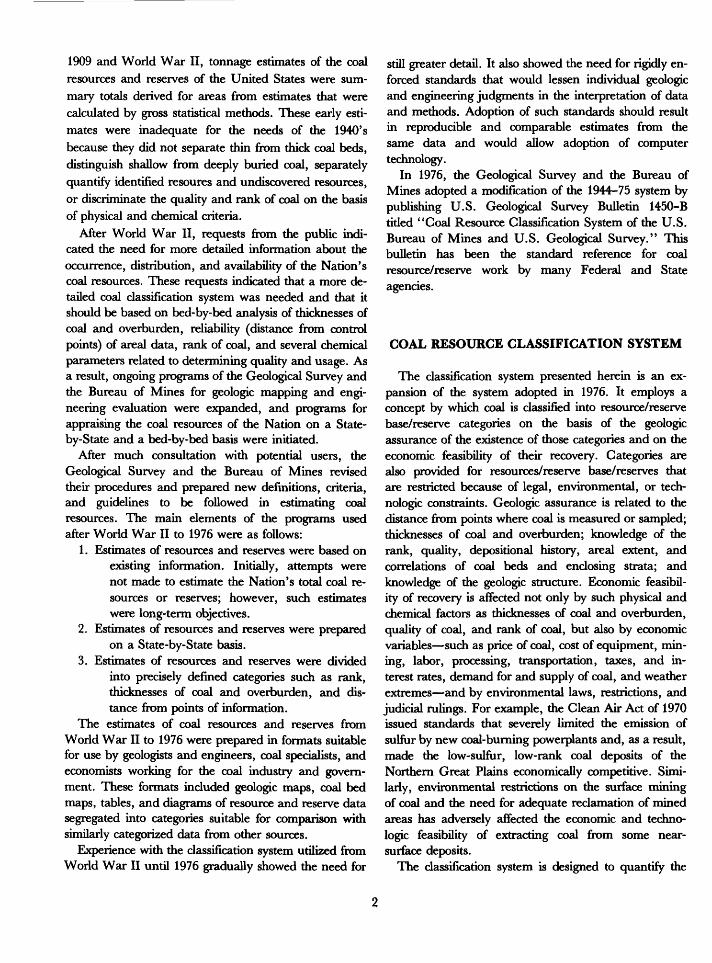
1909 and World War II, tonnage estimates of the coal resources and reserves of the United States were sum mary totals derived for areas from estimates that were calculated by gross statistical methods. These early esti mates were inadequate for the needs of the 1940's because they did not separate thin from thick coal beds, distinguish shallow from deeply buried coal, separately quantify identified resoures and undiscovered resources, or discriminate the quality and rank of coal on the basis of physical and chemical criteria.
After World War II, requests from the public indi cated the need for more detailed information about the occurrence, distribution, and availability of the Nation's coal resources. These requests indicated that a more de tailed coal classification system was needed and that it should be based on bed-by-bed analysis of thicknesses of coal and overburden, reliability (distance from control points) of areal data, rank of coal, and several chemical parameters related to determining quality and usage. As a result, ongoing programs of the Geological Survey and the Bureau of Mines for geologic mapping and engi neering evaluation were expanded, and programs for appraising the coal resources of the Nation on a State- by-State and a bed-by-bed basis were initiated.
After much consultation with potential users, the Geological Survey and the Bureau of Mines revised their procedures and prepared new definitions, criteria, and guidelines to be followed in estimating coal resources. The main elements of the programs used after World War II to 1976 were as follows:
1. Estimates of resources and reserves were based on existing information. Initially, attempts were not made to estimate the Nation's total coal re sources or reserves; however, such estimates were long-term objectives.
2. Estimates of resources and reserves were prepared on a State-by-State basis.
3. Estimates of resources and reserves were divided into precisely defined categories such as rank, thicknesses of coal and overburden, and dis tance from points of information.
The estimates of coal resources and reserves from World War II to 1976 were prepared in formats suitable for use by geologists and engineers, coal specialists, and economists working for the coal industry and govern ment. These formats included geologic maps, coal bed maps, tables, and diagrams of resource and reserve data segregated into categories suitable for comparison with similarly categorized data from other sources.
Experience with the classification system utilized from World War II until 1976 gradually showed the need for
still greater detail. It also showed the need for rigidly en forced standards that would lessen individual geologic and engineering judgments in the interpretation of data and methods. Adoption of such standards should result in reproducible and comparable estimates from the same data and would allow adoption of computer technology.
In 1976, the Geological Survey and the Bureau of Mines adopted a modification of the 1944-75 system by publishing U.S. Geological Survey Bulletin 1450-B tided "Coal Resource Classification System of the U.S. Bureau of Mines and U.S. Geological Survey." This bulletin has been the standard reference for coal resource/reserve work by many Federal and State agencies.
COAL RESOURCE CLASSIFICATION SYSTEM
The classification system presented herein is an ex pansion of the system adopted in 1976. It employs a concept by which coal is classified into resource/reserve base/reserve categories on the basis of the geologic assurance of the existence of those categories and on the economic feasibility of their recovery. Categories are also provided for resources/reserve base/reserves that are restricted because of legal, environmental, or tech nologic constraints. Geologic assurance is related to the distance from points where coal is measured or sampled; thicknesses of coal and overburden; knowledge of the rank, quality, depositional history, areal extent, and correlations of coal beds and enclosing strata; and knowledge of the geologic structure. Economic feasibil ity of recovery is affected not only by such physical and chemical factors as thicknesses of coal and overburden, quality of coal, and rank of coal, but also by economic variables such as price of coal, cost of equipment, min ing, labor, processing, transportation, taxes, and in terest rates, demand for and supply of coal, and weather extremes and by environmental laws, restrictions, and judicial rulings. For example, the Clean Air Act of 1970 issued standards that severely limited the emission of sulfur by new coal-burning powerplants and, as a result, made the low-sulfur, low-rank coal deposits of the Northern Great Plains economically competitive. Simi larly, environmental restrictions on the surface mining of coal and the need for adequate reclamation of mined areas has adversely affected the economic and techno logic feasibility of extracting coal from some near- surface deposits.
The classification system is designed to quantify the
total amounts of coal in the ground before mining began (original resources) and after any mining (remaining re sources). It is also designed to quantify the amounts of coal that are known (identified resources) and the amounts of coal that remain to be discovered (undiscov ered resources). The system also provides for recogniz ing amounts of coal that are (1) standard distances from points of thickness measurements measured, indi cated, inferred, and hypothetical; (2) similar to coal cur rently being mined (reserve base and inferred reserve base); (3) economically recoverable currently (reserves and inferred reserves); (4) potentially recoverable with a favorable change in economics (marginal reserves and inferred marginal reserves); and (5) subeconomic because of being too thin, too deeply buried, or lost-in- mining. Finally, the system allows tabulation of coal amounts that are restricted from mining by regulation, law, or judicial ruling.
Two factors have created difficulties in categorizing resources and reserves in all classification systems. First, most geologists and engineers who classify resources and reserves are not experts in the economics of mining, transportation, processing, and marketing. Second, economic conditions change with time, so that the economic viability of coal is relatively fluid. For ex ample, subeconomic resources of today can become re serves of tomorrow as the price of coal rises; conversely, reserves can become subeconomic resources as the price of coal drops. Finally, changing regulations, laws, and judicial rulings can affect mining, transportation, proc essing, and marketing, and thus the classification of coal resources. The concept of a reserve base was developed to alleviate these difficulties (U.S. Geological Survey, 1976, p. B2).
The reserve base is identified coal defined only by physical and chemical criteria such as thicknesses of coal and overburden, quality, heat value, rank, and distance from points of measurement. The criteria for thickness of coal and for overburden have been selected so that the reserve base includes some currently subeconomic coal. The concept of the reserve base is to define a quantity of in-place coal, any part of which is or may become eco nomic depending upon the method of mining and the economic assumptions that are or will be used. An addi tional purpose is to aid in long-range public and com mercial planning by identifying coal suitable for economic recovery.
Thus, resource specialists need not expend their time identifying the component parts of coal deposits that are currently economically recoverable (reserves) because the reserve base category contains much of the coal that
will be classed as reserves in the foreseeable future. Those required to classify coal as being economically re coverable, marginally recoverable, or subeconomic can examine reserve base estimates to locate such coal.
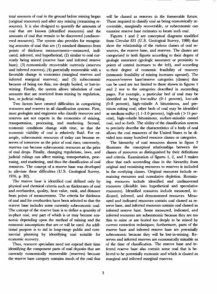
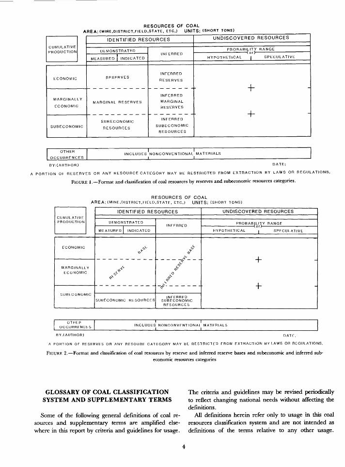
Figures 1 and 2 are conceptual diagrams modified from Circular 831 (U.S. Geological Survey, 1980) that show the relationship of the various classes of coal re sources, the reserve base, and reserves. The classes are categorized in both figures according to their degree of geologic assurance (geologic assurance or proximity to points of control increases to the left), and according to their degree of economic feasibility of recovery (economic feasibility of mining increases upward). The resource/reserve base/reserve categories (classes) that can be used are not limited to those shown in figures 1 and 2 nor to the categories described in succeeding pages. For example, a particular bed of coal may be identified as being low-sulfur (0-1 percent), low-ash (0-8 percent), high-volatile A bituminous, and pre mium coking coal; other beds of coal may be identified as medium-sulfur (1.1-3.0 percent), high-ash (> 15 per cent), high-volatile bituminous, surface-minable cannel coal, and so forth. The ability of the classification system to precisely describe the characteristics of a body of coal allows the coal resources of the United States to be di vided into many hundred resource classes or categories.
The hierarchy of coal resources shown in figure 3 illustrates the conceptual relationships between the classes of resources as distinguished by their definitions and criteria. Examination of figures 1,2, and 3 makes clear that each succeeding class in the hierarchy from original and remaining resources to reserves is included in the overlying classes. Original resources include re maining resources and cumulative depletion. Remain ing resources include identified and undiscovered resources (divisible into hypothetical and speculative resources). Identified resources include measured, in dicated, inferred, and demonstrated resources. Meas ured and indicated resources contain coal classed as re serve base, and inferred resources contain coal classed as inferred reserve base. Some measured, indicated, and inferred resources are subeconomic because they are too thin to mine or are buried too deeply to be mined by current extraction techniques; furthermore, parts of the reserve base and inferred reserve base are potentially subeconomic because they will be lost-in-mining. Re serves and inferred reserves are economically minable as of the time of classification. The reserve base and in ferred reserve base also contain some coal that is be lieved to be potentially economic and which is classed as marginal and inferred marginal reserves.
RESOURCES OF COAL AREA: (MINE,DISTRICT,FIELD.STATE. ETC.) UNITS: ISHORT TONS)
CUMULATIVE
PRODUCTION
ECONOMIC
MARGINALLY
ECONOMIC
SUBECONOMIC
IDENTIFIED RESOURCES
DEMONSTRATED
MEASURED INDICATED
RESERVES
MARGINAL RESERVES
SUBECONOMIC
RESOURCES
INFERRED
INFERRED
RESERVES
INFERRED
MARGINAL
RESERVES
INFERRED
SUBECONOMIC
RESOURCES
UNDISCOVERED RESOURCES
PROBABILITY RANGE
HYPOTHETICAL | SPECULATIVE
f
-1-
OTHER
OCCURRENCESINCLUDES NONCONVENTIONAL MATERIALS
__________I_________________I
BYrCAUTHOR) DATE:
A PORTION OF RESERVES OR ANY RESOURCE CATEGORY MAY BE RESTRICTED FROM EXTRACTION BY LAWS OR REGULATIONS.
FIGURE 1. Format and classification of coal resources by reserves and subeconomic resources categories.
RESOURCES OF COALAREA: (MINE.DISTRICT,FIELD,STATE, ETC.3 UNITS: CSHORT TONS)
CUMULATIVE PRODUCTION
ECONOMIC
MARGINALLY
ECONOMIC
SUBECONOMIC
IDENTIFIED RESOURCES
DEMONSTRATED
MEASURED INDICATED
.-*
/
SUBECONOMIC RESOURCES
INFERRED
/AV
/
/^r
INFERRED SUBECONOMIC RESOURCES
UNDISCOVERED RESOURCES
PROBABILITY RANGE
HYPOTHETICAL j SPECULATIVE
+
+-
OTHFH OCCURRENCES INCLUDES NONCONVENTIONAL MATERIALS
_________I__________________I_________
BY.(AUTHOR) DATE.
A PORTION OF RESERVES OR ANY RESOURE CATEGORY MAY BE RESTRICTED FROM EXTRACTION BYLAWS OR REGULATIONS.
FIGURE 2. Format and classification of coal resources by reserve and inferred reserve bases and subeconomic and inferred sub- economic resources categories
GLOSSARY OF COAL CLASSIFICATION SYSTEM AND SUPPLEMENTARY TERMS
Some of the following general definitions of coal re sources and supplementary terms are amplified else where in this report by criteria and guidelines for usage.
The criteria and guidelines may be revised periodically to reflect changing national needs without affecting the definitions.
All definitions herein refer only to usage in this coal resources classification system and are not intended as definitions of the terms relative to any other usage.
Comparative values for units in the metric and English (U.S. Customary) systems of measurement are based on the Handbook of Chemistry and Physics by R. C. Weast (1971, p. F-242-F-263).
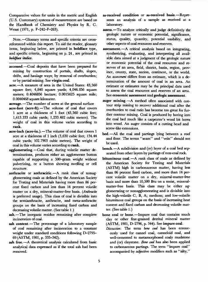
Note. Glossary terms and specific criteria are cross- referenced within this report. To aid the reader, glossary items, beginning below, are printed in boldface type, and specific criteria, beginning on p. 24, are printed in boldface italics.
accessed. Coal deposits that have been prepared for mining by construction of portals, shafts, slopes, drifts, and haulage ways; by removal of overburden^ or by partial mining. See virgin coal.
acre. A measure of area in the United States: 43,560 square feet; 4,840 square yards; 4,046.856 square meters; 0.4046856 hectare; 0.0015625 square mile; 0.0040468 square kilometer.
acreage. The number of acres at the ground surfaceacre-foot (acre-ft). The volume of coal that covers
1 acre at a thickness of 1 foot (43,560 cubic feet; 1,613.333 cubic yards; 1,233.482 cubic meters). The weight of coal in this volume varies according to rank.
acre-inch (acre-in.). The volume of coal that covers 1 acre at a thickness of 1 inch (3,630 cubic feet; 134.44 cubic yards; 102.7903 cubic meters). The weight of coal in this volume varies according to rank.
agglomerating. Coal that, during volatile matter de terminations, produces either an agglomerate button capable of supporting a 500-gram weight without pulverizing, or a button showing swelling or cell structure.
anthracite or anthracitic. A rank class of nonag- glomerating coals as defined by the American Society for Testing and Materials having more than 86 per cent fixed carbon and less than 14 percent volatile matter on a dry, mineral-matter-free basis. (Anthracite is preferred usage). This class of coal is divisible into the semianthracite, anthracite, and meta-anthracite groups on the basis of increasing fixed carbon and decreasing volatile matter. (See table 1.)
ash. The inorganic residue remaining after complete incineration of coal.
ash content. The percentage of a laboratory sample of coal remaining after incineration to a constant weight under standard conditions following D-2795- 69(ASTM, 1981, p. 335-342).
ash free. A theoretical analysis calculated from basic analytical data expressed as if the total ash had been removed.
as-received condition or as-received basis. Repre sents an analysis of a sample as received at a laboratory.
assess. To analyze critically and judge definitively the geologic nature or economic potential, significance, status, quality, quantity, potential usability, and other aspects of coal resources and reserves.
assessment. A critical analysis based on integrating, synthesizing, evaluating, and interpreting all avail able data aimed at a judgment of the geologic nature or economic potential of the coal resources and re serves of an area, field, district, basin, region, prov ince, county, state, nation, continent, or the world. An assessment differs from an estimate, which is a de termination of the amount of coal in an area. An estimate or estimates may be the principal data used to assess the coal resources and reserves of an area. See economic assessment and geologic assessment.
auger mining. A method often associated with con tour strip mining to recover additional coal after the overburden to coal ratio has become too great for fur ther contour mining. Coal is produced by boring into the coal bed much like a carpenter's wood bit bores into wood. An auger consists of a cutting head and screw-like extensions.
bed. All the coal and partings lying between a roof and floor. The terms "seam" and "vein" should not be used.
bench. A subdivision and (or) layer of a coal bed sep arated from other layers by partings of non-coal rock.
bituminous coal. A rank class of coals as defined by the American Society for Testing and Materials (ASTM) high in carbonaceous matter, having less than 86 percent fixed carbon, and more than 14 per cent volatile matter on a dry, mineral-matter-free basis and more than 10,500 Btu on a moist, mineral- matter-free basis. This class may be either ag glomerating or nonagglomerating and is divisible into the high-volatile C, B, A; medium; and low-volatile bituminous coal groups on the basis of increasing heat content and fixed carbon and decreasing volatile mat ter. (See table 1.)
bone coal or bone. Impure coal that contains much clay or other fine-grained detrital mineral matter (ASTM, 1981, D-2796, p. 344). See impure coal. Discussion: The term bone coal has been errone
ously used for cannel coal, canneloid coal, and well-cemented to metamorphosed coaly mudstone and (or) claystone. Bone coal has also been applied to carbonaceous partings. The term "impure coal" accompanied by adjective modifiers such as "silty,"
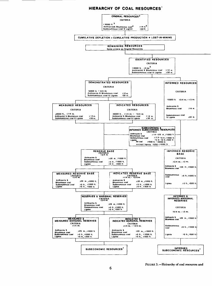
HIERARCHY OF COAL RESOURCES 1
ORIGINAL RESOURCES 2CRITERIA
< 6000 ft 3AnehracieeS. Bituminous coal4 >t4 in.Subbuuminous coal & Lignite >30in.
CUMULATIVE DEPLETION = CUMULATIVE PRODUCTION + LOST-IN-MINING
REMAINING RESOURCESSame criteria as Original Resources
IDENTIFIED RESOURCES
CRITERIA
teOOO ft., <3 mi.6 Anthracite & Bituminous coal Subbilummous coal & Lignite
>14 m. >30 in.
DEMONSTRATED RESOURCES
CRITERIA
<6000 It. < 3/4 mi.Anthracite & Bituminous coal >14m. Subbituminous coal & Lignite >30 in.
MEASURED RESOURCES
CRITERIA
<6000 ft., <1/4 mi. Anthracite & Bituminous coal Subbiluminous coal & Lignite
> 14 in. >30in.
INDICATED RESOURCES
CRITERIA
<6000fl. / >1/4mi. - <3/4 mi Anthracite !> Bituminous coal Subbituminous coal & Lignite
> 14 in. >30 in.
INFERRED RESOURCES
<6000 ft. >3/4mi.-<3mi
Anthracite & Bituminous coal
Subbilummous coal81 Lignite >30 in.
SUBECONOMIC & INFERRED SUBECONOMIC RESOURCES
CRITERIAAnthracite & >14-<28 in. < 1000 f I Bituminous coalSubbituminous coal > 2.5-<s ft y <iooO fl Lignite >2.5-<5 fl.,<500 ft
AH coal >100O II. - <6000 fl.except lignite >500-<1000 fl
RESERVE BASECRITERIA
<3/4 mi
B^u coa, > 28 ,n.. 0000ft.
Subbiluminous coal >5 ft., <tOOO ft.Lignite >5 fl , <500 ft
MEASURED RESERVE BASECRITERIA
<1/4 mi.Anthracite &Bituminous coalSubbituminous coal >5 ft., <1000 ft.Lignite >5 II., <500 ft.
>28 in ,<1000 fl.
INDICATED RESERVE BASECRITERIA
>t/4 ml- <3/4mi
Bilummous coalSubbiluminous coalLignite
>28 in. ,<1000 ft.
>5 ft., <1000 l|.>5 fl. <500 fl.
RESERVES & MARGINAL RESERVES
Anthracite & - O ooo fiBituminous coal >28 '"- <100° fl
Subbiluminous coal >5 fl. <1000 ft.Lignite >5 ft.,<500'ft
MEASURED &MEASURED MARGINAL RESERVES
CRITERIA<1/4 mi.
>2S in,, a000 ftAnthracite &Bituminous coalBubbituminous coal >5 fl. ,<1000 ft.Lignite >5 ft., <500 ft.
INDICATED & INDICATED MARGINAL RESERVES
CRITERIA >1/4 mi. ' <3/4 mi.
Subbiluminous coal Lignite
>« ,a, <1000 ,,.
>5 ft., <lOOOfl. >5 fl., <500 ft.
SUBECONOMIC RESOURCES
INFERRED RESERVE BASE
CRITERIA
>3/4 mi. - <3 mi.
Antnracile & Bituminous coal
>28 in. ,0000 ft.
Subbitummous >5 f, <tooo f,
>5 fl.,<500 ft.
INFERRED &INFERRED MARGINAL
RESERVES
CRITERIA
>3/4 mi.- <3 n
Anthracite & Bituminous coal
Subbilummous coal
>28 in., <1000 ft.
>5 fl. ,<1000 It.
>5-fl ,<500 II.
INFERRED , SUBECONOMIC RESOURCES
FIGURE 3. Heirarchy of coal resources and
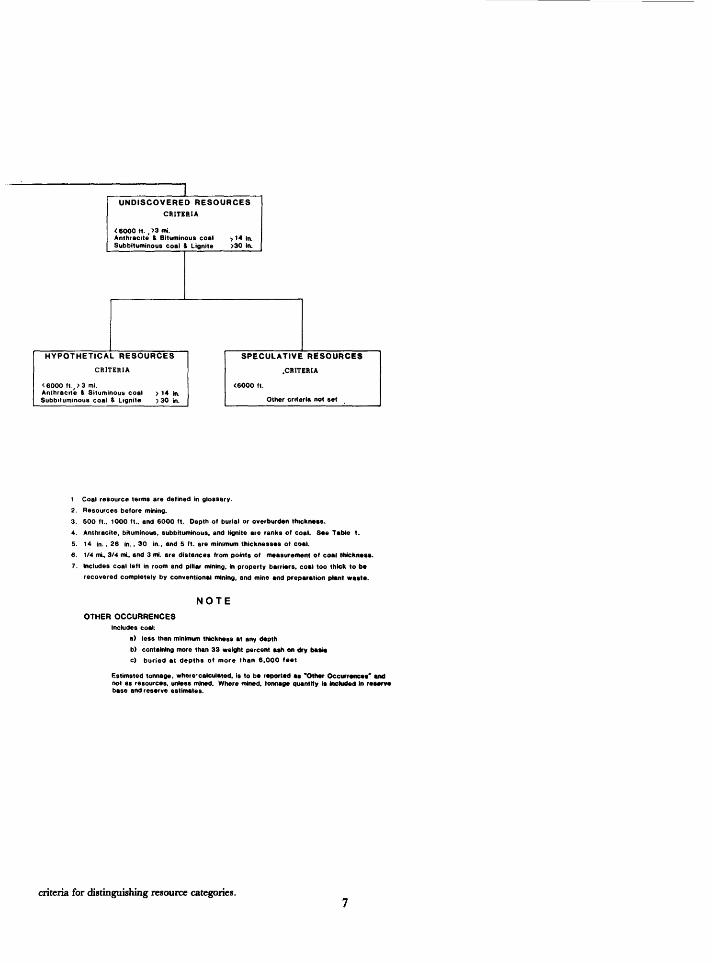
UNDISCOVERED RESOURCESCRITERIA
< 6000 ft. , >3 mi.Anthracite 4 Bituminous coal >14 in.Subbituminous coal > Lignite >30 in.
HYPOTHETICAL RESOURCES
CRITERIA
<6000 ft., >3 mi.Anthracite & Bituminous coalSubbituminous coal & Lignite
> 14 in. >30 in.
SPECULATIVE RESOURCES
.CRITERIA
<6000 ft.
Other criteria not set
1 Coal resource terms are defined in glossary.2. Resources before mining.3. 500 ft.. 1000 ft., and 6000 ft. Depth of burial or overburden thickness.4. Anthracite, bituminous, Subbituminous, and lignite are ranks of coal. See Table t.5. 14 in., 26 in.. 30 in., and 5 ft. are minimum thicknesses of coal.6. 1/4 mi, 3/4 mi, and 3 mi. are distances from points of measurement of coal thickness.7. Includes coal left in room and pillar mining, in property barriers, coal too thick to be
recovered completely by conventional mining, and mine end preparation plant waste.
NOTE
OTHER OCCURRENCESIncludes coal:
a) less than minimum thickness at any depthb) containing more than 33 weight percent ash on dry ba»i»c) buried at depths of more than 6.000 feet
Estimsted tonnage, where-calculated, is to be reported as 'Other Occurrences" Mid not as resources, unless mined. Where mined, tonnage quantity Is included in reterve base and reserve estimates.
criteria for distinguishing resource categories.
"shaly," or "sandy," is the preferred usage be cause the definition of bone coal does not specify the type or weight percentages of impurities.
British thermal unit (Btu). The quantity of heat re quired to raise the temperature of 1 pound of water 1 degree Fahrenheit (°F) at, or near, its point of max imum density of 39.1° F (equivalent to 251.995 gram calories; 1,054.35 Joules; 1.05435 kilojoules; 0.25199 kilocalorie).
burn line. The contact between burned and un- burned coal in the subsurface. In the absence of de finitive information, the subsurface position of a bum line is assumed to be vertically below the surface con tact between unaltered and altered rocks. See clinker,
calorie (cal). The quantity of heat required to raise 1 gram of water from 15° to 16° Celsius. A calorie is also termed gram calorie or small calorie (equivalent to 0.00396832 Btu; 4.184 Joules; 0.001 kilogram calorie).
clinker. Baked or fused rock formed from the heat ofa burning underlying coal bed.
coal. A readily combustible rock containing more than 50 percent by weight and more than 70 percent by volume of carbonaceous material, including inher ent moisture. It is formed from plant remains that have been compacted, indurated, chemically altered, and metamorphosed by heat and pressure during geo logic time.Discussion: Differences in the kinds of plant materials,
in the degree of metamorphism (rank), and in the range of impurities are characteristic of cod and are used in coal classification. Impure coal/coaly material containing more than 33 weight percent ash is excluded from resources and reserve esti mates unless the ash is largely in associated partings so that the coed is cleanable to less than 33 weight percent ash.
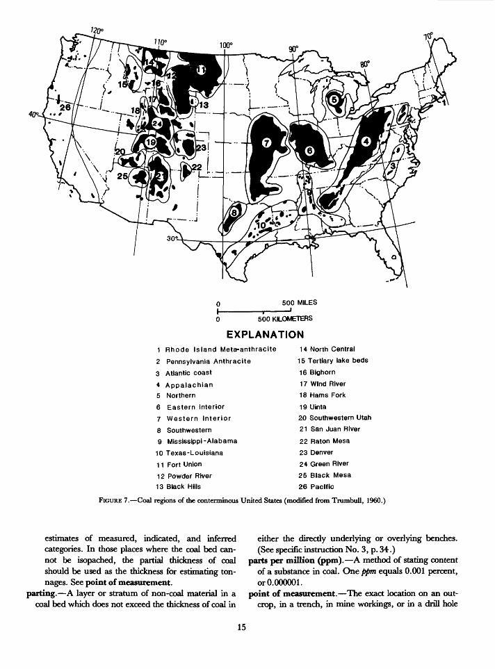
coal bed. See bed.coal field. A discrete area underlain by strata con
taining one or more coal beds. (See figs. 5 and 6.) coal measures. Strata containing one or more coal
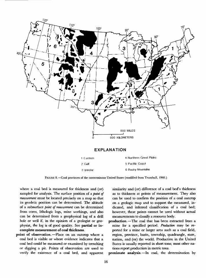
beds. coal province. An area containing two or more coal
regions. (See fig. 8.) coal region. An area containing one or more coal
fields. (See fig. 7.)coal reserves. See reserves. (See also reserves, p. 30.) coal zone. A series of laterally extensive and (or)
lenticular coal beds and associated strata that arbi trarily can be viewed as a unit. Generally, the coal beds in a coed zone are assigned to the same geologic member or formation.
coke. A gray, hard, porous, and coherent cellular- structured solid, primarily composed of amorphous carbon. Coke is combustible and is produced by de structive distillation or thermal decomposition of cer tain bituminous coal that passes through a plastic, state in the absence of air.
concentration. A greater than normal accumulation of substances such as (1) coal, (2) elements, (3) com pounds, and (4) minerals. In coal resource terminol ogy, concentration is used in two senses: (1) concen trations of coaly material into beds that are minable, and (2) concentrations of elements, compounds, and minerals that may add or detract from the value of the extracted coal. A concentration of a substance always exceeds the average content of that substance in the Earth's crust.
consolidated coal. See lignite.content. The amount of ash, an element, an oxide,
other types of compounds, or a mineral in a unit amount of coal, expressed in parts per million or per cent. Also refers to the heat value of coal as expressed in Joules per kilogram (J/kg), kilojoules per kilogram (kj/kg), British thermal units per pound (Btu/lb), or calories per gram (cal/g).
control point. A point of measurement, a point ofobservation, or a sampling point.
correlate, correlation. Demonstration of the appar ent continuity of a coal bed between control, meas urement, or sampling points by showing correspond ence in character and stratigraphic position. Discussion: Correlations of coal beds are based on a
knowledge of the stratigraphy of the coal beds and of the enclosing rocks and of the unique characteristics of individual coal beds. Con fidence in correlations increases as the knowl edge and abundance of data increases. Where a coal bed is continuously exposed along an out crop or strip-mine face, continuity of the coal bed becomes an established fact and not a correlation.
Where data indicate that correlation of a coal bed is possible or probable among data points within an area, an estimate of the resources of that coal bed can be made for the entire area. However, where a coal bed at single data point cannot be correlated with beds at other data points, or where there is only one data point, resources can be calculated for that coal bed us ing the single data point as the center of circles defining measured, indicated, and inferred.
cumulative depletion. The sum in tons of coal ex tracted and lost-in-mining to a stated date for a
8
specified area or a specified coal bed. (See cumulative depletion, p. 25; and fig. 3.)
cumulative production. The sum in tons of coal ex tracted to a stated date for a specified area or a speci fied coal bed. (See cumulative production, p. 25 ; and figs. 1,2, and 3.)
demonstrated. A term commonly used for the sum ofcoal classified as measured and indicated resources.Used when not feasible or desirable to subdivide intomeasured and indicated. (See figs. 1,2, and 3.)
demonstrated reserves. Same as reserves. (See also,demonstrated reserves, p. 25; and figs. 1, 2, and 3.)
demonstrated reserve base. Same as reserve base. (See also demonstrated reserve base, p. 25 ; and figs. 1 , 2, and 3.)
demonstrated resources. See resources. (See also,demonstrated resources, p. 25; and figs. 1, 2, and 3.)
density. Mass of coal per unit volume. Generally ex pressed in short tons/acre-foot or metric tons/hectare/ square hectometer-meter of coal. See specific gravity,
depleted resources. Resources that have been mined; includes coal recovered, coal lost-in-mining, and coal reclassified as subeconomic because of mining. See cumulative depletion. (See also cumulative deple- tion, p. 25; and fig. 3.)
depth (overburden) categories. Coal tonnage data are divided into classes by the thickness of over burden: 0-500 feet (0-150 m); 500-1,000 feet (150-300 m); 1,000-2,000 feet (300-600 m); 2,000-3,000 feet (600-900 m); and 3,000-6,000 feet (900-1,800m). See overburden. Discussion: The depth categories or overburden cate
gories (see table 3, and specific instruction No. 2, p. 33) were decided after consultation among personnel from the U.S. Geological Survey, the Bureau of Mines, and various State Geological Surveys, mining companies, and agencies of foreign nations.
dry, mineral-matter-free basis. A type of calculated analytical value of a coal sample expressed as if the total moisture and mineral matter had been removed. Mineral-matter-Jree is not the same as ash-free.
economic. This term implies that profitable extraction or production under defined investment assumptions has been established, analytically demonstrated, or assumed with reasonable certainty.
economic assessment. A critical analysis resulting in a judgment of the economic nature, significance, status, quantity, quality, market, demand, supply, costs, transportation, cash flow, capital, and proc essing of the coal resources of a mine, area, district,
field, basin, region, province, county, state, or na tion. See assessment.
estimate. A determination as to the amount or ton nage of coal in an area. The term estimate indicates that the quantities of resources are known impre cisely. An estimate differs from an assessment, which is an analysis of all data concerning an area's coal resources and reserves with the objective of reaching a judgment about the geologic nature and economic potential of the coal resources and reserves of the area.
existing market conditions. The relations between production, selling and transportation costs, supply, demand, and profit at any time.
extraction. The process of removing coal from adeposit.
feasibility. The possibility of extracting coal. fixed carbon. The solid residue, other than ash, ob
tained by destructive distillation of a coal, determined by definite prescribed methods (ASTM, 1981, p. 183).
floor. Stratigraphically, the rock immediately under lying a coal bed. Where the bed is overturned, the stratigraphic/700r is the mining roof.
gasification, underground (in situ). A method of utilizing coal by burning in place and extracting the released gases, tars, and heat. See in situ mining,
geologic assessment. A critical analysis resulting in a judgment of the geologic nature, significance, status, quality, and quantity of the coal resources of an area, district, basin, region, township, quad rangle, province, county, state or political province, nation, continent, or the world. See assessment and economic assessment.
geologic assurance. State of sureness, confidence, or certainty of the existence of a quantity of resources based on the distance from points where coal is meas ured or sampled and on the abundance and quality of geologic data as related to thickness of overburden, rank, quality, thickness of coal, area! extent, geologic history, structure, and correlations of coal beds and enclosing rocks. The degree of assurance increases as the nearness to points of control, abundance, and quality of geologic data increases.
geologic evidence. Information derived from geo logic observations that can be used to substantiate the existence, size, depth, attitude, structure, tonnage, and physical and chemical characteristics of a body of coal.
geologic identification. State of being identified as to location, area! extent or size, depth, volume, quan tity, magnitude, and quality of coal resources.
grade. A term indicating the nature of coal as mainly determined by the sulfur content and the amount and type of ash. This term is not recommended for usage in coal resource estimations; definitive statements as to the contents and types of sulfur and ash are prefer able. Statements indicating high, medium, or low grade are inappropriate without documentation. See quality.
heat value or heat of combustion. The amount of heat obtainable from coal expressed in British thermal units per pound, joules per kilogram, kilojoules or kilocalories per kilogram, or calories per gram. To convert Btu/lb to kcal/kg, divide by 1.8. To convert kcal/kgtoBtu/lb, multiply by 1.8.
hectare (ha) or square hectometer (hm2). A metric unit of area equal to 10,000 square meters; 0.010 square kilometer; 2.4710538 acres; 107,639.10 square feet; 11,959.9 square yards; 0.003861 square mile.
high-ash coal. Coal containing more than 15 percent total ash on an as-received basis. See ash-content, medium-ash coal, and low-ash coal.
high-sulfur coal. Coal containing 3 percent or more total sulfur on an as-received basis. See low-sulfur coal and medium-sulfur coal.
high-volatile bituminous coal. Three related rank groups of bituminous coal as defined by the American Society for Testing and Materials which collectively contain less than 69 percent fixed carbon on a dry, mineral-matter-free basis; more than 31 percent vola tile matter on a dry, mineral-matter-free basis; and a heat value of more than 10,500 Btu per pound on a moist, mineral-matter-free basis. (See table 1.)
hypothetical. A low degree of geologic assurance. Es timates of rank, thickness, and extent are based on assuming continuity beyond inferred. Estimates are made, not exceeding a specified depth beyond coal classed as inferred, by projection of thickness, sample, and geologic data from distant outcrops, trenches, workings, and drill holes. There are no measurement sites in areas of hypothetical coal. Used as a modifier to resource terms. See resources and undiscovered. (See also figs. 1,2, and 3.)
hypothetical resources. See Undiscovered Re sources, p. 20; (See also hypothetical resources, p. 25; and figs. 1, 2, and 3.)
identified resources. See Identified Resources, p. 19; (See also identified resources, p. 25; and figs. 1,2, and 3.)
impure coal. Coal having 25 weight percent or more, but less than 50 weight percent ash on the dry basis (ASTM, 1981, D-2796, p. 344). Impure coal having
more than 33 weight percent ash is excluded from re source and reserve estimates unless the coal is dean- able to less than 33 weight percent ash. See bone coal.
indicated. A moderate-degree of geologic assurance. Estimates of quantity, rank, thickness, and extent are computed by projection of thickness, sample, and geologic data from nearby outcrops, trenches, work ings, and drill holes for a specified distance and depth beyond coal dassed as measured. The assurance, although lower than for measured, is high enough to assume continuity between points of measurement. There are no sample and measurement sites in areas of indicated coal. However, a single measurement can be used to dassify coal lying beyond measured as indicated and to assign such coal to resource and reserve base categories (fig. 4). Used as a modifier to resource terms.
indicated reserves and indicated marginal reserves. See reserves and indicated. (See also indicated re serves and indicated marginal reserves, p. 25; and figs. 1,2, and 3.)
indicated reserves base and indicated marginal re serve base. See reserve base. (See also indicated reserve base, p 26, and figs. 1, 2, and 3.)
indicated resources. See Indicated Resources, p. 19. (See also indicated resources, p. 26; and figs. 1, 2, and 3.)
inferred. A low-degree of geologic assurance. Esti mates of quantity, rank, thickness, and extent are based on inferred continuity beyond measured and indicated for which there is geologic evidence. Esti mates are computed by projection of thickness, sample, and geologic data from distant outcrops, trenches, workings, and drill holes for a specified dis tance and depth beyond coal dassed as indicated. There are no sample and measurement sites in areas of inferred coal. However, a single measurement can be used to dassify coal lying beyond indicated as in
ferred and to assign such coal to inferred resource and inferred reserve base categories (fig. 4). Used as a modifier to resource terms.
inferred reserves and inferred marginal reserves. See subdivisions of reserves. (See also inferred re serves, p. 26 , and inferred marginal reserves, p. 26 ; and figs. 1,2, and 3.)
inferred reserve base. See reserve base. (See also inferred reserve base, p. 26; and figs. 1, 2, and 3.)
inferred resources. See Inferred Resources, p. 19. (See also inferred resources, p. 26; and figs. 1, 2, and 3.)
10
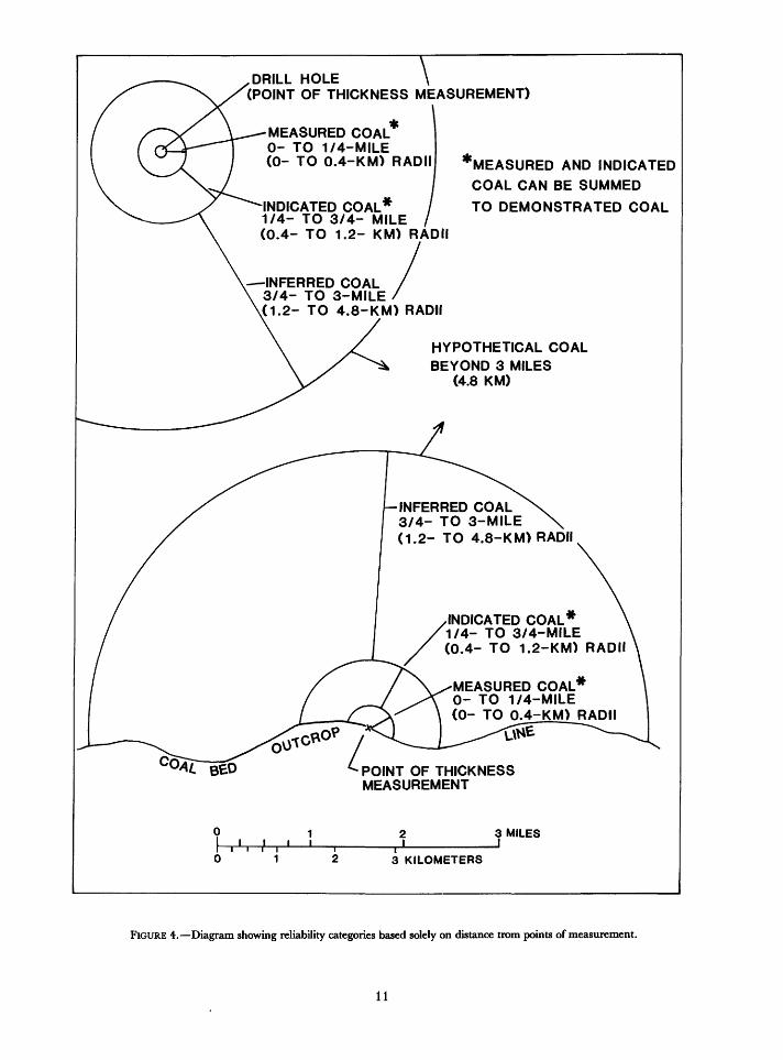
.DRILL HOLE \ '(POINT OF THICKNESS MEASUREMENT)
MEASURED COAL 0- TO 1/4-MILE (0- TO 0.4-KM) RADII
-INDICATED COAL* 1/4- TO 3/4- MILE / (0.4- TO 1.2- KM) RADII
-INFERRED COAL 3/4- TO 3-MILE
v(1.2- TO 4.8-KM) RADII
HYPOTHETICAL COAL BEYOND 3 MILES
(4.8 KM)
"MEASURED AND INDICATED
COAL CAN BE SUMMED
TO DEMONSTRATED COAL
INFERRED COAL3/4- TO 3-MILE(1.2- TO 4.8-KM) RADII
INDICATED COAL* 1/4- TO 3/4-MILE (0.4- TO 1.2-KM) RADII
MEASURED COAL*0- TO 1/4-MILE(0- TO 0.4-KM) RADII
POINT OF THICKNESS MEASUREMENT
0I .',.'.'0 1
1 2
2 3 KILOMETERS
3 MILES
FIGURE 4. Diagram showing reliability categories based solely on distance irom points of measurement.
11
inferred subeconomic resources. See Inferred Subeconomic Resources, p. 20. (See also inferred sub- economic resources, p. 31; and figs. 1, 2, and 3.)
in situ. Refers to coal "in place" in the ground.in situ mining. Utilization of coal by burning in place
and extracting the gases, tars, and heat.joule (J). The basic metric unit of work or energy
equal to 1 x 10⁷ ergs, 0.238662 gram calorie, 0.0002386 kilogram-calorie, or 0.0009471 Btu.
kilogram-calorie (kcal). A metric unit of heat equal to 1,000 gram-calories; 3.9683207 Btu; 4,184 Joules; 4.184,-x 1010 ergs; or 4,184 Watt seconds. Also known as "large calorie.''
kilogram (kg). The basic metric unit of weight meas urement equal to 1,000 grams; 0.001 metric ton; 2.2046 pounds; 0.0011023 short ton; 0.0009842 long ton.
kilojoule (kj). A metric unit of work or energy equal to 1,000 joules; 0.948708 Btu; or 238.662 gram- calories.
known coal. Coal whose existence has been perceived from measurements and observations at the outcrop, in mines, from drill holes, and from exploratory trenches. Data confirming existence may be projected for several miles (kilometers) if based upon reasonable geologic assumptions. See identified resources. Coal fields, basins, regions, provinces, and occurrences of coal in the United States are illustrated in figures 5, 6, 7, and 8.
lignite or lignitic. A class of brownish-black, low- rank coal defined by the American Society for Testing and Materials as having less than 8,300 Btu on a moist, mineral-matter-free basis. (See table 1.) In the United States, lignite is separated into two groups: Lignite A (6,300 to 8,300 Btu) and lignite B (<6,300 Btu). Lignite is the preferred usage.
long ton. A unit of weight in the U.S. Customary System and in the United Kingdom equal to 2,240 pounds (1.0160469 metric tons; 1.1200 short tons; 1,016.0469 kilograms). This term is not recom mended for use in estimates of coal resources.
lost-in-mining. Coal remaining in the ground after all extraction is completed. Lost-in-mining includes coal that is (1) left to support mine roofs, (2) too thin to mine, (3) unmined around oil, gas, water, and dis posal wells, (4) unmined around shafts and electrical and water conduits, (5) unmined as barrier pillars ad jacent to mine or property boundaries, (6) unmined adjacent to haulageways, tunnels, airways, and waterways, (7) unmined because of many other un specified reasons, (8) the unrecovered or unrecover able part of any coal bed in a mining property that has
been or may be extracted, (9) all unrecoverable in beds that closely overlie a mined bed, (10) all unre coverable in beds that closely underlie a mined bed, (11) unmined between mining properties. Discussion: According to this system of classification,
lost-in-mining equals reserve base minus reserves and marginal reserves. Thus, lost-in-mining includes all reserve base coal not economically recoverable at the time of classification or not bordering on be ing economically recoverable. Lost-in-mining coal is subtracted from the reserve base and is divisible into subeconomic coal or noneconomic coal accord ing to its potential for being reclassified as eco nomic. (See fig. 3.)
low-ash coal. Coal containing less than 8 percent total ash on an as-received basis. See ash content, high- ash coal, and medium-ash coal.
low-sulfur coal. Coal containing 1 percent or less total sulfur on an as-received basis. See high-sulfur coal and medium-sulfur coal.
low-volatile bituminous coal. A rank group of bitu minous coal as defined by the American Society for Testing and Materials containing more than 78 per cent and less than 86 percent fixed carbon, and more than 14 percent and less than 22 percent volatile mat ter on a dry, mineral-matter-free basis. (See table 1.)
marginal reserves. Borders on being economic. See economic; general guideline no. 8, p. 32; and sub divisions of reserves. (See also indicated marginal reserves and measured marginal reserves, p. 25 and 27; and figs. 1,2, and 3.)
measured. The highest-degree of geologic assurance. Estimates of quantity are computed partly from di mensions revealed in outcrops, trenches, workings, and drill holes and partly by projection of thickness, sample, and geologic data not exceeding a specified distance and depth. Rank is calculated from the results of detailed sampling that may be located at some distance from this type of resource and may be on the same or other coal beds. The sites for thickness measurement are so closely spaced and the geologic character so well defined that the average thickness, areal extent, size, shape, and depth of coal beds are well established. However, a single measurement can be used to classify nearby coal as measured (fig. 4). Used as a modifier to resource terms.
measured reserves and measured marginal re serves. See subdivisions of reserves. (See also measured reserves, p. 27; measured marginal reserves; p. 27; and figs. 1,2, and 3.)
measured reserve base. See reserve base. (See also measured reserve base, p. 27; and figs. 2 and 3.)
12
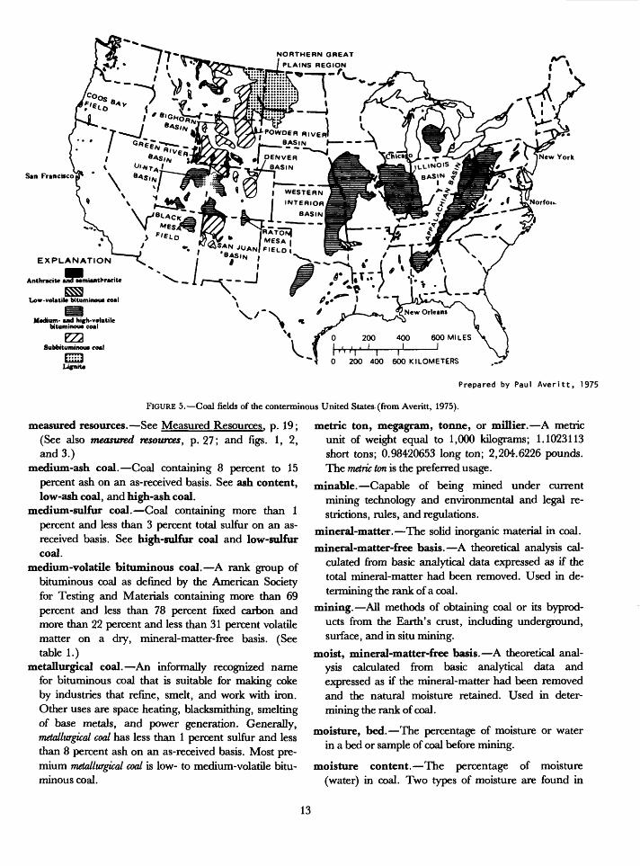
NORTHERN GREAT
PLAINS REGION r\
San Francisco
EXPLANATION
Anthracite andMmianthraciU
BS3Low-volatile bituminoua coal
Medium- and hi(h-v*latile bituminoua coal
EZ2Subbituminoua coal
EH3 400 600 KILOMETERS
Prepared by Paul Averitt, 1975
FIGURE 5. Coal fields of the conterminous United States (from Averitt, 1975).
measured resources. See Measured Resources, p. 19; (See also measured resources, p. 27; and figs. 1, 2, and 3.)
medium-ash coal. Coal containing 8 percent to 15 percent ash on an as-received basis. See ash content, low-ash coal, and high-ash coal.
medium-sulfur coal. Coal containing more than 1 percent and less than 3 percent total sulfur on an as- received basis. See high-sulfur coal and low-sulfur coal.
medium-volatile bituminous coal. A rank group of bituminous coal as defined by the American Society for Testing and Materials containing more than 69 percent and less than 78 percent fixed carbon and more than 22 percent and less than 31 percent volatile matter on a dry, mineral-matter-free basis. (See table 1.)
metallurgical coal. An informally recognized name for bituminous coal that is suitable for making coke by industries that refine, smelt, and work with iron. Other uses are space heating, blacksmithing, smelting of base metals, and power generation. Generally, metallurgical coal has less than 1 percent sulfur and less than 8 percent ash on an as-received basis. Most pre mium metallurgical coal is low- to medium-volatile bitu minous coal.
metric ton, megagram, tonne, or millier. A metric unit of weight equal to 1,000 kilograms; 1.1023113 short tons; 0.98420653 long ton; 2,204.6226 pounds. The metric ton is the preferred usage.
minable. Capable of being mined under current mining technology and environmental and legal re strictions, rules, and regulations.
mineral-matter. The solid inorganic material in coal.
mineral-matter-free basis. A theoretical analysis cal culated from basic analytical data expressed as if the total mineral-matter had been removed. Used in de termining the rank of a coal.
mining. All methods of obtaining coal or its byprod ucts from the Earth's crust, including underground, surface, and in situ mining.
moist, mineral-matter-free basis. A theoretical anal ysis calculated from basic analytical data and expressed as if the mineral-matter had been removed and the natural moisture retained. Used in deter mining the rank of coal.
moisture, bed. The percentage of moisture or water in a bed or sample of coal before mining.
moisture content. The percentage of moisture (water) in coal. Two types of moisture are found in
13
vBarrow EXPLANATION
EAGLE FIELD
"SiRVIS CREEK
PASS FIELD FIELD
Subbituminout coal and lignite
xIsolated occurrence of coal of
unknown extent A. Antkraeitt 8, Bituntinout S, SuMttumimnu L. Lignite
0 100 200 300 MILES
cBrA«?^ER ° 100 200 300 KILOMETERS
Prepared by F F Barnes. 1959
FIGURE 6. Coal fields of Alaska (from Averitt, 1975).
coal, namely, free or surface moisture removed by ex posure to air, and inherent moisture entrapped in the coal and removed by heating to 220°F.
noneconomic. Not capable of profitable production or extraction. Coal classified as noneconomic may be re ported in other occurrences. See other occurrences, noneconomic coal, p. 27.
original. The amount of coal resources in the ground before production.
original resources. See Original Resources, p. 19; and original resources. (See also original resources, p. 27; and figs. 1,2, and 3.)
other occurrences. Coal in the ground that is ex cluded from classification as coal resources. Includes anthracite and bituminous coal less than 14 inches thick, subbituminous coal and lignite less than 30 inches thick, and any coal more than 6,000 feet deep unless it is currently being mined. May include coal that contains more than 33 percent ash. (See other oc currences, noneconomic coal, p. 27; and figs. 1 and 2.)
overburden. Rock including coal and (or) uncon- solidated material that overlies a specified coal bed. Overburden is reported in feet and (or) meters and used to classify the depth to an underlying coal bed.
partial or incomplete measurement of coal thick ness. A determination of an incomplete coal thick ness at a point of measurement.Discussion: Measurements of coal thicknesses that are
incomplete because of (1) near surface slumping of coal and overlying beds, (2) weathering, (3) a drill hole not penetrating the entire coal bed, (4) iden tified planar erosion of top part of coal bed, or (5) removal of most of a coal bed by a stream chan nel are to be treated as points of measurement from which circles of reliability are to be constructed. A geologist must decide whether each measurement is complete or incomplete. The thickness of coal at places where a measurement is deemed incomplete shall be located on the coal bed map by the number of feet and inches actually measured followed by a plus sign to indicate that only a part of the bed was measured. Thus, incomplete measurements define measured coal of a stated minimum thickness. If other thickness data are available to show by iso- paching that a coal thickness is incomplete at a point of measurement, the isopached total thick ness at the point of measurement should be used to determine the average thickness for the tonnage
14
500 MILES
0 500 KILOMETERS
EXPLANATION1 Rhode Island Meta-anthracite 14 North Central
15 Tertiary lake beds
16 Bighorn
17 Wind River
18 Hams Fork
19 Uinta
20 Southwestern Utah
21 San Juan River
22 Raton Mesa
23 Denver
24 Green River
2 Pennsylvania Anthracite
3 Atlantic coast
4 Appalachian
5 Northern
6 Eastern Interior
7 Western Interior
8 Southwestern
9 Mississippi-Alabama
10 Texas-Louisiana
11 Fort Union
12 Powder River
13 Black Hills
25 Black Mesa
26 Pacific
FIGURE 7. Coal regions of the conterminous United States (modified from Trumbull, 1960.)
estimates of measured, indicated, and inferred either the directly underlying or overlying benches.categories. In those places where the coal bed can not be isopached, the partial thickness of coal should be used as the thickness for estimating ton nages. See point of measurement,
parting. A layer or stratum of non-coal material in a coal bed which does not exceed the thickness of coal in
(See specific instruction No. 3, p. 34.)parts per million (ppm). A method of stating content
of a substance in coal. One ppm equals 0.001 percent, or 0.000001.
point of measurement. The exact location on an out crop, in a trench, in mine workings, or in a drill hole
15
10°
500 KILOMETERS
EXPLANATION
1 Eastern
2 Gulf
3 Interior
4 Northern Great Plains
5 Pacific Coast
6 Rocky Mountains
FIGURE 8. Coal provinces of the conterminous United States (modified from Trumbull, 1960.)
where a coal bed is measured for thickness and (or) sampled for analysis. The surface position of a point of measurement must be located precisely on a map so that its geodetic position can be determined. The altitude of a subsurface point of measurement can be determined from cores, lithologic logs, mine workings, and also can be determined from a geophysical log of a drill hole or well if, in the opinion of a geologist or geo- physist, the log is of good quality. See partial or in complete measurement of coal thickness,
point of observation. Place on an outcrop where a coal bed is visible or where evidence indicates that a coal bed could be measured or examined by trenching or digging a pit. Points of observation are used to verify the existence of a coal bed, and apparent
similarity and (or) difference of a coal bed's thickness as to thickness at points of measurement. They also can be used to confirm the position of a coal outcrop on a geologic map and to support the measured, in dicated, and inferred classification of a coal bed; however, these points cannot be used without actual measurements to classify a resource body.
production. The coal that has been extracted from a mine for a specified period. Production may be re ported for a mine or larger area such as a coal field, region, province, basin, township, quadrangle, state, nation, and (or) the world. Production in the United States is usually reported in short tons; most other na tions report production in metric tons.
proximate analysis. In coal, the determination by
16
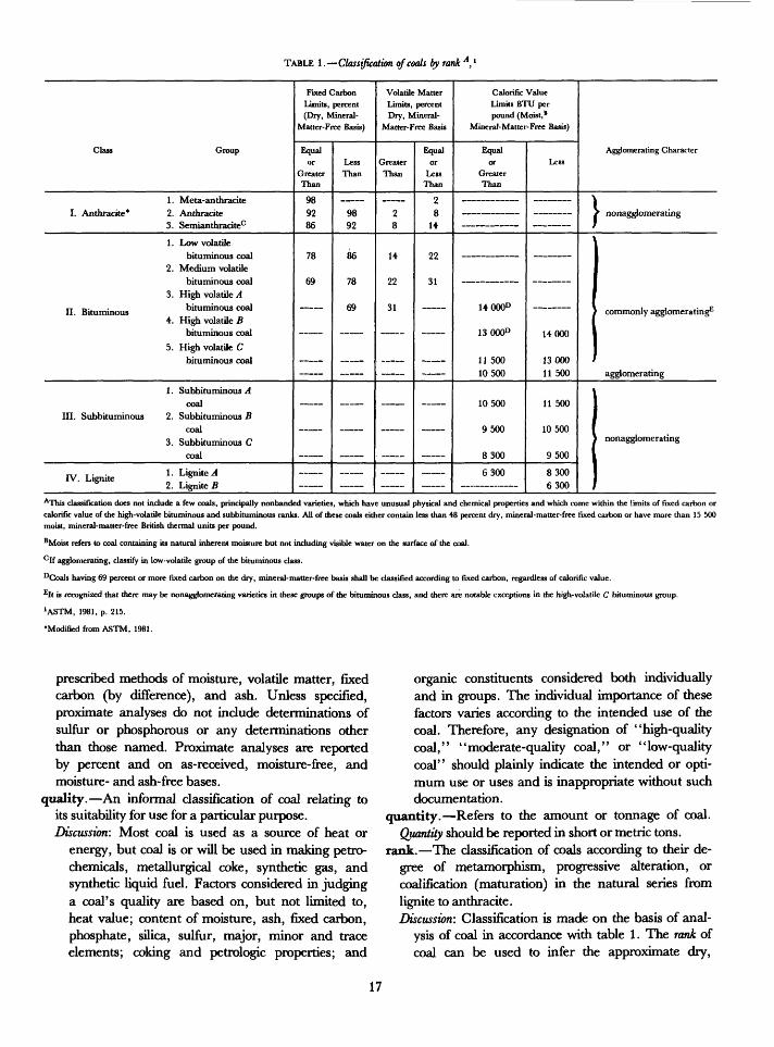
TABLE 1. Classification of coals by rank A, l
Class Group
1. Meta-anthracite I. Anthracite* 2. Anthracite
3. Semianthracitec
1 . Low volatilebituminous coal
2. Medium volatile bituminous coal
3. High volatile A II. Bituminous bituminous coal
4. High volatile B bituminous coal
5. High volatile C bituminous coal
1 . Subbituminous Acoal
III. Subbituminous 2. Subbituminous Bcoal
3. Subbituminous C coal
, T . . 1 . Lignite A IV. Lignite 6
2. Lignite B
Fixed CarbonLimits, percent (Dry, Mineral-
Matter-Free Basis)
Equal or
GreaterThan
98 92 86
78
69
_
LessThan
98
92
86
78
69
_
Volatile MatterLimits, percent Dry, Mineral-
Matter-Free Basis
GreaterThan
2 8
14
22
31
~
Equal or
LessThan
2 8
14
22
31
_
Calorific ValueLimits BTU per pound (Moist, 8
Mineral-Matter-Free Basis)
Equal or
GreaterThan
________
___________
14000°
13000°
11 50010500
10500
9500
8300
6300
Less
_____
_______
14000
1300011 500
11 500
10500
9500
8300 6300
Agglomerating Character
/ nonagglomerating
commonly agglomerating
agglomerating
nonagglomerating
AThis classification does not include a few coals, principally nonbanded varieties, which have unusual physical and chemical properties and which come within the limits of fixed carbon or calorific value of the high-volatile bitununous and subbituminous ranks. All of these coals either contain less than 48 percent dry, mineral-matter-free fixed carbon or have more than 15 500 moist, mineral-matter-free British thermal units per pound.
BMoist refers to coal containing its natural inherent moisture but not including visible water on the surface of the coal.
clf agglomerating, classify in low-volatile group of the bituminous class.
°Coals having 69 percent or more fixed carbon on the dry, mineral-matter-free basis shall be classified according to fixed carbon, regardless of calorific value.
EIt is recognized that there may be nonagglomerating varieties in these groups of the bituminous class, and there are notable exceptions in the high-volatile C bituminous group.
'ASTM, i98i, p. 215. Modified from ASTM, 1981.
prescribed methods of moisture, volatile matter, fixed carbon (by difference), and ash. Unless specified, proximate analyses do not include determinations of sulfur or phosphorous or any determinations other than those named. Proximate analyses are reported by percent and on as-received, moisture-free, and moisture- and ash-free bases.
quality. An informal classification of coal relating to its suitability for use for a particular purpose. Discussion'. Most coal is used as a source of heat or
energy, but coal is or will be used in making petro chemicals, metallurgical coke, synthetic gas, and synthetic liquid fuel. Factors considered in judging a coal's quality are based on, but not limited to, heat value; content of moisture, ash, fixed carbon, phosphate, silica, sulfur, major, minor and trace elements; coking and petrologic properties; and
organic constituents considered both individually and in groups. The individual importance of these factors varies according to the intended use of the coal. Therefore, any designation of "high-quality coal," "moderate-quality coal," or "low-quality coal" should plainly indicate the intended or opti mum use or uses and is inappropriate without such documentation.
quantity. Refers to the amount or tonnage of coal.Quantity should be reported in short or metric tons.
rank. The classification of coals according to their de gree of metamorphism, progressive alteration, or coalification (maturation) in the natural series from lignite to anthracite.Discussion: Classification is made on the basis of anal
ysis of coal in accordance with table 1. The rank of coal can be used to infer the approximate dry,
17
mineral-matter-free heat value, fixed carbon, and volatile matter in a coal, because the amounts of the constituents vary little within each coal rank. (See table 1; and rank calculation, p. 28 .)
rank calculation. The determination of the rank ofa coal. Such determination must use the instructionsgiven under rank calculation, p. 28.
recoverable coal. The coal that is or can be ex tracted from a coal bed during mining. The term "re coverable" should be used in combination with "re sources" and not with "reserves."
recovery percent. The percentage of coal extracted from a bed where the total tonnage originally in the bed is equal to 100 percent.
recovery factor. The estimated or actual percentage of coal that can be or was extracted from the coal orig inally in a bed or beds for an area, mine, district, field, basin, region, province, township, quadrangle, county, state, political province, nation, and (or) the world. See recoveryfactor method, p. 28.
reliability categories. Categories based on distance from points of measurement and (or) sampling. The measured, indicated, inferred, and hypothetical resource categories, as defined, indicate the relative reliability of tonnage estimates as related to distance from points of thickness control of particular parts of a coal deposit. The reliability categories are not indicative of the reliability of the basic data (that is, the accuracy of coal measurements, or the accuracy of location of the coal outcrop). It is assumed that all basic data used in resource estimation have been judged reliable by the estimator and that unreliable data have been discarded. (See fig. 4.)
reserves. Virgin and (or) accessed parts of a coal re serve base which could be economically extracted or produced at the time of determination considering en vironmental, legal, and technologic constraints. The term reserves need not signify that extraction facilities are in place or operative. Reserves include only recov erable coal; thus, terms such as "extractable reserves" and "recoverable reserves" are redundant and are not a part of this classification system. (See figs. 1 and 3; and reserves, p. 30-)
Discussion: Reserves can be categorized as measured and indicated, as underground or surface minable, by thickness of overburden, by thickness of coal in the bed, and by various quality factors. The term "economic reserves" is not to be used because reserves by definition are economic. Reserves, which are derived from reserve base coal, exclude coal thinner or deeper than that classified as reserve
base unless such coal is currently mined. See gen eral guideline No. 7, p. 32.
MANDATORY SUBDIVISIONS: A. Indicated Reserves and Indicated Marginal
Reserves. Categories of virgin reserves having a moderate degree of geologic assurance. See in dicated and marginal reserves. (See also reserves, p. 30; and figs. 1 and 3.)
B. Inferred Reserves and Inferred Marginal Re serves. Categories of virgin reserves having a low degree of geologic assurance. See inferred reserves and marginal reserves. (See also reserves; p. 30; and figs. 1 and 3.)
C. Measured Reserves and Measured Marginal Reserves. Categories of accessed and virgin coal reserves having the highest degree of geo logic assurance. See measured reserves and marginal reserves. (See also figs. 1 and 3.)
OPTIONAL SUBDIVISIONS:A. Reserves and Marginal Reserves.
Reserves may be divided into subcategories other than those heretofore defined. These subcategories may be differentiated, for example, by ash and sulfur content, and heat value; by types or varieties of coal such as boghead or cannel coal; by usage such as metallurgical, petrochemical, and synthetic fuel types; by mineral ownership such as State, Federal, Indian, or private ownership; by Federal coal underlying private surface ownership; and by reserves and restricted reserves underlying State or national parks, monuments, forests, grasslands; military and naval reservations, alluvial valley floors, steep slopes, lakes and large rivers, and en vironmentally protected areas. 1. Restricted Reserves and Restricted Marginal
Reserves. Those parts of any reserve category that are restricted or prohibited by laws or regulations from extraction by underground and (or) surface mining.Discussion: For example, coal in a national
park may meet all the physical, chemical and economic requirements of a reserve but is prohibited from extraction. The assignment to a restricted category may be either tem porary or permanent; however, because laws and regulations can be repealed or changed, such coal should be separately distinguished, and tonnage .estimates recorded as a restricted reserve. Locally, a specific regulation or law might prohibit one method of mining and allow or not specify other methods. In such a circumstance, the coal would be restricted
18
from mining by the prohibited method and tonnage estimates would be so recorded. In other circumstances, other methods would be unrestricted, and tonnage estimates would be reported accordingly.
The separation of coal reserves into the many different subcategories listed above and other subcategories not listed in this text is desirable and encouraged. All subcategories not listed should be defined dearly and ex plicitly so that other resource specialists and the public will not be confused.
reserve base. Those parts of the identified resources that meet specified minimum physical and chemical criteria related to current mining and production prac tices, including those for quality, depth, thickness, rank, and distance from points of measurement. (See
reliability categories; and figs. 2 and 3.) The reserve base is the in-place demonstrated (measured plus indicated) resource from which reserves are estimated. The reserve base may encompass those parts of a resource that have a reasonable potential for becoming economically available within planning horizons beyond those that assume proven technology and current economics. The reserve base includes those resources that are currently economic (reserves), marginally economic (marginal reserves), some of those that are currently subeconomic (subeconomic resources), and some of the resources that have been or will be lost-in-mining but whose attributes indicate possible future recovery. The term "geologic reserve" has been applied by others to the reserve base category, but it also may include the inferred reserve base category; it is not a part of this classification system. (See reserve base, p. 29; and figs. 2 and 3.)
reserve base, inferred. The in-place part of an iden tified resource from which inferred reserves and inferred marginal reserves are estimated. Quantitative estimates are based largely on knowledge of the geologic character of a coal deposit for which there are no samples or measurements. The estimates are based on an assumed continuity beyond the reserve base for which there is geologic evidence. (See figs. 2 and 3.)
resources. Naturally occurring concentrations or deposits of coal in the Earth's crust, in such forms and amounts that economic extraction is currently or poten tially feasible. (See resources, p. 30 ; and figs. 1, 2, and 3.)
MANDATORY SUBDIVISIONS:
A. Hypothetical Resources. See Undiscovered Resources (p. 20). (See also hypothetical resources, p. 25; and figs. 1, 2, and 3.)
B. Identified Resources. Resources whose loca tion, rank, quality, and quantity are known or esti mated from specific geologic evidence. (See iden tified resources, p. 25). Identified coal resources include economic, marginally economic, and sub- economic components. To reflect varying distances from points of control or reliability, these subdivi sions can be divided into demonstrated and in ferred, or preferably into measured, indicated, and inferred. (See identified resources, p. 25; and figs. 1,2, and 3.)Discussion: Identified resources may be accessed and
(or) in bodies of virgin coal which are assigned to resource and reserve base subcategories on the basis of geologic evidence from maps, samples, drill holes, wells, mine records, and fieldwork. Specific evidence must include data on the location, thickness of overburden, distance from points of measurement or sam pling, and extent and thicknesses of the re source bodies. Evidence about quality and rank may be determined from analyses of samples collected from the resource bodies or may be inferred by projection of analytical data obtained elsewhere in the body or from adjacent bodies. An identified resource body may contain reserves, marginal reserves, in ferred reserves, inferred marginal reserves, reserve base, inferred reserve base, demon strated resources, measured resources, indi cated resources, inferred resources, subeco nomic resources and inferred subeconomic resources. (See figs. 1, 2, and 3.)
C. Indicated Resources. Identified bodies of virgin coal having a moderate degree of geologic assurance. See indicated. (See also indicated resources, p. 26; and figs. 1, 2, and 3.)
D. Inferred Resources. Identified bodies of virgin coal having a low degree of geologic assurance. See inferred resources. (See also in
ferred resources, p. 26; and figs. 1,2, and 3.) E. Measured Resources. Accessed and virgin
demonstrated resources having a high degree of geologic assurance. (See measured resources, p. 27; and figs. 1,2, and 3.)
F. Original Resources. The amount of coal in- place before production. Where mining has oc curred, the total of original resources is the sum of the identified resources, undiscovered resources, coal produced, and coal lost-in-mining. (See original resources, p. 27; and figs. 1, 2, and 3.)
G. Remaining Resources. The resources in the
19
ground in a mine, area, field, basin, region, province, county, state, and (or) nation after some mining. The term does not include coal lost-in-mining unless such coal can be considered potentially recoverable. Remaining resources may be divided into categories such as remaining economic, marginally economic, subeconomic, measured, indicated, inferred, identified, and undiscovered (hypothetical and speculative) resources or other types of resources. (See op tional subdivisions, below; and figs. 1,2, and 3.) The total remaining resources are the sum of the remaining identified and undiscovered resources as of the date of the estimate.
H. Subeconomic Resources. That part of identified (demonstrated) resources that does not meet the economic criteria of reserves and marginal reserves. See resources and economic. (See also subeconomic resources, p. 31; and figs, land 2.)
I. Inferred Subeconomic Resources. That part of identified (inferred) resources that does not meet the economic criteria of inferred reserves or inferred marginal reserves. See resources and economic. (See also subeconomic resources, p. 31; and figs. 1 and 2.)
J. Speculative Resources. See Undiscovered Resources (below). (See also speculative resources, p. 30; and figs. 1, 2 and 3.)
K. Undiscovered Resources. Undiscovered resources, the existence of which is only postu lated, comprise deposits that are either separate from or are extensions of identified resources. Undiscovered resources may be postulated in deposits of such quality, rank, quantity, and physical location as to render them economic, marginally economic, or subeconomic. To re flect varying degrees of geologic certainty, undis covered resources may be subdivided into two parts as follows. (See undiscovered resources, p. 31.) 1. Hypothetical Resources. A class of un
discovered resources that are either similar to known coal deposits which may be reasonably expected to exist in the same coal field or region under analagous geologic conditions or are an extension from inferred resources. In general, hypothetical resources are in the central parts of broad areas of coal fields where points of sampling and measurement and evidence for thickness and existence is from distant out crops, mine workings, drill holes, and wells. If exploration confirms the existence of hypo
thetical resources and reveals enough informa tion about their quality, quantity, and rank, they will be reclassified as identified resources.
2. Speculative Resources. A class of un discovered resources that may occur either in known types of deposits in favorable geologic settings where coal deposits have not been discovered or in types of deposits as ye,t unrecognized for their economic potential. Jf exploration confirms the existence of specula tive resources and reveals enough information about their quality, quantity, and rank, they will be reclassified as identified resources.
OPTIONAL SUBDIVISONS:
Resources may be divided into subcategories, for example, on the basis of ash content, sulfur con tent, and heat value; type or variety of coal such as boghead or cannel coal; usage such as metal lurgical, petrochemical, and synthetic fuel types; resources underlying specified lands owned by State governments, the Federal Government, or private interests; by restricted resources under lying State or national parks, monuments, forests, grasslands; military, naval, and Indian reservations; and alluvial valley floors, steep slopes, lakes and large rivers, and environmen tally protected areas.
A. Restricted Resources. Those parts of any resource category that are restricted or pro hibited from extraction by laws or regulations. Discussion: Restricted resources meet all re
quirements of coal classified as resources, ex cept that they are restricted from extraction by law or regulation. The assignment to a re stricted category may be either temporary or permanent, but, because laws and regulations can be repealed or changed, such coal should be separately distinguished and tonnage esti mates recorded as restricted resources.
The division of coal resources into the many different categories described heretofore and into other categories not differentiated in the text is desirable and encouraged. Many re quests for information about resources are received by coal resource specialists and are unanswerable because the scopes of the systems of classification used in the past were too limited. Persons and institutions classify ing resources are, therefore, encouraged to use initiative in defining and developing addi tional classes of coal resources.
20

restricted reserves. See optional subdivisions ofreserves,
restricted resources. See optional subdivisions ofresources.
roof. Stratigraphically, in underground mining the rock immediately overlying a coal bed. Where a bed is overturned, the stratigraphic roof is the mining floor.
sample. A representative fraction of a coal bed col lected by approved methods, guarded against con tamination or adulteration, and analyzed to deter mine the nature; chemical, mineralogic, and (or) petrographic composition; percentage or ppm content of specified constituents; heat value; and possibly the reactivity of the coal or its constituents. Discussion: Some samples are also collected so that
fossil remains can be ascertained and physical, magnetic, or other geophysical properties can be determined, tested, observed, or analyzed. All samples should be accompanied by a description of the sample, including location, thickness of coal, and stratigraphic relationship to other'rocks.
TYPES OF SAMPLES:
A. as-received sample. A sample of coal as itis received at a laboratory.
B. bed or channel sample. A sample of coal col lected from a channel cut perpendicular to the stratification.Discussion: This type of sample is used to ascer
tain the chemistry, rank of coal, mineralogy, petrography, and geophysical and physical properties of coal. Instructions for this type of sampling are contained in Geological Survey Circular 735 (Swanson and Huffman, 1976, p. 2).
C. bench sample. A sample of a subdivision and (or) layer of a coal bed separated from other subdivisions by partings of non-coal rock. Discussion: The term bench sample does not
apply to coal lithotypes such as vitrinite and exinite as used by petrologists.
D. blend pile sample. A sample of coal collected from the blend-pile of a processing plant or a utilization facility such as a powerplant or steel mill.
E. breaker sample. A sample of coal broken or crushed in a breaker plant. A breaker sample is usually collected prior to cleaning of coal.
F. cleaned coal sample. A sample of coal col lected after use of a cleaning procedure.
G. core sample. A sample of coal recovered
from a core which was obtained at depth by a coring device in a drill hole.
H. cutting sample. A sample of coal taken from the cuttings returned during drilling. Discussion: Cutting samples are not recommended
because many comparisons with properly or conventionally collected samples indicate they are rarely representative.
I. delivered coal sample. A sample of coal col lected from a shipment that is being or will be delivered to a user.
J. grab sample. A sample, commonly a single piece, selected from a coal bed, tipple, prepara tion plant, blend pile, conveyor belt, or coal car. Discussion: Grab samples are not recommended
because many comparisons with properly col lected samples indicate they are rarely representative.
K. mine sample. A sample of coal collected from a mine, generally from an underground working face or from a strip-wall face.
L. run of mine or mine run sample. Generallythe same as a tipple sample.
M. tipple sample. A sample of coal collected ata mine tipple.
seam. A bed of coal lying between a roof and floor. This term is not to be used in place of "coal bed" in reports of the U.S. Geological Survey.
short ton. A unit of weight equal to 2,000 pounds; 0.9071847 metric ton, tonne, or megagram; 0.892857 Hong ton.
specific gravity of coal. The ratio of the mass of a unit colume of coal to the mass of an equal volume of water at 4°C.Discussion: The specific gravity of coal varies considerably
with rank and with differences in ash content. The values shown in table 2 are close to the average specific gravities of unbroken or unmined coal in the ground (in situ) for the four major rank cate gories and are to be used in preparing U.S. Geo logical Survey estimates of coal resources and reserves.
Persons associated with individual mining oper ations sometimes use lower specific gravity factors to allow for anticipated losses in extraction. Such usage may be suitable for specific mine areas but is not recommended for use in general reports be cause the recoverability of coal varies greatly between areas, beds, mining methods, and mine operators.
speculative. Lowest degree of geologic assurance. Estimates of rank, thickness, and extent are based on
21
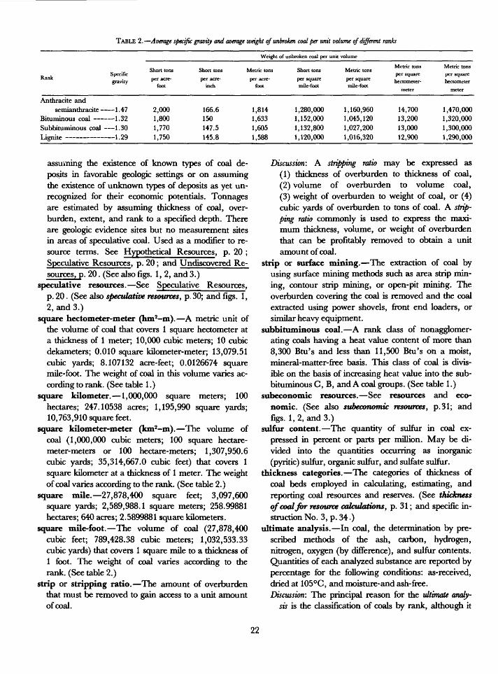
TABLE 2. Average specific gravity and average weight of unbroken coal per unit volume of different ranks
Weight of unbroken coal per unit volume
RankSpecific gravity
Anthracite and semianthracite 1 .47
Bituminous coal 1.32 Subbituminous coal 1.30T iemi<-*» ______ _ 1 OQ
Short tons
per acre- foot
2,000 1,800 1,770 1,750
Short tons
per acre- inch
166.6 150 147.5 145.8
Metric tons
per acre- foot
1,814 1,633 1,605 1,588
Short tons
per square mile-foot
1,280,000 1,152,000 1,132,800 1,120,000
Metric tons
per square mile-foot
1,160,960 1,045,120 1,027,200 1,016,320
Metric tons per square hectometer-
meter
14,700 13,200 13,000 12,900
Metric tons per square hectometer
meter
1,470,000 1,320,000 1,300,000 1,290,000
assuming the existence of known types of coal de posits in favorable geologic settings or on assuming the existence of unknown types of deposits as yet un recognized for their economic potentials. Tonnages are estimated by assuming thickness of coal, over burden, extent, and rank to a specified depth. There are geologic evidence sites but no measurement sites in areas of speculative coal. Used as a modifier to re source terms. See Hypothetical Resources, p. 20 ; Speculative Resources, p. 20; and Undiscovered Re sources, p. 20. (See also figs. 1, 2, and 3.)
speculative resources. See Speculative Resources, p. 20. (See also speculative resources, p. 30; and figs. 1, 2, and 3.)
square hectometer-meter (hm2-m). A metric unit of the volume of coal that covers 1 square hectometer at a thickness of 1 meter; 10,000 cubic meters; 10 cubic dekameters; 0.010 square kilometer-meter; 13,079.51 cubic yards; 8.107132 acre-feet; 0.0126674 square mile-foot. The weight of coal in this volume varies ac cording to rank. (See table 1.)
square kilometer. 1,000,000 square meters; 100 hectares; 247.10538 acres; 1,195,990 square yards; 10,763,910 square feet.
square kilometer-meter (km2-m). The volume of coal (1,000,000 cubic meters; 100 square hectare- meter-meters or 100 hectare-meters; 1,307,950.6 cubic yards; 35,314,667.0 cubic feet) that covers 1 square kilometer at a thickness of 1 meter. The weight of coal varies according to the rank. (See table 2.)
square mile. 27,878,400 square feet; 3,097,600 square yards; 2,589,988.1 square meters; 258.99881 hectares; 640 acres; 2.5899881 square kilometers.
square mile-foot. The volume of coal (27,878,400 cubic feet; 789,428.38 cubic meters; 1,032,533.33 cubic yards) that covers 1 square mile to a thickness of 1 foot. The weight of coal varies according to the rank. (See table 2.)
strip or stripping ratio. The amount of overburden that must be removed to gain access to a unit amount of coal.
Discussion: A stripping ratio may be expressed as(1) thickness of overburden to thickness of coal,(2) volume of overburden to volume coal,(3) weight of overburden to weight of coal, or (4) cubic yards of overburden to tons of coal. A strip ping ratio commonly is used to express the maxi mum thickness, volume, or weight of overburden that can be profitably removed to obtain a unit amount of coal.
strip or surface mining. The extraction of coal by using surface mining methods such as area strip min ing, contour strip mining, or open-pit mining. The overburden covering the coal is removed and the coal extracted using power shovels, front end loaders, or similar heavy equipment.
subbituminous coal. A rank class of nonagglomer- ating coals having a heat value content of more than 8,300 Btu's and less than 11,500 Btu's on a moist, mineral-matter-free basis. This class of coal is divis ible on the basis of increasing heat value into the sub- bituminous C, B, and A coal groups. (See table 1.)
subeconomic resources. See resources and eco nomic. (See also subeconomic resources, p. 31; and figs. 1,2, and 3.)
sulfur content. The quantity of sulfur in coal ex pressed in percent or parts per million. May be di vided into the quantities occurring as inorganic (pyritic) sulfur, organic sulfur, and sulfate sulfur.
thickness categories. The categories of thickness of coal beds employed in calculating, estimating, and reporting coal resources and reserves. (See thickness of cool for resource calculations, p. 31; and specific in struction No. 3, p. 34.)
ultimate analysis. In coal, the determination by pre scribed methods of the ash, carbon, hydrogen, nitrogen, oxygen (by difference), and sulfur contents. Quantities of each analyzed substance are reported by percentage for the following conditions: as-received, dried at 105°C, and moisture-and ash-free. Discussion: The principal reason for the ultimate analy
sis is the classification of coals by rank, although it
22
is often used for commercial and industrial pur poses when it is desirable to know the sulfur con tent. The ultimate analysis also is known as the "total analysis." This, however, is a misnomer because substances other than those noted above are not identified and quantified, such as trace elements, oxides, and rare gases.
underground mining. The extraction of coal or its products from between enclosing rock strata by underground mining methods, such as room and pillar, longwall, and shortwall, or through in situ gasification.
undiscovered. A category of virgin resources of coal having the lowest degree of geologic assurance. Cate gory is divisible into the hypothetical and speculative categories. (See hypothetical and speculative.) Esti mates are quantitative. There are no sample or meas urement of coal thickness sites in areas of undis covered coal. Used as a modifier to resources.
undiscovered resources. See mandatory subdivisions of resources. (See also undiscovered resources y p. 31; and figs. 1,2, and 3.)
vein. A bed of coal lying between a distinct roof and floor. Term is not to be used in place of "coal bed" in reports of the U.S. Geological Survey.
virgin coal. Coal that has not been accessed by min ing. See accessed.
volatile matter. In coal, those products, exclusive of moisture, given off as gas and vapor, determined by definite prescribed methods (ASTM, 1981, p. 184, D2361-66, D3761-79, D3175-77, D3176-74, D3178-73,andD3179-73).
CRITERIA FOR COAL RESOURCE CLASSIFICATION
Although not specifically noted, coal resources are classified in figures 1, 2, and 3 according to geologic assurances of existence and to the economic feasibility of recovery.
The degree of geologic assurance in this system of coal classification is determined from the interrelations of (1) proximity to or closeness of spacing of points where a coal bed is measured or sampled (reliability); (2) con cepts, ideas, and models of the depth, rank, quality, thickness of coal, area! extent, depositional patterns and correlations of coal beds and enclosing rocks; and (3) knowledge of associated structural features as they control the distribution, extent, thickness, depth of burial, and metainorphism of coal resources. An under standing of these elements as they relate to the three
dimensional configurations of stratigraphic sequence is necessary to provide the highest degree of geologic as surance as to the existence and continuity or lack of con tinuity of specific coal beds.
The degree of economic feasibility is determined by interrelating the (1) thickness of coal (see specific in struction No. 3, p. 34); (2) thickness of overburden; (3) the rank and quality of coal as ascertained from anal yses that may be from the same bed or adjacent beds and which may be projected on geologic evidence for several miles; (4) costs of mining, processing, labor, transportation, selling, interest, taxes, and demand and supply; (5) expected selling price; and (6) expected profits.
The thickness of overburden and the thickness of a coal bed are the primary factors controlling the feas ibility of mining. Knowledge of the quantity of coal and rock that must be removed per unit of recovered coal, of the roof and floor conditions, and of the difficulty of separating coal from rock determine the mining method and the equipment chosen for the mining operation. The rank, purity, heat value, and selling price of the coal commonly dictate usage and marketability. Higher rank coals generally are judged more valuable than lower rank coals owing to greater heat values and chem ical characteristics that are sought currently by the metallurgical and petrochemical industries. Economic variables that influence feasibility are price of coal, cost of equipment, mining, labor, processing, transporta tion, interest rates, and taxes. Supply and demand for coal also influence feasibility as do environmental laws, restrictions, judicial ratings, and political considera tions. The relative value of coals may change markedly in the near future as the result of utilizing new tech niques for converting coal to gas and or liquid fuels. Low-rank coals and coals containing pyrite that are cur rently of lower economic value may in the future be con sidered premium fuels for conversion processes.
The criteria for the principal classes of coal resources described hereafter are summarized in table 3 and are to be used in preparing all U.S. Geological Survey coal re source estimates from January 1, 1983, until further revised.
APPLICATIONS OF CRITERIA
The criteria are to be applied only to those deposits of coal that are currently or potentially feasible for economic extraction by underground mining, surface mining, and (or) in situ gasification methods. Coal beds that are thinner than 14 inches (35 cm; anthracite and
23
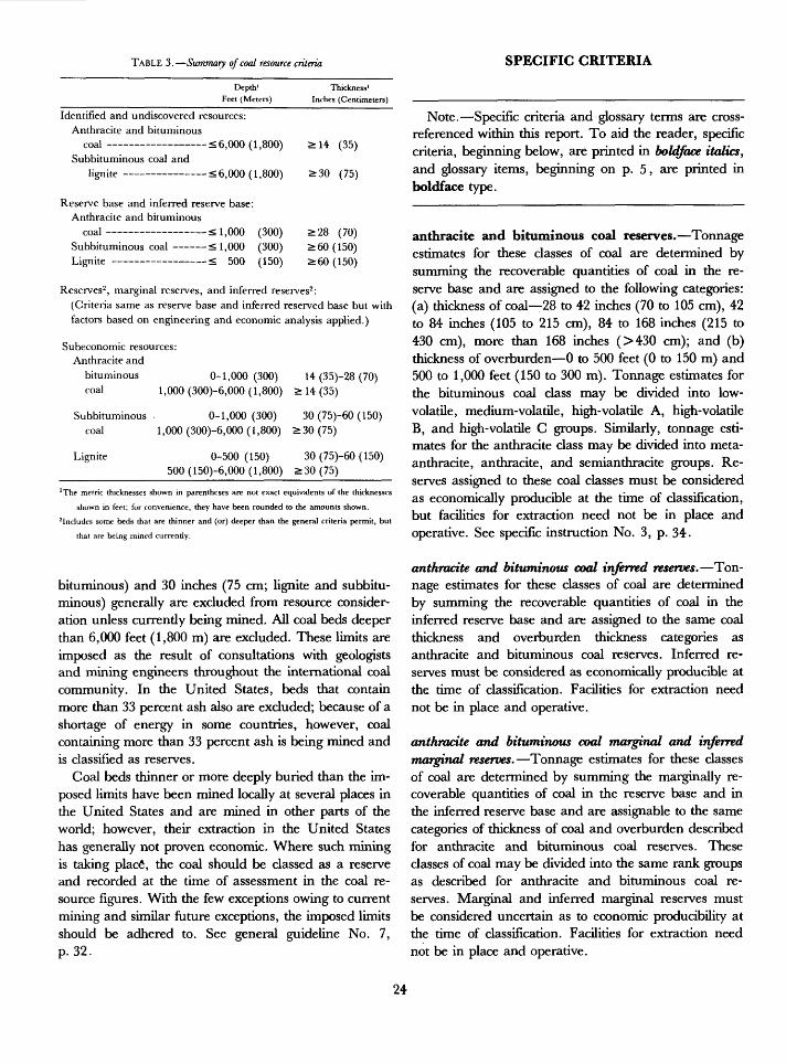
TABLE 3. Summary of coal resource criteria SPECIFIC CRITERIA
Depth' Thickness 1 Feet (Meters) Inches (Centimeters)
Identified and undiscovered resources: Anthracite and bituminous
coal <6,000 (1,800) > 14 (35)
Subbituminous coal andlignite <6,000 (1,800) >30 (75)
Reserve base and inferred reserve base: Anthracite and bituminouscoal <; 1,000 (300) >28 (70)
Subbituminous coal < 1,000 (300) > 60 (150) Lignite < 500 (150) > 60 (150)
Reserves2 , marginal reserves, and inferred reserves2 :(Criteria same as reserve base and inferred reserved base but with factors based on engineering and economic analysis applied.)
Subeconomic resources: Anthracite and
bituminous 0-1,000(300) 14 (35)-28 (70)
coal 1,000 (300)-6,000( 1,800) > 14 (35)
Subbituminous. 0-1,000(300) 30 (75)-60 (150) coal 1,000 (300)-6,000 (1,800) >30(75)
Lignite 0-500(150) 30 (75)-60 (150) 500 (150)-6,000 (1,800) >30(75)______
'The metric thicknesses shown in parentheses are not exact equivalents of the thicknesses
shown in feet; for convenience, they have been rounded to the amounts shown.
2 Includes some beds that are thinner and (or) deeper than the general criteria permit, but
that are being mined currently.
bituminous) and 30 inches (75 cm; lignite and Subbitu minous) generally are excluded from resource consider ation unless currently being mined. All coal beds deeper than 6,000 feet (1,800 m) are excluded. These limits are imposed as the result of consultations with geologists and mining engineers throughout the international coal community. In the United States, beds that contain more than 33 percent ash also are excluded; because of a shortage of energy in some countries, however, coal containing more than 33 percent ash is being mined and is classified as reserves.
Coal beds thinner or more deeply buried than the im posed limits have been mined locally at several places in the United States and are mined in other parts of the world; however, their extraction in the United States has generally not proven economic. Where such mining is taking place1 , the coal should be classed as a reserve and recorded at the time of assessment in the coal re source figures. With the few exceptions owing to current mining and similar future exceptions, the imposed limits should be adhered to. See general guideline No. 7, p. 32.
Note. Specific criteria and glossary terms are cross- referenced within this report. To aid the reader, specific criteria, beginning below, are printed in boldface italics, and glossary items, beginning on p. 5, are printed in boldface type.
anthracite and bituminous coal reserves. Tonnage estimates for these classes of coal are determined by summing the recoverable quantities of coal in the re serve base and are assigned to the following categories: (a) thickness of coal 28 to 42 inches (70 to 105 cm), 42 to 84 inches (105 to 215 cm), 84 to 168 inches (215 to 430 cm), more than 168 inches (>430 cm); and (b) thickness of overburden 0 to 500 feet (0 to 150 m) and 500 to 1,000 feet (150 to 300 m). Tonnage estimates for the bituminous coal class may be divided into low- volatile, medium-volatile, high-volatile A, high-volatile B, and high-volatile C groups. Similarly, tonnage esti mates for the anthracite class may be divided into meta- anthracite, anthracite, and semianthracite groups. Re serves assigned to these coal classes must be considered as economically producible at the time of classification, but facilities for extraction need not be in place and operative. See specific instruction No. 3, p. 34.
anthracite and bituminous coal inferred reserves. Ton nage estimates for these classes of coal are determined by summing the recoverable quantities of coal in the inferred reserve base and are assigned to the same coal thickness and overburden thickness categories as anthracite and bituminous coal reserves. Inferred re serves must be considered as economically producible at the time of classification. Facilities for extraction need not be in place and operative.
anthracite and bituminous coal marginal and inferred marginal reserves. Tonnage estimates for these classes of coal are determined by summing the marginally re coverable quantities of coal in the reserve base and in the inferred reserve base and are assignable to the same categories of thickness of coal and overburden described for anthracite and bituminous coal reserves. These classes of coal may be divided into the same rank groups as described for anthracite and bituminous coal re serves. Marginal and inferred marginal reserves must be considered uncertain as to economic producibility at the time of classification. Facilities for extraction need not be in place and operative.
24
anthracite and bituminous coal reserve base and inferred coal reserve base. See reserve base for thickness of coal and thickness of overburden criteria.
anthracite and bituminous coal resources. Tonnage es timates for these classes of coals are determined by sum ming the estimates for anthracite and bituminous coal identified and undiscovered resources (fig. 3). They are assignable to the same thickness categories as for anthra cite and bituminous coal reserves with the addition of a 14-28 inch (35-70 cm) category (see specific instruction No. 3, p. 34|), and the following overburden categories are to be recognized: 0 to 500 feet (0 to 150 m); 500 to 1,000 feet (150 to 300 m); 1,000 to 2,000 feet (300 to 600 m); 2,000 to 3,000 feet (600 to 900 m); and 3,000 to 6,000 feet (900 to 1,800 m). Tonnage estimates for the bituminous coal class may be divided into the low- volatile, medium-volatile, high-volatile A, high-volatile B, and high-volatile C groups, and tonnage estimates for the anthracite class may be divided into the meta anthracite, anthracite, and semianthracite groups.
cumulative depletion. Cumulative depletion is summed from all coal extracted and lost-in-mining prior to the date of the estimate, which may be 'subdivided on the basis of rank and subrank (class and group) of coal, overburden class, thickness class, mining method, heat value, usage, time, cokeability, chemical constituents, and area of production.
cummulative production. Cummulative production is summed from production from a mine, field, basin, region, province, state, or nation prior to the date of the estimate, which may be subdivided on the basis of rank and subrank (class and group) of coal, overburden class, thickness class, mining method, heat value, usage, time, cokeability, chemical constituents, and area of production.
demonstrated reserves and demonstrated marginal re serves. Tonnage estimates for these categories of coal are the sum of the estimates for measured and indicated reserves and marginal reserves, repectively, which are the preferred usages. See Reserves and Marginal Re serves, p. 18.
demonstrated reserve base. Tonnage estimates for this category of coal are determined by summing the esti mates for the measured and indicated reserves bases. The demonstrated reserve base is the same as the "reserve base," which is the preferred usage. See reserve base, p. 19).
demonstrated resources. Tonnage estimates for this category are the sum of the estimates for the reserve base and subeconomic resources.
economic resources. An informal term used by geolo gists to indicate their estimates of the coal resources that are potentially economic.
hypothetical resources. Tonnage estimates for this cate gory of resources are for (1) extensions of inferred resources (coal beyond a radius of 3 miles or 4.8 km from a point of measurement), and (2) regions where tonnage estimates are based on a knowledge of the geo logic character of coal. Hypothetical resources include coal that is 14 inches (35 cm) or more thick (anthracite and bituminous coal) and 30 inches (70 cm) or more thick (subbituminous coal and lignite) to a depth of 6,000 feet (1,800 m). (See section on "Extrapolated Bed Map Method," p. 37; and "Extrapolated Coal Zone Method," p. 38; see also fig. 4.)
identified resources. Tonnage estimates for this category of resource include all bituminous coal and an thracite 14 inches (35 cm) or more thick and all subbitu minous coal and lignite 30 inches (75 cm) or more thick from the surface to a depth of 6,000 feet (1,800 m) whose location, rank, quality, and quantity have been determined within specified degrees of reliability as demonstrated, measured, indicated, and inferred.
indicated. Virgin coal that lies between 1/4 mile (0.4 km) and 3/4 mile (1.2 km) from a point of thickness of coal measurement. (See fig. 4.)
indicated marginal reserves. Tonnage estimates for this category of reserves include those parts of an indicated reserve base that at the time of determination border on being economically producible assuming certain pro jected economic or technologic changes. The assumed changes and the specific criteria suggesting potential economic profitability should be documented. (See in dicated, p. 10; and fig. 4.)
indicated reserves. Indicated reserves are estimated from an indicated reserve base by subtracting the assumed tonnage of coal that will be lost-in-mining and indicated marginal reserves. The remaining tonnage the coal that is assumed will be extracted is the indicated reserves, which must be considered as economically producible at the time of classification. However, facilities for extrac tion need not be in place and operative. (See indicated, p. 10 ; and fig. 4.)
25
indicated reserve base. An indicated reserve base is deter mined by projection of thicknesses of coal and over burden, rank, and quality data from points of measure ment and sampling on the basis of geologic evidence using the following criteria: (a) individual points of measurement are bounded by measured coal for 1/4 mile (0.4 km) suceeded by indicated coal from 1/4 mile (0.4 km) to 3/4 mile (1.2 km); and (b) indicated reserve base includes anthracite and bituminous coal 28 inches (70 cm) or more thick and subbituminous coal 60 inches (150 cm) or more thick to depths of 1,000 feet (300 m) and lignite 60 inches (150 cm) or more thick to depths of 500 feet (150 m). (See indicated, p. 10.)
indicated resources. Tonnage estimates for indicated re sources are computed by projection of thicknesses of coal and overburden, rank, and quality data from points of measurement and sampling on the basis of geologic evi dence and are assigned to the following categories: (a) individual points of measurement are bounded by measured coal for 1/4 mile (0.4 km) succeeded by 1/2 mile (0.8 km) of indicated coal; and (b) indicated resources include anthracite and bituminous coal 14 inches (35 cm) or more thick and lignite and subbituminous coal 30 inches (75 cm) or more thick to a depth of 6,000 feet (1,800 m). The quantity of coal estimated as indi cated resources is the same as the sum of the indicated re serve base, and indicated subeconomic resources. (See indicated, p. 10; and fig. 4.)
inferred. Virgin coal that lies between 3/4 mile (1.2 km) and 3 miles (4.8 km) from a point of thickness of coal measurement. (See fig. 4.)
inferred marginal reserves. Tonnage estimates for this category of reserves include those parts of an inferred reserve base that at the time of determination border on being economically producible assuming certain pro jected economic or technologic changes. The assumed changes and the specific criteria suggesting potential economic profitability should be documented. (See in ferred, p. 10; and fig. 4.)
inferred reserve base. An inferred reserve base is deter mined by projection of thicknesses of coal and over burden, rank, and quality data from points of measure ment and sampling on the basis of geologic evidence using the following criteria: (a) individual points of measurement are bounded by measured and indicated coal for 3/4 mile (1.2 km) succeeded by inferred coal from 3/4 mile (1.2 km) to 3 miles (4.8 km); and (b) in
ferred reserve base includes anthracite and bituminous coal
28 inches (70 cm) or more thick, subbituminous coal 60 inches (150 cm) or more thick, all to depths of 1,000 feet (300 m), and lignite 60 inches (150 cm) or more in thickness to depths of 500 feet (150 m).
inferred reserves. Inferred reserves are estimated from the inferred reserve base by subtracting the inferred marginal reserves and the coal that is estimated will be lost-in-mining. Inferred reserves must be considered as eco nomically producible at the time of determination con sidering environmental, legal, and technologic con straints. Extraction facilities need not be in place and operative.
inferred resources. Inferred resources are determined by projecting the thicknesses of coal and overburden, rank, and quality data from points of measurement and sam pling on the basis of geologic knowledge and are as signed to the following categories: (a) individual points of measurement are bounded by measured and indi cated coal for 3/4 mile (1.2 km) succeeded by 2-1/4 miles (3.6 km) of inferred coal; (b) inferred resources include an thracite and bituminous coals 14 inches (35 cm) or more thick and lignite and subbituminous coal 30 inches (75 cm) or more thick to depths of 6,000 feet (1,800 m). The quantity of coal estimated as an inferred resource is the same as the sum of the inferred reserve base and in ferred subeconomic resources.
lignite reserves. Tonnage estimates for this class of coal reserves are determined by summing the recoverable quantities of coal in the reserve base and are assigned to the following categories: (a) thickness of coal 5 to 10 feet (1.5 to 3.0 m), 10 to 20 feet (3 to 6 m), 20 to 40 feet (6 to 12 m), and more than 40 feet (>12 m); and (b) thickness of overburden 0 to 500 feet (0 to 150 m). Tonnage estimates for lignite reserves may be divided into the lignite A and B groups. Reserves assigned to the lig nite class must be considered as economically producible at the time of classification, but facilities for extraction need not be in place and operative.
Discussion: Currently, there are few underground ground lignite mines in the United States. In addition, there are few, if any, lignite strip mines that are removing as much as 300 feet (100 m) of overburden. In order to provide for future tech nologic and surface mining advances, the max imum thickness of overburden for surface- minable lignite reserves and reserve base is set at 500 feet (150 m). It is deemed inexpedient to es timate underground-minable lignite reserves and reserve base at depths greater than 500 feet (150 m). (See specific instruction No. 3, p. 34.)
26
lignite marginal and inferred marginal reserves. Ton nage estimates for these dasses of coal reserves are de termined by summing the marginally recoverable quan tities of coal in the reserve base and inferred reserve base and are assignable to the same categories of thicknesses of coal and overburden described for lignite reserves; coal may be divided into the lignite A and B groups. Lignite marginal and inferred marginal reserves must be con sidered as uncertain as to their economic producibility at the time of classification. Facilities for extraction need not be in place and operative.
lignite inferred reserves. Tonnage estimates for this class of reserves are determined by summing the recov erable quantities of coal in the inferred reserve base and are assignable to the same categories of thicknesses of coal and overburden described for lignite reserves. Also, this class of coal may be divided into the lignite A and B groups. Such inferred reserves must be considered eco nomically producible at the time of classification; facili ties for extraction need not be in place and operative.
lignite reserve base and inferred reserve base. See reserve base for thickness of coal and thickness of overburden criteria.
lignite resources. Tonnage estimates for this class of coal are determined by summing the estimates for lig nite identified and undiscovered resources. The same thickness categories as for lignite reserves are to be used with the addition of a 30-60 inches (75-150 cm) cate gory (see specific instruction No. 3, p. 34), and the fol lowing overburden categories are to be recognized: 0 to 500 feet (0 to 150 m); 500 to 1,000 feet (150 to 300 m); 1,000 to 2,000 feet (300 to 600 m); 2,000 to 3,000 feet (600 to 900 m); and 3,000 to 6,000 feet (900 to 1,800 m). The tonnage estimates for this class of coal may be divided into lignite A and B groups.
measured. Accessed and virgin coal that lies within a radius of 1/4 mile (0.4 km) of a point of thickness of coal measurement. (See fig. 4.)
measured marginal reserves. Accessed and virgin coal that lies within a radius of 1/4 mile (0.4 km) of a point of thickness of coal measurement. Tonnage estimates for this category of reserves includes those parts of a meas ured reserve base that at the time of determination border on economic producibility assuming certain pro jected economic or technologic changes. The assumed changes and the specific criteria suggesting potential economic producibility should be documented. (See measured, p. 12; and fig. 4.)
measured reserves. Measured reserves are estimated from a measured reserve base by subtracting the sum of the assumed tonnage of coal that will be lost-in-mining and measured marginal reserves. The remaining ton nage the coal that is assumed will be extracted is measured reserves which must be considered as eco nomically producible at the time of classification; however, facilities for extraction need not be in place and operative.
measured reserve base. A measured reserve base is deter mined by projection of thicknesses of coal and over burden, rank, and quality data from points of measure ment and sampling on the basis of geologic evidence for a radius of 1/4 mile (0.4 km). A measured reserve base in cludes anthracite and bituminous coal 28 inches (70 cm) or more thick and subbituminous coal 60 inches (150 cm) or more thick to depths of 1,000 feet (300 m) and lignite 60 inches (150 cm) or more thick to depths of 500 feet (50 m).
measured resources. Tonnage estimates for measured re sources are computed by projection of thicknesses of coal and overburden, rank, and quality data for a radius of 1/4 mile (0.4 km) from a point of measurement. Meas ured resources include anthracite and bituminous coal 14 inches (35 cm) or more thick and lignite and sub- bituminous coal 30 inches (75 cm) or more thick to depths of 6,000 feet (1,800 m). The quantity of coal es timated as measured is the same as the sum of the meas ured reserve base and measured subeconomic resource.
original resources. Tonnage estimates determined for coal in the ground prior to production. Where coal has been mined, estimates are made by summing remaining resources, cummulative production, and coal lost-in- mining. An estimate of total original resources is the sum of the original resources determined for many mines, fields, basins, regions, provinces, States, and the Nation. (See resources for thicknesses of coal and over burden; and lost-in-mining, p. 12.)
other occurrences, noneconomic coal. Such coal, except where mined locally, consists of anthracite and bitumi nous coal beds less than 14 inches (35 cm) thick; lignite and subbituminous coal beds less than 30 inches (75 cm) thick; and all coal beds that are buried by more than 6,000 feet (1,800 m) of overburden; coal containing more than 33 percent ash; and that coal lost-in-mining that is considered noneconomic. Tonnage estimates are optional for such coal. However, if estimates are made, they should be reported as "other occurrences" and not
27
as resources. However, where currently mined, coal that is considered too thin or too high in ash and would normally be classed as "other occurrences" is to be classed as reserves.
rank assignments. The assignment of rank is a neces sary part of classifying a coal; however, data for deter mining rank are commonly sparse or are far-removed from the localities where the data required for rank assignment is needed. In general, rank gradually changes laterally over many miles or stratigraphically over hundreds to thousands of feet. Because of the lack of data in some areas, conclusions concerning rank as signments commonly must be derived from analytic or petrographic determinations made on coal that lies some distance from where the rank assignment is desired. Conclusions concerning rank where analytic or petro graphic data are sparse must be viewed as tentative. However, if a geologist's understanding of the setting of the area sampled is adequate, the rank assignment prob ably will be correct even though the rank data are sparse.
rank calculation. The rank of coal is to be calculated by using the following instructions which are quoted from the standard specifications for classification of coals by rank (ASTM Standards, 1981, p. 212-216):
8. Calculation to Mineral-Matter-Free Basis8.1 Calculation of Fixed Carbon and Calorific Value: For classification of
coal according to rank, fixed carbon and calorific value shall be cal culated to the mineral-matter-free basis in accordance with either the Parr formulas, Eqs 1, 2, and 3, or the approximation formulas, Eqs 4, 5, and 6, that follow. In case of litigation use the appropriate Pan- Formula.
8.2 Calculation to Mm-free basis: Parr Formulas:
Dry, Mm-free FC(FC - 0.15S)
x 100 (1)[100 - (M + 1.08A + 0.55S)]
Dry, Mm-free VM = 100 - Dry, Mm-free FC (2)
(Btu - 50S)Moist, Mm-free Btu
[100 - (1.08A + 0.55S)]x 100 (3)
Note The above formula for fixed carbon is derived from the Parr formula for volatile matter.
Approximation Formulas:FC
Dry, Mm-free FC x 100 (4)[100 - (M + 1.1A + 0.1S]
Dry, Mm-free VM = 100 - Dry, Mm-free FC (5)
Btu
where
Mm = Mineral matter,Btu = British thermal units per pound (calorific value),FC = percentage of fixed carbon,VM = percentage of volatile matter,M = percentage of moisture,A = percentage of ash, andS = percentage of sulfur.
Above quantities are all on the inherent moisture basis. This basis refers to coal containing its natural inherent or bed moisture but not including water adhering to the surface of the coal.
recovery factor method. Only a part of the coal in any deposit can be extracted when mined. The coal not ex tracted during underground mining, strip mining, or auger mining; the coal that becomes a part of a under ground or strip-mine waste pile; or the coal that is not removed adjacent to a strip-mine or underground-mine boundary is considered as lost-in-mining unless suffi cient tonnages are left unextracted so that additional mining or recovery can be foreseen.
If it is not feasible or possible to calculate the reserves of an area using an economic analysis, a reasonable approximation of the reserves can be determined by us ing the recovery factor method described hereafter.
Each operating mine has a unique percentage of coal that is recovered. This percentage is termed the re covery factor of the mine and is obtained from the fol lowing formula:
RF = Y x 100
Moist, Mm-free Btu[100 - (1.1A + U1S)]
x 100 (6)
whereRF = Recovery factor or percent coal estimated
extractable during mining, X = The total tonnage of coal estimated in the
ground,Y = The tonnage of coal estimated to be recov
erable during mining.
A recovery factor can be applied to a reserve base to obtain an estimate of the reserves of an area. Such use of a recovery factor is appropriate when there is a paucity of geologic data for estimating the tonnage of potentially extractable coal.
It is difficult to estimate accurately the recoverable coal in a very large area such as a field, region, prov ince, basin, State, or the Nation because it is impossible to determine how much coal in the area will not be mined for legal or environmental reasons, what method
28
or methods of mining will be used, and what the average recovery factor will be for all mining methods.
A reserve base and reserves have been estimated by industry for most operating mines in the United States. Generally, data that can be used to compute recovery factors for individual mines are closely held by the oper ators; therefore, there is little publicly available informa tion to guide estimators in determining local, regional, and national recovery factors. Commonly, estimators must extrapolate recovery factors from experience gained in a few mines by assuming that (1) geologic conditions controlling mining will be similar, and (2) success in the recovery of coal in unmined areas will be similar to that of mined areas utilizing the same min ing method. Such extrapolation of recovery factors from a few well known mined areas to less well known or unknown areas requires experience regarding the geol ogy, the mining method or methods to be employed, and an awareness of the difficulties, geologic and other wise, that affect the estimation of reserves. Area, quad rangle, township, field, basin, province, county, State, and national recovery factors can be determined by us ing formulas after determining the mean recovery factor in percent for many mines, ascertaining the quantity of reserve base coal in the area of study, and ascertaining the total quantity of coal that is restricted from mining for any legal, environmental or technologic reason. These formulas are:
Z = 100
NRF = W(100 - Z)
whereX = tonnage of coal restricted from extraction
for any legal, environmental, or tech nologic reason,
Y = tonnage of coal included in the reservebase category of a large area,
Z = restricted coal (percent), W = recovery factor percent obtained from
local mines, andNRF = National, State, or large area recovery
factor in percent applied to all coal in cluding restricted.
In the United States, recovery factors for under ground mining as determined from mine maps of aban doned and operating mines generally range from about 35 to about 70 percent and average about 50 percent. Similarly, recovery factors for abandoned and operating
surface mines range from about 70 to 95 percent and average about 80 percent. These local recovery factors are valid for individual mines but are not valid for large areas because they fail to consider the coal lost-in- mining such as (1) the coal that will not be mined be tween properties, and (2) coal in overlying and under lying beds rendered usuitable for future mining by past underground mining. Further, the local recovery factors do not consider the coal that is restricted or prohibited from mining, such as the coal underlying national parks and wild life sanctuaries; coal that is too deep and too thin to be mined because of excessive costs; and coal that cannot be mined because of unsolved technologic, geo logic, or engineering problems.
The authors recommend applying a recovery factor of 50 percent to the reserve base when computing under ground and surface mining reserves of large areas. However, if actual local recovery factors have been cal culated, the procedure outlined with the two formulas should be implemented for smaller areas.
remaining resources. The resources remaining in the ground after prior mining. These resources include identified and undiscovered resources and include coal lost-in-mining whose attributes indicate possible future recovery. See resources, for thickness of coal and over burden criteria, and figure 3.
reserve base. A tonnage estimate for this category of coal consists of the sum of the estimates for measured and indicated reserves, marginal reserves, and a part of the measured and indicated subeconomic resources (the coal that has or will be lost-in-mining). The reserve base is the same as the demonstrated reserve base. The term reserve base is preferred for reports of the U.S. Geological Survey. The criteria for the reserve base include bitumi nous coal and anthracite 28 inches (70 cm) or more thick, subbituminous coal 5 feet (1.5 m) or more thick that occurs at depths to 1,000 feet (300 m), and lignite 5 feet (1.5 m) or more thick that occurs at depths to 500 feet (150 m).
Discussion: Individual reserve bases, where needed and appropriate, are to be determined by cate gories of reliability, thicknesses of coal and over burden; rank, chemical constituents, ash content, heat value, and potential usage. Addi tionally, estimated individual reserve base estimates are to be summed into totals for each township, quadrangle, coal field, basin, region, province, township and range, county, State, and the Nation. Assignment of coal to a reserve
29
base is controlled by physical and chemical cri teria such as categories of reliability, thicknesses of coal and overburden, rank of coal, and knowl edge of depositional patterns of coal beds and associated structural features. Changing eco nomic, technologic, and environmental consid erations do not control assignment of coal to a reserve base. In contrast, the discrimination of reserves is largely controlled by economic factors such as judgments of cost, profit, and supply of and demand for coal. Reserve discrimination is controlled secondarily by advances or differences in mining, preparation and transportation tech nologies, and by environmental regulations, laws, and judicial rulings.
The physical and chemical criteria used to assign coal to a reserve base category have been used already to evaluate many coal beds that are currently mined in the United States. These evaluations indicate coal assigned to a reserve that is derived from a physically-chemically defined reserve base can be expected to be economically minable with a high degree of con fidence. In a few places, however, where the thickness of a coal bed or associated rock condi tions are exceptionally variable or severe, the varying tonnages of coal classified as a reserve from a physically and chemically defined reserve base may or may not prove to be extractable at a profit.
Changes in environmental laws and regula tions generally affect the tonnages of coal as signed to the various categories of the reserve base; however, assessments of these changes have not been made.
reserves. Reserve tonnage estimates are to be de termined by summing the recoverable quantities of coal in the reserve base for each rank of coal and are assigned to the following categories: (1) thickness of overburden 0 to 500 feet (0 to 150 m) and 500 to 1,000 feet (150 m to 300 m); and (2) thickness of coal 28 to 42 inches (70 to 105 cm), 42 to 84 inches (105 to 215 cm), 84 to 168 inches (215 to 430 cm), and more than 168 inches ( > 430 cm) for anthracite and bituminous coal; and 5 to 10 feet (1.5 to 3.0 m), 10 to 20 feet (3.0 to 6.0 m), 20 to 40 feet (6.0 to 12.0 m), and more than 40 feet ( > 12.0 m) for subbituminous coal and lignite. (See specific instruc tion No. 3, p. 34.) Reserves must be considered as economically producible at the time of classification, but facilities for extraction need not be in place and opera tive. In addition, categories based on potential mining
methods (surface and underground); chemical constit uents such as sulfur, phosphorous and ash content; heat value; and usage such as metallurgical, steam, petro chemical, gasification, and liquefaction are desirable. Reserves and marginal reserves are estimated by deter mining the amount of coal in each reserve base category that can be extracted at the time of classification (reserves), and the amount that borders on being extract- able at a profit (marginal reserves). These two amounts and the amount that will be lost-in-mining, when summed, are equal to the reserve base. The estimates of each reserve category are to be totaled into quadrangle, township, field, basin, region, province, county, and State estimates, and into a national total, and then the various estimates for all categories are to be totaled similarly to reach an inclusive estimate of all reserves.
Reserves are derived from the reserve base, which in cludes bituminous coal and anthracite 28 inches (70 cm) or more thick, subbituminous coal 5 feet (1.5 m) or more thick that occurs at depths to 1,000 feet (300 m), and lignite 5 feet (1.5 m) or more thick that occurs at depths to 500 feet (150 m). Reserves also include thinner and (or) more deeply buried beds of these ranks of coal that are currently being mined.
resources. Tonnage estimates for coal resources are determined by summing the estimates for identified and undiscovered deposits of coal that are 14 inches (35 cm) or more thick for anthracite and bituminous coal and under less than 6,000 feet (1,800 m) of overburden, and 30 inches (75 cm) or more thick for lignite and subbitu minous coal and under less than 6,000 feet (1,800 m) of overburden.
speculative resources. As of publication of this circular, there are no speculative resources of coal estimated for the United States. However, if it is desirable to make such estimates, the definition of Speculative Resources (p. 20) and the criteria for resources will be followed, and the geologic evidence supporting the estimates and methods of quantification will be made available publicly.
subbituminous coal inferred reserves. Tonnage esti mates for this class of coal are determined by summing the recoverable quantities of coal in the inferred reserve base and are assigned to the same categories of thickness of coal and overburden described for subbituminous coal reserves. This class of coal may be divided into the same rank groups as described for subbituminous coal reserves. Inferred reserves must be considered as economically producible at the time of classification. However,
30
facilities for extraction need not be in place and operative.
subbituminous coal marginal and inferred marginal re serves. Tonnage estimates for these classes of coal are determined by summing the marginally recoverable quantities of coal in the reserve base and inferred reserve base, respectively, and are assigned to the same categories of thicknesses of coal and overburden de scribed for subbituminous coal reserves. These classes of coal may be divided into the same rank groups as de scribed for subbituminous coal reserves. Marginal and inferred marginal reserves must be considered uncertain as to their economic producibility at the time of classifi cation. Facilities for extraction need not be in place and operative.
subbituminous coal reserves. Tonnage estimates for this class of coal are determined by summing the recov erable quantities of coal in the reserve base and are as signed to the following categories: (a) thickness of coal 5 to 10 feet (1.5 to 3.0 m), 10 to 20 feet (3.0 to 6.0 m), 20 to 40 feet (6.0 to 12.0 m), and more than 40 feet (> 12.0 m) (see specific instruction No. 3, p. 34); and (b) thickness of overburden 0 to 500 feet (0 to 150 m) and 500 to 1,000 feet (150 to 300 m). Such re serve estimates may be divided into subbituminous A, B, and C rank groups. Reserves assigned to this coal class must be considered as economically producible at the time of classification, but facilities for extraction need not be in place and operative.
subbituminous coal reserve base and inferred reserve base. See reserve base for thickness of coal and thick ness of overburden categories.
subbituminous coal resources. Tonnage estimates for this class of coals are determined by summing the esti mates for identified and undiscovered subbituminous coal resources. The same thickness categories as for sub- bituminous coal reserves are to be used with the addi tion of a 30 inches-5 feet (75 cm-1.5 m) category (see specific instruction No. 3, p. 34), and the following overburden categories are to be recognized: 0 to 500 feet (0 to 150 m); 500 to 1,000 feet (150 to 300 m); 1,000 to 2,000 feet (300 to 600 m); 2,000 to 3,000 feet (600 to 900 m); and 3,000 to 6,000 feet (900 to 1,800 m). Such resource estimates may be divided into subbituminous coal A, B, and C rank groups.
subeconomic resources and inferred subeconomic re sources. Tonnage estimates for these classes of coal are
determined by summing the estimates for measured, in dicated, and inferred resources that do not meet the cri teria for assignment to the reserve base or inferred re serve base because they are too thin to mine, are too deeply buried to mine, or are those parts of the reserve base or inferred reserve base that have been or will be lost-in-mining but whose attributes indicate future recovery may become feasible. Included are all meas ured, indicated, and inferred reliability categories of bituminous coal and anthracite beds 14 to 28 inches (35 to 70 cm) thick, all subbituminous coal beds 30 to 60 inches (75 to 150 cm) thick that are less than 1,000 feet (300 m) below the surface, and all lignite beds 30 to 60 inches (75 to 150 cm) thick that are less than 500 feet ( < 150 m) below the surface, unless the coal in these beds will be recovered in the process of extracting coal from thicker beds. Also included are all beds of bituminous coal and anthracite 14 inches (35 cm) or more thick and beds of subbituminous coal 30 inches (75 cm) or more thick that occur at depths between 1,000 and 6,000 feet (300 and 1,800 m) and lignite beds 30 inches (75 cm) or more thick and more than 500 feet (> 150 m) below the surface.
thickness of coal for resource calculations. The thick ness of coal used for resource calculations is the net thickness of coal in a bed excluding all partings more than 3/8 inch (> 1 cm) thick. Beds and parts of beds made up of alternating layers of thin coal and partings are omitted from calculations if the partings comprise more than one-half of the total thickness. Also, benches of anthracite and bituminous coal less than 14 inches (35 cm) thick and benches of subbituminous coal and lignite less than 30 inches (75 cm) thick are omitted from calculations if they lie above or below partings that may deter their mining. Coal and coaly material containing more than 33 percent ash is excluded from resource and reserve estimates unless the ash is largely in associated partings so that the coal is cleanable to less than 33 per cent ash. (See parting, p. 15, and specific instruction No. 13, p. 36.)
undiscovered resources. Tonnage estimates for this category of resources are based (1) on knowledge of the geologic character, habit, and pattern of a coal bed or coal zone in an area or region or (2) on speculative geologic data. Estimates are made by summing the ton nage estimates for coal assigned to the hypothetical and speculative resources reliability categories. Included are hypothetical and speculative resources of bituminous coal and anthracite in beds 14 inches (35 cm) or more
31
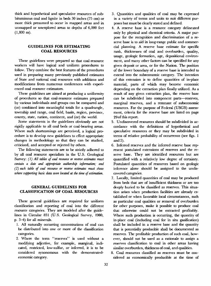
thick and hypothetical and speculative resources of sub- bituminous coal and lignite in beds 30 inches (75 cm) or more thick presumed to occur in mapped areas and in unmapped or unexplored areas to depths of 6,000 feet (1,800 m).
GUIDELINES FOR ESTIMATING COAL RESOURCES
These guidelines were prepared so that coal-resource workers will have logical and uniform procedures to follow. They combine the best features of the procedures used in preparing many previously published estimates of State and national coal resources with additions and modifications from numerous conferences with experi enced coal resource estimators.
These guidelines are aimed at producing a uniformity of procedures so that coal-resource estimates prepared by various individuals and groups can be compared and (or) combined into meaningful totals for a quadrangle, township and range, coal field, basin, region, province, county, state, nation, continent, and (or) the world.
Some statements in the guidelines obviously are not rigidly applicable to all coal beds or coal-bearing areas. Where such shortcomings are perceived, a logical pro cedure is to develop new guidelines to effect appropriate changes in methodology so that they can be studied, criticized, and accepted or rejected by others.
The following statements are to be strictly adhered to by all coal resource specialists in the U.S. Geological Survey: (1) All tables of coal resource or reserve estimates must contain a date and appropriate authorship information; and (2) each table of coal resource or reserve estimates must show where supporting basic data were located at the time of estimation.
GENERAL GUIDELINES FOR CLASSIFICATION OF COAL RESOURCES
These general guidelines are required for uniform classification and reporting of coal into the different resource categories. They are modeled after the guide lines in Circular 831 (U.S. Geological Survey, 1980, p. 3-4) for all minerals.
1. All naturally occurring concentrations of coal can be distributed into one or more of the classification categories.
2. Where the term "reserves" is used without a modifying adjective, for example, marginal, indi cated, restricted, low-sulfur, or inferred, it is to be considered synonomous with the demonstrated- economic category.
3. Quantities and qualities of coal may be expressed in a variety of terms and units to suit different pur poses but must be clearly stated and defined.
4. A reserve base is a resource category delineated only by physical and chemical criteria. A major pur pose for the recognition and discrimination of a re serve base is to aid in long-range public and commer cial planning. A reserve base estimate for specific rank, thicknesses of coal and overburden, quality, usage, geologic formation, age, depositional environ ment, and many other factors can be specified for any given deposit or area, or for the Nation. The position of the lower boundary of a reserve base is intended to extend into the subeconomic category. The intention of this extension is to define quantities of in-place material, parts of which may become economic depending on the extraction plan finally utilized. As a result of any given extraction plan, the reserve base can be subdivided into component parts reserves, marginal reserves, and a remnant of subeconomic resources. For the purpose of Federal (USGS) assess ment, criteria for the reserve base are listed on page 29 of this report.
5. Undiscovered resources should be subdivided in ac cordance with the definitions of hypothetical and speculative resources or they may be subdivided in terms of relative probability of occurrence (see figs. 1 and 2).
6. Inferred reserves and the inferred reserve base rep resent postulated extensions of reserves and the re serve base. They are identified resources but are quantified with a relatively low degree of certainty. Postulated quantities of resources based on geologic inference alone should be assigned to the undis covered categories.
7. Locally, limited quantities of coal may be produced from beds that are of insufficient thickness or are too deeply buried to be classified as reserves. This situa tion arises when production facilities are already es tablished or when favorable local circumstances, such as particular coal qualities or removal of overburden for other purposes, make it possible to produce coal that otherwise could not be extracted profitably. Where such production is occurring, the quantity of in-place coal (including coal for in situ gasification) shall be included in a reserve base and the quantity that is potentially producible shall be documented as reserves. The profitable production of such coal, how ever, should not be used as a rationale to assign a reserves classification to coal in other areas having similar overburden, thickness of coal, and qualities.
8. Coal resources classified as reserves must be con sidered as economically producible at the time of
32
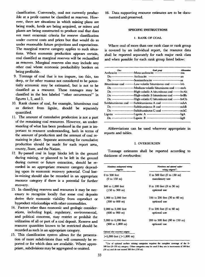
classification. Conversely, coal not currently produc ible at a profit cannot be classified as reserves. How ever, there are situations in which mining plans are being made, lands are being acquired, or mines and plants are being constructed to produce coal that does not meet economic criteria for reserve classification under current costs and prices but that would do so under reasonable future projections and expectations. The marginal reserve category applies to such situa tions. When economic production appears certain, coal classified as marginal reserves will be reclassified as reserves. Marginal reserves also may include any other coal whose economic producibility borders on being profitable.
9. Tonnage of coal that is too impure, too thin, too deep, or for other reasons not considered to be poten tially economic may be estimated, but is not to be classified as a resource. These tonnages may be classified in the box labeled "other occurrences" in figures 1, 2, and 3.
10. Rank classes of coal, for example, bituminous coal as distinct from lignite, should be separately quantified.
11. The amount of cumulative production is not a part of the remaining coal resources. However, an under standing of what has been produced in the past is im portant to resource understanding, both in terms of the amount of production and the amount of coal re maining in place. Separate accounting for cumulative production should be made for each report area, county, State, and the Nation.
12. By-passed coal in large blocks left in the ground during mining, or planned to be left in the ground during current or future extraction, should be re corded in an appropriate resource category depend ing upon its economic recovery potential. Coal lost- in-mining should also be recorded in an appropriate resource category if there is a potential for further recovery.
13. In classifying reserves and resources it may be nec essary to recognize locally that some coal deposits derive their economic viability from coproduct or byproduct relationships with other commodities.
14. Factors other than economic and geologic consider ations, including legal, regulatory, environmental, and political concerns, may restrict or prohibit the utilization of all or part of a coal deposit. Reserve and resource quantities known to be restricted should be recorded as such in an appropriate category.
15. This classification system allows for the presenta tion of more subdivisions than will commonly be re ported or for which data are available. Where appro priate, subdivisions may be aggregated or omitted.
16. Data supporting resource estimates are to be docu mented and preserved.
SPECIFIC INSTRUCTIONS
1. RANK OF COAL
Where coal of more than one rank class or rank group is covered by an individual report, the resource data shall be reported separately for each major rank class and when possible for each rank group listed below:
Class Rankgmap AbbreviationAnthracite Meta-anthracite ma
Do Anthracite an Do Semianthracite sa
Bituminous coal Low-volatile bituminous coal Ivb Do Medium-volatile bituminous coal mvb Do High-volatile A bituminous coal hvAb Do High-volatile B bituminous coal hvBb Do High-volatile C bituminous coal hvCb
Subbituminous coal Subbituminous A coal subA Do Subbituminous B coal subB Do Subbituminous C coal subC
Lignite Lignite A ligA Do Lignite B ligB
Abbreviations can be used wherever appropriate in reports and tables.
2. OVERBURDEN
Tonnage estimates shall be reported according to thickness of overburden:
Mandatory underground mining categories:
0 to 500 feet (0 to 150 m)
500 to 1,000 feet (150 to 300 m)
1,000 to 2,000 feet (300 to 600 m)
2,000 to 3,000 feet (600 to 900 m)
3,000 to 6,000 feet (900 to 1,800 m)
Optional other occurrence category:
> 6,000 feet (> 1,800m)
Mandatory and optional surface mining categories1 :
0 to 500 feet (0 to 150 m) mandatory use
0 to 100 feet (0 to 30 m) optional use
100 to 200 feet (30 to 60 m) optional use
0 to 200 feet (0 to 60 m) optional use
200 to 500 feet (60 to 150 m) optional use
'Use of optional surface mining categories requires the complete coverage of the 0- 500 feet (0-150 m) category. Other categories may be used if they are in increments of 100 feet (30 m) and do not exceed 500 feet (150 m).
33
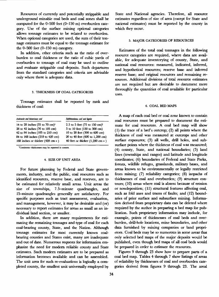
Resources of currently and potentially strippable and underground minable coal beds and coal zones shall be computed for the 0-500 feet (0-150 m) overburden cate gory. Use of the surface mining optional categories allows tonnage estimates to be related to overburden. When optional categories are used, the sum of their ton nage estimates must be equal to the tonnage estimate for the 0-500 feet (0-150 m) category.
In addition, other criteria such as the ratio of over burden to coal thickness or the ratio of cubic yards of overburden to tonnage of coal may be used to outline and evaluate strippable coal deposits. Such departures from the standard categories and criteria are advisable only where there is adequate data.
3. THICKNESS OF COAL CATEGORIES
Tonnage estimates shall be reported by rank and thickness of coal:
Anthracite and bituminous coal
14 to 28 inches (35 to 70 cm)1 28 to 42 inches (70 to 105 cm) 42 to 84 inches (105 to 210 cm) 84 to 168 inches (210 to 420 cm) 168 inches or thicker (420 cm +)
2.5 to 5 feet (75 to 150 cm)1 5 to 10 feet (150 to 300 cm) 10 to 20 feet (300 to 600 cm) 20 to 40 feet (600 to 1,200 cm) 40 feet or thicker (1,200 cm +)
'Centimeter thicknesses may be reported in meters.
4. SIZE OF UNIT AREA
For future planning by Federal and State govern ments, industry, and the public, coal resources such as identified resources, reserve base, and reserves, are to be estimated for relatively small areas. Unit areas the size of townships, 7.5-minute quadrangles, and 15-minute quadrangles generally are satisfactory. For specific purposes such as tract assessment, evaluation, and management, however, it may be desirable and (or) necessary to report estimates for areas as small as an in dividual land section, or smaller.
In addition, there are many requirements for esti mating the remaining tonnages and type of coal for each coal-bearing county, State, and the Nation. Although tonnage estimates for most currently known coal- bearing counties and States exist, many are inadequate and out of date. Numerous requests for information em phasize the need for modern reliable county and State estimates. Such modern estimates are to be prepared as information becomes available and can be assembled. The unit area for such re-evaluations is logically a com pleted county, the smallest unit universally employed by
State and National agencies. Therefore, all resource estimates regardless of size of area (except for State and national estimates) must be reported by the county in which they occur.
5. MAJOR CATEGORIES OF RESOURCES
Estimates of the total coal tonnages in the following resource categories are required, where data are avail able, for adequate inventorying of county, State, and national coal resources: measured, indicated, inferred, and hypothetical resources; reserve base and inferred reserve base; and original resources and remaining re sources. Additional divisions of total resource estimates are not required but are desirable to document more thoroughly the quantities of coal available for particular uses.
6. COAL BED MAPS
A map of each coal bed or coal zone known to contain coal resources must be prepared to document the esti mate for coal resources. A coal bed map will show (1) the trace of a bed's outcrop; (2) all points where the thickness of coal was measured at outcrops and other surface exposures; (3) all wells, drill holes, and sub surface points where the thickness of coal was measured; (4) county, State, and national boundaries; (5) land lines (townships and ranges) and latitude and longitude coordinates; (6) boundaries of Federal and State Parks, forests, wildlife refuges, grasslands, military bases, and areas known to be environmentally or legally restricted from mining; (7) reliability categories; (8) isopachs of thicknesses of coal and overburden; (9) structure con tours; (10) areas where coal is absent because of erosion or nondeposition; (11) structural features affecting coal, such as fold axes and traces of faults; and (12) bound aries of prior surface and subsurface mining. Informa tion derived from proprietary data can be deleted where required by the author in preparing a bed map for pub lication. Such proprietary information may include, for example, points of thicknesses of coal beds and over burden, drill-hole locations, mine boundaries, and other data furnished by mining companies or land propri etors. Coal beds may be so numerous in some areas that only selected bed maps of the major deposits would be published, even though bed maps of all coal beds would be prepared in order to estimate the resources.
Figures 9 through 23 show how to prepare parts of a coal bed map. Tables 4 through 7 show listings of areas of reliability by thicknesses of coal and overburden cate gories derived from figures 9 through 23. The areal
34
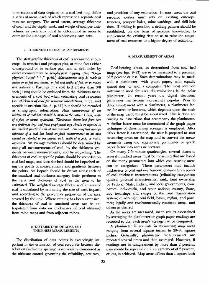
interrelations of data depicted on a coal bed map define a series of areas, each of which represent a separate coal resource category. The areal extent, average thickness of coal, and the depth, rank, and weight of coal per unit- volume in each area must be determined in order to estimate the tonnages of coal underlying each area.
7. THICKNESS OF COAL MEASUREMENTS
The stratigraphic thickness of coal is measured at out crops, in trenches and prospect pits, at mine faces either underground or in surface pits, and in drill holes by direct measurement or geophysical logging. (See "Geo physical Logs* * *," p.46.) Measurements may be made in inches or in feet and inches, in feet and tenths of feet, or in meters and centimeters. Partings in a coal bed greater than 3/8 inch (1 cm) should be excluded from the thickness meas urements of a coal bed when estimating coal resources (see thickness of coal for resource calculations, p. 31, and specific instruction No. 3, p. 34) but should be recorded as stratigraphic information. Field measurements of the thicknesses of coal beds should be made to the nearest 1 inch, tenth of a foot, or metric equivalent. Thicknesses determined from core and drill-hole logs and from geophysical logs should be reported to the smallest practical unit of measurement. The weighted average thickness of a coal bed based on field measurements in an area should be reported to the nearest inch, tenth of a foot, or metric equivalent. An average thickness should be determined by using all measurements of coal, by the thickness gra dients between measurements, and by isopaching. The thickness of coal at specific points should be recorded on coal bed maps, and then the bed should be isopached us ing the points of measurements and gradients between the points. An isopach should be drawn along each of the standard coal thickness category limits pertinent to the rank and thickness of coal in the area to be estimated. The weighted average thickness of an area of coal is calculated by estimating the size of each isopach unit according to the percent or proportion of the area covered by the unit. Where mining has been extensive, the thickness of coal in unmined areas can be ex trapolated from data on thicknesses of coal obtained from mine maps and from adjacent mines.
8. DISTRIBUTION OF COAL BED THICKNESS MEASUREMENTS
The distribution of data points is exceedingly im portant in the estimation of coal resources because dis tribution (including spacing) is universally considered as the ultimate control governing the reliability, accuracy,
and precision of any estimation. In most areas the coal resource worker must rely on existing outcrops, trenches, prospect holes, mine workings, and drill-hole data. If drilling is possible, a drilling pattern should be established, on the basis of geologic knowledge, to supplement the existing data so as to raise the assign ment of coal resources to a higher degree of reliability.
9. MEASUREMENT OF AREAS
Coal-bearing areas, as determined from coal bed maps (see figs. 9-23) are to be measured to a precision of 2 percent or less. Such determinations may be made with a planimeter, with graph paper, with equally spaced dots, or with a computer. The most common instrument used for area determinations is the polar planimeter. In recent years the digital electronic planimeter has become increasingly popular. Prior to determining areas with a planimeter, a planimeter fac tor for acres or hectares, which depends upon the scale of the map used, must be ascertained. This is done ac cording to instructions that accompany the planimeter. A similar factor must be determined if the graph paper technique of determining acreages is employed. After either factor is ascertained, the user is prepared to start measuring areas on the map and to convert the meas urements using the appropriate planimeter or graph paper factor into acres or hectares.
On many 7.5-minute quadrangles, several dozen to several hundred areas must be measured that are based on the many parameters into which coal-bearing areas can be categorized. These parameters may include thicknesses of coal and overburden; distance from points of coal thickness measurements (reliability categories); quality; physical characteristics; rank, land ownership by Federal, State, Indian, and local governments, com panies, individuals, and other nations; county, State, and townships and ranges of the land classification system; quadrangle, coal field, basin, region, and prov ince; legally and environmentally restricted areas, and others as desired.
As the areas are measured, mean results ascertained by averaging the planimeter or graph paper readings are recorded so that each area's acreage can be computed.
A planimeter is accurate in measuring map areas ranging from several square inches to 20-30 square inches. Generally, planimetric measurements are repeated several times and then averaged. However, if readings are in disagreement by more than 2 percent, they should be repeated until an agreement of 2 percent, or less, is achieved. Map areas of less than 1 square inch
35
commonly are not as precisely measureable with a plani- meter as are larger map areas and must be remeasured and the planimeter vernier read many times to obtain an agreement within a 2-percent error. Repetition of planimetric measurements with only two vernier read ings, one at the beginning and one at the end, can be ac complished by continuously tracing the borders of the area being measured a predetermined number of times in a manner similar to the repetitive turning of angles with a transit by a surveyor. The difference between the two readings should be divided by the number of times the borders are traced; the answer multiplied by the planimeter factor is the size of the area. This repetitive measurement of an area is a good method of obtaining precise planimetric readings.
areas (acres or hectares), coal thicknesses, and weight of coal per unit volume and summed for each coal cate gory. The tonnage estimates for each coal category are then rounded to significant numbers so as to not elim inate tonnage estimates for small areas of measured and indicated coal. For example, the tonnage estimates for small areas such as A, B, C, F, G, H, K, M, O, P, Q, and R in figure 17 and A, B, C, D, E, F, G, H, L, Q, W, Y, AA, HH, and OO in figure 19 are not rounded out of the totals and are included in the summing of the total coal resources for all areas in figures 17 and 19. After summing, the resultant total coal resources estimates for a whole map area (a quadrangle, county, or basin) are not rounded because their component parts have been rounded.
10. WEIGHT OF COAL PER UNIT VOLUME
A tonnage estimate for any coal deposit can be made if the thickness of coal, area! extent, and weight of coal per unit volume are known. The weight of coal per unit volume (density) or specific gravity varies with rank, ash content, and the amount of each macerals group (such as vitrinite, inertinite, and exinite) in the coal. Ideally the density of coal in a deposit should be determined from numerous specific gravity determinations on un broken coal, but there are rarely sufficient deter minations to characterize a deposit. Therefore, it is recommended that tonnage calculations be based either on the average specific gravity or the average weight of unbroken coal per unit volume of the different ranks shown in table 2.
11. CALCULATION OF COAL RESOURCES
After the area underlain by coal, the average thick ness of coal, and the weight of coal per unit volume for each category shown on a coal bed map have been deter mined, the tonnage can be estimated. The tonnage is estimated by the following formula:
A x B x C = tonnage of coal whereA - weighted average thickness of coal in inches,
feet, centimeters, or meters, E = weight of coal per appropriate unit volume in
short or metric tons, and C = area underlain by coal in acres or hectares.
12. ROUNDING OF TONNAGE ESTIMATES
The rounding of tonnage figures shall be done only after all calculations have been completed using data for
13. ESTIMATION OF RESOURCES IN THE VICINITY OFWHERE A COAL BED BIFURCATES INTO
TWO OR MORE TONGUES
Resource estimation is difficult in those localities where a coal bed bifurcates or splits into tongues, each of which exceeds the minimum thickness for resource esti mation. The difficulty is caused by the necessity to delineate a boundary between the area where the re sources of the main coal bed are estimated and the areas where the resources of the tongues are individually estimated.
As stated in the glossary, a parting is "a layer or stratum of non-coal material in a coal bed which does not exceed the thickness of coal in either the underlying or overlying benches" of coal. Where the non-coal material exceeds the thickness of either the underlying or overlying parts of the coal bed, the coal bed is consid ered for the purpose of resource estimation to have split into two coal beds (each of which is depositionally a tongue from a thicker main coal bed).
In estimating resources in such a geologic situation, it is necessary to delineate on a coal bed map the areas where resources will be separately calculated; to do so, a line is used to connect all points where one of the tongues becomes thinner than the intervening parting. It is also necessary to locate on the coal bed map all points where the thickness of the main coal bed and the tongues were measured. Measured, indicated, and in ferred reliability circles should be drawn on the bed map from each point of thickness of coal measurement on the main bed and the tongues. The circles should be drawn, according to the appropriate distance for each reliability category, across the boundary line for resource estima tion. After the circles are drawn, the thickness variations of the main coal bed and each tongue (bed) are to be iso- pached separately. Tonnage estimates should then be
36
calculated for each tongue (bed) and the main bed using procedures outlined elsewhere in this report for separate coal beds.
ESTIMATION OF HYPOTHETICAL RESOURCES
The estimation of hypothetical coal resources in areas where geologic, thickness, rank, and areal size data are sparse or absent is necessary to promote exploration for poorly known and undiscovered coal areas. Currently about 2.24 trillion short tons of the Nation's 3.68 trillion tons of remaining coal resource inventory are classified as undiscovered (hypothetical) (Averitt, 1975). Much additional unknown coal may be concealed in the cen tral parts of basins and is not as yet included in the Na tion's coal inventory. This additional unknown coal must be identified, as must the 2.24 trillion tons cur rently remaining in the inventory, because knowledge of the quantity, quality, and rank of the unknown and hypothetical coal could influence the Nation's energy usage plans. Therefore, a question commonly asked by government and industry estimators responsible for in ventorying coal resources is: How do you estimate re sources where there are no nearby thickness, depth, and rank data? Another way of stating this question is: How do you estimate the resources of central parts of poorly explored or unexplored basins?
The problem of estimating hypothetical resources in the central parts of basins and elsewhere has been ap proached by (1) not attempting to calculate them; (2) as suming that the centers of the basins or coal-bearing areas where control is lacking are barren of coal; (3) as suming that the better known marginal areas of coal- bearing basins are representative of the average quantity of coal per square mile in the central parts of the basins; (4) assuming an average thickness of coal and applying this factor to the volume of coal-bearing rocks in an area; and (5) making an outright guess. None of these solutions are satisfactory. A sixth solution has been to extrapolate measurement data from surrounding areas into the unknown area. This approach is better than the others but commonly is inadequate because it does not consider geologic factors that would control un systematic distribution of coal in an unknown area.
The following discussion describes two methods, based on geologic principles, for estimating hypothetical resources. Both are acceptable if the supporting basic geologic and measurement data are documented and presented for evaluation. These alternative approaches can be termed the "extrapolated bed map method" and the "extrapolated coal zone method." Both methods are based on the extrapolation of geologic knowledge and
measurement data into an area of unknown coal re sources. In some problem areas, a mix of the two meth ods may be desirable.
Much of the data called for in the descriptions of the extrapolated bed map and extrapolated coal zone methods will not be available in many areas where hypothetical resources must be estimated. The descrip tions of the methods are written for the ideal amount of control adjacent to an unknown area; thus, the methods will have to be modified on the basis of the type, avail ability, and amount of control data.
EXTRAPOLATED BED MAP METHOD
Step 1. Assemble all available geologic data in the areas adjacent to the unknown area for the coal bed whose resources are to be estimated.
Step 2. Assemble and plot on a base map all perti nent data on thicknesses of coal and overburden, quality of coal, reports of coal in drill holes and wells, and rank of coal.
Step 3. Analyze all data collected in steps 1 and 2 to ascertain trends of coal deposition by (a) construct ing isopach maps of the coal bed in known areas; (b) constructing isopleth maps of heat values, ash contents, and contents of trace elements that may be related to sources of sediment; and (c) identify ing trends of persistent thick or thin coal, or other parameters of coal.
Step 4. Identify depositional and erosional trends and features in the known areas of rocks adjacent to the coal bed and in the coal bed itself that may in dicate ancestorial through-flowing rivers in swamps, coastal environments, unconformities, directions of delta building, paleogeomorphic loca tions of swamps on a coastal plain or delta, and directions and distances to sediment sources. Plot all pertinent data on a map.
Step 5. Extend stratigraphy from known areas into and across the unknown area by utilizing all sur face and subsurface information. Collect surface stratigraphic data and existing petroleum and water well information. Evaluate and analyze all data and determine best correlations so that coal bed extensions and correlations can be made. De termine from available data probable geologic model of deposition. Plot all data on the map of step 4.
Step 6. Construct structure sections across the un known area so that changes in the thickness of over burden and rank of the coal bed can be considered and (or) postulated.
37
Step 7. Construct a structure contour map of the coal bed in the unknown area.
Step 8. Combine all pertinent data from steps 2, 3, 4, 5, and 7 onto a single coal bed map.
Step 9. Fill in the unknown area by projecting per tinent coal and other data across or through the unknown area. This projection should include iso- pachs for thicknesses of coal and overburden, isopleths for rank and (or) heat values, predicted erosional channels cutting through the coal, and other stratigraphic, depositional, or structural fea tures affecting the coal bed.
Step 10. Place land lines and boundaries of political subdivisions on the map.
Step 11. Define areas of hypothetical coal by plot ting the outer limits of inferred coal as determined from points of thickness control in the known areas. Determine acreages of hypothetical coal for the following resource categories: thicknesses of coal and overburden; rank; quadrangle; townships and ranges; counties; and State.
Step 12. Determine the average coal bed thickness for each acreage unit in each category.
Step 13. Calculate and sum estimated tonnages for each category, round estimated tonnages to signifi cant figures as per specific instruction No. 12, p. 36, and sum into a final hypothetical tonnage. These estimated tonnages and the total summed tonnage probably represent the best information that can be estimated for a bed that extends from a known area into an unknown area where control points are absent or sparse.
EXTRAPOLATED COAL ZONE METHOD
If the procedure for an extrapolated bed map analysis of hypothetical coal resources is impractical because of time limitations or sparsity of data it is suggested that the approach to estimating hypothetical resources be by an extrapolated coal zone method.
Step 1. Determine if a coal zone exists by analyzingthe available data.
Step 2. Assemble and plot on a base map all avail able geologic data in areas adjacent to the unknown area.
Step 3. Construct an isopach map of the cummula- tive thicknesses of all coal beds in the coal zone (less partings) that exceed 14 inches for anthracite and bituminous coal beds and 30 inches for lignite and subbituminous coal beds in known areas.
Step 4. Identify trends and geologic features in the rocks of the coal zone in the known area that may indicate persistent ancient through-going rivers,
coastal environments, unconformities, directions of sediment transport, intertonguing sediments and coal beds, regressions and transgressions, and so on. Plot pertinent data on a map.
Step 5. Extend stratigraphy of the coal zone and related rocks into and across the unknown area on the map of step 4 by utilizing all surface and sub surface data. Determine geologic model of deposi tion of the coal zone. Construct stratigraphic diagram of the coal zone and fit diagrammatic data to the map.
Step 6. Construct structure sections across the un known area so that thickness of overburden and rank changes of coal zone can be considered and (or) postulated.
Step 7. Construct a structure contour map of the coal zone in the unknown area.
Step 8. Combine all pertinent data from steps 2, 3, 4, 5, and 7 onto a single coal zone map.
Step 9. Fill in unknown area by projecting pertinent coal zone and other data across or through un known area.
Step 10. Place land lines and boundaries of politi cal subdivisions on map.
Step 11. Define areas of hypothetical coal by plot ting an outer limit of inferred coal as determined from points of thickness control in the known areas. Determine acreages of hypothetical coal for the following categories: thicknesses of overburden, cummulative thicknesses of coal, rank, quadrangle, townships and ranges, counties, and State.
Step 12. Calculate and sum tonnages for each cate gory after determining a cummulative thickness of coal for each acreage unit in each category and cal culating tonnage. Round tonnages to significant figures as per specific instruction No. 12, p. 36, and sum into a total hypothetical tonnage amount.
The extrapolated coal zone solution for hypothetical coal eliminates the estimation of tonnages for many in dividual beds and, in the view of some workers, pro vides a more valid estimate than the bed-by-bed ap proach. Despite this view, the bed-by-bed method is herein recommended for use where practicable and (or) feasible.
EXAMPLES ILLUSTRATING THE BASICGEOMETRIC PRINCIPLES OF
CONSTRUCTING COAL RESOURCE BED MAPS
Coal resource estimation systems on a worldwide basis generally lack illustrations amplifying written in structions as to how to calculate coal resources.
38
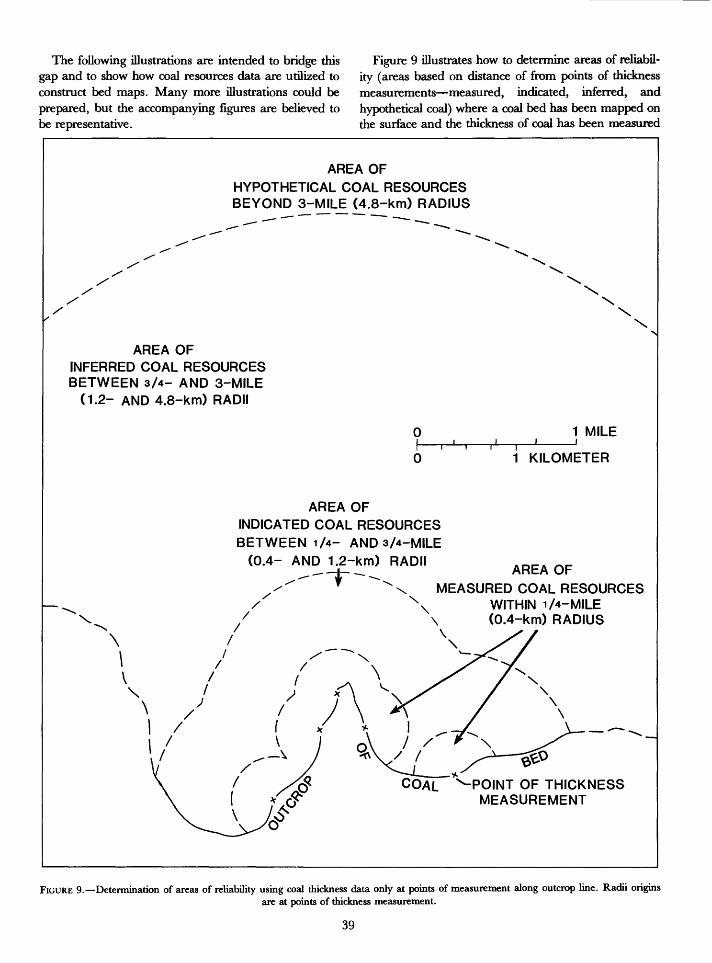
The following illustrations are intended to bridge this gap and to show how coal resources data are utilized to construct bed maps. Many more illustrations could be prepared, but the accompanying figures are believed to be representative.
Figure 9 illustrates how to determine areas of reliabil ity (areas based on distance of from points of thickness measurements measured, indicated, inferred, and hypothetical coal) where a coal bed has been mapped on the surface and the thickness of coal has been measured
AREA OF
HYPOTHETICAL COAL RESOURCES BEYOND 3-MILE (4.8-km) RADIUS
AREA OFINFERRED COAL RESOURCESBETWEEN 3/4- AND 3-MILE
(1.2- AND 4.8-km) RADII
1 MILE
1 KILOMETER
AREA OFINDICATED COAL RESOURCESBETWEEN 1/4- AND 3/4-MILE
(0.4- AND 1.2-km) RADII i-* AREA OF
MEASURED COAL RESOURCES N WITHIN 1/4-MILE
(0.4-km) RADIUS
COAL ^POINT OF THICKNESS MEASUREMENT
FIGURE 9. Determination of areas of reliability using coal thickness data only at points of measurement along outcrop line. Radii originsare at points of thickness measurement.
39
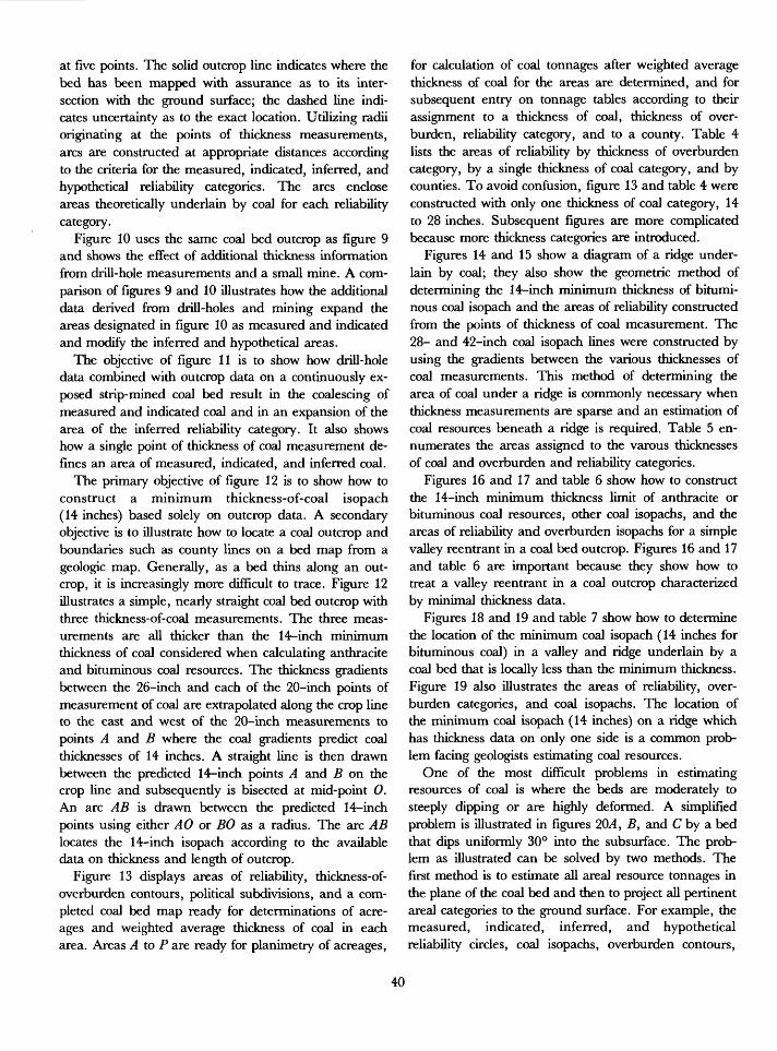
at five points. The solid outcrop line indicates where the bed has been mapped with assurance as to its inter section with the ground surface; the dashed line indi cates uncertainty as to the exact location. Utilizing radii originating at the points of thickness measurements, arcs are constructed at appropriate distances according to the criteria for the measured, indicated, inferred, and hypothetical reliability categories. The arcs enclose areas theoretically underlain by coal for each reliability category.
Figure 10 uses the same coal bed outcrop as figure 9 and shows the effect of additional thickness information from drill-hole measurements and a small mine. A com parison of figures 9 and 10 illustrates how the additional data derived from drill-holes and mining expand the areas designated in figure 10 as measured and indicated and modify the inferred and hypothetical areas.
The objective of figure 11 is to show how drill-hole data combined with outcrop data on a continuously ex posed strip-mined coal bed result in the coalescing of measured and indicated coal and in an expansion of the area of the inferred reliability category. It also shows how a single point of thickness of coal measurement de fines an area of measured, indicated, and inferred coal.
The primary objective of figure 12 is to show how to construct a minimum thickness-of-coal isopach (14 inches) based solely on outcrop data. A secondary objective is to illustrate how to locate a coal outcrop and boundaries such as county lines on a bed map from a geologic map. Generally, as a bed thins along an out crop, it is increasingly more difficult to trace. Figure 12 illustrates a simple, nearly straight coal bed outcrop with three thickness-of-coal measurements. The three meas urements are all thicker than the 14-inch minimum thickness of coal considered when calculating anthracite and bituminous coal resources. The thickness gradients between the 26-inch and each of the 20-inch points of measurement of coal are extrapolated along the crop line to the east and west of the 20-inch measurements to points A and B where the coal gradients predict coal thicknesses of 14 inches. A straight line is then drawn between the predicted 14-inch points A and B on the crop line and subsequently is bisected at mid-point 0. An arc AB is drawn between the predicted 14-inch points using either AO or BO as a radius. The arc AB locates the 14-inch isopach according to the available data on thickness and length of outcrop.
Figure 13 displays areas of reliability, thickness-of- overburden contours, political subdivisions, and a com pleted coal bed map ready for determinations of acre ages and weighted average thickness of coal in each area. Areas A to P are ready for planimetry of acreages,
for calculation of coal tonnages after weighted average thickness of coal for the areas are determined, and for subsequent entry on tonnage tables according to their assignment to a thickness of coal, thickness of over burden, reliability category, and to a county. Table 4 lists the areas of reliability by thickness of overburden category, by a single thickness of coal category, and by counties. To avoid confusion, figure 13 and table 4 were constructed with only one thickness of coal category, 14 to 28 inches. Subsequent figures are more complicated because more thickness categories are introduced.
Figures 14 and 15 show a diagram of a ridge under lain by coal; they also show the geometric method of determining the 14-inch minimum thickness of bitumi nous coal isopach and the areas of reliability constructed from the points of thickness of coal measurement. The 28- and 42-inch coal isopach lines were constructed by using the gradients between the various thicknesses of coal measurements. This method of determining the area of coal under a ridge is commonly necessary when thickness measurements are sparse and an estimation of coal resources beneath a ridge is required. Table 5 en- numerates the areas assigned to the varous thicknesses of coal and overburden and reliability categories.
Figures 16 and 17 and table 6 show how to construct the 14-inch minimum thickness limit of anthracite or bituminous coal resources, other coal isopachs, and the areas of reliability and overburden isopachs for a simple valley reentrant in a coal bed outcrop. Figures 16 and 17 and table 6 are important because they show how to treat a valley reentrant in a coal outcrop characterized by minimal thickness data.
Figures 18 and 19 and table 7 show how to determine the location of the minimum coal isopach (14 inches for bituminous coal) in a valley and ridge underlain by a coal bed that is locally less than the minimum thickness. Figure 19 also illustrates the areas of reliability, over burden categories, and coal isopachs. The location of the minimum coal isopach (14 inches) on a ridge which has thickness data on only one side is a common prob lem facing geologists estimating coal resources.
One of the most difficult problems in estimating resources of coal is where the beds are moderately to steeply dipping or are highly deformed. A simplified problem is illustrated in figures 2QA , B, and C by a bed that dips uniformly 30° into the subsurface. The prob lem as illustrated can be solved by two methods. The first method is to estimate all areal resource tonnages in the plane of the coal bed and then to project all pertinent areal categories to the ground surface. For example, the measured, indicated, inferred, and hypothetical reliability circles, coal isopachs, overburden contours,
40
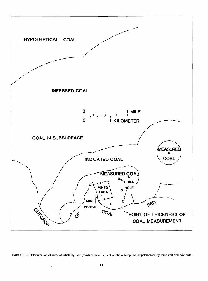
HYPOTHETICAL COAL
INFERRED COAL
1 MILEI______I_____I
1 KILOMETER
COAL IN SUBSURFACE
INDICATED COAL
f___ S"
^-^-^K/iEASURED °x
,~ >»
/MEASURE^
V<COAL
POINT OF THICKNESS OF
COAL MEASUREMENT
FIGURE 10. Determination of areas of reliability from points of measurement on the outcrop line, supplemented by mine and drill-hole data.
41
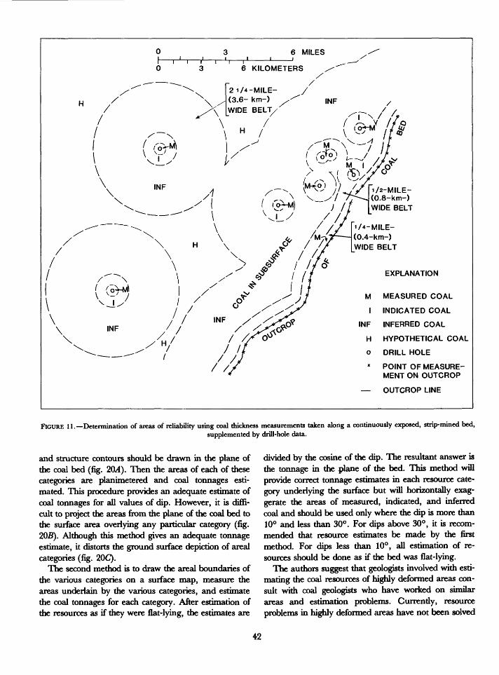
1/2-MILE- (0.8-km-) WIDE BELT
21/4-MILE-
(3.6- km-) WIDE BELT
i/4-MILE-
(0.4-km-) WIDE BELT
EXPLANATION
MEASURED COAL
INDICATED COAL
INFERRED COAL
HYPOTHETICAL COAL
DRILL HOLE
* POINT OF MEASURE MENT ON OUTCROP
OUTCROP LINE
FIGURE 11. Detennination of areas of reliability using coal thickness measurements taken along a continuously exposed, strip-mined bed,supplemented by drill-hole data.
and structure contours should be drawn in the plane of the coal bed (fig. 20/4). Then the areas of each of these categories are planimetered and coal tonnages esti mated. This procedure provides an adequate estimate of coal tonnages for all values of dip. However, it is diffi cult to project the areas from the plane of the coal bed to the surface area overlying any particular category (fig. 205). Although this method gives an adequate tonnage estimate, it distorts the ground surface depiction of area! categories (fig. 20C).
The second method is to draw the area! boundaries of the various categories on a surface map, measure the areas underlain by the various categories, and estimate the coal tonnages for each category. After estimation of the resources as if they were flat-lying, the estimates are
divided by the cosine of the dip. The resultant answer is the tonnage in the plane of the bed. This method will provide correct tonnage estimates in each resource cate gory underlying the surface but will horizontally exag gerate the areas of measured, indicated, and inferred coal and should be used only where the dip is more than 10° and less than 30°. For dips above 30°, it is recom mended that resource estimates be made by the first method. For dips less than 10°, all estimation of re sources should be done as if the bed was flat-lying.
The authors suggest that geologists involved with esti mating the coal resources of highly deformed areas con sult with coal geologists who have worked on similar areas and estimation problems. Currently, resource problems in highly deformed areas have not been solved
42
S37S>
oft^
/
x'0
\<
COAL IN SUBSURFACE
OUTCROP 20V'OF~26"
EXPLANATION 20"POINT OF MEASUREMENT OF THICKNESS OF COAL IN
x INCHES
14-INCH ISOPACH
A,B POINTS WHERE COAL BED IS 14" THICK AS DETERMINED BY EXTRAPOLATING FROM POINTS OF MEASUREMENT
O MIDPOINT OF LINE AB
FIGURE 12. Determination of minimum thickness isoline of 14-inch thick anthracite or bituminous coal using data from a nearly straight outcrop line. A and B are located on the outcrop line where the coal thickness as extrapolated from the points of measurement are pre dicted to be 14 indies. Line AB connecting the points of predicted 14-inch coal is bisected at 0. The radius AO or BO is then used to con struct arc AB, the 14-inch isopach or predicted limit of 14-inch-thick coal. This figure also shows the location of the outcrop line and a county boundary on a coal bed map as derived from a geologic map.
escept locally for small areas. Although methods have been developed, they are generally very time consuming and as yet unproven by mining.
Figure 21 illustrates a coal bed that has been mined from shafts at some distance from outcrops. All data are
derived from the mines or drill holes. The figure shows measured, indicated, inferred, and hypothetical coal; county lines; thickness of coal measurements; coal thick ness categories; and the 0-200 feet, 200-300 feet, and the 300-500 feet overburden categories. It also shows a
43
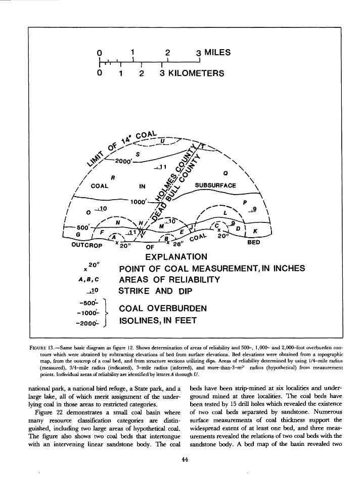
0 3 MILES
01 I2 3 KILOMETERS
S>* 20^-oJLJ20- OF ~ 26" BE°
EXPLANATION
POINT OF COAL MEASUREMENT, IN INCHES AREAS OF RELIABILITY
STRIKE AND DIP
COAL OVERBURDEN
ISOLINES, IN FEET
FIGURE 13. Same basic diagram as figure 12. Shows determination of areas of reliability and 500-, 1,000- and 2,000-foot overburden con tours which were obtained by subtracting elevations of bed from surface elevations. Bed elevations were obtained from a topographic map, from the outcrop of a coal bed, and from structure sections utilizing dips. Areas of reliability determined by using 1/4-mile radius (measured), 3/4~mile radius (indicated), 3-mile radius (inferred), and more-than-3-m'' radius (hypothetical) from measurement points. Individual areas of reliability are identified by letters A through U.
national park, a national bird refuge, a State park, and a large lake, all of which merit assignment of the under lying coal in those areas to restricted categories.
Figure 22 demonstrates a small coal basin where many resource classification categories are distin guished, including two large areas of hypothetical coal. The figure also shows two coal beds that intertongue with an intervening linear sandstone body. The coal
beds have been strip-mined at six localities and under ground mined at three localities. The coal beds have been tested by 15 drill holes which revealed the existence of two coal beds separated by sandstone. Numerous surface measurements of coal thickness support the widespread extent of at least one bed, and three meas urements revealed the relations of two coal beds with the sandstone body. A bed map of the basin revealed two
44
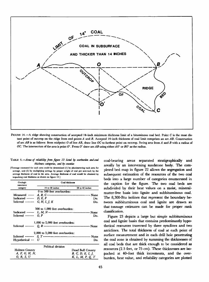
COAL IN SUBSURFACE
AND THICKER THAN 14 INCHES \
FIGURE 14. A ridge showing construction of accepted 14-inch minimum thickness limit of a bituminous coal bed. Point C is the most dis tant point of outcrop on the ridge from end points A and B. Accepted 14-inch thickness of coal limit comprises an arc AB. Construction of arc AB is as follows: from midpoint 0 of line AB, draw line OC to furthest point on outcrop. Swing arcs from A and B with a radius of OC. The intersection of the arcs is point 0' . From 0' draw arc^45 using either AO' or BO' as the radius.
TABLE 4. Areas of reliability from figure 13 listed by overburden and coal thickness categories, and by counties
[Tonnage estimated for each area could be determined (1) by planimetering each area for acreage, and (2) by multiplying acreage by proper weight of coal per acre-inch by the average thickness of coal in the area. Average thickness of coal would be obtained by isopaching coal thickness as shown on figure 13 ]
Geologic assurance category
Coal thickness
14 to 28 inches 28 to 42 inches
0 to 500 feet overburden: Measured A, B, C NoneIndicated D, E, F Do. Inferred G, H, I,J, K Do.
500 to 1,000 feet overburden: Indicated L, M, N NoneInferred 0, P Do.
1,000 to 2,000 feet overburden Inferred Q, R ________________ INO0C
2,000 to 3,000 feet overburden: Inferred S, T NoneHypothetical U Do.
Political divisionHolmes County A, F, G, H, N, 0, R, S, U
Dead Bull County B, C, D, E, I, J, K, L, M, P, Q, T
coal-bearing areas separated stratigraphically and areally by an intervening sandstone body. The com pleted bed map in figure 22 allows the segregation and subsequent estimation of the resources of the two coal beds into a large number of categories enumerated in the caption for the figure. The two coal beds are subdivided by their heat values on a moist, mineral- matter-free basis into lignite and subbituminous coal. The 8,300-Btu isolines that represent the boundary be tween subbituminous coal and lignite are drawn so that tonnage estimates can be made for proper rank classification.
Figure 23 depicts a large but simple subbituminous coal and lignite basin that contains predominantly hypo thetical resources traversed by three synclines and two anticlines. The total thickness of coal at each point of surface measurement and in each drill hole penetrating the coal zone is obtained by summing the thicknesses of all coal beds that are thick enough to be considered as resources (2.5 feet, or 75 cm). These thicknesses are iso- pached at 40-foot thick increments, and the over burden, heat value, and reliability categories are plotted
45
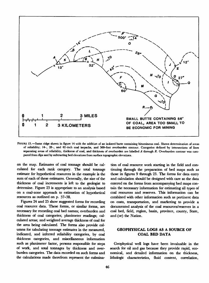
3 MILESii n r0 1 3 KILOMETERS
SMALL BUTTE CONTAINING 56" OF COAL, AREA TOO SMALL TO BE ECONOMIC FOR MINING
FIGURE 15. Same ridge shown in figure 14 with the addition of an isolated butte containing bituminous coal. Shows determination of areas of reliability; 14-, 28-, and 42-inch coal isopachs, and 500-foot overburden contour. Categories defined by intersections of lines separating areas of reliability, thickness of coal, and thickness of overburden are labelled A through R. Overburden contour was com puted from dips and by subtracting bed elevations from surface topographic elevations.
on the map. Estimates of coal tonnage should be cal culated for each rank category. The total tonnage estimate for hypothetical resources in the example is the sum of each of these estimates. Generally, the size of the thickness of coal increments is left to the geologist to determine. Figure 23 is appropriate to an analysis based on a coal-zone approach to estimation of hypothetical resources as outlined on p. 37-38.
Figures 24 and 25 show suggested forms for recording coal resource data. These forms, or similar forms, are necessary for recording coal bed names; overburden and thickness of coal categories; planimeter readings; cal culated areas; and weighted average thickness of coal for the area being calculated. The forms also provide col umns for tabulating tonnage estimates in the measured, indicated, and inferred reliability categories, by coal thickness categories, and miscellaneous information such as planimeter factor, persons responsible for steps of work, and total tonnages by thickness and over burden categories. The data recorded on such forms and the calculations made therefrom represent the culmina
tion of coal resource work starting in the field and con tinuing through the preparation of bed maps such as those in figures 9 through 23. The forms for data entry and calculation should be designed with care so the data entered on the forms from accompanying bed maps con tain the necessary information for estimating all types of coal resources and reserves. This information can be combined with other information such as pertinent data on costs, transportation, and marketing to provide a documented analysis of the coal resources/reserves in a coal bed, field, region, basin, province, county, State, and (or) the Nation.
GEOPHYSICAL LOGS AS A SOURCE OF COAL BED DATA
Geophysical well logs have been invaluable in the search for oil and gas because they provide rapid, eco nomical, and detailed information on the thickness, lithologic characteristics, fluid content, correlation,
46
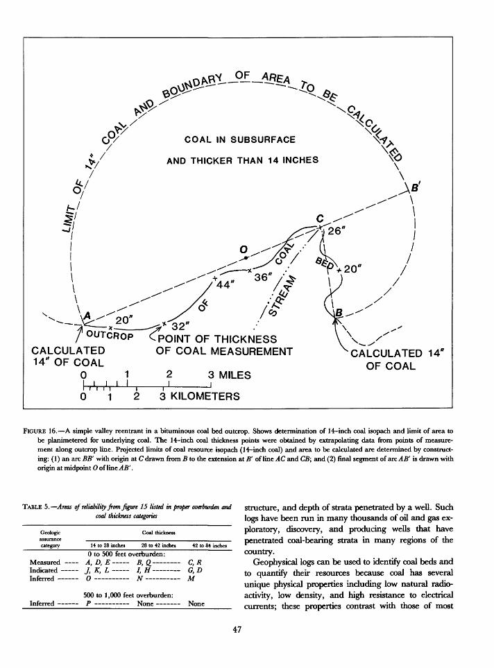
COAL IN SUBSURFACE
AND THICKER THAN 14 INCHES
\-f>
7 OUTCROP
CALCULATED 14" OF COAL
0 1
32"
- POINT OF THICKNESS OF COAL MEASUREMENT
i i i I3 MILES
CALCULATED 14* OF COAL
1 2 3 KILOMETERS
FIGURE 16. A simple valley reentrant in a bituminous coal bed outcrop. Shows determination of 14-inch coal isopach and limit of area to be planimetered for underlying coal. The 14-inch coal thickness points were obtained by extrapolating data from points of measure ment along outcrop line. Projected limits of coal resource isopach (14-inch coal) and area to be calculated are determined by construct ing: (1) an arc BB' with origin at C drawn from B to the extension at B' of line AC and CB; and (2) final segment of arc AB' is drawn with origin at midpoint 0 of line AB'.
TABLE 5. Areas of reliability from figure 15 listed in proper overburden and coal thickness categories
Geologic assurance category
Measured -
Inferred
Coal thickness
14 to 28 inches 28 to 42 inches
0 to 500 feet overburden:A, D, E B, d j K J _____ / If ______ _
0 N
42 to 84 inches
C, RG,DM
500 to 1,000 feet overburden: Inferred P None None
structure, and depth of strata penetrated by a well. Such logs have been run in many thousands of oil and gas ex ploratory, discovery, and producing wells that have penetrated coal-bearing strata in many regions of the country.
Geophysical logs can be used to identify coal beds and to quantify their resources because coal has several unique physical properties including low natural radio activity, low density, and high resistance to electrical currents; these properties contrast with those of most
47
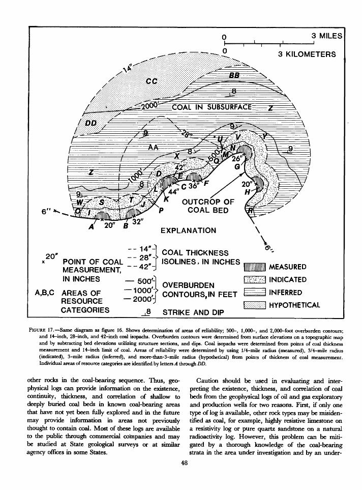
3 MILEST r
3 KILOMETERS
2000===COAL | N SUBSURFACE
^=3B^: ;Jfe;;v:'->S
20 COAL THICKNESS 'SOLINES, IN INCHESPOINT OF COAL _
MEASUREMENT, IN INCHES _
__., «' OVERBURDEN 1000A.B.C AREAS OF "I""",? CONTOURS,IN FEET INFERRED
RESOURCE 2000J 'CATEGORIES ft STRIKE AND DIP
MEASURED
INDICATED
HYPOTHETICAL
FIGURE 17. Same diagram as figure 16. Shows determinadon of areas of reliability; 500-, 1,000-, and 2,000-foot overburden contours; and 14-inch, 28-inch, and 42-inch coal isopachs. Overburden contours were determined from surface elevations on a topographic map and by subtracting bed elevations utilizing structure sections, and dips. Coal isopachs were determined from points of coal thickness measurement and 14-inch limit of coal. Areas of reliability were determined by using 1/4-mile radius (measured), 3/4-mile radius (indicated), 3-mile radius (inferred), and more-than-3-mile radius (hypothetical) from points of thickness of coal measurement. Individual areas of resource categories are identified by letters .4 through DD.
other rocks in the coal-bearing sequence. Thus, geo physical logs can provide information on the existence, continuity, thickness, and correlation of shallow to deeply buried coal beds in known coal-bearing areas that have not yet been fully explored and in the future may provide information in areas not previously thought to contain coal. Most of these logs are available to the public through commercial companies and may be studied at State geological surveys or at similar agency offices in some States.
Caution should be used in evaluating and inter preting the existence, thickness, and correlation of coal beds from the geophysical logs of oil and gas exploratory and production wells for two reasons. First, if only one type of log is available, other rock types may be misiden- tified as coal, for example, highly resistive limestone on a resistivity log or pure quartz sandstone on a natural radioactivity log. However, this problem can be miti gated by a thorough knowledge of the coal-bearing strata in the area under investigation and by an under-
48
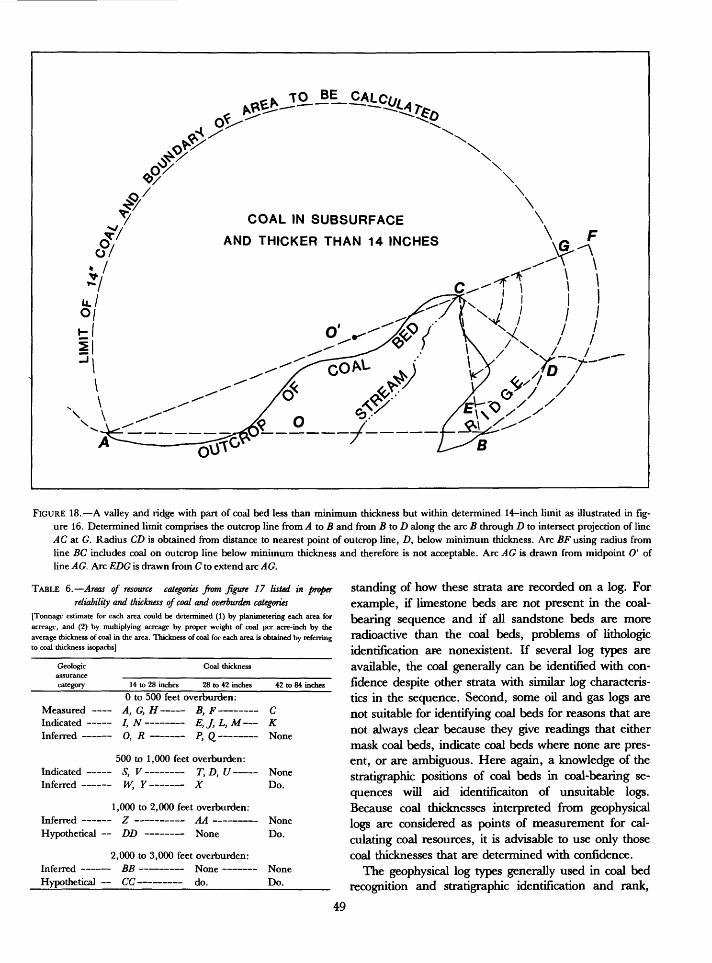
ot
/
y-3V
§/
COAL IN SUBSURFACE
AND THICKER THAN 14 INCHES
\
^,
FIGURE 18. A valley and ridge with part of coal bed less than minimum thickness but within determined 14-inch limit as illustrated in fig ure 16. Determined limit comprises the outcrop line from A to B and from BtoD along the arc B through D to intersect projection of line AC at G. Radius CD is obtained from distance to nearest point of outcrop line, D, below minimum thickness. Arc BF using radius from line BC includes coal on outcrop line below minimum thickness and therefore is not acceptable. Arc AG is drawn from midpoint O' of line AG. Arc EDG is drawn from C to extend arc AG.
TABLE 6. Areas of resource categories from figure 17 listed in proper reliability and thickness of coal and overburden categories
[Tonnage estimate for each area could be determined (1) by planimetering each area for acreage, and (2) by multiplying acreage by proper weight of coal per acre-inch by the average thickness of coal in the area. Thickness of coal for each area is obtained by referring to coal thickness isopachs]
Geologic assurance category
Measured
1 Inferred
2
Hypothetical
Coal thickness
14 to 28 inches 28 to 42 inches
0 to 500 feet overburden:A f U BE1
/, N E, J, L, M
O p __ _ p rt _
500 to 1,000 feet overburden: C T/ T D 77W V - - Y
,000 to 2,000 feet overburden: Z AA DD None
,000 to 3,000 feet overburden: BB None c/c/ do.
42 to 84 inches
C
KNone
None Do.
None Do.
None Do.
standing of how these strata are recorded on a log. For example, if limestone beds are not present in the coal- bearing sequence and if all sandstone beds are more radioactive than the coal beds, problems of lithologic identification are nonexistent. If several log types are available, the coal generally can be identified with con fidence despite other strata with similar log characteris tics in the sequence. Second, some oil and gas logs are not suitable for identifying coal beds for reasons that are not always clear because they give readings that either mask coal beds, indicate coal beds where none are pres ent, or are ambiguous. Here again, a knowledge of the stratigraphic positions of coal beds in coal-bearing se quences will aid identificaiton of unsuitable logs. Because coal thicknesses interpreted from geophysical logs are considered as points of measurement for cal culating coal resources, it is advisable to use only those coal thicknesses that are determined with confidence.
The geophysical log types generally used in coal bed recognition and stratigraphic identification and rank,
49
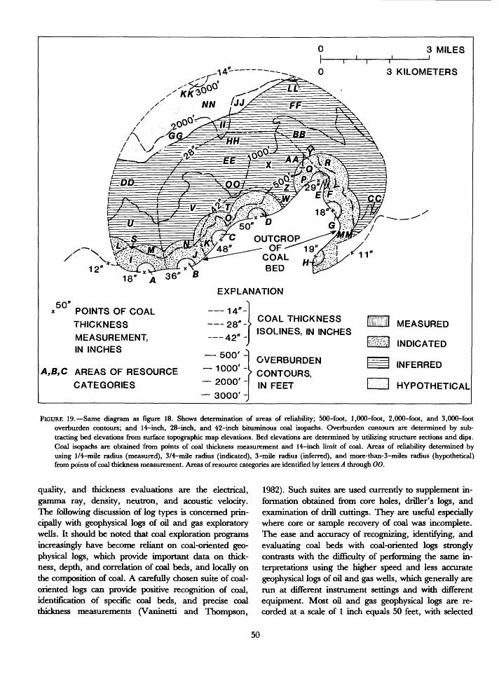
3 MILES1 I
3 KILOMETERS
1218" A
EXPLANATION50"
POINTS OF COAL
THICKNESS
MEASUREMENT, IN INCHES
A,B,C AREAS OF RESOURCE
CATEGORIES
14--
28"-|
42*
500' -
1000' - 2000' -
3000' -
COAL THICKNESS 1SOLINES, IN INCHES
OVERBURDEN
> CONTOURS, IN FEET
MEASURED
INDICATED
INFERRED
HYPOTHETICAL
FIGURE 19. Same diagram as figure 18. Shows determination of areas of reliability; 500-foot, 1,000-foot, 2,000-foot, and 3,000-foot overburden contours; and 14-inch, 28-inch, and 42-inch bituminous coal isopachs. Overburden contours are determined by sub tracting bed elevations from surface topographic map elevations. Bed elevations are determined by utilizing structure sections and dips. Coal isopachs are obtained from points of coal thickness measurement and 14-inch limit of coal. Areas of reliability determined by using 1/4-mile radius (measured), 3/4-mile radius (indicated), 3-mile radius (inferred), and more-than-3-miles radius (hypothetical) from points of coal thickness measurement. Areas of resource categories are identified by letters A through 00.
quality, and thickness evaluations are the electrical, gamma ray, density, neutron, and acoustic velocity. The following discussion of log types is concerned prin cipally with geophysical logs of oil and gas exploratory wells. It should be noted that coal exploration programs increasingly have become reliant on coal-oriented geo physical logs, which provide important data on thick ness, depth, and correlation of coal beds, and locally on the composition of coal. A carefully chosen suite of coal- oriented logs can provide positive recognition of coal, identification of specific coal beds, and precise coal thickness measurements (Vaninetti and Thompson,
1982). Such suites are used currently to supplement in formation obtained from core holes, driller's logs, and examination of drill cuttings. They are useful especially where core or sample recovery of coal was incomplete. The ease and accuracy of recognizing, identifying, and evaluating coal beds with coal-oriented logs strongly contrasts with the difficulty of performing the same in terpretations using the higher speed and less accurate geophysical logs of oil and gas wells, which generally are run at different instrument settings and with different equipment. Most oil and gas geophysical logs are re corded at a scale of 1 inch equals 50 feet, with selected
50
sections recorded at the larger scale of 1 inch equals 20 feet, which is reduced for commercial sale to 1 inch equals 100 feet and 1 inch equals 40 feet, respectively.
ELECTRIC LOGS
By far the most common geophysical logs run in oil and gas exploratory wells are electric logs. Prior to the 1950's, conventional electrical logging surveys consisted of one measurement of the spontaneous potential (SP) and three measurements of apparent electrical resistivity of the rocks adjacent to the bore hole (fig. 26). These rock properties were measured only in the uncased part of a well that was filled with water or a water-based mud. The diameter of the well and the effect of adjacent rocks combined to give confusing curves on older elec tric logs. In solving this problem, a new family of re sistivity curves, the focusing-electrode and the induction logs, came into use in the late 1950's. These logs provide better resolution of the coal beds than the older conven tional logs and permit more accurate coal thickness measurements.
SPLOG
The spontaneous potential (SP) log measures the dif ference in electrical potential between rock types, and the resulting curve is recorded on the left-hand side of the log as a single trace. This curve generally reflects the invasion of drilling fluid into the rocks, so a permeable sandstone bed tends to record as a large deflection to the left of the log response for shale (figs. 27 and 28). There are many exceptions to this generalization as shown by the deflections caused by high-porosity coal beds (see fig. 29, SP curve). There are also many wells where the SP curve is nearly featureless in a coal-bearing section and the porosity is recorded the same as shale (fig. 28/4 and B).
NORMAL AND LATERAL LOGS
Three types of resistivity curves are recorded on the right side of a geophysical log. These are the 16-inch normal (short normal); the 64-inch normal (long nor mal); and the 18-foot, 8-inch or 24-foot lateral (lateral); the names referring respectively to the spacing and to the configuration of the electrodes in the probe. These curves record the resistance of rock types to the flow of an electric current. Because most coal beds are highly
TABLE 7. Areas of resource categories from figure 19 listed in proper reliabilityand thickness of coal and overburden categories
[Average thickness of coal in each area can be determined by utilizing coal isopachs]
Geologic assurance category
Coal thickness
14 to 28 inches 28 to 42 inches 42 to 84 inches
0 to 500 feet overburden:Measured A, F,G, H B, E C, D Indicated /, MM /, J, P KInferred CC, Y, S AA, Z W
Indicated Inferred -
500 to 1,000 feet overburden: L, R, M N, Q U, BB V,X
1,000 to 2,000 feet overburden:Inferred DD, FF EE None Hypothetical GG,JJ None Do.
2,000 to 3,000 feet overburden: Inferred LL, II HH 00
Hypothetical NN None None
3,000 to 6,000 feet overburden: Hypothetical KK None None_____
resistant to the flow of an electric current compared with most adjacent rocks, resistivity curves generally show a large deflection opposite a coal bed. In the short and long (16-inch and 64-inch, respectively) normal curves, however, coal beds thinner than the electrode spacing show a "reverse" (low resistivity) curve bounded by two small peaks (fig. 2&4 and B, No. 6 coal). The lateral curve shows a large deflection opposite thin coal beds and a low deflection below the bed. The lateral curve is of little value in the measurement of the thickness of coal beds because it is asymmetric and generally offset from the coal bed. Nevertheless, this curve can be useful in correlating coal beds (fig. 28/4 and B).
FOCUSING-ELECTRODE AND INDUCTION LOGS
Focusing-electrode logs (for example, lateral logs) use special electrodes to send a narrow focused electric cur rent horizontally into adjacent rocks. This results in a resistivity curve that has good resolution of thin resistive beds such as coal (figs. 29 and 30). These focusing and lateral logs measure the conductivity (inverse of resistiv ity) and the resistivity of rocks by means of induced alternating currents. Commonly, an induction log is run in conjunction with a SP and 16-inch normal log (fig. 27). The induction log is recorded simultaneously as two curves, conductivity and resistivity. The con ductivity curve is hyperbolic, which compresses the parts of the curve characterized by low conductivity.
51
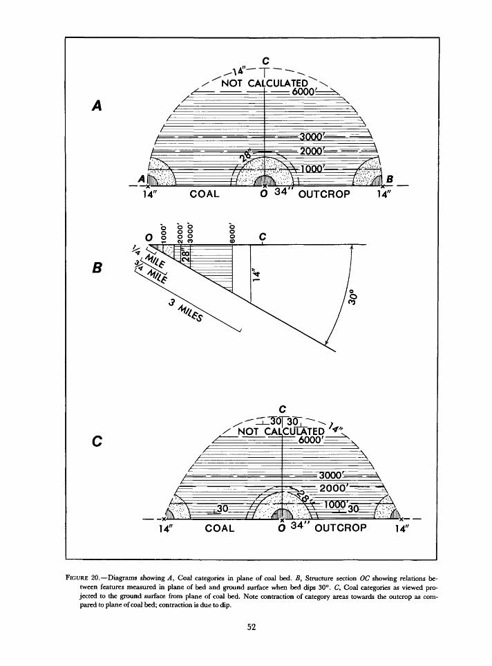
NOT CALCULATED= 6000=
14" COAL O 34 OUTCROP 14"
B
x'*** V'V WV/ I ^>
NOT CALCULATED
2000^
14" COAL O 34 OUTCROP 14"
FIGURE 20. Diagrams showing A, Coal categories in plane of coal bed. B, Structure section OC showing relations be tween features measured in plane of bed and ground surface when bed dips 30°. C, Coal categories as viewed pro jected to the ground surface from plane of coal bed. Note contraction of category areas towards the outcrop as com pared to plane of coal bed; contraction is due to dip.
52
The resistivity curve, however, is not compressed, so it can be compared directly to the short normal curve and can be used for measurement of the thickness of a coal bed. Combinations of induction and focusing-electrode logs are also common.
DISCUSSION OF ELECTRIC LOGS
With the exception of some high-moisture-content lignites, most coal beds are responsible for high- resistivity deflections on resistivity curves. However, some other rock types such as limestone or resistive sandstones also show high-resistivity deflections and may be mistaken for coal. Limestone is indistinguish able from coal on most electric logs. Fortunately, limestone beds are absent in many regions. In the Mid- continent region, however, limestone is abundant in the coal-bearing sequence and generally can be differen tiated from coal only by use of supplementary logs (see fig. 31) or by examination of closely spaced samples of drill cuttings.
Resistive sandstone beds that are permeable generally can be differentiated from coal beds because of their large deflections on a SP log (figs. 26, 27, and 28). Where a SP log is featureless or ambiguous, a knowl edge of the lithology of a coal-bearirig sequence can help differentiate coal from sandstone. For example, in the Powder River basin of Montana and Wyoming, many sandstone beds are gradational with adjacent low resistivity shale beds, whereas the shale beds are in sharp contrast with adjacent high-resistivity coal beds. As a result, the resistivity curves delineating coal beds are more nearly parallel than the curves representing the contacts of sandstone beds.
GAMMA RAY LOG
The gamma ray log records the natural gamma radia tion from rocks adjacent to a drill hole. Coal generally has low natural radioactivity as compared with other rocks, particularly shale, in a coal-bearing sequence (figs. 29, 30, and 31). In some coal-bearing regions, limestone and sandstone may have similar low natural radioactivity (for example, Midcontinent or Appala chian regions) so that in those regions supplemental logs such as density or acoustic velocity are needed to iden tify coal. In other regions, gamma ray logs alone are suf ficient to identify coal beds as, for example, in the Fruitland Formation (Fassett and Hinds, 1971) and in the Northern Great Plains where no other rock types in
the Tertiary coal-bearing sequence, including lime stone, are known to have as low a natural radioactivity as coal. Even in areas where a gamma ray log is diag nostic of coal, a few oil and gas well gamma ray logs are useless because their time constant is so long and their sensitivity is so low that a coal bed either cannot be de tected or its boundaries are obscured. Locally some coal beds are uraniferous; consequently, a high radioactivity is recorded on gamma ray logs. These uranium-bearing coal beds usually can be identified by using other log ging methods.
A gamma ray log is the most versatile of the geophys ical logs for the following reasons: (1) it does not require fluid in the hole; (2) it is not sensitive to small variations in hole diameter; and (3) it can be used to detect coal beds through well casing. In fact, near-surface gamma ray logs of cased oil and gas wells are a prime source of data for identifying and measuring the thickness of shallow coal beds in the Northern Great Plains region.
The gamma ray logs can detect shale partings in a coal bed, but generally the thickness of thin partings is exaggerated. In the Powder River basin of Montana, there is an example where the gamma ray log records a 0.3-foot shale parting at the same thickness as a 2-foot parting.
DENSITY LOG
A gamma-gamma density log records the bulk density of rocks adjacent to a drill hole by measuring the in duced gamma rays emitted by the rocks after bombard ment by a gamma ray source encased in a probe and lowered into the drill hole. The denser the adjacent rocks, the more gamma rays are absorbed and not re turned to a detector in the probe where they are meas ured in grams/cm3 . Most ranks of coal are low in density (about 0.7 to 1.8 grams/cm3) compared to adjacent rocks; therefore, a density log is an excellent tool for coal-bed evaluation. The density log is capable of identi fying detailed variations in the density of rocks. Density logs from oil and gas wells are commonly run at 30 feet per minute, are recorded at 1 inch equals 20 feet, and then are reduced to 1 inch equals 100 feet. At this scale and speed, thin coal beds and partings can be detected and their thicknesses accurately measured (fig. 30). Un fortunately, density logs must be run in uncased holes and are strongly affected by differences in hole diam eter; thus, the curve recorded for a caved or enlarged part of a well may simulate the curve of a coal bed. A caliper log, which measures the diameter of a well, is generally run in conjunction with these logs so that the proper interpretation and correction can be made.
53
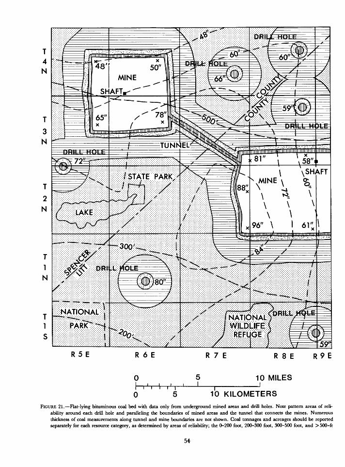
WILDLIFE
R 5 E R 6 E R 7 E
0
0r 5
51
10 MILES
10 KILOMETERS
FIGURE 21. Flat-lying bituminous coal bed with data only from underground mined areas and drill holes. Note pattern areas of reli ability around each drill hole and paralleling the boundaries of mined areas and the tunnel that connects the mines. Numerous thickness of coal measurements along tunnel and mine boundaries are not shown. Coal tonnages and acreages should be reported separately for each resource category, as determined by areas of reliability; the 0-200 foot, 200-300 foot, 300-500 foot, and > 500-ft
54
Density logs should be used in conjunction with other logs to avoid mistaking spurious low-density readings for coal. These logs are generally recorded simultane ously with a gamma ray log, which resolves most uncer tainties of rock identification.
NEUTRON LOG
The neutron log, which is similar to the density log, records the varying intensity of gamma rays resulting from inducing neutrons into rocks adjacent to a drill hole by a probe containing a radioactive source. In general, the number of gamma rays and neutrons de tected as they return to a detector in the probe are in versely proportional to the hydrogen ion content of a particular rock type. The curve recorded by the detector of returning gamma rays and neutrons can be inter preted to indicate the relative fluid content of the rocks and therefore their porosity and permeability. This log is commonly called the porosity index. The curve of the neutron log records high readings adjacent to permeable fluid-filled rocks because of their high hydrogen con tents, but it also records high adjacent to a coal bed because of its high carbon content (fig. 31). A clay with high-moisture content will also record high reading on this curve. Therefore, a high-moisture clay adjacent to a coal bed can obscure the contact between the clay and coal and record a spurious thickness of coal. Other types of logs such as the density or gamma ray will allow a more accurate measurement of the thickness of coal. Neutron logs are also strongly affected by caved or over sized diameter holes; therefore, neutron logs should be used in conjunction with caliper logs.
ACOUSTIC VELOCITY LOG
Acoustic velocity logs record the velocity of pulsed sonic waves generated in a probe, transmitted into rocks surrounding the probe in a drill hole, and reflected to receivers in the probe. The results are recorded as the inverse of velocity that is, the time in microseconds for the waves to travel 1 foot (interval transit time). The velocity of the sonic wave depends both upon the lithology and the porosity of the rock type being pene trated. If the rock type is known, therefore, the acoustic
velocity log can be used as a measure of porosity. A de crease in velocity (increase in interval transit time) can be interpreted to be the result of an increase in porosity. Coal generally has a longer interval transit time (lower velocity) than adjacent rocks. Because an acoustic veloc ity log can record velocity changes in great detail, it is commonly recorded on an expanded scale (1 inch = 20 feet) along with a gamma ray and caliper log. However, its value as a tool for identifying coal beds is dependent on the nature of the coal-bearing sequence. An acoustic velocity log is an excellent tool in deeply buried rocks such as the Tertiary rocks of southwest Wyoming. Acoustic velocity logs can be used to delineate coal beds with precision (see fig. 29). They are of lesser value where the same rocks are near the surface, are poorly consolidated, or are fractured because the many spurious low-velocity deflections are recorded. Such logs are everywhere useful in distinguishing coal from lime stone, which has a much shorter interval transit time.
MEASUREMENT OF THE COAL BED THICKNESS
The measurement of thickness of coal beds on geo physical logs requires the identification of the top and base of the coal beds by either of the following methods: (1) point of inflection method (the points where curves change direction), or (2) midpoints of inflection method (arbitrary points located midway between the points of inflection). The points of inflection method is used for measuring the thickness of coal on gamma ray logs, on resistivity logs, and for thin beds on density, neutron, and acoustic velocity logs. It is important to understand that the thickness of coal measured on the short normal and long normal resistivity curves is less than the true thickness of the coal bed by the amount of the electrode spacing; that is, 16 inches less for the short normal curve, and 64 inches less for the long normal curve. The midpoints of inflection method is used to identify the top and base of thick coal beds on the density, neutron, and acoustic velocity logs (see figs. 26, 27 29, and 30 for ex amples). In general, the SP, long normal resistivity, lateral resistivity, and induction curves are not suitable for accurate measurement of the thickness of coal beds.
The precision and accuracy of coal bed thickness measurements on geophysical logs are dependent on several factors, such as the speed of logging, the scale at
overburden categories; counties; areas underlying the lake; State and national parks and the National Wildlife Refuge; and each township and range. The 200-, 300-, and 500-foot overburden contour lines and the coal isopachs were constructed to define depth of burial and average thickness of coal in each areal category. Explanation for patterns of resource categories is in figure 19.
55
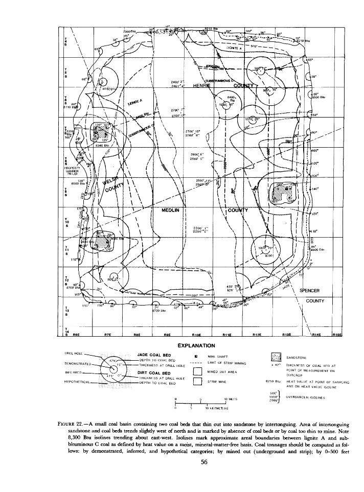
EXPLANATION
JADE COAL BEDDEPTH TO COAL BED
THICKNESS AT DRILL HOLE
DIRT COAL BEDTHICKNESS AT DRILL HOLE
DEPTH TO COAL BED
B MINE SHAFT
----- LIMIT OF STRIP MINING
D
DMINED OUT AREA
STRIP MINE
Lv^ii SANDSTONb
x 42" THIChNESS OF COAL BED AT
POINT OF MEASUREMENT ONOUTCROP
8250 Btu HEAT VALUE AT POINT OF SAMPLING
500'^1000'> 2000'J
AND ON HEAT VALUE ISOLINE
OVERBURDEN ISOLINES
10 hILDMCTI RS
FIGURE 22. A small coal basin containing two coal beds that thin out into sandstone by intertonguing. Area of intertonguing sandstone and coal beds trends slightly west of north and is marked by absence of coal beds or by coal too thin to mine. Note 8,300 Btu isolines trending about east-west. Isolines mark approximate areal boundaries between lignite A and sub- bituminous C coal as denned by heat value on a moist, mineral-matter-free basis. Coal tonnages should be computed as fol lows: by demonstrated, inferred, and hypothetical categories; by mined out (underground and strip); by 0-500 feet
56
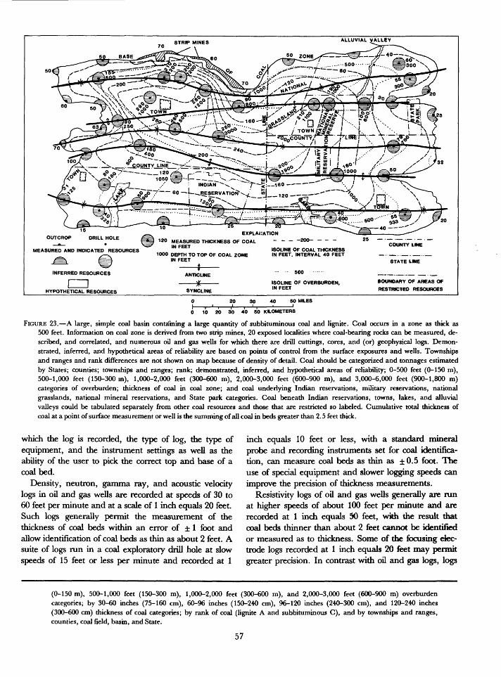
STRIP MINES ALLUVIAL VALLEY
15
OUTCROP DRILL HOLE /
MEASURED AND INDICATED RESOURCES
INFERRED RESOURCES
CZDHYPOTHETICAL RESOURCES
EXPLANATION
MEASURED THICKNESS Of COAL - - - -200- - - -
1000 DEPTH TO TOP OF COAL ZONE IN FEET
ANTICLINE
SYNCLINE
ISOLINE OF COAL THICKNESS IN FEET. INTERVAL 40 FEET
ISOLINE OF OVERBURDEN, IN FEET
COUNTY tME
STATE LIME
BOUNDARY OF AREAS OF
RESTRICTED RESOURCES
20 30 40 SO MILES
0 10 20 30 40 50 KILOMETERS
FIGURE 23. A large, simple coal basin containing a large quantity of subbituminous coal and lignite. Coal occurs in a zone as thick as 500 feet. Information on coal zone is derived from two strip mines, 20 exposed localities where coal-bearing rocks can be measured, de scribed, and correlated, and numerous oil and gas wells for which there are drill cuttings, cores, and (or) geophysical logs. Demon strated, inferred, and hypothetical areas of reliability are based on points of control from the surface exposures and wells. Townships and ranges and rank differences are not shown on map because of density of detail. Coal should be categorized and tonnages estimated by States; counties; townships and ranges; rank; demonstrated, inferred, and hypothetical areas of reliability; 0-500 feet (0-150 m), 500-1,000 feet (150-300 m), 1,000-2,000 feet (300-600 m), 2,000-3,000 feet (600-900 m), and 3,000-6,000 feet (900-1,800 m) categories of overburden; thickness of coal in coal zone; and coal underlying Indian reservations, military reservations, national grasslands, national mineral reservations, and State park categories. Coal beneath Indian reservations, towns, lakes, and alluvial valleys could be tabulated separately from other coal resources and those that are restricted so labeled. Cumulative total thickness of coal at a point of surface measurement or well is the summing of all coal in beds greater than 2.5 feet thick.
which the log is recorded, the type of log, the type of equipment, and the instrument settings as well as the ability of the user to pick the correct top and base of a coal bed.
Density, neutron, gamma ray, and acoustic velocity logs in oil and gas wells are recorded at speeds of 30 to 60 feet per minute and at a scale of 1 inch equals 20 feet. Such logs generally permit the measurement of the thickness of coal beds within an error of ± 1 foot and allow identification of coal beds as thin as about 2 feet. A suite of logs run in a coal exploratory drill hole at slow speeds of 15 feet or less per minute and recorded at 1
inch equals 10 feet or less, with a standard mineral probe and recording instruments set for coal identifica tion, can measure coal beds as thin as ±0.5 foot. The use of special equipment and slower logging speeds can improve the precision of thickness measurements.
Resistivity logs of oil and gas wells generally are run at higher speeds of about 100 feet per minute and are recorded at 1 inch equals 50 feet, wkh the result that coal beds thinner than about 2 feet cannot be identified or measured as to thickness. Some of the focusing elec trode logs recorded at 1 inch equals 20 feet may permit greater precision. In contrast with oil and gas logs, logs
(0-150 m), 500-1,000 feet (150-300 m), 1,000-2,000 feet (300-600 m), and 2,000-3,000 feet (600-900 m) overburden categories; by 30-60 inches (75-160 cm), 60-96 inches (150-240 cm), 96-120 inches (240-300 cm), and 120-240 inches (300-600 cm) thickness of coal categories; by rank of coal (lignite A and subbituminous C), and by townships and ranges, counties, coal field, basin, and State.
57

Coal re
serv
es or
re
sour
ces
ofTowns hi
p, Range
, Qu
adra
ngle
, Field
, County,
State
of
Form
atio
n, Member
, Rank of Coal
, Sulfur Co
nten
t, As
h Co
ntent
, He
at Va
lue
<Btu
Cal)
Name
of
Be
d
Overburden
Range
(feet)
Planimeter
Reading
Area
(Acres)
Weighted
Aver
age
Thic
knes
s (inches)
Rema
inin
g or Original To
nnag
e (m
illions
of short
tons)l
Meas
ured
(i
nche
s)14-28
28-4
242
-84
84-1
68In
dica
ted
(inc
hes)
14-28
28-4
242
-84
84-1
68Inferred (i
nche
s)14
-28
28-42
42-8
484-168
Column to
tal
Plan
imet
er fa
ctor
Shor
t or
metric
tons
per
acre
-inc
h
Plan
imet
ered
by
Calc
ulat
ed by
Chec
ked
by
Tota
l Measured
Tota
l 14-28"
Total
28-42"
Total
0-500'
Total
2,00
0-3,
000'
Tota
l Indicated
Tota
l 42-84"
Tota
l 50
0-1,
000'
Total
3,00
0-6,
000
Total
Inferred
Tota
l 84"+
Tota
l 1,000-2,000'
Grand
Total
* Categorie
s for
hypo
thet
ical
an
d spec
ulat
ive
coal
ma
y be added.
FIG
UR
E 2
4. S
ug
ges
ted
typ
e of
for
m f
or r
ecor
ding
dat
a an
d co
mpu
ted
tonn
ages
for
a m
ine,
are
a, c
oal
bed,
qua
dran
gle,
tow
nshi
p an
d ra
nge,
coa
l fi
eld,
bas
in,
regi
on,
prov
ince
, co
unty
, St
ate
or p
oliti
cal
prov
ince
, an
d th
e N
atio
n.

<£>
FIG
UR
E 2
5. S
ug
ges
ted
for
mat
for
tab
ulat
ing
data
and
cal
cula
ting
tonn
ages
with
hea
ding
s le
ft t
o ju
dgm
ent
of e
stim
ator
.
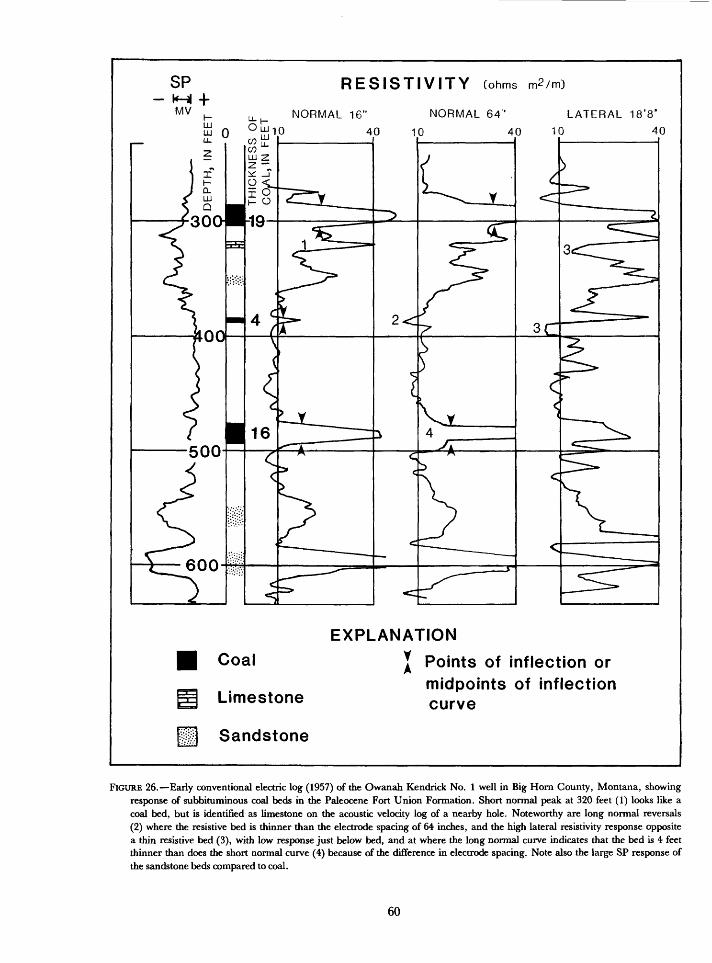
SPKH|MV
RESISTIVITY Cohms m2/m)
NORMAL 16" NORMAL 64" LATERAL 18'8"
EXPLANATION
Coal
Limestone
Sandstone
Points of inflection or midpoints of inflection curve
FIGURE 26. Early conventional electric log (1957) of the Owanah Kendrick No. 1 well in Big Horn County, Montana, showing response of subbituminous coal beds in the Paleocene Fort Union Formation. Short normal peak at 320 feet (1) looks like a coal bed, but is identified as limestone on the acoustic velocity log of a nearby hole. Noteworthy are long normal reversals (2) where the resistive bed is thinner than the electrode spacing of 64 inches, and the high lateral resistivity response opposite a thin resistive bed (3), with low response just below bed, and at where the long normal curve indicates that the bed is 4 feet thinner than does the short normal curve (4) because of the difference in electrode spacing. Note also the large SP response of the sandstone beds compared to coal.
60
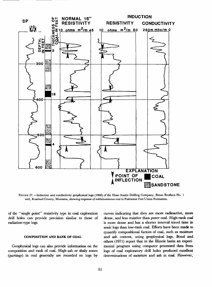
SP NORMAL 16' RESISTIVITY
INDUCTION
RESISTIVITY CONDUCTIVITY
250m mho/m 0
EXPLANATION POINT OF COAL INFLECTION
USANDSTONE
FIGURE 27. Induction and conductivity geophysical logs (1960) of the Hose-Austin Drilling Company, Bones Brothers No. 1 well, Rosebud County, Montana, showing response of subbiruminous coal in Paleocene Fort Union Formation.
of the "single point" resistivity type in coal exploration drill holes can provide precision similar to those of radiation-type logs.
COMPOSITION AND RANK OF COAL
Geophysical logs can also provide information on the composition and rank of coal. High-ash or shaly zones (partings) in coal generally are recorded on logs by
curves indicating that they are more radioactive, more dense, and less resistive than purer coal. High-rank coal is more dense and has a shorter interval travel time in sonic logs than low-rank coal. Efforts have been made to quantify compositional factors of coal, such as moisture and ash content, using geophysical logs. Bond and others (1971) report that in the Illinois basin an experi mental program using computer processed data from logs of coal exploratory drill holes produced excellent determinations of moisture and ash in coal. However,
61
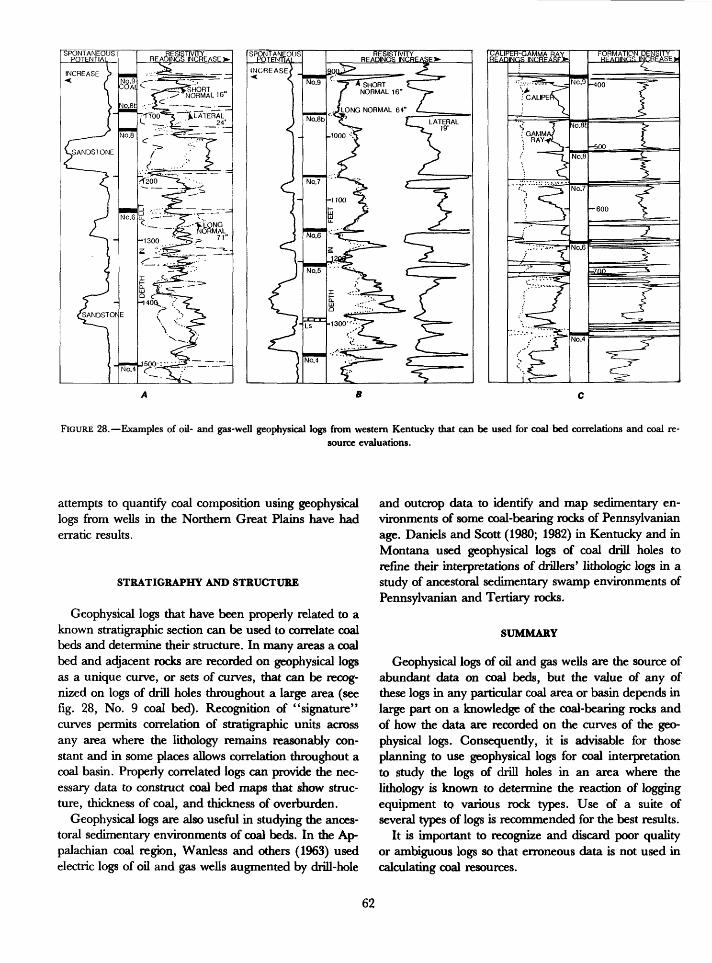
FIGURE 28. Examples of oil- and gas-well geophysical logs from western Kentucky that can be used for coal bed correlations and coal re source evaluations.
attempts to quantify coal composition using geophysical logs from wells in the Northern Great Plains have had erratic results.
STRATIGRAPHY AND STRUCTURE
Geophysical logs that have been properly related to a known stratigraphic section can be used to correlate coal beds and determine their structure. In many areas a coal bed and adjacent rocks are recorded on geophysical logs as a unique curve, or sets of curves, that can be recog nized on logs of drill holes throughout a large area (see fig. 28, No. 9 coal bed). Recognition of "signature" curves permits correlation of stratigraphic units across any area where the lithology remains reasonably con stant and in some places allows correlation throughout a coal basin. Properly correlated logs can provide the nec essary data to construct coal bed maps that show struc ture, thickness of coal, and thickness of overburden.
Geophysical logs are also useful in studying the ances- toral sedimentary environments of coal beds. In the Ap palachian coal region, Wanless and others (1963) used electric logs of oil and gas wells augmented by drill-hole
and outcrop data to identify and map sedimentary en vironments of some coal-bearing rocks of Pennsylvanian age. Daniels and Scott (1980; 1982) in Kentucky and in Montana used geophysical logs of coal drill holes to refine their interpretations of drillers' lithologic logs in a study of ancestoral sedimentary swamp environments of Pennsylvanian and Tertiary rocks.
SUMMARY
Geophysical logs of oil and gas wells are the source of abundant data on coal beds, but the value of any of these logs in any particular coal area or basin depends in large part on a knowledge of the coal-bearing rocks and of how the data are recorded on the curves of the geo physical logs. Consequently, it is advisable for those planning to use geophysical logs for coal interpretation to study the logs of drill holes in an area where the lithology is known to determine the reaction of logging equipment to various rock types. Use of a suite of several types of logs is recommended for the best results.
It is important to recognize and discard poor quality or ambiguous logs so that erroneous data is not used in calculating coal resources.
62
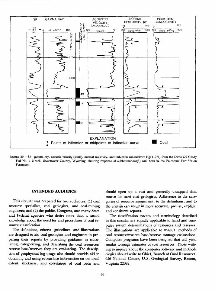
GAMMA RAY ACOUSTIC VELOCITY
O tij CACOUSTLOG")
NORMAL INDUCTIONRESISTIVITY 16" CONDUCTIVITY
10 100 10 100
70 20° ohmsm2/m 1000 100 ohms m2
EXPLANATION * Points of inflection or midpoints of inflection curve Coal
FIGURE 29. SP, gamma ray, acoustic velocity (sonic), normal resistivity, and induction conductivity logs (1971) from the Davis Oil Grady Fed No. 1-2 well, Sweetwater County, Wyoming, showing response of subbituminous(?) coal beds in the Paleocene Fort Union Formation.
INTENDED AUDIENCE
This circular was prepared for two audiences: (1) coal resource specialists, coal geologists, and coal-mining engineers; and (2) the public, Congress, and many State and Federal agencies who desire more than a casual knowledge about the need for and procedures of coal re source classification.
The definitions, criteria, guidelines, and illustrations are designed to aid coal geologists and engineers in pre paring their reports by providing guidance in calcu lating, categorizing, and describing the coal resources/ reserve base/reserves they are evaluating. The descrip tion of geophysical log usage also should provide aid in obtaining and using subsurface information on the area! extent, thickness, and correlation of coal beds and
should open up a vast and generally untapped data source for most coal geologists. Adherence to the cate gories of resource assignment, to the definitions, and to the criteria can result in more accurate, precise, explicit, and consistent reports.
The classification system and terminology described in this circular are equally applicable to hand and com puter system determinations of resources and reserves. The illustrations are applicable to manual methods of coal resource/reserve base/reserve tonnage estimations. Computer programs have been designed that will yield similar tonnage estimates of coal resources. Those wish ing to inquire about the computer software and method ologies should write to Chief, Branch of Coal Resources, 956 National Center, U.S. Geological Survey, Reston, Virginia 22092.
63
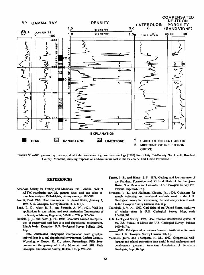
SP GAMMA RAY DENSITY
COMPENSATEDNEUTRON
LATEROLOG POROSITY 3.0 8 (SANDSTONE)
EXPLANATION
COAL SANDSTONE LIMESTONE POINT OF INFLECTION OR MIDPOINT OF INFLECTION CURVE
FIGURE 30. SP, gamma ray, density, dual induction-lateral log, and neutron logs (1978) from Getty Tri-County No. 1 well, Rosebud County, Montana, showing response of subbituminous coal in the Paleocene Fort Union Formation.
REFERENCES
American Society for Testing and Materials, 1981, Annual book of ASTM standards; part 26, gaseous fuels; coal and coke; at mosphere analysis: Philadelphia, Pennsylvania, p. 181-399.
Averitt, Paul, 1975, Coal resources of the United States, January 1, 1974: U.S. Geological Survey Bulletin 1412,131 p.
Bond, L. O., Alger, R. P., and Schmidt, A. W., 1971, Well log applications in coal mining and rock mechanics: Transactions of the Society of Mining Engineers, AIME, v. 250, p. 355-362.
Daniels, J. J., and Scott, J. H., 1980, Computer-assisted interpreta tion of geophysical well logs in a coal depositional environment, Illinois basin, Kentucky: U.S. Geological Survey Bulletin 1509, 44 p.
_____1982, Automated lithographic interpretation from geophys ical well logs in a coal depositional environment, Carbon County, Wyoming, in Gurgel, K. D., editor, Proceedings, Fifth Sym posium on the geology of Rocky Mountain coal 1982: Utah Geological and Mineral Survey, Bulletin 118, p. 220-232.
Fassett, J. E., and Hinds, J. S., 1971, Geology and fuel resources of the Fruitland Formation and Kirtland Shale of the San Juan Basin, New Mexico and Colorado: U.S. Geological Survey Pro fessional Paper 676, 76 p.
Swanson, V. E., and Huffman, Claude, Jr., 1976, Guidelines for sample collecting and analytical methods used in the U.S. Geological Survey for determining chemical composition of coal: U.S. Geological Survey Circular 735, 11 p.
Trumbull, J. V. A., 1960, Coal fields of the United States, exclusive of Alaska sheet 1: U.S. Geological Survey Map, scale 1:5,000,000.
U.S. Geological Survey, 1976, Coal resource classification system of the U.S. Bureau of Mines and U.S. Geological Survey: Bulletin 1450-B, 7 p.
____1980, Principles of a resource/reserve classification for min erals: U.S. Geological Survey Circular 831, 5 p.
Vaninetti, Jerry, and Thompson, R. M., 1982, Geophysical well- logging and related subsurface data useful in coal exploration and development program: American Association of Petroleum Geologists, 34 p., 82 figs.
64
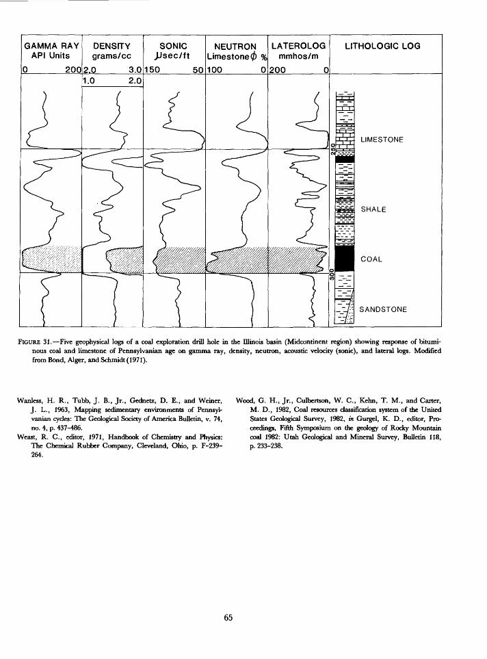
LATEROLOG mmhos/m
GAMMA RAY API Units
DENSITY grams/cc
.0 3.0
SONIC JJsec/ft
150 50
LITHOLOGIC LOGNEUTRON Limestone 0 %
FIGURE 31. Five geophysical logs of a coal exploration drill hole in the Illinois basin (Midcontinent region) showing response of bitumi nous coal and limestone of Pennsylvanian age on gamma ray, density, neutron, acoustic velocity (sonic), and lateral logs. Modified from Bond, Alger, and Schmidt (1971).
Wanless, H. R., Tubb, J. B., Jr., Gednetz, D. E., and Weiner, Wood, G. H., Jr., Culbertson, W. C., Kehn, T. M., and Carter,J. L., 1963, Mapping sedimentary environments of Pennsyl vanian cycles: The Geological Society of America Bulletin, v. 74, no. 4, p. 437-486.
Weast, R. C., editor, 1971, Handbook of Chemistry and Physics: The Chemical Rubber Company, Cleveland, Ohio, p. F-239- 264.
M. D., 1982, Coal resources classification system of the United States Geological Survey, 1982, in Gurgel, K. D., editor, Pro ceedings, Fifth Symposium on die geology of Rocky Mountain coal 1982: Utah Geological and Mineral Survey, Bulletin 118, p. 233-238.
65