coastal protection - core · pacifi c coasts are designated important areas for providing vital...
TRANSCRIPT

C O A S T A L P R O T E C T I O N B E S T P R A C T I C E S
Coastal ProtectionB E S T P R A C T I C E S I N T H E P A C I F I C
European Union

B E S T P R A C T I C E S C O A S T A L P R O T E C T I O N
©2015bythePacificCentreforEnvironmentandSustainableDevelopment(PaCE-SD)andTheUniversityoftheSouthPacific,Suva,Fiji.
Thisworkiscopyright.Nopartofthispublicationmaybereproduced,storedinaretrievalsystemortransmittedinanyformbyanymeanswhatsoeverwithoutthepriorpermissionofthecopyrightowners.TheUniversityoftheSouthPacificandPaCE-SDacceptnoliabilitywhatsoeverwhetherbyreasonofnegligenceorotherwisearisingfromuseorrelianceonthisreportoranypartofit.
PublishedbyPacificCentreforEnvironmentandSustainableDevelopment(PaCE-SD),Suva
Enquiries
AllenquiriesrelatedtothisworkshallbeaddressedtoPaCE-SD,TheUniversityoftheSouthPacific,SuvaFiji.
Cover Photos
(Top):AviewofnaturalmangrovestakenfromNavulivatu,Fiji.(BottomLeft):NaturalcoraltakenatFunafuti,Tuvalu.(Middle):Concreteslopewall,SolomonIslands.(BottomRight):Concretewalls infrontofThurstonGarden,Suva.
Unlessotherwisestated,allimagesinthisreportarecopyrightofthePaCE-SD.SpecialthankstothePaCE-SDteamfortheircontributionstotheimagedatabase:AlitiKoroi,AmeTuisavusavu,AntoineDeRamonN’Yeurt,BirthaTogahai,ChristopherWard,HélèneJacotDeCombes,JasonAlonk,JohnWalenenea,LeoneLimalevu,LukePaeniu,MosesAsitarau,PeleniseAlofa,RoseGodana,SarahHemstock,TessaKoppert,VaineWichman,ViliamuIese,WilliamArudovo,TevitaFakaosi.
Citati on
PaeniuL,IeseV,JacotDesCombesH,DeRamonN’YeurtA,KorovulavulaI,KoroiA,SharmaP,HobgoodN,ChungKandDeviA.(2015).CoastalProtection:BestPracticesfromthePacific.PacificCentreforEnvironmentandSustainableDevelopment.(PaCE-SD).TheUniversityoftheSouthPacific,Suva,Fiji.
USP Library Cataloguing-in-Publicati on Data
Coastalprotection:bestpracticesfromthePacific/L.Paeniu...[etal.].--Suva,Fiji:PacificCentreforEnvironmentandSustainableDevelopment,TheUniversityoftheSouthPacific,2015.80p.;30cm.ISBN978-982-01-0936-01.Shoreprotection--Oceania.2.Coastalzonemanagement--Oceania.3.Coastalengineering--Oceania.I.Paeniu,Luke.II.TheUniversityoftheSouthPacific.PacificCentreforEnvironmentandSustainableDevelopment.GC1023.885.C632015333.91716099--dc23
Disclaimer
TheviewsandopinionsexpressedinthisreportarethoseoftheauthorsanddonotnecessarilyreflecttheofficialpositionofTheUniversityoftheSouthPacific,ThePacificCentreforEnvironmentandSustainableDe-velopment,TheEuropeanUnion,andTheUnitedStatesAgencyforInternationalDevelopment.
European Union

C O A S T A L P R O T E C T I O N B E S T P R A C T I C E S
B E S T P R A C T I C E S I N T H E P A C I F I C

B E S T P R A C T I C E S C O A S T A L P R O T E C T I O N
OnbehalfofPaCE-SD,wewouldliketoacknowledgetheleadershipandvisionofthePaCE-SDDirectorandProfessorinClimateChange,ElisabethHollandforinitiatingthe‘fantasydream’ofcreatingbestpracticereportsoncoastalzoneengineering.ThepublicationofCoastalPro-tection:BestPracticesfromthePacificreportisthefirstinaseriesofsimilarreportstofollow.
ItisequallyimportanttomentionthesupportingroleplayedbytheUnitedStatesAgencyforInternationalDevelopment(USAID)withtheirfundingsupport.
ThankyoualsotothosewhohavecontributedbysharingtheirexperiencesoverthePacificSolutionExchange(PSE)network.(FeaturedinChapter5).
WearedeeplyprivilegedtoacknowledgethesupportprovidedbytheEuropeanUnionGlobalClimateChangeAlliance(EU-GCCA)In-CountryCoordinators(ICCs)inthe15Pacificcountriesfortheirvaluablecontributions.EU-GCCAICCsareAbeAremwa,BettySigrah,BirthaTogahai,CarolEmaurois,JasonAlonk,MosesAsitarau,NaushadYakub,PeleniseAlofa,TamaraGreen-stone,TapulolouTuailemafua,TessaKoppert,TeulealaManuellaMorris,andTevitaFakaosi.Wewouldalso liketoacknowledgethecontributionsof JohnWalenenea,RoseGodana,AmeTuisavusavu,ChristopherWard,SairusiBosenaqaliandSarikaChand.
WealsoacknowledgethecontributionsbyProfessorRandolphThaman,andthankhimforhispositivefeedback.WewouldalsoliketoacknowledgethepioneeringworkdonebythethenSouthPacificIslandsAppliedGeoscienceCommission(SOPAC)oncoastalprotectionthathasservedasabaselineforthisreport.
Lastbutnotleast,thePaCE-SDcoreTaskForcewhoworkedreallyhardtoproducethisreportareacknowledgedwithadmirationandappreciation.TheyareProfElisabethHolland,StephenSmith,SarahHemstock,MorganWairiu,ViliamuIese,HélèneJacotDesCombes,AntoineDeRamonN’Yeurt,AlitiKoroi,PriyaSharma,AshmitaDevi,LukePaeniu,NicholasHobgood,IsoaKorovulavulaandTeddyFong.
Acknowledgement
i

C O A S T A L P R O T E C T I O N B E S T P R A C T I C E S
C-CAP CoastalCommunityAdaptationProject
CTI CoralTriangleInitiative
EIA EnvironmentalImpactAssessment
ENSO ElNiñoandSouthernOscillation
ESD EcologicallySustainableDevelopment
ESCAP EconomicandSocialCommissionforAsiaandthePacific
FSM FederatedStatesofMicronesia
GIZ DeutscheGesellschaftfurInternationaleZusammenarbeit
ICZM IntegratedCoastalZoneManagement
IPCC Inter-governmentalPanelofClimateChange
JICA JapanInternationalCooperationAgency
LMMA LocallyManagedMarineArea
MMA MarineManagedArea
MPA MarineProtectedArea
PACC PacificAdaptationtoClimateChange
PaCE-SD PacificCentreforEnvironmentandSustainableDevelopment
PIPA PhoenixIslandProtectedArea
PNG PapuaNewGuinea
PSE PacificSolutionExchange
SOPAC SouthPacificIslandsAppliedGeoscienceCommission
SPC SecretariatofthePacificCommunity
UK-SPEC UnitedKingdom-StandardforProfessionalEngineeringCompetence
UNDP UnitedNationsDevelopmentProgramme
USP TheUniversityoftheSouthPacific
4AR FourthAssessmentReport(IPCC)
Acronyms
ii

B E S T P R A C T I C E S C O A S T A L P R O T E C T I O N
IampleasedtopresentanothershiningmilestoneofPaCE-SD’scontinuouseffortsinstrivingforexcellence.ThisBestPracticepublicationisauniquecollaborativeundertaking.Thereportprovidesafoundationtoguidecoastalmanagers,coastalplanners,coastalengineers,decisionmakersanddisastermanagersthroughoutthePacificintheireffortstofindsolutions.Thegoalis todevise ‘noregret’strategiesusingeffective interventionstoprotectthePacificcoasts,ecosystemsandbasicvitalinfrastructure.
Thedocumentisnotintendedtoprovideeasyanswerswiththerightcoastalprotectioninter-ventionsforeverylocation.Everylocationhasitsownuniquechallengesandproblems.Solu-tionsareco-learningopportunitiesandshouldbegeneratedlocallyanddesignedwithlocalinputwithallpossibleoptions.Thisdocumentisonlyaguidetotheoptions.
Iwanttoexpressmyappreciationtothosewhowillinglysharedtheirexpertiseandexperi-ences via the Pacific Solutions Exchange (PSE) network. The report is a truly collaborativeproductworkingacrossprojectsandthePacificIslandstogenerateeffectiveoptionsforthe15PacificIslandcountriesweserve
ItisinterestingtonotethattheexperiencessharedinthisdocumentwereacombinationofthosesharedinthePSEnetworkandthoseprimarilycollectedfromover70Pacificliteratures.ThePacificIslandsregionhasrichsourcesofconstructiveandvitalknowledgeonhowtopro-tectthecoast,andourPacificbasedsolutionsaresomethingtobeproudof.Wehavetriedtobringifnotallbutmostoftheseexperiencesinonesingledocumentforeaseofreference.
Itismyintention,thatthisdocumentcouldbecomealivingdocumentthatwouldbereferredtoandrevisedwhentheneedarises.
IcommendthecoreTaskForceofPaCE-SDforthehardworkanddedicationinproducingthisimportantdocument.Thankyouawesomeshiningstars.
ProfessorElisabethHollandDirector, Pacifi c Centre of Environment and Sustainable Development (PaCE-SD).
NotefromtheDirector
iii

C O A S T A L P R O T E C T I O N B E S T P R A C T I C E S
Pacificcoastsareconstantlychangingasaresultofnaturalprocessessuchastides,strongcurrents,rain,stormsurges,strongwind,cyclonesandsealevelrise.Withincreasinghumanactivitieswithinthecoastalareas intermsofhumansettlement, landusechanges,flowofsolidandliquidwasteandcoastaldevelopmentssuchasbeachramps,jetties,causeways,coastalprotectionstructures,reefminingandextractionsofsandandbeachaggregates,thereiseverincreasingchangealongPacificcoasts.Inaddition,climatechangeandclimatevariabilityandextremeweathereventshaveexacerbatedtherateofchangeofPacificcoasts.
Thecoasthasbeendefinedasthezonewherethelandandseameet.ThemainfeaturesofPacificcoastsaredominatedbycoralreefs,reefridges,inter-tidalridges,beaches,cliffs,waveactionsandmangroves.PacificcoastsaredesignatedimportantareasforprovidingvitalPa-cificlivelihood.Thecoastalecosystems,humansettlementandothermajorsupportingservicesandbasicinfrastructurearecentredonthecoastalzone.Coastsarebeingusedformanyrea-sons.TheunderlyingproblemisthatPacificcoastsareinastateofcrisis.AnumberofhumanengineeringinterventionsoverthepastdecadehavecontributedandacceleratedthecoastalerosionprobleminthePacificregion.ThePacificcoastlineisover50,532kmlong.Bothnatu-ralprocessesandhumanengineeringworkareblamedforcausingcoastalerosion.Thisguidehasbeenproducedtoinformandassistcoastalexperts,managers,andPacificcommunitiesunderstandthevariousmeasurestheycantaketoreducecoastalerosion.
CoastalprotectioninterventionsinthePacificbasicallyfallintotwocategories:non-structuraladaptationand structural adaptationapproaches. Thebestpracticeson coastal protectionthatareviewedasnon-structuralwereidentifiedas:
•Knowledgeofcoastalprocesses •Policyonworkingalongsidewithnatureandnotagainstit •Retreat,accommodateandprotectapproach •EnvironmentalImpactAssessmentframework •Foreshoreregulation •LocallyManagedMarineAreas,MarineProtectedAreasandConservationAreas •NationalBiodiversityStrategyandActionPlan •IntegratedCoastalZoneManagementapproach •Adopt‘ridgetoreef’approach •Establishedengineeringstandardframework •ActiveBuildingCode
ExecutiveSummary
iv

B E S T P R A C T I C E S C O A S T A L P R O T E C T I O N
Interventionsthatwereclassifiedasstructuralfallintotwoparts:Thesoftmeasuresandthehardmeasures.Thesoftmeasureapproachesidentifiedincluded:
•Maintainingahealthyreefislandsandislets •Protectionandrestorationofseagrassandalgalecosystems •Maintaininghealthyfringingandbarriercoralreefs •PlantingMangroves •Plantingcoastalvegetation(littoralplants) •StabilizingCoastalbeaches •Beachnourishment
Thehardmeasureapproacheswere:
•Seawalls •Groynes •Revetments •Gabions •Breakwaters •GeotextileContainers
Selectedexamplesofcurrentcoastalprotectioninterventionsarepresentedinpictorialforms.These included examples from the Cook Islands, the Federated States ofMicronesia, Fiji,Guam,Kiribati,Nauru,Niue,theNorthernMarianas,Samoa,theRepublicofMarshallIslands,Palau, PapuaNewGuinea, Tonga, Tuvalu, the Solomon Islands, Vanuatu, and Timor Leste.Someexamplesofunsuccessfulinterventionswerealsocaptured.
ThereportisintendedasageneralguidetocoastalprotectionpracticesinthePacificregion.Theoptionspresentedinthisguideshouldbeexaminedcarefullybyqualifiedengineerspriortoselectionandimplementation.
ThereportendedwithexcellentexperiencessharedthroughthePSEnetworkandsomeim-portantcasestudies.
V

C O A S T A L P R O T E C T I O N B E S T P R A C T I C E S
ListofTables
Table1:MarineAreas,ReefAreasandCoastlinesinPICTs. 5Table2:ComparisonofMarineManagedAreasinthePacificregion. 18Table3:Comparisonofcoastalprotectionframeworks. 23Table4:ComparisonofPICTswithorwithoutcoastalprotectionframeworks. 25Table5:HardEngineeredSolutionAlternatives. 34Table6:Seawallcomponents. 35Table7:SeawallAlternativesComparisonSummary. 36Table8:RevetmentAlternativeComparisonSummary. 38Table9:GroyneAlternativeComparisonSummary. 40Table10:BreakwaterAlternativeComparisonSummary. 41Table11:HardEngineeredSolutionsOverview. 44
ListofFigures
Figure1:MapofthePacificregion. 4Figure2:Thedepositionalenvironments. 6Figure3:Longshoredriftcurrent. 7Figure4:ExamplesofcoastalerosioninthePICTs. 8Figure5:Typicalbeachsystems. 13Figure6:ConstructiveandDestructivewaves. 14Figure7:Retreat,AccommodationandProtectstrategies. 17Figure8:ExampleofapollutedcoastalenvironmentinFongafale. 28Figure9:TheseagrassSyringodium isoeti folium. 29Figure10:Ahealthyislandreflectsintoahealthyreefsystem. 30Figure11:PlantingmangrovesinTuvalu. 31Figure12:Thesemangroveroots. 32Figure13:TheTuvaluForamSandProject. 33Figure14:Foraminifera. 33Figure15:TypicalRockRevetmentSection. 37Figure16:RenoMattressSectionExample. 37Figure17:Schemeofinteractionofgroyne,waves,currentsandshore. 38Figure18:RockGroyneExample. 39Figure19:ConventionalMulti-LayerRubbleMoundBreakwater. 40Figure20:RockBreakwaterExample. 41Figure21:GeotextileSand-filledContainer-Groyneexample. 42Figure22:GeotextileSand-filledContainer-Seawallexample. 42Figure23:GeotextileSand-filledContainer-Revetmentexample. 43Figure24:GeotextileSand-filledContainer-Breakwaterexample. 43Figure25-32:ExamplesofengineeringworksinCookIslands. 46Figure33-34:CoastalinterventionsinEastTimor(Timor-Leste) 46Figure35-38:EngineeringstructuresinFSM. 47Figure39-64:EngineeringstructuresfoundinFiji. 48Figure65-88:CoastalprotectioninterventionsinKiribati. 50Figure89-101:EngineeringstructuresinRMI. 52Figure102-113:CoastalstructureinNauru. 54Figure114-121:Naturalandman-madestructuresinNiue. 55Figure122-131:EngineeringworksinPalau. 56Figure132-136:CoastalinterventionsinPNG. 57Figure137-140:CoastalinterventionsinSamoa. 58Figure141-150:CoastalstructuresinSolomonIslands. 58Figure151-154:EngineeringstructuresinTonga. 60Figure155-171:EngineeringstructuresinTuvalu. 61Figure172-175:CoastalinterventionsinVanuatu. 62Figure176-178:ExamplesfromCookIslands. 63Figure179-184:ExamplesfromFiji. 64Figure185-186:ExamplesfromFSM. 64Figure187-200:ExamplesfromKiribati. 65Figure201:ExamplefromSamoa. 66Figure202-207:ExamplesfromTuvalu. 67Figure208:TraditionalMPAinVanuatu. 70Figure209:Vetivergrassfullygrown. 72Figure210:PlantingofVetivergrassnearriverbank. 72Figure211-213:CliffsinNiue. 73Figure214:GISmap. 75Figure215:Designofsand-bagseawall. 76Figure216:Relocationhomes. 77Figure217:Niuecliff. 77
vi

B E S T P R A C T I C E S C O A S T A L P R O T E C T I O N
T a b l e o f C o n t e n t sAcknowledgement iAcronyms iiNotefromtheDirector iiiExecutiveSummary ivListofTables viListofFigures vi
C h a p t e r 1 IntroductionbyLukePaeniu,Dr.HélèneJacotDesCombe,AshmitaDeviandPriyaSharma
1.1 Definition:WhatdowemeanbyCoast? 11.2 WhyareCoastsImportant? 11.3 TheProblem:What’swrongwithPacificCoasts? 41.4 ThePurpose:Whatisthisreportfor? 91.5 Thestructureofthereport 101.6 Methodology 10
C h a p t e r 2 NonStructuralInterventionsbyLukePaeniu,ViliamuIeseandPriyaSharma
2.1 Non-structuralOptions: 112.1.1 Understandingthewaycoastalprocesseswork 112.1.2 Adoptapolicyofworkingwithnatureasthebestwayforward 162.1.3 AdoptAdaptiveResponsestrategies:retreat,accommodateorprotectionapproach 162.1.4 ConductanEnvironmentalImpactAssessment 172.1.5 EnforceForeshoreRegulations 182.1.6 AdoptMarineProtectedAreas(MPAsorMMA) 182.1.7 AdoptNationalBiodiversityStrategyandActionPlan(NBSAP) 192.1.8 AdoptanIntegratedCoastalZoneManagementApproach(ICZM) 192.1.9 Adopt‘RidgetoReef’approach 212.1.10Settingengineeringstandards,takingresponsibilitiesandcomplyingwithcodesofethics 222.1.11 AdoptaproperBuildingCode 23
C h a p t e r 3 StructuralOptionsbyLukePaeniu,AntoineDeRamonN’Yeurt,KerrynChungandNicholasHobgood
3.1 Introduction 263.1.1 StructuralEngineeringOptions: 263.2 Softstructuralengineeringoptions: 263.2.1 NaturalSoftEngineeringStructures: 263.2.1.1Maintaininghealthyreefislandsandislets 273.2.1.2Improveseagrassandalgal/seaweedecosystems 283.2.1.3Maintainhealthyfringingandbarriercoralreefs 293.2.1.4PlantingMangroves 303.2.1.5StabilizingCoastalBeaches 32

C O A S T A L P R O T E C T I O N B E S T P R A C T I C E S
3.2.1.6PlantingCoastalVegetation(littoralplants) 333.2.1.7BeachNourishment 333.3Hardstructuralengineeringoptions 333.3.1Seawalls 343.3.2Revetment 363.3.3Groynes 383.3.4Breakwaters 403.3.5 GeotextileContainers(InnovativeSolution) 413.3.6 HardEngineeredSolutionsOverview 44
C h a p t e r 4 SelectedExamplesofCurrentInterventionsinthePacificbyLukePaeniuandAlitiKoroi
4.1CookIslands 464.2EastTimor(TimorLeste) 474.3FederatedStateofMicronesia(FSM) 474.4Fiji 504.5Guam 504.6Kiribati 504.7MarshallIslands 524.8Nauru 534.9Niue 554.10NorthernMarianaIslands 554.11Palau 564.12PapuaNewGuinea 574.13Samoa 574.14SolomonIslands 584.15Tonga 604.16Tuvalu 614.17Vanuatu 624.18Interventionsthatdidnotwork 63
C h a p t e r 5 SelectedExamplesofPacificExperiencesbyLukePaeniuandIsoaKorovulavula
5.1HardCoastalStructures 685.2SoftCoastalStructures 695.3BiophysicalStructures 735.4CoastalAdaptationMechanism 745.4.1Participatoryapproach 745.4.2ToolsandDesigns 745.4.3Relocation 775.5AssessmentofCoastalErosioninFSM 775.5.1ScientificapproachestoCoastalManagement 78
C h a p t e r 6 Conclusions 79References 80

B E S T P R A C T I C E S C O A S T A L P R O T E C T I O N 12
1.1 Definition:WhatdowemeanbyCoast?
Coastisabroadtermthatcanbedefinedby:“thepartofthelandadjoiningornearthesea”(Oxfordonlinedic-tionary).
Inthisreport,wewillusethetermPacificCoastwhichinthiscontextmeansthezonewheretheoceanandlandinteract.Thiszoneistheareaimpactedbymarinefactorssuchaswaves,wind,saltsprays,andsaltwaterintru-sion.Thiszoneisexposedtosealevelrise,extremeweatherevents(stormandcyclones)andtidalevents,coastaldevelopmentandmarinepollution.Forsomeatollcountries,almosttheentireislandsandassociatedisletsmaybedefinedascoastalarea.ThedistinctionbetweenPacificcoastsascomparedtocoastsinmostdevelopedcoun-triesliesintheircharacteristics.InthePacificregion,coastalphysicalfeaturesinclude:
•“Coralreefs1whichareacommonandoftendominantfeature •Waveconditionswhichvarysignificantlyintimeandlocationthroughouttheregion •Waterlevelsandcurrentsinthecoastalzonewhicharestronglymodifiedbyfringingreefs •Naturalbeachmaterialwhichiscommonlyandoftendominantlysuppliedfromcarbonatesources •...Mangroves,wheretheyoccur,areaprominentandimportantfeatureofthecoast.”2
1.2 WhyareCoastsImportant?
ThePacificregion’scoastsarewellknownfortheaestheticbeautyoftheirpristinesandybeaches;crystalclearwaters,naturallyformedrocksandlimestoneandtheyareblessedwithcolorfulcoralreefs.3Theyarerichwithdiversecoastalhabitatsandecosystems.
1 Bryne(1994)2 SOPAC(1994)3ibid
Chapter 1: IntroductionbyLukePaeniu,DrHélèneJacotDesCombe,AshmitaDeviandPriyaSharma

C O A S T A L P R O T E C T I O N B E S T P R A C T I C E S 02
However,Pacificcoastsarealsoprovidingroomforhumansettlements:housesandvitalbasicinfrastructureandassetssuchasroads,powerstations,wharves,hospitals,schoolsetc.,arelocatedwithinthecoastalareas.4ItisestimatedthatthepopulationofPacificIslandswhichnumberedaround8.6millionin2000iscurrentlyclosedto10million(SPC,2013)andthat“morethan80%ofPacificIslandersliveinornearcoastalareas”.5Infact,“almost 100 % of Pacific islanders (excluding those in Papua New Guinea) live within 100 kilometers of the coast.” 6
Thesehumanactivitiesandthecoastalecosystemsprovidethesupport forPacific livelihoods,either throughtraditionalactivitiessuchasfishingormoremoderntypeofemploymentinindustryandservices.
“These fragile ecosystems not only support the fisheries and agriculture that the people of the [Pacific] region depend on for food and income, they also provide shoreline protection, places for recreation, [shared] cultural heritage, and many other benefits all of which are at risk from climate change and local stress caused by human activities.” 7
“The shallow ecosystems and productivity of mangroves, seagrass beds, coral reefs and inter-reef seabed are critical natural assets for food production, food security, cultural and recreational activities and livelihoods for many people in Pacific Island States. They also provide important ecosystem services in protection of coasts against storm surges and in production of carbonate sands and debris to nourish beaches and maintain islands. These ecosystems are easily damaged through reclamation, drainage, pollution and destruction of critical habitats for fish and other food species. Once destroyed, these ecosystems are not readily or cheaply restored or replaced.“ 8
“The vital commercial and national assets, essential infrastructure, and populations of most Pacific Island Countries lie in the coastal zone.” 9
However,thedevelopmentofhumanactivitiesaroundthecoastalareasisblamedfordegradingcoastsofthePacificregion.
4SOPAC(1994)5 Howarth(2010)
6RamBidesietal.(2011)7 Keeneretal.(2012)
8 Kenchington(2009)p.19 SOPAC(1994)

B E S T P R A C T I C E S C O A S T A L P R O T E C T I O N
“Given that most of the region’s population is settled in coastal areas, changes in population density combined with new technology and changing development priorities have had a significant impact on coastal environments in the last decade” 10
Pacificcoasts,andmostspecificallycoastalecosystemssuchasmangroveforestsandcoralreefsalsoprovidepro-tectionforthelandbyactingasfirstnaturallinesofdefense.
Tosummarize,peoplearemotivatedtoliveonthecoastforanumberofreasons.Coastsoffer“fertile lowland, abundant marine resources, water transportation, aesthetic beauty, and intrinsic values”. 11Thecoastisthecentreofmajoractivitiesthatinclude“commercial,recreational,andsubsistencefisheries;portsandindustrialfacilitiesthatrelyonshippingfacilities;andtourism,agricultureandforestry…”12
However, over the years, this natural beauty and ecosystem integrity has slowly eroded as coasts havebeenchanged,modified,degradedandre-shaped.BothnaturalprocessesandhumaninterventionareinvolvedinthechangesofthePacificCoasts.
Theimportanceofthecoastscanbereflectedinthewayhumansusethecoast.HerearesomeofcurrentusesofPICTsshorefrontthatwererecordedinMaharaj(2000):
•Mariculture(pearlandshellfish)e.g.intheCookIslands, •Subsistencereeffishing,e.g.inallPICTs, •Fillsites,e.g.inmangrovessystemsthroughoutthePICTs, •Liquidwaste(effluent)disposal,e.g.inindustrialareassuchasLami,FijiIslands, •Maritimeandlanddefense,e.g.FijiNavy,FSMPatrolinKolonia,Pohnpei, •Recreationandtourismdevelopment,e.g.touristresortslikeSheraton’sDenarauIslandResortin theFijiIslands, •Landreclamation,fillandhousingdevelopment,e.g.inpartsofalmostallmangroveareasthroughout thePICTssuchasinKosraeandYapStates,FSM, •Constructionofcoolingwaterinletsandoutletse.g.NauruPowerFacility,Nauru, •Constructionofsewageoutfalls/outlets,e.g.onthewestcoastofNauru, •Constructionoftidalinletsandriver-mouthengineeringworks,e.g.RewaRiver,FijiIslands, •Constructionofcoastalprotectionstructureslikeseawalls,groynes,revetments,breakwaters,gabion basketsandbioengineeringprotection,e.g.generallycommonthroughoutthePICTs, •Constructionofpromenadesandinfrastructurefacilities,e.g.coastalroadsinNauru,FSM,Fiji,Kiribati, NewCaledonia,CookIslandsandSolomonIslands, •Constructionofjetties,boatchannelsandmooringfacilities,e.g.Honiara,SolomonIslandsandPort Vila,Vanuatu, •Constructionofindustrialandrecreationalportsandharbors(commercialportsandyachtclubs),e.g. SuvaYachtClub,FijiIslands, •Constructionandlayingofunderseatelecommunicationcables,e.g.CableandWirelessundersea fiberoptictelecommunicationcables,LaucalaBay,FijiIslands, •Constructionandlayingofpipelinesforfluidtransfer(oilandgas,water,industrialproductsandwaste),e.g.VudaPoint,FijiIslandsandKolonia,FSM,
10 Howarth(2010)p.911 GilbertandVellinga(1990)12 ibid
03

C O A S T A L P R O T E C T I O N B E S T P R A C T I C E S
•Constructionofresidentialandcommercialbuildings,e.g.throughoutthePICTs, •Marineaggregateextraction(sand,gravel,bouldersandcoral-mining),e.g.throughoutthePICTs, •Onlandquarryoperations,e.g.Vanuatu,FijiIslandsandFSM, •Metalliferousminingandhydrocarbonexplorationandproduction,e.g.PapuaNewGuinea, •Agricultureandforestry,includingtimberandcoconutproduction,e.g.andFijiIslandsandtheSolomonIslands •Protectionandnaturalresourceconservation(marineparksandprotectedareas),e.g.inNewCaledoniaandFrenchPolynesia
1.3 TheProblem:What’swrongwithPacificCoasts?
1.3.1:Theissue
Lookingattheglobalscenario,theworld’scoastsareincrisisbecauseoftheincreasinghumanpopulationlivingincoastalareas(Hinrichsen1995).Theauthoralsoarguedthatthecoastsare“over-developed, over-crowded and over-exploited.” 13InthePacificregion,coastsaredefinitelyinastateofcrisisaswell.ThePacificregionismadeupof23nations14:AmericanSamoa,CookIslands,Fiji,TheFederatedStatesofMicronesia,Guam,Kiribati,TheMarshallIslands,NewCaledonia,Niue,TheNorthernMarianaIslands,Nauru,Pitcairn,Palau,FrenchPolynesia,PapuaNewGuinea,Samoa,TheSolomonIslands,TimorLesteTokelau,Tonga,Tuvalu,VanuatuandWallisandFutuna,thatarescatteredoveravastPacificOceanofsome30millionkm2(Figure1).15
Figure 1 Map of the Pacifi c region. Adapted from Govan (2009) p.13.
13Hinrichsen(1995)14SPC(2013)
15 Haberkorn(2008)
04

B E S T P R A C T I C E S C O A S T A L P R O T E C T I O N
PICTs Marine Area (km2) Reef Area (km2) Reef at Risk (%) Coastline (km)
American Samoa 390,000 67 42 116
Cook Islands 1,830,000 212 57 120
Fiji 1,217,000 10,020 68 1,129
FSM 2,980,000 3,172 45 6,112
Guam 218,000 183 100 126
Kiribati 3,800,000 1,967 48 1,143
RMI 2,131,000 1,995 3 370
New Caledonia 1,740,000 4,573 13 2,254
Niue 390,000 15 43 64
Northern Mariana Islands
1,823,000 102 0 1,482
Nauru 436,000 10 100 30
Pitcairn Island 800,000 39 0 51
Table1:MarineAreas,ReefAreasandCoastlinesinPICTs(ModifiedfromGovanatal2009SPREP)
Palau 601,000 709 0 1,519
PNG 2,366,000 13,840 46 20,197
French Polynesia 5,030,000 3,000 29 2,525
Samoa 120,000 200 95 403
Solomon Islands 1,630,000 5,750 46 9,880
Tokelau 290,000 97 0 101
Tonga 700,000 3,587 46 419
Tuvalu 757,000 872 15 24
Vanuatu 680,000 708 70 2,528
Wallis and Futuna 300,000 425 26 129
Timor Leste n/a 35 n/a 735
Table1aboveshowssomeinterestingstatistics.PapuaNewGuineahasahugecoastlineof20,197kmfollowedbySolomonIslandswith9,880kmandFSMwith6,112km.Tuvaluhasthesmallestcoastlineofonly24kmfol-lowedbyNauruwith30km.Intermsofmarineareas,FrenchPolynesiahasthebiggestareawith5millionkm2 whileKiribatihas3.8millionkm2andFSMwith2.98millionkm2.CountrieswithreefsathighriskareNauruandGuamfollowedbySamoaandVanuatu.
These23nationswerehometoapopulationof8.6millionin200016andthispopulationincreasesregularly.ItisestimatedthatthecurrentpopulationofthePacificismorethan10millionandprojectionsfor2035willincreasethisto15millionpeople.17Outofthe8millionpeoplein2000,PNGhasashareof70%.Melanesian’scountrieshadthehighestshareofthepopulationof88%,comparedwithPolynesianislandswith7%whileMicronesian’snationshad5%.18
MajorinfrastructuresthatareimportantinsupportingbasicservicesforPacificpopulationsarealsolocatedwith-inthecoastalareas.19Therefore,theescalatingPacificpopulationnotonlyputsextremepressuresonresourceswithinthePacificcoasts;humanactivitiessuchascoastalengineeringworkonthecoasts(buildingwharves,seawalls,beachrampsandrevetments)allplayamajorroleinthechangingnatureofthePacificcoasts.20
The “introduction of hard-engineered structures has exacerbated island erosion and degraded ecological process.” 21
16SPC(2013)17 ibid18 ibid19 SOPAC(1994)20 OceanPolicyResearchFoundation(2009)21 Kench(2009)p.22
05

C O A S T A L P R O T E C T I O N B E S T P R A C T I C E S
1.3.2:TheCauses
Gillie(1997)statedthatPacificcoastsaresubjecttocontinualchange.Bothnaturalprocessesandhumanactivi-tiescontributetoseverebeacherosionsinthePacific.22Theshapeofthecoastlinedependsonthebalancebetweenmaterialdepositandremoval.Naturalprocessessuchaswaves,watercurrentsandextremeeventssuchascyclonesarethemainfactorsaffectingthecoast.
“Coastal processes are hydraulic and sedimentary process driven by ti des, currents, waves, coastal winds and tsunamis. Forces exerted by wind and water act on the ocean fl oor and shore face to drive currents, move sediments, erode exposed bedrock and shape the coastline, estuaries and the nearshore seabed.” 23
Figure 2: The depositi onal environments (GeologyCafe, 2012)
Thematerialsthataretransportedgetdepositedtoaparticularlocation,duringthedepositionprocess.Deposi-tioncanincludesand,sedimentandshingle.Therearefourmaindepositionenvironments:beaches(depositionofsand,singlesetc.betweenthehightideandlowtidemark),spits(long-termdepositionthatformslongnarrowridgefromthecoastline),bars(growlikespitsbutjointoheadlands)andtombolos(spitgrowsoutwardjoiningoffshoreislandandland)(Gore,2010).
22 Gillie(1997)23Cummingsetal.(2012)p.9
06

B E S T P R A C T I C E S C O A S T A L P R O T E C T I O N
Figure 3: Longshore drift current (RegionWorld, 2007) and causes of erosion on cliff s (Geographypods. 2012)
TheseaisconstantlymodifyingtheshapeofthePacificcoastline.Thisishappeningduetowaveactionsinerod-ing,transportinganddepositingmaterials.Whenwavesapproachfromthedeepoceantheymove incircularformsknownasswells.Astheyapproachshallowwater,wavesbecomesteeperandeventuallycollapsecreatingaswash(thewhitefoamthatreachesthebeach).Thereturnwaveisknownasthebackwash.Onbeaches,whenwashisstrong,itbringsmaterialthatfeedsthebeach,whilethismaterialcancauseerosionatthebaseofcliffs(Figure3).Strongbackwashwillremovematerialfromthebeachesandcausecoastalerosion.
Alongshoredriftoccurswhenwavesentertowardsthecoastalzoneatanangle.Theswashwavesmovesupthebeach,carryingthematerialupandalongthebeach.Ontheotherhand,thebackwashcarriesmaterialsbackdownthebeachatrightangles.Thisprocesscausesaslowmovementofthematerialalongthebeach.Longshoredriftlinkstheerosionanddepositionprocessesbycausingerosionofmaterialsatoneplace,whichisthentrans-portedanddepositedatanotherlocation(RegionWorld,2007).
Anychangeincoastalecosystemsuchasmangroveforestdestruction,orbuildingofstructureonthecoastwillaffectthesenaturalprocessesandmayleadtomorerapiderosion
“Shoreline alterati ons, mangrove and coral harvesti ng, dredge and fi ll acti viti es, sand and gravel extracti on and disposal of waste in the marine environment all result in changes to the natural character of the coast.” 24
Coastalerosionandchangeinshorelinecanbeobservedonmanyislandsintheregion.
24GilbertandVellinga(1990)
07

C O A S T A L P R O T E C T I O N B E S T P R A C T I C E S
Figure 4: Examples of coastal erosion in the Pacifi c Island countries. a) Fiji: severe coastal damage at Laucala Beach Estate, Suva following cyclone Mick in December 2009; b) Palau: eroded coastline in Koror State; c) Kiribati : unprotected coast at Ewena Village, Abaiang Island; d) Tonga: beach erosion exacerbated by constructi on of jett y at Ha’afeva, Ha’apai
1.3.3SomeExamplesofCoastalProtection
BecauseofseriousconcernsofthechangingnatureofPacificcoasts,thePacificregionwasunderextremepres-suretolookforquickeasyfixestothedegradingcoast,andbecamethehubofwhatisbelievedtobeatestinggroundofhardengineeringstructures.Pacificnationsdeliberatelytakeonboardsomeofthesoftandharden-gineeringstructureswiththeprimaryaimtoprotecttheadverseeffectoferodedcoastlinesandtomaintainitsoriginalnaturalbeauty.
Chapter4containsmanyillustrationsofthetypesofcoastalprotectionpracticesusedinPacificCountries.
Therewere‘failure’and‘success’storiesoftheseengineeringinterventionsintheregioninwhichconstructivelessonsandbestpracticesmeasureshavesurfaced.Gillie(1997)arguedthatcoastalgeologyandcoastalengi-neeringinthePacificaresitespecificbecauseofthelargescalegeographicalvariationsinnaturalprocessesandresponses.Thiswasconfirmedbythe informationcollectedthroughthePSEnetwork,confirmingthatcoastalprotectioninterventionisnota‘onesizefitsall’strategythatmaybeappliedacrossPacificcommunities.
08

B E S T P R A C T I C E S C O A S T A L P R O T E C T I O N
Inadditiontopresentnaturalprocessesandhumaninterventions,climatechange,sealevelriseandextremeweathereventsexacerbatethedegradingcoasts.Theprojectionsconcerninglow-lyingcoastspresentedintheInter-governmentalpanelofscientificscientistsonclimatechange(IPCC)AR4areequallyofconcerntothePa-cificregion:
1. “Coasts are experiencing the adverse consequences of hazards related to climate and sea level (very high confidence).” 2. “Coasts will be exposed to increasing risks, including coastal erosion, over coming decades due to climate change and sea-level rise (very high confidence).” 3. “The impact of climate change on coasts is exacerbated by increasing human-induced pressure (very high confidence).” 4. “Adaptation for the coasts of developing countries will be more challenging than for coasts of developed countries, due to constraints on adaptive capacity (high confidence).” 25
IntermsofNaturalhazards,thePacificregionranksamongthemostvulnerableintheworld.26Intermsofchang-estocoastlines,themostdamaginghazardsaretropicalcyclones,floods,stormsurgesandtsunami27.Unfortu-nately,thesehazardsarequitefrequentintheregion,withseveraltropicalcyclones(e.g.TCEvaninSamoaandFijiin2012andTCIaninTongain2014)andtsunamis(SamoaandTonga2009,SolomonIslands2007and2013).Floodschangethecoastlinebydepositingmorematerialonthecoastbutalsobydamagingcoastalecosystemsandstructures(e.g.floodsinNadiandBa,2011and2013).
1.4 ThePurpose:Whatisthisreportfor?
WehavedescribedtheimportanceofPacificcoastsandtheproblemstheyarefacingintheprevioussections.ThepurposeofthisdocumentistoprovidegenuineinformationandguidanceonBestPracticesthatmaybeusedbyPacificCommunitiestoimprovetheirresiliencetotheimpactofclimatechange,sealevelriseandextremeweathereventswithreferencetocoastaladaptationprotectionsmeasures.
Bestpractices inthiscontextreferstoaprocessor interventionthathasstoodthetestoftimeandhasbeenproventoworkoverlongperiods.Someofthecriteriausedincludebeinganeffective,successfulandsustainableintervention,ithastobeenvironmentalfriendly,technicallyfeasible,economicallyaffordableandinvolvethekeystakeholders-(FAOGoodPractices).
Thisguidehasbeenproducedtohelpcoastalexperts,managers,andPacificcommunitiesunderstandthevariousmeasurestheycantaketoreducecoastalerosion.Theguidehasbeenmadetobeuser-friendlyandwasbasedonlongtermexperiencesofPacificCountries.ItisintendedforPacificcommunities,localauthorities,nationalgovernments,donors,coastalengineers,coastalmanagers,non-governmentorganizations,andstakeholdersin-volvedinplanning,anddesigning, implementingcoastalprotectioninterventions.It isprimarilydesignedasareferenceforcoastalpractitionersinvolvedindesigningcoastalprotectioninterventionsinthePacific.Theguide-linesprovidedarebroad,genericandnon-prescriptive.
25 Nicholls,etal.(2007)chapter626Bettencourtetal.(2006)27 Ibid
09

C O A S T A L P R O T E C T I O N B E S T P R A C T I C E S
Therationalesbehindtheconceptionofthisguidearemanyfold:
• Pacificcoastsareincrisis • ThereisanurgentandincreasingneedforPacificcommunitiestoadoptquickfixsolutionsto theirdegradedcoastalecosystems • Manyofthecurrentcoastalprotectioninterventionsareineffective • Coastalerosionanddegradedcoastalecosystemsarecontributingtoanalarmingincreasein thefrequencyofcoastalhazards • Pacificcoastsareasourceoffoodandlivelihoodsecurity • Thevitalbasicinfrastructures,assetsandcoastalpopulationsinPacificcountriesareatgreat riskandfutureprojectionsarequitealarming. • Populationgrowth,extremeweatherevents,climatechangeandclimatevariabilityare exacerbatingtheriskofcoastalerosionanddegradedcoastalecosystemsinthePacific. • EndangeredcoastalassetswillrenderimpossibleeffortsbyPacificcountriestomeettheir MDGsgoals,inparticularthoserelatedtopovertyalleviation.
1.5 Thestructureofthereport
ThestructureofthisreportisdesignedinawaythatitwillhelpguidePacificcommunities,coastalengineersandmanagerstoplanfuturecoastalprotectioninterventions.Thereportincludes:
Chapter1-BriefexplanationofwhyPacificcoastsareimportant,theproblemsfacingPacificcoasts,the purposeofthereport,structureandmethodology; Chapter2-Itprovidesbestpracticesonnon-structuralengineeringstructuraloptions; Chapter3-Structuralengineeringoptions(softandhardmeasures); Chapter4-UpdateonselectedexamplesofcurrentstructuralcoastalinterventionsinthePacific;and Chapter5-SelectedexamplesofPacificexperiencesincoastalprotections.Mostoftheinformation gatheredthroughthePSEnetworkissharedinthischapter.
1.6 Methodology
TheprincipalaimofthisresearchistoconsolidateasmanybestpracticesfromaroundthePacific,aspossible,oneffectivecoastalengineeringinterventionsforprotectingthePacificcoast.Theresearchbeginswithaquerypostedthroughtheclimatechangeexperts’network-thePacificSolutionExchange.Thetwomainqueriesthatweremadewere:
•Shareexperiences(goodpracticesandlessonslearnt)oncoastalprotectionmeasuresand suggestsomesolutionstotheproblem •Provideexamples(toolkits,technologiesetc.)fordesigningandimplementingcoastal protectionmeasures.
ThenextapproachwastoconductaliteraturereviewofcoastalengineeringworkinthePacific.In-CountryCoordinators(ICCs)from15PacificislandscountriesweretaskedtoupdatepartsofChapter4inthisreport.PaCE-SDhasbeeninstrumentalinestablishingareviewcommitteetoproducethisreport.
10

B E S T P R A C T I C E S C O A S T A L P R O T E C T I O N 09
2.1 Non-structuralOptions:
Many interventionsondevelopingcoastalprotectionmethods in thePacific regionprovide lessons frombothgoodandbadexperiencesinthefield.SomeoftheadaptationapproachesthathavebeenintroducedinthePa-cificfallintotwoseparatecategories:Non-structuraloptions;andstructuraloptions.Non-structuraloptionsareinterventionsthatareextremelyusefulandarerequiredinprotectingthecoastlinefrombothhumaninducedandnaturalshocks.Theseareinstrumentstosafeguardthenaturalcoastlinezonesandpromotetheresilienceandofferprotectionofcoastlinesystems.Furthermore,theyarealsoimportantpre-requisites(planningandmanage-mentprocesses)put inplacetoguideandensurehumaninterventionstosafeguardthecoastlinesystemsarecarriedoutinamoreefficient,effectiveandsustainableway.Italsoencouragesthechangeinindividualbehaviorandattitude.
2.1.1Understandingthewaycoastalprocesseswork
Pacificcommunitiesmustfirstattemptto,asapre-requisite,obtaininformationoncoastalprocessesandtryandunderstandhowtheyworkbeforedevelopingtheideaofapplyingstructuraloptionstoprotectthecoast.Col-latingthisbasicinformationisvital,asitwillhelpcontributetowardsdesigningabetteradaptationapproachtocoastalprotectionforthecommunity.Someoftheseprocessesarehighlightedbelow:
Coastalenvironmentsareinfluencedbyastronomicalprocesses(effectsofgravitationalforces),meteorologicalprocesses(interactionofstorms,rainfallandclimatechange),tectonicmovements;hydrologicalprocesses(in-teractionsofwavesandcurrentsandwaterlevels),sedimentprocesses(wavesandcurrentsandtransportsedi-ments)andsocialprocesses(anthropogenicinfluences).
Chapter 2: Non structural interventionsbyLukePaeniu,ViliamuIeseandPriyaSharma

C O A S T A L P R O T E C T I O N B E S T P R A C T I C E S 12
“Coastal processes are hydraulic and sedimentary process driven by tides, currents, waves, coastal winds and tsunamis. Forces exerted by wind and water act on the ocean floor and shore face to drive currents, move sediments, erode exposed bedrock and shape the coastline, estuaries and the near shore seabed.” 28
Itwouldbeidealtounderstandthatthereisaphysicalprocessthatinvolveswind,waves,tidetemperatureandsealevelrise.Thereisalsoabiologicalprocesswhichinvolvescoralandmarinespecies.Coastalprocesseshelpbreaksedimentsandtransportitalongtheshoreline.
Therearethreemainprocessesthatalterandsupporttheformationofthecoastalzone:erosion,transportationanddeposition(Summerfield,1991)thatarediscussedindetailinthissection.Erosionisaprocessofgeologicalfeaturesbeinggraduallywornaway.Itisusuallycausedbytheactionofwindsandthecurrentsontherocksandsediments.Depositionistheaccumulationofsedimentontheseafloor,lakesandrivers(orofsolidparticlesfromtheatmosphereontothelandoroceansurface)(Segar,2007).Transportationistheworkofwavesandtidesintransferringthebrokenmaterialsonthebeachsomewhereelse(NSIDC,2008).
Formation of coasts
Mostofthecoastsareclassifiedaseithererosionalordepositionalcoastsdependingontheirformationfactorbeingeitherfromerosionordepositionofsediments.Erosionalcoastsdevelopwheretheshoreisactivelyerodedbywaveactionorwhereriversorglacierscausederosionwhensealevelwaslowerthanitisnow.Depositionalcoastsdevelopwheresedimentsaccumulateeitherfromalocalsourceorafterbeingtransportedtotheareaintheriversandglaciersorbyoceancurrentsandwaves(Segar,2007).Volcaniceruptionsandearthquakescancauseinstantformationofcoasts.However,sealevelchangeandcoralreefgrowthcauseslowcoastformation.
28 Cummingsetal.(2012)

B E S T P R A C T I C E S C O A S T A L P R O T E C T I O N
Figure 5 Typical beach systems (Short, 2012)
Hydrodynamics of Oceans waves -itisusefultounderstandhowwavesoperate.Wavesarecreatedwhenwindblowsoverthesurfaceoftheocean.Theimportantfactorsthatdeterminethefeaturesofwavesare:
“the strength of the wind The distance of the water The length of ti me for which it blows” 29
Alltheabovedoinfluencetheheightofwaves.Inaddition,thedepthofwaterisalsoafactorthatinfluenceswaveheight.Thisisimportantforlow-lyingcoralreefislands.Thewaveformedalongacoralreefdependsonthelevelofoffshorewaves,whichisnormallybetween0.2-0.5m.Thewave’sheightatsomedistancefromtheridgeiscloseto0.55-0.65m.Fringingreefsareusefulinreducingwaveenergyandwaveheights(SOPAC,1990).Aswavesapproachtheshore,theymakecontactwithseabed,reefsandisland.Thewaveschangeintheformofrefraction(wavesbendinlinewithseabedcontours)orreflection(wavesarereflectedbackwhenblockedbysolidobject)ordiffraction(wavesspreadoutbehindbreakwaterorisland)orfriction(waveenergyandheightarereducedclosetoshore)orshoaling(wavesincreasesinheightsfromdeepwaterlevelsuntiltheybreakandthenreducesrapidlyinheight.)30Soitisimportantthatweknowhowthechangesthatwemakeatthecoastwillaffectandcausechangesinwavepatterns.
TheseaisconstantlymodifyingtheshapeofPacificcoastlines.Thisiscausedbyactionsofwavesineroding,trans-portinganddepositingmaterials.Whenawavesapproachesfromdeepoceanitmovesincircularformknownasswell.Asitapproachesshallowwater,thewavesbecomesteeperandeventuallycollapsecreatingaswash(thewhitefoamthatreachesthebeach).Thereturnwaveisknownasthebackwash.Wavesarecausedbywindblow-ingoverthesurfaceofthewater.
29 Byrneetal.(1990)30ibid
13

C O A S T A L P R O T E C T I O N B E S T P R A C T I C E S
AccordingtoGillie(1997),thePacificOceanisdominatedbyfourmajorwavecomponents:Prevailingnortheasttosoutheastseasandswellsaccompaniedbyeasterlytradewinds;westerlyseas;shortterm,largeseasandswellsgeneratedfromcyclonesandstorms;seasonalsouthandnorthswellwavescreatedbymid-latitudestorms.31
Waves,currents,stormsurgesandtropicalcyclonescaninonewayortheothercausedamagetostructures,floodingofthecoastalzonebutalsocontributetoreplenishmentofmaterialsincoastalareas.
Figure 7 Constructi ve and destructi ve waves that alters the coastline (Geographypods. 2012)Figure 6: Constructi ve and Destructi ve Waves
Causes of erosion-Erosionisacombinationofmanyfactorssuchas:-sealevellongtermtrends,cyclicaleventssuchasENSOepisodes,resultofhumanactivitiesandseverestorms.32Weneedtounderstandthemovementsofwaves(swashandbackwash).Thereareconstructivewaveswheretheswashisstrongandbringsmaterialtothebeach.Inthiscasematerialsaretransportedanddepositedonthebeach.Ontheotherhandwehavedestructivewavesandthesewavescausederosionbecauseswashwavesareweakbutstrongbackwashtakesawaymateri-als.Thebackwashwilleventuallytakeawaymaterialfromthebeach.
Themaincausesofseaerosionarenaturalandhumaninducedones.
“Naturalcausesincludeshorttermbeachdynamics,changes/cyclesinlong-termweatherpatterns,naturalshore-lineevolutionorre-alignment,sealevelriseandcatastrophicgeoharzardsinthecoastalzone.Humaninducedcausesincludebeachsandextraction,theeffectofsand-trappingstructuresandthereclamationofshorefrontland,andtheconstructionsofseawalls.”33
Therearefourknownwaysthatcoastsareeroded:
1.Attritionistheprocesswherewavescausetherocksandpebblestocollideandbreakup. 2.Corrosion(solution)ischemicalweatheringwheretheslightacidityofseawatercausesthegradual dissolutionofthepiecesofcliffs. 3.Hydraulicpressurewheretheseawaterandairgetstrappedincracksintherocks,whichbuildup pressureandcausesthemtobreak. 4.Corrasion(abrasion)–thisprocessisdrivenbythewaves.Wavespickupthepebblesandrocksand hurlthematthecliffbase,thusbreakingthem(NSIDC,2008).
31Gillie(1997)p.18132SOPAC(1990)
33Gillie(1997)p.174
14

B E S T P R A C T I C E S C O A S T A L P R O T E C T I O N
Transportation
Thewavescausethemovementofthebeachmaterials.Thismovementalongthecoastisknownaslongshoredrift.Longshoredriftoccurswhenwavesentertowardsthecoastalzoneatanangle.Theswashwavesmovesupthebeach,carryingthematerialupandalongthebeach.Ontheotherhand,thebackwashcarriesmaterialsbackdownthebeachatrightangles.Thiswaveactionisowingtothegravitationaleffect.Thisprocesscausesaslowmovementofthematerialalongthebeach.Longshoredriftlinkserosionanddepositionprocessbycausingero-sionofmaterialsatoneplace,transportionandthendepositionatanotherlocation.Somemeansoftransporta-tionare:solution,saltation,suspensionandtraction(RegionWorld,2007).
Deposition
Thematerialsthataretransportedgetdepositedtoaparticularlocation,knownasdepositionprocess.Deposi-tioncanaffectsand,sedimentandshingle.Therearefourmaindepositionenvironments:beaches(depositionofsand,singlesetc.betweenthehightideandlowtidemark),spits(long-termdepositionthatformslongnarrowridgefromthecoastline),bars(growlikespitsbutjointoheadlands)andtombolos(spitgrowingoutwardjoiningoffshoreislandandland)(Gore,2010).
Corals
CoralsareoneofthemainfeaturesofPacificcountries.TherearefourtypesofcoralreefsfoundinthePacific:
•Fringingreefs •Barrierreefs •Atollreefsand •Reefislands34
CoralreefsareimportantbecausetheyactaslineofdefenseinprotectingallislandsinthePacific.35
“Coralreefsareimportantbecauseofthewaytheyproducecharacteristic coastalmorphologicalstructures,affectswaterlevelsandcurrentswithinthecoastalzone,and ultimatelysupplybeachmaterials(sand,pebblesandboulders)fromwhichbeaches,small islands(islets,motuorcays),andlonglengthofshorelinesareconstructed.”36
Coralreefsalsoplayanimportantroleinreducingwaveenergy.
Other Factors
Tidesaredrivenbygravitationalforces,whichalterthecoastalprocess.Thelowtideexposestheshoretobecomedryafterthehightideandpromotesshorelineweathering.Tidalrangeplaysanimportantroleincontrollingtheverticaldistanceoverhighwavesandcurrentsthatshapetheshoreline.Tsunamisarelargewavescausedbytec-tonicmovementsthatcanchangethecoastlinestructurewithinminutestohours.Relativesealeveldeterminestheshoreline;riseorfallofsealevelchangestheshoreline(Summerfield,1991).
34Gillie(1997)p.18235ibidp.18336ibidp.183-p.184
15

C O A S T A L P R O T E C T I O N B E S T P R A C T I C E S
2.1.2Adoptapolicyofworkingwithnatureasthebestwayforward
Therearenormallytwooptions.Youeitherworkalongwithnatureoryouworkagainstnature.Pacificcountriesareurgedtoworkalongwithnature.
“Workingwithnaturewillprovemuchmoresuccessfulthanworkingagainstnature”.37
Pacificcommunitiestendtofollowasimilarpattern,whenitcomestoprotectingthecoast,theveryfirstthingthatspringstomindistostrengthenseawalls,offshorebreakers,andrevetments. It isabouttimewechangethisparadigm.Weneedtofirstprotectnaturewhichinturnwillprotectourcommunitiesandfamilies.Thereisastrongneedtoprotectourecosystems.Restoreourwetlands,forestandourmarinereefs.Weshouldnotdisturbourcoastalprocesses,andavoiddisturbingthenaturalhydrologicalcycle.
Somemeaningfulexamplesthatwemaytakeonboardareprotectingourreefs,andplantingofmangroves.
2.1.3AdoptAdaptiveResponsestrategies:retreat,accommodateorprotectionap-proach
Therearethreemaintypesofadaptationresponsestrategiesthatcanbeconsideredforreducingcoastalerosion,protectionofhumanlifeandecosystems–retreat,accommodateorprotect.Inaretreatapproach,coastalsys-temsprocesseswillremainundisturbed.Coastsdynamicwillcontinueasbusinessasusual.People,infrastructureandhabitatsmayhavetomoveinlandorrelocatetohighergrounds.Inanaccommodateapproach,againcoastsdynamicscontinueasbusinessasusualwhilelandusewillbechanged.Usingaprotectapproach,protectionop-tionsareidentifiedwhichmaybeintheformofsoftorhardengineeringstrategies.
“Retreat involves no effort to protect the land from the sea. The coastal zone is abandoned and ecosystems shift landward. This choice can be motivated by excessive economic or environmental impacts of protection. In the extreme case, an entire area may be abandoned. Accommodation implies that people continue to use the land at risk but do not attempt to prevent the land from being flooded. This option includes erecting emergency flood shelters, elevating buildings on piles, converting agriculture to fish farming, or growing flood- or salt-tolerant crops. Protection involves hard structures such as seawalls and dikes, as well as soft solutions such as dunes and vegetation, to protect the land from the sea so that existing land uses can continue.” 38
37MurrayFordandConsultantsNZLtd(2003)38GilbertandVellinger(1990)
16

B E S T P R A C T I C E S C O A S T A L P R O T E C T I O N
Figure 7: Retreat, Accommodate and Protect strategies (Taken from Dorst in Robbert (ed) (2011)
2.1.4ConductanEnvironmentalImpactAssessment
TheEnvironmentalImpactAssessment(EIA)is“an acti vity designed to identi fy and predict the impact of a project on bio-geo-physio-chemical environment and human health so as to recommend appropriate legislati ve measures, program and operati onal procedures to minimize the impacts.” 39
PacificcommunitiesshouldmakeitapracticetofirstconductanEIAbeforeimplementingacoastalprotectionintervention;theyshouldconductanEIAfirst.TheresultoftheEIAwillhelpformulatestrategiesthatminimizedamagestotheenvironment.AnEIA isusuallyconductedbeforeanyproject is implemented.Thiswillensurethatwewillbeabletodetectorforecastanyharmtotheenvironment.ThegoodthingaboutanEIAisthatitalsoconsidersotherpossiblealternatives.
39AnjaneyuluandManickam(2007)
17

C O A S T A L P R O T E C T I O N B E S T P R A C T I C E S
2.1.5EnforceForeshoreRegulations
Oneseriousfactorcausingforeshoreerosionisbeachmining.Sandandaggregateontheforeshorearepositionedinsuchawaytoprotectthelandfromforcesofnature.Ifwecontinuetoremovethemwearecontributingtoexposinglandtoforcesofwindandwaves.Thebestthingtodoistocontrolthecontinuousextractionsofmateri-alsfromtheforeshoreaswellasintheinter-tidalzoneandontheseabed.Theimportantstrategyistodevelopaconstructiveforeshorelawthattakesintoaccountmanagementandcontrolofforeshoreandcoastalzone.
“sand extraction through beach mining for construction and reclamation purposes often results in long term depletion of sand resources on beaches and significantly reduces the natural protection that beaches provide.” 40
2.1.6AdoptMarineProtectedAreas(MPAsorMMA)
MarineProtectedAreas(MPAs)orMarineManagedAreas(MMAs)whetherlegalortraditionalareinitiativescre-atedasno-takezones.Theseapproachesarehelpfulinstabilizingandprotectingcoastlines.Theminingofsandandaggregateinanygivencoastalareaexposesthatcommunitytobeacherosion.Byprohibitingtheuseofaparticularspothelpsinprotectingthecoralreefsandseagrassesfromdamage.MPAsorMMAsareimportantinenhancingecosystemswithinthearea.AlmostallPICTshaveMMAsasdepictedintable2below:
Table 2 Comparison of Marine Managed Areas in the Pacific region. Source: Extracted from Govan et al. (2009). Status and potential of locally managed marine areas in the South Pacific.
40Gillie(1997)
PICTs MMA MMA Area (Km2) Active MMAAmerican Samoa 19 174 0Cook Islands 39 19 24Fiji 246 10,880 217FSM 12 23 0Guam 11 170 0Kiribati 15 411,304 0RMI 1 701 0New Caledonia 0 0 0Niue 3 31 0Northern Marianas Is. 8 13 0Nauru 0 0 0Palau 28 1126 0PNG 166 3764 80French Polynesia 10 2837 0Samoa 84 209 54Solomon Islands 127 1381 113Tokelau 3 1 0Tonga 18 10,009 6Tuvalu 10 76 4Vanuatu 55 89 20Wallis & Futuna 0 0 0Timor Leste N/A N/A N/A
18

B E S T P R A C T I C E S C O A S T A L P R O T E C T I O N
OneofthegreatestachievementsinthePacificwasthedevelopmentofMMAs.Theselocallymanagedareaswereimplementedovermorethan500communitiesandcovermorethan15PICTs.InTable2,Kiribati’smarineman-agedareasisthebiggestinthePacificwith411,304km2whileTongarankedsecondwith10,009km2.FijihasthehighestnumbersofMMAswith246,followedbyPNGwith166andSolomonIslandswith127.FijihasthehighestnumbersofactiveMMAswith217andSolomonIslandshave113activeMMAs.
Theimportanceofestablishing locallymanagedmarineareas isbasicallybecauseoftheirsocial,cultural,eco-nomicandecologicalbenefitsforthosecommunities.Theirmajorcontributingfactorstowardscoastalprotectionarebasedontheconservationofthefirstandsecondlineofdefenseoftheislandfromoceanwavesandextremecycloneandstorms.Undisturbedcoralandseagrassecosystemsactasbufferzonesreducingtheincidentwaveenergy.
2.1.7AdoptNationalBiodiversityStrategyandActionPlan(NBSAP)
NBSAPisanactionplandevisedtoeffectivelyconserveandsafeguardtheover-extractionofbiodiversityandeco-systemswhichhumanpopulationsrelyonfortheirlivelihood.Thestrategieshelpincontrollingtheuseofresourcesandminimizethedisturbancesofcrucialecosystems.TheConventiononBiologicalDiversity(CBD)demandsthateachcountrydevelopaNBSAP.Thesearenationalstrategies,plansorprogrammestoconserveandsustainablyusebiologicaldiversity.NBSAPgivesopportunitiestoprotectandconserveimportantecosystemssuchascoral,seagrass,algalandseaweedthatareimportantnaturallinesofdefense.Protectionofland-basedvegetationisapartoftheconservationmeasures.PacificcountriesthathaveproducedtheirNBSAPareCookIslands,Fiji,Kiribati,MarshallIslands,Micronesia(FSM),Nauru,Niue,PNG,Samoa,SolomonIslands,Tonga,TimorLeste,TuvaluandVanuatu.ThethreemostimportantaspectsofCBDare(1)theconservationofbiologicaldiversity;(2)thesustain-ableuseofbiologicaldiversityand(3)thesharingofbenefitsarisingfromconservingbiologicaldiversity.HavingaNBSAPgivestheopportunityforengagingstakeholders,assessingvitalecosystems,mappingecosystemservicesandidentifyingeconomicservicesindicators.SomegoodpracticelessonsderivedfromNBSAParethecreationofcleargovernancestructure,thereisagoodcommonunderstandingamongstthekeystakeholders,morefocusandastrategicplan,acombinationoftopdownandbottomupapproach,andtheuseoftraditionalknowledge.ThePacifichasarichanddiversebiologicaldiversity.MostofthePacificcountriesNBSAPprovidestrategiestoprotectmarineandterrestrialecosystems,naturalresourcesandendangeredspecies.
2.1.8AdoptanIntegratedCoastalZoneManagementApproach(ICZM)
WhatdowemeanbyanIntegratedCoastalZoneManagement(ICZM)?It is“acomprehensive,multi-sectoral,integratedapproachtotheplanningandmanagementofcoastalareas.Itincludestheprocessofplanningandmanagementforsustainabledevelopment,multipleuseandconservationofcoastalareas.”41
NoonewilldenythecriticalimportanceofcoastalenvironmentsinthePacificregion.RamBidesietal.(2011)arguedthat: “Healthy marine and coastal environments are fundamental to the long term sustainability of island societies, as well as providing the basis for their livelihoods and economic development.”
ThefundamentalchallengesfacingPacificcountriesarethatthesehealthycoastsarequicklybecomingoverex-ploited,ecologicallydegradedandwill likelybecomeunsustainable in thenear future.Awordofadvice is to‘adoptanintegratedcoastalzonemanagementapproach’tosafeguardcoastalresourcesandmaintainlifesup-portingsystemsincoastalareas.RamBidesietal.(2011)hasalsosummarizedthevariousthreatsaffectingPacificCoasts.MostcoastsinthePacificareexperiencingadeclineincoastalresources.Thisisattributedtopollution.Thecompetingusesfordevelopmentpurposesandclimatechangeareamongstthemajorthreats.Overfishing,destroyinghabitats,invasivespeciesandmultiplestressorsaresomeoftheimportantthreats.42
41SOPAC(1994)42RamBidesietal.(2011)
19

C O A S T A L P R O T E C T I O N B E S T P R A C T I C E S
IfweareplanningforadaptationmeasuresitisalwayswisetotakeintoaccountEcologicallySustainableDevelop-ment(ESD)andICZMframework.Theideaofthisintegrationistoprovideaframeworkthatcombinestheman-agementofbroaddrivers,interrelationships,andeffectsofecological,socialandeconomicforcesandinteractionswiththeeconomy.43
SOPAC(1994)alsorecommendedthatPacificcountriesadopttheintegratedcoastalzonemanagementapproachasaplanningandmanagementtoolforcoastalprotection.
“The goals for Integrated Coastal Zone Management for the Pacific should:
• Sustain natural systems by ensuring sustainability of coastal resources, protecting critical systems, and recognizing the inter-relationships between natural, social, economic and cultural systems. • Be determined by locally identified needs and be appropriate to local social, cultural, political and economic systems. • Balance local, provincial, regional and national goals. • Provide for economic and social needs and aspirations of communities. • Encourage integrated coastal management and strategies at appropriate levels of decision making. • Incorporate measures for capacity building, including training and education at all levels, strengthening institutional capacity, improving information and data bases, and improving the exchange of information, experience and expertise.” (SOPAC, 1994).
Cummingsetal.(2012)recommendedaswelltheadoptionofanESDandICZMframeworktoo.ThecasestudyintroducedbyPostandLundin(1996)onGuidelinesforCoastalZoneManagementinsmallislandstatesisworthtakingonboard.Itprovidesaguideonintegratingcoastalzonemanagementprinciples.PacificcountriesareexpectedtodesigntheirownICZMframeworksthatsuittheirneeds.ThemainobjectivesofICZMarethreefold:
• Reinforcing coastal management through training, legislation and building human resources capacity • Conserving and protecting biological diversity of coastal zone ecosystems • Promoting rational development and promote sustainable uses of coastal resources
ThemaincharacteristicsofICZMare:
• Move away from traditional approaches of managing single factor but promote a whole sector approach • Promotes the analysis of priorities, trade-offs, problems and solutions • Continues managing the use, development and protections of coastal resources • Uses multi-disciplinary approach • Maintain the balance between protecting valuable ecosystems and the development of the economy • Operate within the coastal zones as prescribed by law • Seeks stakeholders input in coastal management • Seeks solutions to various complex issues • Integrate sectoral and environmental needs • Provide conflict management • Promote awareness at all level. 44
43ibid44PostandLundin(1996)
20

B E S T P R A C T I C E S C O A S T A L P R O T E C T I O N
ThetheoryofICZMwasraisedinthe1970sasa“dynamicprocessinwhichacoordinatedstrategyisdevelopedand implemented for theallocationofenvironmental, socioculturaland institutional resources toachieve theconservationandsustainablemultipleuseofthecoastalzone”45.
TheICZMprincipleandconceptarealsosupportedbyKay(2005).
TheimportanceofICZMisthreefold.1.-developanunderstandingofsystemsandprocesses;2-usingknowledgetoenhancesustainablelongtermenvironmentallyacceptableplansand3-implementingandenforcingaswellaseducatingthepeople.
“ICZM is widely recognized and promoted as the most appropriate process to deal with climate change, sea-level rise and other current and long-term coastal challenges”. 46
Thethreecoastalzonemanagementprinciplesare:
1.Avoiddevelopmentinareasthatarevulnerabletoinundation 2.Ensurethatcriticalnaturalsystemscontinuetofunctionand 3.Protecthumanlives,essentialproperties,andeconomicactivitiesagainstthe ravagesoftheseas47
2.1.9Adopt‘RidgetoReef’approach
The‘ridgetoreef’conceptwasdevelopedasacomponentofthewiderIntegratedWaterResourcesManagement(IWRM)framework.Themajorideaistounderstandhowhumanactivitiesthatdotakeplaceatwatersourcesinthe‘ridge’area(in-landorhigheraltitude)playacrucialroleindegradingthewatershedorcatchmentatthe‘reef’areacausingdamagestomarinelifeandcoralecosystems.Basicallytheridgetoreefapproachisaholisticappreciationofahigh islandecosystemwhereallbiomesand their interactionsare considered. For instance,somethinghappeninguphill(theridge)willeventuallyaffectsomethingdownstream(thereef).Atypicalexampleisdeforestationofagricultureinthehillsthatinputsedimentloadsintoriversthateventuallymakeittothelagoonandchokecoralsandotherorganisms,reducingreefproductivity. Itisveryimportantforcommunitiestounderstandthisconcept,whichtraditionally,Polynesiansusedtopractice.Sometimestheywonderwhytheirlagoonsarelessproductivebutdonotrealizethatitisthroughtheirownde-structionofcoastalwetlandsandalpineforests,uphillanimalhusbandry,poorfarmingpractices,excessiveusesoffertilizersetc.Ahealthyrainforestandwatershedequalsahealthylagoonandreefsystem.(N’Yeurt,2014.pers.com.)
TheimportanceofridgetoreefapproachissimilartoeffortsundertakeninsimilarframeworkssuchasICZM,IntegratedCatchmentManagement(ICM),theIntegratedWatershedManagement,theCommunityBasedEco-systemApproachandtheNationalBiodiversityStrategyandActionPlan(NBSAP).Alloftheseframeworksensurethatecosystemsandbiodiversityareconservedandprotected.
45FarhanandLin(2010)46Nichollsetal.(2007)47GilbertandVerllinger(1990)
21

C O A S T A L P R O T E C T I O N B E S T P R A C T I C E S
2.1.10Settingengineeringstandards,takingresponsibilities andcomplyingwithcodesofethics
TheguidelinesproposedinCummingsetal.(2012)isinstrumentalintakingtheleadrolewithinthePacificre-gion.IthasbecomeamodelforPacificcountriesbysettingagoodexample.WhiletheguidelinewasspecificallytargetedatAustralianengineerspracticingcoastalengineeringwork,itisequallyrelevantforPacificcountriestoconsider.Beforeacountrythinksaboutputtinginplaceacoastalprotectionintervention,theessenceoftakingfullresponsibilityforyouractions,andcomplyingwithbestinternationalengineeringstandardsandcodeofethicsarecrucial.AustraliahasinplaceacodeofethicsforpracticingengineersandasustainablecharterandacoastalzonepolicywhichcouldformthebasisofadoptionbymostPacificcountries,whichlackthesevitalinstruments.
Manywillwonderwhyitisimportanttocomplywiththeseframeworks.Firstandforemost,theseinstrumentsmayberegardedasdisasterriskreductionmeasures.Itisworthinvestingintheseinstrumentstoavoidpayingtheexpensivecostofecologicalandenvironmentaldamagecausedbyunprofessionalbehavior.Donors,communitiesandinmostcasespoliticalpressureoftenleadtothesetypesofunprofessionalbehaviorintheregion.ThelessongivenbyCummingsetal.(2012)wastoestablishanadaptationdecisionframeworkusingbothlocalknowledgeandscientificknowledge.Thefollowingcoastalmanagementprocesswasoffered:
•Step1-conductliteraturereview •Step2-assessandunderstandcoastalprocesses •Step3-definepastandcurrenthazards •Step4-conductriskassessment •Step5-evaluateallfeasibleoptions •Step6-developmanagementstrategyplan •Step7-adoptmanagementplan •Step8-implementmanagementplan •Step9-conductmonitoringandevaluation48
Settingstandardsisamustinordertoreapthebenefits.Somecountrieshaveanengineeringcouncilthatsetstheseengineeringstandards.EngineeringTechnicianshavetoberegisteredsothattheycarryoutdueresponsi-bilitieswithduecareandobservetheapprovedcodeofconducts.PacificcountriescouldtapUK-SPECasaguideinsettingthesestandards.49Themainfeaturesof‘codeofethics’enablescoastalpractitionersto“demonstrateintegrity,practicecompetently,exerciseleadershipandpromotesustainability.”50Codeofethicsaredesignedinsuchawaythatindividualsandorganizationsfollowsomeformofrulesthatleadstohonesty,integrityandprofes-sionalism.Coastalpractitionersshouldupholdtheprincipleof‘dutyofcare’atalltimesasthisispromotedunderthelawofnegligence.51
Planningforfuturecoastalprotectioninterventionsmustbebasedonasoundunderstandingofcoastalprocessesandfactorsaffectingthecoastalenvironment.52
Humanactivitieswithinthecoastalenvironmentoftenleadtodamagesofecologicalsystemsinthoseareas.ThisiswhyitisusefultodevelopandimplementtheconceptofEcologicalSustainableDevelopment.Theprimeobjec-tiveofESDistoensurethatdevelopmentssafeguardthewelfareoffuturegeneration,protectbiologicaldiversityandmaintainfundamentalecologicalprocessesandlifesupportmechanisms.53ItisalsocommonamongPacificcountriestoconductcomprehensiveEnvironmentalImpactAssessment(EIA)foranyfuturecoastalinterventions.
48Cummingsetal.(2012)49http://www.engc.org.uk/ecukdocuments/internet/document%20library/UK-SPEC.pdf
50 ibid51 Cummingsetal.(2012)
52 ibidp.553ibidp.6
22

B E S T P R A C T I C E S C O A S T A L P R O T E C T I O N
2.1.11AdoptaproperBuildingCode
Thepurposeofhavingabuildingcodeistoprotectthelife,healthandsafetyofindividualswhowillbeoccupyingthebuildings
“The purpose of various Building Codes is to provide minimum standards to safeguard life or limb, health, property, and public welfare by regulating and controlling the design, construction, quality of materials, use and occupancy, location and maintenance of all buildings, structures and certain equipment within this jurisdiction.” 54
Pacificcommunitieswouldbenefittremendouslyiftheyputinplaceabuildingcode.Infrastructurewouldmeetsomeformofminimumstandards.
Table3:ComparisonofbenefitsandlimitationsofCoastalframeworks
Framework Benefits LimitationsUndisturbedCoastalprocesses •Cheap
•Resourcesareaccessible•Easytouselocalcapacity
•Erosioncontinues•Infrastructureatrisks•Seaovertopping•Seadamagingvegetation
WorkingwithNaturepolicy •Cheap•Useoflocalresources•Withinlocalcapacity
•Requireregularmaintenance•Lackofcommunityinterest
Retreat,AccommodateandProtectpolicy
•Easytoimplement•Benefitcommunity
•Lackofinterest
EIA •Avoidenvironmentaleffect•Minimizedenvironmentaleffectatearlystage•Involveallstakeholders
•Costly•Delaysprojectimplementation•Capacitymaybeabsent
ForeshoreRegulation •Protectandenhancenaturalenvironmentandculturalvaluesofthecoastalzone•Minimizedamagedtothecoast•Providesafeforeshoreenvironment•Infrastructuredonotposedamagetocoastalarea•Providessustainableuseoftheforeshore
•Poorenforcement•Lawbreakerscontinuemining
LMMA/MPA •Increasestockabundance•Preservespawningtimes•Providespilloverofjuvenilefish•Reduceoverfishing
Poorenforcement
54TakenFromhttp://www.ci.san-ramon.ca.us/codeforce/bldcodes.html
23

C O A S T A L P R O T E C T I O N B E S T P R A C T I C E S
•Ecosystemmanagement•Maintaincoastalprocesses•Providecoastalprotection
NBSAP •Protectbiodiversityloss•Reformoflandtenure•Changeinownershipusersright•Equitablesharingofresources•Biodiversitymanagement
Poorenforcement
ICZM •Preservenatureandresourceforfuturegeneration•Ithelpspreservingandpromotingsocialequity•Helpsprotectingtraditional•Usesandrights•Promoteequitableaccessofcoastalresources•Pro-activeplanningsavesmoney•Promotessustainabledevelopment
•Poorenforcement•Lackofpoliticalwill•Lackofcommunityinterest
ComplyingwithEngineeringstandards
•Qualitydesignsareadopted•Communitysafety•Communityreceivetopqualityadvice•Fundsarenotwasted
•Veryfewprofessionalsaround•Toomanyamateurprofessionals•Absentofengineeringstandardslaws/policy
Buildingcodes •Providessafetymeasurespreventionisbetterthancure)•Reducingtherisks•Preventinjuriesanddeath•Structureswithstandstorm
•Costofcomplyingmaybeaproblem•Weakenforcement
Table 3 Comparison of coastal protection frameworks
24

B E S T P R A C T I C E S C O A S T A L P R O T E C T I O N 25
Table 4 Comparison of PICTs with or without coastal protection frameworks
Key:
Countryhasframeworkinplace Countryhasnoframeworkinplace Noclue
InTable4,Tonga,Samoa,PNG,andCookIslandsarealreadywayaheadofothersofhavingthesebasiccoastalmanagementinstrumentsinplace.Fiji,KiribatiandTimorLestearealsoheadingintherightdirection.
Table4:ComparisonofPICTshavingbasiccoastalprotectionframeworks
PICTs EngineeringStandards/Codeofethics
ICZMPlan
LMMA/MPA
BuildingCodes
EIA ForeshoreRegulation
CoralProtection
AmericanSamoaCookIslandsKiribatiFijiFSMGuamNewCaledoniaNiueNorthernMarianasRepublicofMarshallPalauPNGPitcairnIslandNauruSamoaSolomonIslandsTokelauTongaTuvaluVanuatuWallisFutunaTimorLesteFrenchPolynesia

C O A S T A L P R O T E C T I O N B E S T P R A C T I C E S 24
3.1 Introduction
TherearemanyexamplesofstructuralengineeringinterventionsthathavebeenimplementedinthePacificre-gion.Thischapterwillsharesomeoftheexperiencesofgoodpracticesofprovidingeffectivecoastalprotectionsthatareofstructuralapproach.Coastalstructurescanbe in the formofman-made interventionsornaturallyformed.Inthischapterwewillidentifytwosetsofengineeringstructures;thosethatarereferredas‘softmea-sures’,andthosethatareknownas‘hardstructures’.
3.1.1 StructuralEngineeringOptions:
3.2 Softstructuralengineeringoptions:
Softstructuralengineeringoptionsareinterventionsthatmaintainandstrengthenthenaturalformofthecoast-line.Inthisconnection,theadoptionofecologicalprinciplesandpracticestoreduceerosionandachievestabiliza-tionandsafetyofshorelinesarepreferred.Softengineeringmethodsworkbestwhenworkinginharmonywithnature.Theyalsoprotecthabitats,improveaestheticsandarecheaptoconstruct.Naturalmaterialsarenormallyused,suchascoral,sandandvegetation.Weshalllookatnaturalsoftengineeringstructuresfirst.
3.2.1 NaturalSoftEngineeringStructures:
Naturehasconstructedvitalcoastalandmarineresourcessuchasmangroves,coralreefs,seagrassbedsandalgalforestandbedswhichprovideproductiveanddiversemarineecosystems.Theseecosystemsprovidevitalhabi-tats,feedinggrounds,andnurseriesformanymarinespecies.Theseresourcesalsoplayausefulroleinprovidingnaturalprotectionasafirstlineofdefense.
Chapter 3: structural optionsbyLukePaeniu,AntoineDeRamonN’Yeurt,KerrynChungandNicholasHobgood

B E S T P R A C T I C E S C O A S T A L P R O T E C T I O N
“The shallow ecosystems and productivity of mangroves, seagrass beds, coral reefs and inter – reefs seabeds are critical natural assets for food production, food security, cultural and recreational activities and livelihoods for many Pacific Islands States. They also provide important ecosystems services in protection of coasts against storm surges and in production of carbonate sands and debris to nourish beaches and maintain islands.” 55
3.2.1.1Maintaininghealthyreefislandsandislets
Pacificcoastscanbestbeprotectedbyhavinghealthycoralreefs.Lowlyingislandsareformedfromcoralcaysmadeupoflimestoneskeletonsofcorals,corallinealgae,andothershallowmarinelife.56Fujita(2009)statesthatreefislandsarenormallyformedoverreefflatsofatolls.Theseislandsarelowlying,flatandsmall.Becauseoftheirsmallsizeandisolation,theyarealsoveryvulnerabletotheeffectsofover-populationandclimatechange.Severeweathereventssuchastropicalcyclonesandnaturaldisasters likeearthquakesandtsunamiscanhavedisastrousimpacts,totallyredistributingthesedimentsandchangingtheprofile,evenlocation,ofthereefisland.
ForverysmallreefislandsnationslikeTuvaluandKiribati,itisextremelyimportanttomaintainahealthyreefeco-systemtoavoidissuesofeutrophicationofthelagoon,overgrowthofcoralreefsbyalgae,lossoffishinggrounds,andcontaminationofthefreshwaterlens.Evenso,theseislandsarethreatenedbysea-levelriseduetoglobalwarming,whichpollutesthe little-availablesoilandfreshwatersupplywithsaltwater intrusion.Kingtidesandstormsfurtheraddtothesaltwaterloadonthefragileterrestrialecosystem.
Oneofthebiggestconcernsonsuchsmallreefislandsistheproperdisposalofwastes,especiallysewage(bothhumanandfromanimals)anddomesticeffluents.Thehighloadsofnitratesandphosphatesintheseeffluents,whicheventuallyallpercolatethroughtheporousatollsandysoilandendupinthelagoon,havedisastrouseffectsontheshallowwatertableoftheatolls,andtheircoastalenvironment.Themostconspicuousmanifestationofsuchpollutionisusuallytheappearanceofalgalblooms,whichcantaketheformofmicro-ormacro-algalprolif-erations(forinstanceinvasiveSargassumspp.whichhasbecomeagreatprobleminFunafuti,Tuvalufollowingadroughtin2011).Thesynergyofweathereventslikedroughtsandanthropogenicfactorssuchasthedirectdump-ingofsewageintothelagoonsanduseoftheseaforcleaningandwashingfurtherexacerbatestheissue.OceanacidificationasaresultofhigherCO2loadsintheatmospherestemmingfromtheburningoffossilfuelsthreatentofragilizethecalcifiedalgalridgesofatollcoralreefs,makingshorelinesmorevulnerabletowavesurges,tsuna-misandcoastalerosion.
Themainthingtorememberinthissituationisthatanythingthatisdoneonland(beittheimproperdisposalofwastesorsewage,theover-useofchemicalfertilizers,theburningoffossilfuels)willsoonshowupinthemarineenvironment,andnegatively impactthelagoonandcoralreefswhichultimatelysustainandmaintainthereefislandandthelifethatdwellsonit,bothbiologicallyandgeologically.Propermanagementpracticesneedtobelearnedandimplementedbylocalcommunities,suchassustainableenergysources(biofuel,photovoltaics),recy-clingofwastes(mulching,composting)andtheavoidanceoftheuseofnon-degradablechemicalsandfertilizers.
55 Kenchington(2009)56ibidp.1
27

C O A S T A L P R O T E C T I O N B E S T P R A C T I C E S
Figure 8: Left : Example of a polluted coastal environment in Fongafale, Funafuti , Tuvalu leading to a brown belt of Sargassum seaweed facing populated areas. Right: Schemati c of how anthropogenic effl uents enter the lagoon of a reef island, leading to algal blooms and reduced producti vity (Source: Funafuti Master Plan htt p://bluesquid.net/Funafuti %20Masterplan.html)
3.2.1.2Improveseagrassandalgal/seaweedecosystems
Seagrassesareanimportantpartofmarineecosystems.57Theyarehigherfloweringplantswhichhavere-adaptedtogrowsubmergedinshallowmarinewaters.Seagrassesareimportantasasourceoffoodformarineorganismssuchasturtlesandmanateesandprovidehabitatsandnurseryforcountlessinvertebratesandvertebratespecies.58 Theycontributegreatlytotheprimaryproductivityofcoastalecosystems,andtheirrootswhichgrowverticallyaswellashorizontallyhelpwithstand thestrongenergyofwavesandcurrents.Apart fromtheir functionsofstabilizingthecoastalseabeds,seagrassesalsotrapsedimentsandfilternutrientsthatflowdownfromtheland,effectivelyactingasasedimentbarrierthatprotectsandbuffersthecoralreefsfrombeingoverwhelmedbypar-ticulatemattersfromtheland.Removingseagrassesfromcoastalareaswouldcontributetothedestabilizationofthecoastalzoneanddegradationofthecoastalmarineecosystem.SoitiswisetomaintainseagrassesasanaturalformofstabilizingthePacificCoasts.SeagrassesarepresentinalmostalltheislandsofMicronesiaandMelanesia,Kiribati,WallisandFutuna,WesternSamoaandNiuebutareabsentintheregionsofTuvaluandTokelau,Phoenix,andtheCookislands.AsinglespeciesoccursintheSocietygroupofFrenchPolynesia;normallyaswegofurtherWest,morespeciesarefound,forinstance1speciesinRotuma,3speciesinWallis,5inFiji,10intheSolomonIslands.59
InmanyPacificIslandssuchasFiji,theimportanceofseagrassareasareoverlooked,andtheyareoftenthevictimsofcoastaldevelopmentandpollution.Beingnotasvisibleasmangroves,theirroleinthemarineecosystemisnotasoftenwellunderstoodbythelocalcommunities.Furthermore,theremovalthroughcommercialfishingofotherorganismsusuallyassociatedwithseagrassbeds(e.g. holothurianssuchsuchasBêche-de-mer,Holothuria atra) further contributes to the lossofproductivityof coastalecosystems in theregion.
57 Takenfromhttp://myfwc.com/research/habitat/seagrasses/information/importance/58 ibid
59 Shortetal.(2001)
28

B E S T P R A C T I C E S C O A S T A L P R O T E C T I O N
Figure 9: Left : The seagrass Syringodiumisoetifolium, the only one found in Rotuma Island, Fiji. Middle: Halophilaovalis, a common seagrass species on the Suva foreshore area in Fiji (credit: SeagrassWatch). Right: Extensive seagrass beds of Haloduleuninervis in Naselese, Taveuni, Fiji.
Aproperapproachtotheprotectionofseagrassecosystemscouldstartatthecommunitylevel,byraisingtheawarenessoftheimportanceofthesemarinecommunitiestotheoverallproductivityofthereef,onwhichcoastalcommunitieshighlydependforlivelihood.Havingahealthyseagrassecosystemwillinturncontributetoahealthyandstructurallystrongcoralreefecosystem,reinforcingthecoastalprotectionofPacificshorelines.
3.2.1.3Maintainhealthyfringingandbarriercoralreefs
Coralreefshelpinprotectingtheislandfromwavesandtsunami.Coralreefsarenormallyfoundinwarmtropicalandsub-tropicalwaters.MostofthecoralreefsarefoundinthePacificOceanwhilesomearefoundinIndian,CaribbeanandAtlanticOcean.Coralreefdevelopmentfallswithinthe200CisothermlimitswheremostofPacificIslandsarelocated.60Coralreefsecosystemsgrowbestinlow-nutrient,shallowwaters.AccordingtoYamamotoandEsteban(2011),coralreefsareformedfrommicroscopicalgaeandskeletalstructuresofcalciumcarbonate.
“Coral reefs are characterized by a high level of biodiversity and elaborate specializati on of resident species, and provide many ecosystem services that economically support nearby human populati ons. They also off er some level of protecti on from natural disasters such as waves or tsunamis.” 61
Reefhealthisacombinationoffactors,andisintimatelylinkedtothehealthoftheecosystemsoftheentireislandthatthereefssurround(“ReeftoRidge”concept,launchedbytheIUCNin2010).
60SPREP2001.Island Ecosystems: Pacifi c Region61YamamotoandEsteban(2011)p.5
29

C O A S T A L P R O T E C T I O N B E S T P R A C T I C E S
Figure 10: Left : A healthy island refl ects into a healthy reef system. Right: The Reef to Ridge Concept.(Source: Left -Wikipedia Commons; Right-Micronesia Conservati on Trust).
Inordertoensurethatreefsarehealthy,land-basedinfluenceneedstobekepttoaminimum.Uncheckeddefor-estationforfirewoodandcommercialtimberexploitationonthehillsofhighislandswillleadtoheavysedimentloadsintowatercatchmentsleadingintothelagoon,carryingparticulatematterthatcansmotherfragilecoralpol-yps.Likewise,theexcessiveuseoffertilizersonfarmlandslocatedonriverbankswillleachchemicalcompoundssuchasnitratesandphosphatesintothewaterways;tourismdevelopmentssuchasgolfcoursesalsoleachlotsof fertilizers into thewater table. Eventually all of thesenutrientswill accumulate into coastal areas, causingeutrophicationandalgalblooms.Heavysedimentationwillalsokillseagrassbedsandseverelyharmmangroveshabitats,withtheuncheckedfinesoilparticlesmakingtheirwaytothecoralreefsandharmingthereef-buildingpolypswhichplaysuchanimportantroleinprotectingshorelinesfromincomingwaveenergy.
3.2.1.4PlantingMangroves
Mangrovesareformsofnaturaltropicalcoastalvegetationthatareadaptedtogrowwellundersalineconditions.Protectingmangroveshelpinprotectingthecoast.Mangrovescanreducetheimpactofwaveerosionbytrappingsand.Theyalsohelpinextendingthecoastlineasthemangrovesgrowandextend.Theyhavelongcurvedrootsthatpropsupfromtheground;theserootshelp intrappingsedimentsandsandandreducescoastalerosion.MangrovediversityisgreatestintheWesternIndo-Pacific,withFijiforinstancehavingthethirdlargestmangroveareainthePacificwith517km2andeightdifferentspecies.Theygrowextensivelyonsedimentaryshorelinessuchasdeltas,andhaveveryhighsedimentaccretionratesandsub-surfacecarbonstoragecapabilities.62AswegoEastintothePacificmangrovespeciesdiversitygetsless,andtheyarenaturallyabsentfromeasternPolynesiaalthoughafewintroducedstandsexistinBoraBoraandTahiti(N’Yeurt,pers.obs.).Inadditiontotheirroleassedimentandcarbontraps,mangrovesofferaveryeffectivenurseryareasforthelarvaeandjuvenilesoffishandcountlessothermarineorganisms,playingaveryimportantroleintherestockingofnearshoreislandfisheries.Manyfoodspeciessuchasoystersandclamshellsgrowonmangroveroots,andaretraditionallyharvestedforsubsistencepurposesbylocalcommunities,whoalsodependonmangroveecosystemsforfishingandfirewood.
Whilerisingsea-levelswillhavesomeimpactonthesurvivalofcoastalmangroves(especiallyonhighislandswith-outriversystemsandlitt lesedimentaryareas),thegreatestimminentthreattotheseecosystemsisfromhumanactivity.CoastaldevelopmenthasclearedvastareasofmangroveforestsfromPacificIslandcountriesbeforeregu-latorymeasureswereinplace,andevennowthereismuchillegalcuttingofmangrovesforthesaleoffirewood,mostlybylow-incomecommunitiesthatdependontheseresourcesforalivelihood.Insomeareas,mangrovesarealsousedasconvenientrubbishdumps.
62Ellison,J.(2010)
30

B E S T P R A C T I C E S C O A S T A L P R O T E C T I O N
Theroleofmangroveareasincoastalprotectioncannotbeoverlooked;inonestudyfollowingtheAsiantsunamiof2004itwasseenthatcoastalareasimmediatelybehindevenrelativelysmallmangroveareassufferedmini-maldamageandlossoflifecomparedtoareaswithoutanymangroves.63Whilethisfindingwaslaterdisputedbysomeotherresearchersastoonaïve,itisclearthatmangroveareasplayanimportantroleindissipatingandbreakingupwaveenergy,uptoacertainlimit(ofcoursenotforaverylargetsunamiwithwaveshigherthantheheightofthemangrovetrees,forinstance).However,bycombiningseveralwaveenergybreakingsystemssuchasrevetments,mangrovesandrowsofcoastalvegetation,muchofthedamagetotheshorelinecanbeeffectivelymitigated.
BecausesomuchofthecoastalmangroveareasofthePacifichavebeenlosttovariousformsofdevelopmentandhavealsobeencutdownforfirewoodorsimplybecauseofthewrongnotionthattheyare‘unhealthy’andfosterdisease(alegacyofill-informedcolonialeraadministrators),thereisanurgentneedtocarryoutreplantingprojects,preferablyinvolvingentirecommunitiesinthecontextofawarenessexercisesastotheimportanceofmangroveecosystems.SuchreplantinghasalreadybeendoneinislandcountriessuchasFijiandKiribati,althoughtheyhavebeenlesssuccessfulinareaswherewhitesandybeachesarepredominantandsoftsedimentarymudareabsent.
Figure 11: Left : Planti ng mangroves in Tuvalu to protect the shoreline from erosion (Source: Japan Internati onal Cooperati on Agency - JICA). Right: the dense and complex aerial roots of mangroves are very eff ecti ve sediment traps that reduce coastal erosion, and also serve to dissipate wave energy in such events as tsunamis.
Onehastobemindfulwhenplantingjuvenilemangrovesnottoplantinhighenergyzonesandthebestsitesarethosewithlowenergytraffic.Kiribati’srecentmangroveplantingisthebestillustrationwherethesitesatBonrikiandTemaikuwereselected.Thesearesiteswherecurrentsareweakasthelongshoredriftandnormalwindfaceoppositedirections.
63Danielsenetal.(2005)
31

C O A S T A L P R O T E C T I O N B E S T P R A C T I C E S
Figure 12: Left : These mangrove roots (Rhizophorastylosa) trap sediments at the Nasese foreshore in Suva, Fiji. Right: Exten-sive mangrove areas such as this one in New Caledonia act as nurseries for a wide range or marine organisms (Photo by Joyce Avaemai).
3.2.1.5StabilizingCoastalBeaches
“Sediments of these islands consist of unconsolidated of bioclasti c sands and gravels. Parti cularly, the upper part of subsurface sediments and surface sediments are mainly composed of foraminiferal sands.” 64
Foraminiferalsandsarepartsofreefsands,theyareeitherdisc-shapedorstar-shapedsand.Theseforaminiferasareorganismsfoundincoralreef.AccordingtoFujita(2009):
“foraminiferas are now being recognized as important sand producers for the maintenance of reef islands”.
InTuvalu,theJICA-fundedForamSandProject,thefirstphaseofwhichwasimplementedonthe1stofApril2009andendedonMarch31st2014,hadtheobjective“toincreasetheresilienceoftheTuvalucoastagainstsealevelrisethroughecosystemrehabilitationandregenerationandthroughengineeringsupportforsandproductionandsedimentationprocesses”.Theproject’spurposewastodevelopamodelofthesandproductionandtranspor-tationprocessesintheTuvalulagoon,takingintoaccounthumanactivitiesandglobalwarming.Followingthis,specificeco-engineering techniqueswere tobedeveloped to createand/or restore sandybeacheserodedbycoastalprocesses.Thecapacityandawarenessofthelocalcommunities,fisheriesandGovernmentstaffwasalsoimprovedtoenableconservationofthecoastalenvironmentandecosystems.
64Fujita(2009)
32

B E S T P R A C T I C E S C O A S T A L P R O T E C T I O N
Figure 13: Left : The Tuvalu Foram Sand Project. Figure 14: Right: Foraminifera, or ‘star sand’ (Source: htt p:// cdn.physorg.com).
InitialresultsofthefirstphaseoftheForamSandproject,whileveryencouragingintermsoftheabilitytocultureandreproduceforaminifera intheTuvaluenvironment, indicatethatthisbio-engineeringtechnique isstillnotmatureintermsofthecost-effectivenessonalargescale,andfurtherresearchisstillneededtomakeitpracticaltoimplementintheclimate-changethreatenedatollnation(Dr.AkihiroKawada,pers.com.).
3.2.1.6PlantingCoastalVegetation(littoralplants)
Thecoastallittoralvegetationisoftenneglectedbythecommunitiesandcoastalplantsareoftentheveryfirsttoberemovedwithoutassessingtheimportantparttheyplayinstabilizingandprotectingthebeachandcoastline.Coastallittoralvegetationsareshrubs,grasses,plantsandtreesthatgrowadjacenttothecoastalareas.Humanactivitiesnearthecoastsaretheprimereasonsfordamagingandunnecessarilyremovingofthesevegetations.MostPacificcountrieshavetheirownnaturallittoralvegetationsbutinsomecasessimilarplantsarecommoninmostPacificcountries.Thereisastrongsuggestiontogrowandre-plantthesetypesofvegetationforstabilizingthecoasts.
3.2.1.7BeachNourishment
Beachnourishmentisaninterventionusedtorebuildanerodingbeachorlostshorelineortocreateanewshore-line.Materialsaretakenfromadifferentsourceandfilledintheaffectedshorelinetowidenthebeach.Sandissimplyaddedtotheaffectedbeach. It involvesthedepositingofvolumesofsandwithorwithoutsupportingstructurealongtheshorelinetowidentheexistingbeach.
3.3Hardstructuralengineeringoptions
Theapplicationof‘hardengineered’solutionreferstothedesign,constructionandmaintenanceofman-madeengineeredinfrastructuretomitigatethedetrimentalimpactofclimatechangeandprotectionofthenaturalen-vironment.Typicalcoastalprotectionhardengineeringstructuresarebuiltprimarilytopreventtheriskoffurtherscouringalongtheshorelineinordertoprotecttheexistingtopographyandinfrastructure.
TypesofhardengineeredstructurescommonlyusedinthePacificIslandsincludeseawalls,revetments,gabions,Renomattresses,riprap,andbreakwaters.ThecurrentcoastalprotectioninnovationwasthedevelopmentofthegeotextilecontainerssuchastheElcorockproduct(Hornsey,etal.,2011).
33

C O A S T A L P R O T E C T I O N B E S T P R A C T I C E S
Whilethehardengineeredsolutionsmayproposea longerdesign lifecomparedtosoftengineeredsolutions,therearemanycriticalfactorsthatcontributetothesustainabilityofeachstructure.Furthermore,thedetaileddesignsolutionwillvarycasebycasetakingintoaccounttheexistingfeaturesoftheareaandtheavailablere-sources.
Therefore,communitiesareadvisedtooutweighthefollowingoptionsaccordinglytoensureadequatecohesionwiththeexistingenvironmenttooptimizeafeasiblesolution.
Table 5: Hard Engineered Solution Alternatives
3.3.1Seawalls
AseawallisthemosteasilyidentifiedhardengineeredstructureinthePacificIslands.Whentheword‘seawall’ismentioned,majorityofthosehearingitimmediatelypictureaverticalconcreteorrockwallalongsidethecoastalembankment.Seawallsareconstructedparalleltotheshoreline,sandwichedbytheexistinglandformorreclama-tionononesidewhileexposedtooceanwavesorrivercurrentsontheother(Cummings,etal.,2012).Likeanystructure,aseawallwillrequirethoroughgeotechnicaltestingandsubsurfaceinvestigationtoassesstheexistingconditionsinordertoproceedwiththedesignaccordingly.Anenvironmentalimpactassessment(EIA)isalsocon-ductedtoensurethatthereisminimaldisturbancetotheexistingecosystemand/orthenaturalfloraandfaunaisenhanced.
Theseawallcategorybranchesoutintodifferenttypesbasedonthetypeofmaterialusedandformationofthestructure.These includeconcretewall,sheetpiling,gabions,andgeotextilecontainersofwhichthetwocom-monlyusedareconcreteandsheetpiling.
Componentsofseawalldesignincludelocationoftheseawall,height,weightofthestructure,structuralconnec-tions,fillmaterial(landwardoftheseawallface),seawallcap,provisionsforsubsoildrainage,andtoeprotection(ODNR,OfficeofCoastalManagement,2011).
a) Concrete seawall –thistypeofstructureisbuiltintwoways.Eitherbydredgingandpouringfreshconcreteonsiteorplacingprecastconcreteblocksandinterlockingtheminsequence.Constructionofthefoundationisthemostcriticalandcomplexcomponentoftheentirestructure.
Concreteseawallsareexpensivetoimplementbutdependingonthedesigntheycansustaintremendousloadcapacityfromwaveconditionsandhavelongerdesignservicelifecomparedtootheralternativematerials.
Table 1: Hard Engineered Solution Alternatives HARD
ENGINEERED SOLUTIONS
Alternatives
Concrete Steel Rock Timber Gabion Reno Mattress
Geo Container
Cat
egor
y
Seawall • • • • Revetment • • • • Groynes • • • • Breakwater • •
34

B E S T P R A C T I C E S C O A S T A L P R O T E C T I O N
b) Sheet Piling- thistypeofstructureismadeofsteelsheetswhicharealignedtogethertoformapilewallalongtheembankment.Thesteelsheetsaredriven into thegroundat thedepthrequiredandeach interlockswiththeadjacentsheetaccordingly.Themethodofconstructingthistypeofstructureofferstemporarydetrimentalimpacts to the surrounding communitywhich include noise,medium to high trafficmanagement due to theuseofheavyplantandmachinery(dependingonthelocation),andairquality.Thesefactorshavetobestrictlymonitoredandmitigated.Thedesignofsheetpilemustbeadheredtoduringconstruction,particularly, inthepreparationofthesheetpilestoensureitsadaptionandsuitabilitytothecoastal(saline)environment.Drillingmethodologyandsequenceof formingthesheetpiles isanothercriticalaspectbecause itdirectlyaffects thedesignlifeofthestructure.
Thecriticalfactorsthatneedtobeconsideredinthedesignofseawallsareasfollows:
Table 6: Seawall Components
No. Component Purpose Diagram
1 Toe scour protection
• To prevent undermining of the structure
http://perfectionseawalls.com/build-a-seawall-bulkhead/
2 Material type • To withstand impact of waves or currents
• To ensure sustainability (balance of obtaining optimum design service life and low maintenance)
3 Filter system • To prevent loss or scour of land behind the structure
4 Crest height • To limit wave overtopping which may be damaging to the structure
http://www.stabroeknews.com/2009/archives/12/31/spring-tides-overtop-seawall/
5 Splash apron
6 Land use • Safe use of land directly behind the structure must be adhered.
http://geography.wr.usgs.gov/pugetSound/
Wave Force Absorb
energy
Water cannot seep through Land
Behind Structure
Filter material (geotextile)
35

C O A S T A L P R O T E C T I O N B E S T P R A C T I C E S
Table 7: Seawall Alternative Comparison Summary*Ratings shown are indicative only and are subject to final design, availability of materials, and site specific environment conditions.
3.3.2 Revetment
Revetmentstructuresaresimilartoseawalls.Theonlydistinctivecharacteristicisthatunlikeseawalls,whichareverticalinnature,revetmentsareinclinedatamorehorizontalslope.Revetmenttypesincludeconcrete,ripraporrock(armor)revetments,Renomattresses,andgeotextilecontainers.However,thetwomostcommontypesthathavebeenusedarerockrevetmentsandRenomattresses.
Geotechnicaltestingandsubsurfaceinvestigationandpreparationisnotascomplexasthatofseawall.However,environmentalimplicationsremainsimilar.
a) Riprap or rock (armor) revetment–thisstructureisoneofthesimplestformsofcoastalorriverbank protection.Themajorfactorsaresubgradepreparation(withgeotextilefilter),andthesizeand placementoftherocks.Thisisamorenaturalapproachtoreducingdirectimpactofwaveenergy againsttheembankmentandenhancessustainabilityorpotentialgrowthofnaturalfloraandfauna. However,continuousmonitoringandpossibleneedforconstantfutureextensionsmayprovecostlyin thelongterm(Coates,etal.,2000).
Componentsofatypicalrockrevetmentarearmorlayer,filterlayer,toe,crest,andsplashapron (optional)showninFigure1.
Table 1: Seawall Alternative Comparison Summary
SEAWALL
Alternatives
Concrete Steel Gabion Geo Container
Fact
ors
Structural performance
Design Life
Construction Complexity
Implementation Cost
Environmental Rating
High Moderate Low
36

B E S T P R A C T I C E S C O A S T A L P R O T E C T I O N
Figure 15: Typical Rock Revetment Secti onSource: (ODNR, Offi ce of Coastal Management, 2011)
b)Reno Matt resses– thisstructureoffers improvedstructuralstabilitycomparedtorock(armor)revetments.Renomattressesaremadeofwireframedmattresseswhicharefilledwithsuitablysizedrocks.Therefore,rocksaremoresusceptibletoremainintactstructurallywiththeboundaryofthewiremattresscomparedtotypicalrockrevetments.Thethicknessofthemattress,whichislessthan0.3m,(Maccaferri,2013)anditsformenablesitsuniquestructuralflexibilitytobeplacedataverticalradiustoformacrestapronatthetopofthestructureandcontinueovertheembankmentslope.
Figure 16: Reno Matt ress Secti on ExampleSource: htt p://www.terraaqua.com/bank-paving.php [Accessed 11 February, 2015]
37

C O A S T A L P R O T E C T I O N B E S T P R A C T I C E S
Table 8: Revetment Alternati ve Comparison Summary*Rati ngs shown are indicati ve only and are subject to fi nal design, availability of materials, and site specifi c environment conditi ons.
3.3.3 Groynes
Groynesarestructuresbuiltperpendicular to thecoastline tomanage thecoastalerosionby interrupting thedirectimpactoflongshorewaves.Theimplementationofgroynesisusuallyaccompaniedbybeachnourishment.Thegroynescausesandaccretionontheupdriftshorelineandconcurrentlyreducethesandfeedtothedowndriftareawhichcausestheerosion(Cummings,etal.,2012).Thereduceddowndrifterosionisthenfurthermiti-gatedbybeachnourishment.ThiseffectisshowninFigure3.
Groynesneedtobeplacedinappropriatelocationsinordertomaximizeenvironmentalopportunitiesinreducingthedependencyonsandnourishmentwhichinturnreducestheoveralldisturbanceoftheshoreline(Coates,etal.,2000).
Figure 17: Scheme of interacti on of groynes, waves, currents and shoreSource: htt p://www.coastalwiki.org/w/images/8/84/File1.jpg [Accessed 11 February, 2015]
REVETMENT
Alternatives
Concrete Rock
Reno Mattress Geo Container
Fact
ors
Structural performance
Design Life
Construction Complexity
Implementation Cost
Environmental Rating
38

B E S T P R A C T I C E S C O A S T A L P R O T E C T I O N
Thetypeofgroyneisdependentonthematerialtype.Forexamples,groynescanbemadeoftimber,concrete,sheetpiles,rocks,gabionbasketsorgeotextilecontainers.Thetypeofgroynetobeuseddependsontheexistingenvironmentalconditionandavailabilityofmaterials.However,themostcommontypeofgroyneconstructedistherockgroyne.
Timbergroynesintheformofhardwoodhavebeeninitiallyused.However,timbergroynesdonotabsorbthewaveenergybutinsteadreflectitwhichmakesittobefarlesseffectivethanthatofrockgroynes.Furthermore,structural failure ismore likely tooccurwithtimbergroynesdue to the scour channels at the seawardends.(Coates,etal.,2000)
Therefore,idealgroynestructuresnormallyincludetheuseoflargerocksorboulders.
a)RockGroynes–thisisacommontypeofgroynewhichhasproveditseffectivenessovertheyearsin termsofabsorbingwaveenergyandstructuralstability.Unlikerockrevetments,rockgroynesuse muchlargersizerockorboulders.Thesizeselectionistoensurestabilityconsideringthepotentialof thewaveimpactespeciallyduringstormsurgesandstructuralsett lementcausedbylargesediment movements.
Figure 18: Rock Groyne ExampleSource: htt p://www.stacey.peak-media.co.uk/EastonBavents/EastontoSizewellDec08/EastontoSizewell08.htm [Accessed 29 January, 2015]
39

C O A S T A L P R O T E C T I O N B E S T P R A C T I C E S
Table 9: Groyne Alternati ve Comparison Summary*Rati ngs shown are indicati ve only and are subject to fi nal design, availability of materials, and site specifi c environment conditi ons.
3.3.4Breakwaters
Breakwatersaregenerallydesignedparalleltotheshorelineandinsomecasesattachedtotheshoreline(U.S.ArmyEngineerResearchandDevelopmentCenter,2015)Breakwaterstendtochangethecoastaldynamicsbyreducingtheamountanddirectionofwaveenergydirectlyimpactingthecoastline(Cummings,etal.,2012).
Thestructuraldesigntoolsforbreakwatersaresimilartoseawallsandgroynessuchasthearmortypeandsize,filteringrequirements,toeprotection,andovertopping(Cummings,etal.,2012).RefertoFigures5and6forex-ample.
Figure 19: Conventi onal Multi -Layer Rubble Mound BreakwaterSource: (Cummings, et al., 2012)
GROYNE
Alternatives
Rock Gabion Geo Container Timber
Fact
ors
Structural performance
Design Life
Construction Complexity
Implementation Cost
Environmental Rating
High Moderate Low
40

B E S T P R A C T I C E S C O A S T A L P R O T E C T I O N
Figure 20: Rock Breakwater ExampleSource: htt p://www.svsarah.com/Sailing/Atlanti cCircle/Images/Angra%20Marina%201.JPG [Accessed 11 February, 2015]
Typically,breakwatersareconstructedinhighwaveenergyenvironmentsandaremadeupoflargearmorrocksorprecastconcreteblocks.Forlowerwaveenergyenvironments,gabionsorgeotextilecontainersmaybeused(U.S.ArmyEngineerResearchandDevelopmentCenter,2015).
Table 10: Breakwater Alternati ve Comparison Summary.
3.3.5 GeotextileContainers(InnovativeSolution)
Traditionalcoastalerosionprotectionsystemhasrevolvedaroundtheuseofrockandconcretewhichwhilestructurallyeffectiveisnotconsideredenvironmentallyoruserfriendly.Thishadthereforeledtothedevelop-mentofinnovativeproductssuchasthegeotextilecontainers(Hornsey,etal.,2011).
BREAKWATER
Alternatives
Concrete Rock Gabion Geo Container
Fact
ors
Structural performance
Design Life
Construction Complexity
Implementation Cost
Environmental Rating
41
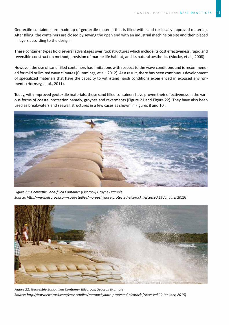
C O A S T A L P R O T E C T I O N B E S T P R A C T I C E S
Geotextilecontainersaremadeupofgeotextilematerialthatisfilledwithsand(orlocallyapprovedmaterial).Afterfilling,thecontainersareclosedbysewingtheopenendwithanindustrialmachineonsiteandthenplacedinlayersaccordingtothedesign.
Thesecontainertypesholdseveraladvantagesoverrockstructureswhichincludeitscosteffectiveness,rapidandreversibleconstructionmethod,provisionofmarinelifehabitat,anditsnaturalaesthetics(Mocke,etal.,2008).
However,theuseofsandfilledcontainershaslimitationswithrespecttothewaveconditionsandisrecommend-edformildorlimitedwaveclimates(Cummings,etal.,2012).Asaresult,therehasbeencontinuousdevelopmentofspecializedmaterials thathavethecapacitytowithstandharshconditionsexperienced inexposedenviron-ments(Hornsey,etal.,2011).
Today,withimprovedgeotextilematerials,thesesandfilledcontainershaveproventheireffectivenessinthevari-ousformsofcoastalprotectionnamely,groynesandrevetments(Figure21andFigure22).TheyhavealsobeenusedasbreakwatersandseawallstructuresinafewcasesasshowninFigures8and10.
Figure 21: Geotexti le Sand-fi lled Container (Elcorock) Groyne ExampleSource: htt p://www.elcorock.com/case-studies/maroochydore-protected-elcorock [Accessed 29 January, 2015]
Figure 22: Geotexti le Sand-fi lled Container (Elcorock) Seawall ExampleSource: htt p://www.elcorock.com/case-studies/maroochydore-protected-elcorock [Accessed 29 January, 2015]
42

B E S T P R A C T I C E S C O A S T A L P R O T E C T I O N
Figure 23: Geotexti le Sand-fi lled Container (Elcorock) Revetment ExampleSource: (Hornsey, et al., 2011)
Figure 24: Geotexti le Sand-fi lled Container (Elcorock) Breakwater ExampleSource: (Hornsey, et al., 2011)
43

C O A S T A L P R O T E C T I O N B E S T P R A C T I C E S
3.3.1 Table11:HardEngineeredSolutionsOverviewH
ard
Engi
neer
ed S
olu-
tion
sP
hoto
grap
hM
ajor
Com
pone
nts
Wav
e C
ondi
tion
Lim
it 1
Con
stru
ctab
ility
Envi
ronm
enta
l Im
pact
Cos
t Im
plic
atio
n 2
Ref
eren
ces
Con
cret
e Se
awal
l
http
s://
ww
w.fl
ickr
.co
m/p
hoto
s/ra
obha
sk/
sets
/721
5761
9303
6702
68/
page
2/
• M
ade
up c
oncr
ete
and
stee
l rei
nfor
cem
ent
• Th
ickn
ess
and
shap
e of
wal
l dep
ends
on
the
desi
gn w
hich
is s
ubje
ct to
lo
catio
n•
Wal
l thi
ckne
ss le
ss th
an
0.5m
ave
rage
.•
Con
cret
e st
reng
th ra
nges
fro
m 2
0-50
MPa
• D
esig
n lif
e of
50
year
s
• M
ediu
m to
Str
ong
wav
e co
nditi
ons
• C
ompl
exity
leve
l – h
igh
• G
eote
xtile
laye
r is
plac
ed
prio
r to
the
plac
emen
t ste
el•
Dep
th o
f fou
ndat
ion
depe
nds
on s
oil c
ondi
tion
• C
oncr
ete
may
be p
oure
d on
site
or p
re-f
abric
ated
of
f site
and
con
stru
cted
on
site
in s
ectio
ns
• Se
awal
l mat
eria
l sha
ll be
de
sign
ed to
sui
t mar
ine
envi
ronm
ent
Initi
al c
ost –
hig
h
Low
mai
nten
ance
(Roy
al H
asko
n-in
gDH
V, 2
012)
Shee
t pilin
g
http
://w
ww
.asc
eoc.
org/
imag
es/u
ploa
ds/0
30.J
PG
• M
ade
up o
f she
et p
iles
that
are
des
igne
d to
resi
st
corr
osio
n in
con
stan
t exp
o-su
re to
mar
ine
envi
ronm
ent
• Sh
eet p
iles
can
be m
ade
of P
VC, fi
ber
glas
s or
ste
el•
Des
ign
life
50 to
75
year
s
• M
ediu
m to
Str
ong
wav
e co
nditi
ons
• C
ompl
exity
leve
l – h
igh
• Sh
eet p
iles
are
driv
en a
t a
sign
ifi ca
nt d
epth
bel
ow
seaw
ater
leve
l to
ensu
re
stru
ctur
al s
tabi
lity
• D
epth
of s
heet
pile
de-
pend
s on
exi
stin
g gr
ound
co
nditi
ons
• A
nti-c
orro
sion
mea
sure
s su
ch a
s pa
int a
pplic
atio
ns
are
appl
ied
to th
e st
eel
shee
t pile
s.•
Hea
vy m
achi
nery
(pi
le
driv
ers
are
used
) to
driv
e th
e pi
les
in s
eque
nce
whi
ch a
re th
en in
terlo
cked
.
• Se
awal
l mat
eria
l sha
ll be
de
sign
ed to
sui
t mar
ine
envi
ronm
ent
• Sh
ort-
term
env
ironm
enta
l di
stur
banc
e su
ch a
s no
ise
and
dust
to b
e m
itiga
ted
durin
g co
nstr
uctio
n.
Initi
al c
ost –
hig
h
Low
mai
nten
ance
(Am
eric
an
Soci
ety
of
Civ
il En
gine
ers,
20
13)
Roc
k re
vetm
ent
http
://w
ww
.mr-
idea
ham
-st
er.c
om/h
owto
/kay
ak/
imag
es/r
evet
men
t.jpg
• M
ade
up o
f dire
ct p
lace
-m
ent o
f sui
tabl
y si
zed
rock
s•
Roc
k si
ze d
epen
ds o
n w
ave
heig
ht, p
erio
d an
d di
rect
ion
and
slop
e•
Rev
etm
ent c
rest
can
be
str
uctu
re in
to a
pub
lic
wal
kway
• D
esig
n lif
e 3-
5yea
rs
• M
ild w
ave
cond
ition
• C
ompl
exity
leve
l – lo
w
• G
eote
xtile
laye
r is
plac
ed
prio
r to
the
plac
emen
t of
rock
s•
Roc
ks p
lace
d at
incl
ina-
tion
or b
atte
r slo
pe to
m
erge
with
the
exis
ting
land
form
• C
rest
mus
t be
abov
e hi
gh
wat
er m
ark
or la
rges
t pro
-je
cted
sto
rm w
ave
impa
ct
• D
issi
pate
wav
e en
ergy
pr
even
ting
scou
ring
• Ef
fect
iven
ess
may
de
crea
se o
vert
ime
if co
n-tin
ued
fore
shor
e er
osio
n•
Larg
e ro
ck re
vetm
ent c
an
be a
haz
ard
due
to p
oten
-tia
l bu
ildup
of a
lgae
Initi
al c
ost –
med
ium
Med
ium
mai
nten
ance
(Con
tinuo
us e
xten
sion
al
ong
adja
cent
pro
per-
ties
may
be
requ
ired)
(Coa
tes,
et a
l.,
2000
)
44

B E S T P R A C T I C E S C O A S T A L P R O T E C T I O N 45
3.3.1 TableII:HardEngineeredSolutionsOverview
Har
d En
gine
ered
Sol
u-ti
ons
Pho
togr
aph
Maj
or C
ompo
nent
sW
ave
Con
diti
on L
imit
1C
onst
ruct
abili
tyEn
viro
nmen
tal I
mpa
ctC
ost
Impl
icat
ion
2R
efer
ence
s
Ren
o M
attr
esse
s
http
://w
ww
.geo
fab-
rics.
com
.au/
prod
ucts
/pr
oduc
ts/3
6-re
notr
ade-
mat
tres
ses/
over
view
• M
ade
up o
f wire
mat
-tr
esse
s w
hich
are
fi lle
d w
ith s
tone
s•
Thic
knes
s of
mat
tres
s ra
nges
from
0.1
7m to
0.3
m•
Ston
e si
zes
are
80m
m to
15
0mm
• Th
e w
ire b
aske
t has
a
PVC
coa
ting
whi
ch p
ro-
tect
s it
agai
nst c
orro
sion
.•
Des
ign
life
5-10
yea
rs
• M
ild w
ave
cond
ition
• C
ompl
exity
leve
l – m
e-di
um
• G
eote
xtile
laye
r is
plac
ed
prio
r to
the
plac
emen
t of
the
mat
tres
s•
Mat
tres
s is
a fl
ex-
ible
str
uctu
re th
at c
an b
e pl
aced
at a
radi
us to
mer
ge
with
the
exis
ting
land
form
• Su
bgra
de to
be
stab
ilized
pr
ior t
o pl
acem
ent o
f mat
-tr
esse
s.
• St
abiliz
es s
lope
or e
m-
bank
men
t•
Prov
ide
inte
rlock
ing
thro
ugho
ut th
e pr
otec
ted
area
.•
Enab
les
grow
th o
f loc
al
fl ora
and
faun
a
Initi
al c
ost –
med
ium
Low
mai
nten
ance
(Mac
cafe
rri,
2013
)
Gab
ions
http
://w
ww
.fost
ersu
pply
.co
m/P
rodu
cts/
Eros
ionc
on-
trol
/Gab
ionB
aske
ts.a
spx
• M
ade
up o
f wire
bas
kets
w
hich
are
fi lle
d w
ith ro
ck
piec
es.
• R
ock
size
s ar
e 10
0mm
to
200m
m•
The
wire
bas
ket h
as a
PV
C c
oatin
g w
hich
pro
-te
cts
it ag
ains
t cor
rosi
on.
• D
esig
n lif
e 5-
10 y
ears
• M
ild w
ave
cond
ition
• C
ompl
exity
leve
l – m
e-di
um to
hig
h
• St
ruct
ure
is in
clin
ed (
4-10
°) a
s sh
own
in th
e fi g
ure
to e
nhan
ce s
tabi
lity
• B
acki
ng e
arth
(ba
tter
slop
e) m
ust b
e st
abi-
lized
prio
r to
erec
tion
of
stru
ctur
e.•
Gab
ion
bask
ets
stre
tche
d pr
ior t
o fi l
ling
of ro
ck
mat
eria
ls.
• Fi
lled
gabi
on b
aske
t sur
-fa
ces
(all
roun
d) m
ust n
ot
allo
w p
oten
tial b
reak
out o
f in
divi
dual
rock
s.
• St
abiliz
es s
lope
or e
m-
bank
men
t•
Prev
ent s
oil e
rosi
on•
Abs
orb
wav
e en
ergy
• C
an b
e de
trim
enta
l if n
ot
desi
gned
and
con
stru
cted
pr
oper
ly
Initi
al c
ost –
med
ium
Low
mai
nten
ance
(Mac
cafe
rri,
2013
)
(Coa
tes,
et a
l.,
2000
)
Geo
text
ile C
onta
iner
s
Exam
ple:
Elc
oroc
kN
EW!
http
://w
ww
.geo
fabr
ics.
com
.au/
abou
t-ge
ofab
rics/
inte
rnat
iona
l
• Sa
nd c
onta
iner
s m
ade
of
geot
extil
e m
ater
ial.
• Fi
ll m
ater
ial m
ade
up o
f lo
cally
sou
rced
san
d•
Can
be
used
in v
ario
us
form
s: s
eaw
all,
reve
tmen
t, gr
oyne
s, a
nd b
reak
wat
ers
• A
vaila
ble
in tw
o si
zes
0.75
m3
and
2.5m
3•
The
geot
extil
e m
ater
ial
prov
ides
hig
h du
rabi
lity
en-
hanc
ing
bette
r des
ign
life
• D
esig
n lif
e 5-
10 y
ears
• Li
mite
d w
ave
cond
ition
• C
ompl
exity
leve
l – lo
w
• Fi
lling
fram
e is
use
d (p
urch
ased
toge
ther
with
El
coro
ck g
eote
xtile
)•
Fillin
g of
bag
s m
ust n
ot
be d
one
in w
et o
r win
dy
wea
ther
con
ditio
ns.
• B
ags
plac
ed in
laye
rs•
Plac
emen
t of b
ags
to b
e do
ne a
t low
tide
• Pr
oper
em
bedm
ent o
f toe
co
ntai
ners
is c
ritic
al (
ap-
prox
imat
ely
0.5m
dee
p)
• Pr
even
ts s
cour
ing
by
abso
rbin
g w
ave
ener
gy•
Dam
aged
san
d ba
gs
affe
ct s
tabi
lity
of e
ntire
st
ruct
ure
• B
ags
prov
ide
enha
nces
na
tura
l aes
thet
ics
Initi
al c
ost –
low
to
med
ium
Low
-med
ium
mai
nte-
nanc
e
(Mac
cafe
rri,
2013
)
(Coa
tes,
et a
l.,
2000
)
(Cum
min
gs, e
t al
., 20
12)
(Int
erna
tiona
l C
oast
al M
an-
agem
ent,
2012
)

C O A S T A L P R O T E C T I O N B E S T P R A C T I C E S 44
ThissectionwillprovideabriefupdateofbaselineinformationoncurrentcoastalprotectioninterventionsaroundsomeofthecountriesinthePacificregion.Thevariousengineeringapproachesusedbydifferentcountriesintheregionwillbepresented.
4.1CookIslands
IntheCookIslands,theengineeringapproachesusedareconcreteseawalls,rockboulderrevetments,groynes,rock breakwater, and beach replenishment. Specific locations of interest are the beach replenishment at theNortherncoastlineandrockmountedbreakwateratAvatiu.BelowaresomeexamplesofengineeringworksintheCookIslands:
Figure 25 Rock riprap wall, Figure 26 Avarua rock groynes, Figure 27 Gabion basket wall, Figure 28 Ngatangiia concrete wall (Source: Fig.25-28: He, 1999).
Chapter 4: selected examples of currentinterventions in the pacificbyLukePaeniuandAlitiKoroi
Har
d En
gine
ered
Sol
u-ti
ons
Pho
togr
aph
Maj
or C
ompo
nent
sW
ave
Con
diti
on L
imit
1C
onst
ruct
abili
tyEn
viro
nmen
tal I
mpa
ctC
ost
Impl
icat
ion
2R
efer
ence
s
Ren
o M
attr
esse
s
http
://w
ww
.geo
fab-
rics.
com
.au/
prod
ucts
/pr
oduc
ts/3
6-re
notr
ade-
mat
tres
ses/
over
view
• M
ade
up o
f wire
mat
-tr
esse
s w
hich
are
fi lle
d w
ith s
tone
s•
Thic
knes
s of
mat
tres
s ra
nges
from
0.1
7m to
0.3
m•
Ston
e si
zes
are
80m
m to
15
0mm
• Th
e w
ire b
aske
t has
a
PVC
coa
ting
whi
ch p
ro-
tect
s it
agai
nst c
orro
sion
.•
Des
ign
life
5-10
yea
rs
• M
ild w
ave
cond
ition
• C
ompl
exity
leve
l – m
e-di
um
• G
eote
xtile
laye
r is
plac
ed
prio
r to
the
plac
emen
t of
the
mat
tres
s•
Mat
tres
s is
a fl
ex-
ible
str
uctu
re th
at c
an b
e pl
aced
at a
radi
us to
mer
ge
with
the
exis
ting
land
form
• Su
bgra
de to
be
stab
ilized
pr
ior t
o pl
acem
ent o
f mat
-tr
esse
s.
• St
abiliz
es s
lope
or e
m-
bank
men
t•
Prov
ide
inte
rlock
ing
thro
ugho
ut th
e pr
otec
ted
area
.•
Enab
les
grow
th o
f loc
al
fl ora
and
faun
a
Initi
al c
ost –
med
ium
Low
mai
nten
ance
(Mac
cafe
rri,
2013
)
Gab
ions
http
://w
ww
.fost
ersu
pply
.co
m/P
rodu
cts/
Eros
ionc
on-
trol
/Gab
ionB
aske
ts.a
spx
• M
ade
up o
f wire
bas
kets
w
hich
are
fi lle
d w
ith ro
ck
piec
es.
• R
ock
size
s ar
e 10
0mm
to
200m
m•
The
wire
bas
ket h
as a
PV
C c
oatin
g w
hich
pro
-te
cts
it ag
ains
t cor
rosi
on.
• D
esig
n lif
e 5-
10 y
ears
• M
ild w
ave
cond
ition
• C
ompl
exity
leve
l – m
e-di
um to
hig
h
• St
ruct
ure
is in
clin
ed (
4-10
°) a
s sh
own
in th
e fi g
ure
to e
nhan
ce s
tabi
lity
• B
acki
ng e
arth
(ba
tter
slop
e) m
ust b
e st
abi-
lized
prio
r to
erec
tion
of
stru
ctur
e.•
Gab
ion
bask
ets
stre
tche
d pr
ior t
o fi l
ling
of ro
ck
mat
eria
ls.
• Fi
lled
gabi
on b
aske
t sur
-fa
ces
(all
roun
d) m
ust n
ot
allo
w p
oten
tial b
reak
out o
f in
divi
dual
rock
s.
• St
abiliz
es s
lope
or e
m-
bank
men
t•
Prev
ent s
oil e
rosi
on•
Abs
orb
wav
e en
ergy
• C
an b
e de
trim
enta
l if n
ot
desi
gned
and
con
stru
cted
pr
oper
ly
Initi
al c
ost –
med
ium
Low
mai
nten
ance
(Mac
cafe
rri,
2013
)
(Coa
tes,
et a
l.,
2000
)
Geo
text
ile C
onta
iner
s
Exam
ple:
Elc
oroc
kN
EW!
http
://w
ww
.geo
fabr
ics.
com
.au/
abou
t-ge
ofab
rics/
inte
rnat
iona
l
• Sa
nd c
onta
iner
s m
ade
of
geot
extil
e m
ater
ial.
• Fi
ll m
ater
ial m
ade
up o
f lo
cally
sou
rced
san
d•
Can
be
used
in v
ario
us
form
s: s
eaw
all,
reve
tmen
t, gr
oyne
s, a
nd b
reak
wat
ers
• A
vaila
ble
in tw
o si
zes
0.75
m3
and
2.5m
3•
The
geot
extil
e m
ater
ial
prov
ides
hig
h du
rabi
lity
en-
hanc
ing
bette
r des
ign
life
• D
esig
n lif
e 5-
10 y
ears
• Li
mite
d w
ave
cond
ition
• C
ompl
exity
leve
l – lo
w
• Fi
lling
fram
e is
use
d (p
urch
ased
toge
ther
with
El
coro
ck g
eote
xtile
)•
Fillin
g of
bag
s m
ust n
ot
be d
one
in w
et o
r win
dy
wea
ther
con
ditio
ns.
• B
ags
plac
ed in
laye
rs•
Plac
emen
t of b
ags
to b
e do
ne a
t low
tide
• Pr
oper
em
bedm
ent o
f toe
co
ntai
ners
is c
ritic
al (
ap-
prox
imat
ely
0.5m
dee
p)
• Pr
even
ts s
cour
ing
by
abso
rbin
g w
ave
ener
gy•
Dam
aged
san
d ba
gs
affe
ct s
tabi
lity
of e
ntire
st
ruct
ure
• B
ags
prov
ide
enha
nces
na
tura
l aes
thet
ics
Initi
al c
ost –
low
to
med
ium
Low
-med
ium
mai
nte-
nanc
e
(Mac
cafe
rri,
2013
)
(Coa
tes,
et a
l.,
2000
)
(Cum
min
gs, e
t al
., 20
12)
(Int
erna
tiona
l C
oast
al M
an-
agem
ent,
2012
)

B E S T P R A C T I C E S C O A S T A L P R O T E C T I O N 47
Figure 29 Concrete Revetment west of airport. Figure 30 Rarotonga Hotel concrete revetment. Figure 31 Avarua Harbor seawall and revetment. Figure 32 Reclaimed Coast Protecti on: Te Tautua Village, Penrhyn Island, Cook Island. (Source: Fig.29-32: He, 1999).
4.2EastTimor(Timor-Leste)
Wavebreakers infrontoftheportofDiliandDiliAirport,mangroves,coastalandMarineProtectedAreasonsomeofTimor Leste’s coastare commoncoastalengineeringapproaches found inTimor Leste.Recently,bigstonesfromrivershavebeenplacedonstretchesofbeachcalled“PantaiKelapa”toserveaslow-costwavebreak-ers.ThemangroveplantingsiteoftheEU-GCCAproject is inUlmeravillage,sub-districtBazarteteanddistrictLiquica,thoughmangroveconservationisalsooneoftheprioritiesfortheGovernmentandNon-GovernmentalorganizationsinTimor-Leste.Inadditiontothat,Timor-LesteisworkingonICMwithinthecontextoftheCoralTriangleInitiative(CTI).Thecountryalsohasmanynationalparks,bothmarineandterrestrialamongwhichisacommunitybasednationalparkcalled‘NinoKonisSantana’
Figure 33 Mangroves in Ulmera village Figure 34 Wave breakers at port Dili, Timor Leste
4.3FederatedStateofMicronesia(FSM)
Seawalls,causewaysandgroynesarecommonengineeringstructuresfoundinFSM.ShownbelowaresomeoftheengineeringstructuresinFSM:
Figure 35 Concrete coral seawall. Figure 36 Coral rubble seawall. Figure 37 Coral seawall. Figure 38 Coral rubble seawall (Source: Fig. 35-38: Maharaj, 1998)

C O A S T A L P R O T E C T I O N B E S T P R A C T I C E S 48
4.4Fiji
InFiji,causeways,bridgesandseawallsarebeingused.FijihasanIntegratedCoastalZonemanagementPlaninplace.ProtectedcoastalareasaretheGreatAstrolabeReefinOnoisland,Kadavu;NadiBay(Tai,Levuka,VomoSewaislandsfringingandoffshorereefareas);Namenalalafringingandbarrierreefs;YaduaTabafringingreefsandsurroundingwaters;andLauGroup.
TheprotectedmangroveareasareBaDelta-Nawaqarua-Natutu;RewaDelta-Muanicake-Nasoatariver;LabasaDelta-LabasariverandLabasadeltamouth.65
SomeofcurrentengineeringstructuresfoundinFijiarepresentedbelow:
Figure 39 Navulivatu concrete seawall. Figure 40 Lomeri concrete wall. Figure 41 Lomeri Rock wall. Figure 42 Lomeri rock wall.
Figure 43 Naitonitoni rip rap rock wall. Figure 44 Naitonitoni rock wall. Figure 45 Lami rubber ti re wall. Figure 46 Lami Gabion basket wall.
Figure 47 Concrete wall in Suva Wharf. Figure 48 Concrete wall in front of Civic Centre. Figure 49 Concrete wall in front of the President’s Residence. Figure 50 Rock wall at Suva Grammar beach front.
65DepartmentofEnvironment,(2011)

B E S T P R A C T I C E S C O A S T A L P R O T E C T I O N 49
DepartmentofEnvironment,(2011)
Figure 51 Naselesele bridge. Figure 52 Rock wall. Figure 53 Naselesele rock wall. Figure 54 Rip rap rock revetment.
Someofthenaturalcoastalprotections
Figure 55 Korotogo Mangroves. Figure 56 Korotogo juvenile mangroves. Figure 57 Namada reef fl at. Figure 58 Namada inter-ti dal reef.
Figure 59 Namatakula Beach rock. Figure 60 Namatakula beach rock. Figure 61 Namatakula beach rock. Figure 62 Navulivatu Shoreline Mangroves.
Figure 63 Mangroves at Naselesele. showing aerial roots trapping sediments. Figure 64 Naselesele Mangroves, Taveuni

C O A S T A L P R O T E C T I O N B E S T P R A C T I C E S 50
4.5Guam
ThecommoncoastalengineeringapproachesfoundinGuamarerevetments,seawallatEastAgana,VegetationatCocosIsland,coralboulderrevetment,concreteandrockseawall.
4.6Kiribati
ThetypesofinterventionsfoundinKiribatiareverticalcoralrockseawalls,cementverticalcoralrockwall,Ga-bionbasketfilledwithcoral,sandbags,cementfrontwall,slopingcoralrockwallwithcement,motorwaysandcauseways.SomeexamplesofseawallsinKiribatiarepresentedbelow:
Figure 65 Concrete Sandbag wall. Figure 66 Rock wall. Figure 67 Causeway Concrete wall. Figure 68 Concrete revetment wall at Parlia-ment House.
Figure 69 Bonriki Sloping sandbag wall. Figure 70 Concrete slabs at Oceanside of Bonriki airport. Figure 71 Sloping concrete wall at Red Beach, Beti o. Figure 72 Wave Breakers at Beti o Wharf.
Figure 73 Mangroves and sand bags wall at Bonriki. Figure 74 Dainippon Causeway Bairiki to Beti o. Figure 75 Private land-reclaiming project using sand bags wall at Bairiki. Figure 76 Sloping cement wall protecti ng Parliament House.

B E S T P R A C T I C E S C O A S T A L P R O T E C T I O N
Figure 77 Concrete wall. Figure 78 Rock Wall Figure 79 Rock and concrete wall. Figure 80 Concrete wall.
Figure 81 Nanikai Stone wall. Figure 82 Tarawa sea wall. Figure 83 Mormon Church seawall. Figure 84 Reclaim seawall extend to lagoon. (Source: Fig.77-84: Woodroff e and Biribo, 2011)
Kiribatiusesmangrovesasaprotectivemeasureforthecoasts.ThePresidentofKiribatiH.E.DrAnoteTonghasbeeninstrumentalinempoweringKiribatiyouthtoplantmangroveseedlingsaseffectivemeasuresinprotect-ingerodedbeaches.
Figure 85 Mangroves. Figure 86 Mangrove project. Figure 87 Mangroves planted in lines. Figure 88 Juvenile Mangroves.
51

C O A S T A L P R O T E C T I O N B E S T P R A C T I C E S
4.7MarshallIslands
Generallyspeaking,coastalprotectionintheRMIisintendedto“holdtheline”andmaintainafixedshoreline,i.e.limiterosionandtoalesserextentlimitfloodingandinundation.ThisisparticularlyevidentinthepopulatedcentersofMajuroandEbeyewherecoastalprotectionislargelyadhocandundertakenatthelevelofindividuallandowners.OtherthantherevetmentandseawallattheMajuroairport,therehavebeenfewcoordinatedorcentralizedcoastalengineeringinterventionspost-independence.Typicallylandownerswillarmorshorelinesus-inganyavailablematerial.Thosewithaccesstotechnicalandfinancialresourceswilluserip-raprevetmentandverticalconcreteblockorcementedcoralwalls.Gabionbasketsfilledwithcoralgravelarealsoused.Morefre-quently,amixofinorganicdebrisincludingtires,scrapmetalandoldheavymachineryisused.RecentlytheRMIendorsedguidanceintheformofapublicationonoptionsforcoastalprotectionforlandowners.
UniversityofHawaiiSeaGrantinassociationwithRMIagenciesisworkingwithcommunitiestobroadentheop-tionstoincludesofterridge-buildingandre-vegetationtechniques,alongwithamoreconcentratedapproachtoreefandreefflatprotection.Whileongoingworkintheouteratollsisstillfocusingonharderfortificationmea-suresandroadelevationalongcauseways,theapproachisbecomingmoreintegratedandinnovativeintermsofcombiningoptionswherepossible.Thiswillhavelongtermbenefitsofmainstreamingwithotherresourceman-agementobjectives(e.g.reefprotection)andmakingitmorelikelythatbenefitsfromlimitedadaptationfundscanbeusedoveralargerarea.
Figure 89 Rip-rap rock wall Figure 90 Sand bags Figure 91 Concrete stone wall(Source: Fig 89 - 91: Karl Fellenius)
Figure 92 Concrete wall Figure 93 Seawall structure Figure 94 Concrete wall(Source: Fig 92 -94: Karl Fellenius)
52

B E S T P R A C T I C E S C O A S T A L P R O T E C T I O N
Figure 95 Seawall in Majuro. Figure 96 Seawall protecti ng huge buildings(Source: Fig.95 - 96: Murray Ford and Coastal Consultants NZ Ltd, 2013).
Figure 97 Seawall placed on rock. Figure 98 Breakwaters in Majuro.(Source: Fig.97 - 98: Murray Ford and Coastal Consultants NZ Ltd, 2013)
Figure 99 Vehicle ti re neatly stacked as seawall. Figure 100 Concrete wall. Figure 101 Seawall protecti ng oil tanks. (Source: Fig.99 - 101: Murray Ford and Coastal Consultants NZ Ltd, 2013).
4.8Nauru
ThecoastalengineeringapproachesusedinNauruareCoralboulderrevetmentandconcreteandrockseawalls.ThetwomajorcoastalengineeringworksdoneonNauruincludetheextensionoftheairportrunwayandtheconstructionofthenewboatharborinAnibareBay.HerearesomeexamplesofengineeringworkinNauru.
53

C O A S T A L P R O T E C T I O N B E S T P R A C T I C E S
Figure 102 Rip rap rock revetment. Figure 103 Concrete wall. Figure 104 Long concrete wall. Figure 105 Concrete wall with rocks at base-ment. (Source: Fig.102 - 105: Maharaj, 2000).
Figure 106 rock revetment. Figure 107 layout of rock revetment. Figure 108 rock wall. Figure 109 rock wall protects a house(Source: Fig.106 - 109: Maharaj, 2000)
Figure 110 Nauru new wharf Figure 111 Rip-rap rock wall(Source: Fig 110 - 111: Maharaj, 2001).
Figure 112 Boat ramp and rip-rap rock wall Figure 113 Rip rap rock wall(Source: Fig 112 - 113: Maharaj, 2001)
54

B E S T P R A C T I C E S C O A S T A L P R O T E C T I O N
4.9Niue
Niueissurroundedbynaturalhighcliffstructureswhichprotectstheislandfromwavesandstrongwinds.AseawallwasconstructedatAvateleBay.TherearetwoMPA’soneinAlofiandoneinMakefu.(fromNiueICCMsBirthaTogahai)
Figure 114 High Cliff of Tamakautoga, Niue Figure 115 High cliff s of Niue (Source: Fig 114 - 115: Susanna Sionetuato)
Figure 116 Walking down the cliff , Niue. Figure 117 Waves cuts the cliff below-Avatele Bay. Figure 118 Pathway down the cliff
Figure 119 Tall Concrete wall at Avatele Bay. Figure 120 Concrete Beach ramp, and seawall. Figure 121 Stone wall at Anaana point, Tamakautoga.
4.10NorthernMarianaIslands
Thecoastalengineeringstructuresfoundareseawalls,bulkheads,andbeachnourishmentatBeachRoad.
55

C O A S T A L P R O T E C T I O N B E S T P R A C T I C E S
4.11Palau
TheshorelineofMelekeokstateinPalauconsistsofmangroves,sandybeaches,seawalls,reclaimedlandatthemarina,andgroynes.HerearesomeexamplesofengineeringworkinPalau:
Figure 122 Rip rap rock wall. Figure 123 Grouted rock wall. Figure 124 Rock wall Figure 125 Concrete wall (Source: Fig.122 - 125: Kench, 2008)
Figure 126 Ngerubesang rock groyne. Figure 127 Concrete groyne. Figure 128 Long groyne. Figure 129 Rock groyne at dock area (Source: Fig.126 -129: Kench, 2008)
Figure 130 Melekeok rock wall protecti ng the road Figure 131 Ngermelech rock wall(Source: Fig. 130 - 131: Kench, 2008)
56

B E S T P R A C T I C E S C O A S T A L P R O T E C T I O N
4.12PapuaNewGuinea
InPapuaNewGuinea,coastalengineeringapproachesusedarebricksandrockseawalls,drystoneseawalls,coralseawallsandboulders.
Figure 132 Dry stone seawalls at Gapagapa village, central province, PNG
Figure 133 Stone wall at Mou Kele village. Figure 134 Sandbag and tree trunk wall. Figure 135 Rock wall at Gilibwa village. Figure 136 Gabion Basket wall at Los Negros Island.
4.13Samoa
InSamoathecoastalengineeringapproachesarestonewalls,volcanicbouldersatLufilufi,Vaialabeachseawall,semiverticalseawallatTusitalaHotel,revetmentatAggieGrey’sHotel,groynesatMulinwuPeninsula,largerockatoldHideawayHotelatMulivai,Revetmentandbeachreplenishment,ChinesefundedseawallatApiawaterfrontandatthebeach.
ThemainapproachesusedinSamoaarehardstructuralarmorrockrevetmentsorseawallsandsoftmeasuressuchasplantingofmangrovesandothersalt tolerantcoastalplantspecies.Thedesignsandconstructionsoftheseinterventionsaredoneonanadhocbasis.Onestandarddesignusescompactedbackfillscoriamaterial,geotextilecloth,secondaryandprimaryarmorrocksplacedat rightslopeandheight. (TakenfromMs.MoiraFaletutuluoftheMinistryofNaturalResourcesandEnvironment,Samoa),HerearesomeexamplesfromSamoa:
57

C O A S T A L P R O T E C T I O N B E S T P R A C T I C E S
Figure 137 Parti al concrete revetment at Piula. Figure 138 Rock wall at Sataoa.(Source: Fig.137 - 138: Moira Faletutulu)
Figure 139 Aerial view of groynes along Mulinuu Peninsula shoreline. Figure 140 Rock wall and vegetati on. (Source: Fig.139: Nati onal Mapping Services, MNRE, Samoa. Fig. 140: Moira Faletutulu)
4.14SolomonIslands
ThemostpopularlowcostengineeringapproachintheSolomonIslandsforcoastalprotectionistheuseofsea-walls.Thesearebuilt fromrockbouldersfromthesurroundingcoastalenvironment.AsshowninFigure141,wheretheseawallisvulnerabletorelativelyintensewaveaction,itisreinforcedbywoodenpillarsimpaledintothebenthos.Becausethelifespanofpillarsisnotthatlongthereforeitrequirescommunityorfamilyefforttomaintainthem.
Someseawallsaremadeofcoralbouldersfromthereefsreinforcedbylogs.Figure142belowshowssuchawallattheSouthernendofNolaHamletinNgawaIslet(ReefIslandsgroupingofTemotuProvince).SeawallslikethisarealsoreinforcedbytherootsofAbalolotreesthatinterlocktherockstogether.
Mangroveforestsalsoplaysamajorrole incoastalprotection intheSolomon Islands,unfortunatelytheirex-ploitationhaveseendramaticincreaseindenselypopulatedareasaroundthecountry.TheLangalangaLagooninMalaitatheSolomonIslandshasseenagreatdealofmangrovedeforestationinthelast15years,increasingcoastalerosion.InNgawaIslandintheReefIslands,thecommunityinanattempttoprotecttheircoastsfromerosion,decidedtoplantmangrovetrees,alongtheircoastintheintertidalzone.Accordingtothevillages,themangroveshavestartedhelpingtheretrievalofthecoastline(seefigure,143).Initiativeslikethesecanonlybeeasilypursuedandachievedthroughgreatercommunityparticipationastheprocessesofplantingandcaringforthemangroveshastocomefromthecommunityasawhole.
58

B E S T P R A C T I C E S C O A S T A L P R O T E C T I O N
Figure 141 Rock Boulders seawall Figure 142 Rock seawall Figure 143 Mangrove Planti ng Theuseofconcreteseawalloftenrequiresmajorinvestments.Theycanbeverycostlytobuild,thusareonlysuit-ableandpracticalinurbanareasandareaswhichhavesomelevelofdevelopment.InSolomonIslandsexamplesincludes,theHoniaraPortsArea,HoniaraCentralMarketandmajorhotelsthatoccupythecoastlinewhichhaveconcreteseawalls.Despitetheircostliness,theyareproventobemoredisasterproof.
Seawallswhichusegabionnetsarealsoeffectiveandcostlybutunlikeconcreteseawalls,theirlifespandependsontheabilityofthewirestoresistcorrosion,theirexposuretophysicalforcesofnaturesuchaslargeoceanswellsandthechemicalpropertiesoftheoceanorestuary(AnupdatefromResearchAssistantJohnWha-leneanea).
Figure 144 Breakwater structure. Figure 145 Gabion structure. Figure 146 Breakwater structure. Figure 147 Concrete revetment. Figure 148 Concrete seawall.
59

C O A S T A L P R O T E C T I O N B E S T P R A C T I C E S
Figure 149 Mangroves in Ulmera village Figure 150 Wave breakers at port Dili, Timor Leste
4.15Tonga
InTonga,limestoneboulderseawallatNukualofabeachfront,andbeachsandseawallatHihifointhewesternareaareused.BreakwaterinEuaIsland.TheseawallatthewaterfrontofNukualofawasconstructedaftercycloneIsaacof1982andcompletedaround1985-86.Thiswasconsideredhighlysuccessfulinprotectingthebeachfrontinthecapitalarea.TheKanokupoluSeawallwasconstructedbythevillagersthemselveswithsomeassistancefromNGOs,GovernmentsandDonors.Thishasbeenverysuccessfulatpreventingfurthererosionatthesite,butonceagainamajorheadacheattheedgeoftheseawallwheretheneighboringvillagesarenowfacingcoastalinundationatagreatermagnitudeandfrequency.SoftengineeringapproacheshavebeenconductedinmoreshelteredlagoonsitevillagessuchasLapahaonthemainislandofTongatapu.Mangrovereplantingandcoastalplantreforestationisongoingastheyattempttoreducetheimpactsofinundationandcoastalerosion.TheuseofsandbagswaspilotedbyonecommunityinHa’apai.Thisprojectwasnotsosuccessfulastheyusedbagsthatwerenotdurable,howevertheconcepthasitsmeritsintermsoftheavailabilityofresourceslocally,andjustneedsfurthermodificationstogetitright(AnupdatefromInCountryCoordinator-Mr.TevitaFakaosi).
Figure 151 Concrete seawall. Figure 152 Waterfront seawall. Figure 153 Rock seawall. Figure 154 Sandbag seawall-Tonga (Photo credit: Fig.151 -154: Tevita Fakaosi)
60

B E S T P R A C T I C E S C O A S T A L P R O T E C T I O N
4.16Tuvalu
InTuvalu,thecommonengineeringapproachesareseawalls,gabionbasketofstones,andconcretecuberevetment.
Figure 155 Concrete wall behind the boat. Figure 156 Concrete wall at Wharf. Figure 157 Concrete cubes beach ramps.
Figure 158 Private wall made up of 44-gallon drums fi lled with concrete. Figure 159 Concrete wall in front of Hotel. Figure 160 Nukufetau jett y and reef channel. (Source: Fig 158: Ms. Makereta Komai. Fig 160: Temata Shozo)
Figure 161 Niutao causeway and Mangroves. Figure 162 Nukulaelae beachramp. Figure 163 Concrete wall in Funafuti .
61

C O A S T A L P R O T E C T I O N B E S T P R A C T I C E S
Figure 164 Stone beach south Fogafale. Figure 165 Stone beach and reef. Figure 166 Storm Bank just aft er Hurricane Bebe 1972. Figure 167 Nukulaelae storm bank. (Source: Fig.166: Tuvalu Meteorological Stati on)
Figure 168 Vaitupu Fisheries Harbor. Figure 169 coral rubble at Vaitupu. Figure 170 Vaitupu reef. Figure 171 Vaitupu seagrass. (Source: Fig.168 -171: Xue, 2002).
4.17Vanuatu
InVanuatuthereisaseawallinPortVilaHarborwhichwasdamagedbyacyclone.Vanuatucomprisesofover83inhabitedislands.Mostpeoplelivingonthecoasthavemoreorlessignoredordonenothinginthenameofengineeringtocountertherisingsealeveland,orcoastalerosion.Some–oncoastalcalmwaters–haveresortedtopilinguprockscollectedfromthesand.Thisisnotveryeffectiveasitiseasilywashedawayduringstorms.Oth-erswhohaveextrafundstospendmightbeableto,orhavebuiltconcretewallsorusecementtoholdtherockstogethertoformaseawall.Thisagainisnotveryeffectiveeitherduringroughstormsandovertimewhenthewaterdigsaroundthewalls.Yetotherswithfundsandorwithexternalsponsorshiplayoutgabionbasketsandfillthemupwithrocks.InLuganvilleandPortVilasomeportionsofthecoastshavebeenburied(landreclamation)andconcreteandmetalwallshavebeenconstructed.TheseengineeringworksweredoneduringthecolonialeraandmostlybytheAmericansduringtheirbriefstayinthecountryduringthesecondworldwar.Alotofmoneywasputintothisinitiativeandalsobecausethewaterconditionsinthesetwolocationsisnormallycalm,thesestructureshavebeeninplaceforquiteawhileandcanstillbeseentoday.Sealevelriseandfrequentcyclonesinthe90shaveerodedthemetalwallsinLuganvilleandrecentstormshavedamagedpartsoftheconcrete/metalseawallinPortVila.Almostalltheattemptsdiscussedoccurwherethewaterisusuallycalm.Areasconstantlyexposedtoroughseaslargelyignoreanyengineeringworkatallaspeopleknowtheireffortswillbefutile.(AnupdatefromVanuatuICC-WilliamBaniArudovo).
62

B E S T P R A C T I C E S C O A S T A L P R O T E C T I O N
Figure 172 Concrete structure at Vanuatu. Figure 173 Same concrete structure.
Figure 174 Veti ver Grass at Piliura village on Pele Island. Figure 175 Gabion basket at Worasiviu. (Source: Fig.174 -175: Christopher Bartlett - SPC/GIZ)
4.18Interventionsthatdidnotwork
Let’snowturnourattentionandtryandcaptureinterventionsthatdidnotworkinsomeoftheselectedPacificcountries.Photosbelowwilltellthestory:
ExamplesfromCookIslands:
Figure 176 Sea erosion caused by failed seawall. Figure 177 Collapsed seawall in Cook Islands. Figure 178 Collapsed groyne at west end. (Source: Fig. 176 -178: He, 1999)
63

C O A S T A L P R O T E C T I O N B E S T P R A C T I C E S
ExamplesfromFiji
Figure 179 Part of seawall at Lomeri High School collapsed. Figure 180 Same seawall looking from seaside. Figure 181 Poor engineering work
Figure 182 Tire wall collapsed at end of seawall. Figure 183 Tire wall was ineff ecti ve. Figure 184 Vehicle ti re wall at end collapsed
ExamplesfromFSM
Figure 185 Polap Island erosion at toe of seawall. Figure 186 Collapsed seawall at Satawan Island. (Source: Fig 184 -185: Maharaj, 1998).
64

B E S T P R A C T I C E S C O A S T A L P R O T E C T I O N
ExamplesfromKiribati
Figure 187 Erosion at end of seawall-Eita, Tabiteuea North. Figure 188 Collapsed seawall-Tewai school, Tabiteuea South. Figure 189Collapsed seawall at Temotu island, Nonuti . (Source: Fig. 187 -189: Gillie, 1993).
Figure 190 Collapsed wall at Roti ma, Nonouti . Figure 191 Eroded road and seawall collapsed at Roti ma..Figure 192 Collapsed concrete fi lled sandbag wall at Nonouti . (Source: Fig.190 -192: Gillie, 1993).
Figure 193 Collapsed seawall in Abemama. Figure 194 Collapsed seawall in Kuria. (Source: Fig.193-194: Gillie, 1993).
65

C O A S T A L P R O T E C T I O N B E S T P R A C T I C E S
Figure 195 Erosion of important monument. Figure 196 Remains of stone wall. Figure 197 Gabion basket -broken wire.
Figure 198 Erosion begins where wall ends. Figure 199 Erosion at end of seawall. Figure 200 Erosion seen at toe of sandbag wall.
ExamplesfromSamoa
Figure 201 Collapsed seawall in Samoa (Source: Yamamoto and Esteban, 2011)
66

B E S T P R A C T I C E S C O A S T A L P R O T E C T I O N 67
ExamplesfromTuvalu
Figure 202 Collapsed Concrete cube Seawall at Nanumaga. Figure 203 Collapsed Concrete cube revetment at Funafuti . Figure 204 Collapsed Gabion basket wall and Tree Trunk wall at Nukulaelae. (Source: Fig.203: Tuvalu NBSAP)
Figure 205 Damaged boulders at toe of concrete seawall, Funafuti . Figure 206 Damaged seawall at Vaiaku Lagi Hotel. Figure 207Collapsed concrete cubes revetment. (Source: Fig.205 -207: Xue and Malologa, 1995).

C O A S T A L P R O T E C T I O N B E S T P R A C T I C E S 66
Basedonthepreviouschapters,thischapterprovidesasummaryofkeyPacificandothersmallislanddevelopingstatesexperiencesofthevariouscoastaladaptationsystemandprocesses.Thefollowingareselectedcasestudiesthatillustratesomeofthepromisingcoastaladaptationsystemsandprocesses.Thesesystemsandprocessesare:
•Hardcoastalstructures; •Softcoastalstructures; •Bio-physicalstructureand •Coastaladaptationmechanism.
5.1HardCoastalStructures
Solomon Islands
Building Stone Walls (TonyWale,Aoke,LangalangaApexAssociation,Honiara,SolomonIslands) ThissimplemethodhasworkedforthecommunityofLangalangaLagoon.Theyareseeingsanddepositedatthecoastandtheirbeachgraduallybeingreplenished;mangroveswillbereplantedalongthestonewalltocreateabufferzonefortheirshores.
Samoa
Groynes (fromKevinPetrini,UnitedNationsDevelopmentProgrammePacificCentre,Suva,Fiji) InSamoatheywereoptingforconstructionofgroyneswhichmightprovetobea“lengthyandrelativelyexpensive”intervention.
Chapter 5: selected examples of pacific experiences By Luke Paeniu, Viliamu Iese and Isoa Korovulavula

B E S T P R A C T I C E S C O A S T A L P R O T E C T I O N
Nauru
Rock Extensions(GodfreyWaidubu,MedicalOfficer(ClimateChange),Nauru)InNauru,theerectionofwhatwasconsideredaminorseawalli.e.rockextensionstothereefintheshorttermwouldprovidethenecessaryprotection.However,inthelongtermitwouldcausethemovementofsandinlargevolumestootherareas.Hence,mostoftheseawallsorextensionswouldbecomebarewithoutsandonbothsidesanddependonthecoastalprocessesinthatgivenarea.AsinthecaseofNauru,thesandstartedtoaccu-mulateagain.
Murray Ford and NZ Consultants Ltd (2013)
Inarecentpublication“ALandowner’sGuidetoCoastalProtection”,someimportanttipswereshared:Indesigningseawalls- it isbettertohavewallsthatarehigherthanthewavesheight,especiallykingtideandstormwaves.Ensurethatthetoeoftheseawallisbuiltinawaythatitisnotscoured.Thewallshouldbeextendedlongenoughtoprotectadjacentcoastsandnotonlyinfrastructureonthesite.Theseawallshouldbebuilttowithstandwaveenergyanddebristransportedbywaveactionsandcurrent.
Incasesofrevetment,wallsshouldbehighenoughtoavoidwavesovertopping.Placingoffilterclothisnecessarybeforebuildingarevetment.Ensurethefoundationisprotectedfrombeingeroded.Theslopeoftherevetmentshouldbe1:2orat300angle.Thestructureshouldbestrongenoughtowithstandhighenergywaves.Groynesarebuilttobehighenoughtotrapsandandsedimenttransportedalongthebeach.Thegroynesshouldbeextendedlongenoughtocapturethesandmovement.Spacingoutgroynesisimportantandthepreferredoptionistohavethemthreetimesthelengthofthegroynes.Breakwaterstructuresshouldbebuilttobehigherthanthestormwavesheightsothatitbreaksofftheincomingwaves.Breakwatersbuiltfarfromthebeachwillhelpreducethewavesenergyandhelpbuildabeachontheleewardside.Theuseoffilterclothisrecommendedwhenbuiltonasandybeach.Itisalsowisetobuildbreakwatersthataresubmergedinthesea.
5.2SoftCoastalStructures
Federated States of Micronesia
ReplantingMangroves and Pandanus (Vita Akapito Skilling, Secretary of Health and Social Affairs, FederatedStatesofMicronesia)
Inattemptingtodissipatetheenergyfromthewavesthaterodetheshore,womenofKosraearereplantingman-groveforestalongthecoastline.InPohnpei,thewomenareplantingpandanustreesalongthecoast,especiallyontheatollislandsinthehopeofslowingdowntheerosionandprovidevitaminArichfoodsforthepeopleresid-ingontheislands.
Tuvalu
“Foraminifera”inTuvalu(ShigekiIshigaki,JapaneseInternationalCooperationAgency(JICA),Suva,Fiji)The Foram Sand Project is a joint research project by Japanese and Tuvalu research organizations and waslaunchedwiththesupportofJapanInternationalCooperationAgency(JICA)andJapanScienceandTechnologyAgency(JST).Thisprojectaimstoreproducelocalspeciesofforaminifera(atypeofmicroscopicmarineorganismwithasilica-basedcellwall)toproducenew‘foramsand’thatcanbeusedtoreplenisherodedareas.Thedown-sideofthisinitiativeisthehighcostinvolvedandslowgrowth.
69

C O A S T A L P R O T E C T I O N B E S T P R A C T I C E S
Samoa
CommunityBasedAdaptationInitiatives(KevinPetrini,UnitedNationsDevelopmentProgrammePacificCentre,Suva,Fiji)
AspartoftheirCBAproposal,someofthesoftsolutionsrelatedtowatershedmanagementandmarineprotectedareaswere identified.Forhardsolutions,however, theywereoptingforconstructionofgroyneswhichmightprovetobea“lengthyandrelativelyexpensive”intervention.Relocationandcontinuingwithothersoftmeasuresremainasthebestpracticesforcoastalprotection.
Caribbean Barbados
The3StrandsStrategy(LornaInniss,CoastalZoneManagementUnit,Barbados)InBarbados,abestpracticeinthisareaofcoastalclimatechangeadaptationconsistsofthree(3)strands:Pro-tection,conservation,restorationofthefivenaturallinesofdefenseagainsthighwaterlevel(mangroveswampsandothercoastalvegetation,beachesandsanddunes,seagrassbeds,fringingreefs,andbankreefs),Controlofhumanbehaviorthrougharigorousregulatoryframeworkandasthelastresortusetargeted,well-designed,science-basedshorelinestabilization“hard”structuressuchasgroins,breakwatersandrevetments.
Vanuatu case study - Traditi onal Marine Protected Areas(WilliamBaniArudovoIn-CountryCoordinator,Vanuatu)
Apalmleaferectedonthecoastliketheoneinthephotobelowsignifiesatabooandcouldmeaneitheroftwothings:
•someoneisdisputingownershipofthisparticularcoastalareaandhence,thisprohibitsusage ofresourcesand,orstopsanydevelopmentthatislikelytotakeplaceinthearea
•Thissignifiesataboo(stop)totheharvestofmarineresourcesinthearea(MPA)untilsuchtime whenthepalmleafisremovedbywhoeverplacedit.Therewouldusuallybeanumberof leaveserectedforthispurposetoindicatetheboundaryoftheMPA.
Onehastoaskaroundwithinthecommunityinordertoknowtheexactpurposeoftheleafthatwaserected.
Figure 208 Traditi onal MPA in Vanuatu
70

B E S T P R A C T I C E S C O A S T A L P R O T E C T I O N
Papua New Guinea case study - Marine Protected Area (MPA)
(RoseGodana,PNG)-Outofthe52protectedareas,therewerenineMPAinPNG.InMadangprovincetherewerethreesites-Baqiai(13,760ha);CrownIslandWildlifesanctuary(58,969ha)andRanba(41,922ha);KamialiofMorobeprovince(65,541ha);MazaofWesternprovince(184,230ha);NdrolowaofManusprovince(5,850ha);PirunqofNorthSolomonprovince(43,200ha);TaleleIslandNationalParkReserveofEasternNewBritain(12ha)andTavaloofEasternNewBritain(2000).PNGisincludedintheCoralTriangleInitiative(CTI).TherearefourCTIdemonstrationsites.TheyarelocatedinManua,Kimbe,MilneBayandMadangprovinces.TheKimbeBayMarineManagementAreaisanetworkcomposedof11locallymanagedmarineareaswhereCTIisworkingat.
Samoa case study – Marine Protected Area (MPA)
SamoahasMPAsinAleipataandSafata.Theprojectgoalwastoprovideforthesustainableuseandprotectionofcoastalmarinebiodiversitywhichisunderthreatinthesetwolocations.InAleipatadistrict,protectionwasfocusedoncoralreefs,nestinggroundofseabirdsandfeedingandnestinggroundsforturtles.InSafataconserva-tionmeasuresaretargetingcoralreefs,lagoonandmangroveshabitats.
Fiji- LMMA
FijihasinitiatedanetworkofLocallyManagedMarineAreas(LMMA)aroundtheregion.Theideaistoshareex-periencesonhowmembercountriesinthePacificconducttheirownLMMA.SomeexamplesofLMMAarefoundinPNG,wheretheyhaveM’bukeAilanMarinMenesmenEria,ManusProvince.IntheSolomonislandstheyhaveCommunityBasedManagementofMarineResources in Jorio,VellaLavella. InVanuatu, theyhave integratingnatural resourcemanagement,ecosystemswithsocial,political,economic,environmentalelementsatMarouandEmua,NorthEfate.InFiji,theyhavetheNamenaMarineReserve,Kubulau,BuaIsland.IntheCookislands,theyhavetheAiutakitrochusmanagementexperienceofcontrollingoverharvestingoftrochusshells.InTuvalu,theyhaveIslandConservationAreasinTuvalu,animprovementofmarineresourcemanagement.InSamoa,theyhavetheCommunitybasedFisheriesManagementProgramme.IntheMarshallIslands,theyhaveReimaanlok-Developinganationalconservationareastrategy.WhileinFrenchPolynesia,theyhavetheManaandBiosphereconservenaturalbiodiversity,ecosystemsandlandandseascapeprogramme.
Tuvalu case study - Planting of Coastal littoral vegetation
LikeallPacificcountries,therearenaturalcoastallittoralvegetation.Therearegrassesandplantsgrownonbeachareas, followedbyplantsandtreesbeyondthehighwatermark in land.These littoralvegetationarenaturalformedofcoastalengineeringstructuresthathelpsinprotectingtheisland.InarecentpublicationofthePlantsofTuvaluwrittenbyThamanetal.(2012),thecreepingvineknownasbeachmorningglory(Ipomoea pes-caprae) arenormallyfoundoncoralrampartofoceancoastofFogafale,Funafuti.Beachheliotrope(Tournefortia argen-tea)arecommoninbeachesofTuvaluplaysimportantroleinstabilizingbeachesandprotectingcoastlines.Salt-grass,swampcouchgrassandseashorepaspalum(paspalum vaginatum)aredensegrassesformednearbeachesinTuvalu.Burrgrass(Cenchrus echinatus)isaweedygrassoftenfoundinsandyareasnearthecoastinTuvalu.Anothercommonshrub (Scaevola taccada) is found inabundant incoastal littoralvegetation.The largetreesthathelpprotectthebeachesinTuvaluareCalophyllum inophyllum, Barringtonia asiatica, Thesapesia populnea, Cordia subcordata and Luumnitzera littorea.66
66ExtractedfromThamanetal.(2012)
71

C O A S T A L P R O T E C T I O N B E S T P R A C T I C E S
Tonga case study- Coastal reforestati on in Tonga to protect coastlines (Prof.RandyThaman,AndrewSmithandTevitaFaka’osi).67
Over30indigenousspecieswereplantedinthreephasesovera2kmofcoastlinesinTonga.Thesespeciesin-cludedcoconutpalms,Panadanus tectorius,Hibiscustiliaceus,Excoecariaagallocha,Calophyllum inophyllum,Hernandianymphaeifolia,Terminaliacatappa,Tournefortiaorgentea,BarringtoniaasiaticaandNeisospermaop-positifoliumandotherspecies.Theyplantedcasuarinasintworowsaswindbreakersandontheleesideofthesecasuarinastheyplanted30indigenouscoastaltrees.Aftersixmonthstheyplantedlesstoleranttrees.Finallytheyplantedhardtreestoincreasediversity.
Veti ver grass (DrChristopherBartlett,SPC/GIZCopingwithClimateChangeinthePacificIslandsRegion,Vanuatu)68
TheSPC/GIZjointinitiativeshopetoenablelocalcommunitiestocopeinwaysthatarenotprohibitivelyexpen-siveandarelocallyimplementable.Theseinitiativesincludelanduseplanning,sand/aggregateminingcontrol,rehabilitating/replantingcoastalareaswithindigenousterrestrialvegetationsuchascreepingvinesandplantingof‘vetiver’grasstocontrolbothinlandandcoastalerosion.AlsoincludedintheprogramarehardtechnologiessuchasGabionbaskets.
TheplantingofVetivergrassisasuccessfuloneinFijiespeciallyclosebytheriverbank.Thesoilisrichenoughtoassistinthegrowthofthevetivergrass.
Figure 209 Veti ver grass fully grown. Figure 210 Planti ng of Veti ver grass near river bank(Source: Photo credit Mr. Leone Limalevu)
MoreinformationonVetivergrasscanbefoundinthemanualbyFenemor et al., (2010)- Veti ver: The proven soil conservati on technique. A training manual for communiti es and fi eld workers.
Vanuatu case study- A revegetati on technique to prevent sediment damage to fringing reefs in Vanuatu. (DonMillerandJamesComley).
SeveresoilerosionoverthesteepslopesofAneityuminVanuatuovermanyyearshavecauseddamagedtothefringing reefat sea.Thesolutionwas theuseofeffectiveVetiverplants-Chrysopogon zizanioides.Theywereplantedaroundhillslopestoholdbackthesoilfromerosion.Thisrevegetationtechniquewasasuccessfuloneasitreducessedimentationerosionandimprovecoralreefhealth.
67WilkinsonandBrodie(2011)p.82-8268WilkinsonandBrodie(2011)p.58-59
72

B E S T P R A C T I C E S C O A S T A L P R O T E C T I O N
Fiji Case study- Implementi ng Ecosystem-based management (StacyJupiter) 69
TheWildlifeConservationsociety,WetlandsInternationalOceaniaandtheWWFSouthPacificprogrammede-velopedand implementedEBMwithintheVatuIRaandCakaulevuregionofVanuaLevu.TheyproducedtheKubulauEBMPlan.
Fiji case study- Integrated Coastal Management in Vanuaso Tikina, Gau Island. (DrJoeliVeitayaki)70
Thevillagerswereabletodeveloptheirresourcemanagementplantopreservetheirenvironmentresources.Amongtheiractivitiestheywantedtoconservepartsoftheirfishinggroundsusingtheirtraditionalrights,prohib-itingtheuseofdestructivemethods,protectingandrehabilitatingmangroveforestsandcoastalvegetations,andmanymore.TheICMwassuccessfulastheydeclaredano-takezoneinsixvillages,theybuiltstonebreakwaterstoprotectthecoastsinNaovukaandLamiti,replantingofcoastalforests,restockingofgiantclamsinprotectedareas,replantingofmangrovesetc.
Niue Sustainable Coastal Development PolicyNiueismovingintherightdirectionwithitssustainablecoastaldevelopmentpolicy.Itsvisionis‘asafe,produc-tiveandsustainablecoastalenvironmentforNiue”.Ithassixmajorthematicgoals:
1.UpholdingcoastalareasasnationalTaogaforallNiue 2.Integratedcoastalplanning,managementanddevelopment 3.Pollutioncontrolandwastemanagement 4.Sustainablemanagementanddevelopmentofcoastalresources 5.Disasterriskreductionanddisastermanagement 6.Strengtheninggovernanceandcapacitybuilding71
5.3BiophysicalStructures
Niue case study
Niue,‘theislandoftherock’hascliffsthatofferbestexamplesofnaturalformsofcoastalprotectionstructures.
Figure 211 Niue cliff with wave acti ons Figure 212 Niue High Cliff s Figure 213 Niue’s cliff as front-line of defense
69ibidp.74-7570 ibidp.72-7371 SOPAC(2008)
73

C O A S T A L P R O T E C T I O N B E S T P R A C T I C E S
5.4CoastalAdaptationMechanism
Thissectionwillpresentthreeofthemaincoastaladaptationmechanisms.Thesemechanismsare:
•Participatoryapproach; •ToolsandDesigns; •Relocation.
5.4.1Participatoryapproach
Oneofthemosteffectivemeansofensuringsustainabilityofanycoastaladaptationinitiativesistheinvolvementofaffectedstakeholdersinparticularthecoastalcommunities.Therefore,participatoryapproacheshavebeenproventobeaveryeffectivemeansofensuringthattheaffectedcommunitiesareinvolvedintheimplementa-tion,maintenanceandrehabilitationworkoftheirbuiltand/ornaturalcoastalprotectioninitiative.
Vanuatu-‘CommunityParticipatoryModel’onEpiIsland(fromIanIerct,PacificAdaptationtoClimateChangeProject,PublicWorksDepartment,PortVila,Vanuatu)
The‘CommunityParticipatoryModel’becameaworkableinterventiononEpiIslandduetoproperconsultationswiththecommunityleadersandabetterphysicaloverviewoftheroadissues.Theyinturn,identifiedtheaffectedareasaroundthecoastandagreedtogive‘forfree’theirlandandresourcesforPACCprojectimplementationonEpi.ItishopedthatthismodelisreplicatedinotherislandsinVanuatuandothercountries.
Coral Triangle Initiative (CTI)
FivePacificcountriesarewithintheCoralTriangleInitiative(CTI),whichincludeTimorLeste,PapuaNewGuinea,Fiji,VanuatuandtheSolomonIslands.TheCTIprogramswouldleadtoimprovingmarineandcoastalecosystemswhich in turnenhance foodsecurityandbuildcapacity in integratedcoastal resourcesmanagement in thesecountries.InTimorLeste,CTIwillintroduceintegratedcoastalresourcemanagementandecosystembasedfish-eriesmanagementinBatugedeandAtauroIslands.InPNG,CTIwillundertakecoastalresourcesmanagementinKimbebayandManusIsland.InFiji,CTIwillintroduceLocallymanagedmarineareacommunitybasedmanage-mentmodelinRaProvince.InVanuatu,CTIwilldevelopplanningincoastalcommunities.TheCoralTriangleInitia-tivewillfocusattentioninMalaitaandIsabelProvince.
Fiji - Linking initiatives to Livelihoods and Well-being (FloydRobinson,UnitedNationsDevelopmentProgrammeMultiCountryOffice,Suva,Fiji)
Acritical factorwhenworkingwithcommunities is linking initiatives to their livelihoodsandwellbeing.Com-munitysupportisenhancedoncetheyunderstandandidentifythelinkbetweentheestablishmentofnofishingzonesandreplanting(mangroveplantsnotonlyprotectedthecoastlinebutalsoattractedcertainfishspecieslikemulletsandcrabs).
5.4.2ToolsandDesigns
TherearemanytypesoftoolsidentifiedthathavebeenputtouseinthePacificforcoastalprotectionandtheyincludethecoastalcalculator,GIS,mappingtool,GPS,thecoastalprotectionguidelineandfactsheets.Somede-signsofseawallsarealsoidentified.
Cook Islands ‘CoastalCalculator’(PaulMaoate,PacificAdaptationtoClimateChangeProject,MinistryofInfrastructureandPlanning,CookIslands)
Thecreationofthe‘CoastalCalculator’isanidealexampleofPACCCookIslands’efforttoincorporateclimatechangerisksintosustainabledevelopmentprogrammes.
74

B E S T P R A C T I C E S C O A S T A L P R O T E C T I O N
Itwasdesignedtohelpengineersdeterminewaverun-upduringstormsandhurricanes,aswellasallowthemtoincludesea-levelriseprojectionsinthedesignsofharborsandcoastalinfrastructure.
Collect good quality maps and aerial photographs
Itisimportanttogatherdigitalimagesof‘hotspots’orproblematicareasofthecoast.Theuseofdigitizedsatel-liteimagesthroughGIS(geographicalinformationsystems)technology,GPSandGoogleEarth.Mappingoftheimportantareasprovidesvitalinformationtoguidedecisionmaking.Inmostcasesthelocalcommunitydoesnotenjoyaccesstothesetechnologiessooutsidehelpmightbesoughtafterinsuchcases.AgoodcasestudywasthatwrittenbyLaurettaBurkeandZacharySugg(Watershed-basedthreatanalysisfortheMesoamericanreef:UsingthepowerofsatellitesandGIStechnologytotackleproblems).TheinformationgatheredfromGIStechnologywashelpfulinrecommendingbestpracticestoreduceerosionandpollution.
Figure 214 Using GIS as a tool to highlight at risk areas by calculating height above sea level. (Image by Siu I Fanga Pouvalu , Kevin Mai-tava, Andra Whiteside and Mavis Yuen). Kiribati case study
KiribatihasaCoastalprotectionguidelinedevelopedwiththeassistanceofBecaInternationalConsultantLtdin2010toprotectcoastline.Thefollowingareessentialstepstaken:
Step1-identifycoastalhazardsandcoastalprocesses Step2-assessthecoastline Step3-choosehighrisksite Step4-collectessentialinformation Step5-observecurrentstatus(existingenvironment) Step6-reviewinformationcollected Step7-decidewhattodo Step8-Consideralloptions Step9-Profilesurvey Step10-outlinedesign Step11-comparedesign Step12-obtainapprovals Step13-detaildesignandpre-construction Step14-qualitycontrolduringconstruction
KiribatihascreatedtheWorld’slargestmarineprotectedarea.ThePhoenixIslandsProtectedArea(PIPA)coversanareaof410,500km2.
75

C O A S T A L P R O T E C T I O N B E S T P R A C T I C E S
SOPAC Fact Sheet
SOPAChasdevelopedaFactsheetNo.7wheretheyprovideinformationaboutcoastalerosioninthePacific.Thisisonewayofbuildingawarenessintheregiononcoastalerosion,coastalprotectionandadviceonerosion.Sometipssharedwere:
Whatyoushoulddoabouterosion?:
•Complywithbuildingcodesandzoningplans •Consideralloptionsandplaneffectivestrategy •Understandyourcoastalprocesses •UseGISandmapouttheaffectedarea •Donotbuildadjacenttobeachleaveareasonablespace
Whattoavoid?:
•Donotdisturbthemovementofsandandwaves •Avoidbuildingtooclosetothebeach •Avoidbuildingseawallunlessnecessary •Avoiddumpingofsolidwasteonbeach
(Source: SOPAC (2007)).Kiribati Seawall designsTheuseofsandbagsasseawalls:
Figure 215 Design of sandbag seawall in Kiribati . (Source: Holden (1992))
BecaInternationalConsultantsLtdwassuccessfulinintroducingsomecreativeseawalldesignsforKiribatiaspartofKAPIIproject.Theseincludetheuseofsandbagseawalls,reinforcedconcretewalls,andplantingofmangroves.TocitemoreseawalldesignoptionsseetheKAPIIreportbyBecaInternationalConsultantLtd.
76

B E S T P R A C T I C E S C O A S T A L P R O T E C T I O N
5.4.3Relocation
Fiji – Relocati on
ForthefirsttimeVunidogoloavillageundertheProvinceofCakaudroveinVanuaLevu,Fijiwasrelocatedthroughthegovernmentnewclimatechangeprogram.TheVunidogoloavillagerelocationprojectwascompletedin2014andwasofficiallyopenedbythePrimeMinisterVoreqeBainimarama.Thevillageislocatedclosetothesea.Thereasonbehindtherelocationwasduetosealevelrisewherethevillageeasilygetsfloodedduringhightide.QuiteafewotherrelocationprogramsfacingalmostthesameproblemsareinthepipelineinFiji
Figure 216 Relocated Homes Figure 217 Top of cliff looking down to the sea,Niue Images By. Teddy Fong
Niue – Relocati on HigherGround(HadenTalagi,PacificAdaptationtoClimateChangeProject,DepartmentofEnvironment,Alofi,Niue)
RelocationwasfoundtobethemostsuitablecoastalprotectionmeasureinNiue.Thisentailedmovingfromthelowerterracetotheupperterrace,20metersto30metersabovesealevelandalsorelocatingfurtherinland.ThismeasureiscosteffectiveascomparedtobuildinginfrastructurethatcanwithstandaCategory5cyclone,similartotheonethathitNiuein2004.
Samoa – Relocati on
(KevinPetrini,UnitedNationsDevelopmentProgrammePacificCentre,Suva,Fiji)InSamoarelocationandcontinuingwithothersoftmeasuresremainasthebestpracticesforcoastalprotection.
5.5AssessmentofCoastalErosioninFSM
(RecommendationsofferedbyMaharaj(1998)
•DonotconstructseawallsandGroynes •Donotreclaimbeaches,mangrovesandreefareas •Donotminethebeachessurfzoneorbackreefareas •Donotblastthereeforcutreefchannels •Donotbuildalongthebeachfront •Buildingsshouldbesetbackfromtheshoreline •Donotdestroyshorelinevegetation
77

C O A S T A L P R O T E C T I O N B E S T P R A C T I C E S
•Re-vegetatethecoastline •Donotdisposeofwasteandgarbageinmangrovesandreefs •Obtainaggregatefromadjacentuninhabitedislandsorthemainland •Nourishbeacheswherepossible •AirportconstructionshouldbeprecededbyEIA’sandEIS •Relocateandredistributepopulationincrowdedareas •Educatepublicontheuseandmanagementofcoastalresources.
5.5.1ScientificapproachestoCoastalManagement
Pacificcountriescouldbenefitfromadoptingscientificapproachestothemanagementofcoastalzones.Someoftheseapproachesareintegratedcoastalzonemanagement(ICZM);Ecosystembasedmanagement(EBM);Marinespatialplanning(MSP);Ecologicalmodelling;andmappingtool.ICZMisadynamicprocesswherebybothhumanandecologicaldimensionsareconsideredforsustainableuseandprotectionofcoastalzones.TheEBMtakesintoaccountthecumulativeinteractionsofdifferentactivitiesandimpactsanddefinesthestrategicobjectivestosustainablymanagethem.MSPactuallyfocusonplanningofdifferentusesofcoastalandmarineecosystemandfindingsolutionstotheseproblems.Ecologicalmodellinghelpsincreatingunderstandingofhowmodelsandprocesscontributetoeffectivecoastalmanagement.72
72 Nobre(2011)
78

B E S T P R A C T I C E S C O A S T A L P R O T E C T I O N 77
Chapter 6: ConclusionS
By Luke Paeniu, Viliamu Iese and Isoa Korovulavula
Inthisreportwehavedefinedthecoastasthezonewherewavesandlandinteract.WehavealsodescribedwhycoastsareimportantinsatisfyinghumanneedsintermsofhowPacificIslandersusethecoastformanypurposes.TheproblemfacingPacificcountrieswithregardstothedeteriorationoftheircoastlinesarealsoontheriseastheycontinuetobepopulated,whilethesecoastlineskeepchangingasaresultofthenaturalclimateandespe-ciallyasaresultofthehumanengineeringinterventionsthathavetakenplace.
Theprimaryaimofthisreportwastoprovideimportantguidelinesandlessonsofcoastalprocessesandbeachdynamics,differenttypesofinterventionsandhowtodevelopeffectivecoastalprotectionsinfuture.Theseguide-linesand lessonswerecollectedfromnumerous literatureswithinthePacificregion.TheapproachedusedtocollecttheseimportantknowledgewerethroughpostingandsharingofviewsinthePacificsolutionexchangenetworkhostedbyUNDPandobtainingrelevantinformationfromSOPAClibraryandliteraturesearchthroughUSPlibraryandGooglesearch.
Thereportidentifiednon-structuralandstructuralcoastalprotectioninterventions.Non-structuralinterventionsinclude-knowledgeofcoastalprocesses,policyonworkingwithnature,retreat,accommodateandprotectap-proach,Environmental Impactassessments framework,Foreshore regulations, Locallymanagedmarineareas,NBSAP,integratedcoastalzonemanagementplans,Adoptridgetoreefapproach,establishedengineeringstan-dardsandbuildingcodes.ExamplesofstructuralinterventionsfoundinthePacificwereMaintaininghealthyreefislandsandislets;protectionandrestorationofseagrassandseaweedsystems;maintaininghealthyfringingandbarriercoralreefs;plantingofmangroves;stabilizingcoastalbeachesandbeachnourishment.Hardstructuresareseawalls,groynes,revetments,gabions,andbreakwaters.
ThereportwasabletocapturesomeexamplesofthesestructuralinterventionsinsomePacificcountries,throughphotographs.
SomeselectedPacificexperiencesweresharedonhardandsoftstructures,biophysicalstructures,coastaladapta-tionmechanism,participatoryapproach,toolsanddesignsandrelocationoptions.

C O A S T A L P R O T E C T I O N B E S T P R A C T I C E S 80
R E F E R E N C E S

B E S T P R A C T I C E S C O A S T A L P R O T E C T I O N
References
1. American Society of Civil Engineers, 2013. Award Nominations, East Garden Grove-Wintersburg Channel from the Bolsa
Chica Tide Gates to Warner Avenue. [Online] Available at: http://www.asceoc.org/nominees/public-nominee-details/proj-
ect_award_nominee_submission11/2013. Accessed 26 January 2015.
2. Anon. n.d. Purpose of building codes. Available at: http://www.cl.san-ramon.ca.us/codeforce/bldcodes.html.Accessed on
12 November 2013.
3. Anon. 1999. Importance of Seagrass. Available at: http://www.myfwc.com/research/habitat/seagrasses/information/im-
portance/. Accessed on 20 December 2013.
Anjaneyulu V and Manickam V. 2007. Environmental Impact Assessment Methodologies. 2nd Ed. BS Publication, Hyderabad.
India. 428pp.
4. Beca. 2010. Shoreline Protection Guideline. Beca International Consultant Ltd. Kiribati, 1-37pp.
5. Beca. 2010. Outline Design Options Report. KAP II. Beca International Consultant Ltd. Kiribati.
6. Bettencourt S, Croad R, Freeman P, Hay J, Roger J, King P, Lal P, Mearns A, Miller G, Pswarayi-Riddihough I, Simpson A,
Teuatabo N, Trotz U and Aalst MV. 2006. Not if But When: Adapting to Natural Disasters in the Pacific Region: A Policy Note.
The World Bank. 1-60pp.
7. Bryne G. 1994. Coastal Engineering in the Pacific. In Coastal Protection in the Pacific Islands: Current Trends and Future
Prospects. SOPAC Miscellaneous Report 177.
8. Byrne G, Shorten G, Bullen F, Collins W and Smith R. 1990. Coastal Engineering in the Pacific. SOPAC Miscellaneous Report
105. 1-96pp.
9. Christie P. 2005. Is Integrated Coastal Management Sustainable? In Ocean and Coastal Management. 48:208-232.
10. Chungting X. 2002. Coastal erosion and management of Vaitupu island, Tuvalu. SOPAC Technical Report 243.
11. Chungting X and Faatasi M. 1995. Coastal sedimentation and coastal management of Fogafale, Funafuti Atoll, Tuvalu.
SOPAC Technical Report 221
12. Coates, T., Brampton, A. & Motyka, G., 2000. A guide to managing coastal erosion in beach/dune systems. [Online] Avail-
able at: http://www.snh.org.uk/publications/on-line/heritagemanagement/erosion/appendix_1.shtml.Accessed 23 January
2015.
13. Cummings P, Gordon A, Lord D, Mariani A, Nielsen L, Panayotou K, Rogers M, and Tomlinson R. 2012. Climate Change Ad-
aptation Guidelines in Coastal Management and Planning. COX R, Lord D, Miller B, Nielsen P, Townsend M and Webb T. (Eds).
The National Committee on Coastal and Ocean Engineering. Engineers Media, Australia. 1-107pp.
14. Damaru P. 2011. Integrated Coastal Management Framework of the Republic of Fiji: Opportunities and issues for manag-
ing our coastal resources sustainably. Department of Environment, Fiji. 1-61pp.

C O A S T A L P R O T E C T I O N B E S T P R A C T I C E S
15. Danielsen F, Sørensen MK, Olwig MF, Selvam V, Parish F, Burgess ND, Hiraishi T, Karunagaran VM, Rasmussen MS, Hansen
LB, Quarto A and Suryadiputra N. 2005. The Asian Tsunami: A Protective Role for Coastal Vegetation. Science 310: 643.
16. Department of Environment. 2011. Integrated Coastal Management Framework for the Republic of Fiji.
17. Dorst K. 2011. Coastal Protection Guidelines: A guide to come with erosion in the broader perspective of integrated
coastal zone management. Climate of coastal cooperation. 86-87pp.
18. Farhan AR and Lim S. 2010. Resilience Assessment on Coastline Changes and urban Settlements: A Case Study in Seribu
Islands, Indonesia. Ocean and Coastal Management, doi:10,1016/acecoaman.2010.12.003.
19. Fenemor A, Meurk C, Hunter G, Aalbersberg B, Thaman R, Tuiwawa M, Buliruarua L, Thomson L, Miller D and Dayal B.
2010. Best practice guide for watershed management in Pacific Island. Component 1A-Project 1A4 Integrated Coastal Man-
agement COWRIE Project. Noumea, CRISP.
20. Ellison J. 2010. Vulnerability of Fiji’s mangroves and associated coral reefs to climate change. A Review. Suva, Fiji, WWF
South Pacific Office
21. Geographypods. 2012. Geography for 2014 and beyond: Surf’s up ocean waves. [Updated: 2014] Available at: http://
www.geographypods.com/coasts1.html .Accessed on 10 February, 2014.
22. GeologyCafe. 2012. Depositional Environments: Where sediments accumulate. Available at: http://geologycafe.com/ero-
sion/deposition.html Accessed on 11 February, 2014.
23. Gilbert J and Vellinga P. 1990. Coastal Zone Management. IPCC Response Strategies Working Group Report. Chapter 5 pp.
146.
24. Gillie RD. 1993. Coastal erosion problems in the Gilbert Islands group Republic of Kiribati. SOPAC Technical Report 167.
25. Gillie R. 1997. Causes of Coastal Erosion in Pacific Island Nations. In Journal of Coastal Research, Special Issue. No 24,
pp181.
26. Gilvear, D. J., 1999. Geomorphology. Fluvial geomorphology and river engineering: future roles utilizing fluvial hydrosys-
tems framework, 31(1-4), pp. 229-245.
27. Gore PJW. 2010. Laboratory 6: Depositional sedimentary environments. Available at: http://facstaff.gpc.edu/~pgore/ge-
ology/historical_lab/2010SedimentaryEnvironments.pdf Accessed on 12 February, 2014.
28. Govan H. 2009. Status and Potential of Locally-Managed Marine Areas in the South Pacific.
29. Haberkorn G. 2008. Pacific Islands’ Population and Development: Facts, Fictions and Follies. New Zealand Population
Review. 33/34: 95-127.
30. He C. 1999. Coastal mapping to assist with development of a strategy for foreshore protection and development, Raro-
tonga, Cook Islands. SOPAC Technical Report 285.

B E S T P R A C T I C E S C O A S T A L P R O T E C T I O N
31. He C. 2001. Coastal erosion assessment Malem Village, Kosrae State, Federated States of Micronesia. SOPAC Technical
Report 314. 1-55pp.
32. Hinrichsen D. 1995. Coasts and the Population Bomb. In Coasts in Crisis. Available on http://www.aaas.org/international/
ehn/fisheries/hinrichs.htm Accessed on 28 November 2013.
33. Holden B. 1992. Coastal Protection Tebunginako Village Agaiang, Kiribati. SOPAC Technical Report 136.
Hornsey, W., Carley, J., Coghlan, I. & Cox, R., 2011. Geotextile sand container shoreline protection systems: Design and ap-
plication. Geotextile and Geomembranes, 29(4), pp. 425-439.
34. Howorth R. 1993. Coastal Processes and Coastal Planning towards the Twenty-first century in the Pacific Island Nations.
SOPAC Miscellaneous Report 142.
35. Howorth R. 1996. SOPAC and its role in coastal development and related national capacity building for PICTs. SOPAC Mis-
cellaneous Report 232.
36. http://www.geography.learnontheinternet.co.uk/toPICTs/coastal_processes.html
37. Huge G. 2009. Status and potential of locally-managed marine areas in the Pacific Island Region: meeting nature conser-
vation and sustainable livelihood targets through wide-spread implementation of LMMAs.
38. International Coastal Management, 2012. Innovative coastal protection solutions to reduce financial and environmen-
tal costs. [Online] Available at: http://www.coastalmanagement.com.au/storage/papers/World%20Eco%20Construct%20
2012%20-%20Innovative%20Coastal%20Protection%20Solutions.pdf.Accessed 27 January 2015.
39. Kay R. n.d. Integrated Coastal zone planning in Asian tsunami-affected countries. Coastal Zone management, Pty Ltd,
Australia.
40. Kazuhiko F. 2009. Enhancing foraminiferal sand productivity for the maintenance of reef islands, Proceedings of Interna-
tional Symposium on Islands and Oceans: Session 1. Ocean Policy Research Foundation. Tokyo, Japan. 1-74pp.
41. Keener VW, Marra JJ, Finucane ML, Spooner D and Smith, MH. (Eds). 2012. Climate Change and Pacific Islands: Indicators
and Impacts. Report for the 2012 Pacific Islands Regional Climate Assessment. Washington, DC: Island Press.
42. Kench PS. 2008. Republic of Palau Technical Mission Report Coastal Impacts and Vulnerability Report Melekeok State,
Babeldaob. EU-SOPAC (EDF 9) Project Report 152.
43. Kench PS. 2009. Understanding small island environmental processes: a basis to underpin Island management. In Interna-
tional Symposium on Islands and Oceans: Understanding Small Island Dynamics. Ocean Research Policy Foundation, Japan.
1-74pp.
44. Kenchington R. 2009. Maintaining Coastal and Lagoonal ecosystems and productivity. In Ocean Policy Research Founda-
tion. Proceedings of International Symposium on Islands and Oceans. Ocean Research Policy Foundation, Japan. 1-11pp.

C O A S T A L P R O T E C T I O N B E S T P R A C T I C E S
45. Maccaferri, 2013. Reno Mattress. [Online] Available at: http://www.maccaferri.co.nz/shop/Double+Twist+Mesh/
Reno%AE+Mattress.html Accessed 20 January 2015.
46. Maccaferri, 2013. ELCOROCK. [Online] Available at: http://www.maccaferri.co.nz/shop/Geocontainer/ELCOROCK%AE.
htmlAccessed 20 January 2015.
47. Maccaferri, 2013. Gabion Baskets. [Online] Available at: http://www.maccaferri.co.nz/shop/Double+Twist+Mesh/
Gabion+Baskets.html Accessed 20 January 2015.
48. Maharaj RJ. 1998. Assessment of Coastal Erosion Problems in the outer islands of Pohnpei, Chuuk and Yap States, Feder-
ated States of Micronesia. SOPAC Technical Report 268.
49. Maharaj RJ. 2000. Coastal Engineering Design of a Rip Rap Revetment System for Shoreline Protection, Yaren District,
Republic of Nauru. SOPAC Technical Report 124.
50. Maharaj RJ. 2000. Coastal Hydrodynamics, coastal processes, and engineering in coastal zone. SOPAC Training Report 85.
51. Maharaj RJ. 2001. Evaluation of the impacts of harbour engineering: Anibare bay, Republic of Nauru.
SOPAC Technical Report 316.
52. Marine Environmental and Construction Consultants, 2014. Information Document for Onshore and Coastal Applications.
[Online] Available at: http://marecon.com/resources/Information%20Document%20for%20Onshore%20and%20Coastal%20
Applications.pdf Accessed 26 January 2015.
53. Misdorp R. (ed). 2011. Climate of Coastal Cooperation, 208 pages. Available at: http://www.coastalcooperation.net/
part-0/CCC.pdf
54. Mocke, G., Jackson, A. & Smit, F., 2008. Alternative Coastal Protection and Amenity Provision Using Multi Function Sand
Filled Geo-Containers.Bandos Island, International Coastal Management.
55. Murray Ford and Consultants NZ Ltd. 2013. A Landowner’s Guide to Coastal Protection. Sea Grant College Program, Uni-
versity of Hawaii.
56. Nicholls RJ, Wong PP, Burkett VR, Codignotto JO, Hay JE, McLean RF, Ragoonaden S and Woodroffe CD. 2007. Coastal
systems and low-lying areas. Climate Change 2007: Impacts, Adaptation and Vulnerability. Contribution of Working Group II
to the Fourth Assessment Report of the Intergovernmental Panel on Climate Change, Parry ML, Canziani OF, Palutikof JP, Van
der Linden PJ and Hanson CE. (Eds). Cambridge University Press, Cambridge, UK, 315-356.
57. NSIDC. 2008. Coastal Processes: the British Geography. [Accessed on 13 February, 2014].
Webpage available at: http://thebritishgeographer.weebly.com/coastal-processes.html.
58. Nobre AM. 2011. Scientific approaches to address challenges in Coastal Management. In Marine Ecology Progress Series.
Vol.431: 279-289.

B E S T P R A C T I C E S C O A S T A L P R O T E C T I O N
59. Ocean Policy Research Foundation, 2009. Proceeding on International Symposium on Islands and Oceans, Tokyo, Japan.
60. ODNR, Office of Coastal Management, 2011. Ohio Coastal Design Manual, Chapter 4: Erosion Control Structures. [Online]
Available at: http://coastal.ohiodnr.gov/structures-erosion/ohio-coastal-design-manual/chapter-4-erosion-control-struc-
tures
61. Post JC and Lundin CG. 1996. Guidelines for Integrated Coastal Zone Management. Environmentally Sustainable Develop-
ment Studies and Monographs Series. Washington, D.C. The World Bank, 1-28pp.
62. Ram-Bedesi V, Lal PN, Narsey, Padma and Conner N. 2011. Economics of Coastal Zone Management in the Pacific. Gland,
Switerland: International Union for Conservation of Nature (IUCN) and Suva, Fiji: IUCN,xiv +88pp
63. Riedel GB and Byrne Consulting Engineers Pty Ltd. 1990. Waves Dynamics and Foreshore Protection. In Coastal Engineer-
ing in the Pacific. SOPAC Miscellaneous Report 105.
64. RegionWorld. 2007. Longshore Drift Available at: http://revisionworld.com/gcse-revision/geography/coastal-landscapes/
coastal-processes/longshore-drift.. Accessed on 13 February, 2014.
65. Royal HaskoningDHV, 2012. Seawall Design Construction and Performance. [Online] Available at: https://www.engi-
neersaustralia.org.au/sites/default/files/seawall_design_construction_and_performance_gary_blumberg.pdf .Accessed 26
January 2015.
66. Segar DA. 2007. Introduction to Ocean Sciences, United States of America, W. W. Norton & Company, Inc. 338-400 pp
67. Short AD. 2012. Coastal Processes and Beaches. Nature Education Knowledge 3(10):15.
Available at: http://www.nature.com/scitable/knowledge/library/coastal-processes-and-beaches-26276621. Accessed on 9
February 2014.
68. Short, FT, RG Coles, C Pergent-Martini. 2001. Global Seagrass Distribution. Chapter 1, pp. 5-30. In: FT Short, RG Coles (eds.)
Global Seagrass Research Methods. Elsevier Science B.V., Amsterdam.
69. SOPAC. 1994. Coastal Protection in the Pacific Islands: Current Trends and Future Prospects. SOPAC Miscellaneous Report
117. Apia Samoa, 1-199pp.
70. SOPAC. 1994. Coastal Protection in the South Pacific. SOPAC Technical Report 190. 1-44pp
71. SOPAC. 2007. Coastal Erosion: Natural Hazards in the Pacific. Fact sheet 7.
72. SPC. 2013. Pacific Population Poster Statistics. Available at: http://www.spc.int/sdd/ Accessed on 27 December 2013.
73. SOPAC. 2008. Niue Sustainable Coastal Development Policy. SOPAC Miscellaneous Report 658.
74. SPREP and SOPAC Secretariat. 2009. Summary report of the first coastal protection meeting held on 21-23 February 1994
in Apia Western Samoa. SOPAC Miscellaneous Report 175.

C O A S T A L P R O T E C T I O N B E S T P R A C T I C E S
75. Summerfield MA. 1991. Global geomorphology—an introduction to the study of landforms. New York, Longman Scientific
& Technical and John Wiley & Sons, Inc., 537 p.
76. Tavanabola S, Vakalabuve and Yauvoli R. 2013. Consolidated Reply: Best Practices on Interventions to Protect Coastlines.
Climate change development community of the Pacific Solution Exchange. UNDP, Fiji, 1-32pp.
77. Thaman R, Fihaki E and Fong T. 2012. Plants of Tuvalu: Lakau mo Mouku o Tuvalu. The University of the South Pacific
Press. Suva, Fiji.
78. UK-SPEC n.d. UK Standard for Professional Engineering Competencies. Available at: http://www.engc.org.uk/ukspec.aspx
79. U.S. Army Engineer Research and Development Center, 2015. Coastal & Hydraulics Laboratory. [Online]
Available at: http://chl.erdc.usace.army.mil/chl.aspx?p=s&a=ARTICLES;187. Accessed 30 January 2015.
80. Webb T, Miller B, Tucker R, von Baumgarten P and Lord D. 2012. Coastal engineering guidelines: for working with the Aus-
tralian coast in an ecologically sustainable way. Engineers Australia National Committee on Coastal and Ocean Engineering.
Engineers Media, Australia.
81. Wilkinson C and Brodie J. 2011. Catchment Management and Coral Reef Conservation: a practical guide for coastal re-
sources managers to reduce damage from catchment areas based on best practice case studies. Global Coral Reef Monitoring
Network and Reef and Rainforest Research Centre. Townsville, Australia, 120P.
82. Woodroffe C D and Biribo N. 2011. Atolls. In D. Hopley (Eds.), Encyclopedia of Modern Coral Reefs: structure, form and
process (pp. 51-71). The Netherlands: Springer.
83. World Bank. 1996. Guidelines for Coastal Zone Management in small island states, World Bank.
84. Woodroffe CD and Biribo N. 2011. Atolls. In Hopley D. (Eds.). Encyclopedia of Modern Coral Reefs: structure, form and
process. The Netherlands: Springer. 51-71pp.
85. Yamamoto L and Esteban M. 2011. Atoll Island States and Climate Change: Sovereignty Implication. In UNU-IAS Working
Paper No. 166. (p. 5).
86. http://www.jica.go.jp/project/english/tuvalu/0802778/outline/index.html

B E S T P R A C T I C E S C O A S T A L P R O T E C T I O N