coastal trails - vic · golf club royal melbourne golf club royal brighton yacht club sandringham...
TRANSCRIPT
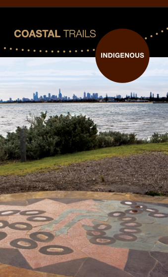
Coastal Trails
indigenous
Bayside Coastal Indigenous Trail map overleaf
Coastal Trails
76 Royal Avenue, Sandringham PO Box 27 Sandringham VIC 3191 T (03) 9599 4444 [email protected] www.bayside.vic.gov.au
Get the Bayside Walks & Trails app

Bayside City Council has developed four affiliated trails stretching across the 17 kilometers of the coastline adjacent to Beach Road between Brighton and Beaumaris. The Bayside Coastal Indigenous Trail
The Bayside Coastal Indigenous Trail Signs and sculptures provide insight into the works and the social customs of Indigenous people. Each of the Indigenous Trail Signs and sculptures are based on stories authored by Boon wurrung Elder, Carolyn Briggs.
The Indigenous Trail Signs and sculptures demonstrate a direct relationship with the Indigenous people and the coastal environment and have been located in positions that enhance and complement this rich cultural heritage.
For more information about the Indigenous stories, visit www.bayside.vic.gov.au/trails
Bayside Coastal Trail Network
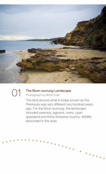
01 The Boon wurrung Landscape Photograph by Bindi Cole
The land around what is today known as the Peninsula was very different two hundred years ago. For the Boon wurrung, the landscape included swamps, lagoons, rivers, open grassland and thinly timbered country. Wildlife abounded in the area.
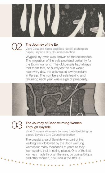
The Journey of the Eel Vicki Couzens Yams and Eels [detail] etching on paper, Bayside City Council collection
Wygabil-ny-ewin was known as the eel season. The migration of the eels provided certainty for the Boon wurrung. The old people had always told them that, as surely as the sun would rise every day, the eels would always return in Pareip. The numbers of eels leaving and returning each year was a sign of prosperity.
02
The Journey of Boon wurrung Women Through Bayside Vicki Couzens Women’s Journey [detail] etching on paper, Bayside City Council collection
The coastal area of Bayside was part of the walking track followed by the Boon wurrung women for many thousands of years as they journeyed to their meeting places. One of the last journeys made through the area, by Louisa Briggs and other women, occurred in the 1830s.
03
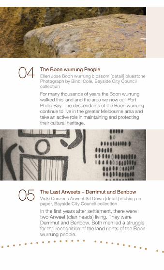
The Last Arweets – Derrimut and Benbow Vicki Couzens Arweet Sit Down [detail] etching on paper, Bayside City Council collection
In the first years after settlement, there were two Arweet (clan heads) living. They were Derrimut and Benbow. Both men led a struggle for the recognition of the land rights of the Boon wurrung people.
05
The Boon wurrung People Ellen Jose Boon wurrung blossom [detail] bluestone Photograph by Bindi Cole, Bayside City Council collection
For many thousands of years the Boon wurrung walked this land and the area we now call Port Phillip Bay. The descendants of the Boon wurrung continue to live in the greater Melbourne area and take an active role in maintaining and protecting their cultural heritage.
04
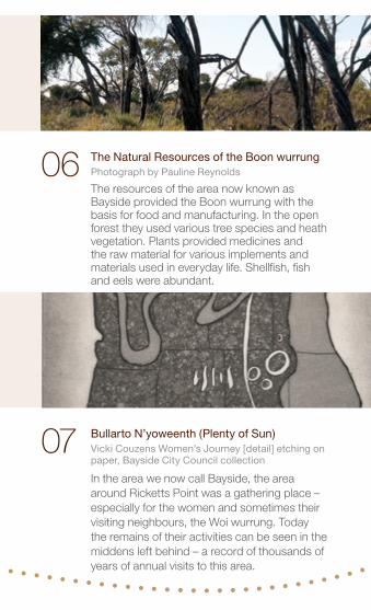
06 The Natural Resources of the Boon wurrung Photograph by Pauline Reynolds
The resources of the area now known as Bayside provided the Boon wurrung with the basis for food and manufacturing. In the open forest they used various tree species and heath vegetation. Plants provided medicines and the raw material for various implements and materials used in everyday life. Shellfish, fish and eels were abundant.
Bullarto N’yoweenth (Plenty of Sun) Vicki Couzens Women’s Journey [detail] etching on paper, Bayside City Council collection
In the area we now call Bayside, the area around Ricketts Point was a gathering place – especially for the women and sometimes their visiting neighbours, the Woi wurrung. Today the remains of their activities can be seen in the middens left behind – a record of thousands of years of annual visits to this area.
07
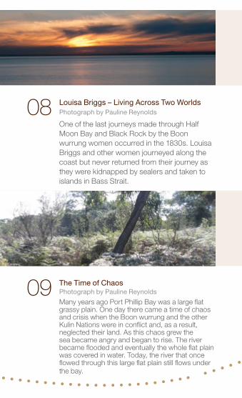
The Time of Chaos Photograph by Pauline Reynolds
Many years ago Port Phillip Bay was a large flat grassy plain. One day there came a time of chaos and crisis when the Boon wurrung and the other Kulin Nations were in conflict and, as a result, neglected their land. As this chaos grew the sea became angry and began to rise. The river became flooded and eventually the whole flat plain was covered in water. Today, the river that once flowed through this large flat plain still flows under the bay.
09
08 Louisa Briggs – Living Across Two Worlds Photograph by Pauline Reynolds
One of the last journeys made through Half Moon Bay and Black Rock by the Boon wurrung women occurred in the 1830s. Louisa Briggs and other women journeyed along the coast but never returned from their journey as they were kidnapped by sealers and taken to islands in Bass Strait.
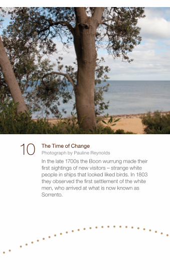
The Time of Change Photograph by Pauline Reynolds
In the late 1700s the Boon wurrung made their first sightings of new visitors – strange white people in ships that looked liked birds. In 1803 they observed the first settlement of the white men, who arrived at what is now known as Sorrento.
10
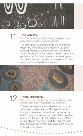
The Ochre Pits Vicki Couzens Paint the Country [detail] etching on paper, Bayside City Council collection
The ochre pits of Bayside provide one of the most direct links to the culture and history of the Boon wurrung. The pits provided them with a palate for art, especially for the live body art used in dance and performance. Ochre was gathered at Sandringham and Beaumaris and prepared for sacred ceremonial customs, art and celebration events.
The Barraimal (Emu) Glenn Romanis The Barraimal [detail] Bayside City Council collection, Photograph by Bindi Cole
The barraimal was a funny bird – too big to fly, with short useless wings. But apart from its funny appearance, the old man barraimal had been cursed – it was up to him to take over the role of the female. He sat on her nest until the young chicks hatched – and then had to look after them as the female barraimal continued to frolic with her friends.
11
12
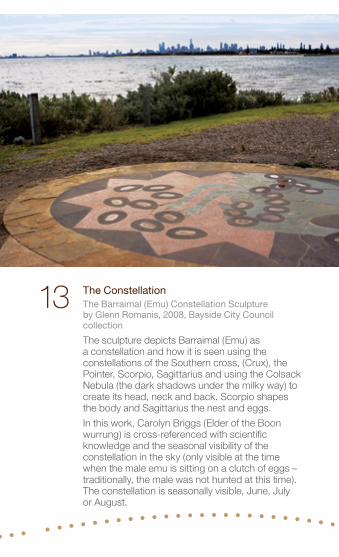
The Constellation The Barraimal (Emu) Constellation Sculpture by Glenn Romanis, 2008, Bayside City Council collection
The sculpture depicts Barraimal (Emu) as a constellation and how it is seen using the constellations of the Southern cross, (Crux), the Pointer, Scorpio, Sagittarius and using the Colsack Nebula (the dark shadows under the milky way) to create its head, neck and back. Scorpio shapes the body and Sagittarius the nest and eggs.
In this work, Carolyn Briggs (Elder of the Boon wurrung) is cross-referenced with scientific knowledge and the seasonal visibility of the constellation in the sky (only visible at the time when the male emu is sitting on a clutch of eggs – traditionally, the male was not hunted at this time). The constellation is seasonally visible, June, July or August.
13
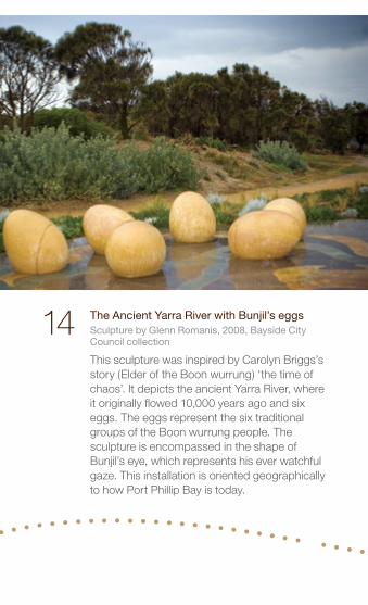
The Ancient Yarra River with Bunjil’s eggs Sculpture by Glenn Romanis, 2008, Bayside City Council collection
This sculpture was inspired by Carolyn Briggs’s story (Elder of the Boon wurrung) ‘the time of chaos’. It depicts the ancient Yarra River, where it originally flowed 10,000 years ago and six eggs. The eggs represent the six traditional groups of the Boon wurrung people. The sculpture is encompassed in the shape of Bunjil’s eye, which represents his ever watchful gaze. This installation is oriented geographically to how Port Phillip Bay is today.
14
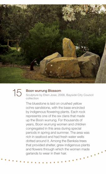
15 Boon wurrung Blossom Sculpture by Ellen Jose, 2008, Bayside City Council collection
The bluestone is laid on crushed yellow ochre sandstone, with the base encircled by indigenous flowering plants. Each rock represents one of the six clans that made up the Boon wurrung. For thousands of years, Boon wurrung women and children congregated in this area during special periods in spring and summer. The area was rich in seafood and had fresh water wells dotted around it. Among the Banksia trees that provided shelter, grew indigenous plants and flowers through which the women made garlands to wear in their hair.
Sandringham
BrightonBeach
NorthBrighton
Gardenvale
Elsternwick
MiddleBrighton
Hampton
Highett
CheltenhamPatterson
Bentleigh
Moorabbin
Mentone
FRANKSTON LINE 64 tram
67 t
ram
SANDRINGHAM LINE
Beach
Elwood
HalfMoon Bay
Port PhillipPort Phillip
Beaumaris Bay
RickettsPoint
RedBlu�
Picnic Point Green Point
Dendy StBeach
MiddleBrighton
Beach
Table Rock Point
H I G H E T TC H E L T E N H A M
G L E N E I R A
K I N G S T O N
S A N D R I N G H A M
B L A C KR O C K
B E A U M A R I S
M E N T O N E
H A M P T O N
B R I G H T O N
B R I G H T O NE A S T
Beaumaris MotorYacht Squadron
CheltenhamPark
Cheltenham Golf Club
VictoriaGolf Club
SandringhamGolf Links
SouthlandShoppingtown
Concourse
Brighton PublicGolf Course
DendyPark
Elsternwick Park & Public Golf Course
RoyalMelbourneGolf Club
RoyalMelbourneGolf Club
Royal BrightonYacht Club
SandringhamYacht Club
Black Rock Yacht Club
BeaumarisYacht Club
Ricketts PointTeahouse
Hampton Sailing Club Bathing
BoxesTrey BitReserve
MiddleBrighton
Baths
Cemetery
Middle Brighton Pier
BrightonTown Hall
Black RockHouse
BaysideCity Council
CorporateCentre
HMVSCerberus
Kamesburgh
Billilla
L
L
LL
PP
P
PP
P
P
P
P
P
P
P
P
P
P
P
PP
P
P
P
P
P
P
P
PP
P
P
P P
P
P
P
P
P
P
P
P
P
Nor
th R
d
Mar
tin S
t
Well St
Hea
d St
Espl
Ormond
Gle
n H
untly
Rd
Church St
Bay
St
Nor
th R
d
Bal
com
be R
d
Bal
com
be R
d
Park
Rd
Wea
ther
all R
d
Che
ltenh
am R
d
Tulip
St
Sout
h R
d
Bay
Rd
Roy
al A
ve
Abbo
tt S
t
Fernhill Rd
Nepean Hwy
to Frankston
Nepean Hwy
Den
dy S
tW
ere
St
Park
St
Cen
tre
Rd
Thom
as S
t
Hig
hett
Rd
Brid
ge
St
Hol
yroo
d St
St Kilda St
New St
Haydens Rd
Dalgetty Rd
Cromer Rd
Wells Rd
Reserve RdH
alifax St
St A
ndrews S
t
Hawthorn Rd
Beach Rd
Bluff Rd
Reserve Rd
Charman Rd
Hampton St
New St
Jasper Rd
Beach Rd
Beach Rd
Esplanade
to Melbourne (15 mins)
Tra
mw
ay P
de
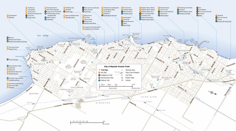
Viewing Area
Train Line & Station
Car Park
Public Toilet
Library
Hampton
L
P
1
4
10
2
City of Bayside Coastal Trails
Trail Sign
Art Trail
Indigenous Trail
Environment Trail
History Trail
2 km1 km0
0
200m 400m 600m
8 mins 30 mins on foot
800m
2 km
30 mins on foot0 8 mins on foot
200 m 600 m 1 km0
101
15
1213212
2723
34334
8978
1011625
121314159
199
16171876
1920
212214
2324
363742
383940
1641
1535
3334
3132
2526
272829301113
810
1112
15148
10
5674456
Red Blu�The Last Arweets PelicanElwood Life Saving Club
EmuConstellationThe Journey of the EelExtinctionRakali
Playthings of the WindSeaweedMiddle Brighton BathsBluestone Sea Wall
Brighton Beach, WilsonBrighton Beach, MatherBrighton Beach, BurnBoon wurrung PeopleCoastal Tea TreeGreen Point GardensBrighton Beach Baths
Brighton BeachSummer SeaBoon wurrung WomenSand DunesBathing Boxes
The SwimmerHampton BeachRenourishmentHampton Beach
SandringhamBy the SeaNatural ResourcesRakaliBlue Tongue
The Beach at SandringhamSandringham BeachAt the BeachWindhoverSandringham Rotunda
Boon wurrung LandscapeTime of ChaosRock Pools
Beach SceneTea TreesStorm CloudsPlenty of SunBayside Inland Birds
Coastal Scrub SandringhamRed Blu� at Sandringham
Half Moon BayRed Blu�Bunjil’s Eggs
Boats at Half Moon BayNear Black Rock
Hauling the SeineMan with Fishing NetLiving Across Two WorldsHalf Moon Bay and the Red Blu� Cli�sHMVS CerberusLittle Beach
The BeaconFishing NetsQuiet CornerBanksia Point BeaumarisOchre PitsQuiet Corner
BlossomRicketts Point PlaqueRicketts Point Marine Sanctuary
SandringhamMentone
Boatsheds Early MorningBeaumaris Cli�sMentone
Great Southern HotelMoyes BayBeaumarisBoatshed at BeaumarisSlumbering Sea
The Sunny SouthRickett’s Point
Time of Change
Australian ImpressionistsHeidelberg Marker
Coastal Trails
indigenous
Bayside Coastal Indigenous Trail map overleaf
Coastal Trails
76 Royal Avenue, Sandringham PO Box 27 Sandringham VIC 3191 T (03) 9599 4444 [email protected] www.bayside.vic.gov.au
Get the Bayside Walks & Trails app