coastal zone consistency determination - … · 930.35. the information in this negative...
TRANSCRIPT

M-1 November 2010
M Coastal Zone Consistency Determination
DEPARTMENT OF THE NAVY BASE REALIGNMENT AND CLOSURE
PROGRAM MANAGEMENT OFFICE, NORTHEAST 4911 SOUTH BROAD STREET PHILADELPHIA, PA 19112-1303
BPMONE/TS Ser 10-053 January 14, 2010
Ms. Kathleen Leyden Maine Coastal Program Director State Planning Office 38 State House Station 187 State Street Augusta, ME 04333-0038
Dear Ms. Leyden:
This office is preparing an Environmental Impact Statement (ElS) for the closure and reuse ofproperty at Naval Air Station (NAS) Brunswick. We are requesting your review of the enclosed Coastal Consistency Determination and respond with your confirmation of potential reuse impacts.
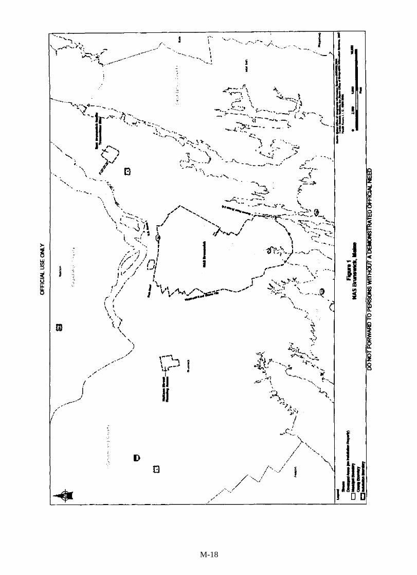
The EIS will analyze potential environmental impacts resulting from the disposal and reuse ofNAS Brunswick in accordance with the Base Closure and Realignment Act of 1990 and reuse of the surplus property in a manner consistent with the Brunswick Naval Air Station Reuse Master Plan (Reuse Master Plan). The property is shown on Figure 1.
The EIS will assess two alternatives including the Reuse Master Plan (Alternative 1) and a High Density scenario (Alternative 2), as well as a No Action Alternative. Alternative 1, the preferred alternative, is the redevelopment scenario presented in the Reuse Master Plan and includes reuse of the existing air field, a combination of residential, parks and recreation, and business and community land uses.
Please provide your response by February 19, 2010 for inclusion in our draft EIS, and if you have any questions, contact Mr. Tom Stephan at (215) 897-4916.
;?~~David Drozd Director
Enclosure: Coastal Consistency Determination
Copy to: NAVFAC MIDLANT (C. Hendrickson) NASB (L. Joy)
M-3
FEDERAL AGENCY COASTAL ZONE MANAGEMENT ACT (CZMA) NEGATIVE DETERMINATION FOR
THE ENVIRONMENTAL IMPACT STATEMENT (EIS) FOR THE DISPOSAL AND REUSE OF NAVAL AIR STATION BRUNSWICK, MAINE
INTRODUCTION This document provides the State of Maine with the Department of the Navy's Negative Determination under CZMA 16 United States Code (U.S.C.) § 1451 et seq. and 15 Code of Federal Regulations (CPR) § 930.35. The information in this Negative Determination is provided pursuant to 15 CPR § 930.35.
This CZMA Negative Determination addresses the Proposed Action of the Draft Environmental Impact Statement (EIS) for the Disposal and Reuse ofNaval Air Station Brunswick, Maine.
BACKGROUND NAS Brunswick is situated on approximately 3,137 acres in the town of Brunswick, Cumberland County, Maine. The facility is approximately 27 miles northeast of Portland and 31 miles south of Augusta, the state capital. The main gate is located on Bath Road, approximately 2 miles east of the downtown Brunswick Business District. In addition to the NAS Brunswick property, the EIS also evaluates the disposal and reuse of:
• McKeen Street Housing Annex (70 acres, Brunswick, Maine)
• East Brunswick Radio Transmitter Site (66 acres, Brunswick, Maine)
• Sabino Hill Rake Station (0.23 acre, Phippsburg, Maine)
The site of NAS Brunswick was originally a municipal airfield constructed in the mid-1930s. The Navy acquired the airfield in response to World War n, and NAS Brunswick was commissioned on April 15, 1943. During World War n, NAS Brunswick provided air and surface patrols in the Atlantic to protect the coast of the United States. After World War II ended in 1945, the installation was placed in caretaker status, and its facilities were leased to a variety of organizations, including Bowdoin College, the University of Maine, and the Town of Brunswick. In 1951, the installation was recommissioned to support regular operations of fleet reconnaissance and anti-submarine aircraft. As a result, NAS Brunswick's facilities were expanded, including the construction of the two 8,OOO-foot-long runways, which still exist. Since the late 1950s, air station aircraft, typically the P3-Orion, have continued to conduct patrols over the North Atlantic. The current mission of NAS Brunswick is to provide facilities, services, and materials to support the various activities of its tenants and support units.
The BRAC Commission recommended disposal of NAS Brunswick on September IS, 2005. The recommendation to dispose of the installation was approved by President Bush and accepted by Congress on November 9,2005. By law, NAS Brunswick must be closed before September 15,2011.
In response to the BRAC decision, Maine Governor Baldacci issued an Executive Order (EO) on August 25,2005, establishing the Brunswick Local Redevelopment Authority (BLRA). On December I, 2005, the BLRA was recognized by the Secretary of Defense as the entity responsible for preparing the redevelopment plan with respect to the installation. Over a twoyear process that involved significant public participation, the BLRA developed the Brunswick
1
M-5
Naval Air Station Reuse Master Plan (Reuse Master Plan), which was officially adopted on December 19,2007. At that point, the BLRA was disbanded, and on January 1,2008, the Maine State Legislature designated the Midcoast Regional Redevelopment Authority (MRRA) to implement the Reuse Master Plan. The Reuse Master Plan is discussed in greater detail below.
NEGATIVE DETERMINATION In accordance with 15 CFR § 930.35, the Navy has reviewed Maine's coastal management program and associated enforceable policies and has determined that the Navy's Proposed Action would have no effects on any coastal use or resource.
It is anticipated that the Reuse Master Plan would be implemented in phases over a 20-year period; therefore, it is unknown at this time exactly how the specific redevelopment of the individual sites and parcels would evolve. However, based on the known elements of the Reuse Master Plan, it is anticipated that it would be implemented in full compliance with all applicable coastal management policies. It would be the responsibility of individual site/parcel developers, as projects are identified for construction, to conduct separate and appropriate environmental documentation and obtain all the necessary permits and approvals prior to implementation of individual projects.
PROPOSED FEDERAL AGENCY ACTION The Proposed Action is the disposal of NAS Brunswick and the McKeen Street Housing Annex, East Brunswick Radio Transmitter Site, and Sabino Hill Rake Station by the Navy in a manner consistent with the Reuse Master Plan (referred to as Alternative 1 in the EIS and from this point forward).
Full build-out under Alternative 1 is proposed to be implemented over a 20-year period. Alternative 1 calls for the development of approximately 1,630 acres (51 %) of the total base property. In addition, Alternative 1 includes a large open space/recreation element that coincides in a positive way with the State of Maine's coastal preservation policies. Approximately 1,570 acres (49%) of the installation property would be dedicated to a variety of active and passive uses, including recreation, open space, and natural areas.
Alternative 1 is based upon reuse of the existing airfield and its supporting infrastructure, a mix of land use types and densities, and the preservation of open space and natural areas. Alternative 1 also incorporates smart-growth principles that include pedestrian-friendly transportation features (e.g., walkable neighborhoods and bike lanes), compact development, open spaces, and a mix of land use types.
The redevelopment would make available approximately 2.1 million square feet of existing building space. Implementation of Alternative 1 would occur in phases, with priorities first on the sale/leasing of existing building space, development of special activity centers or economic centers, and completion of the investigation of areas of environmental concern.
Alternative 1 would, at full build-out, include the following elements:
• Airport Operations. This 500-area contains two existing 8,OOO-foot runways, taxiways, and adjacent buffer zones surrounding the airfield.
• Aviation-related Business. This 230-acre area would be dedicated to aviation-related business, industry, transportation and distribution, and technology based employment.
2
M-6
• Professional Office. This 120-acre district includes professional office space and areas for retail and community support services.
• Community Mixed Use. This 175-acre area provides space for a mix of compact pedestrianoriented development that includes a mix of retail, professional offices, business and support services, restaurants, hotels and conference centers, civic and cultural uses, parks, and government buildings. In addition, this area includes higher-density attached residential housing such as town homes, condominiums, apartments, and assisted livinglindependentcare senior housing.
• Business and Technology Industries. This 190-acre area includes space for technology-based research and development, energy parks, laboratories, light manufacturing, and warehouse and distribution.
• Education District. This 200-acre area is designated for higher education academic space and administrative and support facilities.
• Residential District. This 215-acre area would provide residential housing, including the existing Public Private Venture (PPV) family housing area. The district would consist of a mix of existing single-family attached and detached PPV family housing and new detached/attached single-family housing, multi-family apartments, assisted/senior housing, and retirement/second homes.
• Recreation and Open Space District. This area provides 510 acres of land for a variety of commercial and public outdoor active and passive recreation, including an 18-hole golf course, public gardens, public parks, sports fields, and bicycle trails.
• Natural Areas. Alternative lincludes the conservation and preservation of 1,060 acres of the property as designated natural areas. The natural areas would include pedestrian trails, nature centers, and other non-intrusive, passive outdoor recreation. Approximately 33 acres of this "natural area" would be located at the East Brunswick Transmitter Site.
• Transportation. On-site transportation improvements include 10 roadway access points onto the property, including new secondary access points onto the adjacent street systems at Bath Road/Gurnet RoadlHarpswell Road; a new east-west connector surface road linking Gurnet Road and Harpswell Road; and creation of a new network of pedestrianlbicycle trails. Changes to the existing street and roadway network would include a system of street hierarchy and development of new local streets to provide access to individual parcels.
Off-site transportation improvements include development of a connector spur (road) and interchange that would connect to U.S. Route 1 west of the present interchange at Cook's Corner and the widening of Bath Road (along the northern boundary of the property). This alternative also includes development of a passenger/freight rail spur connecting the property to an existing rail line north of the property boundary. The off-site transportation improvements, including the U.S. Route 1 interchange, are located on private lands, outside the federally owned NAS Brunswick property being disposed. The Navy does not have jurisdiction over these lands; thus, the Navy would have no role or responsibility in the funding, planning, design, or construction of any public off-site roadways.
PURPOSE OF THE PROPOSED ACTION The purpose of the proposed action is to provide for the disposal of NAS Brunswick and its outlying properties by the Navy in accordance with the BRAC Closure Law and its reuse in a manner consistent with the Reuse Master Plan
3
M-7
MAINE'S COASTAL MANAGEMENT PROGRAM The Coastal Zone Management Act (CZMA) of 1972 (16 U.S.c., Section 1451, et seq., as amended) provides assistance to states, in cooperation with federal and local agencies, for developing land and water use programs in coastal zones. Section 307 of the CZMA stipulates that when a federal project initiates reasonably foreseeable effects on any coastal use or resource (land or water use, or natural resource), that action must be consistent to the maximum extent practicable with the enforceable policies of the affected state's federally approved coastal management plan. Federal agencies must also give consideration to management program provisions that are in the nature of recommendations.
The State of Maine's federally approved coastal zone extends from the inland boundary of all 147 coastal towns that contain tidal waters to the outer limit of the State's territorial jurisdiction, which is 3 nautical miles (NM) into the Atlantic Ocean. The enforceable policies of the Maine Coastal Program (MCP) are contained in the following twenty "core laws:"
(1) Natural Resources Protection Act
(2) Mandatory Shoreland Zoning Law
(3) Site Location of Development Law
(4) Erosion Control and Sedimentation Law
(5) Storm Water Management Law
(6) Subdivision Law
(7) Maine Rivers Act
(8) Maine Waterway Development and Conservation Act
(9) Coastal Management Policies Act
(10) Protection and Improvement of Air Law
(11) Protection and Improvement of Waters Act
(12) Nutrient Management Act
(13) Land Use Regulation Law
(14) Maine Hazardous Waste, Septage and Solid Waste Management Act
(15) Nuclear Facility Decommissioning Laws
(16) Oil Discharge and Pollution Control Law
(17) Maine Resources Law
(18) Coastal Barrier Resources System Act
(19) Maine Endangered Species Act
(20) Fee Schedule
FEDERAL REVIEW The Navy does not propose to conduct any activities associated with the Reuse Master Plan that would produce any direct or indirect effects on any of Maine's coastal zone uses or resources included in Maine's coastal management program and associated enforceable policies. All construction and redevelopment activities associated with the Reuse Master Plan (Alternative 1)
4
M-8

would occur within the boundaries of the existing NAS Brunswick installation and its outlying properties, including the McKeen Street Housing Annex, East Brunswick Radio Transmitter site, and Sabino Hill Rake Station. The Reuse Master Plan (Alternative I) was developed with the intent of having a positive impact on both the environment and the local and regional economy. As a result of the phased implementation of the plan, the following goals and objectives are sought:
• Accommodate the needs and values of the community, the region, and the State of Maine and be consistent with the policies of the Brunswick Comprehensive Plan. Redevelopment of the base would provide an opportunity to reconnect the base with the community, both geographically and economically.
• Consider "smart growth" strategies that promote sustainable development and balance economic development, environmental protection, and the preservation or enhancement of the quality of life for Brunswick residents.
• Consider a mix of land uses, including but not limited to the following: businesses with potential for high employment growth, capital investment and tax revenue; open space and public recreation uses; academic and research facilities; governmentaIfpublic services; housing; and aviation.
• Make adequate provision for environmental cleanup and remediation of the installation where needed, including a goal that base cleanup is to the standards necessary to support the proposed reuses of the land and facilities.
• Seek to develop local and regional economic and employment viability and sustainability similar to or better than the economic health of the region before the BRAC announcement. Development on the base should be integrated with the economic development of the town, the region, and the State of Maine.
• Attempt to optimize the use of existing facilities and infrastructure, including the integration of a multi-modal transportation system, with designated land uses.
• Recognize and optimize the skills of the available civilian workforce at NAS Brunswick and the region.
ENFORCEABLE POLICY ANALYSIS The following presents a summary of the Maine coastal policies as applied to the key elements of the proposed action.
Natural Resources Protection Act. The Natural Resources Protection Act (NRPA) requires a permit to be obtained for any activity located on, in, or over a protected natural resource area. Protected natural resources are coastal wetlands, coastal sand dune systems, significant wildlife habitat, fragile mountain areas, freshwater wetlands, great ponds and rivers, and streams or brooks. A permit is also required for any activity located adjacent to a coastal wetland, great pond, river, stream, brook, or significant wildlife habitat contained within a freshwater wetland or adjacent to certain freshwater wetlands.
Coastal and freshwater wetlands are protected under the MEDEP Wetland Protection rules (MEDEP rules, Ch. 310). As part of the proposed action, approximately 339 acres of coastal wetlands would be designated as natural or open space/recreation areas, and therefore preserved from future development. Up to approximately 51 acres of freshwater wetlands could be impacted by future redevelopment of the installation. Any wetland disturbance resulting from
5
M-9
implementation of the proposed action would require that the developer obtain a permit from the MEDEP and the U.S. Army Corps of Engineers (USACE). In addition, per the NRPA, any encroachment within a 75-foot buffer around a wetland would require a permit. Any wetland impacts that occur under the proposed action would be minimized through compliance with applicable federal, state, and local laws and implementation of appropriate mitigation measures developed in accordance with MEDEP and USACE regulations.
Coastal sand dunes are protected under the MEDEP Coastal Sand Dune rules (MEDEP rules, Ch. 355). The proposed action would not impact any coastal sand dunes.
Significant wildlife habitat includes habitat for species appearing on the official state or federal lists of endangered or threatened animal species; high- and moderate-value deer wintering areas and travel corridors (as defined by the Maine Department of Inland Fisheries and Wildlife [MDIFW]); high- and moderate-value waterfowl and wading bird habitats, including nesting and feeding areas; critical spawning and nursery areas for Atlantic salmon (as defined by the Atlantic Salmon Commission); shorebird nesting, feeding, and staging areas, and seabird nesting islands; and significant vernal pools (as defined by the MDIFW) (38 MRSA 480-B Chapter 335). The following significant wildlife habitat occurs at NAS Brunswick: sandplain grassland habitat for state-listed threatened and endangered species; deer wintering areas; tidal waterfowl and wading bird habitats; and vernal pools.
It is expected that impacts on most of the sandplain grassland habitat under the proposed action would be avoided by continued use of the airfield and management of the airfield Clear Zones by the future airport operator. Furthermore, the developer would be required to obtain a permit from the MEDEP for any potential development plans within this grassland habitat. Consequently, no significant impacts on this habitat would be expected.
The mapped deer wintering area at the installation is located within the proposed open space/recreation district. It is expected that sensitive natural resource habitats within this district, such as the deer wintering area, would be avoided by the developer. Currently, the wintering area is bisected by a high fence delineating the property boundary for the installation. It is anticipated that this fence would be removed as part of the installation's reuse, thereby joining the two fragmented habitats and having a positive affect on the deer wintering area.
The tidal waterfowl and wading bird habitat located at the installation would be preserved as a natural area; therefore, this habitat would not be impacted.
Vernal pools considered significant under the NRPA are located within the recreation/open space district. Consequently, it is not expected that any future deVelopment would occur within these vernal pools.
The proposed action would not be located in nor would it affect any fragile mountain areas.
The proposed action would not directly impact any great ponds or rivers. Streams may be directly impacted by construction of new roadways and trails, as well as land clearing and the addition of new impervious surface. Prior to siting or constructing roads, pedestrian trails, or other facilities that result in direct stream impacts, the developer would be required to comply with applicable federal and state laws and regulations. Compliance with applicable laws and regulations would minimize impacts on surface water resources. Furthermore, impacts on surface water resources would be mitigated through development and implementation of Erosion
6
M-10

and Sediment Control Plans (ESCPs) and implementation of Maine's Best Management Plans (BMPs).
Based on the foregoing, the proposed action is consistent with the NRP A coastal policy to the maximum extent practicable.
Mandatory Shoreline Zoning Law. The Shoreland Zoning law requires that municipalities protect shoreland areas through adopting shoreland zoning maps and ordinances. Shoreland areas include areas within 250 feet of the normal high-water line of any great pond, river, or saltwater body, areas within 250 feet of the upland edge of a coastal wetland, areas within 250 feet of the upland edge of a freshwater wetland (except in certain situations), and areas within 75 feet of the high-water line of a stream.
The shorelines of saltwater bodies that occur on the installation, including Harpswell Cove and Buttermilk Cove, as well as all coastal wetlands, would be located in a natural area district and preserved from future development under the proposed action. Shoreland areas associated with freshwater wetlands and streams may be impacted by future redevelopment of the installation. Any stream or wetland impacts that occur under the proposed action would be minimized through compliance with applicable federal, state, and local laws and implementation of appropriate mitigation measures developed in accordance with MEDEP and USACE regulations. Furthermore, impacts on streams and wetlands would be mitigated through development and implementation of ESCPs and implementation of Maine's BMPs.
Based on the foregoing, the proposed action is consistent with the Mandatory Shoreland Zoning Law to the maximum extent practicable.
Site Location of Development (Site Law). This law requires review of developments that may have a substantial effect upon the environment. These types of development, which have been identified by the State Legislature, include projects occupying more than 20 acres, metallic mineral and advanced exploration projects, large structures and subdivisions, and oil terminal facilities. A permit is issued if the project meets applicable standards addressing areas such as storm water management, groundwater protection, infrastructure, wildlife and fisheries, noise, and unusual natural areas.
Under Alternative 1, the built environment of the NAS Brunswick property would be more intensely developed than under existing conditions. The redevelopment would introduce new land uses to the property, including a densely populated community mixed-use district and professional office, education, and business/industry technology land uses. However, the Reuse Plan does not specifically introduce new housing or subdivisions into the Residential Land Use District, but it is assumed that 573 existing PPV housing units would be occupied by nonmilitary residents. The majority of the projected growth in residential units is due to the high residential density (24 units per acre) allowed in the Community Mixed-Use Land Use District.
It will be the responsibility of individual site/parcel developers to conduct separate and appropriate environmental documentation and obtain all the necessary permits that meet the applicable standards addressing areas such as storm water management, groundwater protection, infrastructure, wildlife and fisheries, noise, and unusual natural areas.
7
M-11

Therefore, the proposed action is consistent with this policy to the maximum extent practicable.
Erosion Control and Sedimentation Law. The Erosion and Sedimentation Control Law, which went into effective in 1997, is intended to prevent Maine's waterbodies from degradation due to soil erosion. Under this law, construction projects of any size must incorporate sediment control measures, such as silt fence or hay bales, placed at the down gradient side of the construction site before work begins. In addition, erosion control measures, such as mulch and vegetation, must be placed as soon as practicable to permanently stabilize the site when construction is completed.
Under Alternative 1, the built environment of the NAS Brunswick property would be more intensely developed than under existing conditions. However, proposed redevelopment activity is targeted for areas that were previously developed by the Navy and appropriate design and site layout should mitigate any erosion impacts. In addition, less than 1 % of the soils at the NAS Brunswick installation are steep enough to have the potential for erosion. Any soils and or waterbodies impacted by construction and redevelopment activities would be mitigated through development and implementation of ESCPs and implementation of Maine's BMPs.
It will be the responsibility of individual site/parcel developers to conduct separate and appropriate environmental documentation and obtain all the necessary permits and approvals, including elements of the Erosion Control and Sedimentation Law, prior to implementation of individual projects.
Therefore, the proposed action is consistent with this policy to the maximum extent practicable.
Subdivision Law. Subdivision Law is deals broadly with the regulations associated with the review and approval of proposed subdivisions.
The Reuse Plan does not specifically introduce new housing or subdivisions into the Residential Land Use District, but it is assumed that 573 existing PPV housing units would be occupied by non-military residents. The majority of the projected growth in residential units is due to the high residential density (24 units per acre) allowed in the Community Mixed-Use Land Use District. It is anticipated that the Reuse Plan would be implemented in phases over a 20-year period; therefore, it is unknown at this time exactly how the specific redevelopment of the individual sites and parcels would evolve. Should any new residential subdivisions be considered for construction, it would be the responsibility of individual site/parcel developers to conduct separate and appropriate environmental documentation and obtain all the necessary permits and approvals, including those applicable Subdivision Law, prior to implementation of individual projects.
Therefore, the proposed action is consistent with this policy to the maximum extent practicable.
Maine Rivers Act. The Maine Rivers Act recognizes the importance of Maine's rivers and streams for meeting portions of several public needs, provides guidance for striking a balance among the various uses that affords the public maximum benefit, seeks harmony rather than conflict among these uses, and regulates the balance among the competing uses of the state's rivers and streams. No rivers would be directly impacted by implementation of the proposed action, nor would public access to any rivers or streams be restricted. Streams may be directly
8
M-12
impacted by construction of new roadways and trails, and by land clearing and addition of new impervious surface. Prior to siting or constructing roads, pedestrian trails, or other facilities that result in direct stream impacts, the developer would be required to comply with applicable federal and state laws and regulations. Compliance with applicable laws and regulations would minimize impacts on streams. Furthennore, impacts on streams would be mitigated through development and implementation of ESCPs and implementation of Maine's BMPs.
Based on the foregoing, the proposed action is consistent with the Maine Rivers Act to the maximum extent practicable.
Maine Waterway Development and Conservation Act. The Maine Waterway Development and Conservation Act requires an individual wishing to initiate construction or reconstruction of a hydropower project, or structurally alter a hydropower project in ways that change water levels or flows, to obtain a single permit from the MEDEP. Because Alternative 1 does not contemplate construction or reconstruction of a hydropower project, or structurally alter a hydropower project in ways that would change water levels or flows, a permit for this would not be required. Therefore the proposed action is consistent with this policy.
Coastal Management Policy Act. This document serves as the Navy's review of the State of Maine's Coastal management Policies. Therefore the proposed action is consistent with this policy.
Protection and Improvement of Air Law. The Maine Protection and Improvement of Air Law is the State of Maine's broad and all encompassing air quality statute that deals with elements such as the establishment of air quality regions, green house gas emissions, enforcement, and emission standards, among many others.
The town of Brunswick is currently in attainment for all criteria pollutants. While Cumberland County is subject to a maintenance plan under Section 11O(a)(1) of the Clean Air Act antibacksliding provisions, this requirement does not include conformity obligations. Therefore, the General Conformity Rule would not be applicable to the proposed disposal and reuse ofNAS Brunswick. In addition, upon disposal and reuse of NAS Brunswick, the Navy would not retain control of the property; therefore, the implementation of Alternative I or Alternative 2 is not considered a federal action and the General Conformity Rule does not apply.
Air emissions would result from the project from construction-related emissions (primarily exhaust emissions from construction vehicles and dust resulting from ground disturbance and road traffic, building use emissions (boiler use, lights, etc.), and mobile source emissions (aircraft and motor vehicles).
Although there would be an overall increase in emissions at full build-out, it is estimated that emissions of volatile organic compounds, nitrous oxides, and particulate matter would be reduced due to the discontinuation of Navy aircraft operations and maintenance. Emissions of carbon monoxide and sulfur dioxide would be expected to increase primarily due to the use of heating fuels for the large residential development, emissions from new aircraft, and vehicle use.
It is anticipated that Alternative I would be implemented in phases over a 20- year period; therefore, it is unknown at this time exactly how the specific redevelopment of the individual sites and parcels would evolve and what the overall emissions impacts would be. It would be the responsibility of individual site/parcel developers to conduct separate and appropriate
9
M-13
environmental documentation and obtain all the necessary permits, induding applicable air quality permits, and approvals prior to implementation of individual projects.
Protection and Improvement of Waters Law. The Maine Protection and Improvement of Water Law is a broad and all encompassing statute that deals with large acts and programs such the Great Ponds Program, Groundwater Protection Program, Freshwater Wetlands Program, Shoreline Protection Program, and Natural Resources Protection Act, among many others. This statute encompasses many of the applicable individual policies that are covered by this coastal zone assessment. Therefore the proposed action is consistent with this policy.
Nutrient Management Act. Not applicable to this proposed action.
Maine Land Use Regulation Law. The Maine Land Use Regulation Law seeks to establish principles of sound planning, zoning, and subdivision control for the unorganized and deorganized townships of the State of Maine. The purpose of the law is preserve public health, safety, and general welfare; to prevent inappropriate residential, recreational, commercial, and industrial uses detrimental to the proper use or value of these areas; to prevent the intermixing of incompatible industrial, commercial, residential, and recreational activities; to provide for appropriate residential, recreational, commercial, and industrial uses; to prevent the development in these areas of substandard structures or structures located unduly proximate to waters or roads; to prevent the despoliation, pollution, and inappropriate use of the water in these areas; and to preserve ecological and natural values.
Implementation of Alternative 1 would result in the redevelopment of NAS Brunswick and its outlying properties. The Reuse Plan incorporates nine different land use planning districts to create a mixed-use, smart-growth-oriented community and maintains the existing airfield for private aviation purposes.
The implementation of Alternative 1 would not result in significant impacts on regional land use. However, the proposed action would affect the existing land use conditions within the boundaries of NAS Brunswick, the McKeen Street Housing Annex, the East Brunswick Transmitter site, and the Sabino Hill Rake Station. These impacts would include significant changes to the existing built environments and the incorporation of the NAS Brunswick, the McKeen Street Housing Annex, and the East Brunswick Transmitter Site properties into the town of Brunswick and the Sabino Hill Rake Station property into the town of Phippsburg. Implementation of Alternative 1 would also result in open public access to the formerly secure and restricted military property.
Under the proposed action, NAS Brunswick and its outlying properties would no longer be owned or managed by the federal government. Upon completion of the BRAe disposal process, the properties would fall under the jurisdiction of the local government in which they are located. The local government would then be responsible for providing municipal services (e.g., water, sewer, power) for and administration of the former federal property. The use of land, the reuse of existing buildings and facilities, and the development or redevelopment of buildings on NAS Brunswick, the McKeen Street Housing Annex, and the East Brunswick Transmitter site would be regulated by the Town of Brunswick Zoning Ordinance and other applicable plans and regulations. Reuse of the Sabino Hill Rake Station would conform to the requirements of the Town of Phippsburg Zoning Ordinance and another applicable plans. Implementation of Alternative 1 is the responsibility of the MRRA.
10
M-14
With respect to zoning, in anticipation of the reincorporation of the properties back into the town and to support the implementation of Alternative 1, the Town of Brunswick is in the process of amending its Zoning Ordinance to include three new zoning districts, which will incorporate uses at the NAS Brunswick, McKeen Street Housing Annex, and East Brunswick Transmitter Station properties. The zoning amendment will establish land use controls to regulate land uses and identify land use dimensional and density standards.
The land use plan identified in Alternative 1 is consistent with the objectives of the Town of Brunswick 2008 Comprehensive Master Plan, including reintegration of the NAS Brunswick property back into the community and implementing zoning that is consistent with overall Town policies encouraging denser development in designated growth areas and preserving the rural character outside of these growth areas. The proposed zoning regulations for the NAS Brunswick, McKeen Street Housing Annex, and East Brunswick Transmitter Site properties were specifically designed by the Town of Brunswick to promote the development of the properties in accordance with Alternative 1 (Reuse Master Plan) and to steer development into the appropriate districts and areas. Therefore, the proposed action is consistent with the Town of Brunswick's Zoning Ordinance and the Town ofBrunswick 2008 Comprehensive Master Plan, and the action would not have a negative impact on land use in the Town of Brunswick.
The Sabino Hill Rake Station is currently zoned for business land uses. The Town of Phippsburg will receive the O.23-acre property as a public benefit conveyance (PBC). The town proposes to reuse the property as a vehicle parking lot for access to a trail. There would be no significant zoning impacts from the proposed reuse of the Sabino Hill Rake Station property and no impact on land use.
It is anticipated that the Reuse Plan would be implemented in phases over a 20-year period; therefore, it is unknown at this time exactly how the specific redevelopment of the individual sites and parcels would evolve. It would be the responsibility of individual site/parcel developers to conduct separate and appropriate environmental documentation and obtain all the necessary permits and approvals prior to implementation of individual projects.
Therefore, the proposed action is consistent with this policy to the maximum extent practicable.
Maine Hazardous Waste, Septage and Solid Waste and Management. The Maine Legislature enacted the Maine Hazardous Waste, Septage and Solid Waste Management Act in 1979. This Act directed the MEDEP to issue regulations for the safe management and transportation of hazardous wastes. These rules built upon the minimum federal rules, tailoring them to Maine's environment and strong reliance on groundwater for drinking water.
NAS Brunswick has 18 open Installation Restoration sites present within its boundaries. Alternative 1 calls for adequate provisions for the environmental cleanup and remediation of the installation where needed, including a goal that base cleanup will be to the standard necessary to support the proposed reuse of the land and facilities.
Prior to the transfer of custody and control of parcels, NAS Brunswick will remove and dispose of all hazardous materials in accordance with OPNAV Notice 5100, OPNAVINST 5090.1C, DoD 4165.66-M, and all laws and regulations. or the base will notify the BRAC PMO of plans to complete removal of such wastes or materials.
11
M-15
In addition, the Navy will inform future property owners of the locations of hazardous waste 90day accumulation areas, satellite accumulation (storage) areas, and universal waste storage areas at NAS Brunswick. The Navy will be required to close or transfer these areas in accordance with RCRA and all other applicable federal, state, and local laws and regulations. The Navy will also continue in its current role as lead agency for site investigations and remediation, with oversight by the U.S. Environmental Protection Agency and MEDEP, for all sites in its Environmental Restoration Program.
As a result of reuse planning with respect to selecting compatible land uses and redevelopment options, as well as the Navy's commitment to clean up hazardous materials and wastes, Alternative 1 is compatible with the ongoing cleanup program for hazardous materials and waste sites and, therefore, would not impact the coastal zone.
With respect to future hazardous waste issues, it is expected that the amount of hazardous waste usedlgeneratedlstoredldisposed under Alternative 1 would be less that the quantity generated during the Navy's operation at NAS Brunswick and the outlying properties proposed for redevelopment.
It will be the responsibility of individual site/parcel developers to conduct separate and appropriate environmental documentation, obtain all the necessary permits and approvals, and to conduct any required remedial activities prior to implementation of individual projects. In addition, property owners/developers would also be expected to manage hazardous wastes in accordance with applicable federal and state regulations.
The proposed action is therefore consistent with this policy.
Nuclear Facility Decommisioning Laws. There are no existing nuclear facilities situated on the NAS Brunswick installation that would require decommissioning under the proposed action. The proposed action is therefore consistent with this policy.
Marine Resource Laws. Under the Maine Marine Resources Laws, the Maine Department of Marine Resources is responsible for conserving marine and estuarine resources, including fisheries and protected marine species. Portions of the installation containing marine resources, including Harpswell Cove and Buttermilk Cove, would be designated as natural areas and preserved from future development. Consequently, the proposed action is consistent to the maximum extent practicable with the Maine Marine Resource Laws.
Maine Endangered Species Act. The MDIFW is responsible for implementing the Maine Endangered Species Act. Three state-listed threatened or endangered species are known to occur at NAS Brunswick: the grasshopper sparrow (state endangered), upland sandpiper (state threatened), and clothed sedge (state endangered).
The grassland sparrow and upland sandpiper are grassland dependent and either historically or currently utilize the grassland habitat on the north end of the airfield and the interior grassy areas between the runways. Annual mowing of the airfield buffer zones has provided suitable habitat conditions for both species. Up to approximately 70 acres of grassland habitat, or approximately 12% of the total available grassland habitat on the installation, may be permanently removed under the proposed action. This would not be expected to significantly affect the populations of grasshopper sparrows and upland sandpipers. Furthermore, the developer would likely be
12
M-16

required to consult with the MDINFW and Maine Natural Areas Program prior to implementing any development plans within this grassland habitat.
It is expected that reuse of the airfield within the airport operations district would result in the routine maintenance of grassland habitat that has been documented as supporting populations of clothed sedge, thereby preserving the clothed sedge population and associated area of suitable habitat. Consequently, no significant impacts on this species are expected. Furthermore, the developer would likely be required to consult with the MDINFW and MNAP prior to implementing any development plans within this habitat with documented populations of this species.
Based on the foregoing, the proposed action is consistent with the Maine Endangered Species Act to the maximum extent practicable.
Fee Schedule. Not applicable to this proposed action.
SUMMARY Based upon the description of the proposed action, the locations where the actions would occur, and the discussion of the proposed action as it relates to the State of Maine's enforceable coastal management policies and the environmental analysis specified in the EIS for the Disposal and Reuse ofNaval Air Station Brunswick, the Navy has determined that the proposed action is not anticipated to produce any direct or indirect effects on any of Maine's coastal zone uses or resources that are included in Maine's coastal management program and associated enforceable policies.
It is anticipated that Alternative 1 (Reuse Master Plan) would be implemented in phases over a 20-year period; therefore, it is unknown at this time exactly how the specific redevelopment of the individual sites and parcels would evolve. In addition, Alternative 1 is subject to change due to constantly changing market conditions and other development factors. However, based on the known elements proposed under Alternative 1, it is anticipated the Alternative 1 would be implemented in full compliance-to the maximum extent practicable-with all applicable coastal management policies. It would be the responsibility of individual site/parcel developers to conduct separate and appropriate environmental documentation and obtain all the necessary permits and approvals prior to implementation of individual projects.
13
M-17
~ ~
~ -;l Q
~
.'
J -:: ~::,. " "
..;
......
-', \ "". I , I
~ ".- ..~
1
I I
, I jill
)IUriD~
M-18

Main Stat Plannin OfficSPO Executive D partment
JOHN EUAS BALOACCI MARTHA E. FREEMAN
Governor Director
February 9, 2010
David Drozd, Director Department of the Navy Base Realignment and Closure Program Management Office, Northeast 4911 South Broad Street Philadelphia, Pennsylvania 19112-1303
RE: CZMA negative detennination; Disposal and Reuse of Naval Air Station Brunswick, Maine (NAS Brunswick)
Dear Mr. Drozd:
This letter is in response to your letter dated January 14, 2010, and accompanying information providing the Navy's negative determination pursuant to Section 307 of the Coastal Zone Management Act regarding its proposed action, "disposal of NAS Brunswick and the McKeen Street Housing Annex, East Brunswick Radio Transmitter Site, and Sabino Hill Rake Station by the Navy in a manner consistent with the Reuse Master Plan" for BNAS.l The MCP does not have an enforceable policy that applies to the specific action now proposed, which involves and is limited to transfer of property. Accordingly, the State does not object to the Navy's negative determination regarding this specific proposed action.
As the Navy's negative detennination acknowledgesZ, when the Reuse Master Plan is implemented,
specific actions to redevelop the BNAS will be subject to state environmental and land use laws and related pennit and other approval requirements, and thus potentially federal consistency review, as applicable.
Please contact Todd Burrowes on my staff ([email protected]; 207-287-1496) if you have questions or need additional information.
Sincerely,
f:!!:!:t:/~~/OI Director, Maine Coastal Program
Negative Determination (enclosure), p. 2 2 See id at p.2 and 13
OFFICE LOCATED AT : 184 STATE STR EET . 38 STAT E HO USE STATION . A UGUSTA MAINE
PHONE: (207) 287-6077 Internet: www.malne.gov/spo FAX: (207) 287-6489
I
M-19