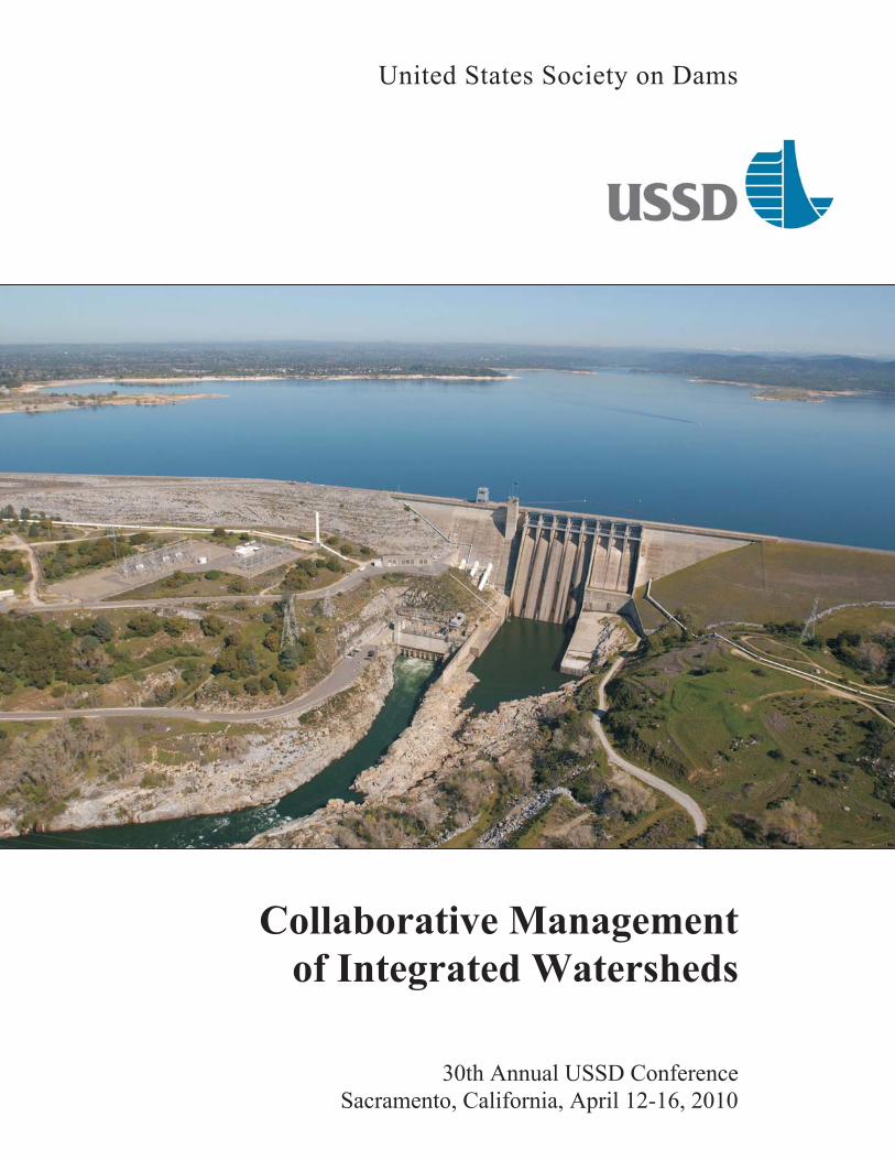
collaborative management of integrated watersheds · collaborative management of integrated...
TRANSCRIPT
United States Society on Dams
Collaborative Management
of Integrated Watersheds
30th Annual USSD Conference
Sacramento, California, April 12-16, 2010
CONTENTS
Plenary Session
California’s Levee Evaluations Program . . . . . . . . . . . . . . . . . . . . . . . . . 1
Mike Inamine, California Department of Water Resources; Sujan Punyamurthula,
URS Corporation; Hamid Bonakdar and Steve Mahnke, California Department of
Water Resources; Richard Millet, URS Corporation; and Pat Dell, Neil O. Anderson
& Associates, Inc.
Levees
Improving Levee Certification by Managing Geotechnical Data with an Enterprise
Geographic Information System . . . . . . . . . . . . . . . . . . . . . . . . . . . . . . 3
B. Fritze and M. Glorioso, AMEC Earth & Environmental, Inc.
Bringing Focus to Safety, Security, and Resiliency Issues for Levees. . . . . . . . . . . 5
Herb Nakasone, Levee Sub-Sector Coordinating Council; Lyman Shaffer, SRA
International; Enrique E. Matheu, U.S. Department of Homeland Security; and
Elizabeth Hocking, Argonne National Laboratory;
Assessing Levee System Performance Using Existing and Future Risk Analysis
Tools . . . . . . . . . . . . . . . . . . . . . . . . . . . . . . . . . . . . . . . . . . . . 7
Michael K. Deering and Christopher N. Dunn, Corps of Engineers
Geotechnical Aspects of Levee Reliability Assessment . . . . . . . . . . . . . . . . . . 9
Gregory R. Fischer and Hollie L. Ellis, Shannon & Wilson, Inc.; and JeanneStypula, King County, Washington
Levee Erosion Screening Process . . . . . . . . . . . . . . . . . . . . . . . . . . . . 11
Wilbur Huang, Richard Millet, Scott Shewbridge, Juan Perri and JuanVargas, URS Corporation; and Mike Inamine and Steve Mahnke, California
Department of Water Resources
Geotechnical Evaluation of California’s Central Valley Urban Levees . . . . . . . . . 13
Richard Millet and Juan Vargas, URS Corporation; and Mike Inamine,California Department of Water Resources
Using Integrated Document and GIS Databases for Geotechnical Levee
Evaluation . . . . . . . . . . . . . . . . . . . . . . . . . . . . . . . . . . . . . . . . 15
Franz Campero, Nagesh Malyala, Nadira Kabir and Ben Brezing, URS
Corporation
Levee Subsurface Investigation Using Geophysics, Geomorphology, and
Conventional Investigative Methods . . . . . . . . . . . . . . . . . . . . . . . . . . . 17
Juan C. Sorensen and Khaled Chowdhury, URS Corporation
iv

Preventing Failure of a Large Canal by Using Staunching to Arrest Leakage . . . . . 19
Peter Amos and Andrew Kilby, Damwatch Services; and Tim Mills, Meridian
Energy Ltd
Seismic
Design and Construction of Seismic Upgrades at San Pablo Dam Using CDSM . . . . 21
Robert C. Kirby and Guilaine L. Roussel, Terra Engineers, Inc.; John A.Barneich, GeoPentech, Inc.; and Atta B. Yiadom and Sean M. Todaro, East Bay
Municipal Utility District
Scoggins Dam — Seismic Performance and Remediation Alternatives . . . . . . . . . 23
John Ballegeer and Jie Yu, Kleinfelder.; and Tom VanderPlaat, Clean Water
Services
Earthquake Deformation Estimates for Risk Analysis . . . . . . . . . . . . . . . . . . 25
John W. France and Christina Winckler, URS Corporation; and Ron Oaks,
Bureau of Reclamation
Laboratory Testing of an Alluvial Clayey and Silty Sand . . . . . . . . . . . . . . . . 27
Karina R. Dahl, Jason T. DeJong and Ross W. Boulanger, University of
California, Davis; and Michael W. Driller, California Department of Water Resources
Non-Linear Numerical Modeling of Centrifuge-Test Results for Embankments
Underlain by Liquefied Soil . . . . . . . . . . . . . . . . . . . . . . . . . . . . . . . 29
R. J. Armstrong, California Department of Water Resources; R. W. Boulanger,
University of California, Davis; and M. H. Beaty, Beaty Engineering LLC
Dynamic Characterization of a Large Multiple-Arch Dam . . . . . . . . . . . . . . . 31
E. Ellis and Z. Duron, Harvey Mudd College; and N. Von Gersdorff and M.Knarr, Southern California Edison
Numerical Model Validation for Large Concrete Gravity Dams . . . . . . . . . . . . 33
Florian Scheulen, Harvey Mudd College; Nicolas Von Gersdorff, Southern
California Edison Company; Ziyad Duron, Harvey Mudd College; and MikeKnarr, Southern California Edison Company
Seismic Evaluation of Two Thin Arch Dams . . . . . . . . . . . . . . . . . . . . . . . 35
Vik Iso-Ahola, Bashar Sudah and Glenn Tarbox, MWH Americas, Inc.; and
Christopher Hill, Metropolitan Water District of Southern California
Seismic Evaluation of Semi-Embedded Outlet Tower . . . . . . . . . . . . . . . . . . 37
Michael H. Beaty, Beaty Engineering LLC; and Michael Ruthford and Donald E.Yule, Corps of Engineers
v

Use of Hi-Resolution LiDAR in Discovering the Polaris Fault, Martis Creek Dam,
Truckee, California . . . . . . . . . . . . . . . . . . . . . . . . . . . . . . . . . . . . 39
Lewis E. Hunter and Ronn S. Rose, Corps of Engineers; Bruce R. Hilton and
Willliam McCormick, Kleinfelder, Inc.; and Todd Crampton, AMEC
Geomatrix, Inc.
Seismic Hazard Characterization of the Kern Canyon Fault for Isabella Dam,
California . . . . . . . . . . . . . . . . . . . . . . . . . . . . . . . . . . . . . . . . . 41
Keith I. Kelson, Fugro William Lettis & Associates Inc.; David T. Simpson,URS Corporation and Ronn S. Rose and David C. Serafini, Corps of Engineers
Concrete
LS-DYNA Modeling of Folsom Dam for Pier Modification Design Loads . . . . . . . 43
Anastasia Johnson and Phoebe Percell, Bureau of Reclamation
Seismic Spillway Pier Modification Designs at Folsom Dam . . . . . . . . . . . . . . 45
Anastasia Johnson and David Gold, Bureau of Reclamation
Mixture Proportioning Study for Massive Concrete Elements at the Folsom
Dam JFP . . . . . . . . . . . . . . . . . . . . . . . . . . . . . . . . . . . . . . . . . 47
Katie Bartojay, Bureau of Reclamation; and William Halczak, Corps of
Engineers
The Bear Creek Dam, Alabama . . . . . . . . . . . . . . . . . . . . . . . . . . . . . 49
Keith A. Ferguson, Consultant; and Donald A. Bruce, Geosystems Inc.
Alkali-Silica Reactivity at Roanoke Rapids Dam — Unique Remedial Design
Challenges . . . . . . . . . . . . . . . . . . . . . . . . . . . . . . . . . . . . . . . . 51
Brian R. Reinicker, HDR|DTA, Inc.;William H. Duke, Federal Energy
Regulatory Commission; John A. Cima, Dominion Generation; and RobinCharlwood, Robin Charlwood & Associates PLLC
Integrity Testing of Post-Tensioned Steel Trunnion Rods . . . . . . . . . . . . . . . . 53
Mark A. Cesare, J. Darrin Holt and Laura J. Guy, FDH Engineering, Inc.
Lugeon Test Interpretation, Revisited . . . . . . . . . . . . . . . . . . . . . . . . . . 55
Camilo Quiñones-Rozo, URS Corporation
Long-Term Monitoring of the Vuhred Concrete Dam . . . . . . . . . . . . . . . . . . 57
Pavel �vanut, Slovenian National Building and Civil Engineering Institute
vi

Dams as Critical Infrastructure
Development of Resilience-Enhancing Strategies Using Regional Exercises . . . . . . 59
Paula L. Scalingi, Center for Regional Disaster Resilience; Enrique E. Matheu,
U.S. Department of Homeland Security; Yazmin Seda-Sanabria, Corps of Engineers;
Robert C. Hughes, U.S. Department of Homeland Security; Douglas J. Norton,
Battelle Memorial Institute; and Alan M. Patterson, U.S. Department of
Homeland Security
Flood Modeling for the 2009 Dams Sector Exercise Series . . . . . . . . . . . . . . . 61
Gregg N. Teasdale, Barry Moran, Yazmin Seda-Sanabria and John W. Hunter,
Corps of Engineers
Modeling, Mapping, and Consequence (MMC) Production Center — Efforts
Supporting Critical Infrastructure . . . . . . . . . . . . . . . . . . . . . . . . . . . . 63
Barry P. Moran, David A. Margo and Yazmin Seda-Sanabria, Corps of
Engineers
Consequence Estimation for Critical Infrastructure Risk Management . . . . . . . . . 65
Jason T. Needham and Yazmin Seda-Sanabria, Corps of Engineers; and David S.Bowles, Utah State University and RAC Engineers & Economists
Addressing Cybersecurity Issues for Dams . . . . . . . . . . . . . . . . . . . . . . . 67
Hal Dalson, Dams Sector Coordinating Council; Enrique E. Matheu, U.S.
Department of Homeland Security; Yazmin Seda-Sanabria and AndresLopez-Esquerra, Corps of Engineers; and Kristen M. Baumgartner, U.S.
Department of Homeland Security
Incorporating Critical Infrastructure Interdependencies into Dam Failure
Consequence Assessments . . . . . . . . . . . . . . . . . . . . . . . . . . . . . . . . 69
Steve Folga, Timothy Allison and James P. Peerenboom, Argonne National
Laboratory; John P. Carr, Corps of Engineers; Enrique E. Matheu, U.S.
Department of Homeland Security; and Yazmin Seda-Sanabria, Corps of
Engineers
Performance of Damaged Soil-Concrete Wraparound Dam Sections Under
Dynamic Loading. . . . . . . . . . . . . . . . . . . . . . . . . . . . . . . . . . . . . 71
Yuliya Kanarska, Ilya Lomov, Lee Glascoe, Joseph Morris and TarabayAntoun, Lawrence Livermore National Laboratory; Robert Hall and StanleyWoodson, Corps of Engineers; and John Fortune and Mary Ellen Hynes, U.S.
Department of Homeland Security
vii

Environment
Keeping an Aging Dam Performing in the 21st Century. . . . . . . . . . . . . . . . . 73
John C. Stoessel and Mike M. Knarr, Southern California Edison; JohnWilkes, CARPI USA; and Craig McElfresh, MCS Construction, Inc.
Over-Water Geophysical Methods for Characterizing Reservoir Bottom
Sediments for Dam Projects . . . . . . . . . . . . . . . . . . . . . . . . . . . . . . . 75
Richard E. Sylwester and Anthony H. Rice, Golder Associates Inc.
Fast Track Design to Expedite Lake Okeechobee and Everglades Restoration . . . . . 77
Stephen L. Whiteside, William K. Taylor and Michael F. Schmidt, RebeccaG. Ascoli and Peter M. Chenevey, CDM
Geotechnical Design and Construction of the Salinas River Diversion Facility . . . . 79
Theodore B. Feldsher and Jiaer Wu, URS Corporation
Changes to Battle Creek Hydroelectric Project to Facilitate Fish Passage . . . . . . . 81
Thomas E. Hepler, Bureau of Reclamation
The Environmental Impact Assessment for AVCE, the First Pumped-Storage
Hydroelectric Power Plant in Slovenia . . . . . . . . . . . . . . . . . . . . . . . . . 83
N. Smolar-Zvanut, Institute for Water, Republic of Slovenia; and A. Rejec,
Soske Elektrarne Nova Gorica, Slovenia
Quantifying Sustainability: Roller Compacted Concrete versus Zoned Earth
Embankment Dam . . . . . . . . . . . . . . . . . . . . . . . . . . . . . . . . . . . . 85
Dennis J. Hogan, Black & Veatch Corporation
Climate Change Impact on Hydrological Extremes in Kaidu River Basin, China. . . . 87
Md. A. Basher, Bangladesh Water Development Board; T. Liu, Katholic
University of Leuven, Belgium; Md. A. Kabir, Monash University, Australia;
and V. Ntegeka and P. Willems, Katholic University of Leuven, Belgium
Embankment Dams
The Use of Electronic Data Analysis and 3-D Modeling to Make Us Smarter . . . . . 89
William D. Spencer, Brett Fritze and David C. Greene, AMEC Earth &
Environmental, Inc.; and Tommy A. Haskins, Corps of Engineers
Geotechnical Investigations at Martis Creek Dam, Truckee, CA . . . . . . . . . . . . 91
Verne W. Brown, Corps of Engineers
Flat-Plate Slope Protection for Hurricane Surge Drawdown Conditions . . . . . . . . 93
J. Dominic Molyneux and Dennis J. Hogan, Black & Veatch Corporation
viii

Embankment Modifications at Folsom Reservoir . . . . . . . . . . . . . . . . . . . . 95
Greg Eddy, Ron Oaks and M. Jonathan Harris, Bureau of Reclamation
Cause of an Embankment Dam Sinkhole . . . . . . . . . . . . . . . . . . . . . . . . . 97
John Lyon, Federal Energy Regulatory Commission; Ray Barham, Alcoa Power
Generation Inc.; and Paul Shiers, Kevin Finn and Michael McCaffrey, PB
Americas, Inc.
Rebuilding an Embankment Dam at a Sinkhole . . . . . . . . . . . . . . . . . . . . . 99
John Lyon, Federal Energy Regulatory Commission; Ray Barham, Alcoa Power
Generation Inc.; and Paul Shiers, Kevin Finn and Bryce Mochrie, PB
Americas, Inc.
The Auxiliary Make-Up Lake Dam — 20 years Later . . . . . . . . . . . . . . . . . 101
Scott R. Brand and Paul R. Zaman, Black & Veatch Corporation; and GaryVan Riessen, Consulting Engineer
Internal Erosion and Impact of Erosion Resistance . . . . . . . . . . . . . . . . . . 103
G. J. Hanson, R. D. Tejral, S. L. Hunt and D. M. Temple, Agricultural
Research Service, USDA
Techniques for Prevention and Detection of Leakage in Dams and Reservoirs . . . . 105
Iván A. Contreras, Barr Engineering Company; and Samuel H. Hernández,
Desurca, Venezuela
A GIS-Based Approach in Assessing Embankment Dams . . . . . . . . . . . . . . . 107
Christopher L. Wang, Federal Energy Regulatory Commission; and Nancy M.Ferris, Corps of Engineers
Applicability of the Existing Empirical Method for Evaluating Shear Wave
Velocity in Core Zone to Korean Dam Sites . . . . . . . . . . . . . . . . . . . . . . 109
Ik-Soo Ha and Byung-Hyun Oh, Korea Water Resources Corporation
Mixed-in-Place and Cutter-Soil-Mixing Methods Applied on Dams and Dikes . . . . 111
Ulli Wiedenmann, Bauer Spezialtiefbau GmbH; and Martin Hoegg, Coastal
Caisson Corp.
Construction of a Deep Cut-Off for a New Power House . . . . . . . . . . . . . . . 113
Arturo L. Ressi-Di-Cervia, Kiewit Construction Company
Studying Salinity Phenomenon of Ajichay Earth Dam (Vanyar, Azerbaijan, Iran)
in Relation to Mineral Dissolution Rate . . . . . . . . . . . . . . . . . . . . . . . . 115
E. Ghanbari, Islamic Azad University, Iran
ix
Dam Safety
Falls Dam Stoney Gate Operability. . . . . . . . . . . . . . . . . . . . . . . . . . . 117
Mark J. Gross, Alcoa Power Generating Inc.; Paul F. Shiers, Anthony W.Plizga and Marc D. Buratto, PB Americas, Inc.; and John C. Lyon, Federal
Energy Regulatory Commission
Hebgen Intake Stoplog Failure — Lessons Learned . . . . . . . . . . . . . . . . . . 119
David W. Lord and Kathleen Clarkson, Federal Energy Regulatory
Commission; and Carrie Harris and Jim Stillwell, PPL Montana, LLC
Will You Be Able to Access Your Dam During Emergencies? . . . . . . . . . . . . . 121
Jeffrey Racicot and David Lord, Federal Energy Regulatory Commission
Keeping Up with Instrumentation and Information Technology Changes at
Two Dams . . . . . . . . . . . . . . . . . . . . . . . . . . . . . . . . . . . . . . . . 123
Hollie L. Ellis, Shannon & Wilson, Inc.; Walter L. Davis, Seattle City Light;
and Richard E. Smith, Corps of Engineers
Dam Hillside Sloughing Remediation Planning . . . . . . . . . . . . . . . . . . . . 125
Bryce Mochrie, PB Power; Andrew Datsko and Jacob Vozel, Allegheny
Energy Supply; and Stefan Schadinger, PB Power
Evaluation of Landslides in Reservoir above Proposed 165M High Dam,
Pervari, Turkey . . . . . . . . . . . . . . . . . . . . . . . . . . . . . . . . . . . . . 127
Ray E. Martin, Consulting Engineer; and Eric B. Rehwoldt, Schnabel
Engineering
Planning
The Columbia River Treaty: A Model for International Water Resource
Collaboration . . . . . . . . . . . . . . . . . . . . . . . . . . . . . . . . . . . . . . 129
James D. Barton, Corps of Engineers
Building from Regional to Statewide Planning: The Texas Approach to
Water Planning . . . . . . . . . . . . . . . . . . . . . . . . . . . . . . . . . . . . . 131
Tom Gooch and Mike Reedy, Freese and Nichols, Inc.; and Carolyn Brittin,
Texas Water Development Board
Smart Water Resources Development through Collaborative Processes. . . . . . . . 133
Uli Kappus, Parsons Water & Infrastructure Inc.; Ken Steele, Consultant; and
Kelly Rodgers, San Diego County Water Authority
Missouri River Recovery Program — Collaborative Partnerships Lead to
Success . . . . . . . . . . . . . . . . . . . . . . . . . . . . . . . . . . . . . . . . . 135
Teresa Reinig and Mary Roth, Corps of Engineers
x

A Conceptual Cost Estimation Model for Hydroelectric Power Plant Projects . . . . 137
Murat Gunduz, Middle East Technical University; and Haci Bayram Sahin,
HHA Engineering Ltd. Co., Turkey
Getting Creative with Public Outreach — When You Can’t Just Buy the
Mailing List . . . . . . . . . . . . . . . . . . . . . . . . . . . . . . . . . . . . . . . 139
Jeffrey A. Shoaf and Gina Molise, San Diego County Water Authority; and
Jessica Berlin, Katz & Associates, Inc.
Optimizing the North Metro Reservoir Complex, Commerce City, Colorado . . . . . 141
Richard Tocher, Tetra Tech, Inc.; and Mike Miller, Denver Water
Climate Change and the Payette River Basin. . . . . . . . . . . . . . . . . . . . . . 143
David J. Hoekema, Xin Jin and Venkataramana Sridhar, Boise State University
Fort Worth’s River “Vision” — Combining Project Sponsors behind
Combined Goals. . . . . . . . . . . . . . . . . . . . . . . . . . . . . . . . . . . . . 145
Stephen L. Whiteside and Michael T. Oleson, CDM
How to Successfully Navigate through the Environmental Maze of Permitting
and Mitigation: The San Pablo Dam Seismic Upgrades Project . . . . . . . . . . . . 147
David Katzev and Atta Yiadom, East Bay Municipal Utility District
Downtown Guadalupe River Project . . . . . . . . . . . . . . . . . . . . . . . . . . 149
Brandon Muncy, Corps of Engineers; and Thomas MacDonald, SujanPunyamurthula and Juan Vargas, URS Corporation
Dam Rehabilitation
Howard Hanson Dam Right Abutment Seepage Performance Issues and
Interim Repairs . . . . . . . . . . . . . . . . . . . . . . . . . . . . . . . . . . . . . 151
Richard E. Smith, Robert E. Romocki and Dennis A. Fischer, Corps of
Engineers
Chicago Sanitary and Ship Canal at Lockport Rehabilitation Case Study . . . . . . . 153
Brant Jones, Thomas Mack and Amy Moore, Corps of Engineers
Dam Decommissioning
Removal of Savage Rapids Diversion Dam — Part Two . . . . . . . . . . . . . . . . 155
Richard D. Benik, Bureau of Reclamation
Hall Brook Dam Removal: A Case Study in Sediment Management . . . . . . . . . 157
David M. Leone, Gregory W. Hunt and William H. Hover, GZA
GeoEnvironmental, Inc.
xi

Removal of Bluebird Dam at Rocky Mountain National Park Colorado . . . . . . . . 159
Charles Karpowicz, Water Resources Management; and Jeff Connor and
Joe Arnold, National Park Service
The Klamath River Dam Removal: A Review of the Costs, Fiancing and
Risks of this Landmark Restoration Program. . . . . . . . . . . . . . . . . . . . . . 161
Ben Swann, Chris Park and Dave Auslam, CDM
Hydrology and Hydraulics
USACE Fort Worth District Dams and Lakes: Lessons Learned from 2007
Flood Events . . . . . . . . . . . . . . . . . . . . . . . . . . . . . . . . . . . . . . 163
José Hernández and Fred Jensen, Corps of Engineers
Annual Exceedance Probability of Probable Maximum Flood Using a
Stochastic Hydrologic Model . . . . . . . . . . . . . . . . . . . . . . . . . . . . . . 165
Jay B. Smith, Tetra Tech, Inc.; Bruce L. Barker, MGS Engineering
Consultants, Inc.; and Lloyd M. Pernela, Puget Sound Energy
A Synthetic Method for Assessing the Risk of Small Dam Flooding . . . . . . . . . . 167
Stefania Grimaldi, Politecnico di Torino; Roberto Del Vesco and DavidePatrocco Direzione Opere Pubbliche; and Davide Poggi, Politecnico di
Torino, Italy
Selection of Breach Parameters for the Herbert Hoover Dike (Very-Large
Storage Low-Head Reservoir) . . . . . . . . . . . . . . . . . . . . . . . . . . . . . 169
Robert C. Tucker and Thomas M. Spencer, Corps of Engineers
A Prototype-Scaled Rock Scour Prediction Model . . . . . . . . . . . . . . . . . . . 171
E.F.R. Bollaert, AquaVision Engineering Ltd., Switzerland
Analysis of Sediment Dynamics in Latrobe River Basin, Australia Using
a Process-Based Distributed Modeling Approach . . . . . . . . . . . . . . . . . . . 173
Md. A. Kabir and D. Dutta, Monash University, Australia
Relation Between K Factors and Failure Rates for Various Dam Gate
Components . . . . . . . . . . . . . . . . . . . . . . . . . . . . . . . . . . . . . . . 175
Robert C. Patev, Corps of Engineers; and Chandra S. Putcha and JawaadMeerza, California State University, Fullerton
Risk
Dams as Systems — A Holistic Approach to Dam Safety . . . . . . . . . . . . . . . . 177
Patrick J. Regan, Federal Energy Regulatory Commission
Overview of the Isabella Dam Potential Failure Modes Workshop . . . . . . . . . . 179
David C. Serafini and Ronn S. Rose, Corps of Engineers
xii

Update for Screening Portfolio Risk Analysis for U.S. Army Corps of
Engineers Dams . . . . . . . . . . . . . . . . . . . . . . . . . . . . . . . . . . . . . 181
Jeffrey T. McClenathan, Corps of Engineers
A Risk-Based Reevaluation of Operating Restrictions to Reduce the Risk of
Earthquake-Induced Dam Failure . . . . . . . . . . . . . . . . . . . . . . . . . . . 183
David S. Bowles and Loren R. Anderson, Utah State University and RAC
Engineers & Economists; Michael E. Ruthford and David C. Serafini, Corps
of Engineers; and Sanjay S. Chauhan, Utah State University and RAC
Engineers & Economists
Folsom Dam
From Approach to Exit: Modeling the Proposed Folsom Dam Auxiliary
Spillway . . . . . . . . . . . . . . . . . . . . . . . . . . . . . . . . . . . . . . . . . 185
Nathan C. Cox and Harold C. Huff, Corps of Engineers
Physical Modeling of the Folsom Dam Tailwater Confluence Area . . . . . . . . . . 187
Robert F. Einhellig, Connie D. Svoboda and K. Warren Frizell, Bureau of
Reclamation; and Nathan C. Cox, Corps of Engineers
Folsom Dam Safety of Dams Modifications — Auxiliary Spillway Phase I
and Phase II . . . . . . . . . . . . . . . . . . . . . . . . . . . . . . . . . . . . . . . 189
Ernest Hall and William Dressel, Bureau of Reclamation
xiii


1
CALIFORNIA’S LEVEE EVALUATIONS PROGRAM
Mike Inamine1 Sujan Punyamurthula2 Hamid Bonakdar3 Steve Mahnke4 Richard Millet5 Pat Dell6
ABSTRACT California’s Central Valley is the country’s most productive farmland and a rapidly growing region in the country’s most populous state. The Central Valley faces significant flood risks from California’s two largest river systems and other watercourses. Flood control in the Central Valley is carried out jointly by the State of California and the federal government though an extensive network of levees stretching throughout the valley. The California Department of Water Resources (DWR) is conducting a comprehensive and unprecedented evaluation of 2,100 miles of levees comprising the Central Valley Flood Control System. Most of these levees are non-engineered structures originally intended to protect mostly rural farmland. DWR is conducting geotechnical exploration, testing, analyses and preliminary design studies on levees that protect highly populated urban areas on a fast-track basis, while non-urban levee evaluations are conducted through a risk-based approach. These studies will inform the financial strategy to improve the Central Valley Flood Control System as well as State and local design and construction projects. This paper presents the strategic and technical approach to geotechnical evaluations.
1 FloodSAFE Levee Evaluations/Repairs Program Manager, California Department of Water Resources, 3464 El Camino Avenue, Suite 200, Sacramento, CA 95821, [email protected] 2 Vice President, Non-Urban Levee Evaluations Deputy Program Manager, URS Corporation, 2870 Gateway Oaks Dr, Suite 150, Sacramento, CA 95833, [email protected] 3 Project Manager, Non-Urban Levee Evaluations, Division of Flood Management, Department of Water Resources, 2825 3464 El Camino Avenue, Sacramento, CA 95821, [email protected] 4 Project Manager, Urban Levee Evaluations, Division of Flood Management, Department of Water Resources, 3464 El Camino Avenue, Sacramento, CA 95821, [email protected] 5 Vice President, Levee Evaluations Program Manager, URS Corporation, 2870 Gateway Oaks Dr, Suite 150, Sacramento, CA 95833, [email protected] 6 Principal/Senior Geotechnical Engineer, Neil O. Anderson & Associates, 902 Industrial Way, Lodi, CA 95240, [email protected]

NOTES
2

3
IMPROVING LEVEE CERTIFICATION BY MANAGING GEOTECHNICAL DATA WITH AN ENTERPRISE GEOGRAPHIC INFORMATION SYSTEM
B. Fritze7
M. Glorioso, PE8
ABSTRACT
Recent catastrophic flood events and levee failures point to heightened need to improve the analysis of data regarding levee system integrity. Historically, geotechnical data management relied on log books, paper maps, and CAD drawings. To aid in effective geotechnical data management for levee certification projects, we moved to a GIS based data management system. The development of the geotechnical data management system resulted from collaboration between the Geotechnical and Water Resources departments. This paper addresses how we transitioned from traditional practices to an enterprise GIS data management processes. It highlights our efforts on a levee system that encompassed approximately 100 miles of levee and required data collection on hundreds of borings, test pits, and cone penetrometer test soundings. To manage the tremendous amount of information, a database was developed to compile and standardize bore hole data. The database includes an easy to navigate interface to guide the user from data entry through report production. The accuracy of data entry is enhanced by the quality control measures built into the system, and the data querying features help the user to quickly retrieve pertinent data within seconds. The structure of the database permits a customizable output that is not software specific for further analysis. The data was brought into the GIS environment by plotting the exploration coordinates, and elevations were derived from high resolution LIDAR data. Geologic cross-sections were easily and quickly prepared from the database using advanced modeling software. The quality controlled data was migrated to an enterprise geodatabase, which permits multiple users to connect to the data simultaneously. A GIS based web application was developed as a portal for all interested parties to view the subsurface information, which increased the effectiveness of communication among team members. The web application gives novice GIS users the ability to view project information in an intuitive collaborative website. Secure network access was built into the website such that the project data could be viewed by the client from their office. While the system contains multiple projects, a team member can only view projects they are assigned to.
7 GIS Project Manager, AMEC Earth & Environmental, Inc., 3800 Ezell Road, Suite 100, Nashville, Tennessee, Phone 615-333-0630, [email protected] 8 Geo-Design Services Department Manager, AMEC Earth & Environmental, Inc., 3800 Ezell Road, Suite 100, Nashville, Tennessee, Phone 615-333-0630, [email protected]

NOTES
4

5
BRINGING FOCUS TO SAFETY, SECURITY, AND RESILIENCY ISSUES FOR LEVEES
Herb Nakasone9 Lyman Shaffer10
Enrique E. Matheu, PhD11 Elizabeth Hocking12
ABSTRACT
The total number of miles of levees is unknown but has been estimated at over 100,000 in the United States. Like dams, levees are distributed throughout the Nation and are owned by all levels of government as well as private entities. Unlike dams, levees are geospatially extended systems that can run for multiple miles and may consist of several segments under different governance units with widely differing administrative, maintenance, and budgetary capabilities. Professional organizations provide a valuable service by encouraging communication and information sharing among levee owners; however, a group of levee experts and representatives from the sector’s professional organizations also expressed the need for a more cohesive forum that could address levee security issues in the context of ongoing levee safety, integrity, and resiliency initiatives. The Levee Sub-Sector Coordinating Council (LSCC), organized within the public-private partnership framework as established through the Critical Infrastructure Partnership Advisory Council, provides that forum. Among the LSCC’s priorities are assisting the U.S. Department of Homeland Security (DHS) in identifying the Nation’s most critical levee systems, providing outreach and assistance to levee owners in the area of security, and ensuring the integration of the interests of levee owners in the Dams Sector’s overall activities and initiatives.
9 Chairman, Levee Sub-Sector Coordinating Council, [email protected] 10 Program Support, SRA International, [email protected] 11 Chief, Dams Sector Branch, Sector-Specific Agency Executive Management Office, Office of Infrastructure Protection, U.S. Department of Homeland Security, Washington, DC 20528, [email protected] 12 Policy Analyst, Argonne National Laboratory, Washington, DC, 20003, [email protected]. Work supported by the U.S. Department of Homeland Security under interagency agreement, through U.S. Department of Energy contract DE-AC02-06CH11357.

NOTES
6

7
ASSESSING LEVEE SYSTEM PERFORMANCE USING EXISTING AND FUTURE RISK ANALYSIS TOOLS
Michael K. Deering P.E., D.WRE13
Christopher N. Dunn P.E.14
ABSTRACT
A process was defined to apply risk analysis methodologies to identify potential system-wide hydraulic impacts resulting from modifications to the Sacramento River Flood Control Project (SRFCP). This effort demonstrated that existing risk assessment tools can be applied in a systems context to reveal responses of one region of a system from perturbations to another region. The example application illustrates the complexities and effort required in conducting a system-wide risk analysis. US Army Corps of Engineers (USACE) policy, as stated in ER 1105-2-101, "Risk Analysis for Flood Damage Reduction Studies" (USACE, 2006a), requires the use of risk analysis and its results in planning flood risk management studies and are to be documented in principal decision documents. The goal of the policy is a comprehensive approach in which the key variables, parameters, and components of flood risk management studies are subject to probabilistic analysis. The benefit of the process for the evaluation of proposed modifications to the SRFCP is an increased understanding of the potential risk inherent in modification alternatives. A second, but no less important goal of this exercise, was to understand more fully what is required to advance the current methods and tools for risk management assessments. Thus, a major purpose of this effort was to identify and assist the development of methods, tools, and guidance for performing and using risk and reliability assessments that match the complexity and frequency of the assessments. An introduction to the next generation of flood risk management tool, HEC-FRM, is presented.
13 Senior Technical Specialist, Water Resources Systems, U.S. Army Corps of Engineers, Institute for Water Resources, Hydrologic Engineering Center, 609 Second Street, Davis, CA 95616 14 Director, U.S. Army Corps of Engineers, Institute for Water Resources, Hydrologic Engineering Center, 609 Second Street, Davis, CA 95616

NOTES
8

9
GEOTECHNICAL ASPECTS OF LEVEE RELIABILITY ASSESSMENT
Gregory R. Fischer15 Hollie L. Ellis16 Jeanne Stypula17
ABSTRACT
Geotechnical investigation and analysis have a significant role in the assessment of levee reliability. This paper presents the major components of a geotechnical investigation and analysis of a levee system and illustrates the breadth and depth of those components in an assessment of the Green River Levees in King County, Washington.
A 25.5 mile reach of the lower Green River flowing through the Lower Valley in western Washington has 47 separate levees protecting people, possessions, and rural, residential, commercial and industrial properties. The assessed value of the property improvements alone is $2.6 billion (2009 dollars). The levees are a mix of facilities ranging from well-engineered and well-maintained structures to early 20th century embankments of uncertain origin and construction. A geotechnical risk assessment of these facilities was completed to assist the County in ranking the levees according to their relative reliability.
The geotechnical investigation included a review of the geologic setting and river morphology, field reconnaissance, subsurface explorations, field instrumentation, and laboratory testing. Geotechnical analysis consisted of seepage and slope stability calculations. Stage-probability-of-failure functions were developed for input to a risk-based cost-benefit analysis program to estimate expected annual damage from flooding.
The outcome of the assessment was relative ranking of the levees in terms of their geotechnical reliability and the relationship of that reliability to the economic impact on the protected community.
15 Sr. Vice President, Shannon & Wilson, Inc., Denver, CO 80204, [email protected] 16 Sr. Vice President, Shannon & Wilson, Inc., Seattle, WA 98103, [email protected] 17 Supervising Engineer, King County, Seattle, WA 98104, [email protected]

NOTES
10

11
LEVEE EROSION SCREENING PROCESS Wilbur Huang18 Juan Perri18 Richard Millet18 Juan Vargas18 Scott Shewbridge18 Mike Inamine19
Steve Mahnke19
ABSTRACT The California Department of Water Resources’ Urban Levee Geotechnical Evaluations Program is evaluating urban levees in the Sacramento and San Joaquin river systems. A three-tiered Erosion Screening Process (ESP) has been developed to qualitatively assess the current risk of erosion failure on a levee’s waterside slope. Erosion is caused mainly by a weakened geometric levee cross section or poor initial construction coupled with high flow velocity and/or wave action. Levees are evaluated through this three-tiered screening process until the erosion risk potential is determined. Each of the tiers prospectively increases in detail. Tier one assesses overall geometry, fetch length, and historical performance. In the second tier, assessments are performed to evaluate the levee’s surface resistance to velocity and wave shear stress. Also, field reconnaissance verifies expected levee performance and look for signs of erosion or unstable conditions. In the third tier, the ESP analyzes levee geometry, river geometry, soil and vegetation types, wind-wave impacts and river velocity impacts to categorize levee reaches into a high, medium, or low erosion risk.
18 URS Corporation 19 Department of Water Resources

NOTES
12
13
GEOTECHNICAL EVALUATION OF CALIFORNIA’S CENTRAL VALLEY URBAN LEVEES
Richard Millet20 Juan Vargas21
Mike Inamine22
ABSTRACT To improve California flood safety, reduce the risk of catastrophic flooding and loss of life, and to comply with the state legislature mandate that urban communities (more than 10,000 people) achieve a 200-year flood level of protection by 2025, the California Department of Water Resources (DWR) is undertaking unprecedented efforts to evaluate urban levees in the Sacramento and San Joaquin River valleys and Delta. DWR’s Urban Levee Geotechnical Evaluations (ULE) Program is performing field exploration, testing, and analysis of 420 miles of state and federal levees protecting highly-populated urban areas in greater Sacramento, Stockton/Lathrop, and Marysville/Yuba City. The overall purpose of the ULE Program is to evaluate state and federal urban project levees and appurtenant non-project levees and determine whether they meet defined geotechnical criteria. The ULE Program will also, when required, identify remedial measure(s) to meet those criteria and bring these urban levees to a 200-year flood level of protection. The $70 million program uses cutting-edge technology and innovative solutions to facilitate expedited levee evaluations.
20 Vice President and Program Manager DWR Geo-Levee, URS Corporation, 2870 Gateway Oaks Dr Ste 150, Sacramento, CA 95833, [email protected] 21 Senior Project Manager, URS Corporation, 2870 Gateway Oaks Dr Ste 150, Sacramento, CA 95833, [email protected] 22 Principal Engineer, Chief of Levee Repairs and Flood Plain Management, California Department of Water Resources, 2825 Watt Ave Ste 100, Sacramento CA 95821, [email protected]

NOTES
14

15
USING INTEGRATED DOCUMENT AND GIS DATABASES FOR GEOTECHNICAL LEVEE EVALUATION
Franz Campero23 Nagesh Malyala24 Nadira Kabir25 Ben Brezing26
ABSTRACT The California Department of Water Resources (DWR) Urban Levee Geotechnical Evaluations (ULE) and Non-Urban Levee Evaluations (NULE) Programs are evaluating approximately 1,950 miles of urban and non-urban levees in California’s Central Valley. The amount of historical data associated with these levees (historical performance, design, maintenance) is staggering. Similarly, the collection of program-generated site-specific data like subsurface exploration logs, laboratory test results, light detection and ranging (LiDAR) survey data, bathymetric data, and helicopter-borne electromagnetic (HEM) survey data is voluminous and will continue to grow in size as the levee evaluations continue. Collected historical and program-generated data needed to be cataloged and formatted in such a way that data are readily available to geotechnical evaluation teams and program stakeholders. This paper discusses how existing and program-generated data are handled in the Levee Evaluations Database, an integrated documents database. It also discuses how the database works in association with geographical information systems (GIS) to efficiently respond to ULE and NULE Program needs. ULE and NULE Program teams developed the Levee Evaluations Database to identify and catalog collected historical and site investigation information. This information is also compiled in a GIS database. Database integration allows GIS specialists to create data layers of site-specific information into specialized maps that can be overlaid with other relevant levee information. Resulting maps can show geotechnical conditions in a specific levee reach and help analysis teams assess existing conditions, prepare analysis cross sections and correlate analysis results with historical performance information. The combined Levee Evaluations and GIS databases also facilitate retrieval of collected information. These combined databases helped ULE and NULE teams catalog, manage and organize terabytes of information and knowledge. They also promote consistency and uniformity of available information, and improve communication across the levee evaluation teams. These databases have already proven indispensable when generating levee profiles and the cross sections required for geotechnical evaluations and analysis. 23 Senior Project Manager, URS Corporation, 2870 Gateway Oaks Drive, Suite 150, Sacramento, CA 95833, (916) 679 2302, [email protected] 24 Engineer, URS Corporation, 2870 Gateway Oaks Drive, Suite 150, Sacramento, CA 95833, (916) 679 2392, [email protected] 25 Senior Project Engineer, URS Corporation, 2870 Gateway Oaks Drive, Suite 150, Sacramento, CA 95833, (916) 679 2087, [email protected] 26 GIS Specialist, URS Corporation, 2870 Gateway Oaks Drive, Suite 150, Sacramento, CA 95833, (916) 679 2246, [email protected]

NOTES
16

17
LEVEE SUBSURFACE INVESTIGATION USING GEOPHYSICS, GEOMORPHOLOGY, AND CONVENTIONAL INVESTIGATIVE METHODS
Juan C. Sorensen, PE, GE27
Khaled Chowdhury, PE, GE28
ABSTRACT The Urban Levee Geotechnical Evaluations (ULE) Program is investigating over 400 miles of urban levees in California’s Central Valley. Geophysical techniques and geomorphologic mapping were used with drilled borings and cone penetration tests (CPT) to investigate the levees. Collected data were compiled in a geographic information system (GIS) database to produce layered maps used to establish subsurface conditions and assess the continuity of levee and foundation strata. The database will also be available for long-term use in future design and construction projects. Schedule and budget limitations and access difficulties to some levee toe locations, limited the project to widely-spaced borings and CPT. These were concentrated on the levee crowns with landside and waterside explorations only at selected locations. To augment and support the exploration-derived data, the results of geophysical and geomorphologic studies were overlain on the boring and CPT logs to evaluate the continuity of stratigraphy, identify potentially problematic conditions, and develop a geologically-based model for assessing levee and levee foundation conditions. Several geophysical techniques were employed with variable success. This paper compares the relative value of these techniques based on geologic conditions within an area. Case history data from three areas with varying geologic conditions are presented to demonstrate the efficacy and limitations of these techniques. The case studies also illustrate the successes and challenges of large-scale subsurface assessment and combining multiple investigative techniques.
27 Project Manager, URS Corporation, 2870 Gateway Oaks Ste 150, Sacramento CA 95833, [email protected] 28 Project Manager, URS Corporation, 2870 Gateway Oaks Ste 150, Sacramento CA 95822, [email protected]

NOTES
18

19
PREVENTING FAILURE OF A LARGE CANAL BY USING STAUNCHING TO ARREST LEAKAGE
Peter Amos29
Andrew Kilby30 Tim Mills31
ABSTRACT
The Tekapo Canal is a 26km (16 mile) long hydro power canal owned by Meridian Energy Ltd in New Zealand. Completed in 1976, the canal is 7m (23ft) deep and has a capacity of 120m3/s (4,240 ft3/s). The canal was constructed from compacted local glacial soils with a silty lining sourced from glacial till deposits. During 2007 and 2008 the canal showed signs of leakage where it crossed over a twin barrel concrete culvert. In October 2008 a diver inspection identified a series of sinkholes within the invert of the canal above the culvert. Approximately 6m3 (211ft3) of silty gravel lining material had been eroded and testing showed direct and rapid connections between sinkholes and seepage outflows at the culvert outlet headwall. A programme of staunching of the sinkholes was immediately implemented whilst solutions were developed to arrest the leakage and enable the canal to remain operational. The paper describes the procedures adopted for underwater staunching to fill voids and provide a low permeability blanket layer over the damaged section while the canal remained operational. In particular, after an initial period of void filling, the development and implementation of an innovative method of staunching with a low permeability silty gravel applied by a concrete pump over the floor of the affected area of canal is described.
29 Managing Director, Damwatch Services PO Box 1549 Wellington New Zealand, +64 4 381 1300, [email protected] 30 Senior Geotechnical Engineer, Damwatch Services PO Box 1549 Wellington New Zealand, +64 4 381 1300, [email protected] 31 Civil Engineering Team Leader, Meridian Energy Ltd, Private Bag 950, Twizel, 7901, New Zealand, +64 3 435 9317, [email protected]

NOTES
20

21
DESIGN AND CONSTRUCTION OF SEISMIC UPGRADES AT SAN PABLO DAM USING CDSM
Robert C. Kirby, PE, GE32 Guilaine L. Roussel, PE33
John A. Barneich, PE, GE34 Atta B. Yiadom, PE35 Sean M. Todaro, PE36
ABSTRACT
Seismic upgrades for San Pablo Dam include removal of the existing downstream buttress of the dam and construction of a new enlarged downstream buttress that is founded on alluvial/colluvial materials after they have been strengthened by Cement Deep Soil Mixing (CDSM). This paper describes the approach used to design the CDSM soil improvements, outlines the approach used for preparation of plans and specifications to implement the design, and summarizes the results of the quality control tests on the completed work. The value of the CDSM work was approximately $30 million and is believed to be the largest CDSM project completed in the United States to date.
32 Principal, Terra Engineers, Inc., 350 Sansome Street, Suite 830, San Francisco, CA 94104, [email protected] 33 Principal, Terra Engineers, Inc., 350 Sansome Street, Suite 830, San Francisco, CA 94104, [email protected] 34 Principal, GeoPentech, Inc., 525 N. Cabrillo Park Drive Suite 280, Santa Ana, CA 92701, [email protected] 35 Senior Civil Engineer, East Bay Municipal Utility District, 375 Eleventh Street, Oakland, CA 94607, [email protected] 36 Associate Civil Engineer, East Bay Municipal Utility District, 375 Eleventh Street, Oakland, CA 94607, [email protected]

NOTES
22

23
SCOGGINS DAM — SEISMIC PERFORMANCE AND REMEDIATION ALTERNATIVES
John Ballegeer P.E. 37
Jie Yu P.E. 38 Tom VanderPlaat 39
ABSTRACT
Scoggins Dam is a 151-foot-high, zoned earthfill embankment constructed by the U.S. Bureau of Reclamation (Reclamation). The facility is located 25 miles west of Portland, Oregon, and is operated and maintained by the Tualatin Valley Irrigation District. Clean Water Services, on behalf of the Tualatin Basin Water Supply Project Partnership (Partners), retained a Kleinfelder design team (Kleinfelder Team), which includes Kleinfelder, AMEC Geomatrix, and BasePoint Design, to evaluate conceptual design alternatives and develop conceptual level designs and construction costs to assist in evaluating the potential for increasing the reservoir storage capacity while addressing anticipated earthquake loads.
Reclamation’s ongoing evaluations of Scoggins Dam include an updated seismic hazards analysis. This hazard includes the Cascadia Subduction Zone megathrust event, a potential magnitude 9 earthquake. The Partnership, in conjunction with Reclamation, convened a Seismic Hazard Review Board (Board) to review the technical data and methodologies for characterizing the seismic hazards at Scoggins Dam. Based on the Board’s initial recommendations, two scenario earthquakes were used to develop conceptual alternatives, a M6.8 earthquake on the Gales Creek fault and a M9.0 earthquake on the Cascadia Subduction Zone megathrust
Can a 200-foot-high embankment dam be designed to withstand a M9 earthquake? The Kleinfelder Team evaluated alternatives for raising the reservoir water surface 40 feet under these severe seismic loading conditions. Initial indications of embankment deformations were estimated using calculated yield accelerations and the simplified Makdisi-Seed method. More complex failure modes were evaluated using the computer program FLAC. Because of the urgency of the water supply needs, and the anticipated schedule for permitting, design and construction of the project, the Partners are developing design concepts ahead of Reclamation's evaluation of the existing dam and the earthquake design criteria and alternatives presented have not been endorsed by Reclamation.
37 Senior Principal Professional, Kleinfelder, 611 Corporate Circle, Suite C, Golden Colorado 80401 [email protected] 38 Project Manager, Kleinfelder, 611 Corporate Circle, Suite C, Golden Colorado 80401 39 Water Supply Project Manager, Clean Water Services, 2550 SW Hillsboro Highway, Hillsboro, Oregon 97123

NOTES
24

25
EARTHQUAKE DEFORMATION ESTIMATES FOR RISK ANALYSIS
John W. France40 Christina Winckler41
Ron Oaks42
ABSTRACT Risk analysis for embankment dams for earthquake loading requires the estimation of earthquake-induced deformations, in particular crest settlements. This can be problematic when evaluating cases with liquefiable foundation and/or embankment materials, for which the embankment deformations may exceed magnitudes that can be easily calculated with finite element or finite difference numerical analysis programs. Addressing this condition can require time-consuming remeshing of elements, sometimes more than once. To support a recent risk analysis, the authors extended the results of detailed finite difference analysis through the use of simplified dynamic runout method (DRUM) analysis. This paper will discuss how the DRUM method can be used to supplement deformation calculations completed with more complex numerical analysis methods. The application of the method will be illustrated with results of analysis for a large embankment dam.
40 Vice President; URS Corporation, 8181 East Tufts Avenue, Denver, CO 80237; 303-740-3812; [email protected] 41 Senior Geotechnical Engineer; URS Corporation; 8181 East Tufts Avenue, Denver, CO 80237; 303-740-3986; [email protected] 42 Geotechnical Engineer; U.S. Department of the Interior, Bureau of Reclamation, Technical Service Center, P.O. Box 25007, Denver, CO 80225-0007; 303-445-2975; [email protected]

NOTES
26

27
LABORATORY TESTING OF AN ALLUVIAL CLAYEY AND SILTY SAND
Karina R. Dahl43
Jason T. DeJong44 Ross W. Boulanger45
Michael W. Driller46
ABSTRACT
This paper describes laboratory testing recently performed on high quality tube samples obtained from a dam site that has been extensively characterized with in situ studies. Conventional tube samples were obtained from critical strata within the dam foundation and classify as clayey and silty sand with fines content of 40 to 48% and plasticity index of 4 to 13. The effect of sample disturbance was a major concern for these soils and additional measures were taken during sampling and specimen preparation to obtain high quality laboratory results. Laboratory testing included classification and monotonic and cyclic direct simple shear (DSS) tests. A testing protocol was introduced to better assess the effect sample disturbance has on monotonic and cyclic shear strength behavior and the degree to which measured strengths are expected to represent in-situ strengths.
43 Graduate Student, University of California, Dept. of Civil and Environmental Engineering, Engineering III, 1 Shields Avenue, Davis, CA 95616 [email protected] 44 Associate Professor, University of California, Dept. of Civil and Environmental Engineering, Room 3101 Engineering III, 1 Shields Avenue, Davis, CA 95616. (530) 754-8995, [email protected] 45 Professor, University of California, Dept. of Civil and Environmental Engineering, Room 3151 Engineering III, 1 Shields Avenue, Davis, CA 95616, [email protected] 46 Supervisor, Department of Water Resources, P.O. Box 942836, 1416 Ninth St., Sacramento, CA 94236-0001, [email protected]

NOTES
28

29
NON-LINEAR NUMERICAL MODELING OF CENTRIFUGE-TEST RESULTS FOR EMBANKMENTS UNDERLAIN BY LIQUEFIED SOIL
R. J. Armstrong47 R. W. Boulanger48
M. H. Beaty49
ABSTRACT Non-linear numerical analyses are frequently used to predict the seismic deformation of dams affected by liquefaction within the structure or its foundation. Ideally, these numerical analyses should be validated using a wide range of information from laboratory tests, centrifuge tests, and, most importantly, well-documented case histories. Case histories of dams affected by liquefaction are, however, limited in number and detail. For this and other reasons it can be advantageous to evaluate the numerical tools using a broader range of physical model and case history data. This paper will provide one such comparison by presenting analysis results of dynamic centrifuge model tests involving bridge approach embankments underlain by liquefied soil. Each of the three centrifuge tests considered two identical approach embankments of dry sand, each 8 m high, separated by a channel. One embankment had a pile group at the crest. The piles extended through the dry embankment and the underlying 5 m of saturated loose sand into a saturated dense sand layer. The embankment, loose sand, and dense sand units were separated by thin silt layers. The numerical simulations were conducted using the program FLAC with the behavior of the soil modeled with the UBCSAND constitutive model. The patterns of deformation predicted by the numerical simulations were similar to those observed from each of the three centrifuge tests. Representative results are presented and discussed in this paper.
47 Water Resource Engineer, Calif. Dept. of Water Resources, Division of Safety of Dams, Sacramento, CA; [email protected] 48 Professor, Department of Civil & Environmental Engineering, University of California, Davis, CA; [email protected] 49 Consulting Engineer, Beaty Engineering LLC, Beaverton, OR; [email protected]

NOTES
30

31
DYNAMIC CHARACTERIZATION OF A LARGE MULTIPLE-ARCH DAM
E. Ellis50 Z. Duron,51 Ph.D
N. Von Gersdorff52 M. Knarr,53 P.E., S.E.
ABSTRACT
In recent years, energy regulators have moved toward a risk-based approach to seismic evaluation of dams. Risk-based analyses often require accurate and detailed models of the dam and surrounding structures, which must be validated with field data. While the literature contains a number of references to the field testing of large concrete dams, few references exist detailing the dynamic characterization of multiple arch dams. Previous testing of these dams, due in part to their large size and complex geometries, has not provided the type and quality of measured responses of the type suitable for model validation. A new field test procedure has been developed and demonstrated on a large multiple arch dam that has yielded full system resonances and corresponding response shapes. The dam consists of 18 arches, 16 of which were monitored for ambient wave and wind induced behavior. Spectral analysis techniques that included the fast Fourier transform and the maximum entropy method, coupled with waterfall plot analyses, were effective in the identification of individual arch and full dam model behavior. Additional testing using an impact technique was completed to obtain a complete response overview of one arch and its adjoining buttresses. The paper presents an overview of the test procedures, sample measured responses, and discusses the application and interpretation of spectral quantities in the context of dynamic behavior. These results will be used to validate numerical models of the dam-foundation-reservoir system in support of ongoing risk-based performance evaluation for this dam.
50 De Pietro Research Fellow, Harvey Mudd College, Claremont, CA 91711, [email protected] 51 Professor of Engineering, Harvey Mudd College, Claremont, CA, 91711, [email protected] 52 Structural Engineer, Southern California Edison Co., San Dimas, CA, 91773, [email protected] 53 Principal Structural Engineer, Southern California Edison Co., San Dimas, CA, 91773, [email protected]

NOTES
32

33
NUMERICAL MODEL VALIDATION FOR LARGE CONCRETE GRAVITY DAMS
Florian Scheulen54
Nicolas Von Gersdorff55 Ziyad Duron,56 Ph.D.
Mike Knarr,57 P.E., S.E.
ABSTRACT
The interaction effects between a large concrete gravity dam, its foundation, and impounded reservoir have been investigated using 2-D and 3-D finite element representations validated against field measurements. Field tests conducted on the dam provided acceleration profiles across the dam crest and along the dam-foundation interface, and were used to assess material properties in the dam and in the foundation. Field measurements of hydrodynamic pressures acquired along the upstream dam face were used to evaluate the relative accuracy of various techniques for representing the reservoir water in the numerical model of the dam-foundation-reservoir system. Techniques for representing the reservoir water included the Westergaard added mass approach, the RSVR2 approach, fluid elements modeled as plane strain elements with the properties of water and acoustic elements. Comparisons of measured and computed acceleration and hydrodynamic pressure frequency responses were obtained that illustrate the advantages and limitations associated with each modeling approach. The paper provides relevant details associated with the field tests on the dam, presents an overview of the numerical models, and discusses the assumptions used in developing the reservoir representations. Frequency responses are compared to highlight model performance. These results will be used to validate numerical models of the dam-foundation-reservoir system in support of an ongoing risk-based performance evaluation for this dam.
54 De Pietro Research Fellow, Department of Engineering, Harvey Mudd College, Claremont, CA 91711, [email protected] 55 Structural Engineer, Southern California Edison Company, San Dimas, CA 91773, [email protected] 56 Professor of Engineering, Department of Engineering, Harvey Mudd College, Claremont, CA 91711, [email protected] 57 Principal Structural Engineer, Southern California Edison Company, San Dimas, CA 91773, [email protected]

NOTES
34

35
SEISMIC EVALUATION OF TWO THIN ARCH DAMS
Vik Iso-Ahola, P.E.58 Bashar Sudah, P.E.59 Glenn Tarbox, P.E.60
Christopher Hill, P.E., G.E.61
ABSTRACT
The Metropolitan Water District of Southern California (MWD) is currently conducting an overall evaluation of the seismic performance and safety of their dams and appurtenant structures. The evaluation is being conducted in phases, where dams of higher relative vulnerability to seismic loading have been identified. The current phase of study consists of limited field and laboratory investigations and simplified seismic analyses for select MWD dams. Two thin arch dams, Gene Wash and Copper Basin, are currently under evaluation in this phase of study. Construction was completed on both dams in 1938. Upstream deformation and cracking was observed at both dams immediately after filling of each reservoir. Studies confirmed that Alkali-Aggregate Reaction (AAR) was occurring in the concrete of both dams and causing the upstream deformation. Monitoring data from the last 50 years suggests that the upstream expansion due to AAR have ceased or significantly declined (Hill, 1995). The overall performance of each dam was evaluated with respect to earthquake induced vertical and horizontal deformations from the postulated design earthquake. The seismic performance evaluation, using three dimensional finite element analyses (3D FEA), included a parametric evaluation of material properties that considered a substantial reduction in the tensile strength of the concrete due to AAR. The evaluation also included an assessment of the potential dam and abutment instability during or following the design earthquake seismic event. This paper will discuss the analysis methods, input parameters, results and conclusions drawn from the dam site reconnaissance, field data evaluation, and 3D FEA analyses.
58 Project Manager, MWH Americas Inc., Walnut Creek, California, [email protected] 59 Civil Engineer, MWH Americas Inc., Walnut Creek, California, [email protected] 60 Vice President, MWH Americas Inc., Bellevue, Washington, [email protected] 61 Safety of Dams Team Manager, Metropolitan Water District, Los Angeles, California, [email protected]

NOTES
36

37
SEISMIC EVALUATION OF SEMI-EMBEDDED OUTLET TOWER
Michael H. Beaty62 Michael Ruthford63 Donald E. Yule64
ABSTRACT
The anticipated seismic response of the control tower at Success Dam is highly influenced by the response of the embankment. Approximately 130 feet of this 181-foot-high tower is embedded within the upstream shell of the dam. The thick concrete walls and depth of the tower creates a structure that is very stiff with respect to the embankment, attracting significant load as the dam deforms during and following an earthquake. The small amount of vertical reinforcement within the tower offers little potential for ductile behavior. The brittle fracture that may occur near the operating floor of the tower can lead to loss of outlet works control even for relatively modest embankment displacements. Larger movements, such as those anticipated under the Maximum Credible Earthquake (MCE), may open seepage paths into the outlet works conduit and allow uncontrolled erosion of shell and core materials. This paper presents the procedures used to evaluate the embankment-tower interaction, the development of system response curves for the tower used in the risk assessment, and a summary of significant analysis results. Key lessons are presented, including the dependence of tower loads on embankment response, the importance of including inelastic behavior in the analytical model of the tower, and the conclusion that typical design procedures based on demand-capacity ratios (DCR) are inadequate for assessing the embedded response.
62 Consultant, Beaty Engineering LLC, Beaverton, Oregon, [email protected] 63 Technical Lead, US Army Corps of Engineers, Sacramento District, 1325 J Street, Sacramento, CA 95814, [email protected] 64 Research Civil Engineer, US Army Corps of Engineers, Engineer Research & Development Center, 3909 Halls Ferry Rd, Vicksburg, MS 39180, [email protected]

NOTES
38

39
USE OF HI-RESOLUTION LIDAR IN DISCOVERING THE POLARIS FAULT, MARTIS CREEK DAM, TRUCKEE, CALIFORNIA
Lewis E. Hunter65
Ronn S. Rose66 Bruce R. Hilton67
William McCormick68 Todd Crampton69
ABSTRACT
Martis Creek Dam is located in the Truckee Basin north of Lake Tahoe and is one of the U.S Army Corps of Engineers’ highest risk dams in the US. While the dam has been able to perform its flood control purpose, a history of excessive seepage during high reservoir levels has prevented the project from fulfilling its full design purpose including water storage. During seepage and seismic studies to assess and mitigate deficiencies, high resolution LiDAR data was obtained. This imagery provides an unprecedented representation of the ground surface that allows evaluation of tectonic geomorphology even in areas with a dense vegetation canopy. At Martis Creek Dam, this geomorphic analysis resulted in the recognition of a previously unknown and through-going lineament between the spillway and dam embankment. This feature extends to the southeast where several lineament splays are exposed on the East Martis Creek fan. These were subsequently explored by paleoseismic trenching at two locations and confirmed as faults with Late Quaternary to Holocene displacement. Faulting was confirmed in both trenches as unique splays of a fault zone with several feet of apparent normal (vertical) slip and an unknown magnitude, but potentially significant, strike-slip component. Faulting was observed near the ground surface in both cases and multiple fault events (minimum of two) which are at least latest Pleistocene, and probably Holocene-active.
65 Lewis E. Hunter, U.S. Army Corps of Engineers, Sacramento, California 95814, [email protected] 66 Ronn S. Rose, U.S. Army Corps of Engineers, Sacramento, California 95814, [email protected] 67 Bruce Hilton, Kleinfelder, Sacramento, CA 95827, [email protected] 68 William McCormick, Kleinfelder, Santa Rosa, CA 95407, [email protected] 69 Todd Crampton, AMEC Geomatrix, Oakland, CA. 94612, [email protected]

NOTES
40

41
SEISMIC HAZARD CHARACTERIZATION OF THE KERN CANYON FAULT FOR ISABELLA DAM, CALIFORNIA
Keith I. Kelson70
David T. Simpson71 Ronn S. Rose72
David C. Serafini73
ABSTRACT
This paleoseismic investigation utilized many tools to characterize the previously poorly understood Kern Canyon fault (KCF) for seismic hazard analyses. The 147-km-long, north-striking KCF has produced multiple surface-rupturing earthquakes within the past several thousand years, contrary to early interpretations of fault inactivity. The KCF passes under the right abutment of the Auxiliary dam at Isabella Lake, and is now considered capable per U.S. Army Corps of Engineers criteria (e.g., ground deformation within the past 35,000 years). The fault characterization summarized here includes analysis of aerial photography and LiDAR-based imagery, geologic and geomorphic field mapping, paleoseismic trenching, age dating (via radiometric, cosmogenic, and luminescence methods), shallow drilling, analysis of shallow geophysical data, and kinematic analysis of instrumental seismicity. This program provides the first solid evidence for Holocene east-down displacement and little or no lateral offset. Late Quaternary displacement has occurred along all or most of the KCF. Field-based geologic and stratigraphic data suggest earthquake surface ruptures with about 0.4 to 1.7 m of displacement, and a late Quaternary slip rate of about 0.2 to 0.4 mm/yr. Possible fault-rupture segments are interpreted from paleoseismic trenching, geomorphic mapping, and analysis of instrumental seismicity. Paleoseismic evidence suggests both single-section and longer, multi-section rupture behaviors. The analyses support the occurrence of earthquakes with magnitudes ranging from M6.5 to perhaps M7.5. These evaluations dramatically improve the characterization of seismic hazard (e.g., strong ground motions, surface rupture) to the dams, and will be used for analysis of probable failure modes, alternatives analysis and, if needed, remedial design.
70 Senior Principal Geologist, Fugro William Lettis & Associates Inc., Walnut Creek, CA, 94596, [email protected] 71 Senior Engineering Geologist, URS Corporation, Oakland, CA, 94612, [email protected] 72 Dam Safety Program Manager, U.S. Army Corps of Engineers, Sacramento, CA, 95814, [email protected] 73 Dam Safety Program Manager, U.S. Army Corps of Engineers, Sacramento, CA, 95814, [email protected]

NOTES
42

43
LS-DYNA MODELING OF FOLSOM DAM FOR PIER MODIFICATION DESIGN LOADS
Anastasia Johnson74
Phoebe Percell, P.E.75
ABSTRACT In order to obtain loadings and behaviors for existing spillway pier modification designs at Folsom Dam, a 3-D LS-DYNA finite element model was created. The model includes the foundation, abutment sections, and most of the width of the concrete dam. Because loadings were being obtained only at the piers, it was not necessary to model the full extent of the concrete dam and abutments. The model contains nearly 1 million elements and incorporates shell, beam and solid elements. The gates were modeled as curved shell elements with the same radius as the prototype gates. Water was modeled upstream of the gates in each spillway bay (water surface elevation of 466.0). Gate arms, trunnion anchors and sliding trunnion bearing pads were also modeled, to ensure that loadings would travel through the structure as realistically as possible. Brick elements were used to model the bridge decks, piers, monoliths and foundation. Proposed design modifications were included in the model (with the exception of the steel wrap downstream of the trunnion anchors) in order to obtain design loadings as well as to determine the efficacy of the modification designs. The contact between the piers and the surface of the monoliths is a tiebreak surface, to allow more realistic behavior of the anticipated crack along the surface. The tiebreak value was set at 650 lb/in2, the documented tensile strength of the concrete in Folsom Dam. Crossing the interface below the piers are the modeled passive anchors. The bracing system was included in the model, but was in place primarily to represent the appropriate weight of the braces and not to obtain loads. A very low modulus of elasticity (2.9x10³ lb/in2) was assigned to the beam elements. This allowed them to pick up only a very small amount axial load (i.e. in the model all of the cross canyon loading is carried by the bridge deck, although in reality the braces would serve this purpose rather than the bridge deck) while still contributing to the inertia of the piers by their weight. Additionally, relative behavior of the beams can be assessed if necessary. The overall behavior of the model appears to be reasonable under seismic excitation.
74 Civil Engineer, U.S. Bureau of Reclamation, Waterways and Concrete Dams Group (86-68130), Denver Federal Center Bldg 67, 80225, [email protected] 75 Civil Engineer, U.S. Bureau of Reclamation, Structural Analysis Group (86-68110), Denver Federal Center Bldg 67, 80225, [email protected]

NOTES
44

45
SEISMIC SPILLWAY PIER MODIFICATION DESIGNS AT FOLSOM DAM
Anastasia Johnson76 David Gold, P.E.77
ABSTRACT
The piers for the existing spillway at Folsom Dam have been modeled in detail and will be subject to high moment and shear forces as a result of seismic loadings. This is observed as a result of both upstream-downstream and cross-canyon motions, and is most evident near the pier-to-monolith contact. The upstream-downstream motions increase the loads on the gate and as a result produces high loadings at the trunnion pin. These trunnion pin loads are oriented in such a way that there is the potential for a large earthquake to create enough shearing force in the concrete under the pin to shear through the pier and cause the trunnion pin to lose support, similar to a shearing failure in a corbel. Cross-canyon motions induce high moment and tensile stresses in the pier, as well as horizontal shearing forces. Large earthquake events have the potential to fail the concrete at the bases of the piers and cause them to “kick out” and topple. A system of components has been designed to stabilize the piers under seismic loading and prevent catastrophic failure. The system includes large steel wraps below the trunnion pins on each pier to contain the failure wedge that forms from high shearing forces, vertical high-strength-steel passive anchors to carry tensile and shear forces at the base of the pier, and a horizontal bracing systems within each spillway bay to decrease cross-canyon pier sway and resulting moment loading.
76 Civil Engineer, U.S. Bureau of Reclamation, Waterways and Concrete Dams Group, Denver Federal Center, Building 67 (86-68130), Denver, CO 80225, [email protected] 77 Civil Engineer, U.S. Bureau of Reclamation, Structural Analysis Group, Denver Federal Center, Building 67 (86-68110), Denver, CO 80225, [email protected]

NOTES
46

47
MIXTURE PROPORTIONING STUDY FOR MASSIVE CONCRETE ELEMENTS AT THE FOLSOM DAM JFP
Katie Bartojay, P.E.78
William Halczak, P.E.79
ABSTRACT
A mix proportioning study was conducted to evaluate massive concrete elements for the U.S. Army Corps of Engineers’ and Bureau of Reclamation’s Folsom Dam Joint Federal Project (JFP). Mixtures were developed for the auxiliary spillway control structure, spillway approach channel, chute, and stilling basin. The results of this study are being used in a Nonlinear, Incremental Structural Analysis (NISA), seismic structural analyses, and to prepare project guidelines and specifications. Over 175,000 cubic yards of 3-inch nominal maximum size aggregate concrete is needed for the Auxiliary Spillway Control Structure. Mass concrete mixture proportions were developed and mechanical and thermal testing was performed. Concrete was designed with a crushed limestone quarry aggregate and a rounded river deposit aggregate using three cementitious material combinations. Comprehensive mechanical properties testing was performed on multiple mixtures at varying ages including; compressive strength, elastic modulus, Poisson’s ratio, hardened density, tensile strain capacity, creep and autogenous length change, and direct shear at lift line interfaces. Thermal properties testing was also conducted on selected mixtures including: adiabatic temperature rise, thermal diffusivity, specific heat, thermal conductivity, coefficient of linear thermal expansion and heat of hydration of cementitious materials. The methodology used to develop mixture proportions and the mixture optimization techniques utilized for 100 plus batches of concrete is presented. Material testing methods and an overview of the testing results is discussed.
78 Civil Engineer, Bureau of Reclamation, , Technical Service Center, Materials Engineering and Research Laboratory, Denver Federal Center, PO Box 25007 (86-68180), Denver, CO 80433, [email protected] 79 Civil Engineer, U.S. Army Corps of Engineers, Sacramento District, 1325 J Street, Sacramento, CA 95814-2922, [email protected]

NOTES
48
49
THE BEAR CREEK DAM, ALABAMA
Keith A. Ferguson, P.E.80
Donald A. Bruce, PhD, C.Eng.81
ABSTRACT
In July of 2007, the Tennessee Valley Authority (TVA) selected the authors to serve on a two member senior review board (Board) for the investigation, design and construction of the rehabilitation of the existing Bear Creek Dam, Alabama. This Board was empowered to make original and fundamental contributions to the project in real time. The Engineer of Record for TVA was P.C. Rizzo and Associates. This embankment dam was built on a karstic limestone foundation. Since construction, up to 1500 gpm of seepage had developed through the dam’s foundation during flood pool storage levels. Previous efforts to reduce and control seepage had been unsuccessful. The paper provides an overview of the safety issues with the existing dam, and the strategies developed for 1) characterization of the karst foundation materials, 2) construction risk management, 3) the configuration and details of the foundation excavation and treatment program that was completed including a multi-line grout curtain and discrete karst feature cutoff panels. In addition, the paper discusses the stability evaluation of the dam, development of the dam cross-section, mix design, and seepage control details of the new replacement Roller Compacted Concrete (RCC) berm. This was constructed immediately downstream of the existing dam while the embankment was maintained in service.
80Senior Dam Safety and Design Consultant, 10135 Summit View Pointe, Highlands Ranch, CO 80126, [email protected]
81President, Geosystems, L.P., P.O. Box 237, Venetia, PA. [email protected]

NOTES
50

51
ALKALI-SILICA REACTIVITY AT ROANOKE RAPIDS DAM UNIQUE REMEDIAL DESIGN CHALLENGES
Brian R. Reinicker, P.E.82 William H. Duke, P.E.83
John A. Cima, P.E.84
Robin Charlwood, P.E.85
ABSTRACT
Roanoke Rapids Dam is a 72-foot high, 3,050-foot long concrete gravity dam with four 26MW power generating units located on the Roanoke River in North Carolina. The dam was constructed in 1955 and has performed satisfactorily for most of its life. The dam has been regularly monitored for seepage, piezometric pressures at the foundation contact, and upstream-downstream deformation for 25 years. The South Non-Overflow Section (SNOS) of the dam is approximately 581 feet long and was designed with an upstream curving south abutment. Recent instrumentation history indicated accelerated deformation, increased seepage, and increases in uplift pressure in the SNOS. These changes led to a two-phased investigative program performed by Gannett Fleming, Inc. from 2006-2008. The investigation discovered significant cracking along several monoliths of the upstream face of the curved portion of the SNOS and concluded that the dam was experiencing concrete growth due to Alkali-Silica Reactivity (ASR). The unique curved geometry of the SNOS south abutment contributed to the observed distress. The partial sections of the affected monoliths above the cracking were determined to be unstable during the design flood (PMF). Low pressure grouting of the cracks and installing high-capacity, post-tensioned anchors in selected SNOS monoliths to improve the long-term stability were the recommended remedial solutions. HDR/DTA, Inc. was contracted by Dominion to perform detailed engineering for the crack grouting and anchoring systems. This paper provides a review of the project, instrumentation history, and investigation program, and describes the unique challenges and aspects of the crack grouting and anchor engineering/design to manage future concrete growth of the structure due to continuing ASR.
82 Senior Geotechnical Engineer, HDR/DTA, Inc., 400 S. Tryon Street, Charlotte NC 28285-0106, [email protected] 83 Project Engineer, Federal Energy Regulatory Commission, Gwinnett Commerce Center, 3700 Crestwood Parkway NW – Suite 950, Duluth GA 30096, [email protected] 84 Consulting Geotechnical Engineer, Dominion Generation, 5000 Dominion Boulevard, Glen Allen VA 23060, [email protected] 85 Principal, Robin Charlwood & Associates PLLC, 1001 Maple Street, Edmonds WA 98020, [email protected]

NOTES
52

53
INTEGRITY TESTING OF POST-TENSIONED STEEL TRUNNION RODS
Dr. Mark A. Cesare86 Dr. J. Darrin Holt, P.E.87
Laura J. Guy88
ABSTRACT The structural integrity of post-tensioned, steel trunnion rods has been evaluated on full size models as well as on site for the Army Corps of Engineer Dams at the West Point Dam in Georgia and the Robert F. Henry Dam in Alabama. A new method of non-destructive testing based upon, Dispersive Wave Propagation Technology, involves initiating and recording lateral (bending, flexural) wave motion in the rods. The resulting frequency spectrum from analysis of the collected field data is then compared to that from a theoretically generated model of the rods. The analytic model developed for this comparison allows the user to adjust theoretical tension values and other physical parameters so that frequency spectrum correlation can be matched, thus yielding a computed, estimated tension value for the rod(s) of interest.
86 Senior Research Scientist, FDH Engineering, Inc., Raleigh NC 27616, [email protected] 87 President, FDH Engineering, Inc., Raleigh NC 27616, [email protected] 88 Signal Analyst, FDH Engineering, Inc., Raleigh NC 27616, [email protected]

NOTES
54

55
LUGEON TEST INTERPRETATION, REVISITED
Camilo Quiñones-Rozo, P.E.89
ABSTRACT The Lugeon test is widely used to estimate average hydraulic conductivity of rock masses. Interpretation methods currently available in the literature were developed at a time when measurements were made in an analogous fashion and data was subsequently recorded by hand at rather large intervals of time. Current technology allows measuring and digital recording of data in real time, thus granting us an opportunity to update the interpretation procedures for Lugeon tests. This paper provides an interpretation method that expands the current procedures to benefit from the recent advances in data acquisition equipment.
89 Senior Civil/Geotechnical Engineer, URS Corporation, 1333 Broadway Suite 800, Oakland, CA 94612, [email protected]

NOTES
56
57
LONG-TERM MONITORING OF THE VUHRED CONCRETE DAM
Pavel Žvanut90
ABSTRACT
The Vuhred gravity dam was built on the Drava River, in Slovenia, in 1956. It was renovated in 2003. Its structural height is 33 m, and the dam crest has a length of 167 m. It is a so-called 'large dam', and for this reason it needs to be monitored on a long-term basis. Long-term monitoring of the Vuhred dam spans nearly 40 years and includes the following types of measurements and inspections: deformation measurements, visual inspections, groundwater measurements, and measurements of external loads on the dam. Automatic measurements of dam monitoring, which started in 2006, permit continuous monitoring of some important parameters, which means that quick decisions can be made in the case that something starts to go wrong, i.e., when the measured values exceed the limit values. The results of continuous measurements, under the influence of external loading, have confirmed the results of previously carried out manual measurements. Analysis of the results of all the measurements (both manual and automatic), as well as the results of inspections, have shown that, under static loading, the Vuhred dam is globally stable and safe. Dam safety is within the presently defined limits, and this is the main goal of dam monitoring – to ensure that the observed dam structure possesses adequate strength and stability.
90Researcher, ZAG – Slovenian National Building and Civil Engineering Institute, Ljubljana, Slovenia, [email protected]

NOTES
58

59
DEVELOPMENT OF RESILIENCE-ENHANCING STRATEGIES USING REGIONAL EXERCISES
Paula L. Scalingi, PhD 91 Enrique E. Matheu, PhD 92 Yazmin Seda-Sanabria 93 Robert C. Hughes, PE 94 Douglas J. Norton 95 Alan M. Patterson 96
ABSTRACT The 2009 Dams Sector Exercise Series – Columbia River Basin (DSES-09) facilitated the development of an integrated strategy to improve the regional resilience of the Tri-Counties area of Washington State (i.e., Benton, Franklin and Walla Walla). The overall resilience of the Dams Sector can be enhanced through a systematic series of multijurisdictional exercises that assess critical infrastructure dependencies and interdependencies. The approach can be based on a simulated manmade or natural hazard event that triggers a regional-scale perturbation into the steady-state conditions of the system. A coordinated series of workshops, tabletop exercises, and/or full-scale exercises can be used in this context to develop regional resilience-enhancing strategies that are scalable. This permits the resulting processes and solutions to be extrapolated to other regions and adjusted based upon the unique characteristics of that area. The Pacific Northwest Economic Region, US Department of Homeland Security, US Army Corps of Engineers, and Pacific Northwest region stakeholders have collaborated in the implementation of this approach by conducting a series of exercises along the Columbia River Basin in 2009. Although DSES-09 utilized a major flood event which impacted multiple sectors to drive the scenario, the integrated strategy will greatly enhance the region’s response to any significant incident. This paper describes this regional exercise approach as an important vehicle to increase disaster preparedness and resilience at the regional level.
91 Director, Center for Regional Disaster Resilience, Pacific Northwest Economic Region, Seattle, WA 98121, [email protected] 92 Chief, Dams Sector Branch, Sector-Specific Agency Executive Management Office, Office of Infrastructure Protection, U.S. Department of Homeland Security, Washington DC, 20528, [email protected] 3 Senior Program Manager, Critical Infrastructure Protection and Resilience Program, Office of Homeland Security, Directorate of Civil Works, U.S. Army Corps of Engineers, Headquarters, Washington DC, 20314, [email protected] 4 Civil Engineer, Dams Sector Branch, Sector-Specific Agency Executive Management Office, Office of Infrastructure Protection, U.S. Department of Homeland Security, Washington DC, 20528, [email protected] 5 Operational Protection Specialist, Battelle Memorial Institute, Contract support to the U.S. Army Corps of Engineers, Washington DC, 20314, [email protected] 6 Infrastructure Protection Analyst, Dams Sector Branch, Sector-Specific Agency Executive Management Office, Office of Infrastructure Protection, U.S. Department of Homeland Security, Washington DC, 20528, [email protected]

NOTES
60

61
FLOOD MODELING FOR THE 2009 DAMS SECTOR EXERCISE SERIES
Gregg N. Teasdale, PhD, PE97 Barry Moran, PE98
Yazmin Seda-Sanabria99 John W. Hunter, PE100
ABSTRACT
This paper describes the inundation modeling and mapping efforts that supported the 2009 Dams Sector Exercise Series - Columbia River Basin (DSES-09) sponsored by the U.S. Department of Homeland Security and the U.S. Army Corps of Engineers (USACE). The exercise triggering event is based on a severe rain-on-snow event affecting a large portion of the Columbia River Basin, leading to significant flooding in the Tri-Cities area. The exercise was organized into five tracks. Track 1, Modeling and Mapping, was led by USACE’s Northwestern Division and evaluated existing models to estimate hydrological and hydraulic conditions based on weather and dam operations, produced updated inundation maps, and identified additional modeling requirements. The inundation maps were critical to the conduct of the subsequent tracks.
Realistic estimation of the impact of extreme flooding on critical infrastructure and key resources was crucial to the development of the exercise. The USACE Modeling, Mapping and Consequence Estimation (MMC) Production Center developed a new comprehensive inundation model using the Hydrologic Engineering Center’s - River Analysis System (HECRAS). The 300 mile reach of the Columbia River system between USACE’s Chief Joseph Dam and McNary Dam was modeled including five non-federal dams owned and operated by county Public Utility Districts (PUD). Accurate modeling of the levee system in the Tri-Cities that is owned and operated by USACE was an area of special emphasis. The channel and floodplain geometry was developed from the best available elevation data and operations of the hydraulic structures were based on information compiled from numerous sources. This paper is an overview of the simulation objectives, the model development process and the challenges of the data synthesis. It includes a discussion of the primary sources of uncertainty in the flood simulation and mapping of inundated areas.
97 Senior Hydraulic Engineer, U.S. Army Corps of Engineers, Walla Walla District, Walla Walla, WA, 99362, [email protected]. 98 Hydraulic Engineer, U.S. Army Corps of Engineers, Nashville District, Nashville, TN, 37202, [email protected]. 99 Senior Program Manager, Critical Infrastructure Protection and Resilience Program, Office of Homeland Security, Directorate of Civil Works, U.S. Army Corps of Engineers, Headquarters, Washington DC, 20314, [email protected]. 100 Senior Hydraulic Engineer, Engineering and Construction Division, Directorate of Civil Works, U.S. Army Corps of Engineers, Headquarters, Washington DC, 20314, [email protected].

NOTES
62

63
MODELING, MAPPING, AND CONSEQUENCE (MMC) PRODUCTION CENTER — EFFORTS SUPPORTING CRITICAL INFRASTRUCTURE
Barry P. Moran, PE101 David A. Margo, PE102
Yazmin Seda-Sanabria103
ABSTRACT
This paper describes dam break flood modeling and consequence estimation efforts being conducted by the U.S. Army Corps of Engineers (USACE) Modeling, Mapping and Consequence (MMC) Production Center in support of the USACE Critical Protection and Resilience (CIPR) Program and other collaborative Dams Sector initiatives. The MMC Production Center, led by the USACE Vicksburg District, is supplemented by a virtual technical staff including engineers, geospatial analysts, and economists from various Divisions and Districts within USACE. The MMC initiatives are focused on the development of consistent and scalable dam break failure modeling capabilities, inundation mapping, and consequence assessment studies of USACE water resources infrastructure using a system-based modeling approach. The products obtained from these models will provide critical information for the quantification of impacts to human life, economic, and potential impacts to critical functions resulting from severe damage, failure, or mission disruption.
101 Hydraulic Engineer, U.S. Army Corps of Engineers, Nashville District, Nashville, TN, [email protected] 102 Hydraulic Engineer, Risk Management Center, U.S. Army Corps of Engineers, Pittsburgh, PA, [email protected] 103 Critical Infrastructure Protection and Resilience Program Manager, U.S. Army Corps of Engineers, Headquarters, Washington DC, [email protected]

NOTES
64
65
CONSEQUENCE ESTIMATION FOR CRITICAL INFRASTRUCTURE RISK MANAGEMENT
Jason T. Needham, P.E. 104 Yazmin Seda-Sanabria 105
David S. Bowles, Ph.D., P.E. 106
ABSTRACT
This paper describes a consequence estimation approach that is applied to dam break flood modeling studies being conducted by the U.S. Army Corps of Engineers (USACE) Modeling, Mapping, and Consequence (MM&C) Production Center in support of the USACE Dam Safety Program and the USACE Critical Infrastructure Protection and Resilience Program (CIPR). Focus will be on methodology and application of the Hydrologic Engineering Center’s Flood Impact Analysis Model (HEC-FIA), which provides capabilities to efficiently estimate various consequences for a specific flood event.
HEC-FIA is a stand-alone, GIS-enabled model for estimating flood impacts due to a specific flood event. The software tool can generate required economic and population data for a study area from readily available data sets and use those data to compute urban and agricultural flood damage, area inundated, number of structures inundated, population at risk and loss of life. All damage assessments in HEC-FIA are computed on a structure-by-structure basis using inundated area depth grids.
While the focus of this paper is on estimating life loss for dam failure, the approach described herein is also applicable for levee safety risk assessments. HEC-FIA is the consequence engine in HEC’s new Flood Risk Management tool (HEC-FRM) that is being developed to facilitate a comprehensive system-wide risk assessment for levees.
104 Consequence Specialist, Risk Management Center, U.S. Army Corps of Engineers, Davis, CA, 95616, [email protected]. 105 Senior Program Manager, Critical Infrastructure Protection and Resilience Program, Office of Homeland Security, Directorate of Civil Works, U.S. Army Corps of Engineers, Headquarters, Washington DC, 20314, [email protected]. 106 Professor of Civil and Environmental Engineering and Director, Institute for Dam Safety Risk Management, Utah State University, Logan, Utah. Managing Principal, RAC Engineers & Economists, Providence, Utah. [email protected].

NOTES
66

67
ADDRESSING CYBERSECURITY ISSUES FOR DAMS
Hal Dalson107
Enrique E. Matheu, PhD108
Yazmin Seda-Sanabria109
Andres Lopez-Esquerra110
Kristen M. Baumgartner111
ABSTRACT
The Dams Sector has identified the need to address the most significant issues and concerns regarding cybersecurity and control systems within the sector, including evaluating the criticality of control systems in all areas related to dam operations and assessing the risks associated with cyber systems. There is a need to develop an overarching strategy to identify what a cyber event (malfunction, misoperation, or deliberate attack) to an industrial control system in a dam may imply and to coordinate sector-wide efforts to mitigate, prepare and respond to possible events. Major challenges in addressing cybersecurity concerns within the Dams Sector include the existence of a wide variety of industrial control systems, from those designed and installed over 20 years ago (which are highly dependent on human interaction), to recently created systems (which are more sophisticated and automated). This paper describes current efforts to develop a sector-wide strategy focused on assessment of requirements, identification of critical issues, development of processes to promote cost effective solutions that are applicable to different types of facilities, and compliance with existing regulations.
107 Chairman, Dams Sector Coordinating Council, [email protected]
108 Dams Sector Branch Chief, DHS, 245 Murray Lane SW, Washington DC 20598, [email protected]
109 Program Manager, U.S. Army Corps of Engineers, 441 G St. NW, Washington, D.C. 20314,
110 Emergency Management Specialist, U.S. Army Corps of Engineers, 441 G St. NW, Washington, D.C.
20314, [email protected]
111 Program Analyst, DHS, 245 Murray Lane SW, Washington DC 20598, [email protected]

NOTES
68

69
INCORPORATING CRITICAL INFRASTRUCTURE INTERDEPENDENCIES INTO DAM FAILURE CONSEQUENCE ASSESSMENTS
Steve Folga, PhD112 Timothy Allison113
James P. Peerenboom, PhD114 John P. Carr115
Enrique E. Matheu, PhD116 Yazmin Seda-Sanabria117
ABSTRACT
Many critical infrastructure and key resource assets (CIKR) are co-located in or near rivers and waterways, including locks and dams, levees, highway and rail bridges, electric power plants, and chemical manufacturing facilities. Each asset functions as an element of a complex set of interdependent facilities. Every item of infrastructure (broadly including businesses and people as well as constructed items such as dams) provides goods and/or services that contribute in some manner to society. Correspondingly, every item of infrastructure depends upon or utilizes the goods and/or services of other infrastructure items through intricate chains of supplier-customer interactions. As a result of these interdependencies, loss of assets such as dams have serious regional, national, and even international, cascading consequences. This paper outlines an end-to-end systems analysis approach that considers individual assets, interrelationships from a systems perspective, and dependencies and interdependencies with other CIKR. Such analyses is believed to lead to significantly improved decisions by owners and operators of CIKR, and in the allocation of Federal and State funding of risk reduction measures by focusing resources where the risks are greatest. Methodologies and approaches currently available for interdependencies estimation for dams, navigation locks, levees, and other CIKR disruptions, and the relative importance of the identified interdependencies are also discussed, as well as current challenges and limitations of such models.
112 Energy Systems Engineer, Argonne National Laboratory, 9700 S. Cass Avenue, Argonne, IL 60439, [email protected] 113 Energy/Environment Policy Scientist, Argonne National Laboratory, 9700 S. Cass Avenue, Argonne, IL 60439, [email protected] 114 Director, Infrastructure Assurance Center, Argonne National Laboratory, 9700 S. Cass Avenue, Argonne, IL 60439, [email protected] 115 Senior Economist, U.S. Army Corps of Engineers, Rock Island District, Clock Tower Building, Rock Island, IL 61204, [email protected] 116 Chief, Dams Sector Branch, Sector-Specific Agency Executive Management Office, Office of Infrastructure Protection, U.S. Department of Homeland Security, Washington DC 20528, [email protected] 117 Senior Program Manager, Critical Infrastructure Protection and Resilience Program, Office of Homeland Security, Directorate of Civil Works, U.S. Army Corps of Engineers, Headquarters, Washington DC, 20314, [email protected]

NOTES
70

71
PERFORMANCE OF DAMAGED SOIL-CONCRETE WRAPAROUND DAM SECTIONS UNDER DYNAMIC LOADING
Yuliya Kanarska118 Tarabay Antoun118 Ilya Lomov118 Robert Hall119 Lee Glascoe118 Stanley Woodson119 Joseph Morris118 John Fortune120
Mary Ellen Hynes120
ABSTRACT Predicting seismic or shock loading damage of the soil-concrete interface where an embankment wraparound dam provides support to the end monoliths in a concrete gravity dam is an inherently challenging three-dimensional coupled problem. We wish to predict formation and growth of a crack between the soil and concrete with a sustained flow of water. Further, we seek to better understand all critical phenomenology of this type of problem such as the potential mitigating and stabilizing role of upstream and downstream filter zone and shell materials. This collaborative research effort will ultimately determine whether advances in computational platforms, constitutive soil models (advances in representing particulates, tension, flow, and hydraulic erosion), and physical testing (advances in centrifuge and flume testing) can be applied successfully to solve this complex problem. Our focus is (1) to develop and validate high fidelity numerical models to investigate crack formation, soil erosion, transport of materials, and stability as part of the erosion process, and deposition within interface cracks; and (2) to investigate the performance of the filter zone materials if an extreme loading event such as an earthquake or shock damages the wraparound section. Our numerical tools include both continuum and discrete approaches. The continuum approach is based on the drift-flux multiphase model where a fluid and a solid are represented as interpenetrating continua and can account for turbulent flow characteristics, particle lift forces due to shear flow, particle collisions, and gravity settling. The discrete particle approach is also applied and is useful when deriving constitutive laws and parameterizations of soil behavior. Different experimental validation studies are under consideration for model validation and calibration. Several case studies for different crack sizes and orientations, particle sizes and environmental hydraulic conditions may be required to confirm the conditions necessary for self-healing or catastrophic growth of a crack. We will present both numerical and experimental findings to date on this effort in light of necessary considerations for further study.
118 Lawrence Livermore National Laboratory, Livermore, CA 119 Army Engineer Research and Development Center, Vicksburg, MS 120 Science and Technology Directorate. U. S. Department of Homeland Security Science, Washington, DC. USA, [email protected]

NOTES
72
73
KEEPING AN AGING DAM PERFORMING IN THE 21ST CENTURY
John C. Stoessel, PE121 Mike M. Knarr, SE122
John Wilkes, PE123
Craig McElfresh124
ABSTRACT Building a concrete arch dam in the Sierra Nevada Mountains, deep in the Ansel Adams Wilderness Area, raised many challenges, while taxing the construction capabilities present in the early 1900s. By far a greater challenge has been keeping that dam performing safely and effectively for almost one hundred years. Freeze-thaw cycles, changing regulatory requirements, escalated extreme load conditions (seismic and flood), location logistics, and Wilderness Area restrictions have either caused the degradation of the dam or impacted the maintenance efforts necessary to respond to deterioration. Rush Meadows Dam, located in the eastern Sierra Nevada Mountains west of June Lake, California, entered service in 1925. Decades of severe environmental exposure have resulted in concrete damage and corrosion of post-tensioned anchors. To address these two conditions, Southern California Edison (SCE) undertook a program to replace the post-tensioned anchors and to install a geomembrane liner over the upstream face. The geomembrane liner will prevent water migration through the concrete, thus interrupting freeze/thaw cycles and stopping the concrete damage caused by freeze/thaw. The replacement anchors will insure that dam stability is maintained, even under seismic and flood loads that are larger than the existing deteriorated anchors were designed to resist. The logistics and permitting associated with construction efforts in a federal wilderness area are significant. Mobilization of work crews, equipment, and material required the use of pack animals, except when equipment was too heavy and a restricted number of helicopter lifts could be arranged with the United States Forest Service. A temporary camp was established at the dam to support the workers, including meal preparation, sanitation facilities, and tents. Permits were required from numerous state and federal agencies, including Army Corps of Engineers, Regional Water Board, Department of Fish and Game, and State Historical Preservation Office.
121Senior Engineer, Southern California Edison Dam Safety Engineering, San Dimas, CA 91773, [email protected] 122Consultant for Southern California Edison Dam Safety Engineering, San Dimas, CA 91773, [email protected] 123President, CARPI USA, Roanoke, VA 21014, [email protected] 124President, MCS Construction, Inc., Clovis, CA 93612, [email protected]

NOTES
74

75
OVER-WATER GEOPHYSICAL METHODS FOR CHARACTERIZING RESERVOIR BOTTOM SEDIMENTS FOR DAM PROJECTS
Richard E. Sylwester L.G, L.E.G.125
Anthony H. Rice P.E. (AZ), P.Eng, P.Geo126
ABSTRACT
The evaluation of reservoir bottom sediments and substrates in upstream and downstream channel reaches, for fisheries studies, FERC relicensing, and potential decommissioning of dams, is often done with limited data. Sediment characteristics (grain size, vertical and lateral extent and presence of contaminants, etc.) are primarily acquired using traditional methods, such underwater grab samples, cores or boreholes. These methods are relatively expensive and the sediment information needs to be broadly extrapolated because of the limited volume of material that is obtained. A number of geophysical methods, including precision bathymetry, sidescan sonar, subbottom profiling and seismic reflection profiling are shown to be cost-effective methods for rapidly acquiring data for sediment characterization. The data, acquired and viewed in real time, provide continuous profiles and plan view images of reservoir and river bottom sediments and substrates that can be used to characterize the sediment (silt, sand, gravel etc.), map the areal and vertical extent of sediment type, determine sediment volumes, and map habitat. Furthermore, while onsite the data can be interpreted and used to identify and select the best locations for obtaining sediment samples and cores for grain size and chemical analysis. Analysis of the sediment samples can then be used to further refine the interpreted geophysical data which are used to produce detailed maps of bottom sediment and substrate. Over-water geophysical investigations were conducted to map depth to bedrock and determine sediment type and thickness for FERC relicensing of three dams on the upper Snake River, and for FERC approval for removing a dam on the White Salmon River in southern Washington. These two case studies illustrate the cost-effectiveness of over-water geophysical methods for low-cost sediment and substrate characterization and for understanding site conditions for fisheries habitat delineation, dam construction and potential dam decommissioning projects.
125 Senior Marine Geophysicist, Golder Associates Inc., Redmond, WA 98052 [email protected]. 126 Principal Geotechnical Engineer, Golder Associates Inc. Redmond, WA 98052, [email protected]

NOTES
76

77
FAST-TRACK DESIGN TO EXPEDITE LAKE OKEECHOBEE AND EVERGLADES RESTORATION
Stephen L. Whiteside, P.E.127
William K. Taylor, P.E.128
Michael F. Schmidt, P.E.129
Rebecca G. Ascoli, P.E.130
Peter M. Chenevey, P.E.131
ABSTRACT
The Lake Okeechobee Fast Track (LOFT) phosphorous reduction project is part of the Northern Everglades program. A key component of the program is the Lakeside Ranch Stormwater Treatment Area (LRSTA), which is a constructed wetland for phosphorus removal. CDM is providing design and construction oversight of the emergent-vegetation STA. The LRSTA project has proceeded on a fast-track schedule despite significant design constraints and is currently in the first phase of construction. Previous STA projects constructed south of Lake Okeechobee were built on sites with only minor topographic relief. However, the Lakeside Ranch property has a 13-foot elevation change across the site. The final design accommodated the topography, along with other environmental and economic constraints, by utilizing an intricate system of canals, ditches, and hydraulic structures to distribute flows evenly across the STA. After eagles’ nests and cultural resources were identified in a central area bisecting the site, the STA had to be designed for construction in two phases. The design of the embankments, seepage collection ditches, and seepage control measures needed to address the local site geology while maintaining a low-height embankment that is not classified as a dam in order to avoid costly upgrades to the system design. Construction of the first phase started in April 2009 and is scheduled to be completed in January 2012. The second phase will be advertised late 2010 and completed on a similar schedule as the first phase. This fast-track timeframe was driven by a need to implement the Northern Everglades program and to realize the environmental benefits as quickly as possible. This paper discusses the innovative design concepts and analysis techniques that were used to develop a practical and cost-effective project despite the scheduling, physical, and regulatory constraints.
127 Vice President, CDM, Raleigh, NC 27612, [email protected] 128 Principal, Project Manager, CDM, Falls Church VA 22042, [email protected] 129 Vice President, CDM, Jacksonville FL 32256, [email protected] 130 Principal, CDM, West Palm Beach FL 33406, [email protected] 131 Senior Civil Engineer, CDM, Maitland FL 32751, [email protected]

NOTES
78

79
GEOTECHNICAL DESIGN AND CONSTRUCTION OF THE SALINAS RIVER DIVERSION FACILITY
Theodore B. Feldsher, PE, GE132
Jiaer Wu, PhD, PE133
ABSTRACT
The Salinas River Diversion Facility (SRDF) is located on the Monterey Bay near the coastal town of Marina, California. The project components include an inflatable gate diversion structure, a vertical-slot fish ladder, an intake structure with fish screens, a pump station, and a transmission pipeline connecting into an existing distribution pipeline system. Extensive liquefaction and lateral spreading were documented along the banks of the Salinas River following the 1906 San Andreas earthquake. Geotechnical investigations at the site confirmed the presence of loose liquefiable soils and the need for special foundation designs and remedial measures to ensure structural stability. This paper presents the project background, geotechnical site conditions, seismicity and liquefaction hazards, and key design features of the SRDF including the foundation improvement program and diversion dam structure and foundation designs. The paper also describes the construction phase, with a focus on the river channel foundation improvement activities.
132 URS Corporation, 1333 Broadway, Suite 800, Oakland, CA 94612, [email protected] 133 URS Corporation, 1333 Broadway, Suite 800, Oakland, CA 94612, [email protected]

NOTES
80

81
CHANGES TO BATTLE CREEK HYDROELECTRIC PROJECT TO FACILITATE FISH PASSAGE
Thomas E. Hepler, P.E.134
ABSTRACT Battle Creek is located in northern California and is a cold water tributary to the Sacramento River. Development of Battle Creek for hydroelectric power generation began in the early 1900s and resulted in the eventual construction of five diversion dams on the North Fork and three diversion dams on the South Fork, along with a complex canal system, to support five high-head, low-volume powerplants. The Battle Creek Hydroelectric Project has been owned and operated by the Pacific Gas and Electric Company (PG&E) since 1919, and is currently licensed by FERC through 2026. Declining salmonid populations in the Sacramento River system, aggravated by ineffective fish ladders, unscreened diversions, and inadequate streamflows, resulted in a multi-agency agreement with PG&E in 1999 to pursue a plan for Battle Creek that would restore and enhance approximately 48 miles of anadromous fish habitat while maintaining the economic viability of the Hydroelectric Project. The Battle Creek Restoration Project includes the installation of fish screens and ladders at three diversion dams, the removal of five diversion dams, the construction of two tailrace connectors and a penstock bypass to prevent canal flows from entering the South Fork; and an increase in streamflows by reducing diversions. Contracts for the project work on the North Fork were awarded in 2009 following FERC approval of PG&E’s license amendment application, with the remaining work to be contracted as additional approvals and funding become available. This paper will describe the NEPA/CEQA compliance process, final design features, and construction status for the Restoration Project.
134 Civil Engineer, Bureau of Reclamation, P.O. Box 25007, Denver, Colorado 80225, [email protected]

NOTES
82

83
THE ENVIRONMENTAL IMPACT ASSESSMENT FOR AVCE, THE FIRST PUMPED-STORAGE HYDROELECTRIC POWER PLANT IN SLOVENIA
N. Smolar-Zvanut135
A. Rejec136
ABSTRACT This paper presents the evaluation of potential negative or positive environmental impacts (natural, cultural, and social) of the Avce Pumped-Storage Hydro Power Plant (Avce PSHPP). Avce PSHPP, the first pumped-storage power plant in Slovenia, is a 185 MW hydropower plant. The Slovene hydropower company, Soske elektrarne Nova Gorica, Ltd., member of Holding Slovenske elektrarne started construction in 2006. An environmental impact assessment (EIA) was performed both during the construction and operation and considered conditions both with and without mitigation measures. The results of the EIA determined that the Avce PSHPP, with recommended mitigation measures, was environmentally acceptable. The proposed mitigation measures protect the natural environment and cultural resources and promote sustainable use of natural resources to reduce the negative impacts on the environment. Trial operation of Avce PSHPP started in 2010. Avce PSHPP operated under an adaptive management program. Monitoring is performed to identify, monitor, and assess trends and impacts that result from the Avce PSHPP construction and operation. These monitoring results will be used to determine the construction and operating regime for the Avce PSHPP and to adopt measures needed to prevent dangerous and harmful impacts to the environment.
135 Ph.D., Project Manager, Researcher, Institute for Water of the Republic of Slovenia, Hajdrihova 28c, 1000 Ljubljana, Slovenia, [email protected] 136 M.Sc.Civ.Ing., Deputy Director for Development and Public Relations, Soske elektrarne Nova Gorica, Erjavceva 20, 5000 Nova Gorica, Slovenia, [email protected]

NOTES
84

85
QUANTIFYING SUSTAINABILITY: ROLLER COMPACTED CONCRETE VERSUS ZONED EARTH EMBANKMENT DAM
Dennis J. Hogan, P.E.137
ABSTRACT
In the current field of dam engineering, and civil engineering in general, much is said about “sustainability” and “building green”. However, professionals are not always able to provide examples in current practice or definitions of what those terms really mean. In this paper the author utilizes Life Cycle Assessment tools to compare two distinct structure types for a new dam to quantify the sustainable aspects of each. The two primary dam types that will be compared are Roller Compacted Concrete and Zoned Earth Embankment. The functional unit of the project is a water impounding structure with a uniform crest elevation that will safely store the reservoir volume for 100 years. The environmental metric that will be analyzed is the life cycle carbon impact or “carbon footprint”, which will be measured as construction equipment and materials emissions in equivalent tons of carbon.
137Project Engineer, Black & Veatch Corporation, Philadelphia, PA, [email protected]

NOTES
86

87
CLIMATE CHANGE IMPACT ON THE HYDROLOGICAL EXTREMES IN THE KAIDU RIVER BASIN, CHINA
Md. A. Basher138
T. Liu139 Md. A. Kabir140
V. Ntegeka2 P. Willems141
ABSTRACT
Changes in the hydrological systems are expected due to climate change resulting from enhanced greenhouse effect. The impact of climate change on the hydrological systems is needed to assess at local and regional scales since these changes are not uniform over the globe. The present study focuses on climate change impact on the hydrological extremes (e.g., high and low flows) during the 2050s over the region of the Kaidu River basin, Bayinbuluke, China. The high flow extreme determines the flooding event while the low flow extreme determines the drought event. In this study, the future climate variables (e.g., precipitation, temperature and potential evapotranspiration) were estimated based on the results from the General Circulation Models (GCMs) for A2 and B1 IPCC (2007) emission scenarios. A statistical downscaling technique was applied to transfer the climate change signal from the grid-based climate model to the point-based meteorological station site. The projections of climate change impacts on the hydrological extremes were analysed with the generalised lump conceptual hydrological model, Veralemeend conceptual Hydrologisch Model (VHM) for the period of 2046 to 2065. The results were compared with a baseline period of 1979 to 1998. The results indicate that the severity of flood and drought will significantly increase due to climate change in this region. The paper describes different steps to estimate future climate variables towards an assessment of climate change impact on the hydrological systems of the case study area with the aid of a lump conceptual model.
138Assistant Engineer, FFWC, Bangladesh Water Development Board, Bangladesh. [email protected] 139PhD Student, Katholic University of Leuven, Belgium. 140PhD Student, Monash University Gippsland, Australia 141Lecturer, Department of Civil Engineering, Katholic University of Leuven, Belgium

NOTES
88

89
THE USE OF ELECTRONIC DATA ANALYSIS AND 3-D MODELING TO MAKE US SMARTER
William D. Spencer, P.G.142
Brett Fritze143 David C. Greene144
Tommy A. Haskins, P.G.145
ABSTRACT Since 2004, AMEC has been involved in data compilation and analysis for several dams and certification of several levee systems, each with specific needs for data analysis. With respect to dams, there are the concrete structures, earthen embankments, previous geotechnical studies, instrumentation readings, ongoing studies and repair work, all requiring intensive data management in order to understand the system as a whole. To more easily analyze the various components, a digital model of the structure is constructed from the available data with individual elements constructed on its own layer. Information yielded can be analyzed to rapidly pinpoint specific areas of concern that may be investigated further, thus saving monies that would otherwise be spent on a broad generic study that may not yield significant information. An interactive database system has been developed where querying features can be displayed. With the hand-held GPS/camera/data logging unit, the geologist or engineer can conduct a walk-over of the levee system and identify areas of concern that should be studied in greater depth. The data can be loaded into the database model, located and used as a tool for planning and scheduling inspections, surveys, and geotechnical drilling, thus maximizing efforts in the field, reducing overall costs. A unique feature of the interactive database system is that the client and/or regulating agency can be granted access to the system to review progress for any or all segments.
142 William D. Spencer, P.G., Senior Geologist, AMEC Earth & Environmental, Inc. 3800 Ezell Road, Suite 100, Nashville, Tennessee; [email protected] 143 Brett Fritze, GIS Project Manager, AMEC Earth & Environmental, Inc. 3800 Ezell Road, Suite 100, Nashville, Tennessee; [email protected]. 144 David C. Greene, Senior GIS Applications Development, AMEC Earth & Environmental, Inc., 3800 Ezell Road, Suite 100, Nashville, Tennessee; [email protected] 145 Tommy A. Haskins, P.G. Senior Geologist USACE, Nashville Corps District; [email protected]

NOTES
90

91
GEOTECHNICAL INVESTIGATIONS AT MARTIS CREEK DAM, TRUCKEE, CA
Verne W. Brown P.G146
ABSTRACT
Martis Creek Dam was constructed by the U. S. Army Corps of Engineers in 1972 for flood control and potential water supply. Initial geotechnical investigations identified potential seepage issues and the dam was constructed according to accepted practices at the time with measures to mitigate those issues. During subsequent test fillings of the lake, significant seepage developed beneath the left abutment of the dam and on the hill side downstream of the dam. This is understood to be due to groundwater flow through coarse glacial deposits beneath the dam’s foundation. In 2007, the US Army Corps of Engineers began a series of subsurface investigations of the dam and vicinity to improve knowledge of the geology. The investigations used conventional drilling as well as geophysical techniques to expand subsurface knowledge. A marker bed in the Prosser Creek Formation locally referred to as the “Blue Silt” was used to tie in observations from across the site. A synthesis of the borehole and geophysical data has permitted a refinement in the understanding of the groundwater flow beneath the dam. Data indicates the presence of a paleochannel eroded into the Prosser Creek Formation filled with coarse glacial outwash deposits beneath the left abutment. This channel is suspected of being the major seepage pathway beneath the dam’s left abutment. Investigations have also improved the knowledge and definition of a recently discovered transform fault that passes between the dam and the spillway.
146 Project Geologist, U. S. Army Corps of Engineers, Sacramento District, Sacramento, CA 95814-2922, [email protected]

NOTES
92

93
FLAT-PLATE SLOPE PROTECTION FOR HURRICANE SURGE DRAWDOWN CONDITIONS
J. Dominic Molyneux, BEng, CEng, MICE147 Dennis J. Hogan, P.E.148
ABSTRACT
Restoration of Florida's Everglades is the world's largest environmental project of its kind. Published in 1999, the 30-year, $8 billion Comprehensive Everglades Restoration Plan was designed to capture, store and redistribute water and to regulate the quality, quantity, timing, and distribution of flows. It is being funded, managed, and implemented through a partnership between the state and federal governments. Situated at a central point at the head of the Everglades, the Everglades Agricultural Area (EAA) Reservoir A-1 was described as a keystone to the success of the Plan by allowing the necessary control of water and flexible delivery schedule. The 21 mile long, 30 ft high, zoned embankment dam was designed to retain a 190,000 ac-ft reservoir. 16.5 ft of freeboard was required due to the potential effects of hurricane generated wind and rain. Hurricane related effects were also responsible for the critical drawdown case for stability design of the concrete flat-slab upstream slope protection. During a hurricane, rapid water level fluctuations can result in uplift pressures under flat-slab protection systems making them vulnerable to sliding and buckling.
147 Regional Practice Leader, Black & Veatch Corporation, 1601 Belvedere Rd, Ste 301S, West Palm Beach, FL 33406, [email protected] 148 Project Engineer, Black & Veatch Corporation, 601 Walnut Street, Suite 550-W, Philadelphia, PA 19106-3307, [email protected]

NOTES
94

95
EMBANKMENT MODIFICATIONS AT FOLSOM RESERVOIR
Greg Eddy149
Ron Oaks150
M. Jonathan Harris151
ABSTRACT
Folsom Reservoir is located approximately 15 northeast of Sacramento, California. It is composed of 11 earthen dams and dikes, and a main concrete dam. The reservoir is operated to provide flood protection to Sacramento and to provide agricultural and municipal water as part of Reclamation’s Central California Project. As part of Reclamation’s Safety of Dams program, the Folsom facility is regularly monitored and evaluated for dam safety. During regularly scheduled evaluations, risk under certain loading conditions was judged to justify action according to Reclamation guidelines. A Corrective Action Study was undertaken to plan modifications to reduce risk. Phase I modifications were begun in 2008 to address internal erosion deficiencies related to static and hydrologic loading conditions. Studies, design, and construction continue for the balance of earthen embankments. The Right and Left Wing Dams are located on either side of the concrete dam, and were included in Phase I activities. During risk analyses, the failure mode identified as most critical involved internal erosion initiated by flood loading. To remediate this condition, the upper 20 feet of the downstream shell was removed, exposing the core; and a thin chimney filter was installed to provide filtering and drainage capabilities. Dike 5 is located north of the main concrete dam, and was included in Phase I activities. Risk analyses identified critical failure modes involving internal erosion under both static and remote hydrologic loading conditions. To reduce risk, portions of the downstream shell were removed, and a thin chimney filter and toe drain were installed. This system provides both drainage and filter protection over the entire height of the dike. Several other dikes and dams are also to be modified in future phases of design and construction.
149 Civil Engineer, Geotechnical Engineering and Embankment Dams Branch, Group 3, Technical Service Center, Bureau of Reclamation, Department of Interior, P.O. Box 25007 (86-68313), Denver, CO 80225, [email protected] 150 Civil Engineer, Geotechnical Engineering and Embankment Dams Branch, Group 2, Technical Service Center, Bureau of Reclamation, Department of Interior, P.O. Box 25007 (86-68312), Denver, CO 80225, [email protected] 151 Civil Engineer, Geotechnical Engineering and Embankment Dams Branch, Group 3, Technical Service Center, Bureau of Reclamation, Department of Interior, P.O. Box 25007 (86-68313), Denver, CO 80225, [email protected]

NOTES
96

97
CAUSE OF AN EMBANKMENT DAM SINKHOLE
John Lyon152 Ray Barham153 Paul Shiers154 Kevin Finn155
Michael McCaffrey156
ABSTRACT Chilhowee Dam is an 85 foot high, 1,500 foot long hydropower development located near Knoxville, Tennessee. A 6 foot deep sinkhole was observed on the upstream slope of the dam’s left embankment section in February 2000 near the abutment. After subsurface investigations were unable to determine the cause of the sinkhole, the affected area was excavated and rebuilt to address the growing safety concern. The paper focuses on the findings of this excavation: 1) the extent of the sinkhole, 2) other deficiencies encountered during the excavation, and 3) the issues with original construction that had contributed to the sinkhole development. The sinkhole was excavated from the surface to its terminus more than 30 feet below the embankment’s crest. It passed nearly vertically through the upstream sloping clay core through noticeably softer clay, ending in a zone of missing downstream fine filter. Piping of core material was evident by: 1) voids in the core, 2) zones of noticeably softer clay, and 3) clay contamination of downstream filters. A vertical crack spanning the clay core was observed near an overhanging rock abutment, having been filled in with filter and rockfill material. The findings of the careful excavation suggest the sinkhole was caused by poor quality control measures during construction near the abutment, not improper construction materials, a distinction important for qualifying the overall safety of the remainder of the embankment. Unacceptable treatment of the rock abutment and a zone of missing downstream fine filter at the abutment contributed to the sinkhole formation.
152 John Lyon, Senior Civil Engineer, Federal Energy Regulatory Commission, 3700 Crestwood Pkwy, Duluth, GA 30096, (678) 245-3000, [email protected] 153 Ray Barham, Technical Manager, Alcoa Power Generation Inc., Tapoco Division, 300 North Hall Road @ Mail Stop T1521, Knoxville, TN 37701, (865) 977-2218, [email protected] 154 Paul Shiers, Senior Project Manager, PB Americas, Inc., 75 Arlington St., Boston, MA 02116, (617) 960-4990, [email protected] 155 Kevin Finn, Engineer, PB Americas, Inc., 75 Arlington St., Boston, MA 02116, (617) 960-5032, [email protected] 156 Michael McCaffrey, Principal Engineer, PB Americas, Inc., 75 Arlington St., Boston, MA 02116, (617) 960-5041, [email protected]

NOTES
98

99
REBUILDING AN EMBANKMENT DAM AT A SINKHOLE
John Lyon157 Ray Barham158 Paul Shiers159 Kevin Finn160
Bryce Mochrie161
ABSTRACT Chilhowee Dam is an 85 foot high, 1,500 foot long hydropower development located near Knoxville, Tennessee. A 6 foot deep sinkhole was observed on the upstream slope of one of the two rockfill embankment sections in February 2000. Geotechnical subsurface investigations confirmed that the embankment material near the sinkhole was of questionable condition, but were unable to determine the cause of the sinkhole. It was decided that the affected area would be excavated and rebuilt to address the safety concern of the growing sinkhole. Construction began with excavation of the embankment area to determine the cause, and ensure the removal, of the observed sinkhole. Several deficiencies were noted during the excavation, and the plan for the rebuild was modified to remedy these problems. Strict quality control was maintained during embankment material placement to ensure that filter compatibility was maintained over all new and existing embankment materials. Material quality, handling, placement and compaction was regulated to ensure that the rebuilt section would function properly and not be prone to similar sinkhole mechanisms. The paper focuses on issues inherent with excavating and rebuilding a portion of an embankment dam with sloping impervious clay core bounded by a series of filters, while maintaining dam safety. The rebuild presented challenges, due to the relative uncertainty of what the initial excavation would reveal and the complexity of the dam’s geometry. Through removing the affected portion, remediating improper rock foundation treatment and rebuilding the embankment, the embankment section that contained the sinkhole was properly replaced.
157 John Lyon, Senior Civil Engineer, Federal Energy Regulatory Commission, 3700 Crestwood Pkwy, Duluth, GA 30096, (678) 245-3000, [email protected] 158 Ray Barham, Technical Manager, Alcoa Power Generation Inc., Tapoco Division, 300 North Hall Road @ Mail Stop T1521 Knoxville, TN 37701, (865) 977-2218, [email protected] 159 Paul Shiers, Senior Project Manager, PB Americas, Inc., 75 Arlington St. Boston, MA 02116, (617) 960-4990, [email protected] 160 Kevin Finn, Engineer, PB Americas, Inc., 75 Arlington St. Boston, MA 02116, (617) 960-5032, [email protected] 161 Bryce Mochrie, Senior Project Engineer, PB Americas, Inc., 75 Arlington St. Boston, MA 02116, (617) 960-4971, [email protected]

NOTES
100

101
THE AUXILIARY MAKE-UP LAKE DAM — 20 YEARS LATER
Scott R. Brand, P.E.162 Paul R. Zaman, P.E.163
Gary Van Riessen, P.E.164
ABSTRACT In 1986, shortly after being built, the dam crest had to be regraded for its grand opening ceremony. The Auxiliary Make-Up Lake Dam, a 150 feet tall zoned earthen dam, had experienced substantial settlement of the crest and downstream bulges were readily visible. An extensive monitoring program was implemented coupled with a lowering of the reservoir to allow an evaluation of the condition of the embankment. This paper explores the numerous field explorations undertaken, the implemented monitoring programs along with documentation of the rehabilitation of the dam. It will also examine similar dam design practices in the Midwest. Exhaustive slope stability analyses were performed for various rehabilitation schemes. The rehab scheme selected provided for excavating approximately 50% of the dam volume was excavated, placing the excavated materials in large stockpile areas for drying, and rebuilding the embankment to the same cross section and moisture/density specification requirements. During the excavation phase of the rehab, a fully instrumented test fill section was prepared and monitored to evaluate the relationships between moisture, density, and shear strength for the medium to highly plastic clays used in the embankment. Details and results of the test fill will be discussed in detail. The effects of high moisture content and the resulting lowering of the shear strength in the clays were evident. During the reconstruction, an extensive amount of instrumentation was installed at various locations throughout the dam. The Aux. Make-Up Lake Dam may well be one of the most highly instrumented dams in the USA. Twenty (20) years of post-construction monitoring and instrumentation data was reviewed. The data showed how the embankment responded to the different rehabilitation phases.
162 Geotechnical Engineer; Black & Veatch Corporation; 8400 Ward Parkway, Kansas City, Missouri 64114; [email protected] 163 Senior Geotechnical Engineer, Black & Veatch Corporation; 8400 Ward Parkway, Kansas City, Missouri 64114; [email protected] 164 Consulting Engineer; Lee’s Summit, Missouri

NOTES
102

103
INTERNAL EROSION AND IMPACT OF EROSION RESISTANCE
G. J. Hanson165
R.D. Tejral166
S. L. Hunt167 D.M. Temple168
ABSTRACT
The two most common causes of earthen embankment and levee failure are embankment overtopping and internal erosion. Internal erosion occurs when water flows through a cavity, crack, and/or other opening within the embankment. These openings may be a result of inadequate compaction during construction, differential settlement, desiccation, earthquakes, burrowing animals, and/or vegetation roots. One of the challenges in predicting failure due to internal erosion is characterizing the material properties relevant to the rate of failure. A series of four large scale earthen embankment internal erosion tests have been conducted at the USDA-ARS Hydraulic Engineering Research Unit in Stillwater, Oklahoma to evaluate how soil properties influence the erosion rate, timing, and geometry of an embankment breach as well as outflow from an embankment breach. The embankments were constructed of homogeneous soils to a height of 1.3 m with a 40-mm diameter, continuous steel pipe placed through the embankment for purposes of initiating internal erosion. Three different materials were used in the tests ranging from an SM to a CL material. The embankment materials were characterized by water content, density, texture, strength, and erodibility. Erodibility was measured using a jet erosion test (JET). The rate of internal erosion and failure observed in these tests varied by several orders of magnitude. This paper documents the observed rate of failure for two of the internal erosion tests P1 and P4 which represent the two extremes in field and laboratory erodibility measurements and in embankment erosion rates.
165 Research Leader, USDA Agricultural Research Service, Hydraulic Engineering Research Unit, Stillwater, OK 74075, [email protected] 166 Agricultural Engineer, USDA Agricultural Research Service, Hydraulic Engineering Research Unit, Stillwater, OK 74075, [email protected] 167 Research Civil Engineer (hydraulic), USDA Agricultural Research Service, Hydraulic Engineering Research Unit, Stillwater, OK 74075, [email protected] 168 Research Engineer (retired), USDA Agricultural Research Service, Hydraulic Engineering Research Unit, Stillwater, OK 74075, [email protected]

NOTES
104

105
TECHNIQUES FOR PREVENTION AND DETECTION OF LEAKAGE IN DAMS AND RESERVOIRS
Iván A. Contreras169
Samuel H. Hernández170
ABSTRACT Leakage is a major safety issue that, if left unchecked, may result in dam failure by various mechanisms. There is enormous pressure on dam operators to repair leaks without significant delays. Frequently, the need to reduce the risk of failure or control water loss has led to costly remedial repairs that are planned and executed without a complete understanding of the problem. A lack of appropriate leakage investigation and monitoring can result in repairs that are unsuccessful in controlling or reducing leakage. In the last few decades, a series of new hydrological techniques have been developed to help in the assessment of leakage and seepage in dams. It is important to make these techniques available to the engineers responsible for dam construction and management so that they become aware of these tools. The available literature on dam leak studies is relatively limited with regard to the use of these techniques when assessing dam leakage. It is difficult to find case studies that discuss integrating the use of several of these techniques in comprehensive evaluations that lead to successful leakage mitigation. These techniques allow identification of recharge zones, preferential paths, and transit times, which aid in monitoring and mitigating the dam leakage. The paper includes description of the techniques and projects in the United States and abroad involving prevention and detection of dam and reservoir leakage, including leakage evaluation, analysis, design, construction, and post-construction verification of repairs.
169 Vice President, Sr. Geotechnical Engineer, Barr Engineering Co., 4700 West 77th Street, Minneapolis, MN 55435, [email protected] 170 Head of Project Management Division, Desurca, Centro Comercial El Pinar, San Cristóbal, Venezuela, [email protected]

NOTES
106

107
A GIS BASED APPROACH IN ASSESSING EMBANKMENT DAMS
Christopher L. Wang, P.E., C.M.S., LSIT171 Nancy M. Ferris, M.S.172
ABSTRACT
Good record keeping is crucial to making well-informed decisions regarding the condition of an embankment dam and its underlying foundation. Information required to make an informed decision may be missing, scattered throughout numerous reports, or filed at different locations. When abundant but scattered dam information is available, the engineer must spend time to find relevant data to assess the condition of the embankment dam and foundation which poses an inconvenience as well as a possible safety concern. Ideally, dam information would be readily available and organized for a straightforward assessment of the condition of the dam. This paper discusses how a Geographic Information System (GIS) can archive and display background information and monitoring data to evaluate the structural and operational safety of a dam. The main advantage of a GIS-based approach is the ability to spatially and temporally correlate, retrieve, and view dam information organized on one map. This approach was applied to San Gabriel Dam, an earth and rock fill dam in Southern California owned by the Los Angeles County Department of Public Works. Instrument data, geologic data, and photographs taken during inspections were stored in a GIS to allow the user to visually correlate these elements on a map. By compiling the information in a GIS in a standardized format the data can be integrated with other similar datasets and shared amongst the watershed management community. San Gabriel Dam’s data may also be displayed in Google Earth or Adobe Acrobat allowing others who are not familiar with GIS software to view it.
171Civil Engineer/Mapping Scientist, Federal Energy Regulatory Commission – Division of Dam Safety and Inspections, San Francisco Regional Office, 901 Market Street, Suite 350, San Francisco, California, USA 94103, [email protected] 172eCoastal Manager – GIS Section, U.S. Army Corps of Engineers, San Francisco District, 1455 Market Street, Suite 1554-A, San Francisco, California, USA 94103, [email protected] The opinions and views offered here are Ms. Ferris and Mr. Wang’s and not necessarily those of the United States, the US Army Corps of Engineers, the Federal Energy Regulatory Commission, individual Commissioners, or other members of the Commission’s staff.

NOTES
108

109
APPLICABILITY OF THE EXISTING EMPIRICAL METHOD FOR EVALUATING SHEAR WAVE VELOCITY IN CORE ZONE TO
KOREAN DAM SITES
Ik-Soo, Ha173 Byung-Hyun, Oh174
ABSTRACT
The purpose of this study is to evaluate the applicability of an empirical method for estimation of shear wave velocity profiles in the core zone to Korean dam sites. In this study, the shear wave velocity profiles in the core zone estimated by an empirical method (Sawada and Takahashi) were compared with those obtained by the various field tests (cross-hole test, down-hole test, MASW, seismic reflection survey) which were conducted in a Korean dam site. Also, the shear wave velocity profiles by an empirical method were compared with those obtained by MASW which was carried out in the core zone of Korea seven dam sites. From the results of four kinds of field tests, in consideration that it is not easy to bore the hole in the core zone of existing dam, surface surveys are recommended as realistic methods. On condition that it is impossible to conduct field tests and it is preliminary investigation, it is recommended that Sawada’s low bound empirical equation be used. From the comparison between the results of MASW case studies and those by the Sawada’s empirical method, it is recommended that using the lower bound of empirical formulation be available and reasonable in case that MASW is not available due to the field conditions.
173Principal Researcher, Dam Safety Research Center, Korea Water Resources Corporation, Daejeon, Republic of Korea, [email protected] 174Director, Dam Safety Research Center, Korea Water Resources Corporation, Daejeon, Republic of Korea, [email protected]

NOTES
110

111
MIXED-IN-PLACE AND CUTTER-SOIL-MIXING METHODS APPLIED ON DAMS AND DIKES
Ulli Wiedenmann175
Martin Hoegg176
ABSTRACT
Mixed in Place (MIP) and Cutter Soil Mixing (CSM) are advanced deep soil mixing methods becoming very popular in dam and dike construction, upgrade and repair. Highly developed equipment and methods allow mixing cementitious materials with natural soil in order to construct very economic high quality vertical structures varying from Cut-Off walls to soil stabilizing construction elements. Its use has been extended to replace many conventional techniques as well as special techniques like Sheet Piles, Jet Grouting, soil-bentonite slurry walls or shallow plastic concrete Cut-Off walls on prestigious projects. This paper describes the MIP and the CSM technique in detail and shows reference projects like Herbert Hoover Dike at Lake Okeechobee, Florida USA where the CSM method have been used with large success. The MIP Method is a vertical drilling and mixing technique. During drilling the natural soil is mixed with cementitious slurry which is introduced at the auger bit. The circular MIP elements can be produced in coarse and clayey soils with a thickness up to 0,9 m and a depth up to 25 m. However the CSM Method is a vertical cutting and mixing technique. During cutting the natural soil is mixed with cementitious slurry which is introduced through the nozzle located between the cutting - mixing wheels. The rectangular CSM elements can be produced in coarse, clayey and rocky soils with a thickness up to 1,5 m and a depth up to 60 m. To maintain a homogeneous soil cement mixture during production both methods require a reliable quality control. The special developed "B-Tronic" system is part of the quality control process which allows the operator to vary and to control production parameters. The recorded data are used to visualize layout, dimension and the quality of the mixed soil elements.
175Ulli Wiedenmann of BAUER Spezialtiefbau GmbH, 86529 Schrobenhausen, Germany [email protected] 176Martin Hoegg of Coastal Caisson Corp., Odessa, Florida, Subsidiary of BAUER [email protected]

NOTES
112

113
CONSTRUCTION OF A DEEP CUT-OFF FOR A NEW POWER HOUSE
Arturo L. Ressi di Cervia177
ABSTRACT
The paper describes Kiewit-Traylor JV’s use of Hydromill technology to install a 3,640 feet long, 140 feet deep cement-bentonite cut off alongside the existing Cannelton lock and dam on the Ohio River, in Kentucky, to permit the construction of a power plant.
Approximately two thirds of the cut-off is built on natural ground, while the rest is installed from a dike built in the river. The dike construction had to satisfy the requirement of the cut-off installation through it, and design details will be provided as well as a description of the marine construction procedures. The use of the reverse circulation Hydromill technology under cement-bentonite posed several challenges, particularly in the design and managing of the drilling fluids. The success of the project was determined by the use of the latest state-of-the-art Hydromill manufactured by Soilmec and by utilizing a sophisticated self-hardening fluid system. By pushing this construction methodology to those depths we open additional possibilities for new construction as well as for remediation projects.
177Technical Consultant, Kiewit Construction Company, 470 Chestnut Ridge Road, Woodcliff Lake, NJ 07677. [email protected]

NOTES
114

115
STUDYING SALINITY PHENEMENON OF AJICHAY EARTH DAM (VANYAR, AZERBAIJAN, IRAN) IN RELATION TO MINERAL DISSOLUTION RATE
E. Ghanbari178
ABSTRACT
Salinity is one of the greatest long-term problems facing many parts of Azerbaijan, Iran. It is degrading and will continue to degrade our natural environment and our agricultural productivity. Dams sited on foundations and abutments containing soluble minerals have the potential to develop seepage and dissolution problems which require monitoring by water resource managers. The central reach of the Ajichay River, between Urmiah Lake and the Douz- Douzan area, is known for high salinity. These high levels of stream flow salinity not only reduce the economic uses of the water, but also limit the biodiversity of aquatic and riparian species along the Ajichay river. The causes of high salinity between Douz- Douzan and Urmiah Lake, especially "Ajichay reservoir dam," are saline water intrusion from both surface and subsurface sources, low runoff into the river, and evaporative concentration of the stream. The amount of salts entering this reach is estimated to be 250000 to 300000 tons/year.
178Professor, Department of Geology and Civil Engineering, Islamic Azad University of Tabriz Branch. [email protected]

NOTES
116

117
FALLS DAM STONEY GATE OPERABILITY
Mark J. Gross179 Paul F. Shiers180
Anthony W. Plizga181 Marc D. Buratto182
John C. Lyon183
ABSTRACT Falls Dam is one of the four dams which comprise the Yadkin Project. The Yadkin Division of Alcoa Power Generating Inc. (APGI) owns and operates the Project. The dam and powerhouse were completed in 1919. The dam includes an integral powerhouse and intake, ten Stoney gates, two Tainter gates and a non-overflow gravity section. In August 1994, Stoney gate 4 became stuck during closure and eventually dropped resulting in a failure of the gate’s lifting mechanisms. In August 2004, the binding of Stoney gate 1 resulted in modifications to the gate side rollers. In December 2008 and June 2009, there were failures of the lifting mechanisms at two other Stoney gates. As a result of the December 2008 incident, APGI initiated a detailed field inspection and testing program to evaluate the lifting mechanisms for the Stoney gates. This paper discusses the history of Stoney gate operational problems, results of the field inspection and testing program including, laboratory test results, potential failure mechanism(s) and root cause(s), repair plans, and operational issues. The issues presented in the paper are important to understand the future inspection and testing needs for this type of gate to ensure continuous and safe operation of the spillway facilities.
179 Mark J. Gross, Technical Manager, Alcoa Power Generating Inc., Yadkin Division, P.O. Box 576, Badin, NC 28009, (704) 422-5774, [email protected] 180 Paul F. Shiers, Senior Project Manager, PB Americas, Inc., 75 Arlington St. Boston, MA 02116, (617) 960-4990, [email protected] 181 Anthony W. Plizga, Senior Project Engineer, PB Americas, Inc., 75 Arlington St. Boston, MA 02116, (617) 960-4972, [email protected] 182 Marc D. Buratto, Principal Engineer, PB Americas, Inc., 75 Arlington St. Boston, MA 02116, (617) 960-4973, [email protected] 183 John C. Lyon, Senior Civil Engineer, Federal Energy Regulatory Commission, 3700 Crestwood Pkwy, Duluth, GA 30096, (678) 245-3000, [email protected]

NOTES
118

119
HEBGEN INTAKE STOPLOG FAILURE — LESSONS LEARNED
David W. Lord, P.E.184 Kathleen Clarkson P.E.185
Carrie Harris, P.E.186 Jim Stilwell187
ABSTRACT
About 17 feet of the Hebgen Dam Intake Tower stoplogs failed on August 31, 2008. The flow through the intake did not go out of bank downstream, nor did it cause any loss-of-life, but the more than 3,000 cfs flow continued for three weeks until September 21, 2009. The Emergency Action Plan was activated and some downstream campsites and residents were evacuated. The high hazard potential Hebgen Dam is an 88-foot-high, 721-foot-long earth-fill dam with a spillway at the right end of the dam. A 70-foot-high, reinforced concrete intake structure is located approximately 200 feet upstream of the dam's left abutment. The intake is not an integral part of the dam, but is itself a water retaining structure. High flows through the pipeline could have led to a dam failure. The actual failure mode was not evaluated as a Potential Failure Mode (PFM) during the 2005 Potential Failure Mode Analysis (PFMA) because it was judged not to lead to an uncontrolled release of water that would threaten life. Although the intake stoplog failure did not lead to any loss-of-life, in addition to the risk to the dam from erosion of the wood-stave pipeline and subsequent erosion of the dam, this failure had large political, public relations, and financial costs to the company and a cost to the industry in general about reliability of water retaining structures. This paper discusses the lessons learned from the failure, including the causes, the method used to secure the intake, problems in the dam failure warning system, and work underway at the intake.
184 Senior Civil Engineer, FERC, Division of Dam Safety and Inspections, Portland Regional Office, 503-552-2728, [email protected] 185Civil Engineer, FERC, Division of Dam Safety and Inspections, Portland Regional Office, 503-552-2723; [email protected] 186Manager Hydro Engineering, PPL Montana, LLC, 406-533-3429, [email protected] 187Senior Environmental Engineer, PPL Montana, LLC, 406-533-3489, [email protected]

NOTES
120
121
WILL YOU BE ABLE TO ACCESS YOUR DAM DURING EMERGENCIES?
Jeffrey Racicot, P.E.188 David Lord, P.E.189
ABSTRACT
Project staff’s ability to respond to an emergency is a reflection of emergency preparedness. One component of emergency preparedness is assuring the ability to access your project in an emergency. Access to the project means the ability of project staff to reach the project during normal and adverse conditions in order to operate equipment and inspect project structures and the ability to transport emergency equipment and supplies to the project during emergencies. In addition, access is essential for assessing the seriousness of uncontrolled releases of water and coordinating the post-failure response and evacuation. Will access to your project be denied or seriously affected by a flood or storm condition that may prevent trained project staff from doing their jobs during an emergency? Can staff access the dam for local operation of spillway or sluice gates? Can necessary supplies and equipment be delivered to your project during emergency situations? Alternate access to dams during emergencies, which can potentially reduce the risk of dam failure and reduce the consequence to the population at risk, should be well understood and incorporated into all dam safety programs and emergency action plans. The emphasis should focus on primary and alternate routes, and means for reaching the dam under various conditions. The expected times to travel the primary and alternate access routes during emergency situations should be well understood by project staff and emergency action plan (EAP) coordinators. We discuss: case studies that illustrate where project staff were unable to access their project during emergencies, what constitutes a credible risk reduction suggestion, how to integrate project access with potential failure modes, emergency planning, and the owner’s dam safety program.
188 Civil Engineer, FERC, Division of Dam Safety and Inspections, Portland Regional Office, 503-552-2738; [email protected] 189 Senior Civil Engineer, FERC, Division of Dam Safety and Inspections, Portland Regional Office, 503-552-2728, [email protected]

NOTES
122

123
KEEPING UP WITH INSTRUMENTATION AND INFORMATION TECHNOLOGY CHANGES AT TWO DAMS
Hollie L. Ellis190
Walter L. Davis191 Richard E. Smith192
ABSTRACT
Instrumentation and information technology are in a constant state of innovation and improvement. Dam owners, operators, and their consultants are confronted with a seemingly endless array of new gages, data acquisition systems, communications options, and software. And for long-term monitoring environments, they are faced with aging and obsolescence of existing instrumentation and information technology (IIT) systems. Planning and implementing system upgrades and replacements has become a more and more frequent occurrence. This paper presents case studies of meeting these challenges and the lessons learned in maintaining long-term IIT systems at two distinctly different dams.
190 Shannon & Wilson, Inc., Seattle, WA 98103, [email protected] 191 Seattle City Light, Seattle, WA 98104, [email protected] 192 U.S. Army Corps of Engineers, Seattle District, Seattle, WA 98124, [email protected]

NOTES
124

125
DAM HILLSIDE SLOUGHING REMEDIATION PLANNING
Bryce Mochrie193
Andrew Datsko194
Jacob Vozel195
Stefan Schadinger196
ABSTRACT
Lake Lynn Dam is a 125-ft high, 1,000-ft long hydropower project, located on the Cheat River in West Virginia, which consists of an integral intake/powerhouse, a gated spillway and two concrete bulkheads. The 51.2 MW project is owned and operated by Allegheny Energy Supply Co., LLC, and has been generating hydroelectric power since 1926. Seepage has been observed along the top of a retaining wall and along the hillside immediately downstream of the dam at the east embankment. Hillside sloughing associated with the seepage has been observed yearly since 2006 and each incident generally occurs further downstream. This paper focuses on the approach and analyses used to identify the hillside seepage source and path in order to identify remediation measures to ensure overall dam safety. The objectives identified in the initial planning of the explorative activities were to evaluate the exiting source of the seepage and to determine if the reservoir is the source. Final results of the field investigations will be used in a determination of an Action Plan for a viable and cost effective remediation solution to the seepage issue through the abutment. After the existing slope has been properly stabilized, a pedestrian/bike path will be constructed atop the scenic hillside downstream of the dam and opened to the public.
193 Bryce Mochrie, PB Power, 75 Arlington St., Boston, MA 02116, (617) 960-4971, [email protected] 194 Andrew Datsko, Allegheny Energy Supply, PO Box 97, Lake Lynn Rd., Lake Lynn, PA 15451, (724) 725-6209, [email protected] 195 Jacob Vozel, Allegheny Energy Supply, 800 Cabin Hill Dr., Greensburg, PA 15601, (724) 830-5912, [email protected] 196 Stefan Schadinger, PB Power, 75 Arlington St., Boston, MA 02116, (617) 960-4976, [email protected]

NOTES
126

127
EVALUATION OF LANDSLIDES IN RESERVOIR ABOVE PROPOSED 165M HIGH DAM, PERVARI, TURKEY
Ray E. Martin, PhD, P.E.197
Eric B. Rehwoldt, P.E., P.G.198
ABSTRACT Reservoir rim stability is a consideration that is sometimes overlooked when designing new dams and inspecting existing dams. Slope failures into a reservoir can be catastrophic due to the volume of potential slide material and the wave that can be generated. A proposed 165 m high hydropower dam is being planned on the Botan River in Siirt Province in southeastern Turkey. The site is located in a high seismic zone. Two old landslides have been identified and are located on the left and right banks of the river just upstream of the dam location. The potential for reactivating these landslides during reservoir operation presents a real concern for the safety of the proposed dam. The paper discusses: 1) geologic mapping, field investigation and inclinometer data; 2) laboratory testing data and the estimated shear strength on the old failure surfaces; 3) stability analyses including earthquake loading; and 4) a mitigation plan to limit future movements of the landslide.
197 Consulting Engineer, 114 North Railroad Avenue, Ashland, VA 23005 [email protected] 198 Principal, Schnabel Engineering, 656 Quince Orchard Road, Gaithersburg, MD 20878 [email protected]

NOTES
128

129
THE COLUMBIA RIVER TREATY: A MODEL FOR INTERNATIONAL WATER RESOURCE COLLABORATION
James D. Barton, P.E., D.WRE199
ABSTRACT
The Columbia River Treaty (Treaty) is an international Treaty established for the cooperative management of the Columbia River System in Canada and the United States. Since it was signed in 1961, the Treaty has served as an excellent example of international collaboration on water resource management. This paper will provide a brief background on the Treaty, describe the extensive international collaboration involved in managing the Columbia River System, and describe future strategies being developed for addressing changing conditions. The headwaters of the Columbia River are in British Columbia (BC), but only about 15 percent of the 259,500 square miles of the Columbia River Basin is actually located in Canada. Yet the Canadian waters account for about 38 percent of the average annual volume, and up to 50 percent of the peak flood waters, that flow by The Dalles Dam on the lower Columbia River. In the 1940s, officials from the United States and Canada began a long process to seek a joint solution to the flooding caused by the Columbia River and to the postwar demand for greater energy resources. That effort culminated in the Columbia River Treaty, an international agreement between Canada and the United States for the cooperative development of water resources regulation in the upper Columbia River Basin. It was signed in 1961and implemented in 1964. The Treaty has served as a model of international cooperation since 1964, bringing significant flood risk management, power generation, and other benefits to both countries. Sharing the benefits of cooperative water management was an integral principle in the Treaty’s design. The principle applied in the Treaty was to share these benefits equally. Thus, for flood control, Canada was paid 50 percent of the value of U.S. flood damages prevented. In exchange for operating the Treaty storage projects for power, Canada also received an entitlement to one-half of the estimated additional downstream power benefits generated in the United States. Long and short-term plans are prepared each year by both countries in order to manage the river system in accordance with the Treaty and optimize the benefits for both countries. Either country can terminate most provisions of the Treaty any time on or after September 16, 2024, with a minimum of 10 years’ written advance notice. The U.S. and Canada are conducting a multi-year effort to study options for managing the river if the Treaty were continued, modified, or terminated. These options, as well as the background and details of the treaty will be presented in this paper.
199 Chief, Columbia Basin Water Management Division, U.S. Army Corps of Engineers, Portland, OR 97208, [email protected]

NOTES
130
131
BUILDING FROM REGIONAL TO STATEWIDE PLANNING: THE TEXAS APPROACH TO WATER PLANNING
Tom Gooch 200 Mike Reedy 201
Carolyn Brittin 202
ABSTRACT
In 1997, the Texas Legislature passed Senate Bill 1 (SB1) and created a grass-roots regional water planning process in which local representatives develop strategies to meet water needs for the next 50 years. The Texas Water Development Board (TWDB) oversees development of the regional plans and develops a State Water Plan from them. Planning is controlled at the regional level and overseen and funded by the state. Texas has completed two rounds of regional water planning under SB1, and a third round is underway. The SB1 regional water planning effort has been a tremendous success. The public has become more involved and more aware of the need to conserve water and secure water supplies for the future. The planning process has encouraged cooperation in the development of new supplies. State funding has been made available for low-interest loans to develop projects from the State Water Plan. The most recent State Water Plan identified 4,500 recommended water management strategies to develop 9 million acre-feet per year in new water supplies to serve a state expected to grow from 21 million people in 2000 to 46 million in 2060. The cost of these strategies is estimated as $30.7 billion (in 2002 dollars). Planning for Texas includes planning for two of the nation’s six largest metropolitan areas – Dallas/Fort Worth and Houston. Examples from those regions show major water issues in Texas, including rapid growth in population and demands, the need for water for the environment, limited groundwater resources, and permitting challenges.
200Vice President, Freese and Nichols, Inc., 4055 International Plaza, Suite 200, Fort Worth, TX 76109, [email protected] 201Associate, Freese and Nichols, Inc., 3100 Wilcrest, Suite 200, Houston, TX 77042, [email protected] 202Texas Water Development Board, P.O. Box 13231, Austin, TX 78711-3231, [email protected]

NOTES
132

133
SMART WATER RESOURCES DEVELOPMENT THROUGH COLLABORATIVE PROCESSES
Uli Kappus, P. E.203 Ken Steele, P. E.204
Kelly Rodgers, P. E.205
ABSTRACT
Collaboration is a key attribute of project success in today’s water supply development environment. Large water projects are often stalled or stopped because an approach for strong cooperative development is not employed. The most contentious problems often arise from a lack of clear articulation of the need for the project or from deficiencies in the development of alternatives that form the basis for selecting the preferred option. Skilled interveners may exploit weaknesses or misunderstandings in these areas at multiple points during the environmental, permitting, financing, real estate acquisition, or partnership formation processes of a project. The key is to fully engage the stakeholder public, interest groups, regulators, and other project participants in a meaningful, collaborative manner at all stages of the project, starting during the scoping and permitting process and extending through operation and maintenance of the constructed facilities. After three proposed reservoir projects in the San Diego region failed to come to fruition in the 1980s, the San Diego County Water Authority (Water Authority) initiated a robust, collaborative, water supply planning process. This approach has resulted in the development of 90,000 acre-feet of emergency water storage (in the event that the imported water supply is interrupted) and 100,000 acre-feet of carryover storage (for drought purposes). The collaborative process is being maintained throughout construction of a four-phase project, which includes the development of two reservoir sites, about 16 miles of large-diameter tunnels and pipelines, four large pumping stations, and a 40-megawatt pumped-storage facility. Total cost of the 15-year Emergency Storage Project construction program is about $1.55 billion. This paper discusses the ongoing, 15-year collaboration process that is successfully being applied by the Water Authority from permitting to operations. It also highlights the need to develop smart projects that can meet water needs while protecting high-value environmental and social resources.
203 Program Manager, Parsons Water and Infrastructure Inc., 1700 Broadway, Suite 900, Denver, Colorado, 80290, [email protected] 204 Consultant, 1740 Burnside Way, Stockton, CA 95207; [email protected] 205 Senior Engineer, San Diego County Water Authority, 4677 Overland Avenue, San Diego, CA 92123, [email protected]

NOTES
134

135
MISSOURI RIVER RECOVERY PROGRAM — COLLABORATIVE PARTNERSHIPS LEAD TO SUCCESS
Teresa Reinig206
Mary Roth207
ABSTRACT
By Congressional authorization, the U.S. Corps of Engineers (Corps) constructed what now constitutes two major projects on the Missouri River: the Missouri River Main Stem Reservoir System (Main Stem Reservoir System) and the Missouri River Bank Stabilization and Navigation Project (BSNP). These two major projects highly altered the flows and habitat that once comprised the natural Missouri River. The mandate and authorizing legislation requires the Corps to find a balance among competing needs and uses of the river by concerned governmental entities and stakeholders. Initiated in 2006, the purpose of the Missouri River Recovery Program (MRRP) is to restore a portion of the Missouri River ecosystem and habitat for fish and wildlife, while maintaining the congressionally authorized uses of the river. The mission is to implement actions to accomplish Missouri River ecosystem recovery goals in coordination and collaboration with agency partners and stakeholders. Section 5108 of the Water Resources Development Act (WRDA) of 2007 authorized the Secretary of Army to establish a committee to be known as the Missouri River Recovery Implementation Committee (MRRIC or Committee) for the purpose of providing guidance to the MRRP. The Committee membership includes all stakeholders, the participation of which is essential in order to ensure that public values are incorporated into the decision processes for the MRRP. Numerous challenges are involved in working with such a large, diverse, and geographically dispersed group. The collaboration exhibited by both MRRP and MRRIC has been extraordinary, and is setting the stage for a successful venture.
206 Missouri River Recovery Program Project Manager, Civil Works. U.S. Army Corps of Engineers. 1616 Capitol Avenue Omaha, NE 68102-4901. [email protected] 207 Missouri River Recovery Implementation Committee Project Manager, Civil Works. U.S. Army Corps of Engineers. 1616 Capitol Avenue Omaha, NE 68102-4901. [email protected]

NOTES
136

137
A CONCEPTUAL COST ESTIMATION MODEL FOR HYDROELECTRIC POWER PLANT PROJECTS
Murat Gunduz208 Haci Bayram Sahin209
ABSTRACT
Due to high number of design parameters and complexity of construction, hydroelectric power plant project costs are affected by many parameters. In this paper, 54 feasibility reports of hydroelectric power plant (HEPP) projects are analyzed. A database is constructed that has the project costs, design parameters and project features. The data set is analyzed by using multiple regression analysis. A cost estimation model is developed to estimate the hydroelectric power plant project cost. This model informs investors about the conceptual cost of the HEPP projects without detailed investigations at the early stages of project.
208 PhD, Associate Professor, Department of Civil Engineering, Middle East Technical University, Ankara, Turkey, [email protected] 209 President, HHA Engineering Ltd. Co., Ankara, Turkey, [email protected]

NOTES
138
139
GETTING CREATIVE WITH PUBLIC OUTREACH — WHEN YOU CAN’T JUST BUY THE MAILING LIST
Jeffrey A. Shoaf210
Gina Molise211 Jessica Berlin 212
ABSTRACT
The final phase of the San Diego County Water Authority’s Emergency Storage Project is raising the height of San Vicente Dam by 117 feet to store water for use in an emergency or during dry years. The massive construction project closed the San Vicente Reservoir behind the dam for up to nine years. This popular reservoir attracted more than 20,000 recreational boaters annually from all over Southern California. The Water Authority needed to inform these boaters well in advance about the reservoir closure. Additionally, the local physically disabled community wanted any new recreational boating facilities to address their specific needs. Unlike a project surrounded by a definitive land area, there was no available mailing list of impacted persons to contact with project information. Reaching out to the boating and recreational users of the reservoir required a creative approach. The community near the reservoir is a mix of industrial businesses and residents who live on ranches. These neighbors were concerned that the project would impact their lifestyle and had concerns about flooding and dam safety. The Water Authority needed to contact this group and address their concerns well in advance of the construction. Experience with other projects had shown that a personalized approach would be needed in addition to the traditional outreach methods of newsletters and presentations. More creative ideas were needed. This paper will outline the public outreach and involvement steps taken by the Water Authority and its consultant, Katz & Associates, so other agencies can develop similar programs.
210 Principal Engineer, PMP, San Diego County Water Authority, 4677 Overland Ave., San Diego, CA, 92123, [email protected] 211 Senior Public Affairs Representative, San Diego County Water Authority, 4677 Overland Ave., San Diego, CA, 92123, [email protected] 212 Senior Account Executive, Katz & Associates, Inc., 4250 Executive Square, Suite 670, San Diego, CA, 92037, [email protected]

NOTES
140

141
OPTIMIZING THE NORTH METRO RESERVOIR COMPLEX COMMERCE CITY, COLORADO
Richard Tocher, P.E.213
Mike Miller, P.E.214
ABSTRACT The North Metro Reservoir Complex includes over 18,000 AF of reservoir storage in Commerce City, Colorado which is north and downstream of the metropolitan Denver area. The project created five reservoirs from gravel mines that had reached the end of their useful lives. The reservoirs were optimized for storage volume and their ability to pass flood events from the adjacent river, creek and irrigation ditch. The site presented difficult geotechnical conditions with shallow groundwater and weak natural mud lenses. The embankments were either lined with compacted clay liners, or slurry walls to control seepage. The slopes were protected by an erosion resistant zone of clayey gravel. The reservoirs will be interconnected through gated low level outlets that allow the water level in each reservoir will be independently regulated.
213 Vice President, Tetra Tech, Inc. Longmont, Colorado; [email protected] 214 Engineering Manager, Dam Safety, Denver Water, Denver, Colorado; [email protected]

NOTES
142

143
CLIMATE CHANGE AND THE PAYETTE RIVER BASIN
David J. Hoekema215 Xin Jin216
Venkataramana Sridhar217
ABSTRACT The Intergovernmental Panel on Climate Change’s Report on Climate Change and Water (Bates et al. 2008) identified the need to address the impacts of climate change at a scale applicable to the management of water resources. The Payette River basin, located in central Idaho, is a major tributary of the Snake River and contains three significant dams: the Black Canyon Dam (1924), Deadwood Dam (1931), and Cascade Dam (1948). The dams along the Payette River are operated by the Payette Division of the United States Bureau of Reclamation’s (USBR) Boise Project. Storage, which exceeds 800,000 acre-feet, provides irrigation for some of the most economically productive farmland in Idaho. This research seeks to answer the question of how robust the current water resource system is to handle future climate change and asks how climate changes compares with other factors influencing water resource planning. This research uses a local water resource management tool, the Snake River Planning Model (SRPM), to assess the impacts of climate change. We found that current water resource management practices in the Payette River basin are robust enough to handle the impacts of climate change at least through 2050. However, urbanization and increased flood risks with climate change will need to be addressed when considering the sustainable development of the basin.
215 Graduate Research Assistant, Department of Civil Engineering, Boise State University, Boise, ID 83725, [email protected] 216 Post Doctoral Research Fellow, Department of Civil Engineering, Boise State University, Boise, ID 83725, [email protected] 217 Assistant Professor, Department of Civil Engineering, Boise State University, Boise, ID 83725, [email protected]

NOTES
144

145
FORT WORTH’S RIVER “VISION” — COMBINING PROJECT SPONSORS BEHIND COMBINED GOALS
Stephen L. Whiteside, P.E.218 Michael T. Oleson, P.E. 219
ABSTRACT
The Trinity River floodway in downtown Fort Worth is a federally-funded, grassed channel overseen by the Fort Worth District of the U.S. Army Corps of Engineers (USACE) and maintained by the Tarrant Regional Water District (TRWD). The Fort Worth Central City (FWCC) project is a key part of the Trinity River Vision Master Planning effort. The visionary project includes the relocation of a segment of the Trinity River by construction of a bypass channel and development of an urban waterfront adjacent to downtown Fort Worth. The project is part flood control project, part urban revitalization, and part ecosystem restoration, and is considered a first of its kind “model project” for how the USACE and local sponsors want to collaborate and develop water resources projects that provide multiple benefits to the public in the future. The primary purpose of the FWCC project is to restore flood protection levels within the heart of the City. However, by combining goals, the project partners were able to devise a plan to bypass flood flows around an underutilized area north of downtown Fort Worth allowing for re-vitalization and development of a new “isolated” waterfront area. The project is a true collaboration of project sponsors which ranged from political entities such as the USACE, TRWD, City of Fort Worth and Tarrant County to non-profit organizations like the Streams & Valley Inc., and others. Bringing this diverse group of interests together has produced not only a flood control project but an urban revitalization, recreation, and ecosystem enhancement project that the entire community embraces.
218 Vice President, CDM, 5400 Glenwood Avenue, Suite 300, Raleigh, NC 27612, [email protected] 219 Project Manager, CDM, 777 Taylor Street, Suite 1050, Fort Worth, TX 76102, [email protected]

NOTES
146

147
HOW TO SUCCESSFULLY NAVIGATE THROUGH THE ENVIRONMENTAL MAZE OF PERMITTING AND MITIGATION: THE SAN PABLO DAM
SEISMIC UPGRADES PROJECT
David Katzev220 Atta Yiadom221
ABSTRACT
Navigating the environmental maze of permitting and mitigation for a major construction project can be daunting. The East Bay Municipal Utility District (EBMUD) recently embarked on a major project to seismically upgrade San Pablo Dam. During environmental review of the project, it became apparent that construction activities would impact jurisdictional wetlands and special status species habitat in the vicinity of San Pablo Dam. Consequently, permitting and mitigation for these impacts were required by both State and Federal regulatory agencies. Due to the sensitive environmental setting and in order to avoid project delays, strategies to keep the permitting effort on schedule included engaging regulatory agency staff on a number of different levels, maintaining communication throughout the entire process, and preparing project support documentation. EBMUD worked cooperatively with the United States (U.S.) Army Corps of Engineers, U.S. Fish and Wildlife Service, California Regional Water Quality Control Board, and California Division of Fish and Game to determine environmental concerns and gain buy-in on the construction project. EBMUD and its consultants made a conscious and consistent effort to respond to agency comments and concerns. As requested by agency staff, EBMUD prepared impact maps, mitigation plans, wetland delineations, financial assurances, draft opinions, and project descriptions as supportive material. By implementing the above strategies, EBMUD secured permits on time and costs related to construction delays were avoided, thus allowing EBMUD to emerge from the regulatory maze with a minimum of twists and turns.
220 Associate Civil Engineer, East Bay Municipal Utility District, 375 11th Street MS#701, Oakland, CA 94607-4240, [email protected] 221 Senior Civil Engineer, East Bay Municipal Utility District, 375 11th Street MS#610, Oakland, CA 94607-4240, [email protected]

NOTES
148

149
DOWNTOWN GUADALUPE RIVER PROJECT
Brandon Muncy222 Thomas MacDonald223 Sujan Punyamurthula224
Juan Vargas225
ABSTRACT The downtown segment of the Guadalupe River Project was authorized in 1986 to provide 100-year flood reduction benefits, improved riparian habitat, and improved opportunities for recreation along the Guadalupe River between Interstate Highway 280 (I-280) and Interstate Highway 880 (I-880) in downtown San Jose, California. The project includes a 0.6-mile-long double-barrel flood bypass box culvert, a low-flow channel for fish passage, terraced river banks with gabion and concrete walls, recreational river walks, overlook plazas and other flood control features. Construction in San Jose’s downtown area presented challenges that required innovative solutions and close collaboration among all stakeholders. The Guadalupe Watershed Inter-Agency Working Group was created to address project challenges and guide it to successful completion.
222 Chief, Civil Works Program, Sacramento District, US Army Corps of Engineers, 1325 J Street Sacramento, CA 95814, [email protected] 223 Senior Project Manager, URS Corporation, 1333 Broadway, Suite 800, Oakland, CA 94612, [email protected] 224 Vice President, URS Corporation, 2870 Gateway Oaks Dr Ste 150, Sacramento, CA 95833, [email protected] 225 Senior Project Manager, URS Corporation, 2870 Gateway Oaks Dr Ste 150, Sacramento, CA 95833, [email protected]

NOTES
150

151
HOWARD HANSON DAM RIGHT ABUTMENT SEEPAGE PERFORMANCE ISSUES AND INTERIM REPAIRS
Richard E. Smith226
Robert E. Romocki227 Dennis A. Fischer228
ABSTRACT
Howard A Hanson Dam (HHD) on the Green River in Washington State has had a history of excessive seepage through the right abutment for pool elevations above 1,155 feet. A record pool (elevation 1,188.8 feet) was held on 9 January 2009. During the post flood drawdown, symptoms indicative of potential piping/internal erosion within the dam’s right abutment were observed including: turbid water discharge from vertical drain 25 in the right abutment drainage tunnel, two depressions formed on the upstream face of the right abutment, and three piezometers in a critical short path seepage area measured excessively high water levels relative to responses measured during past flood events. Dye was placed into the larger of the two depressions as the flood pool receded, and the dye exited 460 feet downstream from a tunnel drain in approximately 5 hours. In response to these symptoms, the U.S. Army Corps of Engineers (USACE) Dam Safety Action Class rating for the dam was revised from a ‘II’ (potentially unsafe) to a ‘I’ (unsafe), and actions were taken to investigate and mitigate the potential piping/internal erosion failure mode including: depression excavation, exploration drilling, installation of additional piezometers, and enhanced monitoring and dye testing during the summer conservation pool (elevation 1,169 feet). Contracts for a double row grout curtain extending along the right abutment 450 feet from the dam embankment and the installation of additional drains within the existing drain tunnel were awarded to be completed by 1 November 2009 to provide interim risk reduction during subsequent flood seasons until a permanent repair is implemented as determined by a dam safety modification study.
226Supervisory Geologist, U.S. Army Corps of Engineers, 4735 E. Marginal Way S., Seattle, WA 98134, [email protected] 227Dam Safety Program Manager, U.S. Army Corps of Engineers, 4735 E. Marginal Way S., Seattle, WA 98134, [email protected] 228Supervisory Civil Engineer, U.S. Army Corps of Engineers, 4735 E. Marginal Way S., Seattle, WA 98134, [email protected]

NOTES
152

153
CHICAGO SANITARY AND SHIP CANAL AT LOCKPORT REHABILITATION CASE STUDY
Brant Jones, P.E.229
Thomas Mack, P.E.230 Amy Moore, P.E.231
ABSTRACT
This paper will discuss the unique history and techniques for restoring portions of the Chicago Sanitary and Ship Canal (CSSC) to acceptable safety standards. The CSSC was constructed in the 1890’s to reverse the natural flow of the Chicago River preventing Lake Michigan pollution. Today, it is used for sanitary, hydropower, flood control, and navigation. The CSSC is a perched canal for 2 miles north of the Lockport Lock. Both banks combine with the Lockport Lock and the Hydro-Powerhouse and Controlling Works to form an intricate water retaining complex that was classified as the riskiest, high-hazard navigation dam in 2004. The west side water retaining structure is a zoned earth embankment. On the east side, water is retained by a concrete wall backed by rock fill. The 120-year-old system suffers from deterioration as evidenced in the canal walls by the visible deterioration, poor investigative cores, and numerous seepage areas. The opposite approach dike has experienced sloughing, sinkholes, and constant seepage. In 2004, a reliability assessment identified stability and pool loss concerns. Repair concepts required minimal impacts to canal operations. In 2007, contractors constructed a 4,300 foot slurry trench cut-off wall using hydromill technology in the earth embankment. Construction is underway for repair of the concrete canal wall under full pool. New precast concrete panels will be placed in a rock trench in the channel floor and tied back to an anchor wall. Infill concrete will then be placed, encapsulating the old wall.
229 Structural Engineer, US Army Corps of Engineers-Rock Island District, P.O. Box 2004, Rock Island, IL 61204, [email protected] 230 Chief, Geotechnical Engineering Branch, US Army Corps of Engineers-Rock Island District, P.O. Box 2004, Rock Island, IL 61204, [email protected] 231 Civil Engineer, US Army Corps of Engineers-Rock Island District, P.O. Box 2004, Rock Island, IL 61204, [email protected]

NOTES
154

155
REMOVAL OF SAVAGE RAPIDS DIVERSION DAM — PART TWO
Richard D. Benik232
ABSTRACT The Removal of Savage Rapids Diversion Dam – Part One, was presented at a United States Society on Dams (USSD) Technical Workshop on Dam Decommissioning in 2008. Part One gave a detailed description of the facility, the reasons for removing the dam, the alternatives considered, discussed the design requirements, and presented the preferred alternative for dam removal. Part Two will discuss the actual removal of the dam which took place in 2009. Constructed in 1921-22 by private developers, Savage Rapids Diversion Dam was utilized to divert flows each year during the irrigation season from mid-May to mid-October. Despite having a fish ladder on each abutment, the dam was considered to be a major impediment to anadromous fish migration (steelhead, Chinook, and Coho) in the Rogue River. The recommended least-cost alternative to improve fish passage and maintain irrigation diversion was to construct a new diversion facility and remove a large portion of the existing dam. Partial removal of the dam would restore fish passage and river navigation to natural conditions. Savage Rapids Diversion Dam continued to operate as a diversion facility through the 2008 irrigation season. Removal of the dam began in April 2009 and was completed by December 2009.
232 Civil Engineer, Bureau of Reclamation, PO Box 25007, Denver, Colorado 80225, [email protected]

NOTES
156

157
HALL BROOK DAM REMOVAL: A CASE STUDY IN SEDIMENT MANAGEMENT
David M. Leone, P.E.233
Gregory W. Hunt234 William H. Hover235
ABSTRACT
A case study evaluating the design challenges involved with removing a small dam located in a narrow stream corridor just upstream of a densely-populated section of the Town of Adams, Massachusetts. The 24-foot high, 135-foot long stone masonry dam was built in the late 19th century, and was in a state of gradual failure. Based on numerous visual inspections, the dam was considered to be in “Unsafe” condition, and the Owner was required to completely repair or remove the dam. Based on preliminary and design-stage alternatives analyses, a dam breach and stream restoration design was developed to restore the site to its natural condition and eliminate the dam as a regulated structure. Despite the generally accepted notion that dam removal is an overall benefit to the environment, several local, state, and federal environmental permits were required to conduct the work. A unique aspect of this project was the challenge of reconstructing the stream channel through the former impoundment area—a two-acre impoundment that had completely filled with sediment. The project involved careful management of the impounded sediment to protect against sediment transport, and potential damage to nearby public utilities, neighboring residences, and upstream and downstream roadway culverts. A combination of stream diversion and sediment excavation “in the dry”, and a step-pool restored stream was used to restore the former impoundment area. The dam removal and stream channel construction work was completed in the Fall of 2009, with additional restoration work to be performed in the Spring of 2010.
233 Project Manager, GZA GeoEnvironmental, Inc., One Edgewater Drive, Norwood, Massachusetts 02062. P: (781) 278-5788, F: (781) 278-5701, E: [email protected] 234 Project Engineer, GZA GeoEnvironmental, Inc., One Edgewater Drive, Norwood, Massachusetts 02062. P: (781) 278-5878, F: (781) 278-5701, E: [email protected] 235 Senior Principal, GZA GeoEnvironmental, Inc., One Edgewater Drive, Norwood, Massachusetts 02062. P: (781) 278-3816, F: (781) 278-5701, E: [email protected]

NOTES
158

159
REMOVAL OF BLUEBIRD DAM AT ROCKY MOUNTAIN NATIONAL PARK COLORADO
Charles Karpowicz 236
Jeff Connor 237 Joe Arnold 238
ABSTRACT
This paper is an historical account of a major dam removal which was initiated in 1989 and completed in 1990. To date, it’s the largest dam removal which has been successfully completed affecting the National Park System. The dam was constructed between 1914 and 1923. Its structural height was 58 feet; length, 200 feet; and maximum storage capacity, 990 acre feet. It was located near 11,000 feet elevation on the Continental Divide in Colorado. As a result of the disastrous private Lawn Lake Dam failure that killed 3 park visitors at Rocky Mountain National Park in 1982, a plan to remove unnecessary or unsafe dams located within the park was expedited. This disaster also spurred increased surveys and inventory updates nationwide and it became apparent that numerous dams and other type streamflow control structures were no longer needed, unsafe, and/or acquired coincidentally as part of real estate purchases to the National Park System. A program of promoting dam removals, i.e. deactivations, was begun which proved very successful in addressing public and dam safety concerns and restoring floodplains. As of 2006 an estimated 160 projects were inventoried in the National Park Service Management Information System for Dams (MISD) as deactivated with the actual removal of an estimated 120 projects. The presentation will focus on the Bluebird Dam removal including planning, real estate and water right acquisitions, mobilization, and deconstruction techniques and site restoration. The project received regional and national Park Service achievement awards. A Microsoft PowerPoint will be prepared and given in conjunction with this paper.
236 Professional Engineer, Retired National Park Service and U.S. Army Corp of Engineers, Water Resources Engineer, Water Resources Management, Fairfax Station, VA 22039, [email protected] 237 Natural Resources Specialist, Rocky Mountain National Park, National Park Service, Estes Park, CO, 80517, [email protected] 238 Supervisory Park Engineer, Rocky Mountain National Park, National Park Service, Estes Park, CO, 80517, [email protected]

NOTES
160

161
THE KLAMATH RIVER DAM REMOVAL: A REVIEW OF THE COSTS, FINANCING AND RISKS OF THIS LANDMARK RESTORATION PROGRAM
Ben Swann239 Chris Park240
Dave Auslam241
ABSTRACT Restoration of a beleaguered salmon fishery on the Klamath River took another step forward in 2009 with the development of the Klamath Hydroelectric Settlement Agreement (KHSA). Anticipated for signing in early 2010, the agreement specified the terms and financing for evaluating and removing four PacifiCorp’s dams (J.C. Boyle, Copco No. 1, Copco No. 2, and Iron Gate) on the Klamath River. The Agreement places a $450 million cost cap on the dams’ removal which will be financed by California and Oregon and specifies indemnity for both PacifiCorp and the Federal Government in this landmark dam removal action. This paper presents the current status of the dam removal action, the potential costs, proposed financing strategy and the outstanding liabilities and concludes that dam removal can be accomplished within the established cost cap but will require the commitment of multiple resource and regulatory agencies in California, Oregon, and the Federal government working together to minimize the liabilities presented by 50 years of river system alteration. Returning the approximate 233 mile segment of river below Keno Dam to a free flowing state will again alter the socioeconomic, recreational and river environment of the Klamath Basin.
239 Vice President, CDM, 2295 Gateway Oaks Dr. Suite 240, Sacramento, CA 95833. [email protected] 240 Planner, CDM, 2295 Gateway Oaks Dr. Suite 240, Sacramento, CA 95833, [email protected] 241 Economist, CDM, 2295 Gateway Oaks Dr. Suite 240, Sacramento, CA 95833, [email protected]

NOTES
162

163
USACE FORT WORTH DISTRICT DAMS AND LAKES: LESSONS LEARNED FROM THE 2007 FLOOD EVENTS
José Hernández242
Fred Jensen243
ABSTRACT This paper provides details on the rainfall totals, damages sustained at specific U.S. Army Corps of Engineers (USACE) projects, and damages prevented in each of the affected river basins during the flood events of 2007. In addition, actions taken by USACE Fort Worth District (SWF) personnel in monitoring flood elevations and operating the reservoirs, coordinating with State and local entities for emergency management needs, and providing necessary communication with multiple media outlets are documented and analyzed in an effort to become even more efficient and effective in future flood and disaster situations.
242Dam Safety Program Manager, U.S. Army Corps of Engineers, Fort Worth District, Fort Worth, TX 76102, [email protected] 243Hydraulic Engineer, U.S. Army Corps of Engineers, Southwestern Division, Dallas, TX 75242, [email protected]

NOTES
164

165
ANNUAL EXCEEDANCE PROBABILITY OF PROBABLE MAXIMUM FLOOD USING A STOCHASTIC HYDROLOGIC MODEL
Jay B. Smith, P.E.244
Bruce L. Barker, P.E.245 Lloyd M. Pernela246
ABSTRACT
Quantitative risk-based decision making is becoming an accepted methodology in dam safety evaluations. An important input is the probability of occurrence of extreme floods, including the Probable Maximum Flood (PMF). Several methodologies have been identified in the literature for estimating the annual exceedance probability (AEP) of extreme floods; they fall within two broad categories: statistical streamflow methods and rainfall-runoff modeling methods. This paper presents the results of a stochastic rainfall-runoff modeling approach used to estimate the AEP of extreme floods for the Baker River Hydroelectric Project (Baker Project), located in a 300-square-mile watershed in Washington’s Cascade Mountains. The Baker Project is owned by Puget Sound Energy and includes Upper Baker Dam and Lower Baker Dam. A PMF study was conducted for the Baker Project using the Stochastic Event Flood Model (SEFM). After the PMF study, SEFM was used to develop flood magnitude-frequency curves for peak inflow, maximum 24-hour and 72-hour inflow, and maximum reservoir elevation, up to and including PMF magnitude. The curves were used to estimate the AEP of the PMF and the AEP of floodwaters reaching key elevations at each dam. The peak magnitudes of the PMF inflow hydrographs at Upper Baker Dam and Lower Baker Dam were determined to have AEP values of 5.1 x 10⁻⁹ and 2.8 x 10⁻⁸, respectively. The stochastically generated flood-frequency curves incorporate the metric of flood probability into the evaluation of dam safety. PSE is currently using them to guide internal decisions regarding hydrologic risk and dam safety at the Baker Project.
244 Senior Project Engineer, Tetra Tech, Inc., 1420 Fifth Avenue Suite 550, Seattle, WA 98101, (206) 728-9655, [email protected] 245 Principal Engineer, MGS Engineering Consultants, Inc., 7326 Boston Harbor Road NE, Olympia, WA 98506, (253) 841-1573, [email protected] 246 Dam Safety Manager, Puget Sound Energy, 10885 NE Fourth Street, Bellevue, WA 98004, (425) 462-3507; [email protected]

NOTES
166

167
SYNTHETIC METHOD FOR ASSESSING THE RISK OF SMALL DAM FLOODING
Stefania Grimaldi247
Roberto Del Vesco248 Davide Patrocco249
Davide Poggi250
ABSTRACT
Flood inundation due to dam failure may cause widespread damage to property, production, and infrastructure. Risk analysis concepts for evaluation of existing dams safety have been widely studied and applied in the last three decades (Federal Coordinating Council for Science, 1979; Gruetter and Schnitter, 1982; Atkinson and Vick, 1985; US Bureau of Reclamation, 1989; Nielsen, 1993; Salmon and Hartford, 1995; Hartford and Nielsen, 1995). Risk analyses are becoming increasing popular to assist dam owners and public authorities in making difficult decisions on major capital expenditures for ensuring dam safety. Nevertheless, risk-based methods are often very expensive in terms of time, manpower, and data entry. The large number of small dams built in Europe requires a synthetic methodology based on very little data entry in order to limit costs. This paper presents a simple, but scientifically based, analytical procedure to estimate dam-break flooding intensity and to assess risk of small dams. Here, the risk of small dam flooding is defined as the total economic damage caused by the failure of a specific structure and is evaluated on the basis of hazard, exposure, and vulnerability. Referring to Piedmontese (Italy) dams, many simple but representative models of dam, breach, and valley geometry have been built. The numerical code BreZo 4.0 is used for the complete modeling of several dam break waves. Based on this numerical lab and on a simple evaluation of land use classes the protocol herein proposed may be used to quickly build a synthetic risk ranking for small dams.
247Engineer, Dipartimento di Idraulica Trasporti ed Infrastrutture Civili, Politecnico di Torino, 10129 Torino, Italy, [email protected] 248Engineer, Settore pianificazione difesa del suolo-Dighe; Direzione Opere pubbliche, difesa del suolo, economia montana e foreste; Regione Piemonte, 10129 Torino, Italy, [email protected] 249Engineer, Settore pianificazione difesa del suolo-Dighe; Direzione Opere pubbliche, difesa del suolo, economia montana e foreste; Regione Piemonte, 10129 Torino, Italy, [email protected] 250Professor, Dipartimento di Idraulica Trasporti ed Infrastrutture Civili, Politecnico di Torino, 10129 Torino, Italy, [email protected]

NOTES
168

169
SELECTION OF BREACH PARAMETERS FOR THE HERBERT HOOVER DIKE (VERY-LARGE STORAGE LOW-HEAD RESERVOIR)
Robert C. Tucker, P.E.251
Thomas M. Spencer, E.I.T.252
ABSTRACT
253In response to the USACE National Dam Safety Program with concerns over our country’s ageing infrastructure, the Jacksonville District (SAJ) has been tasked with producing breach flood inundation maps for the Herbert Hoover Dike Emergency Action Plan (HHD EAP), as well as for required risk assessment input in conjunction with project rehabilitation efforts. The HHD system is comprised of 143 miles of hydraulic-fill cohesionless levee/embankment surrounding Lake Okeechobee in south Florida. The Lake includes 720 sq-mi of surface storage area with a 5,000 sq-mi contributing watershed. However, the Standard Project Flood (SPF) stage only ranges from 5 feet to 15 feet above the exterior natural grade around the perimeter with Probable Maximum Flood (PMF) 10 feet higher. In fact, the only documented breach of the dike was an implosion, i.e. a contributing basin breached through a levee into the lake! The first executable step in producing a dam-breach simulation is determining the breach opening parameters, (1) opening growth rate, (2) time to final width, and (3) the final width itself. When poring over the growing number of published equations to determine the parameters, one has to ask which equation is best and even then, is it applicable and is it appropriate. The overwhelming majority of readily available equations are parametric, also known as regression equations (i.e. plug-and-chug). Therefore, the question then becomes, what known breach functions and parameters are represented and what were the dam scenarios that supplied outcomes included in the datasets. The majority of the scenarios making up found datasets were classic cross-stream dams with either low-storage low-heads (most) or high-storage high-heads, not very high-storage low-head as with HHD case. Non-surprisingly, SAJ initial calculations using parametric equations did not provide results that passed the mustard test given the very flat and vast discharge receiving floodplain. Thus, SAJ investigated for applicable and appropriate complex empirical relationships and physical based equations. This paper provides a methodology that SAJ utilized in combining empirical and physical (erosion) based equations/models that resulted in believable breach opening parameters, albeit super-sized.
251 Chief, Hydraulic Design Section, US Army Corps of Engineers-Jacksonville District, FL 32207, [email protected] 252 Hydraulic Engineer, US Army Corps of Engineers-Jacksonville District, FL 32207, [email protected]

NOTES
170
171
A PROTOTYPE-SCALED ROCK SCOUR PREDICTION MODEL
E.F.R. Bollaert254
ABSTRACT
Scour of rocky foundations in plunge pools and stilling basins results from the interaction between an aerated turbulent flow environment and a fractured solid mass. As such, the phenomenon is quite complex and difficult to assess by means of straightforward mathematical techniques. One of the main problems in developing rock scour assessment methods is that most of the physics involved cannot be described and tested on a laboratory scale. The present paper first outlines the major physics behind scour formation of fractured rock in plunge pools and stilling basins and points out why a prototype-scaled assessment of both flow turbulence and geomechanical characteristics is important to obtain sound prediction results. Second, a physical and prototype based rock scour prediction method is presented in more detail. The model consists of a series of modules that allow estimating the time development of rock scour in plunge pools behind high-head dams and, by combining different mechanisms of progressive rock break-up, is able to predict the 3D scour evolution with time of a rocky foundation. Both theoretical bases and practical applications are discussed.
254 President, AquaVision Engineering Ltd., Chemin des Champs-Courbes 1, CH-1024 Ecublens, SWITZERLAND, [email protected]

NOTES
172

173
ANALYSIS OF SEDIMENT DYNAMICS IN THE LATROBE RIVER BASIN, AUSTRALIA USING A PROCESS-BASED DISTRIBUTED MODELING
APPROACH
Md. A. Kabir255 D. Dutta256
ABSTRACT
Precise estimation of sediment dynamics has become one of the greatest challenges to engineers in devising environmental regulation and planning for sustainable natural resource management. Hydrological extreme events are highly important in analyzing sediment dynamics since they exert critical forces on watershed sedimentology. Traditional conceptual approaches for soil erosion estimation are based on empirical relationships. These approaches are still widely used because of their simple structure and minimum data requirement, whereas the process-based sediment modeling approach considers various hydrological and sediment processes. This paper presents a detailed study on the Latrobe River basin, Australia by applying an existing process-based distributed hydrological model incorporated with sediment modules. The sediment modules are an integration of sediment processes such as, soil erosion, sediment transport and deposition, with the driving hydrological components. In this method, water flow and suspended sediment concentration at different surface girds and river nodes are modeled using one dimensional kinematic wave approximation of Saint-Venant equations. The amount of soil erosion is estimated by adopting suitable physical equations after a comprehensive review. Sediment transport and deposition are modeled using Gover’s transport capacity equation. Elevation data from Shuttle Radar Topographic Mission (SRTM) has been used with other spatial datasets such as, land use and soil classification data, etc. consistently using raster “Geographic Information System (GIS)” tools. The model simulates runoff and its associated sediment dynamics at the Latrobe River basin reasonably well. Analyses indicate that the sediment dynamics in the Latrobe River basin is highly dependent on the soil moisture antecedent conditions. The paper describes the modeling approaches and the outcomes of its application on the case study area.
129PhD Student, School of Applied Sciences and Engineering, Monash University Gippsland, Australia, [email protected] 130Senior Lecturer, School of Applied Sciences and Engineering, Monash University Gippsland, Australia, [email protected]

NOTES
174

175
RELATION BETWEEN K FACTORS AND FAILURE RATES FOR VARIOUS DAM GATE COMPONENTS
Robert C. Patev257
Chandra S. Putcha258 Jawaad Meerza259
ABSTRACT
This paper establishes a relation between well known K factors and the corresponding failure rates of various components of dam gate. This is done at the system level using the component K factors. The K factors are essentially uncertainty factors. The literature regarding the actual computation of K factors is rather sparse. While failure rates of various components can easily be calculated from the corresponding available Mean Time Between Failure (MTBF), calculation of K factors is rather involved and requires additional information. Hence, it would be very useful to develop a functional relation between K factors and failure rate of components based on the data available in the literature. One can then easily calculate the K factor for the component based on the functional relation (developed in this paper) using the available failure rate of the component. In this paper, first K factors are calculated for various components of dam gate followed by establishing a functional relation between factors and corresponding failure rates. Monte Carlo Simulation has been used to simulate the statistical data in different environments needed to calculate factors from the existing base values.
257 New England District U.S. Army Corps of Engineers, 696 Virginia Road, Concord, MA 01742-2751. 258 Professor, Department of Civil and Environmental Engineering, California State University, Fullerton, CA 92834. [email protected] 259 Undergraduate Student, Department of Civil and Environmental Engineering, California State University, Fullerton ,CA 92834.

NOTES
176

177
DAMS AS SYSTEMS — A HOLISTIC APPROACH TO DAM SAFETY
Patrick J. Regan, P.E. 260
ABSTRACT Karen Marais et. al. state, “Determining whether a plant is acceptably safe is not possible by examining a single valve in the plant...” [33]. This may seem intuitively obvious but much of current dam safety decision-making is not appreciably different. Criteria-based decision-making processes analyze a few specific components such as the dam body as a whole to determine if it meets applicable criteria under various loading conditions and the spillway to determine if it will safely pass the inflow design flood. Risk-informed processes do essentially the same thing, except they estimate a probability of occurrence for the failure and, rather than just compare the results of an analysis to a specific criterion, include an evaluation of consequences in assessing if the risk is tolerable. In either case we are essentially trying to determine the safety of a dam by examining a few components of the dam, one at a time, in isolation from other components. An examination of dam failures and safety related incidents shows that most were not caused by a single, easily analyzed, component failure but rather by interactions between various components and subsystems. In order to drive the risk associated with our dams to a level that is as low as reasonably practicable, we must do our best, within the limits of our current knowledge and understanding, to recognize these systemic failure modes prior to an incident or failure. This paper briefly reviews current approaches to assessing the safety of dams and assesses the strengths and weaknesses of these approaches. It then explores alternative approaches researchers have used to improve safety in complex systems. Using two case histories to establish the need to examine the safety of dams using a systems approach, suggestions are then provided on how the dam safety community can utilize a systems approach, along with the best practices in the industry, to improve safety and reduce risk at our dams.
260 Regional Engineer, Federal Energy Regulatory Commission – Division of Dam Safety and Inspections, 805 SW Broadway, Suite 550, Portland, OR 97205, [email protected]

NOTES
178

179
OVERVIEW OF THE ISABELLA DAM POTENTIAL FAILURE MODES WORKSHOP
David C. Serafini261
Ronn S. Rose262
ABSTRACT
Isabella Dam is located on the Kern River 34 miles northeast of the City of Bakersfield on the Kern River in Kern County, California. It provides major flood control, water supply, power generation and recreation benefits to the region. The Isabella Dam has been designated as a Dam Safety Action Class (DSAC) I project by the U.S. Army Corps of Engineers (USACE), requiring urgent and compelling action by USACE to reduce probabilities and consequences of failure and. The Isabella Dam project was completed in 1953 and consists of two dams. The Main Dam is 185 feet high and 1,695 feet long and the Auxiliary Dam is 100 feet high and 3,260 feet long. The gross capacity of Lake Isabella is 568,100 acre-feet, of which 300,000 acre-feet are reserved of operation to control rainfloods. The Project has three areas of deficiency: hydrologic, seismic, and seepage. This paper presents an overview of the Isabella Dam Project and the recent Potential Failure Modes Analysis (PFMA) that was conducted. The PFMA was used to set the framework for the Project’s baseline risk assessment and to enhance our methods and approaches for Project remediation. The PFMA consisted of a meeting involving Project Delivery Team (PDT) members and a group of experts involved in dam safety. The comprehensive PFMA for the Project helped identify and develop a broad list of potential failure modes. The workshop also identified potential significant failure modes. This paper also presents the major challenges and lessons learned during the PFMA.
261Technical Lead, Civil Engineer, Corps of Engineers, Sacramento District, CA 95814, [email protected] 262Dam Safety Program Manager, Corps of Engineers, Sacramento District, CA 95814, [email protected]

NOTES
180

181
UPDATE FOR SCREENING PORTFOLIO RISK ANALYSIS FOR U.S. ARMY CORPS OF ENGINEERS DAMS
Jeffrey T. McClenathan, P.E.263
ABSTRACT
In 2005 the U.S. Army Corps of Engineers (USACE) developed and implemented a Screening Portfolio Risk Analysis (SPRA) process for Dam Safety. The screening process considered loading frequency, an engineering rating to estimate a relative probability of failure, and both human life and economic consequences of failure. The relative probability of failure, relative risk to human life, and relative economic risk from the SPRA process were used to determine a relative ranking of the projects evaluated. Dams have been screened in the following years of 2006 through 2009 for a total of 563 dams and 108 other structures with separate consequences in the USACE portfolio. The results were used to determine initial rating sin the Dams Safety Action Classification (DSAC) system. The dams evaluated included flood control, navigation, and multi-purpose dams. The results of the SPRA were used in determining funding requirements for dams. The limited funds associated with dam safety studies and dam modifications were prioritized using this risk based information from SPRA and their assigned DSAC ratings. In addition, development of EC 1110-2-6064, Interim Risk Reduction Measures, requires all dams classified in DSAC I, II, and III to prepare an interim risk reduction plan and implement risk reduction measures. Project with DSAC I, II, and III ratings are projects with the highest overall risk in the USACE portfolio using the SPRA methodology.
263Hydraulic Engineer, Engineering Risk and Reliability Directorate, SPRA Coordinator, U.S. Army Corps of Engineers, Omaha District; 1616 Capitol Avenue, Omaha, NE 68102-4908; [email protected]

NOTES
182

183
A RISK-BASED REEVALUATION OF OPERATING RESTRICTIONS TO REDUCE THE RISK OF EARTHQUAKE-INDUCED DAM FAILURE
David S. Bowles264
Loren R. Anderson265 Michael E. Ruthford266
David C. Serafini267 Sanjay S. Chauhan268
ABSTRACT
In 2005 the Sacramento District of the US Army Corps of Engineers implemented an operating restriction to reduce the risk of an earthquake-induced failure of Success Dam, which could cause significant life loss and property damage. This paper describes an update of the 2004 risk-based evaluation of operating restrictions for Lake Success to incorporate new information obtained by the District to re-evaluate the level of the operating restriction as a basis for a modification of the restriction.
264Professor of Civil and Environmental Engineering and Director, Institute for Dam Safety Risk Management, Utah State University, Logan, Utah. Managing Principal, RAC Engineers & Economists, Providence, Utah. [email protected]. 265Professor Emeritus, Department of Civil and Environmental Engineering, Utah State University, Logan, Utah. Principal, RAC Engineers & Economists, Providence, Utah. 266Technical Lead for the Success Dam Seismic Remediation Project. Sacramento District, U.S. Army Corps of Engineers, Sacramento, California. 267Civil Engineer, Dam Safety Section, Sacramento District, U.S. Army Corps of Engineers, Sacramento, California. 268Research Assistant Professor of Civil and Environmental Engineering and Associate Director, Institute for Dam Safety Risk Management, Utah State University, Logan, Utah. Principal, RAC Engineers & Economists, Providence, Utah.

NOTES
184

185
FROM APPROACH TO EXIT: MODELING THE PROPOSED FOLSOM DAM AUXILIARY SPILLWAY
Nathan C. Cox, P.E.269 Harold C. Huff, P.E.270
ABSTRACT
A significant physical modeling effort took place to design the proposed Folsom Dam Auxiliary Spillway. Three major physical models were built and tested. The first was a 1:30 scale model of the Control Structure which was tested at the Utah Water Research Lab (UWRL) located in Logan, Utah. The second model was a 1:26 scale model of the Stepped Spillway Chute with testing at the St. Anthony Falls Laboratory (SAFL) located in Minneapolis, Minnesota. The third was a 1:48 scale model of the Confluence (combination of flows from the Main Dam and the new Auxiliary Spillway in the American River) with testing at Reclamations’ Hydraulic Investigations and Laboratory Service Group located in Denver, Colorado. Each of these models provided valuable information to improve the design of the Auxiliary Spillway. In addition several cavitation models were utilized to better define specific aspects of the project. The paper will summarize the findings from each of the physical models and how the model study investigations aided in the design of the proposed Auxiliary Spillway at Folsom Dam.
269 Hydraulic Engineer, US Army Corps of Engineers, Sacramento District, 1325 J Street, Sacramento, CA 95814, [email protected] 270 Hydraulic Engineer, US Army Corps of Engineers, Sacramento District, 1325 J Street, Sacramento, CA 95814, [email protected]

NOTES
186

187
PHYSICAL MODELING OF THE FOLSOM DAM TAILWATER CONFLUENCE AREA
Robert F. Einhellig271 Connie D. Svoboda272 K. Warren Frizell273
Nathan C. Cox274
ABSTRACT Folsom Dam, located upstream of Sacramento on the American River in central California, was designed and constructed by the USACE. The Bureau of Reclamation (Reclamation) has operated Folsom Dam since construction was completed in 1956. Various hydrologic analyses which include the period of record since the project’s completion have led to a substantial increase in the identified Probable Maximum Flood (PMF) for the facility, as well as an increase in the identified flood risk for the Sacramento area. To address the dam safety and flood protection concerns raised by the most recent hydrologic information and analyses, Reclamation and the USACE agreed to work together on a Folsom Dam Joint Federal Project (JFP). The current JFP plan includes increasing both the low-level and total release capacities of Folsom Dam through the addition of an auxiliary spillway. Design of the auxiliary spillway was facilitated through the use of several physical model studies. A 1:48 scale Froude-based model of the proposed auxiliary spillway and the main dam spillway confluence was constructed in Reclamation’s laboratory in 2007. This model includes the main dam spillway (all 8 gates) and the lower chute, stepped chute, stilling basin, and exit channel of the proposed auxiliary spillway, their confluence with the American River, and several hundred feet of river downstream from the new bridge across the American River. The primary purpose of the model was to evaluate flow conditions in the confluence area after completion of the JFP. During the design process, the scope of the model study was expanded several times to include evaluations of main dam spillway capacity, energy dissipation on the auxiliary spillway steps, and auxiliary stilling basin performance with various baffle block arrangements designed to minimize cavitation potential. Evaluation of various design concepts in the model proved to be invaluable and led to cost savings in the final design.
271 Manager, Hydraulic Investigations & Laboratory Services Group (86-68460), Bureau of Reclamation, P.O. Box 25007, Denver, CO 80225-0007, [email protected] 272 Hydraulic Engineer, Hydraulic Investigations & Laboratory Services Group (86-68460), Bureau of Reclamation, P.O. Box 25007, Denver, CO 80225-0007, [email protected] 273 Research Hydraulic Engineer, Hydraulic Investigations & Laboratory Services Group (86-68460), Bureau of Reclamation, P.O. Box 25007, Denver, CO 80225-0007, [email protected] 274 Hydraulic Engineer, US Army Corps of Engineers, 1325 J Street, Sacramento, CA 95814, [email protected]

NOTES
188

189
FOLSOM DAM SAFETY OF DAMS MODIFICATIONS — AUXILIARY SPILLWAY: PHASE I AND PHASE II
Ernest Hall, P.E.275 William Dressel276
ABSTRACT
The Bureau of Reclamation (Reclamation) has entered into an agreement with the U.S. Army Corps of Engineers (USACE) to participate in a joint federal project (JFP) that will meet both agencies goals of safely passing at least the 200-year flood and passing the 2001 Probable Maximum Flood (PMF) with at least 3 feet of freeboard on the existing dams and dikes. The JFP consists of an auxiliary spillway to be constructed south of the existing Folsom Dam that will increase discharge capacity to meet the above stated goals. Prior to the development of the JFP designs, Reclamation had completed designs for a dam safety only (DSO) fuseplug auxiliary spillway that would satisfy Reclamation’s goal. The JFP auxiliary spillway and the DSO fuseplug spillway have essentially the same alignment. Reclamation and the USACE agreed on a division of work packages to complete the JFP. The first work package to be accomplished was excavation and slope support for the construction of an auxiliary spillway. This work package was performed by Reclamation. To facilitate accelerating the overall construction schedule, Reclamation made the decision to begin this excavation as soon as possible. Since Reclamation had funding and approval to begin work on the DSO fuseplug while approval for the JFP was still pending, the first phase of the excavation, Phase I, was designed to accommodate either final spillway configuration. As a result Phase I had to be designed as only a partial excavation with buffers to allow the final configuration of either spillway. This led to several innovative design considerations being included for the final Phase I excavation. During construction of Phase I of the project the JFP was approved and designs were initiated for the second step of the excavation, Phase II. Phase II will consist of the final excavation and slope support for the JFP auxiliary spillway chute and stilling basin. These designs were prepared at the same time as the hydraulic model studies were being performed by the USACE to determine the final configuration of the JFP auxiliary spillway. Running these two studies in parallel called for close coordination between the two agencies with an overall commitment to provide protection to the downstream population as soon as possible. The USACE will have lead responsibility for the remainder of the JFP auxiliary spillway contracts, including constructing the concrete structures and excavating the approach channel.
275 Civil Engineer, U.S. Bureau of Reclamation, Waterways and Concrete Dams Group 276 Civil Engineer, U.S. Bureau of Reclamation, Structural Analysis Group


United States Society on Dams
1616 Seventeenth Street, #483
Denver, Colorado 80202
Phone: 303-628-5430
Fax: 303-628-5431
E-mail: [email protected]
Internet: www.ussdams.org

Colla
bora
tive
Man
agem
ent
of
Integ
rated
Watersh
eds