collaborative research: characterization and modeling of ... of the philippines strait dynamics ....
TRANSCRIPT

Collaborative Research: Characterization and Modeling of the Philippines Strait Dynamics
Using the ROMS 4DVAR Data Assimilation System
Weiqing Han Department of Atmospheric and Oceanic Science,
University of Colorado, UCB 311, Boulder, Co 80309 Phone: (303)-735-3079 fax: (303)-492-3524 email: [email protected]
PIs in other institutions: Andrew M. Moore
Ocean Sciences Department, University of California, Santa Cruz, CA 95064 Phone 831-459-4632 fax: 831 459-4882 [email protected]
Hernan G. Arango, Enrique Curchister, Julia Levin,
IMCS, Rutgers University, New Brunswick, NJ Emanuele Di Lorenzo,
EAS, Georgia Institute of Technology, Atlanta, GA
Award Number: N000140710413 LONG-TERM GOALS The goal of this project is to provide a comprehensive understanding of the remote and local factors that control the meso- and submesoscale features in and around the Philippines Strait region. The primary tool to be used is a nested grid implementation of ROMS in conjunction with advanced data assimilation techniques and adjoint-based methods of sensitivity analysis. The ultimate goal of the project is to improve our capability to predict the inherent spatial and temporal variability near the Straits, and thus contribute to the development of reliable prediction systems. OBJECTIVES The objectives to accomplish the goal are: (1) to explore the effects on the Philippines Straits circulation of remote forcing from the equatorial waveguide of the Pacific Ocean, which have large amplitude variations on intraseasonal, seasonal, and interannual timescales (dominated by ENSO); (2) to estimate the effects of local winds in the Philippines Sea region in generating meso- and submesoscale variability in and around the Philippines Straits; (3) to quantify the role of barotropic tidal forcing in promoting side wall eddies and internal tides; (4) to examine the role of abrupt changes in bathymetry in generating submesoscale variability; and (5) to investigate the impact of data assimilation on the simulation and predictability of the meso- and submesoscale circulation features. APPROACH The approach for accomplishing the proposed project goals is model simulation using ROMS (Shchepetkin and McWilliams 2005) and its comprehensive ocean prediction and analysis system (Moore et al. 2004). Tidal forcing will be imposed using available tidal models (e.g., Egbert and Ray 2000, 2001).
1

Report Documentation Page Form ApprovedOMB No. 0704-0188
Public reporting burden for the collection of information is estimated to average 1 hour per response, including the time for reviewing instructions, searching existing data sources, gathering andmaintaining the data needed, and completing and reviewing the collection of information. Send comments regarding this burden estimate or any other aspect of this collection of information,including suggestions for reducing this burden, to Washington Headquarters Services, Directorate for Information Operations and Reports, 1215 Jefferson Davis Highway, Suite 1204, ArlingtonVA 22202-4302. Respondents should be aware that notwithstanding any other provision of law, no person shall be subject to a penalty for failing to comply with a collection of information if itdoes not display a currently valid OMB control number.
1. REPORT DATE 30 SEP 2007 2. REPORT TYPE
3. DATES COVERED 00-00-2007 to 00-00-2007
4. TITLE AND SUBTITLE Collaborative Research: Characterization And Modeling Of ThePhilippines Strait Dynamics Using The ROMS 4DVAR Data Assimilation System
5a. CONTRACT NUMBER
5b. GRANT NUMBER
5c. PROGRAM ELEMENT NUMBER
6. AUTHOR(S) 5d. PROJECT NUMBER
5e. TASK NUMBER
5f. WORK UNIT NUMBER
7. PERFORMING ORGANIZATION NAME(S) AND ADDRESS(ES) University of Colorado,Department of Atmospheric and OceanicScience,UCB 311,Boulder,CO,80309
8. PERFORMING ORGANIZATIONREPORT NUMBER
9. SPONSORING/MONITORING AGENCY NAME(S) AND ADDRESS(ES) 10. SPONSOR/MONITOR’S ACRONYM(S)
11. SPONSOR/MONITOR’S REPORT NUMBER(S)
12. DISTRIBUTION/AVAILABILITY STATEMENT Approved for public release; distribution unlimited
13. SUPPLEMENTARY NOTES code one only
14. ABSTRACT
15. SUBJECT TERMS
16. SECURITY CLASSIFICATION OF: 17. LIMITATION OF ABSTRACT Same as
Report (SAR)
18. NUMBEROF PAGES
10
19a. NAME OFRESPONSIBLE PERSON
a. REPORT unclassified
b. ABSTRACT unclassified
c. THIS PAGE unclassified
Standard Form 298 (Rev. 8-98) Prescribed by ANSI Std Z39-18

The role of the CU PI, Weiqing Han, is to assist the Rutgers PIs to design the ROMS experiments that isolate remove versus local processes, verify the model forcing fields and interpret the model results. WORK COMPLETED Two ROMS runs for the Philippines Sea region for the period of 2004-2006 have been completed: one with lateral boundary conditions from the daily global 1/12o resolution HYCOM, and the other with the 3-year-mean HYCOM solution that excluded variability at the lateral boundaries from the equatorial waveguide and South China Sea. These two experiments intended to estimate remote versus local influences on the meso- and submesoscale circulations in and around the Philippines Straits, as stated in Objectives (1) and (2). RESULTS a). Validation of ROMS Forcing Winds. The CU PI accomplished the validation of the ROMS forcing winds, which are the 3-hourly NOGAPS winds, by comparing the NOGAPS and QuikSCAT satellite winds. To ensure “independence” of the two datasets, comparison was made before 12Z of November 10, 2004, a time when NOGAPS began to assimilate QuikSCAT winds (Dr. T. Hogan, person. comu., 2007; https://www.fnmoc.navy.mil/PUBLIC/QC/CVRG/index_java_script.html). The 0.5ox0.5o 3-hourly NOGAPS wind fields are compared with the COAPS 1ox1o QuikSCAT 6-hourly pseudo wind stress for the periods of 2004-2006. The QuikSCAT U and V components are calculated from the pseudo wind stress before the comparison. The region shown in the figures below is the ROMS coarser resolution (5km) model domain in the western pacific, which covers the Philippines seas and straits. NCEP/NCAR reanalysis winds on Gausian grids are also used for the comparison. All the winds are at the 10m level. Below are some specific examples for the comparison. In general, NOGAPS and QuikSCAT winds have similar large-scale wind structure and comparable amplitudes, such as the easterly and southeasterly winds south of the equator in Fig. 1. A strong cycle west of Luzon Strait develops from 0hour to 12hour (Figs 1-3) are shown in both wind products, except that the NOGAPS winds appear to be much stronger. This quantitative difference could result partly from the lack of information from the 6-hourly QuikSCAT data, because QuikSCAT satellite only covers 90% of the Earth within 24 hours. Within the South China Sea and the Philippines Seas, QuikSCAT winds appear to be weaker. In addition to the possibility that the NOGAPS winds are too strong, the difference could also be due partly to the lack of information and adjacency to the Islands of the 6-hourly QuikSCAT winds. The 2.5ox2.5o NCEP reanalysis winds are too coarse to resolve smaller scale features. Figs. 4-6 shows the comparisons on July 15, 2004. b) What Was Learned The NOGAPS winds are reasonable to use as forcing fields of the ROMS in the Philippines Sea region. There are, however, quantitative differences between NOGAPS and observed winds in the region. This should be kept in mind when we interpret the ROMS model results by comparing them with in situ observations.
2

Fig. 1. Comparison between NOGAPS 3-hourly winds (top) and QuuikSCAT 6 hourly winds (bottom; downloaded from http://coaps.fsu.edu/scatterometry/) at 0Z July 15,
2004. Wind speeds are contoured in color contours, overlying on which are wind vectors. In addition to the large-scale agreements between the two datasets, a cyclone that appears in NOGAPS winds west of the Luzon Strait also appears in QuikSCAT
winds with a much weaker strength.
3

Fig. 2. Same as Fig. 1 except for 6 hours later.
4

Fig. 3. Same as Fig. 1 except for 12 hours later. The strong Storm west of Luzon gains its strength both in NOGAPS and QuikSCAT winds.
5
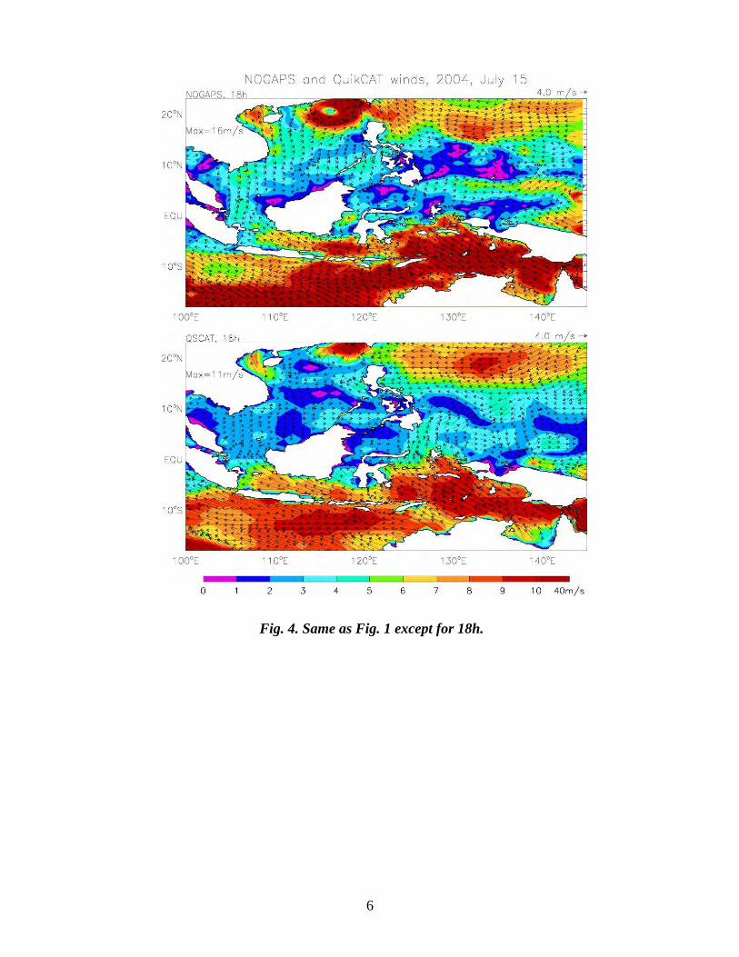
Fig. 4. Same as Fig. 1 except for 18h.
6

Fig. 5. Same as Fig. 1 except for NOGAP winds versus NCEP reanalysis winds at 0h on July 15, 2004. The strong cyclone west of Luzon is completely missed in NCEP winds.
7

Fig. 6. Same as Fig. 5 except at 6h. IMPACT/APPLICATIONS The proposed project is important both scientifically and operationally, because the idea of large-scale control of the meso- and submesoscale features in the Philippines Strait region by the equatorial waveguide is new; via interaction of the circulation with abruptly changing bottom topography and tidal forcing, the waveguides may exert a significant influence on the predictability of the variability. The project will contribute to the prediction and predictability of meso- and submesoscale eddies near the straits, and directly contribute to the Navy’s operational requirement.
8

9
REFERENCES Egbert, G.D., and R.D. Ray, 2000: Significant dissipation of tidal energy in the deep ocean inferred from satellite altimeter data. Nature 405, 775-779. Egbert, G.D., and R.D. Ray, 2001: Estimates of M2 tidal energy dissipation from TOPEX/Poseidon altimeter data. J. Geophys. Res., 106, C10, 22475-22502. Moore, A.M., H.G. Arango, E. Di Lorenzo, B.D. Cornuelle, A.J. Miller, and D.J. Neilson, 2004: A comprehensive ocean prediction and analysis system based on the tangent linear and adjoint of a regional ocean model. Ocean Modelling, 7, 227-258. Shchepetkin, A.F., and J.C. McWilliams, 2005: The Regional Ocean Modeling System: A split-explicit, free-surface, topography-following coordinate ocean model. Ocean Modelling, 9, 347-404.