collection and analysis of gps-based travel data for
TRANSCRIPT

Collection and Analysis of GPS-Based Travel Data for Understanding and ModelingActivity-Travel Patterns in Time and Space
Ram M. PendyalaDept of Civil and Environmental Engineering
University of South Florida, Tampa
GPS Tracking and Time-Geography Applications for Activity Modeling and Microsimulation
Santa Barbara, CA, October 10-11, 2005

Motivation for Time-Space GeographyDerived nature of travel demand – activities distributed in time and spaceAction “space” governed by modal accessibility and “time” availabilityRepresentation of time-space continuum offers strong behavioral framework for modeling activity-travel patterns
Opportunities and constraintsInteractions/interdependencies among agents
Key distinction between tour-based and activity-based microsimulation model systems

Time Use and Activity PerspectivesSpeed is finite and time is limitedIndividual’s trajectory in time and space confined to Hägerstrand’s prismNeed to recognize spatio-temporal constraints on individual’s movementTime use and activity-based approaches to modeling transport demand emerging

A Time-Space PrismA simplified representation of time-space constraints
HomeWork
A
B
v
Space
Time

Role of Time-Space Geography
Prism-Constrained Activity-Travel Simulator (PCATS)Comprehensive activity-based microsimulation model
Time-space geography plays critical role in:Defining destination choice set by mode availabilityDefining activity type choice set by destination availabilityInterdependency among trips with respect to destinations and schedules (timing)Interdependency among individuals – joint activity-travel engagement

Prism-Constrained Activity-Travel Simulator
Spacehomework
Define open and blocked periods for each individualPCATS incorporates time-space constraints
Mode availabilityModal speedTime availableRange of destinations
Structure of PCATS
Time
5:00 P.M.
1:00 P.M.12:00 P.M.
8:00 A.M.
6:30 A.M.

Sample Distributions:Origin Vertex – Morning Prism
0
5
10
15
20
25
30
35
40
45
3 4 5 6 7 8 9 10 11 12 13 14 15 16 17 18 19 20 21 22 23 24 25 26 27Time
Perc
ent o
f Sam
ple
Miami ObsMiami VertexSF ObsSF Vertex
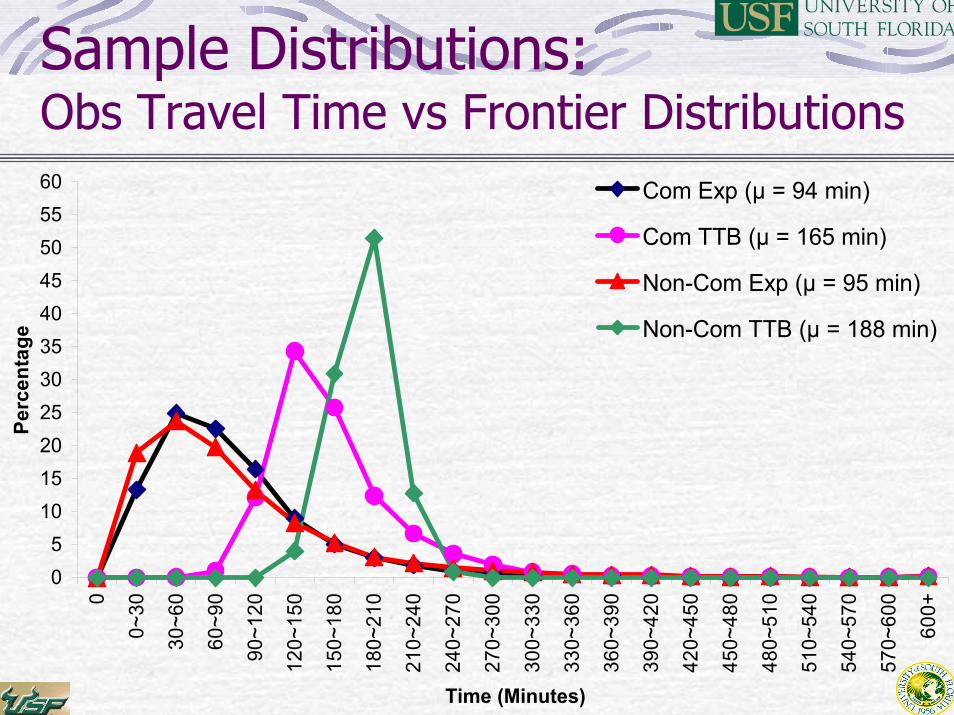
Sample Distributions:Obs Travel Time vs Frontier Distributions
05
1015202530354045505560
0
0~30
30~6
0
60~9
0
90~1
20
120~
150
150~
180
180~
210
210~
240
240~
270
270~
300
300~
330
330~
360
360~
390
390~
420
420~
450
450~
480
480~
510
510~
540
540~
570
570~
600
600+
Time (Minutes)
Perc
enta
ge
Com Exp (µ = 94 min)
Com TTB (µ = 165 min)
Non-Com Exp (µ = 95 min)
Non-Com TTB (µ = 188 min)

International Comparisons
.6178451.52114173India
.464250115.556187101Swiss
.50118895.55816594USA
rBudget (min)
Expendi-ture (min)
rBudget (min)
Expendi-ture (min)
Non-commutersCommutersSurvey area

GPS Data and Time-Space Geography
Accurate temporal and spatial attributes for all activities and tripsConstruct time-space paths of activity-travel participation on (actual) modal networksAutomated geocoding of all activity/trip locationsMultiday and multiweek data on time-space paths due to reduced survey burden
Explore variations and planning time horizons
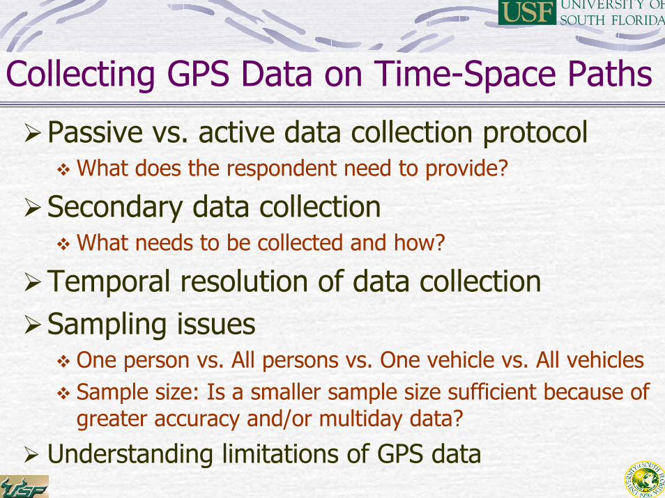
Collecting GPS Data on Time-Space Paths
Passive vs. active data collection protocolWhat does the respondent need to provide?
Secondary data collectionWhat needs to be collected and how?
Temporal resolution of data collectionSampling issues
One person vs. All persons vs. One vehicle vs. All vehiclesSample size: Is a smaller sample size sufficient because of greater accuracy and/or multiday data?
Understanding limitations of GPS data
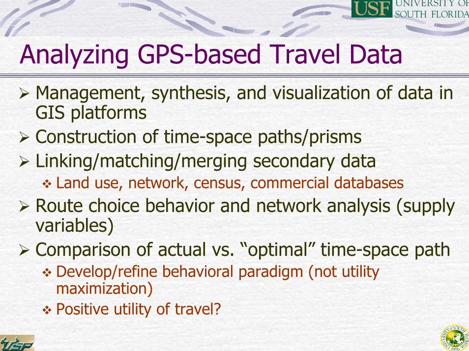
Analyzing GPS-based Travel DataManagement, synthesis, and visualization of data in GIS platformsConstruction of time-space paths/prismsLinking/matching/merging secondary data
Land use, network, census, commercial databasesRoute choice behavior and network analysis (supply variables)Comparison of actual vs. “optimal” time-space path
Develop/refine behavioral paradigm (not utility maximization)Positive utility of travel?

Using GPS Data in Activity-Based Model Development
Define/identify constraints and opportunitiesTime-space constraints Generate choice sets (activity type, destination, mode, time of day)
Incorporate interactions and interdependenciesHousehold time-space paths Interperson interactions (vehicle and task allocation, joint activity engagement)Multiday time-space paths Interday dependency (history dependency and future anticipation/planning)
Inform model linkages and specification

Challenges and Opportunities
Tools and resources for collection, analysis, synthesis, and visualization of time-space geographyIdentify wider range of applications
ICT, mobility, accessibility, and social equity analysisNetwork performance assessment (supply analysis) –application to disaster planningBuilt environment, travel behavior, and physical activityLand use planning – locate activity opportunities within time-space pathsTransportation security and safety applications (locations of people and vehicles by time of day)

Challenges and Opportunities (continued)
Identify wider range of applications (continued)Driver behavior and vehicle acceleration/speed profiles vehicle emissions analysisComprehensive microsimulation of land use – travel demand – traffic (network) continuum