collin county subdivision regulations · g. county etj map ... commissioner’s court adopted the...
TRANSCRIPT

1
COLLIN COUNTY SUBDIVISION REGULATIONS
Department of Engineering
Updated: November 5, 2012

2
TABLE OF CONTENTS DEFINITIONS .................................................................................................................. 4 SECTION I - PRELIMINARY PLAT .................................................................................. 7
A. SUBDIVISION NAME AND STREET NAMES ............................................................................... 7 B. SUBDIVISION DEVELOPER'S NAME ........................................................................................... 7 C. BOUNDARY LINES ........................................................................................................................ 7 D. LOT & STREET LAYOUT ............................................................................................................... 7 E. DRAINAGE & TOPOGRAPHY ....................................................................................................... 7 F. LAND USE ...................................................................................................................................... 8 G. DRAWING REQUIREMENTS ........................................................................................................ 8 H. UTILITY SERVICE ......................................................................................................................... 8 I. SUBDIVISION WITHIN EXTRATERRITORIAL JURISDICTION ................................................... 9 J. APPROVAL PROCEDURE ............................................................................................................ 9
SECTION II - FINAL PLAT ............................................................................................... 9 A. DRAWING REQUIREMENTS ........................................................................................................ 9 B. SUBDIVISION NAME AND STREET NAMES ............................................................................. 10 C. DEVELOPER, ENGINEER, SURVEYOR .................................................................................... 10 D. BOUNDARY LINES ...................................................................................................................... 10 E. UTILITY SERVICE ....................................................................................................................... 10 F. LOTS, STREETS, EASEMENTS, & SET BACK LINE LAYOUT AND DRAINAGE ..................... 10 G. EROSION CONTROL PLAN ........................................................................................................ 11 H. CERTIFICATION & DEDICATION BY DEVELOPER .................................................................. 11 I. CERTIFICATION BY REGISTERED PUBLIC SURVEYOR ........................................................ 11 J. TAX CERTIFICATION BY TAXING ENTITY ................................................................................ 11 K. SUBDIVISION DEED/RESTRICTIONS ....................................................................................... 11 L. OUTSIDE AGENCY COMPLIANCE ............................................................................................ 11 M. APPROVAL BY COMMISSIONERS COURT .............................................................................. 12 N. APPROVAL BY COUNTY JUDGE ............................................................................................... 12
SECTION III - GENERAL ROAD AND STREET REQUIREMENTS .............................. 12 A. GENERAL REQUIREMENTS ...................................................................................................... 12 B. STREET ARRANGEMENT .......................................................................................................... 12 C. STREET STANDARDS ................................................................................................................ 13 D. CUL-DE-SACS ............................................................................................................................. 13 E. MAXIMUM ROAD LENGTH ......................................................................................................... 14 F. CONSTRUCTION AND MAINTENANCE BONDS ....................................................................... 14 G. LOTS ............................................................................................................................................ 15 H. CONSTRUCTION ......................................................................................................................... 15 I. TESTING ...................................................................................................................................... 15
SECTION IV. ROAD ACCEPTANCE PROCEDURE .................................................... 15 A. GENERAL .................................................................................................................................... 15 B. ESTABLISHMENT OF A DATE OF COMPLETION OF CONSTRUCTION ................................ 16 C. RECORD CONSTRUCTION PLANS ........................................................................................... 16 D. FINAL ACCEPTANCE .................................................................................................................. 16
SECTION V - ENVIRONMENTAL .................................................................................. 17 SECTION VI - EXCEPTIONS ........................................................................................ 18 SECTION VII - APPEALS .............................................................................................. 18 SECTION VIII - ENFORCEMENT .................................................................................. 18
A. CIVIL ............................................................................................................................................. 18 B. CRIMINAL .................................................................................................................................... 19 C. AREA ............................................................................................................................................ 19
SECTION IX - SEVERABILITY ...................................................................................... 19 Appendix ........................................................................................................................ 20
A. Roadway Section A ........................................................................................................................... 21 B. Roadway Section B ........................................................................................................................... 22 C. Roadway Section C .......................................................................................................................... 23 D. Geometric Design Standards ............................................................................................................ 24 E. Plat Application ................................................................................................................................. 25 F. Subdivision Check List ...................................................................................................................... 26 G. County ETJ Map ............................................................................................................................... 27 H. County Thoroughfare Plan Map ........................................................................................................ 28

3
INTRODUCTION Commissioner’s Court adopted the Collin County Subdivision Regulations to provide minimum standards for land subdivisions and developments and prevent substandard subdivisions in Collin County. The Subdivision Regulations provide for the safety, health and well-being of the general public. The regulations require subdivision construction standards for streets, drainage, water availability and sewage facilities conducive to a superior quality of life and maintainability without imposing a burden to the taxpayers. In specific cases where literal interpretation of any section would work an undue economic hardship, the Subdivision Regulations provide for variances within state law. If any questions arise as to the language in any sections, the Department of Engineering will provide assistance in interpretation and clarification. Through private and public cooperation, these regulations intend to achieve and maintain a quality of life, which reflects the highest traditions and standards of Collin County. All Collin County departments and agencies will assist individuals, builders, and developers in achieving the performance standards as required and described in the following sections.

4
DEFINITIONS
AS-BUILT PLANS - See Record Plans
BASE FLOOD PLAIN - That area subject to inundation by flood, having a one percent probability of occurrence in any given year, based on existing conditions of development within the watershed area, as determined by the Flood Insurance Study for Collin County provided by the Federal Emergency Management Agency (FEMA).
BEST MANAGEMENT PRACTICES - Best Management Practices are physical, structural or managerial practices that decrease the potential for facilities to pollute drinking water. They can be used singly or in combination as appropriate in a particular situation.
BUILDING PERMIT- See Certificate of Occupancy
BUILDING LINE OR SETBACK LINES - A line established, in general, parallel to the front street line. No building or structure may be permitted in the area between the building line and the street right-of-way.
CERTIFICATE OF OCCUPANCY – A document (building permit) the Development Services Department issues certifying that a residence/building has met minimum inspection requirements necessary for occupancy.
COMMISSIONERS' COURT - Commissioners' Court of Collin County.
COUNTY - County of Collin
COUNTY JUDGE – Presiding member of Commissioners Court. Chief Administrative Collin County Official.
COUNTY ROAD - A public road or street constructed and accepted by the County, through prescription or dedication, for maintenance purposes.
COLLECTOR STREET - A street or road that provides for traffic movement between residential streets and an arterial road and provides access to abutting land.
CUL-DE-SAC - A street having one outlet to another street with a vehicular turnaround at the “remaining” or “other” end.
DEAD-ENDS - A street or alley that has no regular exit or outlet. A closed end street.
DEPARTMENT OF ENGINEERING - The Collin County Department of Engineering.
DEPARTMENT OF PUBLIC WORKS - The Collin County Department responsible for maintaining the County roads and facilities.
DEVELOPER – Persons, corporations, organizations, government or governmental subdivision or agency, estates, trust, partnerships, associates, incorporations or other entities, which undertake the activities covered by these regulations.
DEVELOPMENT SERVICES – The department of the county that reviews permits and inspects public and private residential and commercial structures for compliance to building, fire safety, and health codes.
DRAINAGE PLAN - Calculations and drawings showing the existing watershed characteristics and site water flow conditions and the effects the proposed subdivision will have on site and off site adjacent and surrounding lands.
EASEMENT - A land property right conveyed by the owner of a parcel of land to another person, public agency or private corporation for specific and limited use of that parcel of land.
ENGINEER - Any person registered and currently licensed to practice engineering by the Texas State Board of Registration for Professional Engineers.
EXTRATERRITORIAL AUTHORITY (ETJ) – The unincorporated area, not a part of any municipality, which is contiguous to the corporate limits of any municipality. The extraterritorial jurisdiction of the various population classes of cities (as defined in Article 974(a) V.A.C.S.) shall be as follows:

5
Municipality Population ETJ Boundary (Miles) Less than 5,000 One-half (1/2) 5,000 to 24,999 One (1) 25,000 to 49,999 Two (2) 50,000 to 99,999 Three (3)
100,000 & Greater Five (5)
FEMA - Federal Emergency Management Agency.
FINAL PLAT - A map of a land subdivision prepared in a form suitable for filing of record in the office of the County Clerk, with the necessary affidavits, easements, right-of-way dedications and acceptances and with complete bearings and dimensions of all lines defining lots and blocks, streets, public areas and dimensions of all lines and other dimensions of land and subdivision requirements of Collin County.
FIRE MARSHAL- Person Commissioners Court appoints to administer fire codes, issue and enforce burn permits and investigate fire scenes.
FLOOD PLAIN – See Base Flood Plain.
FLOODWAY - The channel and adjacent areas of water course within which no obstructions to flow would be allowed so that the 100 year flood may pass without cumulatively increasing the 100 year flood plain elevation more than one (1) foot. The floodway and flood plain limits are to be defined based on standard engineering practices or as determined by the Department of Engineering, Federal Emergency Management Agency (FEMA), and Federal Insurance Administration (FIA), and Flood Insurance Rate Maps (FIRM).
GEOMETRIC DESIGN STANDARDS - Minimum allowable engineering geometry standards adopted by Collin County affecting the functional traffic level operation, service and safety of highways and roads in Collin County.
GIS - Geographic Information Systems.
GPS – Global Positioning System
LOT - An undivided tract or land parcel, which has frontage on a public road and is designated as a separate and distinct tract.
LOT LINES - The property lines of any given tract or parcel of land that circumscribe the area divided by any plat of record in the plat records of Collin County, Texas, or in the absence of such a plat, the lot lines shall mean those property lines circumscribing the lot independently isolated on the official plat on file in the Collin County records.
MANUFACTURED HOMES RENTAL COMMUNITY - A plot or tract of land that is separated into two or more spaces or lots that are rented, leased, or offered for rent or lease, for a term of less than 60 months without a purchase option, for the installation of manufactured homes for use and occupancy as residences.
MAY - This verb means permissive within the regulations. MOBILITY PLAN - The Collin County Mobility Plan is the officially adopted plan for the physical development of thoroughfares in the County of Collin and includes any unit as part of such plan separately adopted and any amendment to such plan or parts thereof.
MUNICIPALITY - A political unit, such as a city, town, or village, incorporated for local self-government.
ON-SITE SEWAGE FACILITY (OSSF) – See Private Sewage Facilities - All systems and methods used for the disposal of sewage and wastewater (OSSF), on a specific site other than an organized disposal systems operated under a valid TCEQ permit.
OWNER – See Developer.
PLAT - a map depicting the division or subdivision of lands into lots, blocks, parcels, or tracts.
PLAT, FINAL – see FINAL PLAT definition
PLAT, PRELIMINARY – See Preliminary Plat

6
PRELIMINARY PLAT - A drawing of a proposed land subdivision showing the character and configuration of the land, lots, topographical features and roads in sufficient detail to determine the suitability of the proposed subdivision.
PRESCRIPTIVE ROAD OR RIGHT-OF-WAY - A road or right-of-way that becomes a county maintained road or right-of-way by means of continuous public use and County maintenance over a statutorily defined time period.
PRIVATE SEWAGE FACILITY – All systems and methods used for on-site specific disposal of sewage and wastewater other than organized disposal systems approved and operated under a valid TCEQ issued permit.
PUBLIC ROAD - Any area, parcel or strip of land (road) which provides vehicular access to adjacent property or land whether designated as a street, highway, freeway, thoroughfare, avenue, land boulevard, road, place, drive, or however otherwise designated, and which is either dedicated or granted for public purposes or acquired by prescriptive public use.
RECORD PLANS (AS-BUILTS) - Plans depicting improvements as finally constructed.
RE-PLAT – A modification or reconfiguration of a recorded final plat
RESIDENTIAL (LOCAL) STREET - A street or road that provides direct access to abutting land and provides for local traffic movements.
RE-SUBDIVIDING - The division of an existing subdivision, together with any changes of lot size therein, or the relocation of any street lines or lot lines. (Article 6626e, Tex. Rev. Civ. Ann.)
ROADWAY - The area of any street or road designated for vehicular traffic use or the area between where the curbs are normally placed.
SHALL – This verb is mandatory and not discretionary within the regulations.
STATE PLANE COORDINATE SYSTEM - A coordinate system used by States to locate spatial information with a high degree of accuracy. This coordinate system is widely used in North Central Texas for GIS purposes.
SUBDIVISION - The division of any tract or parcel of land into two or more parts to lay out any division of the tract, including an addition, lots, or streets, alleys, squares, parks, or other parts of the tract intended to be dedicated to the public use or for the use of purchasers or owners of lots fronting on or adjacent to the street, alleys, squares, parks, or other parts. A division includes a division using metes and bounds description in a deed of conveyance or in a contract for deed, by using a contract for sale or other executory contract to convey, or by using any other method.
SUBDIVIDER/DEVELOPER - Any person, partnership, firm, association, corporation or combination thereof, or any officer, agent, employee, servant or trustee thereof, who performs or participates in the performance of any act toward the subdivision of land within the intent, scope and purview of these regulations.
SURVEYOR - any person licensed to practice surveying by the Texas Board of Professional Land Surveying.
TAX CERTIFICATES – Document taxing entities issue showing current tax balance.
TCEQ – Texas Commission on Environmental Quality
TxDOT - Texas Department of Transportation

7
SECTION I - PRELIMINARY PLAT To facilitate and clarify the conceptual development of a subdivision, a preliminary plat may be necessary. The submittal of a preliminary plat will: preclude the duplication of subdivision names; assure proper street alignments; provide for satisfactory drainage; assure compliance with regulations for provisions of potable water; wastewater disposal; and confirm jurisdictional plat approval. The developer shall prepare and submit a preliminary plat of any proposed subdivision to the Department of Engineering for presentation to the Commissioners' Court for approval at least sixty (60) days before the meeting at which approval is requested. The Preliminary Plat shall remain valid for twelve (12) months from the date of approval, after which, it will be automatically void. The Commissioners' Court may approve an extension if requested by the developer. Upon request of the developer, the Department of Engineering may waive the requirement of a preliminary plat, provided that the final plat will be prepared in accordance with the provisions of the preliminary and final plats. The preliminary plat shall show or be accompanied by the following information:
A. SUBDIVISION NAME AND STREET NAMES
The name of the subdivision and proposed street names shall be shown on the plat.
B. SUBDIVISION DEVELOPER'S NAME
The names, addresses and telephone numbers of the developer(s) of the subdivision and the name address and telephone number of the Engineer or Surveyor responsible for the preparation of the preliminary plat shall be included.
C. BOUNDARY LINES
The plat shall show the location of boundary lines and their relation to an original corner of the original survey and a vicinity map showing the subdivision location in the County.
D. LOT & STREET LAYOUT
The plat shall include the accurate location and dimension of existing and proposed streets, roads, lots and alleys, building lines, easements, parks, school sites, street signs and any other features relating to the proposed subdivision; the outline of adjacent properties for a distance of at least one hundred (100) feet; the way the streets, alleys or highways in the proposed subdivision connect with adjacent land or with adjacent recorded subdivisions; the total acreage of the proposed subdivision, including the estimated acreage of each lot. Lots utilizing on-site sewage facilities shall provide for a minimum of one (1) acre of USEABLE surface area and one and one half (1.5) acres for lots served by an individual water system. (In accordance with the Collin County on-site sewage facility rules.CO# 2008-187-03-11)
E. DRAINAGE & TOPOGRAPHY
The preliminary plat shall include a drainage plan prepared by a Texas Licensed Professional Engineer. The preliminary plat shall show the 100-year flood plain elevation and boundaries, existing bridges, culverts and other drainage structures, and physical features of the property related to street and lot drainage and layout. The drainage plan shall show existing drainage areas upstream and downstream including drainage calculations determining the quantity to run off coming by means of land, entering, crossing and exiting the proposed subdivision. The drainage calculations shall be sufficiently detailed to determine changes in the 100-year flood plain elevation, water discharge and velocities within the subdivision and upstream and downstream of the subdivision, and Pre and Post construction Runoff values and means of mitigating any increased runoff.
Topography of the development shall be shown on the preliminary plat. Pre and post construction contour intervals will be shown for assessment and determination of proper drainage requirements. The intervals will be as follows:
1. Land with less than five percent (5%) overall slope, the contour interval shall not be greater than two (2) feet.
2. Land with more than five percent (5%) slope, the contour interval shall not be greater than five (5) feet.

8
Locations of drainage easements will be shown. Drainage easements shall generally be located along the existing drainage way, and shall meet the following standards:
a. Open channels with top widths from 0’ to 50’ requires top width plus 25’.
b. Open channels with top widths greater than 50’ requires, top width plus 25’ each side.
c. Enclosed pipe require 20’ minimum width.
All easements shall be so designed to allow maintenance equipment to enter the easement, and be able to perform the necessary work.
F. LAND USE
Designation of the proposed uses of land within the subdivision shall be shown whether for residential, commercial, industrial, recreational or public use, such as parks, churches, or other specific uses.
G. DRAWING REQUIREMENTS
Six (6) prints of the drawings shall be submitted to the Department of Engineering. The drawing shall show the North Point, scale and date. The preliminary plat shall be drawn to a scale not exceeding one (1) inch equals two hundred (200) feet and presented on standard size sheets of 24" x 36". If the proposed subdivision is too large to be accommodated by a single standard sheet size, two or more sheets may be used with match lines clearly shown.
H. UTILITY SERVICE
The developer shall submit plans for providing water, sewer and electric utility service within the proposed subdivision and shall show the same on the plat.
The proposed water supply shall clearly indicate whether it is municipal water, rural water supply corporation, privately owned water system or individual wells.
Water Construction plans shall show:
1. The location and size of all proposed water lines in relation to the right-of-way, and/or easements in which the lines are to be located.
2. The location of all appurtenances proposed to be installed.
3. The depth to which the water lines are to be installed.
4. Location of proposed hydrants – in accordance with the current Collin County adopted Fire and Safety Code.
The developer shall furnish a certified letter from an approved Texas Commission on Environmental Quality (TCEQ) utility service provider stating that water is available to the subdivision sufficient in quality and quantity to meet minimum state standards required by Section 16.343, Water Code, and consistent with the certification in the letter, and that water of that quality and quantity will be made available to the point of delivery to all lots in the subdivision. The utility provider should indicate that the utility plans have been reviewed and approved. If a separate utility easement is required by the water provider, it shall be indicated on the plat. Approximate fire flow available to the subdivision should be provided in this letter.
The plan for sewage disposal shall clearly indicate municipal sewer service or privately owned/organized on-site sewage disposal system. If it is the developer's intent that each lot purchaser shall provide private on-site sewage facilities (septic tank systems) for each lot owner's needs, then copies of site evaluations performed by a Texas Licensed Professional Engineer or Registered Sanitation (with current Site Evaluator’s license) shall be provided, together with a letter stating recommendations and/or system design of the type of on-site sewage facility system to be installed. If <10 lots, 100% of lots must be evaluated and if > or = to 10 lots, 25% of lots must be evaluated.
If on-site sewage facilities are to be used for wastewater disposal, the location of each soil evaluation shall be noted on the plat and the area covered by that test shall be outlined clearly on the plat. All proposed on-site sewage facilities shall be in accordance with the rules of Collin County for On-site Sewage Facilities. A plan prepared by the person charged with performing tests on the subdivision site shall show areas not suitable for standard on-sight sewage facilities. Such areas shall require special systems approved by the County Development Services Department. Additional plat notes may be required as a result of this review.

9
I. SUBDIVISION WITHIN EXTRATERRITORIAL JURISDICTION
If the location of the subdivision is within the extraterritorial jurisdiction of any municipality within Collin County, Texas, the owner shall consult with the municipality and county to determine if the municipality or county has exclusive jurisdiction and authority to approve subdivision plats.
If it is determined that the municipality will have platting jurisdiction, but the proposed development will utilize on-site sewage facilities (OSSF), the county will be required to do an OSSF review that will be performed concurrent to the municipality plat review. This review will result in additional plat notes. Please contact the Collin County Development Services for the application and review requirements.
J. APPROVAL PROCEDURE
The Department of Engineering shall review the preliminary plat and:
Respond within ten (10) working days to inform the owner on the administrative plat completion.
Send written comments to the developer showing results of the review and conditions of approval. In addition to the requirements following, the final plat shall conform to the requirements of the preliminary plat before Commissioners’ Court approves the final plat.
If the Commissioners' Court does not approve, disapprove, or ask for clarification of the preliminary plat within sixty (60) days from the date of application and plat submittal to the Department of Engineering, the plat shall be deemed approved and so endorsed by the Commissioners' Court.
Approval of the preliminary plat does not constitute acceptance of the subdivision but is merely an authorization to proceed with the preparation of the final plat. No grading of streets or construction is authorized in the subdivision before Commissioners' Court approves the final plat, except as approved by of the Commissioners' Court.
SECTION II - FINAL PLAT A final plat is required unless the subdivision meets the requirements for exceptions detailed in Section VI of the Collin County Subdivision Regulations.
After Commissioners Court approves the preliminary plat, the developer may proceed with the final plat preparation for submittal to the Department of Engineering within twelve (12) months of the date of approval of the preliminary plat and at least sixty (60) days prior to the Commissioners Court meeting at which Court approval is required. The final plat shall remain valid for twelve (12) months from the date of approval after which, it will be automatically void. The Commissioners’ Court may approve an extension if requested by the developer. The extension may be granted for a maximum of six months. The final plat shall conform to all the preliminary plat requirements and shall show or be accompanied by the following information:
A. DRAWING REQUIREMENTS
The recording plat shall be 24” x 36" and shall be on translucent Mylar. The following statements and information shall be noted on the face of the final plat:
1. “Blocking the flow of water or construction improvements in drainage easements, and filling or obstruction of the floodway is prohibited.”
2. “The existing creeks or drainage channels traversing along or across the addition will remain as open channels and will be maintained by individual owners of the lot or lots that are traversed by or adjacent to the drainage course along or across said lots.”
3. “Collin County will not be responsible for the maintenance and operation of said drainage ways or for the control of erosion in said drainage ways.”
4. “Collin County will not be responsible for any damage, personal injury or loss of life or property occasioned by flooding or flooding conditions.”
5. “Collin County permits are required for building construction, on-site sewage facilities and driveway culverts.”
6. “All private driveway tie-ins to a county maintained roadway must be even with the existing driving surface”
7. All utility providers’ names, addresses and phone numbers.
8. “All surface drainage easements shall be kept clear of fences, buildings, foundations and plantings, and other obstructions to the operation and maintenance of the drainage facility.

10
If the recording plat is a photographic reduction of a larger scale original, then the scale shall be shown in graphic form, however, the reduction shall be no more than 50%. All figures, curve lines, letters and signatures shown must be plain, distinct, and of sufficient size as to be easily read and must be of sufficient density to make a lasting and permanent record. Two (2) prints of the final recording plat shall be submitted to Commissioners' Court through the Department of Engineering at the time the recording plat is submitted.
After Commissioners’ Court approves the final plat and the final plat has been signed by the County Judge, the Engineering Department will notify the owner or owner’s representative.
To file the approved subdivision for record in the County Clerk’s Office, the owner or a representative, must present one 24” x 36” translucent Mylar. To be accepted for filing, all signature blocks must be signed and dated. All signatures must be in wide black pen and all seals must be distinct and in black ink.
B. SUBDIVISION NAME AND STREET NAMES
The plat shall include the name of the subdivision and street names, scale, date and North arrow; names or numbers of streets, and lot, block and section numbers within the subdivision. The proposed subdivision and street names shall not conflict with an existing subdivision and street names in an unincorporated area.
C. DEVELOPER, ENGINEER, SURVEYOR
The names, addresses and telephone numbers of the developer of the proposed subdivision and the name, address, telephone number, seal and signature, of the Engineer and/or Surveyor responsible for the preparation of the final plat shall be shown on the final plat.
D. BOUNDARY LINES
The perimeter boundary of the subdivision shall be shown with bearings and distances referenced to a corner of the original survey along with the name, together with a vicinity map and names of adjacent subdivisions, if any. The boundary line description of the tract being subdivided shall close to an accuracy of one in ten thousand (1:10,000).
E. UTILITY SERVICE
The developer shall submit a plan and documentation from the TCEQ approved water provider for providing adequate water and sewer service within the proposed subdivision. If the information is provided during the preliminary plat process, no additional information will be required. However, if no preliminary plat is submitted, the provisions in Section I (Preliminary Plat), Paragraph H (Utility Service) shall be met.
F. LOTS, STREETS, EASEMENTS, & SET BACK LINE LAYOUT AND DRAINAGE
Location of lots, streets, roads, traffic control signs, public highways, utility easements, parks, 100 year flood plain boundaries and source of flood plain information, and other pertinent features, shall be shown with accurate dimensions in feet and decimals of feet to the nearest hundredth, and bearing, with length, of radii and angle of all curves, and with all other information necessary to duplicate the plat on the ground.
Plan and profile drawings of streets, drawings and drainage calculations prepared by a Texas Licensed Professional Engineer shall be submitted on separate plans. Plan and profile drawings shall be drawn at a scale of 1 inch=40 ft. horizontal and 1 inch = 4 ft. vertical.
The location of building set-back lines shall be shown on all lots, streets, and drainage easements, and other public right-of-way or future right-of-way.
Lot straight lines shall clearly show the length and bearing of the line.
Curved lot lines shall clearly show the length of the arc and radius of the curve, or show enough information on the plat to readily determine the radius of the curve.
Building and set back lines shall be 50 feet from the edge of the right-of-way on all major highways and roads, and 25 feet on all public roads other than major highways and roads. Building and set-back lines shall be shown on both preliminary and final plats. If the County setback lines differ from those adopted by a municipality with extraterritorial jurisdiction, the larger or more stringent setbacks shall apply.
Minimum lot frontage on proposed and existing county roads shall be 80 feet for lots with a net area less than one(1) acre, 80 feet cord length for lots located along a curve, 150 feet for lots with a net area equal to or greater than one(1) acre and less than three(3) acres, 200 feet for lots with a net area equal to or greater than three(3) acres and less than five(5) acres, 300 feet for lots with a net area equal to or greater than five(5) acres and less
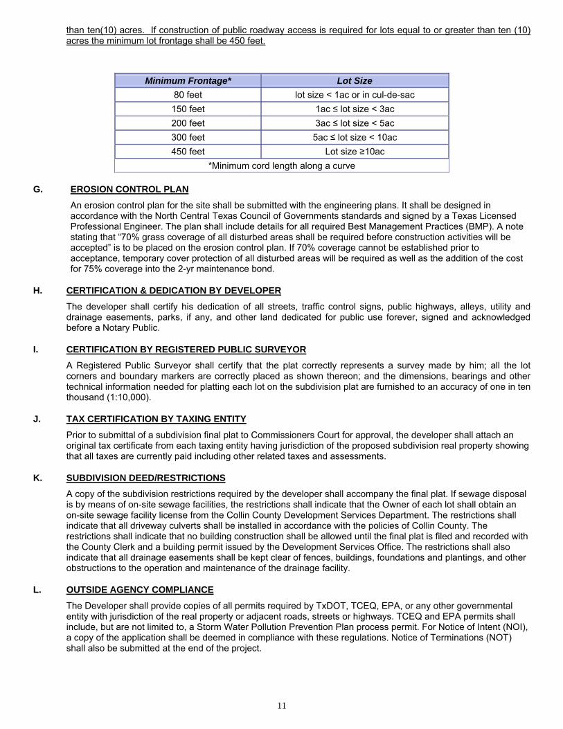
11
than ten(10) acres. If construction of public roadway access is required for lots equal to or greater than ten (10) acres the minimum lot frontage shall be 450 feet.
Minimum Frontage* Lot Size
80 feet lot size < 1ac or in cul-de-sac
150 feet 1ac ≤ lot size < 3ac
200 feet 3ac ≤ lot size < 5ac
300 feet 5ac ≤ lot size < 10ac
450 feet Lot size ≥10ac
*Minimum cord length along a curve
G. EROSION CONTROL PLAN
An erosion control plan for the site shall be submitted with the engineering plans. It shall be designed in accordance with the North Central Texas Council of Governments standards and signed by a Texas Licensed Professional Engineer. The plan shall include details for all required Best Management Practices (BMP). A note stating that “70% grass coverage of all disturbed areas shall be required before construction activities will be accepted” is to be placed on the erosion control plan. If 70% coverage cannot be established prior to acceptance, temporary cover protection of all disturbed areas will be required as well as the addition of the cost for 75% coverage into the 2-yr maintenance bond.
H. CERTIFICATION & DEDICATION BY DEVELOPER
The developer shall certify his dedication of all streets, traffic control signs, public highways, alleys, utility and drainage easements, parks, if any, and other land dedicated for public use forever, signed and acknowledged before a Notary Public.
I. CERTIFICATION BY REGISTERED PUBLIC SURVEYOR
A Registered Public Surveyor shall certify that the plat correctly represents a survey made by him; all the lot corners and boundary markers are correctly placed as shown thereon; and the dimensions, bearings and other technical information needed for platting each lot on the subdivision plat are furnished to an accuracy of one in ten thousand (1:10,000).
J. TAX CERTIFICATION BY TAXING ENTITY
Prior to submittal of a subdivision final plat to Commissioners Court for approval, the developer shall attach an original tax certificate from each taxing entity having jurisdiction of the proposed subdivision real property showing that all taxes are currently paid including other related taxes and assessments.
K. SUBDIVISION DEED/RESTRICTIONS
A copy of the subdivision restrictions required by the developer shall accompany the final plat. If sewage disposal is by means of on-site sewage facilities, the restrictions shall indicate that the Owner of each lot shall obtain an on-site sewage facility license from the Collin County Development Services Department. The restrictions shall indicate that all driveway culverts shall be installed in accordance with the policies of Collin County. The restrictions shall indicate that no building construction shall be allowed until the final plat is filed and recorded with the County Clerk and a building permit issued by the Development Services Office. The restrictions shall also indicate that all drainage easements shall be kept clear of fences, buildings, foundations and plantings, and other obstructions to the operation and maintenance of the drainage facility.
L. OUTSIDE AGENCY COMPLIANCE
The Developer shall provide copies of all permits required by TxDOT, TCEQ, EPA, or any other governmental entity with jurisdiction of the real property or adjacent roads, streets or highways. TCEQ and EPA permits shall include, but are not limited to, a Storm Water Pollution Prevention Plan process permit. For Notice of Intent (NOI), a copy of the application shall be deemed in compliance with these regulations. Notice of Terminations (NOT) shall also be submitted at the end of the project.

12
M. APPROVAL BY COMMISSIONERS COURT
The Department of Engineering shall examine the final plat for compliance with Subdivision Regulations and submit the final plat for Commissioners' Court approval. If Commissioners' Court disapproves the plat, the plat shall be returned to the developer with the reasons for disapproval. If Commissioners' Court approves the plat, the developer has the following options concerning the filing and recording of the final plat with the County Clerk.
OPTION 1.
If the developer opts to file and record the final plat prior to completion of construction of the roads in a subdivision, the developer shall provide appropriate financial security which will assure the County that the roads will be constructed in conformance with the Subdivision Regulations (see Section IV., ROAD ACCEPTANCE PROCEDURE). The financial security can be arranged by one of the following methods:
a). a construction bond may be filed by the developer payable to the County Judge in the amount of the cost of construction. The bonds must be surety bonds provided by a surety company licensed to operate in the State of Texas; or
b). the developer may provide funds in escrow, certificate of deposit, an irrevocable letter of credit or other financial instrument satisfactory to the County Judge in the amount of the cost of construction.
c). the estimated cost of construction for the required bonds or letters of credit shall be determined by using the latest regional Dodge Reports (construction data).
After acceptable financial security is filed with the County, the County Judge will sign the final plat and the developer may then file the final plat with the County Clerk's office.
OPTION 2.
If the developer opts not to submit a financial security to guarantee the completion of the road, drainage, and associated subdivision improvements, the final plat shall not be approved for filing until completion of the subdivision road and improvements. (See SECTION IV. - ROAD ACCEPTANCE PROCEDURES) At such time when the Director of Engineering certifies to the County Judge that the construction is completed according to the County Subdivision Regulations specifications, the County Judge shall sign the final plat and the developer is authorized to submit the final plat to the County Clerk for filing and recording.
N. APPROVAL BY COUNTY JUDGE
A certificate of approval shall be provided on the final plat for the County Judge to sign and approve on behalf of and for Commissioners' Court of Collin County, Texas. A subdivision may be recorded in phases, and in either case, the phase to be recorded shall be accompanied by a set of field notes describing the phase that is to be recorded.
If Commissioners Court approves the final plat, the County Judge, acting on behalf of and for the Commissioners' Court, shall sign the plat indicating Commissioners' Court approval. The Department of Engineering shall notify the developer that the County Judge signed the final plat and the plat is ready to be filed with the County Clerk.
SECTION III - GENERAL ROAD AND STREET REQUIREMENTS All roads in subdivisions shall be platted and constructed to the standards required by Section III, GENERAL ROAD AND STREET REQUIREMENTS. The developer of a subdivision shall be responsible for the cost of the construction of residential, collector, and/or local streets.
General specifications and requirements pertaining to subdivision road and street improvements shall be as follows:
A. GENERAL REQUIREMENTS
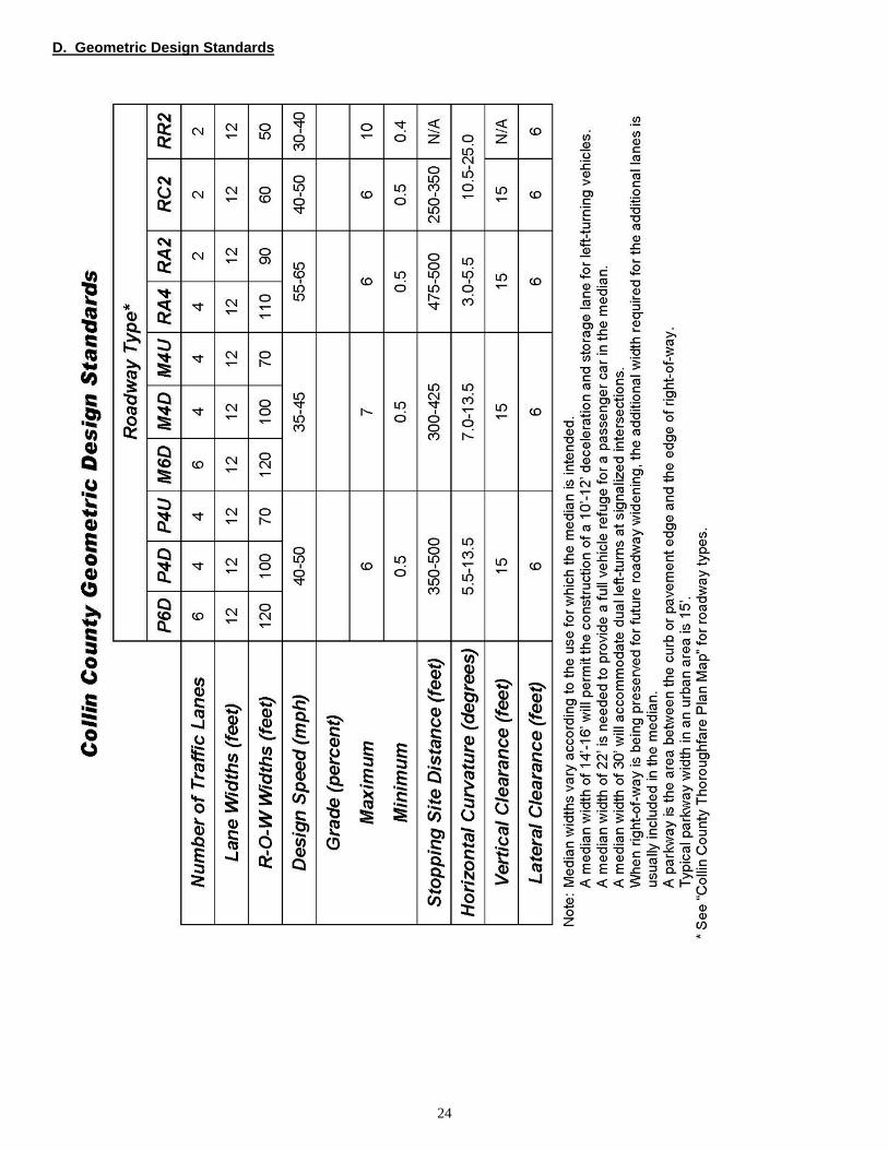
All subdivision streets shall be constructed as required by the current Collin County Mobility Plan and Geometric Design Standards. Streets shall be constructed for the entire specified width and right-of-way unless Commissioners’ Court grants a variance.
B. STREET ARRANGEMENT
Unless otherwise approved by the Commissioners' Court, provisions shall be made for the extension of existing dead-end streets within recorded adjacent subdivisions.
Proposed streets should conform to existing topography, where practical, so drainage may be provided. Where feasible, streets should follow existing topographical valleys or depressions so as to form a natural collection system for surface water.

13
Streets shall be numbered and/or named and installed with permanent metal signs in accordance with Collin County Road Sign Specifications. There shall be no conflicts with existing names, or numbers of other public roads or streets within the county or nearest municipality and street names and numbers in the subdivision. The developer shall pay for the installation of all street names and traffic control signs prior to final plat approval. Signs with road names shall be maintained by the developer during the road warranty period.
C. STREET STANDARDS
1. Right-of-way:
Street rights-of-way within and bordering the subdivision shall conform to the Collin County Mobility Plan and the Collin County Geometric Design Standards.
2. Types of streets:
(a) Streets in subdivisions with lots less than or equal to 0.50 acres
Residential streets shall be 25 feet in width measured back of curb to back of curb. Collector streets shall be 32 feet in width measured back of curb to back of curb.
1) Subgrade - The subgrade shall be lime stabilized with hydrated lime in the amount of 7% by weight of the subgrade to a depth of six (6) inches for the stipulated width, plus one foot behind the curbs. The Director of Engineering shall consider other types of and percentages of lime based on geotechnical laboratory’s tests, evaluations and recommendations described in engineering reports provided paid for by the developer.
2) Surface - The surface course shall be six (6) inches in thickness of 3,600 psi or greater of Portland Cement concrete or an approved equivalent thickness of hot mix asphaltic concrete. (See Exhibit A - Appendix).
(b) Streets in subdivisions with lots greater than 0.50 acre and less than l acre
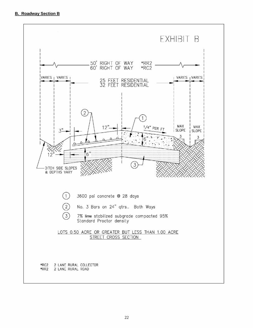
Residential streets shall be 25 feet wide concrete pavement without curbs. Collector streets shall be 32 feet wide concrete pavement without curbs. Both residential and collector streets’ subgrade, base, and pavement shall conform to specifications of Section III, C, 2 (a) above (see Exhibit B - Appendix).
(c) Streets in subdivisions with lots greater than 1 acre
Residential streets shall be 25 feet wide pavement without curbs. Collector streets shall be 32 feet wide pavement without curbs (See Exhibit C - Appendix).
1) Subgrade - The subgrade shall be lime stabilized according to the specifications in Section III, C, 2 (a) 1) above.
2) Base - The base shall be two (2) feet wider than the pavement width and shall be constructed of flexible base as specified in the Standard Specifications for Public Works Construction in North Central Texas to a depth of six (6) inches compacted to 95% Standard Proctor Density.
3) Surface - the surface course may consist of either two-course asphalt surface treatment or two (2) inches of hot mix asphaltic concrete (HMAC). The aggregate shall be pre-coated and in accordance to current TxDOT Standards Specifications For Construction Of Highways, Streets And Bridges.
3. Ditches:
The widths and depths of the ditches shall conform to the typical sections and the calculated storm water discharge Subdivision Regulations require.
4. Miscellaneous Design Features:
All other design features of the roads shall conform to the Collin County Mobility Plan and Collin County Geometric Design Standards.
5. Materials:
Materials shall be as specified in the Standard Specifications for Public Works Construction, North Central Texas Council of Governments.
D. CUL-DE-SACS
Cul-de-sacs may be permitted where the form or contour of the land makes it difficult to plat with connecting streets. Such cul-de-sacs shall provide proper access to all lots and a turn-around shall be provided at the closed
14
end, with an outside property line radius of at least sixty (60) feet and a street line (outside edge of pavement) radius of at least forty-five (45) feet.
In subdivisions constructed in more than one (1) phase, temporary cul-de-sacs shall be required at the end of the street or road which is intended to connect to future streets. The materials of which the temporary cul-de-sac shall be constructed shall conform to those required for the street itself in the geotechnical report.
E. MAXIMUM ROAD LENGTH
The length of roadway shall not be greater than six hundred (600) feet from nearest intersection to the end of roadway. Variances to this requirement may be granted by the Director of Engineering for special circumstances.
F. CONSTRUCTION AND MAINTENANCE BONDS
1. Construction Bonds
The developer shall complete all construction of improvements within eighteen (18) months after approval of final plat. The developer shall file a Construction Bond, executed by a Surety Company authorized to do business in this State, and make payable to the County Judge of Collin County, Texas or his successors in office.
The bond amount shall be equal to one hundred (100%) of the estimated cost of construction of roads, streets, street signs, underground utilities, required drainage structures and all other associated construction improvements.
The developer shall submit the construction bond with the final plat prior to Commissioners Court approval of the final plat.
The construction bond shall remain in full force and in effect until all the roads, streets, street signs, underground utilities, required drainage structures and all other associated construction improvements in the subdivision have been completed to the satisfaction of the Engineering Department and the construction has been released by the County Judge on recommendation of the Director of Engineering.
If any or all of the streets, roads, drainage and drainage structures, as constructed by the owner, fail to meet the requirements of the Subdivision Regulations and the developer fails or refuses to correct the defects within sixty (60) days, from the date the Director of Engineering issues, in writing, the unfinished improvements shall be completed at the cost and expense of obligee or surety or financial securities as provided.
2. Maintenance Bond
To insure roads, streets, street signs, underground utilities, required drainage structures and all other construction are maintained to the satisfaction of Collin County, a maintenance bond executed by a surety company authorized to do business in this state, and made payable to the County Judge of Collin County, Texas, or his successors in office, shall be substituted for the construction bond at the time of release of said construction bond.
The maintenance bond amount shall be equal to ten (10%) percent of the estimated cost of roads, streets, street signs, underground utilities, required drainage structures and all other construction.
The conditions of the maintenance bond shall stipulate that the developer shall guarantee to maintain, to the satisfaction of Collin County, all of the streets, roads, drainage structures and drainage ditches and channels which have been constructed to specifications with construction in a good state of repair for a period of two (2) years from the date of official release of construction security. Construction security will be released by the County Judge on recommendation of the Director of Engineering.
The County shall perform periodical inspections of roads, streets, street signs, underground utilities, drainage structures and all other construction for which maintenance security is held. In the event any or all of the roads, streets, street signs, underground utilities, drainage structures and all other construction improvements are not being maintained in a good state of repair, the Director of Engineering will advise the developer in writing and, if after a reasonable time, the developer fails or refuses to repair said items, the deficiencies shall be corrected at the cost and expense of obligees or financial security.
The release of any bond shall be by order of the Commissioners’ Court. To request a release, the developer shall present a written request to release said bond. The request shall contain a statement by the Engineer responsible for the design of improvements stating that he has made an inspection of such improvements and recommends their acceptance by the County. Attached to his letter shall be one set of “as built” drawings showing the work to be accepted for use by the County. A computer diskette or compact disk containing the “as built” plan sheets in the format and medium specified by the County shall be submitted

15
with the “as built” drawings. The written request of bond release shall be received by Collin County at lease twenty-one (21) days prior to the next regularly scheduled meeting of Commissioners Court.
3. Final Inspection
The developer, upon completion of drainage, roads, streets and other facilities intended for the use of the public, or purchasers or owners of lots fronting or adjacent thereto, shall request, in writing, from the County a final inspection. The developer will be notified in writing of any work not found in compliance with the Subdivision Regulations.
4. Irrevocable Letter Of Credit (In Lieu Of Bond)
An Irrevocable Letter of Credit may be submitted in lieu of bonds, or the purpose of insuring a developer’s promise to construct and maintain the road and drainage of facilities in a subdivision.
Irrevocable Letters of Credit in lieu of Bonds are required under the same conditions as Construction and Maintenance Bonds.
5. Other Security
Any type of security for Construction and Maintenance other than Bonds and Irrevocable Letter of Credit shall be by written request to Collin County, and approval by the Collin County Judge.
G. LOTS
All lots, so far as practicable, shall have the side lines at right angles to the street on which the lot faces, or radial to curved street lines. All lot corners, angle points, point of curve, etc. shall be marked with steel rods of at least eighteen inches (18") in length or with concrete markers as the Director of Engineering may approve and accept. All lot corners shall be marked before the County Judge signs the plat for filing.
H. CONSTRUCTION
Construction and construction materials for roads and drainage facilities in the subdivision shall conform to the Standard Specifications for Public Works Construction, North Central Texas, as prepared by the North Central Texas Council of Governments or to any other construction specifications adopted by the Collin County Commissioners' Court.
A preconstruction meeting with the Engineering department is required prior to the commencement of any work.
The developer shall contact the Department of Engineering forty-eight (48) hours prior to the commencement of any construction. Saturdays and Sundays and legal holidays shall not be considered as part of notification.
All erosion control plan temporary Best Management Practices shall be in place prior to commencement of any work.
The Director of Engineering or authorized representative, shall, from time to time, inspect the construction of all drainage structures and streets in the subdivision during the course of construction for compliance with the regulations and specifications. The developer shall provide free access to the subdivision to the Director of Engineering or his authorized representative. Inspection by the Director of Engineering, or a failure by him to inspect construction as required herein, shall not in any way impair or diminish the obligation of the subdivider to install improvements in the subdivision in accordance with plans and specifications therefore as approved by the Director of Engineering and in accordance with the County's Regulations.
I. TESTING
All testing and inspections required by the Director of Engineering, to determine conformance to specifications, shall be performed by a soil-testing laboratory approved by the Director of Engineering. The Developer shall bear all costs for testing and inspection.
SECTION IV. ROAD ACCEPTANCE PROCEDURE
A. GENERAL
All conditions of final plat approval must be met. All construction must be in accordance with approved plans and construction standards and specifications set forth herein or as Commissioners’ Court may revise and adopt.
16
B. ESTABLISHMENT OF A DATE OF COMPLETION OF CONSTRUCTION
At such time as the road construction is complete, the developer shall notify the Director of Engineering in writing. The Director of Engineering shall then inspect the roads and improvements and give written notice of any deficiencies. Should it be deemed necessary to ascertain compliance with county construction specifications, the Director of Engineering may require copies of test results performed by a certified testing laboratory. Upon correction of deficiencies and re-inspection, the Director of Engineering shall establish a date considered being the date of completion of construction at which time the infrastructure improvements will enter into a two year maintenance period.
The developer will be responsible for maintenance during this period and until the county has issued a letter of final acceptance of the infrastructure improvements. The County will perform regular inspections during this two (2) year period. Routine maintenance should include, but is not limited to, mowing of rights-of-ways and spraying to eliminate vegetation encroachment onto the road surface. Ditch re-grading and or re-vegetation may be required if permanent vegetation was never established and erosion has occurred.
If ownership or management of the subdivision changes, the county engineering department shall be notified.
C. RECORD CONSTRUCTION PLANS
After the developer completes the subdivision roads, streets and drainage improvements, one set of record (as-built) construction plans of all underground utilities, street and drainage improvements that have been constructed shall be filed with the Director of Engineering prior to acceptance of the roads into the two (2) year maintenance period.
The as built plans shall be one-half (1/2) size reproducible copies and in an industry acceptable electronic format.
D. FINAL ACCEPTANCE
Twenty-two (22) months after the accepted date of completion of construction, the developer shall notify the Director of Engineering in writing. The Director of Engineering, or representative, shall inspect the road and improvements and notify the developer in writing of any deficiencies.
Upon correction of deficiencies and re-inspection, the Director of Engineering shall recommend to Commissioners' Court that the roads be accepted by Collin County. Upon Court action, Collin County shall release the maintenance bond or other financial security to the developer and the road and associated drainage improvements into the Collin County road system.
17
SECTION V - ENVIRONMENTAL This section contains environmental information intended to enhance the quality of a new subdivision but is not mandatory for final plat approval. The following resource areas are suggested to be incorporated in new developments to provide the highest quality environment for future Collin County residents. Based on Collin County Park and Open Space Strategic Plan, the developer, together with the County, shall make every effort to preserve natural resources such as the following:
1. Floodplains, wetlands and natural drainage ways;
2. Unique vegetation areas such as forests, native prairies or grasslands, wooded stream corridors, mature trees and marsh lands;
3. Unique wildlife habitat areas;
4. Areas with soils that are highly suited for agricultural production;
5. Areas with soils that are highly erosive and/or have limitations because of excessive slope (20% or greater); and
6. Scenic views of underdeveloped or limited developed (but compatible) landscapes along United States of
America. State of Texas or major County roads that could maintain the rural countryside and beauty of the county. 7. Collin County, at the discretion of Commissioners' Court, shall make every reasonable effort to provide incentives
for implementation of the above environmental factors. Creative land planning is encouraged to maximize the number of building sites, minimize development costs, and preserve the natural resources that contribute to the beauty of Collin County. Collin County Park and Open Space Strategic Plan suggests that, if a tract of land proposed for a subdivision development has any of the resource areas mentioned above, the developer should prepare plans to preserve those resources. These resource areas can be preserved as amenities unique to a total subdivision development through common areas being equally divided between the subdivisions individual lot owners or set aside as an open space resource managed as trustees by the County or other non-profit land conservation entity.

18
SECTION VI - EXCEPTIONS
A. An owner of a tract of land may request an exception to any requirements of the Subdivision Regulations. The owner shall file a written request with the Department of Engineering stating the nature of the exception and the reason the exception feels it should be granted.
1. EXCEPTIONS include, but are not limited to the following:
a. Division or development for agricultural use as defined by Section 1-d-1, Article VIII, Texas constitution;
b. Testamentary division of land;
c. Division of land into four or fewer parts among family members; or related to the owner in the third degree of consanguinity or affinity per Chapter 573 Government Code;
d. Division of land resulting from the dissolution of individual interests of persons or corporations of a corporation or partnership;
e. Lots greater than ten (10) acres in area;
f. Lots sold to veterans through the Veterans’ Land Program;
g. The owner of the land is a political subdivision of the state;
h. Land situated in a flood plain;
i. Lots sold to adjoining land owners;
2. These requests will be considered provided:
a. No new streets, roads, alleys, squares, parks or other tract intended to be dedicated for public use or for the purchasers or owners of lots fronting on or adjacent to the streets, roads, alley, squares, parks or other parts.
b. No new access roads are required,
c. The actions are not taken for the purpose of circumventing the Collin County Subdivision Regulations, and
d. The steps outlined in this section (Section VI).
3. The Department of Engineering shall review the request and reply to the applicant in writing within ten (l0) days either granting or denying the request or informing the applicant that the request has been forwarded to the Commissioners' Court for consideration at its next meeting.
4. If the request is denied, the Department of Engineering shall include in its reply the reasons for the denial.
5. The applicant may appeal a denial in accordance with the procedures set for in Section VII of the Subdivision
Regulations.
SECTION VII - APPEALS
Commissioners’ Court shall refuse to approve any subdivision plat or map unless such plat or map meets the requirements of the Collin County Subdivision Regulations.
A person aggrieved by an action or decision of the Department of Engineering hereunder may, within thirty (30) days of the date of the document giving written notice of the action or decision, appeal to the Commissioners' Court. These appeals are not exclusive but are cumulative of any other remedies at law or in equity.
SECTION VIII - ENFORCEMENT
A. CIVIL
Whenever a violation or the threat of a violation of any of the terms and conditions of the Subdivision Regulations exists, the Commissioners’ Court may institute a suit in a court of which has jurisdiction where the violation occurs, through its own attorney, to:
1. Enjoin the violation or threatened violation of the requirement of the Subdivision Regulations; or

19
2. Recover damages in an amount adequate for the county to undertake any construction or other activity necessary to bring compliance with the requirements established by the Subdivision Regulations.
B. CRIMINAL A violation of any provision of the Subdivision Regulations is a Class B misdemeanor. Each day that a violation occurs constitutes a separate offense.
C. AREA
The Subdivision Regulations shall apply to all unincorporated areas of Collin County.
SECTION IX - SEVERABILITY If any provision of these Subdivision Regulations or the application thereof to any person or circumstances is held invalid, the validity of the remainder of the Regulations and the application thereof to other persons and circumstances shall not be affected.

20
Appendix (The rest of this page intentionally left blank)

21
A. Roadway Section A
22
B. Roadway Section B

23
C. Roadway Section C
24
D. Geometric Design Standards

25
E. Plat Application C. Applica& Fee Schedule

26
F. Subdivision Check List
SUBDIVISION PLAT CHECK LIST
Subdivision Name _______________________________________________ Date Submitted __________________
Subdivision Name Conflicts Yes No Final Preliminary
Number of Lots_______________ Road Access All lots have public road access Internal roads required
Fees for Plan & Plat Review Paid Total Fees Paid $ _____________________
Location Unincorporated _______________________ ETJ ________________________________
Municipality Approval Yes No Not Required Plat Format
Proper Size
Scale, North Arrow & Date
Approval Certificates
Owner & Notary Public
Owner Dedication
Surveyor & Notary Public
Health Department
County
Judge’s signature block
Standard Plat Notes
Location Map
Adjacent Property Shown W/ Names
Lot Description (Block, No., Acreage, Dimension)
Lot Setback Lines __________Ft.
Right -Of-Way Dedication
Utility Service Providers
Drainage Easements shown at full expanse (See Subdivision Regulations for appropriate widths) Drainage & Topography
Drainage Plan Included
Topography Shown
100 Year Flood Plain In Subdivision & Shown on Map If Applicable
Erosion Control Plan Roads – (if applicable)
Type (R, M, C, P) _____ Right – of – Way Width _______ Roadway Width (ft.) _______
Subgrade Treatment _________ Base Type _____________
Surface Asphalt Concrete
Plan & Profile Plans Submitted and Checked
Plans Prepared by Texas P.E.
Subdivision Name & Road Names Approved
Amount Due County $ ____________
Connections to Other Public Roads Acceptable
Restrictions Submitted
Copy of Blackline or Digital plat to 911 Rural Addressing
Permit Requirements For Bldg. & Driveway Indicated
Water Supply Shown
Water Supply State Approved
Wastewater Disposal Plan Approved
Tax Certificate Showing Taxes Paid
Recommended For Commissioners Court Approval
Proposed Agenda Date _____________________
Checked By _____________________________________ Date _______________________________

27
G. County ETJ Map

28
H. County Thoroughfare Plan Map