combining fuzzy analytic hierarchy process and gis to select … · 2013-08-27 · fuzzy ahp (fahp)...
TRANSCRIPT

International Journal of Engineering & Technology IJET-IJENS Vol: 11 No: 05 37
112205-8383 IJET-IJENS @ October 2011 IJENS I J E N S
Abstract-- Determining the best location is a complex process
that faces the Decision makers. In El-Mahalla El-Kubra, Egypt
this problem exists in selecting the best location for wastewater
lift station of an under-construction industrial sewage system.
The site selection problem comes with criteria that determine the
best location. Dealing with real life situation and experts'
judgments involves uncertainty. To solve this problem, we
designed a model containing Multi-Criteria Decision Making
(MCDM) technique that is Analytical Hierarchy Process (AHP)
with fuzzy theory to handle the uncertainty situations and
Geographical Information System (GIS) to determine the best
location. An application adopting the FAHP idea was developed
to calculate weights of the criteria of the site. The GIS was used to
overlay and generate criteria maps and suitability map. The study
ends with an assessment of proposed sites to the generated
suitability map.
Index Term— Geographical information system (GIS), multi-
criteria decision making (MCDM), and fuzzy analytical hierarchy
process (FAHP).
I. INTRODUCTION
E1-Mahalla El-Kubra is a large industrial and agricultural
city in northern Egypt, located in the middle of the Nile Delta
on the western bank of the Damietta branch. It has an
international and national sound with its textile spinning and
weaving industries.
For many years, the sewage network of the city was used for
both human wastes and industrial wastes. But recently there
was a big increase in the field of spinning and weaving which
created the necessity of establishing a stand-alone industrial
sewage network. The government decided to build an
independent industrial sewage network in El-Mahalla. This
new sewage network needs a lift station to leverage the wastes
to the treatment station. This lift station should be located
nearby its sewage network. But there was a problem facing the
planners that is determining the best location of this lift station.
Determining the best site from a number of alternative sites is
a difficult and complex process. Site selection is a kind of
decision making process that requires criteria to be weighted
and alternatives to be evaluated and ranked. Integration
between Multi criteria Decision Making (MCDM) and GIS is
needed to solve the site selection problem as GIS is used to
handle the spatial aspect of the problem and MCDM is used to
calculate weights of the criteria and ranking of alternatives.
Selecting a site for a wastewater lift station is a complex
decision making process. Lift station site selection is
dependent on a number of factors and constraints including:
topography, access, availability of power supply, floodplain,
site drainage, land use, aesthetic and odor concerns, overflow
potential and impact to the environment. These factors shall be
considered when selecting the lift station site. Identifying these
evaluation criteria, defining the effects of them on each other,
assessing their importance, and choosing a particular location
necessitate a well-designed multiple criteria decision making
(MCDM) based evaluation [1].
One of the useful methods of MCDM is Analytical
Hierarchy Process (AHP) introduced by Saaty (1980) [2], it
plays an important role in selecting alternatives [3], [4]. AHP
has become one of the most widely used methods for the
practical solution of MCDM problems [5], [6]. AHP uses
understanding and informed knowledge without the need of
specific data [7]. But the main shortage of AHP is that it deals
with people's expert judgment as a crisp number between 1
and 9 and their Eigen values, this doesn't handle the
uncertainty associating to these judgments. In order to
overcome that incompetence, Fuzzy set is used within AHP
calculations to determine the best alternative [8], [6]. The
combination between AHP and fuzzy set leads to more
flexibility in judgment and decision making. Fuzzy AHP
(FAHP) reflects human thinking as it uses approximate
information and uncertainty to generate decision in addition to
inheritance of the advantages of AHP, ease of handling
qualitative and quantitative data, use of hierarchical structure,
pairwise comparison, reduce inconsistency, and generates
Combining Fuzzy Analytic Hierarchy Process
and GIS to Select the Best Location for a
Wastewater Lift Station in El-Mahalla El-
Kubra, North Egypt E. H. Ibrahim S. E. Mohamed A. A. Atwan
Geology and Geophysics Department,
College of Science,
King Saud University, Riyadh, Saudi
Arabia
Information Systems
Department, Technical College,
El-Mahalla El-Kubra, Egypt
Information Systems Department,
Faculty of Computers and
Information, Mansoura University,
Egypt & Northern Border
University, KSA

International Journal of Engineering & Technology IJET-IJENS Vol: 11 No: 05 38
112205-8383 IJET-IJENS @ October 2011 IJENS I J E N S
priority vectors [4].
There is no evidence in the literature that any of these
publications were applied to a wastewater lift station problem
or applied in Egypt or a region within, using FAHP and GIS.
This is the most powerful motivation to conduct this study. In
this study, GIS is used to analyze and classify maps according
to the determined criteria into predefined classes or buffer
zones. An application is developed using visualbasic.net
adopting FAHP to calculate weights of the criteria using
triangular fuzzy numbers (TFNS). Integration between GIS
and FAHP is performed to obtain the suitability map. Then,
the proposed sites were assessed regarding the generated
suitability map. The rest of this paper is organized as follow: a
brief exploration of the history about the theory used in this
study and an explanation of the theory of using of FAHP in
section 2; in section 3, the integration between FAHP and GIS
containing the study area, data collection, methodology and
analysis; in section 4, results and discussion, and finally
section 5 the conclusion.
II. BACKGROUND
A. Literature Review
Vivien Y.C. Chen et al., (2011) designed a fuzzy decision
support system in multi-criteria analysis approach for selecting
the best plan strategies in environment watershed. A
questionnaire was used to find out from three related groups
comprising 15 experts. The fuzzy theory was used to deal with
subjectivity and vagueness in the criteria and alternatives of
the selection process. This research was applied to an example
of an environment-watershed plan work in Taiwan, to illustrate
the effectiveness and usefulness of the proposed approach. The
result was useful for destination planning and the sustainability
of watershed tourism resources as well [9].
Onut S. Et al., (2010) proposed a combined fuzzy MCDM
with GIS for selecting a shopping center site in Istanbul,
Turkey. FAHP was used for assigning weights of the criteria of
the site selection and fuzzy Technique for Order Preference by
Similarity to Ideal Solution (TOPSIS) to rank the alternative
sites. Then, a sensitivity analysis is performed for getting
accurate results. Eight criteria were determined and six
alternative sites were proposed for the shopping center
location. This study results in that the proposed method is
practical for ranking alternatives with respect to multiple
conflicting criteria for the large scale problems [10].
Vahidnia M.H. et al., (2009) used GIS with FAHP to
determine the optimum site for a new hospital in Tehran urban
area, Iran. A well distributed network of hospitals considering
minimal time, pollution, and cost was created. Three methods
were used to estimate the total weights and priorities of the
alternative sites, which are fuzzy extent analysis, center of area
defuzzification, and α-cut method. Five criteria were
determined and five sites were proposed for the new hospital
site. This study results in nearly identical priorities of the five
alternative sites with the three methods [4].
B. Fuzzy Analytical Hierarchy Process (FAHP)
FAHP is an extension of AHP. The assessment of different
criteria requires using of fuzzy number. While, AHP based on
the use of crisp numbers. FAHP overcomes that defect in
AHP. Since fuzziness is a common characteristic of decision
making problems, the FAHP method was developed to address
this problem [11].
Fuzzy set theory [12] is a mathematical theory designed to
model the fuzziness of real world situations.
A fuzzy number is a special fuzzy set F = {(x, µf(x), x ∈
R}, where x takes its values on the real line, R: -∞ ≤ x ≤ 1 and
µf (x) is a continuous mapping from R to the closed interval
[0, 1]. A triangular fuzzy number (TFN) expresses the relative
strength of each pair of elements in the same hierarchy and can
be denoted as M = (l, m, u), where l ≤ m ≤ u. The parameters l;
m; u; indicate the smallest possible value, the most promising
value, and the largest possible value respectively in a fuzzy
event. Triangular type membership function of M fuzzy
number can be described as in Eq. (1), Fig. (1) [13]. When l =
m = u, it is a nonfuzzy number by convention.
Many FAHP methods based on triangular fuzzy numbers
have been proposed [13]. This study employs fuzzy extent
analysis [13], which is easier to compute than other FAHP
approaches.
By using TFNs via pairwise comparison, the fuzzy judgment
matrix à (aij) can be expressed mathematically as:
Fig. 1. Fuzzy triangular number.

International Journal of Engineering & Technology IJET-IJENS Vol: 11 No: 05 39
112205-8383 IJET-IJENS @ October 2011 IJENS I J E N S
Where ã i j=(li j ,mi j ,ui j) and ãij-1
=(1/ui j ,1/mi j ,li j) for
i,j=1,.....,n and i ≠ j.
The steps of Chang’s fuzzy extent analysis can be summarized
as follows:
1. Sum each row of the fuzzy comparison matrix Ã. Then
normalize the row sums (obtaining their fuzzy synthetic
extent) by the fuzzy arithmetic operation
where ⊗ denotes the extended multiplication of two fuzzy
numbers. These fuzzy triangular numbers are known as the
relative weights for each alternative under a given criterion,
and are also used to represent the weight of each criterion with
respect to the total objective. A weighted summation is then
used to obtain the overall performance of each alternative.
2. Compute the degree of possibility for Śi ≥ Śj by the
following equation:
V (Śi ≥ Śj) = supy ≥ x [min (Śj(x), Śi(y))] (5)
This formula can be equivalently expressed as:
Where Śi = (li, mi, ui) and Śj = (lj, mj, uj) (7)
Fig. (2) illustrates this degree of possibility for two fuzzy
numbers.
3. Estimate the priority vector W = (w1,.....,wn)T of the fuzzy
comparison matrix à as follows:
In order to rank the criteria the TFN should be defuzzified, so
we used a simple centroid method.
4. Finally, the calculated weights of each criterion were
normalized as follows:
Where
In order to perform a pairwise comparison among fuzzy
parameters, linguistic variables have been defined for several
levels of preference (Table I). The fuzzy triangular numbers
used to represent these preferences are depicted in Fig. (3).
To determine if the comparisons are consistent or not a
Consistency Ratio (CR) is calculated by the formula [10]:
Where CI= Consistency Index.
Where = average value of consistency vector and n=
number of criteria.
RI= random index, the consistency index of a randomly
generated pairwise comparison matrix, simply obtained from
the table of Random Inconsistency Indices table (II).
The CR is designed in such a way that if CR < 0.10, the
ratio indicates a reasonable level of consistency. However, if
CR > 0.10 the value of the ratio is indicate inconsistent
judgments [15].
III. INTEGRATING AHP WITH GIS
Fig. (4) shows the methodology used in this study. The
initial stage is data collection stage, in which spatial data about
the problem is collected and experts' measurements of the
criteria as well. There are three phase determined in our
methodology. Phase I related to GIS analysis, covering
converting collected vector maps to raster and spatial analysis
functions (distance analysis and reclassify).while calculating
criteria weights is in phase II using a developed tool adopting
FAHP principal and also calculate the Consistency Ratio for
the verification of the consistency of the input data. Finally,
phase III in which the integration between criteria weights and
Maps is accomplished producing the suitability map which has
the best locations for the lift station and with little visualization
effort the best location is determined.
TABLE I
TRIANGULAR FUZZY NUMBER OF LINGUISTIC VARIABLES USED IN THIS STUDY.
Linguistic
variables
Triangular fuzzy
numbers
Reciprocal triangular fuzzy
numbers
Extremely strong (9,9,9) (1/9,1/9,1/9)
Very strong (6,7,8) (1/8,1/7,1/6)
Strong (4,5,6) (1/6,1/5,1/4)
Moderately strong (2,3,4) (1/4,1/3,1/2)
Equally strong (1,1,1) (1,1,1)
Intermediate (7,8,9), (5,6,7),
(3,4,5), (1,2,3)
(1/9,1/8,1/7), (1/7,1/6,1/5),
(1/5,1/4,1/3), (1/3,1/2,1)
Fig. 3. Triangular fuzzy numbers corresponding to linguistic variables
representing levels of preference.
Fig. 2. The degree of possibility V (Śi ≥ Śj).
TABLE II
RANDOM CONSISTENCY INDEX (RI)
N 1 2 3 4 5 6 7 8 9 10
RI 0 0 .58 .9 1.12 1.24 1.32 1.41 1.45 1.49

International Journal of Engineering & Technology IJET-IJENS Vol: 11 No: 05 40
112205-8383 IJET-IJENS @ October 2011 IJENS I J E N S
A. Study Area
The study is conducted in El-Mahalla El-Kubra, Gharbia,
Egypt. The area extends from 31°10'12" east to 30°58'12"
north as shown in Fig. (5). El-Mahalla El-Kubra is a large
industrial and agricultural city in Egypt, located in the middle
of the Nile Delta on the western bank of the Damietta branch.
It is known for its dominant textile industry. It is famous in the
Middle East for the industry of spinning and weaving.
For many years the sewage network of the city was used for
both human wastes and industrial wastes. But recently there
was a big increase in the field of spinning and weaving which
created the necessity of establishing a stand-alone industrial
sewage network. In 2000, the government decided to build an
independent industrial sewage network in El-Mahalla. This
new sewage network normally needs a lift station to leverage
the wastes to the treatment station. This lift station should be
located nearby its sewage network. But there was a problem
facing the planners that is determining the best location of this
lift station.
B. Data Collection
Spatial data were obtained from the company of drinking
water and sanitation in Gharbia governorate, Egypt. Then,
layers of the selected area were generated and new layers were
created using ARC/GIS operations. Criteria importance to
each other was obtained from experts using 1-9 scale to
generated pairwise comparison.
C. Methodology
Three steps were followed; to determine the best location;
which are: determining the criteria, calculating criteria
weighting, and manipulation and analysis.
Determining the Criteria
The criteria related to this study in Fig. (6) are described
below [16], [17], [18]:
1. Distance from residential areas: The lift station should be
located at least 500 feet from any buildings or houses to
avoid environmental pollution.
2. Access Road: Wastewater lift stations shall be constructed
with adequate access for maintenance vehicles including
vactor trucks with low-hanging hose reels. All weather
vehicular access shall be provided at all sites. All sites shall
have a minimum 16 foot wide paved access road/drive
having a maximum slope of 12 percent.
3. Topography: soil capability with respect to land grading
and land use.
4. Area: Adequate room and turning radius shall be provided
so that the boom truck with a wheel base of 14 feet and a
turning radius of 44 feet may turn into the site and park
inside the site without encroaching on the street or
sidewalk.
5. Existing Utilities: avoid intersecting with utilities lines
(Communications, Power, sewer and Water Connections).
Slope criterion is ignored as the study area has no slope. The
proposed sites with area smaller than required are eliminated.
Existing utilities were erased from Land use layer to avoid
sites intersected with existing utilities.
Calculating Criteria weighting
All the criteria above are obtained after consulting the
relevant experts. Criteria scores were determined according to
the scale introduced by Saaty [2] to represent score value of 9
to 1. The bigger score value the more importance rank of
criteria. The importance of each criterion relative to other
criteria is shown by criteria weighting.
The results of the criteria scoring to assess the relative
importance between two criteria are used in a visualbasic.Net
application that applies a pairwise comparison technique and
FAHP to calculate the weights and consistency ratio as shown
in Fig. (7) and table (III -V).
Fig. 4. The methodology.
Fig. 5. Location of the study area.
Fig. 6. Location of the study area.
International Journal of Engineering & Technology IJET-IJENS Vol: 11 No: 05 41
112205-8383 IJET-IJENS @ October 2011 IJENS I J E N S
Manipulation and Analysis
In this study, layers overlay, to raster conversion, clipping
processes using GIS function and calculating criteria weight
using an application based on FAHP technique makes out the
manipulation of this study as shown in Fig. (7, 8, 9, and 10).
Finally, suitability map for the lift station will be generated.
Suitability map resulted by integrating criteria weights from
FAHP with the criteria maps into raster calculator function in
ARG/GIS software.
This result will present a rank of highest and lowest
suitability areas. Then suitability classification is divided into
three classes: high suitability, medium suitability and low
suitability Fig. (11).
TABLE III
PAIRWISE COMPARISON OF THE STUDY.
Criteria 1 2 3 4
1. Distance from residents 1 5 1/5 1/3
2. Access Road 1/5 1 1/9 1/5
3. Land Use 5 9 1 3
4. End of Sewer 3 5 1/3 1
TABLE IV
THE FUZZY JUDGMENT MATRIX OF THE STUDY
Criteria 1 2 3 4
1. Distance
from residents
(1,1,1) (4,5,6) (1/6, 1/5,
1/4)
(1/4,1/3,1/2)
2. Access Road (1/5, 1/5,
1/4)
(1,1,1) (1/9,1/9,1/9) (1/4, 1/5,
1/6)
3. Land Use (4,5,6) (9,9,9) (1,1,1) (2,3,4)
4. End of Sewer (2,3,4) (4,5,6) (1/4,1/3,1/2) (1,1,1)
TABLE V
THE FUZZY EVALUATION OF THE STUDY
Criteria Fuzzy number Normalized
weights
1. Distance from
residents
(0.132563, 0.184673, 0.257380) 0.185724
2. Access Road (0.035350, 0.042714, 0.053506) 0.042525
3. Land Use (0.358208, 0.508794, 0.664207) 0.505691
4. End of Sewer (0.177430, 0.263819, 0.381919) 0.266060
λ max = 4.254086 CI= 0.084695 CR = 0.094106 (≤ 0.1).
Fig. 7. The layers created in Arc/GIS.
Fig. 8. The layers after applying to raster operations.
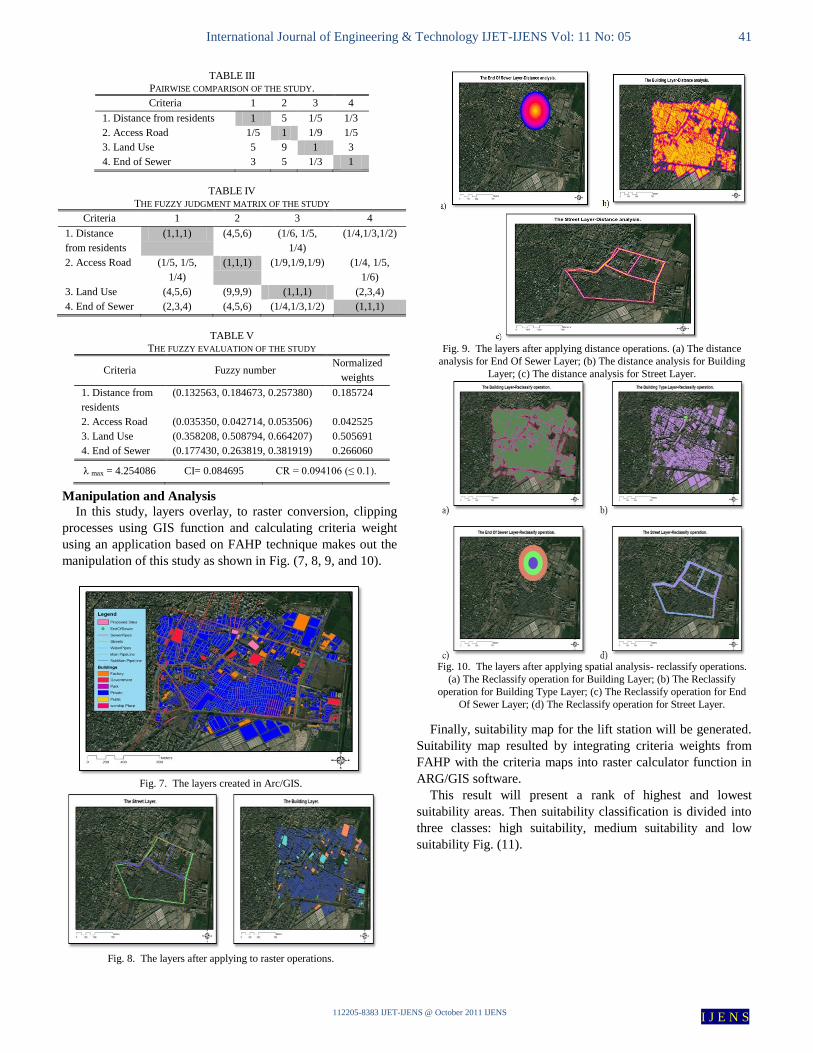
Fig. 9. The layers after applying distance operations. (a) The distance
analysis for End Of Sewer Layer; (b) The distance analysis for Building
Layer; (c) The distance analysis for Street Layer.
Fig. 10. The layers after applying spatial analysis- reclassify operations.
(a) The Reclassify operation for Building Layer; (b) The Reclassify
operation for Building Type Layer; (c) The Reclassify operation for End
Of Sewer Layer; (d) The Reclassify operation for Street Layer.

International Journal of Engineering & Technology IJET-IJENS Vol: 11 No: 05 42
112205-8383 IJET-IJENS @ October 2011 IJENS I J E N S
IV. RESULT AND DISCUSSION
The criteria considered when determining the suitable
location: distance from residents, access Road, existing
utilities, land use, end of sewer and area. Existing utilities
criterion is a constraints which means the suggested sites
cannot intersect with existing utilities. An area criterion is also
a constraint as sites with area smaller than the required are
ignored. Using GIS capabilities: Criteria Maps were
converted to raster then they were classified into three classes:
high suitability, medium suitability and low suitability. The
results are shown in Fig. (10).
Using a developed application using VisualBasic.Net
adopting MCDM –FAHP, the expert's judgments were fed into
the application designed and the result shown in Fig. (13).
The calculated CR was 0.094106 from Eq. (9) indicates a
reasonable level of consistency in the pairwise comparisons
and the weights are accepted. Then, the integration between
GIS and FAHP weights is done using Spatial Analyst
extension of Arc/GIS (Raster Calculator) to multiply weights
obtained with the Criteria Maps. The result is the suitability
map shown in Fig. (11). Then the map was classified into high
suitability, medium suitability and low suitability.
By overlaying the proposed sites map - Fig. (12) - with the
generated suitability map - Fig. (11) - , we concluded that site1
is the most suitable site, site 2 has medium suitability and site
3 is unsuitable as shown in Fig. (12) and (Table VI). By
comparing the results with the criteria determined for the study
and the vector weights which based on the experts opinion we
found that site 1 which is the most suitable site had a land use
of public type which is considered no-cost site, the nearest site
to the end of sewer, the farthest from building and have
adequate access to two roads. While for site 2, its land use
type is park that means there is a cost to build there and farther
than site 1 considering the end of sewer and is as far as site 1
and have access to two roads. For site 3, its land use is private
that makes it the last option to select, the farthest site to the
end of sewer, very close to building and has no access to any
road.
V. CONCLUSION
This paper proposed integration between fuzzy MCDM
approach represented by the fuzzy AHP and GIS to select the
best location for a wastewater lift station. A real world case
study from El-Mahalla El-Kubra was selected. In the proposed
model, an application was designed in visualbasic.net
environment that adopt FAHP to calculate the weights of the
criteria, and GIS functionality was used to extract the
suitability map with the weights calculated.
As a result of the study, we find that the proposed model is
practical and effective identifying suitable sites with respect to
multiple criteria. The model uses fuzzy set theory instead of
dealing with crisp numbers to imitate the real life situations.
In future research, we recommend to use different
defuzzification methods like the CFCS method, the fuzzy
mathematical programming method or the fuzzification of
Saaty’s method (the Lamda-Max method) to convert the TFN
into crisp number. Also, we recommend applying this model
on a more complex problem.
Fig. 11. suitability Map for a wastewater lift station.
Fig. 12. The Proposed Sites map.
TABLE VI
THE ASSESSMENT OF THE PROPOSED SITES.
Site Assessment
Site 1 High suitability
Site 2 Medium suitability
Site 3 Unsuitable
Fig. 13. The calculated weights in the application.

International Journal of Engineering & Technology IJET-IJENS Vol: 11 No: 05 43
112205-8383 IJET-IJENS @ October 2011 IJENS I J E N S
REFERENCES
[1] Burnaz, S. and Topcu, Y. I., 2006. A multiple-criteria decision-making
approach for the evaluation of retail location. Journal of Multi-Criteria
Decision Analysis, 14: 67–76
[2] Saaty, T.L., 1980. The Analytic Hierarchy Process: Planning, Priority
Setting, Resource Allocation. McGraw-Hill, New York, NY.
[3] Dey, P.K., Ramcharan, E.K., 2008. Analytic hierarchy process helps
select site for limestone quarry expansion in Barbados. Journal of
Environmental Management 88: 1384–1395.
[4] Vahidnia, M.H., Alesheikh, A.A., and Alimohammadi, A., 2009.
Hospital site selection using fuzzy AHP and its derivatives. Journal of
Environmental Management, 90 (10): 3048-3056.
[5] Chan, F.T.S., Chan, M.H., Tang, N.K.H., 2000. Evaluation
methodologies for technology selection. Journal of Materials Processing
Technology, 107: 330–337.
[6] Chang, N., Parvathinathan, G., and Jeff, B. B, 2007. Combining GIS
with fuzzy multicriteria decision-making for landfill siting in a fast-
growing urban region. Journal of environmental management, 87(1):
139-153.
[7] Bottero, M., Comino, E. Riggio, V., 2011. Application of the Analytic
Hierarchy Process and the Analytic Network Process for the Assessment
of Different Wastewater Treatment Systems. Environmental
Modellingand Software, Volume 26, Issue 10:1211-1224.
[8] Levary, R. R. and Wan, K. . 1998. A Simulation Approach for Handling
Uncertainty in the Analytic Hierarchy Process. European Journal of
Operational Research 106 (1): 116–122.
[9] Vivien, Y.C. C., Hui-Pang, L., Chui-Hua, L., James, J.H. L., Gwo-
Hshiung, T. and Lung-Shih, Y., 2011. Fuzzy MCDM approach for
selecting the best environment-watershed plan. Applied Soft
Computing, Volume 11, Issue 1: 265-275.
[10] Onut, S., Efendigil, T., and Soner, K. S., 2010. A combined fuzzy
MCDM approach for selecting shopping center site: An example from
Istanbul, Turkey. Expert Systems with Applications, 37 (3): 1973-1980
[11] Mikhailov, L., Tsvetinov, P., 2004, Evaluation of services using a fuzzy
analytic hierarchy process. Applied Soft Computing, 5: 23–33.
[12] Zadeh, L. A., 1965, Fuzzy sets. Information and Control, 8: 338–353.
[13] Chang, D.Y., 1996. Applications of the extent analysis method on fuzzy
AHP. European Journal of Operational Research, 95 (3), 649–655.
[14] Erensal, Y.C., Oncan, T., Demircan, M.L., 2006. Determining key
capabilities in technology management using fuzzy analytic hierarchy
process: a case study of Turkey. Information Sciences, 176 (18): 2755–
2770.
[15] Shariff, A. M. and Wan, M.D., 2008, Land suitability study using GIS
and MCDA in agriculture Activities: a land suitability study for
harumanis mango in perlis using GIS and MCDA, GIS bulletin, 2, ISSN
1394 - 5505, p33-43.
[16] "Public Works Design Manual", 2007, wastewater lift station design
standards,
http://www.thebuilders.com/missy's%20updates/Wastewater_Lift_Statio
n_Design_Manual.pdf.
[17] Water Quality Program, 2008. Criteria for Sewage Works Design,
Department of Ecology. State of Washington, Publication No. 98-37
WQ.
[18] Joint Departments of the Army and Air Force, USA, Technical Manual
TM 5-814-1/AFM 88-11, Volume 2, Sanitary and Industrial Wastewater
Collection-Pumping Stations and Force Mains.