committee of the whole agenda - mississippimills.ca · j. information list, task list and meeting...
TRANSCRIPT
Municipality of Mississippi Mills
COMMITTEE OF THE WHOLE AGENDA
Tuesday, February 16, 2016
Immediately following Council beginning at 6:00 p.m. Council Chambers, Municipal Office
A. APPROVAL OF AGENDA B. DISCLOSURE OF PECUNIARY INTEREST C. DELEGATIONS/PRESENTATIONS/PUBLIC MEETINGS
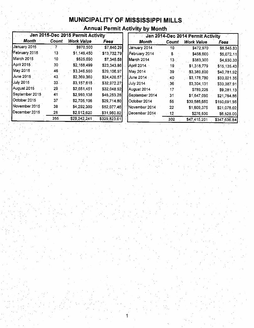
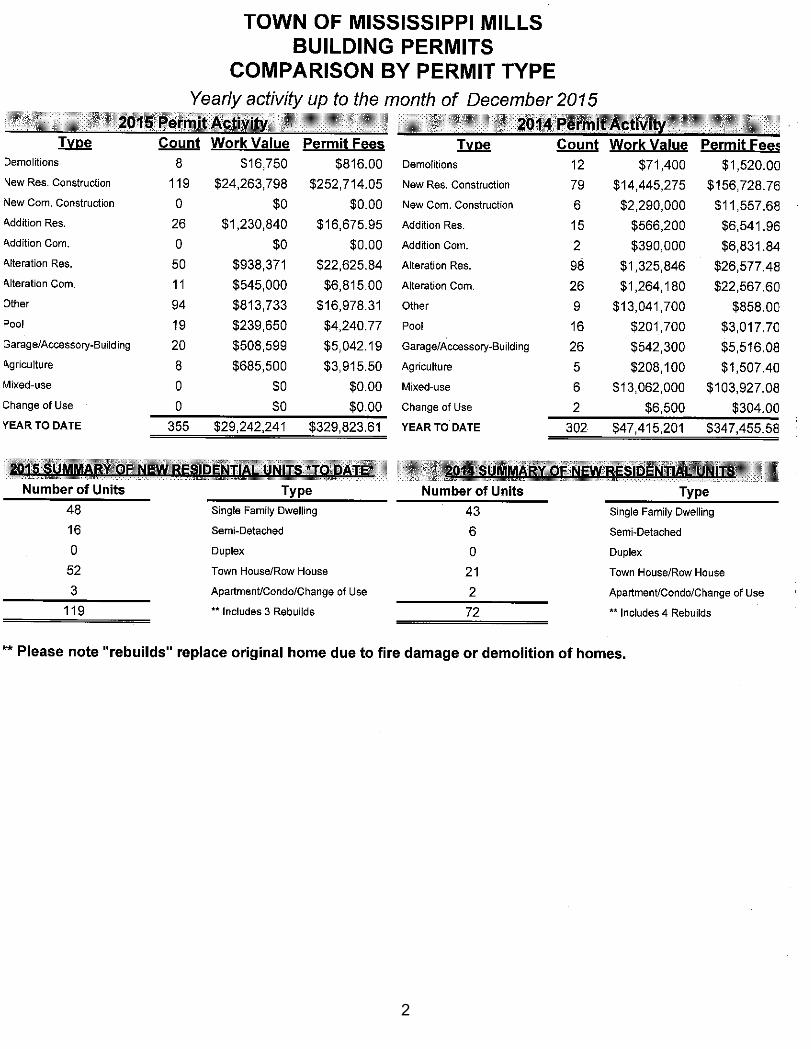
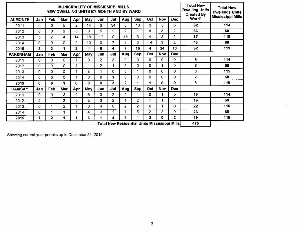
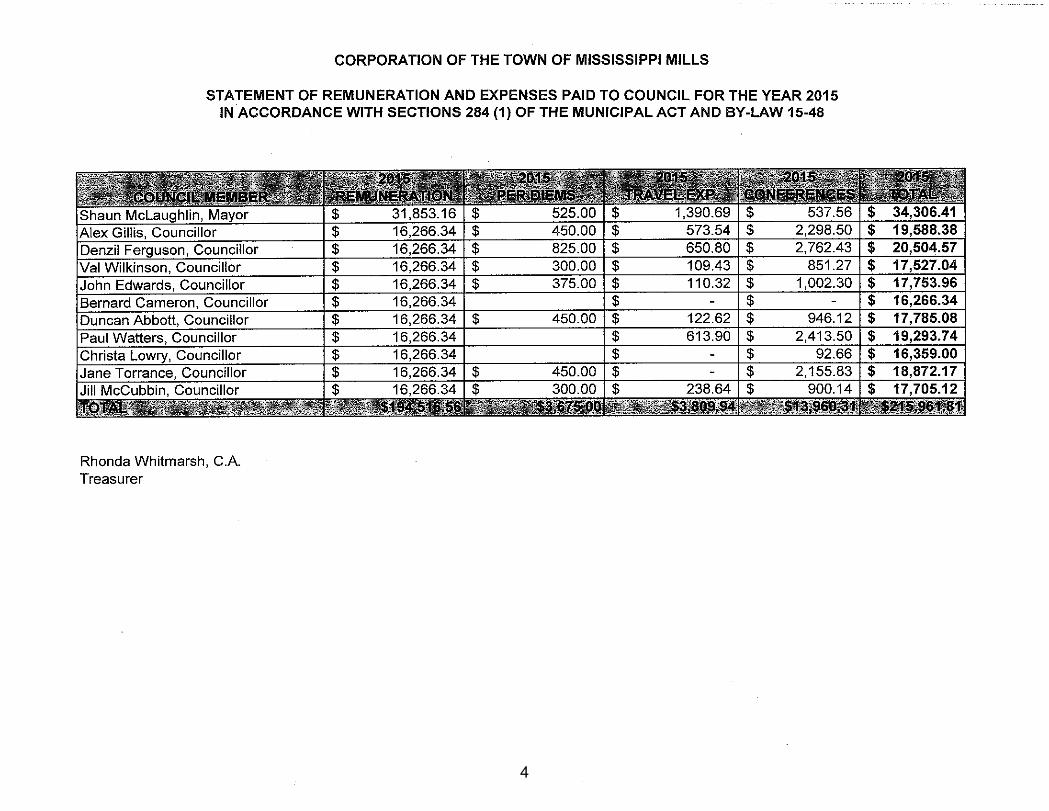
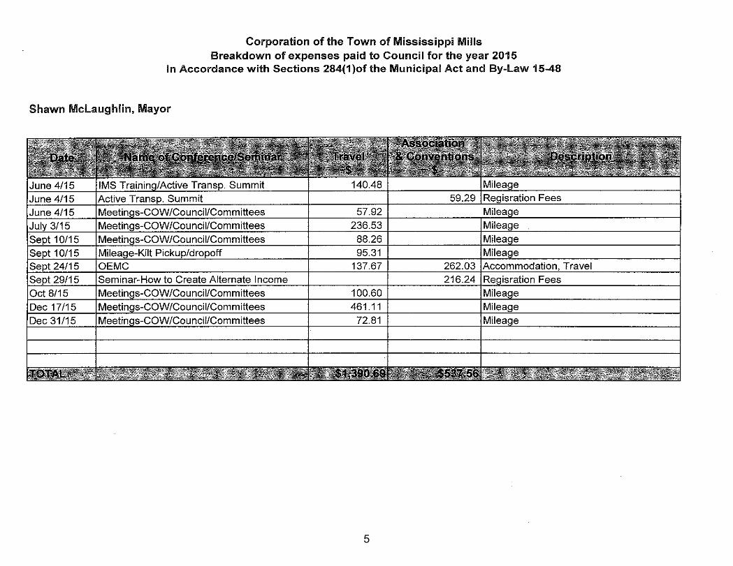
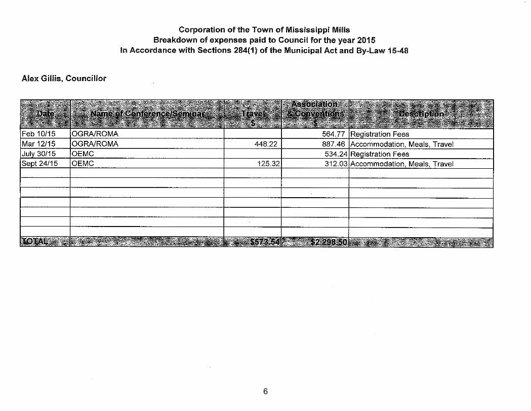
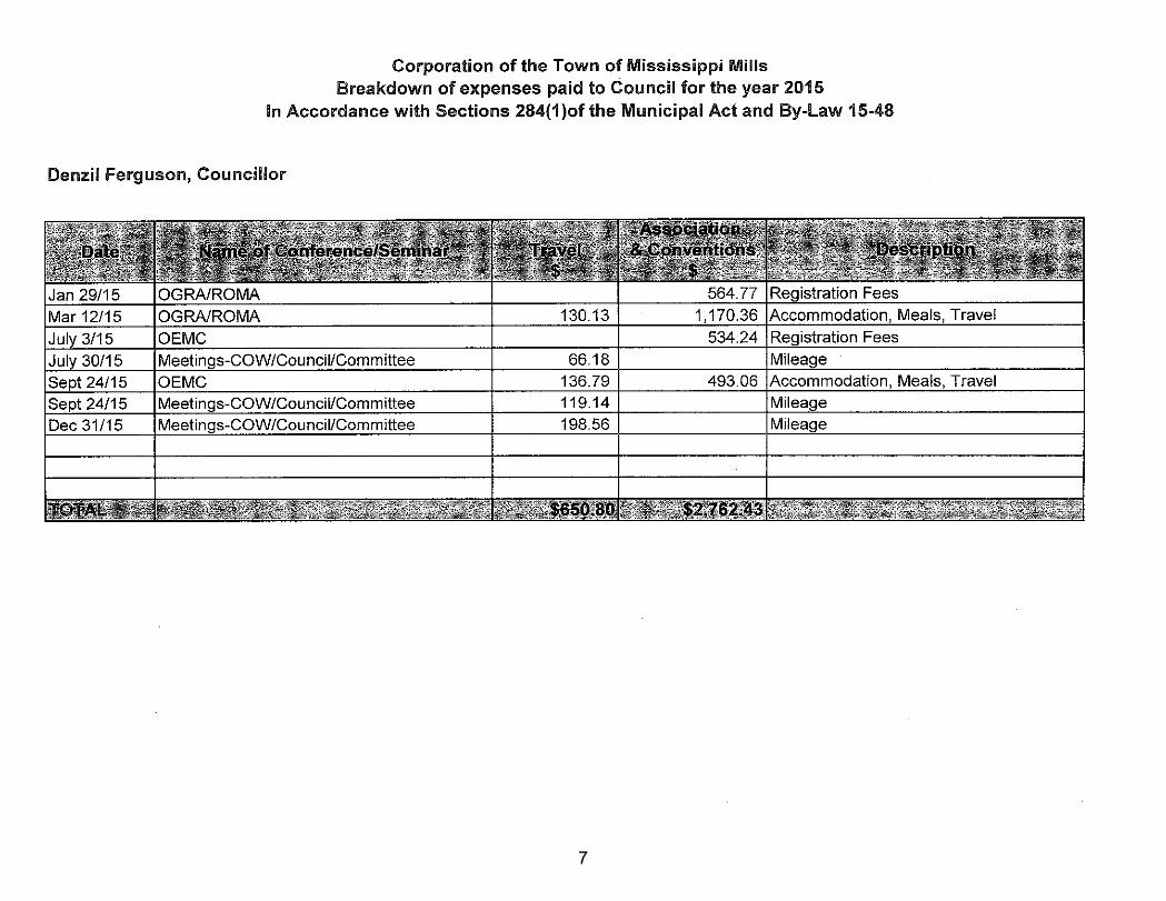
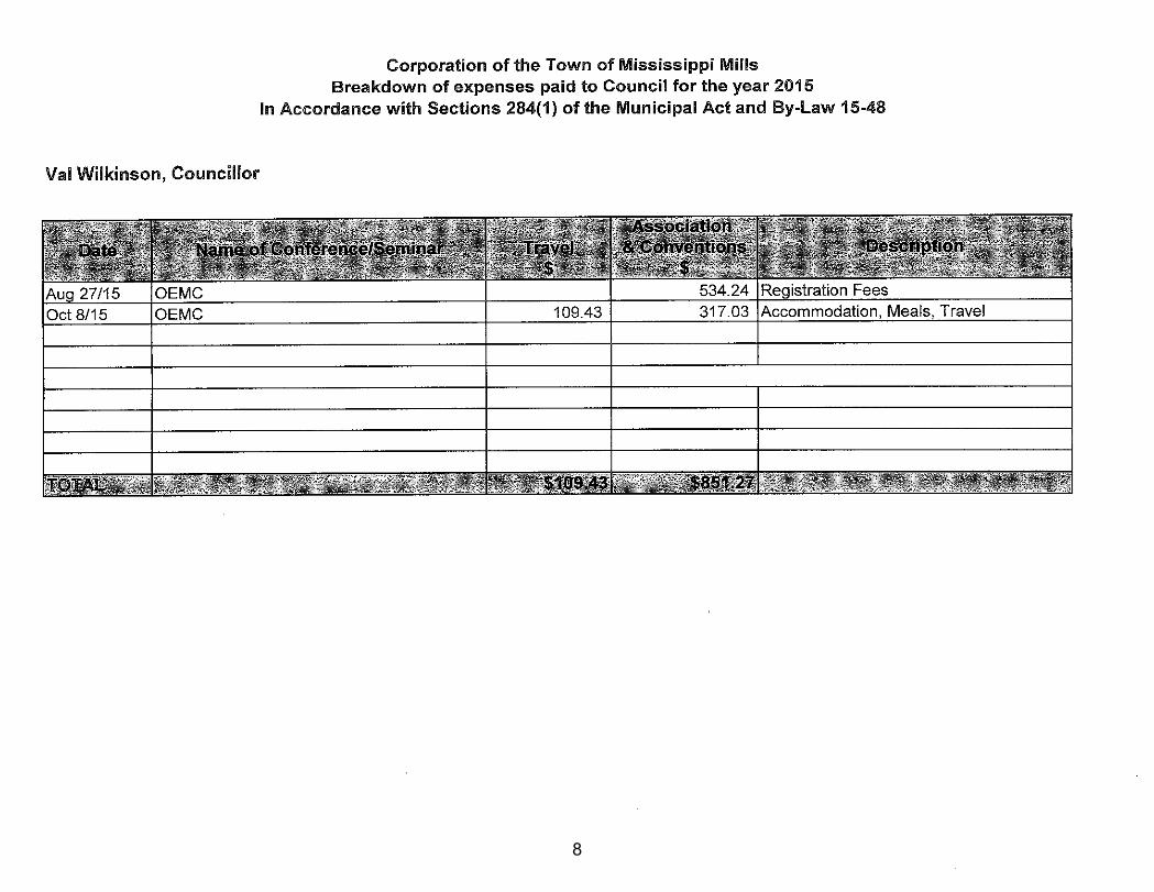
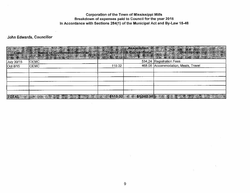
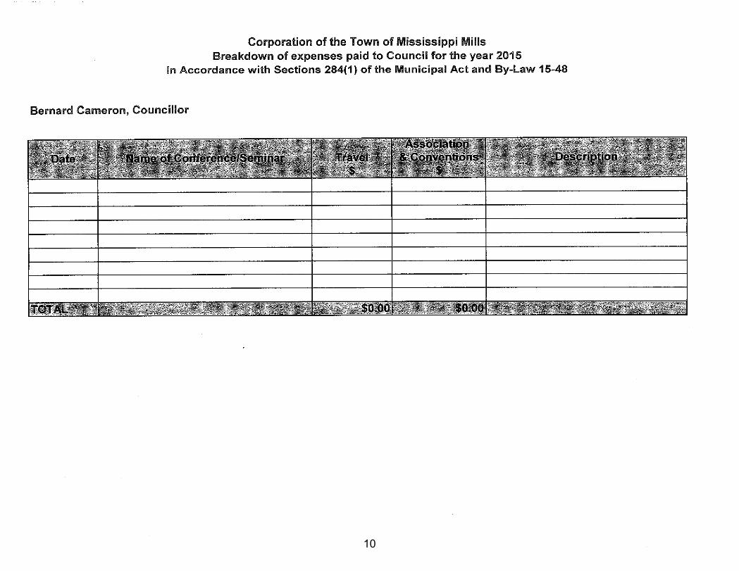
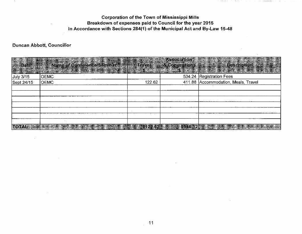
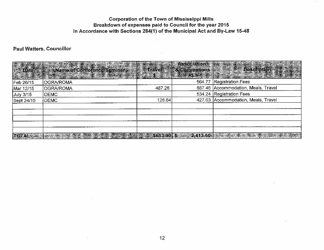
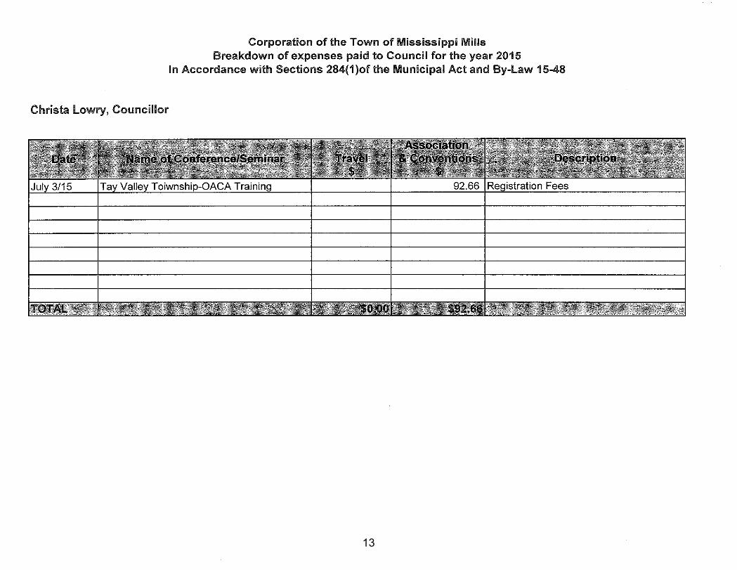
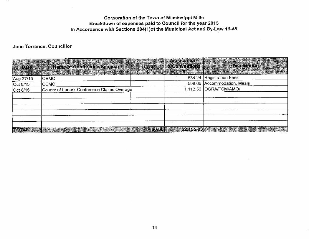
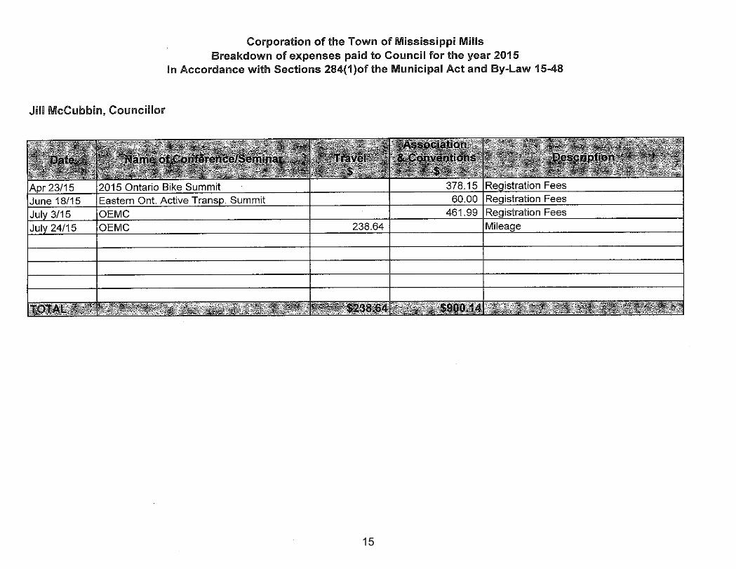
D. CONSENT MATTERS (for information) 1. Building Permits – December 31, 2015 Pages 1-3 2. Statement of Council Remuneration and Expenses 2015 Pages 4-15
E. STAFF REPORTS (for action and direction) Planning and Development 1. Updated Sign By-law #2 Pages 16-40 2. White Lake Campground Expansion Pages 41-99 3. Official Plan and Zoning Amendment Kerry – Elgin Street Pages 100-125 4. Zoning Amendment Levi – Lots 5 and 6, Malloch Section Pages 126-137 Finance and Administration
1. 2015 Transfers to Reserves for Capital Pages 138-139 2. 2016 Municipal Grants Pages 140-142 3. Corporate Sponsorship Recommendation Pages 143-159
F. OTHER/NEW BUSINESS
Petition –White Lake Campground Expansion Pages 160-166
G. CLOSED SESSION/IN CAMERA
Block 42, Plan 89, Ramsay and Lot 24, Conc 9, Ramsay - Disposition of Land (Municipal Act s. 239 2(c))
H. NOTICE OF MOTION
I. MINUTES Motion to approve: Committee of the Whole Minutes – February 2, 2016 Pages 167-172
Committee of the Whole Agenda February 16, 2016 Page 2
Motion to receive: Daycare Advisory – December 10, 2015 Pages 173-176 Recreation and Culture Cost Sharing - January 13, 2016 Pages 177-180 Canada 150 – February 2, 2016 Page 181
J. INFORMATION LIST, TASK LIST AND MEETING CALENDAR 1. Information List Page 182 2. Meeting Calendar Pages 183-184
K. ANNOUNCEMENTS/QUESTIONS OF STAFF Council Meeting – March1, 2016, 6:00 p.m., followed by Committee of the Whole Council Meeting – March15, 2016, 6:00 p.m., followed by Committee of the Whole
L. ADJOURNMENT
1
2
3
4
5
6
7
8
9
10
11
12
13
14
15
THE CORPORATION OF THE MUNICIPALITY OF MISSISSIPPI MILLS
BUILDING REPORT MEETING DATE: February 16, 2016 TO: Committee of the Whole FROM: Len Smith – Chief Building Official SUBJECT: UPDATED SIGN BY-LAW #2 RECOMMENDATION: THAT Committee of the Whole recommends that Council approve the updated Sign By-Law. BACKGROUND: A draft of the updated Sign By-law was presented to the Committee of the Whole on December 15, 2015. Members requested a review of the following: Digital Signs (distance between), Banner Signs (being permitted for limited timeframes and meeting flame spread requirements), Merchandise Displays (sizes and amounts), Downtown Zone (the physical area of the downtown zone) and the requirements for hold harmless and insurance for signs on municipally-owned land. DISCUSSION: Digital Signs – A common setback of 30m (98.4ft) is used in other municipalities. It is recommended that this be used as a starting point for a minimum separation distance. This will be monitored closely for the first year and then amended accordingly, if necessary. Banner Signs – It is recommended that banner signs be permitted in specific zones (commercial, rural and institutional) where their use is commonly requested. There are specific guidelines required in those sections for their use. Banners fall into the temporary sign timeframes of a maximum of 60 days. Merchandise Display – It is recommended that this section be removed until a more fulsome review can be conducted. It may be that these signs are better addressed in a separate by-law. Downtown Zone – The downtown zone has been limited to the downtown commercial areas as outlined in Zoning By-Law 11-83. Hold Harmless & Insurance Requirements – The Municipality’s insurance provider stated that waiving these requirements is strongly not advisable as it could result in undue legal claims. They strongly recommended leaving these requirements in the by-law.
16
SUMMARY: It is recommended that Council approve the proposed Sign By-law to provide more clarity on the regulations and to ensure fairness and equity to all user groups. Respectfully submitted, Reviewed by, _________________________________ ______________________________ Len Smith – Chief Building Official Diane Smithson, CAO _________________________________ Stephen Stirling RPP MCIP, Municipal Planner Attachments: 1. Draft Sign By-law v.4
DRAFT Version #4 February 16, 2016
17
THE CORPORATION OF THE MUNICIPALITY OF MISSISSIPPI MILLS
BY-LAW NO. 16-xx
BEING a by-law for prohibiting and regulating the erection and maintenance of signs, advertising devices, posting of notices, as well as temporary/mobile signs, and awnings within the Corporation of the Municipality of Mississippi Mills. WHEREAS, pursuant to Section 11(3) of the Municipal Act, R.S.O. 2001, Chapter c.25 as amended, a municipality may pass by-laws for prohibiting or regulating signs and other advertising devices, may define a class or classes of signs or other advertising devices, and may specify a time period during which signs or other advertising devices in a defined class may stand or be displayed in the municipality and may require the removal of such signs or other advertising devices which continue to stand or be displayed after such time period has expired; NOW THEREFORE the Council of the Corporation of the Municipality of Mississippi Mills enacts as follows: 1. TITLE, SCOPE AND CONFORMITY REQUIREMENTS
A by-law to regulate within the Corporation, devices which are erected or intended to be erected or located or attached to any property to attract attention to any business, product, activity, service, or facility. This shall include among other things, flags, banners, pennants, lights, inflatable devices and/or objects intended for said purposes. 1.1 SHORT TITLE This By-law may be cited as the 'Sign By-law'. 1.2 APPLICATIONS No sign shall be erected, enlarged or placed for any purpose, within the boundaries of the Corporation, except as permitted by this By-law, and in conformity with the provisions of the most up-to-date current governing version of the Ontario Building Code .
2. GENERAL DEFINITIONS
Building Inspector - Means the Building Inspector that is appointed by the Municipality.
Chief Building Official - Means the Chief Building Official that is appointed by the Municipality.
Committee - Means the Committee of the Whole for the Municipality Corner Lot Sign Triangle – Means a right angle triangle area that extends 6m (20ft) in distance up each property line from an intersecting point of two (2) property lines that are located at a corner of a travelled maintained road owned by the Municipality and are connected with a line between the furthest most points to form a triangle. Within this area no Sign is permitted at any time. Council - Means the elected council for the Municipality Downtown Zone – Means the area outlined in Schedule “B”
18
Driveway Sight Triangle – Means a right angle triangle area that extends 3.05m (10ft) up the edge of a travelled portion of a driveway or entrance curb cut starting at the property line and along the property line along Frontage for a total of 3.05m (10ft) and are connected with a line between the furthest most points to form a triangle. Within this area no Sign is permitted at any time. Encroachment Agreement - Means a legal agreement entered into by an Owner and the Municipality for placement of a Sign that encroaches over or onto Municipally Owned Land. Frontage - Means the Lot Line that fronts a Municipality owned and maintained road allowance. Growing Season - Means the natural growing season and selling for any crop or product as determined by the specifics of the product. (e.g. honey, corn, strawberries etc) Highway - Means the following: County Roads #7B, 9, 11, 16, 16A, 17, 20, 22, 24, 29, 49 and Kings Highway 7 Hold Harmless Agreement – Means an agreement entered into and signed by an Owner and the Municipality that names the Municipality as additionally insured for a liability amount determined by the Municipality. Letter of Authorization – Means a letter of authorization from an Owner of a property to a third party applicant that will be installing a Sign on the owner’s property. Local Communities - Means but is not limited to neighboring communities that abut the Municipality boundary line. Lot Line - Means the division line between a utility or right-of-way or a lot, or the division line between two lots. Maximum Sign Height - Means the measured height from grade below the Sign to its highest most point of the Sign. Minimum Sign Height - Means the measured height from grade below the Sign to its lowest most point, and does not include legs, pylons, or other supporting members. Multiple Business/Plaza Sign/Shopping Centers – Means a gathering of more than two (2) businesses within a single building or multiple buildings on one (1) parcel of land that may or may not be under one management group. Municipality – Means the Corporation of the Municipality of Mississippi Mills. Municipally Owned Land - Means land under the ownership of the Municipality and/or land under the ownership of the Corporation of the County of Lanark and may include but is not limited to parks, road right of ways, sidewalks, boulevards and vacant lands. Not For Profit / Community Organizations - Means a Not For Profit corporation that carries on its activities without the purpose of gain for its members. It is incorporated under the Corporations Act as a corporation that does not issue shares. It must have not for profit purposes and use any profits to promote those purposes. The most common types are charitable (including religious organizations), social clubs, service clubs, sporting and athletic
19
organizations, professional and trade associations, rate payers associations and other community organizations and events.
Offsite Advertising Signs – Means a Billboard Sign that advertises commercial goods or services that are located on a different property from which the sign is located. Such goods and services may include but are not limited to housing developments, commercial stores, real-estate services, contractors, restaurants, and pancake houses.
Owner – Means the legal Owner of a property. Portable - Means easily relocated from place to place and not permanently affixed to ground or structure. Private Land - Means privately owned land. Sign – Means an advertising device or notice, and means any medium including its structure and other component parts which is used or is capable of being used to attract attention to a specific subject matter. Sign Area - Means the number of square meters on the surface of a Sign including the border and frame where there is no border it shall include the area of the surface lying within the extremities of the Sign. Substantially Removed – Means a Sign structure that is demolished, moved or has its support legs, foundations or main mounting structure taken down and rebuilt to an amount of more than 50% of the structure. Zoned - Means a zoning designation assigned by the Zoning By-Law that applies to a parcel of property. Zoning By-Law - Means the most current Zoning Bylaw in force and effect within the Municipality.
3. SIGN DEFINITIONS
Awning Sign - Means a roof like projection supported entirely from the exterior wall of the building composed of rigid or non-rigid materials except for the supporting framework. All awnings containing advertising are regulated by this By-Law and the Ontario Building Code. A Building Permit and a Sign Permit Fee will be assessed to all awning Signs and any application shall have an attachment detail approved by a Professional Structural Engineer. Awnings that encroach over Municipally Owned Land will require approval from the Committee, a Hold Harmless Agreement, and Encroachment Agreement and an insurance certificate provided naming the Municipality as additionally insured in place prior to installation. Banner and Inflatable Sign - Means a Sign composed of lightweight, flexible material such as cloth, plastic, canvas or other similar material, and which is mounted at each end or at the bottom so as to allow movement by atmospheric conditions. Including signs such as but not limited to: inflatable signs, waving arm signs, signs on sides of buildings and advertising balloons but does not include a Vertical Flag Signs. Billboard Sign – Means a Double Faced Sign that is an In Ground Sign erected and maintained for Offsite Advertising purposes and contains no more than one individual business advertising per Sign face and has a Sign face area that is no less than 4.65m2 (50ft2) and no greater than 10m2 (108ft2) per Sign face.
20
Commercial Construction Identification Sign - Means an On Ground Sign that is Portable in nature and is temporarily erected on site to advertise the builder and any other sub trades working on a commercial building site. The Sign may be erected no sooner than permit issuance by the Building Department and must be removed no later than seven (7) days after permit closure. Commercial Construction Identification signs are limited to one (1) Sign on any work site and may contain multiple builder and subcontractor identifications. Sign area shall not exceed 2.97 m2 (32ft2) and have a maximum height of 2.44m (8ft) Commercial Real-Estate Sign – Means a Stake Sign, Pin Sign, In-Ground Sign, or Wall Sign that is placed on a parcel of land that is for sale, lease or rent at the time of placement of the Sign. Wall Signs shall be limited to one Sign per street frontage wall of any building and are restricted to the size under the Wall Sign definition. All other permitted signs are restricted to a maximum size of 0.74m2 (8ft2) and shall have no more than one (1) single faced Sign for every 91.4m (300ft) of street Frontage. Commercial Sandwich Board Sign – Means a Sign which is Portable in nature and does not have more than two (2) sides with an area greater than 0.65m2 (7ft2). Additionally the Sign shall not exceed 0.6m (2ft) in width and shall be between 0.46m (1.5ft) and 1.06m (3.5ft) in height and is supported on ground not in ground. One (1) Commercial Sandwich Board Signs are permitted per frontage for each business within a building containing multiple businesses. Each sign shall have a minimum separation of 1.2m (4ft) from adjacent Commercial Sandwich Board Signs and any In Ground Sign located on the same property. No Commercial Sandwich Board Sign shall be issued without a minimum of 1.5m (5ft) clear space on sidewalk for passage as per Ontario’s Barrier Free Requirements. Commercial Sandwich Board Signs will require a Hold Harmless Agreement if placed on Municipally Owned Land and shall be renewed in writing to the Chief Building Official every yearly by no later than April 1st of each year and shall remain in the approved location at all times. Commercial Sandwich Board Signs shall not interfere with traffic, snow removal, garbage and recycling pick up and shall be removed in times of inclement weather (blizzards etc) and high winds as to avoid being blown into Municipally Owned Land. Community Event Sign – Means a Stake Sign, Pin Sign, or On Ground Sign that is erected for advertising of community events that take place within the Municipality or neighbouring communities. Such events include but are not limited to fairs, truck pulls, festivals, agricultural events, and bake sales for churches and community groups. A community event Sign must adhere to all size restrictions of the Sign type as indicated in this By-Law and shall require permission from the Chief Building Official prior to installation on Municipally Owned Land. Digital Sign - Means an interior or exterior Sign that is remotely changed on or offsite and incorporates a technology or method allowing Sign copy to be changed without having to physically or mechanically replace the Sign face or its components. Such Signage may include but is not limited to: LED, LCD, Plasma Screens and Projectors, which may depict and/or project text, pictures and/or videos, Digital Reader Boards which depict moving or static text only. Exclusions: Static Digital Temperature Displays, Gas Price Displays, Static LED Open Signs, Date/Time Displays.
Directional Sign - Means a Sign indicating direction to be followed to attain a certain destination with only the destination and/or distance identified. Such Sign shall be installed with a minimum height above grade of 0.6m (2ft) to a maximum height above grade of 1.83m (4ft) with a maximum area of 0.18m2 (2ft2) and are not permitted on Municipally Owned Land. Directional signs are limited to a maximum of three (3) signs for any legally permitted commercial business or subdivision.. Directional Signs shall be placed only on Commercially
21
zoned or Rural / Agricultural zoned land. Home based businesses are not permitted to have any directional signage.
Double Faced Sign - Means a Sign with two faces. A double faced Sign may be a “V” shaped Sign, or a Sign perpendicular to the roadway with two separate faces. Downtown Commercial Sandwich Board Sign – Means a Sign which is Portable in nature and does not have more than two (2) sides with an area greater than 0.65m2 (7ft2). Additionally the Sign shall not exceed 0.6m (2ft) in width and shall be between 0.46m (1.5ft) and 1.06m (3.5ft) in height and is supported on ground not in ground. A maximum of one (1) sandwich board sign per frontage in commercial zones will be permitted in the Downtown Zone. Multiple store entities may advertise on one downtown commercial sandwich board sign as long as all entities are contained on the Private Land the Sign is placed in front of. No Downtown Commercial Sandwich Board Sign shall be issued without a minimum of 1.5m (5ft) clear space on sidewalk for passage as per Ontario’s Barrier Free Requirements. Commercial Sandwich Board Signs will require a Hold Harmless Agreement if placed on Municipally Owned Land and shall be renewed in writing to the Chief Building Official every yearly by no later than April 1st of each year and shall remain in the approved location at all times. Commercial Sandwich Board Signs shall not interfere with traffic, snow removal, garbage and recycling pick up and shall be removed in times of inclement weather (blizzards etc) and high winds as to avoid being blown onto Municipally Owned Land. Election Sign – Means any candidate Sign that is in place for any Municipal, Provincial or Federal election. Elections signs must be placed in conjunction with the rules and regulations of the respective Election Act that is governing at the time of erection. Additionally all Election Signs must be removed no later than seven (7) days after conclusion of the election. Fascia Sign – Means a single faced Sign located in such a manner that the Sign is parallel to the main wall of the building to which it is attached. Fascia Signs shall not extend longer than the wall it is installed on unless building is located on a corner. Fascia Signs shall be installed no less than 2.3m (7.5ft) above finished grade and shall not project more than 0.3m (1ft) from the surface of the wall, and may not be placed over any required window, door, HVAC openings or exit facilities. Farm Sign - Means a single or Double Faced In Ground Sign erected to advertise information that includes but is not limited to name, established date, contact info and slogans. Farm Signs shall not exceed 4.5m2 (48ft2) in Sign area. Fence Sign – Means any Sign that is placed on a fence with Offsite Advertising that is visible from an open municipal thoroughfare or Highway. Exclusions are any Incidental Commercial / Industrial Sign located on the Private Land in which it applies, and advertising for business entities that are contained on the property in which the fence is located. Any Sign placed on a fence for advertising shall not exceed 2.2m2 (24ft2) and cannot be a Luminous Sign or Illuminated Sign. Home Based Business Ground Sign – Means an In Ground Sign for a valid home based business located on the property the Sign is placed on with a single face that is parallel to a Road or Highway or a double faced Sign that is perpendicular to a Road or Highway. Minimum height above grade for all Home Based Business Ground Signs shall be not less than 0.6m (2 ft) and the maximum height shall not exceed 1.2m (4ft), and maximum Sign area shall not exceed 0.37m2 (4.0ft2). Home Based Business Ground Signs shall be not permitted to be Illuminated, Luminous Signs or Digital Signs
22
Home Based Business Wall Sign – Means a Sign for a valid home based business located on the property the Sign is placed on located in such a manner that the Sign is parallel to the main wall of the building to which it is attached and shall face a Road or Highway. The Sign shall be installed with a minimum height above grade of 0.6m (2.0ft) to a maximum height above grade of 1.83m (6ft) with a maximum area of 0.37m2 (4.0ft2) and projection of 0.08m (3 in) Such signage may be installed on available wall space and may not be placed over any required window, door, HVAC openings or exit facilities. Home Based Business Wall Signs shall be not permitted to be Illuminated, Luminous Signs or Digital Signs Highway Advertising Sign – Means a Billboard Sign that is located on a property abutting a defined Highway right of way that advertises offsite services, sales, and/or products. No Highway Advertising Sign shall be issued abutting any Highway within the boundaries of the Municipality. Illuminated Sign - Means a Fascia Sign or In Ground Sign which is lit downward from an external lighting source that is not permitted to allow upward transmission of light or to flash or be animated in any way. Additionally these signs should use low wattage bulbs and should be extinguished outside of normal operating hours. All external lighting sources for any illuminated sign shall be in compliance with Section 2.2 of By-Law 03-62 Outdoor Illumination and Control Light Pollution. In Ground Sign – Means a single faced of Double Faced Sign that is supported in-ground with a minimum depth of 4’ for frost coverage and is constructed to withstand environmental uplift and is not attached to any building. Minimum height above grade for all ground signs shall be not less than 0.6m (2 ft) and maximum height shall not exceed 2.44m (8ft), and maximum Sign area shall not exceed 4.5 m2 (48ft2). Incidental Commercial/ Industrial Signs – Means signs that are installed on a single parcel of property and are accessory in nature to the main permitted use. Such signage may include but is not limited to: Parking Signs, entrance/exit signs, menus, hours of operation, loading zone, pregnancy parking Signs, no smoking signs, and no parking signs. Index Sign – Means a Wall Sign or In Ground Sign posted on private property that lists multiple occupants of a building consisting of one main entry that contains multiple tenants and shall not exceed one (1) Sign per individual building on any one parcel of land. The Sign may have a Sign face of not greater than 1.11 m2 (12ft2) and a in the case of an In Ground Sign shall not have a height greater than 1.8m (6ft). Luminous Sign - Means a Sign lighted by an internal source that is not permitted to be flashing or animated in any way. Additionally these signs should not be directed towards adjacent properties, should use low wattage bulbs and should be extinguished outside of normal operating hours. Luminous Signs shall not have a white or light colored lit surface area that exceeds 30% of the Sign face to facilitate compliance with Section 2.2 of By-Law 03-62 Outdoor Illumination and Control Light Pollution. Motor Vehicle Advertising – Means a Sign affixed to a vehicle for advertising that is placed on a property and is in an immobile status. Such signage includes but is not limited to signs affixed to motorized vehicles (licensed or unlicensed), signs on wheels (on trailers), and transports trailers. In use work vehicles parked in residential driveways, or in use as every day transportation with permanent or magnetic advertising are permitted but must be moved every 48 hours. Municipal Sign - Means any Sign that is erected by the Municipality for any services, advertising or announcements.
23

Mural Signs - Means a Sign that is applied directly to the surface of a building, structure or displayed merchandise by means of paint, or other marking substances to create a Sign for advertising. Mural Signs include but are not limited to artistic renderings, current advertisements, and religious statements. Does not include a Window Sign. On Ground Sign – Means a Portable single faced or Double Faced Sign that is not an In Ground Sign or a Portable Sign and is placed for temporary advertising. On ground signs are limited to maximum size height of 1.2m (4ft) and shall not exceed 1.5m2 (16ft2) in Sign face and shall not be erected or displayed at times of heavy winds, snow storms, snow removal, or any similar circumstance where their placement could become a danger due to environmental conditions. On Ground Signs require a Hold Harmless Agreement if placed on Municipally Owned Land and shall be renewed in writing to the Chief Building Official every year by no later than April 1st of each year and shall remain in the approved location at all times. On Ground Signs are not permitted in a defined Driveway Sign Triangle or Corner Sight Triangle. Portable Sign – Means a single faced or Double Faced Sign that is not an In Ground Sign or an On Ground Sign that includes but is not limited to wood signs with weighted bottoms, spider leg signs, and wheeled portable signs. Portable Signs shall not exceed 2.23m2 (24ft2) in Sign area and have a maximum height of 2.4m (8.0ft) and have a minimum of 500lbs of weight applied to base for resistance of movement by environmental conditions or have a detail provided by a Professional Structural Engineer provided for alternate anchorage methods.. On Ground Signs are not permitted on Municipally Owned Lands, Driveway Sign Triangle or Corner Sight Triangle.
Pin Sign – Means a Sign fastened to small metal rods that penetrate the ground for support of the Sign. Such signs are temporary in nature and shall be no greater than 0.14m2 (1.5ft2) in area and no higher than 0.91m (3.0ft) above grade and shall not be installed on Municipally Owned Land. Pin signs may include but are not limited to seasonal snow removal (See 7.17), apartment for rent, personal items for sale and yard sales. Signs advertising businesses within the Municipalities boundaries are not permitted to advertise with Pin Sign. Produce Stand Signs – Means a Stake Sign, Pin Sign, Residential Sandwich Board Sign, and On Ground Sign that is Portable in nature and is put out to display local produce that is sold on private property. Such Signs shall not exceed 0.56m2 (6.0 ft2) in area and are permitted to be displayed on private property only during operation hours of the produce stand. The maximum number of Signs shall not exceed two (2). Produce stands that have a Mural Sign on the structure are permitted and it will not count towards the total Sign count. Property Identification Number Sign – Means 911 identification Sign that is placed on Municipally Owned Land for identification of property for emergency services personnel to locate property in case of emergency Public Authority Signs – Means an In Ground Sign, Fascia Sign, Wall Sign or a Incidental Sign that is in place for Public Authorities which include but are not limited to the County of Lanark, Government of Canada, Province of Ontario, Conservation Authorities, and Schools (for identification and direction only) Residential Construction Identification Sign – Means an On Ground Sign that is temporarily erected on site to advertise the builder and any other sub trades working on a residential building site. Sign may be erected no sooner than permit issuance from the Building Department and must be removed no later than 7 days after permit closure. Residential Construction Identification Signs are limited to one (1) Sign on any work site and may contain multiple builder and subcontractor identifications. Sign area shall not exceed 1.11 m2 (12ft2)
24
and have a maximum Sign Height of 1.8m (6ft). May include a Pin Sign for contracting work taking place on a residential property that does not require a permit (eg. lawn spraying, landscaping, and driveway sealing). Pin Signs can be advertised for a maximum of two (2) weeks after completion of project and must be contained on private property. Residential Incidental Signs – Means a Stake Sign, Pin Sign or Residential Sandwich Board Sign that is Portable in nature and is installed to advertise items including but not limited to seasonal snow removal, apartment for rent, and personal items for sale. Residential Incidental Signs are not permitted on Municipally Owned Land. Residential Mailbox Signs – Means a stationary single or double faced Sign visible from both directions that is perpendicular to the road and is installed above the minimum Canada Post regulated height for a mailbox. Such signs are only permitted to advertise a valid Home Based Business use on the property. Signs are limited to a maximum width of 0.46m (1.5ft) and a height of 0.3m (1.0ft) and shall be securely fastened to not dislodge due to environmental conditions.
Residential Real-estate Sign – means a Stake Sign, Pin Sign, In Ground Sign, or Wall Sign that is placed on a private parcel of land that is for sale, lease or rent at the time of placement of the Sign. Wall Signs shall be limited to one Sign per wall that has Frontage on a Street and are restricted to a maximum size of 0.18m2 (2ft2). All other permitted signs are restricted to a maximum size of 0.18m2 (2ft2) and shall have no more than one (1) single faced Sign for every 91.4m (300ft) of street Frontage. Residential Sandwich Board Sign – Means a Sign which is Portable in nature and does not have more than two (2) sides and meets all requirements elsewhere in this By-law for size and area. Residential Sandwich Board Signs are to be located on privately owned land and are only permitted for a Community Event Sign or a Yard /Garage Sale Sign. Roof Sign - Means any Sign which is located on or above any roof of a building or located on the top of, or above the parapet of a building. A roof Sign shall not include any Sign erected on the wall of a penthouse or other like structure which projects above the roof of a building. Stake Sign – Means a Sign that is fastened to a wooden stake(s) that penetrates the ground for support of the Sign. Such signs are temporary in nature and shall be no greater than 0.14m2 (1.5ft2) in area and no higher than 0.91m (3.0ft) above grade and shall not be installed on Municipally Owned Land. Stake signs may include but are not limited to seasonal snow removal, apartment for rent, personal items for sale and yard sales. Swinging/Perpendicular Sign – Means a Double Faced Sign (not permitted to be a V shape) that has a perpendicular Sign projection supported entirely from the exterior wall of the building composed of rigid materials for both the Sign and the supporting framework. This type of Sign shall have an attachment detail approved by a Professional Structural Engineer. Such signs shall be installed with a Minimum Sign Height of no less than 2.3m (7.5ft) above finished grade and shall not project more than 1.2m (4ft) from the surface of the wall and contain a Sign area of no greater than 0.56m2 (6.0 ft2). Swinging/Perpendicular Signs that encroach over Municipally Owned Land will require approval from the Committee, Hold Harmless Agreement, Encroachment Agreement and an insurance certificate provided naming the Municipality as additionally insured in place prior to installation.
Tree Sign – Means a Sign that is posted on a living tree located on Municipally Owned Land or Private Land.
25
Utility Pole Sign – Means a Sign located on a utility pole that is located on Municipally Owned Land or Privately Owned Land.
Vertical Flag Signs - Are in ground supported advertising flags that indicate location, name, or event upon them and shall be installed only on the property where the service, sale or event is taking place. Vertical Flag Signs shall not exceed 2.44m (8ft) in height and must be installed deep enough in the ground to resist overturn. Vertical Flag Signs are not permitted on Municipally Owned Land. The maximum number of Vertical Flag Signs on any property shall not exceed three (3). Wall Sign – Means a single faced Sign located in such a manner that the Sign is parallel to the main wall of the building to which it is attached. Such Sign shall be installed with a minimum height above grade of 0.6m (2.0ft) to a maximum height above grade of 2.44m (8ft) with a maximum area of 1.11 m2 (12ft2) and projection of 0.3m (1.0ft) Such signage may be installed on available wall space and shall not be installed over any window, door, or required HVAC openings, lighting and exit facilities. Wall signs shall include signs on fences or other vertical planes. Window Sign – Means a Sign painted on the interior of a window, or placed on the inside surface of a window of a permitted commercial business that is used for advertising purposes. Window Signs shall not be Digital Signs. Yard/Garage Sale Sign – Means a Pin Sign, Stake Sign or Residential Sandwich Board Sign that is temporary in nature to advertise a yard sale location contained within the boundaries of the Municipality. Such Signs shall not be installed on Municipally Owned Land. All Yard/ Garage sale signs shall be no greater than 0.14m2 (1.5ft2) in area and not more than 0.6m (2ft) in height and 0.6m (2ft) in width. All yard sale signs may be erected no sooner than two (2) days before sale and must be removed no later than one (1) day after event is completed.
4. APPLICATION FOR PERMIT
4.1 Permit Required
a. No person shall erect, place, alter or cause to be erected or placed or structurally alter any Sign existing or new within the Corporation of the Municipality of Mississippi Mills without first obtaining a Sign permit from the Chief Building Official or a Building Inspector.
b. Any alteration or change to an existing Sign indicating a new business shall require a new Sign permit from the Chief Building Official or Building Inspector as per Section 3.1.a.
c. A change in the message displayed by a Sign or other advertising device does not in itself constitute an alteration.
4.2 Permit Review
a. Prior to the issuance of a Sign permit, an application for a permit, shall be submitted to the Building Department office in order that the proposed. Sign and/or alteration may be examined for conformity with this By-law.
4.3 The application for a permit shall be accompanied by the following information:
a. completed drawings and specifications of what is to be erected or structurally
altered, including where applicable, details of supporting framework (including lighting and materials used);
26
b. erection plans indicating the location of the Sign on the building relative to vehicle access, doors, windows, and other existing signs on the site; and
c. site plans to scale indicating location on the site, street line and other boundaries of the property and the location of the building thereon.
4.4 On receipt of a completed application, the Chief Building Official or Building Inspector
shall issue a Sign permit provided the Sign proposed in the application is in compliance with regulations contained in this By-law, and if applicable with Sign requirements contained in the Ontario Building Code, Regulation 205/08, Section 3.15.
4.5 The fees for Sign permits shall be in accordance with the Municipality of Mississippi
Mills current Fees Bylaw.
5.6 All signs that shall require a permit shall display in an easily readable text in the bottom right hand corner of the sign the assigned permit number issued by the Municipality.
5. PROHIBITED SIGNS 5.1 The following signs are not permitted in any zone. a. Digital Sign (Exceptions listed in definition are permitted in commercial zones) b. Billboard Sign
c. Fence Sign (Exceptions listed in definition are permitted in commercial zones) d. Roof Sign
e. Tree Sign f. Utility Pole Sign 6. PERMIT EXEMPTIONS
6.1 No permit shall be required for any of the following signs, permitted that they are meeting the criteria outlined in each definition and any zone specific requirements.
a. Commercial Construction Identification Sign b. Commercial Real-Estate Sign c. Community Event Sign d. Election Sign e. Farm Sign f. Incidental Commercial / Industrial Sign g. Local Community Event Sign h. Municipal Sign i. Pin Signs j. Produce Stand Sign
k. Property Identification Number Sign l. Public Authority Sign m. Public Conveyance Sign n. Residential Construction Identification Sign o. Residential Real-Estate Sign p. Stake Signs q. Vertical Flag Signs r. Window Sign s. Yard/Garage Sale Signs
27
7. GENERAL SIGN REGULATIONS 7.1 Lighting of Signs No Sign with red or amber lighting shall be located in such a fashion as to:
a. Diminish or detract from the effectiveness of any traffic signal or similar safety warning device.
b. Fall within the vision of motorists in such a manner so as to create a traffic hazard.
7.2 Hold Harmless Agreement and Liability Coverage
a. The Owner or person in control of any Sign extending over or placed on
Municipally Owned Land beyond the building line shall execute a "hold harmless agreement" indemnifying the Municipality against all loss, cost, damage or expense incurred or sustained by or recovered against the municipality by reason of the construction or maintenance of same. The Owner or person in control shall also provide proof of liability coverage in the amount of a minimum of two million dollars ($2,000,000.00).
b. The execution of a 'hold harmless agreement' and the insurance certificate referred to above shall be in the form prescribed by the Council and set out as Schedule "A" to this By-law.
c. No Sign is to be erected prior to the above mentioned documentation being provided to the Municipality. This section also applies to any Sign being erected on Municipally Owned Land that does not require a permit.
7.3 Electrical Work
a. All electrical work related to a Sign shall conform to the applicable regulations of
the authority having jurisdiction over electrical work.
7.4 Maintenance
a. Every Sign shall be kept in good repair and in a safe and secure condition so as not to endanger any person or property at any time.
b. When a Sign is not constructed of galvanized or corrosive resistant materials, it shall be maintained in a clean and painted condition.
7.5 Housekeeping
a. It shall be the duty and responsibility of the Owner or lessee of any Sign to
maintain the immediate premises occupied by the Sign in a neat and tidy condition.
b. Any commercial business that provides goods or services that has a legally permitted Sign on display onsite or offsite at time of closure of business shall remove any Sign in conjunction with the business within one (1) week of closure of the business entity. Any new Sign to be placed on the existing Sign structure will require a new application for permit to be submitted to the Municipality for review by the Chief Building Official or Building Inspector as per 3.1(b) of this By-Law.
28
c. Any discontinued Illuminated Sign including Fascia Sign will require a dark coloured blank to be installed over Sign face until such time that the new advertisement Sign is installed. If no dark coloured blank is installed the disconnection of lighting in the Sign shall also be deemed acceptable.
7.6 Inspections
a. Every Sign for which a permit is required shall be subject to inspection by the
Chief Building Official or Building Inspector. The Owner or other person erecting the Sign shall notify the Municipality that the work on the Sign has been completed so that the necessary inspection may be undertaken by the Chief Building Official or Building Inspector.
7.7 Sign Placement and Fire Department
a. No Sign or advertising device shall be attached to or placed upon any building in such a manner so as to obstruct any fire escape, fire exit, or to interfere in any way with the work of the fire department.
7.8 Sidewalks
a. No person shall paint, print or impress any notice or advertisement on any sidewalk, on any street or on any road allowance without having authority of the Committee.
7.9 Ontario Building Code
a. Any Sign install shall meet requirements of the most current Ontario Building Code and subsequent versions at all times in regards to items such as but not limited to smoke development classification of a plastic Sign, burn rates of a plastic Sign, proximity to overhead electrical conductors, footing requirements and structural designs under Part 4.
7.10 Signs Causing Hazard To Public
a. Any Sign which becomes or is deemed by the Chief Building Official to be a hazard to motorists and/or pedestrians shall be removed.
7.11 Election Sign After Nomination Day
a. No person shall erect an election Sign for a Municipal Election until after the Nomination Day of an election year.
7.12 Grandfathering
a. All Signs legally existing prior to the passing of this By-Law with the exception of Sandwich Board Signs will be considered grandfathered and are permitted to stay in place as long as they are not Substantially Removed. Sign re-facing of existing signs with an advertisement that is no greater in area than the existing sign is permitted but will require a permit as required in Section 4 of this By-Law.
29
7.13 Site-plan Control Approval a. Signs on commercial properties submitted under process of Site-plan Control
from an Applicant to the Planning Department and approved by Council or the Committee will be considered approved and shall not require a separate sign permit.
7.14 Heritage Conservation District (HCD)
a. Any Sign proposed in any HCD that is legally applied by a By-law passed by the Municipality will need to adhere to all requirements of the HCD for erection, installation, or alteration/removal of a Sign.
b. Digital Signs are not permitted with the boundaries of any Heritage
Conservation District as determined by the governing by-Law that is passed by the Municipality
7.15 Municipal Signs
a. Any Municipality sanctioned Sign that is erected or installed upon Municipally Owned Land is not subject to the restrictions of this Sign By-Law.
7.16 Signs Abutting a Highway
a. Any Sign abutting a County Highway will need to meet the following
requirements: i) Any Sign less than 3.05m (10ft) in length must be 30.5m (100ft) from the center line of the Highway. ii) Any Sign 3.05m (10ft) to 7.62m (25ft) in length must be 61m (200ft) from the center line of the Highway. iii) Any Sign 7.93m (26ft) to 15.24m (50ft) in length must be 91.5m (300ft) from the center line of the Highway. iv) No Sign shall be placed within 300 ft of a road intersection and within 100 ft of another Sign on the same side of the Highway.
7.17 Snow Removal Pin Signs a. Snow removal Pin Signs may be erected only between December 1st and
March 31st.
7.18 Outdoor Illumination and Control Light Pollution.
a. No Illuminated Signs, Luminous Signs or Digital Signs shall be permitted within a 4km radius of the Fred Lossing Observatory as per By-Law 03-62.
8. RESIDENTIAL ZONES
8.1 Residential Zones include the following Zoning Designations (R1, R2, R3, R4, RR, LSR, V) – Includes all Sub Zones.
30
8.2 Permitted Signs in this zone are (See Definition for details): Community Event Sign
Election Sign Home Based Business Ground Sign (See 8.4 of this section) Home Based Business Wall Sign (See 8.4 of this section)
Municipal Sign Property Identification Number Sign Residential Construction Identification Sign Residential Incidental Sign
Residential Real-estate Sign (See 8.5 of this section) Residential Sandwich Board Sign
Vertical Flag Sign (See 8.6 of this section) Yard Sale Sign
8.3 Any Sign that is not listed section 8.2 or the definitions section of the Sign By-Law shall
not be permitted.
8.4 As per the Zoning By-Law, Home Based Businesses are permitted to have a maximum of one (1) Sign for home based business advertising. The Sign may be either a Home Based Business Ground Sign or a Home Based Business Wall Sign.
8.5 Residential Real-Estate Signs that are larger than defined criteria shall require a permit
and meet all associated conditions of this By-Law. Residential Real-Estate Signs are not permitted on Municipally Owned Land without permission from the Committee.
8.6 Vertical Flag Signs can only be placed at a sales office in a developing subdivision in a
residential zone. 8.7 Sandwich Board Sign are only permitted for Community Event Signs and shall be
installed no sooner than seven (14) days prior to event and shall be removed no later than one (2) day after the event has ended and shall not be placed on Municipally Owned Land.
9. INDUSTRIAL AND COMMERCIAL ZONES
9.1 Industrial and Commercial Zones include the following Zoning Designations (C1, C2, C3, C4, C5, C6, C7, E1, V, M1, M2, M3, M4, MP, MQ, M4, I) – Includes all Sub Zones
9.2 Permitted Signs in this zone are (See Definition for details)
Awning Signs Banner Signs (See 9.8 of this Section)
Commercial Construction Identification Sign Commercial Real-Estate Sign Commercial Sandwich Board Sign (See 9.7 of this Section) Community Event Sign Digital Sign (See 9.7 of this Section) Election Sign Emergency Sign Fascia Sign Illuminated Sign (See Section 7.18) In Ground Sign Incidental Commercial/Industrial Sign
31
Index Sign Luminous Sign (See Section 7.18) Municipal Sign Mural Sign On Ground Sign Portable Sign Produce Stand Sign Swinging/Perpendicular Sign (See 9.4 of this Section) Wall Sign Vertical Flag Sign Yard Sale Sign
9.3 Any Sign that is not listed in section 9.2 or the definitions section of the Sign By-Law shall not be permitted.
9.4 A maximum of one (1) Swinging/Perpendicular Sign is permitted for any business per
business in a commercial zone.
9.5 Single commercial properties with one tenant are permitted a maximum of one (1) In Ground Sign on the property that advertises the business contained within the subject property. Additionally each business is permitted to have one (1) Fascia Sign, and one (1) Wall Sign OR one (1) Swinging/Perpendicular Sign.
9.6 Multiple Business/Plaza Signs/Shopping Centers shall have one (1) Multiple Business
Sign that is an In Ground Sign located on the property that advertises all businesses contained within the subject property. Additionally each business is permitted to have one (1) Fascia Sign, and one (1) Wall Sign or one (1) Swinging/Perpendicular Sign.
9.7 Digital Signs shall meet the following criteria to be used in this zone:
a) Shall be no greater than 0.65 m2 (3 ft2) in area shall not be standalone in nature
b) Shall only be LED in nature (Cannot be LCD screen) c) Shall have no animation and can only be text based
d) May have multiple messages but no scrolling or movement based animation e) Messages shall not change at a rate less than 30 seconds per message f) Shall have no less than 75% dark coloured text h) No Digital Signs are permitted within Downtown Zone as per Schedule “B” i) No Digital Signs are permitted within 30m (98.4ft) of another Digital Sign on the same side of the road
9.8 Banner Signs shall be permitted for a temporary time frame of no more than 60 days
and will have to provide documentation showing that the material the sign is made of meets the Ontario Building Code requirements for flame spread to be permitted. Banner Signs shall not be permitted to be placed over windows, doors or other service penetrations on the building where it is installed and not more than one (1) banner sign is permitted on any property at any given time. If the building face encroaches on Municipally Owned Land then the requirements of Section 7.2 will need to be addressed. Banner Signs shall be affixed to the building in a manner to ensure that it will not become detached from the building face in adverse weather conditions.
32
10. AGICULTURAL AND RURAL ZONES
10.1 Agricultural and Rural Zones include the following Zoning Designations (A, RU) – Includes all Sub Zones
10.2 Permitted Signs in this zone are (See Definition for details):
Banner Signs (see 10.9 of this Section) Commercial Construction Identification Sign Commercial Real-Estate Sign (See 10.5 of this section) Community Event Sign Election Sign Stake Sign Emergency Sign Fascia Sign (See 10.7 of this section) Farm Sign Fence Sign Home Based Business Ground Sign (See 10.4 of this section)
Home Based Business Wall Sign (See 10.4 of this section) Illuminated Sign (See 10.7 of this section) In Ground Sign (See 10.7 of this section) Incidental Commercial/Industrial Sign (See 10.7 of this section) Index Sign (See 10.7 of this section) Luminous Sign (See 10.7 of this section) Mural Sign
Municipal Sign On Ground Sign (See 10.7 of this section) Pin Sign Portable Sign Produce Stand Signs Residential Construction Identification Sign
Residential Real-estate Signs (See 10.5 of this section) Vertical Flag Sign (See 10.6 of this section)
Yard Sale Sign Wall Sign (See 10.4 of this section)
10.3 Any Sign that is not listed in section 10.2 or the definitions section of the Sign By-Law
shall not be permitted.
10.4 As per the Zoning By-Law, Home Based Businesses are permitted to have a maximum of one (1) Sign for home based business advertising. The Sign may be either a Home Based Business Ground Sign or a Home Based Business Wall Sign.
10.5 Residential Real-Estate Signs and Commercial Real-Estate Signs that are larger than
defined criteria will require a permit and meet all associated conditions of this By-Law. Residential Real-Estate Signs and Commercial Real-Estate Signs are not permitted on Municipally Owned Land without permission from the Committee.
10.6 Vertical Flag Signs can only be placed at a produce sales stand on a place where the
respective services are provided on RU or A Zoned property in which they are installed.
10.7 Commercial Signs are only permitted in the RU and A zone if the use is a permitted commercial use in the Agricultural and Rural area as defined in the Zoning By-Law. Any Commercial Sign permitted must adhere to Section 7.18 of this By-Law.
33
10.8 Single permitted commercial businesses with one tenant are permitted a maximum of
one (1) In Ground Sign on the property that advertises the business contained within the subject property. Additionally each business is permitted to have one (1) Fascia Sign, and one (1) Wall Sign.
10.9 Banner Signs shall be permitted for a temporary time frame of no more than 60 days
and may only be affixed to a building. Banner Signs will have to provide documentation showing that the material the sign is made of meets the Ontario Building Code requirements for flame spread to be permitted. Banner Signs shall not be permitted to be placed over windows, doors or other service penetrations on the building where it is installed and not more than one (1) banner sign is permitted on any property at any given time. If the building face encroaches on Municipally Owned Land then the requirements of Section 7.2 will need to be addressed. Banner Signs shall be affixed to the building in a manner to ensure that it will not become detached from the building face in adverse weather conditions. Banner signs in the Agricultural and Rural Zone are only permitted for commercial entities that are approved uses on the property.
11. INSTITUTIONAL AND OPEN SPACE ZONES
11.1 Institutional and Open Space Zones include the following Zoning Designations (I, OS) – Includes all Sub Zones
11.2 Permitted Signs in this zone are (See Definition for details):
Commercial Construction Identification Sign Commercial Real-Estate Sign (See 11.5 of this section) Community Event Sign (See 11.4 of this section) Digital Signs (See 11.8 of this section) Election Sign Fascia Sign (See 11.7 of this section) Illuminated Sign (See 11.7 of this section) In Ground Sign (See 11.7 of this section) Index Sign (See 11.7 of this section) Luminous Sign (See 11.7 of this section)
Municipal Sign Mural Sign Public Authority Sign
Property Identification Number Sign Vertical Flag Sign (See 11.6 of this section) Yard/Garage Sale Sign Wall Sign (See 11.7 of this section)
11.3 Any Sign that is not listed in section 11.2 or the definitions section of the Sign By-Law
shall be considered not permitted.
11.4 Community Event Signs on Municipally Owned Land must seek approval from the Chief Building Official before placement of sign takes place and shall require a Hold Harmless Agreement and insurance naming the Municipality as additionally insured.
11.5 Residential Real-Estate Signs and Commercial Real-Estate Signs that are larger than
defined criteria shall require a permit and shall meet all other requirements of the Sign By-Law. Residential Real-Estate Signs and Commercial Real-Estate Signs are not permitted on Municipally Owned Land without permission from the Committee and shall meet all indemnity and insurance requirements required by the Municipality.
34
11.6 Vertical Flag Signs on Municipally Owned Land require approval from the Committee.
All other Vertical Flag Signs are limited a maximum of three (3) signs at any time. 11.7 Fascia Sign, Illuminated Sign, Luminous Sign, In Ground Sign, Index Sign and Wall
Sign installations are permitted only on approved new structures and existing buildings and are limited to a maximum of one (1) Fascia Sign, one (1) Wall Sign and one (1) In Ground Sign per property. Any Illuminated Sign or Luminous Sign permitted must adhere to Section 7.18 of this By-Law.
11.8 Digital Signs shall meet the following criteria to be used in this zone:
a) Shall be no greater than 0.65 m2 (3 ft2) in area shall not be standalone in nature
b) Shall only be LED in nature (Cannot be LCD screen) c) Shall have no animation and can only be text based
d) May have multiple messages but no scrolling or movement based animation e) Messages shall not change at a rate less than 30 seconds per message f) Shall have no less than 75% dark coloured text g) No Digital Signs are permitted within 30m (98.4ft) of another Digital Sign on the same side of the road
12. ENVIRONMENTALLY SENSITIVE AND DEVELOPMENT ZONES
12.1 Institutional and Open Space Zones include the following Zoning Designations (D, EH, EP) – Includes all Sub Zones
12.2 Permitted Signs in this zone are (See Definition for details):
Residential Real-estate Signs
13. MINOR VARIANCES 13.1 The Municipality recognizes that there may be exceptions and an appeal to the Committee may be made for minor variances to this By-law. a. The applicant shall submit to the Committee, a detailed plan, specifications,
documents or other information as may be required, the full application fee and any supporting documentation that the applicant considers appropriate.
b. In considering an application for a variance, Committee shall have regard for: 1. Design guidelines for Signs and site specific policies; 2. Physical impediments or obstructions; 3. Topography; 4. Sign visibility; 5. Public Safety; and 6. Whether the variance is desirable in the circumstances.
c. The disposition of the application by Committee is final and binding.
35
14. SIGNS IN VIOLATION AND THEIR REMOVAL
14.1 Signs in Violation
a. Where an employee of the Corporation believes on reasonable grounds that there has been a contravention of this By-law, the employee may, at all reasonable times and upon producing proper identification, enter and inspect any property on or in respect of which he or she believes the contravention is occurring.
b. Whenever the Chief Building Official or a Building Inspector, after inspecting a Sign, finds such Sign on private land to be in violation of the provisions of this By-law, he/she shall notify the Owner of the property and the Owner of the Sign in writing by registered mail, or by causing a notice to be delivered personally to such Owner(s) requiring them or either of them to repair, alter, or change, or remove such Sign within ten (10) days from the receipt of such notice in writing.
c. Where the repair, alteration, change or removal of a Sign is a matter of extreme urgency, so as to be a danger to the public, or motorists or any other situation deemed to be dangerous, the Chief Building Official may give notice verbally and may reduce the period within which, in the Chief Building Official’s sole discretion, is adequate, taking into account the circumstances at the time the notice is given.
d. Where removal is appropriate, such notice as provided in Subsections a. and b. hereof shall terminate the relevant Sign permit.
e. Refusal to comply with Subsection a. or b. will allow the Municipality to remove the offending Sign at the expense of the Owner.
f. Signs, posters, flyers, notices posted on trees, poles, or traffic signs that are in violation of this by-law may be removed immediately without notice to the Owner.
g. Removal of Signs placed on Municipally Owned Land without benefit of permit and in violation of this by-law may be removed immediately without notice to the Owner.
15. RECOVERY OF EXPENSES
12.1 A copy of an invoice for charges for removal of a Sign together with a certificate by the Clerk stating that all of subsections 14.1.a., b. and c. pertain, shall be sufficient authority to enter the amount of the unpaid balance of the invoice on the Collector's Roll for taxes where all of the following pertain:
a. the invoice has been sent to the person liable to pay the same; b. no payment or insufficient payment after a period of 60 days has been received
for the invoice; c. full payment of the invoice is overdue.
16. ABANDONMENT 16.1 Neither the granting of a permit, nor the approval of the plans and specifications, nor inspections made by the Municipality shall in any way relieve the Owner or any other person from full responsibility for carrying out work or having the work carried out in complete accordance with this By-law or any other by-law applicable thereto.
36
16.2 An application for a Sign permit may be deemed to be abandoned six (6) months after the date of filing, if a permit has not been issued and any application fee that has been paid is forfeited. 16.3 Every permit shall expire by limitation and become null and void under the provisions of this By-law and any application fee that has been paid is forfeited:
a. if the work authorized by such permit is not commenced within six (6) months of the date of the permit issuance;
b. if the work authorized by such permit is suspended or abandoned for a period of six (6) months after the work has commenced;
c. if the Sign has been removed. 16.4 If a permit has expired pursuant to Section 16.3., before such work can be commenced, the original permit shall be first renewed upon payment of the prescribed fee and upon the Municipality being furnished with satisfactory proof that the plans and specifications conform to the requirements of this By-law at the time of application renewal.
17. CONFLICT 17.1 Notwithstanding the provisions of any other by-law to the contrary, in the event of a conflict between the provisions of this by-law and other by-laws, the most restrictive provision(s) shall prevail. 18. OFFENCES 18.1 Every person who contravenes any provision of this by-law is guilty of an offence and on conviction is liable to a fine as provided in the Provincial Offences Act, Chapter S. 61, R.S.O. 1990 as amended. 19. PENALTY 17.1 If the Owner or person in control of a property fails to repair, alter or remove a Sign, as the case may be, upon the order of the Chief Building Official, the Municipality, in addition to all other remedies:
a. shall have the right to repair, alter or remove the Sign accordingly, and for this purpose with its servants and agents from time to time, enter in and upon the Private Land where the Sign or awning is situated;
b. shall have right to recover its expenses in carrying out any repair, alteration or removal contemplated by this section by action, and such expenses may be recovered in like manner as municipal taxes as per Section 15.
18. REPEAL SECTION
18.1 By-law 10-55 shall be and are hereby repealed.
19. SCHEDULES AND SEVERABILITY
19.1 Schedules A and B attached to this by-law shall be read with and form part of this By-law.
37
19.2 Should any part, section, subsection or portion of this By-law be repealed or declared by a court of competent jurisdiction to be illegal, the same shall not affect the validity of the By-law as a whole or in part thereof, except for that which was declared to be invalid. 20. EFFECTIVE DATE 20.1 The provisions of this by-law shall come into force and take effect on the day of its passing. BY-LAW READ a third time, passed, Signed and sealed in open Council this ___________, 2015. ______________________ ______________________ Shaun McLaughlin, Mayor Shawna Stone, Clerk
38
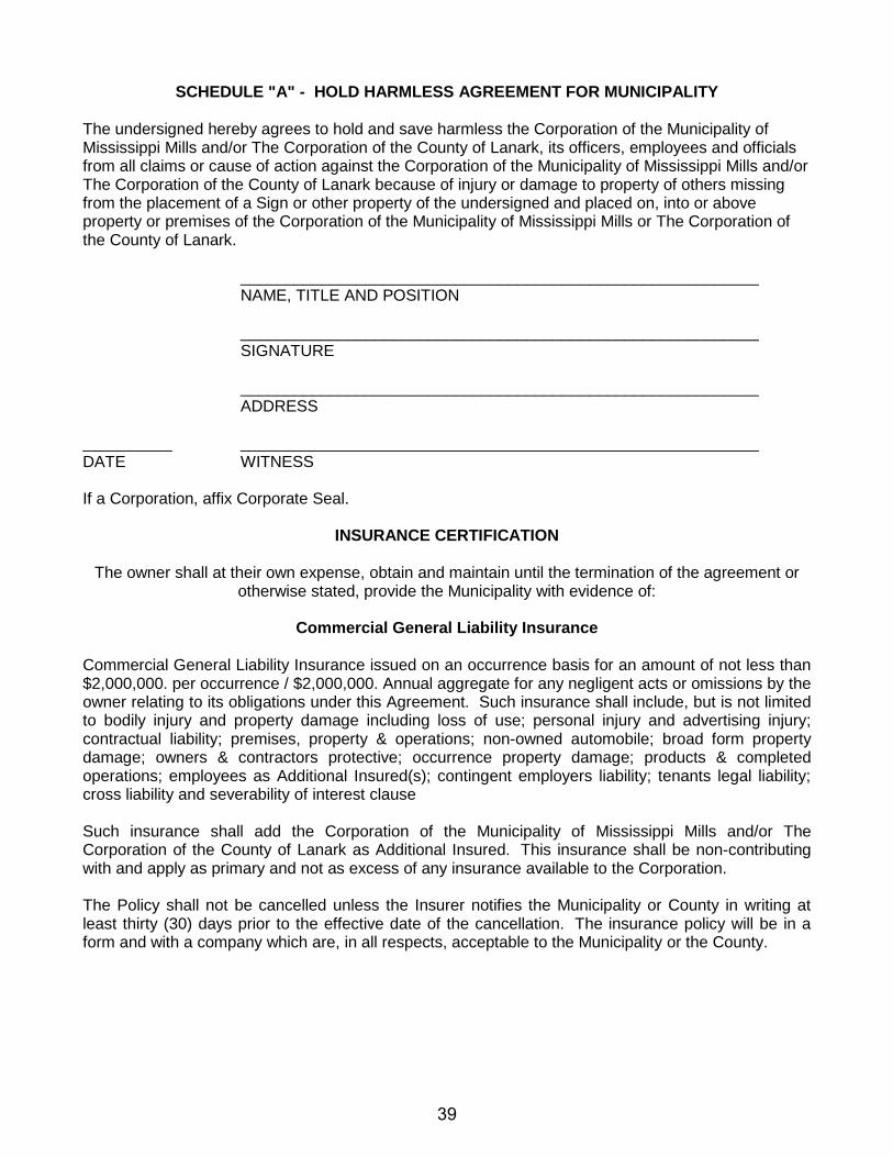
SCHEDULE "A" - HOLD HARMLESS AGREEMENT FOR MUNICIPALITY The undersigned hereby agrees to hold and save harmless the Corporation of the Municipality of Mississippi Mills and/or The Corporation of the County of Lanark, its officers, employees and officials from all claims or cause of action against the Corporation of the Municipality of Mississippi Mills and/or The Corporation of the County of Lanark because of injury or damage to property of others missing from the placement of a Sign or other property of the undersigned and placed on, into or above property or premises of the Corporation of the Municipality of Mississippi Mills or The Corporation of the County of Lanark. __________________________________________________________ NAME, TITLE AND POSITION __________________________________________________________ SIGNATURE __________________________________________________________ ADDRESS __________ __________________________________________________________ DATE WITNESS If a Corporation, affix Corporate Seal.
INSURANCE CERTIFICATION
The owner shall at their own expense, obtain and maintain until the termination of the agreement or otherwise stated, provide the Municipality with evidence of:
Commercial General Liability Insurance
Commercial General Liability Insurance issued on an occurrence basis for an amount of not less than $2,000,000. per occurrence / $2,000,000. Annual aggregate for any negligent acts or omissions by the owner relating to its obligations under this Agreement. Such insurance shall include, but is not limited to bodily injury and property damage including loss of use; personal injury and advertising injury; contractual liability; premises, property & operations; non-owned automobile; broad form property damage; owners & contractors protective; occurrence property damage; products & completed operations; employees as Additional Insured(s); contingent employers liability; tenants legal liability; cross liability and severability of interest clause Such insurance shall add the Corporation of the Municipality of Mississippi Mills and/or The Corporation of the County of Lanark as Additional Insured. This insurance shall be non-contributing with and apply as primary and not as excess of any insurance available to the Corporation. The Policy shall not be cancelled unless the Insurer notifies the Municipality or County in writing at least thirty (30) days prior to the effective date of the cancellation. The insurance policy will be in a form and with a company which are, in all respects, acceptable to the Municipality or the County.
39

SCHEDULE "B" - DOWNTOWN ZONE
Downtown Zone Almonte
40
THE CORPORATION OF THE MUNICIPALITY OF MISSISSIPPI MILLS
PLANNING REPORT MEETING DATE: February 16th, 2016 TO: Committee of the Whole
FROM: Stephen Stirling – Municipal Planner
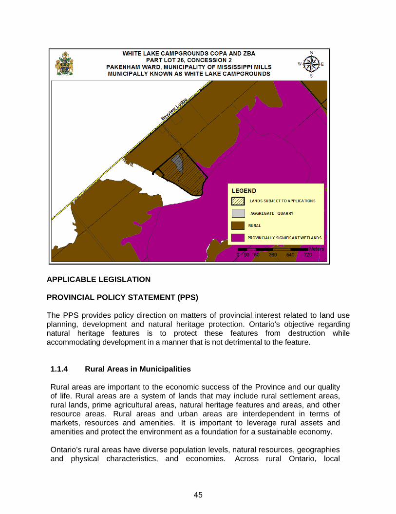
SUBJECT: White Lake Campgrounds Expansion Part of Lot 26, Concession 2 Pakenham Ward, Municipality of Mississippi Mills
RECOMMENDATION: That the Committee of the Whole recommends that Council approves the Community Official Plan Amendment 10 (COPA10) and Zoning By-law Amendment Z-08-15 to permit the expansion of White Lake Campgrounds. EXECUTIVE SUMMARY White Lake Campgrounds is an existing 40 site campground located on the north shore of White Lake in the former Township of Pakenham, in the Municipality of Mississippi Mills. The proponent is seeking to remove the existing aggregate designation from the property and expand the campground to a total of 200 campsites. The development expansion would include an investment of private communal infrastructure to support the development. The proposed development requires an amendment to the Community Official Plan to remove the aggregate designation and to address a campground expansion to 200 campsites accessed by a municipally owned and seasonally maintained road. Similar relief is required from the zoning by-law to remove the aggregate pit classification, include tent and trailer campgrounds as a permitted use, permit access from a seasonally maintained road and reflect the existing water setback for the legal non-conforming trailers. The supporting information submitted with the application clearly demonstrates that the aggregate pit has been exhausted and does not merit continued protection and that the designation to a rural designation is appropriate. The lake capacity assessment approved by the Ministry of Environment and Climate Change concluded that the lake can accommodate the proposed development provided the size of the campgrounds are limited to a maximum of 150 sites and that the development occur on private communal services. It is expected that the proposed infrastructure will lead to an environmental improvement for the lake. The existing municipally owned, seasonally maintained road must be upgraded to ensure year round emergency access to protect the investment of the campgrounds and those residing in permanent dwellings served by the road. Finally, the Environmental Impact Assessment as approved by the Ministry of Natural Resources and Forestry supports the reduced setback from the water provided that the existing and future trailers are no closer to the water and that the identified shoreline improvements are implemented.
41
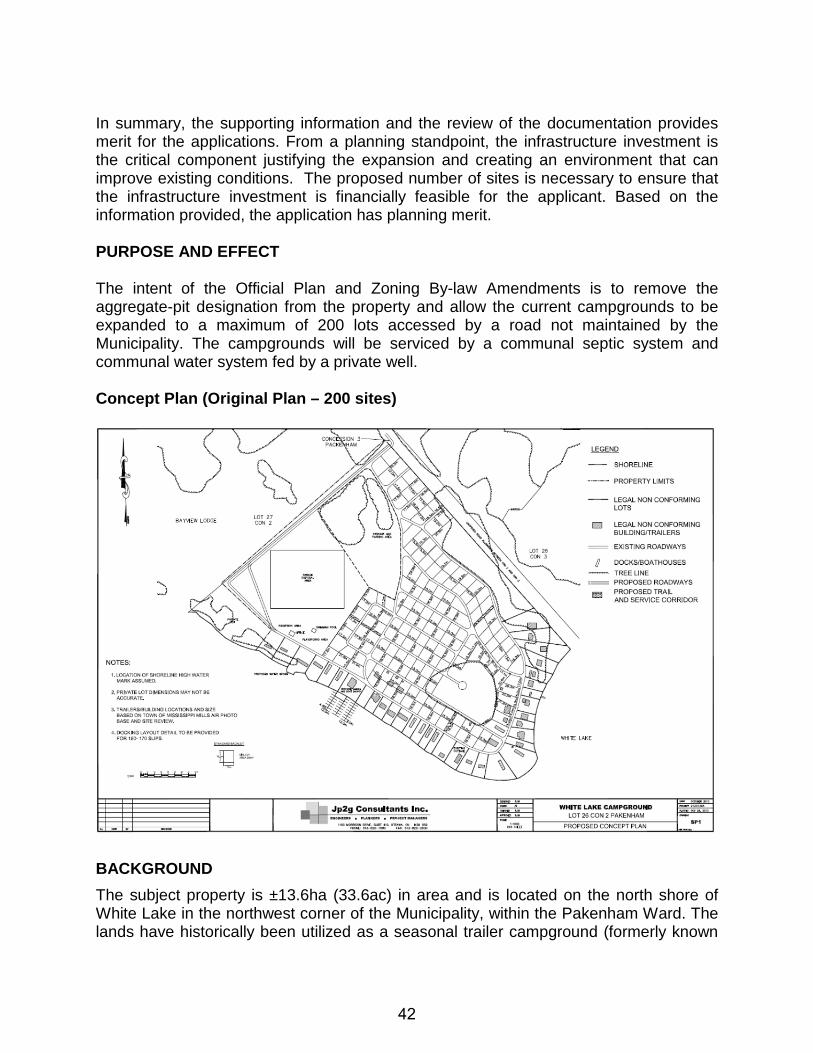
In summary, the supporting information and the review of the documentation provides merit for the applications. From a planning standpoint, the infrastructure investment is the critical component justifying the expansion and creating an environment that can improve existing conditions. The proposed number of sites is necessary to ensure that the infrastructure investment is financially feasible for the applicant. Based on the information provided, the application has planning merit. PURPOSE AND EFFECT The intent of the Official Plan and Zoning By-law Amendments is to remove the aggregate-pit designation from the property and allow the current campgrounds to be expanded to a maximum of 200 lots accessed by a road not maintained by the Municipality. The campgrounds will be serviced by a communal septic system and communal water system fed by a private well. Concept Plan (Original Plan – 200 sites)
BACKGROUND The subject property is ±13.6ha (33.6ac) in area and is located on the north shore of White Lake in the northwest corner of the Municipality, within the Pakenham Ward. The lands have historically been utilized as a seasonal trailer campground (formerly known
42
as Bennett’s Trailer Park) for over 40 years, and currently contain ±40 trailers and a cabin which back onto the shores of White Lake. The site is adjacent to an existing rural-recreational development (Bayview Lodge) which consists of seasonal and travelling full service trailer lots, cabins and chalets for rent, a marina, and other on-site amenities. Beyond an open meadow which covers the majority of the lands, there are three (3) main areas of natural habitat on the property: a cattail marsh (part of the White Lake Provincially Significant Wetland Complex) at the eastern corner, a mixed upland forest along the eastern edge, and a permanently flooded deciduous swamp in the southeasterly section. The locations of these features are depicted on the Natural Habitat Map contained within the Appendix. The property has a total of ±600m of shoreline along White Lake. In addition, a ±1.3ha (3.2ac) portion of land at the north corner of the subject property was historically used as a small aggregate pit. The applicant notes that while this portion of land was formerly used for the extraction of sand and gravel for local projects, it has not been used for this purpose for over 20 years. The Ministry of Natural Resources and Forestry (MNRF), Kemptville Office has no formal records of the site ever being licensed under the Aggregate Resources Act, and the applicant indicates that based on a test pit program completed in May 2013, this portion of land has now been excavated to the bedrock and is depleted of all significant aggregate resources. Access to the subject property is provided from 3rd Concession Pakenham which then connects with Bayview Lodge Road. This portion of 3rd Concession is used for the year-round access to 3205 3rd Concession (a .41ha residential parcel severed from the subject property in 1974 which benefits from an easement over the subject lands), and for access to the existing campgrounds on a seasonal basis. The road is maintained by the Municipality during the summer months and is otherwise privately maintained by the resident of 3205 3rd Concession Pakenham during the winter months. The existing campsites on the subject property have frontage onto an existing internal gravel road network. This road network has been incorporated into the concept plan, with additional roadways being added to serve the new campsites. Several of the existing trailer sites on the property are serviced by a groundwater supply well and sewage disposal services involving trailer holding tanks while others utilize individual outhouses. The applicant has proposed to service the existing 40 sites, as well as the proposed additional 160 sites, by way of a piped seasonal water and sewage system that will be wholly owned and operated by the campground operator. The preliminary stormwater management plan (see Appendix A) shows a water intake occurring along the west shore, as well as stormwater outlets situated at the proposed boat launch area and from the southern tip of the property. Historically, White Lake experienced algal blooms throughout the lake raising health concerns of the Lake. Most recently, White Lake experienced an algal bloom in 2015 which has been reported to the Ministry of Environment and Climate Change (MOECC). The Ministry of the Environment and Climate Change (MOECC) sampled and analyzed the lake water a result of the blooms and found the toxin levels to exceed acceptable levels.
43
The applicant filed a concurrent amendment to the County of Lanark Sustainable Communities Official Plan (OPA#1) to remove the “Aggregate Resources-Pit designation to Rural. On November 24th, 2014, the Ministry of Municipal Affairs approved Official Plan Amendment 1 as approved by the County of Lanark on June 25th, 2014. This amendment came in to force and effect on December 23rd, 2014. The current owners of the property, 8294364 Canada Inc., now wish to expand the existing campground from ±40 campsites to ±200 campsites on communal services and include the following associated uses: parking/storage area, reception building, boat docking structures, recreational areas, sewage treatment facility, and a stormwater management facility. These proposed uses are depicted on a detailed Concept Plan contained within the Appendix. In order to facilitate the proposed development, the applicant is seeking the following amendments: Community Official Plan Amendment (COPA #10)
• Amend the designation of a 1.3ha portion of the subject property from Aggregate Resource-Pit to Rural.
• Amend Section 3.3.8.2(4) of the Municipality’s Official Plan to permit frontage and access onto a seasonally maintained open public road.
• Amend Section 3.3.8.2.2(1) of the Municipality’s Official Plan to permit 200 campsites.
Comprehensive Zoning By-law Amendment (Z-10-13) • Amend the zoning of the portion of property zoned Tourist Commercial
(C6) Zone to Tourist Commercial Exception (C6-5) Zone. This site specific zoning would:
a) include a Tourist Campground as a permitted use; b) permit access from a seasonally maintained road c) address the existing legal-nonconforming trailer sites on the
property; d) incorporate the recommendations from the Environmental Impact
Assessment regarding appropriate reductions in setbacks from lands zoned Environmental Protection (EP) (being a Provincially Significant Wetland).
• Amend the zoning of a 1.3ha portion of the subject property from Mineral Aggregate Pit (MP) Zone to Tourist Commercial Exception (C6-5) Zone.
DESCRIPTION OF SUBJECT LANDS The White Lake Campgrounds are located on the north shore of White Lake in the northwest corner of the Municipality, within the Pakenham Ward. The subject lands are described as Part of Lot 26, Concession 2 Pakenham, Pakenham Ward, Municipality of Mississippi Mills. The property has an approximate lot area of ±13.6ha (33.6ac). Location Map
44
APPLICABLE LEGISLATION PROVINCIAL POLICY STATEMENT (PPS) The PPS provides policy direction on matters of provincial interest related to land use planning, development and natural heritage protection. Ontario's objective regarding natural heritage features is to protect these features from destruction while accommodating development in a manner that is not detrimental to the feature. 1.1.4 Rural Areas in Municipalities
Rural areas are important to the economic success of the Province and our quality of life. Rural areas are a system of lands that may include rural settlement areas, rural lands, prime agricultural areas, natural heritage features and areas, and other resource areas. Rural areas and urban areas are interdependent in terms of markets, resources and amenities. It is important to leverage rural assets and amenities and protect the environment as a foundation for a sustainable economy.
Ontario’s rural areas have diverse population levels, natural resources, geographies and physical characteristics, and economies. Across rural Ontario, local
45
circumstances vary by region. For example, northern Ontario’s natural environment and vast geography offer different opportunities than the predominately agricultural areas of southern regions of the Province.
1.1.4.1 Healthy, integrated and viable rural areas should be supported by:
a) building upon rural character, and leveraging rural amenities and
assets; f) promoting diversification of the economic base and
employment opportunities through goods and services, including value-added products and the sustainable management or use of resources;
g) providing opportunities for sustainable and diversified tourism, including leveraging historical, cultural, and natural assets;
h) conserving biodiversity and considering the ecological benefits provided by nature; and
1.1.5 Rural Lands in Municipalities
1.1.5.1 When directing development on rural lands, a planning authority shall apply
the relevant policies of Section 1: Building Strong Healthy Communities, as well as the policies of Section 2: Wise Use and Management of Resources and Section 3: Protecting Public Health and Safety.
1.1.5.2 On rural lands located in municipalities, permitted uses are:
a) the management or use of resources; b) resource-based recreational uses (including recreational dwellings);
1.1.5.3 Recreational, tourism and other economic opportunities should be promoted.
1.1.5.4 Development that is compatible with the rural landscape and can be
sustained by rural service levels should be promoted. 1.1.5.5 Development shall be appropriate to the infrastructure which is planned or
available, and avoid the need for the unjustified and/or uneconomical expansion of this infrastructure.
1.6.6 Sewage, Water and Stormwater
1.6.6.1 Planning for sewage and water services shall:
a) direct and accommodate expected growth or development in a
manner that promotes the efficient use and optimization of existing: 1. municipal sewage services and municipal water services; and
46
2. private communal sewage services and private communal water services, where municipal sewage services and municipal water services are not available;
b) ensure that these systems are provided in a manner that: 1. can be sustained by the water resources upon which such
services rely; 2. is feasible, financially viable and complies with all
regulatory requirements; and 3. protects human health and the natural environment;
c) promote water conservation and water use efficiency; d) integrate servicing and land use considerations at all stages of
the planning process; and e) be in accordance with the servicing hierarchy outlined through policies
1.6.6.2, 1.6.6.3, 1.6.6.4 and 1.6.6.5. 1.6.6.2 Municipal sewage services and municipal water services are the preferred
form of servicing for settlement areas. Intensification and redevelopment within settlement areas on existing municipal sewage services and municipal water services should be promoted, wherever feasible.
1.6.6.3 Where municipal sewage services and municipal water services are not
provided, municipalities may allow the use of private communal sewage services and private communal water services.
1.6.6.4 Where municipal sewage services and municipal water services or private
communal sewage services and private communal water services are not provided, individual on-site sewage services and individual on-site water services may be used provided that site conditions are suitable for the long-term provision of such services with no negative impacts. In settlement areas, these services may only be used for infilling and minor rounding out of existing development.
1.6.6.5 Partial services shall only be permitted in the following circumstances:
a) where they are necessary to address failed individual on-site
sewage services and individual on-site water services in existing development; or
b) within settlement areas, to allow for infilling and minor rounding out of existing development on partial services provided that site conditions are suitable for the long-term provision of such services with no negative impacts.
1.6.6.6 Subject to the hierarchy of services provided in policies 1.6.6.2, 1.6.6.3,
1.6.6.4 and 1.6.6.5 planning authorities may allow lot creation only if there is confirmation of sufficient reserve sewage system capacity and reserve water system capacity within municipal sewage services and municipal
47
water services or private communal sewage services and private communal water services. The determination of sufficient reserve sewage system capacity shall include treatment capacity for hauled sewage from private communal sewage services and individual on-site sewage services.
1.6.6.7 Planning for stormwater management shall:
a) minimize, or, where possible, prevent increases in contaminant loads; b) minimize changes in water balance and erosion; c) not increase risks to human health and safety and property damage; d) maximize the extent and function of vegetative and pervious surfaces;
and e) promote stormwater management best practices, including
stormwater attenuation and re-use, and low impact development. 2.0 Wise Use and Management of Resources
Ontario's long-term prosperity, environmental health, and social well-being depend on conserving biodiversity, protecting the health of the Great Lakes, and protecting natural heritage, water, agricultural, mineral and cultural heritage and archaeological resources for their economic, environmental and social benefits.
Accordingly:
2.1 Natural Heritage
2.1.1 Natural features and areas shall be protected for the long term.
2.1.2 The diversity and connectivity of natural features in an area, and the long-
term ecological function and biodiversity of natural heritage systems, should be maintained, restored or, where possible, improved, recognizing linkages between and among natural heritage features and areas, surface water features and ground water features.
2.1.3 Natural heritage systems shall be identified in Ecoregions 6E & 7E1,
recognizing that natural heritage systems will vary in size and form in settlement areas, rural areas, and prime agricultural areas.
2.1.4 Development and site alteration shall not be permitted in:
a) significant wetlands in Ecoregions 5E, 6E and 7E1; and.
2.1.5 Development and site alteration shall not be permitted in:
48
a) significant wetlands in the Canadian Shield north of Ecoregions 5E, 6E and 7E1;
e) significant areas of natural and scientific interest; and unless it has been demonstrated that there will be no negative impacts on the natural features or their ecological functions.
2.1.7 Development and site alteration shall not be permitted in habitat of endangered species and threatened species, except in accordance with provincial and federal requirements.
2.1.8 Development and site alteration shall not be permitted on adjacent lands
to the natural heritage features and areas identified in policies 2.1.4, 2.1.5, and 2.1.6 unless the ecological function of the adjacent lands has been evaluated and it has been demonstrated that there will be no negative impacts on the natural features or on their ecological functions.
2.2 Water
2.2.1 Planning authorities shall protect, improve or restore the quality and
quantity of water by:
a) using the watershed as the ecologically meaningful scale for integrated and long-term planning, which can be a foundation for considering cumulative impacts of development;
b) minimizing potential negative impacts, including cross-jurisdictional and cross-watershed impacts;
c) identifying water resource systems consisting of ground water features, hydrologic functions, natural heritage features and areas, and surface water features including shoreline areas, which are necessary for the ecological and hydrological integrity of the watershed;
d) maintaining linkages and related functions among ground water features, hydrologic functions, natural heritage features and areas, and surface water features including shoreline areas;
e) implementing necessary restrictions on development and site alteration to: 1. protect all municipal drinking water supplies and
designated vulnerable areas; and 2. protect, improve or restore vulnerable surface and ground water,
sensitive surface water features and sensitive ground water features, and their hydrologic functions;
f) planning for efficient and sustainable use of water resources, through practices for water conservation and sustaining water quality;
49
g) ensuring consideration of environmental lake capacity, where applicable; and
h) ensuring stormwater management practices minimize stormwater volumes and contaminant loads, and maintain or increase the extent of vegetative and pervious surfaces.
2.2.2 Development and site alteration shall be restricted in or near sensitive
surface water features and sensitive ground water features such that these features and their related hydrologic functions will be protected, improved or restored.
Mitigative measures and/or alternative development approaches may be required in order to protect, improve or restore sensitive surface water features, sensitive ground water features, and their hydrologic functions.
SUSTAINABLE COMMUNITIES OFFICIAL PLAN (SCOP) 3.0 RURAL AREA POLICIES 3.1 General The County of Lanark is characterized by its large expanses of rural, agricultural and recreational lands. The following policies are intended to provide for the long term orderly development of the rural area in a manner which is consistent with ensuring the protection of natural and environmental resources and which will respect the objective of protecting the character of our rural and urban areas. The rural area is not the principal sector for development. Population growth and employment is intended to be directed to Settlement Areas identified in local Official Plans. The intent of this Plan however is not to prohibit development in the rural areas, but rather to provide a framework for appropriate growth which will support the objective of preserving the identity and character of rural and settlement areas. 3.2 Identification of Rural Areas Local municipalities shall identify and designate Rural policy areas which shall be composed of lands which are located outside of the primary development and resource areas, that is to say lands which are outside of local Settlement Areas and lands which are not required for resource uses such as mineral aggregates and agricultural uses or natural heritage functions such as provincially significant wetlands or wildlife habitat areas. Lands which are subject to public health and safety constraints may be included in these designations but development, or certain uses, may be constrained or prohibited in the interest of the protection of life and property.
50
Rural lands are shown on Schedule A to this Plan. The rural designation may include various local Official Plan designations intended to provide additional policy direction for specific types of rural land uses. For example local Official Plans could designate lands shown as Rural on Schedule A of this plan as Highway Commercial, Industrial Park, Tourism Commercial, etc. Changes to rural designations in local Official Plans will not require an amendment to this Plan. 3.3 Land Use Policies 3.3.1 Objectives The County of Lanark’s objectives respecting development in Rural Areas are as follows:
1. To ensure that residential and non‐residential development is consistent with rural service levels;
2. To maintain the distinct character of rural, waterfront and settlement areas; 3. To ensure that development is compatible with natural heritage features and
natural resource uses. 3.3.2 General Policies
1. Local Official Plans will contain policies that ensure that development, redevelopment and the increasing use of rural properties does not result in additional negative environmental impacts.
2. Local Official Plans shall include policies which will ensure that rural development will occur on appropriate water and waste water services.
3. Rural development shall have regard for the safety of people and property and shall occur in a manner which will not result in an increased need or demand for municipal services.
4. Local Official Plans shall ensure that development will be directed to occur in a manner that makes efficient use of existing infrastructure, allows for the maintenance of the area’s character and provides for the long term availability of the resources that make the area attractive.
4.4 Water, Waste water and Stormwater Services In order to control flooding, ponding, erosion and sedimentation and to protect, as much as possible, water quality and aquatic habitat or other natural habitat which depend upon watercourses and other water bodies for their existence, surface water management plans (or stormwater management plans) shall be required for some forms of new development. Storm water management plans shall be required for any new development consisting of more than four lots or for commercial or industrial developments with large amounts of impervious area. Stormwater management will be undertaken in accordance with the Ministry of the Environment Guideline entitled ‘’Stormwater Management Planning and Design Manual, 2003’’ or amendments thereto. Stormwater management may not be required for small scale developments such as
51
lots created through the consent process or developments subject to site plan control where there is no impact on the watershed. 5.0 NATURAL HERITAGE 5.3 Objectives It is Lanark County’s overall goal that the County’s natural heritage features be both conserved and protected from negative impacts of development. Principles that form the basis of policies that achieve this goal are as follows:
1. The County’s significant natural heritage features shall be protected from negative impacts of development.
2. The County’s natural heritage features, including non‐significant features, should be conserved and rehabilitated for the benefit of future generations according to best management practices undertaken today and as they evolve.
5.4 General Land Use Policies The County of Lanark acknowledges that its decisions regarding land use and development can affect significant natural heritage features. Therefore, policies are required to protect these features from the potential negative impacts of development or to conserve them by prohibiting development. The following general policies shall apply:
1. Local Official Plans shall identify and protect those features where development and site alteration is prohibited. These include Provincially Significant Wetlands which are shown on Schedule A to this Plan and the habitat of endangered or threatened species which are not identified on Schedule A as identifying these features may prove to be harmful.
2. Local Official Plans shall identify and protect areas where development is permitted provided there is no negative impact to the natural heritage feature. These include Areas of Natural or Scientific Interest (ANSI’s) and Significant Woodlands which are identified on Schedule A, as well as, fish habitat, significant valleylands, shore lands along major waterways and ground water resources.
3. Development control shall be implemented by local municipalities primarily through the use of local planning controls or in accordance with the relevant sections of this Plan.
4. The County of Lanark and its constituent municipalities have an obligation to consider the impact of development and land use on waterbodies throughout the County in order to ensure the long term viability of this important natural and economic resources. Local Official Plan requirements which provide for a minimum 30 metre setback where development is proposed adjacent to a waterbody shall apply. Any proposed reduction to the minimum setback requirements shall be in accordance with the provisions of local Official Plans.
52
5. Where the policies in this Plan provide for the undertaking of an Environmental Impact Statement (EIS), it is understood that, on the basis of consultation with the appropriate review agency, the EIS may be scoped or eliminated in those instances where the potential impact of development is reduced or non‐existent.
5.5.1 Provincially Significant Wetlands Wetlands are lands which have specific ecological characteristics which include, but are not limited to, the presence of a permanent or seasonal shallow water cover, water‐tolerant vegetation or the presence of a water table which is close to the surface. They are commonly known as swamps, marshes, bogs, and fens. Wetlands serve important functions such as controlling ground water recharge and discharge, reducing flood damage, stabilizing shorelines, retaining and removing nutrients, supporting the food chain, providing fish and wildlife habitat and contributing to the social and economic quality of life in the County. The Ministry of Natural Resources has developed a wetland evaluation system based on the biological, hydrological, social and special characteristics of a wetland area and on the abundance of water which has caused the formation of hydric soils and has favoured the dominance of either hydrophylic plants or water tolerant plants. Wetlands that meet Ministry criteria are classified as provincially significant and have been designated on Schedule A to this Plan as “Provincially Significant Wetlands”. It is a policy of this Plan that such wetlands are to be protected from development and site alteration. The following policies shall apply:
1. Local Official Plans shall designate Provincially Significant Wetlands in their Official Plans and shall base the designation limits on mapping prepared by the Ministry of Natural Resources. Additional Provincially Significant Wetlands may be identified by the Ministry and subsequently added to local Official Plans by amendment. Similarly wetlands that are no longer considered provincially significant may be deleted from Official Plans by amendment.
2. Provincially Significant Wetlands shall be zoned restrictively in local municipal zoning by‐laws.
3. Local municipalities may choose to protect non Provincially Significant Wetlands through local Official Plans and restrictive zoning regulations. Where zoning is used to protect locally significant wetlands, the zoning by‐law shall be considered to conform to this Plan.
4. Development or site alteration in a significant wetland designated in a Local Official Plan is not permitted.
5. Activities that create or maintain infrastructure within the requirements of the Environmental Assessment process or works subject to the Drainage Act are not subject to the policies of this section, however wherever possible such uses shall be located outside of designated wetlands.
6. Development or site alteration within 120 metres of a designated wetland may be permitted, if it can be demonstrated that there will be no negative impacts
53
on the wetland’s natural features or ecological functions. An Environmental Impact Statement (EIS) will be required except for established agricultural uses. In accordance with provincial regulation, approval from the applicable conservation authority is required for all development and site alteration on lands within 120 metres of a wetland designated in this Plan or any local Official Plan.
5.5.2 Endangered or Threatened Species Habitat Endangered and threatened species can encompass any of the many types of living things: birds, mammals, plants, fish, reptiles, amphibians and invertebrates. The existing habitat sites of any endangered or threatened species in the County are not identified in this Plan or in local Official Plans in order to protect endangered or threatened flora or fauna. It is important to protect the significant habitat of endangered and threatened species found within the County. The County and Local Municipalities will work with the Ministry of Natural Resources to develop a mutually acceptable protocol for sharing available endangered and threatened species habitat information. Where this information indicates there is a potential for the habitat of endangered and / or threatened species to be present, any development proposal shall be accompanied by an Ecological Site Assessment to confirm the presence and extent of the significant habitat, as approved by the Ministry of Natural Resources. Where endangered or threatened species habitat is identified in Lanark County then the following policies shall apply:
1. Development and/or site alteration is prohibited in significant habitat of endangered or threatened species as may be identified from time to time.
2. Approval authorities shall, subject to federal or provincial legislation, refuse development applications where the development review process, which can include an Ecological Site Assessment, confirms the existence of significant habitat of endangered or threatened species as approved by the Ministry of Natural Resources.
3. Notwithstanding sub‐sections 1 and 2 above, development and site alteration may be permitted on lands within 120 metres of the habitat of endangered or threatened species provided it has been demonstrated through an Environmental Impact Statement (EIS) that there will be no negative impacts on the natural features or the ecological functions for which the area is identified.
6.2 MINERAL RESOURCES Mineral resources in County of Lanark consist of aggregates such as sand, gravel and limestone. There are also active mining operations such as the Tatlock Calcium Carbonate mine in Lanark Highlands. There are no known petroleum resources.
54
The following policies address mineral mining operations as well as mineral aggregate extraction. 6.2.1 Mineral Mining
1. Mining and related activities will only be permitted outside identified settlement areas;
2. The establishment of new mining and mining related activities shall be subject to the approval of the Ministry of Northern Development and Mines under the Mining Act and the Environmental Protection Act, and shall be subject to local Official Plan policies and local Zoning By‐law regulations;
3. An Influence Area shall be used as a means of protecting existing land uses in the vicinity of proposed mining operations from a land use conflict and, reciprocally, to protect areas designated and licensed for mineral mining from the encroachment of incompatible land uses. Development may be permitted in the Influence Area in accordance with the relevant local land use designation only where the impacts of mining operation can be properly mitigated. Local Official Plans shall establish the extent of the influence area;
4. The establishment or modification of an Influence Area should be carried out in consultation with the Ministry of Northern Development and Mines and the Ministry of the Environment;
5. Proposals for development within 1000 metres of known abandoned mine sites should not be approved until the nature and extent of any potential hazards have been mitigated with the approval of the Ministry of Northern Development and Mines (MNDM). Local Official Plans shall establish appropriate setbacks from known mine hazards.
6.2.2 Mineral Aggregates Mineral and aggregate resources are important to all facets of development in the County as these materials are used in the construction of roads, water and sewer infrastructures, homes, schools and commercial buildings and landscaping projects. As such the identification and long term protection of aggregate resources is important to the County’s well‐being. 6.2.2.1 Identifying Mineral Aggregate Resource Policy Areas All licensed pits and quarries are identified as “Licensed Aggregate Extraction Operation” on Schedule A of this Plan. The identification of mineral aggregate resources in local Official plans shall be based on areas which are currently licensed or areas with known high quality aggregate deposits as follows:
1. Mineral Aggregate Resource ‐ Licensed Pit 2. Mineral Aggregate Resource ‐ Licensed Quarry 3. Mineral Aggregate Resource ‐ Sand and Gravel Reserve 4. Mineral Aggregate Resource ‐ Bedrock
55
6.2.2.2 Permitted Uses The following uses shall generally be permitted in areas of mineral aggregate resources:
1. licensed pits and quarries; 2. licensed wayside pits and quarries; 3. portable asphalt plants and concrete plants; 4. agricultural uses excluding any accessory building or structure; 5. forestry uses excluding any accessory building or structure; 6. conservation and natural resource management uses excluding any accessory
building or structure; 7. uses accessory to an aggregate extraction operation such as crushing and
screening operations, machinery storage facilities and office space; 8. Permanent asphalt and concrete plants may be permitted subject to site specific
municipal planning control. 6.2.2.3 Prohibited Uses Development, including changes in land use and the creation of new lots for residential, commercial, institutional, recreational or industrial development which has the potential to preclude or hinder future aggregate extraction or the expansion of existing extraction operations or resource use shall be prohibited in mineral aggregate resource areas. 6.2.2.4 Adjacent Land In areas located within 300 metres of an area intended or utilized for a licensed pit operation below the water table and 150 metres of an area intended or utilized for a licensed pit operation above the water table as well as in areas located and 500 metres from an area intended or utilized for a licensed quarry operation, incompatible development, including the creation of new lots shall only be permitted subject to the following criteria:
1. That it is demonstrated that the resource use would not be feasible or that the proposed use or development would serve a greater long term public interest;
2. That the proposed non extraction development can be adequately serviced by water and waste water services in a manner which will not impede continued existing and proposed extraction operations;
3. Any other investigation as required by the development approval authority such as traffic studies, noise studies, vibration studies, slope stability studies, air quality impact studies etc. are carried out and demonstrate that the proposed development can proceed without impeding the continued operation of the existing licensed operations and future operations on reserves. Such studies are to carried out by qualified professionals;
4. When a license for aggregate extraction or operation ceases to exist policies 1, 2 and 3 above shall continue to apply.
56
COMMUNITY OFFICIAL PLAN (COP) The subject lands are designated “Rural” within Schedule A of the Municipality’s COP, and are identified to contain an ANSI on Schedule B (Constraints). The policies of the Community Official Plan directing development in an ANSI are designed to accommodate development in sensitive areas in a manner that protects and enhances the natural heritage feature and its long term function. 3.31 Goal and Objectives It is a goal of this Plan to:
Provide for an appropriate range of rural land uses which protect rural resources, traditional land uses, and environmental features.
3.3.2 Permitted Uses On lands designated as “Rural” the following shall be permitted:
(viii) Small scale rural commercial and industrial enterprises which primarily engage in the buying and selling of goods and services to area residents, farms, business or to the traveling public. Such uses include but are not limited to antique and craft shops, artisan studios, butcher and bakery shops, farm-related commercial and industrial, sawmills, feed mills, agricultural processing facilities, contractor’s yards, and tourist commercial establishments.
(xiii) the following tourist commercial uses shall be permitted: a. tourist lodging facilities (such as hotels, motels, resorts, country
inns, rental cottages), summer camps, clubs, places of entertainment, recreational facilities (such as hunt camps, marinas and existing ski hills and golf courses and existing tent and trailer campgrounds);
b. retail commercial establishments catering to the day-to-day needs of the tourist;
c. cultural uses, such as sites of historic interest, museums and related facilities;
d. maple syrup bushes, maple syrup processing facilities, accessory pancake houses, museums and meeting rooms shall be permitted; and,
e. an accessory residential dwelling for the owner
3.3.8.2 Tourist Commercial Policies Tourism is an important part of our local economy with many of our tourism assets are located in the rural area. This Plan shall allow for tourist-related commercial development in the rural area in accordance with the following policies:
1. New tent and trailer campgrounds, golf courses and ski hills shall only be permitted through an amendment to this Plan.
57
2. The proposed tourist commercial use shall be compatible with surrounding uses and shall have minimal impact on the environmental features, natural resources and rural character of the surrounding area. Such development must meet the Minimum Distance Separation from agricultural operations.
3. Uses requiring considerable amounts of water shall be assessed in accordance with the Surface and Ground Water Site Specific Development Criteria of Section 4.1.3 of this Plan.
4. Lot sizes shall be adequate for the proposed use. In assessing the appropriateness of the proposed lot size, consideration shall be given to parking and loading, servicing, storage, signage, amenity areas, open space, landscaping and buffering requirements. Such lots shall have frontage on and direct access to an open public road, maintained year-round.
5. Access to and from tourist commercial uses shall be limited in number and appropriately marked to identify their purpose. Wherever possible, consideration should be given to shared access points, service roads and similar traffic design features which limit access onto public roads.
6. Council may require a traffic study or evaluation to determine the volume of traffic to be generated, needs and/or standards for entrances, turning lanes, vehicle stacking, signalization, on-site directional movements, parking, etc. Traffic engineering should include the integration of both on-site traffic movement and the configuration, type and width of streets, roadways and sidewalks.
7. Lighting poles and utility structures shall be carefully sited in keeping with good design and highway safety practices. Lighting shall be in accordance with the Town’s responsible lighting by-law.
8. Signage shall be carefully sited in keeping with good design and highway safety practices. Signage shall be in accordance with the Town’s sign by-law.
9. Adequate off-street parking and loading facilities shall be provided. Where possible, parking areas shall be sited on a property such that large expanses of parking fronting on public streets are avoided. The visual appearance of parking areas and structures shall be enhanced through the use of diversity of plant forms, landscaping methods or other architectural elements. Parking areas adjacent to residential areas shall be appropriately screened.
10. Outdoor storage areas (equipment, garbage, etc.) shall be screened or fenced from adjacent uses and the street. Permanent display areas shall not be located in designated parking areas. Temporary or seasonal displays shall be permitted where they do not conflict with traffic flows or the safety of pedestrians.
11. Where a tourist commercial development is located adjacent to residential uses, appropriate screening, buffering, distance separation or other measures designed to minimize or mitigate potential land use conflicts or adverse effects shall be required.
12. The Zoning By-law shall place tourist commercial uses in a separate zoning category.
13. Tourist commercial development or redevelopment shall be subject to site plan control. Site plan control shall also apply to changes, additions or alterations to established uses.
58
3.3.8.2.2 Tent and Trailer Campgrounds Tent and trailer campgrounds include seasonally operated parks for tents and recreation vehicles, including park model trailers and such facilities as an accessory dwelling, marina and convenience store catering to the day-to-day needs of the visitors and non-permanent/seasonal residents. New tent and trailer campgrounds shall only be permitted through an amendment to this Plan. In reviewing an application for a new tent and trailer campground, consideration shall be given to the proposal’s ability to satisfy the following development criteria, in addition to other relevant sections of this Plan:
1. The minimum lot area for a tent and trailer campground shall be two hectares. The minimum campsite shall be 235 square metres with a minimum width of at least 15 metres at one point in the campsite. The density shall not generally exceed 30 campsites per hectare. The maximum number of sites for a Travel Trailer Park or Commercial Campground development shall generally not exceed 100. Provisions may be made for group camping sites.
2. Central water stations and toilet facilities satisfactory to the Town and the appropriate approval authority shall be provided by the owner.
3. Each campsite shall have adequate buffer planting at the rear and side of each site. No campsite shall be located within the floodplain.
4. Adequate buffer planting shall be provided between the Travel Trailer Park and Commercial Campground and any adjacent residential areas and such buffer planting or screening shall include the provision of grass strips, berms, trees, shrubs and screening, as required.
5. Adequate on-site parking shall be provided and the internal road system shall provide for safe movement of vehicular, pedestrian and emergency vehicle traffic.
6. Existing topographic and physical features of the site shall be retained in their natural state as far as possible. Existing trees shall be preserved, where possible. Vegetation and landscaping plans may be required to demonstrate incorporation of natural features and retention of existing vegetation.
7. As part of the development review process, the developer shall provide to the Town information regarding: (i) existing site conditions including soil capability, drainage, erosion
susceptibility, forest stands, unique wildlife habitats, unique flower species and access (Where the existing site has high capability for agriculture or low recreation capability, reasons shall be given for the selection of the site. Furthermore, information shall also be included concerning the preservation of any existing natural features);
(ii) the demand for the type of facility proposed exists taking into account the existing supply; and,
(iii) satisfactory methods of sewage disposal and water supply. Proposed servicing shall meet the approval of the MOE.
8. The Zoning By-law shall place tent and trailer campgrounds in a separate zoning category.
59

9. Tent and Trailer campgrounds shall be subject to site plan control. Site plan control shall also apply to changes, additions or alterations to established uses.
3.5.1 Goal and Objective It is a goal of this Plan to:
Protect a sufficient supply of the non-renewable aggregate resources and to ensure proper utilization of the resource.
The following objectives are designed to implement the goal: 1. Designate the resources on the Land Use Schedule so that resource areas are
clearly identified. 2. Ensure that the utilization of the resources takes place in an orderly and
controlled manner. 3. Protect legally existing extractive operations.
4. Restrict development on and adjacent to known aggregate deposits to those
uses which are compatible with and/or supportive of the aggregate industry.
5. Prohibit new residential lots on aggregate deposits or within the influence area of the Aggregate Resource designation.
6. Require that development within rural areas is buffered and set back a minimum
distance from aggregate deposits.
7. Require that extraction and processing of aggregate deposits has a minimal impact on the natural and built environments.
8. Require the timely and satisfactory rehabilitation of lands once the resource is
exhausted in accordance with the Aggregate Resources Act licences and site plans.
3.5.5 Removal or Expansion of Aggregate Resource Designation
1. The removal of part of the Aggregate Resource designation from the Land Use Schedule shall require an amendment to this Plan. Such an amendment shall provide justification for the change in designation and clearly demonstrate and document the need for the alternate land use. In considering such amendments, Council shall take into account the following:
(i) evidence provided by the applicant that aggregate extraction is not feasible due to quality, quantity or other development constraints;
(ii) the necessity of the alternate land use in comparison to the necessity of the aggregate resource;
60
(iii) the reason for the choice of the location and consideration given to alternate locations on non-aggregate lands;
(iv) the consideration given to the option of sequential land use in which the aggregate is removed prior to development of land for the proposed use; and,
(v) the aggregate resource has been depleted and the site fully rehabilitated in accordance with the conditions of the Aggregate Resources Act licence and site plans.
4.6.4.4 Seasonal Local Municipal Roads
2. The Town may post seasonally maintained local municipal roads with signs to indicate that maintenance is limited. Where such roads are classified and posted with a sign, the Town will not be obliged to provide winter maintenance services. There is no obligation by the Town to convert a seasonally maintained road into a year round maintained road.
3. The Zoning By-law will regulate new development on seasonally maintained roads.
ZONING BY-LAW #11-83 The subject lands within the White Lake Campgrounds are currently zoned Tourist Commercial (C6) Zone by the Municipality’s Comprehensive Zoning By-law #11-83. The intent of the Tourist Commercial (C6) Zone is to permit development of recreational commercial uses to serve the community and visiting public in the rural areas. The uses are limited to the following:
Residential Uses
- an accessory dwelling unit forming an integral part of the building or structure containing a permitted non-residential use
- an accessory detached dwelling Non-Residential Uses
amusement park, assembly hall, bed and breakfast, bar, drive-in theatre, drive-through facility, hotel, hunt or fishing camp, lodge, marina, marine facility, motel, museum, private park, propane, consumer outlet, propane, retail, public park, place of entertainment, restaurant, tourist establishment, tourist guest house, buildings, structures and uses accessory to a permitted use.
COMMENTS FROM INTERNAL CIRCULATION: Comments received based on the circulation of this application have been summarized below:
CAO:
61
From a 9-1-1 perspective, are the internal lots going to be numbered in some way and the roadways named (at the owners’ expense) so that should there be a requirement for police, fire or ambulance, they will be able to locate the appropriate unit within the park? The County Rural Addressing Committee is trying to develop standards for lots within these types of campgrounds. How do we ensure that none of the units become a permanent residence? Will the Municipality ever become responsible for the septic system should the Owner not be able to maintain it to the standards required by the Health Unit? I thought I remembered reading something about this in the past. We need to make it very clear that the Municipality will not be responsible to upgrade the road that this property fronts onto. As long as MNRF does not have any concerns with the change in classification from Quarries, then I do not have any problem with it. Clerk: No comments received. Chief Building Official: No concerns or objections. Director of Roads and Public Works:
Public works have reviewed the OPA and Zoning for the White Lake Campground and do not have any specific concerns with the proposal. OPA • We have no objections to the OPA amendments relating to the proposed campground. Concession 3 Pakenham receives summer maintenance services from the Municipality of Mississippi Mills but the road is otherwise privately maintained during the winter months by the resident at 3205 3rd Concession Pakenham which otherwise takes shared access from the private road serving the campsite. As long as the land use remains seasonal in nature, we do not have any concerns with the status quo arrangements on Concession 3; Zoning • Staff concurs with all of the recommendations contained within the Traffic Impact Study from CastleGlenn Consultants Inc. We concur that Bayview Lodge Road is fully capable of supporting the added traffic impacts proposed by this zoning redesignation; • The campground is to be serviced with a seasonal water and sewage system that will be wholly owned and operated by the campground operator. This system is therefore not “communal” by definition and as such it will otherwise be regulated under Ontario Regulations 318/08 and 319/08. Both of the water and sewer systems will be subject to the direct review of the Ontario Ministry of the Environment as the approval authority.
62
Stormwater management principals included in Appendix D of the EIA are generally supported, however final approvals will be subject to further review at the stage of Site Plan Control. Fire: Attached Letter March 25th, 2014 Recreation Coordinator: No concerns or objections.
COMMENTS FROM EXTERNAL AGENCY CIRCULATION: Canada Post: No comments received. Rogers Cable Communications Inc.: No comments received.
Leeds, Grenville & Lanark District Health Unit: See attached February 2nd, 2014. MMAH: No comments received. Hydro One: No comments received Rogers Cable: No comments received. MNRF: See attached letter (October 9th, 2015) and e-mail (January 15th, 2015). MOECC: See Attached November 10, 2015 Ontario Power Generation Inc.: No comments received. Bell: No comments received Algonquins: No comments received. Metis: No comments received.
PUBLIC COMMENTS A Public Meeting under the Planning Act was held on March 18th, 2014 in the Council Chambers of the Municipality of Mississippi Mills to consider the proposed amendments to the County of Lanark’s Sustainable Communities Official Plan, Mississippi Mills Community Official Plan and comprehensive zoning by-law. At the public meeting, five property owners addressed Council and staff regarding their concerns with the application. The concerns expressed by the public focused on the traffic on Bayview Road and 3rd Concession, pedestrian safety and trespassing, use of ATV’s by those residing in the campgrounds, increase in air pollution from campfires and noise pollution from vehicles, impact on the lake as a result of increased boaters and water demand to service campgrounds, location of storm water outlets and the overall density of the development. Letters from five other property owners in the area, outside the notification area were also received by the Municipality raising similar concerns. EVALUATION
63
Community Official Plan Amendment The first component to the Community Official Plan Amendment is to remove the Aggregate Pit designation currently on the property. A review of the information submitted with the application and Ministry’s records indicate that a pit licence to extract the aggregate deposits was never issued by the Ministry of Natural Resources and Forestry for a licenced pit above the water table. Furthermore, site visits by staff in 2013 confirm that the deposits of mineral aggregate resource have been depleted in this location. Also, the County of Lanark Sustainable Community Official Plan removed the “Aggregate Resources-Pit designation from the property on June 24th, 2014, which was approved by the Ministry of Municipal Affairs in November 2014 and is now in force and effect. As a result of the evidence indicating that the deposit is exhausted, along with the designation change to the Sustainable Communities Official Plan, the planning justification to protect the site for aggregate extraction in the local Community Official Plan and zoning by-law is no longer justified.
Community Official Plan policies permit tent and trailer campgrounds on lands that are designated Rural. The tent and trailer campgrounds are to include seasonally operated parks for tents and trailers and may include park model trailers. New tent and trailer campgrounds must provide the following:
• Minimum camp site area of 235m2 with a minimum lot width of 15m • Density generally shall not exceed 30 camp sites per hectare • Camp ground development generally shall not exceed a maximum of 100 sites.
With many campgrounds currently relying on holding tanks, individual septic systems or leaching pits to provide sanitary services, much of the existing technologies provide little effluent filtration, ultimately having direct impacts on the lake. The origin of the policy was to address this issue by considering the ability of the lakes to accommodate development along its shore without significantly impacting the lake and to ensure that the development reflects the rural character of the surrounding area. The private sanitary system for the existing 40 unit campground consists of either holding tanks or leaching pits which has contributed to the higher levels of phosphorous in the lake and the recent algal blooms. As part of the development, the proponent is proposing a communal septic system to support the proposed campground expansion located away from the lake to mitigate as much as possible any potential impact the development might have on the lake. A lake capacity study was completed by Hutchinson Environmental Services to assess the existing capacity of the lake, determine the ability of the lake to accommodate the development and any impact that it might have. The initial modeling completed on the lake was not able to predict an acceptable variation (20%) of phosphorus concentration between the measured and the predicted resulting in the modeling not being acceptable. As a result the assessment of the lake then must fall to the Provincial Water Quality Objective (PWQO) which sets acceptable levels of 20 micrograms per litre (ug/l). In this case the results of the measured and predicted phosphorous concentration slightly exceeded the acceptable
64
20% allowance requiring the water quality to be reviewed PWQO (20 ug/l). The results of the study concluded the additional development would create a PWQO of 12.6 ug/l assuming a septic retention coefficient of 74% or 13.3ug/l assuming no retention, well within the acceptable limits provided the additional campsites do not exceed 110 trailer units (total of 150). The combination of the reduced units, the removal of the existing private sewage systems, accommodating all trailer units in the communal septic system and locating communal septic system away from the lake would reduce the existing phosphorus level in the lake below current leveld, equating to a net environmental gain or “a net decrease from existing conditions”. The Community Official Plan does not provide policies surrounding the expansion of existing campgrounds, however the policies regarding the establishment of new tent and trailer camp sites provide insight on the community’s vision regarding the limited scale of campsites. These policies do not set clear hard limits on size of campgrounds, but does recognize that sometimes the density of the campgrounds may exceed the density of 30 sites per hectare or a maximum of 100 campsites. The size of the campgrounds is to reflect the ability of the lake to accommodate the development and the rural character of the community where the campground is located. In this case, the subject land is approximately 13.6 ha in area. Based on the first density policy of 30 units per hectare, the policy would allow a maximum of 408 sites. The revised campground development of 150 sites would have a density of 11.03 units per hectare which is well below the density standard, but clearly exceeding the intent of the second which concludes that campgrounds should generally be limited to 100 camp sites. Based on the lake capacity assessment that was approved by the Ministry of Environment and Climate Change the assumed reduction of phosphorus as a result of the infrastructure investment, the development would result in a reduction of phosphorus reaching the lake and improving the existing situation. Regarding the rural character, a review of the surrounding White Lake area has indicated the character consists mainly of rural residential lots and hunting/fishing camps with a number of rural campgrounds that range in size from 90 to 312 camp sites. The proposed 150 campsites would be consistent with the area. Revised Site Plan – 150 sites
65
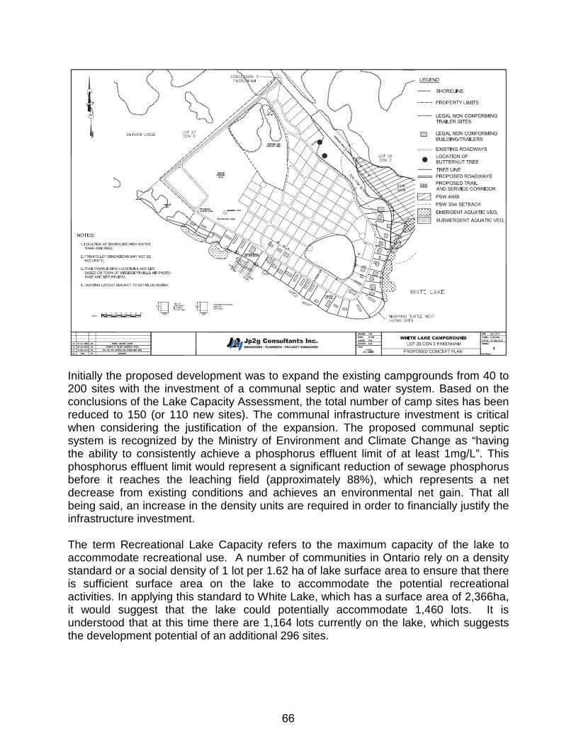
Initially the proposed development was to expand the existing campgrounds from 40 to 200 sites with the investment of a communal septic and water system. Based on the conclusions of the Lake Capacity Assessment, the total number of camp sites has been reduced to 150 (or 110 new sites). The communal infrastructure investment is critical when considering the justification of the expansion. The proposed communal septic system is recognized by the Ministry of Environment and Climate Change as “having the ability to consistently achieve a phosphorus effluent limit of at least 1mg/L”. This phosphorus effluent limit would represent a significant reduction of sewage phosphorus before it reaches the leaching field (approximately 88%), which represents a net decrease from existing conditions and achieves an environmental net gain. That all being said, an increase in the density units are required in order to financially justify the infrastructure investment. The term Recreational Lake Capacity refers to the maximum capacity of the lake to accommodate recreational use. A number of communities in Ontario rely on a density standard or a social density of 1 lot per 1.62 ha of lake surface area to ensure that there is sufficient surface area on the lake to accommodate the potential recreational activities. In applying this standard to White Lake, which has a surface area of 2,366ha, it would suggest that the lake could potentially accommodate 1,460 lots. It is understood that at this time there are 1,164 lots currently on the lake, which suggests the development potential of an additional 296 sites.
66
Concerns were raised by the public regarding the ability of the lake to accommodate the increased recreational demand, such as boat slips and associated boating activity. The number of boat slips permitted to any one site is determined by the Ministry of Natural Resources and Forestry. At the Site Plan Control stage, the Ministry of Natural Resources and Forestry will assess the ability of the lake to accommodate additional docks and boat slips in relation to this site. It is possible that there will be no docks and boat slips allotted to the site. It also must be acknowledged that this lake is not only accessed over private lands, but has numerous points of public access to launches that allow many types of watercraft. As a result, there is no way to control the number of boats that will be on the lake at any one time. The subject property is a waterfront lot located in the northeast quadrant of the Municipality with waterfront access onto White Lake. The property is accessed from Bayview Lodge Road and an unmaintained municipal road known as 3rd Concession Pakenham. An under-sized gravel surfaced road along 3rd Concession that is privately maintained provides access into the existing campgrounds and a waterfront single family dwelling. During the public consultation process concerns were raised by the public that Bayview Lodge Road and the 3rd Concession might not be able to support the increased amount of traffic. A detailed traffic impact study was provided with the application. The study noted existing traffic peaks of 61 vph on Friday and Sunday 88 vph, in the subject area. The study concluded that the impact of the expanded campgrounds would result “in less than 59 vehicles-per-hour (vph) for either morning or afternoon peak hours of travel demand”. As a result the increase of one additional vehicle for either morning or afternoon peak hours along Bayview Lodge Road is considered to have a negligible impact on the functions of Bayview Lodge Road or the existing properties in the area. The 3rd Concession in Pakenham has been developed with a gravel surface and a reduced standard width, reflective of a seasonally maintained road. With the increase in density of the development from the existing 40 units, the Municipality is concerned with the existing reduced road standard and seasonal maintenance of the road. The Municipality needs to ensure that emergency services will have safe, consistent access to the road if required. For this reason, the Municipality is requiring that the 3rd Concession road allowance be upgraded to the satisfaction of the Municipality for year round maintenance as part of the site plan approval process. The development will be serviced with a communal system for both water and sewage. At this point there are two options available to the developer for a water source, being a ground source (well) or a surface source (river). The agencies responsible to approve the water supply method have not raised any concerns at this time regarding the quality or quantity of water, but noted that the supply must meet provincial standards. The details of the communal water service will be determined at the site plan control stage of the development.
67
Concerns were raised by the public regarding the proposed location of the stormwater outlet. With the development maintaining much or the permeable surface, the Environmental Impact Assessment acknowledged the need for an outlet and recommended areas to avoid in order to protect the wildlife habitat. The eventual location of the outlet will be determined at the site plan control stage of the approval process. Zoning By-law Amendment Properties classified under the “Rural” designation of the Community Official Plan are permitted to provide a range of rural land uses that protect traditional rural resources, land uses and environmental features. The Plan recognizes tourist commercial establishments, including tent and trailer campgrounds, as an integral rural lands use appropriate for the rural community. The purpose of the Tourist Commercial (C6) Zone is to permit the development of recreation commercial uses that serve the public, such as a campground. The zoning by-law defines a “Campground” and a “Campground Plot” as follows:
“CAMPGROUND” means a lot used for not more than seven (7) months in any consecutive twelve (12) month period, for the parking and use of travel trailers, tent-trailers, tents or similar transportable accommodation, together with all yards and open space defined in this By-Law, but shall not include a mobile home as defined in this By-Law. A campground may include the off-season storage of travel trailers, tent-trailers or similar transportable accommodation. “CAMPGROUND PLOT” means a parcel of land within a campground intended for occupancy by travel trailers, tents, camper trailers and similar recreation vehicles together with all yards and open space defined in this By-law but shall not include a mobile home.
Given that the existing and proposed campgrounds (as defined in the current by-law) are located in the Tourist Commercial (C6) Zone, the proposed use is appropriate for the site; however it is essential that the capacity limitations of 150 sites be reflected in the performance standards. In addition to setting a maximum number of sites in the zoning by-law, the minimum “Campground Plot” size of 235m2, as per the Community Official Plan must also be identified as a performance standard within the by-law. Section 6.24 of the Zoning By-law requires a minimum 30 m setback from the high water mark to provide safety from flooding and unstable slopes and to help protect the environmental water quality. Currently there are 33 trailers located within the 30 metre setback of the water course. The supporting environmental impact assessment concluded that the development of the campgrounds would have a negligible impact on the water course and wetlands provided that all new development, including seasonal trailers, parking lot, sewage disposal area and playgrounds occur outside the 30 metre
68
setback and that the shoreline improvements identified in the environmental impact assessment are completed. Property development requires frontage onto maintained roads to ensure access for the public and emergency vehicles. The Tourist Commercial (C6) Zone requires a minimum lot frontage of 30 metres for the principle property for this particular reason. The road allowance extends approximately 695 metres from Bayview Lodge Road to the waterfront, of which 308 metres of the road allowance is developed to a reduced standard to provide access to the existing campgrounds and dwellings on the shoreline. The remaining road allowance only provides frontage to either the subject lands to the south west or a vacant parcel of land to the north east. Staff has recommended that the existing roadway servicing the campgrounds and the existing dwelling be upgraded to municipal standards to allow for year round emergency response and be extended by 10 metres to accommodate a vehicle turnaround. Permitting a reduced frontage will allow for the expansion of the road to ensure the road meets the minimum requirements to access to all properties and will accommodate the needs of the road maintenance equipment and emergency vehicles. Requiring the road to extend further than 10 metres beyond the existing roadway would serve no purpose for access and only increase the amount of road infrastructure to be maintained by the Municipality. The mineral aggregate pit identified in the Community Official Plan is also reflected in the zoning by-law. Supporting documentation has concluded that the aggregate deposits are depleted and that pit designation and zoning classification are no longer required. This conclusion has been vetted by the County of Lanark and the Province and as a result, upper tier polices have been amended to reflect this. Based on this, there is no planning rational or justification to protect the deposit. CONCLUSION The proposed amendment to remove the Aggregate Resource – Pit designation from the property reflects depleted status of the deposits on the property and as a result there is no planning justification to maintain that designation on the property. White Lake is an important recreational lake to the surrounding community that has experienced a significant amount of development along its shoreline ranging from permanent dwellings to cottages and camp sites on private services. The Ministry of Environment and Climate Change has concluded that the combination of the phosphorus reduction technology proposed in the communal septic system, best management practices to address storm water runoff and shoreline protection, should result in a net improvement in phosphorus loading of the site even with the increased number of campsites proposed in the application. Overall, Planning Staff are in support of the proposal. Current Community Official Plan policies assumed this type of development would occur on individual private services and never contemplated communal services. With the proposed infrastructure investment supporting the development reducing existing phosphorous impacts on the
69
lake from the site and the upgrading of 3rd Concession, an increase in density is appropriate and is necessary in order to make it economically feasible. The resulting density is consistent with existing campgrounds in the area and reflects the rural character of the area. In the end the proposed amendments are in keeping with the Provincial Policy Statement and the general intent and objectives of the Community Official Plan and the zoning by-law. All of which is respectfully submitted, __________________ ___________________ Stephen Stirling MCIP, RPP Diane Smithson Municipal Planner Reviewed by CAO
70
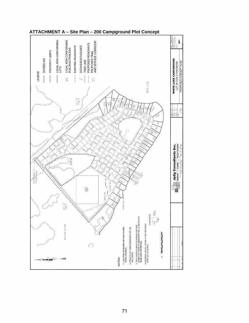
ATTACHMENT A – Site Plan – 200 Campground Plot Concept
71
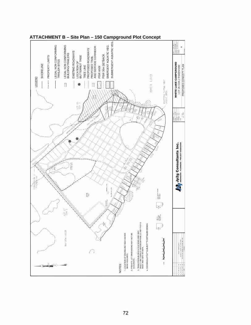
ATTACHMENT B – Site Plan – 150 Campground Plot Concept
72

ATTACHMENT C – Fire Department Comments
73
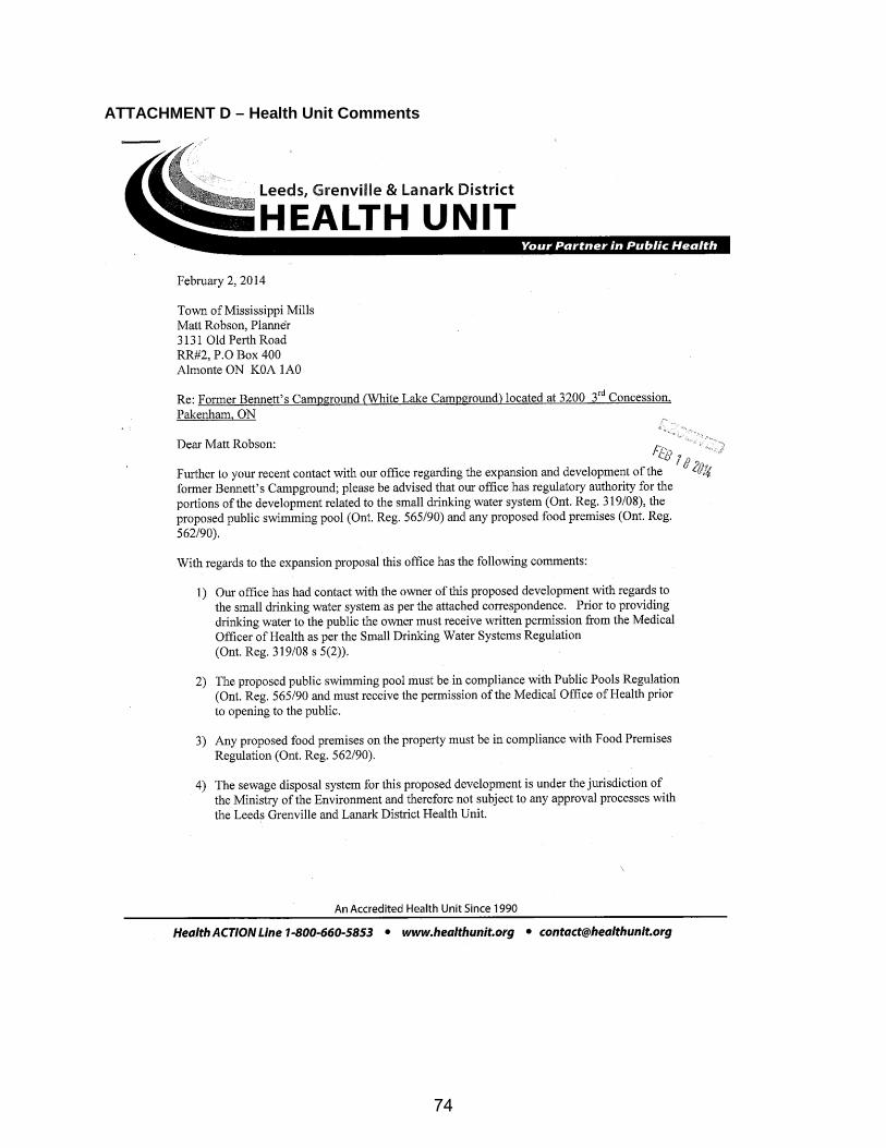
ATTACHMENT D – Health Unit Comments
74
75
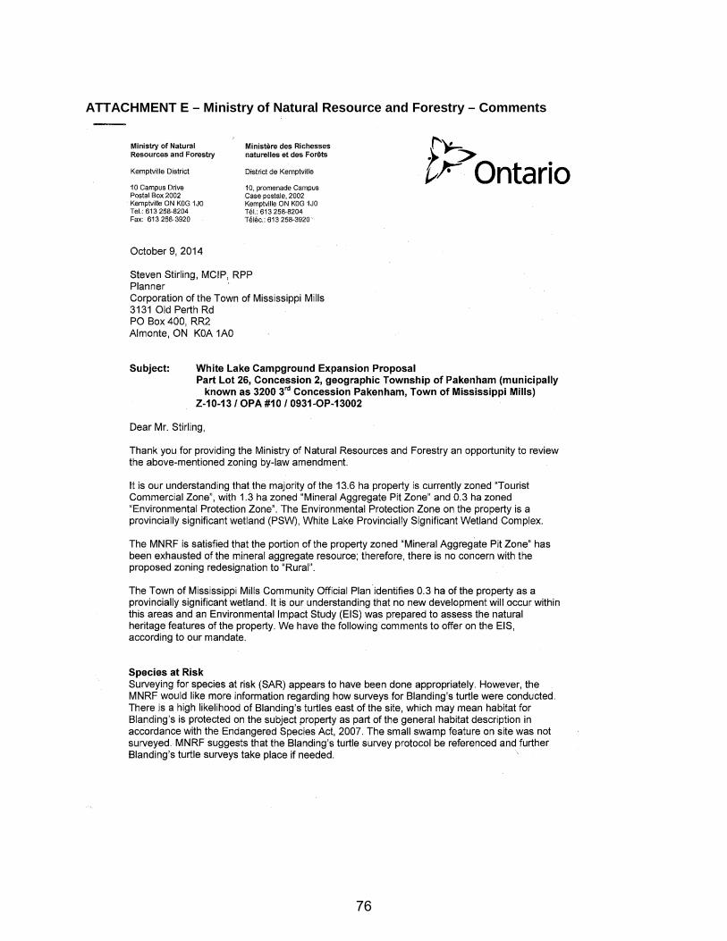
ATTACHMENT E – Ministry of Natural Resource and Forestry – Comments
76
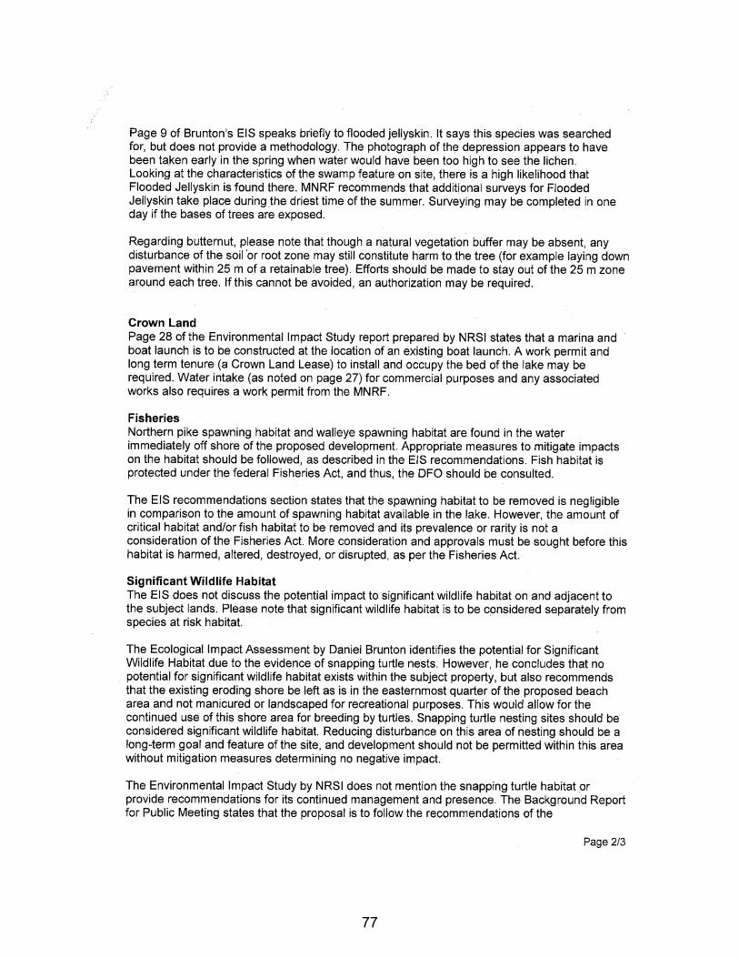
77
78
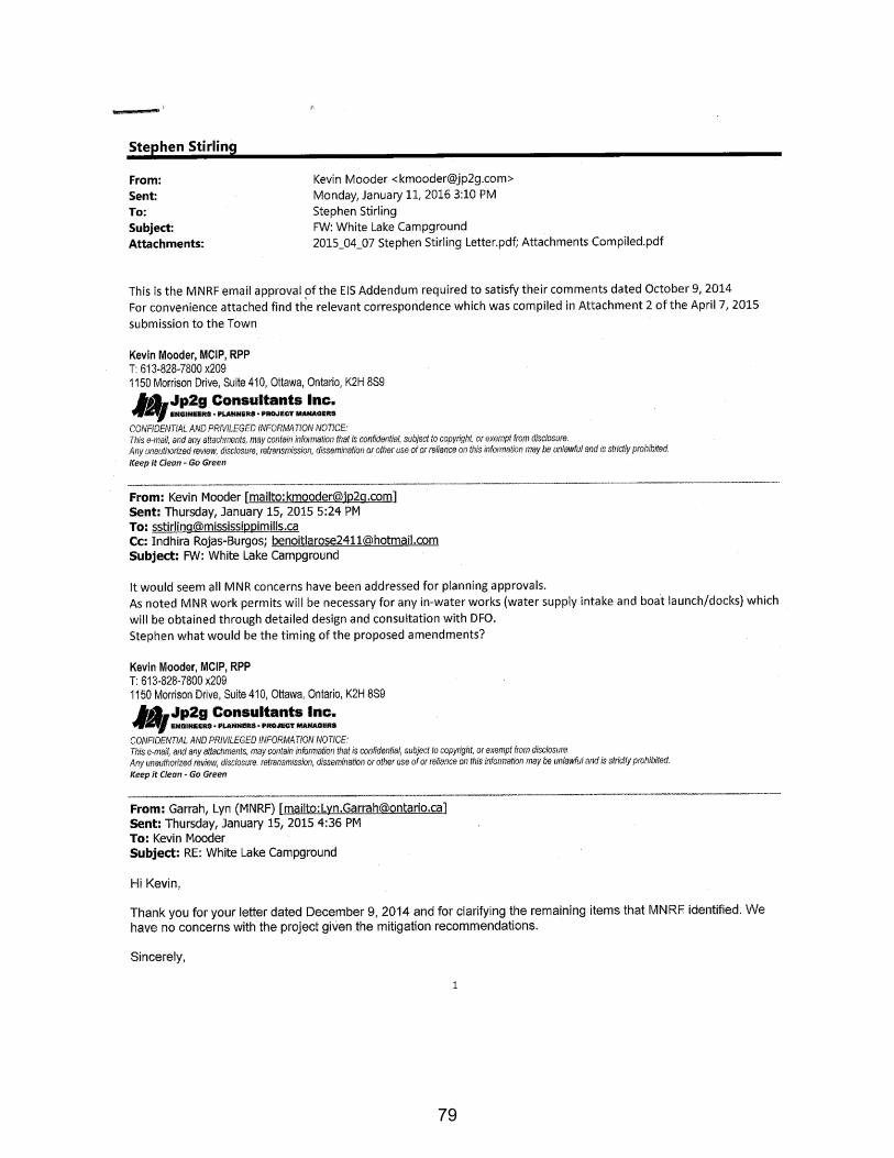
79
80
ATTACHMENT F – Ministry of Environment and Climate Change – Comments
81
82
ATTACHMENT G – Draft COPA (Date: January 6, 2016 Version: 3)
AMENDMENT NO. 10
TO THE
MISSISSIPPI MILLS COMMUNITY OFFICIAL PLAN
83
AMENDMENT NO. 10 TO THE
MISSISSIPPI MILLS COMMUNITY OFFICIAL PLAN
The explanatory text constituting Amendment No. 10 to the Mississippi Mills Community Official Plan was prepared for the Committee of the Whole and was recommended to the Council of the Municipality of Mississippi Mills under the provisions of The Planning Act, R.S.O. 1990 on the 16th day of February, 2016. Amendment No. 10 to the Mississippi Mills Community Official Plan as recommended by the Committee of the Whole was adopted by the Corporation of the Municipality of Mississippi Mills by By-law No. _______ in accordance with the provisions of The Planning Act, R.S.O. 1990 on the 1st day of March, 2016.
84
AMENDMENT NO. 10 TO THE
MISSISSIPPI MILLS COMMUNITY OFFICIAL PLAN
INDEX THE CONSTITUTIONAL STATEMENT PART A - THE PREAMBLE
PURPOSE
LOCATION
BASIS PART B - THE AMENDMENT
INTRODUCTORY STATEMENT
DETAILS OF THE AMENDMENT PART C - THE APPENDICES - MUNICIPAL RECORD
APPENDIX A - CERTIFIED COPY OF BY-LAW No. _______
APPENDIX B - STATEMENT REGARDING PUBLIC NOTICE APPENDIX C - TRUE COPY OF ALL SUBMISSIONS
85
PART A - THE PREAMBLE, does not constitute part of this Amendment. PART B- THE AMENDMENT consisting of the following text and schedules
constitutes Amendment No. 10 to the Mississippi Mills Community Official Plan.
PART C - THE APPENDICES do not constitute part of this amendment. The
Appendices contain the Municipal Record pertaining to this amendment.
86
PART A - PREAMBLE PURPOSE The purpose of Amendment No. 10 to the Mississippi Mills Community Official Plan is to remove the designation of a 1.3ha portion of the subject property from Aggregate Resource-Pit to Rural located in Part of Lot 26, Concession 2 in the former Township of Pakenham, now the Municipality of Mississippi Mills. Historically, the 1.3ha portion of the property has been used as a sand a gravel pit for projects in the area. The subject lands over the last 40 years has been used as a seasonal campground. The Community Official Plan Amendment is also seeking to expand the size of the campgrounds to a maximum of 150 campsites. The increase in campground site is required to financially justify the proposed communal septic system that is expected to reduce the impact on the phosphorus from the development on the lake to levels below current levels. The effect of the Community Official Plan Amendments would have the entire property designated as Rural because the identified aggregate deposit has been exhausted. Removing the designation would provide sufficient land area to accommodate the proposed campground expansion, its services (communal septic, pool, parking, storage etc) while maintaining the existing mature vegetation. A review of the surrounding area, it is noted that there are a number of residential dwellings and other campsites within the influence area of a pit operation. The removal of the aggregate designation would also address an existing situation that is not consistent with provincial regulations. LOCATION This amendment applies to lands described as Part Lot 26, Con 2, Pakenham Ward, Municipality of Mississippi Mills on the north shore of White Lake, known municipally as White Lake Campground. The property has an approximate land area of ±13.6ha (33.6ac). There are currently 40 seasonal dwelling located on the property. BASIS The Community Official Plan Amendment consists of two components, being text and mapping. The basis for the amendments is detailed below as it relates to each component. The Community Official Plan identified a portion of the property to contain an aggregate deposit for a gravel pit. Over the last number of years the deposit material has slowly been removed for local area projects. The intent of the aggregate policies is to protect the local resource to meet the needs of the resource needs of the province. Section 3.5.5.1 of the Community Official Plan outlines policies for consideration when removing an Aggregate Resource designation, which include the following:
87
• evidence provided by the applicant that aggregate extraction is not feasible due to quality, quantity or other development constraints;
• the necessity of the alternate land use in comparison to the necessity of the aggregate resource;
• the reason for the choice of the location and consideration given to alternate locations on non-aggregate lands;
• the consideration given to the option of sequential land use in which the aggregate is removed prior to development of land for the proposed use; and,
• the aggregate resource has been depleted and the site fully rehabilitated in accordance with the conditions of the Aggregate Resources Act licence and site plans.
The documentation in support of the application provides sufficient evidence to conclude that the existing aggregate pit has reached exhaustion and the designation is no longer warranted. Furthermore that a rural designation is appropriate as it reflects designation of the remaining lands and surrounding area. The Community Official Plan does not specifically address the issue of expansion of existing campgrounds, but does set general policies regarding development of these types of uses. The general limitations of the campgrounds are a result of the capacity of the lake to accommodate development and the character of the rural area. The COPA is proposing to increase the maximum number of campsites for campgrounds to generally shall not exceed 150 camps sites in order to financially justify the communal septic and water systems. Supporting documentation concludes that the lake can accommodate the development as a result of the infrastructure investment and will ultimately improve the existing conditions of the lake.
88
PART B - THE AMENDMENT
INTRODUCTORY STATEMENT All of this part of the document entitled "Part B - The Amendment" and consisting of the following text constitutes amendment No. 10 to the Mississippi Mills Community Official Plan. DETAILS OF THE AMENDMENT The Mississippi Mills Community Official Plan, as amended, is hereby further amended with a site specific Community Official Plan Amendment to the lands described as Part Lot 26, Concession 2, Geographic Township of Pakenham, now in the Municipality of Mississippi Mills as shown on Schedule “A” to this Amendment by changing the designation from “Aggregate Resource” to “Rural” and by revising the policies in Section 3.3.8.2.2 (1) with the following:
Is further amended by adding the revised policy as follows:
1. The minimum lot area for a tent and trailer campground shall be two hectares. The minimum campsite shall be 235 square metres with a minimum width of at least 15 metres at one point in the campsite. The density shall not generally exceed 30 campsites per hectare. The maximum number of sites for a Travel Trailer Park or Commercial Campground development shall generally not exceed 100 150. Provisions may be made for group camping sites.
89
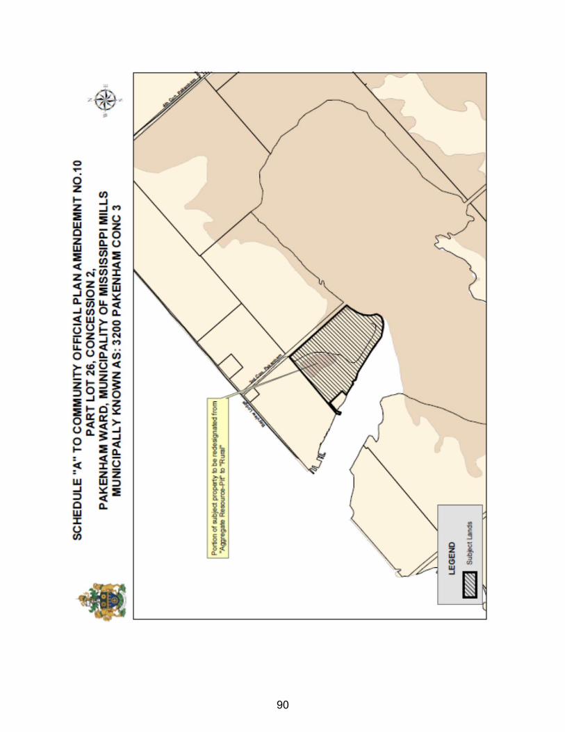
90
PART C - THE APPENDICES
AMENDMENT NO. 10 TO THE
MISSISSIPPI MILLS COMMUNITY OFFICIAL PLAN
MUNICIPAL RECORD
91
APPENDIX - A
CERTIFIED COPY OF BY-LAW NO. _________
ADOPTING THE AMENDMENT
92

APPENDIX - B
Statement by Municipal Employee
Regarding Public Notice
93
Date: February 1st, 2016 Version: 1
AMENDMENT NO. 10 TO THE
MISSISSIPPI MILLS COMMUNITY OFFICIAL PLAN I, Stephen Stirling, Municipal Planner for the Municipality of Mississippi Mills, hereby solemnly declare: (a) that the requirements for the giving of notice and the holding of at least one public meeting for informing and obtaining the views of the public set out in the Official Plan have been complied with, as prescribed by Section 17(9) through 17(14) of the Planning Act, and; (b) that the requirements for the giving of notice of adoption have been complied with, as prescribed by Section 17(17) of the Planning Act. SWORN BEFORE ME AT THE MUNICIPALITY OF MISSISSIPPI MILLS IN THE COUNTY OF LANARK THIS ___ DAY OF ___________ 2016 ______________________ _________________________________ A COMMISSIONER, ETC. Stephen Stirling, MCIP, RPP Municipal Planner
94
APPENDIX - C
True Copy of all Submissions
Received Prior to Adoption of the Amendment
95

APPENDIX - D
Official Plan Amendment #10 Planning Report
96
ATTACHMENT H - DRAFT ZONING BY-LAW
THE CORPORATION OF THE MUNICIPALITY OF MISSISSIPPI MILLS BY-LAW NO. ______
BEING a by-law to amend By-law No. 11-83 being the Zoning By-law for the Municipality of Mississippi Mills. NOW THEREFORE the Council of the Corporation of the Municipality of Mississippi Mills pursuant to Section 34 of the Planning Act, R.S.O. 1990, Chapter P.13, enacts as follows: 1. Schedule 'A' to By-law No. 11-83, as amended, is hereby further amended by changing
thereon from “Tourist Commercial (C6) Zone” and “Mineral Aggregate Pit (MP) Zone” to Tourist Commercial Special Exception 5 (C6-5) Zone”, on those lands identified on the attached Schedule 'A', which are described as East Part Lot 26, Concession 2, Pakenham Ward, Municipality of Mississippi Mills, known municipally as 3200 3rd Concession.
2. By-law 11-83, as amended, being the Zoning By-law for the Municipality of Mississippi Mills, as amended, is hereby further amended by adding the following subsection to Section 24.3:
24.3.5 Notwithstanding the ‘C6’ zoning designation, on those lands delineated as ‘C6-5’ on Schedule “A” to this by-law, may be used in accordance with the C6 zone provisions contained in this by-law, the following provisions shall apply:
1. A “Campground” shall be an additional permitted use. 2. The minimum lot frontage for the “Campground” shall be 10m 3. The total number of “Campground Plots” shall not exceed 150 4. The minimum size of a “Campground Plots” shall be 235m2 5. Notwithstanding Section 6.26 setbacks from Environmental Protection (EP) zone,
existing trailers and accessory structures are permitted within the 30m setback of the White Lake Provincially Significant Wetland. In the event the trailer and accessory structures are replaced, they must not be located any closer to the wetland boundary.
3. Notwithstanding the C6 zoning designation, on those lands delineated as C6-5 to this By-Law future development shall proceed in accordance with the following recommendations of the Environmental Impact Assessment (EIA).
a) Maintenance and protection of the sandy shore which is utilized by nesting turtles.
b) Notwithstanding the above, no new building or structure shall be located within 30m of the White Lake PSW.
c) Notwithstanding the above, development of a marina, boat launch or any flood control measures are permitted subject to the recommendations of the EIA.
d) Sewage disposal system shall include phosphorus abatement technology.
97
3. This By-Law takes effect from the date of passage by Council and comes into force and effect pursuant to the provisions of the Planning Act, R.S.O 1990.
BY-LAW read, passed, signed and sealed in open Council this _________day of February, 2016.
_________________________ _________________________ Shaun McLaughlin, Mayor Shawna Stone, Clerk
98

SCHEDULE A TO BY-LAW NO. __________
99
THE CORPORATION OF THE MUNICIPALITY OF MISSISSIPPI MILLS
PLANNING REPORT MEETING DATE: February 16th, 2016 TO: Committee of the Whole FROM: John McMulkin – Junior Planner SUBJECT: COMMUNITY OFFICIAL PLAN AMENDMENT 14 (D09-KE-15)
ZONING BY-LAW AMENDMENT Z-15-15 (D14-KE-15) Part Lots 10, 11 and 13, Anderson Section, Plan 6262, Being Part
1 on Plan 27R-9062 and Parts 1 and 2 on Plan 27R-5296 Almonte Ward, Municipality of Mississippi Mills OWNER/APPLICANT: John Kerry
RECOMMENDATION: THAT the Committee of the Whole recommends that Council approves the Community Official Plan Amendment (COPA) 14 to change the land use designation of the lands legally described as Part Lots 10, 11 and 13, Anderson Section, Plan 6262, Being Part 1 on Plan 27R-9062 and Parts 1 and 2 on Plan 27R-5296, Almonte Ward, Municipality of Mississippi Mills, from “Downtown Commercial” to “Residential”; AND FURTHERMORE THAT the Committee of the Whole recommends that Council approves the Zoning By-law Amendment to change the zoning of the lands legally described as Part Lots 10, 11 and 13, Anderson Section, Plan 6262, Being Part 1 on Plan 27R-9062 and Parts 1 and 2 on Plan 27R-5296, Almonte Ward, Municipality of Mississippi Mills, from “Community Facility Exception 2 (I-2) Zone” to “Residential Second Density (R2) Zone” in order to permit residential uses on the lands. BACKGROUND, PURPOSE AND EFFECT On November 18, 1975, Restricted Area By-law No. 25-1975 was passed by the former Town of Almonte as the new Comprehensive Zoning By-law for the municipality. This by-law recognized the existing Kerry Funeral Home business operating at 154 Elgin Street by rezoning the property to the “Central Commercial Exception 1 (C3-1)” Zone, as well as the two (2) lots located on either side of the property (presumably to allow for future expansion). These lots are subject to the proposed Community Official Plan and Zoning By-law Amendment applications. On June 10, 1997, the former Town of Almonte passed Comprehensive Zoning By-law No. 15-1997, which rezoned the properties to the “General Commercial Exception 1 (C1-1)” Zone in order to recognize the funeral home business and three apartment units located within it. On December 13, 2005, the Community Official Plan (COP) for the Municipality of Mississippi Mills was adopted by Council and the land use designation on the properties was changed from “Residential” to “Downtown Commercial” in order to ensure that the zoning of the properties conformed to the COP land use designation. On December 5, 2011, Comprehensive Zoning
100
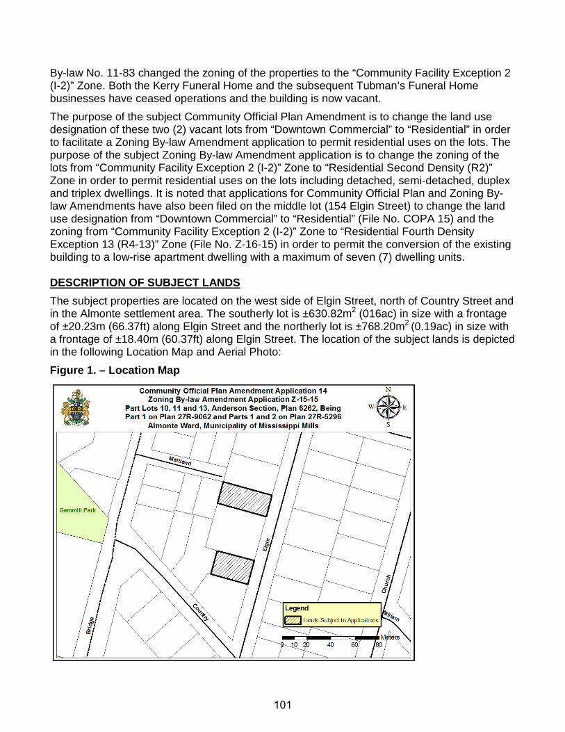
By-law No. 11-83 changed the zoning of the properties to the “Community Facility Exception 2 (I-2)” Zone. Both the Kerry Funeral Home and the subsequent Tubman’s Funeral Home businesses have ceased operations and the building is now vacant. The purpose of the subject Community Official Plan Amendment is to change the land use designation of these two (2) vacant lots from “Downtown Commercial” to “Residential” in order to facilitate a Zoning By-law Amendment application to permit residential uses on the lots. The purpose of the subject Zoning By-law Amendment application is to change the zoning of the lots from “Community Facility Exception 2 (I-2)” Zone to “Residential Second Density (R2)” Zone in order to permit residential uses on the lots including detached, semi-detached, duplex and triplex dwellings. It is noted that applications for Community Official Plan and Zoning By-law Amendments have also been filed on the middle lot (154 Elgin Street) to change the land use designation from “Downtown Commercial” to “Residential” (File No. COPA 15) and the zoning from “Community Facility Exception 2 (I-2)” Zone to “Residential Fourth Density Exception 13 (R4-13)” Zone (File No. Z-16-15) in order to permit the conversion of the existing building to a low-rise apartment dwelling with a maximum of seven (7) dwelling units. DESCRIPTION OF SUBJECT LANDS The subject properties are located on the west side of Elgin Street, north of Country Street and in the Almonte settlement area. The southerly lot is ±630.82m2 (016ac) in size with a frontage of ±20.23m (66.37ft) along Elgin Street and the northerly lot is ±768.20m2 (0.19ac) in size with a frontage of ±18.40m (60.37ft) along Elgin Street. The location of the subject lands is depicted in the following Location Map and Aerial Photo: Figure 1. – Location Map
101
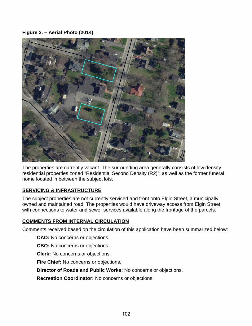
Figure 2. – Aerial Photo (2014)
The properties are currently vacant. The surrounding area generally consists of low density residential properties zoned “Residential Second Density (R2)”, as well as the former funeral home located in between the subject lots. SERVICING & INFRASTRUCTURE The subject properties are not currently serviced and front onto Elgin Street, a municipally owned and maintained road. The properties would have driveway access from Elgin Street with connections to water and sewer services available along the frontage of the parcels. COMMENTS FROM INTERNAL CIRCULATION Comments received based on the circulation of this application have been summarized below:
CAO: No concerns or objections. CBO: No concerns or objections. Clerk: No concerns or objections. Fire Chief: No concerns or objections. Director of Roads and Public Works: No concerns or objections. Recreation Coordinator: No concerns or objections.
102

COMMENTS FROM EXTERNAL AGENCY CIRCULATION Comments received based on the circulation of this application have been summarized below:
Upper Canada District School Board: No comments received. Enbridge Gas Distribution: Enbridge Gas Distribution does not object to the proposed application(s). Catholic District School Board of Eastern Ontario: No comments received. Rogers Cable Communications: No comments received. County of Lanark: No comments received. Ottawa River Power Corporation: No comments received. Canada Post: No comments received. Bell Telephone: No comments received.
COMMENTS FROM THE PUBLIC The Municipality held a Public Meeting on December 15th, 2015, to provide an opportunity for the public to speak to the applications. During the Public Meeting, no one spoke in favour of or in opposition to the applications; however, a letter in support of the applications was filed by Ian and Kathleen MacLean, the owners of 137 Elgin Street across the street from the properties. EVALUATION OF THE APPLICATIONS
PROVINCIAL POLICY STATEMENT (PPS), 2014 The PPS provides policy direction on matters of provincial interest related to land use planning and development. As per Section 3(5)(a) of the Planning Act, R.S.O. 1990, all planning decisions must be consistent with the PPS. The following is a list of applicable sections of the PPS as well as a review of the proposal against these policies:
1.1.1 Healthy, liveable and safe communities are sustained by: a) promoting efficient development and land use patterns which sustain the financial
well-being of the Province and municipalities over the long term; b) accommodating an appropriate range and mix of residential (including second units,
affordable housing and housing for older persons), employment (including industrial and commercial), institutional (including places of worship, cemeteries and long-term care homes), recreation, park and open space, and other uses to meet long-term needs;
e) promoting cost-effective development patterns and standards to minimize land consumption and servicing costs;
h) promoting development and land use patterns that conserve biodiversity and consider the impacts of a changing climate.
103
1.1.2 Sufficient land shall be made available to accommodate an appropriate range and mix of land uses to meet projected needs for a time horizon of up to 20 years. However, where an alternate time period has been established for specific areas of the Province as a result of a provincial planning exercise or a provincial plan, that time frame may be used for municipalities within the area. Within settlement areas, sufficient land shall be made available through intensification and redevelopment and, if necessary, designated growth areas.
1.1.3.1 Settlement areas shall be the focus of growth and development, and their vitality and regeneration shall be promoted.
1.1.3.2 Land use patterns within settlement areas shall be based on: a) densities and a mix of land uses which:
1. efficiently use land and resources; 2. are appropriate for, and efficiently use, the infrastructure and public service
facilities which are planned or available, and avoid the need for their unjustified and/or uneconomical expansion;
3. minimize negative impacts to air quality and climate change, and promote energy efficiency;
4. support active transportation; 5. are transit-supportive, where transit is planned, exists or may be developed;
and 6. are freight-supportive; and
b) a range of uses and opportunities for intensification and redevelopment in accordance with the criteria in policy 1.1.3.3, where this can be accommodated.
1.1.3.3 Planning authorities shall identify appropriate locations and promote opportunities for intensification and redevelopment where this can be accommodated taking into account existing building stock or areas, including brownfield sites, and the availability of suitable existing or planned infrastructure and public service facilities required to accommodate projected needs.
The proposed amendments to the Municipality’s Community Official Plan and Comprehensive Zoning By-law #11-83 would allow the subject lots to be used for residential purposes in accordance with the majority of the surrounding neighbourhood, while changing from a land use designation/zone that is no longer needed to support the former funeral establishment. This intensification of the existing built-up, municipally serviced settlement area of Almonte supports PPS principles through the optimization of existing resources and public investment in municipal infrastructure. It would prevent the need to create additional units outside of the Almonte settlement area, thereby promoting development and a land use pattern that conserves biodiversity and considers the impacts of a changing climate through the prevention of new development in the rural area and the destruction of its natural resources. As noted, the proposed “Residential Second Density (R2)” Zoning would allow for a detached, semi-detached, duplex or triplex dwelling to be located on each of the subject lots. As such, the proposal could provide a mix of housing types, tenure and densities within an existing built-
104
up Downtown Almonte neighbourhood comprised primarily of owner-occupied single detached dwellings. Opportunities for affordable and special needs housing for low and moderate income could be provided, should future owners wish to provide rental accommodation within any of these proposed dwellings. The proposal also contributes to an environment that supports the use and implementation of active transportation and public transit due to its location within Downtown Almonte and its close proximity to shopping, parkland, health care, education and other community amenities. Therefore, it is the opinion of Staff that the applications are consistent with the PPS. LANARK COUNTY SUSTAINABLE COMMUNITIES OFFICIAL PLAN (SCOP) Section 2.3 of the County of Lanark’s Sustainable Communities Official Plan (SCOP) provides the general settlement area policies for the Towns, Villages and Hamlets located within the local municipalities of Lanark County and Section 2.6 outlines the land use policies within settlement areas. The following provides an analysis of the proposal against the relevant policies: 2.3.1 General Policies Lanark County is home to many thriving Towns, Villages and Hamlets which provide a place to live, work and play. The following shall apply:
4. Local Official Plans shall promote intensification in existing built‐up areas based on the type of servicing infrastructure.
5. Efficient development patterns will be encouraged in Settlement Areas to optimize the use of land, resources, infrastructure and public service facilities.
2.6.1 Objectives The County of Lanark’s objectives respecting development in Settlement Areas are as follows:
1. To ensure the provision of an adequate supply of residential land; 2. To provide for a range and mix of low, medium and high density housing types in
accordance with servicing capacities; 3. To provide for neighbourhood facilities and amenities which are appropriate to a
residential living environment; 4. To ensure the provision of roads and other municipal services necessary to the
development of functional neighbourhood areas; 5. To provide for mixed use communities with appropriate commercial, institutional and
employment uses.
As the proposal represents an intensification of the existing built-up, municipally serviced settlement area of Almonte, the proposal promotes efficient development patterns that optimize the use of existing land, resources, infrastructure and public service facilities. The proposal would provide an additional supply of residential land within this settlement area, preventing the need to create additional residential units in the rural area and the destruction of its natural resources. In addition, the properties are in close proximity to commercial,
105
institutional and employment uses. As such, Staff views the proposal to conform to the policies of the Lanark County SCOP. MISSISSIPPI MILLS COMMUNITY OFFICIAL PLAN (COP) Downtown Commercial Designation The subject property is designated “Downtown Commercial” in the local Community Official Plan. The Downtown Commercial designation permits a wide variety of commercial uses including retail, office, service, administrative, cultural, institutional, medical and entertainment uses; residential uses in the form of apartments above or behind the principal commercial use of the building; existing residential development; and, high density residential development. The Downtown Commercial land use designation applies more broadly to the commercial core area of Downtown Almonte and the subject properties together with the former funeral home property represent an anomaly within the Downtown Commercial designation, in that they do not function as a component of the Downtown Almonte commercial core; the properties are located within a built-up, low density residential neighbourhood, so they do not represent or provide an opportunity to become part of any larger mix of downtown commercial activity. The properties are not suited in terms of their location to accommodate a wide mix of commercial and service uses contemplated within the Downtown Commercial designation. As such, Community Official Plan Amendment (COPA) 14 would change this land use designation to a designation which more accurately reflects the surrounding neighbourhood.
Residential Designation The purpose of COPA 14 is to change the land use designation of the subject properties from “Downtown Commercial” to “Residential” in order to allow for residential to be the principal use of the property and to facilitate a Zoning By-law Amendment to change the zoning of the properties to the “Residential Second Density (R2)” Zone. As the surrounding neighbourhood is comprised primarily of low density residential properties and is designated Residential in the COP, the proposed Residential land use designation is more compatible with the surrounding neighbourhood than the property’s current Downtown Commercial designation. Section 2.5 of the COP entitled “Growth and Settlement” contains policies, goals and objectives guiding the planned growth and development of the Municipality for all land use designations, while Section 3.6 contains the land use policies regarding properties located within the Residential designation. The following provides an analysis of the proposal against the relevant policies: 2.5.1 Goals and Objectives It is a goal of this Plan to:
Promote managed, co-ordinated and fiscally responsible growth, which represents an efficient use of land and is environmentally sustainable. Direct the majority of new growth to areas where municipal services are available and where capacity exists to support new development.
The following objectives are designed to implement the goals:
106
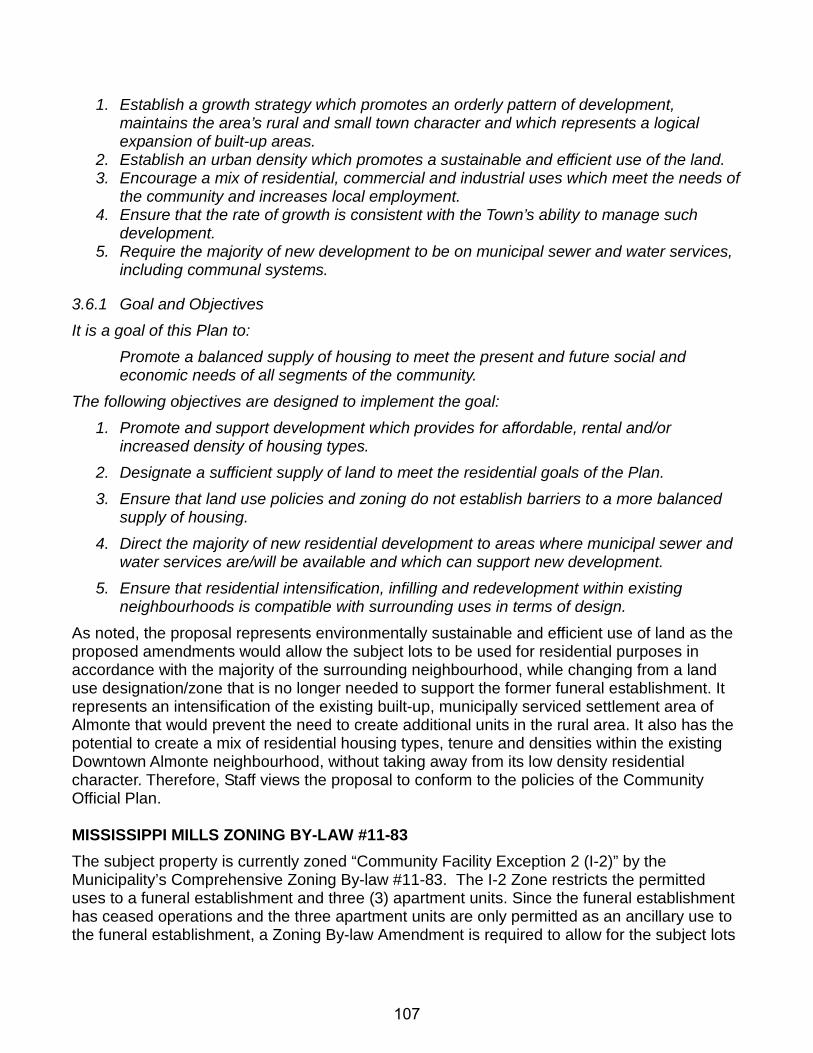
1. Establish a growth strategy which promotes an orderly pattern of development, maintains the area’s rural and small town character and which represents a logical expansion of built-up areas.
2. Establish an urban density which promotes a sustainable and efficient use of the land. 3. Encourage a mix of residential, commercial and industrial uses which meet the needs of
the community and increases local employment. 4. Ensure that the rate of growth is consistent with the Town’s ability to manage such
development. 5. Require the majority of new development to be on municipal sewer and water services,
including communal systems.
3.6.1 Goal and Objectives It is a goal of this Plan to:
Promote a balanced supply of housing to meet the present and future social and economic needs of all segments of the community.
The following objectives are designed to implement the goal: 1. Promote and support development which provides for affordable, rental and/or
increased density of housing types. 2. Designate a sufficient supply of land to meet the residential goals of the Plan. 3. Ensure that land use policies and zoning do not establish barriers to a more balanced
supply of housing. 4. Direct the majority of new residential development to areas where municipal sewer and
water services are/will be available and which can support new development. 5. Ensure that residential intensification, infilling and redevelopment within existing
neighbourhoods is compatible with surrounding uses in terms of design.
As noted, the proposal represents environmentally sustainable and efficient use of land as the proposed amendments would allow the subject lots to be used for residential purposes in accordance with the majority of the surrounding neighbourhood, while changing from a land use designation/zone that is no longer needed to support the former funeral establishment. It represents an intensification of the existing built-up, municipally serviced settlement area of Almonte that would prevent the need to create additional units in the rural area. It also has the potential to create a mix of residential housing types, tenure and densities within the existing Downtown Almonte neighbourhood, without taking away from its low density residential character. Therefore, Staff views the proposal to conform to the policies of the Community Official Plan. MISSISSIPPI MILLS ZONING BY-LAW #11-83 The subject property is currently zoned “Community Facility Exception 2 (I-2)” by the Municipality’s Comprehensive Zoning By-law #11-83. The I-2 Zone restricts the permitted uses to a funeral establishment and three (3) apartment units. Since the funeral establishment has ceased operations and the three apartment units are only permitted as an ancillary use to the funeral establishment, a Zoning By-law Amendment is required to allow for the subject lots
107
to be used for principal residential purposes. As such, the proposed Zoning By-law Amendment would change the zoning of the property from the “Community Facility Exception 2 (I-2)” Zone to the “Residential Second Density (R2)” Zone in order to permit the uses of the R2 Zone on the lots, which include the following: detached, semi-detached, duplex, triplex or converted dwelling; accessory apartment; group home type A; bed and breakfast; home-based business (i.e. domestic and household arts and professional uses); and, park. The purpose of the R2 Zone is to:
(1) restrict the building form to low density residential uses in areas designated as Residential, Rural Settlement Area or Hamlet in the Community Official Plan;
(2) allow a number of other residential uses to provide additional housing choices within the second density residential areas;
(3) permit ancillary uses to the principal residential use to allow residents to work at home; (4) regulate development in a manner that is compatible with existing land use patterns so
that the detached, two and three principal dwellings, residential character of a neighbourhood is maintained or enhanced; and
(5) permit different development standards, identified in the AA subzone, primarily for areas designated as Residential in the Almonte Ward, which promote efficient land use and compact form incorporating newer design approaches.
As noted, the purpose of the subject Community Official Plan Amendment is to change the land use designation of these two (2) vacant lots from “Downtown Commercial” to “Residential” in order to facilitate a Zoning By-law Amendment application to permit residential uses on the lots. As such, the subject Zoning By-law Amendment application to change the zoning of the property to the “Residential Second Density (R2)” Zone would conform to the purpose of the Zone to restrict the building form in the Residential designation of the COP to low density residential uses. While the majority of the surrounding neighbourhood is comprised of owner-occupied, single detached dwellings, these properties are all zoned Residential Second Density (R2). As such, the proposal would provide opportunities for additional housing choices and development rights (i.e. semi-detached, duplex and triplex dwellings) currently afforded to properties in the surrounding neighbourhood. As the R2 Zone encourages ancillary uses to the principal residential use in order to allow residents to work at home, the implementing Zoning By-law would also permit residential home-based businesses (i.e. domestic and household arts and professional uses). Therefore, it is the opinion of Staff that the subject applications meet the intent of the R2 Zone and the Municipality’s Comprehensive Zoning By-law #11-83. CONCLUSION Overall, Staff supports the subject Community Official Plan and Zoning By-law Amendments. Changing the properties from a land use designation/zone that is no longer needed to support the former funeral home establishment to a designation/zone that is reflective of the character of the surrounding neighbourhood represents a logical and efficient use of land that optimizes public investment in existing infrastructure through the intensification of the existing built-up, municipally serviced Downtown Almonte neighbourhood. It would prevent the need to create additional residential units in the rural area and has the potential to create a mix of residential housing types, tenure and densities needed within Downtown Almonte. As such, the subject
108
applications are consistent with the policies of the PPS, conform to the policies of Lanark County’s Sustainable Communities Official Plan and the Municipality’s Community Official Plan, and meet the intent of Comprehensive Zoning By-law #11-83. Therefore, Staff recommends that the Community Official Plan Amendment 14 and Zoning By-law Amendment Z-15-15 be approved. RECOMMENDATION: THAT the Committee of the Whole recommends that Council approves the Community Official Plan Amendment (COPA) 14 to change the land use designation of the lands legally described as Part Lots 10, 11 and 13, Anderson Section, Plan 6262, Being Part 1 on Plan 27R-9062 and Parts 1 and 2 on Plan 27R-5296, Almonte Ward, Municipality of Mississippi Mills, from “Downtown Commercial” to “Residential”; AND FURTHERMORE THAT the Committee of the Whole recommends that Council approves the Zoning By-law Amendment to change the zoning of the lands legally described as Part Lots 10, 11 and 13, Anderson Section, Plan 6262, Being Part 1 on Plan 27R-9062 and Parts 1 and 2 on Plan 27R-5296, Almonte Ward, Municipality of Mississippi Mills, from “Community Facility Exception 2 (I-2) Zone” to “Residential Second Density (R2) Zone” in order to permit residential uses on the lands. All of which is respectfully submitted, __________________ John McMulkin, BES Junior Planner __________________ ___________________ Stephen Stirling, MCIP, RPP Diane Smithson Municipal Planner Reviewed by CAO
109
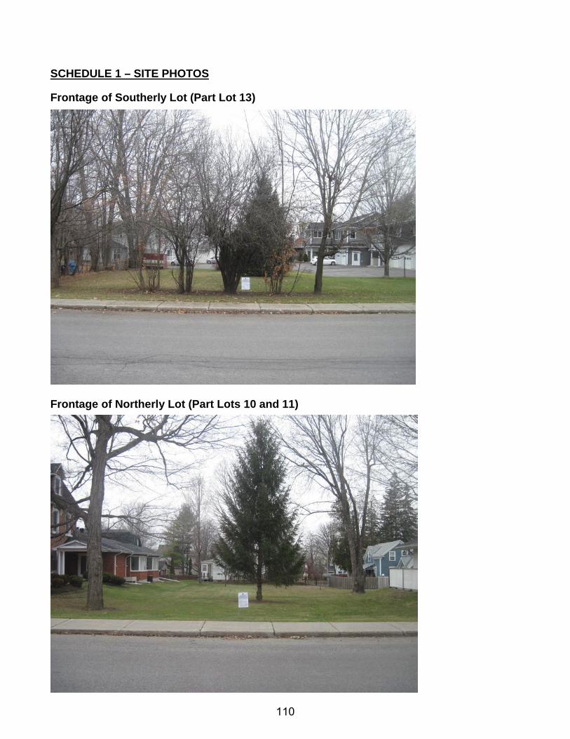
SCHEDULE 1 – SITE PHOTOS
Frontage of Southerly Lot (Part Lot 13)
Frontage of Northerly Lot (Part Lots 10 and 11)
110
SCHEDULE 2 – DRAFT COMMUNITY OFFICIAL PLAN AMENDMENT
AMENDMENT NO.14
TO THE MISSISSIPPI MILLS COMMUNITY OFFICIAL PLAN
111

AMENDMENT NO.14 TO THE
MISSISSIPPI MILLS COMMUNITY OFFICIAL PLAN The explanatory text constituting Amendment No. 14 to the Mississippi Mills Community Official Plan was prepared for the Committee of the Whole and was recommended to the Council of the Municipality of Mississippi Mills under the provisions of The Planning Act, R.S.O. 1990 on the ___ day of _________ 2016. Amendment No. 12 to the Mississippi Mills Community Official Plan as recommended by the Committee of the Whole was adopted by the Corporation of the Municipality of Mississippi Mills by By-law No. _______ in accordance with the provisions of The Planning Act, R.S.O. 1990 on the ___ day of _________ 2016.
112
AMENDMENT NO. 14 TO THE
MISSISSIPPI MILLS COMMUNITY OFFICIAL PLAN
INDEX THE CONSTITUTIONAL STATEMENT PART A - THE PREAMBLE
PURPOSE
LOCATION
BASIS PART B - THE AMENDMENT
INTRODUCTORY STATEMENT
DETAILS OF THE AMENDMENT PART C - THE APPENDICES- MUNICIPAL RECORD
APPENDIX A - CERTIFIED COPY OF BY-LAW No. _______
APPENDIX B - STATEMENT REGARDING PUBLIC NOTICE APPENDIX C - TRUE COPY OF ALL SUBMISSIONS
113
PART A - THE PREAMBLE, does not constitute part of this Amendment. PART B - THE AMENDMENT consisting of the following text and schedules
constitutes Amendment No. 14 to the Mississippi Mills Community Official Plan.
PART C - THE APPENDICES do not constitute part of this amendment. The
Appendices contain the Municipal Record pertaining to this amendment.
114
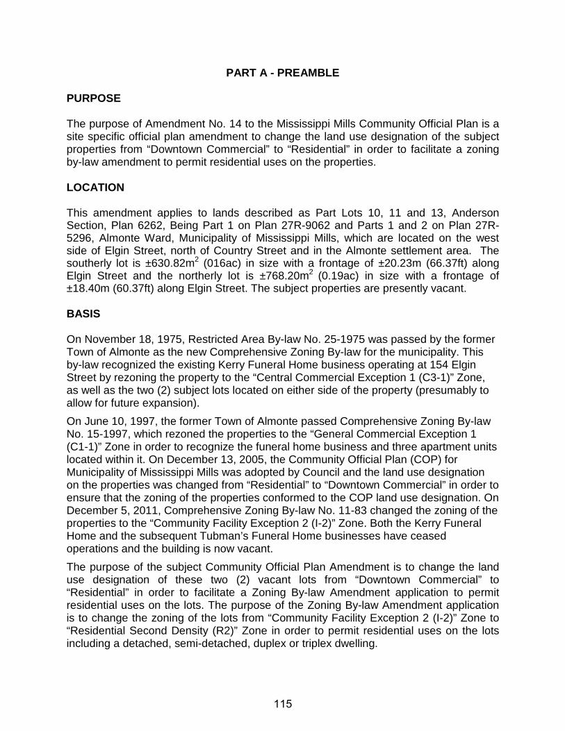
PART A - PREAMBLE PURPOSE The purpose of Amendment No. 14 to the Mississippi Mills Community Official Plan is a site specific official plan amendment to change the land use designation of the subject properties from “Downtown Commercial” to “Residential” in order to facilitate a zoning by-law amendment to permit residential uses on the properties. LOCATION This amendment applies to lands described as Part Lots 10, 11 and 13, Anderson Section, Plan 6262, Being Part 1 on Plan 27R-9062 and Parts 1 and 2 on Plan 27R-5296, Almonte Ward, Municipality of Mississippi Mills, which are located on the west side of Elgin Street, north of Country Street and in the Almonte settlement area. The southerly lot is ±630.82m2 (016ac) in size with a frontage of ±20.23m (66.37ft) along Elgin Street and the northerly lot is ±768.20m2 (0.19ac) in size with a frontage of ±18.40m (60.37ft) along Elgin Street. The subject properties are presently vacant. BASIS On November 18, 1975, Restricted Area By-law No. 25-1975 was passed by the former Town of Almonte as the new Comprehensive Zoning By-law for the municipality. This by-law recognized the existing Kerry Funeral Home business operating at 154 Elgin Street by rezoning the property to the “Central Commercial Exception 1 (C3-1)” Zone, as well as the two (2) subject lots located on either side of the property (presumably to allow for future expansion). On June 10, 1997, the former Town of Almonte passed Comprehensive Zoning By-law No. 15-1997, which rezoned the properties to the “General Commercial Exception 1 (C1-1)” Zone in order to recognize the funeral home business and three apartment units located within it. On December 13, 2005, the Community Official Plan (COP) for Municipality of Mississippi Mills was adopted by Council and the land use designation on the properties was changed from “Residential” to “Downtown Commercial” in order to ensure that the zoning of the properties conformed to the COP land use designation. On December 5, 2011, Comprehensive Zoning By-law No. 11-83 changed the zoning of the properties to the “Community Facility Exception 2 (I-2)” Zone. Both the Kerry Funeral Home and the subsequent Tubman’s Funeral Home businesses have ceased operations and the building is now vacant. The purpose of the subject Community Official Plan Amendment is to change the land use designation of these two (2) vacant lots from “Downtown Commercial” to “Residential” in order to facilitate a Zoning By-law Amendment application to permit residential uses on the lots. The purpose of the Zoning By-law Amendment application is to change the zoning of the lots from “Community Facility Exception 2 (I-2)” Zone to “Residential Second Density (R2)” Zone in order to permit residential uses on the lots including a detached, semi-detached, duplex or triplex dwelling.
115
PART B - THE AMENDMENT
INTRODUCTORY STATEMENT All of this part of the document entitled "Part B - The Amendment" and consisting of the following text constitutes amendment No. 14 to the Mississippi Mills Community Official Plan. DETAILS OF THE AMENDMENT Schedule 'B' to the Municipality of Mississippi Mills Community Official Plan, as amended, is hereby further amended by changing thereon from “Downtown Commercial” to “Residential” for those lands described as Part Lots 10, 11 and 13, Anderson Section, Plan 6262, Being Part 1 on Plan 27R-9062 and Parts 1 and 2 on Plan 27R-5296, Almonte Ward, Municipality of Mississippi Mills, County of Lanark, which are identified as the subject properties on the attached Schedule 'A'.
116
PART C - THE APPENDICES
AMENDMENT NO. 14 TO THE
MISSISSIPPI MILLS COMMUNITY OFFICIAL PLAN
MUNICIPAL RECORD
117

APPENDIX - A
CERTIFIED COPY OF BY-LAW NO. _________
ADOPTING THE AMENDMENT
118

APPENDIX - B
Statement by Municipal Employee
Regarding Public Notice
119
AMENDMENT NO. 14 TO THE
MISSISSIPPI MILLS COMMUNITY OFFICIAL PLAN I, Stephen Stirling, Municipal Planner for the Municipality of Mississippi Mills, hereby solemnly declare: (a) that the requirements for the giving of notice and the holding of at least one public meeting for informing and obtaining the views of the public set out in the Official Plan have been complied with, as prescribed by Section 17(9) through 17(14) of the Planning Act, and; (b) that the requirements for the giving of notice of adoption have been complied with, as prescribed by Section 17(17) of the Planning Act. SWORN BEFORE ME AT THE MUNICIPALITY OF MISSISSIPPI MILLS IN THE COUNTY OF LANARK THIS ___ DAY OF ___________ 2016 ______________________ _________________________________ A COMMISSIONER, ETC. Stephen Stirling, MCIP, RPP Municipal Planner
120
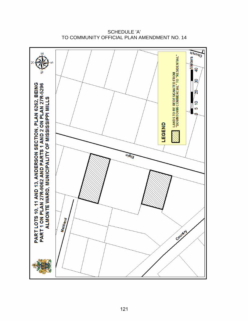
SCHEDULE 'A' TO COMMUNITY OFFICIAL PLAN AMENDMENT NO. 14
121

APPENDIX - C
True Copy of all Submissions
Received Prior to Adoption of the Amendment
122

APPENDIX - D
Official Plan Amendment No. 14 Planning Report
123
SCHEDULE 3 – DRAFT ZONING BY-LAW
THE CORPORATION OF THE MUNICIPALITY OF MISSISSIPPI MILLS
BY-LAW NO. 16-XXX BEING a by-law to amend By-law No. 11-83 being the Zoning By-law for the Municipality of Mississippi Mills. NOW THEREFORE the Council of the Corporation of the Municipality of Mississippi Mills pursuant to Section 34 of the Planning Act, R.S.O. 1990, Chapter P.13, enacts as follows: 1. Schedule 'C' to By-law No. 11-83, as amended, is hereby further amended by changing
thereon from “Community Facility Exception 2 (I-2) Zone” to “Residential Second Density (R2) Zone”, for those lands identified on the attached Schedule ‘A’, which are described as Part Lots 10, 11 and 13, Anderson Section, Plan 6262, Being Part 1 on Plan 27R-9062 and Parts 1 and 2 on Plan 27R-5296, Almonte Ward, Municipality of Mississippi Mills.
2. This By-Law takes effect from the date of passage by Council and comes into force and
effect pursuant to the provisions of the Planning Act, R.S.O 1990.
BY-LAW read, passed, signed and sealed in open Council this __ day of ________, 2016. _________________________ _________________________ Shaun McLaughlin, Mayor Shawna Stone, Clerk
124
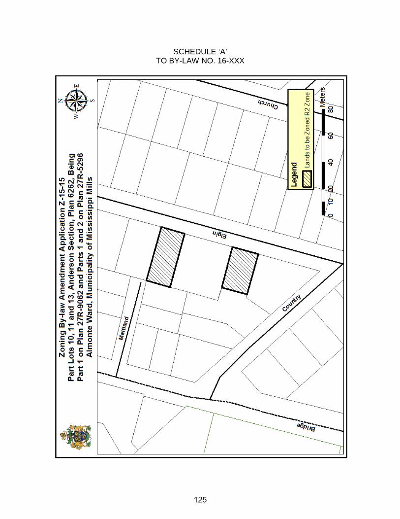
SCHEDULE ‘A’ TO BY-LAW NO. 16-XXX
125
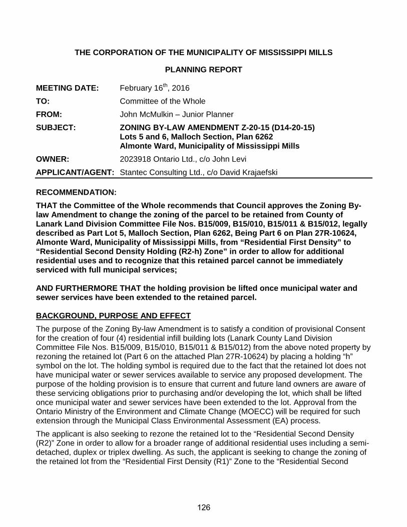
THE CORPORATION OF THE MUNICIPALITY OF MISSISSIPPI MILLS
PLANNING REPORT MEETING DATE: February 16th, 2016 TO: Committee of the Whole FROM: John McMulkin – Junior Planner SUBJECT: ZONING BY-LAW AMENDMENT Z-20-15 (D14-20-15) Lots 5 and 6, Malloch Section, Plan 6262 Almonte Ward, Municipality of Mississippi Mills OWNER: 2023918 Ontario Ltd., c/o John Levi APPLICANT/AGENT: Stantec Consulting Ltd., c/o David Krajaefski
RECOMMENDATION: THAT the Committee of the Whole recommends that Council approves the Zoning By-law Amendment to change the zoning of the parcel to be retained from County of Lanark Land Division Committee File Nos. B15/009, B15/010, B15/011 & B15/012, legally described as Part Lot 5, Malloch Section, Plan 6262, Being Part 6 on Plan 27R-10624, Almonte Ward, Municipality of Mississippi Mills, from “Residential First Density” to “Residential Second Density Holding (R2-h) Zone” in order to allow for additional residential uses and to recognize that this retained parcel cannot be immediately serviced with full municipal services; AND FURTHERMORE THAT the holding provision be lifted once municipal water and sewer services have been extended to the retained parcel. BACKGROUND, PURPOSE AND EFFECT The purpose of the Zoning By-law Amendment is to satisfy a condition of provisional Consent for the creation of four (4) residential infill building lots (Lanark County Land Division Committee File Nos. B15/009, B15/010, B15/011 & B15/012) from the above noted property by rezoning the retained lot (Part 6 on the attached Plan 27R-10624) by placing a holding “h” symbol on the lot. The holding symbol is required due to the fact that the retained lot does not have municipal water or sewer services available to service any proposed development. The purpose of the holding provision is to ensure that current and future land owners are aware of these servicing obligations prior to purchasing and/or developing the lot, which shall be lifted once municipal water and sewer services have been extended to the lot. Approval from the Ontario Ministry of the Environment and Climate Change (MOECC) will be required for such extension through the Municipal Class Environmental Assessment (EA) process. The applicant is also seeking to rezone the retained lot to the “Residential Second Density (R2)” Zone in order to allow for a broader range of additional residential uses including a semi-detached, duplex or triplex dwelling. As such, the applicant is seeking to change the zoning of the retained lot from the “Residential First Density (R1)” Zone to the “Residential Second
126
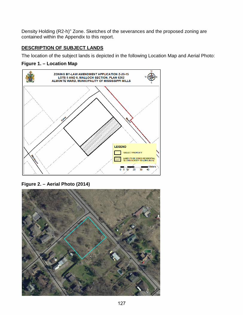
Density Holding (R2-h)” Zone. Sketches of the severances and the proposed zoning are contained within the Appendix to this report. DESCRIPTION OF SUBJECT LANDS The location of the subject lands is depicted in the following Location Map and Aerial Photo: Figure 1. – Location Map
Figure 2. – Aerial Photo (2014)
127
The subject property is located on the southwest corner of Carss Street and Martin Street North, just inside the Ward of Almonte boundary along Martin Street North. The property is ±0.35ha (0.86ac) in lot area and has a lot frontage of ±66.18m (217.13ft) along Carss Street and ±52.72m (172.97ft) along Martin Street North. The property is currently vacant. The area to be rezoned (i.e. the proposed retained parcel) has a lot area ±1,194.6m2 (0.30ac) with a frontage of ±18m (59.06ft) along Martin Street North. The property is generally surrounded by low density residential properties to the north, south and west, and rural-residential properties to the east. SERVICING & INFRASTRUCTURE The subject property is not currently serviced and fronts onto Carss Street, a municipally owned and maintained road, and Martin Street North, a County owned and maintained road. The proposed severed parcels have received municipal entrance permits for driveway access from Carss Street, with connections to water and sewer services available along the frontage of the parcels. The proposed retained parcel would have driveway access from Martin Street North and the applicant received a County entrance permit (No. 2514) for this entrance. Water and sewer services do not run to the proposed retained parcel, so an extension of these services and Ontario Ministry of the Environment and Climate Change (MOECC) approval is required to service any proposed development. COMMENTS FROM INTERNAL CIRCULATION Comments received based on the circulation of this application have been summarized below:
CAO: No concerns or objections. CBO: No concerns or objections. Clerk: No concerns or objections. Fire Chief: No concerns or objections. Director of Roads and Public Works: No concerns or objections. Recreation Coordinator: No concerns or objections.
COMMENTS FROM EXTERNAL AGENCY CIRCULATION Comments received based on the circulation of this application have been summarized below:
Upper Canada District School Board: No comments received. Enbridge Gas Distribution: Enbridge Gas Distribution does not object to the proposed application(s). Catholic District School Board of Eastern Ontario: No comments received. Rogers Cable Communications: No comments received. County of Lanark: No comments received. Ottawa River Power Corporation: No comments received. Canada Post: No comments received.
128
Bell Telephone: No comments received.
COMMENTS FROM THE PUBLIC The Municipality held a Public Meeting on January 26th, 2016, to provide an opportunity for the public to speak to the application. During the Public Meeting, no one spoke in favour of or in opposition to the application. No written correspondence has been received as of the date this report was prepared. EVALUATION OF THE APPLICATION
PROVINCIAL POLICY STATEMENT (PPS), 2014 The PPS provides policy direction on matters of provincial interest related to land use planning and development. As per Section 3(5)(a) of the Planning Act, R.S.O. 1990, all planning decisions must be consistent with the PPS. The following is a list of applicable sections of the PPS as well as a review of the proposal against these policies:
1.1.1 Healthy, liveable and safe communities are sustained by: a) promoting efficient development and land use patterns which sustain the financial
well-being of the Province and municipalities over the long term; b) accommodating an appropriate range and mix of residential (including second units,
affordable housing and housing for older persons), employment (including industrial and commercial), institutional (including places of worship, cemeteries and long-term care homes), recreation, park and open space, and other uses to meet long-term needs;
e) promoting cost-effective development patterns and standards to minimize land consumption and servicing costs;
h) promoting development and land use patterns that conserve biodiversity and consider the impacts of a changing climate.
1.1.2 Sufficient land shall be made available to accommodate an appropriate range and mix of land uses to meet projected needs for a time horizon of up to 20 years. However, where an alternate time period has been established for specific areas of the Province as a result of a provincial planning exercise or a provincial plan, that time frame may be used for municipalities within the area. Within settlement areas, sufficient land shall be made available through intensification and redevelopment and, if necessary, designated growth areas.
1.1.3.1 Settlement areas shall be the focus of growth and development, and their vitality and regeneration shall be promoted.
1.1.3.2 Land use patterns within settlement areas shall be based on: a) densities and a mix of land uses which:
1. efficiently use land and resources;
129
2. are appropriate for, and efficiently use, the infrastructure and public service facilities which are planned or available, and avoid the need for their unjustified and/or uneconomical expansion;
3. minimize negative impacts to air quality and climate change, and promote energy efficiency;
4. support active transportation; 5. are transit-supportive, where transit is planned, exists or may be developed;
and 6. are freight-supportive; and
b) a range of uses and opportunities for intensification and redevelopment in accordance with the criteria in policy 1.1.3.3, where this can be accommodated.
1.1.3.3 Planning authorities shall identify appropriate locations and promote opportunities for intensification and redevelopment where this can be accommodated taking into account existing building stock or areas, including brownfield sites, and the availability of suitable existing or planned infrastructure and public service facilities required to accommodate projected needs.
1.1.3.7 Planning authorities shall establish and implement phasing policies to ensure: a) that specified targets for intensification and redevelopment are achieved prior to, or
concurrent with, new development within designated growth areas; and b) the orderly progression of development within designated growth areas and the
timely provision of the infrastructure and public service facilities required to meet current and projected needs.
1.4.3 Planning authorities shall provide for an appropriate range and mix of housing types and densities to meet projected requirements of current and future residents of the regional market area by:
c) directing the development of new housing towards locations where appropriate levels of infrastructure and public service facilities are or will be available to support current and projected needs;
Changing the zoning of the proposed retained parcel from the “Residential First Density (R1)” Zone to the “Residential Second Density (R2)” Zone represents an intensification of the existing built-up, municipally serviced settlement area of Almonte. This supports PPS principles through the optimization of existing resources and public investment in municipal infrastructure. It would prevent the need to create additional units outside of the Almonte settlement area, thereby promoting development and a land use pattern that conserves biodiversity and considers the impacts of a changing climate through the prevention of new development in the rural area and the destruction of its natural resources. As noted, the proposed “Residential Second Density (R2)” Zoning would allow for a detached, semi-detached, duplex or triplex dwelling to be located on the proposed retained parcel. As such, the proposal could provide a mix of housing types, tenure and densities within an existing built-up Almonte neighbourhood comprised primarily of owner-occupied single detached dwellings. Opportunities for affordable and special needs housing for low and moderate income could be provided, should future owners wish to provide rental
130
accommodation within any of these proposed dwellings. The proposal also contributes to an environment that supports the use and implementation of active transportation and public transit due to its location within Almonte and its close proximity to shopping, parkland, health care, education and other community amenities. The application of the holding provision to the proposed retained parcel in order to facilitate four (4) residential severances would satisfy Policy 1.1.3.7(b) of the PPS through the timely provision of infrastructure in a designated growth area, while at the same time being consistent with Policy 1.4.3(c) by directing new housing towards locations where appropriate levels of infrastructure and public service facilities are or will be available to support current and projected needs. Therefore, it is the opinion of Staff that the application is consistent with the PPS. COMMUNITY OFFICIAL PLAN (COP) The subject property is designated “Residential” in the local Community Official Plan. The Residential designation permits low and medium density residential uses as well as associated accessory uses. Section 2.5 of the COP entitled “Growth and Settlement” contains policies, goals and objectives guiding the planned growth and development of the Municipality for all land use designations, while Section 3.6 contains the land use policies regarding properties located within the Residential designation. Section 5.3.3 of the COP outlines the policies related to holding zones. The following provides an analysis of the proposal against the relevant policies: 2.5.1 Goals and Objectives It is a goal of this Plan to:
Promote managed, co-ordinated and fiscally responsible growth, which represents an efficient use of land and is environmentally sustainable. Direct the majority of new growth to areas where municipal services are available and where capacity exists to support new development.
The following objectives are designed to implement the goals:
• Establish a growth strategy which promotes an orderly pattern of development, maintains the area’s rural and small town character and which represents a logical expansion of built-up areas.
• Establish an urban density which promotes a sustainable and efficient use of the land. • Encourage a mix of residential, commercial and industrial uses which meet the needs of
the community and increases local employment. • Ensure that the rate of growth is consistent with the Town’s ability to manage such
development. • Require the majority of new development to be on municipal sewer and water services,
including communal systems.
2.5.3.2.2 50/30/20 Settlement Strategy The 50/30/20 Settlement Strategy of this Plan is based on a comprehensive review and represents a fundamental shift in where growth will be accommodated. The comprehensive
131
review included the population projection information noted in Section 2.5.3.1. The Plan is designed to direct:
• 50% of future growth to Almonte on full municipal services; • 30% of future growth to rural areas, existing villages with large lots, developed on
private services; and, • 20% of future growth to the existing villages or new rural settlement areas with a form of
servicing which can support lot sizes of approximately 1,000 to 2,000 square metre ( ¼ to ½ acre).
3.6.1 Goal and Objectives It is a goal of this Plan to:
Promote a balanced supply of housing to meet the present and future social and economic needs of all segments of the community.
The following objectives are designed to implement the goal: 1. Promote and support development which provides for affordable, rental and/or
increased density of housing types. 2. Designate a sufficient supply of land to meet the residential goals of the Plan. 3. Ensure that land use policies and zoning do not establish barriers to a more balanced
supply of housing. 4. Direct the majority of new residential development to areas where municipal sewer and
water services are/will be available and which can support new development. 5. Ensure that residential intensification, infilling and redevelopment within existing
neighbourhoods is compatible with surrounding uses in terms of design. 3.6.5 Range of Housing Types
1. The Town shall support a wide range of housing types, zoning standards and subdivision design standards.
2. The Town has established the following housing mix targets:
• Low Density - 70%
• Medium Density - 30% 3. Low density residential development shall include single detached, semi-detached,
duplex, converted dwellings, and triplex housing. In general, the gross density for low density residential development shall be 15 units per hectare (6 units per acre).
5.3.3 Holding Zones Through the Zoning By-law, the Town may pre-zone property for development where the “principle of development” has been established through this Plan. In such cases, the Town may place a Holding Symbol on the zone which prevents any development from taking place until the Town is satisfied that certain conditions have been met. In such instances, the Town
132
can indicate its support for the principle of the development but also identify the need for additional actions prior to development proceeding. The use of a Holding Symbol is seen as an effective tool in the streamlining of the approval process. Following a public notice, Council simply has to pass a by-law to remove the Holding Symbol once it is satisfied that the conditions have been met. There is no appeal period with such by-laws, thereby allowing development to proceed quickly once the conditions have been met. The following policies shall apply to the use of the Holding Symbol.
1. The Town may utilize the Holding Symbol "H" or "h" for all zones in the Zoning By-law as a means of ensuring that certain conditions have been met prior to development proceeding.
2. When lands are placed under the Holding Symbol, the use of the lands and buildings shall be limited to those that existed prior to the Holding Symbol being placed on the property. In some circumstances, the Town may allow additions or alterations to existing uses.
3. Council shall pass a by-law removing the Holding Symbol from the property, in accordance with the requirements of the Planning Act, once it is satisfied that provisions are met and/or agreements entered into which ensure the orderly development of the lands.
4. The Town may use holding provisions of the Planning Act where there is a need for the owner/developer to:
(ii) make arrangements for the installation of sanitary or storm sewer, water and/or road services;
The subject application represents a low density residential development that falls within the Municipality’s established low density housing target of 70% for new residential development. As noted, the proposal is an environmentally sustainable and efficient use of land as the proposed amendment would allow for a mix of residential housing types, tenure and densities within the existing Almonte neighbourhood, without taking away from its low density residential character. It represents an intensification of the existing built-up, municipally serviced settlement area of Almonte that would prevent the need to create additional units in the rural area. As such, it is the opinion of Staff that the proposed R2 Zoning conforms to the residential and growth/settlement of the Community Official Plan. In addition, the use of the holding provision is seen as an effective tool to streamline the development approval process, while preventing development from taking place until the Municipality is satisfied that certain conditions have been met. Section 2.5.3.2.2 of the COP requires that all future growth and development within the Almonte Ward be on full municipal services (i.e. municipal water and sewer services). As Policy No. 5.3.3.4(ii) allows the Municipality to use a holding provision on a property until municipal water and sewer services have been extended to the property, the use of the holding provision of the proposed retained parcel is viewed by Staff to be an effective tool to ensure that the proposed development proceeds on full municipal services. Therefore, Staff views this application of the holding provision to conform to the policies of the Community Official Plan.
133
ZONING BY-LAW #11-83 The subject property is currently zoned “Residential First Density (R1)” by the Municipality’s Comprehensive Zoning By-law #11-83. The R1 Zone permits the following uses: detached dwelling; accessory apartment; group home type A; bed and breakfast; home-based business (i.e. domestic and household arts and professional uses); and park. The applicant is seeking to change the zoning of the retained lot to the “Residential Second Density Holding (R2-h)” Zone in order to recognize that the lot cannot be immediately serviced by municipal water and sewer services and to allow for a broader range of residential uses in addition to the uses of the R1 Zone. These additional residential uses include a semi-detached, duplex or triplex dwelling. The purpose of the R2 Zone is to:
(1) restrict the building form to low density residential uses in areas designated as Residential, Rural Settlement Area or Hamlet in the Community Official Plan;
(2) allow a number of other residential uses to provide additional housing choices within the second density residential areas;
(3) permit ancillary uses to the principal residential use to allow residents to work at home; (4) regulate development in a manner that is compatible with existing land use patterns so
that the detached, two and three principal dwellings, residential character of a neighbourhood is maintained or enhanced; and
(5) permit different development standards, identified in the AA subzone, primarily for areas designated as Residential in the Almonte Ward, which promote efficient land use and compact form incorporating newer design approaches.
As noted, the subject application represents a low density residential development within an existing Almonte neighbourhood. As such, the subject Zoning By-law Amendment application to change the zoning of the property to the “Residential Second Density (R2)” Zone would conform to the purpose of the Zone to restrict the building form in the Residential designation of the COP to low density residential uses. While the majority of the surrounding neighbourhood is comprised of owner-occupied, single detached dwellings, the proposal would provide opportunities for additional housing choices and development rights (i.e. semi-detached, duplex and triplex dwellings). As the R2 Zone encourages ancillary uses to the principal residential use in order to allow residents to work at home, the implementing Zoning By-law would also permit residential home-based businesses (i.e. domestic and household arts and professional uses). Therefore, it is the opinion of Staff that the subject applications meet the intent of the R2 Zone and the Municipality’s Comprehensive Zoning By-law #11-83. CONCLUSION Overall, Staff supports the subject Zoning By-law Amendment application. The placing of a holding provision on the proposed retained parcel in order to facilitate four (4) residential severances is seen as an effective tool to streamline the development approval process while preventing development from occurring until municipal water and sewer services have been extended to the parcel. Changing the proposed retained parcel from the “Residential First Density (R1)” Zone to the “Residential Second Density (R2)” Zone represents an intensification of the existing built-up, municipally serviced settlement area of Almonte that optimizes public investment in existing infrastructure. It would prevent the need to create additional residential
134
units in the rural area and has the potential to create a mix of residential housing types, tenure and densities needed within Almonte. As such, the subject application is consistent with the policies of the PPS, conforms to the policies of the Municipality’s Community Official Plan and meets the intent of Comprehensive Zoning By-law #11-83. Therefore, Staff recommends that Zoning By-law Amendment Z-20-15 be approved.
RECOMMENDATION: THAT the Committee of the Whole recommends that Council approves the Zoning By-law Amendment to change the zoning of the parcel to be retained from County of Lanark Land Division Committee File Nos. B15/009, B15/010, B15/011 & B15/012, legally described as Part Lot 5, Malloch Section, Plan 6262, Being Part 6 on Plan 27R-10624, Almonte Ward, Municipality of Mississippi Mills, from “Residential First Density” to “Residential Second Density Holding (R2-h) Zone” in order to allow for additional residential uses and to recognize that this retained parcel cannot be immediately serviced with full municipal services; AND FURTHERMORE THAT the holding provision be lifted once municipal water and sewer services have been extended to the retained parcel. All of which is respectfully submitted, __________________ John McMulkin, BES Junior Planner __________________ ___________________ Stephen Stirling MCIP, RPP Diane Smithson Municipal Planner Reviewed by CAO
135
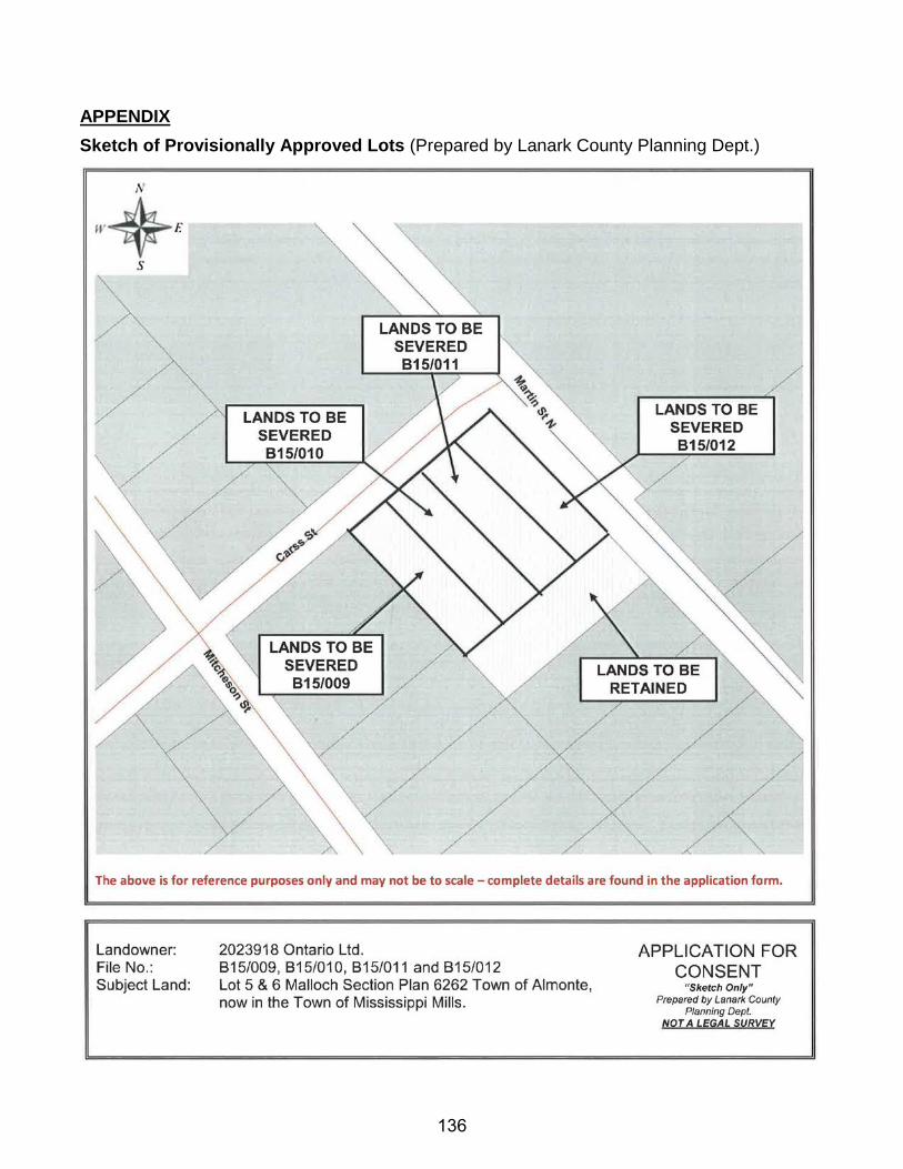
APPENDIX Sketch of Provisionally Approved Lots (Prepared by Lanark County Planning Dept.)
136
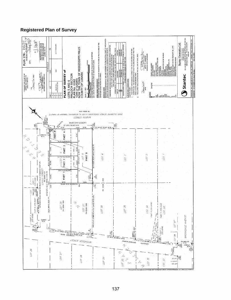
Registered Plan of Survey
137
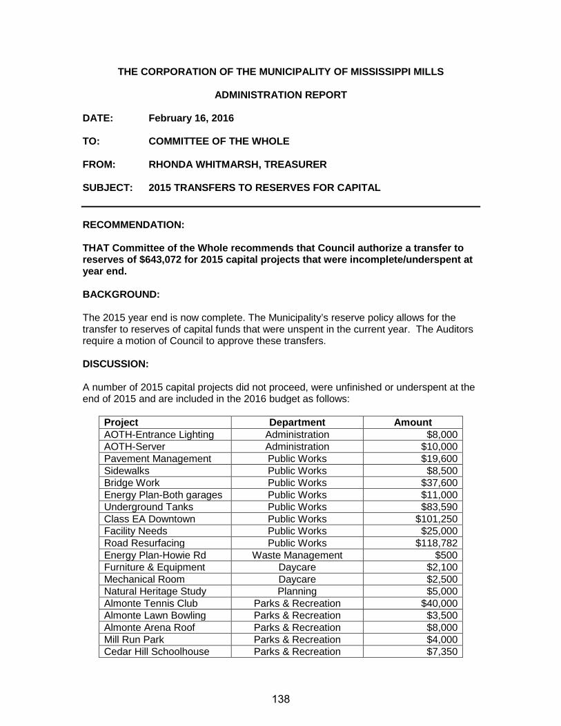
THE CORPORATION OF THE MUNICIPALITY OF MISSISSIPPI MILLS
ADMINISTRATION REPORT
DATE: February 16, 2016 TO: COMMITTEE OF THE WHOLE FROM: RHONDA WHITMARSH, TREASURER SUBJECT: 2015 TRANSFERS TO RESERVES FOR CAPITAL RECOMMENDATION: THAT Committee of the Whole recommends that Council authorize a transfer to reserves of $643,072 for 2015 capital projects that were incomplete/underspent at year end. BACKGROUND: The 2015 year end is now complete. The Municipality’s reserve policy allows for the transfer to reserves of capital funds that were unspent in the current year. The Auditors require a motion of Council to approve these transfers. DISCUSSION: A number of 2015 capital projects did not proceed, were unfinished or underspent at the end of 2015 and are included in the 2016 budget as follows:
Project Department Amount AOTH-Entrance Lighting Administration $8,000 AOTH-Server Administration $10,000 Pavement Management Public Works $19,600 Sidewalks Public Works $8,500 Bridge Work Public Works $37,600 Energy Plan-Both garages Public Works $11,000 Underground Tanks Public Works $83,590 Class EA Downtown Public Works $101,250 Facility Needs Public Works $25,000 Road Resurfacing Public Works $118,782 Energy Plan-Howie Rd Waste Management $500 Furniture & Equipment Daycare $2,100 Mechanical Room Daycare $2,500 Natural Heritage Study Planning $5,000 Almonte Tennis Club Parks & Recreation $40,000 Almonte Lawn Bowling Parks & Recreation $3,500 Almonte Arena Roof Parks & Recreation $8,000 Mill Run Park Parks & Recreation $4,000 Cedar Hill Schoolhouse Parks & Recreation $7,350
138
Banners C&EDC $2,500 Christmas Lights C&EDC $5,000 Tables & Chairs C&EDC $500 Trenchless Sewer Lining Water & Sewer $45,000 Winter Freeze List Water & Sewer $40,000 Infiltration Program Water & Sewer $20,000 Strategic Plan Library $600 Energy Plan Library $1,200 Facility Maintenance Library $32,000 Total $643,072
I am requesting that Council approve the transfer to reserves for these projects. FINANCIAL IMPLICATIONS: The 2016 budget includes carry forward projects from 2015 and assumes that funding would come from reserves. The 2016 budget has already been approved with this funding included. SUMMARY Each year at year end I request a transfer to reserves for unspent capital so that projects can proceed in the following year. I am requesting that Council approve a transfer to reserves in the amount of $643,072 for 2015 unspent capital projects. Respectfully Submitted Reviewed By Rhonda Whitmarsh, Diane Smithson Treasurer CAO
139
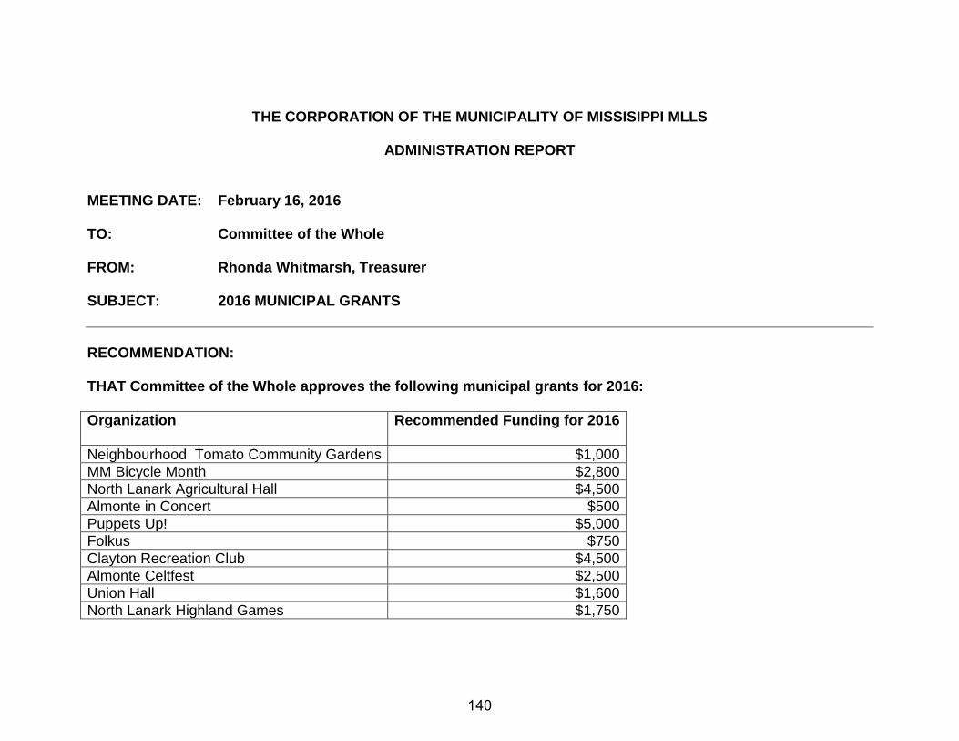
THE CORPORATION OF THE MUNICIPALITY OF MISSISIPPI MLLS
ADMINISTRATION REPORT
MEETING DATE: February 16, 2016 TO: Committee of the Whole
FROM: Rhonda Whitmarsh, Treasurer SUBJECT: 2016 MUNICIPAL GRANTS RECOMMENDATION: THAT Committee of the Whole approves the following municipal grants for 2016: Organization Recommended Funding for 2016
Neighbourhood Tomato Community Gardens $1,000 MM Bicycle Month $2,800 North Lanark Agricultural Hall $4,500 Almonte in Concert $500 Puppets Up! $5,000 Folkus $750 Clayton Recreation Club $4,500 Almonte Celtfest $2,500 Union Hall $1,600 North Lanark Highland Games $1,750
140
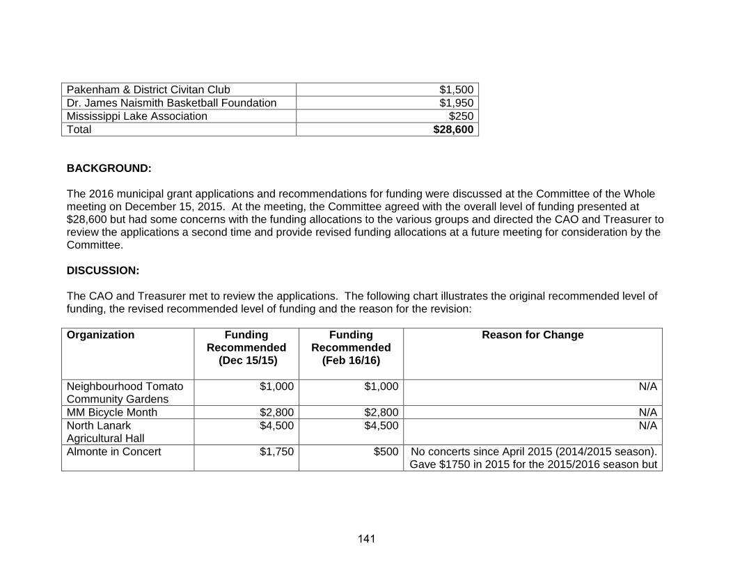
Pakenham & District Civitan Club $1,500 Dr. James Naismith Basketball Foundation $1,950 Mississippi Lake Association $250 Total $28,600 BACKGROUND: The 2016 municipal grant applications and recommendations for funding were discussed at the Committee of the Whole meeting on December 15, 2015. At the meeting, the Committee agreed with the overall level of funding presented at $28,600 but had some concerns with the funding allocations to the various groups and directed the CAO and Treasurer to review the applications a second time and provide revised funding allocations at a future meeting for consideration by the Committee. DISCUSSION: The CAO and Treasurer met to review the applications. The following chart illustrates the original recommended level of funding, the revised recommended level of funding and the reason for the revision: Organization Funding
Recommended (Dec 15/15)
Funding Recommended
(Feb 16/16)
Reason for Change
Neighbourhood Tomato Community Gardens
$1,000 $1,000 N/A
MM Bicycle Month $2,800 $2,800 N/A North Lanark Agricultural Hall
$4,500 $4,500 N/A
Almonte in Concert $1,750 $500 No concerts since April 2015 (2014/2015 season). Gave $1750 in 2015 for the 2015/2016 season but
141
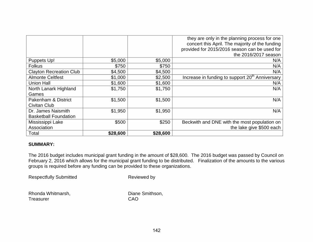
they are only in the planning process for one concert this April. The majority of the funding
provided for 2015/2016 season can be used for the 2016/2017 season
Puppets Up! $5,000 $5,000 N/A Folkus $750 $750 N/A Clayton Recreation Club $4,500 $4,500 N/A Almonte Celtfest $1,000 $2,500 Increase in funding to support 20th Anniversary Union Hall $1,600 $1,600 N/A North Lanark Highland Games
$1,750 $1,750 N/A
Pakenham & District Civitan Club
$1,500 $1,500 N/A
Dr. James Naismith Basketball Foundation
$1,950 $1,950 N/A
Mississippi Lake Association
$500 $250 Beckwith and DNE with the most population on the lake give $500 each
Total $28,600 $28,600 SUMMARY: The 2016 budget includes municipal grant funding in the amount of $28,600. The 2016 budget was passed by Council on February 2, 2016 which allows for the municipal grant funding to be distributed. Finalization of the amounts to the various groups is required before any funding can be provided to these organizations. Respectfully Submitted Reviewed by Rhonda Whitmarsh, Diane Smithson, Treasurer CAO
142
THE CORPORATION OF THE MUNICIPALITY OF MISSISSIPPI MILLS
ADMINISTRATION REPORT
DATE: February 16, 2016 TO: Committee of the Whole FROM: Diane Smithson, CAO SUBJECT: CORPORATE SPONSORSHIP RECOMMENDATION RECOMMENDATION: THAT Council authorizes the Mayor and Clerk to enter into a three (3) year sole-sourced corporate sponsorship agreement with Cornerstone Sponsorship Management AND FURTHERMORE THAT staff be instructed to finalize the Municipality’s Naming Rights Policy and Procedure for consideration by Council. BACKGROUND: In October 2015, Mayor McLaughlin submitted a report for consideration at the October 20, 2015 Committee of the Whole meeting regarding Corporate Sponsorship. Following discussions at that meeting, the following resolution was passed by Council on November 3, 2015: Motion #2 Resolution No. 379-15 Moved by Councillor Ferguson Seconded by Councillor Cameron BE IT RESOLVED THAT Council agree to explore corporate sponsorships of municipal assets to develop a third stream of revenue; AND FURTHERMORE THAT a working group comprised of Councillor Abbott, Councillor Cameron, the Mayor and CAO be established to develop a policy and recommendations on sponsorships for Council’s consideration.
CARRIED
DISCUSSION: Since November, the working group has been meeting to discuss policy considerations (i.e. recommendations on what assets could be named versus not), reviewing sample policy and agency agreements and the fee structure. A list of assets that the working group recommends to Council for sponsorship consideration is attached in Appendix A to this report. The working group agreed that the following types of assets should not be considered for sponsorship:
143
• No assets, including street named after a former historic member of our community i.e. Gemmill Park, Metcalfe Park, Stewart Community Centre. As an alternative assets within these facilities/areas could be considered i.e. splash pad, skateboard park, etc.
In terms of the sponsorship agreement, amendments are required in the following areas: • A termination clause needs to be added to allow the Municipality to get out of the agreement
prior to the end of term, if necessary • All initial sponsorship deals should be approved by a Committee which has been given
Delegated Authority in order to provide timely responses to deals brought forward. • Payment of amounts owing to Cornerstone is to be changed from 5 days to at least 14 days
(net 30 days preferred). An invoice is to be received as well before payment will be made. • Contracts for existing sponsorships are not party to any agreement with Cornerstone.
The term of the initial agreement would be three (3) years though there is an automatic renewal built in of two (2) years if notice is not provided 120 days prior to the end of the term to terminate the contract. Given that dealing with sponsorship will take a lot of staff time if done by the training method, the working group recommends that Council agree to proceed with sponsorship based on the agency model whereby the company brings in the sponsors for our consideration and manages the sponsorship relationship. If Council agrees with the list of assets to be and not to be considered for sponsorship and agrees to the points raised above for entering into an agreement, staff recommends proceeding with a three (3) year sponsorship agreement. If Council has questions, Mr. Montgomery from Cornerstone is willing to attend a meeting to address any questions. A portion of the meeting could also be set aside for various festival / event organizers who may want to look into sponsorship opportunities as a way of funding their events. The one thing that Council needs to give consideration to is whether a public meeting should be held to discuss with the public about the assets that are being considered for corporate sponsorship prior to entering into an agreement with Cornerstone. FINANCIAL IMPACT: Under the Agency model of corporate sponsorship, the following fees will apply: • a retainer fee of $5,000 • a $5,000 listing fee regardless of the number of properties listed • an agency fee of 20% of the value of the sponsorship payment payable over the term of the
naming rights or sponsorship agreement They provide a guarantee that if they do not present over $250,000 over term sponsorships during the first 18 months of their contract, they will waive all outstanding agency fees. Council will need to decide how any proceeds from corporate sponsorship will be utilized. SUMMARY The Sponsorship Working Group has been in discussions regarding various aspects associated with pursuing a corporate sponsorship arrangement for the Municipality. After reviewing the matter, the Sponsorship Working Group is recommending that Council enter into a three year sponsorship agreement with Cornerstone Sponsorship Management.
144
Respectfully submitted, Diane Smithson, Chief Administrative Officer ATTACHMENT: Appendix A – list of assets considered for sponsorship Appendix B – Municipal Naming Rights Policy and Procedure Template Appendix C – Draft Sponsorship Agreement with Cornerstone
145
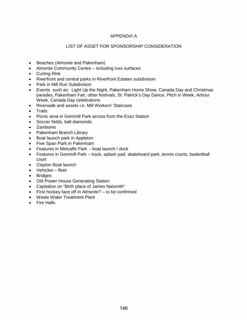
APPENDIX A
LIST OF ASSET FOR SPONSORSHIP CONSIDERATION
• Beaches (Almonte and Pakenham) • Almonte Community Centre – including ices surfaces • Curling Rink • Riverfront and central parks in Riverfront Estates subdivision • Park in Mill Run Subdivision • Events such as: Light Up the Night, Pakenham Home Show, Canada Day and Christmas
parades, Pakenham Fair, other festivals, St. Patrick’s Day Dance, Pitch in Week, Arbour Week, Canada Day celebrations
• Riverwalk and assets i.e. Mill Workers’ Staircase • Trails • Picnic area in Gemmill Park across from the Esso Station • Soccer fields, ball diamonds • Zambonis • Pakenham Branch Library • Boat launch park in Appleton • Five Span Park in Pakenham • Features in Metcalfe Park - boat launch / dock • Features in Gemmill Park – track, splash pad, skateboard park, tennis courts, basketball
court • Clayton Boat launch • Vehicles – fleet • Bridges • Old Power House Generating Station • Capitalize on “Birth place of James Naismith” • First hockey face off in Almonte? – to be confirmed • Waste Water Treatment Plant • Fire Halls
146
147
148
149
150
151
152

153
154
155
156
157

158
159

160
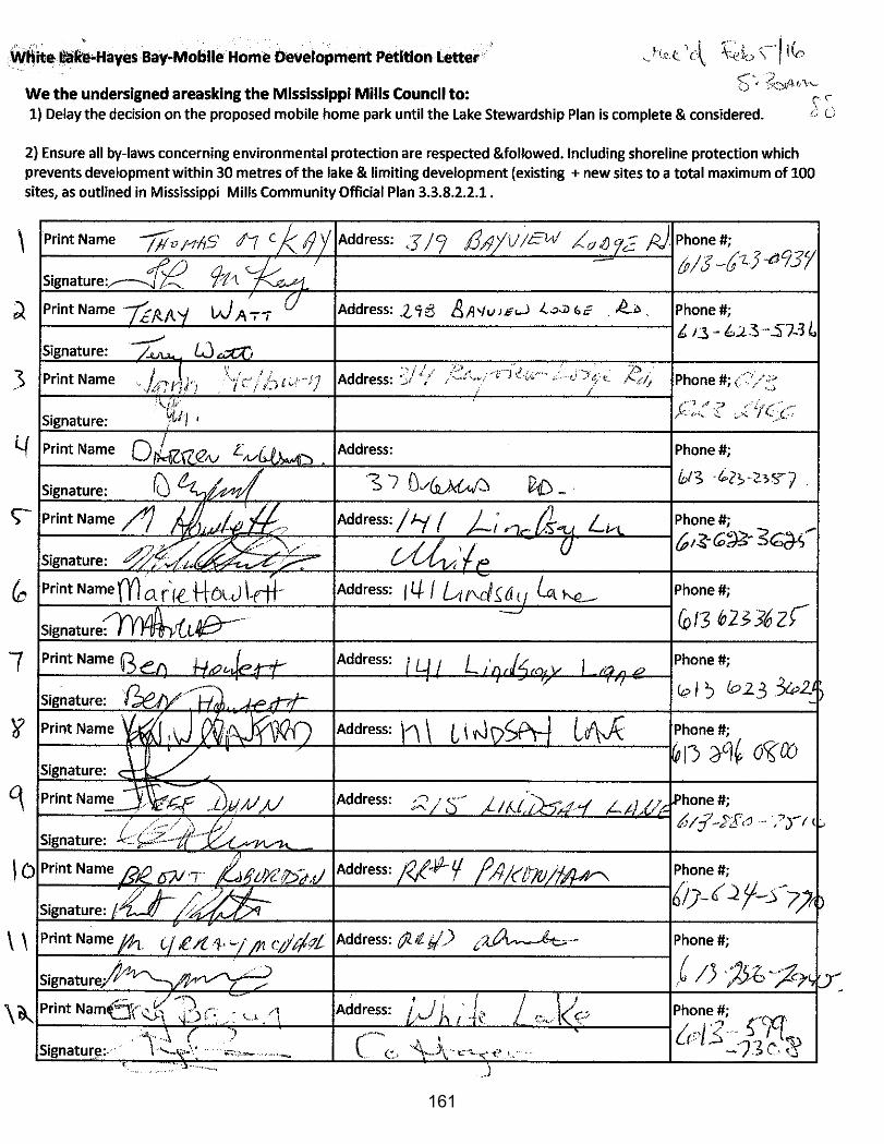
161
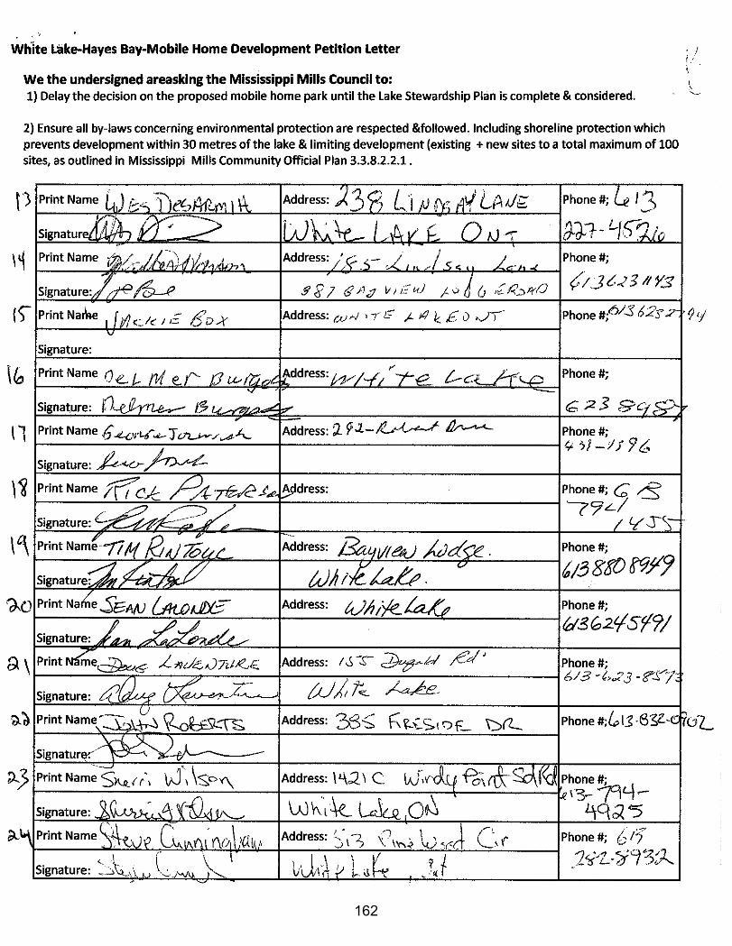
162
163
164
165
166
A meeting of the COMMITTEE OF THE WHOLE was held on Tuesday, February 2, 2016 in Council Chambers. PRESENT: Committee: Councillor John Edwards, Chairperson
Councillor Bernard Cameron Councillor Denzil Ferguson
Councillor Alex Gillis Councillor Christa Lowry Councillor Jill McCubbin
Councillor Jane Torrance Councillor Val Wilkinson
Staff: Diane Smithson, CAO Shawna Stone, Clerk
Troy Dunlop, Director of Roads & Public Works (left at 7:53 p.m.) Steve Stirling, Planner (left at 8:32 p.m.) Calvin Murphy, Manager of Recreation (left at 8:32 p.m.) Tiffany MacLaren, Community/Cultural Coordinator (left at 8:32 p.m.) John McMulkin, Planning Coordinator (left at 7:53 p.m.) ABSENT: Mayor Shaun McLaughlin
Councillor Duncan Abbott Councillor Paul Watters Councillor Edwards called the meeting to order at 6:47 p.m. A. APPROVAL OF AGENDA
Moved by Councillor Ferguson Seconded by Councillor Lowry THAT the agenda be approved as presented.
CARRIED
B. DISCLOSURE OF PECUNIARY INTEREST None were declared.
C. DELEGATIONS/PRESENTATIONS/PUBLIC MEETINGS 1. Paul Virgin and Scott Newton – Mississippi River Power Corporation (MRPC) Mr. Newton provided a review of 2015 - focus on operational improvements and employee safety; performance highlights - lower flows resulted in revenue less than projected; phase one of Metcalfe GeoHeritage Park landscaping plan completed; plan for 2016 and beyond is to develop a strategic plan, complete phase two of Metcalfe Park plan, complete repairs of the old generating station, dam and by-wash area. Mr. Virgin reviewed the plan for Millfall Dam, priority is to improve operational safety; provided an update on penstocks, a mediator has been selected and timeline registered with the courts.
167
2. Public Meeting: Zoning Amendment Neil – 1088 Wolf Grove Road The Planning Coordinator provided an overview of the application. The Clerk advised the following correspondence was received in opposition to the application: • Barry and Patricia Johnston, received January 20, 2016 • John Dewis, received February 2, 2016 • Petition from neighbouring property owners (9 signatures), received January
29, 2016 Tracey Zander, Zander Plan Inc., spoke in support of the application. The following members of the public spoke in opposition to the application: Sally Parsons, Patricia Johnston, and John Dewis. The main concerns raised included excessive noise and environmental risks, namely proximity to wetland, endangered species, demand on water supply, and pollution. The Planning Coordinator stated that the MVCA is conducting a peer review of the EIS completed by DST Engineering Consultants. The applicant, Jeff Neil, answered questions from the Committee regarding business operations. There was a question regarding the temporary salt shed. Staff to follow up with the MVCA for comment.
D. CONSENT MATTERS
Animal Control – 4th Quarter 2015
Moved by Councillor Ferguson Seconded by Councillor Wilkinson THAT the Animal Control report be received.
CARRIED
E. STAFF REPORTS
Public Works Recycling Contract – Change in Facility Processing
Moved by Councillor Ferguson Seconded by Councillor Wilkinson THAT the Director of Roads and Public Works report Recycling Contract – Change in Processing Facility be received.
CARRIED
168
Recreation and Culture Municipal Recognition Program Moved by Councillor McCubbin Seconded by Councillor Lowry THAT a policy be created based on the parameters outlined in the proposal presented by the CEDC and council working group.
CARRIED
Planning and Development Millrun Park - Preliminary Information The Planner provided an overview of the concept plan for Millrun Park. The Committee provided the following comments: • clarify the developer’s responsibility to grade and seed the park per the
agreement • consider removing the shade structure to minimize costs • concern re: the environmental impact of the trail around the pond area, consider
naturalizing this area to minimize maintenance costs • possibility of memorial trees/benches as a funding option • carefully communicate to the public that the plan is a draft Moved by Councillor Gillis Seconded by Councillor Lowry THAT the Planner’s report Millrun Park Preliminary Information be received.
CARRIED
Finance and Administration 1. Bill 8 – Public Sector & MPP Accountability and Transparency Act
Moved by Councillor Ferguson Seconded by Councillor Gillis THAT the Clerk’s report Bill 8 - Public Sector & MPP Accountability and Transparency Act report be received; THAT the Delegation of Authority By-law 13-18 be amended to delegate to the Clerk the powers and duties as head under the Municipal Freedom of Information and Protection of Privacy Act (section 3, subsection 49(1)).
CARRIED – BY-LAW PREPARED
169

2. Agreement with Almonte Farmers’ Market 2016-2021
Moved by Councillor McCubbin Seconded by Councillor Lowry THAT the Committee of the Whole recommends that Council authorize the Mayor and Clerk to enter into a five (5) year agreement with the Almonte Farmers’ Market for the lease of the Mississippi Mills Public Library – Almonte Branch parking lot for a Farmers’ Market for the years 2016-2021.
CARRIED – BY-LAW PREPARED
3. Gemmill Park Project Timeline
Moved by Councillor Ferguson Seconded by Councillor McCubbin THAT the CAO’s report Gemmill Park Project Timeline be received.
CARRIED 4. Pakenham Branch Library Building Committee
Moved by Councillor Cameron Seconded by Councillor Torrance THAT the Committee of the Whole recommends that Council authorize the Mississippi Mills Public Library Board to enter into a contribution agreement with the Federal Economic Development Agency for Southern Ontario (FedDev Ontario) to receive the $264,880 funding for the Pakenham Branch – Mississippi Mills Public Library expansion under the Canada 150 Community Infrastructure Program (CIP 150).
CARRIED – MOTION PREPARED
Moved by Councillor Cameron Seconded by Councillor Wilkinson THAT the Committee of the Whole recommends that Council approve the establishment of a Pakenham Library Building Committee comprised of three (3) members of Council and three (3) members of the Mississippi Mills Library Board as the oversight committee to award the contract for the various components of the Canada 150 Community Infrastructure funding that the Mississippi Mills Public Library Board received for the Pakenham Library Branch expansion and to approve any change orders up to the budgeted amount of $529,760.00 and to ensure the project proceeds according to schedule; AND FURTHERMORE THAT the following be appointed to the Pakenham Library Building Committee – Councillors Cameron, Edwards, and Ferguson.
CARRIED – MOTION PREPARED
170
5. Continuation of Heritage Conservation District Study and Plan
Moved by Councillor Gillis Seconded by Councillor Lowry THAT the Property Owner’s Guide to the Downtown Almonte Heritage Conservation District and the Cultural Heritage Impact Assessment Guide subject to the passing of the Heritage Conservation District Study and Plan be approved; AND THAT the by-law to establish a heritage grants program for owners of properties located within a Heritage Conservation District under Part V of the Ontario Heritage Act subject to the passing of the Heritage Conservation District Study and Plan be approved; AND THAT councilors are encouraged to meet with property owners to discuss issues related to the Heritage Conservation District Study and report back with findings by March 24, 2016 to allow discussions to continue at the April 5, 2016 Committee of the Whole meeting; AND THAT as part of any approval of the Heritage Conservation District Study and Plan for Downtown Almonte, that Council commit to an annual review process to address any concerns of property owners located within the HCD.
CARRIED F. OTHER/NEW BUSINESS
G. CLOSED SESSION/IN CAMERA Moved by Councillor Ferguson Seconded by Councillor Gillis BE IT RESOLVED THAT the Committee of the Whole enter into an in camera session at 9:06 p.m. to discuss a proposed or pending acquisition or disposition of land by the municipality, lot purchase (Municipal Act, s. 239 2(c)).
CARRIED Moved by Councillor Lowry Seconded by Councillor Ferguson BE IT RESOLVED THAT the Committee of the Whole returns to regular session at 9:30 p.m.
CARRIED
Rise & Report 1. Update on Lot Purchase Direction was provided to staff in camera.
171
H. NOTICE OF MOTION
I. MINUTES Moved by Councillor Cameron Seconded by Councillor Ferguson THAT the Committee of the Whole Minutes dated January 26, 2016 be approved.
CARRIED
Moved by Councillor Gillis Seconded by Councillor McCubbin THAT the minutes of the Accessibility Advisory dated January 13, 2016 be received.
CARRIED Moved by Councillor Gillis Seconded by Councillor McCubbin THAT the 2015-2019 Multi-year Accessibility Plan be received.
CARRIED
J. INFORMATION PACKAGE, TASK LIST AND MEETING CALENDAR
Moved by Councillor Lowry Seconded by Councillor Gillis THAT the meeting calendar be received.
CARRIED
K. ANNOUNCEMENTS/QUESTIONS OF STAFF Special Committee of the Whole – Active/Transportation Master Plan - February 9, 2016, 6:00 p.m. Council Meeting – February 16, 2016, 6:00 p.m., followed by Committee of the Whole
L. ADJOURNMENT Moved by Councillor Lowry Seconded by Councillor Gillis THAT the Committee of the Whole meeting be adjourned.
CARRIED The meeting adjourned at 9:21 p.m. ____________________________________ Shawna Stone, Recording Secretary
172
ALMONTE DAYCARE CENTRE ADVISORY COMMITTEE MEETING
Almonte Daycare Centre Advisory Committee meeting held on Thursday, December 10, 2015 at 7:00 p.m. at the Almonte Daycare Centre. PRESENT: Councillor Bernard Cameron, Chairperson Stephanie Kolsters, Members Rhonda Branje, Joni Patterson and Rebecca Meilleur ABSENT: None STAFF: Karen Kane, Director Tammy Costello, Head Teacher A. APPROVAL OF THE AGENDA
Moved by Bernard Cameron Seconded by Join Patterson THAT the agenda be approved as amended, circulated and read. Carried
B. DISCLOSURE OF PECUNIARY INTEREST
Chairperson Stephanie Kolsters inquired if any member of the Daycare Advisory Committee had any conflict of interest in matters before the Committee and if so, that they declare the interest now or at the time of discussion.
C. APPROVAL OF THE MINUTES
Moved by Rhonda Branje Seconded by Joni Patterson THAT the minutes of the Daycare Advisory Committee meeting held on Thursday, May 10, 2015 be approved as circulated and read.
Carried D. DELEGATIONS
None
E. BUSINESS ARISING FROM THE MINUTES
173
F. REPORTS
1. CORRESPONDENCE July 7, 2015 R. Tait McKenzie School re: Water Testing Analysis July 10, 2015 Holly Moran, Director Child Care Quality Assurance
Licensing Branch re: First Aid Training Compliance July 13, 2015 Mary Lou White, Children’s Service Manager: Re Wage
Enhancement Grant August 13, 2015 Upper Canada district School Board re: Lease Agreement
for 2015-2016 Catholic District School Board of Eastern Ontario re: Lease
Agreement for 2015/2016 August 31, 2015 Holly Moran, Director Child Care Quality Assurance
Licensing Branch re: Licensing Standards Website and Self- Test for Supervisors
September 14, 2015 Holly Moran, Director Child Care Quality Assurance
Licensing Branch re: Licensed Child Care Decals October 2, 2015 Lori Hickling, Program Advisor re: Licensing checklist-
final version December 3, 2015 Mary Lou White, Children’s Service Manager: Re 2015 Contract Amendment
December 9, 2015 Teresa Clow, Health Inspector re: Holy Name of Mary. R. Tait McKenzie and Naismith School Health Inspections
December 10, 2015 Halpenny Insurance Brokers re: Certificate of Insurance
2. FINANCIAL REPORT
Revenues over expenses for November 30, 2015 $125,122.17
3. DIRECTOR’S REPORT
174
• Enrolment was higher than expected in September. We currently have a wait
list in the Infant Program.
• Karen Bolger and Racheal Costello were hired for the supply list and are working at the School age programs.
• Karen attended a 3 day Conference in Hamilton “Deepening the Understanding of Pedagogical Leadership”
• Staff meeting was held on November 25, 2015. Kathy Boelsma did a presentation on “Loose Parts”.
• Staff attended Child Care Conference in Carleton Place on October 24th, 2015. Professional workshops included Positive Discipline, Mathematical Play in the Early Years etc..
• The County of Lanark considered putting a cap on “Fee Subsidy”. Due to feedback from the Childcare Centre that has been deferred.
• “How Does Learning Happen” is our new professional learning guide for curriculum and program development.
• Karen is working on a new policy for staff vacation entitlement due to the complexity of scheduling and the challenges of retaining supply staff.
G. NEW BUSINESS
1. The Child Care Licensing Manual provides information about the new legislative and
regulatory requirements for Licensed Child Care Centres as set out in the “Child Care and Early Years Act 2014 which came into effect August 31, 2015. This document replaces the “Day Nurseries Act”.
2. The Ministry of Education Child Care Quality Assurance and Licensing has provided
a new 177 page Licensing Checklist to be completed at each licensing visit.
3. Police Vulnerable Sector Check is now required as a condition of employment for all staff working at the Daycare Centre and School age programs. This includes the cook and cleaning staff.
H. MEETING ANNOUNCEMENT
The next Daycare Advisory Committee meeting will be held on Thursday, March 31, 2016 at 7:00 p.m. at the Almonte Daycare Centre. The Town Christmas Party will be held on Saturday, December 12 at 6:00 p.m.
175
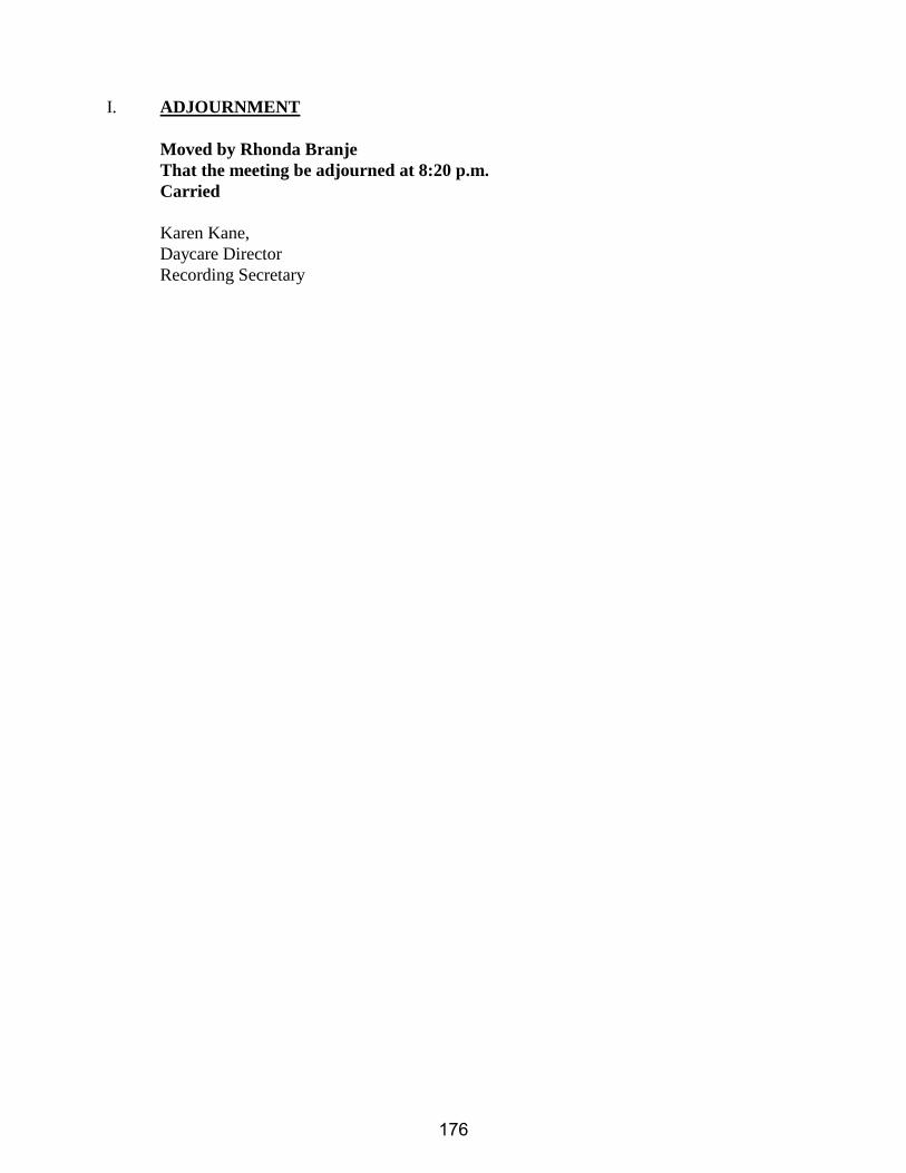
I. ADJOURNMENT
Moved by Rhonda Branje That the meeting be adjourned at 8:20 p.m. Carried
Karen Kane,
Daycare Director Recording Secretary
176
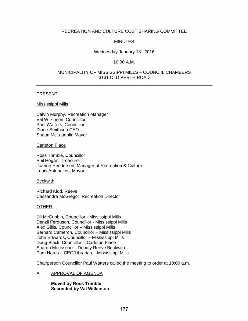
RECREATION AND CULTURE COST SHARING COMMITTEE
MINUTES
Wednesday January 13th 2016
10:00 A.M.
MUNICIPALITY OF MISSISSIPPI MILLS – COUNCIIL CHAMBERS 3131 OLD PERTH ROAD
PRESENT: Mississippi Mills
Calvin Murphy, Recreation Manager Val Wilkinson, Councillor Paul Watters, Councillor Diane Smithson CAO Shaun McLaughlin Mayor Carleton Place Ross Trimble, Councillor Phil Hogan, Treasurer Joanne Henderson, Manager of Recreation & Culture Louis Antonakos, Mayor Beckwith Richard Kidd, Reeve Cassandra McGregor, Recreation Director OTHER: Jill McCubbin, Councillor - Mississippi Mills Denzil Ferguson, Councillor - Mississippi Mills Alex Gillis, Councillor – Mississippi Mills Bernard Cameron, Councillor – Mississippi Mills John Edwards, Councillor – Mississippi Mills Doug Black, Councillor – Carleton Place Sharon Mousseau – Deputy Reeve Beckwith Pam Harris – CEO/Librarian – Mississippi Mills Chairperson Councillor Paul Watters called the meeting to order at 10:00 a.m. A. APPROVAL OF AGENDA
Moved by Ross Trimble Seconded by Val Wilkinson
177

That the agenda be accepted as presented. CARRIED
B. DISCLOSURE OF PECUNIARY INTEREST
The Chairperson requested that any member having a pecuniary interest declare it now or at the time of discussion. There were no disclosures by Committee members at this time.
C. APPROVAL OF MINUTES
Moved by Phil Hogan Seconded by Richard Kidd That the minutes of the meeting held on Oct 7th, 2015 be approved as circulated and read.
CARRIED
D. DELEGATIONS Howard Allan- Review of the current cost sharing agreement between Mississippi Mills, Carleton Place and Beckwith. - Mr. Allan provided the committee with an overall review and history of the
cost sharing agreement between all three municipalities; he stated that the agreement was last reviewed in 2001. The committee was given an opportunity to ask questions. Chairperson Paul Watters asked that item E2 in the agenda (Amendment to the Cost Sharing Terms of Agreement) under Mississippi Mills be moved forward in the agenda for discussion at this time.
- Mayor Shaun McLaughlin provided an overview of the report prepared by the CAO in Mississippi Mills for the Joint Recreation Cost Sharing Committee. He explained that given the fact that the Cost Sharing agreement had not been reviewed for some time that perhaps there was a need for the agreement to be looked at again to determine if changes should be made. After a lengthy discussion on the Cost Sharing Agreement by the Committee the following motion was prepared: Moved by Richard Kidd Seconded by Val Wilkinson THAT the Recreation and Culture Cost Sharing Committee recommend to the respective Municipal Councils that Howard Allan be retained at a cost of $500 per municipality to complete a review of recreation costs on a per household and per capita basis for each of the three partners of the Recreation Cost Sharing Agreement and work with the Recreation staff in each of the municipalities to conduct a review and make recommendations regarding the spheres of influence used for the cost sharing calculations.
MOTION DEFEATED
178
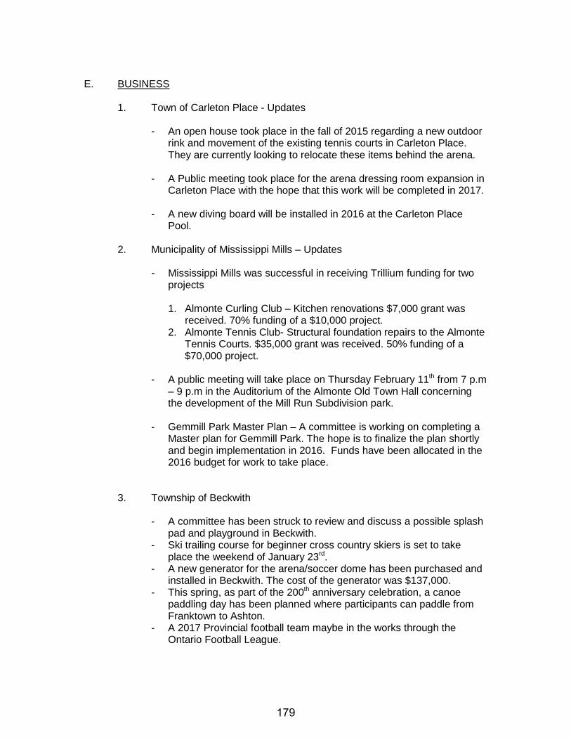
E. BUSINESS
1. Town of Carleton Place - Updates - An open house took place in the fall of 2015 regarding a new outdoor
rink and movement of the existing tennis courts in Carleton Place. They are currently looking to relocate these items behind the arena.
- A Public meeting took place for the arena dressing room expansion in Carleton Place with the hope that this work will be completed in 2017.
- A new diving board will be installed in 2016 at the Carleton Place
Pool.
2. Municipality of Mississippi Mills – Updates - Mississippi Mills was successful in receiving Trillium funding for two
projects 1. Almonte Curling Club – Kitchen renovations $7,000 grant was
received. 70% funding of a $10,000 project. 2. Almonte Tennis Club- Structural foundation repairs to the Almonte
Tennis Courts. $35,000 grant was received. 50% funding of a $70,000 project.
- A public meeting will take place on Thursday February 11th from 7 p.m
– 9 p.m in the Auditorium of the Almonte Old Town Hall concerning the development of the Mill Run Subdivision park.
- Gemmill Park Master Plan – A committee is working on completing a Master plan for Gemmill Park. The hope is to finalize the plan shortly and begin implementation in 2016. Funds have been allocated in the 2016 budget for work to take place.
3. Township of Beckwith - A committee has been struck to review and discuss a possible splash
pad and playground in Beckwith. - Ski trailing course for beginner cross country skiers is set to take
place the weekend of January 23rd. - A new generator for the arena/soccer dome has been purchased and
installed in Beckwith. The cost of the generator was $137,000. - This spring, as part of the 200th anniversary celebration, a canoe
paddling day has been planned where participants can paddle from Franktown to Ashton.
- A 2017 Provincial football team maybe in the works through the Ontario Football League.
179
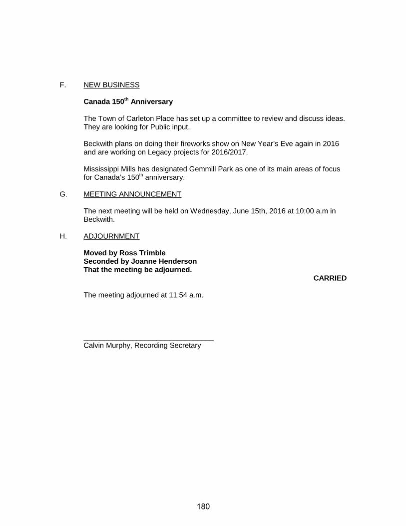
F. NEW BUSINESS Canada 150th Anniversary
The Town of Carleton Place has set up a committee to review and discuss ideas. They are looking for Public input. Beckwith plans on doing their fireworks show on New Year’s Eve again in 2016 and are working on Legacy projects for 2016/2017. Mississippi Mills has designated Gemmill Park as one of its main areas of focus for Canada’s 150th anniversary.
G. MEETING ANNOUNCEMENT
The next meeting will be held on Wednesday, June 15th, 2016 at 10:00 a.m in Beckwith.
H. ADJOURNMENT
Moved by Ross Trimble Seconded by Joanne Henderson That the meeting be adjourned.
CARRIED The meeting adjourned at 11:54 a.m. ________________________________ Calvin Murphy, Recording Secretary
180
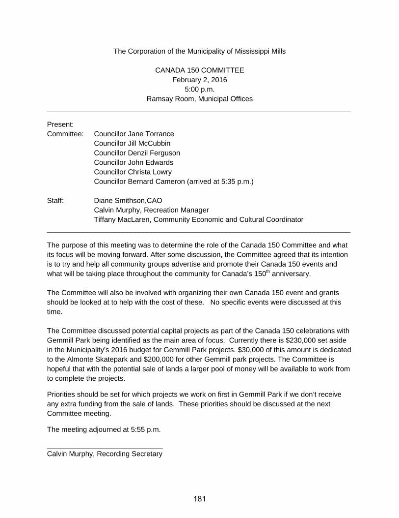
The Corporation of the Municipality of Mississippi Mills
CANADA 150 COMMITTEE February 2, 2016
5:00 p.m. Ramsay Room, Municipal Offices
____________________________________________________________________________
Present: Committee: Councillor Jane Torrance
Councillor Jill McCubbin Councillor Denzil Ferguson Councillor John Edwards Councillor Christa Lowry Councillor Bernard Cameron (arrived at 5:35 p.m.)
Staff: Diane Smithson,CAO
Calvin Murphy, Recreation Manager Tiffany MacLaren, Community Economic and Cultural Coordinator
____________________________________________________________________________
The purpose of this meeting was to determine the role of the Canada 150 Committee and what its focus will be moving forward. After some discussion, the Committee agreed that its intention is to try and help all community groups advertise and promote their Canada 150 events and what will be taking place throughout the community for Canada’s 150th anniversary. The Committee will also be involved with organizing their own Canada 150 event and grants should be looked at to help with the cost of these. No specific events were discussed at this time. The Committee discussed potential capital projects as part of the Canada 150 celebrations with Gemmill Park being identified as the main area of focus. Currently there is $230,000 set aside in the Municipality’s 2016 budget for Gemmill Park projects. $30,000 of this amount is dedicated to the Almonte Skatepark and $200,000 for other Gemmill park projects. The Committee is hopeful that with the potential sale of lands a larger pool of money will be available to work from to complete the projects.
Priorities should be set for which projects we work on first in Gemmill Park if we don’t receive any extra funding from the sale of lands. These priorities should be discussed at the next Committee meeting.
The meeting adjourned at 5:55 p.m.
_____________________________ Calvin Murphy, Recording Secretary
181
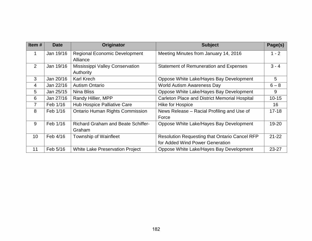
Item # Date Originator Subject Page(s)
1 Jan 19/16 Regional Economic Development Alliance
Meeting Minutes from January 14, 2016 1 - 2
2 Jan 19/16 Mississippi Valley Conservation Authority
Statement of Remuneration and Expenses 3 - 4
3 Jan 20/16 Karl Krech Oppose White Lake/Hayes Bay Development 5 4 Jan 22/16 Autism Ontario World Autism Awareness Day 6 – 8 5 Jan 25/15 Nina Bliss Oppose White Lake/Hayes Bay Development 9 6 Jan 27/16 Randy Hillier, MPP Carleton Place and District Memorial Hospital 10-15 7 Feb 1/16 Hub Hospice Palliative Care Hike for Hospice 16 8 Feb 1/16 Ontario Human Rights Commission News Release – Racial Profiling and Use of
Force 17-18
9 Feb 1/16 Richard Graham and Beate Schiffer-Graham
Oppose White Lake/Hayes Bay Development 19-20
10 Feb 4/16 Township of Wainfleet Resolution Requesting that Ontario Cancel RFP for Added Wind Power Generation
21-22
11 Feb 5/16 White Lake Preservation Project Oppose White Lake/Hayes Bay Development 23-27
182

Sunday Monday Tuesday Wednesday Thursday Friday Saturday
1 10am - Health & Safety
2 8am C&EDC 5:00pm Canada 150 6:00 pm Council & COW
3 4 5 6
7 8 6:30pm EAC
9 6pm Sp CoW TMP/AT
10 11 Millrun Park Open House - AOTH 7-9pm
12 13
14 15 Family Day Office Closed
16 8am C&EDC 6:00 pm Council & COW
17 18 7:30am Beautification
19 20
21/28 ORGA/ROMA Toronto
22/29 ORGA/ROMA Toronto
23 ORGA/ROMA Toronto
24 7pm Library Board (Almonte) 7pm Heritage ORGA/ROMA Toronto
25 26 27
Notes: Shaun away Jan 28-Feb 8 Duncan away Feb 10-Mar 19
Paul away Feb 1-9 183

Sunday Monday Tuesday Wednesday Thursday Friday Saturday
1 8am CEDC 9:30am Police Advisory 6:00 pm Council / COW
2 3pm AAC
3 4 5
6 7 6:30 pm EAC
8 9 10 11 12
13 14 15 8am CEDC 6:00 pm Council / COW
16 17 7:30am Beautification
18 19
20 21 22 23 7pm Heritage
24 25 Good Friday Office Closed
26
27 28 Easter Monday Office Closed
29 30 7pm Library Board (Almonte)
31
Notes: Duncan Feb 10-Mar 19 Alex away Mar 5-Apr 9
184