comparison of segmentation algorithms and estimation of optimal segmentation parameters for very...
TRANSCRIPT

Comparison of Segmentation Algorithms andEstimation of Optimal SegmentationParameters for Very High Resolution
Satellite Imagery
P. R. Sarkar1 P. Srinivas2 J .Srinivasulu3 D. Sita4
1Department of Avionics
Indian Institute of Space Science and Technology
2Head,GRD3Scientist- ‘F’4Scientist - ’E’
Advanced Data Processing Research Institute

Outline
New paradigm in remote sensing, GEOBIAImage Segmentation, the first and critical stepSegmentation algorithms
Objective of this Study
Preparatory workStudy area & Quality assessment technique
MethodologiesSelection of optimal segmentation parameters
Estimation of segmentation parametersExisting methodsProposed approach
ResultsEvaluation of segmentation algorithmsEvaluation of Automatic Estimation of Segmentation Parameter Technique
Conclusions

Why GEOBIA?Geographic Object Based Image Analysis
1. The latest breed of very high resolution (VHR) commercial satellite imagery (<2.0m) imagery, which has dramatically increased new possibilities in remote sensing and cartographic applications.
2. Pixel based analysis neglects the spatial information of very high resolution images.
3. Several study demonstrated that geographic object based classifier is a significantly better approach than the classical pixel classifier.
4. A dramatic increase in availability of affordable powerfulcomputing systems.
5. Need of the multi-scale approaches in the monitoring, modelling and management of the environment. GEOBIA is the best choice for this.

Image Segmentation
Segmentation is a process of completely partitioning an image into non-overlapping regions based on homogeneity parameters or on differentiation of heterogeneity parameters.
Mathematically, it can be defined as follows: if F is the set of all pixels and P( ) is a homogeneity defined on group of connected pixels, then segmentation is a partitioning of the set F into a set of connected regions (S1, S2, ..., Sn) such that:

Why Segmentation?
1. In GEOBIA, we treat a remotely sensed image as union of meaningful image objects. To extract each image objects, we need to use segmentation techniques.
2. As discussed in slide: 3, considering an image as objects gives better classification accuracy and also opportunity to use spatial information.

Segmentation Algorithms
1. Mean-shift Segmentation
2. Multi-resolution Segmentation
3. k-means Segmentation
4. Watershed Segmentation
Mean-shift segmentation
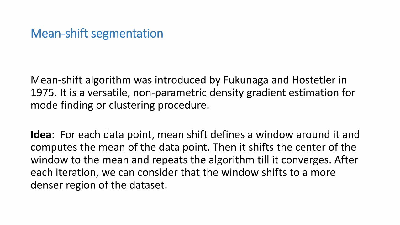
Mean-shift algorithm was introduced by Fukunaga and Hostetler in 1975. It is a versatile, non-parametric density gradient estimation for mode finding or clustering procedure.
Idea: For each data point, mean shift defines a window around it and computes the mean of the data point. Then it shifts the center of the window to the mean and repeats the algorithm till it converges. After each iteration, we can consider that the window shifts to a more denser region of the dataset.

Mean-shift segmentation
At the high level, we can specify Mean Shift as follows:
1. Fix a window around each data point.
2. Compute the mean of data within the window.
3. Shift the window to the mean and repeat till convergence

Mean-shift segmentation

Mean-shift segmentation


Multi-resolution segmentation
1. It is a bottom-up region merging technique, which starts from one-pixel object.
2. Throughout this clustering process, the underlying optimisation procedure minimizes the weighted heterogeneity nh in the image objects where, n is the number of the pixels of image segment h is the definition of heterogeneity measure.
3. The increment of heterogeneity (f) is calculated before themerging of two adjacent object happens.
4. No further fusion takes place when the increment inheterogeneity exceeds a threshold or scale.

Multi-resolution segmentation

k-means segmentation
This algorithm has been the most popular unsupervised learning algorithm which is widely used for image segmentation.
The k-means clustering algorithm is as follows:1. Initialize the cluster centroids µ1, µ2, ..., µk randomly.2. Repeat till convergence

Watershed segmentation
1. The watershed transform is a region based segmentation approach.
2. Imagine the landscape is being immersed in a lake, with holes pierced in topical minima. The process of filling water is stopped when water reaches the highest peak in the landscape. This process finally gives a portioned region or basins separated by dams also called watershed lines.
3. Flow diagram of this algorithm is given in the next slide.

Watershed segmentation

Objective of this Study
Objective of this study
1. Study of various segmentation algorithms and deciding which algorithm works better than the existing techniques for different h-resolution terrain surfaces.
2. Comparing the quality of the segmentation algorithms for very high spatial multi-spectral remotely sensed satellite imagery.
3. Automatic estimation of optimal parameter for segmentation algorithms

Study Area & Quality Assessment Technique

Study areaThe study area analysed for this research downloaded from Digitalglobe website.
Figure: Main study area with 16384 × 16384
resolution

Regions of study
Rural area
Urban area Forest area
Residential area

Quality assessment technique
1. Visual assessment is taken into account for quality checking of segmentation techniques.
2. In this paper, we decided upon visual assessment on the human eye is considered as strong and experienced source for evaluation of segmentation techniques

Selection of the Optimal Segmentation Parameters

Segmentation algorithms and parameters in ORFEO
Mean-shift environment Watershed environment

Segmentation algorithm and parameters in eCogniton
Parameters in eCognition

Segmentation algorithms and parameters in Matlab
1. Mean-shift algorithm has only one bandwidth parameter.
2. k-means has only class parameter.
3. Watershed algorithm does not have any parameter.
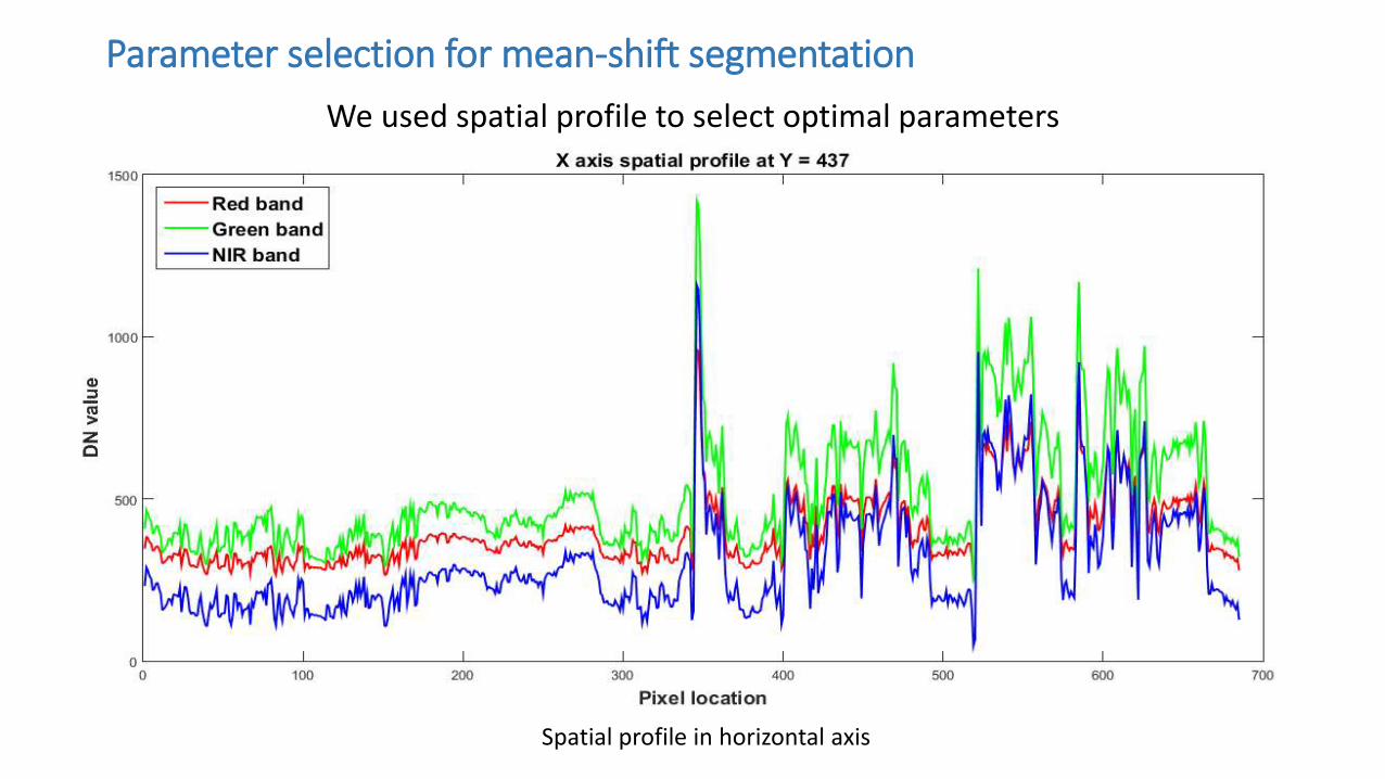
Parameter selection for mean-shift segmentation
We used spatial profile to select optimal parameters
Spatial profile in horizontal axis

Spatial profile in vertical axis

1. From these spatial profiles we can notice peaks in all bands which indicates transition between two different classes. The range between the pixel positions at left side maximum value and right side maximum value, is taken as range radius.
2. Spatial radius is taken by a trial-and-error method.
3. The other three parameters are taken as constants for allthe images under consideration.
4. The optimal parameters are chosen based on visual assessments. The windowing method is described in the next slide.

Parameter selection at different window size

Optimal output of mean-shift
Parameter selection at 761 X 577 Parameter selection at 780 x 577

Optimal output of multi-resolution
WinSize =128 X 128
WinSize =352 X 352
WinSize =468 X 468
WinSize =212 X 212

Parameter selection for k-means and watershed segmentation
k-means:1. The only parameter here is class. Selection of proper class is not difficult
when the test image is small, but it produce slots of ambiguity when it comes for big remote images.
2. One approach to learn the class is to use Elbows method.
Watershed segmentation:
The two parameters for watershed segmentation are chosen based on visual inspection.

Estimation of the Optimal Segmentation Parameters

Existing methods
Post-estimation of segmentation parameters:1. Kim et. al has used the concept of local variance to determine optimal
segmentation parameters of alliance-level forest classification.2. Dragut et. al used local variance in image object level and extended it into multi-
scale analysis based on single layer and later in multiple layers.3. Zhao et. al has used the rate of change of local variance which is similar to the ESP
tool, to estimate the optimal parameter.4. Emary et. al used a similarity measure between two image objects in set of
successive scales.5. Karl and Maurer et. Al have used semi-variogram based spatial dependency
prediction.
Pre-estimation of segmentation parameters:
Ming et. al applies spatial statistics to select optimal parameters for mean-shift segmentation algorithm.

Proposed Approach

Input features extraction
Calculation of spatial statistics before feeding in BPNN
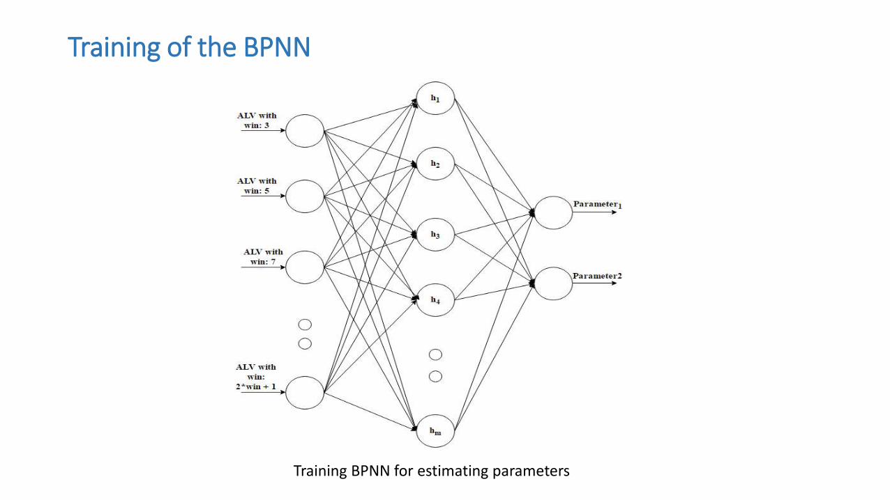
Training of the BPNN
Training BPNN for estimating parameters


Results

Evaluation of Segmentation Algorithms

Rural area Multi-resolution in eCognition Mean-shift in ORFEO
Mean-shift in Matlab K-means in Matlab Watershed in Matlab
Multi-resolution parameters
Mean-shift parameters

Residential area Multi-resolution in eCognition Mean-shift in ORFEO
Mean-shift in Matlab K-means in Matlab Watershed in Matlab
Multi-resolution parameters
Mean-shift parameters
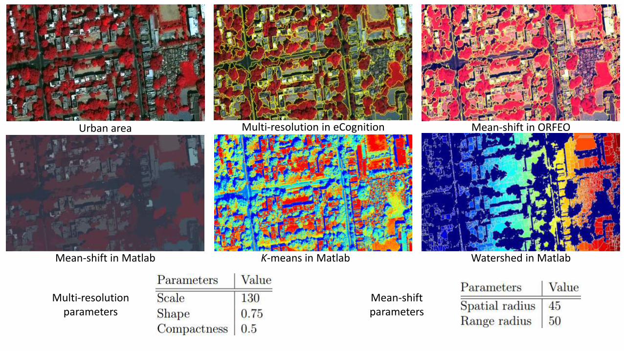
Urban area Multi-resolution in eCognition Mean-shift in ORFEO
Mean-shift in Matlab K-means in Matlab Watershed in Matlab
Multi-resolution parameters
Mean-shift parameters

Forest area Multi-resolution in eCognition Mean-shift in ORFEO
Mean-shift in Matlab K-means in Matlab Watershed in Matlab
Multi-resolution parameters
Mean-shift parameters

Evaluation of Automatic Estimation of SegmentationParameter Technique

Mean Square Error plot for the Trained Network

Average local variance v/s band for four regions of study

Test Images
Rural area Residential area
Urban area Forest area

Estimation of Segmentation Parameters of Multi-resolution
Rural area Residential area
Urban area Forest area

Estimation of Segmentation Parameters of Multi-resolution
Rural area Residential area
Urban area Forest area

Conclusions

Assessment of Segmentation Algorithm
• we see that the watershed algorithm is poor.
• k-means gives a good segmentation solution though it is affected by salt and paper noise due to within-field variability.
• Multi-resolution segmentation is now becoming very famous due to its robust nature and fast processing using multi-threading. From the outcomes, we see that it gives very good segmentation in object level.
• Mean-shift segmentation is also a multi-scale segmentation like multi-resolution, but it take a huge amount of time to process in both ORFEO and Matlab.

Comparison between multi-resolution and mean-shift segmentation

Automatic Estimation of the Optimal Segmentation Parameters
Advantages• The proposed method is a pre-estimation method while other studies are
related to post-estimation. Only one approach is there which does pre-estimation, but it only limits its scale selection to certain segmentation algorithm.
• This proposed approach is not limited to any particular segmentation algorithm. It can estimate any number of parameters for any segmentation algorithm.
• Different remote sensing analysis vendors provide different implementation of segmentation algorithms. This approach tries to map between any VHR landcover and optimal segmentation parameter.
• Geo-statistics of every band is being considered which makes it more robust to any multi-spectral data.

Limitations
• Training the BPNN network is a difficult task. Discussion about BPNN network is beyond of the scope of this project.
• Calculation of local variance in multiple scale takes a long time. Due to the advancement of high performance computing this limitation can be overcome.
• The most important disadvantage is to make a training set for learning the network. Initial human effort is needed but once the network is learnt, the automation process is done

Thank you!
Any questions?