comprehensive plans evaluation - department … · · 2009-05-161.3.1.1 instream flow...
TRANSCRIPT

State of California The Resources Agency
Department of Water Resources
COMPREHENSIVE PLANS EVALUATION
FINAL REPORT
L-3
Oroville Facilities Relicensing FERC Project No. 2100
JULY 2004
ARNOLD
SCHWARZENEGGER Governor
State of California
MIKE CHRISMAN Secretary for Resources The Resources Agency
LESTER SNOW Director
Department of Water Resources

Final Comprehensive Plans Evaluation (L-3) Oroville Facilities P-2100 Relicensing
State of California
The Resources Agency Department of Water Resources
COMPREHENSIVE PLANS EVALUATION
FINAL REPORT
L-3
Oroville Facilities Relicensing FERC Project No. 2100
This report was prepared under the direction of
Jim Martin.............................. Resource Area Manager, Department of Water Resources Jim Upholt .......................................... Senior Engineer, Department of Water Resources
by Mark Greenig ........................................................................ Senior Planner, EDAW, Inc. Nancy Bird........................................................................................ Planner, EDAW, Inc. Josh Teigiser............................................................. Environmental Analyst, EDAW, Inc.
Final Report – For Distribution to Collaborative Oroville Facilities Relicensing Team May 2004

Final Comprehensive Plans Evaluation (L-3) Oroville Facilities P-2100 Relicensing
This page intentionally left blank.
Final Report – For Distribution to Collaborative Oroville Facilities Relicensing Team May 2004
Final Comprehensive Plans Evaluation (L-3) Oroville Facilities P-2100 Relicensing
REPORT SUMMARY
This study has been prepared in support of the relicensing process initiated by the California Department of Water Resources (DWR) for the Lake Oroville Hydroelectric Project, located in northern California. The Federal Energy Regulatory Commission (FERC) license for the Project expires in February 2007 (FERC Project No. 2100). FERC requires that relicensing applicants evaluate how compatible their project and project operations are with other comprehensive management plans. This Relicensing Study L-3 – Comprehensive Plans Consistency Evaluation has been prepared to fulfill this requirement.
This study summarizes the plans and policies that have been developed by Federal, State, and local planning and resource agencies and other entities that are responsible for managing lands and resources within the study area. Some of these comprehensive plans were identified by FERC, some were relevant plans identified by staff, and others were plans identified by the Land Use, Land Management, and Aesthetics Work Group (LULMAWG). The agencies and jurisdictions responsible for implementing the plans were asked to review the descriptions of the plans for accuracy. Most of these agencies and entities responded and their suggested changes have been incorporated in this report. The study area includes Lake Oroville, the lands and waters within the Project boundary and a ¼ mile outside the boundary, adjacent lands, facilities, and areas with a clear Project nexus.
Table 5.0-1 provides a summary of the plans evaluated. This report can be used to determine whether or not changes to Project operations and facilities associated with relicensing and protection, mitigation, and enhancement (PM&E) measures are consistent with these plans.
Final Report – For Distribution to Collaborative Oroville Facilities Relicensing Team RS-1 May 2004

Final Comprehensive Plans Evaluation (L-3) Oroville Facilities P-2100 Relicensing
This page intentionally left blank.
Final Report – For Distribution to Collaborative May 2004 RS-2 Oroville Facilities Relicensing Team

Final Comprehensive Plans Evaluation (L-3) Oroville Facilities P-2100 Relicensing
TABLE OF CONTENTS
REPORT SUMMARY................................................................................................ RS-1
1.0 INTRODUCTION................................................................................................... 1-1 1.1 Background Information.................................................................................. 1-1
1.1.1 Statutory/Regulatory Requirements ...................................................... 1-2 1.1.2 Study Area ............................................................................................ 1-2
1.2 Description of Facilities................................................................................... 1-2 1.3 Current Operational Constraints ..................................................................... 1-5
1.3.1 Downstream Operation ......................................................................... 1-6 1.3.1.1 Instream Flow Requirements.................................................... 1-6 1.3.1.2 Temperature Requirements...................................................... 1-7 1.3.1.3 Water Diversions ...................................................................... 1-7 1.3.1.4 Water Quality............................................................................ 1-8
1.3.2 Flood Management ............................................................................... 1-8
2.0 NEED FOR STUDY............................................................................................... 2-1
3.0 STUDY OBJECTIVE(S) ........................................................................................ 3-1 3.1 Application of Study Information ..................................................................... 3-1
3.1.1 Other Studies ........................................................................................ 3-1
4.0 METHODOLOGY.................................................................................................. 4-1 4.1 Study Design .................................................................................................. 4-1 4.2 How and Where The Studies Were Conducted .............................................. 4-1
5.0 CONSISTENCY EVALUATION OF RELEVANT COMPREHENSIVE AND RESOURCE MANAGEMENT PLANS................................................................... 5-1 5.1 Federal Management Plans............................................................................ 5-1
5.1.1 Plumas National Forest Land And Resource Management Plan (LRMP), 1988 (USFS) ........................................................................... 5-1 5.1.1.1 Galen Management Area ......................................................... 5-3 5.1.1.2 French Creek Management Area ............................................ 5-3 5.1.1.3 Kellogg Management Area ...................................................... 5-4
5.1.2 Sierra Nevada Forest Plan Amendment, 2004 (USFS)......................... 5-5 5.1.3 Redding Resource Management Plan (RRMP), 1993 (BLM)................ 5-6 5.1.4 Final Restoration Plan For The Anadromous Fish Restoration
Program, 2001 (USFWS) ...................................................................... 5-8 5.1.5 California’s Water Future: A Framework For Action, 2000
(CALFED Bay-Delta Program Agencies)............................................... 5-9 5.2 State Management Plans ............................................................................... 5-9
5.2.1 California Outdoor Recreation Plan (CORP), 2002 (DPR)................. 5-10
Final Report – For Distribution to Collaborative Oroville Facilities Relicensing Team i May 2004

Final Comprehensive Plans Evaluation (L-3) Oroville Facilities P-2100 Relicensing
TABLE OF CONTENTS (Cont.)
5.2.2 Public Opinions and Attitudes on Outdoor Recreation in California, 1997 (DPR) ......................................................................................... 5-11
5.2.3 Lake Oroville State Recreation Area (LOSRA) Resource Management Plan (RMP) and General Development Plan, 1973 (DPR) ......................................................................................... 5-12
5.2.4 Lake Oroville State Recreation Area (LOSRA) General Development Plan Amendment – Lime Saddle Area, 1988 (DPR)...... 5-12
5.2.5 Comprehensive Statewide Historic Preservation Plan for California (HPP), 2000-2005 (2001) (DPR – Office of Historic Preservation) ...... 5-12
5.2.6 The California Water Plan Update, Bulletin 160 Series (DWR)........... 5-14 5.2.6.1 The California Water Plan Update: Bulletin 160-93,
1994 (DWR) ........................................................................... 5-14 5.2.6.2 The California Water Plan Update: Bulletin 160-98,
1998 (DWR) ........................................................................... 5-15 5.2.7 Lake Oroville Fisheries Habitat Improvement Plan, 1995 (DWR) ....... 5-15 5.2.8 Oroville Wildlife Area (OWA) Management Plan, 1978 (DFG)............ 5-15 5.2.9 California Regulations on Hunting and Other Public Uses on State
and Federal Areas, 2002 (DFG) .......................................................... 5-16 5.2.10 California Fire Plan: A Framework for Minimizing Costs and
Losses From Wildland Fire, 1996 (CDF and State Board of Forestry [SBF]) ................................................................................. 5-16
5.2.11 Fire Management Plan, 2002 (CDF Butte Unit) ................................ 5-17 5.2.12 California Regional Water Quality Control Board, Central Valley
Region, Water Quality Control Plan (Basin Plan), 4th Edition, 1998.................................................................................................. 5-19
5.3 Local Management Plans ............................................................................. 5-22 5.3.1 Regional Plans.................................................................................... 5-22
5.3.1.1 Butte County 2001 Regional Transportation Plan (RTP), 2001 (BCAG) ......................................................................... 5-22
5.3.1.2 Countywide Bikeway Master Plan, 1998 (BCAG) ................... 5-23 5.3.2 County Plans....................................................................................... 5-24
5.3.2.1 Butte County General Plan, 1996 (County of Butte) ............... 5-24 5.3.3 Municipal Plans................................................................................... 5-30
5.3.3.1 City of Oroville General Plan, 1995 (City of Oroville).............. 5-30 5.3.3.2 Bicycle Transportation Plan, 1998 (City of Oroville) ............... 5-32
6.0 CONCLUSIONS.................................................................................................... 6-1 6.1 Federal Plans ................................................................................................. 6-1
6.1.1 Plumas National Forest Land and Resource Management Plan (LRMP), 1988 (USFS) ........................................................................... 6-1
6.1.2 Sierra Nevada Forest Plan Amendment (SNFPA), 2000 (USFS) ......... 6-1 6.1.3 Redding Resource Management Plan (RMP), 1993 (BLM) .................. 6-1
Final Report – For Distribution to Collaborative May 2004 ii Oroville Facilities Relicensing Team

Final Comprehensive Plans Evaluation (L-3) Oroville Facilities P-2100 Relicensing
TABLE OF CONTENTS (Cont.) 6.1.4 California’s Water Future: A Framework for Action, 2000 (CALFED
Bay-Delta Program Agencies) ............................................................... 6-1 6.2 State Plans ..................................................................................................... 6-2
6.2.1 California Outdoor Recreation Plan (CORP), 2002 (DPR).................... 6-2 6.2.2 Public Opinions and Attitudes on Outdoor Recreation in California,
1997 (DPR) ........................................................................................... 6-2 6.2.3 Lake Oroville State Recreation Area (LOSRA) Resource
Management Plan (RMP) and General Development Plan, 1973 (DPR) .................................................................................................... 6-2
6.2.4 Lake Oroville State Recreation Area (LOSRA) General Development Plan Amendment – Lime Saddle Area, 1988 (DPR)........ 6-2
6.2.5 Comprehensive State-wide Historic Preservation Plan for California (HPP), 2000-2005 (2001) (DPR – Office of Historic Preservation) ......................................................................................... 6-2
6.2.6 The California Water Plan Update, Bulletin 160 Series (DWR)............. 6-2 6.2.7 Lake Oroville Fisheries Habitat Improvement Plan, 1995 (DWR) ......... 6-3 6.2.8 Oroville Wildlife Area (OWA) Management Plan, 1978 (DFG).............. 6-3 6.2.9 California Regulations on Hunting and Other Public Uses on State
and Federal Areas, 2002 (DFG)............................................................ 6-3 6.2.10 California Fire Plan: A Framework for Minimizing Costs and
Losses From Wildland Fire, 1996 (CDF and SBF) ............................. 6-3 6.2.11 Fire Management Plan, 2002 (CDF Butte Unit) .................................. 6-3 6.2.12 Central Valley Region Water Quality Control Plan (Basin Plan),
1998, (California Regional Water Quality Control Board) ...................... 6-3 6.3 Local Plans ..................................................................................................... 6-4
6.3.1 Regional Plans...................................................................................... 6-4 6.3.1.1 Butte County 2001 Regional Transportation Plan (RTP),
2001 (BCAG) ........................................................................... 6-4 6.3.1.2 BCAG, Countywide Bikeway Master Plan, 1998 ...................... 6-4
6.3.2 County Plans......................................................................................... 6-4 6.3.2.1 Butte County General Plan, 1996 (County of Butte) ................. 6-4
6.3.2 Municipal Plans..................................................................................... 6-4 6.3.3.1 City of Oroville General Plan, 1995 (City of Oroville)................ 6-4 6.3.3.2 Bicycle Transportation Plan, 1998 (City of Oroville) ................. 6-4
7.0 REFERENCES...................................................................................................... 7-1
Final Report – For Distribution to Collaborative Oroville Facilities Relicensing Team iii May 2004

Final Comprehensive Plans Evaluation (L-3) Oroville Facilities P-2100 Relicensing
LIST OF TABLES Table 5.0-1. Relevant comprehensive land use and resource management
plans in the Oroville Project area........................................................... 5-2
Table 5.1-1. Applicable Plumas National Forest standards and guidelines in the Galen Management Area ...................................................................... 5-4
Table 5.1-2. Applicable Plumas National Forest standards and guidelines in the French Creek Management Area .......................................................... 5-4
Table 5.1-3. Applicable Plumas National Forest standards and guidelines in the Kellogg Management Area .................................................................... 5-5
Table 5.3-1. Butte County General Plan policies related to Lake Oroville ............... 5-29
Table 5.3-2. City of Oroville General Plan Policies that Mention the Project ........... 5-31
LIST OF FIGURES
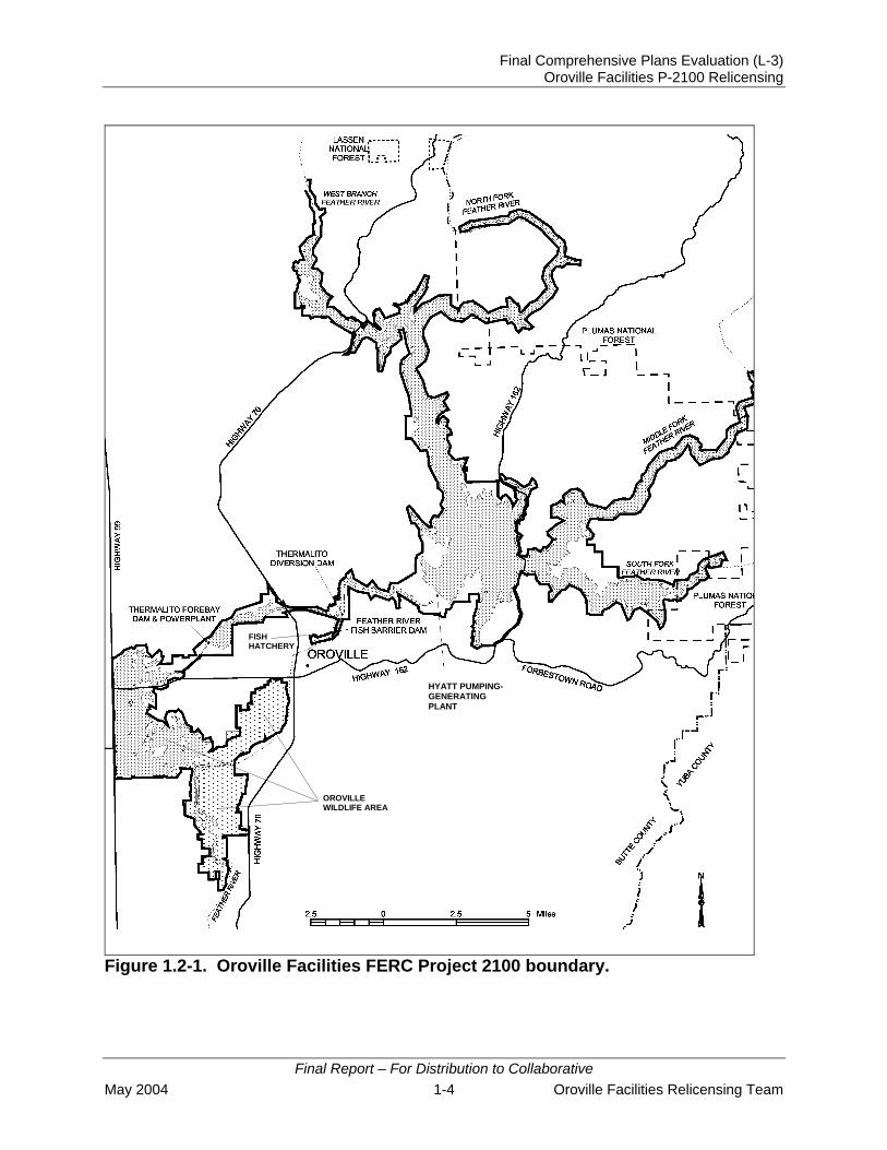
Figure 1.2-1. Oroville Facilities FERC Project boundary ............................................. 1-4
Final Report – For Distribution to Collaborative May 2004 iv Oroville Facilities Relicensing Team

Final Comprehensive Plans Evaluation (L-3) Oroville Facilities P-2100 Relicensing
ACRONYMS af acre-feet AFRP Anadromous Fish Restoration Program ARP Amended Recreation Plan ALP Alternative Licensing Procedure Bay-Delta Sacramento – San Joaquin River Delta and San Francisco Bay BCAG Butte County Association of Governments BLM Bureau of Land Management BOR Bureau of Reclamation BTP Bicycle Transportation Plan CALFED California and Federal CDF California Department of Forestry and Fire Protection cfs cubic feet per second CORP California Outdoor Recreation Plan CVP Central Valley Project CVPIA Central Valley Project Improvement Act DFG California Department of Fish and Game DPR California Department of Parks and Recreation DU dwelling unit DWR California Department of Water Resources EPA U.S. Environmental Protection Agency FERC Federal Energy Regulatory Commission FRSA Feather River Service Area HFQLG Herger-Feinstein Quincy Library Group HPP Comprehensive Statewide Historic Preservation Plan for California LOSRA Lake Oroville State Recreation Area LRMP Land and Resource Management Plan LULMAWG Land Use, Land Management, and Aesthetics Work Group maf million-acre feet MPO Metropolitan Planning Organization msl mean sea level MW megawatt NGO non-government organization NOAA Fisheries National Oceanic and Atmospheric Administration National Marine
Fisheries Service NPS National Park Service OWA Oroville Wildlife Area PAC protected activity center PDEA Preliminary Draft Environmental Assessment PM&E protection, mitigation, and enhancement PWA pre-fire workload analyses R&PP Recreation and Public Purpose Act RAM Resource Area Manager
Final Report – For Distribution to Collaborative Oroville Facilities Relicensing Team v May 2004

Final Comprehensive Plans Evaluation (L-3) Oroville Facilities P-2100 Relicensing
ACRONYMS (Cont.)
RMP Resource Management Plan ROD Record of Decision RTP Regional Transportation Plan RTPA Regional Transportation Planning Agency SBF State Board of Forestry SF single-family SNFPA Sierra Nevada Forest Plan Amendment SWP State Water Project SWQCB State Water Quality Control Board TEA Transportation Equity Act USACE U.S. Army Corps of Engineers USFS U.S. Forest Service USFWS U.S. Fish and Wildlife Service
Final Report – For Distribution to Collaborative May 2004 vi Oroville Facilities Relicensing Team

Final Comprehensive Plans Evaluation (L-3) Oroville Facilities P-2100 Relicensing
1.0 INTRODUCTION
1.1 BACKGROUND INFORMATION
The Lake Oroville Hydroelectric Project is the keystone of the California State Water Project (SWP). The Project provides water supplies, flood control, power generation, recreation, fish and wildlife enhancement, and salinity control to the State of California and is managed by the California Department of Water Resources (DWR). The Federal Energy Regulatory Commission (FERC) license for the Project expires in February of 2007 (FERC Project No. 2100), therefore a relicensing process was initiated by DWR in June of 2000.
As part of Project relicensing, DWR decided to use an Alternative Licensing Procedure (ALP) that involves a collaborative planning effort with local, State and Federal agencies with mandatory conditioning authority, Native American tribes, and local and regional recreation interests. This collaborative process was initiated in December of 2000. Work groups representing major resource categories (e.g., Environmental, Engineering and Operations) are assisting DWR decision-making regarding relicensing issues, the scope of resource studies, and ultimately, protection, mitigation and enhancement (PM&E) measures. The Land Use, Land Management, and Aesthetics Work Group (LULMAWG) is assisting DWR in developing the land use and aesthetics studies.
To help reduce potential resource and management conflicts, FERC requires that relicensing applicants evaluate how compatible their project and project operations are with other comprehensive management plans. Many land and resource management and planning entities develop comprehensive management plans to help them manage the lands and resources for which they are responsible. These comprehensive plans may, or may not, be consistent with other comprehensive management plans. When they are not consistent, management direction of one entity may affect lands or resources managed by other entities.
Relicensing Study L-3 – Comprehensive Plans Consistency Evaluation identifies relevant land and resource management plans and describes them. It then discusses how consistent or inconsistent changes to Project facilities, operations, and PM&Es associated with relicensing are with the identified comprehensive land and resource management plans.
Initially approved in July of 2002, a Draft Final Report was completed in April 2003. After PM&Es and other potential changes to Project facilities and operations are identified, the Draft Final Report will be updated to evaluate the consistency or inconsistency of those changes with the comprehensive plans reviewed in this Study and a Final Report will be issued.
Final Report – For Distribution to Collaborative Oroville Facilities Relicensing Team 1-1 May 2004

Final Comprehensive Plans Evaluation (L-3) Oroville Facilities P-2100 Relicensing
1.1.1 Statutory/Regulatory Requirements
DWR owns and operates the Oroville Facilities, a multipurpose water supply, flood control, power generation, recreation, fish and wildlife enhancement, and salinity control project on the Feather River in Butte County. The facilities currently operate under a license issued by FERC, which expires on January 31, 2007. DWR intends to submit an application for a new FERC license at least 2 years prior to the expiration of the current license. The proposed relicensing process is based on cooperation and collaboration with Federal and State resource agencies, Indian Tribes, local governments, non-governmental organizations (NGO), and interested members of the public.
The primary purpose of L-3 is to meet the relicensing requirements of FERC relative to comprehensive plans. FERC regulations require: the identification of all relevant comprehensive land use and resource management plans and a discussion of the consistency or lack of consistency with each plan as a result of potential changes to Project facilities and operations as a result of relicensing (Chapter 1, Subpart F, Section 6 [Report on land management and aesthetics] of 18 CFR). FERC also requires an applicant justify a lack of consistency and document communication with agencies that have land use and resource management authority in the area. The Consistency Evaluation involves reviewing relevant comprehensive land use and resource management plans to determine if changes to the Project as a result of relicensing efforts would be consistent or inconsistent with those plans. The existing consistency of jurisdictions’ plans with the Project is the baseline condition that will be used by DWR decision-making regarding relicensing issues and potential PME measures. Additionally, FERC requires that licensees cooperate with local, State, and Federal agencies regarding lands adjacent to the study area.
FERC issues updated lists of comprehensive plans for each state that are to considered for Relicensing Study L-3. The list that was used for this Study was issued by FERC in March, 2002. In addition to the plans identified by FERC, other relevant comprehensive land use and resource management plans were examined for this report.
1.1.2 Study Area
The study area includes Lake Oroville, the lands and waters within the FERC Project boundary and a ¼ mile outside the boundary, and adjacent lands, facilities and areas with a clear Project nexus.
1.2 DESCRIPTION OF FACILITIES
The Oroville Facilities were developed as part of the SWP, a water storage and delivery system of reservoirs, aqueducts, power plants, and pumping plants. The main purpose of the SWP is to store and distribute water to supplement the needs of urban and agricultural water users in Northern California, the San Francisco Bay area, the San
Final Report – For Distribution to Collaborative May 2004 1-2 Oroville Facilities Relicensing Team

Final Comprehensive Plans Evaluation (L-3) Oroville Facilities P-2100 Relicensing
Joaquin Valley, and Southern California. The Oroville Facilities are also operated for flood control and power generation, to improve water quality in the Delta, enhance fish and wildlife, and provide recreation. FERC Project No. 2100 encompasses 41,100 acres and includes Oroville Dam and Reservoir, three power plants (Hyatt Pumping-Generating Plant, Thermalito Diversion Dam Power Plant, and Thermalito Pumping-Generating Plant), Thermalito Diversion Dam, the Feather River Fish Hatchery and Fish Barrier Dam, Thermalito Power Canal, Oroville Wildlife Area (OWA), Thermalito Forebay and Forebay Dam, Thermalito Afterbay and Afterbay Dam, transmission lines, and a relatively large number of recreational facilities. An overview of these facilities is provided in Figure 1.2-1. Oroville Dam, along with two small saddle dams, impounds Lake Oroville, a 3.5-million-acre-foot (maf) capacity storage reservoir with a surface area of 15,810 acres at its maximum normal operating level of 900 feet above mean sea level (msl). The hydroelectric facilities have a combined licensed generating capacity of approximately 762 megawatts (MW). The Hyatt Pumping-Generating Plant is the largest of the three power plants with a capacity of 645 MW. Water from the six-unit underground power plant (three conventional generating and three pumping-generating units) is discharged through two tunnels into the Feather River just downstream of Oroville Dam. The plant has a generating and pumping flow capacity of 16,950 cubic feet per second (cfs) and 5,610 cfs, respectively. Other generation facilities include the 3-MW Thermalito Diversion Dam Power Plant and the 114-MW Thermalito Pumping-Generating Plant.
Thermalito Diversion Dam, four miles downstream of the Oroville Dam, creates a tail water pool for the Hyatt Pumping-Generating Plant and is used to divert water into the Thermalito Power Canal. Thermalito Diversion Dam Powerplant is a 3-MW power plant located on the left abutment of the diversion dam. The power plant releases a maximum of 615 cfs of water into the river.
The Thermalito Power Canal is a 10,000-foot-long channel designed to convey generating flows of 16,900 cfs to the Thermalito Forebay and pump-back flows to the Hyatt Pumping-Generating Plant. Thermalito Forebay is an off-stream regulating reservoir for the Thermalito Pumping-Generating Plant. The Thermalito Pumping-Generating Plant is designed to operate in tandem with the Hyatt Pumping-Generating Plant and has generating and pump-back flow capacities of 17,400 cfs and 9,120 cfs, respectively. When in generating mode, the Thermalito Pumping-Generating Plant discharges into Thermalito Afterbay, which is contained by a 42,000-foot-long earthfill dam. The Afterbay is used to release water into the Feather River downstream of the Oroville Facilities, helps regulate the power system, provides storage for pump-back operations, provides recreational opportunities, and provides local irrigation water. Several local irrigation districts receive Lake Oroville water via the Afterbay.
Final Report – For Distribution to Collaborative Oroville Facilities Relicensing Team 1-3 May 2004
Final Comprehensive Plans Evaluation (L-3) Oroville Facilities P-2100 Relicensing
FISH HATCHERY
OROVILLE WILDLIFE AREA
-
Figure 1.2-1. Oroville Facilities FERC P
Final Report – For DMay 2004
HYATT PUMPINGGENERATING PLANT
roject 2100 boundary.
istribution to Collaborative 1-4 Oroville Facilities Relicensing Team

Final Comprehensive Plans Evaluation (L-3) Oroville Facilities P-2100 Relicensing
The Fish Barrier Dam is downstream of the Thermalito Diversion Dam and immediately upstream of the Feather River Fish Hatchery. The flow over the dam maintains fish habitat in the low-flow channel of the Feather River between the dam and the Thermalito Afterbay outlet, and provides attraction flow for the hatchery. The hatchery is an anadromous fish hatchery intended to compensate for salmon and steelhead spawning grounds made unreachable by construction of Oroville Dam. Hatchery facilities have a production capacity of 10 million fall-run salmon, 5 million spring-run salmon, and 450,000 steelhead annually (pers. comm., Kastner 2003). However, diseases have occasionally reduced hatchery production in recent years.
The Oroville Facilities support a wide variety of recreational opportunities. These opportunities include boating (several types), fishing (several types), fully developed and primitive camping (including boat-in and floating sites), picnicking, swimming, horseback riding, hiking, off-road bicycle riding, wildlife watching, and hunting. There are also visitor information sites with cultural and informational displays about the developed facilities and the natural environment. There are major recreation facilities at Loafer Creek, Bidwell Canyon, Spillway, Lime Saddle, and Thermalito Forebay. Lake Oroville has two full-service marinas, five car-top boat launch ramps, 10 floating campsites, and seven two-stall floating toilets. There are also recreation facilities at the Lake Oroville Visitors Center, Thermalito Afterbay, and OWA.
The OWA comprises approximately 11,000 acres west of Oroville that is managed for wildlife habitat and recreational activities. It includes Thermalito Afterbay and surrounding lands (approximately 6,000 acres) along with 5,000 acres adjoining the Feather River. The 5,000-acre area is adjacent to or straddles 12 miles of the Feather River, and includes willow- and cottonwood-lined ponds, islands, and channels. Recreation areas include dispersed recreation (hunting, fishing, and bird watching), plus recreation at developed sites, including Monument Hill DUA, model airplane grounds, and three boat launches on the afterbay and two on the river, and two primitive camping areas. The California Department of Fish and Game’s (DFG) habitat enhancement program includes a wood duck nest-box program and dry-land farming for nesting cover and improved wildlife forage. Limited gravel extraction also occurs in a few locations.
1.3 CURRENT OPERATIONAL CONSTRAINTS
Operation of the Oroville Facilities varies seasonally, weekly, and hourly, depending on hydrology and the objectives that DWR is trying to meet. Typically, releases to the Feather River are managed to conserve water while meeting a variety of water delivery requirements, including flow, temperature, fisheries, diversion, and water quality. Lake Oroville stores winter and spring runoff for release to the Feather River as necessary for project purposes. Meeting the water supply objectives of the SWP has always been the primary consideration for determining Oroville Facilities operation (within the regulatory constraints specified for flood control, instream fisheries, and downstream uses). Power production is scheduled within the boundaries specified by the water operations criteria noted above. Annual operations planning is conducted for multiyear carryover storage.
Final Report – For Distribution to Collaborative Oroville Facilities Relicensing Team 1-5 May 2004

Final Comprehensive Plans Evaluation (L-3) Oroville Facilities P-2100 Relicensing
The current methodology is to retain half of the Lake Oroville storage above a specific level for subsequent years. Currently, that level has been established at 1.0 maf; however, this does not limit drawdown of the reservoir below that level. If hydrology is drier or requirements greater than expected, additional water could be released from Lake Oroville. The operations plan is updated regularly to reflect forecast changes in hydrology and downstream operations. Typically, Lake Oroville is filled to its maximum operating level of 900 feet above msl in June and then lowered as necessary to meet downstream requirements, to a minimum level in December or January (approximately 700 msl). During drier years, the reservoir may be drawn down more and may not fill to desired levels the following spring. Project operations are directly constrained by downstream operational demands and flood management criteria as described below. 1.3.1 Downstream Operation
An August 1983 agreement between DWR and DFG entitled Agreement Concerning the Operation of the Oroville Division of the State Water Project for Management of Fish & Wildlife (DWR and DFG 1983) sets criteria and objectives for flow and temperatures in the low-flow channel and the reach of the Feather River between Thermalito Afterbay and Verona. This agreement: (1) establishes minimum flows between the Thermalito Afterbay outlet and Verona that vary by water year type; (2) requires flow changes under 2,500 cfs to be reduced by no more than 200 cfs during any 24-hour period (except for flood management, failures, etc.); (3) requires flow stability during the peak of the fall-run Chinook salmon spawning season; and (4) sets an objective of suitable temperature conditions during the fall months for salmon and during the spring/summer for shad and striped bass. 1.3.1.1 Instream Flow Requirements
The Oroville Facilities are operated to meet minimum flows in the lower Feather River as established by the 1983 agreement (see above). The agreement specifies that Oroville Facilities release a minimum of 600 cfs into the Feather River from the Thermalito Diversion Dam for fisheries purposes. This is the total volume of flows from the diversion dam outlet, the diversion dam power plant, and the Feather River Fish Hatchery pipeline. Generally, the instream flow requirements below Thermalito Afterbay are 1,700 cfs from October through March, and 1,000 cfs from April through September. However, if runoff for the previous April–July period is less than 1,942,000 acre-feet (af) (i.e., the 1911–1960 mean unimpaired runoff near Oroville), the minimum flow can be reduced to 1,200 cfs from October to February, and 1,000 cfs for March. A maximum flow of 2,500 cfs is not exceeded from October 15 through November 30 to prevent spawning in overbank areas that might become de-watered.
Final Report – For Distribution to Collaborative May 2004 1-6 Oroville Facilities Relicensing Team

Final Comprehensive Plans Evaluation (L-3) Oroville Facilities P-2100 Relicensing
1.3.1.2 Temperature Requirements
The Diversion Pool provides the water supply for the Feather River Fish Hatchery. The hatchery temperature objectives are 52°F for September, 51°F for October and November, 55°F for December through March, 51°F for April through May 15, 55°F for last half of May, 56°F for June 1–15, 60°F for June 16–August 15, and 58°F for August 16–31. In April through November, a temperature range of plus or minus 4°F is allowed for objectives. There are several temperature objectives for the Feather River downstream of the Thermalito Afterbay outlet. During the fall months, after September 15, the temperatures must be suitable for fall-run Chinook salmon. From May through August, the temperatures must be suitable for shad, striped bass, and other fish. National Oceanic and Atmospheric Administration National Marine Fisheries Service (NOAA Fisheries) has also established an explicit criterion for steelhead trout and spring-run Chinook salmon, memorialized in a biological opinion on the effects of the Central Valley Project (CVP) and SWP on Central Valley spring-run Chinook and steelhead. As a reasonable and prudent measure, DWR attempts to control water temperature at Feather River mile 61.6 (Robinson’s Riffle in the low-flow channel) from June 1 through September 30. This measure attempts to maintain water temperatures less than or equal to 65°F on a daily average. The requirement is not intended to preclude pump-back operations at the Oroville Facilities needed to assist the State of California with supplying energy during periods when the California Independent System Operator (ISO) anticipates a Stage 2 or higher alert. The hatchery and river water temperature objectives sometimes conflict with temperatures desired by agricultural diverters. Under existing agreements, DWR provides water for the Feather River Service Area (FRSA) contractors. The contractors need warmer water during spring and summer for rice germination and growth (i.e., minimum 65°F from approximately April through mid-May, and minimum 59°F during the remainder of the growing season), though there is no explicit obligation for DWR to meet the rice water temperature goals. However, to the extent practical, DWR does use its operational flexibility to accommodate the FRSA contractors’ temperature goals. 1.3.1.3 Water Diversions
Monthly irrigation diversions of up to 190,000 af (July 2002) are made from the Thermalito Complex during the May–August irrigation season. The total annual entitlement of the Butte and Sutter County agricultural users is approximately 1.0 maf. After these local demands are met, flows into the lower Feather River (and outside of the Project 2100 boundary) continue into the Sacramento River and into the Sacramento-San Joaquin Delta. In the northwestern portion of the Delta, water is
Final Report – For Distribution to Collaborative Oroville Facilities Relicensing Team 1-7 May 2004
Final Comprehensive Plans Evaluation (L-3) Oroville Facilities P-2100 Relicensing
pumped into the North Bay Aqueduct. In the south Delta, water is diverted into Clifton Court Forebay where the water is stored until it is pumped into the California Aqueduct. 1.3.1.4 Water Quality
Flows through the Delta are maintained to meet Sacramento – San Joaquin River Delta and San Francisco Bay (Bay-Delta) water quality standards arising from DWR’s water rights permits. These standards are designed to meet several water quality objectives such as salinity, Delta outflow, river flows, and export limits. The purpose of these objectives is to attain the highest reasonable water quality, considering all demands being made on the Bay-Delta waters. In particular, they protect a wide range of fish and wildlife including Chinook salmon, Delta smelt, striped bass, and the habitat of estuarine-dependent species. 1.3.2 Flood Management
The Oroville Facilities are an integral component of the flood management system for the Sacramento Valley. During the wintertime, the Oroville Facilities are operated under flood control requirements specified by the U.S. Army Corps of Engineers (USACE). Under these requirements, Lake Oroville is operated to maintain up to 750,000 af of storage space to allow for the capture of significant inflows. Flood control releases are based on the release schedule in the flood control diagram or the emergency spillway release diagram prepared by the USACE, whichever requires the greater release. Decisions regarding such releases are made in consultation with the USACE. The flood control requirements are an example of multiple use of reservoir space. When flood management space is not required to accomplish flood management objectives, the reservoir space can be used for storing water. From October through March, the maximum allowable storage limit (point at which specific flood release would have to be made) varies from about 2.8 maf to 3.2 maf to ensure adequate space in Lake Oroville to handle flood flows. The actual encroachment demarcation is based on a wetness index, computed from accumulated basin precipitation. This allows higher levels in the reservoir when the prevailing hydrology is dry. When the wetness index is high in the basin (i.e., high potential runoff from the watershed above Lake Oroville), required flood management space is at its greatest to provide the necessary flood protection. From April through June, the maximum allowable storage limit is increased as the flooding potential decreases, which allows capture of the higher spring flows for use later in the year. During September, the maximum allowable storage decreases again to prepare for the next flood season. During flood events, actual storage may encroach into the flood reservation zone to prevent or minimize downstream flooding along the Feather River.
Final Report – For Distribution to Collaborative May 2004 1-8 Oroville Facilities Relicensing Team

Final Comprehensive Plans Evaluation (L-3) Oroville Facilities P-2100 Relicensing
2.0 NEED FOR STUDY
The primary purpose of Relicensing Study L-3 is to meet the relicensing requirements of the FERC relative to comprehensive plans. FERC regulations require the identification of all relevant comprehensive land use and resource management plans and a discussion of the consistency or lack of consistency with each plan as a result of potential changes to Project facilities and operations related to relicensing (Chapter 1, Subpart F, Section 6 [Report on land management and aesthetics] of 18 CFR). FERC also requires an applicant justify a lack of consistency and document communication with agencies that have land use and resource management authority in the area. This study involves reviewing relevant comprehensive land use and resource management plans to determine if changes to the Project as a result of relicensing efforts would be consistent or inconsistent with those plans. The existing management direction of the plans provide the baseline condition that will be used by DWR decision-making regarding relicensing issues and potential PME measures. Additionally, FERC requires that licensees cooperate with local, State, and Federal agencies regarding lands adjacent to the study area, therefore communications with relevant agencies and entities are included in this report.
Final Report – For Distribution to Collaborative
Oroville Facilities Relicensing Team 2-1 May 2004

Final Comprehensive Plans Evaluation (L-3) Oroville Facilities P-2100 Relicensing
This page intentionally left blank.
Final Report – For Distribution to Collaborative May 2004 2-2 Oroville Facilities Relicensing Team

Final Comprehensive Plans Evaluation (L-3) Oroville Facilities P-2100 Relicensing
3.0 STUDY OBJECTIVE(S)
3.1 APPLICATION OF STUDY INFORMATION
The application of this study will assist DWR in identifying relevant comprehensive land and resource management plans and to determine the consistency, or lack of consistency, of potential changes to Project facilities, operations, and PM&Es as a result of relicensing with those plans. Understanding this information will help determine how potential changes to Project facilities and operations can be implemented or altered over time to ensure success and satisfaction by all stakeholders.
3.1.1 Other Studies
Relicensing Study L-3 has and will require coordination with Relicensing Studies L-1 – Land Use Report, L-2 – Land Management Report, L-4 – Aesthetics/Visual Resources Report, R-4 – Relationship Assessment of Fish/Wildlife Management and Recreation, R-5 – Assessment of Recreation Areas Management, T-6 – Interagency Wildlife Management Coordination and Wildlife Plan Development, F-5 – Project Effect of FERC Project Fisheries Management Plans on a Balanced Fishery of Resident and Anadromous Fish, and C-3 – Cultural Resource Management.
Final Report – For Distribution to Collaborative Oroville Facilities Relicensing Team 3-1 May 2004

Final Comprehensive Plans Evaluation (L-3) Oroville Facilities P-2100 Relicensing
This page intentionally left blank.
Final Report – For Distribution to Collaborative May 2004 3-2 Oroville Facilities Relicensing Team

Final Comprehensive Plans Evaluation (L-3) Oroville Facilities P-2100 Relicensing
4.0 METHODOLOGY
4.1 STUDY DESIGN
FERC publishes a list of comprehensive land and resource management plans that must be evaluated for consistency for states where there are FERC regulated projects. The list of comprehensive plans for the State of California published in March of 2002 were reviewed to find plans that were relevant to this project. In addition to the FERC identified comprehensive plans, other relevant comprehensive land and resource management plans that were known to staff or identified by LULMAWG were obtained and reviewed. Resource Area Managers (RAMs) from other work groups were also contacted to identify other relevant comprehensive land and resource management plans and asked to provide descriptions of the plans.
An Interim Report was prepared and distributed to the LULMAWG and RAMs, along with agencies and jurisdictions that have planning and management responsibilities in the study area. The Interim Report provided a summary of the comprehensive plans and policies that are relevant to the Project. The LULMAWG received the Interim Report at the February 24, 2003 meeting and were given three months to provide comments. Based upon the LULMAWG’s review, several plans were identified and added to the study. The agencies responsible for land and resource management plans in the study area were also contacted and given the opportunity to review and remark on the descriptions of the comprehensive plans they are responsible for implementing. The Draft Final Report has considered and incorporated the comments of the LULMAWG, DWR, Federal, State, and local planners where appropriate and where comments have been made.
4.2 HOW AND WHERE THE STUDIES WERE CONDUCTED
This study was conducted by reviewing comprehensive land and resource management plans and by interviewing key personnel from DWR, U.S. Forest Service (USFS), Bureau of Land Management (BLM), California Department of Parks and Recreation (DPR), DFG, and local jurisdictions involved in management and planning in the study area.
When PM&Es and other potential changes to Project facilities and operations are identified, interviews with land and resource management agencies and jurisdictions will be conducted for the purpose of determining if the changes are consistent or inconsistent with the various land and resource management plans.
Final Report – For Distribution to Collaborative Oroville Facilities Relicensing Team 4-1 May 2004

Final Comprehensive Plans Evaluation (L-3) Oroville Facilities P-2100 Relicensing
This page intentionally left blank.
Final Report – For Distribution to Collaborative May 2004 4-2 Oroville Facilities Relicensing Team

Final Comprehensive Plans Evaluation (L-3) Oroville Facilities P-2100 Relicensing
5.0 CONSISTENCY EVALUATION OF RELEVANT COMPREHENSIVE AND RESOURCE MANAGEMENT PLANS
The following is a summary of relevant comprehensive land use and resource management plans that are directly applicable to the study area. Table 5.0-1 provides a complete list of plans organized by jurisdiction that were reviewed for this report, beginning with Federal plans, continuing with State plans, and concluding with local plans. Many of these plans, such as the regional and local plans, were not on the FERC-approved list of plans that required evaluation. However, plans that may influence land use and management of study area lands and that are directly applicable to the Project were also included.
5.1 FEDERAL MANAGEMENT PLANS
The federal government does not have extensive land holdings in the study area. For a more detailed discussion related to the management of lands in the study area, refer to Relicensing Study L-2 – Land Management Report. Federal lands that are in the Project area are managed by the USFS and BLM. USFS lands are part of the Plumas and Lassen National Forests and are managed under the Plumas National Forest Land and Resource Management Plan (LRMP). In addition, management of these lands is influenced by the more recent Sierra Nevada Forest Plan Amendment. BLM is responsible for scattered lands managed under the direction of the Redding Resource Management Plan (RMP). All three plans are discussed below. In addition to the comprehensive plans developed by the USFS and BLM that were reviewed, a plan for restoring anadromous fish (Final Restoration Plan for Anadromous Fish Restoration Program), written by the U.S. Fish and Wildlife Service (USFWS), was reviewed. The Record of Decision (ROD) for the Title 34-Central Valley Project Improvement Act (CVPIA) that was written by the Bureau of Reclamation (BOR) and the USFWS was reviewed, as was a plan developed by California and Federal (CALFED) Bay-Delta Program Agencies entitled California’s Water Future: A Framework for Action.
5.1.1 Plumas National Forest Land and Resource Management Plan (LRMP), 1988 (USFS)
The LRMP was adopted in 1988 and directs the management of the 1,618,517 acres of the Plumas National Forest and approximately 15,000 acres of the Lassen National Forest. The Plumas National Forest includes lands adjacent to the Project in the North Fork, Middle Fork, and South Fork extremities of Lake Oroville. Lands in the Big Bend area are contained within Lassen National Forest, but are managed by the Plumas National Forest and fall under the management direction of the Plumas LRMP.
The purpose of the LRMP is to help guide the USFS in the efficient use and protection of National Forest resources, fulfill legislative requirements, and balance local, regional and national needs. The LRMP establishes the management goals and policies that
Final Report – For Distribution to Collaborative Oroville Facilities Relicensing Team 5-1 May 2004

Final Comprehensive Plans Evaluation (L-3) Oroville Facilities P-2100 Relicensing
Table 5.0-1. Relevant comprehensive land use and resource management plans in the Oroville Project area.
Agency Document Title Date FERC
Identified Plan
FEDERAL USFS Plumas National Forest LRMP 1988 No USFS Sierra Nevada Forest Plan Amendment (SNFPA) 2004 No BLM Redding Resource Management Plan and ROD 1993 No
USFWS Final Restoration Plan for the Anadromous Fish Restoration Plan 2001 No
CALFED California’s Water Future: A Framework for Action 2000 No STATE
DPR California Outdoor Recreation Plan (CORP) 2002 Yes
DPR Public Opinions and Attitudes on Outdoor Recreation in California 1997 Yes
DPR Lake Oroville State Recreation Area Resource Management Plan and General Development Plan 1973 No
DPR Lake Oroville State Recreation Area Resource Management Plan – Lime Saddle Area 1988 No
DPR Office of Historic Preservation. Comprehensive Statewide Historic Preservation Plan for California, 2000-2005 2001 No
DWR The California Water Plan Update 1994 Yes DWR Lake Oroville Fisheries Habitat Improvement Plan 1995 No DFG Oroville Wildlife Area (OWA) Management Plan 1978 No
DFG California Regulations on Hunting and Other Public Uses on State and Federal Areas 2002 No
California Department of Forestry and Fire Protection (CDF)
Fire Management Plan 2002 No
CDF & State Board of Forestry (SBF) The California Fire Plan 1996 No
State Water Quality Control Board (SWQCB)
Central Valley Region Water Quality Control Plan (Basin Plan) 1998 No
LOCAL City of Oroville General Plan 1995 No City of Oroville Bicycle Transportation Plan 1998 No Butte County General Plan 1996 No Butte County Association of Governments (BCAG)
Butte County Bicycle Plan, Butte County 2001 Regional Transportation Plan (RTP) 2001 No
BCAG Countywide Bikeway Master Plan 1998 No
Final Report – For Distribution to Collaborative
May 2004 5-2 Oroville Facilities Relicensing Team
Final Comprehensive Plans Evaluation (L-3) Oroville Facilities P-2100 Relicensing
direct the management of the National Forest over 10 to 15 years (the “planning period”) and help meet long-term objectives over a 50 year period (the “planning horizon”). The LRMP also prescribes management practices for specified areas and time periods needed to obtain these objectives. In general, the policies for the land in the areas near the Project emphasize resource conservation, provision of high quality recreational opportunities, and protection of visual resources.
The LRMP has assigned “Management Areas” to all National Forest lands, including lands near the Project. There are three Management Areas for National Forest lands near the Project. Each Management Area has general guidelines for achieving resource objectives along with standards and guidelines for managing the various resources, such as recreation, visual resources, wildlife, and lands. Lands within each Management Area have been assigned a “Management Prescription.”
Each Management Prescription has a different management emphasis. Along with specific standards and guidelines, the Management Prescription also contains general guidelines for achieving resource objectives within the Management Area.
The three Management Areas adjacent to the Project area are the Galen, French Creek, and Kellogg Management Areas. These Management Areas are described below.
5.1.1.1 Galen Management Area
The Galen Management Area extends easterly from Big Bend on the North Fork to the canyon of the Middle Fork of the Feather River. This 8,719-acre management area is bound on the north by a segment of the North Fork Feather River and the Oroville-Quincy Highway through the Brush Creek Work Center, and on the south by the National Forest boundary. Bank instability is a problem in the steep North Fork Canyon. Dispersed recreation is light because the area lacks recreational attractions and private land is widespread. Major activities include fishing, hunting, and some camping. No developed campgrounds are in the area. Table 5.1-1 lists the standards and guidelines for the Galen Management Area, as applicable to Lake Oroville.
5.1.1.2 French Creek Management Area
The French Creek Management Area is located between the North Fork of the Feather River, the Pulga-Four Trees Road, and the Oroville-Quincy Highway. This 29,892-acre Management Area is primarily within the watershed of French Creek, which flows into the North Fork of the Feather River within Lake Oroville. Table 5.1-2 lists the standards and guidelines for the French Creek Management Area, as applicable to Lake Oroville.
Final Report – For Distribution to Collaborative Oroville Facilities Relicensing Team 5-3 May 2004

Final Comprehensive Plans Evaluation (L-3) Oroville Facilities P-2100 Relicensing
Table 5.1-1. Applicable Plumas National Forest standards and guidelines in the Galen Management Area.
General Direction Standards and Guidelines Recreation Efficiently manage recreation in the Lake Oroville State Recreation (LOSRA).
Continue cooperation allowing DPR to manage the reservoir area, including Plumas National Forest lands.
Provide for semi-primitive recreation.
Maintain the character of the Big Bald Rock semi-primitive area. Restrict ORV use.
Facilities Provide roads necessary to meet developed recreation and other demands.
Improve access to the Milsap Bar Campground on the North Fork Feather River.
Source: USFS (1988)
Table 5.1-2. Applicable Plumas National Forest standards and guidelines in the French Creek Management Area.
General Direction Standards and Guidelines Recreation Efficiently manage recreation in the Lake Oroville State Recreation Area (LOSRA).
Continue cooperation allowing the DPR to manage the reservoir area, including Plumas National Forest lands.
Provide developed recreation facilities/programs to meet demand while reducing unit costs.
Maintain Rogers Cow Camp Campground, but operate as a self-service facility with no developed water supply. Close when major expenditure is required.
Visual Resources Maintain pleasing visual corridors. Minimize the visual impact of transmission lines and
hydroelectric facilities. Wildlife Maintain species viability. Provide suitable bald eagle foraging habitat along the North
Fork upstream from Lake Oroville. Water Protect and where necessary, improve water quality.
Maintain and construct additional erosion control works when needed to control excessive erosion and sedimentation from the French Creek basin.
Facilities Upgrade forest arterials and collectors.
Reconstruct the Oroville-Quincy Highway as part of the Forest Highway System. Reconstruct the Stanwood Saddle Road in cooperation with Butte County.
Source: USFS (1988) 5.1.1.3 Kellogg Management Area
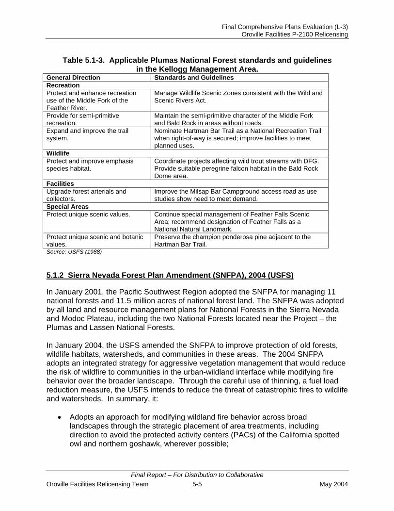
The Kellogg Management Area is a 1 to 2 mile wide corridor along the north side of the Middle Fork of the Feather River Canyon, from Oroville Reservoir to near Bear Creek. Table 5.1-3 lists some of the standards and guidelines for the Kellogg Management Area, as applicable to Lake Oroville.
Final Report – For Distribution to Collaborative
May 2004 5-4 Oroville Facilities Relicensing Team
Final Comprehensive Plans Evaluation (L-3) Oroville Facilities P-2100 Relicensing
Table 5.1-3. Applicable Plumas National Forest standards and guidelines in the Kellogg Management Area.
General Direction Standards and Guidelines Recreation Protect and enhance recreation use of the Middle Fork of the Feather River.
Manage Wildlife Scenic Zones consistent with the Wild and Scenic Rivers Act.
Provide for semi-primitive recreation.
Maintain the semi-primitive character of the Middle Fork and Bald Rock in areas without roads.
Expand and improve the trail system.
Nominate Hartman Bar Trail as a National Recreation Trail when right-of-way is secured; improve facilities to meet planned uses.
Wildlife Protect and improve emphasis species habitat.
Coordinate projects affecting wild trout streams with DFG. Provide suitable peregrine falcon habitat in the Bald Rock Dome area.
Facilities Upgrade forest arterials and collectors.
Improve the Milsap Bar Campground access road as use studies show need to meet demand.
Special Areas Protect unique scenic values. Continue special management of Feather Falls Scenic
Area; recommend designation of Feather Falls as a National Natural Landmark.
Protect unique scenic and botanic values.
Preserve the champion ponderosa pine adjacent to the Hartman Bar Trail.
Source: USFS (1988) 5.1.2 Sierra Nevada Forest Plan Amendment (SNFPA), 2004 (USFS)
In January 2001, the Pacific Southwest Region adopted the SNFPA for managing 11 national forests and 11.5 million acres of national forest land. The SNFPA was adopted by all land and resource management plans for National Forests in the Sierra Nevada and Modoc Plateau, including the two National Forests located near the Project – the Plumas and Lassen National Forests. In January 2004, the USFS amended the SNFPA to improve protection of old forests, wildlife habitats, watersheds, and communities in these areas. The 2004 SNFPA adopts an integrated strategy for aggressive vegetation management that would reduce the risk of wildfire to communities in the urban-wildland interface while modifying fire behavior over the broader landscape. Through the careful use of thinning, a fuel load reduction measure, the USFS intends to reduce the threat of catastrophic fires to wildlife and watersheds. In summary, it:
• Adopts an approach for modifying wildland fire behavior across broad landscapes through the strategic placement of area treatments, including direction to avoid the protected activity centers (PACs) of the California spotted owl and northern goshawk, wherever possible;
Final Report – For Distribution to Collaborative Oroville Facilities Relicensing Team 5-5 May 2004

Final Comprehensive Plans Evaluation (L-3) Oroville Facilities P-2100 Relicensing
• Requires a landscape level assessment of opportunities and constraints to be completed as a first step in designing the pattern of fuels treatments needed to implement the fire and fuels strategy;
• Provides mechanisms for more efficiently using appropriated funds; • Provides opportunities to reduce stand density and improve tree vigor and overall
forest health; • Provides for ecosystem restoration following catastrophic disturbance events; • Allows for the salvage of dead and dying trees for both economic value and fuels
reduction purposes; • Incorporates new fuels and vegetation management standards and guidelines; • Re-establishes the Herger-Feinstein Quincy Library Group (HFQLG) Forest
Recovery Act Pilot Project consistent with the HFQLG Forest Recovery Act; and • Adopts an active and focused adaptive management and monitoring strategy.
Another recent amendment to the SNFPA occurred in 2000 in response to the need for an old forest and associated species (such as the California spotted owl) conservation strategy that would protect, increase, and perpetuate old forest conditions. The 2000 amendment specifically addressed several problem areas briefly described below:
• Protect, increase, and perpetuate old forest ecosystems and provide for the viability of native plant and animal species associated with old forest ecosystems;
• Protect and restore aquatic, riparian, and meadow ecosystems, and provide for the viability of native plant and animal species associated with these ecosystems;
• Manage fire and other fuels in a consistent manner across the national forests, coordinate management strategies with other land owners, integrate fire and fuels management objectives with other natural resource objectives, address the role of wildland fires, and set priorities for fire and fuels management actions;
• Reduce and, where possible, reverse the spread of noxious weeds; and • Maintain and enhance hardwood ecosystems in the lower west side of the Sierra
Nevada.
The SNFPA includes management strategies and standards and guidelines to address problem areas. Some Forest Plan standards and guidelines were superseded by provisions in the SNFPA.
5.1.3 Redding Resource Management Plan (RMP), 1993 (BLM)
The primary purpose of the Redding RMP is to update and integrate BLM land use planning for the Redding Resource Area into a single, comprehensive land use plan. The RMP directs the management of public lands and Federal mineral estates that are administered by the BLM within the Redding Resource Area of north central California. The four main land use issues addressed in the RMP are land tenure adjustment, recreation management, access, and forest management.
Final Report – For Distribution to Collaborative
May 2004 5-6 Oroville Facilities Relicensing Team

Final Comprehensive Plans Evaluation (L-3) Oroville Facilities P-2100 Relicensing
The Redding Resource Area encompasses approximately 247,500 acres of public land and 142,000 acres of Federal mineral estate within Butte, Shasta, Siskiyou, Tehama, and Trinity counties. The total amount of land that the Redding RMP covers is approximately 247,000 acres within a 10 million acre area. The Redding Resource Area consists of more than a thousand individual parcels of public land, scattered through five counties in northern California. To adequately address management issues in such a large geographic area, the Resource Area is divided into seven geographically distinct Management Areas: Scott Valley, Klamath, Trinity, Shasta, Sacramento River, Ishi, and Yolla Bolly. The Oroville Project is located in the Ishi Management Area.
The Ishi Management Area is further divided into seven sub-areas: Battle Creek, Deer Creek, Forks of Butte Creek, Minnehaha Mine, Upper Ridge Nature Preserve, Baker Cypress, and the Remainder of the Management Area. The Oroville Project lands fall under the Remainder of the Management Area sub-area. Within each sub-area are numbered Resource Condition Objectives which indicate how lands are to be managed. The Resource Condition Objectives for the Remainder of the Management Area sub-area that apply to the Project are listed below (by number from the RMP).
(1) Enhancing the resource management efficiency and public service mission of local, State, and Federal agencies via transfer of specific public lands from BLM.
(2) Enhancing the ability to acquire high value resource lands within the Redding Resource Area by disposal of scattered public land interests within the Ishi Management Area.
(5) Transfer, via the Recreation and Public Purpose Act (R&PP) or exchange to a qualified State/local agency or non-profit organization administrative responsibility of six parcels of public land encompassing approximately 800 acres in the West Branch Feather River (between Magalia Reservoir and Lake Oroville).
(7) Transfer via exchange or R&PP to the State of California all surface and submerged public lands, which encompasses approximately 6,900 acres within and adjacent to the Lake Oroville State Recreation Area (LOSRA) (approximately 3,900 acres within LOSRA and 3,000 acres immediately adjoining LOSRA are available for transfer to the State of California). All lands identified by California or BLM as excess to park needs will be offered for exchange to any party after two years from approval of the Final RMP.
(8) 200 acres of public land near the Middle Fork Feather River are suitable for community development purposes as a Reservation for Federally recognized Indian tribe(s). If congressional support is unavailable, offer for exchange to any party after 5 years from the approval of the Final RMP.
Final Report – For Distribution to Collaborative Oroville Facilities Relicensing Team 5-7 May 2004

Final Comprehensive Plans Evaluation (L-3) Oroville Facilities P-2100 Relicensing
5.1.4 Final Restoration Plan for the Anadromous Fish Restoration Program (AFRP), 2001 (USFWS)
The Final Restoration Plan for the Anadromous Fish Restoration Program (AFRP) was established by the USFWS to increase the natural production of anadromous fish in the Central Valley of California under authority of the CVPIA. The Restoration Plan was adopted as Final on January 9, 2001. The CVPIA directed the USFWS to develop and implement a program that makes all reasonable efforts to double natural production of anadromous fish in Central Valley streams (Section 3406(b)(1)) known as the AFRP. The Restoration Plan is a programmatic-level description of the AFRP in broad and general terms, and will be used to guide the long-term development of the AFRP. The Restoration Plan presents the goals, objectives, and strategies of the AFRP, describes how the AFRP identified and prioritized reasonable actions and evaluations, lists those actions and evaluations, and notes those actions and evaluations that are already underway or that may be implemented in the near future. The AFRP coordinates restoration efforts with those used by other groups, such as DFG and the CALFED Bay-Delta Program.
The goal of the AFRP, as stated in Section 3406(b)(1) of the CVPIA, is to "develop within three years of enactment and implement a program which makes all reasonable efforts to ensure that, by the year 2002, natural production of anadromous fish in Central Valley rivers and streams will be sustainable, on a long-term basis, at levels not less than twice the average levels attained during the period of 1967-1991."
Six general objectives are defined to meet the program goals and are listed below:
• Improve habitat for all life stages of anadromous fish through provision of flows of suitable quality, quantity, and timing, and improved physical habitat;
• Improve survival rates by reducing or eliminating entrainment of juveniles at diversions;
• Improve the opportunity for adult fish to reach their spawning habitats in a timely manner;
• Collect fish population, health, and habitat data to facilitate evaluation of restoration actions;
• Integrate habitat restoration efforts with harvest and hatchery management; and • Involve partners in the implementation and evaluation of restoration actions.
Fishery managers must address complex biological, economic, social, and technological issues to substantially restore natural production of anadromous fish in the Central Valley. Restoration is anticipated to be costly and require changing the way aquatic resources and habitats are managed.
Final Report – For Distribution to Collaborative
May 2004 5-8 Oroville Facilities Relicensing Team

Final Comprehensive Plans Evaluation (L-3) Oroville Facilities P-2100 Relicensing
5.1.5 California’s Water Future: A Framework for Action, 2000 (CALFED Bay-Delta Program Agencies)
In 1994, the State of California and the Federal government signed a “Framework Agreement” pledging cooperation on a long-term plan to address chronic water supply and environmental problems in the Bay-Delta. The Bay-Delta is the largest estuary on the west coast — home to 750 plant and animal species — and it supports 80 percent of the state’s commercial salmon fisheries. It is also the hub of California’s two largest water distribution systems - the CVP operated by the BOR and the SWP operated by DWR. Together, these water development projects divert about 20 to 70 percent of the natural flow in the system depending on the amount of runoff available in a given year. Its levees protect farms, homes, and infrastructure. The CALFED Bay-Delta Program is a collaborative effort among 23 state and federal agencies (CALFED Agencies) to improve water supplies in California and the health of the Bay-Delta watershed.
In August 2000, the CALFED agencies signed the CALFED ROD, which now provides the roadmap for the CALFED Program. Following issuance of the ROD, CALFED Agencies are in the process of building a 30-year program that creates a foundation for long-term actions. Program components include:
• Governance; • Ecosystem restoration; • Watersheds; • Water supply reliability; • Storage; • Conveyance; • Environmental water account; • Water use efficiency (conservation and recycling); • Water quality; • Water transfers; • Levees; and • Science.
These program components are described in California’s Water Future: A Framework for Action, established in 2000. This “Framework” document is incorporated within the ROD and states that all aspects of the CALFED Program are interrelated and interdependent. The Framework indicates that CALFED goals for these elements are dependant upon expanded and more strategically managed water storage.
5.2 STATE MANAGEMENT PLANS
The State of California owns and manages a significant amount of land in the Project area. Several agencies are responsible for the management of State land and have developed management plans for guidance. State agencies that have management
Final Report – For Distribution to Collaborative Oroville Facilities Relicensing Team 5-9 May 2004
Final Comprehensive Plans Evaluation (L-3) Oroville Facilities P-2100 Relicensing
responsibilities for State lands in the Project area include DWR, DPR and DFG. In addition to these three State agencies, the California Department of Forestry and Fire Protection (CDF) has developed management plans that influence land and resource management activities in the Project area. The following section summarizes state agency plans and information that pertains to the Project area.
5.2.1 California Outdoor Recreation Plan (CORP), 2002 (DPR)
The California Outdoor Recreation Plan (CORP) was designed to meet the specific program responsibilities of the Federal Land and Water Conservation Fund Act, whose concerns are outdoor recreation, land acquisition, facility development, redevelopment, and rehabilitation. The CORP was prepared by DPR as a tool for Statewide outdoor recreation leadership and action for the next 5 years. The primary objective of the CORP is to determine the outdoor recreation issues that are most critical in California, and to explore the most appropriate actions by which public agencies – State, Federal, and local – might best address them. This plan is comprehensive in its scope, considering the full range of outdoor recreation issues throughout the entire State.
DPR serves as the administrator of Federal and State grant funds, which are disbursed to appropriate State agencies and to the State’s more than 600 park and recreation agencies at the city, county, and special district level.
The CORP takes into consideration the current demographic, economic, political, and environmental conditions, and then explores and analyzes the outdoor recreation issues that will be of major concern to public agencies in the next 5 years. The six overarching issues facing park and recreational agencies identified in the CORP include:
1. The Status of Parks and Recreation
2. Financing Parks and Outdoor Recreation
3. Access to Public Parks and Recreation Resources
4. Protecting and Managing Natural Resource Values
5. Preservation and Protection of California’s Cultural Heritage
6. Statewide Leadership in Parks and Outdoor Recreation
These six Statewide issues will likely have the greatest impact on public sector providers. The CORP explores a wide range of ways in which recreation providers can overcome challenges and create the opportunities the public will demand in coming years. Individual agencies and recreation providers are encouraged to take necessary steps in their own jurisdiction. As the agency responsible for the Statewide outdoor recreation planning process, DPR seeks to provide leadership in the areas of information development and policy guidance.
Final Report – For Distribution to Collaborative
May 2004 5-10 Oroville Facilities Relicensing Team

Final Comprehensive Plans Evaluation (L-3) Oroville Facilities P-2100 Relicensing
5.2.2 Public Opinions and Attitudes on Outdoor Recreation in California, 1997 (DPR)
The Public Opinions and Attitudes on Outdoor Recreation in California Survey was conducted as part of the 1998 revision of the Outdoor Recreation Plan. The Survey was undertaken by DPR, with the participation and strong support of BLM, National Park Service (NPS), and USFS. A random sample of 2,010 California households was used for the Survey. The Survey focused on two major areas of inquiry:
• Public attitudes, opinions, and values with respect to outdoor recreation in California; and
• Demand for and current participation in 43 selected types of outdoor recreation activities.
Major findings of the Survey relevant to the Oroville Project include: • Approximately 39 percent of respondents prefer natural and undeveloped areas
for recreation; • Approximately 30 percent of respondents prefer nature-oriented parks and
recreation areas; • Some of the more popular State-wide recreational activities (and percentage of
State-wide participation by respondents) that were identified and that occur at the Oroville Project include: recreational walking (84 percent), driving for pleasure (68 percent), picnicking in developed sites (65 percent), trail hiking (58 percent), swimming in lakes, etc. (57 percent), general nature wildlife study (54 percent), camping in developed sites (52 percent), freshwater fishing (37 percent), camping in primitive areas (26 percent), power boating (21 percent), kayaking/row boating/canoeing (18 percent), mountain biking (18 percent), horseback riding (14 percent), water skiing (13 percent), hunting (9 percent), and sail boating and windsurfing (7 percent); and
• The survey indicates latent State-wide demand for the following ranked recreational activities occurring at the Oroville Project: recreational walking (1), camping in developed sites (2), trail hiking (3), swimming in lakes/rivers/ocean (6), general nature wildlife study (7), camping in primitive areas (9), beach activities (10), freshwater fishing (12), picnicking in developed sites (13), horseback riding (15), kayaking/row boating/canoeing (21), mountain biking (22), power boating (30) and sail boating and windsurfing (37);
In terms of public spending priorities, the Survey indicates that Californians support policies that focus more on existing facilities rather than expanding opportunities for outdoor recreation areas and facilities. In addition, Californians tend to want more local community parks, more non-motorized vehicle areas for horseback riding, hiking and/or mountain biking, more campgrounds, fewer commercial businesses within public parks, and fewer areas for off-road vehicles.
Final Report – For Distribution to Collaborative Oroville Facilities Relicensing Team 5-11 May 2004

Final Comprehensive Plans Evaluation (L-3) Oroville Facilities P-2100 Relicensing
5.2.3 Lake Oroville State Recreation Area (LOSRA) Resource Management Plan (RMP) and General Development Plan, 1973 (DPR)
The LOSRA General Development Plan was developed by DPR in 1973 and is still in use today. An Amendment adopted in 1988 details additional development in the Lime Saddle Area. The Development Plan describes allowable recreational uses and intensities for various areas around the lake, such as Bidwell Canyon, Lime Saddle, Goat Ranch, and others. Recreational use intensities described in the Development Plan are primarily tied to slope and resource protection constraints. The Development Plan also describes the existing and proposed recreational development (as of 1973) within 15 areas of the park, including Kelley Ridge, Bidwell Canyon, Loafer Creek, Spillway Launching Ramp, Lime Saddle, Thermalito Forebay, and others. These developments include overnight facilities (camping sites, group camps, cabins, and lodges), day-use facilities (parking, picnic units, and swimming beaches), and boating facilities (launching lanes, car/trailer parking, and marina slips).
Management policies contained in the Development Plan emphasize that lands and resources at LOSRA are to be managed to provide recreational opportunities and facilities in a natural or quasi-natural setting. The purpose of the Development Plan is to “…perpetuate, enhance, and make available to the public the recreational opportunities afforded by Lake Oroville, Thermalito Forebay, and adjacent land and water areas and to protect all environmental amenities so that they make an optimum contribution to public enjoyment of the area.”
5.2.4 Lake Oroville State Recreation Area (LOSRA) General Development Plan Amendment – Lime Saddle Area, 1988 (DPR)
The LOSRA General Development Plan Amendment – Lime Saddle Area was approved by the State Park Commission in 1988. The Plan was intended to specifically address the changes needed at the Lime Saddle Marina. The Plan focused on marina changes including: acquisition of 5 acres of adjacent PG&E property, the need to surplus 23 acres of property, and increasing the marina boat capacity from 350 to 500 boats.
5.2.5 Comprehensive Statewide Historic Preservation Plan for California (HPP), 2000-2005 (2001) (DPR – Office of Historic Preservation)
The Comprehensive Statewide Historic Preservation Plan for California (HPP) was developed over the course of several years based upon input from both conservation professionals and the public. The HPP describes the vision for historic preservation and provides guidance on planning procedures for the identification, registration, protection, and preservation of important historical resources. Provisions for the periodic review and revision of the HPP every five years intend to ensure that changing needs and preservation priorities are being met.
Final Report – For Distribution to Collaborative
May 2004 5-12 Oroville Facilities Relicensing Team

Final Comprehensive Plans Evaluation (L-3) Oroville Facilities P-2100 Relicensing
The HPP summarizes the diversity of the State’s cultures, peoples, and resources, including those resources representing the past. Native American cultural resources in California range from 12,000 year old prehistoric archaeological sites to contemporary religious practice and gathering areas. The European presence in California began with early explorers along the coast, 18th Century Spanish missions, and 19th Century Russian fur traders. Population growth was spurred by the Gold Rush, agricultural developments, and later urbanization. These historic developments have all left their own architectural signatures, and representative examples of these resources still retain critical elements of their historic fabric of evocative settings reminiscent of these earlier settlements.
The pace of growth in California increased dramatically since the onset of World War II, increasing population pressure in urban and rural areas and jeopardizing prehistoric and historic resources in these spaces. During this economic “boom” there was little emphasis on integrating historic preservation into land use planning. As a result, prehistoric, ethnographic, and historic sites have been impacted. Without adequate safeguards, continuing pressure from population growth and economic expansion could further impact important examples of California’s past.
Seven shared goals are listed in the HPP that are based on the shared vision that “Californians will join together and work in partnership to preserve, maintain, and enhance the State’s irreplaceable historical and cultural heritage for present and future generations to appreciate and enjoy.” The seven shared goals are:
• Increase the number of significant private and public historic resources that are protected and preserved in all geographic regions of the State;
• Increase the number of individuals, organizations, and local government entities that understand the value of historic preservation planning through education and community outreach programs;
• Stimulate California’s economy by developing and utilizing historic preservation tools and incentives to promote jobs, stimulate investment in local communities, and encourage heritage tourism;
• Expand and diversify the current funding base for historic preservation programs while seeking dependable, long-term sources of economic support;
• Encourage and implement historic preservation planning as a regular component of public policy planning at all levels of government;
• Ensure that the identification of, and information about, historical and cultural resources in California is comprehensive, available in a consistent and complete format, and continually updated and augmented; and
• Promote the preservation and the stewardship of cultural resources among a diversified State population representing all levels of the socio-economic spectrum.
Final Report – For Distribution to Collaborative Oroville Facilities Relicensing Team 5-13 May 2004

Final Comprehensive Plans Evaluation (L-3) Oroville Facilities P-2100 Relicensing
Objectives intended to address each of these goals are listed in the HPP, with a focus on the integration of historic preservation issues as a standard component of land use planning, improved legislation and financial incentives for historic preservation planning purposes, and the promotion of a broader awareness of historic resources in all elements of society.
5.2.6 The California Water Plan Update, Bulletin 160 Series (DWR)
In 1957, DWR published Bulletin 3, the California Water Plan. Bulletin 3 was followed by the Bulletin 160 series, published six times between 1966 and 1993, updating the California Water Plan. A 1991 amendment to the California Water Code directed the DWR to update the plan every 5 years to address potential water shortages.
The Bulletin 160 series assesses California’s water needs and evaluates water supplies to quantify the gap between future water demands and water supplies. The series presents a statewide overview of current water management activities and provides water managers with a framework for making decisions. Bulletins 160-93 and 160-98 are the latest in the series and evaluate water management options that could improve California’s water supply reliability.
5.2.6.1 The California Water Plan Update: Bulletin 160-93, 1994 (DWR)
Since the last water plan update in 1987, California Water: Looking to the Future: Bulletin 160-87, evolving environmental policies were introduced to address uncertainty about much of the State's water supply. The winter-run chinook salmon and the Delta smelt were listed under the State and Federal Endangered Species Acts, imposing restrictions on Delta exports, and the CVPIA (PL 102-575) was passed in 1992, reallocating over a million acre-feet of CVP supplies for fish and wildlife. Bulletin 160-93, The California Water Plan Update, attempts to address some of these issues.
Bulletin 160-93 discusses the effects of recent changes to the institutional framework for water management in California and presents: California's existing water supplies and water quality considerations, the plan's assessment of the need and demand for water, and options for balancing those demands with supply. Finally, “Level I” recommendations are highlighted in two primary areas: demand management and supply augmentation. Level I options are those programs that have undergone extensive investigation and environmental analyses and are judged to have a higher likelihood of being implemented by 2020. Level II options are those programs that could fill the remaining gap shown in the balance between supply and urban, agricultural, and environmental water demands. These options require more extensive investigation and analyses of alternatives. An investigation of Level II options were recommended, and their economic feasibility ascertained, to address the range of demand and supply uncertainty illustrated in the California Water Budget.
Final Report – For Distribution to Collaborative
May 2004 5-14 Oroville Facilities Relicensing Team

Final Comprehensive Plans Evaluation (L-3) Oroville Facilities P-2100 Relicensing
5.2.6.2 The California Water Plan Update: Bulletin 160-98, 1998 (DWR)
Much of Bulletin 160-98 is devoted to identifying and analyzing options for improving water supply reliability within a planning horizon of 1995-2020. Water management options available to, and being considered by, local agencies form the building blocks of evaluations prepared for each of the State’s ten major hydrological regions. The bulletin provides a snapshot, at an appraisal level of detail, of how actions planned by California water managers could reduce the gap between supplies and demands. Rather than providing enforceable policies for water managers to follow, Bulletin 160-98 recommends improved strategies for water managers and local planners to consider.
5.2.7 Lake Oroville Fisheries Habitat Improvement Plan, 1995 (DWR)
In response to the September 22, 1994, FERC Order, the DWR adopted the Lake Oroville Fisheries Habitat Improvement Plan in 1995 to improve fish habitat and establish a schedule for implementation. Due to the magnitude of Lake Oroville’s water level fluctuations, steep slopes, poor soils, and encroachment of terrestrial vegetation, the establishment of rooted aquatic vegetation is extremely limited. A major Plan objective includes increasing the productivity of fisheries within specific areas and the entire lake.
Although the Lake Oroville Fisheries Habitat Improvement Plan focuses on projects to be implemented before the 1998-99 season, it provides a template for long-term habitat enhancement plans for fisheries. These fisheries are a very important component of the overall recreation and tourism industry in the Oroville area. Therefore, the local community, as well as local and statewide fishing organizations, has expressed a strong desire for DWR to be involved in enhancing and maintaining strong fisheries at Lake Oroville. These desires have been presented to FERC on numerous occasions and have resulted in FERC's attention to fisheries at the lake.
5.2.8 Oroville Wildlife Area (OWA) Management Plan, 1978 (DFG)
In 1962, the Director of DWR declared that public interest and necessity required the acquisition of the Oroville Borrow Area (the clay source for the construction of the Lake Oroville Dam) for fish and wildlife enhancement and recreation. In total, 5,500 acres were transferred from DWR to DFG for creation of the OWA on August 12, 1968. In 1978, the DFG developed the Oroville Wildlife Area Management Plan. The purpose of the Management Plan was to provide for the preservation and enhancement of the OWA and for the reasonable use and enjoyment by the public.
The Management Plan describes the plan’s purpose, description of the area, history of the site, present (as of 1978) situation and problems, and recommended action programs. The Management Plan also states that destructive uses and activities incompatible with wildlife and fisheries objectives (that were present at the time the
Final Report – For Distribution to Collaborative Oroville Facilities Relicensing Team 5-15 May 2004

Final Comprehensive Plans Evaluation (L-3) Oroville Facilities P-2100 Relicensing
Management Plan was written) will be eliminated through enforcement of existing regulations or development of additional regulations if necessary.
5.2.9 California Regulations on Hunting and Other Public Uses on State and Federal Areas, 2002 (DFG)
The California Regulations on Hunting and Other Public Uses on State and Federal Areas is not a comprehensive plan per se, but it does govern hunting on State and Federally owned lands and includes specific management direction for the OWA. Included in the Regulations are hunting license provisions and requirements, application and fee information, a listing of all hunting areas throughout the state, including wildlife areas, recreation areas, and national forests, and detailed information regarding area locations and boundaries, hunting practices and regulations, permit requirements, and firearms and archery equipment regulations in each hunting area.
The OWA, which is located in the Project area, is designated as a “Type C” wildlife area. Type C wildlife areas do not require a permit or pass for most uses. The OWA is open to hunting between September 1 and January 31 and during spring turkey season. However, special permits are required during the spring turkey season and are issued by drawing each year. The possession and use of rifles and pistols are prohibited in the wildlife area, except in the designated target practice area, which is open all year.
Regulations within the OWA that influence the use of the area include the following:
• Boating is allowed only on Thermalito Afterbay. Boats may only be launched from designated boat ramps. Boating may be restricted to certain zones designated by the department and boat speeds may not exceed 5 miles per hour.
• Camping is only permitted in designated campsites. Camping on the wildlife area is limited to not more than 7 consecutive days and not more than 14 days total in any calendar year, except by written permission of the Regional Manager.
• Dog training is allowed only in designated areas and only from July 1 through March 15.
• Fires are allowed only in portable gas stoves at sites designated for camping. • Horses are restricted to roads open to vehicles and to areas within 25 feet of
exterior boundary fences.
5.2.10 California Fire Plan: A Framework for Minimizing Costs and Losses From Wildland Fire, 1996 (CDF and State Board of Forestry [SBF])
In 1996, the SBF and CDF adopted the California Fire Plan, a comprehensive strategy for wildland fire protection in California. The Fire Plan is the State’s management guidance for identifying and working to reduce the risk and devastation caused by wildfire. The Fire Plan, updated most recently in 1999, targets pre-fire management measures geared at reducing fire fighting costs and property losses, increasing firefighter safety, and contributing to ecosystem health. The Fire Plan is a cooperative
Final Report – For Distribution to Collaborative
May 2004 5-16 Oroville Facilities Relicensing Team

Final Comprehensive Plans Evaluation (L-3) Oroville Facilities P-2100 Relicensing
effort between the SBF and the CDF. A general State-wide framework is provided from which specific CDF units and other local entities (such as fire safe councils) use to draft county or area specific plans. The planning process defines a level of service measurement, considers assets at risk, incorporates the cooperative interdependent relationships of wildland fire protection providers, provides for public stakeholder involvement, and creates a fiscal framework for policy analysis.
The overall goal is to reduce total costs and losses from wildland fire in California through focused pre-fire management prescriptions. The California Fire Plan has five strategic objectives:
• Create wildfire protection zones that reduce the risks to citizens and firefighters; • Assess all wildlands, not just the State responsibility areas. Analyses will include
all wildland fire service providers — Federal, State, local government, and private. The analysis will identify high risk, high value areas, and develop information on and determine who is responsible, who is responding, and who is paying for wildland fire emergencies;
• Identify and analyze key policy issues and develop recommendations for changes in public policy. Analysis will include alternatives to reduce total costs and losses by increasing fire protection system effectiveness;
• Provide a strong fiscal policy focus and monitor the wildland fire protection system in fiscal terms. This will include all public and private expenditures and economic losses; and
• Translate the analyses into public policies.
Five major Fire Plan elements form the basis of an ongoing fire planning process to monitor and assess California's wildland fire environment, including, (1) wildfire protection zones, (2) initial attack success, (3) protection of assets, (4) pre-fire management, and (5) a fiscal framework. A primary focus of the plan includes identifying those areas of concentrated assets and high risk before fires start, where cost-effective pre-fire management investments can be made to reduce taxpayer costs and citizen losses from wildfire.
5.2.11 Fire Management Plan, 2002 (CDF Butte Unit)
The Butte Unit Fire Management Plan documents the assessment of fire management within the Butte Unit (Butte County and a portion of Plumas County) and identifies strategic areas for pre-fire planning and fuel treatment to reduce destruction and costs associated with wildfire. The Plan systematically assesses the existing level of wildland fire protection service, identifies high-risk and high-value areas where potential exists for costly and damaging wildfires, ranks these areas in terms of priority needs, and prescribes methods to reduce future costs and losses.
The Fire Management Plan has four components:
Final Report – For Distribution to Collaborative Oroville Facilities Relicensing Team 5-17 May 2004
Final Comprehensive Plans Evaluation (L-3) Oroville Facilities P-2100 Relicensing
• Level of service; • Assets at risk; • Hazardous fuels; and • Historic severe fire weather.
To reduce the destruction and costs associated with wildfire, the Fire Management Plan aims to protect assets at risk through focused pre-fire management prescriptions, and in turn to improve initial attack success. The Fire Management Plan identifies five strategic objectives:
• Wildfire Protection Zones – Create wildfire protection zones that reduce the risk to citizens and firefighters;
• Initial Attack Success – Assess the initial attack fire suppression success of wildland fires on lands of similar vegetation type. This is measured in terms of percentage of fires that are successfully controlled before unacceptable costs and losses occur. The analysis can be used to determine the level of success of both the department and the unit;
• Assets Protected – Utilize a methodology for defining and protecting assets and determining their degree of risk from wildfire. The assets at risk addressed in the plan are life safety (citizens and firefighters), watersheds and water quality, timber, wildlife and wildlife habitat, rural communities, unique areas (scenic, cultural, and historic), recreation, range, property in the form of structures, and air quality;
• Fire Management Prescriptions – Develop fire management prescriptions that focus on alternative means of protecting assets at risk. Prescriptions may include a combination of fuel modification, ignition, management, fire-wise planning and education, and pre-development planning. Specific activities include, but are not limited to, land use planning and associated regulations, educational programs and public information, department infrastructure including fire stations and water systems, fuels management, and forest health. Pre-fire management prescriptions will also identify those who will benefit from such work and, consequently, those who should share in the project costs; and
• Fiscal Framework – Use the fiscal framework being developed by the SBF and CDF for assessing and monitoring annual and long-term changes in California’s wildland fire protection systems. Incorporate pre-fire workload analyses (PWA) in an attempt to provide relevant data to guide in the development of the fiscal framework and public policy.
The Project area is primarily located within the service area of Battalion Six, although portions of the Project area are also located within Battalion One, Three, and Five service areas of the Plan. The primary causes of fires in the Project vicinity are arson, debris burning, equipment use, and children playing with fire. Fire prevention programs and objectives in all Battalions include educating the community on fire prevention, conducting fire inspections throughout the battalions, establishing and working
Final Report – For Distribution to Collaborative
May 2004 5-18 Oroville Facilities Relicensing Team

Final Comprehensive Plans Evaluation (L-3) Oroville Facilities P-2100 Relicensing
cooperatively with community fire safety council, improving vegetation management programs, and improving accuracy/cause determination in preliminary fire investigations.
5.2.12 California Regional Water Quality Control Board, Central Valley Region, Water Quality Control Plan (Basin Plan), 4th Edition, 1998
The California Regional Water Quality Control Board, Central Valley Region, first adopted a Water Quality Control Plan (Basin Plan) in 1975 for the entire Sacramento and San Joaquin River Basins. Several editions have been adopted since then, with the current, fourth edition adopted in 1998. The preparation and adoption of Basin Plans is required by the California Water Code (Section 13240) and supported by the Federal Clean Water Act. Section 303 of the Clean Water Act requires states to adopt water quality standards which "consist of the designated uses of the navigable waters involved and the water quality criteria for such waters based upon such uses." According to Section 13050 of the California Water Code, Basin Plans consist of a designation or establishment for the waters within a specified area of beneficial uses to be protected, water quality objectives to protect those uses, and a program of implementation needed for achieving the objectives. State law also requires that Basin Plans conform to the policies set forth in the Water Code beginning with Section 13000 and any state policy for water quality control. Since beneficial uses, together with their corresponding water quality objectives, can be defined per Federal regulations as water quality standards, the Basin Plans are regulatory references for meeting the State and Federal requirements for water quality control (40 CFR 131.20).
The 1998 Basin Plan covers the entire area included in the Sacramento and San Joaquin River drainage basins and incorporates State policies and programs, the results of triennial reviews, and designated beneficial uses, objectives, and implementation programs. The current edition also addresses compliance schedules in permits and agricultural subsurface drainage discharges. The basins are bound by the crests of the Sierra Nevada on the east and the Coast Range and Klamath Mountains on the west. They extend some 400 miles from the California - Oregon border southward to the headwaters of the San Joaquin River.
California State law defines beneficial uses of California's waters that may be protected against quality degradation to include (and not be limited to) "...domestic; municipal; agricultural and industrial supply; power generation; recreation; aesthetic enjoyment; navigation; and preservation and enhancement of fish, wildlife, and other aquatic resources or preserves" (Water Code Section 13050(f)). The Basin Plan specifies which of these use designations are applied to specific water bodies within the region. Protection and enhancement of existing and potential beneficial uses in designated areas are primary goals of the Basin Plan.
Final Report – For Distribution to Collaborative Oroville Facilities Relicensing Team 5-19 May 2004

Final Comprehensive Plans Evaluation (L-3) Oroville Facilities P-2100 Relicensing
Table II-1 of the Basin Plan identifies the following existing beneficial use designations for waters within the Project No. 2100 FERC boundary and the Feather River downstream from the Fish Barrier Dam to the Sacramento River.
Beneficial uses are designated for entire water bodies unless specified with intermediate break points for various river segments.
Municipal and Domestic Supply (MUN) - Uses of water for community, military, or individual water supply systems including, but not limited to, drinking water supply.
Agricultural Supply (AGR) - Uses of water for farming, horticulture, or ranching including, but not limited to, irrigation (including leaching of salts), stock watering, or support of vegetation for range grazing. Irrigation is specifically designated as a beneficial use within the FERC boundary, and in downstream waters potentially affected by the project.
Industrial Service Supply (IND) - Uses of water for industrial activities that do not depend primarily on water quality including, but not limited to, mining, cooling water supply, hydraulic conveyance, gravel washing, fire protection, or oil well repressurization. Power generation is a beneficial use designation specified for waters of Lake Oroville.
Water Contact Recreation (REC-1) - Uses of water for recreational activities involving body contact with water, where ingestion of water is reasonably possible. These uses include, but are not limited to, swimming, wading, water-skiing, skin and scuba diving, surfing, white water activities, fishing, or use of natural hot springs. Canoeing and rafting uses are specifically designated for waters of the Feather River from the Fish Barrier Dam downstream to the confluence with the Sacramento River.
Non-contact Water Recreation (REC-2) - Uses of water for recreational activities involving proximity to water, but where there is generally no body contact with water, nor any likelihood of ingestion of water. These uses include, but are not limited to, picnicking, sunbathing, hiking, beachcombing, camping, boating, tidepool and marine life study, hunting, sightseeing, or aesthetic enjoyment in conjunction with the above activities.
Warm Freshwater Habitat (WARM) - Uses of water that support warm water ecosystems including, but not limited to, preservation or enhancement of aquatic habitats, vegetation, fish, or wildlife, including invertebrates.
Cold Freshwater Habitat (COLD) - Uses of water that support cold water ecosystems including, but not limited to, preservation or enhancement of aquatic habitats, vegetation, fish, or wildlife, including invertebrates.
Final Report – For Distribution to Collaborative
May 2004 5-20 Oroville Facilities Relicensing Team

Final Comprehensive Plans Evaluation (L-3) Oroville Facilities P-2100 Relicensing
Warm and Cold Water Migration (MIGR) – Uses of water that support habitats necessary for migration or other temporary activities by aquatic organisms, such as anadromous fish.
Warm and Cold Water Spawning (SPWN) - Uses of water that support high quality aquatic habitats suitable for reproduction and early development of fish. Both warm and cold water spawning habitats are identified within the FERC Project boundary and on the Feather River downstream to the Sacramento River.
Wildlife Habitat (WILD) - Uses of water that support terrestrial or wetland ecosystems including, but not limited to, preservation and enhancement of terrestrial habitats or wetlands, vegetation, wildlife (e.g., mammals, birds, reptiles, amphibians, invertebrates), or wildlife water and food sources.
Water quality objectives are the limits or levels of water quality constituents or characteristics that are reasonable protection of beneficial uses of water or the prevention of nuisance within a specified area [Water Code Section 13050(h)]. Water quality limits may be defined in the Basin Plan as numeric or narrative objectives. In addition, the Basin Plan incorporates by reference supporting state and federal water quality standards, criteria, and goals (including but not limited to Title 22 of the California Code of Regulations, the California Toxics Rule, the National Toxics Rule and the U.S. Environmental Protection Agency (EPA) Ambient Water Quality Criteria for protection of human health and freshwater aquatic life). To protect beneficial uses designated for specific water bodies, the Regional Water Quality Control Board will apply the more stringent of the criteria applicable. The water quality objectives of the Basin Plan and other applicable state and federal criteria apply to all surface waters in the Sacramento and San Joaquin River Basins, including the Project area. Numeric or narrative water quality objectives for the following constituents and parameters are identified in the Basin Plan:
• Bacteria • pH • Suspended Material • Biostimulatory • Pesticides • Tastes and Odors • Chemical Constituents • Radioactivity • Temperature • Dissolved Oxygen • Salinity • Toxicity • Floating Material • Sediment • Turbidity • Oil and Grease • Settleable Material
Specific numeric objectives for Electrical Conductivity are identified for waters entering Lake Oroville and in the Feather River from the Fish Barrier Dam at Lake Oroville downstream to the Sacramento River.
Compliance with water quality standards, objectives, criteria, and goals is evaluated in light of the controllable factors including the natural background conditions.
Final Report – For Distribution to Collaborative Oroville Facilities Relicensing Team 5-21 May 2004
Final Comprehensive Plans Evaluation (L-3) Oroville Facilities P-2100 Relicensing
The nature of actions to achieve water quality objectives consists of Regional Water Board efforts to identify problems, assess the issues, remedy though imposing appropriate measures, and monitoring problem areas.
5.3 LOCAL MANAGEMENT PLANS
There are three local entities in the Project area that have land planning and/or management responsibilities. The Butte County Association of Governments (BCAG) is the Metropolitan Planning Organization (MPO) and Regional Transportation Planning Agency (RTPA) and is responsible for the preparation of all Federal and State transportation plans and programs for securing transportation funds. BCAG is an association of local governments formed by Butte County and the cities of Biggs, Chico, Gridley, Oroville and the Town of Paradise. In addition to BCAG, Butte County and the City of Oroville also have comprehensive and/or management plans for lands in the Project area.
Although the majority of land in the Project area is managed by State agencies, there are considerable city and county lands that are within the study area. The following sections discuss the local plans that pertain to the Project area.
5.3.1 Regional Plans
5.3.1.1 Butte County 2001 Regional Transportation Plan (RTP), 2001 (BCAG)
The Butte County Regional Transportation Plan (RTP) was developed to fulfill the state requirements of California Senate Bill 45 and the passage of the Transportation Equity Act (TEA) for the 21st Century by Congress in June 1998. In accordance with State law, BCAG has prepared the regional transportation plans for Butte County every three years, the latest of which was adopted in 2001. The Butte County RTP is a 20-year, long range plan that is intended to attain an efficient and environmentally sound multi-modal transportation system. The RTP contains three required elements: a policy element that reflects the mobility goals, policies and objectives of the region, an action element that identifies programs and actions to implement the RTP, and a financial element that summarizes the cost of implementing the projects in the RTP.
Within the policy element of the RTP, “Land Use Coordination” and “Pedestrian and Bikeways” policies are most applicable to the Project. Land Use Coordination policies are intended to facilitate the development of the most efficient and effective transportation system possible through existing and future land development forms. Specific policies include assisting jurisdictions in the preparation of circulation analyses with the countywide transportation model, and encouraging agencies to require land uses that produce significant trip generation, utilize roadways with adequate capacity, and design standards for all transportation modes.
Final Report – For Distribution to Collaborative
May 2004 5-22 Oroville Facilities Relicensing Team
Final Comprehensive Plans Evaluation (L-3) Oroville Facilities P-2100 Relicensing
The objective of Pedestrian and Bikeways policies in the RTP is to “provide a safe, convenient, and efficient non-motorized transportation system which is part of a balanced overall transportation system.” Specifically, RTP policies state that local agencies should encourage: the development of trails to increase access to wilderness and recreational areas of the region, consideration of bicycles and pedestrians when improving existing roadways, and the incorporation of non-motorized facilities in planned street improvement projects where possible.
The RTP also includes a chapter on non-motorized transportation action items. This chapter identifies existing conditions and plans for bikeways on a jurisdictional and regional basis, and provides short and long range policy direction that is consistent and supportive of the goals, policies, and objectives contained in the more specific 1998 Countywide Bikeway Master Plan. The RTP makes reference to its support for the general projects included in the Countywide Bikeway Master Plan, as well as support for the 41-mile bicycle trail loop around the Feather River, and trails located within the Oroville Dam State Recreation Area.
5.3.1.2 Countywide Bikeway Master Plan, 1998 (BCAG)
The Countywide Bikeway Master Plan for Butte County was developed by the BCAG, with input from bikeway advocates, staff from each city and the county, the transportation management association, and the county public. The primary purpose of the plan is to designate a regional bikeway system for Butte County that focuses on area-wide bikeway connections.
The Bikeway Plan details the regional setting of Butte County as it applies to bicycle transportation, including details regarding regionally significant land use patterns, commute patterns, and existing bicycle-related facilities. The Bikeway Plan then details the goals, objectives, and policies, discusses the county’s capital improvement program, and details the financial elements as related to bicycling in Butte County. The Bikeway Plan details the existing and planned bikeways and bicycle facilities throughout the county (as of September 1998). Existing facilities in the Oroville urban area include Class I bike paths along the Feather River from Table Mountain Boulevard to River Bend Park and on Table Mountain Boulevard across Feather River Bridge, and a Class II bike lane on Foothill Boulevard from Olive Highway to the city limit (near Pinedale Avenue). A Class I bike path along the south side of Feather River from the SR 162 Bridge over Feather River to LOSRA is listed in the plan as scheduled for construction during 1998 and 1999. The plan also lists five Class I and 42 Class II proposed bicycle paths that are not yet scheduled for implementation. There are no regional bikeways in the Oroville area or in the Project area.
The Bikeway Plan contains specific goals, objectives, and policies. Most are general in nature and do not specifically relate to the Project area (although the Project area is within the area covered by the plan). One of the goals in the Bikeway Plan does mention the Project specifically and is included below:
Final Report – For Distribution to Collaborative Oroville Facilities Relicensing Team 5-23 May 2004

Final Comprehensive Plans Evaluation (L-3) Oroville Facilities P-2100 Relicensing
Goal 6: Develop a bikeway system that encourages and facilitates recreational use. Objective: Encourage recreational bicycling by providing a bikeway system that responds to the riding needs of both the avid cyclist and the “weekend” rider.
Policies: Emphasize connections to regional recreation centers, such as Lake Oroville and Bidwell Park; plan bikeway facilities to take full advantage of the scenic qualities of Butte County for the enjoyment of residents and visitors alike; provide adequate bicycle parking facilities at regional recreation areas where warranted by demand.
In addition to goals, objectives and policies, the Bikeway Plan identifies existing and planned Class I and II bikeways and planned bicycle related facilities in the Oroville area. It also mentions that the City of Oroville Bicycle Transportation Plan was scheduled (at the time of writing this plan) to be adopted in October of 1998. Funding sources and design standards are also included in the plan.
5.3.2 County Plans
5.3.2.1 Butte County General Plan, 1996 (County of Butte)
Local governments have been directed by the State of California to prepare and adopt a general plan per Section 65302 (a) of the California Government Code. In compliance with California Law, the Butte County General Plan was adopted in 1996 by the County of Butte and the BCAG. The purpose of this document is to provide a complete statement of the policies and intentions regarding future development of land over a planning horizon of 20 years, which extends to the year 2016.
The General Plan contains twelve elements, including Land Use, Circulation, Housing, Conservation, Open Space, Seismic Safety, Safety, Noise, Scenic Highways, Recreation, Economy, and Agriculture. California law does not exclude the area of incorporated cities from the coverage of county general plans. Therefore, the proposals in the Land Use Element, or the element most relevant to the Project, are county-wide in scope and are not limited to unincorporated areas. The most recent adoption of this element occurred in January of 2000.
The land use element of the General Plan designates several land use categories within the study area. The three primary designations in the study area include Public, Grazing and Open Land, and Timber-Mountain. Planned land uses, including their primary and secondary uses and intensity of use, are described below. These land use categories are depicted graphically in the Draft Final Report L-2 – Land Management Report.
Final Report – For Distribution to Collaborative
May 2004 5-24 Oroville Facilities Relicensing Team

Final Comprehensive Plans Evaluation (L-3) Oroville Facilities P-2100 Relicensing
Land Use
Orchard and Field Crops
Primary Uses: Cultivation, harvest, storage, processing, and sale and distribution of all plant crops, especially annual food crops.
Secondary Uses: Animal husbandry and intense animal uses, resource extraction and processing, hunting and water-related recreation facilities, dwellings, airports, utilities, environmental preservation activities, public and quasi-public uses, and home occupations.
Intensity of Use: Minimum parcel size of 5 acres. One single-family (SF) dwelling unit (DU) per parcel with additional housing for on-site employees allowed.
Grazing and Open Land
Primary Uses: Livestock grazing, animal husbandry, intense animal uses, and animal matter processing.
Secondary Uses: Resource extraction and processing, forestry, plant crops, agricultural support services, outdoor recreation facilities, airports, dwellings, utilities, environmental preservation activities, public and quasi-public uses, and home occupations.
Intensity of Use: Minimum parcel size of 40 acres. Gross density could vary from 20 to 40 acres per DU provided at least 80 percent of the total acreage of a project is set aside for open space uses. One SF DU per parcel with additional housing for on-site employees is encouraged.
Timber-Mountain
Primary Uses: Forest management, and the harvesting and processing of forest products.
Secondary Uses: Animal husbandry, resource extraction and processing, environmental preservation activities, outdoor recreation facilities, dwellings, utilities, public and quasi-public uses, home occupations, and airports.
Intensity of Use: In general, the minimum parcel size is 40 acres with some exceptions. One SF DU per parcel with additional housing for on-site employees.
Agricultural Residential
Primary Uses: Agricultural uses and SF dwellings at rural densities.
Final Report – For Distribution to Collaborative Oroville Facilities Relicensing Team 5-25 May 2004

Final Comprehensive Plans Evaluation (L-3) Oroville Facilities P-2100 Relicensing
Secondary Uses: Animal husbandry, forestry, intense animal uses, home occupations, mining, outdoor recreation facilities, environmental preservation activities, airports, utilities, public and quasi-public uses, group quarters, care homes, and transient lodging.
Intensity of Use: The minimum parcel size is 1 to 40 acres. One SF DU per parcel. Home occupations, farm animals, other uses, and setbacks regulated to maintain rural character.
Foothill Residential
Primary Uses: SF DUs at rural densities.
Secondary Uses: Agriculture uses, animal husbandry, home occupations, resource extraction and processing, forestry, outdoor recreational facilities, environmental preservation activities, airports, utilities, public and quasi-public uses, dwellings, group quarters, care homes, and other secondary uses.
Intensity of Use: Minimum parcel size of 1 to 40 acres, with the specific density being subject to zoning factors and development criteria.
Low Density Residential
Primary Uses: Detached SF DUs at urban densities
Secondary Uses: Agricultural uses, animal husbandry, home occupations, outdoor recreation facilities, utilities, public and quasi-public uses, group quarters, and care homes.
Intensity of Use: Zoning allows net parcel sizes of 1 acre to 6,500 square feet. One SF DU per parcel with other residential uses limited to a maximum density of six DUs per gross acre. Home occupations, farm animals, other uses, and setbacks regulated to maintain SF residential character.
Medium Density Residential
Primary Uses: A mixture of urban residential uses, including detached SF homes, condominiums, multiple-dwelling structures, mobile home parks, group quarters, and care homes.
Secondary Uses: Home occupations, professional and business offices, outdoor recreation facilities, utilities, and public and quasi-public uses.
Intensity of Use: Zoning allows net parcel size of 6,500 square feet. A maximum density of 13 DUs per gross acre with group quarters and care homes limited to similar densities is permitted.
Final Report – For Distribution to Collaborative
May 2004 5-26 Oroville Facilities Relicensing Team

Final Comprehensive Plans Evaluation (L-3) Oroville Facilities P-2100 Relicensing
High Density Residential
Primary Uses: Higher-density urban residential uses, including condominiums, multiple-dwelling structures, mobile home parks, group quarters, and care homes.
Secondary Uses: Home occupations, professional and business offices, outdoor recreation facilities, utilities, and public and quasi-public uses.
Intensity of Use: Zoning allows parcel sizes of 6,500 square feet. A maximum density of 20 DUs per gross acres with group quarters and care homes limited to similar densities is permitted.
Commercial
Primary Uses: Structures and activities providing a full range of merchandise and services to the general public.
Secondary Uses: Wholesale storage and distribution, processing and manufacturing, transient lodging, dwelling and group quarters, home occupations, utilities, and public and quasi-public uses.
Intensity of Use: Minimum parcel sizes, dimensions and setbacks to facilitate commercial development. Residential and industrial uses are limited to minimize conflicts with commercial uses.
Industrial
Primary Uses: Processing, manufacturing, packaging, storage, and distribution of goods and commodities.
Secondary Uses: Light commercial uses, dwellings, utilities, public and quasi-public uses.
Intensity of Use: Minimum parcel sizes, dimensions and setbacks to facilitate intense industrial development. Residential and light commercial uses limited to minimize conflicts with industrial uses.
Public
Primary Uses: Large facilities owned and operated by government agencies, including schools, colleges, airports, dams and reservoirs, disposal sites, recreation facilities, conservation areas, fire stations and other government buildings and property.
Secondary Uses: Hospitals and other large quasi-public uses, housing for students or on-site employees, utilities.
Final Report – For Distribution to Collaborative Oroville Facilities Relicensing Team 5-27 May 2004
Final Comprehensive Plans Evaluation (L-3) Oroville Facilities P-2100 Relicensing
Intensity of Use: No standards on intensity, except where necessary to protect adjacent uses and the public welfare.
Another chapter of the General Plan relevant to the Project includes the Scenic Highways Element, which fulfills Section 65302(h) of the Government Code to develop, establish, and protect scenic highways. Scenic Highways are defined as a main public road through an area of picturesque natural landscapes. A Scenic Highway includes not only the pavement or traveled roadway, but also the entire publicly owned right-of-way. Customary accessory uses usually found in the right-of-way include bridges, drainage facilities, public utilities, walkways and trails, protective planting and landscaping, rest areas, and vista points.
The primary objective of this element is the projection and enhancement of scenic areas adjacent to and visible from selected highways. Within Butte County, Highway 70 north of Highway 149 is eligible as a State Scenic Highway, although not officially designated. Being “eligible” indicates that the route is shown on the Master Plan of State Scenic Highways. It is not protected by a State-approved, county-developed plan. A segment of this section of Highway 70 lies within the Project boundary.
The General Plan contains a number of policies that could pertain to the operation and management of Lake Oroville. The County’s policies are primarily related to enhancement of recreational and biological resources at Lake Oroville, as well as the reduction of potential flood and seismic hazards. Butte County has indicated its strong interest in promoting more recreational development around the reservoir, and there appears to be support for land use and zoning designations around the reservoir that would make this development possible. The County policies relevant to Lake Oroville are described below in Table 5.3-1, organized by element of the General Plan. Scenic Highways Element
The Scenic Highways Element fulfills Section 65302(h) of the California Government Code to develop, establish, and protect scenic highways. Scenic highways are defined as a main public road through an area of picturesque natural landscapes. A scenic highway includes not only the pavement or traveled roadway, but also the entire publicly owned right-of-way. Customary accessory uses usually found in the right-of-way include bridges, drainage facilities, public utilities, walkways and trails, protective planting and landscaping, rest areas, and vista points. The Scenic Highways Element has eight policies:
1. Protect valuable scenic areas for enjoyment by residents and visitors; 2. Delineate scenic corridors with careful consideration of all factors; 3. Consider scenic values in the design and improvement of rights-of-way; 4. Control access to scenic highways to control safety; 5. Locate and design utility structures to minimize visual impact, where
economically feasible;
Final Report – For Distribution to Collaborative
May 2004 5-28 Oroville Facilities Relicensing Team

Final Comprehensive Plans Evaluation (L-3) Oroville Facilities P-2100 Relicensing
Table 5.3-1. Butte County General Plan policies related to Lake Oroville. Element Policy Statement Land Use Biological Habitat: Lake Oroville and Butte County's larger streams are highly
valuable habitats for trout, salmon, bass, and other game fish. Several rare and/or endangered plants and animal species are found within the county. Policy 6.5.a. Regulate development in identified winter deer ranges to
facilitate the survival of deer herds. Policy 6.5.b. Prevent development and site clearance other than river bank
protection of marshes and significant riparian habitats. Policy 6.5.c. Limit development which would increase sediment loads in prime
fishing waters. Policy 6.5.d. Regulate development to facilitate survival of identified rare or
endangered plants and animals. Geologic Hazards: The risk of landslides is greatest in areas with steep slopes, weak rock, and high rainfall; some areas around Lake Oroville and its branches have very high risk. Erosion potential varies by the same factors but is greatest in granite areas. Findings and policies on these subjects and other geologic hazards are presented in the Safety Element adopted in 1977. Policy 7.4.a. Correlate allowable density of development to potential for
landslides, erosion and other types of land instability. Open Space Open Space for Outdoor Recreation: The DPR manages the extensive
recreation facilities around Lake Oroville and the Thermalito Bays. Policy L The Butte County should encourage the DPR to complete their
development of recreational facilities in the LOSRA. Scenic Highways
Eligible State Scenic Highways: Highway 70 north of Highway 149 is eligible as a State Scenic Highway, although not officially designated.
Policy 1 Protect valuable scenic areas for enjoyment by residents and visitors;
Policy 5 Locate and design utility structures to minimize visual impact, where economically feasible;
Policy 6 Encourage compatible land use patterns in scenic corridors; and Policy 8 Consider economic impacts on property affected by a scenic
highway designation. Recreation Policy 5 Lake Oroville and Facilities: Proposed development (parking,
camp, picnic, boat ramp, comfort station, trailer, food, gasoline, oil, water, observation points and other facilities to serve the recreation minded public) at the following facilities: Lime Saddle, Foreman Creek, Bloomer, Craig, Kelly Ridge, Forebay, Loafer Creek, Goat Ranch, Afterbay, Potter Ravine, Fish Hatchery, etc. Development Agencies: County, Recreation District and DPR.
Source: Butte County (2000)
Final Report – For Distribution to Collaborative Oroville Facilities Relicensing Team 5-29 May 2004

Final Comprehensive Plans Evaluation (L-3) Oroville Facilities P-2100 Relicensing
6. Encourage compatible land use patterns in scenic corridors; 7. Promote the County’s scenic highways program; and 8. Consider economic impacts on property affected by a scenic highway
designation.
The primary objective of this element is the protection and enhancement of scenic areas adjacent to and visible from selected highways. No officially designated State or County scenic highways currently exist in the study area.
5.3.3 Municipal Plans
5.3.3.1 City of Oroville General Plan, 1995 (City of Oroville)
The City of Oroville General Plan is a statement of Oroville’s vision of its long-term future, focusing on the physical components that comprise the City. The General Plan consists of eight sections: 1) land use, 2) design, 3) circulation, 4) open space, natural resources, and conservation; 5) public facilities and services, 6) safety, 7) noise, and 8) housing goals, objectives, policies, and designations. The objectives and goals outlined in the General Plan are intended to be the framework within which the City will make future decisions related to the community.
The 84 square mile planning area covered by the General Plan is comprised of seven planning sectors that include the Oroville Sphere of Influence (as defined by the Butte County Local Agency Formation Commission), and areas immediately to the west, south, and east. The General Plan directly addresses the issues of housing, conservation, recreation, industry, and circulation, as well as a number of others. Among the themes of the General Plan that are relevant to the Project area are:
• Growth – The Plan encourages new industries and a higher population growth
rate in order to improve the City’s economy; and • Environmental Awareness and Conservation – The General Plan calls for a
relatively high level of ongoing management and planning for the City’s natural and cultural resources, and encourages the conservation of oak woodlands, wetlands, and riparian corridors, in particular, in order to enhance the quality of life in the area relative to nearby metropolitan areas.
The Land Use Element of the General Plan designates most areas near the Project boundary as “Medium Density Residential” and “Parks.” These land use designations are described below: • Medium Density Residential – Medium-density residential land uses in the
Oroville Planning Area consist of SF residential developments with approximately two to six units per gross acre on land under 30 percent slope. This land use is
Final Report – For Distribution to Collaborative
May 2004 5-30 Oroville Facilities Relicensing Team

Final Comprehensive Plans Evaluation (L-3) Oroville Facilities P-2100 Relicensing
primarily located in the Kelley Ridge Planning Sector within Oroville’s Sphere of Influence, which is outside of the city’s jurisdiction.
• Parks – This land use category includes public parks, golf courses, or other appropriate uses. A recreational vehicle park or campground may be permitted as a conditional use within areas designated as Park. Within the City, this land use includes the Table Mountain Golf Course, located adjacent to the OWA in the Thermalito Planning Area. Within Oroville’s unincorporated planning area, park lands are primarily located near the Oroville Dam, and contain such recreational areas as the Bidwell Canyon Campground, the Lake Oroville Visitor Center, and the Dan Beebe trail, which are managed by DPR.
General Plan policies that relate to the operation and management of Lake Oroville generally include enhancement of recreational and biological resources at Lake Oroville, as well as reducing potential flood and seismic hazards. Policies that specifically mention the Project are listed below in Table 5.3-2, organized by element of the General Plan.
Table 5.3-2. City of Oroville General Plan policies that mention the Project. Element Policy Statement
Policy 4x Request the State to landscape and develop the Thermalito Afterbay as a destination water recreation park which defines the western boundary of the community in accordance with the State’s original master plan of recreation development associated with the FERC permit.
City Design
Policy 4y Encourage the efforts of the Feather River Parks and Recreation Department in the North Forebay, Nelson Ballpark expansion, and development of River Bend Park.
Policy 6.11s Coordinate with the DFG to ensure the ongoing operation of the Feather River Fish Hatchery.
Open Space, Natural Resources and Conservation
Policy 6.11w Work with the DFG to ensure the preservation and enhancement of species or resident and anadromous fish along the Feather River, in Lake Oroville, and throughout the Project area.
Policy 8.10e Monitor studies related to induced seismicity; if further studies establish a conclusive relationship between reservoir drawdown, refilling, and seismic activity, encourage the DWR to manage the Oroville Dam water regime to reduce risk (evidence thus far suggests a relationship between reservoir drawdown, refill, and subsequent seismic activity. This was seen in the 1975 Cleveland Hills earthquake, thought to have occurred after unprecedented drawdown and refilling of Lake Oroville).
Policy 8.20m Identify critical facilities in flood hazard areas and within the Oroville Dam inundation area, and seek ways to improve their level of protection, if possible (critical facilities provide fire and emergency services, water, electricity, gas supply, sewage disposal, communications, and transportation).
Safety
Policy 8.20o In the event of dam failure on the Oroville Dam, implement emergency measures consistent with the city’s Multi-hazard Functional Disaster Plan (Dam failure, while considered unlikely, is among the hazards mentioned in the City’s Multi-hazard Functional Disaster Plan).
Source: City of Oroville (1995).
Final Report – For Distribution to Collaborative Oroville Facilities Relicensing Team 5-31 May 2004
Final Comprehensive Plans Evaluation (L-3) Oroville Facilities P-2100 Relicensing
5.3.3.2 Bicycle Transportation Plan, 1998 (City of Oroville)
The City of Oroville Bicycle Transportation Plan, adopted in December 1998, provides the most up-to-date policies for bicycle transportation in the City of Oroville. The City of Oroville plans all bikeways within its “Sphere of Influence,” although they are ultimately outside of the city’s jurisdiction. The planning and implementation of bikeways is not a mandated process, but one undertaken by communities at their discretion. The City of Oroville Bicycle Transportation Plan is broken down into 8 chapters. Chapter 7 (Goals, Objectives, and Policies) is the portion of the City of Oroville Bicycle Transportation Plan (BTP) that relates most closely to the issues associated with Project facilities. The City of Oroville General Plan has specific goals and policies related to bicycle and pedestrian paths, which are incorporated to form the core of the policy element of this bicycle transportation plan.
The Bicycle Transportation Plan lists four goals, which include:
• Provide a system of Class I and Class II bikeways and multi-use recreational trails throughout the Oroville Urban Area that will increase bicycle access to major facilities, shopping, schools, work centers, and points of interest, and will increase the utility of bicycles not only for recreation, but also as a viable mode of alternative transportation;
• Improve safety conditions, efficiency, and comfort for bicyclists and pedestrians through traffic engineering and law enforcement efforts;
• Provide adequate bicycle support facilities; and • Develop a bikeway system that encourages and facilitates recreational use.
Parts of the Project area (the Diversion Pool, Power Canal, Thermalito Forebay, Thermalito Afterbay, Spillway, and OWA) that have bicycle paths traveling by them are of the same network as Oroville’s bikeway system. The plan suggests a need for bicycle support facilities, some of which could be associated with bikeways in or near the Project.
Final Report – For Distribution to Collaborative
May 2004 5-32 Oroville Facilities Relicensing Team

Final Comprehensive Plans Evaluation (L-3) Oroville Facilities P-2100 Relicensing
6.0 CONCLUSIONS
This chapter identifies comprehensive land and resource management plans that may apply to or be affected by changes to Project facilities and operations as a result of relicensing activities. The Preliminary Draft Environmental Assessment (PDEA) will evaluate how activities associated with the Project alternatives, including the No Action Alternative (that represents the existing conditions), would be consistent or inconsistent with the management directions of the plans. The following sections identify potential consistency issues associated with specific plans and potential technical leads that would be appropriate (other than land use specialists) to evaluate them.
6.1 FEDERAL PLANS
6.1.1 Plumas National Forest Land and Resource Management Plan (LRMP), 1988 (USFS)
Consistency Issues: Potential changes that may occur on USFS lands within the Project boundary as the result of relicensing activities will be evaluated in terms of consistency with the Forest Plan and the three Management Areas located near the Project. These issues will be addressed in the PDEA.
6.1.2 Sierra Nevada Forest Plan Amendment (SNFPA), 2000 (USFS)
Consistency Issues: The Plumas National Forest will be contacted by a natural resources technician to see how and if the SNFPA has had any effects on the Forest’s LRMP and/or influenced management of the Forest in any of the three Management Areas located near the Project. If there have been changes, it needs to be determined if relicensing activities associated with the Project would be consistent or inconsistent with these new management directions. These potential consistency issues will be addressed in the PDEA.
6.1.3 Redding Resource Management Plan (RMP), 1993 (BLM)
Consistency Issues: Although BLM policies related to land transfers or exchanges would not directly apply to FERC relicensing, DWR staff will continue to communicate with BLM regarding the potential to transfer lands that are in the Project area from BLM to the State of California. Potential consistency issues with the RMP related to changes as a result of the relicensing process will be addressed in the PDEA.
6.1.4 California’s Water Future: A Framework for Action, 2000 (CALFED Bay-Delta Program Agencies)
Consistency Issues: The Project will likely continue to be consistent with the Framework for Action Plan. The consistency of potential activities related to relicensing with the Framework for Action Plan will be evaluated in the PDEA.
Final Report – For Distribution to Collaborative
Oroville Facilities Relicensing Team 6-1 May 2004
Final Comprehensive Plans Evaluation (L-3) Oroville Facilities P-2100 Relicensing
6.2 STATE PLANS
6.2.1 California Outdoor Recreation Plan (CORP), 2002 (DPR)
Consistency Issues: The Project will likely continue to be consistent with the broad policies of the CORP. The consistency of potential activities related to relicensing with the CORP will be evaluated in the PDEA by a recreation specialist.
6.2.2 Public Opinions and Attitudes on Outdoor Recreation in California, 1997 (DPR)
Consistency Issues: The consistency of potential activities related to relicensing with the findings in the document will be evaluated in the PDEA. This evaluation will include a review conducted by a recreation analyst on how well those activities identified in the Survey satisfy latent recreational demands.
6.2.3 Lake Oroville State Recreation Area (LOSRA) Resource Management Plan (RMP) and General Development Plan, 1973 (DPR)
Consistency Issues: Potential activities associated with relicensing that may affect recreation and/or management in the LOSRA will be evaluated by a recreation specialist in the PDEA for consistency with the policies expressed in the LORSA Resource Management Plan.
6.2.4 Lake Oroville State Recreation Area (LOSRA) General Development Plan Amendment – Lime Saddle Area, 1988 (DPR)
Consistency Issues: Potential activities associated with relicensing that may affect recreation and/or management in the Lime Saddle area will be evaluated by a recreation specialist for consistency with the policies expressed in this plan and addressed in the PDEA.
6.2.5 Comprehensive State-wide Historic Preservation Plan for California (HPP), 2000-2005 (2001) (DPR – Office of Historic Preservation)
Consistency Issues: The Project will likely continue to be consistent with the policies of the HPP. The consistency of potential activities related to relicensing with the HPP will be evaluated in the PDEA by a historic/cultural resources specialist.
6.2.6 The California Water Plan Update, Bulletin 160 Series (DWR)
Consistency Issues: This plan does not directly apply to relicensing efforts of the Project unless potential activities related to relicensing involve changes to water supply for the California State Water Project. It will be necessary for engineering and operations technical specialists to review potential activities related to relicensing to determine if they would be consistent with the intent of the plan.
Final Report – For Distribution to Collaborative
May 2004 6-2 Oroville Facilities Relicensing Team

Final Comprehensive Plans Evaluation (L-3) Oroville Facilities P-2100 Relicensing
6.2.7 Lake Oroville Fisheries Habitat Improvement Plan, 1995 (DWR)
Consistency Issues: DWR's continued habitat improvement efforts (both those associated with and not associated with relicensing) meet the intent of the Habitat Improvement Plan. Activities associated with relicensing will be evaluated by fisheries specialists to assess consistency with the intent of the Habitat Improvement Plan in the PDEA.
6.2.8 Oroville Wildlife Area (OWA) Management Plan, 1978 (DFG)
Consistency Issues: It will be necessary to evaluate potential activities associated with relicensing for consistency with the existing land uses at the OWA and with the direction of the Management Plan. This evaluation will be conducted by specialists in terrestrial biology or ecology and addressed in the PDEA.
6.2.9 California Regulations on Hunting and Other Public Uses on State and Federal Areas, 2002 (DFG)
Consistency Issues: Changes to land use and recreational use patterns that may be proposed as part of the FERC relicensing process will be evaluated by a recreation analyst for consistency with regulations that apply to the OWA in the PDEA.
6.2.10 California Fire Plan: A Framework for Minimizing Costs and Losses From Wildland Fire, 1996 (CDF and SBF)
Consistency Issues: Activities that may be proposed as part of the relicensing process will be evaluated for consistency with the Plan in the PDEA.
6.2.11 Fire Management Plan, 2002 (CDF Butte Unit)
Consistency Issues: Activities that may be proposed as part of the relicensing process will be evaluated for consistency with the Plan in the PDEA.
6.2.12 Central Valley Region Water Quality Control Plan (Basin Plan), 1998, (California Regional Water Quality Control Board)
Consistency Issues: It will be necessary for engineering and operations technical specialists to review potential activities related to relicensing to determine if they would be consistent with the intent of the plan.
Final Report – For Distribution to Collaborative
Oroville Facilities Relicensing Team 6-3 May 2004
Final Comprehensive Plans Evaluation (L-3) Oroville Facilities P-2100 Relicensing
6.3 LOCAL PLANS
6.3.1 Regional Plans
6.3.1.1 Butte County 2001 Regional Transportation Plan (RTP), 2001 (BCAG)
Consistency Issues: The Project will likely continue to be consistent with the policies of the Butte County 2001 RTP. The consistency of potential activities related to relicensing with the RTP will be evaluated in the PDEA.
6.3.1.2 BCAG, Countywide Bikeway Master Plan, 1998
Consistency Issues: Recreation-related activities that are proposed as part of the relicensing process in terms of being consistent with the Plan in the PDEA will be evaluated.
6.3.2 County Plans
6.3.2.1 Butte County General Plan, 1996 (County of Butte)
Consistency Issues: Consistency of potential activities related to relicensing with the Butte County General Plan will be evaluated in the PDEA.
6.3.2 Municipal Plans
6.3.3.1 City of Oroville General Plan, 1995 (City of Oroville)
Consistency Issues: Consistency of potential activities related to relicensing with the City’s General Plan and projects within the Project boundary will be evaluated in the PDEA.
6.3.3.2 Bicycle Transportation Plan, 1998 (City of Oroville)
Consistency Issues: The Project will likely continue to be consistent with the policies of the Bicycle Transportation Plan (BTP). The consistency of potential activities related to relicensing with the Plan will be evaluated in the PDEA.
Final Report – For Distribution to Collaborative
May 2004 6-4 Oroville Facilities Relicensing Team

Final Comprehensive Plans Evaluation (L-3) Oroville Facilities P-2100 Relicensing
7.0 REFERENCES
BCAG (Butte County Association of Governments). 1998. Countywide Bikeway Master Plan. Chico, California. September 1998.
BCAG. 2001. Butte County Bicycle Plan, Butte County 2001 Regional Transportation Plan. Oroville, California.
BLM (Bureau of Land Management). 1993. Redding Resource Management Plan and Record of Decision / Final Environmental Impact Statement.
BOR and USFWS. Record of Decision for Title 34 – Central Valley Project Improvement Act. 2000.
CALFED (California and Federal) Bay-Delta Program. 2000. California’s Water Future: A Framework for Action.
CDF (California Department of Forestry and Fire Protection). 1996. The California Fire Plan: A Framework for Minimizing Costs and Losses From Wildland Fire. CDF and State Board of Forestry. Sacramento, California.
CDF. 2002. Fire Management Plan. Butte Unit. September 2002.
DFG (California Department of Fish and Game). 1978. Oroville Wildlife Area Management Plan. Prepared by E. Hudson, Wildlife Habitat Supervisor II. August 1978. Oroville, California.
DFG. 2002. California Regulations on Hunting and Other Public Uses on State and Federal Areas.
DPR (California Department of Parks and Recreation). 1973. Resource Management Plan and General Development Plan. Lake Oroville State Recreation Area. Sacramento, California.
DPR. 1988. Lake Oroville State Recreation Area (LOSRA) General Development Plan Amendment – Lime Saddle Area. Sacramento, California.
DPR. 2002. California Outdoor Recreation Plan. Sacramento, California.
DPR. 1997. Public Opinions and Attitudes on Outdoor Recreation in California. An Element of the California Outdoor Recreation Planning Program. Sacramento, California. March 1998.
DPR. Office of Historic Preservation. 2001. Comprehensive Statewide Historic Preservation Plan for California, 2000-2005. Sacramento, California.
Final Report – For Distribution to Collaborative
Oroville Facilities Relicensing Team 7-1 May 2004

Final Comprehensive Plans Evaluation (L-3) Oroville Facilities P-2100 Relicensing
DWR. 1993. Proposed Amended Recreation Plan for Lake Oroville State Recreation Area. Sacramento, California. June 1993.
DWR. 1994. The California Water Plan Update. Bulletin 160-93. Sacramento, California. October 1994.
DWR. 1995. Lake Oroville Fisheries Habitat Improvement Plan. Sacramento, California.
DWR. 1998. The California Water Plan Update. Bulleting 160-98. Sacramento, California. November 1998.
City of Oroville. 1995. City of Oroville General Plan. Oroville, California. Adopted October 3, 1995.
City of Oroville. 1998. Bicycle Transportation Plan. Resolution #5384. Adopted December 1, 1998 by Oroville City Council. Oroville, California.
USFS (U.S. Forest Service). 1988. Plumas National Forest Land and Resource Management Plan. Pacific Southwest Region.
USFS. 2004. Sierra Nevada Forest Plan Amendment. Pacific Southwest Region, San Francisco, California. January 2004.
USFWS (U.S. Fish and Wildlife Service). 2001. Final Restoration Plan for the Anadromous Fish Restoration Plan.
USFWS and BOR. Record of Decision for Title 34 – Central Valley Project Improvement Act. 2000.
Internet Resources: USFS. Mission statement. Site accessed June 2003. URL =
http://www.fs.fed.us/aboutus/mission.shtml. DWR. DWR Responsibilities. Site accessed June 2003. URL =
http://wwwdwr.water.ca.gov/ DPR. DPR Responsibilities. Site accessed June 2003. URL =
http://ceres.ca.gov/wetlands/agencies/dept_parks_recreation.html Butte County. 2000. Butte County General Plan. Site accessed April 2004. URL =
http://www.buttecounty.net/dds/Planning/land.htm
Final Report – For Distribution to Collaborative
May 2004 7-2 Oroville Facilities Relicensing Team

Final Comprehensive Plans Evaluation (L-3) Oroville Facilities P-2100 Relicensing
Personal Correspondence: Atkinson, A., Wildlife Habitat Supervisor II, Sacramento Valley & Central Sierra Region.
DFG, Oroville, California; email communication with N. Bird, Planner, EDAW, Seattle, Washington; May 6, 2003.
Atkinson, A., Wildlife Habitat Supervisor II, Sacramento Valley & Central Sierra Region. DFG, Oroville, California; telephone communication with M. Greenig, Project Manager, EDAW, Seattle, Washington; April 28, 2003.
Baker, J., Planning Manager, Butte County Development Services, Oroville, California. e-mail correspondence with N. Bird, Planner, EDAW, Seattle, Washington; March 12, 2003.
Bishop, R., Planner, City of Oroville Planning Department, Oroville, California; personal communication with N. Bird, Planner, EDAW, Seattle, WA; February 25, 2003.
Blanco, C., Habitat Restoration Coordinator, U.S. Fish and Wildlife Service, Stockton, California. E-mail communications with N. Bird, Planner, EDAW, Seattle, Washington; March 20, 2003.
Calloway, R., DPR, Sacramento, California. E-mail communication with N. Bird, Planner, EDAW, Seattle, Washington; March 27, 2003.
Emery, I., Real Estate Division. BLM, Redding, Washington; e-mail communication with N. Bird, Planner, EDAW, Seattle, Washington; March 12, 2003.
Garcia, I., Butte County Association of Governments, Oroville, California; e-mail communication with N. Bird, Planner, EDAW, Seattle, Washington; March 14, 2003
Hawks, David. Captain, CDF/Butte County Fire Rescue, Oroville, California; e-mail communication with L. Leeman, Planner, EDAW, San Francisco, California; March 10, 2003.
Humpherys, Tricia, USFS. Email communication with N. Bird, Planner, EDAW, Seattle, Washington; March 14, 2003.
Stohrer, S. State Water Resources Control Board, Sacramento, California. E-mail communication with N. Bird, Planner, EDAW, Seattle, Washington; July 14 and August 7, 2003.
Final Report – For Distribution to Collaborative
Oroville Facilities Relicensing Team 7-3 May 2004

Final Comprehensive Plans Evaluation (L-3) Oroville Facilities P-2100 Relicensing
This page intentionally left blank.
Final Report – For Distribution to Collaborative
May 2004 7-4 Oroville Facilities Relicensing Team