comstock/mountain lion iron iviine cedar city, utah ... · mar 0 9*2009 utah division of solid...
TRANSCRIPT
MAR 0 9*2009
UTAH DIVISION OF SOLID & HAZAROOUS WASTE
Comstock/Mountain Lion Iron IVIine Cedar City, Utah
Application for Renewal of Class lllb Landfill Permit
Prepared For:
Paiiadon iron Corp. 554 South 300 East, Suite 250
Salt lake City, Utah 84111
Prepared by:
jbr B^envlronmer
environmental consultants, inc.
8160 South Highland Drive Sandy, Utah 84093
801-943-4144
March 2009
Table Of Contents
Introduction
Attachments:
A Maps
B Log sheets Section 1 - Landfill Daily Use Section 2 - Monitoring and Inspections
C General Site Safety and Training Plan Landfill Addendum
D Post Closure Inspection Form
E Financial Assurance and Ownership Documentation
F Application Form and Checklist
Paiiadon Iron, Cedar City, Utah Page 2 Landflll Permit Application March 2009
l a General Inforniation
With this Checklist for Class lllb Landfill, Paiiadon Iron Corporation (PIC) is submitting the enclosed application for the landfill permit for the landfill located at the iron mine site near Cedar City, Utah.
General description ofthe facility (R315-310-3(1 )(b))
PIC owns and operates the Comstock/Mountain Lion Iron Mine located approximately 15 miles west of Cedar City, Utah. The property covers portions of two small mountains. Iron Mountain and Granite Mountain, and some of the intervening valley. This area, also known as the Iron Springs District, has numerous iron deposits along the flanks of these mountains and has been mined by various mining companies and corporations since 1851. The Comstock/Mountain Lion Iron Mine has not been operated since 1995 when it was under its previous ownership of Geneva Steel.
To accommodate the upcoming mining activity that will occur at the Comstock/Mountain Lion Iron Mine, it is proposed that a class Illb landfill be constructed at the southwest edge of the mine, on the northeast edge of Iron Mountain. (Attachment A)
No unauthorized or unacceptable waste will be placed in the landfill. Within the plant and mine, the operators will be trained to know and understand the limitations on waste that can be deposited in the landfill and there will be staff assigned to monitor the acceptance of material for disposal. Onsite waste handling should consist ofthe waste being moved to the landfill cell by forklift, truck, or hand carried. Cover will be applied with a front loader generally consisting of shot waste material.
Legal description ofthe facility (R315-310-3(l)(c))
The legal description ofthe existing onsite landfill is:
Northeast Quarter/Quarter Section ofthe SW quarter section of section 30, Township 36 South, Range 13 West, Salt Lake Base and Meridian
Latitude: 37°37'45.5", Longitude: 113°20'27.5"
This landfill site is within previous disturbed patented and unpatented (Iron Age No. I) land all owned by PIC. Land use in the surrounding area, aside from the existing mine, consists of undisturbed land in its natural state. Light grazing exists with vegetafion consisting of a mixture of shrubs and grasses in the lower elevations and junipers in the higher elevations.
Proof of Ownership, Lease Agreement, or other Mechanism (R315-310-3(l)(c))
See Attachment E
Paiiadon Iron, Cedar City, Utah Page 3 Landflll Permit Application March 2009
Types ofwaste and area served by the facility (R315-310-3(l)(d))
The landfill will accept non-hazardous waste that is generated at the Comstock/Mountain Lion Iron Mine. The waste will consist of construction debris, wood, cement, sheet rock, steel and typical types of mbbish including paper, plastics and trace amounts of waste foods. Within the plant and mine, the operators will be trained to know and understand the limitations on waste that can be deposited in the landfill and the staff will be assigned to monitor the acceptance of material for disposal. No other wastes will be accepted therefore, this landfill will not be a commercial landfill and no other areas are served. The landfill will be strictly used by PIC and its contractors.
A five year average ofwaste placed in the landfill is approximately 35 loads per year at 15 tons each, or 525 tons per year. However, this number can vary significantly depending on the level of production at the facility. Waste rubbish is typically deposited in the landfill weekly.
Intended schedule of construction (R315-302-2(2)(a))
Constmction of the new landfill at the Comstock/Mountain Lion Mine will commence as soon as possible and will end in time for mining to begin. The anficipated date to commence mining operations is August 1, 2008.
l b GENERAL INFORMATION - NEW CLASS III LANDFILLS
Documentation that the facility has met the historical survey requirement of R315-302-l(2)(f) (R315-305-4(l)(b) or R315-305-4(2)(a)(iv)
The area proposed for the landfill was mined as part of a previous operation ending in 1995 and is now currently a waste rock dump. Given the recent and extensive disturbance within the proposed landfill, it is highly unlikely that any cultural resource sites exist within this area. Because of these factors, it is PIC's assertion that a cultural resource inventory is not required for this project.
Name and address of all property owners with 1000 ft of the facility boundary (R315-3l0-3(2)(i))
The only property owner within IOOO feet of the proposed landfill cell is Paiiadon Iron Corporation, who owns the Comstock/Mountain Iron Mine. PIC's corporate office is located at 554 South 300 West, Salt Lake City, Utah.
Documentation that a notice of intent to apply for a permit has been sent to all property owners listed above (R315-310-3(2)(ii))
Since PIC is the only property owner within 1000 feet, they are the only entity who has received a notice of intent.
Paiiadon Iron, Cedar City, Utah Page 4 Landfill Permit Application March 2009

Name ofthe local government with jurisdiction over the facility site (R315-310-3(2)(iii))
Southwest Utah Public Health Department 260 East DL Sargent Dr. Cedar City, UT 84720 435-586-2437
LOCATION STANDARDS FOR NEW CLASS Illb LANDFILLS
Floodplains as specified in R315-302-l(2)(c)(ii) (R315-304-4(2)(a)(i))
Although there are a number of ephemeral washes throughout the area, the nearest surface water body is Quichapa Lake, located approximately 10 miles east-northeast ofthe project site and 5,450 feet above MSL. This lake is home to an extensive shoreline marsh system and is where areas of open water occur. No other rivers or water bodies are near the area which will be considered floodplains. The elevation of the landfill is approximately 6,370 feet above MSL, well out of reach of any floodplain.
Wetlands as specified in R35-302-l(2)(d) (R315-304-4(2)(a)(ii))
Naturally-occurring wetlands are not present on the project site. The project site has been significantly disturbed in the past from prior mining activity, and the remaining undisturbed land consists of arid pinyon-juniper woodland to the west, north, and south, and sagebrush steppe to the east. According to the United State Fish and Wildlife Service's National Wetlands Inventory (NWI) data, the nearest wetland area is a small riparian strip located approximately 6.5 miles east-northeast ofthe project site, associated with the Leach Canyon drainage. Quichapa Lake is located approximately 10 miles east-northeast ofthe project site, where an extensive shoreline marsh system and areas of open water occur. Neither locafion is anticipated to have any environmental effect as a result ofthe project.
A review of high-resolution aerial imagery indicates that some limited wetland development may have occurred near the margins of the open water within the pits at the Iron Mountain facility. The area, community structure, and habitat function of these wetlands are likely variable and directly dependant on water level fluctuafions and water chemistry within the pit lakes. The geographic extent and regulatory status of these wetlands may be subject to federal jurisdiction under Section 404 ofthe Clean Water Act. The applicant will conduct all relevant state and federal water quality and wetlands/Waters of the United States coordination prior to surface-disturbing project activities.
The landfill is located so that the lowest level of waste is at least ten feet above the historical high level of ground water (R315-304-4(2)(a)(iii))
The landfill at the Comstock/Mountain Lion Iron mine will be constructed on at least 20 feet of waste rock above the natural top layer of earth. This waste rock cover, therefore.
Paiiadon Iron, Cedar City, Utah Page 5 Landfill Permit Application March 2009
supersedes any chance that the lowest level of waste is anywhere within ten feet of the historical high level of ground water.
PLAN OF OPERATION (R315-310-3(l)(e))
Description of onsite waste handling procedures (R315-302-2(2)(b), R315-310-3(l)(f))
The waste materials will be gathered onsite as debris is generated. The debris will be gathered bimonthly and loaded with a front-end loader onto a haulage truck. The debris will then be taken to the dump location. The debris will be dumped in 3-5 ft lifts, followed by shallow 1 ft coverings of the debris with local waste rock from this area. The waste rock will be placed over the top ofthe debris to stabilize the surface. This will occur the same day the debris is dumped. The rock will help hold the debris in place and stabilize the surface for the next vertical lift.
Schedule for conducting inspections and monitoring (R315-302-2(2)(c), R315-302-2(5)(a), and R315-310-3(l)(g)):
Inspections of the landfill will be performed monthly during the years of construction of the Ore Processing plant, and any other project that would generate large amounts of waste. Once construction ofthe Processing plant or other project is complete, inspections ofthe landfill will be performed every other month. The monitoring identifies any problems or potential problems to human health or the environment. Inspections are designed to prevent malfunction or deterioration, operator errors, and discharge monitoring. A copy of the inspection log sheet is located in Attachment D, Section 2.
Contingency plans in the event of a fire or explosion (R315-302-2-(2)(d))
A contingency plan in the event of a fire would be to use the 15 lb type handheld annual type ABC fire extinguisher available on all mine heavy equipment and mine vehicles for our initial fire response. In the event the fire is larger than the initial fire response team can handle, the onsite water tanker tmck would be dispatched using the mine radio system. The Iron County fire department will also be called immediately. The mine water truck will have 8,000 gallons of water with fire turret and mulfiple sprays that can dispatch 8,000 gallons in less than 20 minutes. In addition, a cleared fire break will be graded completely around the outer perimeter of the mine to assure that a very large fire or explosion will be contained.
A plan to control fugitive dust generated from roads, construction, general operation and covering the waste (R315-302-2(2)(g)
Fugitive dust will be controlled by the same 8,000 gallon water truck as climate and dust dictate. At closure, the dump will be capped with 6 inches of topsoil and reseeded with native plants, according to the Division of Oil Gas and Mining Reclamation Requirements.
Plan for litter control and collection (R315-302-2(2)(h))
All personnel at the facility will be trained to dispose ofall litter in the appropriate containers onsite. These containers will accept only typical waste products such as paper, wood, metals and trace amounts of waste food products, where they will eventually be placed in the landflll. Wind-blown litter will be kept to a minimum by using covered containers, and covering the
Paiiadon Iron, Cedar City, Utah Page 6 Landfill Permit Application March 2009
landflll the same day debris is dumped (see above paragraph). Mine personnel will collect any litter that escapes the containers. A daily inspection of the containers will ensure that there is no windblown litter.
Procedures for excluding the receipt of Regulated hazardous or PCB containing waste (R315-302-2(2)(i))
Hazardous waste will be handled in accordance with all federal, state, and local laws and transported for disposal offsite to approved, permitted facilifies. Employees will be trained to identify and classify waste according to its hazard class. An active hazardous waste management plan is in place. Any PCB containing wastes onsite will be disposed of offsite to approved, permitted facilities.
Procedures for controlling disease vectors (R315-302-2(2)(j))
The waste materials in the landfill are not attractive to disease vectors or support vector habitats; therefore no special method to control them is necessary. However, the cover of six inches is sufficient to control disease vectors.
A plan for alternative waste handling (R315-302-2(2)(k))
In the event the landfill is unable to accept waste, any non hazardous waste can be deposited into a large waste receptacle until the onsite landfill is either, able to accept the waste, or until another onsite location is determined.
A general training and safety plan for site operations (R315-302-2-(2)(n))
Operators of equipment used in the operation ofthe landflll facility are trained specifically in each piece of equipment as required by Mine Safety and Health Administration regulations. All Paiiadon employees receive safety training as part of annual training required by MSHA including aspects pertaining to landflll operation. (Attachment C)
Any recycling programs at the facility (R315-303-4(6))
With the exception of scrap iron, the Comstock/Mountain Lion Iron Facility does not have any recycling programs onsite.
FACILITY TECHNICAL INFORMATION
MAPS
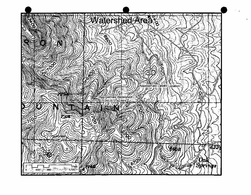
Topographic map drawn to the required scale with contours showing the boundaries of the landfill unit, ground water monitoring well locations, gas monitoring points, and the borrow and fill areas (R315-310-4(2)(a)(i))
Refer to Attachment A for the current topographical map.
Paiiadon Iron, Cedar City, Utah Page 7 Landfill Permil AppUcation March 2009
Most recent U.S. Geological Survey topographic map, 7-1/2 minute series, showing the waste facility boundary; the property boundary; surface drainage channels; any existing utilities and structures within one-fourth mile of the site; and the direction of the prevailing winds (R315-310-4(2)(a)(ii))
Refer to Attachment A for the most recent U.S. Geological Survey map.
ENGINEERING REPORT - PLANS, SPECIFICATIONS, AND CALCULATIONS
Unit design to include cover design; fill methods; and elevation of final cover including plans and drawings signed and sealed by a professional engineer registered in the State ofUtah, when required (R315-310-3(l)(b))
The waste contained in the landfill will be covered in place and leveled periodically. This practice will continue as long as the landfill is in use and at the time for closure. The final filled area will be covered with at least the minimum required cap consisting of two feet of soil including six inches of topsoil. The final cap will be contoured such that the grade is greater than 2 percent and less than 33 percent and will be revegetated with native vegetation or a suitable altemative approved by the Executive Secretary for other similar operations. Any deviation from this plan will be submitted in advance to the Executive Secretary and the Division of Solid and Hazardous Waste for consideration and approval.
Design and location of run-on and run-off control systems (R315-310-5(2)(b))
Runoff from the landfill is not expected to occur due to the design ofthe landfill. The landfill will be designed so that all run-on and run-off will be redirected with diversion ditches into sediment ponds, where the water will be evaporated. After closure, the absorption and evapotranspiration by the vegetation layer and the absence of any appreciable run-on will ensure the control of runoff. Once the vegetation layer growth is established, most storm events will not result in significant direct run-off from the landfill surface area. Nonetheless, significant percolation through the cover layer is unlikely, thus leachate or seepage from the heap is minimal.
The 25-year 24-hour storm event was determined using NOAA Point Precipitation Frequency Estimates calculated from the NOAA Precipitation Frequency Data Server (PFDS), accessed online at http://hdsc.nws.noaa.gov/hdsc/pfds/sa/ut_pfds.html. The program determined that the storm event would produce 2.61 inches of precipitation at latitude 37° 37' 45.5" and longitude -113° 20' 27.5" at an elevation of 6,217 feet.
Using GIS over a topographic base map, the watershed above the proposed landfill was estimated to have a surface area of 245,673 sq. meters, which is 2,644,402 sq. feet or 60.7 acres. The maximum distance from the top ofthe watershed to the lower edge ofthe landfill was determined to be approximately 2,719 ft (0.515 mile), also using GIS, with a change of elevation of 740 ft. The slope of the watershed was then calculated to be 0.272 iVft. The proposed landfill will have a design surface area of 169,211 sq feet or 3.88 acres.
Paiiadon Iron, Cedar City, Utah Page 8 Landfill Permit Application March 2009
The USDA NRCS hydrology model, TR-55, was used to calculate the maximum rate of runoff. Since the watershed above the proposed landflll is described as Pinyon-Juniper in fair condition, with no roads or impervious development, a curve number (CN) of 58 was used. The program was used to calculate a time of concentration (Tc) of 0.159 hr and a peak flow rate of 4.72 cfs at 12.07 hours, using the standard hydrograph and Type II rainfall distribution. The ditch carrying potential run-on around the landfill will be designed with a cross-sectional area and slope capable of managing this flow rate at a minimum. Runoff amount was calculated by TR-55 as 0.161 inches or 35,479 cubic ft (0.814 acre foot). Sediment ponds will be designed to hold this volume at a minimum.
CLOSURE REQUIREMENTS
Closure plan (R315-310-3(l)(h))
Paiiadon will, within 30 days after certification ofclosure, notify the Iron County Recorder to file proof of closure as oufiined in R315-302-2(6).
Closure schedule (R315-310-4(2)(d)(i))
It is intended that the durafion of landfill operations will be 20+ years from the time of constmction.
Paiiadon Iron, Cedar City, Utah Page 9 Landfill Permit Application March 2009
Design of final cover (R315-310-4(2)(c)(iii))
When the operational life ofthe landfill facility has ended, final cover will be accomplished using fill form the adjacent borrow area. This final cover will be at least two feet deep and will be graded to match the surrounding topography. Seeding whh species adapted to the environmental conditions will then be used to revegetate the area. The proposed seeding to be used is listed as follows:
Alfalfa (1 Ib/ac) Westem wheatgrass (2 Ib/ac)
Pubescent wheatgrass (2 Ib/ac) Indian ricegrass (1 Ib/ac)
Russian wildrye (2 Ib/ac) Small bumet (1 Ib/ac)
Antelope bitterbrush (1/ac) Wyoming Big Sage (0.1 Ib/ac)
Forage Kochia (0.4 Ib/ac) Palmer Penstemon (0.5 Ib/ac)
Pacific aster (0.1 Ib/ac)
Capacity of site in volume and tonnage (R315-310-4(2)(d)(ii))
The volume ofthe landfill, as calculated by PIC personnel, totals 2.16x10^ cubic yards. Waste starts out at the "curbside" with a highly heterogeneous density of 200-400 pounds per cubic yard. Using an average of 300 pounds per cubic yard (0.15 tons per cubic yard), the total tonnage ofthe landflll would calculate to 32,400 tons.
Final inspection by regulatory agencies (R315-310-4(2)(d)(iii))
Upon closure ofthe Iron Mountain landflll, a final inspecfion by the Division of Solid and Hazardous Waste will take place to approve the final cover and release the site for closure. The Division of Oil, Gas, and Mining (DOGM) will also perform a subsequent inspection in order to finalize the site for closure. This inspection will examine soil and slope stability, drainage, and vegetation success.
POST-CLOSURE CARE REQUIREMENTS
Post-closure care plan (R315-310-3(l)(h))
Paiiadon will provide post closure activities that will include, at a minimum, monitoring of land and water, for a period of 30 years, or as long as the Executive Secretary determines is necessary for the facility or unit to become stabilized and to protect human health and environment. The Post Closure Plan immediately follows this checklist.
Changes to record of title, land use, and zoning restrictions (R315-310-4(2)(e)(ii))
The tifie to the property on which the landfill sits is held by Paiiadon Iron Corporation. It is estimated that the Iron Mountain property contains 10-20 years of minable reserves. Therefore, operations at the Iron Mountain mining facility are projected well into the future and no near changes to title, land use, or zoning is expected.
Paiiadon Iron, Cedar City, Utah Page 10 Landflll Permit Application March 2009
Maintenance activities to maintain cover and run-on/run-off control systems (R315-310-4(2)(e)(iii))
Post-closure monitoring ofthe landflll site will be conducted periodically for several years following closure. The site will be monitored to insure slope and erosional stability. Run-on/run-off structures will also be inspected to ensure proper functioning and stability. As required by DOGM regulations regarding reclamation, inspection of vegetative success will be performed for at least 3 years following reclamation. After the third year, success of revegetation will be determined.
List the name, address, and telephone number of the person or office to contact about the facility during the post-closure care period (R315-310-4(2)(e)(vi))
Bruce Yeomans Mine Manager, Paiiadon Iron Corporation 2708 S Comstock Road Cedar City, Utah 84720 Fax: (435) 572-4836 Phone: (435)572-4531
FINANCIAL ASSURANCE REQUIREMENTS
Identification ofclosure costs including cost calculations (R315-310-4(2)(d)(iv))
A mining reclamation bond of $1.4 milhon held by DOGM currently exists for the Iron Mountain mine site, including the landfill facility.
Identification of post-closure costs including cost calculations (R315-310-4(2)(e)(iv))
A mining reclamation bond of $1.4 million held by DOGM currently exists for the Iron Mountain mine site, including the landfill facility.
Identification ofthe financial assurance mechanism that meets the requirement of Rule 315-309 and the date the mechanism will become effective (R315-309-l(l))
A mining reclamation bond of $1.4 million held by DOGM currently exists for the Iron Mountain mine site, including the landfill facility. Paiiadon proposes that this bond cover the financial assurance mechanism required under R315-309. This bond amount more than exceeds any closure or post-closure cost forthe landfill facility. This bond was revised in 2008 and is valued at $1.4 million.
Paiiadon Iron, Cedar City, Utah Page 11 Landflll Permil Application March 2009
Closure and Post Closure Plan for
Paiiadon Iron Corporation Comstock/Mountain Iron Mine Landfill
Paiiadon Iron, Cedar City, Utah Page 12 Landfill Permit Application March 2009
Table of Contents
1.0 Introduction
l.l Site Description and Background
2.0 Statement of Closure Plan
3.0 Closure Plan 3.1 Methods, Procedures, and Processes
3.1.1 Maintenance and Control 3.1.1.1 Escape of Air Pollutants/Gases 3.1.1.2 Control of Run-off
3.1.2 Final Facility Topography 3.1.3 Drainage Plan 3.1.4 Composition of Cover
3.1.4.1 Sloping 3.1.4.2 Landscaping 3.1.4.3 Vegetation
3.1.5 Description of Monitoring and Maintenance 3.1.6 Contact Personnel
3.2 Maximum Portion of Operation 3.3 Maximum Inventory and Estimated Life 3.4 Schedule for Complefion 3.5 Notification and Review 3.6 Closure Activity Notification
4.0 Post-Closure Plan 4.1 Maintenance of Final Cover
4.1.1 Repairs 4.1.2 Prevention of Run-On and Run-Off 4.1.3 Maintenance and Operation of Leachate Collection System 4.1.4 Monitoring of Surface and Groundwater 4.1.5 Monitoring of Gases
4.2 Post-Closure Care Statement 4.3 Post-Closure Use Statement 4.4 Post-Closure Certification
5.0 Submittal Statement
List Of Attachments for Closure and Post-Closure Plans
Attachment #1 Post-Closure Inspection Form Attachment #2 Landflll Closure Plan, Final Facility Topography
Paiiadon Iron, Cedar City, Utah Page 13 Landflll Permit Application March 2009
1.0 Introduction
Paiiadon Iron Corporation (PIC) is submitting the enclosed Closure and Post-Closure Plan in accordance with the State of Utah, Division of Solid and Hazardous Waste's (DSHW) R315-304-5 rules with this document.
1.1 Site Description and Background
PIC owns and operates the Comstock/Mountain Lion Iron Mine located approximately 15 miles west of Cedar City, Utah. The property covers portions of two small mountains. Iron Mountain and Granite Mountain, and some of the intervening valley. This area, also known as the Iron Springs District, has numerous iron deposits along the flanks of these mountains and has been mined by various mining companies and corporations since 1851. The Comstock/Mountain Lion Iron Mine has not been operated since 1995 when still under the previous ownership of Geneva Steel.
The Comstock/Mountain Lion Iron Mine landfill is an industrial solid waste landflll that meets the classification of a Class Illb Landfill. It is guarded, fenced, gated at common access roads, and large berms are constructed on remote back roads and trails. The landfill is not accessible to the public. Only non-hazardous debris that is generated onsite will be accepted. The landfill is not located on public lands or near public drinking water supplies. The landflll is not located in a subsidence area, flood zone, near designated wetlands, or above an underground mine. There are no surface bodies of water, residential dwellings, or incompatible structures within 14 mile ofthe landfill. The coordinates ofthe landfills are as follows:
NW % NE/SW '/4 Secfion 30, Township 36 South, Range 13 West, Sah Lake Base and Meridian Latitude: 37°37'45.5", Longitude: 113°20'27.5"
2.0 Statement of Closure Plan
Paiiadon is required to submit Closure and Post-Closure Plans in a way that "'minimizes the need for further maintenance and minimized the post-closure formation and releases of leachate and explosive gases to the air, groundwater or surface water to the extent necessary to protect the public health and welfare and prevent any nuisance." This document represents Palladon's compliance with R315-302-3 (2).
3.0 Closure Plan
3.1 Methods, Procedures, and Processes
All materials disposed of within the existing Class Illb landfill has been and will continue to be within the acceptable waste constituents of an industrial non-hazardous landfill. The landfill will accept only non-hazardous waste that is generated at the Iron Mountain Mine site. The waste consists of construction debris, wood, cement, sheet rock, steel and typical
Paiiadon Iron, Cedar City, Utah Page 14 Landfill Permit Application March 2009
types of rubbish including paper, plastics and trace amounts of waste foods. No other wastes are accepted, therefore, this landfill is not a commercial landflll and no other areas are served.
3.1.1 Maintenance and Control
Access to the facility is restricted through mine security. Signs are posted indicating authorized personnel only are allowed on the access roads leading into the plant. Wind dispersal of landfill litter is minimized by the application of cover.
After cessation of operations at the mine, the landfill will be closed with an application of the intermediate cover and a complete inspection ofthe surface will be performed. Cleanup of the site will be performed concurrently. All remaining visible litter and debris in the immediate vicinity will be placed in the final lift ofthe landfill unit. At that time, the final cover will be applied. A thorough closure inspection shall consist of observations for erosion, sloping, drainage, surface leachate, and run-on. Areas requiring repairs/modifications will be documented on the Landfill Inspection Form (see Attachment D, Section #2). Necessary modifications will be made using appropriate materials and compacted, as required.
3.1.1.1 Escape of Air Pollutants/Gases
The contents of this industrial waste landflll have little or no amounts of putrescible materials and the decomposition of the organic wastes are minimal. The U.S. EPA reports that methane is generated from "municipal" solid waste only when the moisture content exceeds 40% (U.S. EPA, 1994). Due to the limited moisture at the site and the absence of putrescible wastes contained in the heap, methane gas generation is not anticipated. Vector, dust, and odors are effectively controlled so they are not a nuisance or hazard to health, safety or property. None of the waste is flammable, but combustible waste may exist; however, a fire or explosion in the landfill area is highly unlikely. The area is served by the local fire department, and equipment is located onsite to move soil for fire suppression, if necessary.
3.1.1.2 Control of Run-off
Runoff from the landflll is not expected to occur due to the design ofthe landfill. The landflll will be designed so that all run-on and run-off will be redirected with diversion ditches into sediment ponds, where the water will be evaporated. After closure, the absorption and evapotranspiration by the vegetation layer and the absence of any appreciable run-on will ensure the control of runoff. Once the vegetation layer growth is established, most storm events will not resuh in significant direct run-off from the landfill surface area. Nonetheless, significant percolation through the cover layer is unlikely, thus leachate or seepage from the heap is minimal.
Paiiadon Iron, Cedar City, Ulah Page 15 Landfill Permit Application March 2009
3.1.2 Final Facility Topography
The waste will be leveled to the extent practicable, covered with a minimum of two feet of soil and the cover contoured to match the surrounding topography. Seeding with species adapted to the environmental conditions will then be used to revegetate the area. The proposed seeding to be used is listed as follows:
Alfalfa (1 Ib/ac) Westem wheatgrass (2 Ib/ac)
Pubescent wheatgrass (2 Ib/ac) Indian ricegrass (1 Ib/ac)
Russian wildrye (2 Ib/ac) Small bumet (1 Ib/ac)
Antelope bitterbrush (1/ac) Wyoming Big Sage (0.1 Ib/ac)
Forage Kochia (0.4 Ib/ac) Palmer Penstemon (0.5 Ib/ac)
Pacific aster (0.1 Ib/ac)
3.1.3 Drainage Plan
Drainage will consist of water being redirected by diversion ditches around the waste dump. This water is intended to accumulate in sediment ponds to eventually be evaporated.
3.1.4 Composition of Cover
The final cover system will be made ofthe intermediate compacted cover, compacted soil layer, and vegetation layer. The material used for final cover will be placed on the graded, compacted, intermediate cover layer (12 inches of intermediate cover). The soil layer material will be compacted and will be composed of clayey silt-sand mixture with a low permeability. The soil layer will be no less than 6 inches of compacted soil and will come from onsite sources. These two layers total 18 inches of compacted soil, which will serve to minimize infiltration. A vegetation layer of no less than 6 inches will then be applied. The vegetation layer will be of an organic composition that will support native or compatible plant life. The final cover depth will be no less than 24 inches.
3.1.4.1 Sloping
The final cap will be contoured such that the grade is greater than 2 percent and less than 33 percent and will be revegetated with native vegetation or a suitable altemative approved by the Executive Secretary for other similar operations. Any deviation from this plan will be submitted in advance to the Executive Secretary and the Division of Solid and Hazardous Waste for consideration and approval.
Paiiadon Iron, Cedar City, Utah Page 16 LandfiU Permit Application March 2009
3.1.4.2 Landscaping
The waste will be leveled to the extent practicable, covered with a minimum of two feet of soil and the cover contoured as described above. No vegetation, other than local introduced and native grasses and woody species identified in this plan will be placed on the landflll.
3.1.4.3 Vegetation
See the DOGM NOI Reclamafion Report
3.1.5 Description of Monitoring and Maintenance
Qualified personnel will be located near or around the landflll to supervise continued activities during closure. The closure ofthe landflll will be concurrent with the landfill's final development. Landflll operafions will proceed in a manner that will minimize the working area of the landfill. Once the final intermediate cover is placed and graded, landfill inspections will commence. The Post-Closure Landflll Inspection Form (see Attachment # 1) will be used for the final closure inspection.
3.1.6 Contact Personnel
The following positions and personnel represent Palladon's contact list of responsible officials as they pertain to the Delta Mill Landfill operation, closure, and post-closure issues.
Landfill Owner: Paiiadon Iron Corporation Operator: Paiiadon Iron Corporation Address: 554 South 300 East, Suite 250
SahLakeCity, Utah 841II
Owner Contact Person: Donald G. Foot Phone: (801)521-5252
Operator Contact Person: Bruce Yeomans Phone: (435)572-4531
Paiiadon Iron, Cedar City, Utah Page 17 Landfill Permil Application March 2009
3.2 Maximum Portion of Operation
The working face has been limited to the smallest area practical in order to confine the amount of exposed waste without interfering with effective operation. The maximum working face (surface area) open at any one time has been approximately 1500 square feet, a total maximum height of 50 feet and horizontal spatial distance of approximately 30 feet.
3.3 Maximum Inventory and Estimated Life
Based on volume and tonnage calculafions provided by Paiiadon Iron, the estimated life of the currently permitted landflll cells is approximately 20 years from the time ofthis submittal.
3.4 Schedule for Completion
Within 60 days of scheduled complefion ofthe landfill, Paiiadon will notify the DSHW. Closure activities will commence within 30 days after receipt ofthe final volume ofwaste, and will be completed within 180 days ofthe start time. Paiiadon will notify the DSHW upon completion of closure to schedule the final inspecfion by regulatory agencies.
3.5 Notification and Review
Within 60 days of certification of closure of the mine landfill, Paiiadon will make the proper notification and submittals to the Iron County recorder and, upon doing so, file proof of title filing with the Executive Secretary. With respect to the requirement at R315-302-2(6)(b) for public access to records containing information about solid waste amounts, location, and periods of operation, Paiiadon files annual reports to the Division of Solid and Hazardous Waste, as required. These documents are public records and may be obtained by local zoning authorities from either the Division or Paiiadon, upon request.
3.6 Closure Activity Notification
Paiiadon will begin closure acfivhies of the landflll in accordance with the approved Closure Plan no later than 30 days following the final receipt of waste at the landfill. Closure activities shall be completed within 180 days from their starting time, however, Paiiadon reserves the right for extensions of the deadline for beginning and concluding closure activity. The Executive Secretary will be given written justification for any extension requests. If necessary, fences will be erected to limit service and signs will be posted at conspicuous locations indicating closure activities have begun. Altemative disposal site locations will be indicated on the closure notice signs.
Paiiadon Iron, Cedar City, Utah Page 18 Landfill Permit Application March 2009
4.0 Post-Closure Plan
After the Closure Plan has been executed, completed, and certified, the following post-closure and end use plan will be implemented. Following closure ofthe landflll, Paiiadon will conduct the appropriate industrial landflll post-closure care.
4.1 Maintenance of Final Cover
Facility maintenance and monitoring of applicable gases, land, and water constituents will be conducted for a period of 30 years after closure. The landflll cover and surrounding areas will be inspected and repaired by Paiiadon or Paiiadon contractor on a quarterly basis for the first year, then semi-annually for 29 years thereafter. The Post-Closure Inspection Form is shown in Attachment #1.
4.1.1 Repairs
During landflll inspections, if any settlements, subsidence or erosion areas are found on the cover, they will be promptly backfilled with onsite compatible (similar permeability) soil. After final grading, the area will be re-vegetated with the prescribed nafive seed mix. If there are areas of inherent erosion it will be documented on the Landflll Inspection Form and addressed by re-grading and placement of appropriate cover material. To prevent integrity breaks in the cover due to mechanical agitation, notices will be posted and access will be limited to inspection, maintenance, and monitoring personnel. Repairs will be made promptly with the appropriate soil, rip rap, or other necessary materials that will be compatible to the immediate environmental factors that cause breeches in the cover integrity.
4.1.2 Prevention of Run-On and Run-Off
Run-on/run-off stmctures will be inspected to ensure proper functioning and stability. As required by DOGM regulafions regarding reclamafion, inspection of vegetative success will be performed for at least 3 years following reclamation. After the third year, success of revegetation will be determined.
4.2 Post-Closure Care Statement
Paiiadon will conduct post-closure monitoring and maintenance care as necessary for a period of 30 years from date of closure or as directed by the Executive Secretary. Reduction or extension ofthe 30 year monitoring and maintenance care period may be negotiated between the Executive Secretary and Paiiadon management.
Paiiadon Iron, Cedar Cily, Ulah Page 19 Landfill Permil Application March 2009
4.3 Post-Closure Use Statement
Post-Closure use is anticipated to be very minimal. Post-Closure use will not increase the foreseeable threat to public health.
4.4 Post-Closure Certification
Paiiadon will submh written verification following the closure of a landflll unit and following the completion of post-closure care of a landfill unit. This verificafion will state the completed acfivifies are in accordance with the requirements of R315-302-3(7)(b).
Paiiadon Iron, Cedar City. Utah Page 20 Landfill Permil Application March 2009
5.0 Submittal Statement
The Closure Plan, Post-Closure Plan, and other necessary documents were prepared and submitted to the Division of Solid and Hazardous Waste.
No subsequent modificafion to the Closure and post-Closure Plan will be made without the approval of Executive Secretary. Paiiadon reserves the right to petition to amend the Post-Closure Plan.
Paiiadon will keep a copy ofthe most recent approved Closure Plan and Post-Closure Plan at the Comstock/Mountain Lion Mine.
Paiiadon Iron, Cedar City, Utah Page 21 Landfill Permil AppUcation March 2009
Attachment A
Topographic maps of Landfill Landflll Watershed Map
Paiiadon Iron, Cedar City, Utah Landfill Permit Application March 2009
^-- ^ ' ^ ; ^ , ' ^ i ? f ^ ^ ^ i , ^ . ^ j : ^
Attachment B
Log sheets
Section #1 - Landfill Waste Log
Section #2 - Inspections
Paiiadon Iron, Cedar City, Utah LandfiU Permit Application March 2009
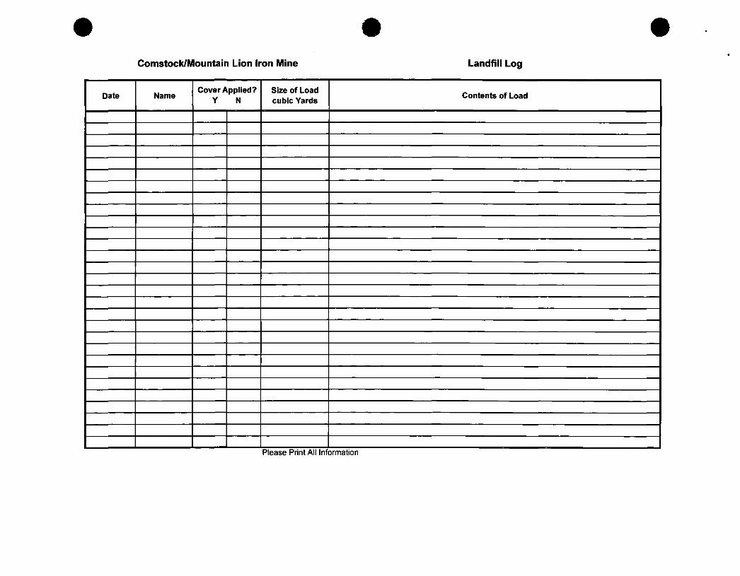
Comstock/Mountain Lion Iron Mine Landfill Log
Date Name Cover Applied?
Y N Size of Load cubic Yards
Contents of Load
Please Print All Information
Comstock/Mountain Lion Iron Mine Landfill Inspection Form
Date Time Landfill Cell Name Signature Inspect for: manfunctions, deterioration, operator errors, discharges that
cause or may cause a threat to human health or the environment, any other abnormal conditions
1
i PLEASE PRINT ALL INFORMATION
Attachment C
General Site Safety and Training Plan Addendum
Paiiadon Iron, Cedar City, Ulah Landfill Permil Application March 2009
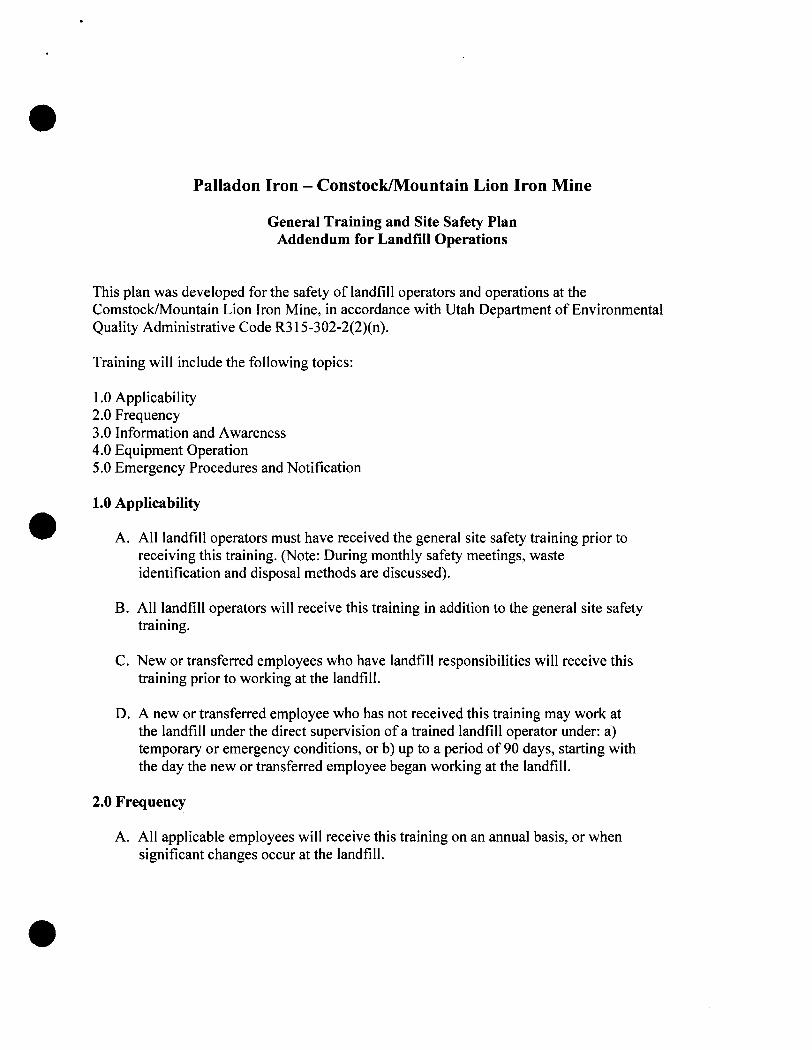
Paiiadon Iron - Constock/Mountain Lion Iron Mine
General Training and Site Safety Plan Addendum for Landfill Operations
This plan was developed for the safety of landfill operators and operations at the Comstock/Mountain Lion Iron Mine, in accordance with Utah Department of Environmental Quality Administrative Code R315-302-2(2)(n).
Training will include the following topics:
I.O Applicability 2.0 Frequency 3.0 Information and Awareness 4.0 Equipment Operation 5.0 Emergency Procedures and Notification
1.0 Applicability
A. All landfill operators must have received the general site safety training prior to receiving this training. (Note: During monthly safety meetings, waste identification and disposal methods are discussed).
B. All landfill operators will receive this training in addition to the general site safety training.
C. New or transferred employees who have landfill responsibilities will receive this training prior to working at the landfill.
D. A new or transferred employee who has not received this training may work at the landfill under the direct supervision of a trained landflll operator under: a) temporary or emergency conditions, or b) up to a period of 90 days, starting with the day the new or transferred employee began working at the landfill.
2.0 Frequency
A. All applicable employees will receive this training on an annual basis, or when significant changes occur at the landfill.
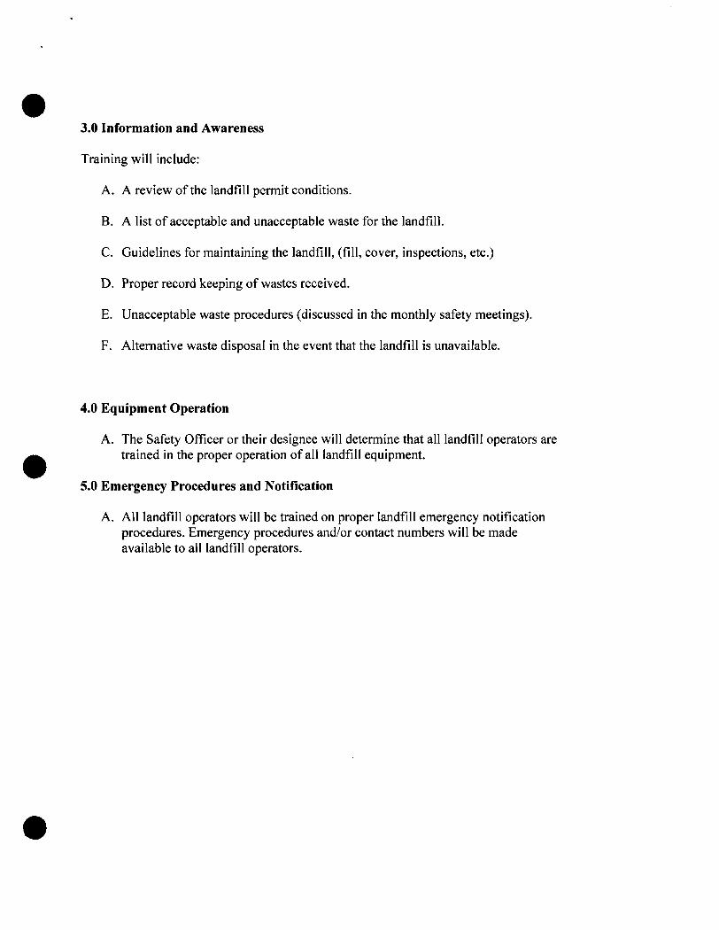
3.0 Information and Awareness
Training will include:
A. A review ofthe landfill permit conditions.
B. A list of acceptable and unacceptable waste for the landfill.
C. Guidelines for maintaining the landfill, (fill, cover, inspections, etc.)
D. Proper record keeping of wastes received.
E. Unacceptable waste procedures (discussed in the monthly safety meetings).
F. Altemative waste disposal in the event that the landfill is unavailable.
4.0 Equipment Operation
A. The Safety Officer or their designee will determine that all landfill operators are trained in the proper operation ofall landfill equipment.
5.0 Emergency Procedures and Notification
A. All landfill operators will be trained on proper landfill emergency notification procedures. Emergency procedures and/or contact numbers will be made available to all landfill operators.
Attachment D
Post - Closure Inspection Form
Paiiadon Iron, Cedar City, Utah Landfill Permil Application March 2009
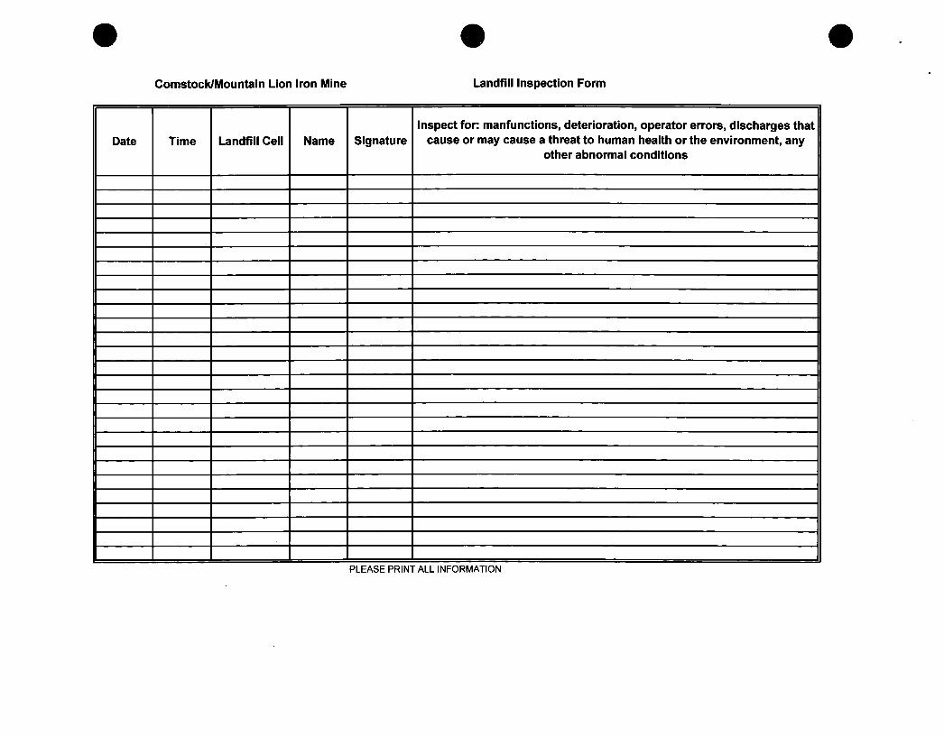
Comstock/Mountain Lion Iron Mine Landfill Inspection Form
Date Time Landfill Cell Name Signature Inspect for: manfunctions, deterioration, operator errors, discharges that
cause or may cause a threat to human health or the environment, any other abnormal conditions
1
PLEASE PRINT ALL INFORMATION
Attachment E
Financial Assurance and Ownership Documentation
Paiiadon Iron, Cedar Cily, Utah Landfill Permil AppUcation March 2009
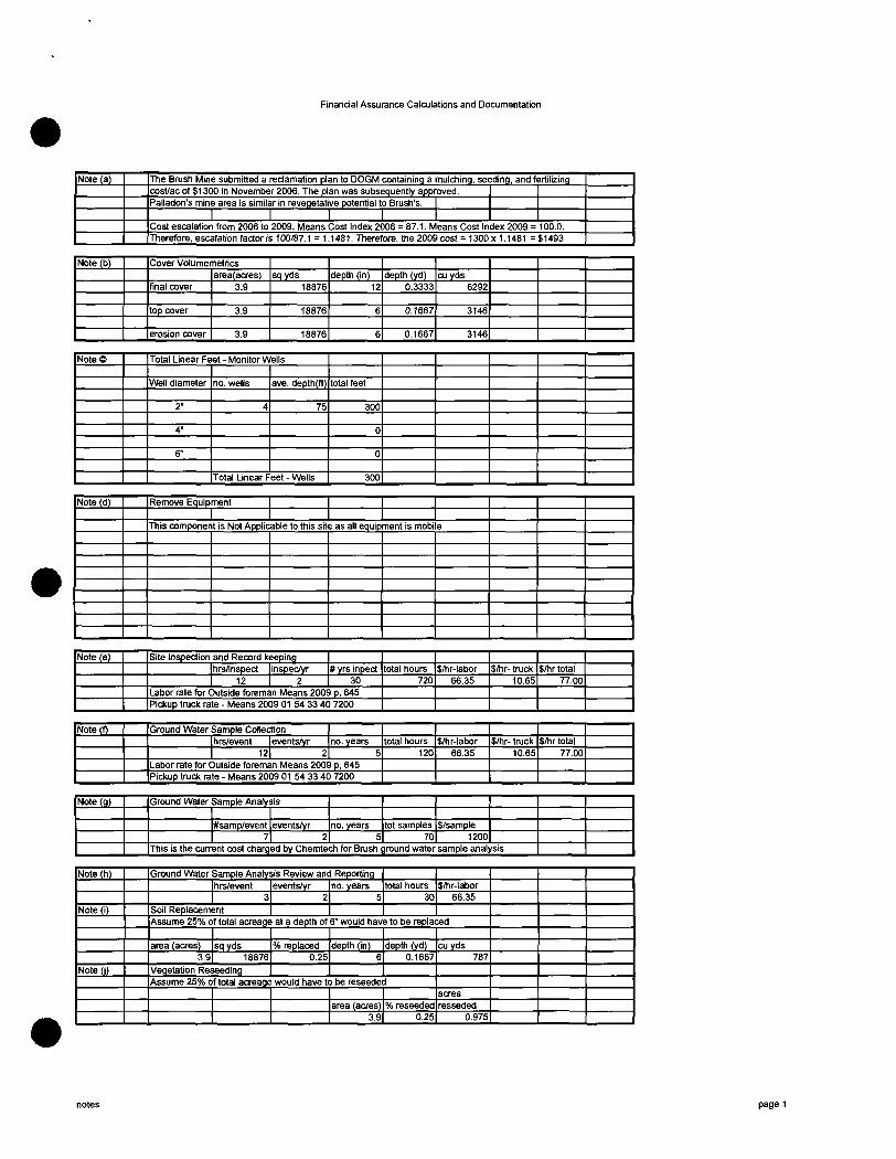
Financial Assurance Calculations and Documentation
Note (a) The Bmsh Mine submitted a reclamation plan to DOGM containing a mulching, seeding, and fertilizing cost/ac of $1300 in November 2006. The plan was subsequently approved. Palladon's mine area is similar in revegetative potential to Brush's.
1 I ' l 1 Cost escalation from 2006 to 2009. Means Cost Index 2006 = 87.1. Means Cost Index 2009 = 100.0. Therefore, escalation factor is 100/87.1 = 1.1481. Therefore, the 2009 cost = 1300 x 1.1481 = $1493
Note (b) Cover Volumemetrics
final cover
top cover
erosion cover
area(acres) 3.9
3.9
3.9
sqyds 18876
18876
18876
depth (in) 12
6
6
depth (yd) 0.3333
0.1667
0.1667
cu yds 6292
3146
3146
NoteO Total Linear Feet - Monitor Wells
Well diameter
2"
4"
6"
no. wells
4
ave. depth(ft)
75
Total Linear Feet - Wells
total feet
300
0
0
300
Note (d) Remove Equipment
1 This component is Not Applicable to this site as all equipment is mobile
Note (e) Site Inspection and Record keeping hrs/inspect
12 inspec/yr
2 # yrs inpect
30 Labor rate for Outside foreman Means 2009 p, 645 Pickup tmck rate - Means 2009 01 54 33 40 7200
total hours 720
$/hr-labor 66.35
$/hr- tmck 10.65
$/hr total 77.00
Note (f) Ground Water Sample Collection hrs/event
12 events/yr
2 no. years
5 Labor rate for Outside foreman Means 2009 p. 645 Pickup tmck rate - Means 2009 01 54 33 40 7200
total hours 120
$/hr-labor 66.35
$/hr- tmck 10.65
$/hrtotal 77.00
Note (g) Ground Water Sample Analysis
#samp/event 7
events/yr 2
no. years 5
tot samples 70
$/sample 1200
This is the current cost charged by Chemtech for Bmsh ground water sample analysis
Note (h)
Note (1)
Note li)
Ground Water Sample Analysis Review and Reporting hrs/event
3 Soil Replacement
events/yr 2
no. years 5
total hours 30
$/hr-labor 66.35
Assume 25% of total acreage at a depth of 6" would have to be replaced
area (acres) 3.9
sqyds 18876
Vegetation Reseeding
% replaced 0.25
depth (in) 6
depth (yd) 0.1667
Assume 25% of total acreage would have to be reseeded
area (acres) 3.9
% reseeded 0.25
cu yds 787
acres resseded
0.975
notes page 1
Financial Assurance Calculations and Documentation
ICOST ESTIMATE FOR POST-CLOSURE OF LANDFILL-PALLADON IRON MINE (2/24/09) I j
Note : Numbering format follows the DSHW "Preparation of Closure - Post Closure Cost Estimate Guidance" The numbered items in the guidance document not shown in this estimate denote they are not applicable.
1.0 1.2
1.4.1a
1.4.1b
1.4.1c
2.0 2.1.1 2.1.2 3.0 3.2
Item
Engineering Costs Site Inspection and Record keeping Ground Water Sample Collection Ground Water Sample Analvsis Ground Water Sample Analysis Review&Reporting Maintenance Costs Soil Replacement Vegetation Reseeding Monitor Wells abandonment Final Plugging of Ground W^ter Monitor Wells
Subtotal 10% Contingency
Post-Closure Care Total
Unit Measure
hours
hours
sample/ ea
hours
cuyd acres
LF
Cost/Unit
77.00
77.00
1200
66.35
3.65 1493
8.40
No. Units
720
120
70
30
787 0.975
300
Total Cost
55440
9240
84000
1991
2871
$ 2,520
156061 15606
$ 171,667
Source
Means2009 - 31 23 16.50 2100
Means2009 - 02 41 13.76 0900
Note
see Note (e)
see Note (f)
see Note (g)
see Note (h)
scraper costs see Notes (a) & C)
see note (c) for total LF
TOTAL CLOSURE AND POST-CLOSURE COSTS
Total Closure Costs
Total Post-Closure Costs
Total Cost
$ 93,812
$ 171,667
$ 265,479
postclosure page 2
Financial Assurance Calculations and Documentation
ICOST ESTIMATE FOR CLOSURE OF LANDFILL - PALLADON IRON MINE (2/24/09) j
Note : Numbering fbnnat follows the DSHW "Preparation of Closure - Post Closure Cost Estimate Guidance" The numbered items in the guidance document not shown in this estimate denote they are not applicable.
1.0
1.1 1.4 1.5 1.6
1.7 1.12
Item
Engineering & Preliminary Site Work Topographic Survey Development of Plans Contract Administration Administrative Costs for final cover certification & closure notice Prtjject Management Remove Equipment
Subtotal 10% Contingency
Engineering Subtotal
Unit Measure
acre
CosVUnit
525
No. Units
3.9
Total Cost
$ 2,048
0 $ 2,048
205 $ 2,252
Source
Means2009 - 02 21 13.09 0020
Note
see below Subtotal see below Subtotal see below Subtotal
see below Subtotal see note (d)
2.0 2.1
2.1.1a 2.1.Ie
2.2 2.2.1 2.2.1a 2.2.1e
2.3 2.3.2 2.3.5 2.4
2.4.1,2,3
Item
Construction Final Cover System Soil Placement Soil Transportation Completion of Top Cover Infiltration Layer Soil Placement Soil Transportation Erosion Layer Placement Soil Placement Soil Transportation Revegetation Seeding, Fertilize,Mulch
Subtotal 10% Contingency
Construction Subtotal
Unit Measure
cuyd cuyd
cuyd cuyd
cuyd cuyd
acre
Cost/Unit
1.19 3.65
1.19 3.65
1.19 3.65
1493
No. Units
6292 6292
3146 3146
3146 3146
3.9
Total Cost
$ 7,487 $ 22,966
$ 3,744 $ 11,483
$ 3,744 $ 11,483
$ 5,823
$ 66,729 6,673
$ 73,402
Source
Means2009 - 31 23 16.46 5000 Means2009 - 31 23 16.50 2100
Means2009 - 31 23 16.46 5000 Means2009 - 31 23 16.50 2100
Means2009 - 31 23 16.46 5000 Means2009 - 31 23 16.50 2100
Brush mine reclam costs
Note
dozer costs-note (b) scraper costs-note (b)
dozer costs-note (b) scraper costs-note (b)
dozer costs-note I b L scraper costs-note (b)
see note (a) calcs tab
3.0|Ga8 Collection System is not applicable for this site |
4.0
Item
Monitor Well Costs
Unit Measure Cost/Unit No. Units
Refer to Post Closure Costs fbr Well Abandonment costs
1 1 1
Total Cost Source Note
CALCULATION OF TOTAL CLOSURE COSTS
Engineering Total Constmction Total
SUBTOTAL
Development of Plans Contract Administration Administrative Costs for final cover certification & closure notice Project Management Performance Bond Legal Fees
2.5% of Subtotal 3.5% of Subtotal 3.5% of Subtotal
3.5% of Subtotal 1.0% of Subtotal 10% of Subtotal
GRAND TOTAL CLOSURE COSTS
$ 2,252 $ 73,402
$ 75,654
1,891 2,648 2,848
2,648 757
7,565
$ 93,812
closure page 3
On Mon, Jun 2, 2009 at 2:18 PM, Alysen Pedersen <alvdotped(g)gmail.com> wrote:
Matt,
The attached revised page 37 has the information in red that states: "Because the proposed landfill is located on top ofthe existing dump, it is included in the reclamation plan for that dump."
This has been approved by DOGM, so the $265,479.00 will be taken out ofthe bond amount that was allotted for the reclamation ofthe waste dump. This bond amount will increase next April, because it is currently based on the 2005 estimates.
The reclamation plan for the dump where the landfill sits is just as (if not more so) encompassing as the plan listed in the Landfill Permit Application.
I hope this helps clarify some things. If you need any more information, please let me know.
Thanks, -Alysen
On Fri, May 22, 2009 at 9:53 AM, Alysen Pedersen <alvdotped(a',gmail.com> wrote:
Hi Matt,
Attached is the pertinent information. The NOI dated August 2008 should have most of the information you need. The revised pages (26, 37, 41a) are changes made since August 2008. These have the correct language and bond amount.
I hope this helps.
-Alysen
Mining And Reclamation Program Iron Mines Near Cedar City, UT
Paiiadon Iron Corp. May, 2008
All references to Geneva Steel in the following Notice of Intent text, drawings, and appendices are to be read as "Paiiadon Iron Corp." as Paiiadon has assumed all mining and reclamation responsibility for this operation.
Paiiadon Iron Corp. -0- Final .Approved Version, July 23, 2008
Inter. Wheatgrass Agropyron Intermedium 2.0 Ladac Alfalfa Medicago Sativa 2.0 Yellow Sweetclover Melilotus Officinalis 1.5 Small Burnett Sangvisorba Minor 2.0 Palmer Penstemon Penstemon Palmeri 0.5 Rabbitbrush Chrysothamnus Nauseous 0.5 Curleaf Mtn. Mahogany Cercocarpus Ledifolius 1.0 Bitterbrush Purshia Tridentata 1.0 Mountain sagebrush Atemisia Tridentata Vaseyana 0.1 Forage kochia Kochia Prostata 0.5
Totals 16.6 * Plant names are the same as is written in original 1995 version:
When drill seeded, the broadcast rate will be reduced by 1/3.
The operator will reserve the right to alter this seed mix depending on relative availability ofthe seed.
If such an eventuality arises, DOGM will be duly notified.
10.0 ENVIRONMENTAL IMPACT ASSESSMENTS FOR AREAS NOT PREVIOUSLY PERMITTED
Due to a Revision to this NOI in 2009, an additional 17.72 acres have been bonded as a location for lean ore stockpiles. The area chosen can be seen on the Drawing IM-0100-3f sheet 6 of 6. This area was chosen because it is pre-disturbed, with piles of lean ore already covering the area. Because of this, no further environmental impacts will be caused. The material that will be stockpiled is composed of the same material (iron ore) that is already permitted, so no variances to the reclamation plan are needed.
Due to a Revision to this NOI approved in 2008, the South Waste Dump will be extended by 60.4 acres into the S 'A SE V Secfion 30 and the N V2 NE '/4 Section 31, T36S, ROW. Approximately 48 acres of this is on lands bonded in 2008, while 12.4 acres is expansion within previously bonded area. An additional 3.6 acres that was previously bonded but not disturbed will be used for topsoil storage. A total of 64 acres will be disturbed to develop the South Waste Dump extension. These lands are all shown on Figure IM-0100-3, IM-0100-3f, lM-0100-12, and IM-010013.
The estimated number of acres to be disturbed and reclaimed per year for this waste dump expansion beyond what was disturbed as of July 2005 is listed below, by year:
YEAR 2008 2009 2010 2011 2012 TOTAL
DISTURBED ACRES 10 43 11 0 0
64
RECLAIMED ACRES 0 0 0 0 0 0
Reclamation will not commence until after the dump is at its final configuration, which will not occur until after this five-year term is complete. Topsoil salvage and storage, and reclamation procedures for the South Waste Dump are described on pages 37 through 38 ofthis NOI. The post-mining topography for the waste dump is shown on Figure 0100-13, and cross-sections are shown on Figure 0101-9.
The following impacts of disturbance are expected (U.S. BLM, 1984).
• Impacts to soils and vegetation will be moderate as previously discussed. After reclamation, a cover of native shrubs and grasses will be established on the disturbed areas, recognizing that certain Pre-Act areas may require a variance due to lack of any vegetative or
Paiiadon Iron Corp. -26- Final Approved Version, March 11,2009
Variances:
1. Some haul roads (Crystal Springs access road) will serve as livestock ranching and third party
property access for post-mine use.
2. 70% revegetation standard may be waived on Pre-Act areas. Operator is required to established a
minimum cover of beneficial vegetation, if possible. If operator has used practical methods which
are those specified in the permit and minimal cover of beneficial vegetation is not met. This
standard may be waived.
3. Highwall and natural drainage blocking variance.
12.2.4 S/021/010 [Excelsior/Chesapeake]
Permitted as 5 acres of disturbance. Now subject to R647-4-107, 110, and 111.
12.3 RECLAMATION PLAN FOR AREAS UNDER APPLICATION (Comstock Waste Dump Extension, Tip Top, Excelsior/Chesapeake Extension, Burke Pit Road)
Reclamation Plan:
The Comstock Dump Extension is identified on Drawing IM-OIOO-3, sheet 6 of 6, and IM-0100-3f, sheet
6 of 6. Because the proposed landfill is located on top of the existing dump, it is included in the
reclamation plan for that dump. The reclamation plan is as follows:
The dump crest will be rounded during reclamation to blend with surrounding lands. Maximum slope angle ofthe dump face will be 35 degrees or flatter, which will allow for rounding of crest and toe. Using dozers, the top ofthe dump will be rounded to a broad, convex hillock. The main dump slope and toe of the dump will be concave in shape (see cross-sections in Figure 0101-9). The dump itself will have more shape variation than older dump areas on the property, and thus will look more natural and blend better with native surroundings, as shown on IM -0100-13.
As the dump is created, large rocks will be dumped in the minor epheineral draw, located near the north end ofthe dump extension. This action, plus the natural coarseness and porosity ofthe remaining dump material to be placed on top of these rocks, will allow any water seepage in this draw to pass through the dump without creating stability problems.
Large rocks will also be used selectively on the dump top and slopes to provide islands of habitat, erosion control, and wind shelter for plants and animals.
1) Topsoil will be recovered where possible. The soil (Ironco-Quih Complex, 25-60% slopes, 0-3" - extremely cobbly loam, 3-11" - very cobbly loam) is not conducive to collection and redistribution, but will be salvaged where possible to an average salvage depth of 6 inches across the 60.4 acre area to be disturbed. Topsoil will not be stripped from topsoil storage areas. An effort will be made to develop a suitable soil substitute to augment soil resources, using fines generated during mining mixed with 5 ton/acre foot (6 lb/cubic yard) of composted manure. Topsoil will be stored in two stockpile areas: one located near the base of
. the pre-1995 dump toe (Topsoil Stockpile 1), and one located on top ofthe 1995 dump
Paiiadon Iron Corp. revised existing NOl -37- v. July 15,2008
hazardous waste. Several facilities were demolished by Paiiadon in 2006 in anticipafion of
modernizing and re-opening the mine. A permanent Class Illb landflll permit is in process as of
June, 2008 for the burial of this construction debris and office waste, to be authorized by the
Division of Solid and Hazardous Waster (DSHW). A copy ofthe approved pennit will be located
in Appendix F.
The waste will be buried near the back of disturbance, away from drainage paths and dump
slopes, in the pre-1995 South Waste Dump (see Figure IM-0100-3 for landfill location).
12,4 TOXIC MATERULS
Minor amounts of asbestos materials were identified in the debris pile created fi-om demolition.
These were removed prior to burial and removed to an appropriate hazardous waste facility. Oils
and other wastes are kept in containers and retumed to refineries or disposed of off-site. No
hazardous wastes exist or are generated on the site, thus cleanup or closure is not expected.
Deleterious or acid forming materials are nonexistent on the property. Three materials at the
mine site were sampled for maximum acid potential and neutralization potential: overburden
waste, lean ore, and wet plant waste. These materials are representative of all onsite materials.
Sample results are contained in Appendix D. These samples indicate that there is little potential
for acid mine drainage from these materials. This is to be expected since the ore body does not
contain sulfides, and iron mines have never been known to produce acid mine drainage.
(USEPA, 1978)
13.0 SURETY ESTIMATE
Prior permitted areas and areas subject to this application are identified on Drawings IM-0100-
3a, IM-0100-3, sheet 6 of 6 and IM-0100-3f, sheet 6 of 6. As was previously mentioned, the
permitted areas are larger than the areas of current disturbance or areas which will be disturbed
in the next five years. This is true simply because ofthe long term life of a base metal mine. The
surety estimate was arrived at by determining total reclamation costs for currently disturbed
areas subject to reclamation as well as total costs for those areas to be disturbed in the next five
years. These areas are identified in Drawings IM-0100-3.
Paiiadon Iron Coip. revised existing NOI -41- Final Approved yersion, July 23, 2008
The current surety held by Paiiadon is $1,299,100.00, as requested by DOGM in a memo dated
Febmary 1, 2005. This value has been increased due to various factors that are explained below.
The calculations used to arrive at the revised bond amount are at the front of Appendix A.
A reclamation credit of $52,510.00 has been taken for those old Geneva stmctures that are
shown on the 1995 drawings that have been demolished as of 2006. This credit was figured by
determining the percent increase in the bond between 1995 (when the last detailed bond analysis
was done) and 2005 (when DOGM approved the transfer ofthe mine to Paiiadon). This was a 31
percent increase. Thus, buildings that were bonded at $0.19 per cu, ft, in 1995 were assumed to
be bonded at ($0.19/cu. ft. x 31 percent = $0.25/cu. ft.) in 2005 and 2006 when the buildings
were demolished.
A reclamation cost increase of $29,842.00 has been added to the reclamation liability for those
stmctures that have been or will be constmcted since 1995. This bond liability increase is based
on $0.31/cu ft, and is derived from RS Means data for 2008. The locations and sizes ofthe 17
stmctures that were demolished or constmcted are shown on Drawing IM-Load out.
An additional 48.0 acres will be disturbed by the extension to the south ofthe Comstock Waste
Dump. The average cost per acre for reclamation liability is $3,115.00. This figure, applied to the
48 new disturbance acres, increases the bond liability by $149,537.00. The new area to be
disturbed is identified in Drawings IM-0100-3, sheet 6 of 6 and IM-0100-3f, sheet 6 of 6.
An additional 17.72 acres will be bonded to allow for the constmction of a lean ore stockpile.
The area is pre-disturbed, with existing piles of lean ore already covering the area. The average
cost per acre for reclamation liability is $3,115.00. This figure, applied to the 17.72 new
disturbance acres, increases the bond liability by $55,197.80. The new area to be disturbed is
identified in Drawing IM-0100-3f, sheet 6 of 6.
The total bond liability for Paiiadon mine for the next 5-year term commencing in 2008 is
$1,426,000.00, .an increase of $126,900.00 which also accounts for a credit for the previous
demolition from the reclamation bond amount set by DOGM in 2005.
Calculations and descriptions of reclamation requirements are included in Appendix A. An
updated reclamation liability summary sheet based on the 2005 correspondence from DOGM
that covers the changes noted in the paragraph above is included at the beginning of that
appendix. A summary of each of the disturbance areas and factors relevant to the reclamation
status (pre-act disturbance, etc.) is found in Section 12.2. Backup information for purposes of
volume calculations is also found in Drawings IM-0101-1 through IM-0101-8. Geneva
understands that
PaliacJon Iron Corp. revised existing NOI -41a- Final Approved Version. March 11, 2009
SEP-20-2005 TUE 10:42 An OIL, GAS & fllNING FAX NO, 801 3B9 3940 P. 05
w>RM viib.i«L For Divison Use;
(K*vi»ilSiptcnit>cr200C) File No.; "M^.^y/P A ] f f f c ^
DOGM Lead; ^ O J
STATE OP UTAH DEPARTMENT OF NATURAL RESOURCES
DIVISION OF OIL. GAS AND MINING 1 SM West Konbtempte, Suile lilO
Box 14S801 Sail; L«ke City, Utah 84114.58&1
Telephone: (800 538-5291 F.x: C80I) 359-3940 RECEIVED
TRANSFER OP 2VOT/CE OF INTCNnON Apo l e LARGE MININC OPERAllONS
~O0OOQ—
(a) Notica of Intention t6 be transfiunred (file nimibcr);i M/0?l|f008
UlVuKOiLUA^&MiNINC
(b) Maane of mining operation; I ron Mountain Miatt
(c) t-aeatian nf mining operatinn /rounty^: T r/ Y^
(d) Najne, telephone numbet and maiUug address of the operator cuireatly holding thii notice of j ntentiou (tians&ror):
Catiava S t e e l Cof'poraclon '
— il^ . f t . .ao i t 2500 •• I , _ ^ , i
<a) Name, telephone nuinber and mai tine address of the operator acijuinttg the notice of iotention (txana&iee):
Paiiadon Iron Corporation
2fe81 Parleys WAy , {j^lte 204 ;_ ,
Salt Lake Ctty, Utah ^4109 (^01) 556-1015
(b) Name, telepboae numbtf a&d address of the authorized representatives ot the Transferee to whom any notices under tbe provisions ofthe Utah MiA(id Land Reclamation Act may be sent:
Oi»naIil e . f o o t , J r .
XI IT, XAi^e t/av
Fruic Uftlahtc. Utah AAfJI? <aQn '5«-07fi9
(a) The total number of disturbed acru permitted and bonded under the approved UWBC Mining Notice of Intention; ^17 Acres
62"'=' i-si-sTasioB xoj iHraasyT dH wd5e--9 S O O B L \ inr
SEP-2D-2[)05 TUE 10:42 AM OIL, GflS & MINING m NO, 801 35S 3940 P. 06
(b) Complate Appendix "A^'Csttaehed). i legal descriptibn ofthe approved and bonded disturbed aereage (include: TownahipCa}, RtageCt), anrl «eetian(s], la th« t/4, IM, IM section, aoA lhc county),
(c) The actual number of aoea diaiutbed by the mining opoatioa through the date of this tzaasfer; A17 ACTB*
(d> Attach a to|»graphic tsap (labeled as Appendix "B'*) of suitable scale which clearly outlines tbe existing disturbed area boundaries throtigh the date of (Ut tnasifer (max. scale, 1 inch - SOO ft, 1 inch » 200 ft., or larger Kale is preftrred). Label disturbed areas as approphale,
This t^iphcaiion. tnust ba accoaipsoied by a fiilly executed and signed RecIamatioB Ccniract (Forni MR<RC> and an acceptable dxtm of replacement tecUunation sunty.
R«viM(IJ«iwuy2M0 TorniMR-TIU.
t i p , ^ Of, i Aeviied iMMtty IOOO fowl MR.TRL
i^^^^^ssswniiiii
OE -d frSi'STSSlOB xdd i3ra3syn dH wdeesa BOOS L \ mr
SEP-20-2006 TUE ) 0 ! « AD OJL, CflS & HININO FAX ^a 801 359 3840 P. 07
STATE OF.
COUNTY OP. )s..
FJNAL SWORN STATEMENT OF TRANSFEREE
G^y^ . iMA »g.y that I wa.
beieg (bit duW twain under <nth, dcpoie acd
(ofllc*ror.8«l)»r f k M i d r \ ^ p ^ de i fCfd / iM^
(Cotperstiaa/Cempany Name); aad thti I am duly luibohzed to execute lod deliver ibe fbRgoios
i^ligalieas; that I have r«ad tin appiicatica and fiilly asdenciMl lliC:eontu<* tfaerec^ chat all
statemests toettumd in the nmsfa application are true aad comet»ihe best ofmy lowwledge and
belief Sy «xiKulioa of ttiii atatemect, th* TnasCnee agrees to be bound by tbe cams and cooditians
of Netica aflBlestioa a a J t f C Z ^ f O J l . ^ Utah Mined Uad tlsclaauioD Aot, «Bd the Rules
tad Sjsfiiltoiata pnHnulfsMd UrtietHKler.
Nune (typew priM)
Title
Subscribed aad swore beCne m« thi* J S t i i ' d a y of _ ^ , 2cft6 .
My comnission Expina:
Koviwd ;«Bu«(y 2O0O
Notary Public n. . . , Aesidinc at: n r P / W t i \ * . \ -
C0)i(.6PIB£8M»Mfl7
Effective Date; f p * ^ / / t j ^JJ^Osr NOI No,: f ^ m ^ i l e i n ^
ReviwejttviiryitM rgmMl.TRL
l e -ol frSfrSISSTDB Xbd iB radSb i dH wdirGts eooa i t i n r
SEP-20-2005 TUE 10:42 AH OIL, C/IS & fliNJNG FAX NO. 801 358 3940 P, 08
APPENDIX "A"
Pai iadon Icon CorpogaCien New Operator
M/021/QOa
Pemiit Number
_Iron Mountain Hine Mine Mame
I ron . Coiutty, Utah
The legal description «f the lands to be dhitarbcil It (Townihip, Range and sect>oa(s} to the 1/4, 1/4,1/4 section):
Th* tea*) 4B*eri|Mlon of lands to b« di«turbsd >•:
I ror Matin ta>n HI 1/4 $ec. 2 . T37S, Rl4i»
friaekniiwlt Fii)*s ArM tWZ S£ ^ 4 Sec. 34, SW 1/4 s a c . 3 5 . T36S> R14W NWl/4 Sec. 2 . TS75, R14VI
Kount«in Lion $1/2 S«c. 19, MW 1/4 S»c. 30 T36S, R13W
Burlie P i t SE 1/4 ME 1/4 Sec. 34, SW 1/4 NU 1/4 Sec. 35 , T 3 « , Rl4tf
ChesipBAK ( Excenslor « l /2 SC 1/4, S 1/2 S 1/2 NE 1/4 Sac 2S, T36S, «1*U
Tip TdP El/2 NW 1/4 Sac, Z i . T36S, R14W
MU CoMStock Plant A r u Wl/2 Sec. 29. £ i / i Sec. 30. TJfiS. R13W
CofflstOCk Ar«s Port-foos of Sac. 30, T36S, ltl3S
? l « e « a f t
iroiw MR-TRU
se -ol i-sfrsrssroB XUd IBr^HSbn dH Wd.EtB BODS M tnr
RELEASE
Please be advi.';ed (hal Paiiadon lion Corpoiiuion ("Piilliidon") has provided ihe State of Uiah. Division of Oii. Gas and Mining and ihc U.S.D.l.- Bui-eau of Land .Management ("Oblieee.i") wjih ihe New Bond as described in ifie Bonding and Securiiy Agreemenl dated ApriJ ]3. 2005. beiween. jnie.'- aiia. PaJJadon! and Travelers Casually and Surety Company of Amenca (Bond Number 10451 I468j. in repJacen«ni of The Mined Land Reclamaiion Act Surety Bond Number 103.')^0271 (the "Bond") issued on behalf of Geneva Sieel Company as principal. Such aJteinate financial assurance has been accepied by ObJipees as sufficieni financial a.ssuranci in compliance with the Uiah Mined Land Reciamatior, Act and the Reclamaiion Cohiraci governing (he obligaiion of Pal laden lo reclaim the Iron Mountain Mine Permit number M/021/008.
Therefore. Oblipecs do hereby fult>-. finally and uncondiiionally release and forever discharge Si. Paul Fire and Marine Insurance Company. Travelers Casually and Surety Company of America and each of iheir affiliates and subsidjaries (collectively. "St. Paul TraveJers") from any and all pasi. prcseni and future liability by reason of or in connection with the issuance of the Bond (Bond Number 103.'i40271) issued on behalf of the priricipaJ Geneva Steel Company. Each of the undersigned individuals signing on behalf of either Obligee furiher represents and warrants that he or she has the authority to execuie this Release on behalf of the Obligee and to bind the Obligee hereunder. In addition, in the event there is any inconsistency between the terms of this Release and any and all other documents, the Obligees hereby agree that the terms of this Release shall control.
DATED this • . "day of April. 2005 to be effective upon the effective date of the alternate financial assurance given by Paiiadon and accepied by Obligees.
STATE OF UTAH DEPARTMENT OF NATURAL RESOURCES DIVISION OF OIL. GAS & MINING
By? Pnn Its: ,
It Name: ... - • ~ ' ^ ^ ^ , -
• • ' • - ' ' • - ; • : . — •
/ I ; I ' ' . - • . A , ' . - . ^ . .. V
'r;.: " -. r-r-"
U S DEPARTMENT OF THE INTERIOR BUREAU OF LAND MANAGEMENT
l|ri^t Name: :ZOM\C^ f l ^t^Uu'
^ E - d V9frST2SI08 Xdd iBryBSdi dH wdSEsg BOOS L I inr
Bond Number ifi*aii4ai—
A T T A C H M E N T B
Pemiii Number M r-FORM iMR-6 Mine Natne IrV" M°t'"'»-"'—
STATE OF UTAH DEPARTMENT OF NATURAL RESOURCES
Division of Oil, Gas a^d Mining 1 594 West North Temple Suite 1210
Box 345801 Salt Lake City, Utah 84114-5801
Telephone: (801)538-5291 Fax: (8010 359-3940
THE MINED LAND RECLAMATION ACT
S U R E T Y B O N D » • * • * * • « * * * • * * * * * * * * * * * * *
The undersigned Paiiadon Iron Cnrporadoti. as Principal, and Travelers Casualty and Surety C^rr.-^«^^ of America . as Surety, hereby jointly and severally
bind ourselves, our heirs, administrators, executors, sticcessors. and assigns, jointly and severally, unto the State of Ulah, Division of Oil, Gas and Miniijtg (Division) and the U.S.D.I- Bureau of Land Management, in the penal sum of
One Milliori Two Hundred ISinetv Nine Thousand Orie Hundred and no/100 — doll ars rs 1.299.100.00).
Principal has estiinated in the Mining and Reclamation Plan or Notice approved or accepted by the Division of Oil, Gas and Mining on the 26th day of April . 1995. that 417.05 acres of land wi]] be disturbed by mining operation in the State ofUtah.
A description ofthe disturl?ed land is attached as "Attachment A" to rhe Reclamation Contract, of which this document is an integral part.
The condition ofthis obligation is that ifthe Division determines that Principal has satisfactorily reclaimed the disturbed lands in accordance with the approved / accepted Mining and Reclamation Plan or Notice and has faithfully performed all requirements ofthe Mined Land Reclamation Act, and complied with the Rules and Regulations adopted in accordance therewith, then this obligation shaJ] be void; otherwise it shall remain in full force and effect.
Ifthe Mining and Reclamation Plan or Notice provides for periodic panial reclamation of the disturbed lands, and ifthe lands are reclaimed in accordance with such Plan, Notice, Act and regulations, then Principal may apply for a reduction in the amount ofthis Surety Bond,
In the converse, ifthe Mining and Reclamation Plan or Notice provides for a gradual increase in ihe area disturbed or the extent of disturbance, then, the Division may require that the ainourt of this Surety Bond be increased, with rhe wrinen approvai ofthe Surety.
^^'"^ frsi-srssioe xyd la ryasbT dH Wd9e:9 BOOS ^.T m r
Page 2 MR-6 Joint Agency Surety Bond AttactunenC B (revised November 1, 2004)
Bond Number 1045! M68 Peimit N-uitiber >d/D21^008 Mine Name t^P" Mountain
Cither Agency File Number . Effective Date April! 8. 2005
This bond may be canceled by Surety after ninety .(90) days following receipt by the Division and Principal of written notice of such cancellation. Surety's liability shall then, at the expiration of said ninety (90) days, cease and terminate except thai Surety will remain fiilly liable for ail reclamation obligations ofthe Principal incurred prior to the date of termination.
Principal and Surety and their successors and assigns agree to guarantee said obligation and to indemnify, defend, and bold harmless the Division fi-om any and all expenses (including attomey fees) which the Division may sustain in the collection of sums due hereunder.
Surety will give prompt notice to Principal and to the Division of the filing of any petition or the commencement of any proceeding relating to the bankruptcy, insolvency, reorganization, or adjustment ofthe debts of Surety, or alleging any violation or regulatory requirements which could result in suspension or revocation ofthe Surety's license to do business, .
IN WITNESS WHEREOF, the Principal and Surety hereunto set their signatures and seals as of the dates set forth below.
Paiiadon Iron Corporation Principal (Permittee)
By (Ntomc ario Title typed): Z ^
Surety Company
V -Jf-OC Date
Travelers Casualty and Surety Cotnpanv of America Surety Company Name
S. Murrv Mullenax Surety Company Officer
1100 East 6600 South. #500 Street Address
SaU Lake Citv. UT 84121 City, State, Zip
Attomev-in-F^ct Title/Posilion
Signature
OS Jll on 801-269-56S7 Phone Number
Date
se •«! > S V S T 2 S I 0 8 XBJ larygsy-i dH wd^ess soos i i mr
Pase 3 MR-6 Joint Agencj' Surety Bond Attachment B (revised November 1, 2004)
Bond Number 104511468 Permit N\wnbei M/Q2t/O0R Mice Name Iroi) Mouniain
Other Agency File Number EfTective Date April 18.2005
SO AGREED this I y day of y ' . f<K>f^ . , 20 /•> - • , ? '
AND APPROVED AS TO FORM AND AMOUNT OF SURETY:
Mary Ann Wri^t , Acting D i ^ t o r Utah State Division of OiVGas and Mining
•'NOTE: Where one sign.<; by virtue of Power of Atlomify for a Surety, such Power of Anomey must be filed with this bond, Ifthe Operator is a corporation, the bond shall be executed by its duly authorized oflficer.
9e ' d t-si^siesioB Xfcld 1 3 r a 3 S b T dH wdBEsa aoos L \ inr
Pige 4 MR-6 Joint Agency Surety Bond Anachment B (revised November 1, 2004)
Bond Number 10451146$ Pemiit Number M/021/OQ8 Mine Name tron Mountain
Ojthcr Agency File Numbet. Effective Date Aoril 18.2005
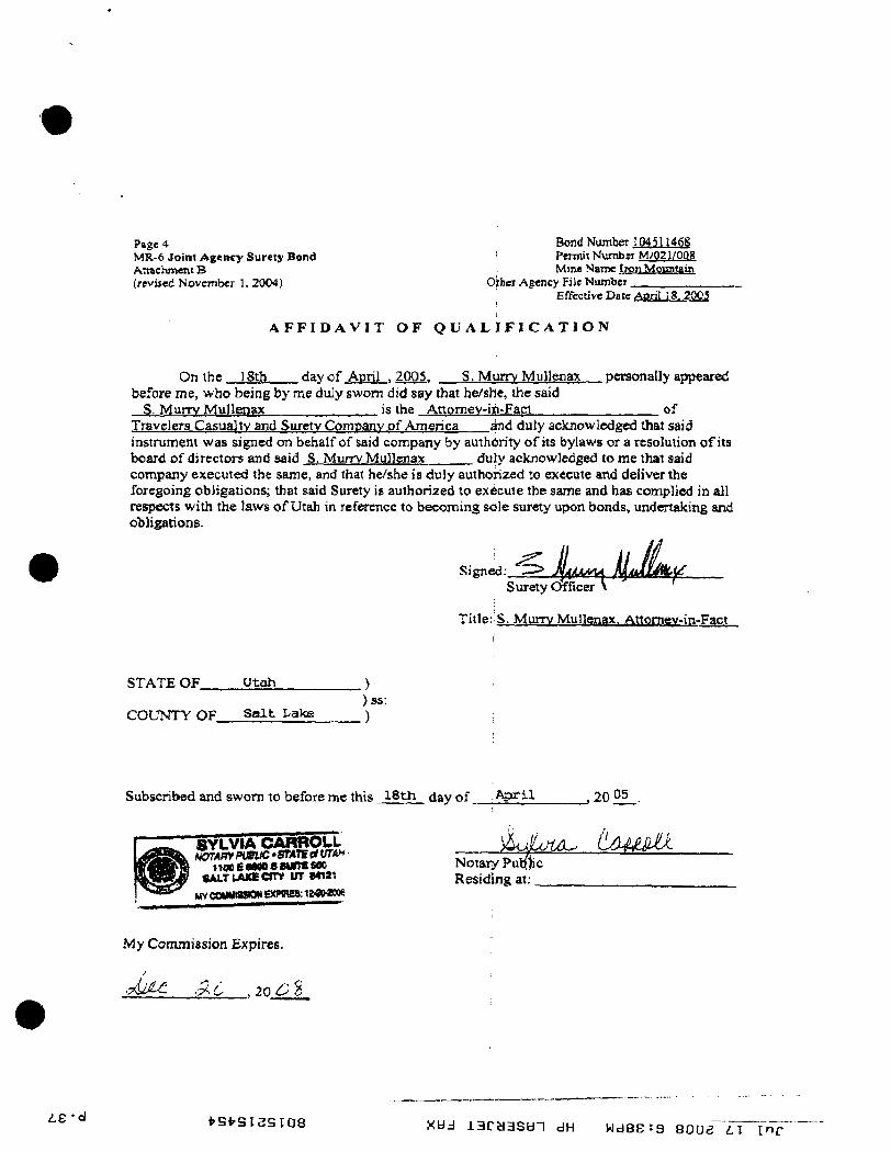
A F F I D A V I T O F Q U A L I F I C A T I O N
On the 18th day of April . 2005. S. Murrv Ivltillenax personally appeared before me, who being by me duly sworn did say that he/she, the said
S. Murrv Mullenax is the Anoraev-iiii-Fact of Travelers Casualty and Surety Company of America and duly aclcnowledgcd that said instrument was signed on behalf of said company by authority ofits bylaws or a resolution ofits board of directors and said S. Murrv MuHenax duly acknowledged to me that said company executed the same, and that he/she is duly authorized w execute and deliver the foregoing obligations; that said Surety is authorized to execute the same and has complied in all respects with the laws of Utah in reference to becoming sole surety upon bonds, undertaking and obligations.
Signed:. ^i I leer V Surety Officer
Title:;S. Murrv Mullenax. Attomev-in-Fact
STATE OF
COUNTY OF
Utah ) )ss:
S a l t Lake )
Subscribed and sworn to before mc this 18th day of A p r i l ., 20 05
SYLVIA CARROLL NenAirff>uBtM •STATE c* UTAH
iiooEaaoosMinesoo SALTLAKE o r * Iff Mtai
MV COMMtSSClN EXPIIW8; 1MM006
Notary Pupjic Residing at:
tamUJ(-
My Commission Expires:
• M ^ . ^ C .20 C %
L£-<i vsfrsisstoe Xdd i a r a a s d i dH Wdsesa BOOS L I m r
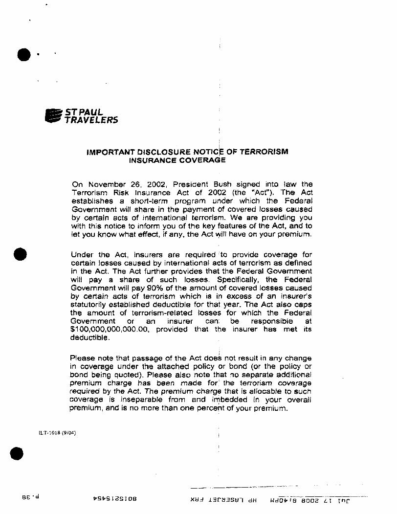
ST PAUL TRAVELERS
IMPORTANT DISCLOSURE NOTICE OF TERRORISM INSURANCE COVERAGE
On November 26, 2002, President Bush signed into law the Terrorism Risk Insurance Act of 2002 (the "Act"). The Act establishes a short-term program under which the Federal Government will share in the payment pf covered losses caused by certain acts of international terrorism. We are providing you with this notice to inform you of the key features of the Act, and to let you know what effect, if any, the Act will have on your premium.
Under the Act, insurers are required to provide coverage for certain losses caused by international acts of terrorism as defined in the Act. The Act further provides that the Federal Government will pay a share of such losses. Specifically, the Federal Government v/ill pay 90% of the amount |of covered losses caused by certain acts of terrorism which is in excess of an insurer's statutorily established deductible for that year. The Act also caps the amount of terrorism-related losses for which the Federal Government or an insurer can; be responsible at $100,000,000,000.00, provided that the insurer has met its deductible.
Please note that passage of the Act does not result in any change in coverage under the attached policy or bond (or the policy or bond being quoted). Please also note that no separate additional premium charge has been made for; the terrorism coverage required by the Act. The premium charge that is allocable to such coverage is inseparable from and imbedded In your overall premium, and is no more than one percent of your premium.
ILT--1018(9/CW)
S E - d t - S l r S I S S I O B xy j i3ry3syT dH wdoi'-'B eooe L I m r
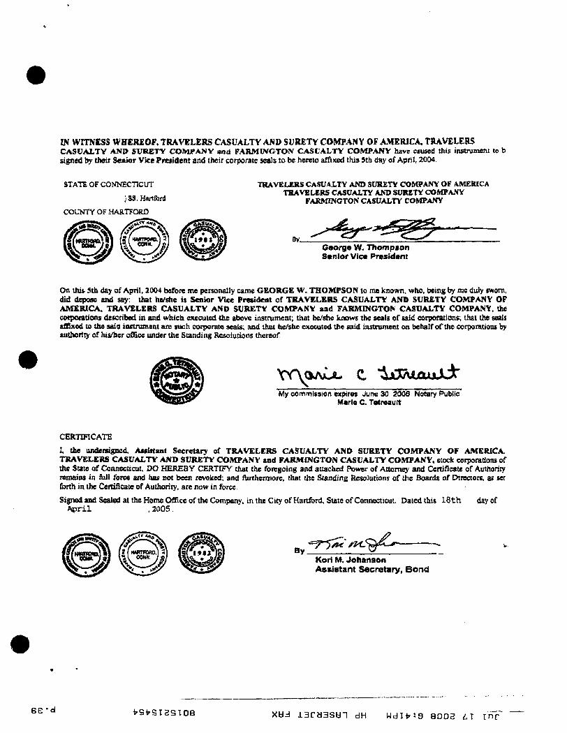
IN WITNESS WHEREOF, TRAVELERS CASUALTY AND SURETY COMPANY OF AMERICA, TRAVELERS CASUALTY AND SVRETY COMPANY and PARMINCTON CASUALTY COMPANY have ciused this instrument to b signed by their Senior Vice President and their corporate seals to be hereto aifixed this Sth day of April, 2004.
STATE OF CONNECTICUT
}SS. Hartford
COUNTY OF HARTFORD
TRAVELERS CASUALTY AND SURETY COMPANY OF AMERICA THAVELERS CASUALTY AND SURETY COMPANY
FARMINGTON CASUALTY COMPANY
8V_ ^ . . ^ - ^ - - ^ ' 2 ^ ^ ^
George W. Thompaon Senior Vice President
On this Sth day of April, 2004 before me personally came GEORGE W. THOMPSON to me known, who, being by mc duly sworn, did depose and say: that he/she is Senior Vice President of TRAVELERS CASUALTY AND SURETY COIVCPANV OP AMERICA TRAVELERS CASUALTY ANO SURETY COMPANY and FARMINGTON CASUALTY COMPANY, the coiporations described ia and which executed the above instniment; that he/she knows the seals of said corporations; that the seals affixed to the said instruinent are such corporate seals; and that he/she executed the said instrument on behalf of the corporations by authority of hi<cr office under the Standing Resolutions thereof.
xr\c OAJUU C "ixXAJLoaJjk' My comrrflsaion expires Jun« 30, 2006 Notary Public
Marie C. TetreauK
CERTIFICATE
I, the ttiidersigned, Awiatant Secretary of TRAVELERS CASUALTY AND SURETY COMPANY OF AMERICA TRAVELERS CASUALTY AND SURETY COMPANY and FARMINGTON CASUALTY COMPANY, stock corporations of the Sate of Comtectccut, DO HEREBY CERTIFY chat the foregoing and attached Power of Attomey and Certificate of Authoricy reniaias in &li force and has not been revoked; and fUrthermofc, that the Standing Resolutions of the Boards of Direaors, as set forth in the Certificate of Authority, are now in force
Signed and Sealed at the Home Office of the Companv. in the City of Hartford, Sute of Connecticut. Dated this 1 8 t h day of A p r i l . 20O5.
By "=7*5^ ' ' * < - ^ 9 ' ^ ^ Kori M. Johanson Assistant Secretary, B o n d
BE'o l i^svsigsioe Xdd iaraasdi dH WdH'Jg 8002 i T i n r
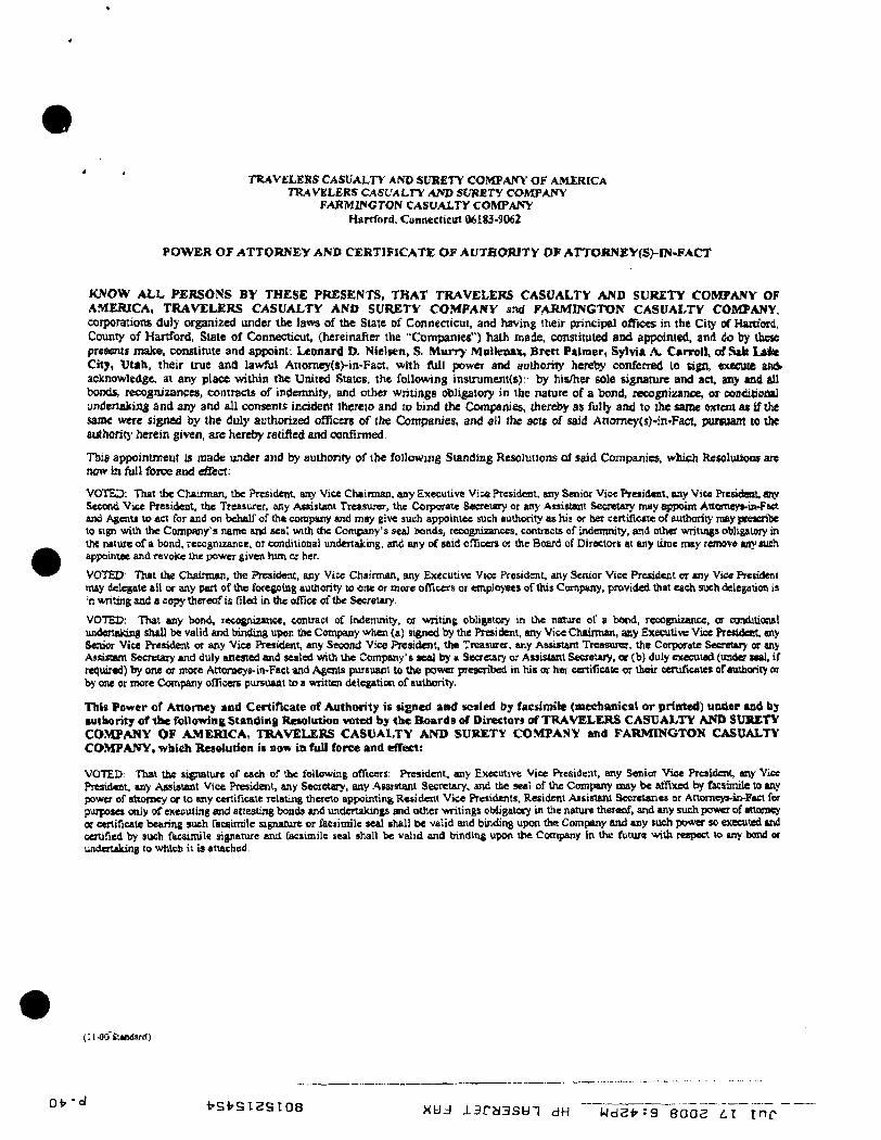
TRAVELERS CASUALTY AND SURETY COMPANY OF AMERICA TRAVELERS CASUALTY AND SURJSTy COMPANY
FARMINGTON CASUALTY COMPANV Hartford. Connecticut 06183-9062
P O W E R o r ATTORNEY AND CERTIFICATE O F AUTHORITY O F ArTORNEY(S)- IN-FACT
KNOW A L L P E R S O N S BY THESE PRESENTS, THAT TRAVELERS CASUALTY AND SURETY COMPANY OF AMERICA, TRAVELERS CASUALTY AND SURETY COMPANV and FARMINGTON CASUALTY COMPANY, corporations duly organized under the laws of the State of Connecticut, and having their principal offices in the City of Hartford, County of Hartford, State of Connecticut, {hereinafter the "Companies") hath made, constimted and appointed, and do by these presents make, constimte and appoint. Leonard D. Nielsen, S. Murr> Mnllenax, Brett Palmer, Sylvia A. Carroll , of Sah Laihe City, Utah, their true and lawfiil Attomej'(s)-in-Fact, with fUlt power and authority hereiiy conferred to sign, execuie awV acknowledge, at any place wilhin the United States, the following insirument<s>: by his/her sole signature and act, any and ail bonds, recojoizancea, contracts of indemnity, and other writings obligatory in the nature of a bond, lecognizance, or ooaditiona] undertaking and any and all consents incident thereto and to bind the Companies, therd>y as fully and to the same extent a t if the same were signed by the duly authorized oflicerB of the Companies, and all the acts of said Attomey(s}-in>Faet puiwam to the authorit)' herein given, are hereby ratified and confirmed
This appointment is made under and by authority of the following Standing Resolutions of said Companies, which ResoltiUoas are now in full force and effect:
VOTED: That tbe Chairman, the President, any Vice Chairman, any Executive Vice President, any Senior Vic« President, any Vice Presidettt. any Second Vice President, the Treasurer, any Assiitmi Treasurer, the Coiporate Secretary or any AttisUmt Secretary may appoint Attomeys-in-Fact and Agenii to act far and on behalf of the company and may eive such appointee such authority as his or her certificate of authority may prescribe to sign with the Company's name and seal with the Company's sea) bon<ls, recognisances, contiacts of indemnity, and other writings obligatory in the nature of a bond, recognizance, or conditional tmdertskking, and ary of said o(Ticere or the Board of Directors st any time may remove any such appoinue and revoke the power given him or her.
VOTED: Thai the Chainnan, the President, any Vice Chairman, any Executive Vjce President, any Senior Vice President or any Vice Fretideni may delegate all or any part of the foregoing authority to one or more ofTiGCis or employees ofthis Company, provided that each such delegation is 'n writing and a copy ttiereof is Hied in the office of tfae Secretary.
VOTED: That any bond, lecognizancc, contract of indemnity, or writing obligatoiy in the nature of a bond, recognizance, or conditional undersaiong shall be valid and bindii^ upon the Company when (a) signed by the President, any Vice Chairman, any Executive Vice President, any Senior Vice President or any Vice President, any Secoml Vice President, the Treasurer, any Assistam Treasurer, the Corporate Secretary « any Asdttant Secretary and duly attested and sealed with the Company's sea] by a Seaetary or Assistant Secretary, or (b) duly executed (under seal, if required) biy one or more Attorneys. in-Faci and Agents purstiant to the power prescribed in his or her certificate or their certificates of authority or by one or more Company officers pursuant to a written delegation of authority,
ThIt Power of Attorney and Certiricate of Authority is signed and sealed by faesiroile (mechanical o r printed) under and b j authority o f t h e followins Standing Resolution voted by the B o a r d s of Directors of TRAVELERS CASUALTY AMD SURETY COMPANY OF AMERICA, TRAVELERS CASUALTY AND SURETY COMPANY and FARMINGTON CASUALTY COMPANY, which Resolution is now in full force and effect:
VOTED: That the signature of each of the following officers: President, any Executive Vice President, any Senior Vice President, any Vict President, any Assistant Vice Ptesident, any Secretary, any Assistant Secretary, and the seal of Ihe Company may be affixed by facsimile to sny power of attorney or to any certificate Tclating thereto appointing Resident Vice Presidents, Resident Assistsnl Secretaries or Attomeys-ir-Fact fw purposes only of executing end attesting bonds and underiakings and other writings obligatory in the nature thereof, and any such power of attorney or certificate bearing such facsimile signature or faeiimile seal shall be valid and binding upon the Company and any such power sc executed and certified by such facsimile signature and facsimile seal shall be vahd and binding upon the Conipany in the future with respecl to any bond or undertaking to which it is attached.
Ol-OOSXIxiatd)
Oi- -ol V S t S I S S I O B Xdd laraasdT dH wdat-ra BOOS L I inc
IV 'ol I 'SfrSIgSTOB Xdd ia ryasd i dH wde^tg aooe i i ^ m F
IW'^ Palladon-staked BLM utv^atented land
Palladon-owred Patented miriing claims
McCahill Family Land
Utah State Owned Property
Private patented land (not Paiiadon)
BLM Land
Index Contour
Contour Interval (20 <L)
Depression Indei
Depression Interval (20 ft,)
Buildings
Removed Buildings
Condemnotion Drill Holes
1.36S R14W Sell Laks Mei
/X.-^^^-t|-|
A iCrx )) \
BOND BOUND.' RY
^-'l/^^fK
;"/////^'
IRON MOUNTAIN
PROPERTY MAP
ASSET PURCHASE AGREEMENT
PALLADON/W UCC AND
IRO.N ORE MINE LLC
AViffT Pl IRfTlASH AGPl^f^Mlf.'NT
TLia Asaa. Purchase Aeresmeiu (thes "Asn:cmvnl") is nuule and enteivd iato aa of Qm 13Ui d w of IJeoember, 20M (the "ElUt^w: Dflf''j by and hetwieen IRON ORE .WINES LliC. a UuluwHiv liiiated liobalixy comfoc^-, sii debtor and debtor in puitesslCtt <''Se]Le(^ Wkd WKATTJiN ITTAH COPPER COMPANY, « Ucih cocpuwLon. and P.4I.I.A1S0N S^NTirRES LTD^ a Brilish Col .uuiWa oorpwxrtJnn (.lofetber, "Suycr^.
RlvOTALS
A, Seller Dvms certain rtalaifcapem-MulprojiBcij located ill bMiCoiiniy, [.hah
Q. Sells: (tealns in nefl oil snuzh javpstt/ uud mucn certain Tights in cooaaaica thoKivitb. AniJ IhiycT deiCTW to punjbistf i ^ Mi^ Cvnperly and EtjJits.
C ScQur is ilic debtnr, (mc she dabtor in powRsiicd, .In a peoding bonlcniptBy prvcoedjng, and sjiprms! of Ons Afpiitiniini by ordef of die Birikrupic)' Cuurt au juvvMc^ lu Scc JGU 10.1 if lihifl A ^ a n u m l ia a cuaJitiOfl frKedentlD the oUiyuAims c&ttic: fMrtiea heretn and the leilc loA punJuiac cd'llie property.
A<THH.KMB>rr
bKJuiiSidnnlKififlfthemunul pnnciim au] kvuKfit' e^miained hsea i and other |$oo(l an i valuafcJ: coDtider^tioin, ihe reKipi aod stTffieiwn' nf which aiv hneby aclculyn4edJ^ed, Seller m i Rnyer agjme as fcUuH-a:
1' Ijgfater in riHgaafdOBi Srjjef ii! Ihe ddbior. aod Qui ikb^uc iu pC«KMicn). In a h»1cngxcy pfucveiJiiie pft&diue in die UcJted Slates BtaOTtt^teif Cmst ftir the Districl o t Utah (In r t Jnm Urn Mi/*ti I.TJC, Caae Nd. D2-J53S9> (tbe "Rarfcniptcy Proooedimt"). I tas Aftrwammr iii mhjeci to iha ptiut appn^sMJ (rf ihe Baafcrtjucy Ccmt u vci fiirlli k SectJnn Ifl.
2. Paivimst ftixl fltkaf Piwnerv
1.1 Purcfaaaa arid Sftlf Qif IVflneiTi.-. Subieci to (ht: jiaiiib ajJ CiCidfltong Ot Ihla .'VSKCinefll, Seller agrdci to ii]L atid Bii>vr a g i s s lc pundtmc aU of SeUei'i rJEhi, tide and interest in and Iv Ibc IbJc^ioc A3gel« and pmpstxit >'.BuJb (itM3 and pfnporiei a t colleclivehi-MfciKil tu litrtitafler « - h e *j\cqun«d Asi«l i^ :
2,1.1 ITu; EvUl •"/Cf< !y located in Inm Couut 'V i^lnh end more t-flrtifi-'aTly dearibed ml Sdiflduhi ?.,l,l atmcbad hereto {lhc 'TtMd ppopertyT; nmwle.i, hcmwiver. Bu^xr »AJLUVI,'1H1I>» IIUIT all nr n paraon olQis K«:al Pmpeny ia prencnlly leased ibr agricul'niral purpcwa, and Buyo vrill aiinnne suiA liea£<3 and acoe^ title tu the Real FrOputy sul^ci:! lu eu^ii l(ftU!L Ths putie!; vadxriSiaJ aail itcree rtksl Ruyer tboD have and be taii lkd 10 aQ>' and all income of whiuixver ZKJ.UK dctlved frnm 'Hie ag^ci^lucal luatci, and Erom tbe rest nf Ihe Acqaired ,^»?ts, Ihioi tad olW 1he Phol Ooiina Datt- (iU defilKi3 iB S««tK»n 1 'i-^. heltvw^
VtOlH-ZMt
2.1.2 The v a r a (i£lit9 identified OBI l ^ i i d i^beJU^ Bllacl^ "Waiur Ki(^la~K F»^Jit<^ liorwcviear, Bmer aeknon-ledscB thai mmo of thi "Hutc HJC^t a t t prvMfiUly laased for a(;ticultutai jnirpoces, ard n a y s vsill aaimu: LiCfa k a s n acd acccfit t l l b to Ibe Wntcr KieiH'. imbJMl cn luch leases,
2.i..i The paicsitsd and uupHiunicd mLninc CIAIIW nnd nrther Iznd!) Hai atv 4e»ribed in ScberiuHe^.IJi ulached hanto (lhc "MlninB Claims");
2,1,4 iiCllcr'f OfKratine rightx umier bn^gc rainjt: pcnnll No. UIQl/IXB liir Ibt liuB Muiim^b tAWn i^-vpfxr)' iu IEX» CouEcy Utab ((hie '^Mina JVxicJt^, fa «iincn;tly Rppnwed by Iiv TMnh Oiviidnn «f Oil. Cas ami Miniuu ( " I X X J M ^ K 101k« eirtent irAnsfemUe and !nhf«ct In DOGNf iffntoval;
Z.I.3 To di$ ectent iransferaUe, the UOSBB, lisKiuica. pumiilb anil $|>priyra|8 Itiaed on Sehadulej-U aUched hiJvCu;
2,IJ> 'Ihv fixTweSt Tno:2dneiy, equipmenl, and oihiT iieana Of p«raoi»l ptcfMSQ* idoilJiied anSdwdnlea.l . i i Dtinchad Letnito:
Z.k.T Jboac^ i i s i b spw^JKoU^ Isisd in ^ihedcJa 2 .^7 atucbed beseu, iuiuUidlLi: til piiriicUilgtr Use eKinine. nriginals and uupwa ufaB iraiipa, jvpotia, fikf. nnd oilber dntn au l Bifbinnnlisn of ntur^suever EaUm C^ncSiKllis AJe caees iod din-Aerj^ etc-X mipinUext oJ •tAam held, cccxxcniii; or ivlalitcj directly nc primarily to tbe .'Ic^oired Asitets; ptovidijd, Jiowever» thm Selkt Aod IK o^eiKs sliall have tha ri^hi fuc a period of i tu yean aAcr ilie Finol ClMrii^ nate to rerview and oopf, al SaDw's uipuiH;, i M do^xmeiiK ard dou in the event S e l l s electa or iweda (0 dO- $0 in SiWit'a Usttetieai, nrd Buyer ^leeei LU ouupecalis with lOil Ikcilicatc any iu i ^ aclkm hw fldiov 9oi
2.1 .E . ^ f {/[bCl rsd property, pentanal pniperly. waler ami uQia at^hlK vfPMOKiSSt pCfJuttt^ «{i(9toval8 «ad uiets onced, held or huvaller flnjiilcvi by K<4Jnr jeMlue rn SeHer^s n^iunt and asTkuHmnl opeiatians and psupefika k IiOD County, Utol^ including any diitHivered afw- the tltkcove Tbtn cr aller UK tinftl Clnini(i (as deftned oi Section I U i belcnvX
S, fawJndeJ .4a9«s, NntwidBtandiaif an>-lhigg uuoiaiaA] in SiuAlua 2 to tht cootraiT, Seller ia m t laenins, and Uvya a wit lAcdiaskft atsy assets of Seller not specifkally iHenciiiBd in Section 1, tnchidli^ witbaul limilalsCUi Ihe foI)(K#iiis AasstK owned hy Seller, all of which shall he idaswd by Sdhir
'^.1 SdltJ'fl hni liiesB^ firondal, auccunliiix aiul iipuHliUiuil ti^vutdii^ Stits iiud ilnnvir^, expefrt chnse iicns idemlEiBd ui Sacikui 2. L7 t a i ' o i S«he(^lc 3-1.7;
3.2 all dacnmusts ur date .lemnnnhly neaessary Ear Seller w oeet els l e ^ oUigodccB ur pt&,ii Lumpliaxe Ihanwltbi
^ K 0 4 4 £ d M
2 J any cash, o u b cvuivaJCdKB, potty cn^Ai, depuflit eeccnnti, checks tEaerved by Sclkr upuii Wliiclt CuUcciSou taa a x been noade, nticcnins.s^ nntes aod cnntracts reoeovable^ a id Vm^- ami liKitl-ftita BWAlritivf ovfucd ivy .Seller as cf the CDniiiig IDste (as defined in SectHm bl . lbEkvth
3 ' Ihe ri(;hhi that ONZue to Selkc Lodar Ihis Aj^etaiiedt;
i - i claims. ri^Ms and mlerola in uiuJ tu aay idkiulii tHn m a t t t local gnnobise, irucinw nr other luKes ur ieees ol any iiattm Vi'h)irtBO!; >er relai;irx!< In Iffxcc snd fecE; and claicns a^iaisix any pcnoin ur uujly;
^.h All (ither ungib^ and ialuii;pbU! axsels <ir puttiuDB llumul'ivlaim] lu SeUar njt e«pre«ly Jtsied in Sectioai 2;
3.7 clauaOi. tinits and interesH rdaied in sn- tuny to any RLI W p r a i f l |u•upttt>'s^otioe^^d«l iiirhe.A*qnined.\saets:aisd ^ _ „ ^ ' - 7 ^ i f i y ^
J.B iaiurauftt uOUO« «vl pmeeeds r h e 7 « Q f / ^ ' = ^ ^ ^ ' > < S ^ ^ ^ ^ i f ^ y O ^ M ' ^ . - ^ 4 1 0 , 0 0 0 ^ 0 0 0 ^ - P j ^ - ^ ^
^' Ttnchnae WceL. The pmchase ^uriui; da \hs Acquired A£aei£ aliull be ECBE MlOicci n(,1r IT I I m ihtllaffl (Htl'I'JtW'iH) <1he "kuiehsse Prioe^. The Pnreliae [^riee shall be piO'i^i' 13 wbv-1rAnaforfe<) ftmdi^ same div mnritnbslf^, as fbiHOKV:
ta) 'PXfy Tnuusuid DuSlari (S5VjD00'> aliftlL he delmied in filler tm eunest mnaey (the "^^iafwst ^4nncy"J cnneurreeidy witb the s^niog 4if dua Agn^anufni by bulb foiliiss, ^ i c h PJirnest Mant9 diaD be lidly eansHl by IJtillAt aitd JHHsnnudaUc M InQVi, 8 ^ only to SectioDs S aod 16 i a i s a . biK aplpillcnhle (nfthcml mtarest) tn die Pniehosie Price ac itK. ClOElnc (M deflned in Recrian 11 hekiw),
(b) Buyer ahali bv allcnMtd A CJ«dU in ihe Hnciont of One Millian Tfanee Hund»d Tbuusaol UvUati (£L?0OJO09) whlmui inteieal (tbe "^XKlaiiiBlian, Cwdit^ at tfae Chnnp fnr (hs cseumplion nf SeDer's TedamaBoa oh&fiaiiMS i t p#0vld«1 hf ieifi. aed
(c) lha h ^ o n v v i Uu; fuichwe W e t simi} be dellTivred in escmw In Finn Ainedcaii lllIC lUtfiiriWie Ajgeoey, Inc. in Sail Lake CHy, Ulah or sudb othar lille s^oriipwo' aa eufsy be imimally occqitable to Seller and Uujw 4Uu: TilLu Cunrpitnjr") af ibu dnEJnB} -0 be hdd bj- the Tide Ccmpanv yeniia^ the 1*11381 Clounf^
S. Aaumeii LiablUtiica. A,i furlher cnnndeiatica b t cansamauiiDa af t ie transaciian] ccuicmplatcd betelg' (dhe "IVnnsacdnns^, Buyer, ivilbuul further aClioa by any pHty, will Jiasiime AB cf the nn!ang.D:ite and sijpees Ifaenal^ tu jifiy vthai Juu and uadcnintJ^, deftcid aod hoid harmless Seller lod its pEitxA and afTiIlaKi^ aiul thicir mpocdvc dlncioci, nffieen, emplnjiiees, exeats;, cndiliotm, imutttfiCi. mtiltben, iharehc4.'i«si, refveSHicatTKi, succBiiuni and assigns, jodi^iilual^- awl t;ullcc4ivei(y (toeedber, the ' t e l l e r Tnoemnified ?arties^j, ^am and auainal xiy Add iJl oliUfiiKlpita ailtt lidhelicief af eny land rdating ba tfae Acquiied AiaCl^ KIK "ASfUiand T.iBbiKtM!^), includmB vnihuul Snsilntiun all cwdamilsun tiblijatiaeis nilh
3
reapcBt io Uie Mining Claiaut all of ReIlBr\ uUl^ntsoBe under Ibe Mine Tuuii; w d chat tetiain fUdnmaiiiia CotMnui widi DOOM duted May 2^, I99B. File MIK WD2UIHi& (ibe '^teclansstwa Cixntraa'^ «ill dcnts cif aimplyioft witb Mx Heelatnuisun CoifrtriKS, nay witssnients^ disviCS <a ilcjivndi thai DOGM nt tbe Unined Si'Jrtes Boeou »f 1 .sod ^Janjteenieal may OMue in MuuucrioD with tnsjnluiljflj or TBdatmsflA the KGsiu(> C'lados itiicludlDS nay iwitiifAioii leipirvmenei;, bnndmg requiTefnsnv bued ftci, v a cwsta for eny liinvBud ft^atmait a t bnndin^i pe*{uiiieinetM or ad«Siiionnl bonding liM mm he t t q u l s t ^ and ail niaLateiMnce Jl-us tad filinj^ tu i i imd ia cnnacctioa with unpaftedled itriniag dpitns incluiJEd within Ibe hdining Quiiua. Jhiyar's U i U ^ n n c utidu-i llite Reetiaa 5 iditdj 9arvi^« ih« l ^nal Cjusug and the Tnnsaieilonii Md xhaU con&nie ib«e»iter perTietually. It is mukmcod and a^nuHt h tn imw, Itat Bqwr, in uKler w jTrmecl aoJ tiisiic icsdf from the riiir of S M J K , Ihcrd'piirt)' IMillity, may aad iii S K I inteadv lu take SOu al Closing tc ilu: Aiittiirci i^iiela in d>e nanx; of A mhadiary cv f/vntr^illBi uucpor^inn or othvr Icfel eniitj^'. ifueh Ktioa -iaU nAt elLmiuaie or dimicusb Buj'er's .^sisuraicd T.iahtliiine liCKuader.
b. jVUm^ iian nf ^aretuuL- t'rtna. B t c u and SeOra agfcc that to aaionm nf tlw jmsuxR value of lhc Fiirthue PtiCt imd ibe AsnuDed iJafaiUitcs t}inl aae lisfamilea fbr fadceal Inccne laji jiiupcMii, dattaBiiBicd Uiklsis ioM Kcouci SwiiOD 4J)3 af dw- bilutwl Reveout; Code of ISBfiv ** amended, idifdl be allocated for Mera l incodie lax pucpoeee onaang thfi Acquired Aatulg in JccnrdlQce with SctedtJe fi aMaditxl tmewfc Subject (<i iJtereqaireaeailenfapjilicatik Jaw, such altocntJon AvO be ^'ludiAe upac the tmrliec Tut Hut pinpones uf niiiic any ntuni, iv|>o[t or schwiufft Te^aodiaqi Uuua.
7, l>fle BDiHgica: CwJinaeac.v [Vrlnd. Qujriit, al l u ovn cxixitt^ sKall periunci whauives level nf due djliecme Bnjw dMflis afipcopdate. Bi^pgr tibiQ hove 3C dsyi a tW die GUcttwe Hait ia w ] i l ^ to pesAnm iocb dna dilijj'Cfiae (tbe "Ccntsneency PbrioT). Hiiy«r may iuuxf npon !!kJt<t''( jirnpety at nsiannitile l i iuu mid al Duycr'a anie lisic ami Mpense ducist^ Ibe CoQiiajBcoQ' Pioriod ba cxauiJne the Anfuiied Asooi and tn COSKIUVI a t'hase I envjosutxriitni stWIy nn the Kuiit I'rnjierty anil ihe Mininu CIniiiis; pnA'ldcd thai (i> BuQPcr shaQ nut uureuHmafal]; iuterfete vnth tbt tue nf any of tbe Aci|ulicd A S M S or udicr ioipnnwMnics or fiictizia un che jmpsity. Cii) Buyer sudi prmnpdy ileitis and MBUKU acf damaga dcfltt CO the A,«^|utr(4 Assets w ad^jcent janpaty In cacawutijCiin ^ i tb such tiSsUi^ (ui) U-jy« ahnll conxply wiOi tS\ npplicablr Hw^ regii]aliu:£ *s>d cciUnaDeei: in pexfindiig such test i i^ 9ni (rr) SeUor ttufl have ibe l i ^ to apptdrvc of tbe Sdouity. i{tsdiilcjltimi ami ax/pi of waA. uf ioiy eoiranmuiral inifiectix' or {Utineer. Quycr shoU povoiptty penidt; SuUflr nfih copiBtt uf«ny and ail Mjovctys, appHdiaSa, encineeiin^ Uihanisxy niti eovinmnuaiU] repattsi, and other niuiiiB pcodveed in «nuiM4liOCD v n ^ Quyur's dus diH jCiHie. DujKe ahall indemadfy, defend and hold h^irmless much <if Ihe MIer IcOconified TarUfts frora and. acpjnnt uny ii^'jiy cff dunaeti wi&iiig Irnia DnyH's flctivitiei vai/» Hiis fleoiijcni. Biiy9r''K oblidatWTis uochir this Secdna sdwll pjrvive A:^ Uauiioiirioin of ihia .Aftiteniem. U 3B a resuh af JJuyer^s due dili£«j)ce^ Mayer dradc^ nm ta pdrcfaue the Ai^ubedAfsets. than UqycT shall iiiuwcimel]''so U M I ^ Seller in xniltoj^ hot ia cu LVviS\ toter tban I1H> cttiniiwico of diC Cootisi^icy' (^amd. If BUfver timely ouliCot Seller in mit ingnf ita decision int Vibaiovr ce«sDc oOt to punducui (Lc Acqtmed Ajosntt iSris ^Vt$n»3Dual f hnll be leoairaHd, Ru^er dsaS not he ubiJc^red to punduu« the ^\cijnired Asteti, Seilet £bdl rK^n Ihu tcmoBVManey, aiU^ neither peuty AuSi bmv miy judbBr nfihi& tx crhligoaocu bL-tcnnder cthce than tbuK abGgatlioai^ which an: intended w rarx-ive temtinlitton- If Q u } ^ ^ ^ '^ limelj
4 <ii:au'>(jL4K
nofify Sdltr in writing uf iia deciiiwi nr t to purthsse tbe Auquired Assets, Buyu ^balt te nbKffited to pjnoeed wilb lllC a o s i r g and lu ccuiaimOBie die pur t lwe cf iba Aoqulswl Aaseta in accardaniCi with Hw «lbw ptiwisimifc of ihia A;$r«inesl
«, TiUgConunhmem- Wlhin ] 3 days after ibc Eaia;lLve liata. Seller wiU d d i w to Buyer a preiiniiauy ifek lepoet prnpoEwl fcij- the Tide Compsiai- ihrmmg thu ajuuMoA of titlo to the Heal l>ror«:ri)' (b« ajf the Walur rtiBhta or Ihe Mininfe Clsima) <du; T i l t e K<|)Oft-% ISu>er duill fliarmfter luwe the iwntiiutei of the Cnnrintjsacy I f t lM to review Ihft Tide Report and liu Jicdfy SeUcr ia *ritsng if D4Qtcr dlsapprnves of anj' cocCJiptifflii shima iu The TOte Hapurt ThiuK cKcflpiioiU w i*twii Buyur does not O^ccl wr to which Bayer bw screed in the A|{s«<Ji>enr are te&crvd 10 her=in M the •Pftrmitesd r»wplloiu*.'* U nnyer diiappnjvea nf onj- tilttflaooa, Seller ai«y, wdiin lai «l«ys ifter recuiviaO nntice of BuyWe rtiMjipToviil, W I I M © jesnove die ohiecriDoibat; ca«|»liryn{s) or <i) wlviae Buyar d w it wUI n « ewe * e ohjcsxlunalib Btoqpliodts), If SelLer dues neWwr (i) nur {is) wJlldo such tenslBty peried, or if Selhit jttOWdCR die nolUu pennitted h* lil)» then Buyer as its exflntiw cMc«:d> niOO' leraninaSB this AfitWOWBt by wrtttea rwtice to Seller given wiibin J3« doya foUnwicft ttw end of i te Uai-dsor perind. in whidi evem tbis AfirMmeht shall icnnluatt, Buyer shaU bol be cbBgfllad » jnuduM die. Aoqtiliwl AsBBts; Sifflcr shall rtluoi the Eoroasi Moeiej' JO Wnjer (wiflwuJ inltres), acd oeilh** vfirt}" fWI lave any finHher rifihla Of obdgaliaiis ter«mu3sr c d w Ihan Ihom obUpaliuai Willi* are in i auh^ an nrv ive usuiiiuvtinn. If Buyer doC3 Rol timely ednel M tenranate tUe Ajpaecwit in accurdaufic witb lhil& Seetioo will£u fh* itays fdUwiim ihe end nf tbe Uai-dny pejiod, tbeo Buyot shalJ he irrciWftWy demnvd 10 hnve eeceptad *!l atcesilinns in Hit TJlle Report as Ptnnittcd Kaoejrtinaa, and drij AsictitieoJ !*in remam in fidi fcree and tllcct feccepl ftf din pnwiwuui uf Seuliwu ] * below a Ikjneiv electiLfj b j J3u>er w wrnunati; ihsS Apeeonert wiluly becouae of bUe a Ihf- R M I Ptupesv es pew»ided in tWs Seeiixm » le Ihe cmly hasis in tt is A^oenuaU luid^c which Bnyar Q^yohtainBttftadofdiaBamBslMnney. Any liOe icpom cswaais^ lhc Water Rights a n d t a the hfiiiHHj clftlcni; sfcoa bt ut«!ilj»ed hy Bayer «a pnn of UuyHr'tf d«e dtliseoce ai Btiyw'* » I B Hspost dnrine lhc Cnnrinip^acy Faiiud.
» Imn On: Mbea Files. Aa au scwmmodaliuo Ift ^tMfte only. ScUcr Efatll uae wnnsQicr^ly reakwftle ef&mi to mate uvailahle fer Buy«'8 review, wilUn Iw doys afier the Klftcliw Diaiu. oil of StJIerB tniMU flies that are nadliy wniliMB lu Scum's «ii«iaB jHrnmosiE] ttiihoul anr««om*lB eeon pwlaWng In die liUu to *nd the cnndilloai flf * B jXcquiiwI A s w a (tbe "Stller Piles''): ptuviided, howwwai, that Bdier mokes nc K^sentadBiB w vswnaiuiet with M o t a 10 the amunsy Of onmpleteoeaa of such fflcs aed fhall "nise no oUiemlon w organiai^ teFemlile or oihciwiae otlmnfH UJ \ u a t t n s * fflea. AH mfaimrjim ptUViMed by Seller (oAm ta«n infoHKHUtion iha is avaikhle in the pubUc Beaerclly itOHJ«ii oOiw smuuea) jball be Bianbdiu^d nnd pnUwtod by ftuyer in cuolidiaKC HwcHgh isid *ftei ihe dosinit, iQlill tbs Fiiml CUdloft. Buyer i M I iWt disdoite auch ItffomHiian tu any ifadrd piciy ouept «n 8 confidential haalfi lo Buyer's advisnni who have ai j ;»* * confidenliriliij- apeemeK wilb Seller and whn are KSivtty invulisd in Bssaling B u j « lo el.^ahsate and jjtifchB« lbs A«nnl«i A a w s ar aa rwiuawl bf law- If dJf AETMtaenl irauiinnIeK ftir auj- ruaaOD other dian O B transfer of ibe AeqUEied A-eels to B«tS«r, then BuyftI aliaU tetuni to Sitisu tdi cnjries ufaoj dwmmenis pcoviiM by bteJItj wilb Kjpcct in Ibe Aoquiscd Awels ticeludinR any sumnudej w nniw »i1h « 3 p « t to such dutusassli:}. nuyur'S oblienrino ta mil diaclwe the infirnnatou provided hy Sclksr shall srjivivB stKh IcrminKinn. Buryer ncknowkdeea 1l»« Se l te l i u nuuiwcms boldisigs aiul docuaient stm'age
ii9t.ivAm:
areas in varimia locadDne and liooitwl cnniqwv«er tu m o a t mcb Seller Files. $<Iler shall have nn HabiBl}' to Bi^va uiulcr auy IhMO' whaisoevei in Ihjt «veal Selkv fiiln to moke avaihible far nn-iev^- any uf lhc Sdler Piles, nnr sltaSl JH:l}i3 1K«V aa>' (ubiUty to Bv/ei unda- any iheon-who i soem cfi WOOnnt of the iccnracy, conleiil or cnuipleiesieaR nf dw Rdler Files. The LuoliikuialJlf u ^ lUJO^disclosue gn<o^scians of ihiA flectiesi 9 du l l Uamsnatb ol Iba Fiiuf Ctoani^ (bul ncn heshie) nnd dieKaller ifal] be of DO ciirThsT fnn:e nr effect.
lO. Cnndilimii to Clnsia;. Sulki^! nttligatino bo sell the Axitiuirhl ASsCta, and Knyer's nUi^atHui to puKtnae CK Anqnired Asseu, ss iitxisiuyciil ini llue wKiifMlkm «r waive? (to the extent ibe ccadlrioc » kgally wiivahle) by Biiyci 9Qd Seiim nf earfc nf die Mlnwinj Luodclinns v'iui 10 iLf durte indiested below:
IOLI paafcnqriicy Cffw APcnovnL Priur to Uu; d o a i u s IJKt, SeJIm fihali hnwe ohcniued a litul. nan-efipcalabJc Ordcj of die Qankiuptcy CouR (ibe "Older") approving ih s Atsceememl p^usuaot lo Seetian 3<Q of Ae Banktnpltiy Code (llie "nanVniptn- Cauit Apfoovan. lipfiUeir Bhall «pp4y f « die QnSer as soon t s rriMnnalily immllcabie fuSuwln^ llis fidbciJVL Datc> aiid Bii}w shdl owpfBab: wilh Sclkt in obmiiiing (be Uidcr. llie <fin<oi» tK<Ke that the Dankniptcy CuiEt-hcaiiiie cc Ihe ntotioB b r eppiv>iil of dlt sole C^lbe /.cquirBd Assets to Ouyar KTiiiM {ptiihjftid ta dig Caarei. amcutrmtel bc b A i Ili Jemiary 20O5. on a date nu later dion an'ci] dqys «ft«- die eod of the Cnnlini^iaKT I'erind.
l i . CltwhiR
l l . l Cfcujjoft Hole, llie coGBunundiuu of Ibe putfchane«f che Acqsiied Assets (dw T 3 a d a ( n ebiU o i ^ c "^ ^ offices of ihe Tide CjampiD>- on a dace muluall}' a^jnied to by lltc f n a i a as man, as leasvoab^- ptictleable chllonin}; Bauknip^ ' Cuuil Aptxuval «id tbe eiiit nf lha CnretinganB}- Pesiod (d» date 00 which Use CiOBh!« occinj being the ."Owring Dote"'), hut io BU iivuui Jeter tbon die lad n occur uf (a) 24 dnys a'iier Doc&n^ta}- Ceuit Apfiraval, ur Ch) Ijrninry ^ ^ ^'XiS (Ibe X k n i n ^ Deadline^; pmvidud huvtcvct, tlml lilt Closlofi cnniy eccur d rmeh crtbsr lime asid plau« B9 (be (ktftia nuy muimdl)' niiroe hi writfnc^ mid Ihe Cloring DeodKne ma^' bt; aiMKkd by Buyer pimnuot to Sudiud 11.2 hereof.
1 1 ^ ExfxaiiXl i.,f flfvrinp TW,n['Tini- Jn Iht cvciiS BxtiHaT tus noi iBceJvod the approval of OOClv; C<i tliC iTUH&r nf t&e Muw J^:dUt1 and to the aanunptinn hy Bnyer bf all of Sidler'a 6hli£allo(nF mider die ReclamalioD Cuuli »et hw the Gnsing DeadBna, Bi^vr may evtuBd Che ClCfiiaa HeniUine mue hy deli.t^ai4g 10 Seller on ur helbns dw uti^cat Uuiibg lX«dliiie (a) A «ijilen nntioe cf exHcuiwi iduili^uie the lost a u e to -Hfaicli. die Uueiiifi [>cadline will be exleodad, ivlw:b date SliaU ID no event he later than (lie teat to Mcurof (1) March 31,211CC o r ^ ) £0 days EulliiU'ina dK «i£inal fDnsang OeadlinC^ and fb) ps}raent of lhe sunt of Five llundhsd Dullate (SSW) nnillinlied hy Ibe number oi^wys included ia Ibe eodensiun ndice. (diu 'HKUmsiuu rayiiX£rt")j wiiich Vxiaisim Fi/fatsA DSUSI be at lensi Sl S.OWl even if [lie nwabcr od dca^ Ss leas iltno ttO, Tha Gxtemdua rayicnd thall he deecwd lu be fully iftntcd by ^ l e r nnd noi> tefiirKlBhle M BuyK, am!, diiall w i be npplied to die Purchfiaa Fiice ac CSosdne.
113 Closing Deliveiksw Al tJMi Cloging:
C&MOM-SJSI:
\ \ .Xi Seller wUi (ULMiUlt, adUMwiedija and deliver m the Tide Conqmny IB eacnyni- (a )«specnt wansnty de«d fw llie R e d Ftopuly auhsdoniively cn die fijnn oif Exhibli l i J . K a ] attached hercno (the "Rest Pmpcft)' D o o D , {ll) a qulcJahn deed for die V i m i KigfSle eubstsniivdy m the form of Enhihil ll. .i.ll^^ allflckd bcKiO (ibc "^a t a r Rights Deed"), (e) a ipdtclaim deed fbr the Mining CTlAJnt; 9ub0laiilive|> hi Itu luou uf iiafaibitJI J.lfn^ onflcitcd hetcio (Ibe "Micdni^ Ctum Deed') (ibe Real Prosieny VetA. Tb: Waicir Ri^ils Deed sod tbe Mhliug Chiiic l>ied an refened to herrai a.i the "Deeda"), (rf) e bill <ft sale novering die itMIS Hlduded ill diu Auiuinal Aiaicts DOW than Ibe Real Pmperty, 1l-£ Wmer KJ^Ml end Ibe Miiung CUhna !uh»nmt^wj^ Loittr ibn i »lltcfaoi Imrtlu ai Exiii]xl.lA.^J.L4) (die "Hill of !ialie^;i, and («) suiih other docucaenta as me ^ ) neeeteaiy so CSiitfletC Ibc trasiifEr of ibe Aoqyiied AMK(S to Bii>i:r. (ii) othenvise neceixuy cn onnnplete the TliviSA^^Qm, aod tiii> teamnilily n»qiie«r<d Liy Btiyet.
113,1 i t l k s and thurcT shall utucwlc, aclunvsiedge and deliva lu Scllu' a Transfer nf Notice of Inlenrinn, T,inEe Vthrring Opermloos, USlaft die DOOM finn attbctied hereto M HjtMKi 11.3^ (da: " M i » r e m i t Assiefanent'').
It-t.p Thiyer sluill CjicOdej aeluiuw|j«;b!<' and deliver m SeUOl a Kcclatasnlcm Co<iU«t, Uidng tbe OOQM fixtn ottncbed hoeto 98 fcflthlhl[JtlJ,3 (*Qiqw'8 Reelainatlon (iMiirmt;!"}
I U , 4 Bu>er shall pay tn ihe Tide Cmr^umy In iacnnv the faalnnee of tbe Pnrehnss l ^ce [sAa^ Aedti tOi the b iaswi Muoey asid the Reclamntioa Ciwlil} by y n n tianslerred fimds^ niui;e dto' (ivAibbliily, .^ny Incuuil uesm»l on sucb finds dtall IM; cmd to Sella ami ahaU uul be aedited eonaid tbe Purchase Price.
113-3 All pi^pcrty laxua, foev aod asiKiuiiMDla on the Aequbot Asauls peyabSt- uu ur at lu Ibe fmal Qosiog Date shall be die obl^liot^ of BOd paid b^- BLyer.
lt.3.6 £«cb pnly diaU eneeuw aud dd i^w nich adifitianiil niEUaviu of Don-fatnipi aumis. closEng. sintecnanlx, asmgmnienes^ M^noptkHlS (uid udicr custoawiy and usual clofbe CixnuiKuJa aa uu^ be nucvcably cuquired ui cnnsumaiale the Transscdotu coortamflBied beneby.
12. CbligatScnis and Coodiiiooa On or Afier Cloalna The falkiwiiiB nbllpwmM And ccodlllofia G&Bll Appt ' Cd vr idtcr the dcan fp
12.1 l l i h i n Ih'c dtys arict MK CkuisK;. Burner shoU deliver to D O & 4 a itelanutiuD siaecy oc otfaer bend in n fnrm and mnonin (ituCluJIug inAsdoo a4JU8UllCllle) aceepiabk: ti> DOGM, witfa Duyer cannd at principnl And wJQiOUl any uUigadooi nf JJellcr sjpecified tbci«hi (ibc "KLiihiewniml Bui»r>, to Adly replace and idcasc Seller's exisline reclanisuoQ Kxety bood whicb is in the amounl of jl^73,iyKl.CC (^cUcf'g BundT). Any tefiuids, lehmes or ccmi|vi',»irlO(u of 8iiy kind aswcialed witfa the Seller's BoaJ ahaU $g exshiavely to Seller. Ifthe RcplncciiKn Bond ^ nut to delivetcd to DDGM wJlblu laid G«v ilay peiwd. Seller iney Lerminnte this .^Ereef^enl liy vitlltut itoticc lu Buyv, Seller l cAl iXd \x oblleaicd to aidl On; A'Oimred .Osiels toBu>er, SeUershnJI reuin Ihe fianicet Muney, and neither
REH<a44-£jllM
poity iball have auy furtiber Tiehb ur otilteldlniK bctuuitdn otiber Iboa i b o ^ obltfifsiooB wfaich m ilHsoded Iv Mvv'ive tenninalian. Ill such instance of terminalicBS by Seller, If Qi^vr has defrrtied die btlance nf «be Punaiaju Ki te (not Indudba the KafWHi Muucy OT the Redamatloii Ciedtt), or any pu t ihereof, to Out TUlc Crfnpany Ci> tic held in eKtvM- pnauaiit In Section 11.3(4 nbnvB, Lbeo Buycu tlwll S>e enisikd lo Ihe Tmraediaw jetmn nf BKI mucKj' (wlrtinm inUmsil) t u r n die Tille Cetflpnny.
12.2 Within &vt cays atkr Wujier deiivati l&C Keplnoemeni Baud W JX)fiM,
"irtJw shall dey>w to DOGM Use exetutttl Mine Pennil AHiEnmem and Buyer's Recbutjaiion
Cojitnuc.
1 _S Widuu fi« days aficj IxUer teeesvea fruitl l>i"Jt"iM a iwdilea release «* Seijftr and Cieneva. SJlsal LLC finrn all oWlfiarions umStr tbt Rwlwnatioo Cisairoc;, SeBer shoU liStviA ibe Title Campus^ «a dtfivet die Hufchose PdCC t^inds held in otsauw to Seller aod to deliver ibe Deeds and the BBI of Sale held ui eswowto Bnyer. ITiftdclivBiy of swfa i tods and dKumenie ^ ihe Trtle CwJipauy fl-aJl be i n m u *s the "Tuud Closina" and tbe date OB whidi Ihc Finn] aoaic® ia wsiipleted dian be known nt the "Fiuafl U n a n g liaia."
dnzvuf.
fnuL
112J4 B U J W shall he respuecible fw TBeoedinft &t Deeds aod fiw the cast
IJ.S Pa th Ftttly £l»H l»y n u L - ^ f o: the tida Company's cloais^ and eacrow
] 2J, Any tide ins^wnce dial Bu>Kr nrmy wisb to pttmhwe osi the Eieal P J V I * I ^ V Miiriuft <::lBims aod'cr Wascr Kights stsd] be aritmeed aad puld ftf fcy Buyer.
12.7 If Ibe FiDiJ Cloaii^ tia» n « ocemred althlo nine mualbs >dUtr the EBtellvc riwe, then eadiei p a i ^ may leoaiuDie diia A ^ i s a c n t by written n o d « in the other piity, in ' H U A « » » Unjer dudl BO« be ob«E«*«l ^ jnif **»« Ihe Aaprirod Assets, S d k r ahaU net be obliimicd » KU the Adpiiicd Atnets. SalUf sMI mtain the i a ru t i t Mccer>-, Buyer &B1I be enlillwl 10 the inmwdisU: ittom (widioui interest} of the balanioe of tfae Tundiasc Pfiee ( r a iniludba die Dameal Money nr ibe ItaulaniatBon QwHlK ot «ty pan Ibeseui; wfaidi dieietofini! Buyer inay have A^^eied to tfae r u l t Cempony to be bftW m esctuw putSHtf tn Sectmi 11.3,4 ttiave, Bud neltbej party ahall b a w «8y fiarfiw flflhs or oblitiaiicins hsreundar other diau 1 h « t nbfigaliuus lAtiiicb ore silUmdud 10 jiirvive leou^WitiAn.
1 2 ^ Ujmn Ibe Fine! OoainB, Bu>w 8!l»^ he deercwl to b*w mleued and wnivad any and al] claims (adniiniJrtratiw ur orbaTftTsa} il m«3i' have ognmst dm Sttlec IndemniJisd P«de«, hxludiae ^ " « ^ < ^ ^ ^^ " ^ ='*™^ IbM « e or oauld t t filed In txmnceiloin widi tbe BBnksv^e^' Pmceedintt
12.? Chher i Mn die Btakmptoj- Cmul Apprrvnl acd IXXi.M nppronral of the Mine Permit .Ajaifttsnent. Euyar iball tw srlety Tcaputslhte for nbtaamiifo a/l its wie eapajeo, any r.tvl BTI neoaasrj eo.i.esameniil approvals foi Ihe iraoKer nf tfae Ac(|ulted AisRts and ublahlhij!
(iUKtUt*.9»
nil nquiiud jypaovnls, permits aid cuoactivvi frnns all uiLliftiee and gnvtiiuaicnUl erairies with jusisdicdosi for tbe IVnnsadiucis and ti^is^i intended use of Ibe Adiniivd A:gset8.
13. Cpivdilica md Ust, nf f<iqiiirBd ' Vf ^ eller T TU retain all iwlt nf lasa Ibr IJK; Aequiiwi Assein until die Filial CtOElbC Al die wnuh,aiod of die Fioal CloHni!, passuiauti aod risk c i loss sflml! pass to Ihcw. ILXCitrT AS EXI'JtRNil.Y SET I'ORTH fS SECllOS U ITFJtnOF AND^ WITli fOUirfiCTTO T im KKAL l-ROPHRTV ONLV, AS SET FDHIH m THE. M M . P R O r a m V ttlXTl, TTIE ITJHCiiASE AND SALB OF THE ALMtJlKKl> ASKfiTS IS "^AS-IS" ANB "WHBR&is'' WTTII ALL FAULTS IN ALL KESPBCTSj Nt.rnncR S E L U E R N O R . \ ? )Y O V I T S M S H B E H S S OITBICERS, K M I ' I . O Y E F S , Af»:XFB> ATITIRKKW, RETHESENTATIVia OR ATFlLIAITiS BAS MADE OR MAKES ANV •W.VRRAJHiy l»H ItEPBESENTAHflN WHAT&0»\T?R HUGARDINtJ THE ACQTHREi) ASSETS, OR ANY OlHER MATTKH m ANY WAY RELATED TO IWK ACOUIJUUI 4iSSRT^ IXCLUIUNC RITT ^OT LIMirEO TO, m i J f i It* THE ACQVUU£J> ASSBTS, U S E , VATJUBV OMOtABTUTV, liNVmONMENrAL CONm-nON, RDCLAMA-nON ODLHJAI J[»4S. VLVBII.ITV, USABiiUTV, UrUiTrES. ZOyiatG, A C C B S S . WimaANDS, T I L \ > ' S * £ H A B ! L I T Y » O R AW V OtHFR MATniR RELATKO TO THE ACQUlKltD ASSETS, OR ANV UOrVDVSMSSn OR TROFEl^rV QFON WHICH THE ACQULREO A.SSBTS ARC LOCATED^ OR WHICH -WILL BE USED IW CONMJCTION THEREWITH. IT IS JHX EXPUCIT INTENT OF KACa PAHTV flnKKETO THAT SJKUi?R IS MAKING NO REFKUNKMTATION OR WARRANTY WHATSOEVJ?,R, RXFRESS OR TMPUEft, DOF.VOND I'HOfiE EXFKI^LY GIVEN' IN TBIS AtiKUiMtlNI, tKCULTHNl;, WmiOOT UMlTAnON, AKV WARRANTY OR OTHER HEPBKSEWlAilOX AS TO THE CONDlTlONj SAFEiy, ."WrrADIUTY o n liifTUTV OF THF, ACOVIRfiO ASSETS OR ANV W.\»RAWrV OK OTHER REPRESEWATIOJf AS TO MERCIIAKTAIflUTV OR f ITNRSS FOR ANY ?ARTTCULAA URF OR rUKTOdE WHH lUISWfiTr TO "niE SAME. SlSJr.LER SHALL NOT DB LIABLE >'OB ANY OAHACES ARISIE4G OUT OV A3fY ftEFECr OB l>HncniNt:y TN THB ACQUin£I> . SSETTS. ]«)TWrraBTANI>INX3 ANYTHING IN THIS AGlUf.l'.WRNT TO TUB CONTRARY. IN NO EVENT SHALL SELLER BB LIABLE FOR ANY CONSEQUENTIU. DAMAGES .\RISLNC OUT o r OK Hl.r,ATFJ} TO THIS ACREEMEWl",Tft% TRANSACIIONS0» THE ArQUIHEJ> AfiSjrrS, A L L C L A I M S F O R W H I C H ARR H E R E U Y WAIVED. BirVER QEIUiHV ACKNOWLElK;»fi AND AtiREl:>» THAT nUOii IO THE FINAL CLOSING^ SEIiER MAY V m THE AC^UTRED ASSETS Df A MANNKK CONSlirreNT WITH HiSTOftlCAL PBACritMS.
H. itenrgemallona mid Wairtmiesof ShJltJ. SeUcr wpreswllBMldwinHEW to Buyer ihaL aa of the dale huvoi . ^ fls of Ihe ?b»l CInaing Vtalc, bvr f ubjec: to ubiaioiqc Oic Bankmptcy Caint AppcD id;
!*.l Seller is not a liUCiCtt person" ts tbfrt wrm is dcliiiod 1 iilTt«»xnl Revenue Code J 1145.
14.2 Sdlcr lias sU pnv er acd j iilUuJty necessary- li> cnis- imn tbii: .A^rwaienl and to cnnmucmale On ItmuLcllosH.
UI:H<H4 'S4K
M,3 Ibib Atf ternart bns been dulv audaoiized hy ill leqfdred acdons by ur on
behalf of Seller.
14,-4 Exceix u expressly ptu^^dcd herein, no onnaeol or appcuval i>f an) third pxly is ri«{tiiiwl (fl Btrthnriye Seller to ccfcsf UWO 1hi.< .^pieemeM or bu iunsuminato die iiauaaelion^
I AS Tau p;3sOiu Of (tcrsnns nnuiiK ih£: Auw^iiuiU uu bchnlf of flelles bnxe been dulv aulborixed lo do SO CO' *S requisite acliuns by 0( CO beiuilf of Sslter.
1 . Kenrenentniiogu and yarrgnllft of FVnyer. Qns>cr n:{nci«Us and warmUU to ScUei 11*1, flf of :be d a » hnrsofaid as ufIhjt Unsl I'insLng D«e:
] J 1 jfli5wWe!iefniriahCuppurC,ornpnnywacffliimadDodjdly osjanixLdaod utdUoe under the hvis of the State of L^ab. m i Hnya PaLladua V^ialuiu Ltd. is a UKpouition dnjyorEBiilMdajd caialing under die iaWB of Brrtisi Colunibia> t^MSdt.
i i 2 . Buyer baa all pav^er ao l ni{tvnty neoneiary to uilct iciu ibia .AgnTrriinil and CO couaumnaise Ibe Tnxuactiune,
1 ii:'i Thi.t .\7reemenl baa bcee du]y nutfanriiced bv aD icquirwl actiuna bs ur Lti
OiMdl' of Rww.
] S,^ 'S:ice|;« » exfEcady pcU^^ed herein, ao ocmBRl or appruval of any Ibird cATly tf r^uired to autiumw StiyCT m esnsr huo diia Apwuitan ui lo MMKuronvie the TtnnsacdnnB.
15 J The pcnuu oi p a w n s signui(i ibia Atinxawau «ii bcholi of Etuyer bave been duly aisdiucizal tu iki H> by 1 1 requisite aclione bJ' or on henalf of TVjver.
15£ Buyer is uf icUkiCW mphisticadco tsid limmdal abality lo o ^ o l c the tnsrtts ofthe pa -hmv of du- Ai:i|>i!ftd Acseis and to luIfiiJ Jls flOJItfififlnfl htreJtuier. Pxcejw rhr the tepceientalluas aoJ vrt««i1ics pmvidsd ia Bedicij 14* Bayei ia Ml relying upoo, and hereby spedfisaUy vs^lves imy claim of Uabibty bmeti on, aery slntecnent, cepresenlatiua. wananly, proiaiss, w^eiwnt, oc nmbetiafcing by Seller or miy ixber parauu mfxcsadiiiu <a |y:bpoitiji(> lo Kipfcscm SelJH in cuooecduc "iilh die Aetfnired .'\ssels.
16. Ollsft Offers. Buyer ackmysikJuei snd agiees thai ibe sale of dw Anquiied AsH-la [.'.•usiwii; tn ibis Agseemem is subJKUl 10 hlg;hBr aad b e u a u ibn . Uutd BsalirupWj- Couat Apptt>VfJ 18 ribtainec, SeUur sbuU ba 'C llse riehrt to enbn' into one ur nsurc agcoCCftmia, i d u nibjem to Ttoniii^toy Cuurt apptuvuL -t ifll! other pceidial btiyuri who st'^nut offcn which, ui Sciler's Kile and ttaeluic dlectcdoo. ore hipie? and bcitlci titan 4)C oft^ set lorlh benbi . If n-nltiplB offore a t t rcwivod, fe^ltr will dolBOiine whieh Of rhe nffcrs sh.iuJd he nabmitDed k r aaalcrtpiey Ccun npprcvj; tsid will give nifllee to Bsnyw of an oddillana] oppcetuniry (wbii;h 3 1 ^ iuk-^iiilr iHie (T n^nre hiddhif upput>i>i.'ii'*s -: r nii£T.nns wins •"^h prL-cedumi u Selier
LO -J tHlMi S.JiC
delenoinBa tu be apticeprinte) M snbndl a Msher tnd betoer uflbr prlet to the fecctpt of Benkn^pce^- Cotui ApT"*^- If ^<V>* *'>'*-' f^ submit ibe highcsi and b«dt otEbr, 4» determined by Seller b ils sole ditcmixm. upunaullee by Speller in nu}erdda AgiKmeiit dinii tmlomnticBlly leniiinaU: ami l^cieaftif lids A^KunUnl ihsU he null and raid aaad ucilber Seller m r Bu}er shall liava any funliCT rigbu nr obl^aticda boeui^der cxcqii daaiu lUu ate ixftaoded to t u o i v e spsb tomdnaDOn. Buyer stall meui DU diunfqi«i, whetfaer drni iU eOuSOHivtttid rvincidenini. fnwn die KtmloadoD of ibis A|tKiaiu:id aa a Ksdt of a bifbct nod baler offer, but in Ifae eiieail uf suidi termlttutioei Seller stall tcftuid Bnjwr's r .ane i l MUIKJ (wilbout oirtere$t)L Duyer aicknuiAlDd^io dial, excqit &t ihe pt«viin.-inR of Saciion 3 above^ terminBlKm of lbs Au^uurKSn piirKHM 10 lUs Seclioa Id is die uidy basis in thia AKivxan«nd under which fiuynr may obtain 8 rtfmub nf tfae Barncst MOcKj',
17. intlipyiifiBirinn. To d u tiiLlvS mlcnt permitted by Sow, Biqvr shall, and does lientb>' ifpee to, iiUtd'HiHy, defimd ami buld luiunless die Seller faiduxnuGud Pailka from «nd «$ain£l any And nil chnoB, deuiKOds, snits, pniceBdiBigx, aHaclucKuitSt levies^ danuges, IDSSCB, lUbiLitio, iie^!^ fins, punallka, dfuui? fnr uideaniBeadcoi ov ef iiili iLutini^ and any olher matter whatsoever, aod oil' s :0^ ond eiq»Bea invuited iu connection diennvilh, inicbdiqfi. atlOfiKys' fyte (.cioQtaividty, the ^ d a i m s ^ liM (a) hgiiries tci or d e i h uf K V IUKI p u V or m y ooplovee or OCeut of itnyer or Sailer adfins iS^clliy or nuUtecdy ont <vf cv in any wny itllaling tu Ibv ownership or uic uf the Aoqivied Asscia by BuQKr or ony of its diruetott. o&lKffl, fipim, eaipluyi^, acrtKnls. coomcLuRs, lupplicfs, moteiiiSnien or vundixut MWtaaus or mtlgna (die '''BM>cf Pettier "j, (b) dan^giC (O tir kot of firuperly adsin^ d b e c ^ nr indiieclfy out uf ur io any way relating to ibc u wncdhip or use cf the Awpitnal Aoiets by tbe B > eer FanSM, aod (e) Rny iKn ue ctuiisClOit Of tbe KJuyir Paides ariiiuii eut of dwir use or paiwsaietj of tbe Acqiured Ansets hefi4c and sfHer i t e Fiud Closiiie, jnrhiriing but not liiuitod to tbe ea^lrranmeouil ooodirics of lhc AoquaedAsBetalRtnewtKi occuning bef«rC or (fter rhe Final C k c i a ^ I b e iudKXiuilly an ibilb abuw ^IMH uiK be limited in any vi^y bv foy limitadDo on the anttuufi <u VPC of proaeedi^ rinm^M, ownpeiuuldun ue licacdils poyible imriiT nuuruiKe policies, w n d m s compeDsatMrn aclik diadjslily boMdilat od jCt emffiJDyeebeoafiltKSS, Ctnyer jdha.11 defend idt UaiuiS atiid pIQi'fill eosts acd uxfKEBus kcldenid dieseto. bul tou- uf the SeUei lodemoiSed Virtim Ahnll bavc the right, as their opdoD, to portxapueiudieli own defeiue t f anx^ KpacBte oouosel whSiautielleniiagBt^wr nf any obligadoa bennadi.'T,
] 8. .Aawmnent; m n i l i a s J i l ^ . RiiiyET nuy elect lo tsk£ lltfe to tJM Aeiiuired Assets at CloHiij in Ibe nante ed ttuyet's udDsidiaiy ut aUilHlted 'ODiporotion or odusr l e ^ eadt>'. EKoeptine the fise^oin^ Bufci mity not assign Lia iidetcat or vny pert thenof in dila A ^ e u n c u lu ooj' ulber paity ^ IhOAit SelCer's prior v,Tjncn content, which ocosail abdl oul be ulueM«<kSbly wiQiheU, but i sy vngmaeoi (v,iidber to s i d subsuliaiy ur aiflLiotc or piasnant to teller's M Hclen ctmneru:) shall oat «limiiifrte nr reduce Osier 's ubdlgiitknH and liability under this .Ageement, Subges! Co Ibe jmoedliis seaieDce, ibiiF ActoaflDcm dmll be binding on end inicu Ij che benefit oflhe pu1ie« and their lespeL-ttvL suioaaot i and vuignt.
19. Btckcr CwnBviialnnsL S d l e r o d Tti!}ereBdiaBJ«ei:>jiifdeiau]%-, defend Aikd told iiannkxa Ite edKT frrnn aod agudnst «£l els!.irK, liqhilides aad uxpciwcSi incJudinfi attorneys' fees, ^iibifi tfXOi nny brnlHzaga cunuidaskois cn finder's Usai pu 'Uble AE a lesult of n o b ]izzt}-'s OKilonc.
II
20. .Atiameii^a' Fees. If an aclioo ia iiglUuwd to einfixce any lena Oif lldB Agrecmcni, Ibe p{a<,-dUii party f hall ceonver from d u lusauK pnny Irs TentmuhlB atumeyb'' Cux uud u^BlB M sel by die kial i(/\ii\ 81x1, m the event of appeal, as ECt b^' the appelbidje cuuriB Ot die trtal ccort on remeoj.
21. Qnvemina Law; CoaBlnictioit. This Agmemnll idiiUl b5 {jpvemod by and OMiBtmed in accnrdance nilfa (be l aw of ihe Stale d'Ulah, mlliOUl cecnrd In rules peiteiniiig to cnnfliirs of !iws, Tbw parlicv, on hehalf of tbenuKlvij!! mid their succi'tsxn'.t, hereby e^iu; aod onnam tu the wuctiKive >qriad(ialian u d venia; ef the state and fedecd cvuitii: e l UlAh. thii AgrcL-meniC l»* Iwen cnreMly re\'iBwad bj- boih pftrties end dKircvjntel, uul sblJI V c«" tmed 80 tbonj^h both p i s t i s dialled iL
22. Nu WdvM. >*) deciimi m- wmvcr uf vaf rijbl «r remedy bj- eilher party «l) aay occiciL-n idlAli cnnstinue an elecjion ce vaaiva of 6 e .<«« nraiqr Dcliia- IVKIII U tCiitedy on o ^ ' uchci Oicnsson.
23. Kntlce. All nRrieesci donasds auJ lApiests n t ich may be ur at«; ivnuised to be p \ v a b>' eidier pxt>- to die olher ahall be in V'Titing and shall be pccFomnlty served on the desisnued paniy, ddi^^cmd bf eap te i omitier, »ml Vf dellseied eeksmni,^ le iw or iiu-iiidilu Inuumissioi (If sent t ^ fAcsinule iriaiEnbtiiun i. di'4(i1i<^ onpy iteH be sea', by firsI d u t luail), UuilCd SUM) eefdfted nr cegixUmni Dndt, rrsntee prepaid, luldsuaiwl lu lie pnilles a.i fo1ki-im unless a put>- hovto deniinaU:!! Olbcrmu in wrilie^:
Tf to .^ l le r :
l i e i i ^ ^ N n n e s l U C Atteodoa: Kea C loluiaen IDSOWfllCictlcvnKoad VliKiwd,U-,diS4<}9« Fai: (801)227-9141
wJtb a luquaied oopn- to:
}^m ^ddcmpi nauwn Ccc and Lovejess Atcenrtion: Dnnial A . lumCii I g± Sfflrth State Sued . Unite I " M SahLnkeCSl^UiahlMlll Faic: (801)532-77*0
If w tsnyer:
Westem Ulah Cu|:pcc flnmpanj-Atteotiua: Maik D, I^nlnK, FniKdual P.O.ftL»it4ffl Wilfr»^JJlabfW751 F B I C : ( « 5 ) J 8 7 - 5 0 B S
12
aod
I'aJlado/l Ventures l2d. Afienrion: Ciear^^S. YuuL£, ^residem ^?D InterlnidHB Blvd, ^uile i.iH Brrnmfiahl. OvIucaduSODSI Fast: (i03l 327-132«
Mlb a jowiied copj- to:
U'illidoi B. VViay P.O Bu.t •>3\S Millijiid,U»b*4Ml Mj)c:{*i5>3«T-S55S
Anj- nOTlw ci^en in tbe fuoa sel tuitb li«e<n jshall be deeiBtd tmen and leceivwl aa telkiwa! rf (icUv«ed. v,htc dttd^itttd: if cent by delSversd ielr(!rnn» telex or gnii iuJc UAft£Enl»Jiin on the n w t bnsncsv sbtf folkywing die ssndiog lUiicot; md if sent b - juiill om Ihe fiflfa biBiasia iby JLi]k>w!t)( I t e BiaiHng diovutl
24. Other PfonettT. Seller juj^ew ifM, m die uvanl it U rtlawft'CTed by Buyer ur Stikr, eifltot "wdtut <ir wTlHn three i,icais aAci tlic Ti:isi LIOSKIJ;, thai Ullc, tight w ieMHffl IB W WHO(V' property whicb if i. -^wc- owivert nr held b>- SelUr shmild F«ss to Dujw puauHiit to the Hems trf dus Agreeacal (the "Oths Pn^wty' ') ia bdd or owned by Qeneva Steel L IC ("Hjeneva") tff any niTOktoi euth>- of Seller or Gcacva, died teller ai Lu enpois^ itall use oconmuvMlly ieSKinable cffoilR to cuuse said ulirt. canity tonanpcly after nicfa dbooveiT » canwy. aasicp or otherwias unasser to 3c i» i wilhflnt fadier twBuSaaUuii ft nd widiaui any ii.uiXMfliiw wfcnsoever said Otbtr rcupew. At Ibe eleaixm ul" Stdler, said linnafia- maj- be .1lti>Hly tn Buyer fcum said otbet eodty, 4[ f nm n i d DtlM:r colity to Heeler, and thenw lu Buyer, Xoihaig is M i ^eetion or in Ihia ApeemsBt ShRll he eniwtnied as bnpuiiiJl: any rMisuioa wbalaucvet n<\ M I e r io aialse any efSirl to JIHVSWO- oitj- Other Ptuptvly, nnd in rr* evem dudl Buyer he obK^ited to nay any cuuijklwfttinn ta -eid whtr ^mli•y in r. ider » EHIKI dm inucKJ of any Otlw Prupcny.
25. hutifc Agreement. This Aftfiwinent sets forlt Ibc altUe undewtanding of l ie partios wilb itjpecl te Ihe Aoquicud .AffielB That Agrsenxtf sapsr^edes and. temunatoa any and all pfjOJ necrdaliimv, diieusaiuuv. icreemer.-.s tod uadoifiKiiHirgt betM>eea dut perljea uc diiii piedecefffva in uiitrcafU bchidinE wilhmil aiiu'.!»JCiOt thai oertaia Tuiai Sliwl dnted Iwie l i , iWM. This Aun^iyiciii nwy nnt'ne mcdilicd ui mnciidedeiKteptby a WTlOfP flEreesnerK executod bybjlhptcliiH
36 Furtier AwtTirjEiLia. The parlies shaU [Mtarm those auta amyor sicia fJl Cwcuiucuis required by diis .Atfoccwnd nr >hjdi may Lc iMacmahly neoetsHT) t i cfifonfare t i» ic imsmd inrlemurdu; Aftfement
2". MtdlialH CipmlHtpyl^. Ihlf Agreenient may be etecAKl ui uiuldph! a/aitaapKits, whifh tdsen tojiLlliuT idiull vucutiluli; uue djd die Mcne donmenL
24. J-'akflJ Sicriflnrca. Fw pnrpmw cf eMculicg ds s Agictiiiciit. 8 j3Srty*» fsrxcd si^aiuru ifanll Lc deeiucd to l c Ibe eqiuvglent of BB eci^'ina] 9ij:dAiW&
IN WlTlCF.fiS WHFRIiOf:, die partsw hereiu liavv enecuied Ihis Agneement bv- their duly audiedzi.'d a&enmeifFecti've n r f dnP.f^cti'svIhiti;.
{tigftotwt pairefaiifnaj
14
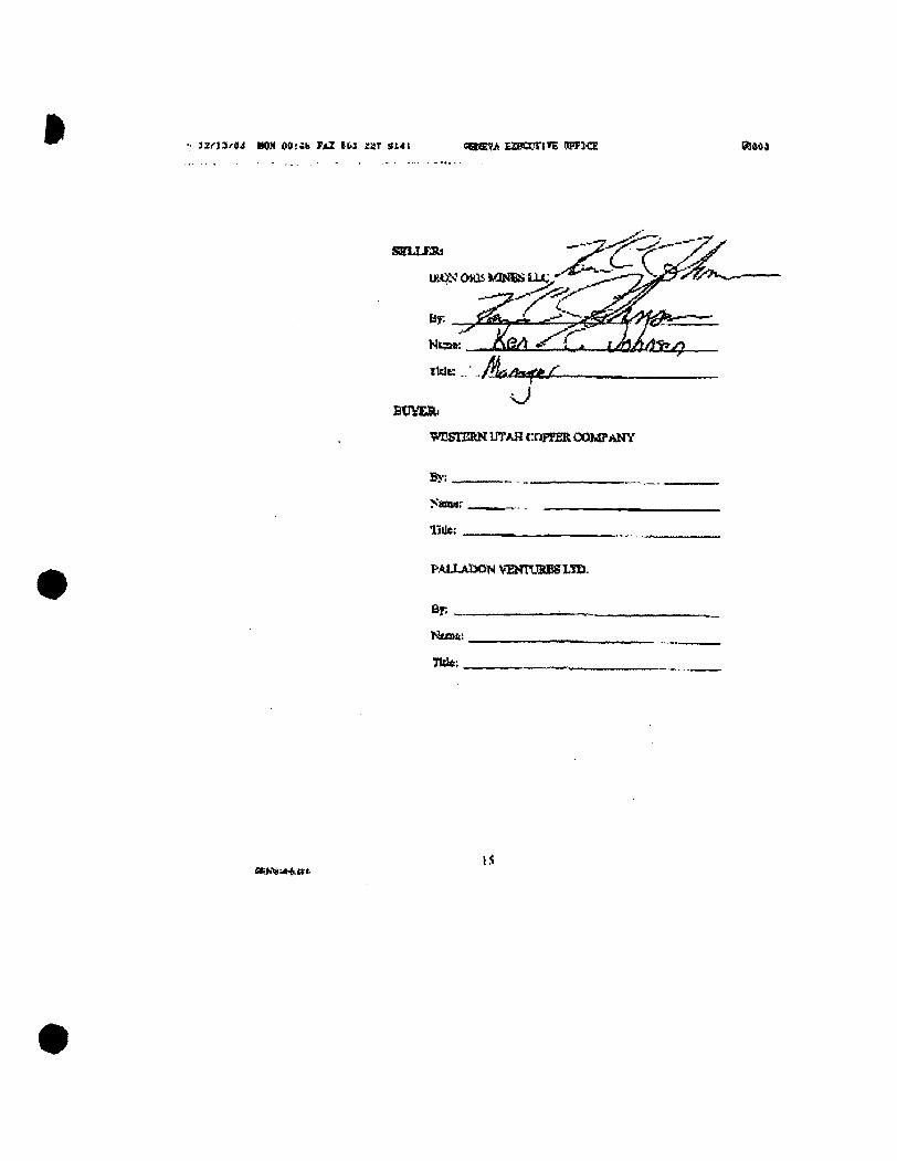
M f l ' i ' i i KW 00!4b Fs2 Ibi xar 3t4t caeEfii ES!a?riTE DIFFKX 0)404
SELXERs
LK.ON' OHli ivONCS LLC
^ ' ^ ^ ^ " < ^ Nt3»: _JlSiaijSL-_L- UHA/lSl^
o BOVEA.
"WUSTERN UTAH cqpFER CXXMFANY
By:
Namar
Utte.- .
PALLAIXJN VamjRBSLTD.
Sp
Mun&i
Tide; .
x v ^ J i ^ a t . IS
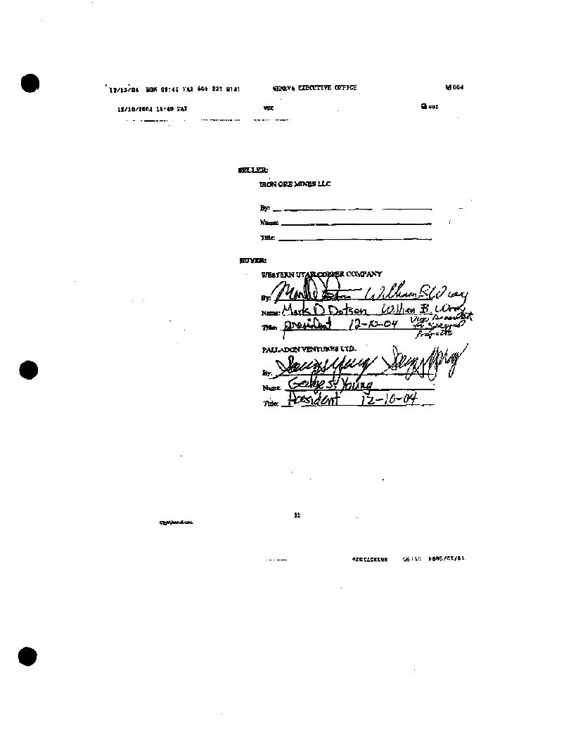
U/iiftn, note 01:41 V.U **» a t au i snotv^ eiEctrnvE an=icL woo4
Il/1B/Hn4 lS-*» TKX I K 3 B B 1
MZLLEB;
QtQNOPSVKNBSUC
By:.
lAbpK .
Tide:
jBTItMlb
PAU>J»WVINYU*'M WU^
- -- Jf^gj?
«EKti6Ei:«e 'Ji i ': kasi/Kt/ai
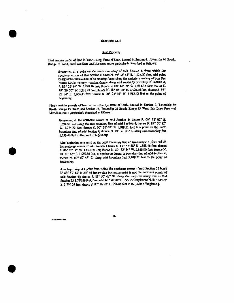
SiAedulu 2dl.1
XtaJF^mneKv
That oestoin pa r« l of lonH in Irun Ccuiug', State of Utah. t*««eo in Saetion 4. Jo^nshjp 3fi Soulh, Ronge l3 Wuiit, b^lt r jJm B s s acd XiAiCiin. mute p«eti«iSM}- dcKrihed as LuUuws;
defiiiming ol a paiui on Hv smidj bouudaiy of said Sccticd 4^ Hvm which die Hxdiei0t coonst ufeald SoeticQ 4 biarsN, V)" i ^ 49" E. 1.K2IJ.(30 lee^ -tud ptniA beljXg m tbe intUKUiiaii of an exiadnfe ftrn* ifcns the eaatcib' twiu^Saiy oflratt Ore Mines LLC8 ^iropoty: r u n : ^ dmjce olrmg sud aw^ieity bcuodaiy ot'SMlton 4 , <;. B?' 2(f 4<>' W. 1^73.90 lert; llieweN. OQ" 03' 09 ' W. l , ; i 4 J 3 feel; dJCMKS^ n r 2tS 3<r W. U U , * ! feot Uuai«N. OO^dS^B' f, / . A ^ - ^ feel; flienocH, ll!»' aa,' 54 ' E. 2,604.4? feel; dimci: S. i W l i ' 16" \V. 3.912,42 fiset na dw poinl of bcgismia:;.
Ibogs certma paiuels cf land in b tn CuucAy. Htnte nf Ulah, luvUr d m Seodoo ^, lenhiiahlp 3b Soudl, Ranee IS West, Kd Seclion 33, ToMiship iS Suudi, Raoee 15 West, Salt L«k» Bftse end Meridian, EUUIO jtrnuoAidy <i:vaib>fi w fbUomv:
Beginning at dic nordvosl eamut o i nnd Sesaua 4; Ibcuoe f\. W 12' 02" £ . [ J ^ . i 9 feet tkiae the east bnundary Ime of siod Seeihn 4;lhenuaN. SB" 3(7 2^ ' W. 1,774 J E tier, rtienoe K. 00" 20' fllV' R \ j S a 3 l feet to n pcirt on UK norlfc bcnrndai}- bne of add SeclLoci 4; Ihenoe N . S9" 57' 4 ^ ' £ . ainng said bumsdftty Ume 1,73S ^ fist Kl die point uJ b,;C»nnni^
JMSO Sn^pimrtT M n pnini CB die- uosdi bmmdaiy lise «f Sfid ^ectioD 4, Intn ^ndtieh die nuitiKas emner of a i d Section 4 beats K. Bit' 37 4S;* R l,SCS.44 fe«i ihenoe S. W 20' W W. I .fifiSJS liaat flience-K. 4"?" S2' 54" W. ;,«11,B0 C«fe dwnee X. flB'Ul'+S'fi, l,li55&lfeet.wnpninlnnOBiiH]iJlbt«inndniylincofba5dScctsmi^ tbenee N. K?" JT 4ff' 1;. iikm(; gflii bcunda^ lid* XM9.72 fcei » lhc pdnt of betfpwlnc.
A l » bepcsinic al« (Vint &nm vtihich Ihe snulhesl cunKr nf said Secdun 33 bvfiOft N. W 5T 48" t 150 ifl feet (vfchith be£iniuas puinl iJ alaC" ibe ncctfaessl ( « n i « of Hiid Section 41; Qsncc S- R" 57' 4»" "f/- dcaig dw s c a b Vmncary line t f said i5acrinn3i 1,738.46 fee); dienoeN. CO' W 11(1' C. ?W,65 fecl'.lberoeN, B9' 58' OT E. ],7i=OO3feel;lbcoetS,0ri^ lfi"2S"Ei.'Wi/46fiaei«id»poiiUofbepjmiing,
16 7,CtflM*<Ase
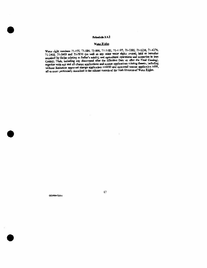
SebodulB 2.1.3
Water Tt-.Bhti
Wnto lisht numbers 71-15S: ^ l -SM, 7]-(H?l, 71-1181. 71-1197, 7 M 2 M . 7I-1234, 71-1279, 71-2402, 7S,.340iJ u d 7l-JRl.i (as i«dl as aqy otbcr iwisr tights uwnodf held or neieufler auqiopwl by Sellw relfrttng tn SeBer's jutolnj; imd aj^iuulnaiwl rvperalianii and lUOpcrOes in Iran Coiinij-, Utah, lucladina a j ' di9co\wrcd after tbe tfiectivB Dme ot After ibe Pinal Ooiane), Ireeiber wilh stO' and all chaniiL atvllwlimia and nuuiwe npplieaslcas rawing OiesBto. iaeludllie widioul liauifltian appru»«J duangs iqsplicaliou nlddSO m d KppiKJved notnise app&atiou HilW, all as luece i^tirricularly uraajbed in die olEiisftl rsoordj; of itfi- \ ltah DiTfUitn of * 'u lu EJJJIK.
C£H444-Sjd»
Kthedufe 3.1,31
Thnce psMciicd minmg fJaias, iinpesenlKl uiiiiins claims^ and iidwr londi, loetitod b Iron Count}, UUds. dcsajbed on the fcllowin^ 1II puce*, ingeiiw wirti any rKher tusd i-'topeiity ovtxA, held 01 hun^fhr ocqinnxl br. Sciler recatinf; in SeElBi's ra^ioti. i "^ cgriLuUutal ofiesatiDns aiid prupwGea in Iron Cuinii>', tilak. iDciudiss nny dSsw-Tawl aftes die tUe^^rtws TlBle er alii ; 1lw Final CSusing.
IB tSeWCWMih;
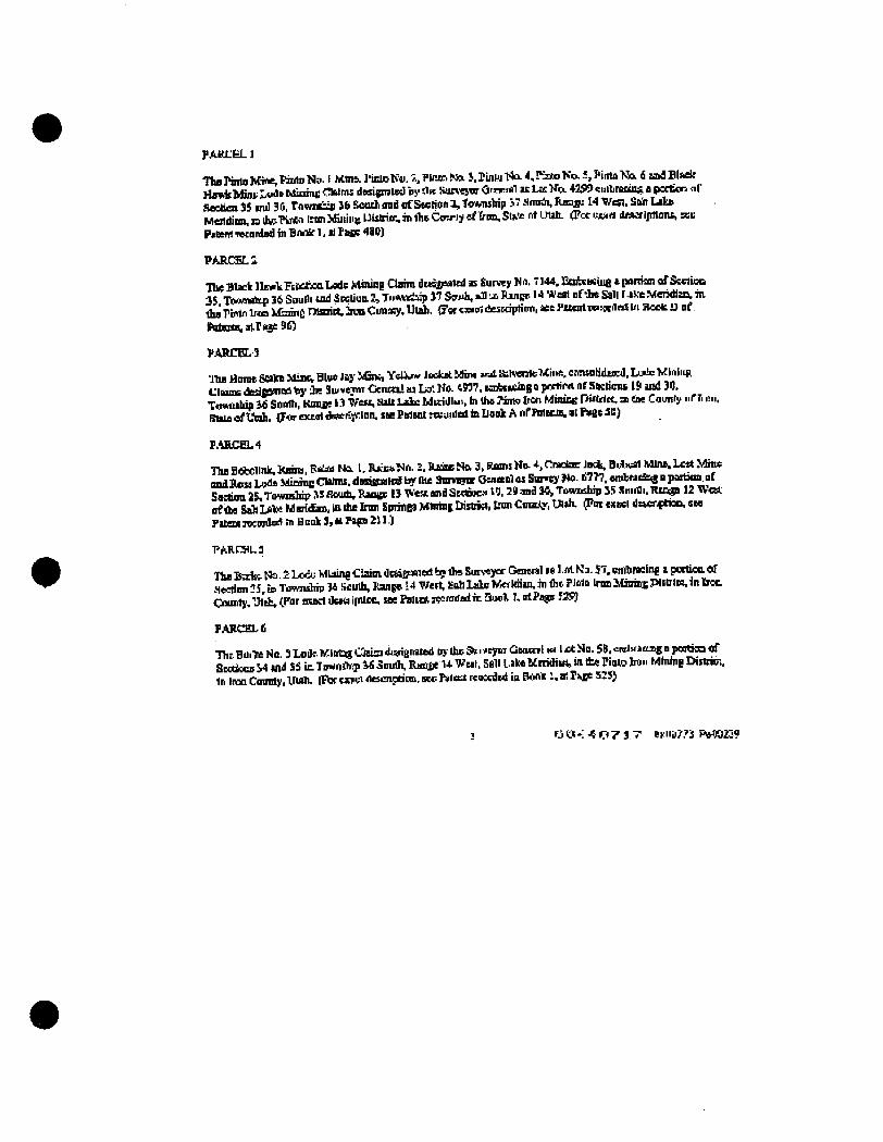
PARL£!L]
Tha Pinto Mine,HnlDNs. I MfflA I'intoKw. *,Plmr-Nft J. PinUi H i 4, Kato Ko..% Pinta No. fi urfBlMlf Hs«kb&it 'uvif Minme Chlnu desijml«I by (IK Suni Jinr Ounrrtil t t Lac Ko. 429? eiulimninji a pactioo <ir Stetea 3S md 30, ToMSBip Jft South and of Swiion 1, twfcnsbip jT -Hmiih, Range 14 Vest. Snh Lita Mendinn. ia itajTVnw Imn Miiiint Lllstrim. in flis Caviy ef frim, Sl** nt UUh. (Foe u«;4rt d«srlpllant, sec Pjsem TetonladinBnairl.tiraGG 481})
PARCSELS
TTfct Black llewtFtwrfjcnLsde Xlining Clamidt»i?6tf«ltd M Survey No. "144, BoAxKiue » pontan oTScctioQ 3S Tbwnatp 36 Soulli u d SPSIIUU 2, J u t x t t ^ 17 SjT*>h, *n a ftjjiBr. 1« W s t nf-ie Sail r.-iKe Merahia in duiPirtn1rMM5mncn9soiet.JmoCimsey. Utah. ff«tjBii«dessdpti«i,«sl'*BentwwlHSUia«tO of (WBita,airKie90
PARCELS
•Jhe Hume Salm Mine, Bh>e lay Mins, YelV* Jockst Mim « d &h«i3lcMii«i, crmtnHditcd, Lt»lc WInliiR auBBdKips iBl t y fe Su.«TOr Cfcnm!at L * Ko. t n ? . BSEbtseing 0 pwtirw nf SKIicns 19 ind 30, Tflwulria ifi SoBlh. Knnae 13 West, HiU Lshc MKidl"V hi ths Mmo Iicn MinicB Piftrtet. m CM Caunfy nrr. en. BtsiaoifUah. (F<»exefl1**eK^lnn. SBePalsntrtvuidolinllookA nfPnlBcia.ilPi^3B)
F.UUCeL4
The BeJjClInk, itjnii, F * ^ Na U JliawNo, I. PJUK NO, 3, Rams Ho- *, Cmelaar Ja*. Bi^x^ Mlneb lest Mine and BASS Lods JdirmiB CWmi. dgoupsled b* Die SBrvawor Om<«rol as Svrv^ ^o . Ii777. u e h n t S ^ a partimi,Df Saitioa 2$, Township SS Sonuh, RanBc 13 Vest and SHSDOC*. ta. 29 and M^ Township JS Smrili. TUngB 12 West of da Sah Lite MaiidEni. in die Iron SprinfiS Mtntaj Distiisl, tnn CoiaAy, Wdu (Pot cxacl OtwrftioD. S H Fitem rocnrloA hi Honk 3, It Piga 21 ] )
PARCaua
lha BaSst. t*i. £ Lcce Mlaing Ciarai dtt»£f*nd byd» SuiNtyor Genwiil » l . « l Ka. 57, CTfibflKhig i portifia Of aectinn IS. Eo Tomidiip 3* Kcudi, Itan^e 14 Wert, Koh Lale Merhfiin, in dit ?i«tn Inm Jifinint Pl«irli«, inlroc Osnnty, 'Jt'dv Cfor auct dssu ipUcc, see PalH* paraded in Suul J, o lPa^ J2S5
PABCEXIS
Tbr B u i ^ No. 3 Loflr KlBt^S CStisa 4i3riBi»ted brj-Ihc 9^'i'eym GBOOTI Irt 1 xt So. SB, cwJrfifla*g B j » ^ ^ Sfiodsce 54 tnd SS ic- Tn-mihip ^ Snufli. Ranfis U WBJI. Sail Uke KtriOiHi, in the Pinto bon Mhitng Diittim. 1n Iren County, Uudi. (Por cisei dtsenndmi. sec T*i«tt reoacdtd in EWyili!, a! ^^Be SIS)
O O '! -« O 7 3 T ei:iiil?,'i P\*(02J?
PARCHl.7
Ibe Hudce He. £ Lode Mining Q s i u desagnnlsd by tos Sur«CT«s Oencnl as LolNo. 59 co-JbijCJns » pnthm o^ Satlioe35,Tw*iiiiluf 3feSouOi md of Sectioo 7tIHlawndiap 37Suudi, Rsmfie 14 WeeL SaltLdtaMeridian, b the PKto tpcm bSminK Di«iiin h iKin Cnunty. Uuib. (Put CMXI dtstiiptioc. see Ps'xnl rtuwiel le Hook 1. K Pa|!«5»)
PARCH, a
The CMI: Prselinn L.:>ie baimi( Cfaim, dcdfiiiMed as fiurni Ku, 7)42, enihrining I portion of SeC««t 2, Tow^rip 37 S^ffi', Hinge l< Wes cf dij Eab LtlttT/lerldlsi, a die Pintu LOj Mining Dumol, Iron County,. UU)h, (Pore)utldes:Tipiluo,ftt Faiinl retcrded inB<i^itrn nfriliaH,atFai:e91>
PARCEI.9
AnnndiviA;^ 17JKaiKiectinandlDdir ri;'l'i>«flo[i:
llie Ciacinisli No. -'' 1 J de Mnmg CItia sf iKti]>iMt£. by the iiicvcifla OUUPMI us Survey Kb 5040, ddbnixBS a portJcn of SosdooB 27, 38,33 md 34. Ttnrndnp I * South, Jtmge 14 WB«, Salt l.6lDe Meridiin, in dw Kulu Ttoii Mliilr^ DtBsict, fcim <»iity, Unih. (Fcr ewei destrtpUm, sia Pttenl Twxnled in Bnot J. a: Paps 28(S)
PAHritL 111
Tb&OiBi nn tac Uemposy TnetiftA 1 n te UhrtngCliisA doicruted bydie Suncj^or Omimil ai purvey Ko, fiBl 5, tmbmeieg a paclioa of Sertion W, Towsiip 35 Soulh, B(«ee 12 Wnc of the SiJt tA^Vki 'Mia, in die ben Ejcine* Mlamg Dittiia, Eran Ct/srcy. Ush. CivresKi deampdaa. sea Pitanl rwMr dot In Bent 5, at Pant
PAKlOELll
Tba PianoeLed; Muung Ustsa, dsajptaitd by <1« Sar^ajm <jmKiHl m Hmrq^ tJa. ii72ti, «nihi»sing 6 pnninB of iicednn 29, TewaSrir 33 South, Kings L2 Wetd Af Ihe a h Ld» Mmuiiaii, ••• Hie Iroc SiprtiasMinini: Diririei, bwiCounty, t-Tah. ^urc>a*daieiiptiai,sierrtwr:recnniBdiaPo*3, mPige ITE)
P.A.fiirEL 12
AnmuUndul 9V. HMnA m md ID '&etHVMlne',
The l^nddi ip Tip Lnie bCaiitg Claim, cesijpalcd hy Ite Surveyor OtnwAl * n « No, SC3B. embianoe 4 poitkm of Section *T, Tt-nvuldii Hit amrJi, Kanjc 1* Wtsi, SJili tdaMoid i in , in Uie PUito fam JrCinini: I>ist*l, InawCMUUyafhWk&imiirflHsiia. NOra: PajoiticdieslsahCmmty. (FcreatfldewRjnocKtPatBm rweided in Book 3, tt Pist- 2B9t>
P.UICEL13
Pie (iem No. 2 Lude Mlnliifi f^ilni, d i ^nued al Suriw Ha. y iM. cmbnidiic i. ponion of Soclions 3S H»1 36, Townsluy 3S Sciah ana Sjelion ?., Tyt/hsMp 3t Saudi, ill lii Kange IS West of Ihe Sfch 1 dke bieridiu. b tat hOD SpriiiEJ hfIfting lijBiio. Eren Cui,«i> V^li. (for t«tel dfteripace, sea Pmenl rworded In Baofc.4. u Page 15)
* U C M - ^ O ? ! ? Br.0a773 PoOit2*0
^ A R C B L U
An undivided St»t intaie^l In snd «a -ftc fulkwiau:
TlK bnn TQII Na. I UOe bfinm{; Cbim ^dgnued u Eutvry Kn. T l l i , embiudnC 4 ponlan of Seaioc 31. Tuv,w*lti Ifi Smrth. Waup 13 West tf dit S»U 1 iiTte Vjeriffiin. ia foe I?tt1a Inm MnmiE Pim in. iron tlmmty, Utah. (Put tJ«!»rf Apmiptoo, MW Pateu ctoanlad in E « k 4, K PaW ^ )
PAKCELIS
Tlie bBG Smdsnxc Minev fttso Eandilioe Kft l and hon Saiintume rtactiun LoJe MWnj fadms. dcciunatoj IB Sur^ta-Ko, T22S. eatewbit; i lartlon OJSKIBCO^ 27 snd Jr., Tou*i*ip 36 SouOi. RsnftC 14 Wen of ttus Sah Laka Msridbui. In the PintoliOft fdhiing ffiBricI, tw , <Xrsi.Vf. Wah. <?w etam fleBeripilon, tut Piaent meordHl in Beck A, 31 Pass B^
PARCBl. \ t
The Cmn Venice l.nde CMm disignsledby flit Biweyw GecBial W Suriisy Na 60BB. snffnKhig I pnnioa of iseooa 30. Vewreftitp i i StniDi, Ttiu«e i l West of nl*: Sab Ldta Mavdisn; a die kwi Spnnfi Mining IXstrist, boc Counly, Wsis. p<oc cj#ci rttscrtfibact sw Palo* reoocdod in Bwolc 3. at P g ^ 33)
PARCSiLlT
An nnflMded i&A inieiis m and lc nr:. ftiVliimiE^
Thi Ume tbp < I. Ume C q i « , Lame Cap * J . time Ctp (W ond Lime Otf t^teliawl Lode VE-.^E i'Mtix. dsaiBtflei M SuiUyKos. 7 i lS i rd 7J Wi, erataatia t purlUm of Jltctieni 34 aid 3 J, TVimja-ip 3* BouBs and BBrtiun 3, Towndrip 3V aondi. la in Bane* " W*n <tf Ibe S«« L^l* W<;n«»n, hidm Piato bun Mifthi Iron Op*Jly, tJU4»- <Fcf eitel diecnrH™,«« l?MMtTewrd«di hi Hook 4, sl Pbiet 2ti)
PARCEL IB
Ttoe lJ:lle Mennon ijode MV.1r« t l i i i , flnipisM hy i s Eerw^or Oenetil ai Vx No. 5J. eohraant a pnir«i of Seation SS. T\»wriship 33 SffaJi. Kangs 12 Wral, H»b Lake Meiilan, m the Ircn ^ logs . UmiajiDishiri ;-> Ijrrn«mty,U«h. (fureiuKideBCiip:lain,seePstfttffeeBrdBainBo«* l , s rP«B5Sl)
PARCEL l»
Ths Lone Wcdtt Lcdt Mining COiira, dMiipiiwal u Sunvy No. 725&, embnu i i a eoracn af Stetiun 3.1, T c 4 i « ^ 36 Stfi(h, Jtmst 14 Wen nf die Sdt I J 4 C Medditn. in d« PSKo h«J JCnliifl nlsffitt. boe Counly, 1,1fli. (for csuiti ijeiinpawv » « P»"nt rsomdad i , TW*k 4, at P e p 2nij
P A S C E L M
T h t M a * L * 4 >1.fi.ftL.*!J«iilMAAU«lAacMiningChlB*»ileiapBta:»Reivey*f1lll9.tii*icttloe a junlon of i « ^ « and JS. Tfl*.*dp 36 Souia. ?»».£* 14 WsM of Oie Sdt Lali; Mtridim, In ± B JtnUi Iiun Minicenistitet booCtoEty. 'Jtzi. (FOIT eiJHdeicriprtun, (teI'ats::nsofaedInBtcls 4,alTujf: K'Jf
i C t O ' i - J i O ? l . y Drl'n^?^^ Fni'.03*i
PARCEL 2]
Tha NapniBCP FiaztiaB Ludc Muitut Cbina, deegMlwl as Survey Ke, 7143, nrAciiClne I portlnn of .SeAein2. Tovmilhlp 37 SmOi, Htngs 14 Vfest uf lbs Sail Lske Mciidlsc, b dia Pintc b in Minics Diitrio. Inm CUucIv, Utah. (For<aacldwaipilan.seel<iRentr*cotdsdinBcu1(n iirPaiAitj), al Pneem)
PARCF1,32
The Pinto No. 7, PiE*« No.«. Vtm Nn. 9, Pinta K& 10. fi^lu K M 1. Pirac. Nn. 12, PimcNo. 15. Pimo No. 14. ftrtoNo, IS.FbtoNu. l^PlnuNa. S7.PimpN«. LB.Pini^Kii^ l<},TininND.30,PbUaMcL21 izdPintoNa. i l . Lade Mining Clainu. dulCMltd hydie £un«yar Oecnal as L«l Kn9.4336,4342^ 4r>h<) ind 4^99, tnAEBChuj « |iujii<Hi of JlMlloiis 2 md 3, Twivhip 37 Renlh c»d of Sectics 35, TeniuJup 3A ^ i i \ Rsiiee 14 West Stii lake MsiJdiiiu. Hi flis PJac bun Wcis t Diiiri^ CUaity of Ireo, Uldi. (Fw «t»ei tUner ^nkm, let Patent Rcotdod in Buok 1. ai ?i>V **< )
PtMC&Lli
Tbe PicWft KQ. 25 Lndsbfinme CWm, dsslgnMed is frirvey Ne, T^cc-, emluwuig e jweiinn af Seetioa JS. lWii»1iiEi3£i!lmitb,lljnKe 14'Wsiti^ti>£ HallLskaUaridim.in ihcPhiin Iron Mmtngi:!t9l»ct b-n Counly. Ulsb. CF<* etact deiwiptiaa. tu: Punil leecrded biDmdc D «f raicnh% ul psfie 2 « )
PARCBLl*
Tha Piochs Lode Mnmg tloim, de^^BKc- by (he Sicveynr Uennal ts Lui Nu. 53, r^nlmtetisE a ponlan of SwIiixiA 29 and ^ XcmzA^ 3$ Souih. TLugs 12 Waal, S»U Uue MeT> im, in die ITK. Spiinp Mlnlnj lliiiriit, Irrai CDuni>-, UtdL CFm emu •Issoili.'oet:;. nc Palcnl n»>vdU iu Boot: I, u Ps gs 5^ fH
PARCEL 2S
TheRiriniFiiulInn Ladab£cmGClMDV<^iB::aladuSuTwyKOk fiR37. :n±rutninpKt»Qcf Sf«lien»29 (^^ 3C^ Tenkiij3-,£p 33 ia:£i, Rame 12 Wm: ol Uu saitLake Mc^liiri, In Ihe hvn iipiinp Mmku lAaiiei: iioa Cnnnty, Ula& (For exioc dcsaipixn, t t t Pment nowded in Bosis 3, M ftgt ziSff
PARCGL2ti
The Rea N a 9 LodeblimnE Om». desipitted as Suney Kn. 7339. aaibiiJianii« pur.i j -. i^'itecslca 27, Tuimsbip 3* Sffjft, Kamge 14 Weil ftf die StJs Lob Mcridistft, in Oe fii-to boc Miracg Disiriei, Cmn tJoeiigi-. Iftah. CF(H«aii:LdeKiiptioa, seeF^iiaOKianindiB Dock ;i]5,iriPtge«93)
PARCEL ^7
Ihe Kndfir Al. Bvdjti n uid Kod^ErM Lode MStSttg Claims. deiiicmMd t t 9uve / No. 7120, sdxac i iv h jttllon of SeEtxni 26 *nd « , Tfronsbip 3fi SouOi, H i " ^ U West, Sife Ltiau Jt-riOiiin, lii t * Pbrtn ten i i ~ m t D^biel, h t a C^auitjr. U lu . (par esiaei description, sue Patem lemrded ui Qook 4, ai faga 84]
i:is-.-c JS.<; 7 t T" f- i i J ' r i rseiiStJ
PARCEL W
Tkjc SunAreunNai. 7 Lode Mining Obim desipBtod as 5ur»y Kc t i i i i , tnitKf eing s pccuoe cf Ssciien 33, Town^ap ^" Snnh, Raiac 14 Wc<i uf liM SAH LdutdcEidiKs, in He Pmio Inm IvCiniit niurlcc. boa County. Ulah. (fer nscl dm^.i^oa. see Pnenl nrnrdcd in Ronk 4, ai Pifs 232^
PASCaa i "
The iiunbteEs AS U ' ^ Mnins Claim, KIKI>«II um tLt^igsrui in fiK I ^ I I K of Liaii MHiiizeiociiL Jmied SOtes nepirtmmt of du biimiur, u. Paioifl Ka 1123130, .fHaioi i=. £SB Tsto b t o Mmmg Distrisl, Ir^^ C.vjiey, l.'cih, as ^cterilKd ihtiein.
PARCEL3&
ThsVerixBMsLDdcUiiili^C'iauBdfidEniUidln'ihrSii.'vegBTCeccnl tt<J.otNa. 53, imifanrtiiigsporluec^ Ssct)aa30,Tcwssbip?3 Smnh, Heaje U'WcM.Siii tJiketiJcddiin, in Uw iiun Sprin^j Minlnj Olitn((,imn Ctvnit, 1 foJi. (HIT eaw; /le«r^wan. sea Ptwnl i«:«rileil tn iJook : . sl ji^ee iJ4>
An nndiiTifiid 17,5K xteieil in and V> die faHoniag:
T b Vide No. 2 Lode Mmz); Cliiii^ deflCMted hy Ihs SunKju Obieial as Let Nu. SOd'J, Hi:fctKinp a pofticn cfScoloii 3fi m527.'Inwiislepii Sooth.l^Rr.pe U West2idiLt^c Vervain,bdxHTIIIIIrcki^MmincI>ishisl, bun Cu.«V» l-'tib. {Ta Hua» (iescciptxcv'w ''**"ii reeorflsd ia 3cf* J. at i'asa 285}
PAJWTHl. 32
Th< a^ntt. t^ytbaat, IJinrieuie and Ccyeitl I JI:1= Minln); Cldau dnit<iiiied by dx Savefw Cieasral ns Lot NCK 4310,4344 ted4351.emmauugapunJucuOecnnL 33, TD«nddp3E SMd^Kanns 13 We9:,andafSectDDD3fi, TtrtvBibip ?6 Setsch, Kmcc 14 Wast Sait l a i c AM^'an. :n ftie Piah; }r<a Mmiof Distret, In the Comity ne inc . StM. nfOtdi. (For exacl liuui iption, see Prnmi rcrnrdefl in Uo«k A uf Patents, at Psgc 4!l«>
?ARt3U.M
Tbe Dun t-tdit Unnns t >•*-'> i:^gnztBd by ds; Sm ^eycr U s u n l s 1 ju No. ,±4%, cmbivcine a pmbca of Seclion 30.7iivndiip 5$ £uulh. Hangs 13 Va/i, ^tli !.ik; MantUui, in die Plntc Itm Minitie Dlnriic, in iha Cxujrtj' cf Iroi, Huia of Utah. (For euot deiaiptiun, Utt Pa>HilTKan'«d In Hook A cdTalcnty, at Page i if}
FASCXLSi
Tht nener No I Loile Mhiing Chiic diaicaud by 4K Sunre^or CicnmJ ai L{H K'^ 434^, seiteacins ' putkn cf ScClioii 23. iowat jp 3* Soofli. k x ^ n i4 Wc»i. .<Jal! Lake Xteiilii^v A d » PiJto 1P*I Uuskig Discict, in (be County cf Vue, livta «'Uwb. P'or eicaci deecriFliuii, *:t PatHUTetmOcd in Ucok A uf PMents, at Page 5 i i }
PAR.rKI. 33
'J1u.>i>U'n,'D_>jEnNM. 1.1^M}e-Jl^o. 2, Cnijnrn Vu..: ouSlluhitiNo. riIjodeMiimi|:ai.t!iEid»si9uudbyths Survcf 10 (Jsoerjl KS J m Kos. 4267,4335 ut!- 4.^0^ emtcwbie n t»r(iim of Sie<*i.-«* U And 34 in Township 36
Suutb, Konge 14 Wtst, Sah L d e SduiidiMk, A iHe Pinto bea Mining Dbmcl, In the Lcuni; nf iron. Sots of Uiih. (Fm txici d«Knip:inn. see ?aizm nKodcd i i B«k A nf S^stenb. i t Piet K12;
PAW:m.5(i
TlvLKcb and Uij^glLaieHliiinsClaiics designated by the SuveyorCenanilstLulNui, 4)11 Mid4343, crr^.nodlit a pcrdon nf Stetieoj 24 awl W iii Tti-uship 36 Seuik, Ranee U Wast. Stb Lake liicridian b die Pii*i friin MInInt rjismcl m tho Counly uT Inm. Slew cf Utah. <For «aiKi dascrajrtion, saePattac mcmdf d in Booi A ofPwms, K Pa«e 3(n>
PAIICE:-3?
The M':ij:««lii t.1nn No, 1, Mcuolnn lawa t*f*- 2, Mouniain I k n Nu. i , Mounliai Lwo Ne. 4 asd BiiCTE iie Lode )i23in8 Climm'SeclipHted or dit Sizvtva Oeiiemi OS Lm KoG. 4266,4312 ond 4429, fffifatiomg a pnitim, uf bewim 19 and 30, T6w«*ilp 3* Sfcuth.taBCP 13 W«t and af aeedoe 24,Tkwuililp 36 Saudi, ftan^ We#l, Sch Ltka Xferidisn, id die K s u ben Jvtinms Di£t(ioi. In die Cvmly uf tuo. Stale «ruii t^ (For cnaot ^icteiqiiioii. see PaxminDoskA ufPaiffM. ol P t ^ SIOQ
PA.RCHI. IR
TIM Red Cieiul I i i ^ Mem^Cbim designrUid by Ibe Sur^eyx Oenctrl 091 K a dO, eizbtainns a pocasBi e^ ilBttioQ 35, Tewiaanp 3fr ikmtt^ oai of Sr^Sw* ^ Tnwidiip 37 Sn,ili*R"iiee 14 Wat. Sab Lake Meridian, m. 1he Plnm b«s MiWrg Kjnie^ Imn Cajnly, Uob. <F« oact eesnipliw^ aer. Pmerx hi lioak 1, at Page 531)
PARrHl-39
•Jlie Mi^^kfiM. lUa No. I, H«0( N R 2, lUxNft ^ Bto K!L 4, Siw Nw, JS. R«K I>ln.«. Rm No. 7, and B M Ludi Muang CJBiics 1* rf«ien«iol by Cie Sumajvi Ctiiefsl as Lot Nos. 4309,4«5.4 J70 and 4402, tsafcracml; * jHirtlnnofSKlinnj56i.Z7,J4iadJS,,BTDOTdiip3fiBou£i!{m«t 14 K p t . SaU Ltke Meridian, in dwPi*) Inm Mtfdng TJisaiBi in dn Ceuotj' of boL State cf Uwh- (Par asaot d«8erjj*a» se* Patem tn Boot A of Pa-.aUtv alP»tji:4RR)
FAXCEL^
Tbt iHwalE^d Ttaot Lude Mfa^ Clcim dtEiB:al"l hylhe iAnvegicr <itmisti ai Loc Nc, 4$Bfi, caAxicini; a poi^^i «3f Berticn 19, TvttsiUpp U Scudi, KtcgP 13 •WcE EaltLaite MwidUc, to i x P t a a b m Marine Distrift, in Ihe Counly eflrim. Stale ofUMili, (For exuil dHGri|Hl<0(V 5« ^ " 1 in Tent A of Puenis, at Page 54)
f ARCSL 41
n « Irea SpriuBd PlaM Minhig CrbnnshuBtB in (be Iran Spdnff Miane iJlimat, ttna Cuumy, L>ib, d « ^ f B the Norieast quttlw fflftle Nnnheatl q:ai*a, tbe North half of 4w Soulh it*1f cf the Norieasl qmrlir. md tha Lab ! «rt<19 of aBolins 29. Tuvnidiip.« Scudu Ranu: U Wea, Sth Lisa MeiiiJitn.
l.FRH AhiU EStCESTmO H strip oif land If 0 fcei « « e toa»eytdbr|r Columla Stsel Cmpantioa to I M AngeleE 9nd 88alt Late Hziiuad Cuwpmy by Deid ^ t sd f»f* a t . iSad (S« Titvd K:arded in Bank J ofiinafe, M FBB« 254) AP«i»nnsctno«efiS*tftlIftWJ!?PMTisls4, H), j l . i t .25 acd 41.
0 0 4 4 0 7 1 7 Br.n0773 pBft.li44

rARCBL42
Ihe rfJ., MeCihin Ko.}»Musday N A I ami Monday No. 2 Planer t Jh i i ^ Chum seKdtt in Hie PlnHi hyat Mining I>istiic:, Iran Cnunty, l.'tah, and desci jbcd ta feOenm
(be N.l, Qslni eemprlElc^ ihe Kcs di liUrafdK KurdKtsl qjuiilErif the SoodiwHl quuler, the ^^cth litlfuf ih« Ntjnhw,<!!4l quarlcr of die SnirfMast qustlR. the V/esl ialt oi UK Ketlhtut qnaner aid dm Ux r^jmbsmil i cf JvDion 26 Toi^ship 36 Kud^ Ranp 14 Wesl, Sidl LaJm Mendian;
die McCaldll Ho. 3 Cltuo eainjirisiiig lir; Nmili-wcii iiwrter ufaaid Heeliuii 36;
fliE Voiday ^4o. 1 dain: ocr^ccisisK \ix Nurthcast q,u2i1irof tiertion 27 of said 1 omnthlp icd Rs.i£E;
End UM Mniukiy No, 2 Claim olmipiisias die KorUi Ydtforitit KoiihvH! faancr; ihv Sovsjxut quarttrof the Noia>f«i; t^iufla, wid Eaul hair^vf Ihe Si/ Uiwcyl qsorist of (hv NutlhwEsI ?iar!cr oTsau Stttioi 27.
PARrKI.43
A l l l i l iA iv i i lu l ?.i3 inlcFcdtl i n * I K 1 10 t t ie T i i l l c ia f r^
Ti* SonihaMhaHoftbeNectorPaeerMiiiiz^ Claim livmtsindu Imn Springs Mining l>i9ciat. Imn Conriiy, Utah, somprifiing die Scu&.mo'. qcolcr of SeEi5oo 20, Towmhip 35 Sosdi, Rapge 12 \iitfc, Sah i.ake t<ta Idiaii.
PARCRL J4
Ijout^6,,7..Smifat!!eellC4i.33, Voa^Khip3li StiilCa,Hiaff: 14 VzO^SillZjio:Kcni*tni,Ina CAiinly,TTtah.
PARCEL 45
Lot* 13u 14.13,1 ti Kidi 17 cf Svdicn 33. Tunndrip 3d Suvh, Rv^c 14 W<ii, Sslt Lake Moiduc, ben County, UudL
P A R C E L 4 4
TlitKisrlliixntjsjiicei of HeuJfut i I . ToQiTUltp 36 Homis Range 1 ^ Wam, !itS Lake Ibaerldlui, hodCkuiity, IRUi.
PABCJJLsrT
ThaKoitlihtif nf d:eKorihwe!tqDBlBrDfS«!tim32.To^nEadp3d SoudtKanes 13''A'aei.SaltLake Soseond Mejldls;^
PA3!CEL4S
Htji'^op. jisrtmtedLodeHaaxsdaiai Lif.Ko. 56.eiralsd aiSesdon 23,Tosmihip i6 Sim&,Kanse l« V^es:. iJtl: I.Ike Bite ond Meridian, Pinta M^JTg Districl, Irce. Ctunly. Utah. (Par Rxart dsKfydnn, see Pitonl ceumivdPdmiaT} f, 1«t1y> FiOiyNVw ID637hiKr4itr1 nf Ulnln£ l>eBdsupage5WcfIhe oflAcinl leuadtfir the [run Coictj- RvitnOti, tluih.)
S ; - : - . : J < . H . 0 7 X ^ iifiU/'J P5l)J45
PARCEL 49
Hlink ban Kci 1, psremed Lnde Mminu ChlOh and Qlackbrni NA. 2, pilBsged LodeMiniiiG 1 :itBm, Smrrey K(x 73*0, oihiited in SastiaB » i n d Seclion Sft Voundilp 3ft Souii. Ranoc i3 Vi i l , Salt Lda D u t *nd Kteidian. Pinie Making Ulstriot. livn rwioty. Ltah. ( iw w t f Aaiislpnoo, see Pauail <B:K1 atoduueaa utrcte) ttxinOal lursaty 3.1537 l i EhbyMo, 110641 In HoctD of I-altift ti /age Mii of diccniclii) reemdj of d » Itun Cuwity Rectxdir.L^tih.)
PARCJU.su
huiepBcdance bco. No, 2, (alioiBd Pla«f Mining Clahn, aTjateC- Ji Section 19. Lute 6 uid 7, Towahip 3i suum, Range 1J Weal, Sail l*ke tiikse and Mwidion. Jficui MiiMoc TJismiDC Jroc. Cavoy. Vuh. (For eiici drterip«l«k we Patia losunled Aprii 6.19a as bury Ko, 283 I I I fci Book irt-al Pa^e 949 orue Bill BBl tBCordi ef five Imn c:ciiirityRiMi:deT, t^lah.)
PARCEL31
U.tl Planer h'c. 13 nnd V.C.PIKBTKCI U,fmsntK PIswrr HSIniag Cluras, dmaled I;, tm 12, Section JO. Township 3d Soudl,Ranee " W««L Sab Laie iStse and Meridian, Paw* ^f^ua^ Pli-n in, ami ecenty. Uab. (See Pienu t uaded Janunj" 16. i * » B Entry Kft 1 i 1413 in Bnik )42 at Page 343 of On nfflciil rsomds uf On Jam Cbihny Ktooeder, Uldi!)
PAKJCOLS}
1fa:.Ph»ar:«ft. ia>LKita6d?ij(rrM*-JiiECIu=^ftw»l:>l soLotS. SostiOfi Vi/Vetntiapit SuiitURmge 13 West, SailLabeRase and Mitsidiwi. Pimo liin3;sl>i«'"«l. "*i Oommj-jUiih, eaea^ons wid eiutiiEng oil thai parata nTgrtWd enthmeid n miiiine -dainia dceijnsisdas Mnrnal Swvxy Not. 5041.3059 uuS 7349, (Sae PalenlKPocdeilNownibet 16,197?si:ESUryNn. 165743 In Book 17B*iFose lfi9 tf fliarrfnei.liwarescfdw hoaCcuityllBwrdtf, tJodt
PABCa£Li3
A l« 666fifiK.lntereslittIhdti«naenEelnmNv. 1.piseitod Pbter MbungClam, wtihfMfligdieftUowini: deHrib«lpropsflyiihia66da:Sfait:cuntj-,SlBleOflPah: Tht&«i WnfdieNaidiKtrtWorMeclimil*. Tosmsbip 3d Soudi, Ksnpe 13 WcJiij Hah l.iie Eite ami Meridian. (Ste Puem letcidsd April 12,1976 as iSnhj-1 * . 3 W137 in Btjck 216 «rt Pa^fl'ISI ef tK caocial wpfldH of da Irmi 0^•Il«y Reoorder. I h ^
PARCat 5*
Htwsn, patmled l.nde Mnrinij CiUixi, K:ney No. Vi'i4, tomprisinL * I'mdsc (K Lot No. 5C41, alraalK: a Stcii.oi 50 Tawnship M Spudi, Range 13 Wesi. aak Lake Bate «id Meridssn, Flnlo r-liningKiRiiei. Imn CoBay. Ul*. (For«neiacldwerilfli"n.wPa»enlfttonled:amiary22, I'JOtns EntiyKt. ll2Cl B I B O K A ei'PatemauPHiB 3S3 fi<tt»e cffwwl ctwodi af die ben Cuoiiy RocDider,LtftIi.>
111
PARCSI.J3
9 'Mi Migneiic, paicnUrd lofe Mjorns Odm, £uniB>-Nx 54. tUiamd io JeciicD 30, Tuwnlhlp 3b ocudk, R K ^ 13 Vwl, SM t ^ e base and Uenditn, FrJLo MUiing nisnisi. Iron OmO^, UiAh, {fr'tc exact deattiplios^ lee Pitemiecmdcd Jane r . l ' A i x EnUjNu. l!4343 lr. Hade 3!tU u 1 ^ 5. 3-3^7 nf fiie nfAoal tacnnta vf die Iccn County Keoocdec, Ltah.)
PARCEL 50
LastChuuH, patcnlft', l ^ e Mmtng Cbrim, SurwvKc, :i>fi3,mmjciiinK a peniwi nrs.ni 4'97B, sitaiand i t SRIIMI 20, I'owndrip SG Sculh, ^ f ' i t 13 WesL Sah. Laka Due iiid Mmdian. Pinto f lin(}TlU^1DC limi (jjuiiiy.llioli. •J'ccHUKidej5ripti(.ci,ae(:-^«a!ttcordtdJi«uary32,l<i06as2nt>jNu, 11 ISfi to Book A oif PaiBA; ai Faet 5S7 nfdie nffietal nxur& uf Aie ben County Rtctcdtr, thilb.)
PARCELS?
Sefticni Ml, 20,29 md M), Ttmi^sbip 36 Scudj, Ranfie 15 West. Stk Like Babe and Mendlia htm Cuuiily, UliK
juduaaj g-.nBl6eHaiap»wlrir'aiid<oiieeCeuBi). Qiuir of llwh. totaitd in DtUJiMi I, Tewaib^ 3fi CuuOiiItmni IS West, Sth Laki-Ba:ic icd Meridian, :i»ct,p!irtietlsfty detmbed as fulbukii negftmbiiiit i peal u i HIE Rtji ' ' ixxinrtaiyof SBcticn4,Teftnfhm3dSDB-iR»np IS Vfer_ ixIHSWhtflftWhlihOie SixKhia^ Soctian 4 DCH* K . SS* 26" aV" E. j,53E.6.T feet, saidpnacbrinif n dioiiueisedioa cf»i» cSlMioojHJwe lica^ du <&3terly bcundaiy (rf r ^ n e n Sted's pnqsmf, r.auiine r:«nce dcni laid sDiat^lly b a m i d a i 7 p P & ; ^ 2fi' 4S" W. \,l7a.<X) feet Thicsse N. IHI* fli' Ofl' »'. 1.514.« feci: Thence £S, S9* a i ' J p H v l ^ LS"! feet; ThtiiwK,O0ru5'irE,2.JiJS.44 4Bt; ThenceE.8?»»'34" Ji .2/0Wi6Hn7J>«SeSw(»' 23' l^r-flf. 3,912.*J feel lelhaijoiaimdplaoe nn;eglnningsdCDa6sirir.e "^-^ unH.mr te r less ,
PARCELS?
Thotsoertan picwiE ftf landinbcn Ccunly, Slileof dtih,lw<Joi!t B6ascc4,To««ni*uii Sn Smirt-.brrffl i ; V t n . bjdStoooBi ?;>Tewitihip35 Saudi,Rted* ^* l*;js<salt l^kt B B « ltdhleddiim, uaxc t«*(iis»llar]y deeiribul fn fliHows: J J s^ , :m; it lhc i«1haasi OOTtfcfSedMi 4, T. SC S.. R. IS W-, HLlUUi: Tbnu* S. OV 12' 02" H. l,S94.5* JiiJ «Vr-(£ rtie Etst bounduyliiie nrHaclion 4; Thtnee N, W 3tK 22" W. 1,774 J l feel; Thtoi* 14 OO'JO" •M''K, 1 jfifit.Sl fw!l lo/^j5lni cn diB Nordi btunfia^ 4S" P, i'«*it sad swndMy line 1,75^4<f*e110 die point tnd ptnce uf beinlnntrig md ccntdnisi 68-6 airts mcri ocliAt,
PARCEL «•
Afro I^B '^h iwt^ ' i a r t « i Ihe Nimh honadary Bat nf Seciiaa 4, T. 3d S , R, IS W , S ^ McrJeastcfa^urRcciion4btaisN. K* ST4K- J!. 1 .iOK.46fcei;Tlieneei.00' 20' 00" W, 1 ,ti(S3JS feet; X h s t z t l O i r i 2 ' 34"* V . S.S^n.JDfbst; InentsN, OC HI' « - B. :,(i55,B« ftti,in a pmm an du;Kiidh Inj^dSmy lias ef Sec 4; ITmLcsN. B ^ i^ ' 43" t a i n s taid bcuodnj "-"•* 2,849.72 feel to 6>t poln and chill of hipnminn "n" ciMiis^ine \ftiJ\ asrsi narrf or Innr
ll o o + * o r t 7 •m'fi/'n i-coi ai?
AIQIII agiiHiiiiii. liii puinl In— Wa^hlhi CeulJMutBWW ai MawaMiJJ.Ti 3S&I.7.. "•.? W.|1it.l kV SV 4 t "E . 653.10 feff. RildpntmitahodxHortbtMl fftmjTffrfSBrtird^.tUfctt-ir. i r ^ M J A M -TbetjfeS. 8?* 57' * 1 - w.ala«d»SeTdT>«r^3ijJUiM*flt«lJtffiT5T7iMfi ftel; Thanos N.CCJfi' 00" E 794.6(5 fttij Thtfj? H BSLSe-fr^rrTJ^IJifBBt Thacce S. 00" I t ' « ' L 7*1.46 fte! lo Oic pofiu atitf pUtt I kl IJ III'mil •^-•-••^'^•i-'n^-rfr m r m T t r ' - - •^•^'•'"vian - - •* •^••" '^ i««
PARCH. £2
APIUL LOD3, Inui Sixiujj Eimi«, Sar*y Nn. iCi i : SoutwiH •yJmer,^e3C^^D29,Tw^^lririp 23 Swiai. KJ19 12 Wutfu Srh l ,^c Hose acd UsiidaB.
PA1| f> l 63
CEKTt^RY Ktl. I LODEyfrvn %!iiai nisaict, iu^^tyK^l. SIIKR: Kcudsiaal iirmirtB. 5v.-iiwi iP.Tci*iid»lp 5S Soudu Rrnitf; 12 Vest, ^ h L a k s B w mdUttidiec
PAACEL64
MTJI^tU- tjUUDjImn Rt='^E!*tWttrjn.SutvtvNe. rilWK: anndiwctliiu»i!a, Secllcn lU.TewnshipSS SouUi, Rs^oe 13 W K , 3el: Laka Bi«»e end Mmdiic.
PARCELM
MX^RtMAC:, &on Spriagt T>j<.'ie:, Sttvoy t*o. 5Q%S- Mntth-iwea (juansr, SIKUUU 2'J, 7«i.nstap j i S>ouih. Rnnge 12 Vt'tHt, Htj( lake B»s ind Mtrtd^n.
PARCEL 6j
ROOSE\'lil.T, hon Sprig* Plrawt, Utrvey Nu SOU. SowieaBt t/ainti, Htcoaa 29.1 T*nskif 3.3 S«uti. R>n(>« 12 Wesi, S^l Lske ^Uat aiu] h&eridiic.
PARCEL W
W. S. SC31LEy, iron iiftnfp Diiliisl, Jirvey No. 5066: Sftntheost qnantr, S«;Ui.i. 19, Tnwndiip 33 Soctii, Rsngt l2 WcA, Reh Lake Uass and b^^eiiliui.
PARrHf. d!
BLACK D W A K F L O O E , Pimo DkiUA Survey No. 47C1: Ncritmesl ijosrle:, SsWrtS 30, 1 owahip Jd Sffrf^ Xsngs 13 Woe. Sal: Lika tiasc and Merktan.
?.'KRt:V.L(6
OOPPKR PRACnON LLIDh, PinUi DiSBiCI, Sur*^ N c 4701 Neilhv.«t nuxiK, £ocli«i 30. Tnwvihip i i South. Biiip: 13 W«L Sah L^lclUsa and Mendian.
12 C ' l - ; - > * 0 ~ l V ftTf.n'73 pf.KUti
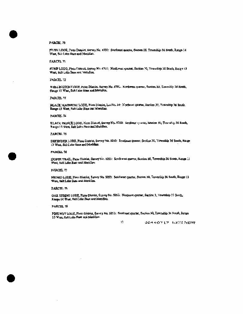
P.yiCELTO
ptvnrKljOD^PnnoDistriel, KurveyNa. tJOV, doinhaastqMa:t(3,$eeM)o25, ToMisbifi^ JiODdi.lUnge 14 Weal, Sa.'t IM» Boss BOJ Mk-is^ao.
PARCF1.71
tr:(Uf LODS.Pmij.*DiauKt. Swrtj Ka 4701; Narthwiw i/oaier. Sicrian ?<", Tcwnsliip i i Snodi, R>ci;e 13 Wot, Hell Liks Saec nm Mendiu.
PARCEL 72
WULUKOTOKtmiE.FicAoDiiftia. SICVE)-ND.470;. Sonnweei qimto, Ramon3U. TouWii;: iiisimlh, i ^ t e : n W K , Sab I sUe lHase isA bavtdiczL
PARCEL TJ
BLACR MAC3W.TIC' LO&E, Plmo Uisnicii, Ltsi Na. i4-. K x d o u i qomet, Saetion 30, Towirtrtp 3* Sajfii, R a n p 13 Wan, :!!aiii Lake Bate sm Mtcidiaai.
PAHC8L74
BLACK PttlHCELOIJp., VictoDiiUietjSurveyKok5CS3: !^Jhe«f: f;iwier,Seetion 3tvTWrrfiiv3£ Somh, Hingn 11 West, SaU LoVc Hoss and Maldlnn.
PARCW. 7J
DETEKDEK j i ^ £ , FimvDiftrict, Eunvty>fla. 3053; £cud»nqcansr, Ssz&w 3i:, Tomnihtp 56 SeuUi, Ku'.pe j:i Weet. Sdt L<Jie Hose and Mddim.
PAJtCliLld
U O P ^ TRAIL, P^iu DUbiot, SctveyKcv 3Cd3: Scufhwta qoiriN. Seaiat 30, Township 36 Seutti, Rtcga 13 Wesl, ,Hoh Lake Ba« Md Mmuikft
PARCEL 7?
NECSO tOSUSi, PrK,-> llijcim. Survey- No. 50)53: S(it:rineect '^vanti. Steitnr, SD. Towntbi;? 34 Soulh, Rzcjp; 13 VflSi, RtttLil»3«9tf jtfutMemuan
rABCBi:.T4
DAK. SIliiINC 11®E.Pidj*CHuiriei,S-:ivcyKc SOSi: NurihtsacutttE, Saetion J, lownarip 37 .Smli^ Kin^f. 14 WuA, ACt Lske I ^ and MtriSan.
PARtSL?9
P!HE KUT UXUli, Piiiic District, SUT«V KO. 505J: SoQila*r. O.IUCIB:, Seclion 30, Tfrntisfcip 3*: fciuh, Raaat ISWiMua«ttLdsi>FI»e EcdM«aiilii«
1-' 0 O * ^ O ~ f 7 F-.*?-3 r^».^4?
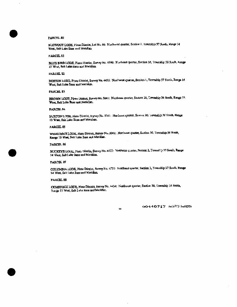
PARcra. so
RlJQ'WWJTLODlx Pinto Kstriw, Ixt Ni. 44: Kwdiwsrt qutrler. Sif«tr;« 1, Trtftrjh:?3.7 St***. Jiange 34 Vitr , Roll LaksDaK und Meridiaa
PARCEL£1
BLUE WRti IjQDiE. PinSO IJiariet. Sun«y No. flOSS: K-jnhean qutnct. Sccilon 53. Township 3d SueOi, KacgB J3 WMI, 9Ah I jdos Elate *Dd Meridian.
FARCSLtl
BOSTONiJOTekKAi Dlsbisl, E<jcveyWo.4435: tUmitMsuc^ana.Stif.V.Ki t,Tewndiip37 !ieoia,Kmig6 14 WuL Gall l .da Base and Mer:dinn.
PAKCliLB^
BROWN UODE, Pir*o lAiA-jct, Survey Nn. 5U41: Kwihesst qnaxtcr. SiSeii«i 3D. Tp«Tahip 3fr Saudi, Rantf! 11 West, Bill Lslm Base s o i Merician.
PARCFI-M
UUJiTON iJCmai, ?innvrji««rict, &jrM7 Nu. .IW 1: NoriJt«i iiumter, &n--<r. 3L\ J cmatsp if S^iih, Kmuc 13 Vest. Salt Lake Btse and Merjimn,
PAf!C0La3
WlGtffAiAN LQDti, PiOto Pinria. iamvr ?*•. 3W I: Npr«.»a q-icaler, Seniot 30. TevoEtap 3« S>-"«nh. Hjtsig: 13 West, ^Ic Inke 3asc l«d Meridan.
PARCBI.M
BUCKEYEUlUliPintolUtnia,Sm«.yNa.4433: Nmhsssi(juutei,Seasoc2,Tuwi*."?^7S««ARamjc 14 West, Sab 1 Ate Hax ami Meridhn.
PARCfiLB?
COLLrMBIALODEvPlntiiDasiriel, SurreyKc. 'iTll: Northiail iiuulet, Kocdon I, TflwiishipS7 Swufli.Hte«e 14 West, Sill I aka HVK and MeridiaiL
PARCEL as
COMBIWXLODE. PimaDfeisel, SmveyKc. «ri4: b?aidiw\*i nuBtac, £odi.>n 3U. Mwhip ift Homh. Raiw; n Wen. Sab U ' i t Base and Weldlm.
• • j O - t + O ? ! ? ante??? MOOJEli
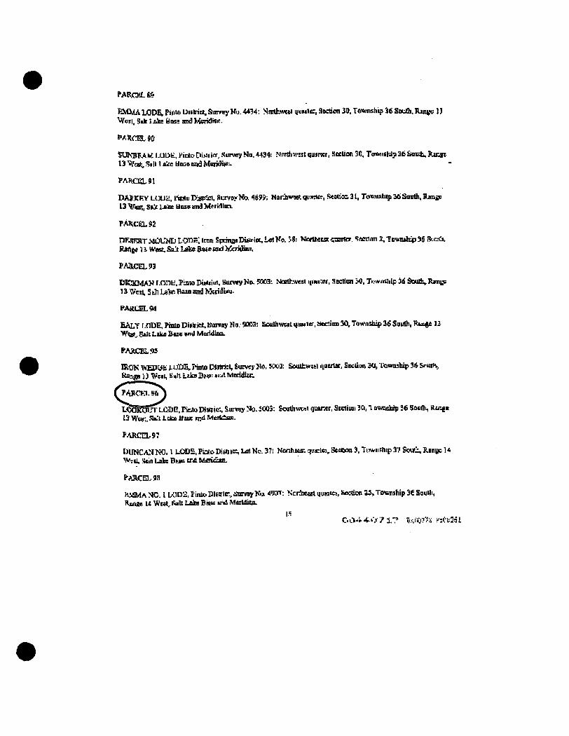
PAf^CPX.»
K M M A LODEk Pililo Piibia, Surrey Nu. 4434: Snrttwwt MUM1< . aecticn 30. Tflwnship 36 Sotth. Ran»e 13 VTeii. Sik 1 j ^ bos: and MeridiU!.
PARCm9D
SUKBPAK IXlDt. PidtoDimiiw, Surwy Nn.4434; Nftrth'«st quirscr, Section 30. T(nkiilWji36 Sont . Ranat 13 "^tai^ Sill i ^ Unss und Mioidiiif.
PARCEL 91
rHASKKY LUUa. l-inlu Eartci . SurveyIfe 469?; Nonbvwt vsritr , SeotaQ 31, Te«x«stuip 36 Sandi, Rmac 13 ^fiSi, Ss^ Late UDSP imd Meri^lKi-
PARCEL92
TlF-HraiT WDL'ND LOnKi Inm Sptinflfl K*ulot, Lei Ka SS: «orihetst ••anftT. Hiscdrai 2, tptnuise 36 fi ti.<i, R a t ^ U West. Salt Lale Bate and hCciiiEaii.
PAllCELH
D I C K M A N f . o n t . Pimo DimiLi, Butvey No. SOOai ^kHd•.well itinixr, HecHiai JO, TiMwnslilp 3d South, Rsnip 1^ "^^sL SbbLSilteKiSBand MsridliAi.
FAacSLW
E A L Y r.flDE. Pmlo Diilriet, Scavay No. S(»3; Eoudiweal qiwisr, Stection 3 ^ Towndiip 26 Soudi, Ri*4e U Wiat^ Stit Laka &ue vid MeddUm.
PAaCBi,.«
IRON ^HJWfc LUfilv Pimo DWricI, Survey No. 5Ci;-3: Soulhw;!:! aoerlac. Escliun 30, Towiuhip 36 $ru6^ Ko^n l J \^fit, iiuttLakaDM>:>i-,'tMeridltc.
P^o-n.afi
L^BRSi^^t iDG. Picto IHsolc-., Sum:y No. JC03: Soudiwvil rpaner. SEctiuii IQ, t owsairip Jd Sooth, Rtnga 13 Wev.. Si-'i Lclu Uaigc mil Meit£an.
PARCEL97
DUNCAN NO. 1 LOOa, Pi3.o Dim le. Lot Nc. 37: Kcnhecs: qjariei, Stcooa 3, TLwufhip 3v Soi.Xi.. Ranijc 1* 'ViTcil, Kan Lake Bi..aB t a i Meiiean.
p^jw:ni.9ii
KlOdA NC. I L0t)2, Pinto. Dldrlr., i tmnyKa 49X1: NcrSwat uuaiiei, Seaicn U , Tffsnsbip 36 Soudi, RmiK U Wtat, f^U Lakg DWK >.->i McfldicB.
|.
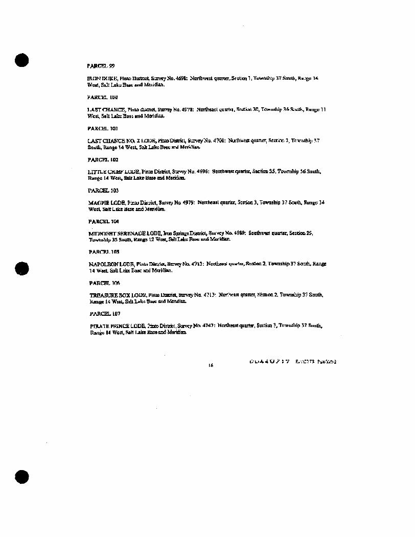
PAFCF1.99
ERtlNIXIKK, HiBKiIJssteKt irxvey No.4dM,: Noribwest ijiHiwr,Srdiw 1,li*«»fta;ii 37souUi, ftu.-gp 1< Wnd, SiJl Laki; Btev a id Meiidiin.
PAKL'l^. lUtl
l.A5TrHANCF,Plrtu><i«nol, !fnr7sjNfl.4'J",fa: .Nordnastquwln, SosiiniSIl, r vwuiildp 3ft i t iuK 1iaii|;i: 11 WciU Salt Lab: Sa i t and Merldiui,
FARt:HL l a i
LASTCE.Ai"<;EWJ. 11XIIJK, riao DiatitI, SCzvey^Sn. 47C0: •Nudlwcffl i iiiiTOT, Recrin-i ]l,T(:vr«fti]i ?.7 Soudl, Ronge 14 West, Sak La1»DHe in) UCKIWV
PARCra, 1112
UTlLk' CHIHF LUDE, PinUi Distiei. Sn**}- Nu. 4696; Str(HbweK cfttria, Section 3i5, TiyMiship id Soudi. ninite 14 Veil, Silt Lake Base md himHia.
PARCEL ]{»
MAfiPIE LCOE. Pinto DiaiUl. Survey Mu 4979: Noiiheail qnaltr. Sieiec 3. lonrasbip 37 BouO-., Runip 1* WecL liBltLikeiltseaEflMnidum.
PARCEO. JM
MmHlCiHT .SFJLFNAUE LOiDI!. Inn Sprint;] DigthOt Siu'vey Now <. B9: Soodinvl quarter, EeMieB 29, TuMUtlillt 33 South. tCmiRS V2 ^ C R , Sill Ll4ii: B I M : w i i UerHttUJ.
PARCIiJ. ins
NAPOLEON LOIiP; Pinlitmrj1ot.SirwjtloL47k3: Koilbn!i iiiiwlti,R4aleca. Iemnihlp37 liiorat,Hxi^ 14 West £^h Lake Due MU) Mi;rii1isn,
PAnoir. irfi
TREASURE 30XIXNH. 1*1010 Uaerii*, Sunay No. 4713: Nor-Vwi qniner, Semoa. 2, T-nwaeuiip I'J Sandi, Rnnjgc U Weat, Sdl L»1«: BWK cud Kendlm.
PARCEL 107
PniAlK HROlCnLODE, ?si»Dijbi;l,Sl«\^EyKn 4747: Nctdieostquttlir. Seeiiw?,Tu*uslilp 17 Suudi, Ran^ii 14 WoJt, Rah IJdm JIOSB cad ideiiiiaB.
l V L » J t 4 U > S T E,:i:?TJ PbU"CAi
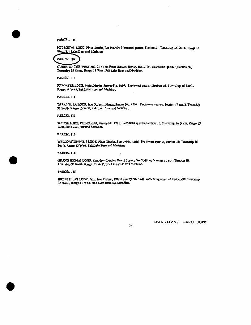
PARCEL ICa
POr KETAL iJODE. Puiin nistrict,Lu( No, 49: Honb^fiil qnaeta:. Seclion 31. To^nd '^ ^ti Soudi. Rutse 13 VnLSah L u s DsK and Meridian.
PAROJLiO?
OUEENOP THE WISrNO.aLODK, PjiiuDittrrt &jn.vj Wn. 4 T i t Sujd:i«es; qnancr.SMlrm 3il, Teirndsp JS Hondi, Ranjc l i Vt'oi . Ran Lake Ba»7 und MfiridiN-.
FAliiOiLllO
VFPCIKI'ER L O D E ; Phrio CdHrid, ftinty Na, 41#3: Smnhwtsl quartv. .leilion Jti. fuvfi^tblp 3i! Suudv Rax^ 14 V u t , Sck La'ee tiise leV Meddiin.
PARcta.m
TARA.vrui.1 LOrW.aocSwiiiasDistriclaSarrtjNo,4«)a; Wctibuisnfpsiwr. SixAiuiii 1 end2.T<w!Bbrp 36 Sculh, Range 15 Wisi, Sab Lyke Base and bCeridian.
PARCSLIIZ
WEUGBU3DE; rttM Disulo!, Sunrj- Ntk. 4'.' 12: fbiulheist qseitei, Kecdaa 31, Tuvnuta'p 56 &tdli. Kii^o 23 Woe, &alt L i ^ Due and Meridian.
FASCELIU
ViTLLtNCTONKn. 1 LODE, FiztoDinlic. Survey- Nn. 4Mlti: lAniTmesl qmrtu, Section M. Twvnfiip 36 3wfi , Rt^tgs 13 W^st Silt L i ^ ficsa «n:9 Merideaa.
PARTJELtlU
GRAND IRON Hi LOna, Fxnu bfo uiscriei, I'uenl Sum) ' No. 7340, win ming a pont of Eeonmi 3(1, 1 owuhip 3d bvjdi. Rani;e 13 Wci:, StU Lake Esse and Mi:ddica.
PABCl^ H i
wen* BSLL #1 Uynn, Piato bcii Uistaiei, Puem Svr^«y No. 7211, Rt^xu±ts a pwi i^ iiacticEi 3n, I ' c w s ^ 36 Si^dV Xmgs 13 Wesn, ScH Ijikf Uasg an>t Meridian.
f iC i^ . cr ." 1 7 BF.UJ",I/J; .c<1jr!n:t
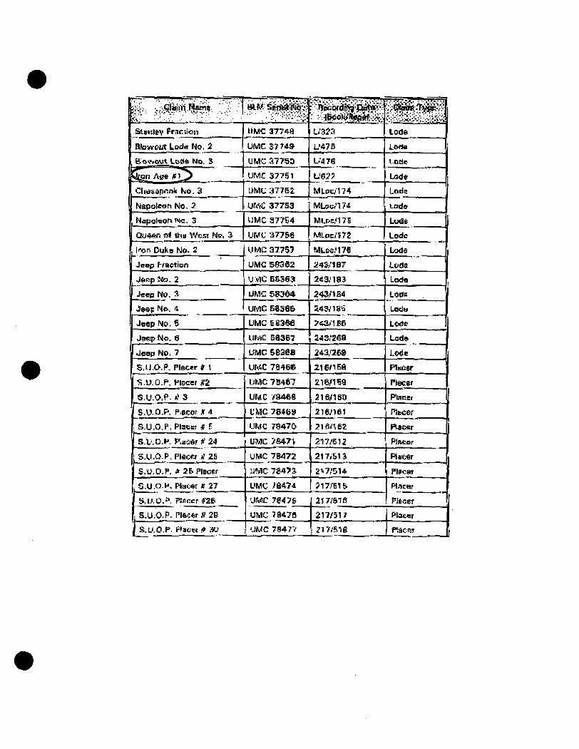
SlaidfeV Frncdon
BlowC'Ut Lpde No, 2
B<»KVfiut Lcdft ND. S
Ceri Au* JfL^
Clia&aponk Ko. 3
Napoleon No. 3
Napal«onruc. 3
Que«n n* itw Wc-Tt N&. 3.
|fX>n Duke No. 2
Jeep f-raction
Jonp }Co. 2
Jeep NO, A
Jftep Ne. A
Jeep No. ?'
J(tep No. 6
Jeap No. 7
S.U.O.P. Placer* 1
IJ S.U.O.P, I'lacer #2
1 S,U.O,P- rf 5
' S.U.O.P. P.BCcr K 1
S.U.O.P. Placer # F;
S.L'.O.K r'.aier H 24
1 S.U.O.P. Flaonr A'ZS
S.U.O.P, f 2B Placer
, S.U,O.H. Plater « 27
S.U.O.P. FSnrcr « &
S.U.O.P. PISC*r fl 20
j S.U.O.P. Hiacec * 30
IIMC 3774B
UIWC 37 7 «
UMC 3775D
UMC 377.151
L>MC 37752
UMC 37753
UMC 37754
UMf :477&6
UMC 37757
UMC 58362
U:V1C:BSS63
UMC &83d4
UMC Eese&
UMC eiii3$e
UMC 58367
UMC seaes
UWC 78466
UMC 7B467
UMC / a 4 « a
UMC 7S46S
UMC 73470
U?.ilC 7S47t
UH*C 7B472
UMC 7fr47a
UMC ?e*74
'JMC 7S47&
UMC 78478
UMC 78477
Li'SJa
L'47B
L.'476
U02?
MI.Dp-174
MLac,'l74
MlPn."17B
MLoci'trS
MLM.'17fl
a45..'iB7
243.'18J
243./1B4
£43/18(5
7*ai'1BB
»s ;2«9
243,r2B8
21 en SB
216/159
5 m i B 0
216.'iei
216/^62
217/612
217/bia
2i.7,'514
517.'B1&
217r'Slfl
217.f51?
2l7.' l i1B
i^iS lode
Lo*>o
i.Dde
L(K)*
Lode 'j
Lade
Lude 1
Lode
LcKld
Lode:
Loda
LOtlB 1
badu
Lorin
Lad«
Lo<ie
Flucer
Placer
Puitjcr
PIbcer
PLBonr
Plneer |
Placer
Placpr
PLirar
Placer
"
1 Placer
F^ficiw
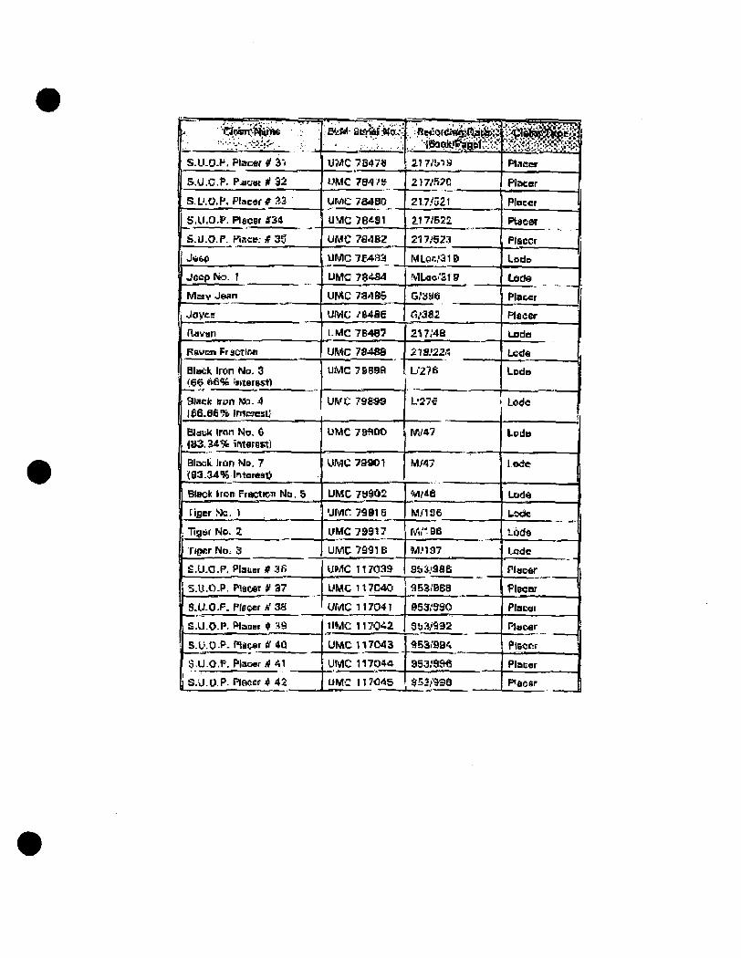
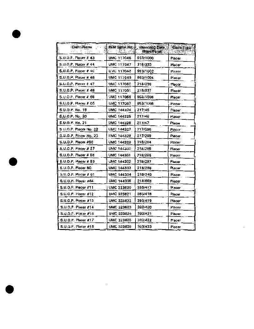
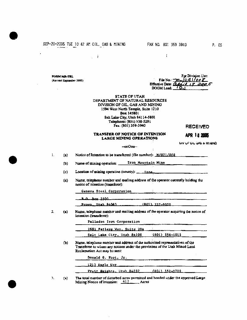
SEP-20-2005 TUE 10i42 AH OIL, GAS & HINING FAX NO. 801 359 3940 P. 05
FORM MR-TRL Foc DivjuoD Uss: (Ravittd Siptenibcr 2000) File No.; "»i^wy/0 A ) ( e c g ' _
Effective Oate: ^ i ^ { ' [fT T ? r r ' - ' ^ DOGM Lead: ^ O . j
STATE OF UTAH DEPARTMENT OF NATURAL RESOURCES
DIVISION OF OIL, GAS A>?D MI>aNG 1594 West Kortb teni|>te, Suite 1^10
Box 14S801 Salt Lake City, Uuh 84114.580't
Telephone: {80 0 S38-S291 Fax: (801) 359-3M0 RECEIVED
TRANSFER OP NOTICE OP INTCN170N ADD t f i M K LARC£ MININC OPEBAllONS * *"**
-ooOoo—
(a) Notic 0 of Intention to be transftired (Hie luimfacr):: M/021/008
LNV uF OIL UAb a MII^NQ
fb) Mante of minins operation: i r o n MoMncaip Mine
(c) t-ftcatiop of mining nparatinn /countvl: r fr,*,
(d) N&me, telepltone number and mailing attdress of tbe operator ctirrently holding the notice of i ntentiou (tran»&ror):
Geneva Steel Corporation
- — B n,, iSoK 2500 . I • • •"' ,
p^»vo. iii-«h 9iLt\*.\ (ftfliv ??7-iflnf)
2. (a) Naaie, telephone number and mailing address ofthe operator acquiring the ntitice of inteiMJon (trana&ree):
PalLadon Iron Corporation
2681 Patlftva Way. \iltp 204 .J
Salt Lake Ctty, Utah 84109 :(801> 5S6-10I5
(b) Kajne, teleplione numbor and address of the authorized represenutives of the Tranafbree to whom any notices under tbe provisions ofthe Utah Mined Lstid Heclamation Act may be scat:
Donald 6. Foot, Jr,
1 3 1 3 jEfrg].!? K'lY
Frule aaiohtn. Utah 9 . k a \ l YBRll SS2-07nq
(a) The total number of disturbed acreai permiticd and bonded under the approved Large Mining Notice oflntention: 417 Acres
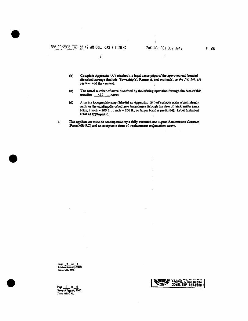
^^f : :?? :2°?L.™£ 10''^2 AM O I L , GAS & H I M N C FAX NO. 801 35S 3940
(ti) Conaplotc Appendix " A'*(atlaehcd). a legal descripiipa of tbe approved and bonded disturbed acreage Onchide: Town&hip(i). ftangeCt), and secttoix(s), to ik« 1/4, 1/4, 1/4 section, and the county).
(e) The actual number of acies diatutbed by the niining operatioa through the date of this ttansfer: 417 Acret
(d> Attach a topographic sup Oabelad is Appendix "B'') cf suitable scale which clearly outlines the existing disturbed area boundaries throtigh fhe date of this transfer (max. Male, 1 inch • SOO ft., 1 iach = 200 ft., or larger scale is preferred). Labal disturbed areas as appropriale.
This triplication tnuit be accompanied by a fiilly executed and signed Reclamation Ctmtraot (Farm MR'RC) and an accepuble foim of replacantcnt reclamation surety.
Hivik«l Jtmiuy 2ft40 femiMll-TIU.
Paw i _ af t ftevi««<ljittit«yll»0 fond MR-TRL
COtW. EXP 74t>2flfle <
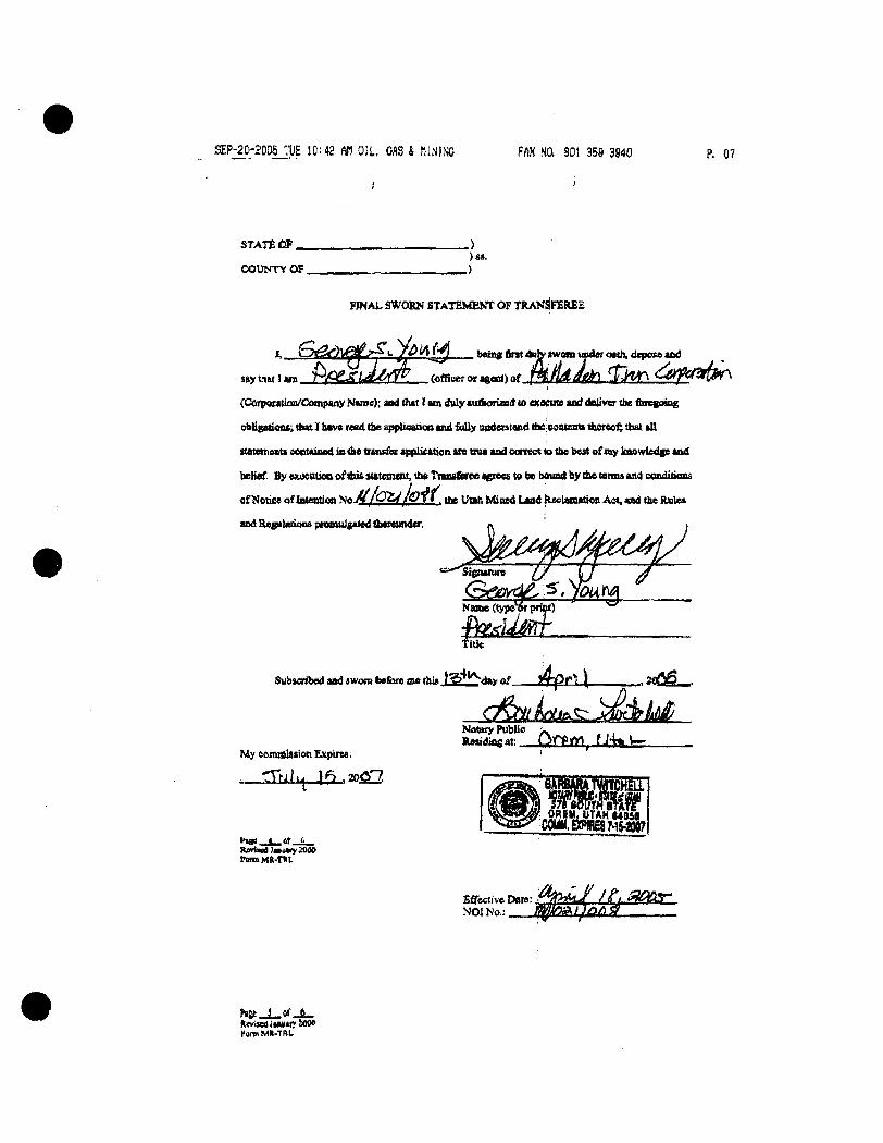
SEP-20-2005 TUE 10: *2 Af) O i l , CflS & fllNJNO FfiX MQ 801 35S 3940 P. C7
STATE l » .
COUNTY OF. )s>.
FINAL SWORN STATEMENT OF TRANSFEREE
. faeiiig fint duh* twom under oath, dqwxe and
$»y that 1 a n r y - g ^ L a M ^ r r ^ (oflieer or aeent) of f H i f i d a e h \ f h ^ C S J ^ ^ M ^
(Corpwaitaii/CMnpany Name); aad that I un duly tuiiionaBd co eae^ute and deliver tbe finegoine
obligaiiM*^ th«t I have read tbe applicaticn md folly OBdeHtand tfteicsntestt there«^ that kU
statementi centainnd in die iun<fe< appUeation are oua and correct to the best o fay knowl£dgs and
belief. By eKiKutina of this siatemtm, tbe TfaasCaree agrees te be bound by tbe terau and condidons
of Nonce oflntention T S t a M / O Z ^ / O j i . cbe Utah Ivtined Land tlEcLanttion A«, and the Rules
aad Re^iletioos ptoenilfilad thtreuttder.
« i » ^
Name (type^r priul
Tide
Subsciil>ed aad iwora tofbre oie thi» JStb. day of . JipcU _i2 ' W { ^ _ .
d^Lit .^)MdrM My commission Expirea:
- T N } . ^ 1^ .206-7.
Notary Public ^^ lUMdiagat: l)if^tf\ f J -k
OREMJlTAHMDSa
•••ss « af t novuKri Jjvury 2O0O fcrtmMD.TIlL
Bffecti've Date: NOI No,:
Fgrm Mt-TRI.
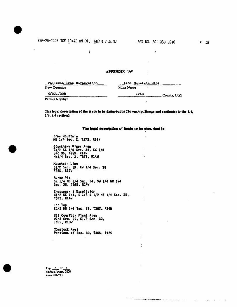
SEP-20-2006 TUE 10!42 AM OIL, CAS & MINING FAX NO, 801 359 3940 P, 08
APPENDIX "A"
Paiiadon Icon CorporaClen New Operator
M/021/008
Pennit Number
I ton Mountain Mlt>a Mine Name
Iron . County, Utah
The leg«l deieripiioR of the landa to ht dif turbed is (Towathip, Range and sei:tioB(s> to the 1/4, 1/4,1/4 SMtion):
TIM i*a>i dsMTlption of l»ndt te be disturbad I a:
Iron Mountain Ht 1/4 Sec. 2, T37S, R14K
ftUcfchiiwIi Fines Aree El/2 S£ 1/4 see. 34, SW 1/4 Sac.35. T3($. R14W NWl/4 Sec. 2 , T375, RUW
Hounteifl Lion Sl/2 Sec. 19, HW 1/4 Sec. 30 T36S, Ri3W
Burke PU S£ 1/4 ME 1/4 Sec, S4, SW 1/4 NW 1/4 Sec. 3S. TW5, JH4W
ChesApeele ( Excel >slor Ul/Z se 1/4, S l / t 5 1/2 NE 1/4 Sec. 25. T365, fll4W
Tip Top £1/2 KW 1/4 Sac, 2S. T3<S» R14U
UII Covstoek Plant Area Wl/2 Sec. 29, £1/2 See. 30. TJ6S» R13W
Comstock Area Portions of Sae. 30. T36S, R13S
fime 6 or
ReviwdJsniitry2000 foim tvtR.TRL
RELEASE
Please be advi.isecl ihai Paiiadon Iron Corporaiion ("Paiiadon") has provided ilie Siaie of Uiah. Division of Oii. Ga.<; and Minins and ihe Li.S.D.l.- Bureau of Land .Managemeni ("Obligee.*;") with ihe .New Bond «s de.iicribed in ihe Bonding and Securiiy Agreement dated ApriJ ]3 . 2005. beiween, inier alia. Paliarion! and Travelers Casuaiiy and Surety Company of Amenca {Bond Number 10451 1468j. in repiacenieni of The Mined Land Reclamaiion Act Surety Bond Number 103.')'^027l (the "Bond") issued on behalf of Geneva Sieel Company a.s principal. Such alternate financial assurance has been accepied by Obligees a.s sufficieni financial assurance in compliance with the Utah Mined Land Reclamauor, Act and ihe Reclamaiion Contraci governing (he obligation of Palladcn lo reclaim ihe Iron Mountain Mine Permil number M/021/008.
Therefore. Obligees do hereby fult>'. finally and unconditionally release and forever discharge Si. Paul Fire and Marine Insurance Company. Travelers Casually and Surety Company of America and each of iheir affiliates and subsidiaries (collectively. "St. Paul Travelers") from any and all past, present and future liability by reason of or in connection with the issuance of the Bond (Bond Number 103.^40271) issued on behalf of the principal Geneva Siee) Company. Each of (he undersigned individuals signing on behalf of eilher ObJijgec further represents and warrants thai he or she has the authority to execute this Release on behalf of the Obligee and to bind the Obligee hereunder. In addition, in the event there is any inconsisiency beiween the terms of this Release and any and aJJ other documents, the Obligees hereby agree ihat the terms of this Release shall control.
DATED this • • day of April. 2005 to be effective upon the effective dale of the akernaie financial assurance given by Paiiadon and accepted by Obligees.
STATE OF UTAH DEPARTMENT OF NATURAL RESOURCES DIVISION OF OIL. GAS & MINING
ByT Prmt Name; Its: - - > ' \ /
- • •'..•-.., . - •'
/ ' ' ; i ' - . .• , v ' . ' . . ^ .
r?.:- . ' ., ;••-;? -~ • 'V ,
U.S. DEPARTMENT OF THE INTERIOR BUREAU OF LAND MANAGEMENT
B y ^ i M ^ ^ i i ^ & x ^ I^riht Name; :Z0M.ic- f~ ^ c V ^ '
i t ^ . c I ^c^' ^ ctiICl) Ct ^jif- ^-Aicmi^
Attachment F
Application Form and Checklist
Paiiadon Iron, Cedar Ciiy, Ulah Landfill Permit Application March 2009
Utah Class III Landfill Permit Application Form
Utah Division of Solid and Hazardous Waste Solid Waste Management Program Mailing Address Office Location Phone (801) 538-6170 P.O. Box 144880 288 North 1460 West Fax (801) 538-6715 SaltLakeCity. Utah 84114-4880 Salt LakeCity. Utah 84116 www.deqUtah gov
APPLICATION FOR A PERMIT TO OPERATE A CLASS III LANDFILL
Please read the instructions that are found in the document, INSTRUCTIONS FOR APPLICATION FOR A PERMIT TO OPERATE A CLASS III LANDFILL. This application form shall be used for all Class III solid waste disposal facility permits and modifications. Part I, GENERAL INFORMATION, must accompany a permit application. Part II, APPLICATION CHECKLIST, is provided to assist applicants and, if included with the application, will assist review. Part 11 is provided to assist in preparation and review of a permit application, it is not rule. The text of the rule governs all permit application contents and should be consulted when questions arise.
Please note the version date of this form found on the lower right of the page; if you have received this form more than six months after this date it is recommended you contact our office at (801) 538-6170 to determine if this form is still current. When completed, please return this form and support documents, forms, drawings, and maps to:
Dennis R. Downs, Director Division of Solid and Hazardous Waste Utah Department of Environmental Quality PO Box 144880 Salt Lake City, Utah 84114-4880
JNoti ite: When the application is determined to be complete, submittal of two copies of the complete application will be ired.)
m Utah Class III Landfill Permit Application Form
/iGerierallriformatlbnr-^APPLICANT: PLEASE COMPLETE ALL SECTIONS: ^ >* .f -'-V-v* • ^ „ ' , f t . ,
^.Landfill Type D Class Ilia 0 Class lllb
AL .^Applicatibri l|ype New Application Renewal Application
• Facility Expansion • Modification
For Renewal Applications, Facility Expansion Applications and Modifications Enter Current Permit Number
llh^ Facility Name and ;Location>^^ Legal Name of Facility
Comstock/Mountain Lion I r o n Mine Site Address (street or directions to site) 5 ""^ " ^^^ °^ '^^'^^^ ^^^^ ° " ™^ ^^ ' ^^^^ 1.5 mi North
on Comstock Road,then 4,000 feet NW on Mine Property County
I r o n County
City Cedar C i t y Slate U T ZipCode 8 4 7 2 0 Telephone ( 4 3 5 ) 4 6 3 - 4 7 2 3
Tovmship 3 6 S Range 13W Section(s) 30 Quarter/Quarter Section N E / SW Quarter Section NW
Main Gate Latitude N degrees 3 7 minutes 3 7 seconds 4 5 . 5 Longitude W degrees 1 1 3 minutes 2 0 seconds 2 7 . 5
IVi Facility Owner(s) Infonnation < Legal Name of Facility Owner
Paiiadon Iron Corporation Address (mailing)
554 South 300 E a s t City Salt Lake City state U T ZipCode 8 4 1 1 1 Telephone ( 8 0 1 ) 5 2 1 - 5 2 5 2
V.. Facility Operator(s) Infortnatidh^ J'-v.. .•..-c»t-^
Legal Name of Facility Operator
Paiiadon Iron Corporation Address (mailina
554 South 300 East Salt Lake City state U T ZipCode 8 4 1 1 1 Telephone ( 8 0 1 ) 5 2 1 - 5 2 5 2
V/.'" Property Owner(s) Information'. Legal Name of Property Owner
Paiiadon Iron Corporation Address (mailing)
554 South 300 East City S a l t Lake C i t y state U T ZipCode 8 4 1 1 1 Telephone ( 8 0 1 ) 5 2 1 - 5 2 5 2
vV/f. .Contact Information.^
Owner Contact Donald G. Foo t , J r . Title Pres ident and Chief Executive Officer Address (mailing) 554 South 300 E a s t
City S a l t Lake C i t y state U T ZipCode 8 4 1 1 1 Telephone ( 8 0 1 ) 5 2 1 - 5 2 5 2
Email Address Alternative Telephone (cell or other)
Operator Contact B r u c e Yeomans Title Mine Manager Address (mailing) 2708 S Comstock Road
City Cedar C i t y state U T ZipCode 8 4 7 2 0 Telephone ( 4 3 5 ) 5 7 2 - 4 5 3 1
Email Address Alternative Telephone (cell or other)
Property Owner Contact D o n a l d G . F o o t , J r , Title President and Chief Executive Officer Address (mailing) 554 South 300 Eas t
I Ema
S a l t Lake C i t y state U T ZipCode 8 4 1 1 1 Telephone ( 8 0 1 ) 5 2 1 - 5 2 5 2
Email Address Alternative Telephone (cell or other)
Utah Class III Landfill Permit Application Form /' General Infdrmatidn (Continued) tifjV V t r . ' - ^
W a s t e Typ'es''(cKec;k ail that apply)^ fXi,v; Facility Area: [•1 All types of non-hazardous industrial v\«ste generated by the facility OR
the following specific waste types Waste Type Combined Disposal Unit Monofill Unit D Construction & Demolition D D D Industrial D D n Incinerator Ash D D n Animals D D n Asbestos D D n Other n n Note: All waste types must be generated by the industry which owns the faql i ty
Facility Area 4 6 5
Disposal Area 3 . 8 8
Design Capacity
Years 2 0
Cubic Yards 6 3 2 . 0 0 0
Tons 9 4 , 8 0 0
acres
acres
X,- F6e and Application Documents -
Indicate Documents Attached To This Application n Application Fee: Amount $
@ Facility Map or Maps Ground Water Report
0 Facility Legal Description [ • ] Closure Design
Plan of Operation Cost Estimates
[ 3 Waste Description [ • ] Financial Assurance
THEREBY CERTIFY THAT THIS INFORMATION AND'ALL ATTACHED PAGES ARE CORRECT AND COMPLETE. :,.*. Title President and CEO
Date
Name typed or printed
Address 554 South 300 East, Salt Lake City, UT 84111
Signature of Authorized Land Owner Representative (if applicable)
Name typed or printed
Title Date
Address
Authorized.Operator^ presentative (if apgjicable)
Yeomans
Title Mine Manager
Date
'j/^/zoo^f
Name typed or printed
Address 2708 S Comstock Road, Cedar City, UT 84720
Utah Class III Landfill Permit Application Checklist
Important Note: The following checklist is for the permit application and addresses only the requirements of the Division of Solid and Hazardous Waste. Other federal, state, or local agencies may have requirements that the facility must meet. The applicant is responsible to be informed of, and meet, any applicable requirements. Examples of these requirements may include obtaining a conditional use permit, a business license, or a storm water permit. The applicant is reminded that obtaining a permit under the Solid Waste Permitting and Management Rules does not exempt the facility from these other requirements.
An application for a permit to construct and operate a landfill is documentation that the landfill will be located, designed, constructed, operated, and closed in compliance with the requirements of Rules R315-304 of the Utah Solid Waste Pemiitting and Management Rules and the Utati Solid and Hazardous Waste Act (UCA 19-6-101 through 123). The application should be written to be understandable by regulatory agencies, landfill operators, and the general public. The application should also be written so that the landfill operator, after reading it, will be able to operate the landfill according to the requirements with a minimum of additional training.
Copies of the Solid Waste Permitting and Management Rules, the Utah Solid and Hazardous Waste Act, along with many other useful guidance documents can be obtained by contacting the Division of Solid and Hazardous Waste at 801-538-6170. Most of these documents are available on the Division's web page at www.hazardouswaste.utah.gov. Guidance documents can be found at the solid waste section portion of the web page.
When the application is determined to be complete, the original complete application and one copy of the complete application are required along with an electronic copy.
Part l l Application Checklist
/. Facility General Information ' - : ; . . ; . , . - '- Descnption of item
la. General Information For -"All Facilities ' " ^ '
Completed Part 1 General information
General description ofthe facility (R315-310-3(1 )(b))
Legal description of property (R315-310-3(1 )(c))
Proof of ownership, lease agreement, or other mechanism (R315-310-3(1 )(c))
A demonstration that the landfill is not a commercial facility
Waste type and anticipated daily volume (R315-310-3(1 )(d))
Intended schedule of construction (R315-302-2(2)(a))
Ib ' General Information - NeweOi: Laterally Expand|hgX|ass ML, 4 (.
Documentation that the facility has meet the historical survey requirement of R315-302-1 (2)(f) (R315-305-4(1 )(b) or R315-305-4(2)(a)(iv))
Name and address of all property owners within 1000 feet of the facility boundary (R315-310-3(2)(i))
Documentation that a notice of intent to apply for a permit has been sent to all property owners listed above (R315-310-3(2)(ii)) Name of the local government with jurisdiction over the facility site (R315-310-3(2)(iii))
Location J n ^ . , Document '
•^
Page 3
Page 3
Page 3
Page 3
Page 4
Page 4
Page 4
Page 4
Page 4
Page 4
Page 5
Page 1 of 5 (rev. 9/2007)
Utah Class III Landfill Permit Application Checklist
-'/^'^FacilityiGeneral.•lnforn[latiori.i i>v.i,,,.,,;,.,i,,,::,;: L..,.-. i .« ••• •L2 z, :......••'."..;, ":. T'^.'^^Tt'i . i..>i,.y ...,k.- f.-* $-"C ''*~-'S f ••^-*Description:'ofltem'•:!^--:-^^•-.J. ,.,- . ']..-
:/c.r LoMtiofeSlahaai'ds-'New;:Class^^l Geology
Geologic maps showing significant geologic features, faults, and unstable areas Maps showing site soils
Surface water
Magnitude of 24 hour 25 year and 100 year storm events
Average annual rainfall
Maximum elevation of flood waters proximate to the facility Maximum elevation of flood water from 100 year flood for waters proximate to the facility
Wetlands
Ground water
Historic Preservation Survey
M Additionai(Lo<^tion^B^ Landfills Not On -Waste-Generation Site- ^ -v-*; i--;: •*'-* L-i-.L,^ i....;.:;„,;; .:,•....i, •. ...,...•,.:..•;..J. 4
Land use compatibility (R315-304-4(1 )(a))
Maps showing the existing land use, topography, residences, parks, monuments, recreation areas or wilderness areas within 1000 feet of the site boundary
Certifications that no ecologically or scientifically significant areas or endangered species are present in site area
List of airports within five miles of facility and distance to each
/e. location'standards-New Class lllb Landfills ?,4 .^^ r. :....i
Floodplains as specified in R315-302-1 (2)(c)(ii) (R315-304-4(2)(a)(i))
Wetlands as specified in R35-302-1 (2)(d) (R315-304-4(2)(a)(ii)) The landfill is located so that the lowest level ofwaste is at least ten feet above the historical high level of ground water (R315-304-4(2)(a)(iii)) Historical Preservation Survey (R315-304-4(2)(a)(iv))
?/i^Pfen of bperatibns M i l class IM Landfills (R315-310-i3(1)(^
Description of on-site waste handling procedures and an example ofthe form that will be used to record the weights or volumes ofwaste received (R315-302-2(2)(b) And R315-310-3(1 )(f)) Schedule for conducting inspections and monitoring, and examples of the forms that will be used to record the results of the inspections and monitoring (R315-302-2(2)(c), R315-302-2(5)(a), and R315-310-3(1 )(g))
, «. :.,Location |n,.i ^..f «<': vDocument -t« 4 ,<r
• ' i : - - •*•. -.v. ..f-.- . . \ , ^v .v . . . ;^; . .<•:.,. s,:.. ^ ^
''\ -• ' •••« v;;, . . : . , ..-.r, j . ^ S i . v f 3l.
Page 5
Page 5
Page 5
Page 4
•V . 'ff' ^ * ' V •• ••- :•?• ; V - . : V , . . ^ . ^ i . i.;, . r . ; „...
Page 6
Page 6
Page 2 of 5 (rev. 9/2007)
Utah Class III Landfill Permit Application Checklist
'/:;'Facility-.General.lhfbrmatioh:'^ : ' : 'TT"-^' - ••": -T ; _-..->- •-;:-r. .•••*<.v-•. :=<'v..s • -•*••• /••'•- ••• • • ' • ' ' • Z " ' ^ T ' T D b s c n p t i o r f d f l t e m ' ^ ' r ' ^ ' ' " • ' ^ " ' ' • • ' ' ' i ' " ' ' ' ' ' ^ ^ ^ ^ ^
Cont ingency plans in the event of a fire or explos ion (R315-302-2(2)(d))
Plan to contro l fugi t ive dust generated f rom roads, construct ion, general operat ions, and cover ing the was te (R315-302-2(2)(g))
Plan for letter contro l and col lect ion (R315-302-2(2)(h))
Procedures for exc luding the receipt of prohibi ted hazardous or PCB contain ing wastes (R315-302-2(2)( i ) )
Procedures for control l ing d isease vectors (R315-302-2(2)(k))
A plan for al ternat ive was te handl ing (R315-302-2(2)( l ) )
A genera l t ra in ing and safety plan for site operat ions (R315-302-2(2)(o))
Any recycl ing programs p lanned at the facil i ty (R315-303-4(6))
Any other site specif ic informat ion pertaining to the plan of operat ion required by the Execut ive Secretary (R315-302-2(2)(p))
tg.'Groiin(i WaterMohitbnrii iC^lass Mlalan^ v »-r.,..-
Ground Water Monitoring Plan (R315-304-5(4)(a)
' " ^" Idcatipri i lhfyf '• * *'' !! ••i Document I-••*';•'•
Page 6
Page 6
Page 6
Page 7
Page 7
Page 7
Page 7
Page 7
. : , - • . ; • .•..,...-Ji. :< i i . . . ^ . «..^A,, ?
L _. ...
'•//'\Fability^Technical Information-•••-•' =-- ; -- -: ^ -^.-iv- i- i?^4 s-v- -k i - ^--'t u---- • •.* t - t ,> - j : ' f " f " ' t " • ; ^ . - " . r ' p- " . ' • : " '-: • ^ ' - ' / • - ^ ^ " t - • " , ; ' • " ; • - . • • • « • • ' : • . • - i , ' - ^ * " i ' - - i i - • v i j j i - * ; - * ^ - -
y/a^-Maps^ All Class MLLandfills^i^S; ,? •./:.,s .<-..-:).•.::,.-f. > 45,,,.,.;.;„,^
Topographic map drawn to the required scale with contours showing the boundaries of the landfill unit, ground water monitoring well locations, gas monitoring points, and the borrow and fill areas (R315-310-4(2)(a)(i))
Most recent U.S. Geological Survey topographic map, 7-1/2 minute series, showing the waste facility boundary; the property boundary; surface drainage channels; any existing utilities and structures within one-fourth mile of the site; and the direction ofthe prevailing winds (R315-310-4(2)(a)(ii))
11 . Geqihydrbldgical Asiiessrneht ? Classllla Landfills (R315-310-?'
• • v ^ . . • ' • . ^ - n ^ : . . ^ . . / f . : . . ^ ^ • ^ ^ • - . . i ^ . . i S . . : . . - : . ^ . . - ^ . L . "^^ •. • r/. • - f - . . ' ^ . « * _ . . . . . . . . . . . - i . . •• . . , ^ . . - . . i . : ? ; : , i ' . y . . . ' . .. . ^ ^ v
Local and regional geology and hydrology including faults, unstable slopes and subsidence areas on site (R315-310-4(2)(b)(i))
Evaluation of bedrock and soil types and properties including permeability rates (R315-310-4(2)(b)(ii))
Depth to ground water (R315-310-4(2)(b)(iii))
Quantity, location, and construction of any private or public wells on-site or within 2,000 feet ofthe facility boundary (R315-310^(2)(b)(v))
Tabulation of all water rights for ground water and surface water on-site and within 2,000 feet ofthe facility boundary (R315-310-4(2)(b)(vi))
Page 7
Page 8
.., : . -^C-, . - s, .... . - . ^ v .;.;.,. v y . " i - . - •••if
r *•' •• - f ,*• . ' ,-•
Page 3 of 5 (rev. 9/2007)
Utah Class III Landfill Permit Application Checklist
a^FacilityiQeiieralJnfofmatidhT'^rf •"' •""• t'"^^:----r7- 'f-i^^'^^-irh v-; ; -^ --^-' i •*•<- --i ':,,J:.^i.J.Ji.../,.-:' J .^-.^ •' ,.' ^Description of Item' I ,;•-;---r-^-v:. .^ •. ,;..:.•.,-.,>••.,.
Identification and description of all surface waters on-site and within one mile of the facility boundary (R315-310-4(2)(b)(vii))
For an existing facility, identification of impacts upon the ground water and surface water from leachate discharges (R315-310-4(2)(b)(viii))
Calculation of site water balance (R315-310-4(2)(b)(ix))
,lic. Engineering Report - Plans, Specifications, And Calculations - . .Ail Class III Landfills/ ' - " . " • ' ',., ' \
Unit design to include cover design; fill methods; and elevation of final cover including plans and drawings signed and sealed by a professional engineer registered in the State of Utah, when required (R315-310-3(1 )(b))
Design and location of run-on and run-off control systems (R315-310-5(2)(b))
//d.» Engineering Report - Plans, Specifications, Arid Calculations: , Class llla Landfills- . • . . . - / , ' . ' ,
Engineering reports required to meet the location standards of R315-304-4 including documentation of any demonstration or exemption made for any location standard (R315-310-4(2)(c)(i))
Anticipated facility life and the basis for calculating the facility's life (R315-310-4(2)(c)(ii))
Equipment requirements and availability (R315-310-4(2)(c)(iii))
Identification of borrow sources for daily and final cover and for soil liners (R315-310^(2)(c)(iv))
Run-off treatment and disposal and documentation to show that any treatment system is being or has been reviewed by the Division of Water Quality (R315-310-4(2)(c)(v) and R315-310-3(1 )(i))
T/e! Clo^ure^Requirements^AII Class III Landfills ^ « - ^ Closure plan (R315-310-3(1 )(h))
Closure schedule (R315-310-4(2)(d)(i)) Design of final cover (R315-310-4(2)(c)(iii)) Capacity of site in volume and tonnage (R315-310-4(2)(d)(ii))
Final inspection by regulatory agencies (R315-310-4(2)(d)(iii))
W P6st-Clbslifrear#Requifements - All Class lllliahdfills 1 v * -4
Post-closure care plan (R315-310-3(1 )(h))
Changes to record of title, land use, and zoning restrictions (R315-310-4(2)(e)(ii))
Maintenance activities to maintain cover and run-on/run-off control systems (R315-310-4(2)(e)(iii))
'•'"^ Lbcatiorrlh'" \~ >• "'!" * ' Docum^nt'h * '•
Page 8
Page 8
5 , - » ,
i.-"-'.'. • ; : • " ' i~ . .^ \ ; : -"iyv,.^., t. mi. .
Page 9
Page 9
Page 10 Page 10 Page 10
1..'^ '••'-....'If.-, , | . . ; <v •'.!<•, - ^ j . : K . . . i - , - . . •
Page 10
Page 10
Page 11
Page 4 of5 (rev. 9/2007)
Utah Class III Landfill Permit Application Checklist
-7; Facility-0eneral::lnformation,.:.,s.-.4-.'!;;-. ^4<.i i . .*:..i„^..:.i .-i . .... .. ..,...,.:. .i..,.'C J. ..1 .1...:^ v>.. jfti-.;- ^'.>i.'J-. >4,;v ^i ... _, .Description of Item ::: - ^ ,? .-•
. „ > . . - . : : ; , t ^ ••.-•. : * . > i .• • ' , I » •; i • . • ; : . ' • i ' • '.. : • • ' '• • -
List the name, address, and telephone number of the person or office to contact about the facility during the post-closure care period (R315-310-4(2)(e)(vi))
>//a. Financial Assurance Requirements^- All diass III LahdfillSv ;; ,
Identification ofclosure costs including cost calculations (R315-310-4(2)(d)(iv))
Identification of post-closure care costs including cost calculations (R315-310-4(2)(e)(iv))
Identification of the financial assurance mechanism that meets the requirements of Rule R315-309 and the date that the mechanism will become effective (R315-309-1(1) and R315-310-3(1)0))
Location In .' ; Document * -
Page 11
Page 11
Page 11
Page 11
N:\ALL\SWS-Fonn\Permit Application fontis\2007_Class_IlI application_and_checklist.doc
Page 5 of 5 (rev. 9/2007)
Table Of Contents
Introduction
Post Closure Plan
Post Closure Plan Attachments
Attachment #1 - Post-Closure Inspection Form Attachment #2 - Landfill Closure Plan - Final Facility Topography
Attachments;
A Maps
B Log sheets Section 1 - Landfill Daily Use Section 2 - Monitoring and Inspections
C General Site Safety and Training Plan Landflll Addendum
D Post Closure Inspection Form
E Financial Assurance and Ownership Docuementation
F Application Form and Checklist
Paiiadon Iron, Cedar City, Utah Page 2 LandfiU Permit Application August 21, 2008
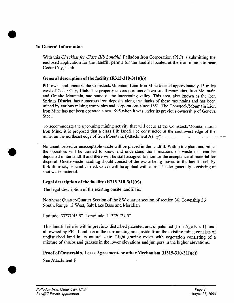
la General Information
With this Checklist for Class Illb Landflll, Paiiadon Iron Corporation (PIC) is submitting the enclosed application for the landflll permit for the landflll located at the iron mine site near Cedar City, Utah.
General description ofthe facility (R315-310-3(l)(b))
PIC owns and operates the Comstock/Mountain Lion Iron Mine located approximately 15 miles west of Cedar City, Utah. The property covers portions of two small mountains. Iron Mountain and Granite Mountain, and some of the intervening valley. This area, also known as the Iron Springs District, has numerous iron deposits along the flanks of these mountains and has been mined by various mining companies and corporations since 1851. The Comstock/Mountain Lion Iron Mine has not been operated since 1995 when it was under its previous ownership of Geneva Steel.
To accommodate the upcoming mining activity that will occur at the Comstock/Mountain Lion Iron Mine, it is proposed that a class Illb landflll be constructed at the southwest edge ofthe mine, on the northeast edge of Iron Mountain. (Attachment A) ^^—
No unauthorized or unacceptable waste will be placed in the landflll. Within the plant and mine, the operators will be trained to know and understand the limitations on waste that can be deposited in the landfill and there will be staff assigned to monitor the acceptance of material for disposal. Onsite waste handling should consist ofthe waste being moved to the landflll cell by forklift, truck, or hand carried. Cover will be applied with a front loader generally consisting of shot waste material.
Legal description ofthe facility (R315-310-3(l)(c))
The legal description ofthe existing onsite landfill is:
Northeast Quarter/Quarter Section ofthe SW quarter section of section 30, Township 36 South, Range 13 West, Salt Lake Base and Meridian
Latitude: 37°37'45.5", Longitude: 113°20'27.5"
This landfill site is within previous disturbed patented and unpatented (Iron Age No. 1) land all owned by PIC. Land use in the surrounding area, aside fi-om the existing mine, consists of undisturbed land in its natural state. Light grazing exists wdth vegetation consisting of a mixture of shrubs and grasses in the lower elevations and junipers in the higher elevations.
Proof of Ownership, Lease Agreement, or other Mechanism (R315-310-3(l)(c))
See Attachment F
Paiiadon Iron, Cedar City, Utah Page 3 Landflll Permit Application August 21, 2008
• • l ' ^ I
Types ofwaste and area served by the facility (R315-310-3(l)(d))
The landfill will accept non-hazardous waste that is generated at the Comstock/Mountain Lion Iron Mine. The waste will consist of construction debris, wood, cement, sheet rock, steeland typical types of rubbish including paper, plastics and trace amounts ofwaste foods." Withirfthe^ plant and mine, the operators will be trained to know and understand the limitations on waste that can be deposited in the landfill and the staff will be assigned to monitor the acceptance of
'^h,'- material for disposal. No other wastes will be accepted therefore, this landfill will not be a commercial landflll and no other areas are served. The landflll will be strictly used by PIC and its
' '':/ %; ^contractors.
' A five year average ofwaste placed in the landflll is approximately 35 loads per year at 15 tons -f each, or 525 tons per year. However, this number can vary significantly depending on the level of
production at the facility. Waste rubbish is typically deposited in the landflll weekly.
Intended schedule of construction (R315-302-2(2)(a))
Construction of the new landfill at the Comstock/Mountain Lion Mine will commence as soon as possible and will end in time for mining to begin. The anticipated date to commence mining operations is August 1, 2008.
lb GENERAL INFORMATION - NEW CLASS III LANDFILLS
Documentation that the facility has met the historical survey requirement of R315-302-l(2)(f) (R315-305-4(l)(b) or R315-305-4(2)(a)(iv)
The area proposed for the landfill was mined as part of a previous operation ending in 1995 and is now currently a waste rock dump. Given the recent and extensive disturbance within the proposed landfill, it is highly unlikely that any cultural resource sites exist within this area. Because of these factors, it is PIC's assertion that a cultural resource inventory is not required for this project.
Name and address of all property owners with 1000 ft of the facility boundary (R315-310-3(2)(i))
The only property owner within 1000 feet of the proposed landfill cell is Paiiadon Iron Corporation, who owns the Comstock/Mountain Iron Mine. PIC's corporate office is located at 554 South 300 West, Salt Lake City, Utah.
Documentation that a notice of intent to apply for a permit has been sent to all property ^ i { r , ? owners listed above (R315-310-3(2)(ii))
Since PIC is the only property owner within 1000 feet, they are the only entity who has received a notice of intent.
Paiiadon Iron, Cedar City, Utah Page 4 Landflll Permit Application August 21, 2008
Name ofthe local government with jurisdiction over the facility site (R315-310-3(2)(iii))
Southwest Utah Public Health Department 260 East DL Sargent Dr. Cedar City, UT 84720 435-586-2437
LOCATION STANDARDS FOR NEW CLASS Illb LANDFILLS
Floodplains as specified in R315-302-l(2)(c)(ii) (R315-304-4(2)(a)(i))
The nearest surface water body is Quichapa Lake, located approximately 10 miles east-northeast of the project site and 5,450 feet above MSL. This lake is home to an extensive shoreline marsh system and is where areas of open water occur. No other rivers or water bodies are near the area which will be considered floodplains. The elevation ofthe landfill is approximately 6,370 feet above MSL, well out of reach of any floodplain.
Wetlands as specified in R35-302-l(2)(d) (R315-304-4(2)(a)(ii))
Naturally-occurring wetlands are not present on the project site. The project site has been significantly disturbed in the past from prior mining activity, and the remaining undisturbed land consists of arid pinyon-juniper woodland to the west, north, and south, and sagebrush steppe to the east. According to the United State Fish and Wildlife Service's National Wetlands Inventory (NWI) data, the nearest wetland area is a small riparian strip located approximately 6.5 miles east-northeast ofthe project site, associated with the Leach Canyon drainage. Quichapa Lake is located approximately 10 miles east-northeast ofthe project site, where an extensive shoreline marsh system and areas of open water occur. Neither location is anticipated to have any environmental effect as a result ofthe project.
A review of high-resolution aerial imagery indicates that some limited wetland development may have occurred near the margins of the open water within the pits at the Iron Mountain facility. The area, community structure, and habitat function of these wetlands are likely variable and directly dependant on water level fluctuations and water chemistry (particularly, acidity) within the pit lakes. The geographic extent and regulatory status of these wetlands may be subject to federal jurisdiction under Section 404 of the Clean Water Act. The applicant will conduct all relevant state and federal water quality and wetlands/Waters of the United States coordination prior to surface-disturbing project activities.
The landflll is located so that the lowest level of waste is at least ten feet above the historical high level of ground water (R315-304-4(2)(a)(iii))
The landflll at the Comstock/Mountain Lion Iron mine will be constructed on at least 20 feet of waste rock above the natural top layer of earth. This waste rock cover, therefore, supersedes any chance that the lowest level of waste is anywhere within ten feet of the historical high level of ground water.
Paiiadon Iron, Cedar City, Utah Page 5 LandfiU Permit Application A ugusl 21, 2008
• J < ' /--.
PLAN OF OPERATION (R315-310-3(l)(e)) U . , .
Description of onsite waste handling procedures (R315-302-2(2)(b), R315-310-3(l)(f)^
The waste materials will be gathered onsite as construction and operating debris is generated. The debris will be gathered approximately weekly and loaded with a front-end loader onto a haulage truck. The debris will then be taken to the dump location. The debris will be dumped in 3-5 ft lifts, followed by shallow 1 ft coverings ofthe debris with local waste rock from this area. The waste rock will be placed over the top of the debris to stabilize the surface. This will help hold the debris in place and stabilize the surface for the next vertical lift. After construction ends and during the remainder of the mine life, debris will be collected and dumped monthly.
/ / •
Schedule for conducting inspections and monitoring (R315-302-2(2)(c), R315-302- ^ 2(5)(a), and R315-310-3(l)(g)): -
Inspections will be performed weekly during the years of construction of the JSlilpand any'^-^f^ / ^ other project. This will change to monthly inspections after construction is complete, and ^ ' mining continues. The monitoring identifies any problems or potential problems to human health or the environment. Inspections are designed to prevent malfunction or deterioration, operator errors,^d-dJ3charge monitoring. A copy of the inspection log sheet is located in Attachment D, 'Section 2.
Contingency plans in the event of a fire or explosion (R315-302-2-(2)(d))
A contingency plan in the event of a fire would be to use the 15 lb type handheld annual type ABC fire extinguisher available on all mine heavy equipment and mine vehicles for our initial fire response. In the event the fire is larger than the initial fire response team can handle, the onsite water tanker truck would be dispatched using the mine radio system. The Iron County fire department will also be called immediately. The mine water truck will have 8,000 gallons of water with fire turret and multiple sprays that can dispatch 8,000 gallons in less than 20 minutes. In addition, a cleared fire break will be graded completely around the outer perimeter of the mine to assure that a very large fire or explosion will be contained.
A plan to control fugitive dust generated from roads, construction, general operation and covering the waste (R315-302-2(2)(g) A /< ?
Fugitive dust will be controlled by the same 8,000 gallon water truck as climate and dust dictate. At closure, the dump will be capped with 6 inches of topsoil and reseeded with native plants, according to the Division of Oil Gas and Mining Reclamation Requirements.
Plan for litter control and collection (R315-302-2(2)(h))
All personnel at the facility will be trained to dispose of all litter in the appropriate containers onsite. These containers will accept only typical waste products such as paper, wood, metals
Paiiadon Iron, Cedar Cily, Utah Page 6 Landflll Permit Application August 21, 2008
and trace amounts of waste food products, where they will eventually be placed in the landfill.
Procedures for excluding the receipt of Regulated hazardous or PCB containing waste (R315-302-2(2)(i))
Hazardous waste will be handled in accordance with all federal, state, and local laws and transported for disposal offsite to approved, permitted facilities. Employees will be trained to identify and classify waste according to its hazard class. An active hazardous waste management plan is in place. Any PCB containing wastes onsite will be disposed of offsite to approved, permitted facilities.
Procedures for controlling disease vectors (R315-302-2(2)(j))
The waste materials in the landflll are not attractive to disease vectors or support vector habitats; therefore no special method to control them is necessary. However, the cover of six inches is sufficient to control disease vectors. Although future mill wastewater will be pumped into the tailings pond, the area where the landfill is located is protected fi-om this water, and no water is pumped into the landfill section.
A plan for alternative waste handling (R315-302-2(2)(k))
In the event the landflll is unable to accept waste, any non hazardous waste can be deposited into a large waste receptacle until the onsite landfill is either, able to accept the waste, or until another onsite location is determined.
A general training and safety plan for site operations (R315-302-2-(2)(n))
Operators of equipment used in the operation ofthe landflll facility are trained specifically in each piece of equipment as required by Mine Safety and Health Administration regulations. All Paiiadon employees receive safety training as part of annual training required by MSHA including aspects pertaining to landfill operation. (Attachment C)
Any recycling programs at the facility (R315-303-4(6))
With the exception of scrap iron, the Comstock/Mountain Lion Iron Facility does not have any recycling programs onsite.
FACILITY TECHNICAL INFORMATION
MAPS
Topographic map drawn to the required scale with contours showing the boundaries of the landfill unit, ground water monitoring well locations, gas monitoring points, and the borrow and fill areas (R315-310-4(2)(a)(i))
Refer to Attachment A for the current topographical map. i /
Paiiadon Iron, Cedar City, Utah Page 7 Landfill Permit Application August 21, 2008
Most recent U.S. Geological Survey topographic map, 7-1/2 minute series, showing the waste facility boundary; the property boundary; surface drainage channels; any existing utilities and structures within one-fourth mile of the site; and the direction of the prevailing winds (R315-310-4(2)(a)(ii))
Refer to Attachment A for the most recent U. S. Geological Survey map. ...... ' / ' ' y V,
ENGINEERING REPORT - PLANS, SPECIFICATIONS, AND CALCULATIONS
Unit design to include cover design; fill methods; and elevation of final cover including plans and drawings signed and sealed by a professional engineer registered in the State of Utah, when required (R315-310-3(l)(b))
The waste contained in the landfill will be covered in place and leveled periodically. This practice will continue as long as the landfill is in use and at the time for closure. The final filled area will be covered with at least the minimum required cap consisting of two feet of soil including six inches of topsoil. The final cap will be contoured such that the grade is greater than 2 percent and less than 33 percent and will be revegetated with native vegetation or a suitable altemative approved by the Executive Secretary for other similar operations. Any deviation fi-om this plan will be submitted in advance to the Executive Secretary and the Division of Solid and Hazardous Waste for consideration and approval.
Design and location of run-on and run-off control systems (R315-310-5(2)(b))
Runoff from the landflll is not expected to occur due to the design ofthe landflll. The landfill will be designed so that all run-on and run-off will be redirected with diversion ditches into sediment ponds, where the water will be evaporated. After closure, the absorption and evapotranspiration by the vegetation layer and the absence of any appreciable run-on will ensure the control of runoff. Once the vegetation layer growth is established, most storm events will not result in significant direct run-off firom the landflll surface area. Noneth^^s, significant percolation through the cover layer is unlikely, thus leachate or seepage frorn' the heap is minimal. ""
CLOSURE REQUIREMENTS
Closure plan (R315-310-3(l)(h))
Paiiadon will, within 30 days after certification ofclosure, notify the Iron County Recorder to file proof of closure as outlined in R315-302-2(6). The Closure Plan immediately follows this checklist.
Closure schedule (R315-310-4(2)(d)(i))
It is intended that the duration of landfill operations will be 20+ years firom the time of construction.
-np
Paiiadon Iron, Cedar City, Ulah Page 8 Landflll Permit Application August 21, 2008
Design of final cover (R315-310-4(2)(c)(iii))
When the operational life ofthe landfill facility has ended, final cover will be accomplished using fill form the adjacent borrow area. This final cover will be at least two feet deep and will be graded to match the surrounding topography. Seeding with species adapted to the environmental conditions will then be used to revegetate the area. The proposed seeding to be used is listed as follows:
Alfalfa (1 Ib/ac) Westem wheatgrass (2 Ib/ac)
Pubescent wheatgrass (2 Ib/ac) Indian ricegrass (1 Ib/ac)
Russian wildrye (2 Ib/ac) Small burnet (1 Ib/ac)
Antelope bitterbrush (1/ac) Wyoming Big Sage (0.1 Ib/ac)
Forage Kochia (0.4 Ib/ac) Palmer Penstemon (0.5 Ib/ac)
Pacific aster (0.1 Ib/ac)
Capacity of site in volume and tonnage (R315-310-4(2)(d)(ii))
The volume ofthe landfill, as calculated by PIC personnel, totals 2.16x10^ cubic yards. Waste starts out at the "curbside" with a highly heterogeneous density of 200-400 pounds per cubic yard. Using an average of 300 pounds per cubic yard (0.15 tons per cubic yard), the total tonnage ofthe landfill would calculate to 32,400 tons.
Final inspection by regulatory agencies (R315-310-4(2)(d)(iii))
Upon closure ofthe Iron Mountain landflll, a final inspection by the Division of Solid and Hazardous Waste will take place to approve the final cover and release the site for closure. The Division of Oil, Gas, and Mining (DOGM) will also perform a subsequent inspection in order to finalize the site for closure. This inspection will examine soil and slope stability, drainage, and vegetation success.
POST-CLOSURE CARE REQUIREMENTS
Post-closure care plan (R315-310-3(1 )(h))
Paiiadon will provide post closure activities that will include, at a minimum, monitoring of land and water, for a period of 30 years, or as long as the Executive Secretary determines is necessary for the facility or unit to become stabilized and to protect human health and environment. The Post Closure Plan immediately follows this checklist.
Changes to record of title, land use, and zoning restrictions (R315-310-4(2)(e)(ii))
The title to the property on which the landfill sits is held by Paiiadon Iron Corporation. It is estimated that the Iron Mountain property contains 10-20 years of minable reserves. Therefore, operations at the Iron Mountain mining facility are projected well into the future and no near changes to title, land use, or zoning is expected.
Paiiadon Iron, Cedar City, Utah Page 9 Landflll Permit Application A ugust 21, 2008
Maintenance activities to maintain cover and run-on/run-off control systems (R315-310-4(2)(e)(iii))
Post-closure monitoring of the landfill site will be conducted periodically for several years following closure. The site will be monitored to insure slope and erosional stability. Run-on/run-off structures will also be inspected to ensure proper functioning and stability. As required by DOGM regulations regarding reclamation, inspection of vegetative success will be performed for at least 3 years following reclamation. After the third year, success of revegetation will be determined.
List the name, address, and telephone number of the person or office to contact about the facility during the post-closure care period (R315-310-4(2)(e)(vi))
Greg G. Hawkins Director of Operations, Paiiadon Iron Corporation 554 South 300 East, Ste. 250 SahLakeCity, Utah, 84111 Fax: (801)521-5454 Phone: (801)521-5252
FINANCIAL ASSURANCE REQUIREMENTS
Identification ofclosure costs including cost calculations (R315-310-4(2)(d)(iv))
A mining reclamation bond of $1.3 million held by DOGM currently exists for the Iron Mountain mine site, including the landfill facility. This bond amount more than exceeds any closure or post-closure costs for the landflll facility.
Identification of post-closure costs including cost calculations (R315-310-4(2)(e)(iv))
A mining reclamation bond of $ 1.3 million held by DOGM currently exists for the Iron Mountain mine site, including the landfill facility. This bond amount more than exceeds any closure or post-closure cost for the landflll facility.
Identification of the financial assurance mechanism that meets the requirement of Rule 315-309 and the date the mechanism will become effective (R315-309-l(l))
A mining reclamation bond of $1.3 million held by DOGM currently exists for the Iron Mountain mine site, including the landflll facility. Paiiadon proposes that this bond cover the financial assurance mechanism required under R315-309. This bond amount more than exceeds any closure or post-closure cost for the landflll facility. This bond is in the process of being revised this year (2008) and is projected to value at $1.4 million.
Paiiadon Iron, Cedar City, Utah Page 10 Landfill Permit Application A ugusl 21, 2008
Closure and Post Closure Plan for
Paiiadon Iron Corporation Comstock/Mountain Iron Mine Landfill
Paiiadon Iron, Cedar City, Utah Page 11 LandfiU Permit Application August 21, 2008
Table of Contents
1.0 Introduction
1.1 Site Description and Background
2.0 Statement of Closure Plan
3.0 Closure Plan 3.1 Methods, Procedures, and Processes
3.1.1 Maintenance and Control 3.1.1.1 Escape of Air Pollutants/Gases 3.1.1.2 Control of Run-off
3.1.2 Final Facility Topography 3.1.3 Drainage Plan 3.1.4 Composition of Cover
3.1.4.1 Sloping 3.1.4.2 Landscaping 3.1.4.3 Vegetation
3.1.5 Description of Monitoring and Maintenance 3.1.6 Contact Personnel
3.2 Maximum Portion of Operation 3.3 Maximum Inventory and Estimated Life 3.4 Schedule for Completion 3.5 Notification and Review 3.6 Closure Activity Notification
4.0 Post-Closure Plan 4.1 Maintenance of Final Cover
4.1.1 Repairs 4.1.2 Prevention of Run-On and Run-Off 4.1.3 Maintenance and Operation of Leachate Collection System 4.1.4 Monitoring of Surface and Groundwater 4.1.5 Monitoring of Gases
4.2 Post-Closure Care Statement 4.3 Post-Closure Use Statement 4.4 Post-Closure Certification
5.0 Submittal Statement
List Of Attachments for Closure and Post-Closure Plans
Attachment #1 Post-Closure Inspection Form Attachment #2 Landfill Closure Plan, Final Facility Topography
Paiiadon Iron, Cedar City, Utah Page 12 LandfiU Permit Application August 21, 2008
1.0 Introduction
Paiiadon Iron Corporation (PIC) is submitting the enclosed Closure and Post-Closure Plan in accordance with the State of Utah, Division of Solid and Hazardous Waste's (DSHW) R315-304-5 rules with this document.
1.1 Site Description and Background
PIC owns and operates the Comstock/Mountain Lion Iron Mine located approximately 15 miles west of Cedar City, Utah. The property covers portions of two small mountains. Iron Mountain and Granite Mountain, and some of the intervening valley. This area, also known as the Iron Springs District, has numerous iron deposits along the flanks of these mountains and has been mined by various mining companies and corporations since 1851. The Comstock/Mountain Lion Iron Mine has not been operated since 1995 when still under the previous ownership of Geneva Steel.
The Comstock/Mountain Lion Iron Mine landfill is an industrial solid waste landfill that meets the classification of a Class Illb Landfill. It is guarded, fenced, gated at common access roads, and large berms are constructed on remote back roads and trails. The landfill is not accessible to the public. Only non-hazardous debris that is generated onsite will be accepted. The landfill is not located on public lands or near public drinking water supplies. The landflll is not located in a subsidence area, flood zone, near designated wetlands, or above an underground mine. There are no surface bodies of water, residential dwellings, or incompatible structures within VA mile of the landflll. The coordinates of the landfills are as follows:
NW % NE/SW VA Section 30, Township 36 South, Range 13 West, Salt Lake Base and Meridian Latitude: 37°37'45.5", Longittide: 113°20'27.5"
2.0 Statement of Closure Plan
Paiiadon is required to submit Closure and Post-Closure Plans in a way that "minimizes the need for further maintenance and minimized the post-closure formation and releases of leachate and explosive gases to the air, groundwater or surface water to the extent necessary to protect the public health and welfare and prevent any nuisance." This document represents Palladon's compliance with R315-302-3 (2).
3.0 Closure Plan
3.1 Methods, Procedures, and Processes
All materials disposed of within the existing Class Illb landfill has been and will continue to be within the acceptable waste constituents of an industrial non-hazardous landfill. The landfill will accept only non-hazardous waste that is generated at the Iron Mountain Mine site. The waste consists of construction debris, wood, cement, sheet rock, steel and typical
Paiiadon Iron, Cedar City, Utah Page 13 LandfiU Permil Application August 21, 2008
types of rubbish including paper, plastics and trace amounts of waste foods. No other wastes are accepted, therefore, this landfill is not a commercial landflll and no other areas are served.
3.1.1 Maintenance and Control
Access to the facility is restricted through mine security. Signs are posted indicating authorized persormel only are allowed on the access roads leading into the plant. Wind dispersal of landfill litter is minimized by the application of cover.
After cessation of operations at the mine, the landflll will be closed with an application of the intermediate cover and a complete inspection ofthe surface will be performed. Cleanup of the site will be performed concurrently. All remaining visible litter and debris in the immediate vicinity will be placed in the final lift ofthe landfill unit. At that time, the final cover will be applied. A thorough closure inspection shall consist of observations for erosion, sloping, drainage, surface leachate, and run-on. Areas requiring repairs/modifications will be documented on the Landflll Inspection Form (see Attachment D, Section #2). Necessary modifications will be made using appropriate materials and compacted, as required.
3.1.1.1 Escape of Air Pollutants/Gases
The contents of this industrial waste landfill have little or no amounts of putrescible materials and the decomposition of the organic wastes are minimal. The U.S. EPA reports that methane is generated from "municipal" solid waste only when the moisture content exceeds 40% (U.S. EPA, 1994). Due to the limited moisture at the site and the absence of putrescible wastes contained in the heap, methane gas generation is not anticipated. Vector, dust, and odors are effectively controlled so they are not a nuisance or hazard to health, safety or property. None of the waste is flammable, but combustible waste may exist; however, a fire or explosion in the landflll area is highly unlikely. The area is served by the local fire department, and equipment is located onsite to move soil for fire suppression, if necessary.
3.1.1.2 Control of Run-off A i > A ^ ^ t i y ^
Runoff from the landfill is not expected to occur due to the design of the landflll. The landfill will be designed so that all run-on and run-off will be redirected with diversion ditches into sediment ponds, where the water will be evaporated. After closure, the absorption and evapotranspiration by the vegetation layer and the absence of any appreciable run-on will ensure the control of runoff Once the vegetation layer growth is established, most storm events will not result in significant direct run-off from the landflll surface area. Nonetheless, significant percolation through the cover layer is unlikely, thus leachate or seepage from the heap is minimal.
Paiiadon Iron, Cedar City, Utah Page 14 Landflll Permit Application August 21, 2008
3.1.2 Final Facility Topography
The waste will be leveled to the extent practicable, covered with a minimum of two feet of soil and the cover contoured to match the surrounding topography. Seeding with species adapted to the environmental conditions will then be used to revegetate the area. The proposed seeding to be used is listed as follows:
Alfalfa (1 Ib/ac) Westem wheatgrass (2 Ib/ac)
Pubescent wheatgrass (2 Ib/ac) Indian ricegrass (1 Ib/ac)
Russian wildrye (2 Ib/ac) Small bumet (1 Ib/ac)
Antelope bitterbrush (1/ac) Wyoming Big Sage (0.1 Ib/ac)
Forage Kochia (0.4 Ib/ac) Palmer Penstemon (0.5 Ib/ac)
Pacific aster (0.1 Ib/ac)
3.1.3 Drainage Plan
Drainage will consist of water being redirected by diversion ditches around the waste dump. This water is intended to accumulate in sediment ponds to eventually be evaporated.
3.1.4 Composition of Cover
The final cover system will be made ofthe intermediate compacted cover, compacted soil layer, and vegetation layer. The material used for final cover will be placed on the graded, compacted, intermediate cover layer (12 inches of intermediate cover). The soil layer material will be compacted and will be composed of clayey silt-sand mixture with a low permeability. The soil layer will be no less than 6 inches of compacted soil and will come from onsite sources. These two layers total 18 inches of compacted soil, which will serve to minimize infiltration. A vegetation layer of no less than 6 inches will then be applied. The vegetation layer will be of an organic composition that will support native or compatible plant life. The final cover depth will be no less than 24 inches.
3.1.4.1 Sloping
The final cap will be contoured such that the grade is greater than 2 percent and less than 33 percent and will be revegetated with native vegetation or a suitable altemative approved by the Executive Secretary for other similar operations. Any deviation from this plan will be submitted in advance to the Executive Secretary and the Division of Solid and Hazardous Waste for consideration and approval.
Paiiadon Iron, Cedar City, Utah Page 15 LandfiU Permit Application August 21, 2008
3.1.4.2 Landscaping
The waste will be leveled to the extent practicable, covered with a minimum of two feet of soil and the cover contoured as described above. No vegetation, other than local introduced and native grasses and woody species identified in this plan will be placed on the landfill.
3.1.4.3 Vegetation
See the DOGM NOI Reclamation Report
3.1.5 Description of Monitoring and Maintenance
Qualified personnel will be located near or around the landfill to supervise continued activities during closure. The closure ofthe landfill will be concurrent with the landfill's final development. Landfill operations will proceed in a manner that will minimize the working area of the landfill. Once the final intermediate cover is placed and graded, landflll inspections will commence. The Post-Closure Landfill Inspection Form (see Attachment # 1) will be used for the fmal closure inspection.
3.1.6 Contact Personnel
The following positions and personnel represent Palladon's contact list of responsible officials as they pertain to the Deha Mill Landfill operation, closure, and post-closure issues.
Landfill Owner: Operator: Address:
Paiiadon Iron Corporation Paiiadon Iron Corporation 554 South 300 East, Suite 250 Sah Lake City, Utah 84111
Owner Contact Person: Phone: Alternate Phone:
Donald G. Foot (801)521-5252 (801)556-1015
Operator Contact Person: Phone: Alternate Phone:
Greg G. Hawkins (801) 521-5252 (801) 860-8097
Paiiadon Iron, Cedar Cily, Utah LandfiU Permit Application
Page 16 August 21, 2008
3.2 Maximum Portion of Operation
The working face has been limited to the smallest area practical in order to confine the amoimt of exposed waste without interfering with effective operation. The maximum working face (surface area) open at any one time has been approximately 1500 square feet, a total maximum height of 50 feet and horizontal spatial distance of approximately 30 feet.
3.3 Maximum Inventory and Estimated Life
Based on volume and tonnage calculations provided by Paiiadon Iron, the estimated life of the currently permitted landfill cells is approximately 20 years from the time ofthis submittal.
3.4 Schedule for Completion
Within 60 days of scheduled completion ofthe landflll, Paiiadon will notify the DSHW. Closure activities will commence within 30 days after receipt of the final volume of waste, and will be completed within 180 days ofthe start time. Paiiadon will notify the DSHW upon completion of closure to schedule the final inspection by regulatory agencies.
3.5 Notification and Review
Within 60 days of certification of closure of the mine landfill, Paiiadon will make the proper notification and submittals to the Iron County recorder and, upon doing so, file proof of title filing with the Executive Secretary. With respect to the requirement at R315-302-2(6)(b) for public access to records containing information about solid waste amounts, location, and periods of operation, Paiiadon files aimual reports to the Division of Solid and Hazardous Waste, as required. These documents are public records and may be obtained by local zoning authorities from either the Division or Paiiadon, upon request.
3.6 Closure Activity Notification
Paiiadon will begin closure activities of the landfill in accordance with the approved Closure Plan no later than 30 days following the final receipt ofwaste at the landfill. Closure activities shall be completed within 180 days from their starting time, however, Paiiadon reserves the right for extensions of the deadline for beginning and concluding closure activity. The Executive Secretary will be given written justification for any extension requests. If necessary, fences will be erected to limit service and signs will be posted at conspicuous locations indicating closure activities have begun. Altemative disposal site locations will be indicated on the closure notice signs.
Paiiadon Iron, Cedar City, Utah Page 17 Landfill Permit Application August 21, 2008
4.0 Post-Closure Plan
After the Closure Plan has been executed, completed, and certified, the following post-closure and end use plan will be implemented. Following closure of the landflll, Paiiadon will conduct the appropriate industrial landfill post-closure care.
4.1 Maintenance of Final Cover
Facility maintenance and monitoring of applicable gases, land, and water constituents will be conducted for a period of 30 years after closure. The landfill cover and surrounding areas will be inspected and repaired by Paiiadon or Paiiadon contractor on a quarterly basis for the first year, then semi-annually for 29 years thereafter. The Post-Closure Inspection Form is shown in Attachment #1.
4.1.1 Repairs
During landfill inspections, if any settlements, subsidence or erosion areas are found on the cover, they will be promptly backfilled with onsite compatible (similar permeability) soil. After final grading, the area wdll be re-vegetated with the prescribed native seed mix. If there are areas of inherent erosion it will be documented on the Landfill Inspection Form and addressed by re-grading and placement of appropriate cover material. To prevent integrity breaks in the cover due to mechanical agitation, notices will be posted and access will be limited to inspection, maintenance, and monitoring personnel. Repairs will be made promptly with the appropriate soil, rip rap, or other necessary materials that will be compatible to the immediate environmental factors that cause breeches in the cover integrity.
4.1.2 Prevention of Run-On and Run-Off
Run-on/run-off stmctures will be inspected to ensure proper fianctioning and stability. As required by DOGM regulations regarding reclamation, inspection of vegetative success will be performed for at least 3 years following reclamation. After the third year, success of revegetation will be determined.
4.2 Post-Closure Care Statement
Paiiadon will conduct post-closure monitoring and maintenance care as necessary for a period of 30 years from date of closure or as directed by the Executive Secretary. Reduction or extension of the 30 year monitoring and maintenance care period may be negotiated between the Executive Secretary and Paiiadon management.
Paiiadon Iron, Cedar City, Ulah Page 18 Landflll Permit AppUcation August 21, 2008
4.3 Post-Closure Use Statement
Post-Closure use is anticipated to be very minimal. Post-Closure use will not increase the foreseeable threat to public health.
4.4 Post-Closure Certification
Paiiadon will submit written verification following the closure of a landfill unit and following the completion of post-closure care of a landflll unit. This verification will state the completed activities are in accordance with the requirements of R315-302-3(7)(b).
Paiiadon Iron, Cedar City, Utah Page 19 LandfiU Permit Application August 21, 2008
5.0 Submittal Statement
The Closure Plan, Post-Closure Plan, and other necessary documents were prepared and submitted to the Division of Solid and Hazardous Waste.
No subsequent modification to the Closure and post-Closure Plan will be made without the approval of Executive Secretary. Paiiadon reserves the right to petition to amend the Post-Closure Plan.
Paiiadon will keep a copy ofthe most recent approved Closure Plan and Post-Closure Plan at the Comstock/Mountain Lion Mine.
Paiiadon Iron, Cedar City, Utah Page 20 LandfiU Permit Application August 21, 2008
Attachment A
Maps of Landflll
Paiiadon Iron, Cedar City, Utah Page 21 LandfiU Permit Application August 20, 2008
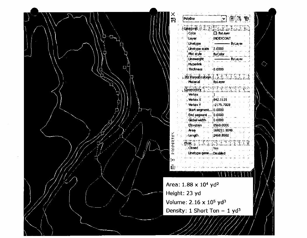

Attachment B
Log sheets
Section #1 - Landfill Waste Log
Section#2 - Inspections
Paiiadon Iron, Cedar City, Utah Page 22 Landfill Permit Application July 18,2008
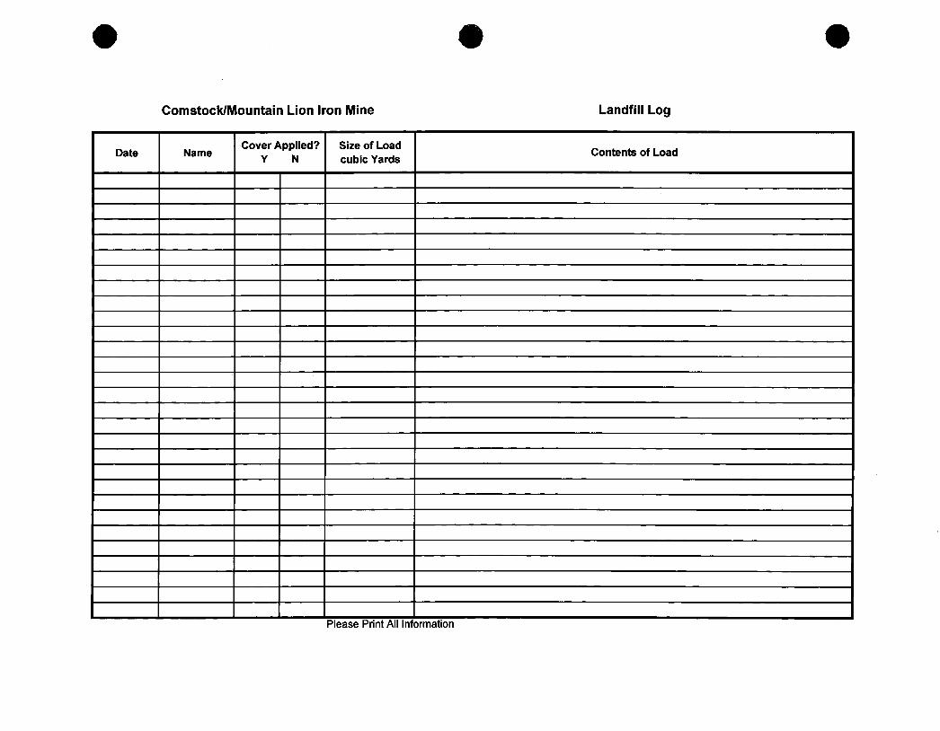
Comstock/Mountain Lion Iron Mine Landfill Log
Date Name Cover Applied?
Y N Size of Load cubic Yards
Contents of Load
Please Print All Information
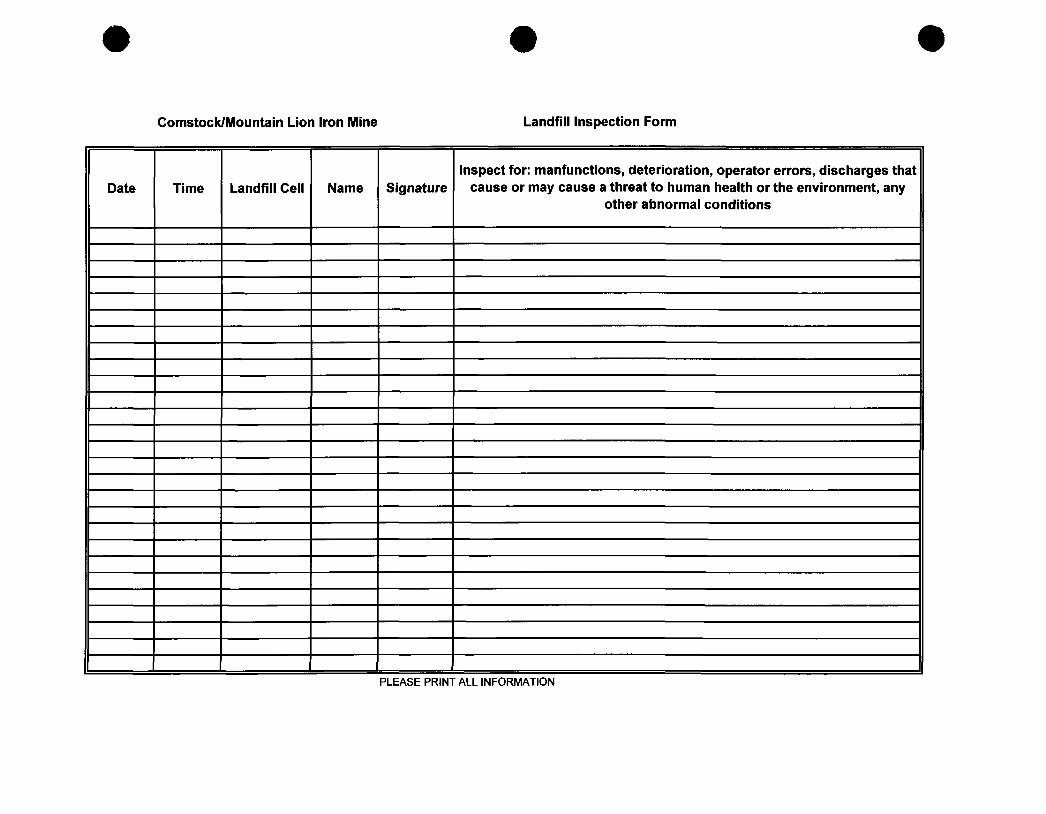
Comstock/Mountain Lion Iron Mine Landfill Inspection Form
Date Time Landfill Cell Name Signature Inspect for: manfunctions, deterioration, operator errors, discharges that
cause or may cause a threat to human health or the environment, any other abnormal conditions
PLEASE PRINT ALL INFORMATION
Attachment C
General Site Safety and Training Plan Addendum
Paiiadon Iron, Cedar City, Utah Page 23 Landfill Permit Application July 18,2008
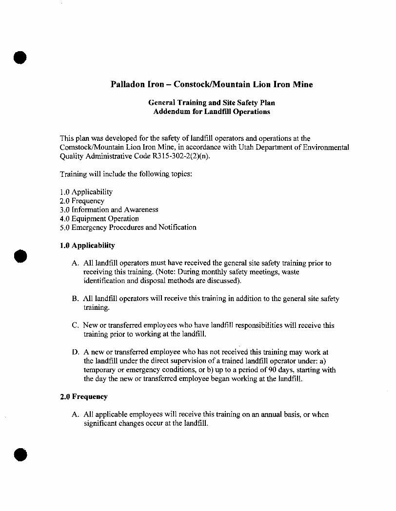
Paiiadon Iron - Constock/Mountain Lion Iron Mine
General Training and Site Safety Plan Addendum for Landfill Operations
This plan was developed for the safety of landfill operators and operations at the Comstock/Mountain Lion Iron Mine, in accordance with Utah Department of Environmental Quality Administrative Code R315-302-2(2)(n).
Training will include the following topics:
1.0 Applicability 2.0 Frequency 3.0 Information and Awareness 4.0 Equipment Operation 5.0 Emergency Procedures and Notification
1.0 Applicability
A. All landfill operators must have received the general site safety training prior to receiving this training. (Note: During monthly safety meetings, waste identification and disposal methods are discussed).
B. All landflll operators will receive this training in addition to the general site safety training.
C. New or transferred employees who have landfill responsibilities will receive this training prior to working at the landflll.
D. A new or transferted employee who has not received this training may work at the landfill under the direct supervision of a trained landfill operator under: a) temporary or emergency conditions, or b) up to a period of 90 days, starting with the day the new or transferred employee began working at the landfill.
2.0 Frequency
A. All applicable employees will receive this training on an annual basis, or when significant changes occur at the landfill.
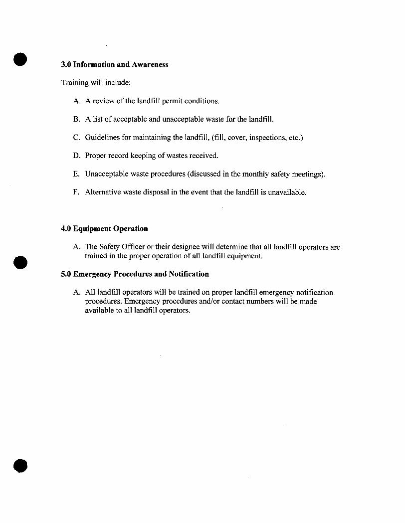
3.0 Information and Awareness
Training will include:
A. A review ofthe landflll permit conditions.
B. A list of acceptable and unacceptable waste for the landflll.
C. Guidelines for maintaining the landfill, (fill, cover, inspections, etc.)
D. Proper record keeping of wastes received.
E. Unacceptable waste procedures (discussed in the monthly safety meetings).
F. Altemative waste disposal in the event that the landflll is unavailable.
4.0 Equipment Operation
A. The Safety Officer or their designee will determine that all landfill operators are trained in the proper operation ofall landflll equipment.
5.0 Emergency Procedures and Notification
A. All landflll operators will be trained on proper landfill emergency notification procedures. Emergency procedures and/or contact numbers will be made available to all landfill operators.
Attachment D
Post-Closure Inspection Form
Paiiadon tron, Cedar City, Utah Page 24 Landfill Permit Application July 18,2008
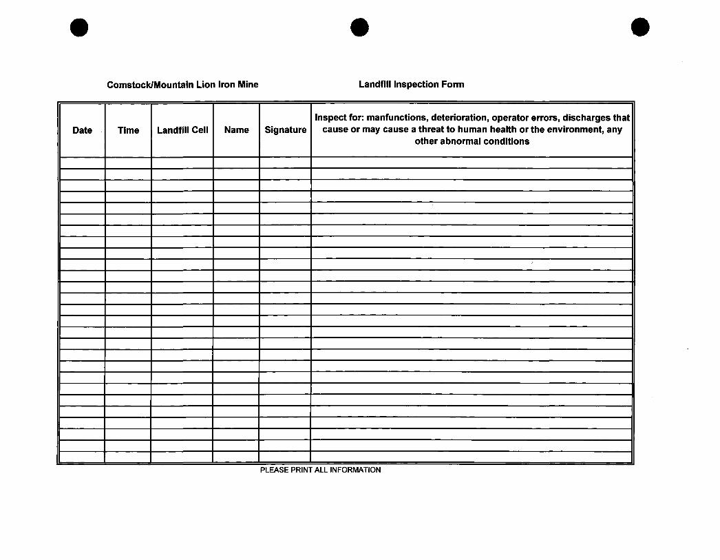
Comstock/Mountain Lion Iron Mine Landfill Inspection Form
Date Time Landfill Cell Name Signature Inspect for: manfunctions, deterioration, operator errors, discharges that
cause or may cause a threat to human health or the environment, any other abnormal conditions
'
PLEASE PRINT ALL INFORMATION
Attachment E
Financial Assurance and Ownership Documentation
Paiiadon Iron, Cedar City, Utah Page 25 Landfill Permit Application Juty 18,2008
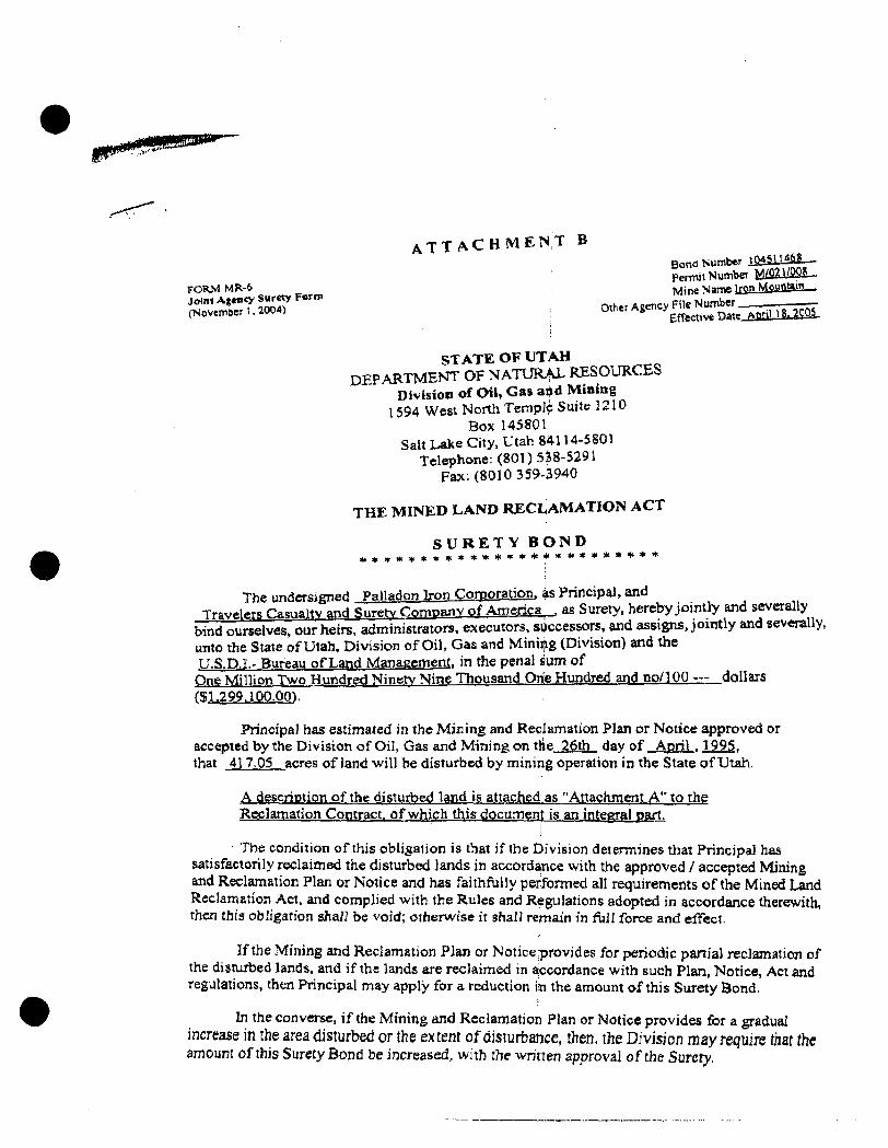
A T T A C H M E N T B Bond Number m £ m 6 S - -PennitNutnbeTM^22i/2Si_
FORM MR-6 Mine Natne IreiLMSMBail!— joini Agency Surety Form Aeency File Number —-CNovcmt.eH.2W4) ° ' ^ " ^ ^ ^ ^Effective Datt_6J!liUl.i22S.
1
STATE OF UTAH DEPARTMENT OF NATURAL RESOURCES
Division of Oil, Gas ai^d Mining 1594 West North Temple Suite UIO
Box 145801 SaltLake City. Utah 84114-5801
Telephone: (801) 538-5291 Fax: (8010 359-3940
THE MINED LAND RECLAMATION ACT
S U R E T Y B O N D * * • • • * • • * * • * * * * * « « • * • * * * * *
y^f. nnrr-Tirn-i P' ' ' I°"1"" V"" Corporation, as Principal, and . . , , ,, T . . . 2 7 r L a l t v ^ n H ^ ^ ; ; ^ i f E ^ ^ ^ ; ^ ^ ^ ^ L ^ ^ ^ , «« surety, hereby jointly and several^
b7nd ourselves, our heirs, administrators, execut^^^ ard assigns, jointly and sevenilly. unto the State ofUtah, Division of Oil, Gas and Minij^g (Division) and the TI.S.D.I- Bureau of Land Management, in the penal sum of One Million Two Hundre<;l IMinetv Nine Thousand Orie Hundred an^ no/100 — doll ars (5^.?99.1P0.Q0).
Principal has estimated in the Mining and Recjlamation Plan or Notice approved or accepted by the Division of Oil, Gas and Mining on the 26th day of April . Ig^g, that 417-05 acres of land will be disturbed by mining operation in the State ofUtah.
A description ofthe disturbed land is attached as "Attachment A" to the Reclamation Contract, of which this documenl: is an integral part.
The condition ofthis obligation is that ifthe Division detennines that Principal has satisfactorily reclaimed the disturbed lands in accordance with the approved / accepted Mining and Reclamation Plan or Notice and has faithflilly performed all requirements ofthe Mined Land Reclamation Act, and complied with the Rules and Regulations adopted in accordance therewith, then this obligation shall be void; otherwise it shall remain in full force and effect.
Ifthe Mining and Reclamation Plan or Notice provides for periodic panial reclamation of the disturbed lands, and ifthe lands are reclaimed in accordance with such Plan, Notice, Act and regulations, then Principal may apply for a reduction iin the amount ofthis Surety Bond.
In the converse, ifthe Mining and Reclamation Plan or Notice provides for a gradual increase in the area disturbed or the extent of disturbance, then, the Division may require that the amount ofthis Surety Bond be increased, with the wrinen approval ofthe Surety.
Page 2 MR-6 Joint Agency Surety Bond Attachment B (revised November 1, 2004)
Bond Number 104511468 Pennit Number M/021/008 Mine Name Irop Mountain
Qther Agency File Number Effective Date Appl 18. 2005
This bond may be canceled by Surety after ninety ,(90) days following receipt by the Division and Principal of written notice of such cancellation. Surety's liability shall then, at the expiration of said ninety (90) days, cease and terminate except that Surety will remain fiilly liable for all reclamation obligations ofthe Principal incurred prior to the date of termination.
Principal and Surety and their successors and assigns agree to guarantee said obligation and to indemnity, defend, and hold harmless the Divisiori from any and all expenses (including attorney fees) which the Division may sustain in the collection of sums due hereunder.
Surety will give prompt notice to Principal and tothe Division of the filing of any petition or the commencement of any proceeding relating lo the bpkruptcy, insolvency, reorganization, or adjustment ofthe debts of Surety, or alleging any violation or regulatory requireinents whicb could result in suspension or revocation ofthe Surety's license to do business.
IN WITNESS WHEREOF, the Principal and Surety hereunto set their signatures and seals as of the dates set forth below.
Paiiadon Iron Corporation Principal (Permittee) i
; am Title typed); I > By
ure
Surety Company
t "i-n-oc Date
Travelers Casualty and gurety Companv of America Surety Company Name
S. Murrv Mullenax Surety Company Officer
Attomev-in-Fact Title/Position
Signature
1100 East 6600 South. #500 Street Address
; Sah Lake Citv. UT 84121 City, State, Zip
801-269-^5657 Phone Number
Date
Page 3 MR-6 Joint Agency Surety Bond Anachment B (revised November 1, 2004)
Bond Nuinber 1&4S114S8 Permit Nuinber M/021/008 Mine Name Iron Mountain
Other Agency File Number. EfTective Date April 18. 2005
SO AGREED this / •r -. day of. /./-r-ip-A/N.... ) i n /•> '•^' . ,20 ^ ,^
AND APPROVED AS TO FORM AND AMOUNT OF SURETY.
— ^ ,/. \ ^ A . -^^<H- ' j i ^ iy '
Mary Ann Wri^t, Acting Di|»ctor Utih State Division of OiVtjas and Mining
••NOTE: Where one signs by virtue of Power of Attomisy for a Surety, such Power of Attomey musl be filed with this bond. Ifthe Operator is a corporation, the bond shall be executed by its duly authorized officer.
Page 4 MR-6 Joint Agency Surety Bond Attachment B (revised November 1. 2004)
Bond Number 104511468 Permit Nuinber M/021/008 Mine Name Iron Motmtain
Oiher Agency File Number Effective Date April 18.2005
A F F I D A V I T O F Q U A L I F I C A T I O N
On the 18th. day cf April . 2005, S. Murrv Mullenax personally appeared before me, who being by me duly sworn did say that he/she, the said
S. Murrv Mullenax is the Attomev-iiii-Fact of Travelers Casualty and Siu-ety Companv of America and duly acknowledged that said instrument was signed on behalf of said company by authority of its bylaws or a resolution ofits board of directors and said S. Murrv Mullenax duly acknowledged to me that said company executed the same, and that he/she is duly authorized to execute and deliver the foregoing obligations; that said Surety is authorized to execute the same and has complied in all respects with the laws ofUtah in reference to becoming sole surety upon bonds, undertaking and obligations.
Signed: ^ JjAAMA ^ J m c ^
Surety Officer
Title: S. Murrv Mullenax, Attomev-in-Fact
STATE OF Utoh
COUNTY OF S a l t Lake
. ) ) ss;
.)
Subscribed and sworn to before me this 18th day of . ^ a r i l ,20tJ5
SYLVIA CARROLL NOTMfty n m i c • STATE a UTAH
1100 EMoos s u r e eoo SAUTLAKCCnY UT 84121
MV COMWSStON EXPineS; 14«(MC06
My Commission Expires;
Notary Puqjic Residing at; _
tauM.
yiJM •y^6 .20 O
STPAUL TRAVELERS
IMPORTANT DISCLOSURE NOTICE OF TERRORISM INSURANCE COVERAGE
On November 26, 2002, President Bush signed into law the Terrorism Risk Insurance Act of 2002 (the "Act"). The Act establishes a short-term program under which the Federal Government will share in the payment Of covered losses caused by certain acts of international terrorism. We are providing you with this notice to inform you of the key features of the Act, and to let you know what effect, if any, the Act vyill have on your premium.
Under the Act, insurers are required to provide coverage for certain losses caused by international acts of terrorism as defined in the Act. The Act further provides that the Federal Government will pay a share of such losses. Specifically, the Federal Government will pay 90% of the amount ;of covered losses caused by certain acts of terrorism which is ip excess of an insurer's statutorily established deductible for that year. The Act also caps the amount of terrorism-related losses for which the Federal Government or an insurer can; be responsible at $100,000,000,000.00, provided that the insurer has met its deductible.
Please note that passage of the Act does not result in any change in coverage under the attached policy or bond (or the policy or bond being quoted). Please also note that no separate additional premium charge has bee!^ made for; the terrorism coverage required by the Act. The premium charge that is allocable to such coverage is inseparable from and imbedded in your overall premium, and is no more than one percent of your premium.
ILT-IOIS (9/04)
IN WITNESS WHEREOF, TRAVELERS CASUALTY AND SURETY COMPANY OF AMERICA, TRAVELERS CASUALTY ANt> SVRKTY COMPANY and FARMINGTON CASUALTY COMPANY have MUsed this instrument to b signed by their Senior Vice President and their corporate seals to be hereto afRxed this Sth day of April, 2004,
STATB OF CONNECTICUT
}SS.Hanfonl
COLJNTY OF HARTFORD
TRAVELERS CASUALTY AND SURETY COMPANV OF AMERICA TRAVELERS CASUALTY AND SURETY COMPANV
FARMINGTON CASUALTY COMPANY
av_ Gaorge W. Thompson Senior Vice President
On iiti& Sth <iay of April, 2004 before me personally came GEORGE W. THOMPSON to me known, who, being by mc duly sworn, did depose and say; that he/she is Senior Vice President of TRAVELERS CASUALTY AND SURETY COMPANY OF AMERICA TRAVELERS CASUALTY ANO SURETY COMPANY and FARMINGTON CASUALTY COMPANY, the corporations described in and which executed the above instrument; that he/she knows the seals of said corporations; thai the teals aSxed to the said inctruinent are siKh corporate seats; and that he/she executed the said instrument on behalf of the corporations by authority of his/her ofiice under the Standing Resolutions thereof
\>r\c OAJUL- t "ijiJTULOUjjL^ My commission expires June 30, 2006 Notary Public
Marie C. Tetreault
CERTIFICATE
I. the undersigned, AMictant Secretary of TRAVELERS CASUALTY AND SURETY COMPANY OF AMERICA. TRAVELERS CASUALTY AND SURETY COMPANY and FARMINGTON CASUALTY COMPANY, stock corporations of the Sute of Connecttcut, DO HEREBY CERTIFY chat the foregoing and attached Power of Attomey aad CerUlicate of Authority remains in iiill force and has not been revoked; and furthermore, tiiat the Standing Resolutions of the Boards of Direaors. as set forth in the Certificate of Authority, are now in force.
Signed aad Sealed at the Home Office of the Company, in the City of Hartford, State of Connecticut. Dated this 1 8 t h day of A p r i l , 2005 .
By Kori M. Johanson Assistant Secretary, Bond
TRAVELERS CASUALTY AND SURETY COMPANY OF AMERICA TRAVELERS CASUALTY AND SURETY COMPANY
FARMINGTON CASUALTY COMPANY Hartford. Coeneciicut 06183-9062
POWER OF ATTORNEY AND CERTIFICATE OF AUTHORITY OF ATTORNE Y(S)-IN-FACT
KNOW ALL PERSONS BY THESE PRESENTS, THAT TRAVELERS CASUALTY AND SURETY COMPANY OF AMERICA, TRAVELERS CASUALTY AND SURETY COMPANY and FARMINGTON CASUALTY COMPANY, corporations duly organized under tiie laws of the State of Connecticut, and having their principal offices in the City of Hartford, County of Hartford, State of Connecticut, (hereinafter the "Companies") hath made, constituted and appointed, and <Jo by these presents make, constitute and appoint: Leonard D. Nielsen, S. Murrj Muitenax, Brett Palmer, Sylvia A Carroll, of ISeJt Late City, Utah, their due and lawfiiJ Ationie3'(s}-in-F3ct, with ftili power and authority herehy conferred to sign, execuie ajidi> acknowledge, at any place within the United States, the following instnfment<s}: by his/her sole signature and act, any and all bonds, recognizances, contracts of indemnity, and other writings obligatory in the nature of a bond, recognizance, or ooaditioita] undertaking and any and all consents incident thereto and to hind the Companies, therd>y as fully and to the same extent as if the same were signed by the duly authorized officers of the Companies, and ail the acts of said Anoniey(s)«in-Fact, punoam to Uie authority herein given, are hereby ratiiied and confirmed
This appointment is made under and by authority of the following Standing Resolutions of said Companies, which Resolutions are now tn full force and efifect:
VOTED: That !h« Chairman, the President, any Vice Chaimum, any Executive Vice President, any Senior Vjce President, any Vioe Prcsideat, any Second Vice President, the Treasurer, any Assistani Treasurer, the Coiporate Secretary or any Assistant Secretary may appoint Atteniey*>ia>Fset and Agenu to act for and on behalf of the company and may give such appointee such authori^ as hi s or her certificate of authority may pMscribe to sign with the Company's name and seal with the Company's seal bonds, recognizances, contracts of indemnity, and other writings obhgaiory in the nature of a bond, recognizance, or conditional undertaking, and any of said officets or the Board of Directors at any time may remove any such appointee and revoke the power given him or her.
VOTED: That the Chainnan, the President, any Vice Chairman, any Executive Vice President, any Senior Vise President or any Vice Fresideni may delegate all or any part of the foregoing authority to one or more ofTlcers or employees ofthis Company, provided that each such delegation is -n writing and a copy hereof is filed in the office ofthe Secretary.
VOTED: That any bond, recognizance, cortract of indemnity, or writing obligatory in the nature of a bond, recognizance, or conditional undertaking shall be valid and binding upon the Company when (a) signed by the President, any Vice Chainnan, any BxecuUve Vice President, any Senior Vice President or any Vice President, any Secoiid Vioe President, the Treasurer, any Assistam Treasurer, the Corporate Secretary or any Assistant Secretary and duly attested and seated with the Company's seal by a Secretary or Assisbnt Secretary, or Cb) duly executed (imder seal, if required) by one or more Attomeys-in-Fact and Agents pursuant to the power prescribed in his or her certificate or their certificates of authority or by one or more Company officers pursuant to a written delegation of autlwrity.
This Power of Attomey and Certificate of Authority is sigeed and sealed by facsimile (mechanical or printed) under and by authority of the folIowinB Standing Resolution voted by the Boards of Directors of TRAVELERS CASUALTY AND SURETY COMPANY OF AMERICA, TRAVELERS CASUALTY AND SURETY COMPANY and FARMINGTON CASUALTY COMPANY, which Resolution is sow in full force and effect:
VOTED: That the signature of each of the following afftcers: President, any Executive Vice Piesidenl, any Senior Vice President, any Vice President, any Assistant Vice President, any Secretary, any Assistant Secreuuy, and tbe seat of Ihe Company may be aCTtxed by facsimile to any pow«r of attomey or to any certificate relating thereto appointing Resident Vice Presidents, Resident Assistant Secretaries or Attomeys-in-Fact fer purposes only of executing and attesting bonds and undertakings and other vmtings obligatory in the nature thereof, and any such power of attomey or certificate bearing such facsimile signature or facsimile seal shall tie valid and binding upon the Compeny and any such power so executed and certified by such facsimile signature and facsimile seal shell be valid and binding upon the Company in the future with respect to any bond or undertaking to whicb it is attached.
Cl-0OS'M>ia/d)
Attachment F
Application Form and Checklist
Paiiadon Iron, Cedar City, Utah Page 26 Landfill Permit Application Juty 18,2008
m Utah Class III Landfill Permit Application Form
/General Information vvv APPLIGANT; PLEASE COMPLETE ALL SECTIONS.. ;,:«^ i f i i - v i ? : **u-^w
/.. Landfill Type n Class llla [7] Class lllb //•v Application ty i ie 3 New Application
Z\ Renewal Application • Facility Expansion • Modification
For Renevi/al Applications, Facility Expansion Applications and Modifications Enter Current Permit Number
yU^'Facility Nami^ and:L6catioh . . / M J K : %i : \ . .^ :
Legal Name of Facility Comstock/Mountain Lion Iron Mine
Site Address (street or directions to site) 15 "^ "^^^ °^ ^^^^"^ "^^ty on HWY 56, then 1.5 mi North on Comstock Road , then 4 ,000 f e e t NW on Mine P r o p e r t y
County I r o n County
City Cedar C i t y state U T ZipCode 8 4 7 2 0 Telephone ( 4 3 5 ) 4 6 3 - 4 7 2 3
Township 368 Range 13W Section(s) 30 Quarter/Quarter Section N E / SW Quarter Section NW
Main Gate Latitude N degrees 3 7 minutes 3 7 seconds 4 5 . 5 Longitude W degrees 1 1 3 minutes 2 0 seconds 2 7 . 5
/ ^ Fa(:ility Owher(s) ihfbrmation'^ • :^ '- \-7j . i^s:: .^
Legal Name of Facility Owner
Paiiadon Iron Corporation Address (mailing)
554 South 300 E a s t S u i t e 250 City S a l t Lake C i t y State U T ZipCode 8 4 1 1 1 Telephone ( 8 0 1 ) 5 2 1 - 5 2 5 2
V. Facility Operator(s) Information Legal Name of Facility Operator
P a i i a d o n I r o n C o r p o r a t i o n Address (mailing)
554 South 300 East Suite 250 Salt Lake City state UT ZipCode 8 4 1 1 1 Telephone ( 8 0 1 ) 5 2 1 - 5 2 5 2
y/.^ Property Owner(s) Infonnation Legal Name of Prooerty Owner
Paiiadon Iron Corporation Address (mailing)
554 South 300 E a s t S u i t e 250 City Salt Lake City state U T ZipCode 8 4 1 1 1 Telephone ( 8 0 1 ) 5 2 1 - 5 2 5 2
V//. ;Gontact Information
Ovwier Contact Donald G. F o o t , J r . Title Pres ident and Chief Executive Officer Address (mailing) 554 South 300 East Suite 250
City Salt Lake City state U T Zip Code 8 4 1 1 1 Telephone ( 8 0 1 ) 5 2 1 - 5 2 5 2
Email Address don. f o o t @ p a l l a d o n i r o n . com Alternative Telephone (cell or other)
Operator Contact G reg G. H a w k i n s Title D i r e c t o r of O p e r a t i o n s Address (mailing) 2 7 0 8 S . C o m s t o c k R d
City Cedar C i t y state U T ZipCode 8 4 7 2 0 Telephone ( 8 0 1 ) gTGO - ' ^ O ' ^ - y
Email Address ghawkins8palladoniron.com or
hawkins. palladongqmail. com Alternative Telephone (cell or other)
Property Ovmer Contact Donald G. Foo t , J r . Title Pres ident and Chief Executive Officer Address (mailing) 554 South 300 Eas t S u i t e 250
• I Ema
S a l t Lake C i t y state U T ZipCode 8 4 1 1 1 Telephone ( 8 0 1 ) 5 2 1 - 5 2 5 2
Email Address don. foo t@pal l adon i ron .eom Alternative Telephone (cell or other)
•n Utah Class III Landfill Permit Application Form
/ General Information (Cohtiriued) , W a s t e T y p e s (check all that apply) iX. FacilityjArea
P I All types of non-hazardous industrial vraste generated by the facility OR the following specific waste types
Waste Type Combined Disposal Unit Monofill Unit D Construction & Demolition Q D D Industrial D D n Incinerator Ash D D n Animals D D n Asbestos n D n other n D Note: All waste types must be generated by the industry which owns the fadlity
Facility Area 4 6 5
Disposal Area 3 . 8 8
Design Capacity
Years 2 0
Cubic Yards 2 1 6 . 0 0 0
Tons 3 2 , 4 0 0
acres
acres
X/-Fee arid Application Documents;: Indicate Documents Attached To This Application 0
0 Facility Map or Maps 0 Facility Legal Description n Ground Water Report l y ] Closure Design
Application Fee: Amount $ 7 5 0 . 0 0
W] Plan of Operation [ • I Cost Estimates
E Waste Description [ • ] Financial Assurance
LHEREBY CERTIFY THAT IHIS JhlPDRMATION AND ALL ATTACHED PAGES ARE CORRECT AND COMPLETE Title President and CEO
Date
Vf S ^ / z ^ / c ^ Address 554 South 300 East, Salt Lake City, UT 84111
Title Date
Address
Name typed or printed ized/pperator Representative (if applicable) Title
Director of Operations Date
s/ai/c:^ Name typed or printed
Address
2708 S. Comstock Road, Cedar City, Utah, 84720
Utah Class III Landfill Permit Application Checklist
Important Note: The following checklist is for the permit application and addresses only the requirements of the Division of Solid and Hazardous Waste. Other federal, state, or local agencies may have requirements that the facility must meet. The applicant is responsible to be informed of, and meet, any applicable requirements. Examples of these requirements may include obtaining a conditional use permit, a business license, or a storm water permit. The applicant is reminded that obtaining a permit under the Solid Waste Permitting and Management Rules does not exempt the facility from these other requirements.
An application for a permit to construct and operate a landfill is documentation that the landfill will be located, designed, constructed, operated, and closed in compliance with the requirements of Rules R315-304 of the Utah Solid Waste Permitting and Management Rules and the Utah Solid and Hazardous Waste Act (UCA 19-6-101 through 123). The application should be written to be understandable by regulatory agencies, landfill operators, and the general public. .The application should also be written so that the landfill operator, after reading it, will be able to operate the landfill according to the requirements with a minimum of additional training.
Copies of the Solid Waste Permitting and Management Rules, the Utah Solid and Hazardous Waste Act, along with many other useful guidance documents can be obtained by contacting the Division of Solid and Hazardous Waste at 801-538-6170. Most of these documents are available on the Division's web page at www.hazardouswaste.utah.gov. Guidance documents can be found at the solid waste section portion of the web page.
When the application is determined to be complete, the original complete application and one copy of the complete application are required along with an electronic copy.
Part l l Application Checklist
7f'FacilltylGerieral1riff6miatiorVf"^ •'•* •5'• •&''*¥• •'"'# • *' •ii.^"^**-*^ »'4'''";r-"l
] " ' . . . - • • - • . . ^ ^ - ' ^ '.' " ' . ' . - - ' ' - ' ' . ~ - ' • *
la. General Information For-AlUFacilities ; J
Completed Part 1 General information
General description ofthe facility (R315-310-3(1 )(b))
Legal description of property (R315-310-3(1 )(c))
Proof of ownership, lease agreement, or other mechanism (R315-310-3(1 )(c))
A demonstration that the landfill is not a commercial facility
Waste type and anticipated daily volume (R315-310-3(1 )(d))
Intended schedule of construction (R315-302-2(2)(a))
"/fc. General Information •^New-OrLaterally^Expanding^Classi^lll^t * i a n d f l l l S > % > . I ; ; 7 - > ^ : & - i : k 4 ; , . . ; ' . • , . ^ , * i . . v , i . . . . ; s v . . . : , ; . . - : / i . r t , . . s . - , . •:: . i . : \ • ..Z.
Documentation that the facility has meet the historical survey requirement of R315-302-1 (2)(f) (R315-305-4(1 )(b) or R315-305-4(2)(a)(iv))
Name and address of all property owners within 1000 feet of the facility boundary (R315-310-3(2)(i))
Documentation that a notice of intent to apply for a permit has been sent to all property owners listed above (R315-310-3(2)(ii)) Name of the local government with jurisdiction over the facility site (R315-310-3(2)(iii))
Location In ; •Document
Page 3
Page 3
Page 3
Page 3
Page 4
Page 4
Page 4
%.. ..•|,;».,;,J,« .Jj?!:. .....SJ ,. ^^«
Page 4
Page 4
Page 4
Page 5
Page 1 of 5 (rev. 9/2007)
Utah Class III Landfill Permit Application Checklist
<A'''Faciiity'General;: Information..:-» --.i '::-i.-,..A...i- Lr,.^„.;. <i. . . , : .A ' . . 'ZLZ '1 . X.-',-.';'' T!-' v " ' ^ ••' '•-;--;- '^? •'•"- -^-i-y t< •%.< . . . . D e s c r i p t i o n o f I t e m •';•••••—••••'•' - • • - < > . , - . : : : ; - .;v.......j;
;7c. Location standards - N^w Glass llla Landfills (RSI5-304-4(1))-: Geology
Geologic maps showing significant geologic features, faults, and unstable areas Maps showing site soils
Surface water
Magnitude of 24 hour 25 year and 100 year storm events
Average annual rainfall
Maximum elevation of flood waters proximate to the facility Maximum elevation of flood water from 100 year flood for waters proximate to the facility
Wetlands
Ground water
Historic Preservation Survey
Ji^i^^^dltlpnal L c ^ Not On • /•Waste:X3erieration.:Site-. -,;'-l..Z^''Zj...i J Z i : ll'SZ'k 7Z''^/l'J..kZZ'z-Land use compatibility (R315-304-4(1 )(a))
Maps showing the existing land use, topography, residences, parks, monuments, recreation areas or wilderness areas within 1000 feet ofthe site boundary
Certifications that no ecologically or scientifically significant areas or endangered species are present in site area
List of airports within five miles of facility and distance to each
/e; Location Standards.4 NeWiClas^ Z 'Z ' IZZ' t l • :
Floodplains as specified in R315-302-1 (2)(c)(ii) (R315-304-4(2)(a)(i))
Wetlands as specified in R35-302-1 (2)(d) (R315-304-4(2)(a)(ii)) The landfill is located so that the lowest level of waste is at least ten feet above the historical high level of ground water (R315-304-4(2)(a)(iii))
Historical Preservation Survey (R315-304-4(2)(a)(iv))
M- Plan of Operat ior is- All (DIass III Landf i l l s (R315r3?0^3( t ) ( l )and l
• R315-302-2(2));:••^•^••.••'••^•^'t • r Z j ' ' : - ^ r ] Z - ' ' ' - l ''^"''••'^- ' ' ^ - - — - f
Description of on-site waste handling procedures and an example of the form that will be used to record the weights or volumes ofwaste received (R315-302-2(2)(b) And R315-310-3(1 )(f)) Schedule for conducting inspections and monitoring, and examples of the forms that will be used to record the results ofthe inspections and monitoring (R315-302-2(2)(c), R315-302-2(5)(a), and R315-310-3(1 )(g))
5 ..LocationJn. !t ; i. i J Document.^. .:
•:; •'• . : • iy • •> ?. W v - •;. 4
*;•.•4-^^ "• 'i>:---:S > « i 4 -
• ; ^ ' ' • > • " " • • - • - ^ « - > • ' . ' i V ^ " ^ v • ' '•• •••
Page 5
Page 5
Page 5
Page 4
• " • ' • '•• • ' > • \ 1 . ' ' • • • « « V - > i ; - • ' • ! ;
•, ' , , • * . ; , . • V; . . . 'v , * y . 4 : . . * - ; ' . . .-^ . ,v , • !
Page 6
Page 6
Page 2 of 5 (rev. 9/2007)
Utah Class III Landfill Permit Application Checklist
/ : Facility Generallnformation 4 « . ; . . i i . r ? ! ^ ,..jt..;^.^i...-^i. ,.;,,,.-.>•,;;.. %.. .., ..,.Pe^ ^ i , r . -i I
Contingency plans in the event of a fire or explosion (R315-302-2(2)(d))
Plan to control fugitive dust generated from roads, construction, general operations, and covering the waste (R315-302-2(2)(g)) Plan for letter control and collection (R315-302-2(2)(h)) Procedures for excluding the receipt of prohibited hazardous or PCB containing wastes (R315-302-2(2)0)) Procedures for controlling disease vectors (R315-302-2(2)(k))
A plan for alternative waste handling (R315-302-2(2)(l))
A general training and safety plan for site operations (R315-302-2(2)(o))
Any recycling programs planned at the facility (R315-303-4(6))
Any other site specific information pertaining to the plan of operation required by the Executive Secretary (R315-302-2(2)(p))
/g. ^Grbuhd;V\^t€lr Monitoririg - 'Class llla landfills ^-^ & ; -:, ,< »<,,
Ground Water Monitoring Plan (R315-304-5(4)(a)
r ; Location J n | 7 '• "•""fDoburriieht' i -^?;?''
Page 6
Page 6
Page 6
Page 7
Page 7
Page 7
Page 7
Page 7
• r ^ , - . ; . . . ' , f y '^ .^- • • } . ' : ^ : - • ; . ; x ; C i ^ . . ' . . •.; '^V., •
;.5rJ: • • i i . . ' " i - ^!S!•• .-jS i * " ^ :!«•••
'W'Facility'tecKHical Ihlxjrmation''';'''"'"-^''•';:•'";" "' '"t •>..->;• vs-' v..*^--- ;:. •y. hZ-'^'^ i -;•••
//a.;'Maps'-^ll Gla^s III Landfills; ; T -y:;•;..•.,--..--p..::,,.. -.- > r ,. =;
Topographic map drawn to the required scale with contours showing the boundaries ofthe landfill unit, ground water monitoring well locations, gas monitoring points, and the borrow and fill areas (R315-310-4(2)(a)(i))
Most recent U.S. Geological Survey topographic map, 7-1/2 minute series, showing the waste facility boundary; the property boundary; surface drainage channels; any existing utilities and structures within one-fourth.mile ofthe site; and the direction ofthe prevailing winds (R315-310-4(2)(a)(ii))
//fcllGedhydrcioJical Assessment-Clasg IJll'Baridtills"(R^l5^10- t
Local and regional geology and hydrology including faults, unstable slopes and subsidence areas on site (R315-310-4(2)(b)(i))
Evaluation of bedrock and soil types and properties including permeability rates (R315-310-4(2)(b)(ii))
Depth to ground water (R315-310-4(2)(b)(iii))
Quantity, location, and construction of any private or public wells on-site or within 2,000 feet ofthe facility boundary (R315-310-4(2)(b)(v))
Tabulation of all water rights for ground water and surface water on-site and within 2,000 feet ofthe facility boundary (R315-310-4(2)(b)(vi))
••4*,r .^„J^J.#:; . . •<>£, v'?;. . i ^ , - ' . ^ . -
Page 7
Page 7
- v r . - ^ r • • ' ; » • ' • . ; • • • . • « • ' • • ! - • • * • • • • V
-J )
r).
^rM^f^l^U
Page 3 of 5 (rev. 9/2007)
Utah Class III Landfill Permit Application Checklist
J. Facility General l n f o r m a t i 6 n , j L « . t i ? ! I. ' . ' * ' Description of item " ; >•
Identification and description of all surface waters on-site and within one mile of the facility boundary (R315-310-4(2)(b)(vii))
For an existing facility, identification of impacts upon the ground water and surface water from leachate discharges (R315-310-4(2)(b)(viii))
Calculation of site water balance (R315-310-4(2)(b)(ix))
//c; Engineering Report -Plans, Specifications, And .Calculations -All Class:III Landfills '
Unit design to include cover design; fill methods; and elevation of final cover including plans and drawings signed and sealed by a professional engineer registered in the State of Utah, when required (R315-310-3(1 )(b))
Design and location of run-on and run-off control systems (R315-310-5(2)(b))
V/d. Engineering Report:- Plans, Specifications, And Calcuiations - • I C I a S S ^ ' l l I ^ l m i c i f i M ' -r ' ^Z ' l •r-:^"':S:'^'W ',;' ; -.. ....^•r.-..,,..-:.-•:; . , ,
Engineering reports required to meet the location standards of R315-304-4 including documentation of any demonstration or exemption made for any location standard (R315-310-4(2)(c)(i))
Anticipated facility life and the basis for calculating the facility's life (R315-310-4(2)(c)(ii))
Equipment requirements and availability (R315-310-4(2)(c)(iii))
Identification of borrow sources for daily and final cover and for soil liners (R315-310-4(2)(c)(iv))
Run-off treatment and disposal and documentation to show that any treatment system is being or has been reviewed by the Division of Water Quality (R315-310-4(2)(c)(v) and R315-310-3(1 )(i))
V/e: Clblure Retiuiremiitgf-AJ^ Landfills <^^*-5 ^ - ? f Closure plan (R315-310-3(1 )(h))
Closure schedule (R315-310-4(2)(d)(i)) Design of final cover (R315-310-4(2)(c)(iii)) Capacity of site in volume and tonnage (R315-310-4(2)(d)(ii))
Final inspection by regulatory agencies (R315-310-4(2)(d)(iii))
?//f:'Pb#CI6sureiCafe [Requirenifent^-^ll'CIa^^ ;^*t
Post-closure care plan (R315-310-3(1 )(h))
Changes to record of title, land use, and zoning restrictions (R315-310-4(2)(e)(ii))
Maintenance activities to maintain cover and run-on/run-off control systems (R315-310-4(2)(e)(iii))
Ldcatibh In '!* • ''•- ' ' 'i Dbeiirneht - -w* ' ::-
1 ' < ' i ' .
Page 8
Page 8
^V -ft'-- feif'A;. ...''*. s?.-.\;<i.-
Page 8
Page 8 Page 9 Page 9
Page 9
i.A'^h--'A-^.A-j--Page 9
Page 9
Page 10
Page 4 of 5 (rev. 9/2007)
Utah Class III Landfill Permit Application Checklist
/.•^^Facility General lififbrmatibri^ • T - T'^-'A Z ••;?••-C"•»^•" ' '% ,,.--3j--^i.-fe.«-V v-; ..,.,rj4;-.- --5r-e-fei'- •?'•'.•-•ft%»rfft;:«Descriptiori50fltem'*iv*Jv./ vi-:...•%=*..%;:*.>v4vt-:« ^ : 2 '' •' -' 1 "•• •-' " r *4 5' 't ^ -' '*• f '"' '"
List the name, address, and telephone number of the person or office to contact about the facility during the post-closure care period (R315-310-4(2)(e)(vi))
//g.^*FinanciaLAssurance Requirements - All Class illl. Landfills^ 4
Identification ofclosure costs including cost calculations (R315-310-4(2)(d)(iv))
Identification of post-closure care costs including cost calculations (R315-310-4(2)(e)(iv))
Identification of the financial assurance mechanism that meets the requirements of Rule R315-309 and the date that the mechanism will become effective (R315-309-1(1) and R315-310-3(1)0))
;::,: |5,,L0Gati6n,lrT^,.^L ' ' Document i
Page 10
^ •'" ' * t /
Page 10
Page 10
Page 10
N:\ALL\SWS-Form\Permit Application fomis\2007_Class_III application and_checklist doc
Page 5 of 5 (rev. 9/2007)
E
MAR 0 9 2009 ^ % 1 ' ^ %
UTAH DIVISION OF SOLID & HAZARDOUS WASTE
^env i ronmenta l consu l tan ts , inc. www.jbrenv.com 8160 South Highland Drive • Sandy, Utah 84093 [P] 801.943.4144 [F] 801.942.1852
March 6,2009
Mr. Dennis Downs Division of Solid and Hazardous Waste P. O. Box 144880 Salt Lake City, Utah 84114-4880
RE: Paiiadon Iron Corporation Class Illb landfill Permit Application Revisions
Dear Mr. Downs:
On January 19, 2009, JBR Environmental Consultants (JBR) received notice from Paiiadon Iron Corporation (PIC) that DSHW reviewed and provided comments for the Class Illb landfill Permit Application submitted on August 21, 2008. This notice, dated December 31, 2008, identified some incomplete or unclear items in the application that were to be revised before resubmittal. JBR has made the necessary revisions on behalf of PIC and is resubmitting this application for a permit for a Class Illb landfill located at the iron mine site approximately 15 miles west of Cedar City, Utah.
Enclosed you will find a modified checklist that addresses each item in the checklist provided by DSHW. If you have any questions or need any other information, please do not hesitate to contact me at 801-943-4144 or Bruce Yeomans at (435) 572-4531.
Sincerely,
Spencer Daines
Attachments
cc: Alysen Pedersen, PIC
Corporate Office • Sandy, Utah Boise, Idaho Butte, Montana Elko, Nevada Reno, Nevada Eugene, Oregon Medford, Oregon St. George, Utah