concord school - safe routes to schoolsaferoutes.vermont.gov/sites/saferoutes/files/concord stp...
TRANSCRIPT
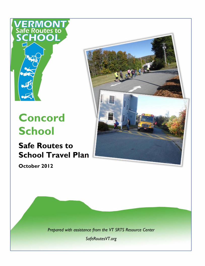
Concord School Safe Routes to School Travel Plan October 2012
Prepared with assistance from the VT SRTS Resource Center
SafeRoutesVT.org

Page left intentionally blank.
Page 3 of 18
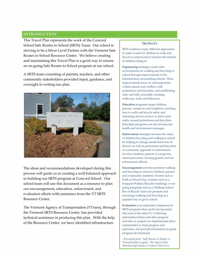
INTRODUCTION
This Travel Plan represents the work of the Concord School Safe Routes to School (SRTS) Team. Our school is striving to be a Silver Level Partner with the Vermont Safe Routes to School Resource Center. We believe creating and maintaining this Travel Plan is a good way to ensure an on-going Safe Routes to School program at our school.
A SRTS team consisting of parents, teachers, and other community stakeholders provided input, guidance, and oversight in writing our plan.
The ideas and recommendations developed during this process will guide us in creating a well-balanced approach to building our SRTS program at Concord School. Our school team will use this document as a resource to plan our encouragement, education, enforcement, and evaluation efforts with assistance from the VT SRTS Resource Center.
The Vermont Agency of Transportation (VTrans), through the Vermont SRTS Resource Center, has provided technical assistance in producing this plan. With the help of the Resource Center, we have identified infrastructure
The Five E’s
SRTS combines many different approaches to make it safer for children to walk and bicycle to school and to increase the number of children doing so.
Engineering strategies create safer environments for walking and bicycling to school through improvements to the infrastructure surrounding schools. These improvements focus on reducing motor vehicle speeds and conflicts with pedestrians and bicyclists, and establishing safer and fully accessible crossings, walkways, trails and bikeways.
Education programs target children, parents, caregivers and neighbors, teaching how to walk and bicycle safely and informing drivers on how to drive more safely around pedestrians and bicyclists. Education programs can also incorporate health and environment messages.
Enforcement strategies increase the safety of children bicycling and walking to school by helping to change unsafe behaviors of drivers, as well as pedestrians and bicyclists. A community approach to enforcement involves students, parents or caregivers, school personnel, crossing guards and law enforcement officers.
Encouragement activities promote walking and bicycling to school to children, parents and community members. Events such as Walk to School Day, contests such as a Frequent Walker/Bicyclist challenge, or on-going programs such as a Walking School Bus or Bicycle Train can promote and encourage walking and bicycling as a popular way to get to school.
Evaluation is an important component of SRTS programs that can be incorporated into each of the other E’s. Collecting information before and after program activities or projects are implemented allow communities to track progress and outcomes, and provide information to guide program development.
- Excerpted from “Safe Routes to School: A Transportation Legacy”, the report of the National Safe Routes to School Task Force
Page 4 of 18
improvements that would have a positive impact on walking and biking to school. These infrastructure recommendations are considered planning level and will require further engineering analysis to determine feasibility. It is our hope that our recommendations can be the basis for grants and/or improvements initiated by the Town of Concord.
Members of the Concord School Travel Plan Team
Patty Lyons Principal
Cindy Simpson-Hall Save Our School (SOS)
Karl Goulding Town of Concord AA and School Board Chair
Brian Gallagher PE teacher
Allison Low Northern Vermont Development Association (NVDA)
Stephanie Simpson Concord Parent Teachers Organization (PTO)
TEAM VISION
The SRTS program at the Concord School aligns with the community’s efforts towards promoting walkability. The SRTS program goals of combining engineering, education, enforcement, evaluation, and encouragement strategies (also known as the Five E’s) to improve the safety and health of students who walk to school, fit our school’s and town’s values very well.
Our vision for the Concord School (and the surrounding neighborhood) is:
‐ To be a school that has safe opportunities for students to travel by foot or bike ‐ To be a community that works together to address needs of all roadway users in a
comprehensive way ‐ To provide school access to all active transportation users
This Travel Plan outlines our school’s intentions for making walking to and from school more sustainable and safer for students and the community.
ABOUT THIS PLAN
Our SRTS team met three times with the VT SRTS Resource Center to develop and adopt this SRTS Travel Plan. Each meeting provided education on the benefits of SRTS and highlighted successful program components and strategies. The “engineering meeting” included a guided walk audit of the areas around our school. We also discussed education, encouragement,
Page 5 of 18
enforcement, and evaluation strategies, which helped identify needed and complimentary programs to support proposed engineering strategies.
Meeting Date Content and Outcomes
August 2012 Kick-off Meeting: How the VT SRTS Travel Plan Works ‐ Award of the planning assistance grant ‐ Overview of the planning process
Engineering Meeting ‐ Team visioning ‐ Opportunity and barrier discussions ‐ Walk audit
September 2012 Plan Review ‐ Reviewed the draft plan ‐ Observed arrival and dismissal ‐ Identified roles and immediate steps for non-engineering
recommendations
October 2012 Plan Adoption ‐ Adopted plan ‐ Began implementation of non-infrastructure
recommendations
TRAVEL PLAN CONTEXT
CONCORD SCHOOL AND CONCORD OVERVIEW
Concord School is in Concord, VT, a small town in the Northeast Kingdom of Vermont. Concord is located near the intersection of Interstates 91 and 93 on Vermont Route 2 and borders the State of New Hampshire on the Connecticut River. St. Johnsbury is the largest town by population in the Northeast Kingdom and serves as a commercial center for the area.
Concord School is located just south of Vermont State Highway Route 2 across the Moose River on School Street. Route 2 is the major east/west corridor serving the State of Vermont with a speed limit of 35 mph in the Town of Concord and 40 mph outside the town limits.
Page 6 of 18
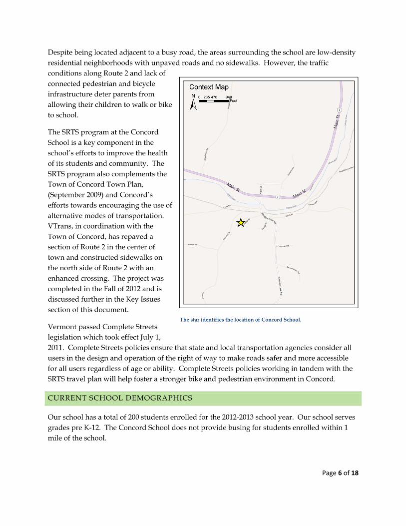
Despite being located adjacent to a busy road, the areas surrounding the school are low-density residential neighborhoods with unpaved roads and no sidewalks. However, the traffic conditions along Route 2 and lack of connected pedestrian and bicycle infrastructure deter parents from allowing their children to walk or bike to school.
The SRTS program at the Concord School is a key component in the school’s efforts to improve the health of its students and community. The SRTS program also complements the Town of Concord Town Plan, (September 2009) and Concord’s efforts towards encouraging the use of alternative modes of transportation. VTrans, in coordination with the Town of Concord, has repaved a section of Route 2 in the center of town and constructed sidewalks on the north side of Route 2 with an enhanced crossing. The project was completed in the Fall of 2012 and is discussed further in the Key Issues section of this document.
Vermont passed Complete Streets legislation which took effect July 1, 2011. Complete Streets policies ensure that state and local transportation agencies consider all users in the design and operation of the right of way to make roads safer and more accessible for all users regardless of age or ability. Complete Streets policies working in tandem with the SRTS travel plan will help foster a stronger bike and pedestrian environment in Concord.
CURRENT SCHOOL DEMOGRAPHICS
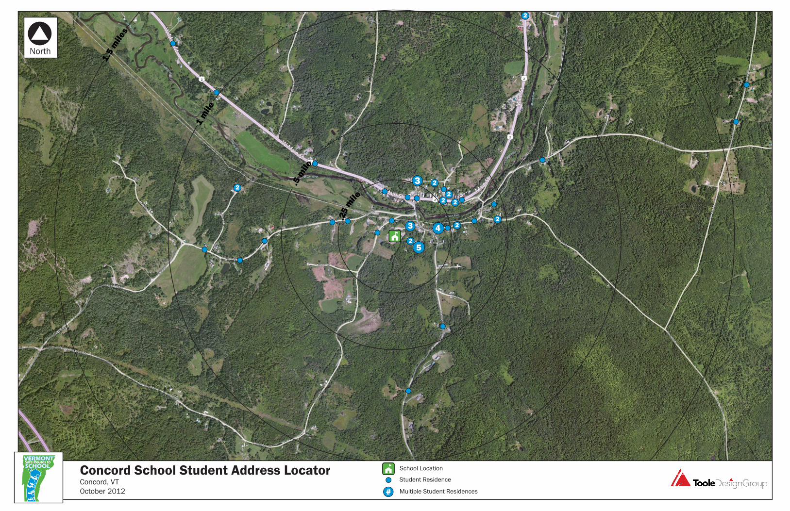
Our school has a total of 200 students enrolled for the 2012-2013 school year. Our school serves grades pre K-12. The Concord School does not provide busing for students enrolled within 1 mile of the school.
The star identifies the location of Concord School.
Page 7 of 18
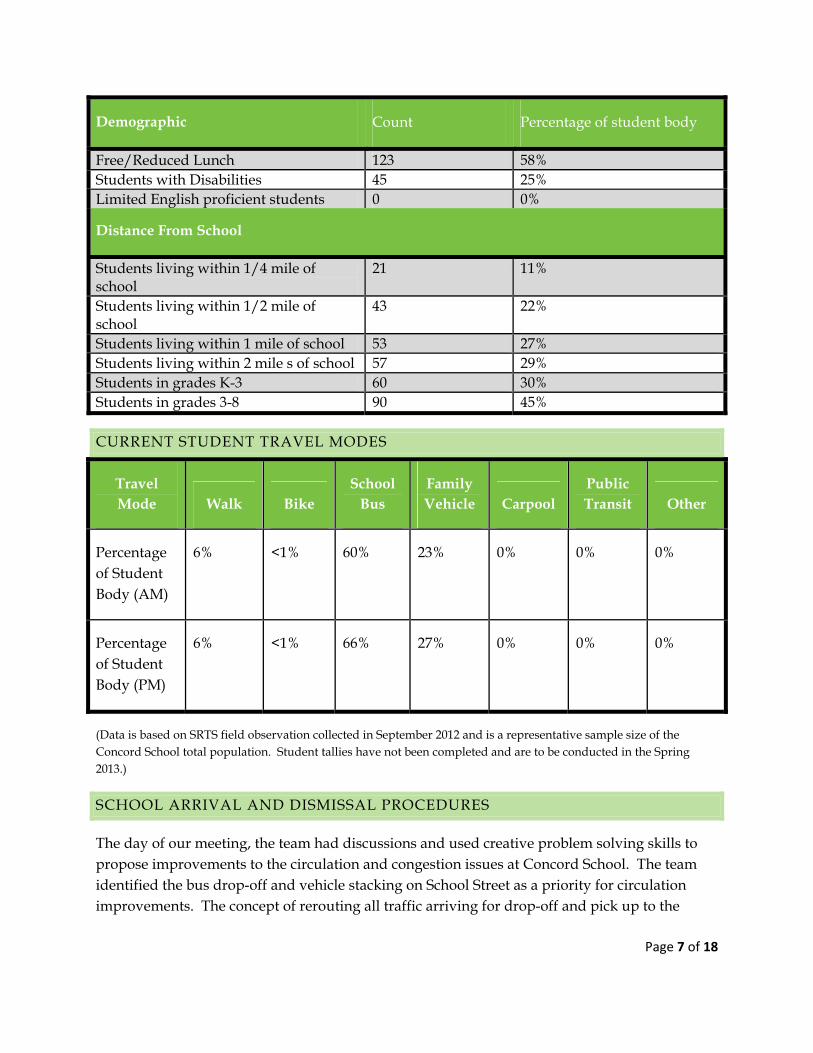
Demographic Count Percentage of student body
Free/Reduced Lunch 123 58% Students with Disabilities 45 25% Limited English proficient students 0 0%
Distance From School
Students living within 1/4 mile of school
21 11%
Students living within 1/2 mile of school
43 22%
Students living within 1 mile of school 53 27% Students living within 2 mile s of school 57 29% Students in grades K-3 60 30% Students in grades 3-8 90 45%
CURRENT STUDENT TRAVEL MODES
(Data is based on SRTS field observation collected in September 2012 and is a representative sample size of the Concord School total population. Student tallies have not been completed and are to be conducted in the Spring 2013.)
SCHOOL ARRIVAL AND DISMISSAL PROCEDURES
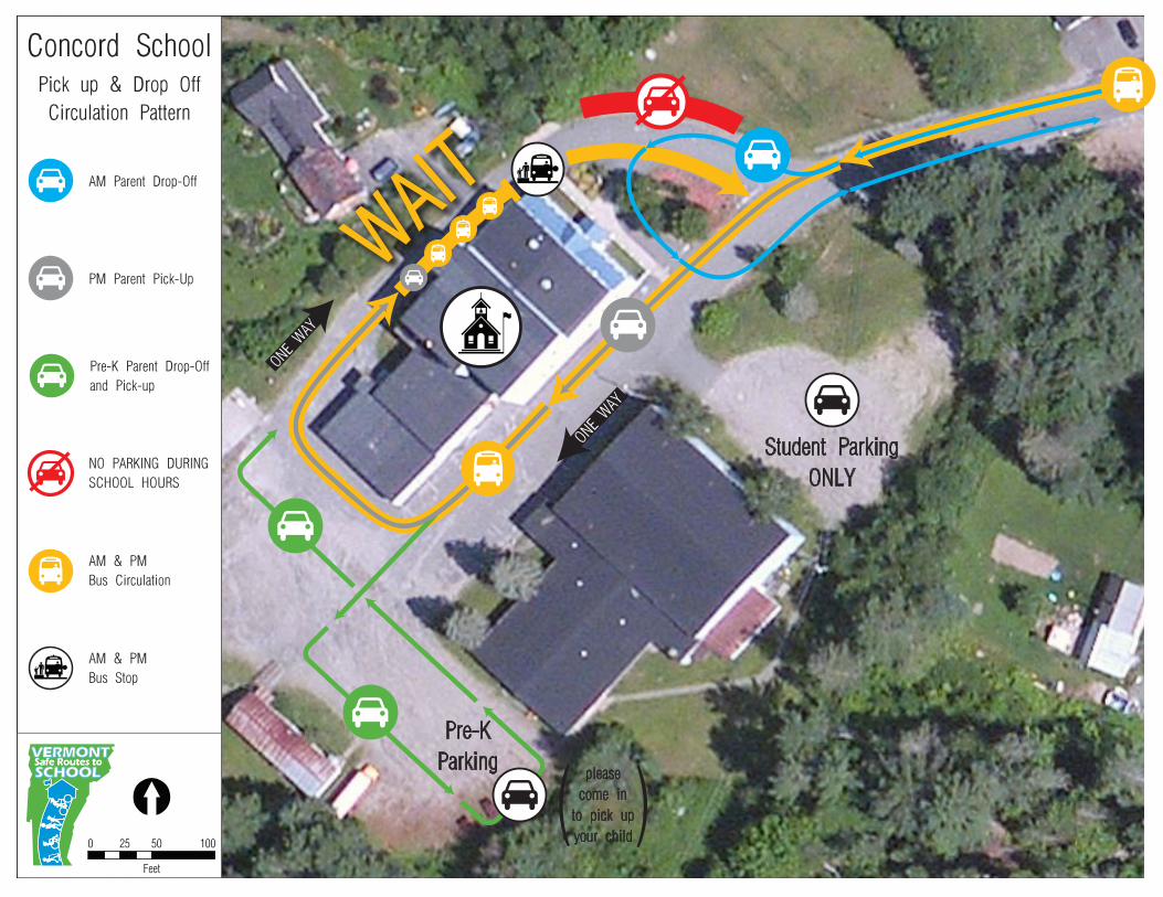
The day of our meeting, the team had discussions and used creative problem solving skills to propose improvements to the circulation and congestion issues at Concord School. The team identified the bus drop-off and vehicle stacking on School Street as a priority for circulation improvements. The concept of rerouting all traffic arriving for drop-off and pick up to the
Travel Mode Walk Bike
School Bus
Family Vehicle Carpool
Public Transit Other
Percentage of Student Body (AM)
6% <1% 60% 23% 0% 0% 0%
Percentage of Student Body (PM)
6% <1% 66% 27% 0% 0% 0%
Page 8 of 18
south driveway of the school started to reveal improved traffic operations. Arriving buses would loop behind the school through the rear parking lot and arrive at the same bus drop off location north and west of the school front doors. Personal vehicles would stack behind the buses on the north driveway into the rear parking lot and would not be released until all buses have been loaded and cleared the school grounds. Access from School Street to the student parking lot would remain two-way until the student parking driveway. The proposed traffic operations pattern would convert both the south driveway from the student parking lot driveway and the north driveway to one-way circulation pattern around Concord School.
During the start of the 2012-2013 school year, the Concord School implemented the revised circulation patterns recommended for improving traffic operation procedures on school grounds. To date, the revised traffic operations have been observed to minimize and reduce the conflicts between pedestrian, bicyclists, and motorists creating a safer and efficient travel for all transportation modes. The Concord School plans to maintain and reinforce the revised circulation patterns developed by the SRTS Team.
Concord School relies on policies, practices, and support activities to ensure a safe and orderly process for arrival and dismissal, regardless of how students travel to school. Parents are reminded of these procedures in the student handbook and in ‘backpack’ mail that is sent home with students.
The morning bell for Concord School rings at 8:05 am and all students enter through the front doors and proceed to the cafeteria before the start of school.
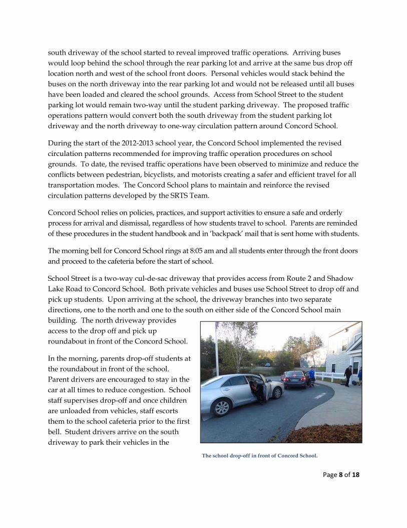
School Street is a two-way cul-de-sac driveway that provides access from Route 2 and Shadow Lake Road to Concord School. Both private vehicles and buses use School Street to drop off and pick up students. Upon arriving at the school, the driveway branches into two separate directions, one to the north and one to the south on either side of the Concord School main building. The north driveway provides access to the drop off and pick up roundabout in front of the Concord School.
In the morning, parents drop-off students at the roundabout in front of the school. Parent drivers are encouraged to stay in the car at all times to reduce congestion. School staff supervises drop-off and once children are unloaded from vehicles, staff escorts them to the school cafeteria prior to the first bell. Student drivers arrive on the south driveway to park their vehicles in the
The school drop-off in front of Concord School.
Page 9 of 18
student parking lot on the south side of the school, north of the gymnasium.
The Concord School also has a half-day Pre-K program in the rear of the gymnasium building. Students arrive via the south driveway from School Street where vehicles park and walk the students to the Pre-K doors. Vehicles then loop back out and exit via the south driveway to School Street.
A shared bus driveway is located at the north side of Concord School. Student bus riders unload north of the school front entrance, utilize an existing marked crosswalk in front of the buses and walk inside to the cafeteria through the school’s front doors.
During the drop off procedures, three school buses park behind one another in the driveway on the north side of the main building until children are ready to unload. The current width of the driveway does not allow personal vehicles to access the drop off roundabout and are forced to stack until all the buses have cleared the bus drop off site. Depending on variability in the schedule, vehicles have been observed backing up and stacking along School Street and in some cases causing congestion as far as Route 2.
Students walking or biking to school must use the front door as all other doors to the school are locked.
During dismissal, students who have received parental permission to walk or bike to and from school are released at 3:10pm. These students are released from the front main entrance providing extra time to clear the school grounds before further dismissal operations. Starting in the 2012/2013 school year, school staff member escorts the students along School Street, across the bridge on Shadow Lake Road, and finally to the crosswalk at Route 2 to cross safely.
In the afternoon, buses line up end-to-end in the driveway between the gymnasium and the school on the south side. Students who ride the bus are released at 3:12pm and exit through the side door of the school. No vehicles are permitted to leave until all buses have finished loading and cleared the school grounds.
Parent pick-up occurs in the parking lot at the rear door of the school. Parents stack into the rear parking lot from the north driveway and queue down the north driveway towards School Street. Once the school staff has identified the correct vehicle with the student, the vehicle loops around the parking lot for pick-up.
The Concord School circulation map can be found in Appendix E.
Page 10 of 18
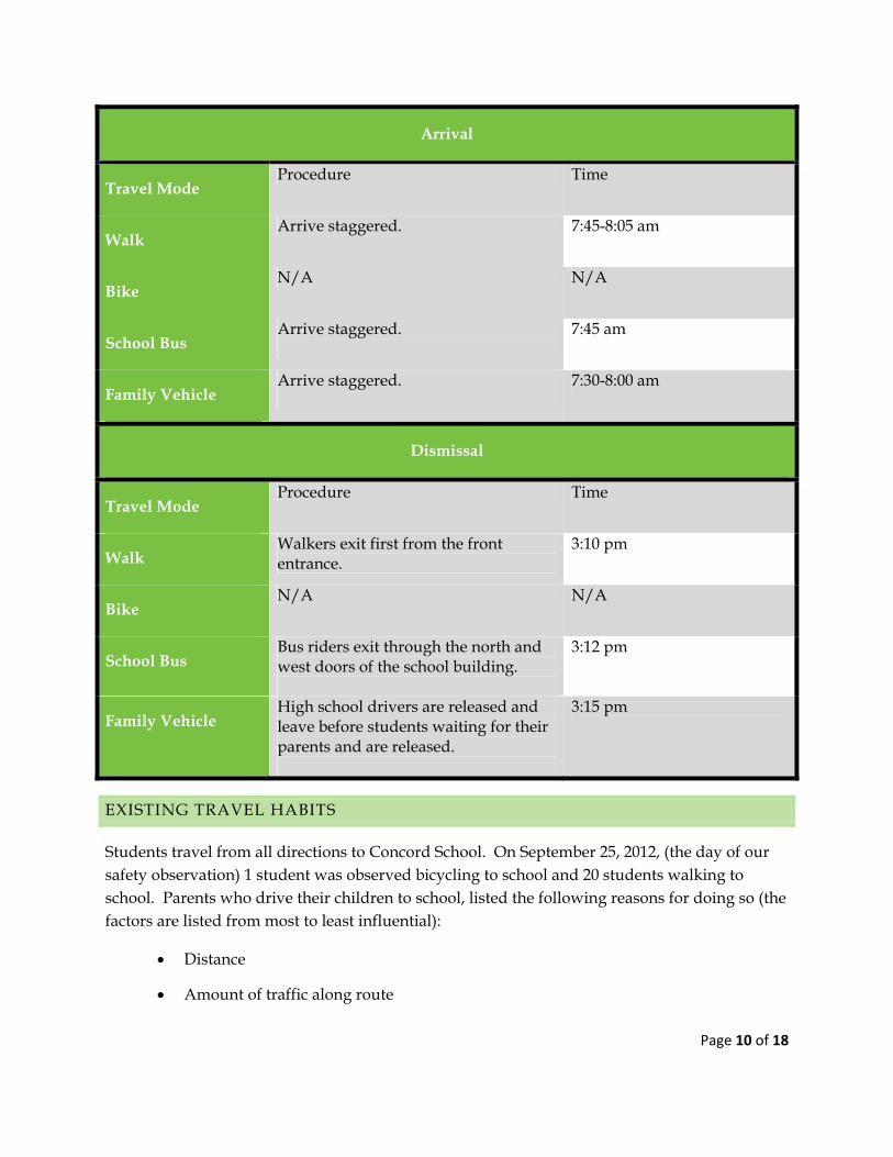
Arrival
Travel Mode Procedure Time
Walk Arrive staggered. 7:45-8:05 am
Bike N/A N/A
School Bus Arrive staggered.
7:45 am
Family Vehicle Arrive staggered.
7:30-8:00 am
Dismissal
Travel Mode Procedure Time
Walk Walkers exit first from the front entrance.
3:10 pm
Bike N/A N/A
School Bus Bus riders exit through the north and west doors of the school building.
3:12 pm
Family Vehicle High school drivers are released and leave before students waiting for their parents and are released.
3:15 pm
EXISTING TRAVEL HABITS
Students travel from all directions to Concord School. On September 25, 2012, (the day of our safety observation) 1 student was observed bicycling to school and 20 students walking to school. Parents who drive their children to school, listed the following reasons for doing so (the factors are listed from most to least influential):
Distance
Amount of traffic along route
Page 11 of 18
Violence and crime in the area
Speed of traffic along route
Adults to bike or walk with
(Data based on SRTS Parent Survey results administered in September 2012)
Parent survey response was limited and completed by households outside of the 2 mile radius of Concord School. In order to capture a more accurate sample size, it is recommended that the households should be resurveyed, focusing on the students who live within the 1/2 mile radius of Concord School.
The parent surveys (collected in September of 2012) showed that if some of the conditions listed above were changed, they would reconsider allowing their children to walk to school. Many of the issues in the list above can be addressed with either infrastructure or non-infrastructure strategies (or in some cases both). We kept these concerns in mind when picking the strategies that we want to accomplish this school year, 2012-2013.
KEY ISSUES
The team identified the following barriers when developing this Travel Plan:
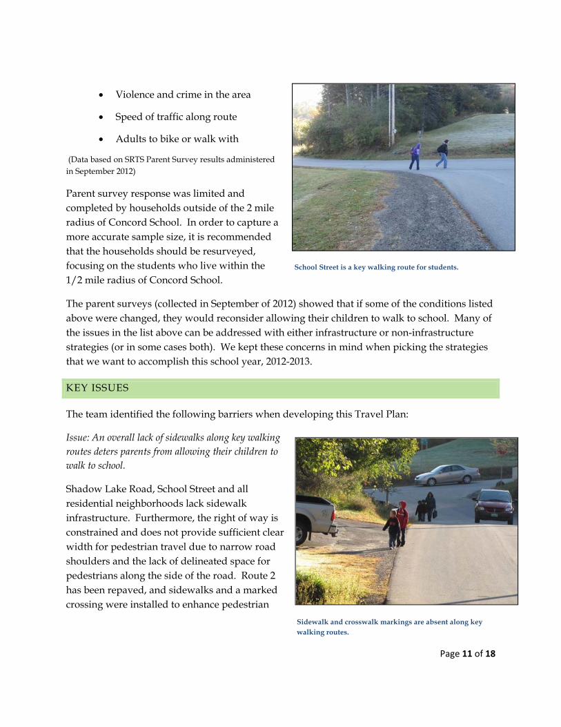
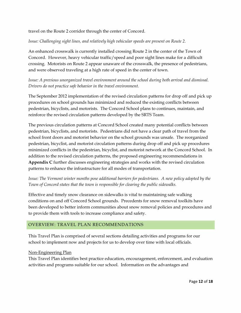
Issue: An overall lack of sidewalks along key walking routes deters parents from allowing their children to walk to school.
Shadow Lake Road, School Street and all residential neighborhoods lack sidewalk infrastructure. Furthermore, the right of way is constrained and does not provide sufficient clear width for pedestrian travel due to narrow road shoulders and the lack of delineated space for pedestrians along the side of the road. Route 2 has been repaved, and sidewalks and a marked crossing were installed to enhance pedestrian
School Street is a key walking route for students.
Sidewalk and crosswalk markings are absent along key walking routes.
Page 12 of 18
travel on the Route 2 corridor through the center of Concord.
Issue: Challenging sight lines, and relatively high vehicular speeds are present on Route 2.
An enhanced crosswalk is currently installed crossing Route 2 in the center of the Town of Concord. However, heavy vehicular traffic/speed and poor sight lines make for a difficult crossing. Motorists on Route 2 appear unaware of the crosswalk, the presence of pedestrians, and were observed traveling at a high rate of speed in the center of town.
Issue: A previous unorganized travel environment around the school during both arrival and dismissal. Drivers do not practice safe behavior in the travel environment.
The September 2012 implementation of the revised circulation patterns for drop off and pick up procedures on school grounds has minimized and reduced the existing conflicts between pedestrian, bicyclists, and motorists. The Concord School plans to continues, maintain, and reinforce the revised circulation patterns developed by the SRTS Team.
The previous circulation patterns at Concord School created many potential conflicts between pedestrian, bicyclists, and motorists. Pedestrians did not have a clear path of travel from the school front doors and motorist behavior on the school grounds was unsafe. The reorganized pedestrian, bicyclist, and motorist circulation patterns during drop off and pick up procedures minimized conflicts in the pedestrian, bicyclist, and motorist network at the Concord School. In addition to the revised circulation patterns, the proposed engineering recommendations in Appendix C further discusses engineering strategies and works with the revised circulation patterns to enhance the infrastructure for all modes of transportation.
Issue: The Vermont winter months pose additional barriers for pedestrians. A new policy adopted by the Town of Concord states that the town is responsible for clearing the public sidewalks.
Effective and timely snow clearance on sidewalks is vital to maintaining safe walking conditions on and off Concord School grounds. Precedents for snow removal toolkits have been developed to better inform communities about snow removal policies and procedures and to provide them with tools to increase compliance and safety.
OVERVIEW: TRAVEL PLAN RECOMMENDATIONS
This Travel Plan is comprised of several sections detailing activities and programs for our school to implement now and projects for us to develop over time with local officials.
Non-Engineering Plan This Travel Plan identifies best practice education, encouragement, enforcement, and evaluation activities and programs suitable for our school. Information on the advantages and
Page 13 of 18
considerations for each strategy, and resources to help us implement each, are included in the Appendix J.
16–Month SRTS Activity Calendar Our team will pursue a smaller subset of items in the non-engineering plan during the next 16 months. We will review our work periodically, adding additional activities that will continue the SRTS program momentum.
Engineering Recommendations With assistance from the Vermont SRTS Resource Center, we have identified short, medium and long-term engineering treatments to make walking and bicycling to school safer for our students.
Snow Removal Toolkit Snow, sleet, slush, ice, and rain impact all modes of transportation, and the timely clearance and removal of the elements are essential for the functionality and accessibility of a Safe Routes to School program. A Snow Removal Toolkit can better inform communities about snow removal policies and procedures, and to provide tools to increase compliance and safety. Snow removal recommendations are located in Appendix I.
NON-ENGINEERING TRAVEL PLAN
We identified a number of activities and programs to promote walking and biking to school. These activities and programs, while grouped by “The Five E’s”, are dependent upon each other for their individual success. We plan to work on our highest priority programs this year, following up with other programs in successive years. We used the timeframe below to determine when to initiate programs:
Type Short Medium Long
Encouragement, Education, Enforcement, Evaluation
What we plan to do this school year
What we plan to do next school year
What we plan to do starting in two years
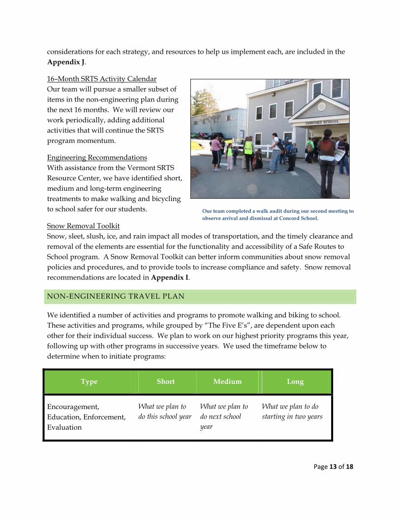
Our team completed a walk audit during our second meeting to observe arrival and dismissal at Concord School.
Page 14 of 18
EDUCATION STRATEGIES
The education strategies included in our 16-month activity calendar are aimed at providing all students with safe pedestrian walking skills. Our education activities this year will include:
Incorporating Walk Smart/Bike Smart curriculum into PE and Health classes
Formalizing an organized crossing guard education and training program
Other education strategies we will work on after this year are:
Investigating free or reduced cost bicycle helmets
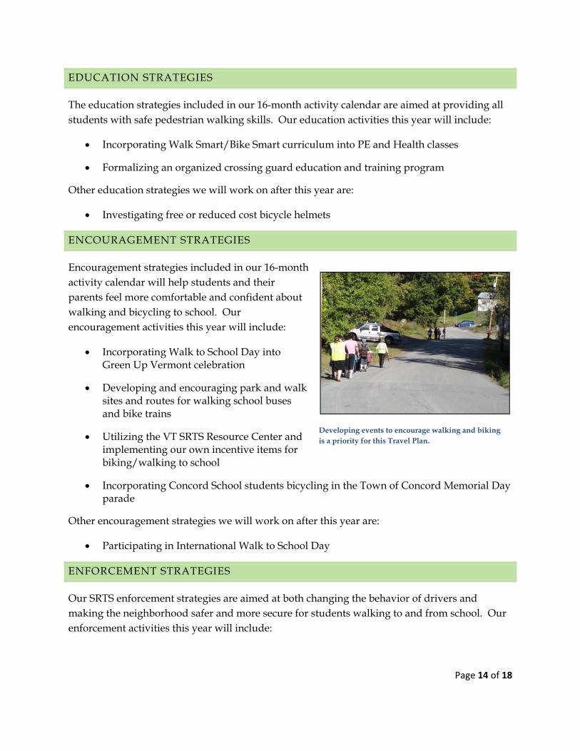
ENCOURAGEMENT STRATEGIES
Encouragement strategies included in our 16-month activity calendar will help students and their parents feel more comfortable and confident about walking and bicycling to school. Our encouragement activities this year will include:
Incorporating Walk to School Day into Green Up Vermont celebration
Developing and encouraging park and walk sites and routes for walking school buses and bike trains
Utilizing the VT SRTS Resource Center and implementing our own incentive items for biking/walking to school
Incorporating Concord School students bicycling in the Town of Concord Memorial Day parade
Other encouragement strategies we will work on after this year are:
Participating in International Walk to School Day
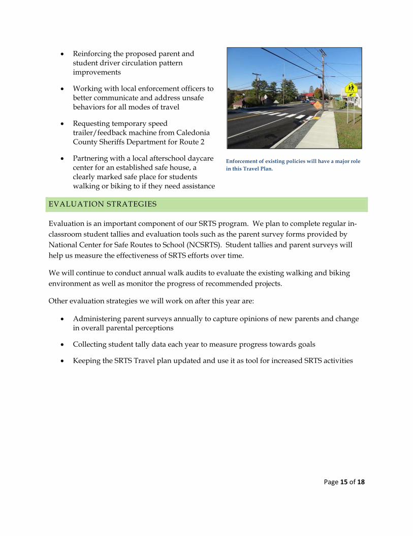
ENFORCEMENT STRATEGIES
Our SRTS enforcement strategies are aimed at both changing the behavior of drivers and making the neighborhood safer and more secure for students walking to and from school. Our enforcement activities this year will include:
Developing events to encourage walking and biking is a priority for this Travel Plan.
Page 15 of 18
Reinforcing the proposed parent and student driver circulation pattern improvements
Working with local enforcement officers to better communicate and address unsafe behaviors for all modes of travel
Requesting temporary speed trailer/feedback machine from Caledonia County Sheriffs Department for Route 2
Partnering with a local afterschool daycare center for an established safe house, a clearly marked safe place for students walking or biking to if they need assistance
EVALUATION STRATEGIES
Evaluation is an important component of our SRTS program. We plan to complete regular in-classroom student tallies and evaluation tools such as the parent survey forms provided by National Center for Safe Routes to School (NCSRTS). Student tallies and parent surveys will help us measure the effectiveness of SRTS efforts over time.
We will continue to conduct annual walk audits to evaluate the existing walking and biking environment as well as monitor the progress of recommended projects.
Other evaluation strategies we will work on after this year are:
Administering parent surveys annually to capture opinions of new parents and change in overall parental perceptions
Collecting student tally data each year to measure progress towards goals
Keeping the SRTS Travel plan updated and use it as tool for increased SRTS activities
Enforcement of existing policies will have a major role in this Travel Plan.
Page 16 of 18
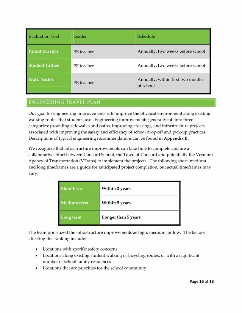
Evaluation Tool Leader Schedule
Parent Surveys PE teacher Annually, two weeks before school
Student Tallies PE teacher Annually, two weeks before school
Walk Audits PE teacher
Annually, within first two months of school
ENGINEERING TRAVEL PLAN
Our goal for engineering improvements is to improve the physical environment along existing walking routes that students use. Engineering improvements generally fall into three categories: providing sidewalks and paths, improving crossings, and infrastructure projects associated with improving the safety and efficiency of school drop-off and pick-up practices. Descriptions of typical engineering recommendations can be found in Appendix B.
We recognize that infrastructure improvements can take time to complete and are a collaborative effort between Concord School, the Town of Concord and potentially the Vermont Agency of Transportation (VTrans) to implement the projects. The following short, medium and long timeframes are a guide for anticipated project completion, but actual timeframes may vary:
Short term Within 2 years
Medium term Within 5 years
Long term Longer than 5 years
The team prioritized the infrastructure improvements as high, medium, or low. The factors affecting this ranking include:
Locations with specific safety concerns Locations along existing student walking or bicycling routes, or with a significant
number of school family residences Locations that are priorities for the school community
Page 17 of 18
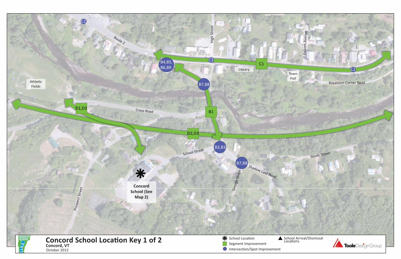
Engineering Recommendations for specific locations in the vicinity of Concord School can be found in Appendix C.
CONSIDERATIONS FOR DESIGN AND FUNDING
Design All infrastructure recommendations in this plan are considered “planning level” and
will require further engineering analysis, design, or public input before implementation.
Recommended changes to existing traffic patterns (adding a signal, adding a stop sign, changing lane patterns, etc.) will require a study to evaluate the potential impact that the recommendation could have on existing traffic conditions.
Drainage, existing utilities and ADA compliance will need to be evaluated for all recommendations at the time of design. ADA guidelines recommend particular design features to accommodate persons with disabilities. ADA design considerations for curb ramps, sidewalks and paths, include appropriate slopes, landing areas, surface conditions, and use of detectable warning materials for visually impaired pedestrians, among other design features.
Right-of-way was not evaluated as a part of this project. Recommendations assume that sufficient right-of-way exists or that a method to gain needed right-of-way will be identified as the project progresses.
VTrans district office staff will be involved in the planning and design process for any recommendation made on the State system.
All infrastructure recommendations should comply with federal, state, and local standards including the American Association of State Highway and Transportation Officials’ Policy on Geometric Design of Highways and Streets and the Manual on Uniform Traffic Control Devices (MUTCD).
Refer to the Vermont Pedestrian and Bicycle Facility Planning and Design Manual for guidelines on pedestrian and bicycle accommodations.
Funding A variety of funding sources may be used for the recommendations. For example,
projects requiring right-of-way acquisition or existing utilities relocation are not typically eligible with SRTS funds, but may be funded through other sources.
More information on the types of projects eligible for SRTS funding through VTrans and at
http://saferoutes.vermont.gov/getting_started/funding.
Page 18 of 18
ATTACHMENTS
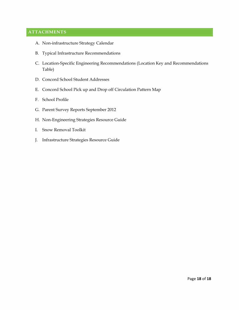
A. Non-infrastructure Strategy Calendar
B. Typical Infrastructure Recommendations
C. Location-Specific Engineering Recommendations (Location Key and Recommendations Table)
D. Concord School Student Addresses
E. Concord School Pick up and Drop off Circulation Pattern Map
F. School Profile
G. Parent Survey Reports September 2012
H. Non-Engineering Strategies Resource Guide
I. Snow Removal Toolkit
J. Infrastructure Strategies Resource Guide
Appendix A Non‐Infrastructure CalendarSept 2012 Oct 2012 Nov 2012 Dec 2012 Jan 2013 Feb 2013 Mar 2013 Apr 2013 May 2013 June 2013 July 2013 Aug 2013 Sept 2013 Oct 2013 Nov 2013 Dec 2013
Lead PE teacher
Plan Implement
Lead TBD
Plan Implement
Lead PE teacher
Plan Implement ENCOURAGEMENT
Lead PE teacher
Plan Implement
Lead Principal
Plan Implement
Lead PE teacher
Plan Implement
Lead PE teacher
Plan Implement
Lead PE teacher
Plan Implement
Incorporate Walk Smart/Bike Smart Vermont!
curriculum into PE classes
Offer education with reduced cost bicycle helmets
Activity
Formalize an organized crossing guard education and
training program
Utilize VT Resource Center incentive items
EDUCATION
Incorporate Walk to School Day into Green Up
Vermont celebration
Develop and encourage park/walk sites and routes for
walking school buses and bike trains
Partner with the Concord Memorial Day Parade for
school students to bike and walk during parade
activities
Participate in International Walk to School Day
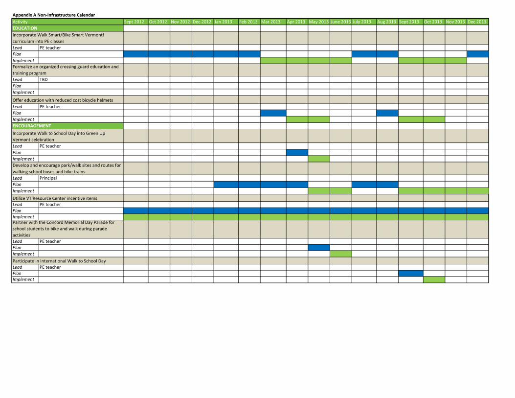
Sept 2012 Oct 2012 Nov 2012 Dec 2012 Jan 2013 Feb 2013 Mar 2013 Apr 2013 May 2013 June 2013 July 2013 Aug 2013 Sept 2013 Oct 2013 Nov 2013 Dec 2013
ENFORCEMENT
Lead Principal
Plan Implement
Lead Essex County Sheriff/Principal
Plan Implement
Lead Principal
Plan Implement
Lead PE teacher
Plan Implement
Lead PE teacher
Plan Implement Student Tallies
Lead PE teacher
Plan Implement Conduct annual walking audit
Lead PE teacher
Plan Implement
Request Temporary speed trailer/feedback machine
from Calendonia County Sheriffs Department for Route
2
Activity
Parent Survey
Reinforce the proposed parent and student driver
circulation pattern improvements
Partner with a local afterschool daycare center for an
established safe house for students walking or biking
Work with local enforcement officers to better
communicate and address unsafe behavior for all
modes of travel
EVALUATION
Page 1 of 3
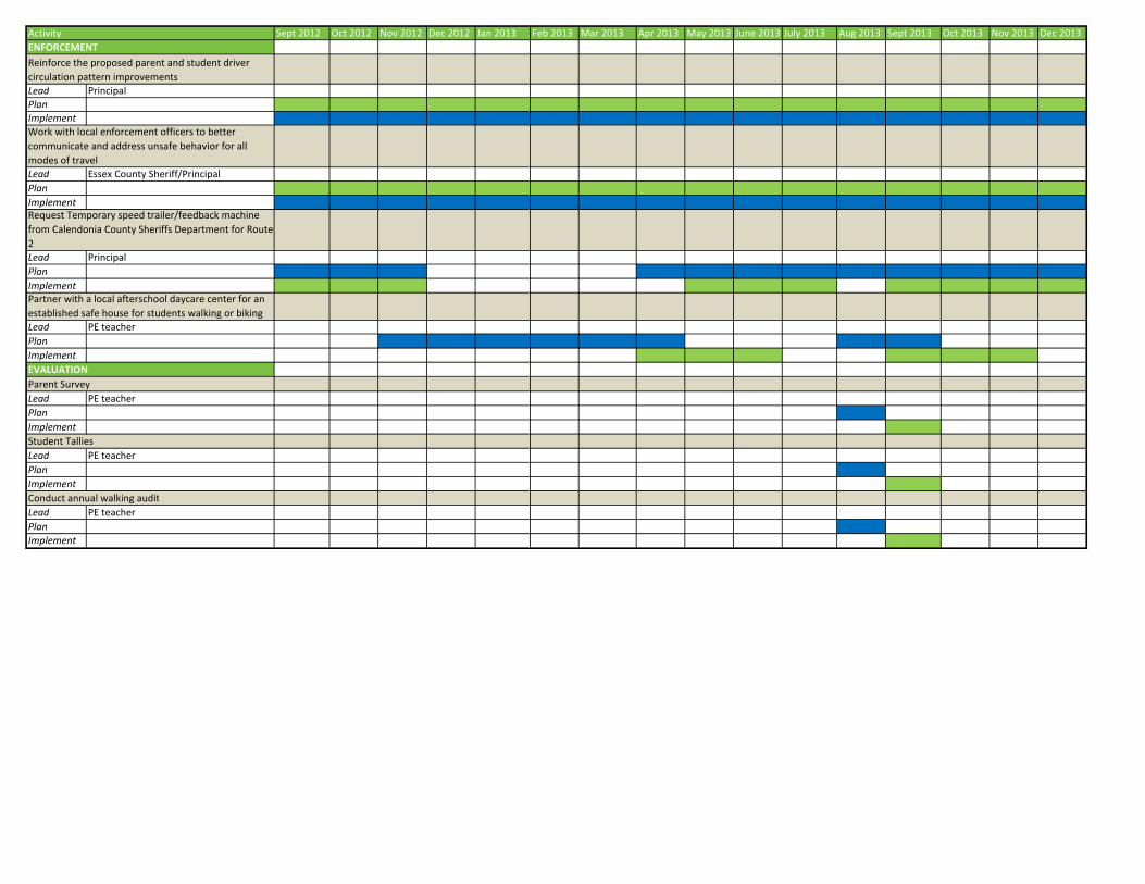
APPENDIX B TYPICAL INFRASTRUCTURE RECOMMENDATIONS
The following infrastructure recommendations are typical treatments used in SRTS projects. These recommendations may or may not be included in this travel plan. The basic information is provided to give an overall understanding and implementation guidance on each treatment.
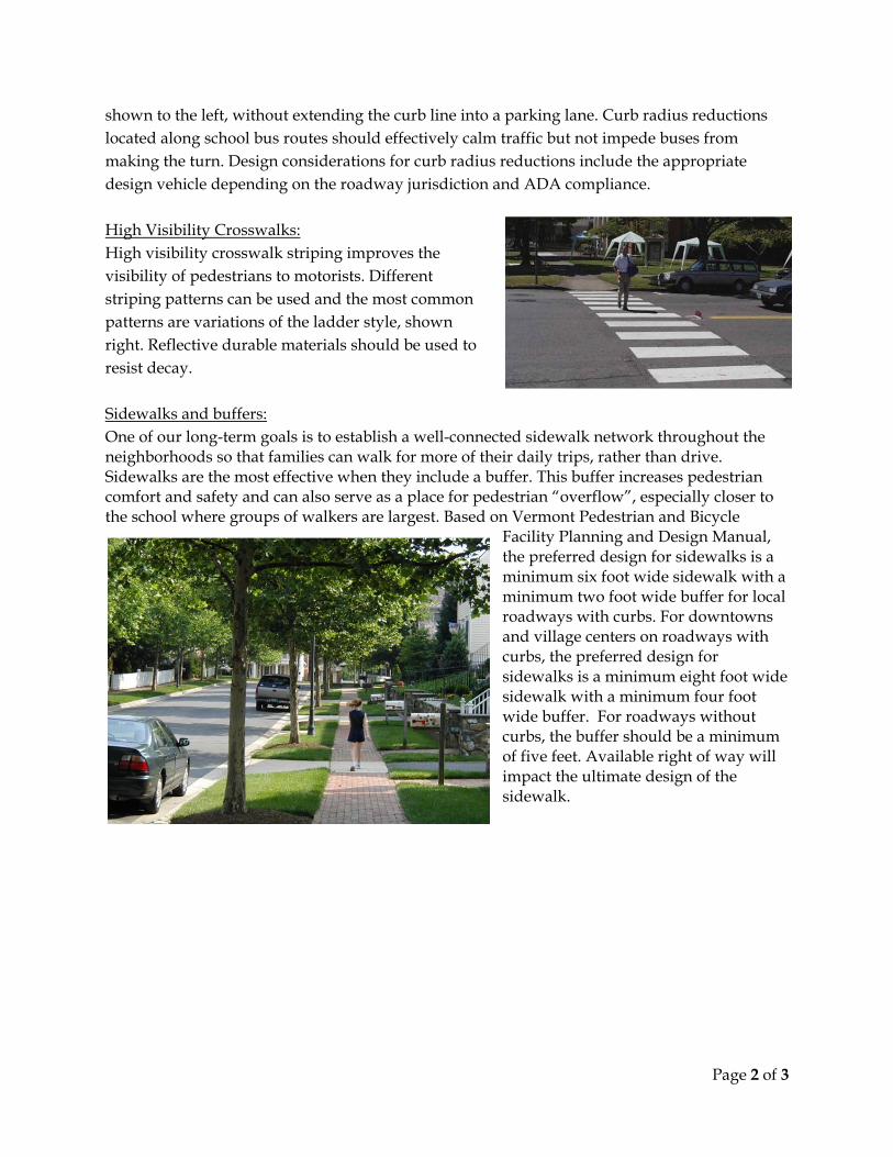
Rectangular Rapid Flashing Beacons: Rectangular rapid flashing beacons (RRFB), as shown to the left, are warning beacons used to increase visibility of students and all pedestrians as they cross the roadway at uncontrolled crosswalks. This type of signal is pedestrian-activated, i.e., the signal will only flash if a pedestrian has pushed a button, indicating that they need to cross the street. Any proposed RRFB locations need to meet current guidance provided in the interim approval of the MUTCD. For proposed uncontrolled crosswalks on state maintained roads, VTrans approval and justification are needed.
Curb Extensions: Curb extensions, as shown below, are recommended to reduce pedestrian crossing distances (and thus exposure to traffic) and to slow motor vehicle turning speeds at intersections. Curb extensions located along school bus routes should effectively calm traffic, but not impede buses from making the turn. Design considerations should include the appropriate design vehicle, maintenance concerns, and snow plow accommodations depending on the roadway jurisdiction.
Curb Radius Reductions: Curb radius reductions are recommended to slow motor vehicle turning speeds and to reduce pedestrian crossing distances (and thus exposure to traffic). Curb radius reductions involve tightening the motor vehicle turning radius at an intersection, as
Page 2 of 3
shown to the left, without extending the curb line into a parking lane. Curb radius reductions located along school bus routes should effectively calm traffic but not impede buses from making the turn. Design considerations for curb radius reductions include the appropriate design vehicle depending on the roadway jurisdiction and ADA compliance. High Visibility Crosswalks: High visibility crosswalk striping improves the visibility of pedestrians to motorists. Different striping patterns can be used and the most common patterns are variations of the ladder style, shown right. Reflective durable materials should be used to resist decay. Sidewalks and buffers: One of our long-term goals is to establish a well-connected sidewalk network throughout the neighborhoods so that families can walk for more of their daily trips, rather than drive. Sidewalks are the most effective when they include a buffer. This buffer increases pedestrian comfort and safety and can also serve as a place for pedestrian “overflow”, especially closer to the school where groups of walkers are largest. Based on Vermont Pedestrian and Bicycle
Facility Planning and Design Manual, the preferred design for sidewalks is a minimum six foot wide sidewalk with a minimum two foot wide buffer for local roadways with curbs. For downtowns and village centers on roadways with curbs, the preferred design for sidewalks is a minimum eight foot wide sidewalk with a minimum four foot wide buffer. For roadways without curbs, the buffer should be a minimum of five feet. Available right of way will impact the ultimate design of the sidewalk.
Page 3 of 3
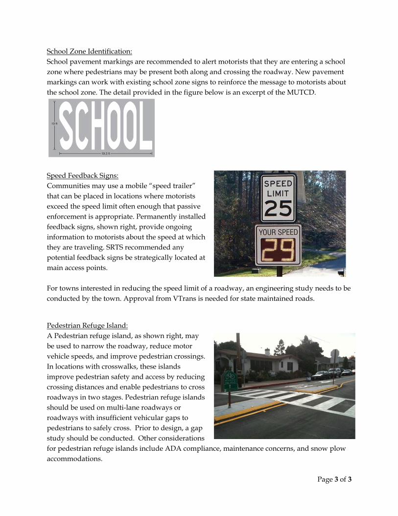
School Zone Identification: School pavement markings are recommended to alert motorists that they are entering a school zone where pedestrians may be present both along and crossing the roadway. New pavement markings can work with existing school zone signs to reinforce the message to motorists about the school zone. The detail provided in the figure below is an excerpt of the MUTCD.
Speed Feedback Signs: Communities may use a mobile “speed trailer” that can be placed in locations where motorists exceed the speed limit often enough that passive enforcement is appropriate. Permanently installed feedback signs, shown right, provide ongoing information to motorists about the speed at which they are traveling. SRTS recommended any potential feedback signs be strategically located at main access points. For towns interested in reducing the speed limit of a roadway, an engineering study needs to be conducted by the town. Approval from VTrans is needed for state maintained roads.
Pedestrian Refuge Island: A Pedestrian refuge island, as shown right, may be used to narrow the roadway, reduce motor vehicle speeds, and improve pedestrian crossings. In locations with crosswalks, these islands improve pedestrian safety and access by reducing crossing distances and enable pedestrians to cross roadways in two stages. Pedestrian refuge islands should be used on multi-lane roadways or roadways with insufficient vehicular gaps to pedestrians to safely cross. Prior to design, a gap study should be conducted. Other considerations for pedestrian refuge islands include ADA compliance, maintenance concerns, and snow plow accommodations.
School Loca� on School Arrival/Dismissal Loca� ons
Intersec� on/Spot Improvement
Segment ImprovementConcord School Loca� on Key 1 of 2Concord, VTOctober 2012
Pro
spe
ct S
tre
et
C1
D1,D3
Ge
org
e S
tre
et
B4,B5,
B6,B9
Cross Road
South StreetSchool Street
Athle� c
Fields
Hig
h S
tre
et
Route 2
Shadow Lake Road
Royalston Corner Road
D2,D3
B1
B7,B8
C2
C3
C2
Concord
School (See
Map 2)
LibraryTown
Hall
Fols
om
Ave
nu
e
B2,B3
B7,B8
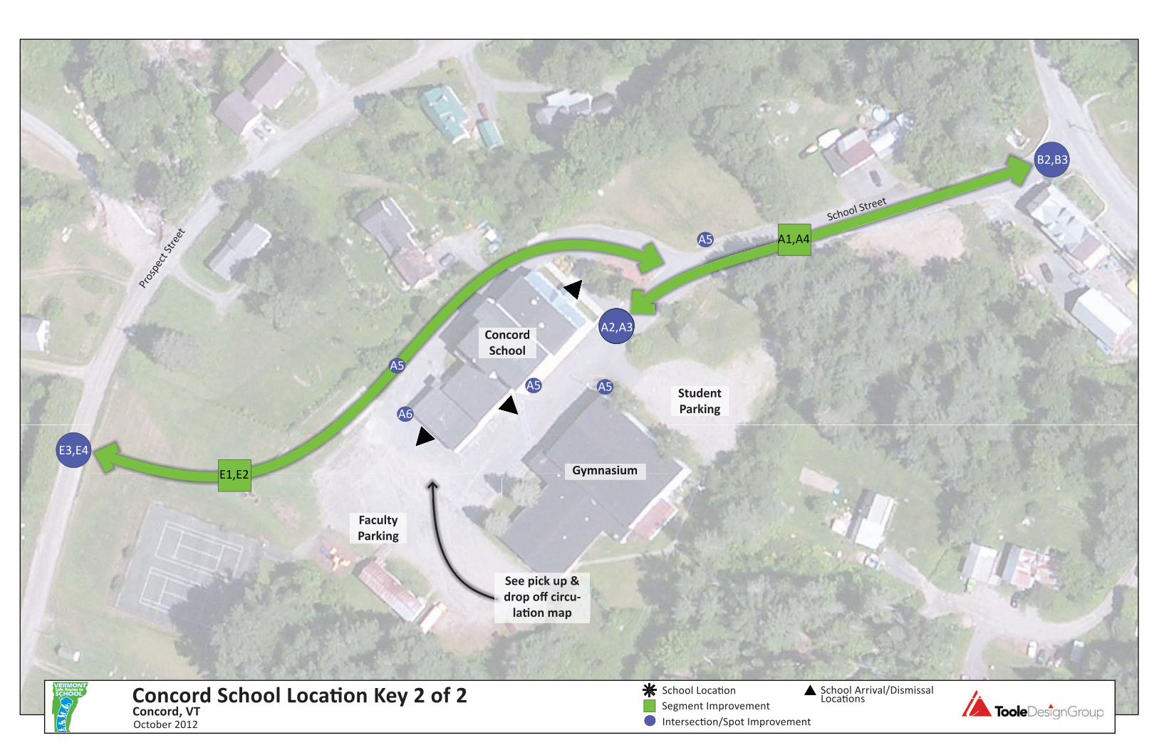
School Loca� on School Arrival/Dismissal Loca� ons
Intersec� on/Spot Improvement
Segment ImprovementConcord School Loca� on Key 2 of 2Concord, VTOctober 2012
B2,B3
A2,A3Concord
School
Gymnasium
Faculty
Parking
A1,A4
A2,A3CCCooonnccoorrrddd
SScchhoooollSScchhool
GGymmnnaassiuummGGymnaasiiuummE1,E2
School Street
E3,E4
Student
Parking
Pros
pect
Str
eet
See pick up &
drop off circu-
la� on map
A5 A5
A5
A5
A6

APPENDIX D
CONCORD SCHOOL STUDENT ADDRESSES
.5 m
ile
1 m
ile
1.5
mile
s
.25
m
ile2
22 2
22
2
3
5
4
32
2
Concord School Student Address LocatorConcord, VTOctober 2012
North
School Location
Student Residence
Multiple Student Residences

APPENDIX E
CONCORD SCHOOL CIRCULATION PATTERN MAP
Concord SchoolPick up & Drop Off
Circulation Pattern
AM & PM
Bus Stop
AM & PM
Bus Circulation
AM Parent Drop-Off
Pre-K Parent Drop-Off
and Pick-up
PM Parent Pick-Up
NO PARKING DURING
SCHOOL HOURS
Student Parking
ONLY
Pre-K
Parkingplease
come in
to pick up
your child
Feet

APPENDIX F
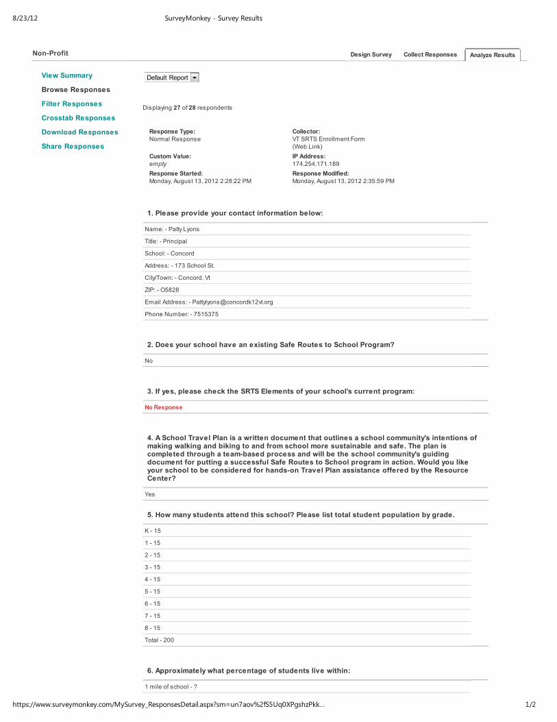
CONCORD SCHOOL PROFILE
8/23/12 SurveyMonkey - Survey Results
1/2https://www.surveymonkey.com/MySurvey_ResponsesDetail.aspx?sm=un7aov%2fS5Uq0XPgshzPkk…
View Summary
Browse Responses
Filter Responses
Crosstab Responses
Download Responses
Share Responses
Non-Profit Design Survey Collect Responses
Default Report
Displaying 27 of 28 respondents
Response Type:Normal Response
Collector:VT SRTS Enrollment Form
(Web Link)
Custom Value:
empty
IP Address:
174.254.171.189
Response Started:
Monday, August 13, 2012 2:28:22 PM
Response Modified:
Monday, August 13, 2012 2:35:59 PM
1. Please provide your contact information below:
Name: - Patty Lyons
Title: - Principal
School: - Concord
Address: - 173 School St.
City/Town: - Concord, Vt
ZIP: - O5828
Email Address: - [email protected]
Phone Number: - 7515375
2. Does your school have an existing Safe Routes to School Program?
No
3. If yes, please check the SRTS Elements of your school's current program:
No Response
4. A School Travel Plan is a written document that outlines a school community's intentions ofmaking walking and biking to and from school more sustainable and safe. The plan iscompleted through a team-based process and will be the school community's guidingdocument for putting a successful Safe Routes to School program in action. Would you likeyour school to be considered for hands-on Travel Plan assistance offered by the ResourceCenter?
Yes
5. How many students attend this school? Please list total student population by grade.
K - 15
1 - 15
2 - 15
3 - 15
4 - 15
5 - 15
6 - 15
7 - 15
8 - 15
Total - 200
6. Approximately what percentage of students live within:
1 mile of school - ?
2 miles of school - ?
Analyze Results

8/23/12 SurveyMonkey - Survey Results
2/2https://www.surveymonkey.com/MySurvey_ResponsesDetail.aspx?sm=un7aov%2fS5Uq0XPgshzPkk…
2 miles of school - ?
7. Approximately how many students currently:
Walk to school - ?
Bike to school - ?
8. How many crossing guards are assigned to this school? If none, please provide details ifschool staff, volunteers, student safety patrols, etc help to cross students.
One staff member will be assigned
9. Please mark the stakeholders that will participate in the SRTS program:
Principal
Parents
School Staff
Community Organization
10. I have received the support from my school's principal to pursue a Safe Routes to Schoolprogram
Yes
Patty Lyons [email protected]
Copyright © 1999-2012 SurveyMonkey
Follow Us: Facebook • Twitter • LinkedIn • Our Blog
Help: Tutorials • Answers & FAQs • Contact Support
About Us: Management Team • Board of Directors • Partners • Newsroom • Contact Us • We're Hiring
Policies: Terms of Use • Privacy Policy • Anti-Spam Policy • Security Statement • Email Opt-Out
Dansk • Deutsch • English • Español • Français • 한국어 • Italiano • Nederlands • 日本語 • Norsk • Português • Русский • Suomi • Svenska • 中文(繁體)
Use Cases • Customer Feedback • Product Feedback • Market Research • Employee Satisfaction • Performance Reviews • Healthcare Surveys • Event Planning
Education Surveys • Non Profit Surveys • Phone Polling • Forms By Wufoo • SurveyMonkey Audience

APPENDIX G
PARENT SURVEY REPORTS SEPTEMBER 2012
Parent Survey SummaryProgram Name: Concord School Month and Year Collected: September 2012
School Name: Concord School Set ID: 8666
School Enrollment: 200 Date Report Generated: 10/03/2012
Enrollment within Grades Targeted by SRTS Program: 200 Number of QuestionnairesAnalyzed for Report:
6
Number of Questionnaires Distributed: 200
This report contains information from parents about their children's trip to and from school. The report also reflectsparents' perceptions regarding whether walking and bicycling to school is appropriate for their child. The data used in thisreport were collected using the Survey about Walking and Biking to School for Parents form from the National Center forSafe Routes to School.
**Because less than 30 questionnaires are included in this report, each graph and table display counts rather thanpercentage information.
Page 1 of 10
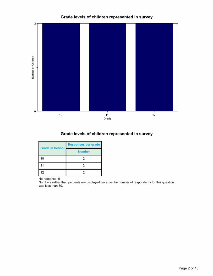
Grade levels of children represented in survey
Grade levels of children represented in survey
Grade in SchoolResponses per grade
Number
10 2
11 2
12 2
No response: 0Numbers rather than percents are displayed because the number of respondents for this questionwas less than 30.
Page 2 of 10

Parent estimate of distance from child's home to school
Parent estimate of distance from child's home to school
Distance betweenhome and school Number of children
Less than 1/4 mile 0
1/4 mile up to 1/2 mile 0
1/2 mile up to 1 mile 1
1 mile up to 2 miles 2
More than 2 miles 3
Don't know or No response: 0Numbers rather than percents are displayed because the number of respondents for this questionwas less than 30.
Page 3 of 10
Typical mode of arrival at and departure from school
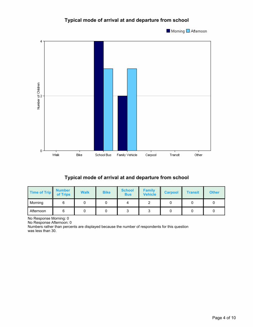
Typical mode of arrival at and departure from school
Time of Trip Numberof Trips Walk Bike School
BusFamilyVehicle Carpool Transit Other
Morning 6 0 0 4 2 0 0 0
Afternoon 6 0 0 3 3 0 0 0
No Response Morning: 0No Response Afternoon: 0Numbers rather than percents are displayed because the number of respondents for this questionwas less than 30.
Page 4 of 10
Typical mode of school arrival and departure by distance child lives from school
Page 5 of 10
Typical mode of school arrival and departure by distance child lives from school
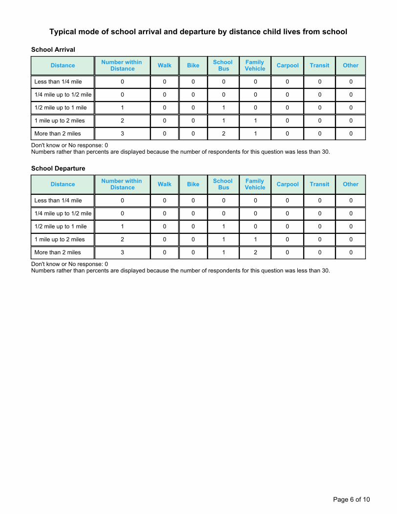
School Arrival
Distance Number withinDistance Walk Bike School
BusFamilyVehicle Carpool Transit Other
Less than 1/4 mile 0 0 0 0 0 0 0 0
1/4 mile up to 1/2 mile 0 0 0 0 0 0 0 0
1/2 mile up to 1 mile 1 0 0 1 0 0 0 0
1 mile up to 2 miles 2 0 0 1 1 0 0 0
More than 2 miles 3 0 0 2 1 0 0 0
Don't know or No response: 0Numbers rather than percents are displayed because the number of respondents for this question was less than 30.
School Departure
Distance Number withinDistance Walk Bike School
BusFamilyVehicle Carpool Transit Other
Less than 1/4 mile 0 0 0 0 0 0 0 0
1/4 mile up to 1/2 mile 0 0 0 0 0 0 0 0
1/2 mile up to 1 mile 1 0 0 1 0 0 0 0
1 mile up to 2 miles 2 0 0 1 1 0 0 0
More than 2 miles 3 0 0 1 2 0 0 0
Don't know or No response: 0Numbers rather than percents are displayed because the number of respondents for this question was less than 30.
Page 6 of 10

Number of children who have asked for permission to walk or bike to/from school bydistance they live from school
Asked Permission? Number of Children Less than1/4 mile
1/4 mile upto 1/2 mile
1/2 mile upto 1 mile
1 mile upto 2 miles
More than2 miles
Yes 0 0 0 0 0 0
No 6 0 0 1 2 3
Don't know or No response: 0Numbers rather than percents are displayed because the number of respondents for this question was less than 30.
Page 7 of 10

Issues reported to affect the decision to not allow a child to walk or bike to/from school byparents of children who do not walk or bike to/from school
Issues reported to affect the decision to allow a child to walk or bike to/from school byparents of children who already walk or bike to/from school
Issue Child does not walk/bike to school Child walks/bikes to school
Distance 5 0
Amount of Traffic Along Route 2 0
Violence or Crime 2 0
Speed of Traffic Along Route 2 0
Adults to Bike/Walk With 1 0
Crossing Guards 0 0
Weather or climate 0 0
Sidewalks or Pathways 0 0
Safety of Intersections and Crossings 0 0
Child's Participation in After SchoolPrograms
0 0
Time 0 0
Convenience of Driving 0 0
Number of Respondents per Category 6 0
No response: 0Note:--Factors are listed from most to least influential for the 'Child does not walk/bike to school' group.
Page 8 of 10
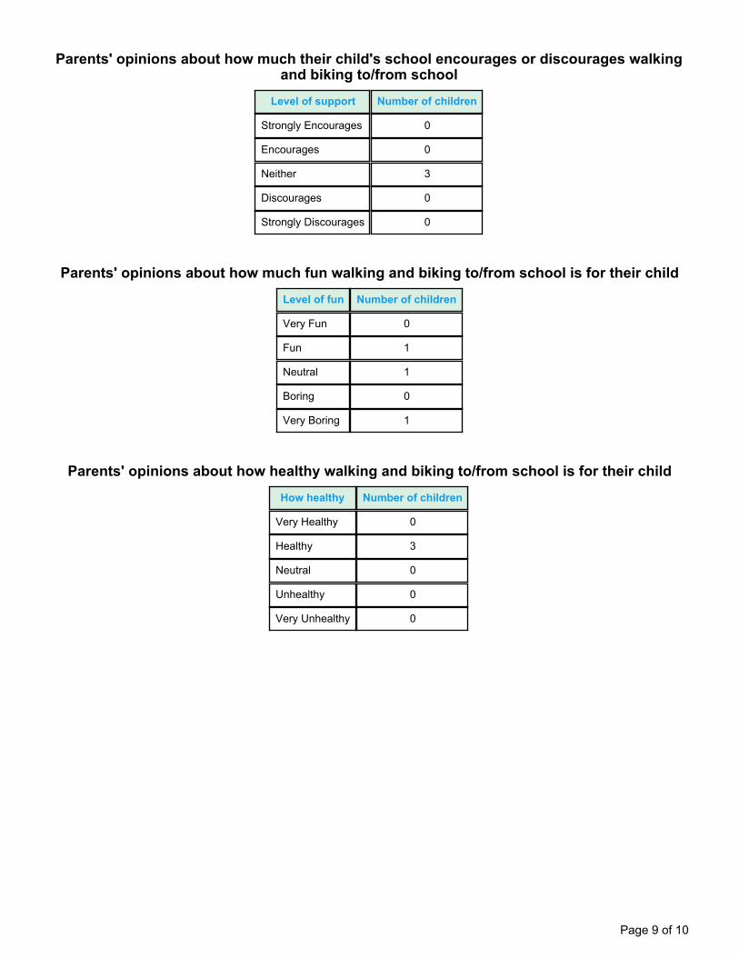
Parents' opinions about how much their child's school encourages or discourages walkingand biking to/from school
Level of support Number of children
Strongly Encourages 0
Encourages 0
Neither 3
Discourages 0
Strongly Discourages 0
Parents' opinions about how much fun walking and biking to/from school is for their child
Level of fun Number of children
Very Fun 0
Fun 1
Neutral 1
Boring 0
Very Boring 1
Parents' opinions about how healthy walking and biking to/from school is for their child
How healthy Number of children
Very Healthy 0
Healthy 3
Neutral 0
Unhealthy 0
Very Unhealthy 0
Page 9 of 10
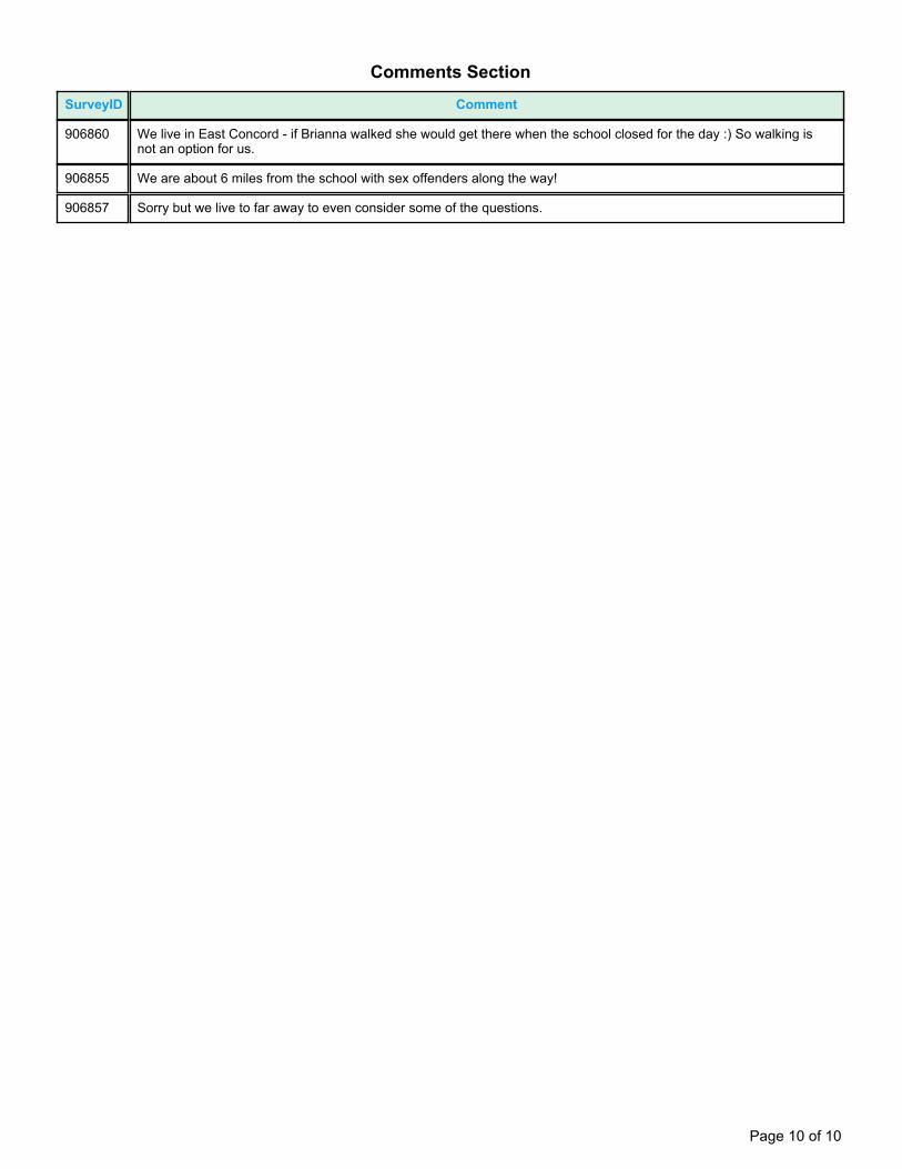
Comments Section
SurveyID Comment
906860 We live in East Concord - if Brianna walked she would get there when the school closed for the day :) So walking isnot an option for us.
906855 We are about 6 miles from the school with sex offenders along the way!
906857 Sorry but we live to far away to even consider some of the questions.
Page 10 of 10
Page 1 of 6
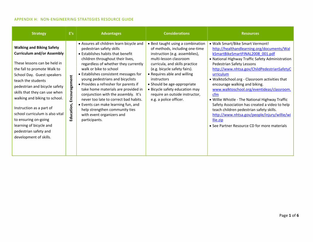
APPENDIX H: NON‐ENGINEERING STRATEGIES RESOURCE GUIDE
Strategy E’s Advantages Considerations Resources
Walking and Biking Safety Curriculum and/or Assembly
These lessons can be held in the fall to promote Walk to School Day. Guest speakers teach the students pedestrian and bicycle safety skills that they can use when walking and biking to school.
Instruction as a part of school curriculum is also vital to ensuring on‐going learning of bicycle and pedestrian safety and development of skills.
Education, Encou
ragemen
t
Assures all children learn bicycle and pedestrian safety skills
Establishes habits that benefit children throughout their lives, regardless of whether they currently walk or bike to school
Establishes consistent messages for young pedestrians and bicyclists
Provides a refresher for parents if take home materials are provided in conjunction with the assembly. It’s never too late to correct bad habits.
Events can make learning fun, and help strengthen community ties with event organizers and participants.
Best taught using a combination of methods, including one‐time instruction (e.g. assemblies), multi‐lesson classroom curricula, and skills practice (e.g. bicycle safety fairs).
Requires able and willing instructors
Should be age‐appropriate Bicycle safety education may require an outside instructor, e.g. a police officer.
Walk Smart/Bike Smart Vermont! http://healthandlearning.org/documents/WalkSmartBikeSmartFINAL2008_001.pdf
National Highway Traffic Safety Administration Pedestrian Safety Lessons http://www.nhtsa.gov/ChildPedestrianSafetyCurriculum
WalktoSchool.org ‐ Classroom activities that encourage walking and biking. www.walktoschool.org/eventideas/classroom.cfm
Willie Whistle ‐ The National Highway Traffic Safety Association has created a video to help teach children pedestrian safety skills. http://www.nhtsa.gov/people/injury/willie/willie.zip
See Partner Resource CD for more materials
Page 2 of 6
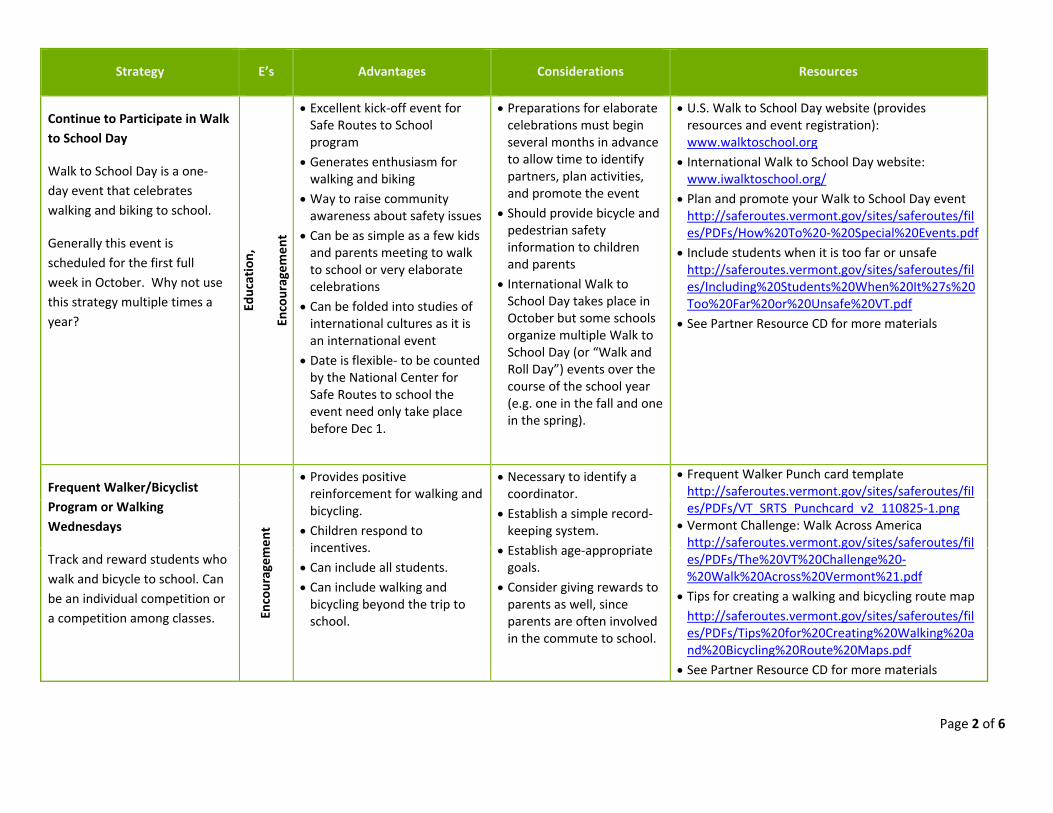
Strategy E’s Advantages Considerations Resources
Continue to Participate in Walk to School Day
Walk to School Day is a one‐day event that celebrates walking and biking to school.
Generally this event is scheduled for the first full week in October. Why not use this strategy multiple times a year?
Education,
Encouragem
ent
Excellent kick‐off event for Safe Routes to School program
Generates enthusiasm for walking and biking
Way to raise community awareness about safety issues
Can be as simple as a few kids and parents meeting to walk to school or very elaborate celebrations
Can be folded into studies of international cultures as it is an international event
Date is flexible‐ to be counted by the National Center for Safe Routes to school the event need only take place before Dec 1.
Preparations for elaborate celebrations must begin several months in advance to allow time to identify partners, plan activities, and promote the event
Should provide bicycle and pedestrian safety information to children and parents
International Walk to School Day takes place in October but some schools organize multiple Walk to School Day (or “Walk and Roll Day”) events over the course of the school year (e.g. one in the fall and one in the spring).
U.S. Walk to School Day website (provides resources and event registration): www.walktoschool.org
International Walk to School Day website: www.iwalktoschool.org/
Plan and promote your Walk to School Day event http://saferoutes.vermont.gov/sites/saferoutes/files/PDFs/How%20To%20‐%20Special%20Events.pdf
Include students when it is too far or unsafe http://saferoutes.vermont.gov/sites/saferoutes/files/Including%20Students%20When%20It%27s%20Too%20Far%20or%20Unsafe%20VT.pdf
See Partner Resource CD for more materials
Frequent Walker/Bicyclist Program or Walking Wednesdays
Track and reward students who walk and bicycle to school. Can be an individual competition or a competition among classes. En
couragem
ent
Provides positive reinforcement for walking and bicycling.
Children respond to incentives.
Can include all students. Can include walking and bicycling beyond the trip to school.
Necessary to identify a coordinator.
Establish a simple record‐keeping system.
Establish age‐appropriate goals.
Consider giving rewards to parents as well, since parents are often involved in the commute to school.
Frequent Walker Punch card template http://saferoutes.vermont.gov/sites/saferoutes/files/PDFs/VT_SRTS_Punchcard_v2_110825‐1.png
Vermont Challenge: Walk Across America http://saferoutes.vermont.gov/sites/saferoutes/files/PDFs/The%20VT%20Challenge%20‐%20Walk%20Across%20Vermont%21.pdf
Tips for creating a walking and bicycling route map http://saferoutes.vermont.gov/sites/saferoutes/files/PDFs/Tips%20for%20Creating%20Walking%20and%20Bicycling%20Route%20Maps.pdf
See Partner Resource CD for more materials
Page 3 of 6
Strategy E’s Advantages Considerations Resources
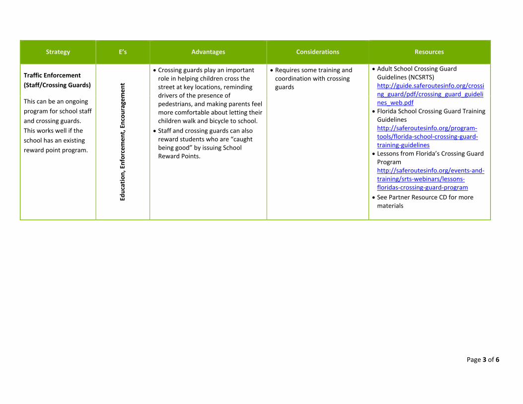
Traffic Enforcement (Staff/Crossing Guards)
This can be an ongoing program for school staff and crossing guards. This works well if the school has an existing reward point program.
Education, Enforcemen
t, En
couragem
ent
Crossing guards play an important role in helping children cross the street at key locations, reminding drivers of the presence of pedestrians, and making parents feel more comfortable about letting their children walk and bicycle to school.
Staff and crossing guards can also reward students who are “caught being good” by issuing School Reward Points.
Requires some training and coordination with crossing guards
Adult School Crossing Guard Guidelines (NCSRTS) http://guide.saferoutesinfo.org/crossing_guard/pdf/crossing_guard_guidelines_web.pdf
Florida School Crossing Guard Training Guidelines http://saferoutesinfo.org/program‐tools/florida‐school‐crossing‐guard‐training‐guidelines
Lessons from Florida’s Crossing Guard Program http://saferoutesinfo.org/events‐and‐training/srts‐webinars/lessons‐floridas‐crossing‐guard‐program
See Partner Resource CD for more materials
Page 4 of 6
Strategy E’s Advantages Considerations Resources
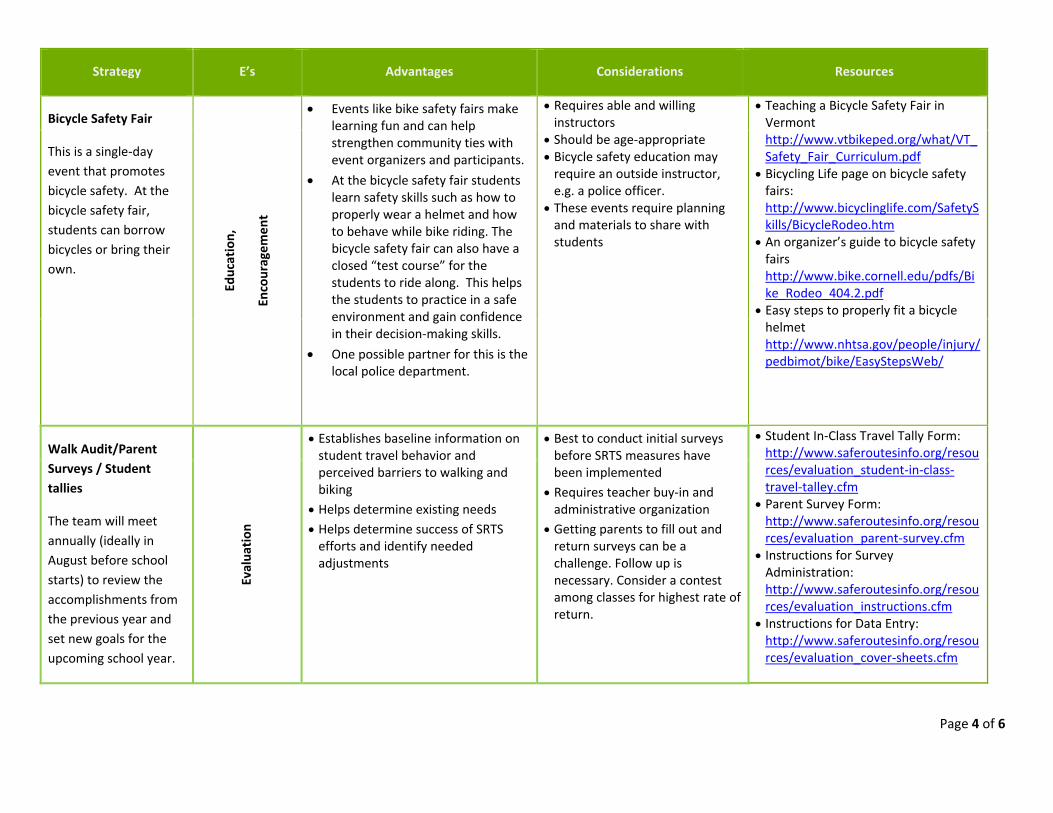
Bicycle Safety Fair
This is a single‐day event that promotes bicycle safety. At the bicycle safety fair, students can borrow bicycles or bring their own.
Education,
Encouragem
ent
Events like bike safety fairs make learning fun and can help strengthen community ties with event organizers and participants.
At the bicycle safety fair students learn safety skills such as how to properly wear a helmet and how to behave while bike riding. The bicycle safety fair can also have a closed “test course” for the students to ride along. This helps the students to practice in a safe environment and gain confidence in their decision‐making skills.
One possible partner for this is the local police department.
Requires able and willing instructors
Should be age‐appropriate Bicycle safety education may require an outside instructor, e.g. a police officer.
These events require planning and materials to share with students
Teaching a Bicycle Safety Fair in Vermont http://www.vtbikeped.org/what/VT_Safety_Fair_Curriculum.pdf
Bicycling Life page on bicycle safety fairs: http://www.bicyclinglife.com/SafetySkills/BicycleRodeo.htm
An organizer’s guide to bicycle safety fairs http://www.bike.cornell.edu/pdfs/Bike_Rodeo_404.2.pdf
Easy steps to properly fit a bicycle helmet http://www.nhtsa.gov/people/injury/pedbimot/bike/EasyStepsWeb/
Walk Audit/Parent Surveys / Student tallies
The team will meet annually (ideally in August before school starts) to review the accomplishments from the previous year and set new goals for the upcoming school year.
Evalua
tion
Establishes baseline information on student travel behavior and perceived barriers to walking and biking
Helps determine existing needs Helps determine success of SRTS efforts and identify needed adjustments
Best to conduct initial surveys before SRTS measures have been implemented
Requires teacher buy‐in and administrative organization
Getting parents to fill out and return surveys can be a challenge. Follow up is necessary. Consider a contest among classes for highest rate of return.
Student In‐Class Travel Tally Form: http://www.saferoutesinfo.org/resources/evaluation_student‐in‐class‐travel‐talley.cfm
Parent Survey Form: http://www.saferoutesinfo.org/resources/evaluation_parent‐survey.cfm
Instructions for Survey Administration: http://www.saferoutesinfo.org/resources/evaluation_instructions.cfm
Instructions for Data Entry: http://www.saferoutesinfo.org/resources/evaluation_cover‐sheets.cfm
Page 5 of 6
Strategy E’s Advantages Considerations Resources
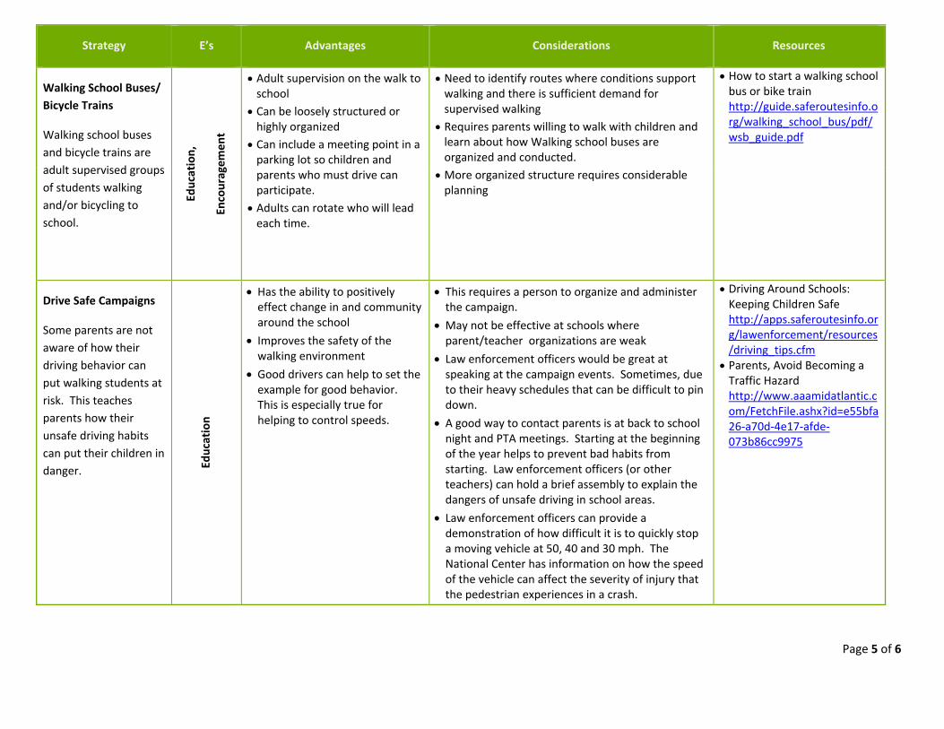
Walking School Buses/ Bicycle Trains
Walking school buses and bicycle trains are adult supervised groups of students walking and/or bicycling to school.
Education,
Encouragem
ent
Adult supervision on the walk to school
Can be loosely structured or highly organized
Can include a meeting point in a parking lot so children and parents who must drive can participate.
Adults can rotate who will lead each time.
Need to identify routes where conditions support walking and there is sufficient demand for supervised walking
Requires parents willing to walk with children and learn about how Walking school buses are organized and conducted.
More organized structure requires considerable planning
How to start a walking school bus or bike train http://guide.saferoutesinfo.org/walking_school_bus/pdf/wsb_guide.pdf
Drive Safe Campaigns
Some parents are not aware of how their driving behavior can put walking students at risk. This teaches parents how their unsafe driving habits can put their children in danger. Ed
ucation
Has the ability to positively effect change in and community around the school
Improves the safety of the walking environment
Good drivers can help to set the example for good behavior. This is especially true for helping to control speeds.
This requires a person to organize and administer the campaign.
May not be effective at schools where parent/teacher organizations are weak
Law enforcement officers would be great at speaking at the campaign events. Sometimes, due to their heavy schedules that can be difficult to pin down.
A good way to contact parents is at back to school night and PTA meetings. Starting at the beginning of the year helps to prevent bad habits from starting. Law enforcement officers (or other teachers) can hold a brief assembly to explain the dangers of unsafe driving in school areas.
Law enforcement officers can provide a demonstration of how difficult it is to quickly stop a moving vehicle at 50, 40 and 30 mph. The National Center has information on how the speed of the vehicle can affect the severity of injury that the pedestrian experiences in a crash.
Driving Around Schools: Keeping Children Safe http://apps.saferoutesinfo.org/lawenforcement/resources/driving_tips.cfm
Parents, Avoid Becoming a Traffic Hazard http://www.aaamidatlantic.com/FetchFile.ashx?id=e55bfa26‐a70d‐4e17‐afde‐073b86cc9975
Page 6 of 6
Strategy E’s Advantages Considerations Resources
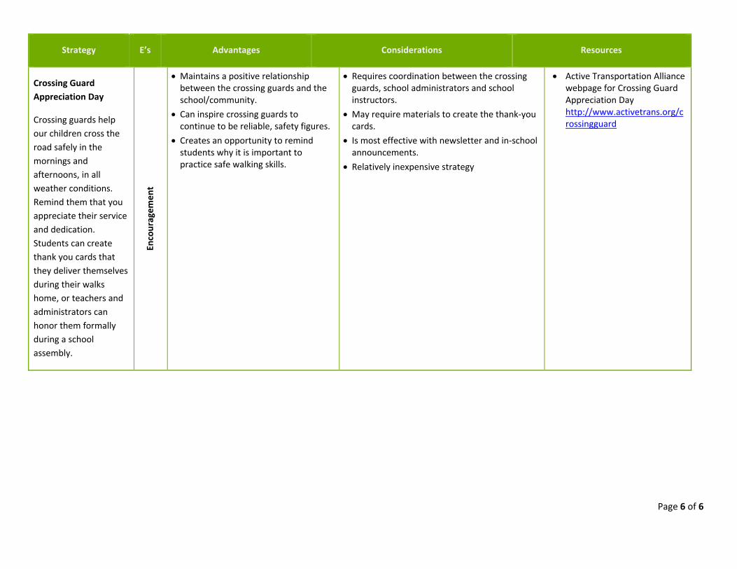
Crossing Guard Appreciation Day
Crossing guards help our children cross the road safely in the mornings and afternoons, in all weather conditions. Remind them that you appreciate their service and dedication. Students can create thank you cards that they deliver themselves during their walks home, or teachers and administrators can honor them formally during a school assembly.
Encouragem
ent
Maintains a positive relationship between the crossing guards and the school/community.
Can inspire crossing guards to continue to be reliable, safety figures.
Creates an opportunity to remind students why it is important to practice safe walking skills.
Requires coordination between the crossing guards, school administrators and school instructors.
May require materials to create the thank‐you cards.
Is most effective with newsletter and in‐school announcements.
Relatively inexpensive strategy
Active Transportation Alliance webpage for Crossing Guard Appreciation Day http://www.activetrans.org/crossingguard
Page 1 of 2
APPENDIX I SNOW REMOVAL TOOLKIT
Prompt and effective snow, ice, and slush clearance on sidewalks along Safe Routes to School is critical for maintaining safe biking and walking conditions. Snow removal of bicycle and pedestrian accommodations that are designated school routes should be planned for. According to the VT Pedestrian and Bicycle Facility Design Manual Section 10.5.1, local policies should treat the clearance of snow from walkways as equally important as clearance of snow from roadways in order to maintain year-round accessibility.
Guidelines
The responsibility of all snow and ice clearance generally falls upon the property owner of the facility. A municipality’s highway department is typically responsible for snow and ice removal on roads and sidewalks on public property. Private roads and sidewalks on private property are the responsibility of the property owner.
A clear, unobstructed pathway at a minimum of 48” wide should be provided on all sidewalks, curb ramps, and through crosswalks. Snow, slush, and ice should be cleared from sidewalks, to provide a clear path of 48”, ideally, within 12 hours after a storm event. Designated portions of the roadway for bicycle use should also be cleared since, even in winter, some experienced bicyclists commute by bicycle.
Pedestrian walkways, curb ramps, and crosswalks or bicycle facilities should not be used for areas of snow storage. Additional consideration should also be taken to maintain adequate sight distances at all intersections and to prevent snow storage from building up too close to walkways. Paved shared-use paths that are designated routes to school should be kept clear of snow so that students can walk to school year-round. Snow clearance is not a consideration for natural surface paths that are used for winter activities which also allow students to cross-country ski or snow-shoe to school.
Recommendations
The following six basic recommendations can assist a community in developing a strategy to improve sidewalk snow and ice clearance.
1. Create a norm of snow and ice clearance through social awareness campaigns. 2. Identify a municipal point person for snow removal. 3. Determine priority sidewalks and paths for snow clearance. 4. Improve monitoring and enforcement. 5. Design sidewalks for easier snow removal.
Page 2 of 2
6. Train municipal and private snow plowing personnel on the guidelines for pedestrian and bicycle facility clearance (i.e., 48” clear path and priority routes.)
Monitoring and Enforcement
There are three primary ways in which the clearance of sidewalks can be monitored and enforced;
1. Identify who monitors and enforces. 2. Define penalties and how they will be enforced. 3. Implement a social awareness campaign.
Page 1 of 8
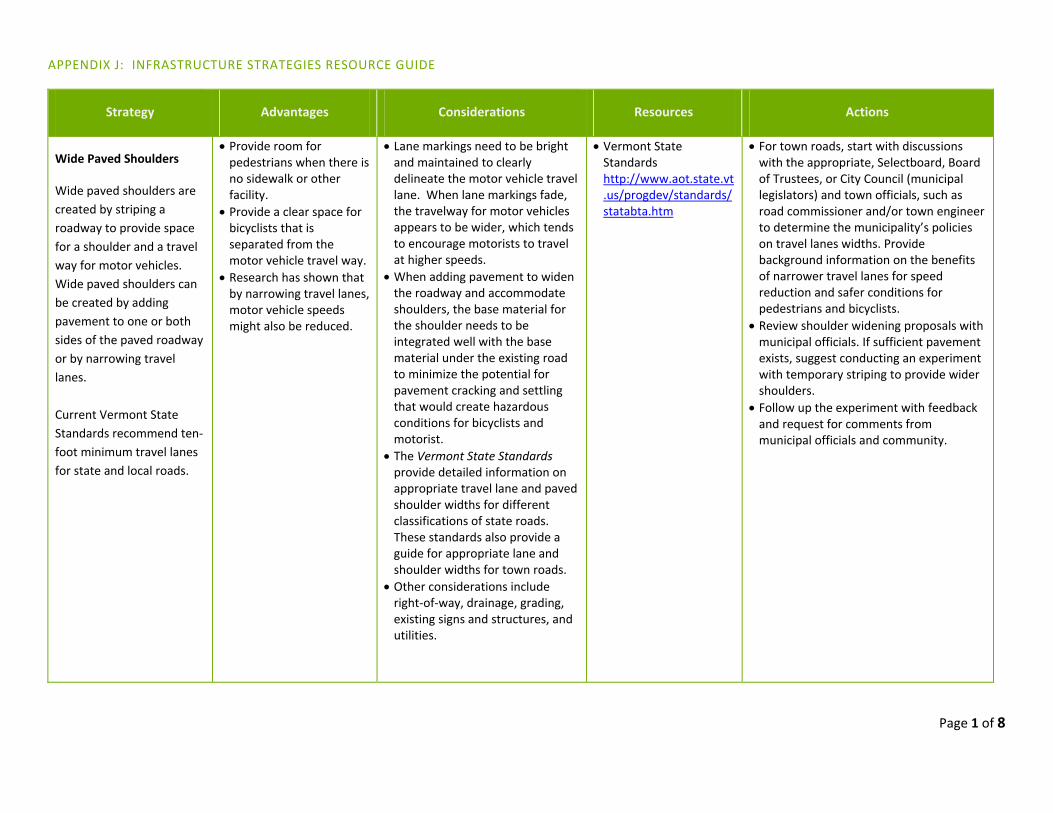
APPENDIX J: INFRASTRUCTURE STRATEGIES RESOURCE GUIDE
Strategy Advantages Considerations Resources Actions
Wide Paved Shoulders
Wide paved shoulders are
created by striping a
roadway to provide space
for a shoulder and a travel
way for motor vehicles.
Wide paved shoulders can
be created by adding
pavement to one or both
sides of the paved roadway
or by narrowing travel
lanes.
Current Vermont State
Standards recommend ten‐
foot minimum travel lanes
for state and local roads.
Provide room for pedestrians when there is no sidewalk or other facility.
Provide a clear space for bicyclists that is separated from the motor vehicle travel way.
Research has shown that by narrowing travel lanes, motor vehicle speeds might also be reduced.
Lane markings need to be bright and maintained to clearly delineate the motor vehicle travel lane. When lane markings fade, the travelway for motor vehicles appears to be wider, which tends to encourage motorists to travel at higher speeds.
When adding pavement to widen the roadway and accommodate shoulders, the base material for the shoulder needs to be integrated well with the base material under the existing road to minimize the potential for pavement cracking and settling that would create hazardous conditions for bicyclists and motorist.
The Vermont State Standards provide detailed information on appropriate travel lane and paved shoulder widths for different classifications of state roads. These standards also provide a guide for appropriate lane and shoulder widths for town roads.
Other considerations include right‐of‐way, drainage, grading, existing signs and structures, and utilities.
Vermont State Standards http://www.aot.state.vt.us/progdev/standards/statabta.htm
For town roads, start with discussions with the appropriate, Selectboard, Board of Trustees, or City Council (municipal legislators) and town officials, such as road commissioner and/or town engineer to determine the municipality’s policies on travel lanes widths. Provide background information on the benefits of narrower travel lanes for speed reduction and safer conditions for pedestrians and bicyclists.
Review shoulder widening proposals with municipal officials. If sufficient pavement exists, suggest conducting an experiment with temporary striping to provide wider shoulders.
Follow up the experiment with feedback and request for comments from municipal officials and community.
Page 2 of 8
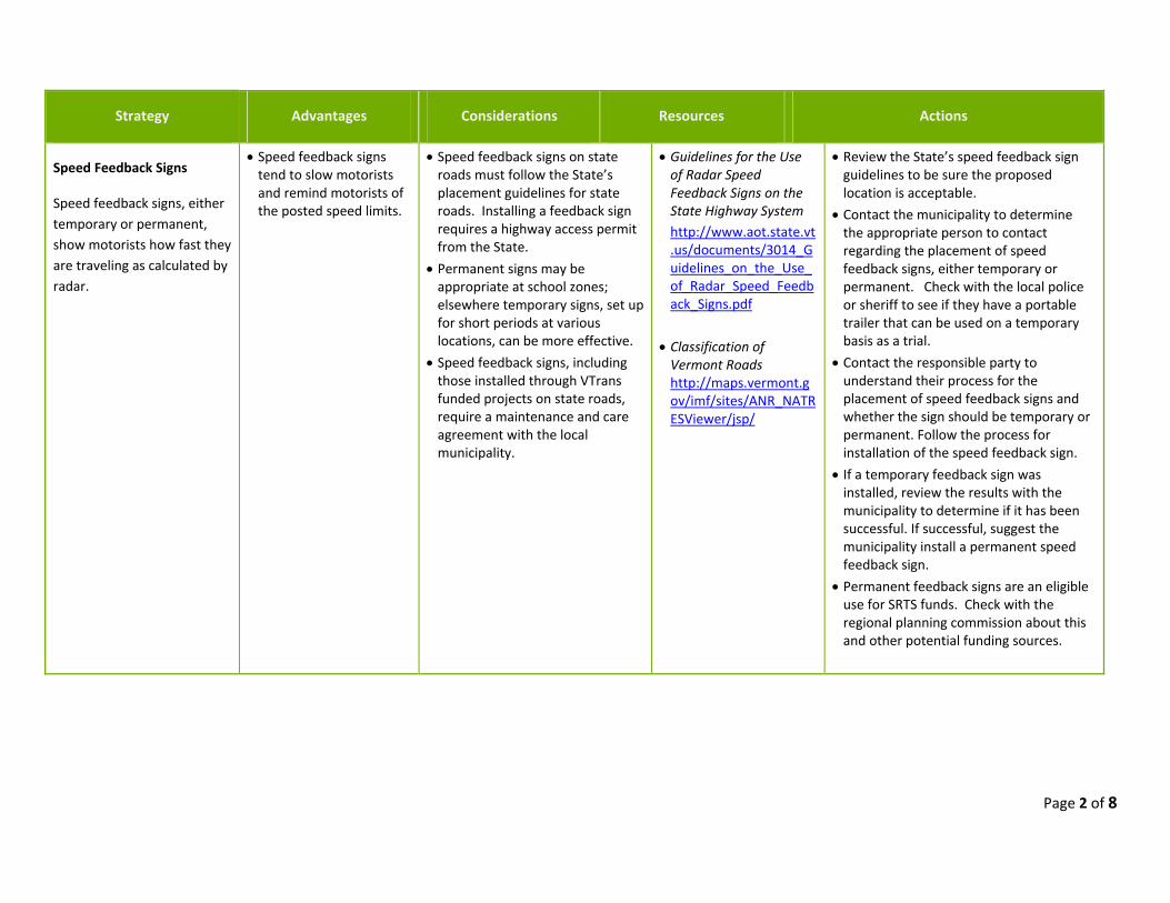
Strategy Advantages Considerations Resources Actions
Speed Feedback Signs
Speed feedback signs, either
temporary or permanent,
show motorists how fast they
are traveling as calculated by
radar.
Speed feedback signs tend to slow motorists and remind motorists of the posted speed limits.
Speed feedback signs on state roads must follow the State’s placement guidelines for state roads. Installing a feedback sign requires a highway access permit from the State.
Permanent signs may be appropriate at school zones; elsewhere temporary signs, set up for short periods at various locations, can be more effective.
Speed feedback signs, including those installed through VTrans funded projects on state roads, require a maintenance and care agreement with the local municipality.
Guidelines for the Use of Radar Speed Feedback Signs on the State Highway System
http://www.aot.state.vt.us/documents/3014_Guidelines_on_the_Use_of_Radar_Speed_Feedback_Signs.pdf
Classification of Vermont Roads http://maps.vermont.gov/imf/sites/ANR_NATRESViewer/jsp/
Review the State’s speed feedback sign guidelines to be sure the proposed location is acceptable.
Contact the municipality to determine the appropriate person to contact regarding the placement of speed feedback signs, either temporary or permanent. Check with the local police or sheriff to see if they have a portable trailer that can be used on a temporary basis as a trial.
Contact the responsible party to understand their process for the placement of speed feedback signs and whether the sign should be temporary or permanent. Follow the process for installation of the speed feedback sign.
If a temporary feedback sign was installed, review the results with the municipality to determine if it has been successful. If successful, suggest the municipality install a permanent speed feedback sign.
Permanent feedback signs are an eligible use for SRTS funds. Check with the regional planning commission about this and other potential funding sources.
Page 3 of 8
Strategy Advantages Considerations Resources Actions
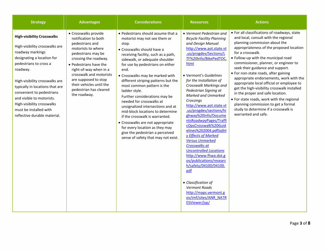
High‐visibility Crosswalks
High‐visibility crosswalks are
roadway markings
designating a location for
pedestrians to cross a
roadway.
High‐visibility crosswalks are
typically in locations that are
convenient to pedestrians
and visible to motorists.
High‐visibility crosswalks
must be installed with
reflective durable material.
Crosswalks provide notification to both pedestrians and motorists to where pedestrians may be crossing the roadway.
Pedestrians have the right‐of‐way when in a crosswalk and motorists are supposed to stop their vehicles until the pedestrian has cleared the roadway.
Pedestrians should assume that a motorist may not see them or stop.
Crosswalks should have a receiving facility, such as a path, sidewalk, or adequate shoulder for use by pedestrians on either end.
Crosswalks may be marked with different striping patterns but the most common pattern is the ladder style.
Further considerations may be needed for crosswalks at unsignalized intersections and at mid‐block locations to determine if the crosswalk is warranted.
Crosswalks are not appropriate for every location as they may give the pedestrian a perceived sense of safety that may not exist.
Vermont Pedestrian and Bicycle Facility Planning and Design Manual http://www.aot.state.vt.us/progdev/Sections/LTF%20Info/BikePedTOC.html
Vermont’s Guidelines for the Installation of Crosswalk Markings and Pedestrian Signing at Marked and Unmarked Crossings http://www.aot.state.vt.us/progdev/sections/highway%20info/DocumentsRoadwayPages/TrafficOpsCrosswalk%20Guidelines%202004.pdfSafety Effects of Marked Versus Unmarked Crosswalks at Uncontrolled Locations http://www.fhwa.dot.gov/publications/research/safety/04100/04100.pdf
Classification of Vermont Roads http://maps.vermont.gov/imf/sites/ANR_NATRESViewer/jsp/
For all classifications of roadways, state and local, consult with the regional planning commission about the appropriateness of the proposed location for a crosswalk.
Follow‐up with the municipal road commissioner, planner, or engineer to seek their guidance and support.
For non‐state roads, after gaining appropriate endorsements, work with the appropriate local official or employee to get the high‐visibility crosswalk installed in the proper and safe location.
For state roads, work with the regional planning commission to get a formal study to determine if a crosswalk is warranted and safe.
Page 4 of 8
Advantages Considerations Resources Actions
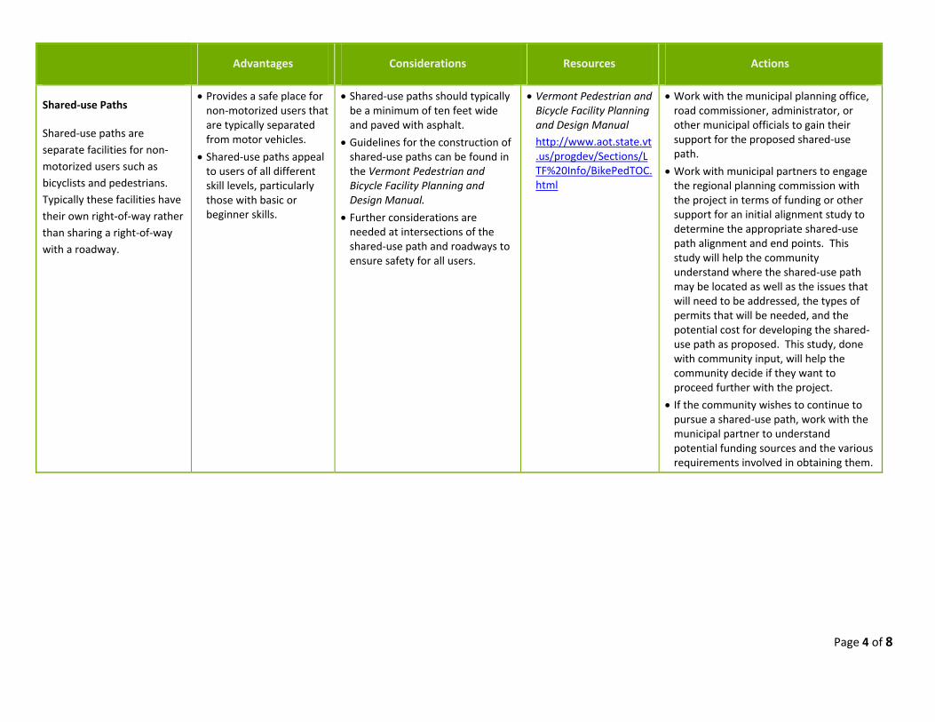
Shared‐use Paths
Shared‐use paths are
separate facilities for non‐
motorized users such as
bicyclists and pedestrians.
Typically these facilities have
their own right‐of‐way rather
than sharing a right‐of‐way
with a roadway.
Provides a safe place for non‐motorized users that are typically separated from motor vehicles.
Shared‐use paths appeal to users of all different skill levels, particularly those with basic or beginner skills.
Shared‐use paths should typically be a minimum of ten feet wide and paved with asphalt.
Guidelines for the construction of shared‐use paths can be found in the Vermont Pedestrian and Bicycle Facility Planning and Design Manual.
Further considerations are needed at intersections of the shared‐use path and roadways to ensure safety for all users.
Vermont Pedestrian and Bicycle Facility Planning and Design Manual http://www.aot.state.vt.us/progdev/Sections/LTF%20Info/BikePedTOC.html
Work with the municipal planning office, road commissioner, administrator, or other municipal officials to gain their support for the proposed shared‐use path.
Work with municipal partners to engage the regional planning commission with the project in terms of funding or other support for an initial alignment study to determine the appropriate shared‐use path alignment and end points. This study will help the community understand where the shared‐use path may be located as well as the issues that will need to be addressed, the types of permits that will be needed, and the potential cost for developing the shared‐use path as proposed. This study, done with community input, will help the community decide if they want to proceed further with the project.
If the community wishes to continue to pursue a shared‐use path, work with the municipal partner to understand potential funding sources and the various requirements involved in obtaining them.
Page 5 of 8
Strategy Advantages Considerations Resources Actions
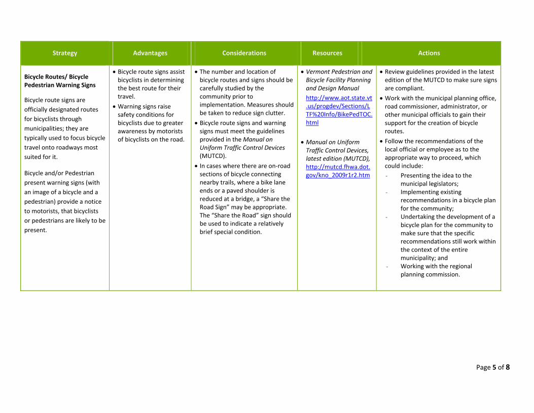
Bicycle Routes/ Bicycle Pedestrian Warning Signs
Bicycle route signs are
officially designated routes
for bicyclists through
municipalities; they are
typically used to focus bicycle
travel onto roadways most
suited for it.
Bicycle and/or Pedestrian
present warning signs (with
an image of a bicycle and a
pedestrian) provide a notice
to motorists, that bicyclists
or pedestrians are likely to be
present.
Bicycle route signs assist bicyclists in determining the best route for their travel.
Warning signs raise safety conditions for bicyclists due to greater awareness by motorists of bicyclists on the road.
The number and location of bicycle routes and signs should be carefully studied by the community prior to implementation. Measures should be taken to reduce sign clutter.
Bicycle route signs and warning signs must meet the guidelines provided in the Manual on Uniform Traffic Control Devices (MUTCD).
In cases where there are on‐road sections of bicycle connecting nearby trails, where a bike lane ends or a paved shoulder is reduced at a bridge, a “Share the Road Sign” may be appropriate. The “Share the Road” sign should be used to indicate a relatively brief special condition.
Vermont Pedestrian and Bicycle Facility Planning and Design Manual http://www.aot.state.vt.us/progdev/Sections/LTF%20Info/BikePedTOC.html
Manual on Uniform Traffic Control Devices, latest edition (MUTCD), http://mutcd.fhwa.dot.gov/kno_2009r1r2.htm
Review guidelines provided in the latest edition of the MUTCD to make sure signs are compliant.
Work with the municipal planning office, road commissioner, administrator, or other municipal officials to gain their support for the creation of bicycle routes.
Follow the recommendations of the local official or employee as to the appropriate way to proceed, which could include:
- Presenting the idea to the municipal legislators;
- Implementing existing recommendations in a bicycle plan for the community;
- Undertaking the development of a bicycle plan for the community to make sure that the specific recommendations still work within the context of the entire municipality; and
- Working with the regional planning commission.
Page 6 of 8
Strategy Advantages Considerations Resources Actions
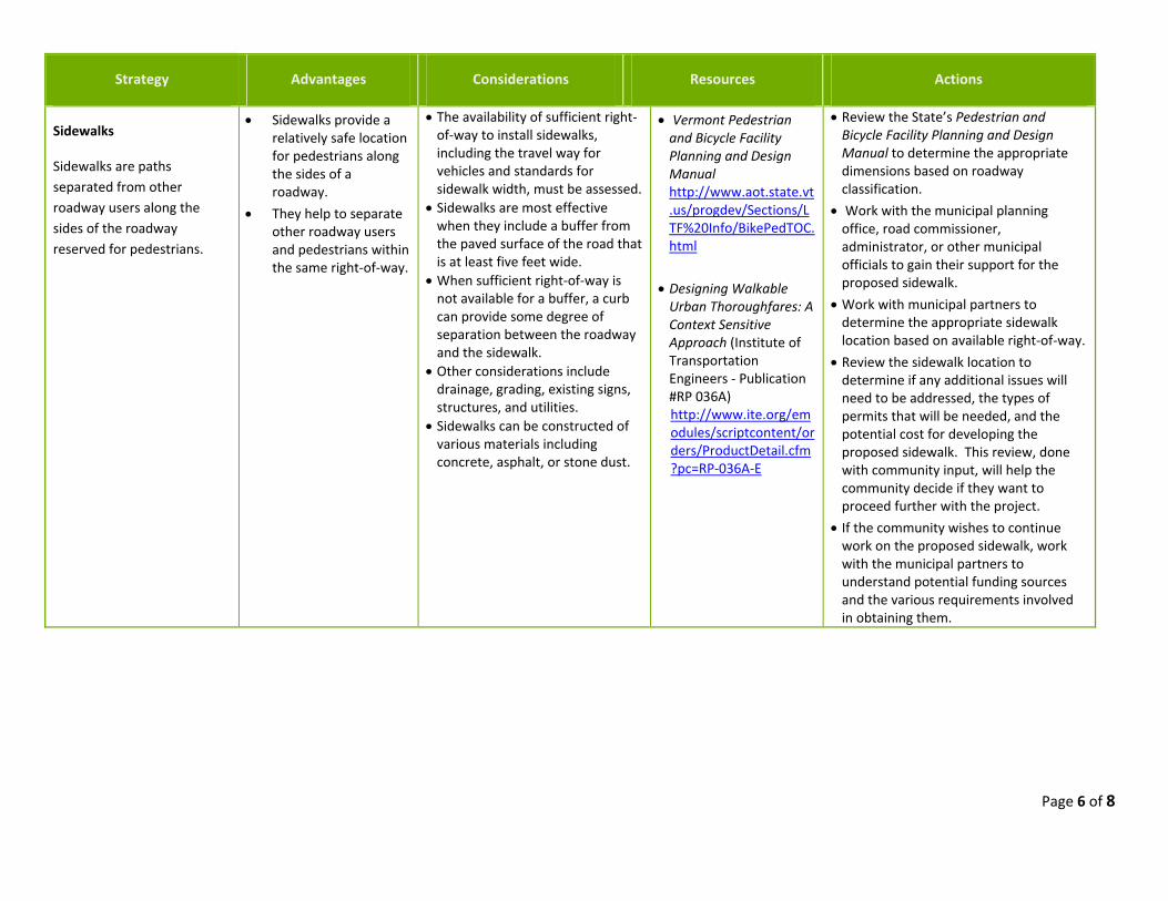
Sidewalks
Sidewalks are paths
separated from other
roadway users along the
sides of the roadway
reserved for pedestrians.
Sidewalks provide a relatively safe location for pedestrians along the sides of a roadway.
They help to separate other roadway users and pedestrians within the same right‐of‐way.
The availability of sufficient right‐of‐way to install sidewalks, including the travel way for vehicles and standards for sidewalk width, must be assessed.
Sidewalks are most effective when they include a buffer from the paved surface of the road that is at least five feet wide.
When sufficient right‐of‐way is not available for a buffer, a curb can provide some degree of separation between the roadway and the sidewalk.
Other considerations include drainage, grading, existing signs, structures, and utilities.
Sidewalks can be constructed of various materials including concrete, asphalt, or stone dust.
Vermont Pedestrian and Bicycle Facility Planning and Design Manual http://www.aot.state.vt.us/progdev/Sections/LTF%20Info/BikePedTOC.html
Designing Walkable Urban Thoroughfares: A Context Sensitive Approach (Institute of Transportation Engineers ‐ Publication #RP 036A) http://www.ite.org/emodules/scriptcontent/orders/ProductDetail.cfm?pc=RP‐036A‐E
Review the State’s Pedestrian and Bicycle Facility Planning and Design Manual to determine the appropriate dimensions based on roadway classification.
Work with the municipal planning office, road commissioner, administrator, or other municipal officials to gain their support for the proposed sidewalk.
Work with municipal partners to determine the appropriate sidewalk location based on available right‐of‐way.
Review the sidewalk location to determine if any additional issues will need to be addressed, the types of permits that will be needed, and the potential cost for developing the proposed sidewalk. This review, done with community input, will help the community decide if they want to proceed further with the project.
If the community wishes to continue work on the proposed sidewalk, work with the municipal partners to understand potential funding sources and the various requirements involved in obtaining them.
Page 7 of 8
Strategy Advantages Considerations Resources Actions
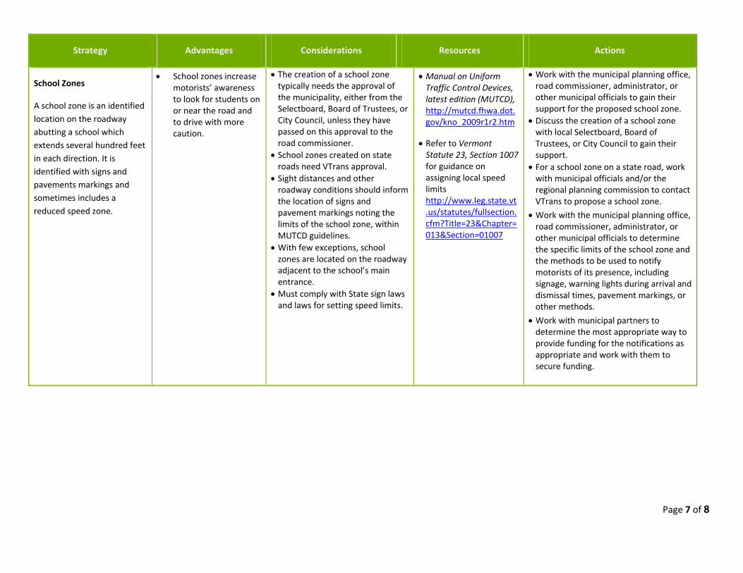
School Zones
A school zone is an identified
location on the roadway
abutting a school which
extends several hundred feet
in each direction. It is
identified with signs and
pavements markings and
sometimes includes a
reduced speed zone.
School zones increase motorists’ awareness to look for students on or near the road and to drive with more caution.
The creation of a school zone typically needs the approval of the municipality, either from the Selectboard, Board of Trustees, or City Council, unless they have passed on this approval to the road commissioner.
School zones created on state roads need VTrans approval.
Sight distances and other roadway conditions should inform the location of signs and pavement markings noting the limits of the school zone, within MUTCD guidelines.
With few exceptions, school zones are located on the roadway adjacent to the school’s main entrance.
Must comply with State sign laws and laws for setting speed limits.
Manual on Uniform Traffic Control Devices, latest edition (MUTCD), http://mutcd.fhwa.dot.gov/kno_2009r1r2.htm
Refer to Vermont Statute 23, Section 1007 for guidance on assigning local speed limits http://www.leg.state.vt.us/statutes/fullsection.cfm?Title=23&Chapter=013&Section=01007
Work with the municipal planning office, road commissioner, administrator, or other municipal officials to gain their support for the proposed school zone.
Discuss the creation of a school zone with local Selectboard, Board of Trustees, or City Council to gain their support.
For a school zone on a state road, work with municipal officials and/or the regional planning commission to contact VTrans to propose a school zone.
Work with the municipal planning office, road commissioner, administrator, or other municipal officials to determine the specific limits of the school zone and the methods to be used to notify motorists of its presence, including signage, warning lights during arrival and dismissal times, pavement markings, or other methods.
Work with municipal partners to determine the most appropriate way to provide funding for the notifications as appropriate and work with them to secure funding.
Page 8 of 8
Strategy Advantages Considerations Resources Actions
Road Signs
Road signs provide
information on road
conditions, direction,
advisories, or mandatory
actions. Road signs may be
regulatory, warning, or guide
signs.
Signs notify road users about road conditions, other users, regulations, or conditions that may not be immediately apparent.
Many signs are not typically an expensive installation and can be approved and installed quickly.
The number and type of existing signs can influence the effectiveness of new signs. Sign “clutter” can diminish the impact of new signs.
Permanent signs can become part of the background and their perception by regular road users can diminish over time.
Changing conditions, such as temporary flashing lights or periodic flags, can help to continually draw attention to a sign.
Adding new signs to a local road typically needs the approval of the municipality, either from the Selectboard, Board of Trustees, or City Council, unless they have passed on this approval to the road commissioner.
Signs added to state roads need VTrans approval.
Any proposed signage must meet the guidelines provided in the Manual on Uniform Traffic Control Devices (MUTCD).
Temporary devices such as in‐ street “Yield to Pedestrian” signs, require designated personnel to provide continuous maintenance. Such signs must be installed and removed EACH DAY of intended use and should not remain on the roadside when not in use.
Vermont Pedestrian and Bicycle Facility Planning and Design Manual http://www.aot.state.vt.us/progdev/Sections/LTF%20Info/BikePedTOC.html
Manual on Uniform Traffic Control Devices, latest edition (MUTCD), http://mutcd.fhwa.dot.gov/kno_2009r1r2.htm
Classification of Vermont Roads http://maps.vermont.gov/imf/sites/ANR_NATRESViewer/jsp/
Work with the municipal planning office, road commissioner, administrator, or other municipal officials to gain their support for the placement of new signs.
Discuss the placement of new signs with local Selectboard, Board of Trustee or City Council to gain their support.
Work with the municipal planning office, road commissioner, administrator, or other municipal officials to determine the appropriate place for the signs while meeting guidelines provided in the MUTCD.
If proposed on a state road, work with the municipal officials and the regional planning commission to contact VTrans to gain their approval and any necessary permitting for the proposed signs.