conservation strategy for private land in the riverina bioregion of victoria
DESCRIPTION
This ‘Conservation Strategy for Private Land in the Riverina Bioregion of Victoria’ provides the impetus to guide Trust for Nature, governmentagencies, non-government organisations and the community in the protection of the Victorian Riverina Bioregion.TRANSCRIPT

Trust for NatureConservation Strategy for Private Land in the Riverina Bioregion of Victoria September 2012
Trust for Nature C
onservatio
n Strateg
y for P
rivate Land in the R
iverina Bio
regio
n of V
ictoria S
eptember 2012


1
ForewordThis ‘Conservation Strategy for Private Land in the Riverina Bioregion of Victoria’ provides the impetus to guide Trust for Nature, government agencies, non-government organisations and the community in the protection of the Victorian Riverina Bioregion.
The Victorian Riverina Bioregion contains some of the most significant vegetation and drainage systems in the state, yet it is significantly under-represented within Australia’s National Reserve System.
The ‘Conservation Strategy for Private Land in the Riverina Bioregion of Victoria’ describes the significance of the region, outlines targets for action and identifies the places within the landscape where we need to focus our efforts to contribute to a comprehensive, adequate and representative National Reserve System.
The Strategy was developed by Trust for Nature staff and steering committee members of the Protected Areas on Private Land Program. This program was supported by Trust for Nature through funding from the Australian Government’s Caring for our Country initiative. The Strategy is underpinned by Trust for Nature’s state-wide conservation planning approach and it builds upon the years of work undertaken by Trust for Nature on private land and the framework provided by the Northern Plains Technical Advisory Group’s Conservation and Protection of Northern Plains Grasslands – A Strategic Direction (Department of Sustainability and Environment 2010).
This Strategy has been developed for the Victorian Riverina Bioregion. It also forms a template which can be applied across all ecosystems that are under represented in Australia’s National Reserve System. The Strategy provides a focus for all natural resource management agencies to align their approach to private land conservation activities and contribute to an integrated approach to biodiversity conservation across the Victorian Riverina.
This Strategy is intended to provide a clear and consistent direction to achieve real gains in private land conservation and will form the backbone to assist Trust for Nature prioritise its conservation efforts within the Victorian Riverina.
The aims in this Strategy are based on the understanding that protecting our private land remnant landscapes involves us all working together – governments, non governments, landowners and the community. This provides a direction for us all to ensure we are working towards achieving a National Reserve System and protecting our native plants and wildlife for future generations.
Victoria Marles Camilla Graves CEO Chairman Trust for Nature Board of Trustees

Published by Trust for NatureLevel 5/379 Collins Street, Melbourne, September 2012
Also published on www.trustfornature.org.au
© Trust for Nature 2012This publication is copyright. No part may be reproduced by any process except in accordance with the provisions of the Copyright Act 1968.
Developed and written by Deanna Marshall, Nathan Wong and Doug Robinson, Trust for Nature; and Stephen Page, Talkin’ Technical Communications.
Edited by Stephen Page, Talkin’ Technical Communications.
Thank you to Kelly Arbon of Trust for Nature for producing the GIS statistics and Dr. Jim Radford of the Department of Sustainability and Environment who provided valuable comments on the draft.
Protected Areas on Private Land Steering CommitteeDeanna Marshall, Trust for Nature; Nathan Wong, Trust for Nature; Doug Robinson, Trust for Nature; Kathryn Smith, Department of Sustainability, Environment, Water, Population and Communities; James Trezise, Department of Sustainability, Environment, Water, Population and Communities; Jim Radford, Department of Sustainability and Environment.
Printed by: Printed on Recycled Paper
For more information contact Trust for Nature 1800 99 99 33 or visit www.trustfornature.org.au.
DisclaimerCite this report as:
Trust for Nature 2012. Conservation Strategy for Private Land in the Riverina Bioregion of Victoria.

3
Contents1. Introduction and scope of this strategy ................................................................................................................... 6
1.1. Scope of the Conservation Strategy for Private Land in the Riverina Bioregion of Victoria ........................................ 8
1.2. Australia’s National Reserve System........................................................................................................................ 8
1.3. Trust for Nature ....................................................................................................................................................... 8
2. Riverina bioregion in focus ...................................................................................................................................... 10
2.1. The Riverina Bioregion .......................................................................................................................................... 10
2.2. Riverina subregions ............................................................................................................................................... 12
2.3. Vegetation communities of the Victorian Riverina Bioregion ................................................................................... 13
2.4. Current reservation ............................................................................................................................................... 19
3. Threatening processes and land use drivers ......................................................................................................... 22
3.1. Threatening processes .......................................................................................................................................... 22
3.2. Land use drivers ................................................................................................................................................... 24
4. Methods .................................................................................................................................................................... 26
4.1 Conservation targets and objectives ...................................................................................................................... 26
4.2 Objective 1: Improve protection of the least protected vegetation types ................................................................. 28
4.3 Objective 2: Improve protection of threatened species ........................................................................................... 28
4.4 Objective 3: Improve protection of key areas for biodiversity .................................................................................. 29
4.5 Objective 4: Improve the integrity, viability and functionality of ecosystems ............................................................. 30
4.6 Mapping the focal landscapes ............................................................................................................................... 30
5. Victorian Riverina bioregion conservation assessment ........................................................................................ 31
5.1 Comprehensiveness of ecosystems ....................................................................................................................... 31
5.2 Adequacy of ecosystem protection ........................................................................................................................ 33
5.3 Representativeness of ecosystem protection ......................................................................................................... 34
5.4 Objective 1: Protection of threatened vegetation communities ............................................................................... 34
5.5 Objective 2: Protection of threatened species ........................................................................................................ 38
5.6 Objective 3: Protection of key areas for biodiversity ................................................................................................ 39
6. Priorities for action ................................................................................................................................................... 41
6.1. Priority private land areas for inclusion in the National Reserve System ................................................................. 41
6.2 Additional priority private land areas for inclusion in the National Reserve System .................................................. 60
6.3 Ongoing management of existing Trust for Nature private protected areas ............................................................. 60
6.4 Additional opportunities to increase landscape conservation .................................................................................. 60
6.5 Next Steps ............................................................................................................................................................ 60
7. Appendices ............................................................................................................................................................... 62
Appendix A: Priority threatened species ....................................................................................................................... 62
Appendix B: Important wetlands in the Victorian Riverina Bioregion ............................................................................. 65
Appendix C: Spatial datasets ....................................................................................................................................... 66
8. References ................................................................................................................................................................ 67

1. Introduction and scope of this Strategy
The Victorian section of the Riverina Bioregion comprises the alluvial plains on the northern side of the Great Dividing Range along the drainage systems flowing into the Murray River. The bioregion contains many significant natural heritage values including internationally recognised (Ramsar) wetlands and concentrations of internationally, nationally, state and regionally threatened species.
Of particular interest for private land conservation, and therefore to Trust for Nature, are the under-reserved vegetation communities on private land, where they are found in the landscape, and how best to conserve them into the future.
Native vegetation in the Victorian Riverina Bioregion has been extensively cleared for agriculture. Only 30% of the bioregion now supports remnant native vegetation. Less than 10% of this remnant vegetation is protected to a level capable of inclusion in the Australian Government’s National Reserve System.
Establishment of the existing National Reserve System focussed on the main river systems and anabranches of the Murray River Corridor. As a result, many well represented vegetation types retain over 50% of their pre-1750 extent. However, moving away from the main river systems, extensive areas of the more arable plains were cleared for agricultural development. Consequently, 29% of vegetation types are significantly under represented within the existing National Reserve System. An additional 87,553 ha are required to make the Riverina Bioregion representative. Thus the Riverina Bioregion is recognised as a high priority for additional reservation through various means to increase the National Reserve System (NRMMC 2009).
Through its targeted program of land purchases and conservation covenants, Trust for Nature has grown the National Reserve System by over 35,000 ha in this bioregion over the last decade. This Strategy provides a clear direction for increasing this rate of protection and achieving a representative National Reserve System by 2032.
Trust for Nature is the principal Victorian organisation for protecting natural heritage values with perpetual land management agreements attached to property titles. Conservation covenants are currently the only level of protection offered for private land that meet the Australian Government’s standards for inclusion in the National Reserve System (Fitzsimons 2006).
This Conservation Strategy for Private Land in the Riverina Bioregion of Victoria has been prepared as part of Trust for Nature’s Victorian Riverina Protected Areas on Private Land (PAPL) program. PAPL contributes to the National Reserve System by:
• promotingandfacilitatingvoluntaryconservationcovenants between Trust for Nature and landowners with important natural values on their properties; and
• landacquisition.
This Strategy guides and directs our efforts in private land conservation to contribute to a comprehensive, adequate and representative bioregional, multi-tenure, Protected Area Network. The Strategy identifies focal landscapes for conservation management, and areas of high priority for investment to secure natural heritage values.
The goals and approaches outlined in this document apply equally to all Natural Resource Management agencies working to conserve natural heritage values at the bioregional level and contribute to the National Reserve System. By aligning our goals and approaches in a single strategic plan, the Trust envisages the different agencies complementing each other’s endeavours in private land conservation in the Victorian Riverina Bioregion.
6 CONSERVATION STRATEGY FOR PRIVATE LAND IN THE RIVERINA BIOREGION OF VICTORIA

7
Sunset at Korrak Korrak Grasslands. This Trust for Nature owned
and managed reserve forms an integral link between Back Creek
and Bael Bael Grassland Nature Conservation Reserve on the Avoca
Plains. Purchased in 2001, Korrak Korrak Grasslands contains 246
ha of remnant grasslands in the Riverina Bioregion. Photo: Deanna
Marshall, 2012.

8 CONSERVATION STRATEGY FOR PRIVATE LAND IN THE RIVERINA BIOREGION OF VICTORIA
1.1. Scope of the Conservation Strategy for Private Land in the Riverina Bioregion of Victoria
• EstablishastrategicapproachtoTrustforNature’sconservation activities on private land, focussing on protecting priority ecosystems and species in the Victorian Riverina Bioregion.
• Developastrategicapproachtonatureconservationon private land that complements the conservation measures being undertaken by partner agencies on public and private land.
1.2. Australia’s National Reserve System
The National Reserve System (NRS) is a national network of legally protected areas on private and public land across Australia. Included are all protected areas and reserves established and effectively managed for conservation by the Australian Government, the states, territories, local government, Indigenous and private landowners and non-government organisations. This strong partnership between organisations and individuals has underpinned the success of the National Reserve System to date (NRMMC 2009).
The National Reserve System Program focuses on assisting and directing the establishment of a Comprehensive, Adequate and Representative (CAR) system of protected areas to ensure the conservation of Australia’s native biodiversity (Commonwealth of Australia 1999). The National Reserve System aims to conserve examples of under-represented ecosystems; areas with concentrations of threatened species; and areas and vegetation communities of special environmental significance (Commonwealth of Australia 1999).
The National Reserve System Program has developed standard guidelines for the establishment of a CAR Reserve System. These criteria underpin Trust for Nature’s targeted approach for identifying priority areas for protection and addition to the National Reserve System. A key aim of Trust for Nature’s targeted approach is to significantly increase the level of protection of the least protected ecosystems within the Victorian Riverina Bioregion.
To be eligible for inclusion within the National Reserve System, an area of land must meet the International Union for the Conservation of Nature (IUCN) definition of a ‘protected area’, defined as:
‘A clearly defined geographical space, recognised, dedicated and managed, through legal or other effective means, to achieve the long-term conservation of nature with associated ecosystem services and cultural values’ (Dudley 2008).
In Victoria, 17.26% is currently protected in the National Reserve System (CAPAD 2008).
1.3. Trust for Nature
Since its inception under the Victorian Conservation Trust Act 1972, Trust for Nature has developed into one of Victoria’s leading private land conservation organisations. Trust for Nature acts as a not-for-profit organisation actively assisting private landowners in protecting significant native habitat on private land. In this role, Trust for Nature is able to receive gifts and donations of money and land.
Trust for Nature has developed a range of tools to facilitate private land conservation and specifically aid private individuals protect biodiversity on private land. Through perpetual conservation covenants, Trust for Nature has facilitated the protection of more than 47,000 ha involving over 1,115 covenants. The Trust has also actively purchased and preserved more than 55 properties across Victoria through its Revolving Fund, and currently owns (as at June 2012) and manages an additional 47 properties covering over 36,000 ha of Victoria.
Trust for Nature promotes the conservation of high-priority habitat through a range of mechanisms:
• voluntaryconservationcovenants• landacquisition(RevolvingFundandpermanent
reserves); and• environmentalmarkets.
Voluntary conservation covenantsTo be eligible for inclusion in the National Reserve System, private land must be reserved in perpetuity. Trust for Nature is currently the only organisation in Victoria that can assist private landowners to become part of Australia’s National Reserve System within Victoria, by providing perpetual Conservation Covenants under the Victorian Conservation Trust Act 1972.
Conservation covenants are voluntary but legally-binding agreements between a landholder and Trust for Nature to permanently protect the natural heritage values on a property. Conservation covenants remain one of the most effective forms of private remnant protection, as the covenant remains on the title of a property, even when sold. Any change in management status must have Ministerial or statutory approval. Conservation covenants are supported by State legislation through the Victorian Conservation Trust Act 1972.
Currently in the Victorian Riverina Bioregion, Trust for Nature has 75 conservation covenants covering 3,844.90 ha.

9
Land acquisitionPermanent Reserves
Trust for Nature continues to consider purchasing properties of high conservation significance in the interest of all Australians, both now and into the future. Properties purchased and retained by Trust for Nature are managed for conservation often with the support of a voluntary friends’ group. To date, eight properties totalling 31,215.36 ha in the Victorian Riverina Bioregion contribute to the National Reserve System.
Trust for Nature properties include the iconic Neds Corners Station and Wanderers Plain. Both of these are part of multi-tenure, protected area landscapes in the tens of thousands of hectares. These iconic landscapes have inspired locals to enter into conservation covenants, and form an integral part of engaging locals in conservation management. Thus, the impacts of these purchases and protection of these assets reaches well beyond the boundaries of these properties.
Revolving Fund
In 1989 Trust for Nature established its highly successful Revolving Fund. Funds provided through bequests, donations and Australian government grants are used to purchase environmentally significant land, which the Trust then on-sells with the condition of a conservation covenant.
All proceeds from the sale of Revolving Fund properties are wholly returned to the Revolving Fund to replenish its reserves and allow for future purchases.
Private Revolving Fund projects
Trust for Nature works closely with other private companies involved in purchasing environmentally significant properties, who then covenant them prior to on-selling. These partnerships greatly assist Trust for Nature to achieve its goal of increasing the National Reserve System within bioregions that are under represented.
Environmental MarketsNative Vegetation Offsets
Under State and Federal legislation, the removal of native vegetation on one site may be balanced by the protection and enhancement of similar or better vegetation at another. A native vegetation offset is an agreement where a landowner undertakes to protect and improve the quality of native vegetation on their land to balance the approved removal of vegetation elsewhere.
Native vegetation offset sites must be protected through an in-perpetuity agreement registered on title. Trust for Nature can provide this agreement in the form of an offset covenant. Trust for Nature is able to coordinate commercial agreements between proponents who have an offset requirement and landowners who have suitable vegetation to improve in order to meet this requirement.
Trust for Nature develops an offset agreement and a covenant for the landowner, creating a legal obligation to improve native vegetation over a 10 year period and protect it forever. Under the offset agreement, the proponent provides funds to the landowner to meet this legal obligation. Trust for Nature facilitates this payment as well as the documentation required to meet the planning approval. Trust for Nature has an ongoing role to provide surety around the improvement and maintenance of offset sites through its Stewardship Program.
Trust for Nature supports landowners throughout the offset process from initiation through to agreement, and later in protecting the environmental values on the property. Trust for Nature maintains a register of landowners with high value native vegetation willing to participate in offset arrangements, and provides ongoing stewardship to assist in the implementation of native vegetation protection and improvement measures. To date, landowners have received funding to manage over 400 ha of land through Trust for Nature’s Native Vegetation Offset Program.
Carbon Offsets
A carbon offset is a reduction in emissions of carbon dioxide or greenhouse gases made to compensate for or to offset an emission made elsewhere. Trust for Nature has established several partnerships with voluntary carbon offset providers where sequestration of carbon dioxide through native vegetation revegetation occurs on protected land. These plantings of indigenous flora are selected to make a contribution to biodiversity once mature.
Trust for Nature continues to pursue opportunities in the voluntary and regulated carbon markets both in Australia and internationally. Ongoing negotiations with carbon offset providers include the potential for the protection of remnant vegetation in the Victorian Riverina.

10 CONSERVATION STRATEGY FOR PRIVATE LAND IN THE RIVERINA BIOREGION OF VICTORIA
2. Riverina bioregion in focus
2.1. The Riverina Bioregion
The Interim Biogeographic Regionalisation for Australia (IBRA) is a bioregional framework delineating ‘natural’ regions or ‘landscape pattern’ which reflect biophysical, environmental and vegetation factors, such as climate, lithology, landform, vegetation, flora and fauna and land use (Commonwealth of Australia 1999).
In Victoria, IBRA subregions are often referred to as ‘Victorian Bioregions’. For clarity, this strategy uses the national terminology - ‘bioregion’ refers to the IBRA bioregions and ‘subregion’ to the IBRA subregions.
Bioregions that contain less than 10% in the National Reserve System are considered under represented. Figure 1 shows these under represented bioregions, including the Riverina Bioregion within Victoria, South Australia and NSW. With only 6.46% (161,943 ha) protected in the National Reserve System, the Riverina Bioregion within Victoria is a high priority for protection.
The Riverina Bioregion covers 9,713,013 ha of grazing and agricultural land within the Murray-Darling Basin in New South Wales, South Australia and Victoria (Sattler et al. 2008). Approximately 25% of this bioregion lies within Victoria (Table 1; Figure 2).
In Victoria, the Riverina Bioregion covers approximately 2,507,791 ha of northern Victoria, from Rutherglen in the east to the South Australian border in the west. Extensive riverine floodplains with low relief, associated with the Murray, Avoca, Loddon, Campaspe, Goulburn, Broken, Ovens and Kiewa Rivers, characterise the bioregion.
Vegetation types include box woodlands, mallee woodlands, grassy woodlands, chenopod shrublands, grasslands and wetlands, most of which have been severely altered and degraded since European Settlement. As a consequence, many of these vegetation types and their associated plants and animals are threatened with extinction.
Figure 1. Bioregions that contain less than 10% in the National Reserve System are considered under represented (Collaborative Australian Protected Area Database 2008).
AW
MUR
LSD
PIL
GSD
DLCK
DABCA
STU
GUP
FIN
BRT
CHC
MII
EIU
DEU
DMR
BBN
BBS
MGD
ML
FLB
STP
SCP
NCP
DRP
RIVNSS
CPBBS
NETNAN
BHC
VVP
TNM
Avon Wheatbelt - AWBrigalow Belt North - BBNBrigalow Belt South - BBSBroken Hill Complex - BHCBurt Plain - BRTCentral Arnhem - CACentral Kimberley - CKChannel Country - CHCCobar Peneplain - CPDaly Basin - DABDampierland - DLDarling Riverine Plains - DRPDavenport Murchison Ranges - DMRDesert Uplands - DEUEinasleigh Uplands - EIUFinke - FINFlinders Lofty Block - FLBGreat Sandy Desert - GSDGulf Plains - GUPLittle Sandy Desert - LSDMitchell Grass Downs - MGDMount Isa Inlier - MIIMulga Lands - MLMurchison - MURNSW South Western Slopes - NSSNandewar - NANNaracoorte Coastal Plain - NCPNew England Tablelands - NETPilbara - PILRiverina - RIVSouth East Coastal Plain - SCPStony Plains - STPSturt Plateau - STUTasmanian Northern Midlands - TNMVictorian Volcanic Plain - VVP
Under represented bioregions
Projection: Geographics - Datum: GDA94
Data Source:Collaborative Australian Protected Areas Database (CAPAD) - (2008) and Interim Biogeographic Regionalisation of Australia (IBRA 6.1) - (2005) were compiled by the Department of the Environment, Water, Heritage and the Arts with data provided by State/Territory land management agencies.Australian Coastline and State Borders1:100,000 (1990) Geoscience Australia Map produced by National Reserve System Section, Parks Australia.January 2010
0 250 500 1,000 kilometres

11
Figure 2. The Victorian Riverina Bioregion extends along the Murray River from the South Australian border in the west, to Rutherglen (just east of Wodonga) in the east.
0 25 50 100 150 200 kilometres

12 CONSERVATION STRATEGY FOR PRIVATE LAND IN THE RIVERINA BIOREGION OF VICTORIA
2.2. Riverina subregions
The Riverina Bioregion is divided into six subregions, four of which are represented in Victoria. These four subregions comprise the Murray Fans (RIV3), Victorian Riverina (RIV4), Robinvale Plains (RIV5) and Murray Scroll Belt (RIV6) subregions (Table 1; Figure 3).
Table 1. Terrestrial protected areas in the Riverina subregions, five of which are represented in NSW, four in Victoria and one in South Australia (IBRA Version 6.1, CAPAD 2008).
Subregion Subregion Code Jurisdiction(s)
Subregion Area (ha)
Protected Area (ha)
Proportion Protected (%)
Contribution to NRS (%)
Lachlan RIV1 NSW 2,377,521 27,864 1.17 0.028%
Murrumbidgee RIV2 NSW 2,946,811 98,585 3.35 0.101%
Murray Fans RIV3 NSW, VIC 1,952,125 28,536 1.46 0.029%
Victorian Riverina RIV4 VIC 1,891,517 39,387 2.08 0.040%
Robinvale Plains RIV5 NSW, VIC 161,824 39,793 24.59 0.041%
Murray Scroll Belt RIV6 SA, VIC, NSW 383,214 93,671 24.44 0.096%
Figure 3. The four subregions of the Victorian section of the Riverina Bioregion

13
Murray Scroll Belt subregion
Stretching along the Murray River from Mildura downstream to the South Australian border, the Murray Scroll Belt subregion is an entrenched river valley with associated floodplain and lake complexes of numerous oxbow lakes, billabongs, ephemeral lakes, swamps and active meander belts. Here, the Murray River forms a narrow valley where fluvial processes predominate within an otherwise aeolian-dominated landscape. The red brown earths, cracking clays and texture contrast soils (Dermosols, Vertosols, Chromosols and Sodosols) derive from alluvium deposits from the Cainozoic period (DSE 2011b).
These soils support Alluvial-Plain Shrubland, Riverine Grassy Chenopod Woodland and Riverine Grassy Forest ecosystems.
Robinvale Plains subregion
A narrow gorge confined by the cliffs along the Murray River from Narrung downstream to Mildura, which is entrenched within older up-faulted Cainozoic sedimentary rocks. Red brown earths, cracking clays and texture contrast soils (Dermosols, Vertosols, Chromosols and Sodosols) derive from alluvium deposits from the Cainozoic period (DSE 2011b).
These soils support Riverine Grassy Forest and Riverine Grassy Chenopod Woodland ecosystems.
Murray Fans subregion
A flat to gently undulating landscape from Rutherglen downstream to Narrung, predominantly associated with the Murray River and lower reaches of the major river systems. The Murray Fans subregion occurs on recent unconsolidated sediments with evidence of former stream channels, braided old river meanders and palaeo channels, and broad floodplain areas associated with major river systems and prior steams (known as braided/anastomosing streams). The red brown earths and texture contrast soils (Dermosols, Kurosols, Chromosols and Sodosols) derive from alluvium deposits from the Cainozoic period (DSE 2011b).
Vegetation is a mosaic of Plains Grassy Woodland, Pine Box Woodland, Riverina Plains Grassy Woodland and Riverina Grassy Woodland ecosystems.
Victorian Riverina subregion
A flat to gently undulating landscape from Rutherglen downstream to Lake Boga, predominantly associated with higher reaches of the major river systems away from the Murray River floodplain. The Victorian Riverina subregion occurs on recent unconsolidated sediments with evidence of former stream channels and wide floodplain areas associated with major river systems and prior steams. The red brown earths and texture contrast soils (Dermosols, Kurosols, Chromosols and Sodosols) which dominate the riverine plain derive from alluvium deposits from the Cainozoic period (DSE 2011b).
Dominant vegetation types are Plains Grassy Woodland, Plains Grassland, Pine Box Woodland/Riverina Plains Grassy Woodland Mosaic, Riverine Grassy Woodland/Riverine Sedgy Forest/Wetland Mosaic, Plains Grassy Woodland/Gilgai Plains Woodland/Wetland Mosaic, Grassy Woodland and Wetland Formation ecosystems.
2.3. Vegetation communities of the Victorian Riverina Bioregion
Landforms of the Victorian Riverina Bioregion consist of rivers and floodplains; creeklines and secondary floodplains; shallow depressions; prior streams, lunettes and sand ridges; plains; gilgai plains; level to depressed plains; sand plains and low rises (DSE 2011b).
The vegetation communities contain a mosaic of floodplain wetlands and woodlands, interspersed with grasslands and ephemeral wetlands. These mosaics are a product of the climate, soils, flooding regimes and geological events of the region. Sandier and better drained soils support woodland. Where soils contain more clay, trees give way to grasslands and ephemeral wetlands of Black Box and Lignum. Patterns of filling and drying are fundamental to the way these wetlands function.
These different ecosystems interact and complement each other, and many species have evolved in response to the particular characteristics and patterns of the different ecosystems.
For this Strategy, five broad vegetation communities are defined across the Riverina Bioregion - Wetlands, Plains Grassy Woodlands, Grasslands, Riverine Grassy Woodlands and Chenopod Shrublands.
Subregion Subregion Code Jurisdiction(s)
Subregion Area (ha)
Protected Area (ha)
Proportion Protected (%)
Contribution to NRS (%)
Lachlan RIV1 NSW 2,377,521 27,864 1.17 0.028%
Murrumbidgee RIV2 NSW 2,946,811 98,585 3.35 0.101%
Murray Fans RIV3 NSW, VIC 1,952,125 28,536 1.46 0.029%
Victorian Riverina RIV4 VIC 1,891,517 39,387 2.08 0.040%
Robinvale Plains RIV5 NSW, VIC 161,824 39,793 24.59 0.041%
Murray Scroll Belt RIV6 SA, VIC, NSW 383,214 93,671 24.44 0.096%

14 CONSERVATION STRATEGY FOR PRIVATE LAND IN THE RIVERINA BIOREGION OF VICTORIA
The Ovens River is one of Victoria’s highest quality rivers and is now part of the Warby Range Lower Ovens National Park. Extensive high quality Red Gum forests and many wetlands occur between Wangaratta and its confluence with the Murray River. With a natural flow regime and high levels of instream habitat diversity, the Ovens has features such as coarse woody debris, deep pools, cobble banks and a diversity of aquatic plants (macrophytes).
Recent floodwaters after heavy rains in March 2012 breathed life into these beautiful majestic red gums, providing critical resources for the associated threatened species including Trout Cod, Murray Cod, Barking Owl and Squirrel Glider. Photo: Frosts Crossing - Lower Ovens (near Wangaratta), Deanna Marshall, 2012.
Wetlands
Wetlands of the Victorian Riverina Bioregion are widespread and extremely diverse. Marshes, floodplain forests, billabongs, weir pools and anabranches are typically fringed by River Red Gum forest or woodland with an understorey of herbs, sedges and grasses. Alluvial soils consist of heavy grey, brown or red clays.
Major environmental features include the Barmah and Gunbower forests; the Kerang Lakes and Corop Lakes systems; the Murray River environment including the Gunbower Creek; and the Ovens River. These areas also comprise the major public land blocks within the bioregion and provide a range of values for fauna, flora, recreation and tourism.
The Victorian Riverina Bioregion contains 30 wetlands of national significance covering 86,661 ha (Environment Australia 2001). This includes three Ramsar listed wetlands: Gunbower Forest (19,931 ha), Barmah Forest (28,515 ha) and the Kerang Wetlands (9,419 ha).
Six Living Murray Icon Sites occur within the Victorian Riverina Bioregion:• Barmah-MillewaForest• Gunbower–Koondrook–PerricootaForest
• HattahLakes• ChowillaFloodplainandLindsay–WallpollaIslands• RiverMurrayChannel• LowerLakes,CoorongandMurrayMouth
While these icon sites occur primarily on public land, Trust for Nature’s Neds Corner Station includes more than 2,000 ha within the Chowilla Floodplain and Lindsay-Wallpolla Islands icon site. A large number of wetland systems remain on private land areas and are often only recognised as important in very wet years.

15
Buloke Woodlands form part of the Plains Grassy Woodland community. It is estimated that Buloke trees can live to more than 400 years and they are very slow growing. When protected from stock and rabbit grazing, regeneration of Buloke occurs readily. Photo: Trust for Nature’s Wanderers Plain, Deanna Marshall, 2012.
Plains Grassy Woodlands
Characteristically, these Plains Grassy Woodlands have naturally low density tree cover dominated by River Red Gum, Black Box, other box eucalypt species and/or Buloke and native Callitris Pines. The shrub layer, when present, includes a mix of species such as Lightwood, Golden Wattle, Gold-dust Wattle and some chenopod species.
These communities occur away from the main riverine tributaries and are generally associated with the floodplain in areas where the growth of trees is not limited by water availability or the severe cracking of heavy clay soils that inhibits seedling establishment and survival.
Plains Grassy Woodlands are considered to be endangered Ecological Vegetation Classes (EVCs) within the Victorian Riverina Bioregion.

16 CONSERVATION STRATEGY FOR PRIVATE LAND IN THE RIVERINA BIOREGION OF VICTORIA
Grasslands are naturally treeless vegetation types characterised by large open plains dominated by wallaby, spear and spider grasses with a mixture of herbs from the daisy, saltbush and pea families.
These naturally treeless grasslands complement the adjacent woodlands, providing essential habitat for many endangered species of plants and animals. Photo: Trust for Nature covenanted private property on the Patho Plains, Megan Wong, 2012.
Grasslands
Grasslands are naturally treeless vegetation types although the occasional tree or shrub may be present. Grasslands in the Victorian Riverina Bioregion are dominated by wallaby, spear and spider grasses with a mixture of herbs from the daisy, saltbush and pea families. These grasslands exist on heavy (grey and red) cracking clays and sometimes on friable soils in areas subject to occasional inundation during major flooding events.
These areas are often characterised by large open plains which are largely treeless. Shrub components of these systems are often rare and have generally been lost through intensive livestock grazing. As these systems graduate into drier areas, chenopod shrubs tend to dominate and the system is better described as a chenopod shrubland.
Grasslands are considered endangered within the Victorian Riverina Bioregion.

17
Structurally, this vegetation type forms a woodland or open forest of River Red Gum (Eucalyptus camaldulensis) and occasional Black Box (Eucalyptus largiflorens) in lower rainfall areas. The understorey has very few shrubs and the ground layer is dominated by grasses. As pictured here, River Red Gum can be more stunted on the Plains.
Even though large areas of this vegetation type still occur along the major river courses of the region including the Murray River, many of these areas are degraded on both public and private land, due to grazing, recreation and inappropriate flooding regimes. Photo: Avoca Plains, Tim Bond, 2010.
Riverine Grassy Woodlands
(includes Creekline Grassy Woodlands)
Generally open woodland to between 10-15m tall, often characterised by large stunted trees that form a discontinuous canopy interspersed with open grassy and herbaceous gaps. When present, shrub components of these woodlands are often sparse and patchy and include a mix of wattles and chenopods. These areas are normally dominated by a single tree species and usually include
Black Box, Buloke, River Red Gum, Grey Box, Yellow Box and Yellow Gum. Riverine Grassy Woodlands are associated with the major river courses of the bioregion.
Riverine Grassy Woodlands are considered endangered within the Victorian Riverina Bioregion.

18 CONSERVATION STRATEGY FOR PRIVATE LAND IN THE RIVERINA BIOREGION OF VICTORIA
Chenopod Shrublands
Chenopod shrublands occupy broad, flat alluvial terraces along the Murray River, west from Mildura to the South Australian border. They are also found in narrow bands fringing raak and saline lakes such as Lake Tyrell and on relict lakebed surfaces such as Pine Plains. The field layer is characterised by succulents and a suite of annual herbs (DSE 2011a).
Chenopod shrublands are generally dominated by wallaby and spear grasses with chenopod shrubs, and a mixture of herbs from the daisy, saltbush and pea families. Chenopod shrubs become more dominant as rainfall decreases across the landscape.
Chenopod Shrublands consist of saltbush and bluebush species that are highly adapted to survive in extremely dry conditions where water may only be available intermittently and the rainfall is often very erratic. Photo: Neds Corner Station, Nathan Wong, 2010.

19
2.4. Current reservation
Key reserves on public land
The key reserves on public land (Figure 4) include the River Murray Reserve (Murray Fans, Murray Scroll Belt and Robinvale Plains subregions); Ovens National Park (Victorian Riverina subregion); Barmah National Park (Murray Fans subregion); Terrick Terrick National Park, Bael Bael Grasslands Nature Conservation Reserve and Korrak Korrak Nature Conservation Reserve (Victorian Riverina subregion); and Hattah Kulkyne National Park (Robinvale Plains subregion).
Protected private areas in the Victorian Riverina Bioregion
Significant Trust for Nature reserves in the Victorian Riverina Bioregion include Neds Corner Station, Wanderers Plain and Korrak Korrak Grassland, Glassons Grassland, Kinypanial Grassland and the Naringaningalook Grassland (Table 2).
Table 2. Major Trust for Nature reserves in the Victorian Riverina Bioregion
Reserve Subregion Area (ha) CMA / TfN region
Neds Corner Station Murray Scroll Belt 29,816 Mallee
Wanderers Plain and Korrak Korrak Grassland Victorian Riverina 2,500 North Central
Glassons Grassland Victorian Riverina 170 North Central
Kinypanial Grassland Victorian Riverina 333 North Central
Naringaningalook Grassland Victorian Riverina 18 Goulburn Broken
Figure 4. Key reserves on public land within the Victorian Riverina Bioregion.
0 25 50 100 150 200 kilometres

20 CONSERVATION STRATEGY FOR PRIVATE LAND IN THE RIVERINA BIOREGION OF VICTORIA
IBRA subregion Total area (ha)
Area of private
land (ha)
Total area
of native
vegetation (ha)
Area of native
vegetation on
private land
(ha)
Total area
conserved
(ha)
Area conserved
on private land (ha)
Murray Fans 433,605 342,568 172,823 86,733 20,722 521
Murray Scroll Belt 115,569 58,844 104,087 48,356 56,022 26,809
Robinvale Plains 63,137 15,741 55,741 8,086 38,632 284
Victorian Riverina 1,889,700 1,776,681 417,028 348,942 32,903 3,008
TOTAL 2,502,011 2,193,834 749,679 492,117 148,279 30,622
At January 2012, Trust for Nature had in place 75 registered conservation covenants covering 3,844.9 ha of private land in the Victorian Riverina Bioregion (Figures 5 and 6).
Of the 2,502,011 ha within the Victorian Riverina Bioregion, approximately 88% is private land.
There are 749,679 ha of native vegetation within the Victorian Riverina Bioregion, with 20% conserved by Governments, Indigenous Groups and private individuals as part of the National Reserve System. Four per cent of native vegetation within the Victorian Riverina Bioregion is conserved on private land (Table 3).
Table 3. Native vegetation in Victorian Riverina subregions on private and public land
Figure 5. Trust for Nature covenants and properties within the Victorian Riverina subregions.

21
Figure 6. Trust for Nature covenants and reserves within the Victorian Riverina subregions.
30000
25000
20000
15000
10000
5000
0Murray Scroll Belt Victorian Riverina Murray Fans Robinvale Plains
Covenant Reserves
Trust for Nature’s current protection efforts in the Victorian Riverina subregion
IBRA subregion Total area (ha)
Area of private
land (ha)
Total area
of native
vegetation (ha)
Area of native
vegetation on
private land
(ha)
Total area
conserved
(ha)
Area conserved
on private land (ha)
Murray Fans 433,605 342,568 172,823 86,733 20,722 521
Murray Scroll Belt 115,569 58,844 104,087 48,356 56,022 26,809
Robinvale Plains 63,137 15,741 55,741 8,086 38,632 284
Victorian Riverina 1,889,700 1,776,681 417,028 348,942 32,903 3,008
TOTAL 2,502,011 2,193,834 749,679 492,117 148,279 30,622

22 CONSERVATION STRATEGY FOR PRIVATE LAND IN THE RIVERINA BIOREGION OF VICTORIA
3. Threatening processes and land use drivers
3.1. Threatening processes
Habitat loss, pest plants and animals, chemical use and climate change are major factors contributing to the key threats and threatening processes in the Victorian Riverina Bioregion.
Loss of native vegetation
Victoria is the most extensively cleared state in Australia with approximately half of its former area of native vegetation cleared for agriculture, mining and urban development since European settlement (CES 2009). Two thirds of Victoria - 14 million hectares - is private land, where 80% of the former extent of native vegetation has been removed (CES 2009) particularly grasslands, chenopod shrublands, grassy woodlands, riverine woodlands and wetlands.
Broadscale removal of native vegetation is now regulated. However, approximately 1,200 ha of native woody vegetation and 3,200 ha of grassland vegetation continues to be removed every year, principally in threatened woodland and grassland ecosystems (CES 2009). Incremental clearing of particular vegetation communities such as the Environmental Protection and Biodiversity Conservation Act 1999 (EPBC) listed Buloke Woodlands and Flora and Fauna Guarantee Act 1988 (FFG) listed Northern Plains Grasslands is also significantly impacting habitat and threatened species dynamics at regional scales (Maron & Fitzsimons 2007, Marshall & Fitzsimons 2008).
This incremental loss of native vegetation on private land is likely to continue as new land uses and technologies create new urban, agricultural and mining activities (OCE 1992, Muir et al. 1995, Maron & Fitzsimons 2007, CES 2009). Significantly, much of the remaining extent of some of Victoria’s most threatened ecosystems occurs on private land and therefore remains at risk of loss and degradation from future land use changes.
Inappropriate grazing management
The impacts of grazing vary with the management regime. Most remaining sites on private land are significantly modified by a long history of grazing and differ greatly from their original composition. Under a grazing regime, the most palatable species are the most impacted. Grazing can be used as a conservation management tool, but best practice grazing management of conservation properties and reserves is less well understood. As well as overgrazing, undergrazing can be a problem, allowing biomass to accumulate to a point that it compromises inter-tussock spaces (DSE 2010).
Habitat fragmentation
The extensive habitat loss across Victoria has left nearly 80% of Victoria consisting of fragmented landscapes. The proportion of fragmented landscapes is generally higher in the more highly-cleared, predominantly freehold regions of the State (VEAC 2010). Ecological consequences of habitat fragmentation include decline in species richness; loss of species; changes in species composition; decreases in population size; impacts on breeding success and survival; and disruption of ecological processes, including pollination, seed dispersal and water flow.
Pest plant and animal invasions
Pest plants and animals are a major threat to Victoria’s natural environment as well as its agricultural economy. Environmental weed invasion is the most significant threatening process affecting threatened native plant species. Predation by introduced animals is the second most important threat to threatened fauna (CES 2009). The impacts of pest plants and animals on Victoria’s biodiversity are formally acknowledged and described through the listing of many pest plant and animal impacts under the Flora and Fauna Guarantee Act 1988 (FFG Act).
Chemical, biocide and fertiliser application
Broadscale application of chemicals and naturally derived biocides has disastrous impacts on the flora and fauna of native systems. Many native herb species are not able to compete in high nutrient environments. Fertiliser additions create vigorous weed growth, eliminating native flora and therefore fauna. Other environmental impacts include chemical residues in water and aquatic organisms, and effects on non-target invertebrate and vertebrate organisms (DSE 2010).

23
One of the main ongoing threats involving aerial spraying of pesticides (including fungal based controls) is the spraying of Australian plague locust hoppers. These hoppers periodically occur in plague proportions over a large portion of the Victorian Riverina Bioregion, especially the grasslands. There is little Australian research on the impacts of these insecticides and biocides on non-target species in the native grasslands of south-eastern Australia.
Water extraction
Wetland systems have been significantly modified due to river regulation, construction of levee banks and drainage for human settlement and agriculture (Nias 2002). Across Victoria, 37% of wetland area has been lost, mainly due to drainage. This impact has been greatest for natural freshwater meadows (43% of original area lost), shallow freshwater marshes (60% of original area lost) and deep freshwater marshes (70% of original area lost). Over 90% of wetland loss has been on private land. The areas most affected by drainage are the irrigation areas around Kerang and Shepparton (Environment Australia 2001).
The hydrological regime of wetlands is also threatened by changes to local or regional water tables, use of wetlands for water storage or wastewater disposal, and river regulation. Salinisation also significantly threatens wetlands where irrigation and land clearing have raised saline water tables or where saline irrigation tailwaters are disposed into wetlands. Other threats include increased nutrient loads from runoff in urban and agricultural areas, sedimentation, and invasion by pest plants and animals (Environment Australia 2001).
Timber extraction
The larger River Red Gum forest blocks in the Barmah, Gunbower and the Goulburn River areas have been intensively harvested since early settlement for timber products including sleepers, sawlogs and firewood. The composition and structure of the vegetation within these forest blocks has been substantially altered, resulting in a much younger, and in places, denser forest. These structural and age class changes have dramatically affected the diversity and abundance of faunal species, particularly those that are hollow-dependent (DSE 1997).
Mining
Between 2007 and 2011, funding assistance was provided to support and encourage mineral exploration in Victoria. Funding assistance encouraged innovative drilling programs, particularly in areas previously seen as either higher risk or having limited prospectivity (DPI 2011). Within the Riverina Bioregion, almost 100 aircore holes were drilled for gold exploration, particularly west of Echuca, in the Victorian Riverina subregion.
Climate change
Climate change will have major impacts on biodiversity in Victoria. Changes to Victoria’s climate include more days over 35°C, less annual rainfall, more intense rainfall events, fewer frosts, more days of extreme fire danger and more extreme floods and droughts. These impacts will result in reduced water flows in rivers and wetlands, reduced groundwater recharge, increases in weeds and pest animals, and increases in fire intensity and frequency.
At the ecosystem scale, these changes are already affecting availability of food resources and habitat, and are considered the driving cause of substantial declines in woodland birds over the past fifteen years (MacNally et al. 2009). Climate change and reduced flooding of wetlands has also caused dramatic declines in the condition of most of south-eastern Australia’s wetlands and waterways (Olsen & Weston 2004).

24 CONSERVATION STRATEGY FOR PRIVATE LAND IN THE RIVERINA BIOREGION OF VICTORIA
3.2. Land use drivers
Land use drivers include intensified land use, water availability, population growth, land turn-over and social and demographic patterns.
Intensified land use
Based on NaturePrint v2.0 data (DSE 2011c), the threat of habitat loss over future years remains high throughout the agricultural regions of the Victorian Riverina Bioregion.
Water availability
Competition for water resources in irrigation areas will intensify across the Victorian Riverina Bioregion. Climate change will cause major shifts in rainfall and temperature patterns, and in the occurrence of extreme climatic events.
Further development of the water market in the Murray-Darling Basin will see irrigation patterns change in the Victorian Riverina Bioregion and the consequences of this are unknown.
Population growth
Victoria’s population is expected to grow from 5.1 million to 7.3 million from 2006 to 2036, with regional population projected to increase by 477,000. Expected growth areas include coastal and inland areas near Melbourne, the major regional cities and their hinterlands, and the irrigation areas along the Goulburn and Murray Rivers (DSE 2005, VIF 2008). Increasing urban and peri-urban expansion around regional centres is already having major effects on biodiversity (CES 2009). As urbanisation and peri-urban development continue to accelerate, these impacts will become more severe.
Land turn-over
Rural land is increasingly purchased and owned by individuals who do not reside in that community. In some parts of Victoria there are more than five of these non-local purchasers for every local purchaser. This is typical in areas within amenity landscapes: areas with attractive landscapes in close proximity to Melbourne, major provincial cities or transport corridors and therefore attractive to ‘tree
Figure 7. Predicted habitat loss due to land clearing ranging from low (white, orange) to high (blue, purple). (Source: DSE, 2012)
0 25 50 100 150 200 kilometres

25
Figure 8. Ratio of local to non-local land purchases 1991 - 2001 (Barr 2009)
changers’ or weekenders (Barr 2008, Barr 2009). As these pressures have increased land values, the number of land transactions in these areas has declined by 80-90% (Barr pers. comm. Dec 2011).
Social and demographic patterns
Rural Victoria has undergone a large social and demographic transformation over the last fifty years. Changes which continue to transform the social rural landscape, and are therefore significant to Trust for Nature’s activities, include:
• areasremaininginfarmproductionhavecomeunderincreasing pressure to improve productivity as it becomes harder to buy neighbouring land to improve farm scale (Barr 2009)
• otherthaninamenitylandscapes,rurallandvaluesoverthe last three years have generally declined
• youngpeopleareincreasinglymigratingtocities,leavingan ageing population in rural areas and declining small regional towns
• ruralresidentsnotgeneratingtheirincomefromprimaryproduction are generally moving closer to regional centres to gain greater access to amenities
• residentsnotgeneratingthemajorityoftheirincomefrom primary production are more likely to be willing to conserve areas on these farms because it is less likely to impact on household income; and
• Inthefuture,farmsareexpectedtocontinuetogetlargerand the number of farm businesses will further shrink (Barr 2009).

26 CONSERVATION STRATEGY FOR PRIVATE LAND IN THE RIVERINA BIOREGION OF VICTORIA
CAR element Description TfN Conservation Objective
1. Under represented
regional ecosystem
Regional ecosystems are the primary building block for the NRS.
Protecting the full range and diversity of regional ecosystem types is
one of the key strategies for enabling native biodiversity to adapt to a
changing climate.
A regional ecosystem is considered to be under-represented if less than
10% of the original extent of the ecosystem within the IBRA subregion is
protected in the NRS.
Objective 1: Improve protection
of the least protected vegetation
types
2. Core habitat for
listed threatened
species or ecological
community
Core habitat is an area in the landscape listed* threatened species or
ecological communities are likely to naturally occur and survive (shelter,
disperse, breed and feed).
Objective 2: Improve protection
of threatened species
3. Core habitat for
listed marine or
migratory species
Core habitat is an area in the landscape where EPBC listed marine
or migratory species are likely to naturally occur and survive (shelter,
disperse, breed and feed).
Objective 2: Improve protection
of threatened species
4. Place of
environmental
significance
Places that are key areas for the survival and evolution of Australia’s
native biodiversity may be considered to have environmental significance.
These places are important for inclusion in the NRS if they are of
significance at the IBRA subregion scale.
They are places that may have one or more of the following attributes:
climatic refuge, species endemism, high species or ecosystem diversity,
aquatic ecosystem, ecological gradient, important for migratory or
nomadic species or critical for the lifecycle of key species.
Objective 3: Improve protection
of key areas for biodiversity,
including:
•Refugia
•Aquaticecosystems
•Importantlocationsofmigratoryspecies
or the lifecycle of species
5. Improved
adequacy
A place improves adequacy of the NRS if it helps maintain the integrity
and viability of populations, species and/or ecological communities in
an IBRA subregion or improves ‘ecological functionality’ of the reserve
system in the IBRA subregion.
Adequacy can be improved by: replicating the protection of biodiversity
values, improving ecological connectivity and/or re-configuring protected
area boundaries to allow for better management of threats to other CAR
elements.
These sites improve the NRS by increasing the resilience and capacity
for adaptation to climate change.
Objective 4: Improve the integrity, viability
and functionality of ecosystems
4. Methods
4.1 Conservation targets and objectives
Trust for Nature’s Statewide Conservation Plan for Private Land in Victoria (Trust for Nature, in press) identifies two conservation targets for private land in Victoria:
• prioritynativeecosystemsonprivateland,includingterrestrial ecosystems, wetlands and waterways; and
• priorityfloraandfaunaspeciesandcommunitiesonprivate land.
Four conservation objectives have been defined for these conservation targets, based on the Australian Government’s National Reserve System (NRS) guidelines:
• improveprotectionoftheleastprotectedvegetationtypes
• improveprotectionofthreatenedspecies• improveprotectionofkeyareasforbiodiversity,including
refugia, aquatic ecosystems, and important locations of migratory species or the lifecycle of species; and
• improvetheintegrity,viabilityandfunctionalityofecosystems.
Table 4 places these conservation objectives in the context of the National Reserve System (NRS) Comprehensive, Adequate and Representative (CAR) elements. Criteria and assessment indicators developed for the four conservation objectives are described in the following sections. Methods are further described in Trust for Nature’s Statewide Conservation Plan (Trust for Nature, in press). Appendix C outlines the spatial datasets used in the various analyses.
National Reserve System CAR criteria
National Reserve System guidelines define the three components of a Comprehensive, Adequate and Representative (CAR) reserve system:
Comprehensiveness
Comprehensiveness is defined as the protection of the full range of regional ecosystems within an IBRA region in the National Reserve System. Currently, the National Reserve System target for achieving comprehensiveness is for 80% of regional ecosystems to have some representation in protected areas by 2015 (NRMMC 2009).
Adequacy
Adequacy is defined as the protection of at least the minimum area of ecologically functional ecosystems needed to provide the ecological viability and integrity of populations, species and ecological communities at an IBRA subregional scale in the National Reserve System.
There are as yet no formal National Reserve System definitions of adequacy. Therefore, this study applied the JANIS criteria as a surrogate measure for adequacy, following the precedent set by the World Wide Fund for Nature (WWF) in its most recent review of Australia’s protected area system (Taylor et al. 2011).
Representativeness
Representativeness is defined as the protection of the variability of regional ecosystems in a bioregion. This is achieved by protecting the full range of regional ecosystems within an IBRA subregion in the National Reserve System (Commonwealth of Australia 1999). The National Reserve System target for this criterion is that 80% of subregional ecosystems have some inclusion in the National Reserve System by 2025 (NRMMC 2009).

27
CAR element Description TfN Conservation Objective
1. Under represented
regional ecosystem
Regional ecosystems are the primary building block for the NRS.
Protecting the full range and diversity of regional ecosystem types is
one of the key strategies for enabling native biodiversity to adapt to a
changing climate.
A regional ecosystem is considered to be under-represented if less than
10% of the original extent of the ecosystem within the IBRA subregion is
protected in the NRS.
Objective 1: Improve protection
of the least protected vegetation
types
2. Core habitat for
listed threatened
species or ecological
community
Core habitat is an area in the landscape listed* threatened species or
ecological communities are likely to naturally occur and survive (shelter,
disperse, breed and feed).
Objective 2: Improve protection
of threatened species
3. Core habitat for
listed marine or
migratory species
Core habitat is an area in the landscape where EPBC listed marine
or migratory species are likely to naturally occur and survive (shelter,
disperse, breed and feed).
Objective 2: Improve protection
of threatened species
4. Place of
environmental
significance
Places that are key areas for the survival and evolution of Australia’s
native biodiversity may be considered to have environmental significance.
These places are important for inclusion in the NRS if they are of
significance at the IBRA subregion scale.
They are places that may have one or more of the following attributes:
climatic refuge, species endemism, high species or ecosystem diversity,
aquatic ecosystem, ecological gradient, important for migratory or
nomadic species or critical for the lifecycle of key species.
Objective 3: Improve protection
of key areas for biodiversity,
including:
•Refugia
•Aquaticecosystems
•Importantlocationsofmigratoryspecies
or the lifecycle of species
5. Improved
adequacy
A place improves adequacy of the NRS if it helps maintain the integrity
and viability of populations, species and/or ecological communities in
an IBRA subregion or improves ‘ecological functionality’ of the reserve
system in the IBRA subregion.
Adequacy can be improved by: replicating the protection of biodiversity
values, improving ecological connectivity and/or re-configuring protected
area boundaries to allow for better management of threats to other CAR
elements.
These sites improve the NRS by increasing the resilience and capacity
for adaptation to climate change.
Objective 4: Improve the integrity, viability
and functionality of ecosystems
Table 4. National Reserve System CAR elements and associated Trust for Nature conservation objectives (Commonwealth of Australia 1999)

28 CONSERVATION STRATEGY FOR PRIVATE LAND IN THE RIVERINA BIOREGION OF VICTORIA
4.2 Objective 1: Improve protection of the least protected vegetation types
Protecting native vegetation is a cornerstone of biodiversity conservation and has been the basis of conservation planning in Australia for more than thirty years (Dunlop & Brown 2008). Protecting the full range and diversity of regional ecosystem types, particularly those not already represented in the reserve system is also recommended as one of the strategies for enabling native biodiversity to adapt to a changing climate (Dunlop & Brown 2008).
Assessment criteria and indicators for this objective were based on three approaches:
• NRSguidelinesfordeterminingaCARsystemofprotected areas identify the protection of under-represented regional ecosystems as a key action required to build the NRS (Commonwealth of Australia 1999, NRMMC 2005)
• Analysisoftheoccurrenceofthreatenedecologicalcommunities on private land; and
• Analysisoftheextentanddistributionofgrassland,woodland and wetland ecosystems on private land. These three ecosystems are known to be highly threatened by past habitat loss, and are a statewide priority for increased protection on private land (NRE 1997, Todd 1997, Morgan & Clarke 2008, VEAC 2010).
4.3 Objective 2: Improve protection of threatened species
Protection of threatened species forms a core element of Australia’s Biodiversity Conservation Strategy (NRMMC 2010) and the NRS Comprehensive Adequate and Representative (CAR) Reserve System criteria (Commonwealth of Australia 1999, NRMMC 2009). Specifically, the NRS guidelines for CAR include three elements relevant to the conservation of threatened species – protection of threatened species, protection of migratory shorebirds and protection of places of environmental significance.
Priority threatened species
Priority threatened species were initially identified using DSEs Bioregional Network Analysis (BNA) dataset, which categorises the importance of land parcels for threatened species (see Inset Box).
From this dataset, Trust for Nature classified species as being priorities for conservation on private land if private land in the Riverina Bioregion (or subregions) was estimated as comprising part of the top 50% of the species’ population size in Victoria (Categories 1A, 1B, 1C) and the total contribution of the subregion(s) towards the species’ total population was estimated to be 30% or greater.
This list was adjusted by cross-referencing with DSEs current Actions for Biodiversity Conservation (ABC) database (accessed November 2011), Advisory List of Threatened Invertebrate Fauna in Victoria (DSE 2009a), Flora and Fauna Guarantee Act (FFG) Listing (DSE 2010), Environment Protection and Biodiversity Conservation Act (EPBC) listing advice and other scientific data sources (see Inset Box).
Core habitat for listed marine or migratory species
Core private land habitat for listed migratory species was identified by overlaying private land and maps of Important Bird Areas (IBAs) for migratory birds, and adding a 250 metre buffer, based on known disturbance thresholds for a range of shorebirds (Castelle et al. 1992, Glover et al. 2011).
The criteria and indicators used for conservation objective 2 are summarised in Table 6.
Databases of Significant Species
Bioregional Network Analysis (BNA) datasetCategorises the importance of a given land tenure parcel in each bioregion for 678 threatened species of flora and fauna, based on GIS analysis and expert advice (Lowe et al. 2000).
Actions for Biodiversity Conservation (ABC) databaseSpecies are listed as statewide priorities under ABC if there is a specific high or medium-priority action identified for a particular species on private land in a given subregion or Trust for Nature operational region.

29
4.4 Objective 3: Improve protection of key areas for biodiversity
Places of environmental significance for species assemblages were identified using two data sources:
• Flora and Fauna Guarantee Act (FFG) listings of threatened fauna communities, and analysis of the significance of private land habitat for the conservation of those communities; and
• BirdlifeAustralia’smappingandanalysisofImportantBirdAreas(IBA)forgloballysignificantcongregationsofshorebirdsor waterbirds (Dutson et al. 2009).
For the FFG listed Victorian temperate Woodland Bird Community, a statewide dataset of key locations on private land was generated from a Birdlife Australia dataset.
Important Bird Areas significant for global concentrations of waterbirds or shorebirds were mapped from the IBAs dataset and the extent of private-land habitat that intersected with those IBAs determined. A 250m buffer was added to these areas, based on the known flight distances of some key shorebird species in response to human disturbance (Glover et al. 2011), and broader conservation principles for wetland protection from nearby impacts.
The criteria and indicators used for conservation objectives 2 and 3 are summarised in table 5.
Table 5. Criteria and indicators used for Conservation Objectives 2 and 3
Criteria Indicator Data source
Priority threatened
species
Threatened or declining species, identified as priorities for action
on private land through: * Bioregional Network Analyses (BNA)
* Actions for Biodiversity Conservation (ABC) * Environment
Protection and Biodiversity Conservation Act 1999 (EPBC Act)
List.
Or, species with at least 40% of their modelled Victorian range on
private land (as derived by NaturePrint).
BNA dataset (DSE 2000)
ABC dataset (DSE, updated 2011)
NaturePrint v2.0 (DSE 2011)
Marine or migratory
species
Important Bird Areas (IBAs) nominated for migratory shoreirds,
which overlap with private land.
IBA shapefiles and spreadsheet (Birdlife Australia)
Key areas for
biodiversity
Flora and Fauna Guarantee Act 1988 (FFG) listed fauna
communities occurring substantially on private land. IBAs
nominated for bird congregations which overlap with private land.
FFG Listings (DSE)
IBA shapefiles and spreadsheet (Birdlife Australia)
Grey-crowned Babblers Photo: © Chris Tzaros

30 CONSERVATION STRATEGY FOR PRIVATE LAND IN THE RIVERINA BIOREGION OF VICTORIA
4.5 Objective 4: Improve the integrity, viability and functionality of ecosystems
The NRS does not currently have a standard method for evaluating adequacy of the reserve system (NRMMC 2009). However, the Joint ANZECC/MCFFA NFPS Implementation Sub-Committee (JANIS) endorsed criteria for the establishment of National Forest Reserve Criteria.
The indicators for adequacy used by Trust for Nature are based on the 1997 JANIS criteria. Data in the DSE EVC spreadsheet 2007-2008 and the Trust for Nature database, was analysed according to the following three JANIS criteria:
• JANISCriteria1-EcologicalVegetationClasses(EVCs)whichhavelessthan15%oftheirpre-1750distributionprotected in ‘Dedicated Reserves’
• JANISCriteria2-EVCslistedasVulnerable,whichhavelessthan60%oftheirremainingextentprotectedin‘DedicatedReserves’
• JANISCriteria3-EVCslistedasRareorEndangered,whichhavelessthan100%oftheirremainingextentprotectedin‘Dedicated Reserves’.
Protect and enhance landscape connectivity
This objective also incorporates the fundamental conservation planning principles of landscape conservation and island biogeography:
• patchesshouldbeaslargeaspossibleforspeciesdiversityandpopulationviability;and• landscapeconnectivityiscriticaltomovementofgenes,speciesandindividualsatdifferentspatialandtimescales.
This objective is considered critical to the conservation of biodiversity in human-dominated landscapes where it is recognised that reservation alone will not be sufficient to conserve biodiversity values and that a whole-of-landscape approach is therefore required for effective conservation (NRMMC 2005, DSE 2009b).
Based on these conservation-planning principles, two criteria relating to landscape connectivity were developed:
• targetedprotectionofprivatelandvegetationthatbuildsonexisting,largepatchesofnativehabitat,particularlywherethere is already a core of protected vegetation; and
• targetedrestorationofhabitatlinkagestoimproveconnectivitybetweencorepatchesandfocallandscapes.
The criteria and indicators used for protecting and enhancing landscape connectivity are summarised in table 6
Table 6. Criteria and indicators for protecting and enhancing landscape connectivity
Criterion Indicator Data Source
Remnant vegetation with good remaining
ecological connectivity
Sites with medium to high modelled landscape context
(11-20)
DSE NV2005_QUAL
Areas best suited to improving landscape
connectivity
Places across Victoria with the greatest potential for
improving ecological connectivity to improve and
support the viability of Victoria’s biodiversity.
DSE NV2005_CONN10
4.6 Mapping the focal landscapes
Nine focal landscapes for targeted conservation effort were identified using the Department of Sustainability and Environment’s Natureprint v2.0 Strategic Natural Values dataset. NaturePrint is a statewide model for biodiversity decision-making released by DSE in November 2011. Zonation analysis was used to identify areas of strategic natural values, based on modelled and site-based data for 100 ecological assemblages, 500 vertebrate species, 17 freshwater assemblages and site data for 777 threatened species of plants and animals (DSE 2011c).
Zonation iteratively removed low-ranking sites from the virtual landscape, whilst maximising the retention of sites in areas of high landscape connectivity and condition. Zonation was weighted towards retaining more complete and compact landscapes, since managing a more aggregated landscape will be cheaper and easier (DSE 2011c). The final dataset then ranks every pixel across Victoria from 100 to zero, based on its strategic natural values.
Trust for Nature converted this raster-based data into polygons and merged the three highest-ranking polygons (classes 5-7) into a single layer. Polygons were then filtered into three size-classes: >10,000 ha, 5,000-10,000 ha and 1,000-10,000 ha. Finally, these landscapes were clipped to the private land layer (derived from PLM25) to identify significant areas of high-ranking strategic natural values on private land.

31
5. Victorian Riverina bioregion conservation assessment
5.1 Comprehensiveness of ecosystems
Comprehensiveness is an assessment of the number of EVCs in the bioregion that are included in the reserve system. That is, are examples of all EVCs included in the reserve system?
Ecosystem comprehensiveness for the Victorian Riverina Bioregion is 71% (Table 7). The eleven IBRA bioregions within Victoria range between 60% and 98% comprehensiveness of EVC protection, with the Riverina Bioregion ranking sixth.
Table 7. Comprehensiveness of ecosystem protection for Victorian Riverina Bioregion
Bioregion Riverina
Proportion of the bioregion’s EVCs protected in the Protected Area Network (>=1ha) (%)
73%
Total number of EVCs present in the bioregion 194
Number of unprotected EVCs present in the bioregion 52
EVC = Ecological Vegetation Class; PAN = Protected Area Network
Table 8 shows the areas of the major EVC groups inadequately represented in the reserve system in the Victorian Riverina Bioregion, on private and public land.
Table 8. Areas of inadequately represented Ecological Vegetation Class groups in the Victorian Riverina Bioregion on all land, private land and public land
EVC group
Total area of
inadequately
represented EVCs (ha)
Area of inadequately
represented EVCs
on private land (ha)
Area of inadequately
represented EVCs
protected on public
land (ParksVic) (ha)
Box Ironbark Forests or dry/lower fertility Woodlands 4,256.26 3,535.79 257.29
Dry Forests 1,057.37 904.17 46.11
Herb-rich Woodlands 927.73 808.97 13.28
Lower Slopes or Hills Woodlands 11,498.56 10,413.57 539.27
Mallee 1,100.74 750.72 272.73
Plains Grasslands and Chenopod Shrublands 87,745.45 79,492.73 7,335.17
Plains Woodlands or Forests 228,868.49 212,064.00 9,229.54
Riparian Scrubs or Swampy Scrubs and Woodlands 3,050.87 1,848.35 13.47
Riverine Grassy Woodlands or Forests 179,804.01 96,279.83 51,493.82
Rocky Outcrop or Escarpment Scrubs 39.29 38.52 0.75
Salt-tolerant and/or succulent Shrublands 3,066.59 931.35 710.25
Wetlands 45,087.34 31,193.77 9,081.57
Box Ironbark Forests or dry/lower fertility Woodlands 4,256.26 3,535.79 257.29
EVC = Ecological Vegetation Class
Of the 194 EVCs in the Riverina Bioregion, 52 were not recorded from any protected area, on either public land or Trust for Nature land. For 32 of these unprotected EVCs, greater than 70% of their remaining extent occurred on private land.
Figures 9 (overleaf) shows inadequately protected EVC groups in the Victorian Riverina Bioregion on private land and protected on public land. Figure 10 shows inadequately protected EVCs in the Victorian Riverina Bioregion on private land.
Criterion Indicator Data Source
Remnant vegetation with good remaining
ecological connectivity
Sites with medium to high modelled landscape context
(11-20)
DSE NV2005_QUAL
Areas best suited to improving landscape
connectivity
Places across Victoria with the greatest potential for
improving ecological connectivity to improve and
support the viability of Victoria’s biodiversity.
DSE NV2005_CONN10

32 CONSERVATION STRATEGY FOR PRIVATE LAND IN THE RIVERINA BIOREGION OF VICTORIA
Figure 9. Inadequately protected Ecological Vegetation Class groups in the Victorian Riverina Bioregion on all land, private land and protected on public land.
Trust for Nature’s current protection efforts in the Victorian Riverina subregion
30000
25000
20000
15000
10000
5000
0
Box
Ironb
ark
Fore
sts
or d
ry/lo
wer
fert
ility
W
oodl
ands
Dry
For
ests
Her
b-ric
h W
oodl
ands
Low
er S
lope
s or H
ills
Woo
dlan
ds
Mal
lee
Plai
ns G
rass
land
s an
d Ch
enop
od
Shru
blan
ds
Plai
ns W
oodl
ands
or
Fore
sts
Ripa
rian
Scru
bs o
r Sw
ampy
Scr
ubs a
nd
Woo
dlan
ds
Rive
rine
Gra
ssy
Woo
dlan
ds o
r For
ests
Rock
y O
utcr
op o
r Es
carp
men
t Scr
ubs
Salt-
tole
rant
and
/or
succ
ulen
t Shr
ubla
nds
Wet
land
s
Total area (ha) Total area (ha) on private land Total area (ha) protected on public land (ParksVic)
Figure 10. Inadequately protected Ecological Vegetation Class groups in the Victorian Riverina Bioregion on private land.
0 3015 60 90 120 kilometres

33
5.2 Adequacy of ecosystem protection
Adequacy is an assessment of the area of each EVC that is included in the reserve system, based on the extent (hectares) as well as the ecological functionality of the area, through elements such as ecological connectivity, viability for populations, etc.
For Victoria’s protected area system, two areas contained EVCs that were inadequately protected at the subregional scale under one or more of the JANIS criteria:
• woodlandsandchenopodshrublandseastofNedsCornerStationintheMurrayScrollBelt;and• theMurrayValleyandassociatedriverinefloodplains,particularlyonthePathoPlains,lowerAvoca,lowerLoddon,
Broken Creek, Longwood Plains, Barmah district, and lower Ovens floodplain.
For private land, the greatest extent of inadequately protected ecosystems (under the JANIS criteria) occurred in the Victorian Riverina and Murray Fans subregions (Table 9).
Table 9. Area of inadequately protected Ecological Vegetation Classes (EVCs) in the Victorian Riverina subregions, based on JANIS criteria
Subregion
Total area (ha) of
inadequately protected EVCs
Total area (ha) of
inadequately protected EVCs
on private land
Total area (ha) of inadequately
protected EVCs protected on
public land (ParksVic)
Murray Scroll Belt 6,082.71 1,261.97 4,635.57
Robinvale Plains 3,711.12 1,495.13 1,403.58
Murray Fans 145,174.04 87,248.35 39,349.89
Victorian Riverina 411,534.83 348,256.32 33,604.21
Across both public and private land, the EVC groups with the highest number of inadequately protected EVCs were Wetlands, Plains Woodlands and Riverine Grassy Woodlands. For each of these EVC groups, most of the inadequately protected constituent EVCs occurred predominantly on private land (Figure 11).
400,000.00
350,000.00
300,000.00
250,000.00
150,000.00
100,000.00
50,000.00
0
Total area (ha) of inadequately represented EVC’s (J123)
Total area (ha) of inadequately represented EVC’s (J123) on private land
Total area (ha) of inadequately represented EVC’s (J123) protected on public land (ParksVic)
Murray Fans Murray Scroll Belt Robinvale Plains Victorian Riverina
Figure 11. Areas of inadequately protected Ecological Vegetation Classes in the Victorian Riverina subregions on all land, private land and public land.

34 CONSERVATION STRATEGY FOR PRIVATE LAND IN THE RIVERINA BIOREGION OF VICTORIA
5.3 Representativeness of ecosystem protection
Representativeness is an assessment of the number of EVCs in each subregion that are included in the reserve system within that subregion.
The Representativeness of EVCs in each of these four subregions ranges between 62% (Victorian Riverina) and 95% (Murray Scroll Belt). As with Comprehensiveness, the Murray Scroll Belt subregion has the best Representativeness (Table 10).
The Victorian Riverina subregion has the largest extent of unprotected EVCs occurring predominantly on private land.
Table 10. Unprotected Ecological Vegetation Classes in the reserve system in Victorian Riverina subregions.
IBRA subregion
Proportion of
subregion’s EVCs
protected (>=1ha) EVCs present
Unprotected EVCs on
all land
Unprotected EVCs
on private land
Murray Scroll Belt 95% 21 1 1
Robinvale Plains 90% 29 3 0
Murray Fans 77% 124 28 14
Victorian Riverina 62% 121 46 42
5.3.1 National Reserve System priority subregions
To achieve a CAR reserve system by 2015, the NRS has set an additional objective of prioritising protection in bioregions with <10% of their remaining area currently protected in the NRS. Based on this criterion, the Riverina Bioregion has been assessed as being nationally under-represented in the NRS. At the subregional scale, the Victorian Riverina and Murray Fans subregions fall well below this 10% protection target (Table 11).
Table 11. Terrestrial Protected Areas in the Riverina subregions (IBRA Version 6.1, CAPAD 2008)
Subregion Subregion Code Jurisdiction(s)
Subregion Area (ha)
Protected Area (ha)
Proportion Protected (%)
Contribution to NRS (%)
Murray Fans RIV3 NSW, VIC 1,952,125 28,536 1.46 0.029%
Victorian Riverina RIV4 VIC 1,891,517 39,387 2.08 0.040%
Robinvale Plains RIV5 NSW, VIC 161,824 39,793 24.59 0.041%
Murray Scroll Belt RIV6 SA, VIC, NSW 383,214 93,671 24.44 0.096%
5.4 Protection of threatened vegetation communities
Three Ecological Communities from the Victorian Riverina bioregion are listed under the Commonwealth Environment Protection and Biodiversity Conservation Act 1999 (EPBC Act):
• BulokeWoodlandsoftheRiverinaandMurray-DarlingDepressionBioregions(Endangered)• GreyBox(Eucalyptusmicrocarpa)GrassyWoodlandsandDerivedNativeGrasslandsofSouth-easternAustralia
(Endangered); and• WhiteBox-YellowBox-Blakely’sRedGumGrassyWoodlandandDerivedNativeGrassland(CriticallyEndangered).
Within these listed communities, a significant proportion of the total protected area of a number of the threatened EVCs occurs on Trust for Nature’s protected areas, for example:
• VictorianRiverinaPlainsGrassyWoodland/PlainsGrassland/PlainsGrassyWetlandMosaic(TrustforNatureland=96% of total protected area)
• VictorianRiverinaShallowSandsWoodland(TrustforNatureland=83.2%oftotalprotectedarea);and• MurrayScrollBeltSemi-aridWoodland(TrustforNatureland=27.4%oftotalprotectedarea).

35
Buloke Woodlands of the Riverina and Murray-Darling Depression Bioregions
The Buloke Woodlands of the Riverina and Murray-Darling Depression Bioregions are listed as a threatened ecological community by the Australian Government. The woodlands occur across the Riverina and Murray-Darling bioregions in tracts or patches within other habitats such as open forests or woodlands.
Buloke Woodlands are characterised by the Buloke tree, a leafless Casuarina (sheoak) that grows to about 15m and has cones. Buloke Woodlands support many types of plants. In Victoria, the corresponding Ecological Vegetation Classes that contain Buloke Woodlands include Buloke Grassy Woodland and Plains Savannah.
Buloke Grassy Woodland is a recognised name for some component communities in New South Wales, Victoria and South Australia. Recognised names for other component communities in New South Wales and Victoria include Semi-arid Pine-Buloke Grassy Woodland and Grey Box-Buloke Grassy Woodland. Recognised names for additional component communities in Victoria include Semi-arid Shrubby Pine-Buloke Woodland and Semi-arid Herbaceous Pine-Buloke Woodland.
The understorey of Buloke Woodlands is generally grassy with native grasses such as species of Wallaby Grass as well as many herbs. In other areas the understorey consists of smaller shrubs and herbs.
Many species of animals call the Buloke Woodlands home including the threatened Woodland Bird Community (FFG Act). Buloke Woodlands provide important habitat for Hooded Robins, Diamond Firetails, White-brown Treecreepers (Murray Scroll Belt subregion), Chestnut-crowned Babblers and Bush Stone-curlews.
Buloke Woodlands on the Avoca Plains. Photo: Deanna Marshall, Trust for Nature
IBRA subregion
Proportion of
subregion’s EVCs
protected (>=1ha) EVCs present
Unprotected EVCs on
all land
Unprotected EVCs
on private land
Murray Scroll Belt 95% 21 1 1
Robinvale Plains 90% 29 3 0
Murray Fans 77% 124 28 14
Victorian Riverina 62% 121 46 42
Subregion Subregion Code Jurisdiction(s)
Subregion Area (ha)
Protected Area (ha)
Proportion Protected (%)
Contribution to NRS (%)
Murray Fans RIV3 NSW, VIC 1,952,125 28,536 1.46 0.029%
Victorian Riverina RIV4 VIC 1,891,517 39,387 2.08 0.040%
Robinvale Plains RIV5 NSW, VIC 161,824 39,793 24.59 0.041%
Murray Scroll Belt RIV6 SA, VIC, NSW 383,214 93,671 24.44 0.096%

36 CONSERVATION STRATEGY FOR PRIVATE LAND IN THE RIVERINA BIOREGION OF VICTORIA
Grey Box (Eucalyptus microcarpa) Grassy Woodlands and Derived Native Grasslands of South-eastern Australia
The Grey Box (Eucalyptus microcarpa) Grassy Woodlands and Derived Native Grasslands of South-Eastern Australia were once widespread across the inland, from central New South Wales, through Victoria, to eastern South Australia.
These grassy woodlands and grasslands occupy a position in the landscape transitional between the temperate woodlands and forest of the lower slopes and tablelands of south-eastern Australia, and the semi-arid communities further inland. They typically occur in landscapes of low-relief on productive soils derived from alluvial or colluvial materials but may occur on a range of substrates. The ecological community tends to occupy drier sites of the belt of grassy woodlands in south-eastern Australia, within a rainfall zone of 375-700 mm / year.
A tree canopy dominated by Grey Box is typically present. A range of other associated tree species may be present but do not dominate the ecological community. The understorey comprises a sparse shrub layer and a species-rich ground layer of grasses and herbs. Chenopods are often present, particularly in drier parts of the range. This ecological community includes patches of derived grassland where a tree canopy of Grey Box was known to have been present but has been removed, and the native ground layer remains largely intact.
Since European settlement, much of this ecological community has disappeared or become degraded. The little remaining in good condition is now protected by the Commonwealth Environment Protection and Biodiversity Conservation Act 1999.
Grey Box grassy woodland. Photo: Chris Tzaros, 2011

37
White Box-Yellow Box-Blakely’s Red Gum Grassy Woodland and Derived Native Grassland
White Box-Yellow Box-Blakely’s Red Gum Grassy Woodland and Derived Native Grassland can occur as either a woodland or a derived grassland. Derived grassland is a grassy woodland from which the trees have been removed. The ground layer consists of native tussock grasses and herbs, and a sparse, scattered shrub layer. Where a tree layer still occurs, White Box (Eucalyptus albens), Yellow Box (E. melliodora) or Blakely’s Red Gum (E. blakelyi) dominate.
Other tree species associated with the ecological community in Victoria include Red Box, Red Stringybark, Long-leaved Box, Candlebark and White Cypress Pine.
This ecological community provides important habitat for a large number of plants and animals, including rare and threatened species such as Superb Parrots, Regent Honeyeaters and Squirrel Gliders. More than 400 native plant species have been recorded within the ecological community. Most of these species are grasses and herbs that occur in the ground layer, which is why the ecological community can exist in the absence of trees.
Grassy woodland with a tree layer of Yellow Box. Photo: Garry Cheers

38 CONSERVATION STRATEGY FOR PRIVATE LAND IN THE RIVERINA BIOREGION OF VICTORIA
5.5 Protection of threatened species
Flora
Forty-one species of priority, private-land vascular plant taxa were identified across the Victorian Riverina Bioregion. Of these priority taxa, 34% are classified as threatened nationally and 54% are listed under Victoria’s Flora and Fauna Guarantee Act 1988.
Figure 12 shows the number of priority flora species present in each Victorian Riverina subregion. A complete list of threatened flora species in the Victorian Riverina Bioregion is included in Appendix A.
Figure 12. Number of priority flora species present in each Victorian Riverina subregion.
Fauna
Forty species of priority fauna were identified for targeted conservation on private land across the Victorian Riverina Bioregion. These comprised five mammals, nineteen birds, six reptiles, two frogs, one fish and seven invertebrates.
Of these priority species, 25% are classified as threatened nationally and 72% are listed under Victoria’s Flora and Fauna Guarantee Act 1988.
Figure 13 shows the number of priority fauna species present in each Victorian Riverina subregion. A complete list of threatened fauna species in the Victorian Riverina Bioregion is included in Appendix A.
35
30
25
20
15
10
5
0
Murray Scroll Belt Robinvale Plains Murray Fans Victorian Riverina
35
30
25
20
15
10
5
0
Murray Scroll Belt Robinvale Plains Murray Fans Victorian Riverina
Figure 13. Number of priority fauna species present in each Victorian Riverina subregion.
Marine and migratory birds
Trust for Nature identified the North Victorian Wetlands Important Bird Area (IBA) as one of thirteen IBAs around Victoria that are key locations for listed migratory birds. This IBA covers 6,028 ha, of which 153 ha is on private land. The North Victorian Wetlands is known to be important for several rare and threatened water birds including the listed marine species, Red-necked Avocet.
A full list of marine and migratory bird species in the Victorian Riverina Bioregion is included in Appendix A.

39
5.6 Protection of key areas for biodiversity
Ramsar wetland sites
Ramsar wetlands are wetlands of international importance listed under the Convention on Wetlands, also known as the Ramsar Convention. The Convention, signed in 1971 at a meeting in Ramsar, Iran, aims to halt the worldwide loss of wetlands and to conserve those that remain.
Out of the eleven sites that occur in Victoria, the Victorian Riverina Bioregion contains three: Gunbower Forest, Barmah Forest and Kerang Wetlands.
Nationally Important Wetlands
The private-land extent of Nationally Important Wetlands is greatest in the Murray Fans subregion with 794 wetlands on private land covering 2,658 ha. The Murray Scroll Belt subregion has 84 wetlands covering 761 ha, with the larger private wetland being Lindsay Island at Neds Corner Station.
Robinvale Plains subregion has 21 wetlands covering 18.7 ha and the Victorian Riverina subregion has 399 wetlands on private land covering 6,714 ha. Bunguluke Wetlands, Tyrrell Creek, Lalbert Creek Floodplain, Broken Creek and Lower Broken River are some of the larger private land wetlands in the Victorian Riverina subregion. A full list of Important Wetlands in the Victorian Riverina Bioregion can be found in Appendix B.
Table 12 shows the area of wetlands protected on Crown and Trust for Nature land in the Victorian Riverina subregions.
Table 12. Wetlands protected on Crown and Trust for Nature land in the Victorian Riverina subregions
Extent of Wetlands..
Subregion
Total extent of
Wetlands (ha)
..protected by
TfN (cover &
proportion) (ha)
..on private
land (ha)
..on public
land (ha)
..protected on public
land (ParksVic) (ha)
Murray Fans 51,575.04 8,415.31 43,159.65 32,414.75 47.53
Murray Scroll Belt 4,631.69 1,525.35 3,106.31 2,698.03 388.78
Robinvale Plains 6,160.01 1,052.23 5,107.77 4,313.44 12.26
Victorian Riverina 88,035.24 42,559.05 45,476.18 13,849.51 215.29
Total 150,401.98 53,551.94 96,849.91 53,275.73 663.86
Figure 14 shows wetland EVCs which are adequately and inadequately protected in the Victorian Riverina Bioregion.
0 3015 60 90 120 kilometres

40 CONSERVATION STRATEGY FOR PRIVATE LAND IN THE RIVERINA BIOREGION OF VICTORIA
Important Bird Areas
Important Bird Areas (IBAs) are sites of global bird conservation importance. Each IBA meets one of four global criteria used by BirdLife International. There are three registered IBAs within the Victorian Riverina Bioregion:
• NorthVictorianWetlands,aroundKerang(6,028ha)• PathoPlains,northeastofMitiamo(79,403ha);and• Barmah-Millewa(263,485hainVictoriaandNSW).
5.7 Improving the integrity, viability and functionality of ecosystems
Figure 15 shows landscape context incorporating size, connectivity and condition of remnant vegetation on private land.
Figure 15 Landscape context for the Victorian Riverina Bioregion. Dark green areas are high in their size, connectivity and condition.
0 3015 60 90 120 kilometres

41
6. Priorities for action
6.1. Priority private land areas for inclusion in the National Reserve System
Trust for Nature have identified nine focal landscapes across the Victorian Riverina Bioregion (Figure 16). These are priority private land areas for targeted conservation effort, and ultimately inclusion in the National Reserve System.
Focal landscapes are significant areas of high-ranking strategic natural values on private land, based on ecological assemblages, threatened species and landscape connectivity and condition, and were derived from NaturePrint v2.0’s Strategic Natural Values dataset (Appendix C).
Figure 16 Trust for Nature’s focal landscapes on private land in the Victorian Riverina Bioregion

42 CONSERVATION STRATEGY FOR PRIVATE LAND IN THE RIVERINA BIOREGION OF VICTORIA
The nine focal landscapes, across the four subregions, are labelled A-I on figure 17. Each landscape is described in the following section.
Figure 17 Trust for Nature’s focal landscapes (numbered A-I) on private land in the Victorian Riverina subregions.
Focal Landscape A - (102,825 ha)
IBRA subregion: Murray Scroll Belt
Located in the very western part of the bioregion and west of Mildura, this focal landscape encompasses the 30,000 ha Trust for Nature owned Neds Corner Station.
Table 13. Major ecosystem values of Focal Landscape A
Attribute Total extent (ha) Private land extent (ha) Private land proportion (%)
Extent of native vegetation 98,688.65 46,816.16 47.4
Extent of under-represented EVCs (based on JANIS criteria)
4,825.14 707.19 14.6
Extent of mapped wetlands (based on DSE Wetlands94 layer)
2,581.30 743.51 28.8
Priority species for conservation found in this focal landscape comprise the following: Carpet python Morelia spilota metcalfei (en, FFG), De Vis’ Banded Snake Denisonia devisi (vu, VU), Fat-tailed Dunnart Sminthopsis crassicaudata (nt), Gile’s Planigale Planigale gilesii (nt, FFG), Growling Grass Frog Litoria raniformis (en, VU, FFG), Hooded Scaly-foot Pygopus nigriceps (cr, FFG), Inland Dotterel Charadrius australis (vu), Plains-wanderer Pedionomus torquatus (cr, VU, FFG), Red-naped Snake Furina diadema (vu, FFG), Regent Parrot Polytelis anthopeplus (vu, VU, FFG), Southern Hairy-nosed Wombat Lasiorhinus latifrons, Desert Greenhood Pterostylis xerophila (vu, EN, FFG), Menindee Nightshade Solanum karsense (VU) and Narrow-leaf Emu-bush Eremophila sturtii (en, FFG).
Note: FFG = listed as threatened under the Flora and Fauna Guarantee Act 1988, Conservation status in Victoria: cr = critically endangered, en = endangered, vu = vulnerable, nt = near threatened. National conservation status based on the Environment Protection and Biodiversity Conservation Act 1999: CR = critically endangered, EN = endangered, VU = Vulnerable, CD = Conservation Dependent.

43
0 5 10 15 20 kilometres
Attribute Total extent (ha) Private land extent (ha) Private land proportion (%)
Extent of native vegetation 98,688.65 46,816.16 47.4
Extent of under-represented EVCs (based on JANIS criteria)
4,825.14 707.19 14.6
Extent of mapped wetlands (based on DSE Wetlands94 layer)
2,581.30 743.51 28.8

44 CONSERVATION STRATEGY FOR PRIVATE LAND IN THE RIVERINA BIOREGION OF VICTORIA
Focal Landscape B (28,776.59 ha)IBRA subregion: Robinvale Plains
Focal landscape B adjoins Hattah Kulkyne National Park.
Table 14. Major ecosystem values of Focal Landscape B
Attribute Total extent (ha) Private land extent (ha) Private land proportion (%)
Extent of native vegetation 28,539.17 654.6 2.3
Extent of under-represented EVCs (based on JANIS criteria)
352.39 4.82 1.4
Extent of mapped wetlands (based on DSE Wetlands94 layer)
2,474.3 13.91 0.6
Priority species for conservation found in this focal landscape comprise the following: Menindee Nightshade Solanum karsense (VU), Winged Pepper-cress Lepidium monoplocoides (en, EN, FFG), Yellow Swainson Pea Swainsona pyrophila (vu, VU, FFG), Carpet python Morelia spilota metcalfei (en, FFG), Fat-tailed Dunnart Sminthopsis crassicaudata (nt), Growling Grass Frog Litoria raniformis (en, VU, FFG), Mildura Ogyris Ogyris subterrestris subterrestris (vu, FFG), Regent Parrot Polytelis anthopeplus (vu, VU, FFG) and Spot-tailed Quoll (southeastern mainland population) Dasyurus maculatus maculatus (en, EN, FFG).
Note: FFG = listed as threatened under the Flora and Fauna Guarantee Act 1988, Conservation status in Victoria: cr = critically endangered, en = endangered, vu = vulnerable, nt = near threatened. National conservation status based on the Environment Protection and Biodiversity Conservation Act 1999: CR = critically endangered, EN = endangered, VU = Vulnerable, CD = Conservation Dependent.
0 1 2 4 6 8 kilometres

45
Attribute Total extent (ha) Private land extent (ha) Private land proportion (%)
Extent of native vegetation 28,539.17 654.6 2.3
Extent of under-represented EVCs (based on JANIS criteria)
352.39 4.82 1.4
Extent of mapped wetlands (based on DSE Wetlands94 layer)
2,474.3 13.91 0.6
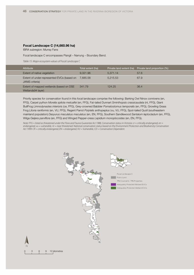
46 CONSERVATION STRATEGY FOR PRIVATE LAND IN THE RIVERINA BIOREGION OF VICTORIA
Focal Landscape C (14,660.96 ha)IBRA subregion: Murray Fans
Focal landscape C encompasses Piangil – Narrung – Boundary Bend.
Table 15. Major ecosystem values of Focal Landscape C
Attribute Total extent (ha) Private land extent (ha) Private land proportion (%)
Extent of native vegetation 9,321.96 5,371.14 57.6
Extent of under-represented EVCs (based on JANIS criteria)
7,685.58 5,215.53 67.9
Extent of mapped wetlands (based on DSE Wetlands94 layer)
341.79 124.25 36.4
Priority species for conservation found in this focal landscape comprise the following: Barking Owl Ninox connivens (en, FFG), Carpet python Morelia spilota metcalfei (en, FFG), Fat-tailed Dunnart Sminthopsis crassicaudata (nt, FFG), Giant BullFrog Limnodynastes interioris (ce, FFG), Grey-crowned Babbler Pomatostomus temporalis (en, FFG), Growling Grass Frog Litoria raniformis (en, VU, FFG), Regent Parrot Polytelis anthopeplus (vu, VU, FFG), Spot-tailed Quoll (southeastern mainland population) Dasyurus maculatus maculatus (en, EN, FFG), Southern Sandlewood Santalum leptocladum (en, FFG), Wilga Geijera parviflora (en, FFG) and Winged Pepper-cress Lepidium monoplocoides (en, EN, FFG).
Note: FFG = listed as threatened under the Flora and Fauna Guarantee Act 1988, Conservation status in Victoria: cr = critically endangered, en = endangered, vu = vulnerable, nt = near threatened. National conservation status based on the Environment Protection and Biodiversity Conservation Act 1999: CR = critically endangered, EN = endangered, VU = Vulnerable, CD = Conservation Dependent.
0 3 6 9 12 kilometres

47
Attribute Total extent (ha) Private land extent (ha) Private land proportion (%)
Extent of native vegetation 9,321.96 5,371.14 57.6
Extent of under-represented EVCs (based on JANIS criteria)
7,685.58 5,215.53 67.9
Extent of mapped wetlands (based on DSE Wetlands94 layer)
341.79 124.25 36.4

48 CONSERVATION STRATEGY FOR PRIVATE LAND IN THE RIVERINA BIOREGION OF VICTORIA
Focal Landscape D (72,143.88 ha)IBRA subregions: Murray Fans; Victorian Riverina
Focal landscape D covers the Lower Avoca and Kerang Wetland areas which includes Trust for Nature’s 2,500 ha Wanderers Plain property.
Table 16. Major ecosystem values of Focal Landscape D
Attribute Total extent (ha) Private land extent (ha) Private land proportion (%)
Extent of native vegetation 32,674.35 21,860.35 66.9
Extent of under-represented EVCs (based on JANIS criteria)
30,928.14 21,671.87 70.1
Extent of mapped wetlands (based on DSE Wetlands94 layer)
8,104.61 2,366.83 29.2
Priority species for conservation found in this focal landscape comprise the following: Australian Painted Snipe Rostratula benghalensis (cr, VU, FFG), Carpet python Morelia spilota metcalfei (en, FFG), Fat-tailed Dunnart Sminthopsis crassicaudata (nt), Grey-crowned Babbler Pomatostomus temporalis (en, FFG), Growling Grass Frog Litoria raniformis (en, VU, FFG), Hooded Scaly-foot Pygopus nigriceps (cr, FFG), Plains-wanderer Pedionomus torquatus (cr, VU, FFG), Spot-tailed Quoll (southeastern mainland population) Dasyurus maculatus maculatus (en, EN, FFG), Arching Flax-lily Dianella sp. aff. longifolia (Benambra) (vu), Chariot Wheels Maireana cheelii (vu, VU, FFG), Oat Kangaroo-grass Themeda avenacea (k), Plains Spurge Euphorbia planiticola (en, FFG), Slender Darling-pea Swainsona murrayana (en, VU, FFG), Soft Sunray Leucochrysum molle (vu), Stiff Groundsel Senecio behrianus (en, EN, FFG), Striate Spike-sedge Eleocharis obicis (vu, VU) and Veined Pepper-cress Lepidium phlebopetalum (en).
Note: FFG = listed as threatened under the Flora and Fauna Guarantee Act 1988, Conservation status in Victoria: cr = critically endangered, en = endangered, vu = vulnerable, nt = near threatened, d = data deficient, k = unknown. National conservation status based on the Environment Protection and Biodiversity Conservation Act 1999: CR = critically endangered, EN = endangered, VU = Vulnerable, CD = Conservation Dependent.
0 42 8 12 16 kilometres

49
Attribute Total extent (ha) Private land extent (ha) Private land proportion (%)
Extent of native vegetation 32,674.35 21,860.35 66.9
Extent of under-represented EVCs (based on JANIS criteria)
30,928.14 21,671.87 70.1
Extent of mapped wetlands (based on DSE Wetlands94 layer)
8,104.61 2,366.83 29.2

50 CONSERVATION STRATEGY FOR PRIVATE LAND IN THE RIVERINA BIOREGION OF VICTORIA
Focal Landscape E (99,924.94 haIBRA subregions: Murray Fans; Victorian Riverina
Focal landscape E covers the Patho Plains and Gunbower area.
Table 17. Major ecosystem values of Focal Landscape E
Attribute Total extent (ha) Private land extent (ha) Private land proportion (%)
Extent of native vegetation 57,208.5 31,985.58 60
Extent of under-represented EVCs (based on JANIS criteria)
52,067.21 31,858.93 61.2
Extent of mapped wetlands (based on DSE Wetlands94 layer)
12,644.4 1,711.26 13.5
Priority species for conservation found in this focal landscape comprise the following: Australian Painted Snipe Rostratula benghalensis (cr, VU, FFG), Bush Stone-curlew Burhinus grallarius (en, FFG), Fat-tailed Dunnart Sminthopsis crassicaudata (nt), Golden Sun Moth Synemon plana (cr, CE, FFG), Grassland Froghopper Perelytrana rana (dd), Grey-crowned Babbler Pomatostomus temporalis (en, FFG), Plains-wanderer Pedionomus torquatus (cr, VU, FFG), Spot-tailed Quoll (southeastern mainland population) Dasyurus maculatus maculatus (en, EN, FFG), Striped Legless Lizard Delma impar (en, VU, FFG), Arching Flax-lily Dianella sp. aff. longifolia (Benambra) (vu), Chariot Wheels Maireana cheelii (vu, VU, FFG), Oat Kangaroo-grass Themeda avenacea (k), Red Swainson-pea Swainsona plagiotropis (en, VU, FFG), Ridged Water-milfoil Myriophyllum porcatum (vu, VU, FFG), Slender Darling-pea Swainsona murrayana (en, VU, FFG), Stiff Groundsel Senecio behrianus (en, EN, FFG), Striate Spike-sedge Eleocharis obicis (vu, VU), Turnip Copperburr Sclerolaena napiformis (en, EN, FFG), and Winged Pepper-cress Lepidium monoplocoides (en, EN, FFG).
Note: FFG = listed as threatened under the Flora and Fauna Guarantee Act 1988, Conservation status in Victoria: cr = critically endangered, en = endangered, vu = vulnerable, nt = near threatened, d = data deficient, k = unknown. National conservation status based on the Environment Protection and Biodiversity Conservation Act 1999: CR = critically endangered, EN = endangered, VU = Vulnerable, CD = Conservation Dependent.
0 5 10 15 20 kilometres
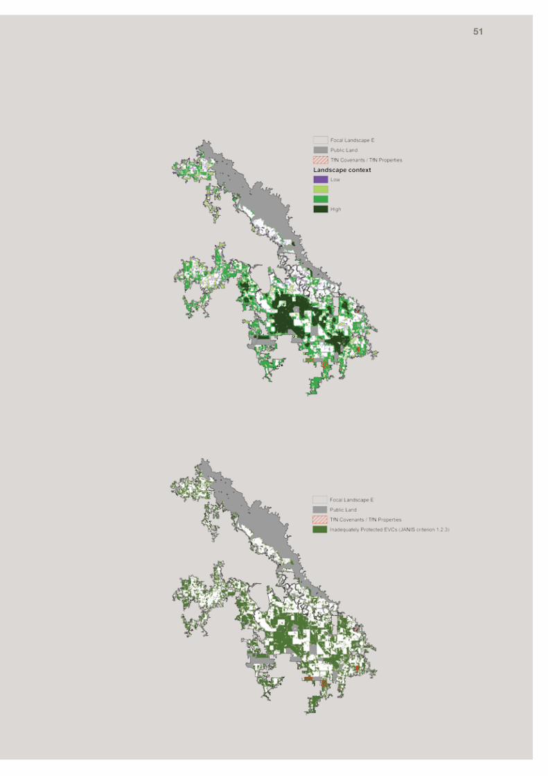
51
Attribute Total extent (ha) Private land extent (ha) Private land proportion (%)
Extent of native vegetation 57,208.5 31,985.58 60
Extent of under-represented EVCs (based on JANIS criteria)
52,067.21 31,858.93 61.2
Extent of mapped wetlands (based on DSE Wetlands94 layer)
12,644.4 1,711.26 13.5

52 CONSERVATION STRATEGY FOR PRIVATE LAND IN THE RIVERINA BIOREGION OF VICTORIA
Focal Landscape F (24,256.58 ha)IBRA subregion: Victorian Riverina
Focal landscape F covers the Loddon Plains - Canary Island/Bears Lagoon area.
Table 18. Major ecosystem values of Focal Landscape F
Attribute Total extent (ha) Private land extent (ha) Private land proportion (%)
Extent of native vegetation 11,177.04 9,940.09 88.9
Extent of under-represented EVCs (based on JANIS criteria)
11,177.04 9,940.09 88.9
Extent of mapped wetlands (based on DSE Wetlands94 layer)
699.08 362.77 51.9
Priority species for conservation found in this focal landscape comprise the following: Australian Painted Snipe Rostratula benghalensis (cr, VU, FFG), Brolga Grus rubicunda (vu, FFG), Bush Stone-curlew Burhinus grallarius (en, FFG), Carpet python Morelia spilota metcalfei (en, FFG), Fat-tailed Dunnart Sminthopsis crassicaudata (nt), Grassland Froghopper Perelytrana rana (dd), Grey-crowned Babbler Pomatostomus temporalis (en, FFG), Growling Grass Frog Litoria raniformis (en, VU, FFG), Hooded Scaly-foot Pygopus nigriceps (cr, FFG), Plains-wanderer Pedionomus torquatus cr VU FFG, Spot-tailed Quoll (southeastern mainland population) Dasyurus maculatus maculatus (en, EN, FFG), Chariot Wheels Maireana cheelii (vu, VU, FFG), Oat Kangaroo-grass Themeda avenacea (k), Plains Spurge Euphorbia planiticola (en, FFG), Red Swainson-pea Swainsona plagiotropis (en, VU, FFG), Slender Darling-pea Swainsona murrayana (en, VU, FFG), Stiff Groundsel Senecio behrianus (en, EN, FFG) and Striate Spike-sedge Eleocharis obicis (vu, VU).
Note: FFG = listed as threatened under the Flora and Fauna Guarantee Act 1988, Conservation status in Victoria: cr = critically endangered, en = endangered, vu = vulnerable, nt = near threatened, d = data deficient, k = unknown. National conservation status based on the Environment Protection and Biodiversity Conservation Act 1999: CR = critically endangered, EN = endangered, VU = Vulnerable, CD = Conservation Dependent.
0 2 4 6 8 kilometres

53
Attribute Total extent (ha) Private land extent (ha) Private land proportion (%)
Extent of native vegetation 11,177.04 9,940.09 88.9
Extent of under-represented EVCs (based on JANIS criteria)
11,177.04 9,940.09 88.9
Extent of mapped wetlands (based on DSE Wetlands94 layer)
699.08 362.77 51.9

54 CONSERVATION STRATEGY FOR PRIVATE LAND IN THE RIVERINA BIOREGION OF VICTORIA
Focal Landscape G (10,936.45 ha)IBRA subregions: Victorian Riverina
Focal landscape G covers the Bunguluke area (Ninyeunook/Towaninny).
Table 19. Major ecosystem values of Focal Landscape G
Attribute Total extent (ha) Private land extent (ha) Private land proportion (%)
Extent of native vegetation 5,975.88 5,142.71 86.1
Extent of under-represented EVCs (based on JANIS criteria)
5,975.89 5,142.72 86.1
Extent of mapped wetlands (based on DSE Wetlands94 layer)
5832.37 5615.86 96.3
Priority species for conservation found in this focal landscape comprise the following: Australian Painted Snipe Rostratula benghalensis (cr, VU, FFG), Carpet python Morelia spilota metcalfei (en, FFG), Fat-tailed Dunnart Sminthopsis crassicaudata (nt), Growling Grass Frog Litoria raniformis (en, VU, FFG), Hooded Scaly-foot Pygopus nigriceps (cr, FFG), Plains-wanderer Pedionomus torquatus (cr, VU FFG), Spot-tailed Quoll (southeastern mainland population) Dasyurus maculatus maculatus (en, EN, FFG), Striped Legless Lizard Delma impar (en, VU, FFG), Arching Flax-lily Dianella sp. aff. longifolia (Benambra) (vu), Chariot Wheels Maireana cheelii (vu, VU, FFG), Hoary Scurf-pea Cullen cinereum (en, FFG), Oat Kangaroo-grass Themeda avenacea (k), Plains Spurge Euphorbia planiticola (en, FFG), Red Swainson-pea Swainsona plagiotropis (en, VU, FFG), Silky Swainson-pea Swainsona sericea (vu, FFG), Slender Darling-pea Swainsona murrayana (en, VU, FFG), Turnip Copperburr Sclerolaena napiformis (en, EN, FFG).
0 2 4 6 8 kilometres

55
Attribute Total extent (ha) Private land extent (ha) Private land proportion (%)
Extent of native vegetation 5,975.88 5,142.71 86.1
Extent of under-represented EVCs (based on JANIS criteria)
5,975.89 5,142.72 86.1
Extent of mapped wetlands (based on DSE Wetlands94 layer)
5832.37 5615.86 96.3

56 CONSERVATION STRATEGY FOR PRIVATE LAND IN THE RIVERINA BIOREGION OF VICTORIA
Focal Landscape H (212,986.88 ha)IBRA subregions: Murray Fans; Victorian Riverina
Located in the eastern part of the bioregion, focal landscape H covers the Broken - Boosey catchments and Barmah Forest.
Table 20. Major ecosystem values of Focal Landscape H
Attribute Total extent (ha) Private land extent (ha) Private land proportion (%)
Extent of native vegetation 125,158.67 72,118.73 57.6
Extent of under-represented EVCs (based on JANIS criteria)
108,244.5 71,039.69 65.6
Extent of mapped wetlands (based on DSE Wetlands94 layer)
33,496.73 5,222.09 15.6
Priority species for conservation found in this focal landscape comprise the following: Brolga Grus rubicunda (vu, FFG), Bush Stone-curlew Burhinus grallarius (en, FFG), Carpet python Morelia spilota metcalfei (en, FFG), Grey-crowned Babbler Pomatostomus temporalis (en, FFG), Growling Grass Frog Litoria raniformis (en, VU, FFG), Spot-tailed Quoll (southeastern mainland population) Dasyurus maculatus maculatus (en, EN, FFG) and Superb Parrot Polytelis swainsonii (en, VU, FFG).
Note: FFG = listed as threatened under the Flora and Fauna Guarantee Act 1988, Conservation status in Victoria: cr = critically endangered, en = endangered, vu = vulnerable, nt = near threatened. National conservation status based on the Environment Protection and Biodiversity Conservation Act 1999: CR = critically endangered, EN = endangered, VU = Vulnerable, CD = Conservation Dependent.
0 105 20 30 40 kilometres

57
Attribute Total extent (ha) Private land extent (ha) Private land proportion (%)
Extent of native vegetation 125,158.67 72,118.73 57.6
Extent of under-represented EVCs (based on JANIS criteria)
108,244.5 71,039.69 65.6
Extent of mapped wetlands (based on DSE Wetlands94 layer)
33,496.73 5,222.09 15.6

58 CONSERVATION STRATEGY FOR PRIVATE LAND IN THE RIVERINA BIOREGION OF VICTORIA
Focal Landscapes I (52,681.11 ha)IBRA subregion: Victorian Riverina
Located in the very eastern part of the bioregion, focal landscape I covers the floodplain of the Ovens River.
Table 21. Major ecosystem values of Focal Landscape I
Attribute Total extent (ha) Private land extent (ha) Private land proportion (%)
Extent of native vegetation 23,198.79 18,250.18 78.7
Extent of under-represented EVCs (based on JANIS criteria)
23,133.88 18,244.76 78.9
Extent of mapped wetlands (based on DSE Wetlands94 layer)
1,254.39 980.47 78.2
Priority species for conservation found in this focal landscape comprise the following species: Spot-tailed Quoll (southeastern mainland population) Dasyurus maculatus maculatus (en, EN, FFG), Growling Grass Frog Litoria raniformis (VU, FFG), Regent Honeyeater Xanthomyza phrygia (EN, FFG), Superb Parrot Polytelis swainsonii (VU, FFG), Euroa Guinea-flower Hibbertia humifusa ssp. erigens (VU, FFG) and Warby Range Swamp Gum Eucalyptus cadens (VU, FFG).
0 3 6 9 12 kilometres

59
Attribute Total extent (ha) Private land extent (ha) Private land proportion (%)
Extent of native vegetation 23,198.79 18,250.18 78.7
Extent of under-represented EVCs (based on JANIS criteria)
23,133.88 18,244.76 78.9
Extent of mapped wetlands (based on DSE Wetlands94 layer)
1,254.39 980.47 78.2

Timeframe Action
Short-term (1-2 years) Target protection towards increasing the National Reserve System within focal landscapes
Undertake Conservation Action Plans on at least 3 of the focal landscapes (ecological accountability)
Undertake INFFER assessments on at least 3 of the focal landscapes (investment accountability)
Continue targeted engagement with high priority private land areas
Continue to engage with relevant Technical Advisory Groups and Recovery teams
Continue to enhance and improve the condition of existing Trust for Nature private protected areas
Medium-term (3-5 years) Replicate conservation achievements for previous decade (2002 – 2012) across the Riverina Bioregion
Work towards achieving a multi-tenure conservation network that achieves the Comprehensive, Adequate and Representative criteria
Establish and undertake projects to achieve the aims of the strategy in at least 3 focal landscapes
Work with partners to manage and enhance the values of the Protected Area Network
Undertake Conservation Action Plans for each of the 9 focal landscapes (ecological accountability)
Undertake INFFER assessments for each of the 9 focal landscapes (investment accountability)
Medium long-term (5-15 years)
Replicate conservation achievements of (2002-2012) every 5 years across the Bioregion
Work towards achieving a multi-tenure conservation network that achieves the Comprehensive, Adequate and Representative criteria
Establish and undertake projects to achieve the aims of the strategy in all the focal landscapes of the bioregion
Work with partners to manage and enhance the values of the Protected Area Network
Aspirational Goals Achieve a Comprehensive, Adequate and Representative reserve network for the Victorian section of the Riverina IBRA
Work with partners to manage and enhance the values of the Protected Area Network
60 CONSERVATION STRATEGY FOR PRIVATE LAND IN THE RIVERINA BIOREGION OF VICTORIA
6.2 Additional priority private land areas for inclusion in the National Reserve System
Protecting and maintaining the best remaining remnants is a critical conservation goal, regardless of whether the remnant is located within a focal landscape. The many smaller fragmented areas, often scattered across numerous properties, provide vital connections between larger remnants and corridors on roadsides and riparian areas.
Mechanisms for project development and accountability to achieve priority goals
Trust for Nature recommends using Conservation Action Planning (CAP) and the Investment Framework for Environmental Resources (INFFER) project development tools in the focal landscapes of the Victorian Riverina Bioregion. These project development tools clearly communicate conservation needs and ecological and financial accountability for management interventions and actions.
Conservation Action Planning (CAP)
Through Conservation Action Planning, land managers and agencies can conceptualise the conservation opportunities and hazards applicable to a property, landscape, bioregion, state or country. CAP facilitates understanding and prioritising of actions based on scientific and expert opinion. CAP forms the basis of ensuring that projects achieve the ecological outcomes in the most appropriate order, and that limited resources and time are directed to the area of most concern.
Investment Framework for Environmental Resources (INFFER)
INFFER is a leading NRM project development process that allows land managers and agencies to ensure that projects account for social and political limitations that may influence project success. Using INFFER to develop and proof project concepts ensures that the Trust’s limited resources achieve the most cost effective outcomes, in an open and accountable framework.
6.3 Ongoing management of existing Trust for Nature private protected areas
Increasing the viability and reducing the threats to private land areas is critical for maintaining their persistence in perpetuity. To this end, an ecological management framework has been developed for the Victoria Riverina Bioregion. This framework will guide Trust for Nature’s ongoing Stewardship Program with landowners, and provide landowners with access to information for the management of the region’s natural areas.
6.4 Additional opportunities to increase landscape conservation
Trust for Nature is a private land organisation and will consider any tools to achieve conservation on private land, including the use of short term agreements.
Trust for Nature recognises achieving a comprehensive, adequate and representative National Reserve System requires complementary partnerships with other NRM agencies. State Government programs complementary to Trust for Nature include the Land for Wildlife and BushTender programs.
Land for Wildlife (Victoria) is a State government program supporting landowners or managers who provide habitat for native wildlife on their land. Land for Wildlife is a voluntary scheme that does not alter the legal status of the property. Land for Wildlife now encompasses over 5,900 registered properties covering 560,000 ha (DSE 2012). Figure 18 shows the distribution of Land for Wildlife properties across the Victorian Riverina Bioregion. Over the past 30 years of Land for Wildlife, about 5% of Land for Wildlife properties have progressed to conservation covenants (P. Johnson pers. comm. 2012).
BushTender is an auction-based approach to improving management of native vegetation on private land, where landowners competitively tender for contracts to improve their native vegetation. Landowners have the option of a five-year fixed term management agreement or a five-year fixed term management agreement with an on-title permanent agreement.
6.5 Next Steps
Trust for Nature’s aspiration for the Victorian Riverina Bioregion is to secure all high priority areas on private land for addition into the National Reserve System and to continue managing existing Trust for Nature reserves. This Strategy directs this goal, by identifying the focal landscapes and providing clear direction for the Trust to detail areas within the landscape to be targeted for priority protection.
Achieving this goal requires supportive partnerships with other natural resource management agencies to ensure protection mechanisms are integrated within natural resource management programs. Trust for Nature has developed an Implementation Plan for the Bioregion (Table 22), and will continue to work with our organisational partners and relevant natural resource management agencies to achieve these outcomes, subject to resources. To ensure resources are directed appropriately, Trust for Nature will utilise a range of project development and assessment tools, particularly Conservation Action Planning and Investment Framework for Environmental Resources (INFFER) assessments.
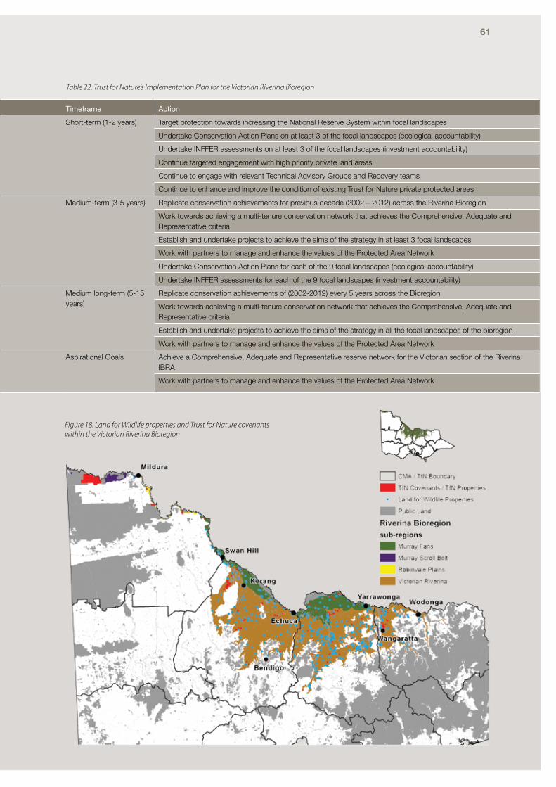
61
Timeframe Action
Short-term (1-2 years) Target protection towards increasing the National Reserve System within focal landscapes
Undertake Conservation Action Plans on at least 3 of the focal landscapes (ecological accountability)
Undertake INFFER assessments on at least 3 of the focal landscapes (investment accountability)
Continue targeted engagement with high priority private land areas
Continue to engage with relevant Technical Advisory Groups and Recovery teams
Continue to enhance and improve the condition of existing Trust for Nature private protected areas
Medium-term (3-5 years) Replicate conservation achievements for previous decade (2002 – 2012) across the Riverina Bioregion
Work towards achieving a multi-tenure conservation network that achieves the Comprehensive, Adequate and Representative criteria
Establish and undertake projects to achieve the aims of the strategy in at least 3 focal landscapes
Work with partners to manage and enhance the values of the Protected Area Network
Undertake Conservation Action Plans for each of the 9 focal landscapes (ecological accountability)
Undertake INFFER assessments for each of the 9 focal landscapes (investment accountability)
Medium long-term (5-15 years)
Replicate conservation achievements of (2002-2012) every 5 years across the Bioregion
Work towards achieving a multi-tenure conservation network that achieves the Comprehensive, Adequate and Representative criteria
Establish and undertake projects to achieve the aims of the strategy in all the focal landscapes of the bioregion
Work with partners to manage and enhance the values of the Protected Area Network
Aspirational Goals Achieve a Comprehensive, Adequate and Representative reserve network for the Victorian section of the Riverina IBRA
Work with partners to manage and enhance the values of the Protected Area Network
Figure 18. Land for Wildlife properties and Trust for Nature covenants within the Victorian Riverina Bioregion
Table 22. Trust for Nature’s Implementation Plan for the Victorian Riverina Bioregion

62 CONSERVATION STRATEGY FOR PRIVATE LAND IN THE RIVERINA BIOREGION OF VICTORIA
7. Appendices
Appendix A: Priority threatened species
Priority threatened floraTable 23. Victorian Riverina Bioregion priority threatened flora species
English Latin EPBC FFG
DSE Advisory List
Murray Scroll Belt subregion
Robinvale Plains subregion
Murray Fans subregion
Victorian Riverina subregion
Arching Flax-lily Dianella sp. aff. longifolia (Benambra)
v Y
Ausfeld’s Wattle Acacia ausfeldii N v Y
Basalt Podolepis Podolepis sp. 1 e Y
Buloke Mistletoe Amyema linophylla ssp. orientale
v Y
Button Immortelle Leptorhynchos waitzia
v Y
Chariot Wheels Maireana cheelii VU L v Y
Desert Greenhood Pterostylis xerophila
EN L v Y
Downs Nut-grass Cyperus bifax v Y
Dwarf Amaranth Amaranthus macrocarpus var. macrocarpu
v Y
Euroa Guinea-flower Hibbertia humifusa ssp. erigens
VU L v Y
Hoary Scurf-pea Cullen cinereum L e Y
Long Eryngium Eryngium paludosum
v Y
Menindee Nightshade
Solanum karsense VU Y Y
Narrow-leaf Emu-bush
Eremophila sturtii L e Y
Northern Golden-moths
Diuris protena L e Y
Oat Kangaroo-grass Themeda avenacea
k Y
Painted Diuris Diuris tricolor L e Y
Pale Flax-lily Dianella sp. aff. longifolia (Riverina)
v
Pale Spike-sedge Eleocharis pallens k Y
Plains Spurge Euphorbia planiticola
L e Y
Red Swainson-pea Swainsona plagiotropis
VU L e Y
Ridged Water-milfoil Myriophyllum porcatum
VU L v Y
Riverina Leek-orchid Prasophyllum aff. occidenatale D
e Y
Silky Swainson-pea Swainsona sericea L v Y
Slender Darling-pea Swainsona murrayana
VU L e Y

63
English Latin EPBC FFG
DSE Advisory List
Murray Scroll Belt subregion
Robinvale Plains subregion
Murray Fans subregion
Victorian Riverina subregion
Soft Sunray Leucochrysum molle
v Y
Southern Sandlewood
Santalum leptocladum
L e Y
Spiny Rice-flower Pimelea spinescens ssp. spinescens
VU L e Y
Stiff Groundsel Senecio behrianus EN L e Y Y
Striate Spike-sedge Eleocharis obicis VU v Y Y
Swamp Buttercup Ranunculus undosus
v Y
Tough Scurf-pea Cullen tenax L e Y
Turnip Copperburr Sclerolaena napiformis
EN L e Y
Umbrella Grass Digitaria divaricatissima
v Y Y
Veined Pepper-cress
Lepidium phlebopetalum
e Y
Warby Range Swamp Gum
Eucalyptus cadens VU L v Y
Wilga Geijera parviflora L e Y
Winged New Holland Daisy
Vittadinia pterochaeta
e Y
Winged Pepper-cress
Lepidium monoplocoides
EN L e Y
Yellow Swainson Pea
Swainsona pyrophila
VU L v Y Y
Yellow-tongue Daisy Brachyscome chrysoglossa
L v Y
Conservation Status in Australia (EPBC)
Extinct (EX) Critically Endangered (CR) Endangered (EN) Vulnerable (VU) Conservation Dependent (CD)
Conservation Status in Victoria (DSE Advisory List)
Extinct (EX) Regionally Extinct (RX) Extinct in the Wild (WX) Critically Endangered (CR) Endangered (EN)Vulnerable (VU) Near Threatene (NT) Data Deficient (DD)
Status under the Victorian Flora and Fauna Guarantee Act 1988 (FFG)
Listed (L) Nominated (N) Invalid or ineligible (I) Delisted (D
English Latin EPBC FFG
DSE Advisory List
Murray Scroll Belt subregion
Robinvale Plains subregion
Murray Fans subregion
Victorian Riverina subregion
Arching Flax-lily Dianella sp. aff. longifolia (Benambra)
v Y
Ausfeld’s Wattle Acacia ausfeldii N v Y
Basalt Podolepis Podolepis sp. 1 e Y
Buloke Mistletoe Amyema linophylla ssp. orientale
v Y
Button Immortelle Leptorhynchos waitzia
v Y
Chariot Wheels Maireana cheelii VU L v Y
Desert Greenhood Pterostylis xerophila
EN L v Y
Downs Nut-grass Cyperus bifax v Y
Dwarf Amaranth Amaranthus macrocarpus var. macrocarpu
v Y
Euroa Guinea-flower Hibbertia humifusa ssp. erigens
VU L v Y
Hoary Scurf-pea Cullen cinereum L e Y
Long Eryngium Eryngium paludosum
v Y
Menindee Nightshade
Solanum karsense VU Y Y
Narrow-leaf Emu-bush
Eremophila sturtii L e Y
Northern Golden-moths
Diuris protena L e Y
Oat Kangaroo-grass Themeda avenacea
k Y
Painted Diuris Diuris tricolor L e Y
Pale Flax-lily Dianella sp. aff. longifolia (Riverina)
v
Pale Spike-sedge Eleocharis pallens k Y
Plains Spurge Euphorbia planiticola
L e Y
Red Swainson-pea Swainsona plagiotropis
VU L e Y
Ridged Water-milfoil Myriophyllum porcatum
VU L v Y
Riverina Leek-orchid Prasophyllum aff. occidenatale D
e Y
Silky Swainson-pea Swainsona sericea L v Y
Slender Darling-pea Swainsona murrayana
VU L e Y

64 CONSERVATION STRATEGY FOR PRIVATE LAND IN THE RIVERINA BIOREGION OF VICTORIA
English LatinAnimal category EPBC FFG
DSE Advisory List
Murray Scroll Belt subregion
Robinvale Plains subregion
Murray Fans subregion
Victorian Riverina subregion
Apostlebird Struthidea cinerea Bird L - Y
Australian Painted Snipe
Rostratula benghalensis
Bird VU L CR Y
Barking Owl Ninox connivens Bird L EN Y Y Y
Black-chinned Honeyeater
Melithreptus gularis
Bird L NT Y
Brush-tailed Phascogale
Phascogale tapoatafa
Mammal L VU Y Y
Bush Stone-curlew Burhinus grallarius Bird L EN Y Y Y
Carpet python Morelia spilota metcalfei
Reptile L EN Y Y Y Y
De Vis’ Banded Snake
Denisonia devisi Reptile VU VU Y
Fat-tailed Dunnart Sminthopsis crassicaudata
Mammal NT Y Y Y Y
Freshwater Catfish Tandanus tandanus
Fish L EN Y
Giant BullFrog Limnodynastes interioris
Frog L CR Y
Gile’s Planigale Planigale gilesi Mammal L NT Y
Golden Sun Moth Synemon plana Invertebrate CR L CR Y
Grassland Froghopper
Perelytrana rana Invertebrate DD Y
Grey-crowned Babbler
Pomatostomus temporalis
Bird L EN Y Y
Ground Cuckoo-shrike
Coracina maxima Bird L VU Y
Growling Grass Frog
Litoria raniformis Frog VU L EN Y Y Y Y
Hay Plains Mini Stonehopper
Genus Novum Invertebrate - Y Y
Hooded Robin Melanodryas cucullata
Bird L NT Y
Hooded Scaly-foot Pygopus nigriceps Reptile L CR Y Y
Latham’s Snipe Gallinago hardwickii
Bird NT Y Y
Lewin’s Rail Rallus pectoralis Bird L VU Y
Little Bittern Ixobrychus minutus
Bird L EN Y
Little Egret Egretta garzetta Bird L EN Y
Priority threatened faunaTable 24. Victorian Riverina Bioregion priority threatened fauna species

65
English LatinAnimal category EPBC FFG
DSE Advisory List
Murray Scroll Belt subregion
Robinvale Plains subregion
Murray Fans subregion
Victorian Riverina subregion
Mildura Ogyris Ogyris subterrestris subterrestris
Invertebrate L VU Y
Nankeen Night Heron
Nycticorax caledonicus
Bird NT Y Y
Pale Sun-moth Synemon selene Invertebrate CR Y
Plains-wanderer Pedionomus torquatus
Bird VU L CR Y
Powerful Owl Ninox strenua Bird L VU Y
Red-naped Snake Furina diadema Reptile L VU Y
Regent Honeyeater Xanthomyza phrygia
Bird EN L CR Y
Regent Parrot Polytelis anthopeplus
Bird VU L VU Y Y Y
Riverina Stonehopper
Cratilopus sp. 1 Invertebrate Y
Royal Spoonbill Platalea regia Bird VU Y Y
Spot-tailed Quoll
(southeastern mainland population)
Dasyurus maculatus maculatus
Mammal EN L EN Y Y Y Y
Squirrel Glider Petaurus norfolcensis
Mammal L EN Y
Striated Sun-moth Synemon collecta Invertebrate - Y
Striped Legless Lizard
Delma impar Reptile VU L EN Y
Superb Parrot Polytelis swainsonii Bird VU L EN Y
Woodland Blind Snake
Ramphotyphlops proximus
Reptile NT Y Y
Conservation Status in Australia (EPBC)
Extinct (EX) Critically Endangered (CR) Endangered (EN) Vulnerable (VU) Conservation Dependent (CD)
Conservation Status in Victoria (DSE Advisory List)
Extinct (EX) Regionally Extinct (RX) Extinct in the Wild (WX) Critically Endangered (CR) Endangered (EN) Vulnerable (VU) Near Threatened (NT) Data Deficient (DD)
Status under the Victorian Flora and Fauna Guarantee Act 1988 (FFG)
Listed (L) Nominated (N) Invalid or ineligible (I) Delisted (D

66 CONSERVATION STRATEGY FOR PRIVATE LAND IN THE RIVERINA BIOREGION OF VICTORIA
Listed marine and migratory speciesTable 25 lists Victorian Riverina Bioregion bird species that are recognised as important marine or migratory species.
Table 25. Victorian Riverina Bioregion listed marine and migratory species
English Latin Migratory Marine
Australian Pratincole Stiltia isabella Listed - overfly marine area
Bar-tailed Godwit Limosa lapponica Migratory Listed
Black-eared Miner Manorina melanotis Migratory
Black-tailed Godwit Limosa limosa Migratory Listed - overfly marine area
Black-winged Stilt Himantopus himantopus Listed - overfly marine area
Cattle Egret Ardea ibis Migratory Listed - overfly marine area
Curlew Sandpiper Calidris ferruginea Migratory Listed - overfly marine area
Double-banded Plover Charadrius bicinctus Migratory Listed - overfly marine area
Fork-tailed Swift Apus pacificus Migratory Listed - overfly marine area
Great Egret, White Egret Ardea alba Migratory Listed - overfly marine area
Latham’s Snipe, Japanese Snipe Gallinago hardwickii Migratory Listed - overfly marine area
Little Curlew, Little Whimbrel Numenius minutus Migratory Listed - overfly marine area
Malleefowl Leipoa ocellata Migratory
Marsh Sandpiper, Little Greenshank Tringa stagnatilis Migratory Listed - overfly marine area
Painted Snipe Rostratula benghalensis (sensu lato)
Migratory Listed - overfly marine area
Pectoral Sandpiper Calidris melanotos Migratory Listed - overfly marine area
Pin-tailed Snipe Gallinago stenura Migratory Listed - overfly marine area
Rainbow Bee-eater Merops ornatus Migratory Listed - overfly marine area
Red-capped Plover Charadrius ruficapillus Listed - overfly marine area
Red-necked Avocet Recurvirostra novaehollandiae Listed - overfly marine area
Red-necked Stint Calidris ruficollis Migratory Listed - overfly marine area
Regent Honeyeater Xanthomyza phrygia Migratory
Ruff (Reeve) Philomachus pugnax Migratory Listed - overfly marine area
Rufous Fantail Rhipidura rufifrons Migratory Listed - overfly marine area
Satin Flycatcher Myiagra cyanoleuca Migratory Listed - overfly marine area
Sharp-tailed Sandpiper Calidris acuminata Migratory Listed
Swift Parrot Lathamus discolor Listed - overfly marine area
Swinhoe’s Snipe Gallinago megala Migratory Listed - overfly marine area
White-bellied Sea-Eagle Haliaeetus leucogaster Migratory Listed
White-throated Needletail Hirundapus caudacutus Migratory Listed - overfly marine area
Wood Sandpiper Tringa glareola Migratory Listed - overfly marine area

67
Appendix B: Important wetlands in the Victorian Riverina BioregionTable 26. Directory of important wetlands in the Victorian Riverina Bioregion
Wetland Name Area (ha)
Barmah-Millewa Forest 29,500
Black Swamp 176
Broken Creek 2,500
Cemetery Swamp 89
First Marsh (The Marsh) 780
Fosters Swamp 219
Gunbower Island 19,500
Hird’s Swamp 344
Johnson’s Swamp 411
Kanyapella Basin 2,581
Kow Swamp 2,724
Lake Bael Bael 648
Lake Charm 520
Lake Cullen 632
Lake Kelly & Stevensons Swamp 320
Lake William 96
Little Lake Charm, Kangaroo Lake & Racecourse Lake 1,332
Lower Broken River 1,268
Lower Goulburn River Floodplain 13,000
Muckatah Depression 2,909
Second Marsh (Middle Marsh) 233
Tang Tang Swamp 103
Third Marsh (Top Marsh) 946
Third, Middle and Reedy Lakes 598
Town Swamp 80
Tragowel Swamp (McPhails Swamp) 262
Wallenjoe Wetlands 303
Woolshed Swamp 353
Source: Environment Australia (2001). A Directory of Important Wetlands in Australia, Third Edition. Environment Australia, Canberra.
English Latin Migratory Marine
Australian Pratincole Stiltia isabella Listed - overfly marine area
Bar-tailed Godwit Limosa lapponica Migratory Listed
Black-eared Miner Manorina melanotis Migratory
Black-tailed Godwit Limosa limosa Migratory Listed - overfly marine area
Black-winged Stilt Himantopus himantopus Listed - overfly marine area
Cattle Egret Ardea ibis Migratory Listed - overfly marine area
Curlew Sandpiper Calidris ferruginea Migratory Listed - overfly marine area
Double-banded Plover Charadrius bicinctus Migratory Listed - overfly marine area
Fork-tailed Swift Apus pacificus Migratory Listed - overfly marine area
Great Egret, White Egret Ardea alba Migratory Listed - overfly marine area
Latham’s Snipe, Japanese Snipe Gallinago hardwickii Migratory Listed - overfly marine area
Little Curlew, Little Whimbrel Numenius minutus Migratory Listed - overfly marine area
Malleefowl Leipoa ocellata Migratory
Marsh Sandpiper, Little Greenshank Tringa stagnatilis Migratory Listed - overfly marine area
Painted Snipe Rostratula benghalensis (sensu lato)
Migratory Listed - overfly marine area
Pectoral Sandpiper Calidris melanotos Migratory Listed - overfly marine area
Pin-tailed Snipe Gallinago stenura Migratory Listed - overfly marine area
Rainbow Bee-eater Merops ornatus Migratory Listed - overfly marine area
Red-capped Plover Charadrius ruficapillus Listed - overfly marine area
Red-necked Avocet Recurvirostra novaehollandiae Listed - overfly marine area
Red-necked Stint Calidris ruficollis Migratory Listed - overfly marine area
Regent Honeyeater Xanthomyza phrygia Migratory
Ruff (Reeve) Philomachus pugnax Migratory Listed - overfly marine area
Rufous Fantail Rhipidura rufifrons Migratory Listed - overfly marine area
Satin Flycatcher Myiagra cyanoleuca Migratory Listed - overfly marine area
Sharp-tailed Sandpiper Calidris acuminata Migratory Listed
Swift Parrot Lathamus discolor Listed - overfly marine area
Swinhoe’s Snipe Gallinago megala Migratory Listed - overfly marine area
White-bellied Sea-Eagle Haliaeetus leucogaster Migratory Listed
White-throated Needletail Hirundapus caudacutus Migratory Listed - overfly marine area
Wood Sandpiper Tringa glareola Migratory Listed - overfly marine area

68 CONSERVATION STRATEGY FOR PRIVATE LAND IN THE RIVERINA BIOREGION OF VICTORIA
Appendix C: Spatial datasets
Native Vegetation – Landscape Connectivity A derived dataset that rates the landscape between existing native vegetation according to its proximity to native vegetation and contribution to landscape connectivity for biodiversity. It indicates potential connectivity for a range of mobile species.
This view of connectivity does NOT include barriers of movement of individual species or any assessment of the potential recoverability of the landscape.
Source: Native Vegetation – Landscape Connectivity – 10 classes (2005) (NV2005_CONN10/)
Custodian: Department of Sustainability and Environment
Remnant Vegetation Patch ContextThis dataset looks at the size and shape of a patch of remnant native vegetation and its connectivity and proximity to adjacent patched of remnant native vegetation. It is intended that this automated process will replace the need to manually calculate the landscape context component of site-based Habitat Hectare assessments. Existing native vegetation is assigned a rating of 0-25 based on measures of patch size, patch shape, landscape connectivity and proximity
Source: Native Vegetation – Modelled Quality (Site Condition and Landscape Context) 2005 (NV2005_QUAL/)
Custodian: Department of Sustainability and Environment
Vegetation Condition This dataset is a modelled dataset of the quality of Terrestrial Native Vegetation as per the ‘Habitat Hectares’ approach (Parkes et al. 2003). Specifically it is a model of the ‘Habitat Score’ which is an index comprising ten separate metrics that are weighted and summed. Seven of these are site-based vegetation condition metrics, referred to collectively as the ‘Site Score’ and three are related to the spatial context of the site and referred to collectively as the ‘Landscape Score’. The Site Score comprises 75% of the final quality score and the Landscape Score makes up the other 25%.
Site Score Components: Large Tree Score (10), Canopy Cover Score (5), Understorey Score (25), Litter Score (5), Log Score (5), Weed Score (15), Recruitment Score (10).
Landscape Score Components: Patch Size/Shape (10), Neighbourhood and Connectivity (15).
Source: Native Vegetation - Modelled Quality (Site condition and landscape context) 2005 (NV2005_QUAL/)
Custodian: Department of Sustainability and Environment
Focal LandscapesFocal landscapes are effective natural landscapes that have high biodiversity values and are large enough for functioning ecosystems and populations.
The focal landscapes layer is derived by Trust for Nature from NaturePrint Version 2 (DSE Nov 2011). The derived layer is made up of vegetated areas that are rated by NaturePrint V2 as medium or high strategic natural values and form a combined area of at least 10,000 ha. A tolerance of 25m has been applied.
Adequacy: EVCs which are inadequately protected in the Protected Area Network
Nationally Agreed Criteria for the Establishment of a Comprehensive, Adequate and Representative Reserve System for Forests in Australia, Joint ANZECC/MCFFA National Forest Policy Statement Implementation Sub-committee, 1997.
Criterion 1: 15% of the pre-1750 distribution of each EVC should be protected.
Criterion 2: Where EVCs are recognised as Vulnerable, then at least 60% of their remaining extent should be reserved.
Criterion 3: All remaining occurrences of Rare and Endangered EVCs should be reserved
Source: Department of. Sustainability and Environment; All_v_bioevc_bcs_area statement dec21_2007, plus amend Mar08 from David Parkes 090527.xls
69
8. References
Barr, N. (2008). The Social landscapes of Rural Victoria, in C.Pettit, W.Cartwright, I.Bishop et al. Landscape Analysis and Visualisation: Spatial Models for Natural Resource Management and Planning. Berlin, Springer: 327-350.
Barr, N. (2009). The House on the Hill: The transformation of Australia’s Farming Communities. Melbourne. Halstead Press.
CAPAD (2008). Collaborative Australian Protected Area Database. Viewed at http://www.environment.gov.au/ parks/nrs/science/capad/index.html
Castelle, A.J., C. Conolly, M. Emers, E.d. Metz, S. Meyer, M. Witter, S. Mauerman, T. Erickson, Cooke, S. (1992). Wetland buffers: Use and Effectiveness. Publication # 92-10. Washington State Department of Ecology. Olympia, Washington.
CES (2009). State of the Environment Victoria 2008, Commissioner of Environmental Sustainability, Melbourne.
Commonwealth of Australia (1997). Nationally Agreed Criteria for the Establishment of a CAR Reserve System for Forests in Australia. Viewed at: http://www.daff.gov.au/__data/assets/pdf_file/0011/49493/nat_nac.pdf
Commonwealth of Australia (1999). Australian Guidelines for Establishing the National Reserve System. Environment Australia, Canberra.
DPI (2011). Rediscover Victoria Drilling Initiative, Department of Primary Industries. Viewed at http://www.dpi.vic.gov.au/earth-resources/exploration-and-mining/rediscover/rvd-project
DSE (1997) Victorian Riverina, Bioregion: Victorian Riverina, Department of Sustainability and Environment. Viewed at http://www.dse.vic.gov.au/conservation-and-environment/biodiversity/victorias-biodiversity-strategy/victorias-biodiversity-strategy-1997/directions-contents/victorian-riverina
DSE (2005). Regional Matters: an atlas of regional Victoria. Victorian State Government, Department of Sustainability and Environment, East Melbourne.
DSE (2009a). Advisory list of threatened invertebrate fauna in Victoria 2009. Victorian State Government, Department of Sustainability and Environment, East Melbourne.
DSE (2009b). Securing Our Natural Future: A white paper for land and biodiversity at a time of climate change. Victorian State Government, Department of Sustainability and Environment, East Melbourne.
DSE (2010). Conservation and Protection of Northern Plains Grasslands – A Strategic Direction. Victorian State Government, Department of Sustainability and Environment, East Melbourne.
DSE (2011a), Chenopod shrublands, Department of Sustainability and Environment. Viewed at http://www.dse.vic.gov.au/conservation-and-environment/native-vegetation-groups-for-victoria/simplified-native-vegetation-groups/native-vegetation-group-12-plains-grasslands-and-chenopod-shrublands.
DSE (2011b). Victoria’s Bioregions. Department of Sustainability and Environment (2011). Viewed at http://www.dse.vic.gov.au/conservation-and-environment/native-vegetation-groups-for-victoria/victorias-bioregions.
DSE (2011c). Natureprintv2.0: Elements and Integration. A technical explanation of the Natureprintv2.0 analysis. Victorian State Government, Department of Sustainability and Environment, East Melbourne.
DSE (2012). Land for Wildlife, Department of Sustainability and Environment. Viewed at http://www.dse.vic.gov.au/plants-and-animals/native-plants-and-animals/land-for-wildlife
Dudley, N. (Editor) (2008). Guidelines for Applying Protected Area Management Categories. Gland, Switzerland: IUCN.
Dunlop, M. & Brown, P.R. (2008). Implications of Climate Change for Australia’s National Reserve System – A Preliminary Assessment. Report to the Department of Climate Change, and the Department of the Environment, Water, Heritage and the Arts, March 2008.
Environment Australia (2001). A Directory of Important Wetlands in Australia, Third Edition. Environment Australia, Canberra.
Fitzsimons, J. (2006). Private protected areas? Assessing the suitability for incorporating conservation agreements over private land into the National Reserve System: a case study of Victoria, Environmental and planning law journal, vol. 23, no. 5, pp. 365-385.
Glover, H.K., Weston, M.A., Maguire, G.S., Miller, K.K., Christie, B.A. (2011). Towards ecologically meaningful and socially acceptable buffers: Response distances of shorebirds in Victoria, Australia, to human disturbance. Landscape Urban Plan. doi:10.1016/j.landurbplan.2011.08.006.
MacNally, R., Bennett, A.F., Thomson, J.R., Radford, J.Q., Unmack, G., Horrocks, G. & Vesk, P.A. (2009). Collapse of an avifauna: climate change appears to exacerbate habitat loss and degradation. Diversity and Distributions 15, 720-730.
Maron, M. & J.A. Fitzsimons (2007). Agricultural intensification and loss of matrix habitat over 23 years in the West Wimmera, south-eastern Australia. Biological Conservation 135: 603-609.

70 CONSERVATION STRATEGY FOR PRIVATE LAND IN THE RIVERINA BIOREGION OF VICTORIA
Marshall, D & Fitzsimons, J.A. (2008). Challenges for native grassland conservation on Victoria’s Northern Plains. Australasian Plant Conservation, Vol. 16 No.4, March-May 2008.
Muir, A. M., Edwards, S. A., and Dickins, J. M. (1995). Description and Conservation Status of the Vegetation of the Box-Ironbark Ecosystem in Victoria. Flora and Fauna Technical Report No. 136. Department of Natural Resources and Environment, Victoria.
NRMMC (2005). Directions for the National Reserve System – A partnership Approach, Natural Resource Management Ministerial Council, Australian Government, Department of the Environment and Heritage, Canberra.
NRMMC (2009). Australia’s Strategy for the National Reserve System 2009-2030. Natural Resource Management Ministerial Council, Australian Government, Department of Sustainability, Environment, Water, Population and Communities, Canberra.
Nias, D. (2002). In Native Vegetation Guide for the Riverina. Notes for land managers on its management and revegetation. Compiled and edited by Kylie Kent, Gill Earl, Bruce Mullins, Ian Lunt and Rick Webster. Johnstone Centre, Charles Sturt University 2002. Chapter 5 Managing Wetlands, Deborah Nias, NSW Murray Wetlands Working Group Inc. Albury NSW. Page 25.
OCE (1992). Agriculture and Vitoria’s Environment: 1991 State of the Environment Report. Office of the Commissioner for the Environment, Melbourne.
Olsen, P. & Weston, M. (2004) (eds). The state of Australia’s Birds 2004; water, wetlands and birds. Supplement to Wingspan 14(4). Birds Australia, Melbourne.
Sattler, P.S. and Taylor, M.F.J. (2008). Building Nature’s Safety Net 2008, Progress on the Directions for the National Reserve System, WWF – Australia Report, Sydney.
Taylor, M.F.J., Sattler, P.S., Fitzsimons, J., Curnow, C., Beaver, D., Givson, L., and Llewellyn, G. (2011). Building Nature’s Safety Net 2011. The state of protected areas for Australia’s ecosystems and wildlife. WWF-Australia, Sydney.
Trust for Nature (2012). Statewide Conservation Plan for private land in Victoria, draft 28 March 2012. In press.
VEAC (2010). Remnant Native Vegetation Investigation – Discussion Paper, State Government of Victoria, Victorian Environmental Assessment Council, East Melbourne.
VIF (2008). Victorian State Government Population and Household Projections 2006-2036, Second release 2009, Victoria In Future. State Government of Victoria, Department of Planning and Community Development, Melbourne.

Trust for Nature C
onservatio
n Strateg
y for P
rivate Land in the R
iverina Bio
regio
n of V
ictoria S
eptember 2012