coordinated smart growth and natural resources assessment for
TRANSCRIPT

Coordinated Review of Land Use Planning Documents with respect to Wildlife Habitat,
Natural Resources, and Smart Growth Principles: Ashland, NH
February 2013
Prepared by the Lakes Region Planning Commission
and the Audubon Society of New Hampshire Conservation Department in consultation with the Ashland Planning Board
Support for the project was provided by the Samuel P. Pardoe Foundation
Upper images provided by Leigh Sharps.

Analysis by Topic
1
Review of Land Use Planning Documents for Ashland, New Hampshire with respect to Wildlife Habitat and Natural Resource Protection, Audubon Society of New Hampshire, February 2013
Analysis by Topic
The intent of this review is to assess the current level of protection for wildlife habitat and natural resources provided by the Town of Ashland’s land use regulations and identify additional opportunities for regulatory protection. The review included the following:
• Master Plan (adopted 2011); • Zoning Ordinance (adopted 1985, amended several times 1986-2012); • Site Plan Review Regulations (adopted 1983, amended throughout 1986-2003); • Subdivision Regulations (adopted 1974, amended throughout 1975-2008).
This chapter provides a comprehensive analysis of current provisions for protecting important natural resources and wildlife habitat in the Town’s land use planning documents. Some topics are interrelated and provide alternate strategies for protecting a given resource or addressing a particular problem, such as sprawl. Each section includes a brief description of the topic and how it affects human quality of life and wildlife survival, a brief summary of pertinent provisions in current documents and recommendations for revisions if stronger protections are desired by the Town. Legal review of proposed revisions is always advisable.
Topic Page Agriculture and Productive Soils 2 Energy Efficiency 4 Floodplains 6 Forests and Forestry 8 Groundwater 10 Growth Management and Sprawl 12 Impervious Surfaces 14 Landscaping and Natural Vegetation 15 Light Pollution 17 Natural Hazards 18 Shorelands, Surface Waters, and Wetlands 23 Steep Slopes and Ridgelines 27 Stormwater Management and Erosion Control 29 Terrain Alteration 31 Village District 33 Watersheds 34 Wildlife Habitat 35

Analysis by Topic
2
Review of Land Use Planning Documents for Ashland, New Hampshire with respect to Wildlife Habitat and Natural Resource Protection, Audubon Society of New Hampshire, February 2013
Agriculture and Productive Soils
Agriculture is an important component of New Hampshire’s economy and environment, and makes vital contributions to the State’s food supply. New Hampshire’s glacial history has left the state with limited areas of productive soils suitable for agriculture. These soils are critical to the future of food production in New Hampshire. Prime agricultural soils and soils of statewide importance are included in the NH Natural Services Network. Agricultural lands are important to native wildlife by providing breeding habitat for grassland birds, migration stopover habitat for waterfowl, and wintering habitat for wild turkeys.
The New Hampshire Natural Services Network identifies 520 acres of productive soils in Ashland. The Land Use Chapter of the Master Plan indicates that approximately 57 acres (approximately 2.2% of the Town’s area) are currently in agricultural uses.
Current Provisions
Community Vision states that town policies and ordinances must protect natural resources and preserve the essential rural character of the town. Current Master Plan has no Natural Resources chapter available for review. Zoning Ordinance permits agriculture and farming within the Rural Residential Zone, which encompasses 6,633 acres, approximately 92% of the Town’s land area. Subdivision regulations provide for cluster development. Site Plan Review Purpose includes avoiding development that results in adverse impacts on the environment.
Recommendations
Master Plan: • Consider addressing agriculture and productive soils in a Natural Resources Chapter. Include
acreage of Prime Farmland Soils, acres of Farmland Soils of Statewide Importance, and acres of farmland soil of local importance.
• Consider recommending adoption of an overlay district to protect the Town’s productive soils and active agricultural lands.
• Consider exploring incentives for maintaining active agriculture. Zoning Ordinance:
• Consider amending the Purpose language to include protection of natural resources, including agricultural lands and productive soils.
• Consider adopting an agricultural overlay district ordinance to protect the Town’s productive soils and active agricultural lands. “Agricultural Incentive Zoning” (Chapter 1.7) in Innovative Land Use Planning Techniques: A Handbook for Sustainable Development provides model language for an Agricultural Conservation District Ordinance and examples of agricultural zoning in New Hampshire municipalities.
• Consider adopting a Right to Farm provision. (See Lyme, NH Zoning Ordinance Article IV. 4.51; www.lymenh.gov/Public_Documents/LymeNH_PlanZone/2011%20Zoning%20
• Ordinance/Article%20lV%20-%20Use%20Regulations.pdf)

Analysis by Topic
3
Review of Land Use Planning Documents for Ashland, New Hampshire with respect to Wildlife Habitat and Natural Resource Protection, Audubon Society of New Hampshire, February 2013
Subdivision Regulations:
• Consider amending the Introduction (Article 1) to add a Purpose section that includes protecting important natural resources, including agricultural lands and productive soils.
• Consider including community gardens in the uses of open space within cluster subdivisions (Article 2.6b).
• Consider requiring preliminary conceptual consultation for applications involving agricultural lands and productive soils.
• Consider including active agricultural lands in preliminary subdivision layout requirements (Article5.4e).
Site Plan Review Regulations:
• Consider including protection of important natural resources, including agricultural lands and productive soils, in the Purpose of the Site Plan Review Regulations (Article 1.2).
• Consider requiring Pre-application Consultation in the general procedure for site plans (Article3.1), as recommended in the Master Plan, and including the presence of agricultural lands and productive soils among the topics for discussion.

Analysis by Topic
4
Review of Land Use Planning Documents for Ashland, New Hampshire with respect to Wildlife Habitat and Natural Resource Protection, Audubon Society of New Hampshire, February 2013
Energy Efficiency
Energy efficient design of neighborhoods and buildings has long-term economic benefits for residents and taxpayers as well as environmental benefits of resource conservation and reduced pollution. Energy efficiency benefits wildlife by decreasing the habitat loss and degradation associated with producing electricity and the global impacts of burning fossil fuels.
Current Provisions
Land Use chapter of Master Plan recommends adopting design standards; Transportation chapter recommends developing a transportation system/network that supports alternative modes of travel, supporting the maintenance and reconstruction of sidewalks in town, encouraging the development of safe pedestrian and bike pathways, and exploring sidewalk expansions and crosswalks in key locations; Community Facilities chapter recommends making energy-efficiency considerations a component of all decision making processes, maintaining an ongoing inventory of energy use, and investing in various improvements to improve the energy efficiency of municipal buildings. Subdivision regulations provide for cluster development.
Recommendations
Master Plan: • Consider adding language to the Vision that specifically addresses energy efficiency. • Consider including an Energy Chapter. • Consider including energy efficiency actions to the Demographics and Housing section.
Zoning Ordinance: None. Subdivision Regulations:
• Consider amending the Introduction (Article 1) to add a Purpose section that includes encouraging energy efficiency.
• Consider including a provision that subdivision layouts shall be designed to maximize the efficiency of the road network (Article 2.1).
• Consider developing a set of design standards for development as recommended in the Master Plan that includes layout of subdivisions to maximize energy efficiency. See “Energy Efficient Development” (Chapter 3.5) in Innovative Land Use Planning Techniques: A Handbook for Sustainable Development for ideas.
• Consider requiring Preliminary Conceptual Consultation in the general procedure for subdivisions (Article 5.2a), as recommended in the Master Plan, and including energy conservation aspects of road and lot layouts among the topics for discussion.
Site Plan Review Regulations:
• Consider amending the Purpose language (Article 1.2) to include encouraging energy efficiency. • Consider developing a set of voluntary best practices and design standards for development
that includes layout of subdivisions to maximize energy efficiency. See “Energy Efficient

Analysis by Topic
5
Review of Land Use Planning Documents for Ashland, New Hampshire with respect to Wildlife Habitat and Natural Resource Protection, Audubon Society of New Hampshire, February 2013
Development” (Chapter 3.5) in Innovative Land Use Planning Techniques: A Handbook for Sustainable Development for ideas.
• Consider including a description of energy conservation features of building orientation and layout, landscaping, and exterior lighting in Site Plan Requirements (Article 3.3).

Analysis by Topic
6
Review of Land Use Planning Documents for Ashland, New Hampshire with respect to Wildlife Habitat and Natural Resource Protection, Audubon Society of New Hampshire, February 2013
Floodplains
Floodplains are low-lying lands where water spreads out after overflowing the banks of streams and rivers during periods of snowmelt or heavy precipitation. In addition to providing critical storage areas for floodwaters, they provide the surface over which a river’s meanders can shift over time. Development in floodplains may result in damage to private property and public investments such as roads and utilities, risks to public health and safety, and increased flooding downstream. Floodplains are included in the NH Natural Services Network as Flood Storage Areas. Floodplains provide important habitat for furbearing mammals, a number of amphibians, several species of turtles, and numerous breeding and migrating birds. The New Hampshire Natural Services Network identifies 864 acres of flood storage area in Ashland.
Current Provisions
Community Vision states that town policies and ordinances must protect natural resources and preserve the essential rural character of the town. Hazard Mitigation Plan ranks flooding as a high risk, and identifies Owl Brook and the Squam and Pemigewasset rivers as water bodies at greatest risk for flooding. Zoning Ordinance includes a Floodplain Development Ordinance. Subdivision regulations require that floodplains be identified on the Subdivision Plat and include specific regulations for lands identified as Special Flood Hazard Areas. Site Plan Review Purpose includes protecting public health, safety, and welfare; avoiding development that results in adverse impacts on the environment, nearby properties and the community; and providing for the safe, attractive, and harmonious development of the site and community.
Recommendations
Master Plan: • Consider addressing flood storage areas in a Natural Resources Chapter. Include acreage of
100-year floodplain in the Town. • Consider encouraging conservation ownership or easements on floodplain areas.
Zoning Ordinance:
• Consider amending the Purpose language to include protection of natural resources, including floodplains.
Subdivision Regulations:
• Consider amending the Introduction (Article 1) to add a Purpose section that includes protecting important natural resources, including floodplains.
• Consider requiring Preliminary Conceptual Consultation in the general procedure for subdivisions (Article5.2a) as recommended in the Master Plan, and including soils subject to frequent or occasional flooding and lands below the 1% flood frequency (100-year flood) elevation among the topics for discussion.
• Consider adding soils subject to frequent or occasional flooding to information required on the final Subdivision Plat (Article 5.4e)

Analysis by Topic
7
Review of Land Use Planning Documents for Ashland, New Hampshire with respect to Wildlife Habitat and Natural Resource Protection, Audubon Society of New Hampshire, February 2013
Site Plan Review Regulations: • Consider requiring Pre-application Consultation in the general procedure for site plans (Article
3.1), as recommended in the Master Plan, and including soils subject to frequent or occasional flooding and lands below the 1% flood frequency (100-year flood) elevation among the topics for discussion.
• Consider including soils subject to frequent or occasional flooding and lands below the 1% flood frequency (100-year flood) elevation in the Site Plan Requirements (Article 3.2).
• Consider requiring a plan for on-site stormwater management (Article 3.2).

Analysis by Topic
8
Review of Land Use Planning Documents for Ashland, New Hampshire with respect to Wildlife Habitat and Natural Resource Protection, Audubon Society of New Hampshire, February 2013
Forests and Forestry
Forests provide the natural vegetation for most of New Hampshire’s landscape. They play important roles in providing clean air and water, and opportunities for recreation; moderating climate; protecting watersheds; and contributing to aesthetic values and rural character. Forestry is a significant component of New Hampshire’s economy, providing fuel, fiber, and solid wood products to state, regional, national, and international markets. Forests provide essential habitat for the majority of New Hampshire’s wildlife species. Harvesting patterns contribute to the diversity of forest age classes, species compositions, and structures on the New Hampshire landscape, providing diverse habitats for native wildlife. Approximately 75% of the land acres in Ashland are forested. Ashland has no Town Forests.
Current Provisions
Primary goals of Community Vision include enhancing the town’s position as a destination for individuals seeking quality outdoor recreation, and promoting low-impact business opportunities to improve economic well-being; Vision states that town policies and ordinances must protect natural resources and preserve the essential rural character of the town. Current Master Plan has no Natural Resources chapter available for review; Recreation chapter recognizes the contributions of forested conservation lands to recreation opportunities in Ashland. Hazard Mitigation Plan ranks wildfire as a medium risk and recommends distributing information on how to protect homes from fires. Zoning Ordinance permits forestry within Rural Residential Zone, which encompasses 6,633 acres, approximately 92% of Town’s land area. Subdivision Regulations provide for cluster development.
Recommendations
Master Plan: • Consider addressing forest resources in a Natural Resources chapter. • Consider recommending acquisition of town forest land with Land Use Change Tax funds to
provide a future income stream from sustainable harvesting, as well as local recreational opportunities.
Hazard Mitigation Plan:
• Consider including information about firewise landscaping, practices, and building materials in materials distributed to promote fire protection. “Firewise Landscaping in North Carolina” (http://www.ces.ncsu.edu/forestry/pdf/ag/firewise_landscaping.pdf) ranks the flammability of many plant species that also occur in New Hampshire. “Firewise Construction: Design and Materials” (http://csfs.colostate.edu/pdfs/construction_booklet.pdf) discusses design elements and building materials that improve a structure’s fire resistance. Both of the above documents are included on the accompanying CD in the “Resources for Communities” section.
Zoning Ordinance:
• Consider amending the Purpose language to include protection of natural resources, including large blocks of unfragmented forest.

Analysis by Topic
9
Review of Land Use Planning Documents for Ashland, New Hampshire with respect to Wildlife Habitat and Natural Resource Protection, Audubon Society of New Hampshire, February 2013
• Consider establishing a Forest Conservation District, with a larger (e.g., 20- to 50- acre) minimum lot size, in areas of large unfragmented blocks. See the Lyme, NH Mountain and Forest Conservation District (www.lymenh.gov/Public_Documents/LymeNH_Regs/regs/ZoneOrd.doc) for ideas.
• Consider adopting maximum setback from the edge of any public right of way for buildings in the Rural Residential Zone (Articles 2.3a, c) to minimize forest fragmentation effects.
• Consider revising cluster subdivision regulations as recommended in the Master Plan by converting to a conservation subdivision ordinance. See City of Concord, NH Cluster Development ordinance (provided in “Resources for Communities” section of this binder) and “Conservation Subdivision” (Chapter 1.4) in Innovative Land Use Planning Techniques: A Handbook for Sustainable Development for ideas.
Subdivision Regulations: • Consider amending the Introduction (Article 1) to add a Purpose section that includes
protecting important natural resources, including large blocks of unfragmented forest. • Consider revising cluster subdivision regulations as recommended in the Master Plan. See City
of Concord, NH Cluster Subdivision regulations (provided in “Resources for Communities” section of this binder) and “Conservation Subdivision” (Chapter 1.4) in Innovative Land Use Planning Techniques: A Handbook for Sustainable Development for ideas.
Site Plan Review Regulations: None. Driveway Regulations:
• Consider developing a set of design standards for development as recommended in the Master Plan that includes limitations on driveway length.

Analysis by Topic
10
Review of Land Use Planning Documents for Ashland, New Hampshire with respect to Wildlife Habitat and Natural Resource Protection, Audubon Society of New Hampshire, February 2013
Groundwater
Groundwater includes water stored in stratified drift (i.e., sand and gravel) aquifers and in bedrock (i.e., deep or artesian) aquifers, and is the most common source of drinking water in New Hampshire. Potable groundwater is a critical resource for New Hampshire communities. High-yield aquifers are included in the NH Natural Services Network as Water Supply Lands. Groundwater is important to wildlife as the source of springs and seeps which provide water in upland areas and feed surface waters and wetlands.
The NH Natural Services Network identifies approximately 245 acres of water supply lands in Ashland, which is part of the State’s second largest aquifer and the Town’s municipal water source; additional aquifers of somewhat lower transmissivity exist within the Town. (See Figures 4 and 5 in Section 5, Spatial Analysis of Important Natural Resources in Ashland with Respect to Current Zoning.)
Current Provisions
Community Vision states that town policies and ordinances must protect natural resources and preserve the essential rural character of the town. Current Master Plan has no Natural Resources chapter available for review. Zoning Ordinance includes Pemigewasset and Squam overlay districts, which provide limited protection to some aquifer areas. Site Plan Review Regulations include standards that require prevention of ground- and surface-water contamination due to on site storage or use of petroleum products and hazardous substances.
Recommendations
Master Plan: • Consider addressing groundwater resources in a Natural Resources Chapter. Include acreage of
all aquifers recognized by the NH. Department of Environmental Services. • Consider including a recommendation to consider an aquifer protection overlay district. (While
Wellhead Protection Areas cover portions of the largest aquifer, much of the Town’s aquifer, including a significant portion of the most highly transmissive aquifer area, are unprotected. See Figures 4 and 5 in Section 5, Spatial Analysis of Important Natural Resources in Ashland with Respect to Current Zoning.)
• Consider including a recommendation to work with adjacent towns to protect shared aquifers. Zoning Ordinance:
• Consider amending the Purpose language (Article 1.1) to include protection of natural resources, including stratified drift aquifers.
• Consider developing an aquifer protection overlay zone. See the NH Department of Environmental Services Model Groundwater Protection Ordinance, available online at: des.nh.gov/organization/commissioner/pip/publications/wd/documents/wd-06-41.pdf and “Protection of Groundwater and Surface Water for Drinking Water Supply” (Chapter 2.5 of Innovative Land Use Planning Techniques: A Handbook for Sustainable Development for ideas.

Analysis by Topic
11
Review of Land Use Planning Documents for Ashland, New Hampshire with respect to Wildlife Habitat and Natural Resource Protection, Audubon Society of New Hampshire, February 2013
Subdivision Regulations: • Consider amending the Introduction (Article 1) to add a Purpose section that includes
protection of important natural resources, including stratified drift aquifers. • Consider requiring Preliminary Conceptual Consultation in the general procedure for
subdivisions (Article5.2a), as recommended in the Master Plan, and including the location of stratified drift aquifers among the topics for discussion.
• Consider adding the location of stratified drift aquifers to information required on the final Subdivision Plat (Article 5.4e).
Site Plan Review Regulations:
• Consider requiring Pre-application Consultation in the general procedure for site plans (Article3.1), as recommended in the Master Plan, and including the location of stratified drift aquifers among the topics for discussion.
• Consider including the location of stratified drift aquifers in the Site Plan Requirements (Article 3.2).

Analysis by Topic
12
Review of Land Use Planning Documents for Ashland, New Hampshire with respect to Wildlife Habitat and Natural Resource Protection, Audubon Society of New Hampshire, February 2013
Growth Management and Sprawl
Growth management includes a variety of techniques and strategies to encourage orderly growth and development in areas appropriate for development, protect important natural resources, and discourage sprawl. Growth management helps to prevent deterioration of human quality of life and property values and loss and degradation of wildlife habitat that result from uncontrolled growth. Sprawl refers to dispersed, automobile-dependent development that segregates residential, commercial, industrial, and business uses. Sprawl contributes to air pollution and inefficient use of time and resources, which have negative impacts on human health, economic well-being, and quality of life. The inefficient use of land associated with sprawl results in excessive loss and degradation of wildlife habitat.
Current Provisions
Community Vision states that town policies and ordinances must protect natural resources and preserve the essential rural character of the town. Master Plan emphasizes infill development for commercial and industrial uses; Demographics and Housing chapter recommends encouraging higher density land use in the Village Residential Zone. Zoning Ordinance permits cluster residential development in the Rural Residential Zone Subdivision Regulations provide for cluster development.
Recommendations
Master Plan: • Consider recommending creation of a mixed use Village District in the downtown area to
provide flexibility in uses and opportunities for economic development. Zoning Ordinance:
• Consider creating a mixed use Village Zone in the downtown area, incorporating the present Commercial and Village Residential zones and some adjacent portions of the Rural Residential Zone. See “Urban Growth Boundary and Urban Service District” (Chapter 1.8) in Innovative Land Use Planning Techniques: A Handbook for Sustainable Development for ideas.
• Develop Land and Space Requirements (Article 2.3) to encourage infill development in the Village Zone. See “Infill Development” (Chapter 1.6) in Innovative Land Use Planning Techniques: A Handbook for Sustainable Development for ideas.
Subdivision Regulations:
• Consider revising cluster subdivision regulations as recommended in the Master Plan. See City of Concord, NH Cluster Subdivision regulations (provided in “Resources for Communities” section of this binder) and “Conservation Subdivision” (Chapter 1.4) in Innovative Land Use Planning Techniques: A Handbook for Sustainable Development for ideas.
Site Plan Review Regulations: None.

Analysis by Topic
13
Review of Land Use Planning Documents for Ashland, New Hampshire with respect to Wildlife Habitat and Natural Resource Protection, Audubon Society of New Hampshire, February 2013
Driveway Regulations: • Consider developing a set of design standards for development as recommended in the Master Plan
that includes limitations on driveway length.

Analysis by Topic
14
Review of Land Use Planning Documents for Ashland, New Hampshire with respect to Wildlife Habitat and Natural Resource Protection, Audubon Society of New Hampshire, February 2013
Impervious Surfaces
Impervious surfaces include buildings, exposed rock, concrete, and other materials through which water cannot move. Impervious surfaces increase run-off of precipitation, potentially leading to erosion, sedimentation, flooding, and reduced groundwater supplies which are detrimental to both humans and wildlife. Impervious surfaces also contribute to heat island effects and reduce air quality.
Current Provisions
Recommendations of the Land Use Chapter of the Master Plan include developing Design Standards or Guidelines for development. Mitigation Recommendations of the Hazard Mitigation Plan include incorporating impervious surface regulations in local ordinances to prevent a significant increase in run-off as development increases.
Recommendations
Master Plan: • Consider recommending adoption of design standards and guidelines that include limitations on
impervious surfaces. Zoning Ordinance:
• Consider prohibiting impervious driveways and parking lots in the Pemigewasset and Squam overlay districts.
• Consider adopting an ordinance to address impervious surfaces. “Permanent (Post-construction) Stormwater Management” (Chapter 2.1) in Innovative Land Use Planning Techniques: A Handbook for Sustainable Development provides model language for a zoning ordinance article that addresses impervious surfaces.
Subdivision Regulations:
• Consider developing a set of design standards for development as recommended in the Master Plan that includes limitations on impervious surfaces.
• Consider including a provision that subdivision layouts shall be designed to maximize the efficiency of the road network and minimize impervious surfaces (Article 2.1).
Site Plan Review Regulations:
• Consider including a provision that access, parking, and loading areas shall be designed and constructed so as to minimize impervious surfaces (Article 2).
• Consider including total impervious surface and percent of lot in Site Plan Requirements (Article 3.2).
Driveway Regulations:
• Consider developing a set of design standards for development as recommended in the Master Plan that includes limitations on driveway length.

Analysis by Topic
15
Review of Land Use Planning Documents for Ashland, New Hampshire with respect to Wildlife Habitat and Natural Resource Protection, Audubon Society of New Hampshire, February 2013
Landscaping and Natural Vegetation
Landscaping refers to refers to visible, human-modified features of a plot of land, including vegetation, water features, shape of terrain, fences and other material objects. Landscaping contributes to the aesthetics of neighborhoods and communities, enhances property values, improves urban air quality, and can reduce heating and cooling costs. Natural vegetation includes the native trees, shrubs, wildflowers, grasses, ferns, and mosses that grow on a land parcel before it is cleared for development. Maintaining as much natural vegetation on a development site as practical prevents erosion, mediates microclimate, contributes to human quality of life and property values, and saves the time, cost, and risks of installing new plantings. Landscaping benefits wildlife by providing backyard habitat. Natural vegetation provides higher wildlife habitat value than new plantings.
Current Provisions
The Community Vision states that town policies and ordinances must protect natural resources and preserve the essential rural character of the town. Recommendations generated by the 2009 Community Master Plan Survey include improving landscaping and developing a street tree program. Recommendations of the Land Use chapter include developing Design Standards or Guidelines. Recommendations of the Recreation chapter include providing shade in municipal parks and playgrounds. Subdivision regulations require that the subdivider give due regard to the preservation and protection of existing features such as trees, scenic points, brooks, streams, water bodies, other natural areas, and historic landmarks in order to preserve the natural environment. Site Plan Review Regulations require that landscaping consists of natural, undisturbed vegetation or features, grounds cover, shrubs, or trees as appropriate; and that submitted plans address proposed landscaping, including the location, height and type of vegetation with an indication of existing vegetation to be retained.
Recommendations
Master Plan: • Consider adopting goals/objectives such as:
o Review and revise local policies and regulations to minimize destruction of natural vegetation during construction activities.
o Review and revise local policies and regulations to encourage the use of native species in landscaping.
o Review and revise local policies and regulations to discourage the use of plants that require significant inputs of water and nutrients in landscaping.
o Encourage landscaping designs that reduce heating and cooling costs. Zoning Ordinance: None.

Analysis by Topic
16
Review of Land Use Planning Documents for Ashland, New Hampshire with respect to Wildlife Habitat and Natural Resource Protection, Audubon Society of New Hampshire, February 2013
Subdivision Regulations: • Consider adopting landscaping standards and guidelines. See Landscaping (Chapter 3.6) in
Innovative Land Use Planning Techniques: A Handbook for Sustainable Development and Integrated Landscaping: Following Nature’s Lead for ideas.
Site Plan Review Regulations:
• Consider adopting landscaping standards and guidelines. See Landscaping (Chapter 3.6) in Innovative Land Use Planning Techniques: A Handbook for Sustainable Development and Integrated Landscaping: Following Nature’s Lead for ideas.

Analysis by Topic
17
Review of Land Use Planning Documents for Ashland, New Hampshire with respect to Wildlife Habitat and Natural Resource Protection, Audubon Society of New Hampshire, February 2013
Light Pollution
Light pollution includes any adverse effects of artificial light, including sky glow, glare, light trespass, decreased night visibility and energy waste. Controlling light pollution conserves energy and resources, saves money, and prevents public health and safety hazards and nuisances. Controlling light pollution can avoid negative impacts of artificial light on wildlife, particularly on migratory birds.
Current Provisions
The Community Vision states that town policies and ordinances must protect natural resources and preserve the essential rural character of the town. Recommendations of the Land Use chapter of the Master Plan include developing Design Standards or Guidelines. The Zoning Ordinance specifies that all lighting shall be installed so as not to disturb the neighbors or the residential nature of the area. The Purpose of Site Plan Review regulations includes avoiding development that results in adverse impacts on the environment; Standards include a provision that outdoor lighting shall be shielded so as not to shine onto abutting properties or onto public highways or streets; and outdoor lighting must be included on submitted site plans.
Recommendations
Master Plan: • Consider adopting a goal pertaining to dark sky preservation in a Natural Resources chapter.
Zoning Ordinance:
• Consider adopting lighting performance standards for all zoning districts. See “Preserving Dark Skies” (Chapter 3.4) in Innovative Land Use Planning Techniques: A Handbook for Sustainable Development and the New England Light Pollution Advisory Group (NELPAG) website (www.icq.eps.harvard.edu/nelpag/nelpag.html) for ideas.
Subdivision Regulations:
• Consider including a Guideline that street lighting is not required but where provided may not cause sky glow or glare onto adjacent properties (Article 2).
Site Plan Review Regulations: • Consider amending the outdoor lighting design standard to also prohibit sky glow (Article 2.3). • Consider amending Site Plan Requirements to include type as well as size and locations of lights
(Article 3.2).

Analysis by Topic
18
Review of Land Use Planning Documents for Ashland, New Hampshire with respect to Wildlife Habitat and Natural Resource Protection, Audubon Society of New Hampshire, February 2013
Natural Hazards
Natural hazards are dangers to people and property associated with natural phenomena such as geological and ecological processes and weather. New Hampshire’s most common natural hazard is flooding. Forest fires are infrequent in the State, and are usually controlled before spreading very far. Landslides are most likely in mountainous areas, but can occur locally anywhere slopes exist. Land use practices can mitigate or exacerbate the risks of natural hazards. Development that reduces infiltration and storage of precipitation can exacerbate downstream flooding. Scattered residential development in extensive forests both increases the risk of forest fires and makes fighting them more difficult and dangerous. On steep slopes, increased water in soils from precipitation or leach fields, soil vibration from construction or traffic, undercutting at the foot of slope, and increased weight from new buildings) above all can trigger slope failure. Climate change may alter the frequency of these hazards if precipitation events become more sporadic and intense. Natural hazards can threaten human health and safety, damage public and private property, and degrade or destroy wildlife habitat. Current Provisions
Hazard Mitigation Plan assesses the risk of flooding as high and identifies Owl Brook and Squam and Pemigewasset rivers as water bodies at greatest risk for flooding; assesses wildfire risk as medium and recommends distributing information on how to protect homes from fires. Zoning Ordinance includes a Floodplain Development Ordinance. Subdivision Regulations require that floodplains be identified on the Subdivision Plat and include specific regulations for lands identified as Special Flood Hazard Areas. Site Plan Review Purpose includes protecting public health, safety, and welfare; avoiding development that results in adverse impacts on the environment, nearby properties and the community; and providing for the safe, attractive, and harmonious development of the site and community.
Recommendations
Hazard Mitigation Plan: • Consider including areas most vulnerable to wildfire on the map of natural hazards in the
Hazard Mitigation Plan. “Firewise Construction: Design and Materials” (http://csfs.colostate.edu/pdfs/construction_booklet.pdf) provides guidelines for identifying high risk areas for wildland fire based on topographic position. (Included on CD.)
• Consider including land use regulations, including maximum setbacks and driveway lengths, as a mitigation strategy for wildland fires.
• Consider providing residents and developers with educational materials regarding firewise landscaping, practices, and building materials as a mitigation strategy for wildland fires. “Firewise Landscaping in North Carolina (http://www.ces.ncsu.edu/forestry/pdf/ag/ firewise_landscaping.pdf) ranks the flammability of many plant species that also occur in New Hampshire (provided on separate list). “Firewise Construction: Design and Materials”

Analysis by Topic
19
Review of Land Use Planning Documents for Ashland, New Hampshire with respect to Wildlife Habitat and Natural Resource Protection, Audubon Society of New Hampshire, February 2013
(http://csfs.colostate.edu/pdfs/construction_booklet.pdf) discusses design elements and building materials that improve a structure’s fire resistance. (Both included on CD).
• Consider including natural resource protection strategies, including sediment and erosion control, watershed management, and wetland protection as mitigation strategies for flooding.
Zoning Ordinance:
• Consider adopting an overlay district to address wildland fire hazard areas. • Consider adopting maximum setback from the edge of any public right of way for buildings in
the Rural Residential Zone (Articles 2.3a, c) to minimize forest fragmentation effects and reduce risks from wildland fires.
Subdivision Regulations:
• Consider requiring Preliminary Conceptual Consultation in the general procedure for subdivisions (Article5.2a), as recommended in the Master Plan, and including wildland fire risk among the topics for discussion.
• Consider adopting special standards for subdivisions in the Rural/Residential district (or in identified wildland fire hazard areas) to minimize the possibility of wildland fires involving structures and structural fires involving wildlands. Such standards might include maximum distance from collector road, maximum driveway length, on-site water supply, and landscaping specifications. (See National Fire Protection Association. 2008. NFPA 1144: Standard for Reducing Structure Ignition Hazards from Wildland Fire.)(Building code standards, such as inflammable roofing and siding materials, may also be desirable.)
Site Plan Review Regulations:
• Consider requiring Pre-application Consultation in the general procedure for site plans (Article3.1), as recommended in the Master Plan, and including wildland fire risk among the topics for discussion.
• Consider adopting special standards for site plans in the Rural/Residential district (or in identified wildland fire hazard areas) to minimize the possibility of wildland fires involving structures and structural fires involving wildlands. Such standards might include maximum distance from collector road, maximum driveway length, on-site water supply, and landscaping specifications. (The National Fire Protection Association (www.nfpa.org) has many pertinent standards available to members). (Building code standards, such as inflammable roofing and siding materials, may also be desirable.)

Analysis by Topic
20
Review of Land Use Planning Documents for Ashland, New Hampshire with respect to Wildlife Habitat and Natural Resource Protection, Audubon Society of New Hampshire, February 2013
New Hampshire Trees and Shrubs with a Low Flammability Rating
Tall trees (>30 feet tall)
Red maple Acer rubrum
Sugar maple Acer saccharum
Sweet (Black) birch Betula lenta
Pignut hickory Carya glabra
Shagbark hickory Carya ovata
White ash Fraxinus americana
Red (Green) ash Fraxinus pennsylvanica
Black cherry Prunus serotina
White oak Quercus alba
Scarlet oak Quercus coccinea
Northern red oak Quercus rubra
Black oak Quercus velutina
Black locust Robinia pseudoacacia
Black willow Salix nigra
Sassafras Sassafras albidum
Basswood Tilia americana
American elm Ulmus americana
Source: Firewise Landscaping in North Carolina NC State University. (http://www.ces.ncsu.edu/forestry/pdf/ag/firewise_landscaping.pdf)

Analysis by Topic
21
Review of Land Use Planning Documents for Ashland, New Hampshire with respect to Wildlife Habitat and Natural Resource Protection, Audubon Society of New Hampshire, February 2013
New Hampshire Trees and Shrubs with a Low Flammability Rating
Small trees and shrubs (10-30 feet tall)
(Smooth) alder Alnus serrulata
(Speckled alder) Alnus rugosa
Juneberry (Canada shadbush) Amelanchier canadensis
Allegheny serviceberry (Early shadbush) Amelanchier laevis
Ironwood (American hornbeam) Carpinus caroliniana
Flowering dogwood Cornus florida
Hawthorn Crataegus spp.
Witch hazel Hamamelis virginiana
Winterberry Ilex verticillata
Hop hornbeam (Ironwood) Ostrya virginiana
Wild plum Prunus americana
Fire cherry Prunus pensylvanica
Winged sumac Rhus copallina
Smooth sumac Rhus glabra
Elderberry Sambucus canadensis
Mountain ash Sorbus americana
Source: Firewise Landscaping in North Carolina NC State University. (http://www.ces.ncsu.edu/forestry/pdf/ag/firewise_landscaping.pdf)

Analysis by Topic
22
Review of Land Use Planning Documents for Ashland, New Hampshire with respect to Wildlife Habitat and Natural Resource Protection, Audubon Society of New Hampshire, February 2013
New Hampshire Trees and Shrubs with a Low Flammability Rating
Small shrubs (<10 feet tall)
New Jersey tea Ceanothus americanus
Buttonbush Cephalanthus occidentalis
Sweet pepperbush Clethra alnifolia
Hazelnut Corylus americana
Blue huckleberry Gaylussacia frondosa
Spicebush Lindera benzoin
Highbush blueberry Vaccinium corymbosum
Lowbush blueberry Vaccinium pallidum
Mapleleaf viburnum Viburnum acerifolium
Arrowwood Viburnum dentatum
Source: Firewise Landscaping in North Carolina NC State University. (http://www.ces.ncsu.edu/forestry/pdf/ag/firewise_landscaping.pdf)

Analysis by Topic
23
Review of Land Use Planning Documents for Ashland, New Hampshire with respect to Wildlife Habitat and Natural Resource Protection, Audubon Society of New Hampshire, February 2013
Shorelands, Surface Waters, and Wetlands
Shorelands, surface waters, and wetlands comprise the visible parts of the land’s hydrological network. These resources govern the quality and availability of water for human and livestock consumption, recreational activities, industrial uses, and wildlife habitat. Shorelands, also called riparian areas, are frequently used as travel corridors for wildlife moving across the landscape.
Ashland encompasses approximately 344 acres of open water. Lakes and ponds include a substantial proportion of Little Squam Lake, three impoundments along the Squam River, three small ponds along an unnamed tributary of Ames Brook, and two old oxbows of the Pemigewasset River. Ashland includes 3.6 miles of the sixth order Pemigewasset River, 4.8 miles of the fourth order Squam River, and 12 miles of first, second, and third order streams, including Ames, Owl, and Spring brooks.
Current Provisions
A primary Community Vision goal is to enhance the town’s position as a destination for those seeking quality outdoor recreation; Vision states that town policies and ordinances must protect natural resources and preserve the essential rural character of the town. Land Use chapter of Master Plan cites the desirability of expanding the sewer system to include residential neighborhoods near Little Squam Lake in an effort to improve and maintain water quality. Current Master Plan has no Natural Resources chapter available for review. Zoning Ordinance includes Floodplain Development Ordinance and overlay districts to protect water quality in Little Squam Lake and the Pemigewasset and Squam rivers. Subdivision Regulations include guidelines that subdividers give due regard to the preservation and protection of existing features such as trees, scenic points, brooks, streams, water bodies, other natural areas, and historic landmarks in order to preserve the natural environment; a requirement that land that cannot be safely used for building development purposes because of peril from flood hazard or poor drainage shall be identified on Subdivision Plat; authorize Planning Board to withhold approval of a lot where there is question of suitability for its intended use due to a tendency to periodic flooding or poor drainage; require that subdivision layout show any water courses and ponds or standing water and approximate grades and profiles of all streets with typical cross-sections indicating cut and fill, and location and size of any bridges, culverts, or drains which may be required, including provisions for handling storm drainage. Site Plan Review Regulations include standards that require prevention of ground- and surface-water contamination due to on site storage or use of petroleum products and hazardous substances; require that site plan shows water bodies and water courses.
Recommendations Master Plan:
• Consider addressing shorelands, surface waters, and wetlands in a Natural Resources Chapter. Include acreage of wetlands as well as surface waters.
• Consider recommending protection for wetlands and headwater streams to maintain downstream water quality.

Analysis by Topic
24
Review of Land Use Planning Documents for Ashland, New Hampshire with respect to Wildlife Habitat and Natural Resource Protection, Audubon Society of New Hampshire, February 2013
Zoning Ordinance: • Consider amending the Purpose language to include protection of natural resources, including
shorelands, wetlands, and surface waters. • Consider expanding the Squam Overlay district to 500 ft. within the Rural Residential District. • Consider providing buffer protection for wetlands and headwater streams. See “Shoreland
Protection: The Importance of Riparian Buffers” (Chapter 2.6) in Innovative Land Use Planning Techniques: A Handbook for Sustainable Development for ideas.
Subdivision Regulations:
• Consider amending the Introduction (Article 1) to add a Purpose section that includes protecting important natural resources, including shorelands, wetlands, and surface waters.
• Consider requiring Preliminary Conceptual Consultation in the general procedure for subdivisions (Article 5.2a), as recommended in the Master Plan, and including shorelands, wetlands, and surface waters among the topics for discussion.
• Consider adding wetlands and soils subject to frequent or occasional flooding to information required on the final Subdivision Plat (Article 5.4e).
• Consider requiring that boundaries of wetland and shoreland buffers be permanently marked to facilitate awareness of future landowners. This can be accomplished by adding a special condition to appropriate subdivision approvals to the effect of “The wetland buffers shall be clearly and permanently marked before, during, and after construction; building permits will not be issued until the buffers are marked” or by adding such language into the Subdivision Regulations.
• Consider revising definition of Shore Frontage (Article 10) to “the average of the distances of the actual natural navigable shoreline footage and a straight line drawn between property lines, both of which are measured at the normal high water line” to conform to the NH Code of Administrative Rules (Env-Wt 101.89).
• Consider including wetland soils in Definitions (Article 10). Site Plan Review Regulations:
• Consider requiring Pre-application Consultation in the general procedure for site plans (Article 3.1), as recommended in the Master Plan, and including shorelands and wetlands among the topics for discussion.
• Consider including wetlands in the Site Plan Requirements (Article 3.2). • Consider requiring that boundaries of wetland and shoreland buffers be permanently marked to
facilitate awareness of future landowners. This can be accomplished by adding a special condition to appropriate site plan approvals to the effect of “The wetland buffers shall be clearly and permanently marked before, during, and after construction; building permits will not be issued until the buffers are marked” or by adding such language into the Site Plan Review Regulations.
• Consider including wetland soils in Definitions (Article 7).

Analysis by Topic
25
Review of Land Use Planning Documents for Ashland, New Hampshire with respect to Wildlife Habitat and Natural Resource Protection, Audubon Society of New Hampshire, February 2013
Summary of changes to Comprehensive Shoreland Protection Act of 1991
effective July 2011
• Comprehensive Shoreland Protection Act renamed Shoreland Water Quality Protection Act.
• Stumps and rocks can now be removed from within the waterfront buffer and replaced with pervious surfaces, new trees, or other woody vegetation.
• Points are now awarded for shrubs and natural ground cover in compensating for tree removal.
• The new tree and sapling scoring methodology is as follows:
Tree Diameter
1 to 3 inches 1 point
>3 to 6 inches 5 points
>6 to 12 inches 10 points
>12 to 24 inches 15 points
>24 inches 25 points
Shrubs and Ground Cover
4 sq ft of shrub area 1 point
50 sq ft of ground cover 1 point
• Using the new scoring methodology when trees are removed, 50 points must remain within each grid segment.
• “Unaltered state” now means vegetation allowed to grow without cutting, limbing, trimming, pruning, mowing, or other similar activities except as needed for plant health, normal maintenance, and renewal. The vegetation no longer needs to be native, and there is greater freedom to modify existing “unaltered areas.”
• Regardless of lot area, 25% of the area between 50 ft and 150 ft of the reference line must remain in an unaltered state.
• Examples of impervious surfaces now include roofs and, unless designed to effectively absorb and infiltrate water, decks, patios, and paved, gravel, or crushed stone driveways, parking areas, and walkways.

Analysis by Topic
26
Review of Land Use Planning Documents for Ashland, New Hampshire with respect to Wildlife Habitat and Natural Resource Protection, Audubon Society of New Hampshire, February 2013
• There is no longer a limit on impervious area, as long as there is a stormwater management system in place designed and certified by a professional engineer and each grid segment meets at least the minimum required tree, sapling, shrub, and groundcover score.
• Providing additional plantings within deficient grid segments is now required only when landowners and developers exceed 30% impervious area. Projects that propose greater than 20% impervious area still must incorporate stormwater management systems.
• With a permit, is now permissible to convert existing decks into permanent living space on non-conforming structures.
• The former provision that allowed construction of a 12-ft deck on non-conforming structures was repealed. Thus, no new decks can be constructed and existing decks cannot be expanded within the waterfront buffer of non-conforming structures.
• There is a new Permit By Notification process (PBN) for projects that propose no more than 1,500 sq ft of total impact, of which no more than 900 sq ft is new impervious area.
A presentation illustrating these changes as well as the basic provisions of the Shoreland Water Quality Protection Act is available at:
http://des.nh.gov/organization/divisions/water/wetlands/cspa/documents/changes-swqa.pdf

Analysis by Topic
27
Review of Land Use Planning Documents for Ashland, New Hampshire with respect to Wildlife Habitat and Natural Resource Protection, Audubon Society of New Hampshire, February 2013
Steep Slopes and Ridgelines
Steep slopes are often defined as grades equal to or exceeding 15%, i.e., areas where the elevation increases 15 feet in 100 feet of horizontal distance. Slopes with such high gradients are vulnerable to failure, when the pull of gravity on slope materials exceeds the forces of friction and cohesion that hold them in place. Protecting steep slopes prevents damage to public and private property resulting from slope failure; environmental damage such as erosion, sedimentation, and drainage problems; excessive cuts and fills; and unsightly slope scars. Ridgelines form the boundary between watersheds, and land uses in these sensitive areas can have negative impacts for great distances downstream. Ridgeline development is also visible over large areas and affects community aesthetics and rural character. Many ridgelines have shallow soils that support mast-bearing trees, such as oaks, hickories, and beech, which provide important food sources for wildlife. Ridgeline protection benefits wildlife by protecting these food sources and important travel routes for large mammals. Protection of steep slopes benefits wildlife by preventing habitat degradation of uplands, wetlands, and surface waters.
Current Provisions
The Community Vision states that town policies and ordinances must protect natural resources and preserve the essential rural character of the town. One recommendation of the Land-Use chapter in the Master Plan is to conduct a viewshed analysis. Zoning Ordinance requires that no land with slope exceeding 25% be included in determining minimum lot size. The Purpose of Site Plan Review Regulations includes avoiding development that results in adverse impacts on the environment.
Recommendations
Master Plan: • Consider recommending greater protection of steep slopes.
Zoning Ordinance:
• Consider amending the Purpose language to include protection of natural resources, including steep slopes and ridgelines.
• Consider adopting a Steep Slopes ordinance or overlay district. See Lakes Region Planning Commission. 2005. Regulating Development on Steep Slopes, Hillsides, and Ridgelines; “Steep Slope and Ridgeline Protection” [Chapter 2.2] in Innovative Land Use Planning Techniques; and the“Ridgeline and Hillside Viewshed Protection Area Overlay Zone” of Lafayette Township, NJ [http://www.lafayettetwp.org/ordinances/2010/2010_03.pdff ] for ideas.
• Consider including Steep Slopes in Definitions (Article 10) and reducing threshold to 15%. Subdivision Regulations:
• Consider requiring Preliminary Conceptual Consultation in the general procedure for subdivisions (Article 5.2a), as recommended in the Master Plan, and including steep slopes among the topics for discussion.
• Consider adding slopes in excess of 25% and slopes of 15-25% to information required on the final Subdivision Plat (Article 5.4e)

Analysis by Topic
28
Review of Land Use Planning Documents for Ashland, New Hampshire with respect to Wildlife Habitat and Natural Resource Protection, Audubon Society of New Hampshire, February 2013
Site Plan Review Regulations:
• Consider requiring Pre-application Consultation in the general procedure for site plans (Article 3.1), as recommended in the Master Plan, and including steep slopes among the topics for discussion.
• Consider including slopes exceeding 25% and slopes of 15-25% in the Site Plan Requirements (Article 3.3).

Analysis by Topic
29
Review of Land Use Planning Documents for Ashland, New Hampshire with respect to Wildlife Habitat and Natural Resource Protection, Audubon Society of New Hampshire, February 2013
Stormwater Management and Erosion Control
Stormwater runoff refers to precipitation that cannot soak into the ground and subsequently ponds or flows over the earth’s surface. Management of this runoff is important for preventing soil erosion, water pollution, and flooding, and for ensuring adequate recharge of groundwater. Erosion control prevents damage to private property and public investments such as roadways, conserves productivity of upland soils, and prevents degradation of wetlands and surface waters. Stormwater management and erosion control benefit wildlife by preventing degradation of upland and aquatic habitats.
Current Provisions
The Community Vision states that town policies and ordinances must protect natural resources and preserve the essential rural character of the town. One recommendation of the Land-Use chapter of the Master Plan is to adopt design standards; the Transportation chapter indicates that culverts are checked on a yearly rotating basis; the Community Facilities chapter indicates that municipal stormwater is captured and channeled separately and falls within the purview of the public works department. The Zoning Ordinance includes a Floodplain Development Ordinance and requires that if clay, sod, loam, sand, or gravel is removed within 100 feet of any public highway, street, or roadway, the area shall be inspected to assure that the premises will be protected against erosion and washouts within 90 days of the completion of construction or removal of material. Subdivision Regulations require that adequate measures be taken to prevent soil erosion during road construction and lot clearing, that all road designs shall incorporate appropriate drainage features to protect road stability, abutting property and natural watercourses, that the location and size of any bridges, culverts, or drains which may be required, including provisions for handling storm drainage be included on the subdivision layout, and that a performance bond be posted for the installation of facilities for handling storm drainage. Site Plan Review Regulations require that provisions be made to prevent erosion and sedimentation caused by changed topography and soils and surface conditions during and after construction, that during construction, sediment in the run-off water shall be trapped by the use of sediment basins or other acceptable methods until the disturbed area is stabilized, that diversion, sediment retention basins, and other such devices shall be constructed prior to any on-site grading or disturbance of existing surface materials, and that the site plan shows the location of catch basins and other surface drainage facilities.
Recommendations
Master Plan: • Consider recommending that the Town review the current system for handling municipal
stormwater to evaluate its capacity and environmental impacts on receiving waters. Zoning Ordinance:
• Consider adopting a stormwater ordinance. See “Permanent (Post-construction) Stormwater Management” (Chapter 2.1) in Innovative Land Use Planning Techniques: A Handbook for Sustainable Development for ideas.

Analysis by Topic
30
Review of Land Use Planning Documents for Ashland, New Hampshire with respect to Wildlife Habitat and Natural Resource Protection, Audubon Society of New Hampshire, February 2013
Subdivision Regulations: • Consider requiring a stormwater management plan for all subdivision roads, or those exceeding
a threshold number of lots. • Consider adopting design standards for stormwater management devices. See “Permanent
(Post-construction) Stormwater Management” (Chapter 2.1) in Innovative Land Use Planning Techniques: A Handbook for Sustainable Development for ideas.
• Consider adopting design standards for erosion control measures. See “Erosion and Sediment Control During Construction” (Chapter 2.8) in Innovative Land Use Planning Techniques: A Handbook for Sustainable Development for ideas.
Site Plan Review Regulations:
• Consider requiring a stormwater management plan for all site plans. • Consider adopting design standards for erosion control measures. See “Erosion and Sediment
Control During Construction” (Chapter 2.8) in Innovative Land Use Planning Techniques: A Handbook for Sustainable Development for ideas.

Analysis by Topic
31
Review of Land Use Planning Documents for Ashland, New Hampshire with respect to Wildlife Habitat and Natural Resource Protection, Audubon Society of New Hampshire, February 2013
Terrain Alteration
Terrain alteration refers to earth-moving operations, including cut and fill, which reshape the topography of the land. State law requires a permit from the Department of Environmental Services for activities that disturb more than 100,000 square feet of terrain (50,000 square feet within protected shorelands), but municipalities may adopt more stringent regulations. Terrain alteration can result in soil erosion and increased stormwater runoff, leading to water pollution and damage to public and private property. Terrain alteration results in direct and indirect loss of wildlife habitat.
Current Provisions
Community Vision states that town policies and ordinances must protect natural resources and preserve the essential rural character of the town. Master Plan Land Use Chapter recommends developing Design Standards or Guidelines. Definition of “development” in Zoning Ordinance includes filling, grading, and excavation. Subdivision Regulations require that subdividers give due regard to preservation and protection of existing features in order to preserve the natural environment; grades of streets, so far as practicable, shall conform to the existing terrain; preliminary subdivision layout, any subsequent revisions, and final Subdivision Plat shall show or be accompanied by approximate grades and profiles of all streets with typical cross-sections indicating cut and fill. Site Plan Review Purpose includes avoiding development that results in adverse impacts on environment; Regulations require that development conforms, as much as possible, to the natural topography of the site; that grading and filling operations be conducted to minimize alteration of surface and subsurface drainage to, towards, and across abutting properties; and site plans show proposed grading and filling.
Recommendations
Master Plan: • Consider addressing terrain alteration in a surface geology section of a Natural Resources
chapter. • Consider recommending adoption of policies to minimize the extent of terrain alteration
associated with development in order to maintain natural hydrologic patterns, maintain rural character, and protect property and public safety.
• Consider recommending adoption of Excavation Regulations to comply with RSA 155-E. Zoning Ordinance: None. Subdivision Regulations:
• Consider requiring cut and fill volumes in Subdivision Layouts (Article 5.4j). Site Plan Review Regulations:
• Consider including cut and fill volumes in the Site Plan Requirements (Article 3.3).

Analysis by Topic
32
Review of Land Use Planning Documents for Ashland, New Hampshire with respect to Wildlife Habitat and Natural Resource Protection, Audubon Society of New Hampshire, February 2013
Other: • Consider adopting Excavation Regulations to govern the excavation of earth within the Town
in compliance with RSA 155-E.

Analysis by Topic
33
Review of Land Use Planning Documents for Ashland, New Hampshire with respect to Wildlife Habitat and Natural Resource Protection, Audubon Society of New Hampshire, February 2013
Village District
A village district is a defined zoning area that accommodates mixed development, including the residential, commercial, and office uses that evolved in traditional New England villages. Village districts can be designed to encompass or expand existing village centers or to enable the development of new villages at desired locations, such as at crossroads or other nodes of activity. This planning tool provides economic benefits by concentrating services and infrastructure needs and helps to prevent sprawl. Village districts benefit wildlife by concentrating development on the landscape, resulting in larger contiguous areas of undeveloped land.
Current Provisions
A primary goal of Ashland’s Community Vision is to promote low-impact business opportunities to improve economic well-being; the Community Vision states that town policies and ordinances must protect natural resources and preserve the essential rural character of the town. The 2009 Community Master Plan Survey indicated desires to maintain the quaint Ashland town character, encourage tourism, create opportunities for walkable and bikeable access in-town., and focus attention on improvements to the downtown commercial zone. The Land Use chapter of the Master Plan indicates that current commercial development opportunities are predominantly within existing buildings and the existing commercial zone is constrained by adjacent residential development that inhibits downtown commercial zone expansion; recommends potential expansion of the Village Residential zone to provide additional opportunities for compact residential development in close proximity to the commercial services. The Housing chapter recommends continuing to encourage higher density land use in the Village Residential Zone, including residential uses, and continuing to encourage a mix of housing for residents, especially within the Village Residential Zone, near a variety of services.
Recommendations
Master Plan: • Consider recommending creation of a mixed use Village District in the downtown area.
Zoning Ordinance:
• Consider creating a mixed use Village Zone in the downtown area, incorporating the present Commercial and Village Residential zones and some adjacent portions of the Rural Residential Zone. See “Urban Growth Boundary and Urban Service District” (Chapter 1.8) in Innovative Land Use Planning Techniques: A Handbook for Sustainable Development for ideas.
• Develop Land and Space Requirements (Article 2.3) to encourage infill development in the Village Zone. See “Infill Development” (Chapter 1.6) in Innovative Land Use Planning Techniques: A Handbook for Sustainable Development for ideas.
Subdivision and Site Plan Review Regulations: None.

Analysis by Topic
34
Review of Land Use Planning Documents for Ashland, New Hampshire with respect to Wildlife Habitat and Natural Resource Protection, Audubon Society of New Hampshire, February 2013
Watersheds
A watershed is the area of land that drains into a particular water body. The cumulative effects of land uses within a watershed can lead to problems with water quality and flooding, and their associated negative impacts on humans and wildlife. Stream health deteriorates when impervious surfaces cover more than 10% of the watershed area; streams may become incapable of supporting beneficial uses when impervious coverage exceeds 25%.1 Ashland includes lower portions of the Squam River and Pemigewasset River watersheds and headwaters of the Lake Winnipesaukee Drainage (approximately 53%, 38%, and 9% of the Town, respectively).
Current Provisions
The Community Vision states that town policies and ordinances must protect natural resources and preserve the essential rural character of the town. The Hazard Mitigation Plan ranks flooding as the leading concern for natural hazards. The Land Use chapter of the Master Plan cites the benefits of future sewer expansion projects into residential neighborhoods near Little Squam Lake for improving and maintaining water quality. The current Master Plan has no Natural Resources chapter available for review. Site Plan Review Regulations include standards that require prevention of ground- and surface-water contamination due to on site storage or use of petroleum products and hazardous substances.
Recommendations
Master Plan: • Consider addressing watersheds in a Natural Resources Chapter. • Consider including a recommendation to adopt land use policies that manage cumulative
impacts of land use within a watershed. • Consider including a recommendation to collaborate in regional efforts to protect the
Pemigewasset and Squam watersheds. Zoning Ordinance:
• Consider expanding the Squam Overlay district to 500 ft. within the Rural Residential District. • Consider providing buffer protection for wetlands and headwater streams. See “Shoreland
Protection: The Importance of Riparian Buffers” (Chapter 2.6) in Innovative Land Use Planning Techniques: A Handbook for Sustainable Development for ideas.
Subdivision and Site Plan Review Regulations: • See Floodplains; Impervious Surfaces; Shorelands, Surface Waters, and Wetlands; and
Stormwater Management and Erosion Control.
1 Schueler, T. 2000. Basic Concepts of Watershed Planning. Pp. 145-161 in T. Schueler and H. Holland, eds., The Practice of Watershed Protection. Center for Watershed Protection, Ellicott City, MD.

Analysis by Topic
35
Review of Land Use Planning Documents for Ashland, New Hampshire with respect to Wildlife Habitat and Natural Resource Protection, Audubon Society of New Hampshire, February 2013
Wildlife Habitat
Wildlife habitat includes the resources that native species need to survive: food, water, and shelter, including safe places to produce young, and safe travel routes between areas of critical resources. Highly ranked wildlife habitat identified in the NH Fish & Game Department’s Wildlife Action Plan is included in the NH Natural Services Network. The NH Wildlife Connectivity Model identifies potential travel corridors between large areas of protected land. Wildlife habitat contributes to human amenities such as clean water, clean air, recreation opportunities, aesthetic values, and rural character.
The New Hampshire Wildlife Action Plan identifies nine habitat types occurring within Sandwich, including peatland, wet meadow/shrub wetland, forest floodplain, grassland, rocky ridge/talus slope, high-elevation spruce-fir, lowland spruce-fir, northern hardwood-conifer, and hemlock-hardwood-pine. Portions of each of these habitats, totaling 32,320 acres (approximately 54% of Town area), are the highest ranked by ecological condition in the State or biological region. Sandwich also includes several highly ranked montane watersheds.
Current Provisions
The Community Vision states that town policies and ordinances must protect natural resources and preserve the essential rural character of the town. The recreation chapter of the Master Plan cites the various tracts of protected land in the Town and notes that the I. Frank Stevens Memorial Forest is actively managed for: forest products, wildlife habitat, biological diversity, and educational opportunities. Currently the town of Ashland applies 100 percent of the land use change tax to further conservation efforts in town.
Recommendations
Master Plan: • Consider addressing wildlife habitat in a Natural Resources Chapter. The New Hampshire
Wildlife Action Plan includes town habitat maps and descriptions of the various habitat types (http://www.wildlife.state.nh.us/Wildlife/wildlife_plan.htm).
• Consider identifying local priorities for open space protection that include core areas of wildlife habitat.
• Consider recommending strategies to maintain wildlife connectivity zones within the Town. Zoning Ordinance:
• Consider amending the Purpose language to include protection of natural resources, including wildlife habitat.
• Consider adopting maximum setback from the edge of any public right of way for buildings in the Rural Residential Zone (Articles 2.3a, c) to minimize forest fragmentation effects.
• Consider establishing a Forest Conservation District, with a larger (e.g., 20- to 50- acre) minimum lot size, in areas of large unfragmented blocks. See the Lyme, NH Mountain and Forest Conservation District (www.lymenh.gov/Public_Documents/LymeNH_Regs/regs/ZoneOrd.doc) for ideas.

Analysis by Topic
36
Review of Land Use Planning Documents for Ashland, New Hampshire with respect to Wildlife Habitat and Natural Resource Protection, Audubon Society of New Hampshire, February 2013
• Consider revising cluster subdivision regulations as recommended in the Master Plan by converting to a conservation subdivision ordinance. See City of Concord, NH Cluster Development ordinance (provided in “Resources for Communities” section of this binder) and “Conservation Subdivision” (Chapter 1.4) in Innovative Land Use Planning Techniques: A Handbook for Sustainable Development for ideas.
Subdivision Regulations:
• Consider amending the Introduction (Article 1) to add a Purpose section that includes protecting important natural resources, including wildlife habitat.
• Consider requiring Preliminary Conceptual Consultation in the general procedure for subdivisions (Article 5.2a), as recommended in the Master Plan, and including highly ranked wildlife habitat and unfragmented forest blocks among the topics for discussion.
• Consider requesting identification and protection of special habitats such as vernal pools, deer wintering areas, and important mast stands in subdivision layouts (see Voluntary Practices, Section 7).
• Consider adopting special standards for identified wildlife connectivity zones. Such standards could include maintenance of open space connectivity and stream crossing structures (e.g., culverts) that provide for wildlife passage.
• Consider requiring sloped (Cape Cod) curbing where curbing is required. Sloped curbing prevents small animals from becoming trapped in the roadway.
Site Plan Review Regulations: • Consider adopting special standards for identified wildlife connectivity zones. Such standards
could include maintenance of open space connectivity and stream crossing structures (e.g., culverts) that provide for wildlife passage.
• Consider requesting identification and protection of special habitats such as vernal pools, deer wintering areas, and important mast stands in site plans (see Voluntary Practices, Section 7).
• Consider requiring sloped (Cape Cod) curbing where curbing is required. Sloped curbing prevents small animals from becoming trapped in the roadway.

Review of Land Use Planning Documents with respect to Wildlife Habitat and Natural Resources:
Ashland, NH
February 2013
Prepared by the Audubon Society of New Hampshire Conservation Department
In consultation with the Ashland Planning Board
Support for the project was provided by the Samuel P. Pardoe Foundation
Image provided by Leigh Sharps

1
Smart Growth Assessment:
Checklist Questions
Lakes Region Planning Commission Smart Growth Principle 1:
Maintain traditional compact settlement patterns Maintain traditional compact settlement patterns to efficiently use land, resources and infrastructure investments. A. How visible is the edge of your downtown/village center (or centers, if your municipality has more than one)? It is clearly visible. ___3 pts The edge of the downtown/village center is still recognizable, but it has begun to blend with outlying development. _√_2 pts There is no distinction between the downtown/village center and outlying development. ___1 pt B. Where is most commercial and industrial growth occurring? Within the downtown/village center. ___3 pts Both in and outside the downtown/village center _√_2 pts Outside the town center, in strip patterns along roads and/or on large lots. ___1 pt C. Where is most new residential growth occurring? Mostly within the downtown/village center. ___3 pts Partly within the downtown/village center and partly in outlying areas, often in clustered developments. ___2 pts Mostly in areas outside the downtown/village center, on large lots. _√_1 pt D. Does your master plan include specific language that describes a desired pattern of development? If so, what does this language say? Yes. The master plan describes a desired pattern of development that includes one or more compact centers, with primarily low-density cluster development in surrounding areas. _√_3 pts The master plan is not specific on the desired pattern of development. ___2 pts The master plan calls for growth throughout town; or there is no master plan. ___1 pt E. Is there a distinct pattern to densities in local zoning — from higher densities in compact centers to lower densities in outlying areas? Yes. _√_3 pts Yes, but zoning densities in downtown/village center districts are significantly lower than among older lots in the same locations. Outlying areas also have low densities. ___2 pts No. Lot sizes are the same throughout all districts in the community; or they are mixed in size throughout all areas of town. ___1 pt F. If your community provides public sewer and/or water, how are line extensions managed? The sewer and water service area is defined and consistent with the downtown/village center. Line extensions outside this area are prohibited. ___3 pts The sewer and water service area is defined and consistent with the downtown/village center — but some line extensions are approved outside this area. ___2 pts The sewer and water service area is not defined. _√__1 pt

2
G. Where are your community’s public buildings (including schools and post offices), and where are they planned? Most existing and planned public buildings are in community core area. _√__3 pts Most existing public buildings are in the community core area, but some planned buildings are on the edge of town. ___2 pts Most existing and planned public buildings are on the edge the community. ___1 pt H. Does development along state roads occur in a node or strip pattern of development? Development along state roads is focused into nodes. ___3 pts Development is a mix of nodes with a strip pattern in between. _√_2 pts Development along state roads is in a strip pattern. ___1 pt I. Do land use regulations establish minimum densities to promote efficient use of lands designated for higher densities? Yes. Minimum densities are required. ___3 pts No, but we find that many developers take advantage of the opportunity to have increased or varying densities. ___2 pts No. _√_1 pt J. Do subdivision regulations allow the planning board to require the connection of subdivision streets to existing streets and the stubbing of streets to allow connections to future subdivision developments? What about the provision of interparcel connections between individual developments, where compatible? Yes. Interconnections between subdivisions to reduce reliance on arterial roads can be required by the planning board. ___3 pts No. The planning board cannot require this but does suggest it on occasion. ___2 pts No. Road connectivity is not considered as part of a subdivision application. _√_1 pt
Smart Growth Principle 1 Score _19_ Smart Growth 30-26 In Transition 25-17 Needs Your Attention 16-10
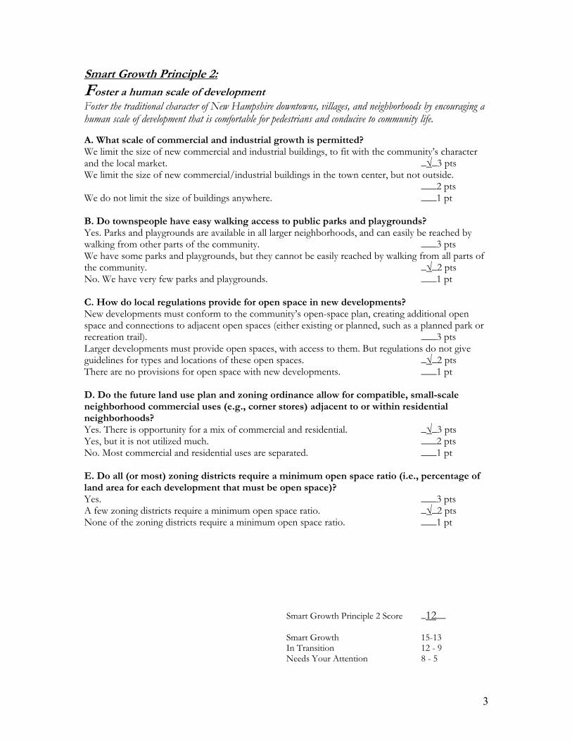
3
Smart Growth Principle 2: Foster a human scale of development Foster the traditional character of New Hampshire downtowns, villages, and neighborhoods by encouraging a human scale of development that is comfortable for pedestrians and conducive to community life. A. What scale of commercial and industrial growth is permitted? We limit the size of new commercial and industrial buildings, to fit with the community’s character and the local market. _√_3 pts We limit the size of new commercial/industrial buildings in the town center, but not outside. ___2 pts We do not limit the size of buildings anywhere. ___1 pt B. Do townspeople have easy walking access to public parks and playgrounds? Yes. Parks and playgrounds are available in all larger neighborhoods, and can easily be reached by walking from other parts of the community. ___3 pts We have some parks and playgrounds, but they cannot be easily reached by walking from all parts of the community. _√_2 pts No. We have very few parks and playgrounds. ___1 pt C. How do local regulations provide for open space in new developments? New developments must conform to the community’s open-space plan, creating additional open space and connections to adjacent open spaces (either existing or planned, such as a planned park or recreation trail). ___3 pts Larger developments must provide open spaces, with access to them. But regulations do not give guidelines for types and locations of these open spaces. _√_2 pts There are no provisions for open space with new developments. ___1 pt D. Do the future land use plan and zoning ordinance allow for compatible, small-scale neighborhood commercial uses (e.g., corner stores) adjacent to or within residential neighborhoods? Yes. There is opportunity for a mix of commercial and residential. _√_3 pts Yes, but it is not utilized much. ___2 pts No. Most commercial and residential uses are separated. ___1 pt E. Do all (or most) zoning districts require a minimum open space ratio (i.e., percentage of land area for each development that must be open space)? Yes. ___3 pts A few zoning districts require a minimum open space ratio. _√_2 pts None of the zoning districts require a minimum open space ratio. ___1 pt
Smart Growth Principle 2 Score _12__ Smart Growth 15-13 In Transition 12 - 9 Needs Your Attention 8 - 5

4
Smart Growth Principle 3:
Incorporate a mix of uses Incorporate a mix of uses to provide a variety of housing, employment, shopping, services and social opportunities for all members of the community. A. Where are commercial/industrial and residential uses located in relation to each other? The downtown/village center allows commercial, industrial, and residential uses. _√_3 pts We have mixed-use districts, but they are scattered around the community. ___2 pts No mixed uses are permitted. Commercial/industrial and residential uses are segregated. ___1 pt B. Can townspeople meet most daily shopping needs (groceries, hardware, etc.) in the community? Yes. We can meet everyday needs at a diversity of local businesses. ___3 pts We can buy some goods in the community, but must travel outside town for others. _√_2 pts No. We have to travel outside of the community to meet most everyday needs. ___1 pt C. How does local zoning encourage business development in the downtown/village center? It provides for a variety of businesses in the downtown/village center, including those that meet people’s daily needs; and it offers regulatory incentives, such as reduced parking and setbacks. _√_3 pts Zoning encourages a mix of downtown business types - but regulations, such as lot size, setbacks and parking, make such a mix of development unlikely. ___2 pts It does not encourage a mix of downtown business types - and regulations require lot sizes, setbacks, and parking provisions that can’t be met in the downtown/village center. ___1 pt D. Which option best describes the mix of housing types in your community? We have a mix of housing types, including affordable housing to buy, multi-family rental housing, and senior housing that reflects the composition of our community. _√_ 3 pts We have a limited mix, including some affordable housing. ___ 2 pts We have very little diversity in housing, and/or very little affordable housing. ___ 1 pt E. How has your community planned for future housing needs, especially in and around your downtown? Our community plan projects the amounts and types of housing that will be needed over the next 10 years or has established housing goals. We also work with local and regional housing groups to meet these needs within or adjacent to our community. ___ 3 pts The community plan includes a preliminary evaluation of future housing needs, but does not specify how to meet them. ___ 2 pts We have not discussed future housing needs. _√_ 1 pt F. Do local regulations enable your community to meet diverse housing needs and ensure long-term affordability? Yes. New developments are required to include housing targeted at more than one segment of the market – for example, apartments along with single-family homes, or affordable homes along with market–rate housing. ___ 3 pts New developments have the option of including a mix of housing, but are not required to. _√_ 2 pts No. New developments are not required to include a mix of housing – and in some cases, they are prohibited from doing so by regulations. ___ 1 pt

5
G. Does your community provide incentives to support affordable housing (density bonuses, fee waivers, higher density zones, fast tracking)? Yes, we have a range of incentives to encourage more affordable housing production. ___ 3 pts We offer some incentives, but don’t actively promote them as an option. ___ 2 pts No. We do not offer any incentives. _√_ 1 pt H. If the community has a downtown, are residential uses allowed in the central business zoning district? Yes. _√_3 pts No. Mixing of residential and commercial is only permitted outside of the downtown area. ___2 pts No. All commercial and residential uses are separated. ___1 pt I. Do the provisions within at least some of the residential zoning districts allow for a wide range of housing types by right (versus requiring a conditional use permit or special exception)? Yes. There is opportunity for a mix of housing types by right and it is utilized. _√_3 pts Yes, it is allowed by right but it is not utilized much. ___2 pts No. Most zoning districts specify a limited range of housing types. ___1 pt J. Does the zoning ordinance allow for “accessory apartments” within single-family residential (SFR) zoning districts? Yes. Accessory apartments are permitted in SFR districts and utilized. _√_3 pts Yes. Accessory apartments are permitted in SFR districts but few actually exist. ___2 pts No. ___1 pt
Smart Growth Principle 3 Score _24_ Smart Growth 30-26 In Transition 25-17 Needs Your Attention 16-10

6
Smart Growth Principle 4:
Preserve New Hampshire’s working landscape Preserve New Hampshire’s working landscape by sustaining farm and forest land and other rural resource lands to maintain contiguous tracts of open land and to minimize land use conflicts. A. Where is most development in your community located? Within or close to the downtown/village center. _√_3 pts In outlying areas, but not on farmland. ___2 pts In outlying areas, including farmland. ___1 pt B. What strategies does your master plan have for protecting farmland? A comprehensive, specific set of strategies and policies. ___3 pts Some specific strategies. ___2 pts Vague or no strategies. _√_1 pt C. Does your master plan map the location of farms and prime agricultural soils? Yes. ___3 pts Yes, but in a vague or incomplete way. ___2 pts No. _√_1 pt D. Is there local support for farming and/or forestry through tax abatements, and/or a dedicated town fund to help purchase or protect prime working land? Yes — we offer tax abatements and/or a dedicated fund. ___3 pts We have, or are working on, a plan to offer tax abatements and/or a dedicated fund. ___2 pts No, we offer neither. _√_1 pt E. Does the zoning ordinance zone much of the fringe land as exclusively agricultural (i.e., a holding category) or with a substantial minimum lot size that discourages single-family tract housing and preserves large sites for viable farm use? The Rural/Agricultural District does have a large minimum lot size, more suitable for agricultural use. ___3 pts The Rural/Agricultural District permits agricultural use but the minimum lot size is two acres. _√_2 pt
Smart Growth Principle 4 Score _8__ Smart Growth 15-13 In Transition 12 - 9 Needs Your Attention 8 - 5

7
Smart Growth Principle 5: Provide choices and safety in transportation Provide safety and choices in transportation to create livable, walkable communities that increase accessibility for people of all ages, whether on foot, bicycle, or in motor vehicles. A. Which of these options best describes the layout of local streets? Streets are interconnected, in a clear pattern for getting around the community. ___3 pts The downtown/village center has a network of streets — but in outlying areas, streets are disconnected, with no clear pattern for getting around. _√_2 pts Streets are disconnected, with no clear pattern for getting around. ___1 pt B. How has your community planned for future streets? We have a street network plan. ___3 pts We have begun working on a plan for future streets. ___2 pts We have no plan for future streets. _√_1 pt C. How does your community regulate the width of new streets? Regulations allow different street widths, depending on the character of the area, the projected volume of traffic, and/or the desired speed of traffic. _√_3 pts Regulations allow some variation in street widths, but only under limited circumstances. ___2 pts No variation in the width of streets is permitted. ___1 pt D. What provisions has your community made for pedestrians and cyclists? We have a good network of sidewalks and pedestrian/bike paths, interconnecting much of the community. ___3 pts We have some sidewalks, and a plan for pedestrian/bike paths to connect specific areas of community. _√_2 pts We have only some limited sidewalks, and no plan for pedestrian/bike paths. ___1 pt E. Does your community offer public transportation? Yes. We have a transit system supported by dedicated revenues. ___ 3 pts Yes, but local support for the service is discretionary from the general fund. _√_ 2 pts No. ___ 1 pt F. Do you require sidewalks and trails in new developments? Yes. As part of our community plan, we have sidewalk and trail design standards for residential and commercials developments. ___ 3 pts Yes. We require sidewalks and trails in new residential and commercials developments, but we do not have design standards. ___ 2 pts No. We have limited requirements for sidewalks. _√_ 1 pt G. Does your street design enable pedestrian traffic? Yes. We have a good network of sidewalks and pedestrian/bike paths connecting much of the community including safe and convenient crossings of major roads. ___ 3 pts Yes. We have some sidewalks, and a plan for pedestrian/bike paths to connect to specific areas of town. _√_ 2 pts We have only some limited sidewalks, and no plan for pedestrian/bike paths. ___ 1 pt

8
H. Has your community designated or established safe routes for children to walk or bike to school? Yes. We have established safe routes to school from all parts of our community that include accessible and readily-visible means of crossing or getting around major barriers such as busy roads. _√_ 3 pts We are aware of the concept, but have not established any safe routes to school. ___ 2 pts No. We had not established any safe routes to school. ___ 1 pt I. Do land use regulations include maximum parking ratios (i.e., a cap on the number of parking spaces that can be built in a particular development) in addition to minimum parking requirements? Yes. There is a cap on the number of parking spaces ___3 pts No, but most developments don’t go overboard with parking. _√_2 pts No, there is no cap and developments end up with a wide expanse of asphalt. ___1 pt J. Is on-street parking allowed in places where it can be safely provided, such as in downtown areas and pedestrian retail districts? Yes. There is on-street parking in the downtown area and it seems to work for both pedestrians and drivers. ___3 pts Yes. There is on-street parking in the downtown area but there are problems for both pedestrians and drivers. _√_2 pts No. There is no on-street parking in the downtown area. ___1 pt
Smart Growth Principle 5 Score _20_ Smart Growth 30-26 In Transition 25-17 Needs Your Attention 16-10

9
Smart Growth Principle 6: Protect Environmental Quality Protect environmental quality by minimizing impacts from human activities and planning for and maintaining natural areas that contribute to the health and quality of life of communities and people in New Hampshire. A. What action is your community taking to protect natural areas? We have strong provisions to protect natural areas — including wetlands, wildlife habitat, and sites for rare plants — in site-plan review and/or subdivision regulations. ___3 pts We have made provisions to protect some, but not all, natural areas in site-plan review and/or subdivision regulations. _√_2 pts We have made no provisions to protect natural areas in site-plan review or subdivision regulations. ___1 pt B. Has your community identified its natural assets (rivers, mountains, wetlands, open space, agricultural lands, viewsheds, agricultural lands) and taken steps to restore or protect them? Yes, we highlight our natural assets in our master plan and have taken steps to restore/protect them (e.g., water and energy efficiency programs, conservation easement programs, urban service boundaries, etc.) ___ 3 pts Yes, we highlight our natural assets, but we have not taken any steps to restore/protect them. _√_ 2 pts No. We do not highlight our natural assets in our planning efforts. ___ 1 pt C. Do land use regulations require developers to consider connecting open spaces and greenways to existing destinations and open space reservations? Yes. This is a requirement. ___3 pts This is not a requirement but we offer incentives for those that do. ___2 pts No, this is not considered as part of the review process. _√_1 pt D. Do local land use regulations provide for “conservation subdivisions” or “cluster subdivisions” as a matter of right (versus requiring a conditional use permit or special exception)? Yes. There are very few hurdles in the conservation/cluster subdivision process. ___3 pts Conservation/cluster subdivisions are permitted but there are obstacles for the applicant. _√_2 pts Conservation/cluster subdivisions are not permitted or there are numerous obstacles including that they are permitted only by conditional use or special exception. ___1 pt E. Have the community’s development regulations been revamped recently to encourage or require best management practices (BMPs) for water quality? Does this include a water-quality or aquifer ordinance? Yes. ___3 pts Our ordinances do address water quality issues but there are some gaps in them. _√_2 pts No. ___1 pt F. Does the community have guidelines and incentives for designing development sites and buildings for energy efficiency? Yes. This is a requirement. ___3 pts This is not a requirement but we offer incentives for those that do. ___2 pts No, this is not considered as part of the review process. _√_1 pt

10
Smart Growth Principle 6 Score _10_ Smart Growth 18-15 In Transition 14-10 Needs Your Attention 9 - 6

11
Smart Growth Principle 7:
Involve the community Involve the community in planning and implementation to ensure that development retains and enhances the sense of place, traditions, goals, and values of the local community. A. Which of these options best describes the conditions of historic buildings in your community? Most are in use and well-maintained. _√_3 pts Most are in poor condition, but they are in use. ___2 pts Most historic buildings are vacant or have been demolished ___1 pt B. Does your community have a set of clear design guidelines so streets, buildings, and public spaces work together to create a sense of place? Yes. We have a set of design guidelines that connect our street, buildings, and public spaces. ___ 3 pts Yes, but our design guidelines are vague or confusing. ___ 2 pts No. We do not have a set of design guidelines . _√_ 1 pt C. Does your community sponsor events to celebrate its cultural heritage, natural assets or community character? Yes. We have a number of fairs, concerts, events celebrating our community heritage, natural assets, or character. ___ 3 pts Yes, we have one or two events celebrating our community heritage, natural assets, or character. _√_ 2 pts No. We do not have such events. ___ 1 pt D. What action is your community taking to protect historic buildings and other features? We have a defined historic district, along with guidelines for development within it. ___ 3 pts We have highlighted the importance of historic buildings and other features, but we have no specific measures to maintain or enhance them. _√_ 2 pts We have taken no action on historic buildings and features. ___ 1 pt E. To what extent was the public involved in developing your most recent the community plan? There was a lot of public involvement – committee, workshops, survey work, well-attended public meetings. ___ 3 pts Some public meetings were well attended, but overall there was not a lot of public involvement in developing the plan. _√_ 2 pts Only the required number of public hearings were held. ___ 1 pt F. Are citizens active in community planning, development, and resource protection? Yes. Many are involved at the municipal level; there are also citizen groups working on specific areas. ___ 3 pts There is some local participation in a few aspects of community planning. _√_ 2 pts No. There is no local community development organization, downtown organization, historical society, community planning, organization, or land trust. ___ 1 pt

12
Smart Growth Principle 7 Score _12_ Smart Growth 18-15 In Transition 14-10 Needs Your Attention 9 - 6

13
Smart Growth Principle 8:
Manage growth locally Manage growth locally in the New Hampshire tradition, but work with neighboring towns to achieve common goals and address common problems more effectively. A. Do elected and appointed board members and staff in nearby communities have opportunities to meet and network with each other on a regular basis? Yes. There are a number of regular forums and meetings in which elected and appointed board members and staff have opportunities to meet and network with each other on a regular basis. ___ 3 pts Staff members from different communities in the region meet periodically, but elected and appointed board members from different communities hardly ever meet. _√_ 2 pts No. Elected and appointed board members and staff from different communities rarely meet. ___ 1 pt B. Do the towns, cities, and counties in your area have any formal cooperative agreements on issues such as land use, transportation, housing, infrastructure, emergency services, other services, revenue sharing, or economic development? Yes. Local governments in our region have intergovernmental agreements in at least three of the following areas: land use, transportation, housing, infrastructure, emergency services, other services, revenue sharing, or economic development. ___ 3 pts Local governments in our region have intergovernmental agreements in one or two of the following areas: land use, transportation, housing, infrastructure, emergency services, other services, revenue sharing, or economic development. _√_ 2 pts No. We have no formal agreements between local governments on planning issues in our area. ___ 1 pt
Smart Growth Principle 8 Score _4_ Smart Growth 6 In Transition 5 - 3 Needs Your Attention 2
This checklist was adapted from the following sources: The Vermont Smart Growth Scorecard (2000), http://www.epa.gov/dced/scorecards/VTscorecardvtfonsprawl.pdf The Colorado Smart Growth Scorecard (2003), http://www.epa.gov/dced/scorecards/Colorado_Scorecard.pdf, Comprehensive Smart Growth Checklist - Prepared by Nashua Regional Planning Commission Adopted for use in Preparing A Master Plan CD-ROM (2004), http://www.nh.gov/oep/resourcelibrary/referencelibrary/m/masterplan/preparingamasterplan/documents/smartgrowthchecklist.pdf.

Principle Number
Reference in Master Plan
Master Plan Goals and ObjectivesReference in Zoning Ordinance
Zoning OrdinancesReference in Subdivision Regulations
Subdivision RegulationsReference in Site Plan Regulations
Site Plan Review Regulations
1Land Use 1.1.1 Community Survey
With the infrastructure in place that supports commercial and industrial development, likely future sewer expansion projects in the next decade are increased residential service, especially those residential neighborhoods in near Little Squam Lake, in an effort to improve and maintain water quality. [See Principle 6]
1.1 Purpose
Purpose:It is the intent of this Ordinance to promote the health, safety, and general welfare of the people of theTown of Ashland by establishing a set of regulations that will guide the community’s growth so as toprotect the value of homes and land, to promote good civic design and to insure the wise and efficientexpenditure of public funds.
2.1d General Requirements: Guidelines
The Planning Board may, after adequate investigation, withhold approval of a lot where there is a question of suitability of said lot for its intended use due to the presence of suchfactors as: ….• Inadequate capacity for sanitary sewer disposal
1.2 Introduction
Purpose: The purpose of Site Plan Review is to provide a thorough public review and analysis of certain development projects in order to protect the public health, safety, and welfare; toavoid development which results in adverse impacts on the environment, nearby properties, and the community; and to provide for the safe, attractive, and harmonious development of thesite and the community. [See also Principles # 6 & 8.]
1Land Use 1.1.1 Community Survey
Currently there are efforts in Ashland to repurpose vacant mill buildings in the commercial and industrial zone.
2.2c Zones and Zone Regultions - VR
Public water and sewer lines generally serve areas designated as “Village Residential”.
2.1e General Requirements: Guidelines
The Planning Board may disapprove any scattered or premature subdivision of land which would involve danger or injury to health, safety, or prosperity by reason of the lack of watersupply, drainage, transportation, schools, fire protections, or other public services, or which would necessitate the excessive expenditure of public funds for and supply such services.
2.11 Standards
Grading and filling operations shall be conducted to minimize the alteration of surface and subsurface drainage to, towards, and across abutting properties. [See also Principle #6.]
1Land Use 1.1.1 Community Survey B
With limited opportunities for expansion of the downtown commercial zone, improvements to this vital community resource should be a primary focus of attention.
2.4c Zone Regulations
The total land area in a cluster development shall equal the minimum lot size requirements established in 2.3c, times the number of lots and/or dwelling units. [No bonuses]
2.4 General Requirements: Fire Protection
Where a subdivision is proposed in a location where a water supply for fire fighting purposes is not readily accessible, the Planning Board shall, as a condition of final approval, require the developer to provide, at the developer’s expense, for the installation of fire protection devices including, but not limited to, fire hydrant system, fire ponds, cisterns, dry hydrants, or storage tanks and require the developer to allow access to such devices by reserving water and maintenance easements to the Town, as the Planning Board may deem appropriate.
2.12 Standards
Provisions shall be made to prevent erosion and sedimentation caused by changed topography and soils and surface conditions during and after construction. [More guidance might be appropriate.] [See also Principle #6.]
1Land Use 1.1.1 Community Survey C
Often village centers do not have parcels of significant size to accommodate large chain stores. As a result, when these stores are permitted by zoning they locate on parcels in areas outside of village centers. In Ashland, future commercial development of these business types in the area of I-93, may distract from the desired compact village center and promotion of tourist attracting, low impact businesses. Careful land use planning in the area of I-93, which serves as a gateway to downtown Ashland, through the promotion of services and business that complement village businesses is highly desirable.
4.9 Special Provisions - Flood Hazard Areas
Do have Flood Hazard Ordinance: it does need to be updated.
2.5 General Requirements: Water Supply
Water in sufficient quantity (to be determined by the Fire Chief or designee) to handle a fire in the structure under consideration must be available for use by the fire department. Normally a water supply should be within hose laying distance for the fire department. If water supply, for fire fighting purposes is an issue, the proposed shall be reviewed by the Fire Chief, and the Board may make his recommendation a condition of approval.
2.12a Standards
During construction, sediment in the run-off water shall be trapped by the use of sediment basins or other acceptable methods until the disturbed area is stabilized. Diversion, sediment retention basins, and other such devices shall be constructed prior to any on-site grading or disturbance of existing surface materials. [Reference some Innovative Land Use Techniques.] [See also Principle #6.]
Smart Growth Assessment Matrix: Ashland, NH
Principle 1: Maintain traditional compact settlement patterns to efficiently use land, resources and infrastructure investments.
Page 1 of 15

Principle Number
Reference in Master Plan
Master Plan Goals and ObjectivesReference in Zoning Ordinance
Zoning OrdinancesReference in Subdivision Regulations
Subdivision RegulationsReference in Site Plan Regulations
Site Plan Review Regulations
Smart Growth Assessment Matrix: Ashland, NH
1Land Use 1.1.2 Recent Trends
[Multi-family dwellings are permitted in RR and VR Zones.]
2.6 General Requirements: Cluster Development
Cluster Development is permitted and encouraged for the preservation of open space, to promote more efficient use of land, and to provide flexibility in subdivision design.
1Land Use 1.3 FLU
The town’s primary future land use focus is on infill development that utilizes existing buildings and developable land for industrial and commercial uses.
2.6a General Requirements: Cluster Development
When cluster housing or multiple dwelling units are proposed, the minimum lot size shall be determined by the Planning Board based upon the character of the land involved, the type ofhousing proposed, and other pertinent factors. The total area in the subdivision must meet the requirements of Article 2 of the Zoning Ordinance.
1Land Use 1.4 Recommend.
The purpose of a build-out analysis is to show a locality what land is available for development, how much development can occur and at what densities, and what consequences may result when complete build-out of available land occurs according to the zoning ordinance. A build-out analysis can reflect changes in the zoning ordinance to illustrate the effects of those changes on future resources. A build-out analysis can also help quantify the costs of growth.
2.6c General Requirements: Cluster Development
The area, which has not been built upon, shall be consolidated into open space and designed as an integral partof the development. It may be used for recreation, conservation, or park purposes by the owners and occupants of the lots in the cluster development.
1Land Use 1.4 Recommend.
Limited space for off-street parking exists in the downtown. This issue has been explored in the past and could be a significant limitation for commercial development. Past identified solutions may no longer be viable today. These solutions should be explored and assessed with a commitment to determining current needs and opportunities. The Planning Board considers this to be the leading impediment to downtown development.
2.6d General Requirements: Cluster Development
A statement of adequacy of utility systems for the provision of water service, fire protection, sewer service, and storm drainage shall be provided to the Planning Board where applicable.
1Land Use 1.4 Recommend.
A regional effort is ongoing to identify, assess, and take remedial actions to cleanup and repurpose underutilized former industrial sites. The town should stay active in this effort and support the efforts of identified brownfield site owners. {See also Principle 3,6.]
2.7a General Requirements: Flood Hazard Areas
All proposals governed by these regulations having lands identified as Special Flood Hazard Areas on the current (at the time of application) Flood Hazard Boundary Map of the Town ofAshland shall:• Include the 100-year flood elevation data (base flood elevation) for proposals of more than fifty lots or five acres, whichever is less• Provide that all construction – including public utilities and facilities, such as sewer, gas, electrical, and water systems – will be located, elevated, and constructed to minimize or eliminate flood damage• Provide adequate drainage to reduce exposure to flood hazards• Shall be consistent with the need to minimize flood damage
Page 2 of 15

Principle Number
Reference in Master Plan
Master Plan Goals and ObjectivesReference in Zoning Ordinance
Zoning OrdinancesReference in Subdivision Regulations
Subdivision RegulationsReference in Site Plan Regulations
Site Plan Review Regulations
Smart Growth Assessment Matrix: Ashland, NH
1
DemoHousing 3.3.4 Summary and Recommend.
The town should continue to encourage higher density land use in the Village Residential Zone, including residential uses. Housing in this area has lesser impacts on the environment, enables residents to have easy access to a variety of services, can lead to greater community interaction, and results in less of an impact to municipal services.
2.7b General Requirements: Flood Hazard Areas
New or replacement water supply systems and/or sanitary sewage systems shall be designed to minimize or eliminate infiltration of floodwaters into the systems. The dischargefrom such systems shall be located so as to avoid impairment of them or contamination from them during flooding.
1
Cultural/ Historical 7.2.3 Historic Preservation Tools
Discusses RSA 79-E (Tax incentives for revitalization projects)
2.7f-3 General Requirements: Flood Hazard Areas
National Flood Insurance Requirements for Subdivision and Site Plan RegulationsFor subdivisions and site plans that involve land designated as “Special Flood Hazard Areas” (SFHA) by the National Flood Insurance Program (NFIP)....2.7 f-3 The Planning Board shall require the applicant to submit sufficient evidence (construction drawings, grading and land treatment plans) so as to allow a determination that:(i) all such proposals are consistent with the need to minimize flood damage;(ii) all public utilities and facilities, such as sewer, gas , electrical and watersystems are located and constructed to minimize or eliminate flood damage; and(iii) adequate drainage is provided so as to reduce exposure to flood hazards.
1Cultural/ Historical 7.4 Recommend.
Consider adopting a Community Revitalization Tax Relief Incentive Program through RSA 79-E to encourage rehabilitation of structures in the downtown area.
3.3 Street Design and Construction
Except where near-future connections may be possible, dead-end streets shall not exceed a length of 1000 feet or a length approved by the Planning Board….
3.8f Street Design and Construction
All road designs shall incorporate appropriate drainage features to protect road stability, abutting property and natural watercourses.
4.1 Water and Sewage Systems
If the subdivision is to be served by public water and/or sewage lines, the developer shall be responsible for the installation of all lines within the subdivision and for the construction of any lines needed to connect the subdivision lines to existing public water and sewage lines. In addition, the developer shall be responsible for any rebuilding or upgrading of the existing public water and sewage systems necessary to meet the increased demand placed on the public systems by the subdivision, including, but not limited to, the installation of pumping stations and the replacement of existing lines with larger sized lines. The new water and sewage lines shall be built according to the standards of the Ashland Water and Sewer Department. [See also Principle #6.]
1
Page 3 of 15

Principle Number
Reference in Master Plan
Master Plan Goals and ObjectivesReference in Zoning Ordinance
Zoning OrdinancesReference in Subdivision Regulations
Subdivision RegulationsReference in Site Plan Regulations
Site Plan Review Regulations
Smart Growth Assessment Matrix: Ashland, NH
2Community Vision
policies and ordinances must preserve the essential rural character of the town
2.2c Zones and Zone Regultions - VR
Village Residential: This zone provides for residential neighborhoods that are adjacent or close to commercial areas, schools and fire and police protections.
2.3 General Requirements: Guidelines - Recreation Land
The Planning Board may require a subdivision with a potential of sixteen or more lots to provide one or more recreational areas, the combined size of which shall be equal to 2,000 square feet of land for each building lot under 50,000 feet in area.
2 Land Use 1.1A common theme emerging from this Master Plan update process is the need to preserve the community characteristics that make Ashland an attractive place to live and visit.
4.6b Special Provisions - Home Occupation
There shall be no outside parking of vehicles defined in NH RSA 259:7, 259:11a, 259.59, 259:98 and 259:109 as Bus, Combination Vehicle, Motor Truck, Semi-trailer, Tractortrailer, and Truck-tractor.
2.3a General Requirements: Guidelines - Recreation Land
Subdivisions, which represent a continuation of an earlier subdivision, which had a potential of sixteen or more lots, may also be required to meet these standards for recreation land.
2Land Use 1.1.1 Community Survey B
Land use related values identified in the 2009 Community Master Plan Survey included: maintain the quaint Ashland town character,...improve landscaping
10 Definitions
Home Occupation - Any use that is customarily conducted within a dwelling by the inhabitants thereof which is secondary to the use of the dwelling for residential purposes and does not change the character of the building or the character of the neighborhood.
2.3b General Requirements: Guidelines - Recreation Land
The developer shall provide for the maintenance of recreation land in a manner suitable to the Planning Board.
2Land Use 1.1.1 Community Survey B
[Carry over from 1984 MP] These recommendations include a detailed three-phased action plan for the downtown that addresses a host of town character improvements including promotional signage, opening and maintaining views to the river, creating an access road to adjacent mill sites to increase connectivity and redevelopment potential, and specific recommendations for signs, a pocket park, street furniture, increased parking, street lighting, building façade improvements, and a street tree program.
2Land Use 1.1.1 Community Survey B
current community initiatives supportive of downtown improvements include the work of the Downtown Revitalization Committee and the efforts of the Ashland Historical Society in creating a walking tour in downtown.
2Land Use 1.1.1 Community Survey C
The development of comprehensive design guidelines is recommended as an effective tool for coordinating incremental future development and redevelopment with the existing character of the community.
2Land Use 1.1.1 Community Survey B
Survey respondents indicated that more gasoline fueling stations, additional fast food restaurants, and large chain stores are viewed as being undesirable.
2Land Use 1.4 Recommend.
The purpose of design guidelines is to convey the type of commercial and multi-family development a community desires which is consistent with the characteristics that make the community an attractive place...The goal in the creation and use of this planning tool is a direct link between the guideline contents and the community vision articulated in this master plan.
Principle 2: Foster the traditional character of New Hampshire downtowns, villages, and neighborhoods by encouraging a human scale of development that is comfortable for pedestrians and conducive to community life.
Page 4 of 15
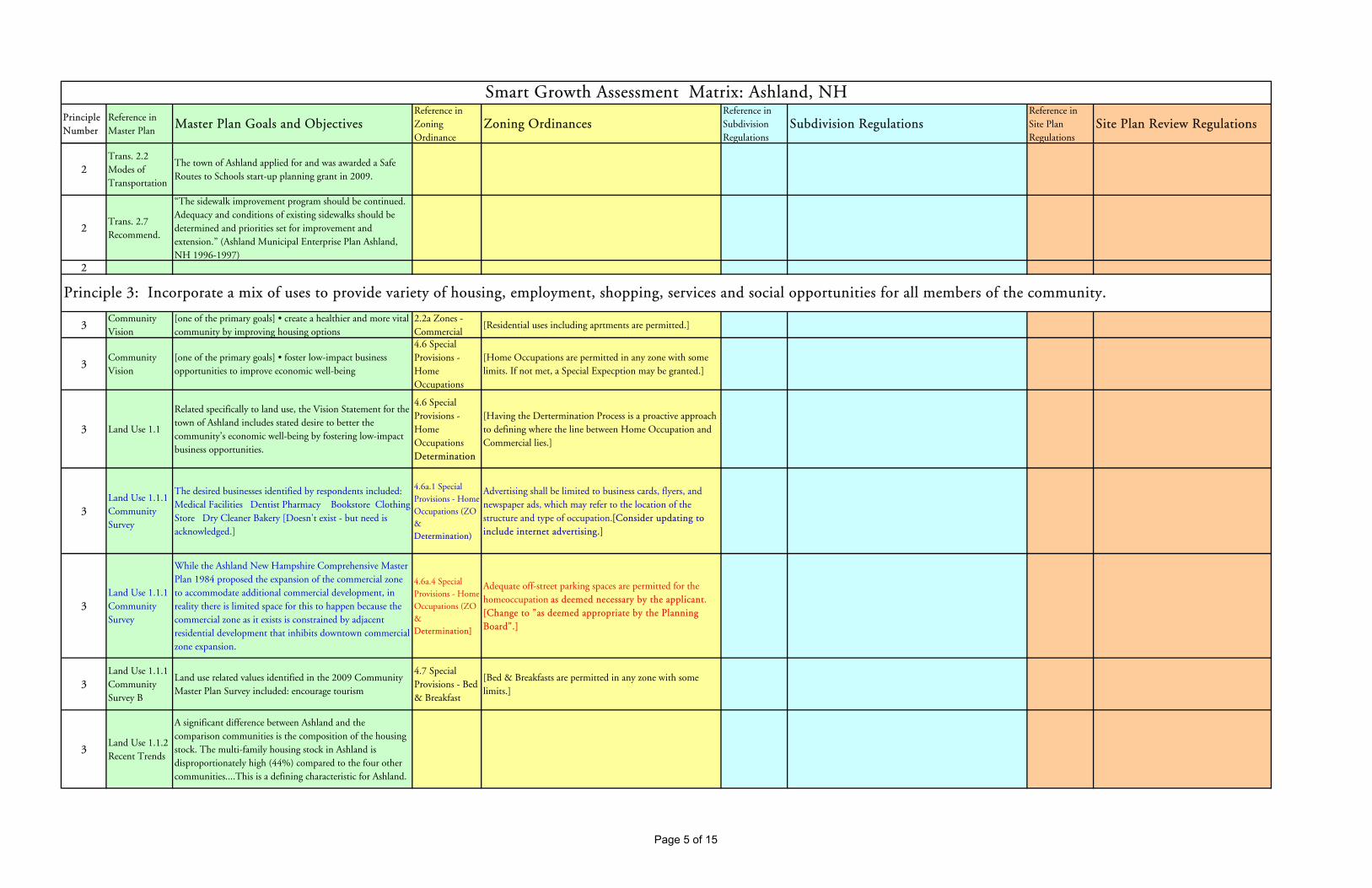
Principle Number
Reference in Master Plan
Master Plan Goals and ObjectivesReference in Zoning Ordinance
Zoning OrdinancesReference in Subdivision Regulations
Subdivision RegulationsReference in Site Plan Regulations
Site Plan Review Regulations
Smart Growth Assessment Matrix: Ashland, NH
2Trans. 2.2 Modes of Transportation
The town of Ashland applied for and was awarded a Safe Routes to Schools start-up planning grant in 2009.
2Trans. 2.7 Recommend.
“The sidewalk improvement program should be continued. Adequacy and conditions of existing sidewalks should be determined and priorities set for improvement and extension.” (Ashland Municipal Enterprise Plan Ashland, NH 1996-1997)
2
3Community Vision
[one of the primary goals] • create a healthier and more vital community by improving housing options
2.2a Zones - Commercial
[Residential uses including aprtments are permitted.]
3Community Vision
[one of the primary goals] • foster low-impact business opportunities to improve economic well-being
4.6 Special Provisions - Home Occupations
[Home Occupations are permitted in any zone with some limits. If not met, a Special Expecption may be granted.]
3 Land Use 1.1
Related specifically to land use, the Vision Statement for the town of Ashland includes stated desire to better the community’s economic well-being by fostering low-impact business opportunities.
4.6 Special Provisions - Home Occupations Determination
[Having the Dertermination Process is a proactive approach to defining where the line between Home Occupation and Commercial lies.]
3Land Use 1.1.1 Community Survey
The desired businesses identified by respondents included: Medical Facilities Dentist Pharmacy Bookstore Clothing Store Dry Cleaner Bakery [Doesn't exist - but need is acknowledged.]
4.6a.1 Special Provisions - Home Occupations (ZO & Determination)
Advertising shall be limited to business cards, flyers, and newspaper ads, which may refer to the location of the structure and type of occupation.[Consider updating to include internet advertising.]
3Land Use 1.1.1 Community Survey
While the Ashland New Hampshire Comprehensive Master Plan 1984 proposed the expansion of the commercial zone to accommodate additional commercial development, in reality there is limited space for this to happen because the commercial zone as it exists is constrained by adjacent residential development that inhibits downtown commercial zone expansion.
4.6a.4 Special Provisions - Home Occupations (ZO & Determination]
Adequate off-street parking spaces are permitted for the homeoccupation as deemed necessary by the applicant. [Change to "as deemed appropriate by the Planning Board".]
3Land Use 1.1.1 Community Survey B
Land use related values identified in the 2009 Community Master Plan Survey included: encourage tourism
4.7 Special Provisions - Bed & Breakfast
[Bed & Breakfasts are permitted in any zone with some limits.]
3Land Use 1.1.2 Recent Trends
A significant difference between Ashland and the comparison communities is the composition of the housing stock. The multi-family housing stock in Ashland is disproportionately high (44%) compared to the four other communities....This is a defining characteristic for Ashland.
Principle 3: Incorporate a mix of uses to provide variety of housing, employment, shopping, services and social opportunities for all members of the community.
Page 5 of 15

Principle Number
Reference in Master Plan
Master Plan Goals and ObjectivesReference in Zoning Ordinance
Zoning OrdinancesReference in Subdivision Regulations
Subdivision RegulationsReference in Site Plan Regulations
Site Plan Review Regulations
Smart Growth Assessment Matrix: Ashland, NH
3Land Use 1.3 FLU
Ashland’s secondary focus is the potential expansion of the Village Residential zone. This would provide additional opportunities for compact residential development in close proximity to the commercial services. While this would not lead to additional commercial development opportunities, home occupations are permitted in the Village Residential Zone.
3Land Use 1.4 Recommend.
Given the space and potential for new businesses to locate in the village center, a proactive approach to attracting businesses might include an inventory of commercial space, vacant land, and associated amenities.
3Land Use 1.4 Recommend.
A regional effort is ongoing to identify, assess, and take remedial actions to cleanup and repurpose underutilized former industrial sites. The town should stay active in this effort and support the efforts of identified brownfield site owners. {See also Principle 1.6.]
3Land Use 1.4 Recommend.
The previously prepared Ashland Downtown Improvement Plan contains a wealth of suggestions that are relevant for Ashland today.
3Trans. 2.2 Modes of Transportation
75 percent of the Ashland workforce commutes to work alone by automobile.
3Trans. 2.2 Modes of Transportation
Approximately 27 percent of workers live and work in Ashland while the 73 percent that work outside the community average a 23.3 minute commute to work.
3
DemoHousing 3.2.3 Employment/Wages
Ashland is slightly below the Lakes Region average in terms of the percentage of residents commuting outside the town to get to work.
3
DemoHousing 3.2.3 Employment/Wages
Notable is the relatively high percentage (71%) of lower paying service producing jobs; this is not uncommon in the Lakes Region, which is heavily dependent on tourism.
3
DemoHousing 3.2.3 Employment/Wages
Tools to enhance housing choice] These include provisions for home occupations, variable density based on the availability of utilities, and the permissibility of manufactured housing and apartments. In-law apartments are another housing option that can help keep the costs of housing manageable for some in the community; Ashland’s ordinance does not forbid these. The zoning ordinance permits the development of elderly housing and multi-family housing of up to six units in most of the town and even higher densities in the Village Residential Zone.
Page 6 of 15

Principle Number
Reference in Master Plan
Master Plan Goals and ObjectivesReference in Zoning Ordinance
Zoning OrdinancesReference in Subdivision Regulations
Subdivision RegulationsReference in Site Plan Regulations
Site Plan Review Regulations
Smart Growth Assessment Matrix: Ashland, NH
3DemoHousing 3.3.3 Existing Housing Stock
(H)ome ownership is possible over a wide price range. When compared with HUD’s workforce affordable price for the county of $220,000, there do appear to be options available to Ashland residents.
3
DemoHousing 3.3.4 Summary and Recommend.
An aging population will require different housing arrangements and needs. Those that can care for themselves may require housing that is in close proximity to services. Fixed incomes may limit affordability and require lower cost housing choices. Also, the demand for medical, living assistance, and other related services will increase. Housing for the workers that will care for seniors will need to be available within their means. The town should determine whether the existing elderly housing is sufficient for its current and projected needs.
3
DemoHousing 3.3.4 Summary and Recommend.
The Lakes Region is largely a tourist based economy comprised of industries that generally produce lower paying jobs. Appropriately priced housing both for rent and purchase is needed to support area service workers.
3
DemoHousing 3.3.4 Summary and Recommend.
The town should continue to encourage a mix of housing for residents, especially within the Village Residential Zone, near a variety of services. This can be accomplished through the subdivision and site plan review processes. This may be accomplished through dialog with applicants encouraging a mix of housing types allowable within the existing land use regulations and zoning ordinance.
3Cultural/ Historical 7.4 Recommend.
Support the efforts of the town Recreation Department to develop and promote activities that bring residents and visitors together throughout the year.
3
4Land Use 1.1.2 Recent Trends
[Agriculture, forestry, and farming are permitted in RR Zone.]
2.2d Zones - Rural Residential
• Agricultural, forestry and farming uses [permitted use]
4
Recreation 5.4 Private Lands Recreational Opportunities
Current Use tax reductions are available for parcels of land ten or more acres in size that are farms, forest or unproductive land.
10 Definitions
Accessory Building A subordinate building incidental to and on the same lot occupied by the main buildings or use. The term “accessory building”, when used in connection with a farm, shall include all buildings customarily used for farm purposes.
4
Cultural/ Historical 7.2.3 Historic Preservation Tools
Discusses RSA 79-D ((Tax relief for barn maintenance)
Principle 4: Preserve New Hampshire’s working landscape by sustaining farm and forest land and other rural resource lands to maintain contiguous tracts of open land and to minimize land use conflicts.
Page 7 of 15

Principle Number
Reference in Master Plan
Master Plan Goals and ObjectivesReference in Zoning Ordinance
Zoning OrdinancesReference in Subdivision Regulations
Subdivision RegulationsReference in Site Plan Regulations
Site Plan Review Regulations
Smart Growth Assessment Matrix: Ashland, NH
4Cultural/ Historical 7.4 Recommend.
Consider utilizing RSA 79-D “Discretionary Preservation Easements” to encourage the maintenance of barns and farms.
4
5Land Use 1.1.1 Community Survey B
Land use related values identified in the 2009 Community Master Plan Survey included: ...create opportunities for walkable and bikeable access in-town.
Zones and Zone Regulations 3.2 Off Street Parking
Adequate off-street loading and parking shall be provided ['Adequate' is subject to interpretation.]
3.1 Street Design and Construction
The arrangement of streets in the subdivision:• Shall provide for the continuation of the principal streets in adjoining subdivision• Shall provide for their proper projection when adjoining property is not subdivided, and• Shall be as wide as existing connecting streets
2.4 Standards
Sidewalks shall be provided for pedestrian traffic between the main entrances of business, housing or industrial establishments and parking areas and streets. Sidewalks shall be physically separate from driveways or parking areas.
5Land Use 1.1.1 Community Survey B
For Ashland a design challenge is the flow of traffic on Main Street. Traffic solutions that identify and integrate pedestrian connectivity and opportunities for streetscape improvements serve as potential opportunities to advance recommendations in the downtown improvement plan.
Zones and Zone Regulations 3.2b Off Street Parking
All construction and renovation as described in 3.2 shall provide adequate off-street parking spaces equivalent to 200 square feet per space plus adequate additional area for maneuvering. The following standards shall be used:• Residential use: two spaces for each family unit• Hotel, motel and tourist accommodations: one space for each unit• Commercial and industrial uses: one space for each three anticipated patrons and/or employees on the premises at any one time• Public assembly (auditorium, church, hall, restaurant and theater): one space for every four seats [More uniform defenition] [Consider parking maximums]
3.2a Street Design and Construction
No street or highway right-of-way shall be less than 50 feet wide, and it may be required to be more if a wider street is warranted in the opinion of the Planning Board.
5Land Use 1.4 Recommend.
Apply for a Plan NH grant to perform a traffic design charrette in downtown Ashland. [Charrette completed in 2012]
4.7 Special Provisions - Bed & Breakfast
Parking: Minimum off-street parking to include (2) spaces for the owner/innkeeper and (1) space for each unit, (200 square feet minimum per space) [Consider maximum.]
3.7 Street Design and Construction
Existing streets within, abutting, or servicing subdivision shall, whenever necessary in the opinion of the Planning Board, be widened and improved by the developer so that they meet the specifications contained in these regulations. Where access to the subdivision is over a private right-of-way, a Class VI road, or an unpaved or otherwise inadequate street, the Planning Board may require the developer to improve the access road so that it meets the specifications contained in these regulations.
5Trans. 2.2 Modes of Transportation
In 2008, the annual average labor force in Ashland consisted of 1,092 employed residents of which approximately 60 walked to work.
Parking Regulations - 24-1-12 Handicapped Parking
No person shall stop, stand or park a vehicle in any parking space, whether on public or private property, specifically designated for the physically handicapped by means of a sign stating that the space is reserved for the physically handicapped or displaying the wheelchair symbol(a) Mechanic Street parking lot – first space(b) Pleasant Street behind the police department parking(c) First parking space in parking lot adjacent to MemorialPark [Consider providing more Handicap spaces in town.]
3.9 Street Design and Construction
The Planning Board will not approve any plan unless the road design meets the following specifications and construction standards. The Planning Board may increase the travel way width…[variable road widths]
Principle 5: Provide choices and safety in transportation to create livable, walkable communities that increase accessibility for people of all ages, whether on foot, bicycle, or in motor vehicles.
Page 8 of 15

Principle Number
Reference in Master Plan
Master Plan Goals and ObjectivesReference in Zoning Ordinance
Zoning OrdinancesReference in Subdivision Regulations
Subdivision RegulationsReference in Site Plan Regulations
Site Plan Review Regulations
Smart Growth Assessment Matrix: Ashland, NH
5Trans. 2.2 Modes of Transportation
While walking and bicycling are not the most popular means of travel to work, pedestrian activity in Ashland is promoted by conveniently spaced businesses and municipal services in the village.
5Trans. 2.2 Modes of Transportation
The Ashland Road Agent conducted a sidewalk inventory and condition assessment for town and state routes. All sidewalks in Ashland are Americans with Disabilities Act (ADA) compliant. The over-all sidewalk network rating is Good (2.96) with several sections in Fair condition and in need of repair.
5Trans. 2.2 Modes of Transportation
Like other rural New Hampshire communities, a fully developed public transportation system complemented by a choice of private transportation providers does not exist. Existing public transit in the Ashland area is limited to a small group of service providers and volunteer drivers:
5Trans. 2.4.6 Challenges
Main Street in the town of Ashland is also a state road (US3 / NH25) and is the main route from Interstate 93 Exit 24 to the Squam Lakes Region. This causes considerable traffic congestion in the downtown area because cars are parked along Main Street.
5Trans. 2.4.6 Challenges
Sight distance issues have been identified at the junctions of Main Street and Gordon Street; Howe Road and Scenic View Road (US 3/ NH 25); River Street and Scenic View Road; Cross Road and Scenic View Road.
5Trans. 2.4.6 Challenges
Public parking has been identified at the following areas: town hall parking lot, Mechanic Street parking area, Memorial Park parking area, Booster Club parking lot and along Main Street (all are restricted during the winter season).
5Trans. 2.5 Town Road Standards
A recent trend has placed more emphasis on road design that minimizes lane width based on traffic volume, road purpose, and desired vehicle travel speeds. One result is increased space for wider shoulders, bicycle lanes, sidewalks, and other amenities within the right of way. Another result is a roadway of appropriate scale for the site where vehicle and non-vehicle uses are safely accommodated. Scale and context road planning are consistent with the community’s desire to maintain rural character. Variable design standards are often described in a community’s regulations based on anticipated traffic volumes. New road construction and existing road improvement standards are outlined in the Ashland Subdivision Regulations. Last updated in May 2008, the regulations outline acceptable road widths based on the anticipated volume of traffic the road will carry.
5Trans. 2.7 Recommend.
• Evaluate the parking along Main Street, and, if necessary make changes to increase safety.
5Trans. 2.7 Recommend.
• Develop a transportation system/network that supports alternative modes of travel.
Page 9 of 15

Principle Number
Reference in Master Plan
Master Plan Goals and ObjectivesReference in Zoning Ordinance
Zoning OrdinancesReference in Subdivision Regulations
Subdivision RegulationsReference in Site Plan Regulations
Site Plan Review Regulations
Smart Growth Assessment Matrix: Ashland, NH
5Trans. 2.7 Recommend.
• Support the maintenance and reconstruction of sidewalks in town.
5Trans. 2.7 Recommend.
• Encourage the development of safe pedestrian and bike pathways.
5Trans. 2.7 Recommend.
• Assess Safe Routes to Schools Committee progress and interest in Travel Plan development.
5Trans. 2.7 Recommend.
• Explore sidewalk expansion and crosswalk to ball field, Route 3 to River Street, and along Main Street to West Street.
5
Recreation 5.5 Other Recreational Opportunities
Snowmobile trails through Ashland...many miles existing within the town of Ashland. The town also has two state snowmobile corridors (Corridor 8 and Corridor 24) which pass throughtown and provide connectivity to other portions of the state trail network. The state snowmobile trail system in Ashland is served by a snowmobile parking area off US Route 3, one mile north of I-93 Exit 24.
5Recreation 5.6 Recommend.
Work with State and other organizations to develop biking and walking routes and hiking trails.
5
6Community Vision
[A primary goal] • enhance the town’s position as a destination for those seeking quality outdoor recreation
2.2d Zones - Rural Residential
Rural Residential: This zone provides for low to medium density rural living, open space and theprotection of environmentally sensitive areas such as wetlands, floodplains, poor soils, and steep slopes.
2.1b General Requirements: Guidelines
The subdivider shall give due regard to the preservation and protection of existing features such as trees, scenic points, brooks, streams, water bodies, other natural areas, and historic landmarks in order to preserve the natural environment.
1.2 Introduction
Purpose: The purpose of Site Plan Review is to provide a thorough public review and analysis of certain development projects in order to protect the public health, safety, and welfare; to avoid development which results in adverse impacts on the environment, nearby properties, and the community; and to provide for the safe, attractive, and harmonious development of the site and the community. [See also Principles # 6 & 8.]
Principle 6: Protect environmental quality by minimizing impacts from human activities and planning for and maintaining natural areas that contribute to the health and quality of life of communities and people in New Hampshire.
Page 10 of 15

Principle Number
Reference in Master Plan
Master Plan Goals and ObjectivesReference in Zoning Ordinance
Zoning OrdinancesReference in Subdivision Regulations
Subdivision RegulationsReference in Site Plan Regulations
Site Plan Review Regulations
Smart Growth Assessment Matrix: Ashland, NH
6Community Vision
policies and ordinances must protect our natural resources2.2d Zones - Rural Residential
[Cluster development permitted.]2.1c General Requirements: Guidelines
Land of such character that it cannot be safely used for building development purposes because of danger to health or peril from fire, flood hazard, poor drainage, poor soil conditions, excessive slope or other hazardous conditions shall be identified on the Subdivision Plat. Such characteristics include:• Steep land (as identified in Section 2.4a of the Ashland Zoning Regulations).• Areas with a high water table (within 2 feet of the surface)• Flood plains• Areas with less than 3 feet of natural soil over the majority of lots• Areas with less than 3 feet of natural soil over impermeable material (percolation rateslower than 30 minutes per inch)
2.3 Standards
Outdoor lighting shall be shielded so as not to shine onto abutting properties or onto public highways or streets, and it shall be restricted to that which is necessary for advertising and security of the development.
6 Land Use 1.1Related specifically to land use, the Vision Statement for the town of Ashland includes stated desires to improve opportunities as an outdoor recreation destination
2.2e Zones - Pemigewasset Overlay District
Pemigewasset Overlay District: This district provides protection for the environmentally sensitive corridor along the Pemigewasset River and the restrictions contained herein take precedence over permitted uses in the portions of the zones over which it lies. The following uses are prohibited:• Structures on slopes, which exceed fifteen percent (15%)• Mobile home parks • Any excavations for which an Earth Excavation Permit issued under RSA 155 E is required. The eastern boundary of the district shall be 500 feet from the river’s high-water line, except that it shall be1000 feet from the high-water line in any floodplain.
2.1d General Requirements: Guidelines
The Planning Board may, after adequate investigation, withhold approval of a lot wherethere is a question of suitability of said lot for its intended use due to the presence of suchfactors as:• Rock formations• Tendency to periodic flooding• Poor drainage• Unsuitable soil or soils, and ...
2.7 Standards
Pollution Control: Provisions shall be provided to prevent ground- and surface-watercontamination due to on-site storage or use of petroleum products and hazardous substances incompliance with NH RSA 146-C, 147-A, 153, and 430.
6Land Use 1.1.1 Community Survey
With the infrastructure in place that supports commercial and industrial development, likely future sewer expansion projects in the next decade are increased residential service, especially those residential neighborhoods in near Little Squam Lake, in an effort to improve and maintain water quality. [See Principle 1]
2.2f Zones - Little Squam Lake and Squam River Overlay District
Little Squam Lake and Squam River Overlay District: This district provides protection for theenvironmentally sensitive corridor along the shores of Little Squam Lake and Squam River, and therestrictions herein take precedence over permitted uses in the portion of the Rural Residential Zone overwhich it lies. The following are prohibited:• Structures on slopes, which exceed fifteen percent (15%)• Application of fertilizers, pesticides or herbicides• Underground fuel storage tanks• Any excavations for which an Earth Excavation Permit issued under RSA 155 E isrequired.This district extends 250 feet inland from the shoreline of Little Squam Lake, Squam River and upstreamfrom the River Street Dam.
2.6c Cluster Development
The common open space shall be so defined on the subdivision plan and shall be made subject to a deed restriction, which shall thereafter prohibit further subdivision of that openspace, or the use of it for purposes other than originally designated.
2.11 Standards
Grading and filling operations shall be conducted to minimize the alteration of surface and subsurface drainage to, towards, and across abutting properties. [See also Principle #1.]
Page 11 of 15

Principle Number
Reference in Master Plan
Master Plan Goals and ObjectivesReference in Zoning Ordinance
Zoning OrdinancesReference in Subdivision Regulations
Subdivision RegulationsReference in Site Plan Regulations
Site Plan Review Regulations
Smart Growth Assessment Matrix: Ashland, NH
6Land Use 1.1.2 Recent Trends
Rural Residential (RR): This zone provides opportunities for low to medium density residential development and open space. Most of the large tracts of conservation land in Ashland are located in this zone, which also promotes the protection of environmentally sensitive resources such as: steep slopes, floodplains, wetlands, and poorly drained soils. Comprised of 6,633 acres or approximately 92 percent of the total land area in Ashland, the Rural Residential zone is the largest zone.
Zones and Zone Regulations 2.2e & f Lot Size and Frontage
[Differences between Pemi (200') and Squam (50') Overlays in terms of mobile home parks, application of fertilizers, pesticides, and herbicides,UST]
2.7e Flood Hazard Areas
Waterfront subdivisions with frontage on Little Squam Lake and the Squam and Pemigewasset River must comply with Article 5 of the Zoning Ordinance.
2.12 Standards
Provisions shall be made to prevent erosion and sedimentation caused by changed topographyand soils and surface conditions during and after construction. [More guidance might be appropriate.] [See also Principle #1.]
6Land Use 1.1.2 Recent Trends
[Cluster residential developments permitted in RR Zone]
Zones and Zone Regulations 2.3c Lot Size and Frontage
[Difference between Pemi (200') and Squam (50') Overlays and put in context of SWQPA]
2.8a Easements
Reserve strips of land which, in the opinion of the Board, show intent on the part of the subdivider to control access to land dedicated (or to be dedicated) to public use shall not be permitted.
2.12a Standards
During construction, sediment in the run-off water shall be trapped by the use of sediment basins or other acceptable methods until the disturbed area is stabilized. Diversion, sediment retention basins, and other such devices shall be constructed prior to any on-site grading or disturbance of existing surface materials. [Reference some Innovative Land Use Techniques.] [See also Principle #1.]
6Land Use 1.1.2 Recent Trends
Overlay Districts: The town of Ashland has two overlay districts designed to protect environmentally sensitive water resources which include the Pemigewasset River corridor and the Little Squam Lake and Squam River shorelines. The overlay districts provide additional development constraints designed to protect water quality. The districts include land within 500 feet of the Pemigewasset River and 250 feet of the Little Squam Lake and Squam River shorelines.
Zones and Zone Regulations 2.3c Land and Space Requirements
(b) A lot owned in common as a recreation area serving nearby dwelling units is exempt from the minimum lot frontage requirement [There do not seem to be any limits to number of homes that could access a recreation lot - could lead to overcrowding - funnel development.]
2.10 Erosion Control
Adequate measures to prevent soil erosion shall be taken during road construction and lot clearing. Such measures may include, but are not limited to:• Maintenance of vegetative cover on steep slopes• Seeding of road shoulders and embankments• Construction of settlement basins and temporary dams
3.3: Application - Site Plan Requirements…. Also Checklist
Identitify wetland boundaries on the plat and consider requiring that other natural or historic features be shown also.
6Land Use 1.1.2 Recent Trends
[Differences in Overlay District prohibitions - Manuf. Housing (Pemi), fert./pest., herb. (Squam), UST (Squam)]
Zones and Zone Regulations 2.4c Lots
The total land area in a cluster development shall equal the minimum lot size requirements established in 2.3c, times the number of lots and/or dwelling units. [No incentives]
3.8f Street Design and Construction
All road designs shall incorporate appropriate drainage features to protect road stability, abutting property and natural watercourses.
6Land Use 1.4 Recommend.
A viewshed analysis documents, maps, prioritizes, and protects important areas that are visible from specific locations. This analysis can be conducted for a specific feature or include views throughout the town. A good starting point for Ashland might be the identification of potential views from downtown to the river. In this instance vegetation that currently obscures river views from desired vantage points in the village would be identified and assessed for clearing and long-term maintenance.
Zones and Zone Regulations 2.4d Lots
(added March 10, 2009) Lot sizing for lots without town sewer shall not use the following in determining countable area for minimum lot size:o Slopes greater than 25%o Areas of exposed ledgeo Wet land areaso Fill materials that contain tree stumps, sawdust, woodchips, tree bark, bricks, asphalt, concrete, metal, wall board, construction debris or other such non-soil material, or contain no more than 25% by volume of cobbles larger than six (6) inches in diameter or stone larger than twelve (12) inches in diametero Areas that are unsuitable for septic placement
4.1 Water and Sewage Systems
If the subdivision is to be served by public water and/or sewage lines, the developer shall be responsible for the installation of all lines within the subdivision and for the construction of any lines needed to connect the subdivision lines to existing public water and sewage lines. In addition, the developer shall be responsible for any rebuilding or upgrading of the existing public water and sewage systems necessary to meet the increased demand placed on the public systems by the subdivision, including, but not limited to, the installation of pumping stations and the replacement of existing lines with larger sized lines. The new water and sewage lines shall be built according to the standards of the Ashland Water and Sewer Department. [See also Principle #1.]
Page 12 of 15

Principle Number
Reference in Master Plan
Master Plan Goals and ObjectivesReference in Zoning Ordinance
Zoning OrdinancesReference in Subdivision Regulations
Subdivision RegulationsReference in Site Plan Regulations
Site Plan Review Regulations
Smart Growth Assessment Matrix: Ashland, NH
6Land Use 1.4 Recommend.
A regional effort is ongoing to identify, assess, and take remedial actions to cleanup and repurpose underutilized former industrial sites. The town should stay active in this effort and support the efforts of identified brownfield site owners. {See also Principle 1.3.]
3.1b Height Restrictions
Within the Pemigewasset Overlay and Little Squam Overlay District, no building or structure shall be constructed with an overall height exceeding 35 feet above mean ground level.
4.3 Water and Sewage Systems
If the subdivision is to be served by a private community water supply, the water supply must be adequate to meet the needs of the subdivision at all times. Private community water supply systems and private community sewage systems and treatment plants must be constructed according to the standards of the NH Water Supply and Pollution Control Commission.
6Trans. 2.4.3 Scenic Roads
The town of Ashland designated approximately 1.6 miles of town road as Scenic Roads by town vote in 1987 and 1988 as outlined in RSA 231:157.
3.7 General Provisions: Erosion
If clay, sod, loam, sand, or gravel is removed within 100 feet of any public highway, street, or roadway, the area shall be inspected to assure that the premises will be protected against erosion and washouts within 90 days of the completion of construction or removal of material.
4.4 Water and Sewage Systems
Private sewage disposal systems shall be located at least 125 feet from all year-round surface waters in accordance with Article 7, section 7.3 of the Building Regulations and of Article 2 of the Zoning Ordinance.
6
DemoHousing 3.3.4 Summary and Recommend.
While the town permits cluster subdivision in the Rural Residential Zone, the Planning Board should consider additional information regarding what is required in a cluster subdivision project and the development of incentives, such as flexible density or road construction requirements to encourage these types of projects. The purpose of cluster ordinances is to allow site flexibility while preserving natural features. Density incentives aid in minimizing land consumed for housing, and allowing smaller lot sizes may effectively lower housing costs.
4.2 Special Provisions - Waterfront Access
The minimum shore frontage for a building lot located along Little Squam Lake or along the Squam and Pemigewasset Rivers shall be 200 feet.
5.4e Preliminary Subdivision Layout
The area of the entire parcel to be subdivided, the locations, names, and widths of existing and proposed streets, right-of-way lines, lot frontages, lot sizes in square feet and acres, existing and proposed easements and deed restrictions over and under private property, the location of all parcels of land proposed to be dedicated to public use with the conditions of such dedications, notations pertaining to private roads, areas to be dedicated to public use, and existing buildings, watercourses, ponds or standing water, rock ledges, and other essential features. [Include wetlands and be more specific regarding "essential features".]
6
Recreation 5.2.4NH Recreational Standards
Encouraging the School District to develop trails for nature study during the school year, as well as for public hiking and cross-country skiing seasonally, would enhance recreational and educational opportunities within the community.
4.4 Mobile Home Parks
Mobile homes placed or replaced within the Pemigewasset Overlay District must be installed upon a permanent foundation.
6
Recreation 5.3 Conservation Lands Recreational Opportunities
Within the town there are many permanently protected conservation areas that allow varying degrees of public access and a variety of recreational opportunities from snowmobiling to bird watching.
4.5a Recreational Camping Parks
Within the Pemigewasset and Little Squam Overlay Districts, the following standards shall apply: The minimum area shall be 5 acres.
6
Recreation 5.4 Private Lands Recreational Opportunities
While having land enrolled in Current Use does not require a land owner to open the property to public use, there is an incentive for landowners who opt to allow some low impact public uses called the Recreational Discount. This incentive reduces the Current Use assessment by 20 percent for allowing the public to use private land for six low-impact uses: skiing, snowshoeing, fishing, hunting, hiking, and nature observation.
4.5b Recreational Camping Parks
Within the Pemigewasset and Little Squam Overlay Districts, the following standards shall apply: A 35 foot landscaped buffer strip shall be maintained along all perimeters of the park, except that along the riverfront the buffer strip shall be 75 feet wide. Within this space, a dense visual screen of suitable shrubs and trees 6 feet or more in height shall be provided. Such open space shall not be built upon, paved, nor used for parking.
Page 13 of 15

Principle Number
Reference in Master Plan
Master Plan Goals and ObjectivesReference in Zoning Ordinance
Zoning OrdinancesReference in Subdivision Regulations
Subdivision RegulationsReference in Site Plan Regulations
Site Plan Review Regulations
Smart Growth Assessment Matrix: Ashland, NH
6
Recreation 5.4 Private Lands Recreational Opportunities
While not permanently protected recreational opportunities, there is a disincentive to take land out of current use. The amount of the tax penalty is ten percent of the fair market value of the land being removed which is assessed at the time of the change in use. Currently the town of Ashland applies 100 percent of the land use change tax to further conservation efforts in town.
Zones and Zone Regulations 4.7 B&B Parking
Minimum off-street parking to include (2) spaces for the owner/innkeeper and (1) space for each unit, (200 square feet minimum per space) [Consider a max.]
6Recreation 5.6 Recommend.
Explore the Trust for Public Lands Conservation Economics or similar programs to quantify the economic value of conservation and recreational lands in Ashland.
10 Definitions
Cluster Development [Defined] A pattern of subdivision development, which places housingunits into compact groupings while providing a network of commonly owned or dedicated open space. [Good phrasing]
6 10 Definitions
Green Space: Land not covered by impervious cover, which is capable of growing grass, plants, shrubs, trees, or similar ground cover. Such land, which does not have any of the above listed landscaping, shall be developed and maintained with these landscaping features. The use of wood chips shall be limited to beneath trees or shrubs, or to areas where the maintenance of grass would be prohibitive.
10 Definitions [Impervious cover is not directly defined.]
7Community Vision
policies and ordinances must protect our community values5.2 Pre-Application Consultation
As provided in RSA 676:4 II and prior to submission of a subdivision application, a subdivider may meet with the Planning Board and engage in non-binding discussions in the following manner: [Good to have this placed at the beginning of the article.]
3.1 Application
Pre-application Consultation: Prior to submitting an application, a potential applicant may appear before the Planning Board to informally discuss these regulations and their possible application to the proposed project. Such pre-application consultation shall bind neither the applicant nor the Planning Board nor its members. The Planning Board may waive the requirement for Site Plan Review according to Section 1.3G. [Good to include and good location in article.]
7Cultural/
Historical 7.4 Recommend.
To enhance the communication and understanding between the Planning Board and Historical Society and assist with implementing Recommendations 5, 6, 7, and 8, the town should consider forming a Heritage Commission (RSA 673:4-a, 674:44-a–d).
7Cultural/
Historical 7.4 Recommend.
If the town decides not to form a Heritage Commission at this time, the Planning Board should seek to retain a member who is also active in the Historical Society and will actively serve as an intermediary between the two entities, giving regular updates on the activities of each to the other.
Principle 7: Involve the community in planning and implementation to ensure that development retains and enhances the sense of place, traditions, goals, and values of the local community.
Page 14 of 15

Principle Number
Reference in Master Plan
Master Plan Goals and ObjectivesReference in Zoning Ordinance
Zoning OrdinancesReference in Subdivision Regulations
Subdivision RegulationsReference in Site Plan Regulations
Site Plan Review Regulations
Smart Growth Assessment Matrix: Ashland, NH
7Cultural/
Historical 7.4 Recommend.
Members of the Planning Board should gain a greater awareness and fuller understanding of the funding, restoration, and development opportunities associated with historical properties that are available.
7Cultural/
Historical 7.4 Recommend.
The Historical Society should develop and promote a more detailed Historic Walking Tour of the downtown area, expanding upon the brochure developed by the Revitalization Committee.
7
8
Recreation 5.2.4NH Recreational Standards
efforts should be made to work with surrounding towns for a regional plan to enhance conservation and provide recreational opportunities around the lake and river corridor.
9.4 Communications Devices: Procedural Requirements for Communication Devices
Procedural Requirements for obtaining approval to install a wireless communication device. The Town of Ashland Planning Board shall make all approvals of Communication Devices.I. Rights of Abutting Towns: Because the visual impact of wireless communication facilities can transcend town lines; the Town of Ashland shall formally notify all towns that may reasonably be visually affected of applications for such proposed Communication Towers. The applicant shall be responsible for the cost of this notice.
Section 5, Flowchart
No reminder for Planning Board to make a determination as to whether the proposal qualifies as a Development of
Regional Impact (DRI) under RSA 36:54-57.
Article 4 Review
Procedure & Flowchart
No reminder for Planning Board to make a determination as to whether the proposal qualifies as a Development of Regional Impact (DRI) under RSA 36:54-57.
8
Other 4.9 Floodplain [Update to reference the DFIRMs.Note - End Page does
reference 2008 maps.]Throughout
Replace "Soil Conservation Service" with "Natural Resources Conservation Service".
ThroughoutReplace "NH Water Supply and Pollution Control
Commission" with "NH Department of Environmental Services".
7 DefinitionsParcel - An area of land, which is part of a tract and capable of division into one or more lots in accordance with these
regulations. [Clarify]
Principle 8: Manage growth locally in the New Hampshire tradition, but work with neighboring towns to achieve common goals and more effectively address common problems
Page 15 of 15

Smart Growth Assessment: Ashland, NH
Entering Ashland, NH on NH Route 132 Image source: http://thisnewenglandblog.projo.com/ashland.jpg
February 2013
Prepared by the Lakes Region Planning Commission in consultation with the Ashland Planning Board. Support for the project was provided by the Samuel P. Pardoe Foundation.


THE LAKES REGION PLANNING COMMISSION
Danbury
Andover
Franklin
Northfield
Tilton
Hill
Alexandria
Hebron
Bristol
Bridge
water
New H
ampto
n
Sanbornton
Meredith
Laconia
Gilford
Belmont
Gilmanton
Barnstead
Alton
Ashland
Holderness
Sandwich
Tamworth
Freedom
Effingham
OssipeeMoultonborough
Tuftonboro
Wolfeboro
Harbor
Center
Alexandria Janet Towse Alton David Hussey Andover John Cotton John Warzocha, Alt. Ashland Gordon McCormack, Jr. Barnstead David Kerr
Belmont Vacant Bridgewater Vacant Bristol Steve Favorite Center Harbor Maureen Criasia Danbury Charlotte McIver
Effingham George Bull Theresa Swanick Franklin Robert Sharon Freedom Jean Marshall Gilford Scott Dunn Gilmanton Stanley O. Bean, Jr. Ralph Lavin
Moultonborough Herbert Farnham Barbara Perry New Hampton Dr. George Luciano Northfield Wayne Crowley Douglas Read Ossipee Dr. Patricia Jones Roger terKuile Sanbornton Ralph Carter Carmine Cioffi
Sandwich Toby Eaton H. Boone Porter, III Tamworth Patricia Farley Karen McNiff, Alt. Tom Peters Tilton Joseph Jesseman Tuftonboro Dan Duffy Stephen Wingate Wolfeboro Roger Murray, III Chuck Storm Donald St. Germain, Alt.
Hebron Mitch Manseau Hill Vacant Holderness Todd Elgin Robert Snelling Laconia Dean Anson, II Warren Hutchins Meredith William Bayard Herbert Vadney
LAKES REGION PLANNING COMMISSION STAFF
Daniel Callister Assistant Planner Gerald Coogan Senior Planner Michael Izard Principal Planner
David Jeffers Regional Planner Kimon G. Koulet Executive Director Dari Sassan Regional Planner
Michelle Therrien GIS Coordinator Rosemarie Gelinas Administrative Assistant Barbara Sullivan Bookkeeper
LRPC COMMISSIONERS2012-2013


Table of Contents
I. What is Sprawl? 1
II. Patterns in Ashland 3 A. Population B. Housing C. Summary
III. What is Smart Growth? 4 IV. What is a Smart Growth Assessment? 5
V. Smart Growth in Ashland 6
A. Ashland’s Smart Growth Principles B. Smart Growth Checklist, Matrix, and Ashland’s Planning Documents C. Smart Growth Principles and Ashland’s Planning Documents
1. Maintain traditional compact settlement patterns 9 2. Foster human scale development 12 3. Incorporate a mix of uses 14 4. Preserve New Hampshire’s working landscape 16 5. Provide choices and safety in transportation 17 6. Protect environmental quality 19 7. Involve the community 22 8. Manage growth locally but work with neighboring communities 24


Smart Growth Assessment: Ashland, New Hampshire, Lakes Region Planning Commission, February, 2013 1
I. What is Sprawl? Since the 1980s, New Hampshire has had the fastest growing population rate of all the New England states1. While this rate has decreased during the past decade to 6.5%, it still represents an additional 8,000 residents per year2. Economically, this growth is often perceived as good for New Hampshire; it brings new jobs, new people, and new ideas. At the same time, however, it also brings new challenges. Unmanaged, growth can become sprawl, which threatens to destroy the very qualities that make New Hampshire a great place to live. “Sprawl is a pattern of development that results when:
• we use more and more land for various human activities; • the places where we conduct activities are farther apart, and tend to be in homogeneous rather
than mixed-use groupings; and • we rely on automobiles to connect us to those places.
Development or change in land use contributes to sprawl when: • it increases the need or demand for motor vehicle trip miles
per housing unit in the community; • it increases the per-person or per-unit amount of land space
devoted to cars; and • it otherwise increases the per-person or per-unit
consumption or fractionalization of land areas that would otherwise be open space.”3
http://www.mercola.com/ImageServer/Public/2005/september/9.16sprawl.jpg
“Sprawling growth moves away from our town centers, leaving downtowns struggling. It spreads residential development across the rural landscape on large lots, eliminating the farms and woodlots of the working landscape - the pieces that are the very essence of rural character. The resulting pattern of development leaves islands of single uses widely spread apart from each other. In many areas the automobile becomes the only logical way of reaching these far-flung districts. Instead of the traditional mixed use patterns of development, where at least some residential development was directly accessible to downtowns that provided a variety of commercial, industrial, and institutional activities, we have residential subdivisions and office parks far outside of downtown. Instead of small-scale retail centers, we have stores and retail complexes hundreds of thousands of square feet in size, surrounded by acres of parking. In doing so, we are losing any traditional, distinctive New Hampshire character.”4
The NH Department of Environmental Services has studied the pattern of land use in New Hampshire and has this to say about its impact on the state’s environment, “‘Sprawl’ describes a pattern of development characterized by increasing amounts of developed land per person, scattered, low-density development, and 1 NH Office of Energy and Planning webpage, http://nh.gov/oep/programs/DataCenter/Population/PopulationEstimates.htm (visited 11/12/10). 2 US Census, http://2010.census.gov/2010census/data/index.php (visited 1/25/11). 3 NH Office of State Planning, Annual Report to the General Court and the Governor on Growth Management, December 2001 p.2. 4 NH Office of State Planning, Report to Governor Shaheen on Sprawl, December 1999. p. 1.

2 Smart Growth Assessment: Ashland, New Hampshire, Lakes Region Planning Commission, February, 2013
the fragmentation and loss of open space. Sprawl and other poor development practices impose significant negative impacts on air and water quality, reduces the quantity and quality of wildlife habitat, and limit recreational opportunities for area residents.”5
Sprawl is expensive because it increases the cost of municipal services and thus taxes; it destroys the traditional land uses of forestry and agriculture; it makes us more dependent on the automobile, thus increasing traffic, congestion and air pollution; it increases water pollution through increased pavement; and it destroys the small town, rural character that is so important to many of New Hampshire’s communities. This type of development occurs not because of the ill will of developers or the ineffectiveness of government. Developers respond to market forces within the rules established by state and municipal governments. At times, however, the rules are not coherent, consistent, or logically linked to the goals they are intended to realize. Sometimes rules designed for one desirable purpose have unintended, undesirable consequences. For example:
• Two acre zoning intended to preserve a rural setting results in the fragmentation of wildlife habitat;
• Land use regulations regulating odors intended to protect health in a residential area results in limits on farming that hastens the loss of large tracts of working open space.
The term ‘smart growth’ is sometimes substituted for policies and techniques that prevent or counteract sprawl. The central focus of a Smart Growth Assessment is to provide a useful link between the Principles of Smart Growth and their application in municipal land use practice. This report is a step in providing that link for the town of Ashland, NH. It is intended to be a guide as the town updates its regulations, ordinances, and master plan.
5 Smart Growth webpage, NH Department of Environmental Services, http://www.des.state.nh.us/wmb/was/smartgrowth.htm (visited November 12, 2010).

Smart Growth Assessment: Ashland, New Hampshire, Lakes Region Planning Commission, February, 2013 3
II. Patterns in Ashland A. Population and Demographics Ashland is one of the smallest towns in the Lakes Region, in terms of area and to a lesser degree population. While Ashland’s economy used to be based heavily on a few large employers, this has changed and the town is working on developing a different sort of economic base. In the 1980s the population of New Hampshire increased by 20% with an additional 11% increase in the 1990s. The Lakes Region population grew at 17.6% in the 1980s and 15.8% in the 1990s. During the 1980s Ashland’s rates of growth for each decade (6.0% and 2.1% respectively) were far lower than both the state and region.6 Census 2010 records indicate that Ashland’s population stood at 2,076 residents yielding a growth rate of 6.2% since the 2000 Census, right in between the state (6.5%) and regional (5.9%) figures. As a group Ashland’s residents are slightly older than the rest of New Hampshire, having a higher median age (43.1% vs. 41.1%) and a larger percentage of residents over 65 years old (16.8% vs. 13.5%) and a smaller proportion of residents under 25 years of age (27.5% vs. 31.2%).
Population: Ashland, NH
1,6501,7001,7501,8001,8501,9001,9502,0002,0502,100
1980 1990 2000 2010Population
B. Housing
In the 1980s the number of housing units in Ashland increased by 28% from 908 to 1,162. By 2000 there was a slight drop in the number of units. In 2010 the total number of housing units in Ashland was up to 1,186. The housing boom of the 1980s had an even greater impact around the region and throughout the state with growth rates of 29% and 30%; in the 1990s the rate growth in housing units in the Lakes Region and the state had slowed to 6% and 8.6%, respectively. As noted in the 2012 Ashland Master Plan, 22% of Ashland’s housing stock is seasonal, lower than the Lakes Region average of 30% and more than three times higher than the state average of 10%. 6 Lakes Region Demographic Profile, Lakes Region Planning Commission, 2003.

4 Smart Growth Assessment: Ashland, New Hampshire, Lakes Region Planning Commission, February, 2013
The housing stock in Ashland is varied; residents of this community have far more diverse options for housing than those in many other Lakes Region communities. Single family housing represents 46% of Ashland’s housing stock, significantly lower than the Lakes Region average of 78%7. Twenty-nine percent of the housing units are either condominiums or apartments. The percentage of multi-family housing is similar to the rest of the region (9.0% vs. 10.5%).
Rate of Growth in Ashland
1980-1990 1990-2000 2000-2010
Population 6.0% 2.1% 6.2% All Housing Units 28.0% -1.1% 3.2%
C. Summary Since 1980 Ashland’s population has increased by 15% and the number of housing units has increased by slightly more than 30% over that same time period. During the 1980s Ashland experienced a far greater growth in construction than in population. After a large drop in development activity, Ashland is beginning to see some more development. How that development occurs is something that the community, through its various boards and commissions need to be attentive to.
III. What is Smart Growth?8 Change is occurring in New Hampshire - more people, more traffic, changing jobs, higher taxes, and various stresses on the environment. Given these pressures, it is understandable that taxpayers and communities often respond with a loud “STOP!” Growth management, tax caps, and budget cuts are all natural responses to situations that appear overwhelming. Smart Growth says, “First, decide on your vision. Then explore the possible ways to achieve it.” In practical terms, Smart Growth consists of evaluating and shaping all new development and re-development initiatives according to the following eight principles:
1. Maintain traditional compact settlement patterns to efficiently use land, resources and infrastructure investments;
2. Foster the traditional character of New Hampshire downtowns, villages, and neighborhoods by encouraging a human scale of development that is comfortable for pedestrians and conducive to community life;
3. Incorporate a mix of uses to provide a variety of housing, employment, shopping, services and social opportunities for all members of the community;
4. Preserve New Hampshire’s working landscape by sustaining farm and forest land and other rural resource lands to maintain contiguous tracts of open land and to minimize land use conflicts;
7 Development Activities in the Lakes Region: 2011 Annual Report, Lakes Region Planning Commission. 8 Text in Sections I and II is adapted from GrowSmart NH Tool-Kit Project, 2002, NH Office of Energy and Planning and Planning Decisions, Inc. http://nh.gov/oep/programs/SmartGrowth/_docs/chester_report.pdf pp.3, 4.

Smart Growth Assessment: Ashland, New Hampshire, Lakes Region Planning Commission, February, 2013 5
5. Provide choices and safety in transportation to create livable, walkable communities that increase accessibility for people of all ages, whether on foot, bicycle, or in motor vehicles;
6. Protect environmental quality by minimizing impacts from human activities and planning for and maintaining natural areas that contribute to the health and quality of life of communities and people in New Hampshire;
7. Involve the community in planning and implementation to ensure that development [supports] and enhances the sense of place, traditions, goals, and values of the local community; and
8. Manage growth locally in the New Hampshire tradition, but work with neighboring towns to achieve common goals and address common problems more effectively.
IV. What is a Smart Growth Assessment? A Smart Growth Assessment evaluates where the community stands regarding the Smart Growth Principles. To accomplish this, several steps must be taken:
• Trends in the municipality’s population and development are compiled along with projections for these patterns.
• The community reviews the eight NH Smart Growth Principles and identifies which of these they support.
• The most recent Master Plan goals and objectives are reviewed for statements that support the Smart Growth Principles,
• The current local land use ordinances and regulations are reviewed for consistency with each of the town-supported Smart Growth Principles.
• Patterns and practices in town are assessed as they pertain to Smart Growth. • Suggestions are made regarding what steps the community might take to better implement the
identified Smart Growth Principles. This assessment is based upon the most current documents available for Ashland, including the Master Plan, 2012, Zoning Ordinances, 2012; Subdivision Regulations, 2008, and Site Plan Review Regulations, 2006.

6 Smart Growth Assessment: Ashland, New Hampshire, Lakes Region Planning Commission, February, 2013
V. Smart Growth in Ashland
A. Ashland’s Smart Growth Principles The Ashland Planning Board reviewed the eight Principles of Smart Growth outlined by the NH OEP that apply to New Hampshire communities and agreed that all of the Principles apply to Ashland.
B. Smart Growth Checklist, Matrix, and Ashland’s Planning Documents The intent of this Smart Growth Assessment is to provide the town of Ashland and especially the Ashland Planning Board with tools for understanding how the town stands in its efforts to embrace and implement Smart Growth identifying any impediments to implementation that might exist. One method of assessing a community’s progress towards Smart Growth is a Smart Growth Checklist. Over the years several checklists have been developed by a variety of public and private organizations, some analyzing planning documents exclusively, others focusing on patterns and community actions9. LRPC staff recognized the desire of the Planning Board to have a review of their documents for consistency as well as the need to take into account patterns and local actions. As a result a compilation of several checklists was developed that has a 60/40 ratio of references to planning documents versus patterns and actions (Section 2). This checklist asks the reviewer to choose which of three phrases best characterize the documents/patterns/actions. A number ‘1’, ‘2’, or ’3’ is associated with each phrase, with ‘3’ corresponding to the phrase that best reflects “Smart Growth”. The points under each principle can then be totaled to give an indication of where the community currently stands in terms of implementing each of the Smart Growth Principles. The intent is that this be used a guide that the Planning Board can use as an annual review of progress. This score should be used as a benchmark against which subsequent checklist reviews can be measured. After reviewing the town’s planning documents, a Smart Growth Matrix (Section 3) was developed and statements from the various documents were placed in appropriate sections. Those statements which contradict the Principle are in red text, those that partially support the Principle are in blue text, bold font is used to place emphasis on certain statements, and [brackets] surround comments from the reviewer. The section which immediately follows this text builds upon the information in the Smart Growth Matrix analyzing how closely the guiding documents of the municipality are aligned with each Principle. Where appropriate, the analysis addresses some of the impediments to implementing Smart Growth and makes suggestions for improvement. Such recommendations are referenced to the Master Plan (MP), Zoning Ordinance (ZO), Subdivision Regulations (Sub), Site Plan Review Regulations (SPR), or Actions and Policies (A&P). Efforts were made to link each reference’s individual goal, objective, ordinance, or regulation with one Principle; however, some repetition was necessary. Due to the interrelated nature of the Smart Growth statements, there are some statements that play an important role in shaping the town’s ability to implement multiple Principles. Many foster the Smart Growth Principles; in a number of cases the Ashland Master Plan
9 http://www.epa.gov/dced/scorecards/, visited August 13, 2009
Smart Growth Assessment: Ashland, New Hampshire, Lakes Region Planning Commission, February, 2013 7
has statements supportive of a Principle and there are no statements contrary to the Principle, but in other documents they are merely silent on the topic. Our work with Ashland has been unique, since the town is nearing completion of the update to its master plan. Notably, the Natural Resources chapter is yet to be developed. The Ashland Master Plan proposes several modifications, most of which support these Smart Growth Principles. General Topic Observations: The flowcharts illustrating the Subdivision and Site Plan Review Procedures and Timeframes are good aids for the applicant and Planning Board members. (Sub, SPR) The Subdivision and Site Plan Review Regulations reference the “USDA Soil Conservation Service” and the “NH Water Supply and Pollution Control Commission”; these should be updated to reflect their current names, “USDA Natural Resources Conservation Service” and “NH Department of Environmental Services”.

8 Smart Growth Assessment: Ashland, New Hampshire, Lakes Region Planning Commission, February, 2013
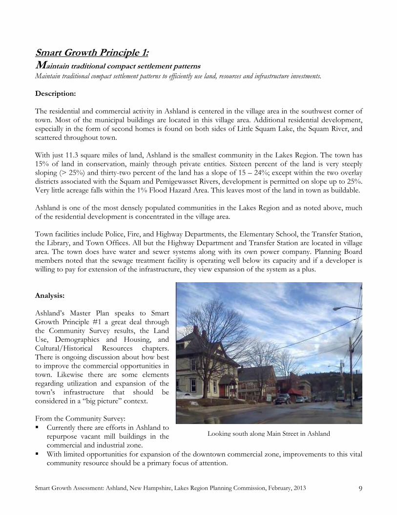
Smart Growth Assessment: Ashland, New Hampshire, Lakes Region Planning Commission, February, 2013 9
Smart Growth Principle 1: Maintain traditional compact settlement patterns Maintain traditional compact settlement patterns to efficiently use land, resources and infrastructure investments. Description: The residential and commercial activity in Ashland is centered in the village area in the southwest corner of town. Most of the municipal buildings are located in this village area. Additional residential development, especially in the form of second homes is found on both sides of Little Squam Lake, the Squam River, and scattered throughout town. With just 11.3 square miles of land, Ashland is the smallest community in the Lakes Region. The town has 15% of land in conservation, mainly through private entities. Sixteen percent of the land is very steeply sloping (> 25%) and thirty-two percent of the land has a slope of 15 – 24%; except within the two overlay districts associated with the Squam and Pemigewasset Rivers, development is permitted on slope up to 25%. Very little acreage falls within the 1% Flood Hazard Area. This leaves most of the land in town as buildable. Ashland is one of the most densely populated communities in the Lakes Region and as noted above, much of the residential development is concentrated in the village area. Town facilities include Police, Fire, and Highway Departments, the Elementary School, the Transfer Station, the Library, and Town Offices. All but the Highway Department and Transfer Station are located in village area. The town does have water and sewer systems along with its own power company. Planning Board members noted that the sewage treatment facility is operating well below its capacity and if a developer is willing to pay for extension of the infrastructure, they view expansion of the system as a plus. Analysis: Ashland’s Master Plan speaks to Smart Growth Principle #1 a great deal through the Community Survey results, the Land Use, Demographics and Housing, and Cultural/Historical Resources chapters. There is ongoing discussion about how best to improve the commercial opportunities in town. Likewise there are some elements regarding utilization and expansion of the town’s infrastructure that should be considered in a “big picture” context. From the Community Survey: Currently there are efforts in Ashland to
repurpose vacant mill buildings in the commercial and industrial zone.
With limited opportunities for expansion of the downtown commercial zone, improvements to this vital community resource should be a primary focus of attention.
Looking south along Main Street in Ashland

10 Smart Growth Assessment: Ashland, New Hampshire, Lakes Region Planning Commission, February, 2013
Often village centers do not have parcels of significant size to accommodate large chain stores. As a result, when these stores are permitted by zoning they locate on parcels in areas outside of village centers. In Ashland, future commercial development of these business types in the area of I-93, may distract from the desired compact village center and promotion of tourist attracting, low impact businesses. Careful land use planning in the area of I-93, which serves as a gateway to downtown Ashland, through the promotion of services and business that complement village businesses is highly desirable.
From the Land Use chapter: The town’s primary future land use focus is on infill development that utilizes existing buildings and
developable land for industrial and commercial uses. [Limited off-street parking in the downtown] A regional effort is ongoing to identify, assess, and take remedial actions to cleanup and repurpose
underutilized former industrial sites. The town should stay active in this effort and support the efforts of identified brownfield site owners.
The town should continue to encourage higher density land use in the Village Residential Zone, including residential uses. Housing in this area has lesser impacts on the environment, enables residents to have easy access to a variety of services, can lead to greater community interaction, and results in less of an impact to municipal services.
From the Cultural and Historic Resources chapter: Consider adopting a Community Revitalization Tax Relief Incentive Program through RSA 79-E to
encourage rehabilitation of structures in the downtown area. In terms of the Zoning Ordinance, we find a few statements clearly supporting Principle #1 and a couple that could be improved: Purpose: It is the intent of this Ordinance to promote the health, safety, and general welfare of the
people of the Town of Ashland by establishing a set of regulations that will guide the community’s growth so as to protect the value of homes and land, to promote good civic design and to insure the wise and efficient expenditure of public funds.
Public water and sewer lines generally serve areas designated as “Village Residential” [however, it can be extended to meet the needs of a particular project at the developer’s expense].
[Cluster Development is permitted throughout the Rural Residential zone.] In the Subdivision Regulations we find a large number of statements directly supporting this principle: [Several statements assert the need for adequate sewer capacity.] The Planning Board may disapprove any scattered or premature subdivision of land which would
involve danger or injury to health, safety, or prosperity by reason of the lack of water supply, drainage, transportation, schools, fire protections, or other public services, or which would necessitate the excessive expenditure of public funds for and supply such services. [The board may also require the development of fire access roads and fire protection devices.]
[Cluster Development is permitted.] [The Street Design and Construction section is established to protect the infrastructure and adjacent
property. The 1,000’ limit on dead-end streets limits exposure to fire protection and also results in encouraging road connectivity, which is a wise land use practice resulting in less sprawl and more efficient use of public resources.]
[The section on public water and sewer lines makes it clear that the infrastructure can be extended to serve the needs of developers and that the cost of extension will be passed on to the developer.]
Site Plan Review Regulations

Smart Growth Assessment: Ashland, New Hampshire, Lakes Region Planning Commission, February, 2013 11
The Purpose of the Site Plan Review Regulations makes it clear that the overall intent is, “to protect the public health, safety, and welfare” and “to avoid development which results in adverse impacts on the environment, nearby properties, and the community; and to provide for the safe, attractive, and harmonious development of the site and the community”.
Recommendations: Consider the development of a Village Overlay District, allowing for some mixed uses. This might also
encourage infill and expansion around the village area. (ZO) Consider encouraging Cluster Development by adopting density incentives [the ordinance permits this
type of resource-efficient development, with the inclusion of density incentives, it could actually encourage this type of development, reducing land use and the amount (and cost) of the associated infrastructure]. (ZO, Sub., SPR)
Consider creating a master plan for the expansion of utilities that is in concert with the Land Use
chapter of the Master Plan. (A &P) Consider utilizing RSA 79-E to encourage the rehabilitation of structures in the downtown area,
ultimately improving the town’s tax base. (A&P)

12 Smart Growth Assessment: Ashland, New Hampshire, Lakes Region Planning Commission, February, 2013
Smart Growth Principle 2: Foster a human scale of development Foster the traditional character of New Hampshire downtowns, villages, and neighborhoods by encouraging a human scale of development that is comfortable for pedestrians and conducive to community life. Description: While the central commercial blocks in Ashland have a bit of an urban feel, the area is only a couple of blocks. A block or two back from the main streets homes and apartments are found. It is quite walkable with sidewalks running in front of many of the storefronts out along many of the residential streets and along Main Street through most of the commercial District. From the village area residents can walk to the ball field/playground. Ashland Elementary School is located in the heart of the village area and served by sidewalks. In the village area there are a small grocery store, a convenience store, some antiques and art shops, and several restaurant/pubs. A resident could take care of most of their daily needs without driving; however, there are many services that are only offered in Plymouth or Laconia. While the sidewalks extend out Main Street through the commercial zone, they do not extend out Winona Road or Riverside Dr. Analysis: The Vision, Land Use, and Transportation chapters of the Ashland Master Plan speak clearly of preserving many of the characteristics of the community while moving forward with efforts to revitalize the downtown. There are a limited number of statements in the Zoning Ordinance and Subdivision Regulations that directly address this Principle; there are none in the Site Plan Regulations. From the Master Plan: (Vision)… policies and ordinances must preserve
the essential rural character of the town (Land Use) A common theme emerging from this
Master Plan update process is the need to preserve the community characteristics that make Ashland an attractive place to live and visit.
(Land Use) The development of comprehensive design guidelines is recommended as an effective tool for coordinating incremental future development and redevelopment with the existing character of the community.
(Transportation) Sidewalk improvements should continue.
Zoning Ordinances: Village Residential: This zone provides for residential neighborhoods that are adjacent or close to
commercial areas, schools and fire and police protections.
The H. H. Shepard Building

Smart Growth Assessment: Ashland, New Hampshire, Lakes Region Planning Commission, February, 2013 13
There are limits in the various residential zones on the percent coverage of the lot by buildings [no mention is made of impervious surfaces].
Part of the definition of Home Occupation is that it “does not change the character of the building or the character of the neighborhood”.
Under Site Plan Review Regulations: The Planning Board may require a subdivision with a potential of sixteen or more lots to provide one or
more recreational areas, the combined size of which shall be equal to 2,000 square feet of land for each building lot under 50,000 feet in area.
The developer shall provide for the maintenance of recreation land in a manner suitable to the Planning Board.
There are no landscaping requirements. Recommendations: Consider including a maximum percentage of lot covered by impervious surfaces and including some
limits in the Commercial area. (ZO) Insert language into the subdivision and site plan regulations addressing pedestrian connectivity with
neighboring structures (Sub., SPR) Consider requiring landscaping standards in the village area that would require/encourage the
retention/planting of substantial trees and shrubs. (SPR) Continue to work with the Safe Routes to Schools program at the NH Department of Transportation
for support and resources to design and develop additional sidewalks. (A&P)

14 Smart Growth Assessment: Ashland, New Hampshire, Lakes Region Planning Commission, February, 2013
Smart Growth Principle 3: Incorporate a mix of uses Incorporate a mix of uses to provide a variety of housing, employment, shopping, services and social opportunities for all members of the community.
Description:
Ashland has one of the most diverse and affordable housing markets in the Lakes Region. Those interesting in moving to town can find apartments, condos, single- and multi-family homes (including accessory apartments), along with housing for the elderly, farms, and second homes across a wide price range. Many of these housing units are available in the village area. There are a number of businesses in town; the town’s zoning reflects the fact that they are concentrated around the village area. Much of one’s shopping and services could be obtained without leaving the Village and Commercial Districts, although many people do have to travel out of town to obtain certain services. More than 25% of Ashland residents commute out of town; this is slightly higher than the Lakes Region average. The Master Plan survey identified several types of businesses that would be desirable in Ashland. Some community and social activities take place in town, although it has been noted that fewer residents seem to be participating in such activities and that more activities are occurring outside the village (Little Squam Lake) or outside of town (Plymouth). Analysis: Providing for a healthy mix of housing, employment, shopping, services, and social opportunities within the community is one of the biggest challenges that Ashland faces. Much is said in a variety of Master Plan chapters on this subject. Far less was found in the Zoning Ordinance and none was found in the regulations. Master Plan: (Community Survey) The desired businesses identified by respondents included: Medical Facilities,
Dentist, Pharmacy, Bookstore, Clothing Store, Dry Cleaner, and Bakery (Vision – a primary goal) create a healthier and more vital community by improving housing options (Vision – a primary goal) foster low-impact business opportunities to improve economic well-being Ashland has a relatively high (44%) proportion of multi-family housing.
A mix of commercial and residential uses along Main Street near the Squam River.

Smart Growth Assessment: Ashland, New Hampshire, Lakes Region Planning Commission, February, 2013 15
(Future Land Use) Ashland’s secondary focus is the potential expansion of the Village Residential zone. This would provide additional opportunities for compact residential development in close proximity to the commercial services. While this would not lead to additional commercial development opportunities, home occupations are permitted in the Village Residential Zone.
A regional effort is ongoing to identify, assess, and take remedial actions to cleanup and repurpose underutilized former industrial sites. The town should stay active in this effort and support the efforts of identified brownfield site owners.
(Demographics and Housing) The town should continue to encourage a mix of housing for residents, especially within the Village Residential Zone, near a variety of services. This can be accomplished through the subdivision and site plan review processes. This may be accomplished through dialog with applicants encouraging a mix of housing types allowable within the existing land use regulations and zoning ordinance.
(Historic and Cultural Resources) Support the efforts of the town Recreation Department to develop and promote activities that bring residents and visitors together throughout the year.
In the Zoning Ordinance: Home Occupations are permitted in any zone and the board has a formal Determination Process so that
it is clear where the boundaries between Home Occupation and Commercial activities lie. A variety of housing options are permitted around town, including single- and multi-family homes as
well as accessory apartments, leading to numerous housing options across a fairly wide of spectrum of price ranges.
Recommendations: Consider a Village Overlay District to permit more mixed uses throughout more of the downtown,
including the Village Residential zone. (ZO) Consider updating the description of Home Occupation advertising limits to address internet
advertising. (ZO) Modify the determination of parking spaces associated with home occupations. “Adequate off-street
parking spaces are permitted for the home occupation as deemed necessary by the applicant.” ZO 4.6a.4 [Change to "as deemed appropriate by the Planning Board".](ZO)
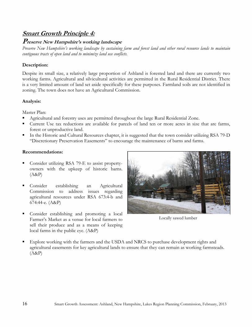
16 Smart Growth Assessment: Ashland, New Hampshire, Lakes Region Planning Commission, February, 2013
Smart Growth Principle 4: Preserve New Hampshire’s working landscape Preserve New Hampshire’s working landscape by sustaining farm and forest land and other rural resource lands to maintain contiguous tracts of open land and to minimize land use conflicts. Description:
Despite its small size, a relatively large proportion of Ashland is forested land and there are currently two working farms. Agricultural and silvicultural activities are permitted in the Rural Residential District. There is a very limited amount of land set aside specifically for these purposes. Farmland soils are not identified in zoning. The town does not have an Agricultural Commission. Analysis: Master Plan: Agricultural and forestry uses are permitted throughout the large Rural Residential Zone. Current Use tax reductions are available for parcels of land ten or more acres in size that are farms,
forest or unproductive land. In the Historic and Cultural Resources chapter, it is suggested that the town consider utilizing RSA 79-D
“Discretionary Preservation Easements” to encourage the maintenance of barns and farms. Recommendations: Consider utilizing RSA 79-E to assist property-
owners with the upkeep of historic barns. (A&P)
Consider establishing an Agricultural
Commission to address issues regarding agricultural resources under RSA 673:4-b and 674:44-e. (A&P)
Consider establishing and promoting a local
Farmer’s Market as a venue for local farmers to sell their produce and as a means of keeping local farms in the public eye. (A&P)
Explore working with the farmers and the USDA and NRCS to purchase development rights and
agricultural easements for key agricultural lands to ensure that they can remain as working farmsteads. (A&P)
Locally sawed lumber

Smart Growth Assessment: Ashland, New Hampshire, Lakes Region Planning Commission, February, 2013 17
Smart Growth Principle 5: Provide choices and safety in transportation Provide safety and choices in transportation to create livable, walkable communities that increase accessibility for people of all ages, whether on foot, bicycle, or in motor vehicles.
Description: Interstate 93 and several state routes dominate Ashland’s road network. The heart of the village includes the junctions of NH Route 132 (Main Street) and Winona Road and the junction of NH Route 132 (Main Street) with US Route 3/NH 25 (Riverside Drive). These intersections are quite busy and confusing for motorists, cyclists, and pedestrians. The Commercial District extends out along US 3/NH 25 nearly to the interstate. The town has a good network of sidewalks along Main Street and extending up Highland Street. There is on-street parking with some off-street parking; some feel that parking is insufficient and limiting the growth of businesses in the district. The sidewalks are functional; their appearance could be improved with pop-outs, benches, and planters. Analysis: Master Plan: (Community Survey) “...create opportunities for walkable and bikeable access in-town” and “design
challenge is the flow of traffic on Main Street. Traffic solutions that identify and integrate pedestrian connectivity and opportunities for streetscape improvements serve as potential opportunities to advance recommendations in the downtown improvement plan.”
Have been successful in Safe Routes to Schools grant and applying for a second grant in 2013. Held a Plan NH Charrette in 2012. (Modes of Transportation) Existing public transit in the Ashland area is limited to a small group of
service providers and volunteer drivers. (Modes of Transportation) Main Street in the town of Ashland is also a state road (US3 / NH25) and is
the main route from Interstate 93 Exit 24 to the Squam Lakes Region. This causes considerable traffic congestion in the downtown area because cars are parked along Main Street.
(Recreation) Work with State and other organizations to develop biking and walking routes and hiking trails.
Zoning Ordinance (3.2) Adequate off-street loading and parking shall be provided. Subdivision Regulations (3.2) No street or highway right-of-way shall be less than 50 feet wide, and it may be required to be
more if a wider street is warranted in the opinion of the Planning Board. (3.2) There are provisions variable road widths.
Recommendations: Consider adopting parking guidelines to clarify the meaning of ‘adequate parking'. (ZO)
Consider including parking maximums in the parking guidelines noted above to reduce the amount of
pavement. (ZO)

18 Smart Growth Assessment: Ashland, New Hampshire, Lakes Region Planning Commission, February, 2013
Consider developing a Sidewalk Plan a) to ensure that the infrastructure is maintained and b) to identify and prioritize areas of sidewalk expansion (Riverside Street, Winona Road, Depot Street, etc.). (A&P)
Consider developing a Streets Plan to ensure that road connectivity is encouraged. This would be
important both in the village and commercial areas as well as in the Rural Residential District, creating nodes as opposed to linear development along roads. (A&P)
Consider requiring road connectivity in subdivisions to make efficient use of town resources. The
more development that is permitted along “non-interconnected” roads, the more pressure is placed on municipal services. Additionally, the Planning Board could work with the Police and Fire Departments to incorporate elements of the Crime Prevention Through Environmental Design10 into the planning process. Many of these elements are consistent with Smart Growth Principles. (Sub)
Consider resuming representation on the Lakes Region Transportation Technical Advisory Committee
(for issues related to regional transportation) to provide a local voice regarding the many state highways in Ashland. (A&P)
10 Information http://www.crimewise.com/library/cpted.html, Training http://www.cptedtraining.net/ (Accessed January 15, 2013).

Smart Growth Assessment: Ashland, New Hampshire, Lakes Region Planning Commission, February, 2013 19
Smart Growth Principle 6: Protect Environmental Quality Protect environmental quality by minimizing impacts from human activities and planning for and maintaining natural areas that contribute to the health and quality of life of communities and people in New Hampshire.
Description:
While Ashland has a relatively small land area, since much of its development is focused around the village area or around the lake, it has a large percentage of forested land. Very little of this land is protected public land. Thus most of the undeveloped land in town has the potential to be developed; this accentuates the importance for clear guidance from the Planning Board to land owners who wish to develop their land regarding the use of sustainable, environmentally-friendly development practices. Analysis: Master Plan: (Vision) enhance the town’s position as a destination for those seeking quality outdoor recreation (Vision) policies and ordinances must protect our natural resources (Land Use) With the infrastructure in place that supports commercial and industrial development, likely
future sewer expansion projects in the next decade are increased residential service, especially those residential neighborhoods in near Little Squam Lake, in an effort to improve and maintain water quality.
(Land Use) The Rural Residential (RR) zone provides opportunities for low to medium density residential development and open space. Most of the large tracts of conservation land in Ashland are located in this zone, which also promotes the protection of environmentally sensitive resources such as: steep slopes, floodplains, wetlands, and poorly drained soils. Comprised of 6,633 acres or approximately 92 percent of the total land area in Ashland, the Rural Residential zone is the largest zone.
(Land Use) Cluster Development is permitted in the RR Zone. (Land Use) Overlay Districts: The town of Ashland has two overlay districts designed to protect
environmentally sensitive water resources which include the Pemigewasset River corridor and the Little Squam Lake and Squam River shorelines. The overlay districts provide additional development constraints designed to protect water quality. The districts include land within 500 feet of the Pemigewasset River and 250 feet of the Little Squam Lake and Squam River shorelines.
(Recreational Opportunities) Encouraging the School District to develop trails for nature study during the school year, as well as for public hiking and cross-country skiing seasonally, would enhance recreational and educational opportunities within the community.
(Recreational Opportunities) Within the town there are many permanently protected conservation areas that allow varying degrees of public access and a variety of recreational opportunities from snowmobiling to bird watching.
Zoning Ordinance: The Squam and Pemi Overlay districts have different provisions. The reasons for these differences are
not clear. Back lot access to common waterfront recreation areas are not limited (ZO 2.3c).
20 Smart Growth Assessment: Ashland, New Hampshire, Lakes Region Planning Commission, February, 2013
While Cluster Development is permitted in the RR Zone, there are no incentives built into the ordinance.
Cluster Development [Defined] A pattern of subdivision development, which places housingunits into compact groupings while providing a network of commonly owned or dedicated open space. [Good phrasing]
Subdivision Regulations The subdivider shall give due regard to the preservation and protection of existing features such as trees,
scenic points, brooks, streams, water bodies, other natural areas, and historic landmarks in order to preserve the natural environment. (2.1b)
Delineation of wetlands is not a required element of the plat. Reserve strips of land which, in the opinion of the Board, show intent on the part of the subdivider to
control access to land dedicated (or to be dedicated) to public use shall not be permitted. (Sub 2.8a) Adequate measures to prevent soil erosion shall be taken during road construction and lot clearing. Such
measures may include, but are not limited to: • Maintenance of vegetative cover on steep slopes • Seeding of road shoulders and embankments • Construction of settlement basins and temporary dams (Sub 2.10)
If the subdivision is to be served by public water and/or sewage lines, the developer shall be responsible for the installation of all lines within the subdivision and for the construction of any lines needed to connect the subdivision lines to existing public water and sewage lines. In addition, the developer shall be responsible for any rebuilding or upgrading of the existing public water and sewage systems necessary to meet the increased demand placed on the public systems by the subdivision, including, but not limited to, the installation of pumping stations and the replacement of existing lines with larger sized lines. The new water and sewage lines shall be built according to the standards of the Ashland Water and Sewer Department. (Sub 4.1)
While there are real environmental benefits to providing sewerage to properties close to water bodies and aquifer, there can be drawbacks to such a policy, including more linear development along the infrastructure expansion route and possible requests for development in places that had previously been undeveloped.
Site Plan Review Regulations: Purpose: The purpose of Site Plan Review is to provide a thorough public review and analysis of certain
development projects in order to protect the public health, safety, and welfare; to avoid development which results in adverse impacts on the environment, nearby properties, and the community; and to provide for the safe, attractive, and harmonious development of the site and the community.
Do have outdoor lighting restrictions (2.3) Have standards regarding pollution control, grading and filling, erosion and sedimentation (SPR 2.7,
2.11, 2.12) Delineation of wetlands is not a required element of the plat.
Recommendations: Consider defining Impervious Surface in Zoning Ordinance. (ZO)
Consider limiting where sewer expansion will be permitted. While there are potential benefits to water
quality when sewer access is provided in environmentally sensitive areas such as along shorefronts, over aquifers, and on steep slopes, unlimited expansion of this infrastructure can encourage scattered,

Smart Growth Assessment: Ashland, New Hampshire, Lakes Region Planning Commission, February, 2013 21
sprawling development. Consider limiting expansion of the sewer system to areas identified in the Land Use chapter of the Master Plan or requiring cluster development. (A&P)
Consider providing the board and applicant with specific suggestions of erosion and sedimentation
control methods using elements of the model ordinance in the Innovative Land Use Guide (Chapter 2.8) (Sub, SPR)
Consider instructing applicants to show wetland boundaries delineated by a wetland soil scientist on the
plat. (Sub, SPR, and checklists) Consider instructing applicants to identify other natural or historic features on the plat. (Sub, SPR, and
checklists) Consider incorporating incentives into the subdivision process for applications that preserve linkages
between habitats. (Sub) Consider requiring that lighting not only be limited to the premises but also be downward facing. (SPR)
Consider adopting a Groundwater Protection Ordinance to strengthen the protections against harmful
substances getting into the large aquifer that reaches into several parts of Ashland. (ZO) Consider making the Cluster Residential Development Ordinance into a Conservation Subdivision
Ordinance and making it mandatory on parcels of a certain size (10 or 20 acres). With a Conservation Subdivision Ordinance fifty percent of the developable land would remain as open space and there would be incentives awarded to the developer for features such as contiguity with other open lands, larger percentages of open land, footpaths into the open land, and public access to footpaths. The Innovative Land Use Guide (2008) provides model language for this. Multi-unit dwellings should be permitted in this type of development. If an applicant wishes to utilize ‘conventional subdivision’, then a Conditional Use Permit would be needed. (ZO)
Example of Conventional Subdivision Same area as a Conservation Subdivision
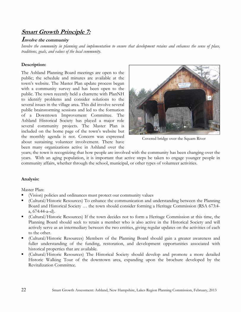
22 Smart Growth Assessment: Ashland, New Hampshire, Lakes Region Planning Commission, February, 2013
Smart Growth Principle 7: Involve the community Involve the community in planning and implementation to ensure that development retains and enhances the sense of place, traditions, goals, and values of the local community.
Description:
The Ashland Planning Board meetings are open to the public; the schedule and minutes are available at the town’s website. The Master Plan update process began with a community survey and has been open to the public. The town recently held a charrette with PlanNH to identify problems and consider solutions to the several issues in the village area. This did involve several public brainstorming sessions and led to the formation of a Downtown Improvement Committee. The Ashland Historical Society has played a major role several community projects. The Master Plan is included on the home page of the town’s website but the monthly agenda is not. Concern was expressed about sustaining volunteer involvement. There have been many organizations active in Ashland over the years; the town is recognizing that how people are involved with the community has been changing over the years. With an aging population, it is important that active steps be taken to engage younger people in community affairs, whether through the school, municipal, or other types of volunteer activities. Analysis: Master Plan: (Vision) policies and ordinances must protect our community values (Cultural/Historic Resources) To enhance the communication and understanding between the Planning
Board and Historical Society … the town should consider forming a Heritage Commission (RSA 673:4-a, 674:44-a–d).
(Cultural/Historic Resources) If the town decides not to form a Heritage Commission at this time, the Planning Board should seek to retain a member who is also active in the Historical Society and will actively serve as an intermediary between the two entities, giving regular updates on the activities of each to the other.
(Cultural/Historic Resources) Members of the Planning Board should gain a greater awareness and fuller understanding of the funding, restoration, and development opportunities associated with historical properties that are available.
(Cultural/Historic Resources) The Historical Society should develop and promote a more detailed Historic Walking Tour of the downtown area, expanding upon the brochure developed by the Revitalization Committee.
Covered bridge over the Squam River

Smart Growth Assessment: Ashland, New Hampshire, Lakes Region Planning Commission, February, 2013 23
Subdivision Regulations (5.2) As provided in RSA 676:4 II and prior to submission of a subdivision application, a subdivider may
meet with the Planning Board and engage in non-binding discussions in the following manner: [Good to have this placed at the beginning of the article.]
Site Plan Review Regulations Pre-application Consultation: Prior to submitting an application, a potential applicant may appear before
the Planning Board to informally discuss these regulations and their possible application to the proposed project. Such pre-application consultation shall bind neither the applicant nor the Planning Board nor its members. The Planning Board may waive the requirement for Site Plan Review according to Section 1.3G. [Good to include and good location in article.]
Recommendations: Consider posting the Planning Board agenda on the town website. (A&P)
Consider forming a Heritage Commission under RSA 673:4-a in order to carry out cultural and historical
inventories and advise the Planning Board on such issues. (A&P) Work with the Heritage Commission if one is formed to explore and promote the resources available
for restoration and other activities through the New Hampshire Division of Historical Resources. (A&P)
Ensure that there is communication between the Downtown Revitalization Committee and the Planning
Board. (A&P)

24 Smart Growth Assessment: Ashland, New Hampshire, Lakes Region Planning Commission, February, 2013
Smart Growth Principle 8: Manage growth locally Manage growth locally in the New Hampshire tradition, but work with neighboring towns to achieve common goals and address common problems more effectively.
Description:
Like many communities its size, Ashland provides many emergency services locally but does maintain mutual aid agreements with its neighbors to assist each other if a situation exceeds the local capacity. For a community the size of Ashland, the town provides its citizens with a remarkably wide variety of municipal services; it is particularly self-sufficient with regards to utilities. The community supports and is involved with a number of regional planning efforts including the Lakes Region Planning Commission and several regional land conservation organizations. Analysis: Master Plan: (Recreation) efforts should be made to work with surrounding towns for a regional plan to enhance
conservation and provide recreational opportunities around the lake and river corridor. Zoning Ordinance (9.4) Procedural Requirements for obtaining approval to install a wireless communication device. The
Town of Ashland Planning Board shall make all approvals of Communication Devices. I. Rights of Abutting Towns: Because the visual impact of wireless communication facilities can transcend town lines; the Town of Ashland shall formally notify all towns that may reasonably be visually affected of applications for such proposed Communication Towers. The applicant shall be responsible for the cost of this notice.
Subdivision & Site Plan Review Regulations None
Recommendations: While the town specifies in its zoning ordinance that in the case of wireless communication towers
abutting communities should be notified, no such provisions are made for other scenarios where neighboring communities might be impacted. Consider inserting language into the Procedures of Subdivision and Site Plan Review Regulations reminding the Planning Board to make a determination as to whether the proposal qualifies as a Development of Regional Impact (DRI) under RSA 36:54-57 and include this in the associated flowcharts. (Sub, SPR)
Maintain communication and involvement with neighboring communities on environmental issues,
development proposals, and other issues that could have mutual benefits. (A&P) The Planning Board and Conservation Commission should work to coordinate their land protection and
planning efforts with adjacent communities to ensure that such efforts are done effectively. (A&P) Consider greater involvement on regional transportation planning efforts through the Transportation
Technical Advisory Committee. (A&P)

Habitat/Natural Resource Topic Smart Growth Principle Agriculture and Productive Soils 4. Working landscape Energy Efficiency 1. Compact settlement patterns
5. Transportation choices and safety Floodplains 6. Environmental quality Forests and Forestry 4. Working landscape
6. Environmental quality Groundwater 6. Environmental quality
8. Work with neighboring towns Growth Management and Sprawl 1. Compact settlement patterns
2. Human scale of development 5. Transportation choices and safety
Impervious Surfaces 6. Environmental quality Landscaping and Natural Vegetation 6. Environmental quality Light Pollution 6. Environmental quality Natural Hazards 6. Environmental quality
8. Work with neighboring towns Shorelands, Surface Waters, and Wetlands 6. Environmental quality Steep Slopes and Ridgelines 6. Environmental quality
8. Work with neighboring towns Stormwater Management and Erosion Control 6. Environmental quality Terrain Alteration 6. Environmental quality Village District 1. Compact settlement patterns
2. Human scale of development 3. Mix of uses
Watersheds 6. Environmental quality 8. Work with neighboring towns
Wildlife Habitat 6. Environmental quality

Smart Growth Principle Habitat/Natural Resource Topic 1. Compact settlement patterns Energy Efficiency
Growth Management and Sprawl Village District
2. Human scale of development Growth Management and Sprawl Village District
3. Mix of uses Village District 4. Working landscape
Agriculture and Productive Soils Forests and Forestry
5. Transportation choices and safety Energy Efficiency Growth Management and Sprawl
6. Environmental quality Stormwater Management and Erosion Control Floodplains Forests and Forestry Groundwater Impervious Surfaces Landscaping and Natural Vegetation Light Pollution Natural Hazards Shorelands, Surface Waters, and Wetlands Steep Slopes and Ridgelines Terrain Alteration Watersheds Wildlife Habitat
7. Community involvement All 8. Work with neighboring towns Groundwater
Natural Hazards Steep Slopes and Ridgelines Watersheds

Coordinated Review of Land Use Planning Documents with respect to Wildlife Habitat, Natural Resources, and Smart Growth Principles: Ashland, NH
Introduction
History “Smart Growth” is a set of planning principles that guide communities toward mixed uses, greater development density in village centers, walkable, involved communities, and a working rural landscape with a healthy environment. The concept of Smart Growth has been around for many years, and in many ways is exemplified by the traditional New England village. In 2003 New Hampshire officially adopted eight Smart Growth Principles. Since 2006 the Lakes Region Planning Commission (LRPC) has been working with local planning boards throughout the region to conduct assessments of their planning documents with respect to these adopted Smart Growth Principles. From 2006 - 2008 these efforts by LRPC were funded through the NH Department of Environmental Resources, Resource and Environmental Protection Program (NH DES REPP). Historically, New Hampshire has depended on natural resources to support its economy – from forest products to agriculture to tourism. These resources also provide important ecological services and contribute to our quality of life. Aquifers, productive soils, flood storage areas, productive forest lands, and high quality wildlife habitat are not distributed evenly across the landscape. As development affects increasing areas of New Hampshire land, it becomes increasingly important to identify and protect the natural resource values on which our economy and quality of life depend. The N.H. Fish & Game Department completed the State’s first Wildlife Action Plan in 2005, with goals of restoring declining species and keeping common species common. Engaging municipalities in this effort is a critical component of the plan, since the vast majority of land use decisions are made at the local level. To that end, the Department contracted with the Audubon Society of New Hampshire (ASNH) and The Jordan Institute in 2007 to develop tools that would aid municipalities in efforts to protect important wildlife habitat and other natural resources. The process for reviewing land use planning documents with respect to wildlife habitat and natural resources is one of the products of that contract. The Jordan Institute has since focused their work on energy-efficient buildings, and ASNH has continued to adapt and apply the review process for communities across the State. LRPC and ASNH worked collaboratively with the town of Bristol in 2008, and the cities of Franklin and Laconia in 2009 to produce a “Coordinated Review of Land Use Planning Documents with respect to Wildlife Habitat, Natural Resources, and Smart Growth Principles,” with funding from NH DES REPP and the Samuel P. Pardoe Foundation. The Samuel P. Pardoe Foundation funded the entirety of reviews for the towns of Gilmanton in 2010-11 and Sandwich in 2011-12, and is the sole funder for this Smart Growth, Natural Resources, and Wildlife Habitat review for the Town of Ashland. We believe that the smart growth and natural resource reviews complement each other and provide an efficient and effective road map for improving the municipal planning process. The two tables that immediately follow this introduction illustrate the relationships between

the smart growth principles and the habitat and natural resource topics addressed in this document. Summary of Findings Most of the statements and recommendations put forth in Ashland’s recently updated Master Plan are consistent with the Smart Growth Principles. We encourage the use of land use planning tools which allow for flexibility and encourage responsible development both in the village area as well as in other areas of town. While Ashland already has some mixed uses in the village area, there are some constraints, so we encourage considering a Village Overlay District. We recommend that the town develop a plan for expansion of the sewer system that protects natural resources and makes efficient use of town infrastructure, yet does not encourage scattered, sprawling development. The town has a Cluster Subdivision provision; we make some recommendations that could both strengthen and encourage wider utilization of this important tool. Several recommendations address connectivity of streets and sidewalks in the village area. We also suggest tools that the town could use to encourage revitalization of some buildings in the village as well as historic barns. Ashland has several policies to protect the Town’s natural resources, including a Floodplain Development Ordinance, and the Pemigewasset and Squam overlay districts. Several recommendations from the Wildlife Habitat and Natural Resources review echo those from the Smart Growth Review, such as adopting a village district, taking steps to protect agricultural lands, enacting a groundwater protection ordinance, and converting the Cluster Subdivision Provision to a Conservation Subdivision Ordinance, with such subdivisions permitted by right. We strongly support the Master Plan recommendation for developing design standards and guidelines, and encourage the inclusion of standards and guidelines for stormwater management, landscaping, and outdoor lighting. We also recommend requiring pre-application discussions for both subdivisions and site plans, at least in areas with important natural resources. Pre-application meetings provide the opportunity to identify important resources on a parcel and determine appropriate strategies for their protection before survey and engineering investments commit a developer to a specific site plan or subdivision layout. Completion of a Natural Resources chapter of the Master Plan will provide critical guidance for developing policies to protect the Town’s natural resources. Document Description This report is divided into several sections: Sections Two, Three, and Four address Smart Growth in Ashland, Five and Six address Wildlife Habitat and Natural Resources; Seven synthesizes recommendations from the two assessments, and Eight provides voluntary practices to protect wildlife habitat features and a supplementary list of resources. The CD version of this document provides additional information in Section Eight, including the Colorado State Forest Service’s “Firewise Construction Design and Materials,” North Carolina State University’s “Firewise Landscaping in North Carolina,” excavation regulations from Belmont and Northfield, Concord’s Cluster Development ordinance, a model dark skies ordinance, a model wind ordinance from Pennsylvania, and the New Ipswich wind ordinances. How to use this document The intended use of this document is two-fold. Firstly, it should serve as reference for community leaders as they review and revise municipal planning documents with such

questions as, “Are we working towards Smart Growth and doing the best we can to protect our natural resources?” and “Are our land use planning documents consistent with one another?” This should also be a “living document” - as policies are adopted and documents revised, these changes should be noted in this binder. This document is intended to be a resource, and contains references to additional resources and model ordinances. In particular, we refer frequently to Innovative Land Use Planning Techniques: A Handbook for Sustainable Development. This reference, published in 2008 by the NH Department of Environmental Services, NH Association of Regional Planning Commissions, NH Office of Energy and Planning, and NH Municipal Association, is a critical reference for New Hampshire planning boards. We also strongly recommend use of Integrated Landscaping: Following Nature’s Lead to advise developers on landscaping strategies. We also provide links to pertinent information available on the worldwide web. In the end, however, there is no substitute for direct assistance and advice. Sandwich is fortunate to have a large number of active Planning Board members with a range of experiences and talents. The town can also draw upon the Lakes Region Planning Commission for assistance in drafting changes to ordinances and regulations.

Spatial Analysis of Important Natural Resources in Ashland with respect to Current Zoning
1
Review of Land Use Planning Documents for Ashland, New Hampshire with respect to Wildlife Habitat and Natural Resource Protection, Audubon Society of New Hampshire, February 2013
Spatial Analysis of Important Natural Resources in Ashland with respect to Current Zoning
Introduction
Maps provide useful tools for understanding the distribution of important natural resources on the landscape and how current zoning supports or hinders their protection. Several tools have been developed to help municipalities assess the spatial distribution of natural resources within their boundaries. The New Hampshire Natural Services Network (NSN) is a GIS-based tool created by a collaborative of planning and natural resource professionals. The NSN identifies lands throughout the State that provide important ecological services on which human life and economic opportunity depend, and which are difficult and expensive to replicate. Natural Services Network base maps (Figure 1) include four components:
Water supply lands include highly transmissive aquifers identified by the US Geological Survey and favorable gravel well sites identified by the NH Department of Environmental Services.
Flood storage lands include 100-year floodplains identified by FEMA and lacustrine (associated with lakes), riverine (associated with rivers), and palustrine (other non-tidal) wetlands identified by the USFWS National Wetlands Inventory.
Productive soils include prime farmland and farmland of statewide importance identified by the
Natural Resource Conservation Service.
Highly ranked wildlife habitat includes areas of highest ranked habitat by ecological condition in the State and within each of the State’s nine ecoregions, as identified by the NH Fish & Game Department Wildlife Action Plan. A detailed explanation of the ranking process is provided at http://www.wildlife.state.nh.us/Wildlife/Wildlife_Plan/highest_ranking_habitat.htm.
The NH Wildlife Connectivity Model was developed in 2008 by NH Audubon and NH Fish & Game biologists. It is a basic GIS-based landscape permeability model that predicts potential broad-scale wildlife connectivity zones across the State. The model includes a set of raster data layers consisting of cost surfaces for 16 native wildlife species, chosen to represent a range of variation in their dispersal behavior. Each raster surface was created by assigning a "cost" value for each species on each 30 meter square of land. The cost value reflects the ease or difficulty of moving across the landscape for the species in question. Cost is based on land cover, distance to road (weighted for traffic volume), distance to riparian area, and slope. The 16 cost surfaces can be used individually or in combination to identify wildlife connectivity zones by determining least cost movement corridors between selected polygons. The mean cost surface (Figure 2), which averages cost values for the 16 species, is useful for general planning purposes. It is strongly encouraged that users incorporate best available local data sources wherever possible and ground-truth results of corridor analyses, which is essential for identifying critical connectivity zones. Ashland currently has four zoning districts (Figure 3). The Rural/Residential District is the largest (6,633 acres) and includes most of the Town. The Village Residential District (197 acres in total) is located in the southwest quadrant of the Town on both sides of the Squam River. The Commercial District (84 acres in total) includes two areas of 25 and 59 acres, respectively, in the southwestern quadrant. The Industrial/Commercial District (279 acres in total) includes a 263-acre area between the Pemigewasset River and Interstate 93 along the southwestern boundary of the Town and three smaller areas of three to seven

Spatial Analysis of Important Natural Resources in Ashland with respect to Current Zoning
2
Review of Land Use Planning Documents for Ashland, New Hampshire with respect to Wildlife Habitat and Natural Resource Protection, Audubon Society of New Hampshire, February 2013
acres adjacent to the Village Residential and Commercial districts. In addition, the Pemigewasset and Squam overlay districts encompass 686 and 358 acres, respectively, associated with these water bodies. Data Sources
Data layer Source Ashland Zoning 2008 Lakes Regional Planning Commission NH Natural Services Network GRANIT NH Wildlife Connectivity Model mean cost surface NH Fish & Game Department
NH Conservation/Public Lands GRANIT Methods Using ArcView software, we overlaid the Ashland zoning districts on each component of the New Hampshire Natural Services Network and calculated resource areas within each zoning district. We used the mean cost surface from the Wildlife Connectivity Model to evaluate connectivity zones at the regional and local scales. For the regional assessment, we used contiguous conservation land polygons associated with the Green Acres conservation easement (Plymouth), Burleigh Tract/Owl Brook Training Facility/Science Center of New Hampshire (Holderness), and the Hersey Mountain conservation lands (New Hampton/Sanbornton) as endpoints for the analysis. For the local assessment, we used contiguous conservation polygons associated with the Church Hill Wildlife Management Area, Glidden Forest Conservation Easement, Stevens and Newsom Memorial forests, Preston tract of the Lakes Region Conservation Trust, and the Scribner-Fellows State Forest. Appendix A lists the various parcels associated with each of the endpoint polygons used in these analyses. Results and Discussion Water supply lands Ashland encompasses approximately 245 acres of water supply lands (highly transmissive aquifers), 80% of which is in the Industrial/Commercial District (Table 1, Figure 4). The 1,433 -acre aquifer associated with the Pemigewasset River that underlies parts of Ashland, Bridgewater, New Hampton, and Plymouth is the only highly transmissive aquifer in Ashland. Total aquifer area (including areas of intermediate transmissivity) within Ashland is approximately 1,720 acres. While 560 acres are within wellhead protection areas, none of Ashland’s aquifers are currently protected by conservation ownership or easement. Table 1. Distribution of Water Supply Lands across Ashland Zoning Districts
Zoning District Acres of water supply landsRural Residential District 32 Village Residential District 0 Industrial/Commercial District 196 Commercial District 0 Open water* 17 Pemigewasset Overlay District 200 Squam Overlay District 0
* The Ashland Zoning Districts do not include open water.
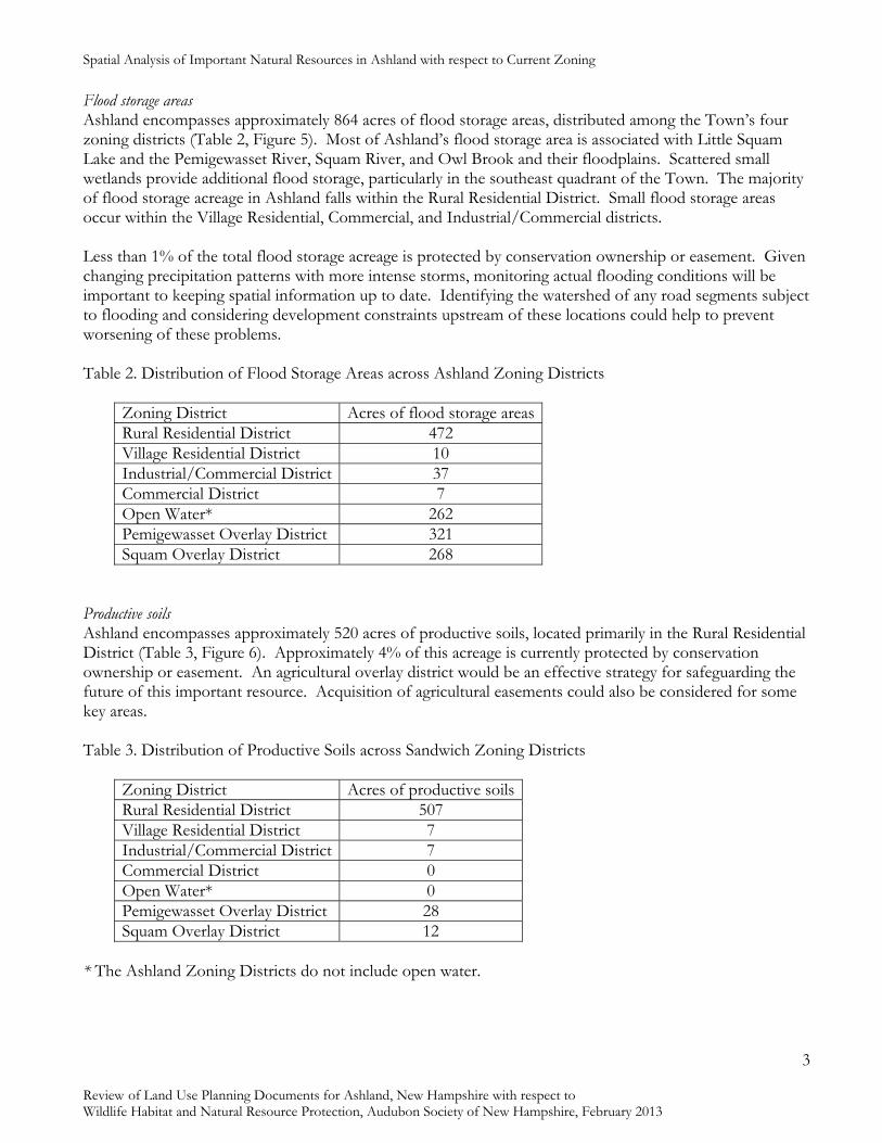
Spatial Analysis of Important Natural Resources in Ashland with respect to Current Zoning
3
Review of Land Use Planning Documents for Ashland, New Hampshire with respect to Wildlife Habitat and Natural Resource Protection, Audubon Society of New Hampshire, February 2013
Flood storage areas Ashland encompasses approximately 864 acres of flood storage areas, distributed among the Town’s four zoning districts (Table 2, Figure 5). Most of Ashland’s flood storage area is associated with Little Squam Lake and the Pemigewasset River, Squam River, and Owl Brook and their floodplains. Scattered small wetlands provide additional flood storage, particularly in the southeast quadrant of the Town. The majority of flood storage acreage in Ashland falls within the Rural Residential District. Small flood storage areas occur within the Village Residential, Commercial, and Industrial/Commercial districts. Less than 1% of the total flood storage acreage is protected by conservation ownership or easement. Given changing precipitation patterns with more intense storms, monitoring actual flooding conditions will be important to keeping spatial information up to date. Identifying the watershed of any road segments subject to flooding and considering development constraints upstream of these locations could help to prevent worsening of these problems. Table 2. Distribution of Flood Storage Areas across Ashland Zoning Districts
Zoning District Acres of flood storage areasRural Residential District 472 Village Residential District 10 Industrial/Commercial District 37 Commercial District 7 Open Water* 262 Pemigewasset Overlay District 321 Squam Overlay District 268
Productive soils Ashland encompasses approximately 520 acres of productive soils, located primarily in the Rural Residential District (Table 3, Figure 6). Approximately 4% of this acreage is currently protected by conservation ownership or easement. An agricultural overlay district would be an effective strategy for safeguarding the future of this important resource. Acquisition of agricultural easements could also be considered for some key areas. Table 3. Distribution of Productive Soils across Sandwich Zoning Districts
Zoning District Acres of productive soilsRural Residential District 507 Village Residential District 7 Industrial/Commercial District 7 Commercial District 0 Open Water* 0 Pemigewasset Overlay District 28 Squam Overlay District 12
* The Ashland Zoning Districts do not include open water.

Spatial Analysis of Important Natural Resources in Ashland with respect to Current Zoning
4
Review of Land Use Planning Documents for Ashland, New Hampshire with respect to Wildlife Habitat and Natural Resource Protection, Audubon Society of New Hampshire, February 2013
Highly ranked wildlife habitat Ashland encompasses approximately 890 acres of highly ranked wildlife habitat, distributed among the Town’s five zoning districts (Table 4, Figure 7). Approximately 2% of highly ranked wildlife habitat in Ashland is currently protected by conservation ownership or easement. Table 4. Distribution of Highly Ranked Wildlife Habitat across Sandwich Zoning Districts
Zoning District Acres of highly ranked wildlife habitatRural Residential District 536 Village Residential District 7 Industrial/Commercial District 114 Commercial District 13 Open Water* 217 Pemigewasset Overlay District 266 Squam Overlay District 304
Wildlife connectivity zones Approximately 2,400 acres of potential wildlife connectivity zones exist in Ashland. Local connectivity zones criss-cross the central and southern parts of the Town, connecting four large areas of protected land (Figure 9, Table 5). Keeping these connectivity zones in mind , particularly at their intersections with routes 3, 25, and 132, will ensure that wildlife can continue to move safely through Ashland as the Town continues to grow. Regional connectivity zones cross east-west in the northern part of the Town, connecting large tracts of protected land in Plymouth and Holderness, and northeast-southwest in the southeastern part of the Town, connecting large protected areas in Holderness and New Hampton/Sanbornton (Figure 10, Table 5).
Table 5. Distribution of Local and Regional Wildlife Connectivity Zones across Ashland Zoning Districts
Zoning District Acres of wildlife connectivity zones Total (Local; Regional)Rural Residential District 2,279 (1,157;1,122) Village Residential District 8 (8,0) Industrial/Commercial District 16 (16,0) Commercial District 32 (32,0) Open Water* 97 (97,0)
Considerations
Figure 9 illustrates water supply lands, flood storage areas, productive soils, and highly ranked wildlife habitat in Ashland. The northwest corner of the Town includes overlapping flood storage area, highly productive soils, and highly ranked wildlife habitat. The Town might consider designing a natural resource overlay district for this area to protect its various functions and values. The location of the majority of Ashland’s Industrial/Commercial district over the Town’s only highly transmissive aquifer deserves thoughtful consideration. While portions of the Town’s aquifers are in well-head protection zones, much of the aquifer area, including a significant portion of the most highly

Spatial Analysis of Important Natural Resources in Ashland with respect to Current Zoning
5
Review of Land Use Planning Documents for Ashland, New Hampshire with respect to Wildlife Habitat and Natural Resource Protection, Audubon Society of New Hampshire, February 2013
transmissive aquifer, are unprotected. The Town may want to consider strategies for increasing aquifer protection during the master planning process. Productive soils are not abundant in Ashland, but occur in a number of sizeable patches. Action now, such as acquisition of easements or adoption of an agricultural overlay zone, can ensure protection of these resources for future generations. A number of regulatory tools exist that could strengthen natural resource protection in Ashland. The functions of some tools overlap with those of others, so careful consideration will be needed to select the best combination of tools and resources to effectively meet the Town’s needs.

Spatial Analysis of Important Natural Resources in Ashland with respect to Current Zoning
6
Review of Land Use Planning Documents for Ashland, New Hampshire with respect to Wildlife Habitat and Natural Resource Protection, Audubon Society of New Hampshire, February 2013

Spatial Analysis of Important Natural Resources in Ashland with respect to Current Zoning
7
Review of Land Use Planning Documents for Ashland, New Hampshire with respect to Wildlife Habitat and Natural Resource Protection, Audubon Society of New Hampshire, February 2013

Spatial Analysis of Important Natural Resources in Ashland with respect to Current Zoning
8
Review of Land Use Planning Documents for Ashland, New Hampshire with respect to Wildlife Habitat and Natural Resource Protection, Audubon Society of New Hampshire, February 2013

Spatial Analysis of Important Natural Resources in Ashland with respect to Current Zoning
9
Review of Land Use Planning Documents for Ashland, New Hampshire with respect to Wildlife Habitat and Natural Resource Protection, Audubon Society of New Hampshire, February 2013

Spatial Analysis of Important Natural Resources in Ashland with respect to Current Zoning
10
Review of Land Use Planning Documents for Ashland, New Hampshire with respect to Wildlife Habitat and Natural Resource Protection, Audubon Society of New Hampshire, February 2013

Spatial Analysis of Important Natural Resources in Ashland with respect to Current Zoning
11
Review of Land Use Planning Documents for Ashland, New Hampshire with respect to Wildlife Habitat and Natural Resource Protection, Audubon Society of New Hampshire, February 2013

Spatial Analysis of Important Natural Resources in Ashland with respect to Current Zoning
12
Review of Land Use Planning Documents for Ashland, New Hampshire with respect to Wildlife Habitat and Natural Resource Protection, Audubon Society of New Hampshire, February 2013

Spatial Analysis of Important Natural Resources in Ashland with respect to Current Zoning
13
Review of Land Use Planning Documents for Ashland, New Hampshire with respect to Wildlife Habitat and Natural Resource Protection, Audubon Society of New Hampshire, February 2013

Spatial Analysis of Important Natural Resources in Ashland with respect to Current Zoning
14
Review of Land Use Planning Documents for Ashland, New Hampshire with respect to Wildlife Habitat and Natural Resource Protection, Audubon Society of New Hampshire, February 2013

Spatial Analysis of Important Natural Resources in Ashland with respect to Current Zoning
15
Review of Land Use Planning Documents for Ashland, New Hampshire with respect to Wildlife Habitat and Natural Resource Protection, Audubon Society of New Hampshire, February 2013
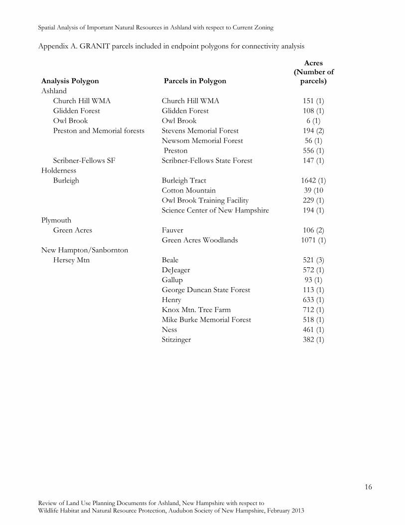
Spatial Analysis of Important Natural Resources in Ashland with respect to Current Zoning
16
Review of Land Use Planning Documents for Ashland, New Hampshire with respect to Wildlife Habitat and Natural Resource Protection, Audubon Society of New Hampshire, February 2013
Appendix A. GRANIT parcels included in endpoint polygons for connectivity analysis
Analysis Polygon Parcels in Polygon
Acres (Number of
parcels) Ashland Church Hill WMA Church Hill WMA 151 (1) Glidden Forest Glidden Forest 108 (1) Owl Brook Owl Brook 6 (1) Preston and Memorial forests Stevens Memorial Forest 194 (2) Newsom Memorial Forest 56 (1) Preston 556 (1) Scribner-Fellows SF Scribner-Fellows State Forest 147 (1) Holderness Burleigh Burleigh Tract 1642 (1) Cotton Mountain 39 (10 Owl Brook Training Facility 229 (1) Science Center of New Hampshire 194 (1) Plymouth Green Acres Fauver 106 (2) Green Acres Woodlands 1071 (1) New Hampton/Sanbornton Hersey Mtn Beale 521 (3) DeJeager 572 (1) Gallup 93 (1) George Duncan State Forest 113 (1) Henry 633 (1) Knox Mtn. Tree Farm 712 (1) Mike Burke Memorial Forest 518 (1) Ness 461 (1) Stitzinger 382 (1)

Summary of Recommendations
Review of Land Use Planning Documents for Ashland, New Hampshire with respect to Wildlife Habitat and Natural Resource Protection, Audubon Society of New Hampshire, February 2013
1
Summary of Recommendations
This section of the report consolidates recommendations from both the Smart Growth Assessment and the Wildlife Habitat and Natural Resource review. The first group of recommendations pertains to potential revisions of land use planning documents, and is organized by document. The second group of recommendations pertains to actions and policies that could be undertaken by Town government, including the Select Board, Planning Board, Conservation Commission, and Department of Public Works. Before implementing any of the following recommendations, it is critically important to refer back to the previous sections, which provide detailed information and justifications. (References to pertinent smart growth principles and natural resource topics are provided at the end of each recommendation.)
Category Page Document Revisions
Master Plan 2 Hazard Mitigation Plan 5 Zoning Ordinance 6 Subdivision Regulations 9 Site Plan Review Regulations 11
Actions and Policies 14

Summary of Recommendations
Review of Land Use Planning Documents for Ashland, New Hampshire with respect to Wildlife Habitat and Natural Resource Protection, Audubon Society of New Hampshire, February 2013
2
Document Revisions
Master Plan Vision Statement
• Consider adding language to the Vision that specifically addresses energy efficiency. (Energy Efficiency)
Chapter One: Land Use
• Consider recommending adoption of an overlay district to protect the Town’s productive soils and active agricultural lands. Consider exploring incentives for maintaining active agriculture. (Agriculture and Productive Soils)
• Consider including land use regulations, including maximum setbacks and driveway lengths, as a mitigation strategy for wildland fires. (Natural Hazards)
• Consider recommending acquisition of town forest land with Land Use Change Tax funds to provide a future income stream from sustainable harvesting, as well as local recreational opportunities. (Forests and Forestry)
• Consider recommending creation of a mixed use Village District in the downtown area. (Growth Management and Sprawl, Village District, Principle 1, 3)
• Consider including a recommendation to adopt land use policies that manage cumulative impacts of land use within a watershed. (Watersheds)
Chapter Two: Transportation
• Consider recommending adoption of design standards and guidelines that include limitations on impervious surfaces. (Impervious Surfaces)
Chapter Three: Demographics and Housing
• Consider including energy efficiency actions to the Demographics and Housing section. (Energy Efficiency)
• Consider recommending creation of a mixed use Village District in the downtown area. (Growth Management and Sprawl, Village District, Principle 1, 3)

Summary of Recommendations
Review of Land Use Planning Documents for Ashland, New Hampshire with respect to Wildlife Habitat and Natural Resource Protection, Audubon Society of New Hampshire, February 2013
3
Chapter Four: Natural Resources
• Consider addressing o agriculture and productive soils o flood storage areas o forest resources o groundwater resources o shorelands, surface waters, and wetlands o terrain alteration o watersheds o wildlife habitat
in a Natural Resources chapter. (Agriculture and Productive Soils; Floodplains; Forests and Forestry; Groundwater; Shorelands, Surface Waters, and Wetlands; Watersheds; Wildlife Habitat)
• Consider adopting goals/objectives such as: o Review and revise local policies and regulations to minimize destruction of
natural vegetation during construction activities. o Review and revise local policies and regulations to encourage the use of native
species in landscaping. o Review and revise local policies and regulations to discourage the use of plants
that require significant inputs of water and nutrients in landscaping. o Encourage landscaping designs that reduce heating and cooling costs.
(Landscaping and Natural Vegetation)
• Consider encouraging conservation ownership or easements on floodplain areas. (Floodplains)
• Consider recommending adoption of Excavation Regulations. (Terrain Alteration)
• Consider recommending adoption of an aquifer protection overlay district. (Groundwater)
• Consider including a recommendation to work with adjacent towns to protect shared aquifers. (Groundwater)
• Consider adopting a goal pertaining to dark sky preservation. (Light Pollution)
• Consider including natural resource protection strategies, including sediment and erosion control, watershed management, and wetland protection as mitigation strategies for flooding. (Natural Hazards)
• Consider recommending collaboration in regional efforts to protect the Pemigewasset and Squam watersheds. (Watersheds)
• Consider recommending protection for wetlands and headwater streams to maintain downstream water quality. (Shorelands, Surface Waters, and Wetlands)

Summary of Recommendations
Review of Land Use Planning Documents for Ashland, New Hampshire with respect to Wildlife Habitat and Natural Resource Protection, Audubon Society of New Hampshire, February 2013
4
• Consider recommending greater protection of steep slopes. (Steep Slopes and Ridgelines)
• Consider recommending adoption of policies to minimize the extent of terrain alteration associated with development. (Terrain Alteration)
• Consider recommending adoption of an overlay district to protect the Town’s
productive soils and active agricultural lands. (Agriculture and Productive Soils)
• Consider exploring incentives for maintaining active agriculture. (Agriculture and Productive Soils)
• Consider identifying local priorities for open space protection that include core areas of wildlife habitat. (Wildlife Habitat)
• Consider recommending strategies to maintain wildlife connectivity zones within the
Town. (Wildlife Habitat)
Chapter Six: Community Facilities
• Consider recommending review of the current system for handling municipal stormwater to evaluate its capacity and environmental impacts on receiving waters. (Stormwater Management and Erosion Control)
Potential New Sections
• Consider including an Energy Chapter. (Energy Efficiency)

Summary of Recommendations
Review of Land Use Planning Documents for Ashland, New Hampshire with respect to Wildlife Habitat and Natural Resource Protection, Audubon Society of New Hampshire, February 2013
5
Hazard Mitigation Plan
Recommendations
• Consider including information about firewise landscaping, practices, and building materials in materials distributed to promote fire protection. (Forests and Forestry, Natural Hazards)
• Consider including areas most vulnerable to wildfire on the map of natural hazards in the Hazard Mitigation Plan. (Natural Hazards)
• Consider including land use regulations, including maximum setbacks and driveway lengths, as a mitigation strategy for wildland fires. (Natural Hazards)
• Consider including natural resource protection strategies, including sediment and erosion control, watershed management, and wetland protection as mitigation strategies for flooding. (Natural Hazards)

Summary of Recommendations
Review of Land Use Planning Documents for Ashland, New Hampshire with respect to Wildlife Habitat and Natural Resource Protection, Audubon Society of New Hampshire, February 2013
6
Zoning Ordinance
Article One: Purpose and Authority
• Consider amending the Purpose language (Article 1.1) to include protection of natural resources. (Agriculture and Productive Soils; Floodplains; Forests and Forestry; Groundwater; Shorelands, Surface Waters, and Wetlands; Steep Slopes and Ridgelines; Watersheds; Wildlife Habitat)
Article Two: Zones and Zone Regulations
• Consider including a maximum percentage of lot covered by impervious surfaces in the Commercial area. (Principle 2)
• Consider developing Land and Space Requirements (Article 2.3) to encourage infill
development in the Village Zone. (Growth Management and Sprawl, Village District)
• Consider adopting maximum setback from the edge of any public right of way for
buildings in the Rural Residential Zone (Articles 2.3a, c) to minimize forest fragmentation effects and reduce risks from wildland fires. (Natural Hazards, Forests and Forestry, Wildlife Habitat)
• Consider adopting a Right to Farm provision. (Agriculture and Productive Soils)
• Consider prohibiting impervious driveways and parking lots in the Pemigewasset and
Squam overlay districts. (Impervious Surfaces)
• Consider expanding the Squam Overlay district to 500 ft. within the Rural Residential District. (Shorelands, Surface Waters, and Wetlands, Watersheds)
• Consider providing buffer protection for wetlands and headwater streams.
• Consider encouraging Cluster Development by adopting density incentives (Principle 1)
Article Three: General Provisions
• Consider adopting parking guidelines to clarify the meaning of ‘adequate parking'. (Principle 5)
• Consider including parking maximums in the parking guidelines noted above to reduce the amount of pavement. (Principle 5, Impervious Surfaces)
• Consider adopting lighting performance standards for all zoning districts. See “Preserving Dark Skies” (3.4) in Innovative Land Use Planning Techniques: A Handbook for

Summary of Recommendations
Review of Land Use Planning Documents for Ashland, New Hampshire with respect to Wildlife Habitat and Natural Resource Protection, Audubon Society of New Hampshire, February 2013
7
Sustainable Development. And The New England Light Pollution Advisory Group (NELPAG) provides model language for an outdoor lighting ordinance to address light pollution, successful ordinances in Kennebunkport, ME, Tucson, AZ, and Cloudcroft, NM, and other useful information pertaining to light pollution. (www.icq.eps.harvard.edu/nelpag/nelpag.html) for ideas. (Light Pollution)
Article Four: Special Provisions
• Consider updating the description of Home Occupation advertising limits to address internet advertising. (Principle 3)
• Consider modifying the determination of parking spaces associated with home occupations. (Principle 3)
• Consider limiting where sewer expansion will be permitted. (Principle 6)
Article Ten: Definitions
• Consider including “Steep Slopes” and reducing threshold to 15%. (Steep Slopes and Ridgelines)
• Consider including “Impervious Surface.” (Principle 6, Impervious Surfaces)
• Consider redefining Cluster Subdivision as Conservation Subdivision. (Principle 6)
Potential New Articles
• Consider revising cluster subdivision regulations as recommended in the Master Plan, by converting to a conservation subdivision ordinance. (Wildlife Habitat, Forests and Forestry, Principle 6)
• Consider a Village Overlay District to permit more mixed uses throughout more of the downtown, including the Village Residential zone. (Growth Management and Sprawl, Village District, Principles 1, 3)
• Consider adopting a groundwater protection ordinance or aquifer protection overlay
district to strengthen the protections against harmful substances getting into the large aquifer that reaches into several parts of Ashland. (Principle 6, Groundwater)
• Consider adopting an ordinance to address impervious surfaces as suggested in the Hazard Mitigation Plan. (Impervious Surfaces)
• Consider adopting a stormwater ordinance. (Principle 6, Stormwater Management and Erosion Control)
• Consider adopting an agricultural overlay district ordinance to protect the Town’s productive soils and active agricultural lands. (Agricultural Lands and Productive Soils)

Summary of Recommendations
Review of Land Use Planning Documents for Ashland, New Hampshire with respect to Wildlife Habitat and Natural Resource Protection, Audubon Society of New Hampshire, February 2013
8
• Consider adopting a Steep Slopes ordinance or overlay district.
• Consider establishing a Forest Conservation District, with a larger (e.g., 20- to 50- acre) minimum lot size, in areas of large unfragmented blocks. (Wildlife Habitat)
• Consider adopting overlay districts to address wildland fire hazard areas. (Natural Hazards)

Summary of Recommendations
Review of Land Use Planning Documents for Ashland, New Hampshire with respect to Wildlife Habitat and Natural Resource Protection, Audubon Society of New Hampshire, February 2013
9
Subdivision Regulations
Article One: Introduction
• Consider amending the Introduction (Article 1) to add a Purpose section that includes encouraging energy efficiency and protecting important natural resources, including agricultural lands and productive soils, floodplains, stratified drift aquifers, shorelands, wetlands and surface waters, unfragmented forests blocks, and wildlife habitat. (Agriculture and Productive Soils; Forests and Forestry; Energy Efficiency; Groundwater; Floodplains; Shorelands, Surface Waters and Wetlands; Wildlife Habitat)
Article Two: General Requirements for the Subdivision of Land
• Consider including a Guideline that street lighting is not required but where provided may not cause sky glow or glare onto adjacent properties. (Light Pollution)
• Insert language into the subdivision and site plan regulations addressing pedestrian connectivity with neighboring structures. (Principle 2)
• Consider incorporating incentives into the subdivision process for applications that preserve linkages between habitats. (Principle 6, Wildlife Habitat)
• Consider providing the board and applicant with specific suggestions of erosion and
sedimentation control methods. (Principle 6, Stormwater Management and Erosion Control)
• Consider including a provision that subdivision layouts shall be designed to maximize the efficiency of the road network and minimize impervious surfaces. (Impervious Surfaces)
• Consider encouraging Cluster Development by adopting density incentives. (Principle 1)
• Consider including community gardens in the uses of open space within cluster subdivisions. (Agriculture and Productive Soils)
• Consider adopting special standards for subdivisions in the Rural/Residential district (or in identified wildland fire hazard areas) to minimize the possibility of wildland fires involving structures and structural fires involving wildlands. (Natural Hazards)
• Consider requiring a stormwater management plan for all subdivisions, or those exceeding a threshold number of lots. (Stormwater Management and Erosion Control)
• Consider instructing applicants to show wetland boundaries delineated by a wetland
soil scientist on the plat. (Principle 6, Shorelands, Surface Waters, and Wetlands)
• Consider instructing applicants to identify other natural or historic features on the plat. (Principle 6)

Summary of Recommendations
Review of Land Use Planning Documents for Ashland, New Hampshire with respect to Wildlife Habitat and Natural Resource Protection, Audubon Society of New Hampshire, February 2013
10
Article Three: Street Design and Construction
• Consider requiring road connectivity in subdivisions to make efficient use of town resources. The more development that is permitted along “non-interconnected” roads, the more pressure is placed on municipal services. Additionally, the Planning Board could work with the Police and Fire Departments to incorporate elements of the Crime Prevention Through Environmental Design1 into the planning process. Many of these elements are consistent with Smart Growth Principles. (Principle 5)
Article Five: Subdivision Procedures and Requirements
• Consider instructing applicants to show wetland boundaries delineated by a wetland soil scientist on the plat. (Principle 6, Shorelands, Surface Waters, and Wetlands)
• Consider instructing applicants to identify other natural or historic features on the plat. (Principle 6)
• Consider incorporating incentives into the subdivision process for applications that
preserve linkages between habitats. (Principle 6, Wildlife Habitat) • Consider including Determination of Regional Impact for all proposals in Procedures
of Subdivision and Site Plan Review Regulations and in the associated flowcharts. (Principle 8)
• Consider requiring Preliminary Conceptual Consultation in the general procedure for
subdivisions, as recommended in the Master Plan, and including; o wildland fire risk o energy conservation o soils subject to frequent or occasional flooding and lands below the 1% flood
frequency (100-year flood) elevation o the location of stratified drift aquifers o steep slopes o highly ranked wildlife habitat and unfragmented forest blocks o shorelands, surface waters, and wetlands
among the topics for discussion. (Natural Hazards; Energy Efficiency; Floodplains; Groundwater; Steep Slopes and Ridgelines; Wildlife Habitat)
• Consider including in the preliminary subdivision layout requirements: o active agricultural lands o stratified drift aquifers o slopes in excess of 25% and slopes of 15-25%, o soils subject to frequent or occasional flooding o wetlands and soils subject to frequent or occasional flooding.
(Agriculture and Productive Soils; Groundwater; Steep Slopes and Ridgelines; Floodplains; Shorelands, Surface Waters, and Wetlands)
1 Information http://www.crimewise.com/library/cpted.html, Training http://www.cptedtraining.net/ (Accessed January 15, 2013).

Summary of Recommendations
Review of Land Use Planning Documents for Ashland, New Hampshire with respect to Wildlife Habitat and Natural Resource Protection, Audubon Society of New Hampshire, February 2013
11
• Consider requiring cut and fill volumes in Subdivision Layouts. (Terrain Alteration) • Consider converting cluster subdivision regulations to a Conservation Subdivision
Ordinance . (Forests and Forestry, Growth Management and Sprawl, Principle 6)
• Consider developing a set of design standards for development that includes limitations on impervious surfaces. (Impervious Surfaces)
• Consider adopting landscaping standards and guidelines. (Landscaping and Natural Vegetation)
• Consider requiring that boundaries of wetland and shoreland buffers be permanently marked to facilitate awareness of future landowners. (Shorelands, Surface Waters, and Wetlands)
• Consider requesting identification and protection of special habitats such as vernal
pools, deer wintering areas, and important mast stands in subdivision layouts. (Wildlife Habitat)
• Consider adopting special standards for identified wildlife connectivity zones. Such standards could include maintenance of open space connectivity and stream crossing structures (e.g., culverts) that provide for wildlife passage. (Wildlife Habitat)
• Consider requiring sloped (Cape Cod) curbing where curbing is required. Sloped curbing prevents small animals from becoming trapped in the roadway. (Wildlife Habitat)
• Consider adopting design standards for erosion control measures. (Stormwater Management and Erosion Control)
• Consider adopting design standards for stormwater management devices. (Stormwater
Management and Erosion Control) Article Seven: Definitions
• Consider revising definition of Shore Frontage (Article 7) to “the average of the distances of the actual natural navigable shoreline footage and a straight line drawn between property lines, both of which are measured at the normal high water line” to conform to the NH Code of Administrative Rules. (Shorelands, Surface Waters, and Wetlands)
• Consider including wetland soils in Definitions. (Shorelands, Surface Waters, and Wetlands)

Summary of Recommendations
Review of Land Use Planning Documents for Ashland, New Hampshire with respect to Wildlife Habitat and Natural Resource Protection, Audubon Society of New Hampshire, February 2013
12
Site Plan Review Regulations
Article One: Introduction
• Consider amending the Purpose language (Article 1.2) to include encouraging energy efficiency and protecting important natural resources, including agricultural lands and productive soils, floodplains, stratified drift aquifers, shorelands, wetlands and surface waters, unfragmented forests blocks, and wildlife habitat. (Agriculture and Productive Soils; Forests and Forestry; Energy Efficiency; Groundwater; Floodplains; Shorelands, Surface Waters and Wetlands; Wildlife Habitat)
• Consider encouraging Cluster Development by adopting density incentives. (Principle 1)
Article Two: Standards
• Consider including a provision that access, parking, and loading areas shall be designed and constructed so as to minimize impervious surfaces. (Impervious Surfaces)
• Consider amending the outdoor lighting design standard to also prohibit sky glow. (Light Pollution)
• Insert language into the subdivision and site plan regulations addressing pedestrian connectivity with neighboring structures. (Principle 2)
• Consider requiring landscaping standards in the village area that would require/encourage the retention/planting of substantial trees and shrubs. (Principle 2, Landscaping and Natural Vegetation)
• Consider providing the board and applicant with specific suggestions of erosion and
sedimentation control methods. (Principle 6, Stormwater Management and Erosion Control)
• Consider requiring that lighting not only be limited to the premises but also be downward facing. (Principle 6)
• Consider instructing applicants to show wetland boundaries delineated by a wetland
soil scientist on the plat. (Principle 6, Shorelands, Surface Waters, and Wetlands)
• Consider instructing applicants to identify other natural or historic features on the plat. (Principle 6)
Article Three: Application
• Consider requiring Pre-application Consultation in the general procedure for site plans, as recommended in the Master Plan, and including:
o presence of agricultural lands and productive soils o soils subject to frequent or occasional flooding and lands below the 1% flood
frequency (100-year flood) elevation

Summary of Recommendations
Review of Land Use Planning Documents for Ashland, New Hampshire with respect to Wildlife Habitat and Natural Resource Protection, Audubon Society of New Hampshire, February 2013
13
o location of stratified drift aquifers o wildland fire risk o shorelands and wetlands o steep slopes
among the topics for discussion. (Agriculture and Productive Soils; Floodplains; Groundwater; Natural Hazards; Shorelands, Surface Waters, and Wetlands; Steep Slopes and Ridgelines)
• Consider including in the Site Plan Requirements: o wetlands, o soils subject to frequent or occasional flooding and lands below the 1% flood
frequency (100-year flood) elevation, o description of energy conservation features of building orientation and layout,
landscaping, and exterior lighting to include type as well as size and locations of lights,
o slopes exceeding 25% and slopes of 15-25%, o cut and fill volumes, o total impervious surface and percent of project o plan for on-site stormwater management, and o location of stratified drift aquifers.
(Groundwater; Shorelands, Surface Waters, and Wetlands; Floodplains; Light Pollution; Steep Slopes and Ridgelines; Terrain Alteration; Energy Efficiency; Impervious Surfaces)
Article Four: Review and Procedure
• Consider including Determination of Regional Impact for all proposals in Procedures of Subdivision and Site Plan Review Regulations and in the associated flowcharts. (Principle 8)
Other Recommendations
• Consider adopting landscaping standards and guidelines. (Landscaping and Natural Vegetation)
• Consider adopting special standards for site plans in the Rural/Residential district (or in identified wildland fire hazard areas) to minimize the possibility of wildland fires involving structures and structural fires involving wildlands. (Natural Hazards)
• Consider requiring that boundaries of wetland and shoreland buffers be permanently marked to facilitate awareness of future landowners. (Shorelands, Surface Waters, and Wetlands)
• Consider revising definition of Shore Frontage to “the average of the distances of the actual natural navigable shoreline footage and a straight line drawn between property lines, both of which are measured at the normal high water line” to conform to the NH Code of Administrative Rules. (Shorelands, Surface Waters, and Wetlands)

Summary of Recommendations
Review of Land Use Planning Documents for Ashland, New Hampshire with respect to Wildlife Habitat and Natural Resource Protection, Audubon Society of New Hampshire, February 2013
14
• Consider including wetland soils in Definitions. (Shorelands, Surface Waters, and Wetlands)
• Consider requiring a stormwater management plan for all site plans. (Stormwater Management and Erosion Control)
• Consider adopting design standards for erosion control measures. (Stormwater Management and Erosion Control)
• Consider adopting special standards for identified wildlife connectivity zones. (Wildlife Habitat)
• Consider requesting identification and protection of special habitats such as vernal pools, deer wintering areas, and important mast stands in site plans. (Wildlife Habitat)
• Consider requiring sloped (Cape Cod) curbing where curbing is required. (Wildlife Habitat)
Potential New Articles
• Consider including a Definitions section in the Site Plan Regulations.

Summary of Recommendations
Review of Land Use Planning Documents for Ashland, New Hampshire with respect to Wildlife Habitat and Natural Resource Protection, Audubon Society of New Hampshire, February 2013
15
Actions and Policies
• Consider creating a master plan for the expansion of utilities that is in concert with the Land Use chapter of the Master Plan. (Principle 1)
• Consider utilizing RSA 79-E to encourage the rehabilitation of structures in the
downtown area, ultimately improving the town’s tax base. (Principle 1)
• Continue to work with the Safe Routes to Schools program at the NH Department of Transportation for support and resources to design and develop additional sidewalks. (Principle 2)
• Consider utilizing RSA 79-E to assist property-owners with the upkeep of historic
barns. (Principle 4)
• Consider establishing an Agricultural Commission to address issues regarding agricultural resources under RSA 673:4-b and 674:44-e. (Principle 4)
• Consider establishing and promoting a local Farmer’s Market as a venue for local
farmers to sell their produce and as a means of keeping local farms in the public eye. (Principle 4)
• Explore working with the farmers and the USDA and NRCS to purchase development
rights and agricultural easements for key agricultural lands to ensure that they can remain as working farmsteads. (Principle 4)
• Consider developing a Sidewalk Plan a) to ensure that the infrastructure is maintained
and b) to identify and prioritize areas of sidewalk expansion (Riverside Street, Winona Road, Depot Street, etc.). (Principle 5)
• Consider developing a Streets Plan to ensure that road connectivity is encouraged..
(Principle 5)
• Consider resuming representation on the Lakes Region Transportation Technical Advisory Committee (for issues related to regional transportation) to provide a local voice regarding the many state highways in Ashland. (Principle 5)
• Consider limiting where sewer expansion will be permitted. (Principle 6)
• Consider posting the Planning Board agenda on the town website. (Principle 7)
• Consider forming a Heritage Commission under RSA 673:4-a in order to carry out cultural and historical inventories and advise the Planning Board on such issues(Principle 7)

Summary of Recommendations
Review of Land Use Planning Documents for Ashland, New Hampshire with respect to Wildlife Habitat and Natural Resource Protection, Audubon Society of New Hampshire, February 2013
16
• Work with the Heritage Commission if one is formed to explore and promote the resources available for restoration and other activities through the New Hampshire Division of Historical Resources. (Principle 7)
• Ensure that there is communication between the Downtown Revitalization Committee
and the Planning Board. (Principle 7)
• Maintain communication and involvement with neighboring communities on environmental issues, development proposals, and other issues that could have mutual benefits. (Principle 8)
• The Planning Board and Conservation Commission should work to coordinate their
land protection and planning efforts with adjacent communities to ensure that such efforts are done effectively. (Principle 8)
• Consider greater involvement on regional transportation planning efforts through the
Transportation Technical Advisory Committee. (Principle 8)
Other Recommendations
• Consider adopting Excavation Regulations to govern the excavation of earth within the Town in compliance with RSA 155-E. (Terrain Alteration)