core paths planfalkirk council
TRANSCRIPT

The Falkirk Council Core Paths Plan
May 2010


Falkirk Council Core Paths Plan
Falkirk Council Core Paths Plan - May 2010 Contents
Contents
Foreword and Introduction 1
Preparing the Core Paths Plan 3
v Round 1 Informal Consultation 3
v Selecting the Core Path 3
v Round 2 Informal Consultation 4
v Round 3 Formal Consultation 4
v Meeting the Needs of Different Users 5
v Meeting the Needs of Land Managers 5
v Checking the Routes 5
v Aspirational Routes 5
v Management of the Core Paths Network 5
v Proposals affecting Designated Sites & Natural Heritage Issues 5
v Monitoring 6
Falkirk Council’s Core Paths Network Map 7
Core Paths
v 001 Camelon, Bantaskine and Tamfourhill 8 - 9
v 002 Falkirk Central 10 - 11
v 003 Hallglen, Glen Village and Lochgreen 12 - 13
v 004 Bainsford, Langlees and New Carron 14 - 15
v 005 Grahamston, Middlefield and Westfield 16 - 17
v 006 Grangemouth (including Skinflats) 18 - 19
v 007 Blackness 20 - 21
v 008 Boness 22 - 23
v 009 Carron and Carronshore (excluding Skinflats) 24 - 25
v 010 Airth 26 - 27
v 011 Larbert and Stenhousemuir 28 - 29
v 012 Denny, Dunipace, Head of Muir and Dennyloanhead 30 - 31
v 013 Bonnybridge 32 - 33
v 014 Banknock, Haggs and Longcroft 34 - 35
v 015 Lower Braes 36 - 37
v 016 Polmont 38 - 39
v 017 Brightons 40 - 41
v 018 Shieldhill and California 42 - 43
v 019 Reddingmuirhead and Wallacestone 44 - 45
v 020 Maddiston 46 - 47
v 021 Whitecross 48 - 49
v 022 Avonbridge and Standburn 50 - 51
v 023 Slamannan and Limerigg 52 -53
Future Review 55
Appendices 57


Falkirk Council Core Paths Plan - May 2010 Foreword and Introduction Page 1
Foreword
I am pleased to commend Falkirk Council’s Core Paths Plan, which was approved following
extensive consultation with our communities, path users and land managers.
The Land Reform (Scotland) Act 2003 came into effect in February 2005 and introduced a right to
non-motorised access to most land and inland water in Scotland. It also placed a statutory duty
on all local authorities to draw up a network of paths known as Core Paths. The Act and the
accompanying Scottish Outdoor Access Code have raised awareness of how to enjoy the
outdoors and manage land responsibly with respect to these new access rights.
Falkirk Council is committed to improving the quality of life for people living and working in
the area and it has become clear that welcoming paths are increasingly important to local
communities not just for recreation, but for commuting and getting to local amenities and other
places of interest.
Councillor Craig Martin
Leader of the Council
Falkirk Council
Introduction
Part 1 of the Land Reform (Scotland) Act 2003 introduced a right of responsible access to most
land and inland water in Scotland. This Act also placed a duty on all local authorities to prepare a
Core Paths Plan.
The Core Paths Plan identifies a network of paths that gives people reasonable (non-motorised)
access throughout the Falkirk Council area. Although the whole path network should provide for
a range of recreational access - walking, cycling, horse riding, canoeing, etc - and for all abilities
of use, not every individual path caters for every type of user.
Falkirk Council’s network of core paths has emerged through extensive consultation with local
communities, landowners and other key agencies and organisations.
The core paths network forms the basic system of paths in the Falkirk Council area. These will
link into the wider path network and will connect with paths in neighbouring council areas. As
highlighted within national guidance, Core Paths Plans - a guide to good practice, 2005, core paths
are of particular importance close to where people live.
Falkirk Council Core Paths Plan


Page 3Falkirk Council Core Paths Plan - May 2010 Preparing the Core Paths Plan
Preparing the Core Paths Plan
The need for each local authority to produce a Core Paths Plan is detailed in sections 17 - 23 of
the Land Reform (Scotland) Act 2003.
The duties and powers enshrined in this Act are expanded upon in the Scottish Executive
publication Part 1 Land Reform (Scotland) Act 2003, Guidance for Local Authorities and National
Park Authorities, 2005. This sets out the wider framework and requirements to enable local
authorities to meet their obligations under this legislation.
In line with guidance from Scottish Natural Heritage and Paths for All (Core Paths Plans - a guide
to good practice, 2005), Falkirk Council carried out a 3-phase consultation process.
Further Information is available at www.outdooraccess-scotland.com
Round 1 : Informal Consultation -
canvassing people about their access needs and aspirations
Phased consultations took place between 1998 and 2006 across the Falkirk Council area with
local communities, land managers and user groups identifying their most important routes.
These consultations (see appendix 2) brought to light a number of path issues which enabled local
communities, land managers and user groups to help shape access provision in their areas. As
a result local path networks were developed across the Falkirk Council area.
Selecting the Core Paths
Information gathered during the access consultation exercise provided a starting point for the
development of this Core Paths Plan. Using national guidance and support from the Local Access
Forum, Falkirk Council developed a set of criteria to help determine which paths should be
identified as core paths. Approved by the Environment & Heritage Committee on 11th April 2006,
the criteria for a core path were:
1. Is the path fit for multi-use?
2. Does it create or enhance routes, preferably loops, in and around settlements and centres of
population?
3. Does the route allow people access to, and appreciation of visitor attractions historic or natural
heritage sites?
4. Does it contribute to the network of routes of varying lengths around settlements/ attractions?
5. Does the path help create links between settlements, facilities (e.g. shops, banks, schools),
transport links and attractions?
Paths meeting 3 or more of the above criteria were identified as potential core paths. Routes
meeting less than three of these criteria are considered part of the wider path network or fall within
general access rights.
Falkirk Council Core Paths Plan

Page 4Falkirk Council Core Paths Plan - May 2010 Preparing the Core Paths Plan
Preparing the Core Paths Plan
Round 2 : Informal Consultation -
checking community, path user and land management needs were correctly
understood
From July 2007 to July 2008, the preliminary view of the core path network was used to consult
with the general public, land managers, path users and key agencies and organisations to:
v find out if it met their needs
v check it for any obvious gaps or inaccuracies
v and to get feedback prior to producing the Consultative Draft Core Paths Plan
To make sure a wide range of interested parties had a chance to comment on the proposals,
a programme of consultation events took place across the Falkirk Council area. In addition
discussions took place with Access Officers or their representatives from the neighbouring
councils of Stirling, West Lothian and North Lanarkshire to highlight any possible cross-boundary
issues:
1. Targeted land manager meetings
2. Interest group meetings
3. Community Council and Area Forum meetings
4. Displays in Libraries, One Stop Shops and Community Centres
5. Organised events including Big in Falkirk, Craft Markets, Falkirk Farmers Market, Community
events and Airth Highland Games
6. Open Day for agencies, partner organisations and representatives of other interested parties
7. Consultation with all elected members
8. Signs erected at either end of proposed core paths
9. Website based consultation combined with media press releases and promotional leaflets
10. Response to individual requests
Appendix 2 details the programme of consultation undertaken.
In total 280 people responded to the second round of consultation with 557 comments received
relating to both proposed core paths and other paths. Comments were received either via the
website, in writing, by attending a community event, or through visiting a static display at one of
the venues across the Falkirk Council area. 33% of respondents approved of the Draft Core Paths
Plan, 22% approved but with exceptions, 8% did not approve, and the remaining 37% of
respondents did not express a view.
Those responding comprised people living in the area, visitors to the area, user group
representatives, land managers, and agencies/organisations with an interest in the core path
proposals.
This consultation informed the revision of the draft core paths plan resulting in additions and
omissions of core paths. The results of this process can be seen in detail at
www.falkirk.gov.uk/goto/corepathsplanning.
Falkirk Council Core Paths Plan
Round 3 : Formal Consultation -
12 week consultation period
In line with Section 18 of the Land Reform (Scotland) Act 2003, a 12-week formal consultation
was carried out between February and April 2008.
In total 57 respondents made formal representation to Falkirk Council with regard to the
Consultative Draft Core Paths Plan. This included 36 formal objections and a further 79
comments. At the conclusion of the negotiation period, and following a number of site visits and
advice from the Access Forum, 6 objections remained outstanding. As a result Scottish Ministers
required that a local inquiry into the Core Paths Plan be undertaken.
Following the 3 rounds of consultation, advice from the Access Forum and the local inquiry process,
Falkirk Council made a number of amendments resulting in a final core path network of 814 paths
totalling 395 km.

Page 5Falkirk Council Core Paths Plan - May 2010 Preparing the Core Paths Plan
Preparing the Core Paths Plan
Meeting the Needs of Different Users
Through consultation with path users, agencies and the Local Access Forum, the needs and
aspirations of different types of user have been considered. These include walkers, cyclists, horse
riders, canoeists, and people with disabilities, local communities and visitors. Not all core paths
will be suitable for all users; however, in line with Core Paths Planning Guidance the path network
as a whole should provide reasonable access for different users. As suggested in the Scottish
Outdoor Access Code, it is up to individual users to decide if a particular path is suitable for their
intended use.
Meeting the Needs of Land Managers
Land management interests have been taken into account during Core Paths Plan preparation and
significant effort has been made through general media releases, individual letters and a
programme of consultation events to identify and contact land managers where core paths are
proposed on their land. The views of land managers have helped shape the extent of the Core
Paths Plan and it is hoped that where designated, core path status will assist with future land
management activities. Dialogue with land managers in relation to core paths and wider access
matters will continue.
Checking the Routes
To find out the condition of each proposed core path, the Outdoor Access Team surveyed all the
paths to identify:
v If the routes do indeed exist on the ground
v what work, if any, is required to make them fit for purpose
v extent and condition of infrastructure and signage.
Aspirational Routes
There were a number of suggestions and ideas that have come forward during the consultations
which do not feature in the current network of core paths. These have been noted for future
consideration.
Management of the Core Paths Network
Falkirk Council currently manages and maintains many of the paths highlighted in the Core Paths
Plan. These arrangements will continue.
Other paths are owned and managed by a variety of agencies and individual land owners.
Existing arrangements for managing paths will also continue and Falkirk Council will assist in this
where possible within financial and other resource constraints. Core path status will not change
the underlying ownership or management arrangements.
Proposals affecting designated sites and natural heritage issues
Part 1 of The Nature Conservation (Scotland) Act 2004 places a duty on all public bodies to
further the conservation of biodiversity, having regard to (a) the Scottish Biodiversity Strategy and
(b) the UNEP Convention on Biological Diversity.
More specifically it states that “It is the duty of every public body and office-holder, in exercising
any functions, to further the conservation of biodiversity so far as is consistent with the proper
exercise of those functions”.
Falkirk Council will take a precautionary approach to any proposals in relation to core paths that
could affect natural heritage interests, such as:
v Constructing new paths
v Upgrading existing paths
v Any changes to maintenance regimes; or
v Improving promotion in ways likely to increase path use or change the type of use
As such no additional works to implement core paths will be carried out if they could affect Natura
sites unless Falkirk Council has first ascertained that the proposals will not adversely affect the
integrity of the site.
Due consideration will be given to European protected species or other protected species in any
access improvement work undertaken.
Falkirk Council Core Paths Plan

Page 6Falkirk Council Core Paths Plan - May 2010 Preparing the Core Paths Plan
Preparing the Core Paths Plan
Monitoring
There are a number of ways that paths are monitored and maintained within Falkirk Council:
v Roads Service - maintain adopted roads, cycleways and footways
v Ranger Service - monitor and manage countryside paths
v Community Services - manage a number of Falkirk Council-owned parks and open spaces.
There are also numerous path management activities carried out by private land managers. These
arrangements will continue.
Existing arrangements for monitoring the effects of the use of Natura sites will also continue.
Scottish Natural Heritage has a responsibility to monitor and report on the condition of Sites of
Special Scientific Interest (SSSI’s) with a similar regime in place for monitoring the status of sites
designated under the Habitats Directive, including Special Protection Areas (SPA’s) and Special
Areas of Conservation (SAC’s).
The Slamannan Plateau SPA is subject to an ongoing programme of monitoring carried out by
fieldworkers through the Bean Goose Working Group. This provides an excellent opportunity to
share data and information relating to changes in the quantity and type of public access in order
to assess any changes in the behaviour of the birdlife.
Monitoring of the Firth of Forth SPA will be carried out by Falkirk Council’s Ranger Service. The
Ranger Service will visit the area on no less than two occasions per year to assess the overall
condition of the site and report any notable changes in its condition. They will also note any
changes in the behaviour of visitors and birdlife.
Falkirk Council will also explore the opportunity of working with the Royal Society for the
Protection of Birds (RSPB) and/or other relevant organisations to minimise the potential for
disturbance to birdlife within the vicinity of the SPA’s. In addition, there is an opportunity to
monitor public use of these paths/sites through installing people counters at appropriate locations
on core paths near sensitive natural heritage areas.
Falkirk Council Core Paths Plan

Page 7Falkirk Council Core Paths Plan - May 2010 Falkirk Council’s Core Paths Network Map
Falkirk Council’s Core Path Network Map
Falkirk Council Core Paths Plan
Bo’nessGrangemouth
Airth
Larbert
Denny
Banknock
Bonnybridge
Falkirk
Polmont
Slamannan Avonbridge

No. of Paths: 46
Network Length: 18km
Description: Range of routes taking in 2000 years of history.
These are paths to the Roman Fort on the Antonine Wall at Roughcastle, round the Falkirk Wheel, along the Forth & Clyde Canal towpath as well as newly created path networks at Mungal Riverside and Summerford Park.
Places of Interest: Antonine Wall, Roman Fort Roughcastle, Falkirk Wheel and Forth & Clyde Canal.
Network Links: Mill Lade and Larbert, Summerford, Roughcastle and Bonnybridge.
Opportunities: Continuation of the River Carron Walkway - improvements to the network between Dorrator “Swing” Bridge and the Mungal network and extension along the River Carron to Denny.
001 Camelon, Bantaskine and Tamfourhill
Path No. Location Grid Reference Surface Gradient Length
001/10 Falkirk Wheel to Antonine Wall NS85127989 Compacted stone Steep 272m
001/11 Cotland Drive, Mungal NS88068180 Tarmac Gentle 152m
001/13 Roughcastle Roman Fort NS84747997 Unsurfaced Flat 414m
001/15 Falkirk Wheel to Antonine Wall NS85247997 Compacted stone Steep 345m
001/19 Carmuirs Park NS85448054 Part compacted stone andpart tarmac
Flat 683m
001/21 Mungal Farm NS88088164 Tarmac Flat 279m
001/24 Roughcastle Roman Fort NS84787980 Compacted stone Gentle 217m
001/28 River Carron path: Swing Bridge to Camelon Cemetery
NS87048126 Unsurfaced Generally flat butsteps at Cemetery end
486m
001/3 Roughcastle Roman Fort NS84367977 Compacted stone Flat 61m
001/30 Falkirk Wheel to Roughcastle NS84588012 Compacted stone Moderate 352m
001/32 Falkirk Wheel to Roughcastle NS84588012 Compacted stone Moderate 308m
001/33 Falkirk Wheel to Roughcastle NS85018002 Compacted stone Slight 48m
001/34 Falkirk Wheel to Roughcastle NS84877987 Compacted stone Flat 195m
001/36 Mungal Riverside NS87748151 Compacted stone Flat 100m
001/37 Cotland Drive, Mungal NS87858136 Tarmac Flat 249m
001/38 Mungal Riverside NS88048205 Part compacted stone andpart tarmac
Flat 603m
001/39 Mungal Riverside NS87898189 Tarmac Flat 429m
001/40 Camelon Cemetery NS87248110 Tarmac Flat 228m
001/41 Camelon Cemetery NS87388106 Tarmac Flat 364m
001/42 Lock 16 NS87168026 Tarmac Flat 202m
001/43 Forth & Clyde canal towpath NS87588032 Compacted stone Flat 1,252m
001/44 Forth & Clyde canal towpath NS86158010 Compacted stone Flat 1,635m
001/45 Cotland Drive, Mungal NS87818147 Tarmac Flat 159m
001/47 Camelon Cemetery NS87448074 Tarmac Flat 131m
001/55 Lime Road, Tamfourhill NS85787965 Tarmac Steep 172m
001/56 Lock 16 NS87048020 Compacted stone,
part unsurfaced
Flat 153m
001/57 Forth & Clyde canal towpath NS85238029 Compacted stone Flat 140m
001/58 Merchiston Playing Fields NS87928111 Tarmac Flat, steps at one end
752m
001/6 Roughcastle Roman Fort NS84817973 Part compacted stone andpart tarmac
Steep 411m
001/61 Falkirk Wheel NS85338004 Tarmac Steep 493m
001/62 Roughcastle Roman Fort NS84447984 Compacted stone Flat 240m
001/63 Falkirk Wheel to Roughcastle Roman Fort NS85118006 Compacted stone Flat 224m
001/65 Mungal Farm NS88038137 Tarmac Flat 97m
Path No. Location Grid Reference Surface Gradient Length
001/66 Falkirk Wheel Tunnel NS85267973 Compacted stone Flat 159m
001/68 River Carron to Camelon Playing Fields NS86688125 Loose stone Flat 98m
001/69 Summerford Park NS86847952 Tarmac Steep 490m
001/70 Summerford Park NS86847952 Tarmac Steep 208m
001/71 Summerford Park NS86847952 Tarmac Flat 165m
001/72 Summerford Park NS86847952 Tarmac Steep 323m
001/73 Summerford Park NS86847952 Tarmac Flat 271m
001/74 Summerford Park NS86847952 Tarmac Moderate 188m
001/75 Summerford Park NS86847952 Tarmac Flat 200m
001/76 Forth & Clyde Canal NS86578028 Water Flat 2,995m
001/77 Cycle path to Falkirk Wheel NS90687909 Tarmac Flat 200m
001/8 Antonine Wall at Falkirk Wheel NS85547986 Compacted stone Moderate 447m
001/9Sunnyside Road to Merchiston Playing Fieldsand Sunnyside Street
NS87768065 Mix of tarmac and paving Flat 501m
Falkirk Council Core Paths Plan - May 2010 Page 8

Falkirk Council Core Paths Plan - May 2010 Page 9
001 Camelon, Bantaskine and Tamfourhill
Based upon the Ordnance Survey mapping with the
permission of the Controller of Her Majesty's Stationery
Office, © Crown copyright. Unauthorised reproduction
infringes Crown Copyright and may lead to prosecution
or civil proceedings. Falkirk Council 100023384 (2010).
Map 013Page 33
Map 003Page 13
Map 004
Page 15
Map 011Page 29
Core Water Route 001/76
Forth & Clyde Canal
001/30
001/62
001/3
001/3
001/13
001/6 001/6
001/34
001/
24
001/66
001/55
001/8001/10
001/63
001/33
001/32
001/61
001/61
001/15
001/15
001/76
001/76
001/77
001/19
001/44
001/57
001/44
001/43
001/43
001/42001/56
001/69
001/69
001/74
001/75
001/72
001/72
001/70
001/71
001/73
001/9
001/47
001/41
001/40
001/28
001/28001/68
001/58
001/65
001/65
001/65
001/36
001/36
001/36
001/38
001/38
001/39
001/45
001/45
001/21
001/37
001/76
SummerfordTamfourhill
Falkirk Wheel
Roughcastle
Three BridgesRoundabout
Carmuirs
Falkirk
Golf Course
Omnibus Depot
Camelon
Falkirk
Cemetery
River
Carron
New Carron
Village

Falkirk Council Core Paths Plan - May 2010 Page 10
002 Falkirk Central
No. of Paths: 40
Network Length: 13.5km
Description: The High Street in Falkirk Town Centre remains one of the longest pedestrianised streets in the country. Other paths in this particular area are concentrated in and around Callendar House and Callendar Woods.
Places of Interest: Falkirk Town Centre, Callendar House, Callendar Park and the Antonine Wall and Forth & Clyde Canal at Bleachfield.
Network Links: Local woodland network, Hallglen, Glen Village and Laurieston.
Opportunities: Improvements to signage to and from Falkirk Town Centre.
Path No. Location Grid Reference Surface Gradient Length
002/718 Callendar Park NS88637911 Tarmac Flat 242m
002/720 Callendar Woods NS89867882 Compacted stone Flat 255m
002/721 Callendar Woods NS89777892 Compacted stone Steep 103m
002/722 Wellside Court NS88438011 Tarmac Flat 249m
002/724 Callendar Park to Callendar Woods NS89677922 Compacted stone Steep 413m
002/725 Callendar Park NS90167928 Mix of compacted stone andtarmac, part unsurfaced
Steep 929m
002/726 Callendar Park / Callendar Woods NS90597907 Compacted stone Flat 231m
002/728 Old Redding Road to Callendar Woods NS90727913 Compacted stone Slight 269m
002/730 Callendar Woods to Mausoleum NS90527899 Unsurfaced Flat 263m
002/731 Hallglen to Callendar Woods NS88977877 Compacted stone Moderate 181m
002/732 Callendar Woods NS90347890 Compacted stone Moderate 781m
002/736 Callendar Woods NS88827917 Compacted stone Flat 175m
002/737 Callendar Park to Callendar Woods NS89567937 Compacted stone Moderate 191m
002/740 Callendar Woods NS89277889 Compacted stone Steep 780m
002/741 Callendar Business Park to Callendar Woods NS90677909 Compacted stone Flat 200m
002/743 Bleachfield to Hope Street NS88458029 Tarmac Flat 165m
002/745 Callendar Woods NS89467903 Compacted stone Flat 753m
002/747 Kemper Ave to Callendar Woods NS88747917 Compacted stone Flat 52m
002/748 Callendar Woods NS88967914 Compacted stone Flat 149m
002/749 Callendar Woods NS89437909 Compacted stone Slight 719m
002/751 Old Redding Road to Callendar Woods NS90697917 Compacted stone Flat 269m
002/753 Old Redding Road to Callendar Business Park NS90707925 Part compacted stone, part tarmac
Flat 72m
002/754 Callendar Woods NS89177867 Compacted stone Steep 849m
002/755 Callendar Woods NS89827874 Compacted stone Steep 229m
002/758 Callendar Woods NS90147900 Compacted stone Steep 783m
002/761 South Bantaskine Drive NS88017927 Tarmac Moderate 259m
002/762 Callendar Woods NS88827895 Compacted stone Slight 448m
002/763 Callendar Woods NS90727893 Part compacted stone, part tarmac
Moderate 171m
002/764 New Hallglen Road to Callendar Woods NS90007860 Compacted stone Steep 510m
002/765 New Hallglen Road to Callendar Woods NS89847870 Compacted stone Steep 273m
002/766 High Street / Tolbooth Street, Falkirk Town Centre
NS88787994 Paving Flat 908m
002/767 Lint Riggs, Falkirk Town Centre NS88678002 Paving Flat 65m
002/768 Kirk Wynd, Falkirk Town Centre NS88797994 Tarmac Flat 43m
002/769 Cow Wynd, Falkirk Town Centre NS88877985 Tarmac Moderate 49m
Path No. Location Grid Reference Surface Gradient Length
002/770 Wooer Street, Falkirk Town Centre NS88857992 Paving Slight 67m
002/771 Callendar Road to Callendar House NS89707955 Tarmac Flat 379m
002/772 Callendar Park NS85327912 Tarmac Flat 439m
002/773 Bleachfield, Forth & Clyde Canal to Falkirk Town Centre
NS88148046 Tarmac Flat 412m

Falkirk Council Core Paths Plan - May 2010 Page 11
002/773
Map 015
Page 35
Map 005
Page 17
Map 018
Page 41
Map 003
Page 13
002 Falkirk Central
Based upon the Ordnance Survey mapping with the
permission of the Controller of Her Majesty's Stationery
Office, © Crown copyright. Unauthorised reproduction
infringes Crown Copyright and may lead to prosecution
or civil proceedings. Falkirk Council 100023384 (2010).
002/743
002/722
002/766
002/766
002/767
002/769
002/768
002/770
002/771
002/725
002/725002/737
002/737
002/718
002/761002/774
002/736
002/747
002/762
002/731
002/754
002/740
002/755
002/765002/764
002/745
002/749
002/725
002/772
002/726
002/730
002/732
002/732
002/763
002/753
002/751
002/741
002/728
Callendar Park
Callendar Wood
Callendar Wood
Callendar
Business Park
Hallglen
Schools
FALKIRK
Howgate
Shopping Centre
Woodlands
Arnothill
Infirmary
Dollar Park
Central Retail Park

003 Hallglen, Glen Village and Lochgreen
Falkirk Council Core Paths Plan - May 2010 Page 12
Path No. Location Grid Reference Surface Gradient Length
003/1114 Rough Castle Community Woodland NS84597880 Compacted stone Flat 271m
003/1116 Rough Castle Community Woodland NS84477960 Compacted stone Moderate 74m
003/1119 Calder Place to New Hallglen Road NS89867840 Tarmac Slight 479m
003/1122 Glen Village Recreation Ground NS88447835 Tarmac Flat 314m
003/1128 Lionthorn Road to Pirleyhill Gardens NS88447835 Compacted stone Moderate 233m
003/1134 Rough Castle Community Woodland NS84637916 Compacted stone Moderate 344m
003/1135 Rough Castle Community Woodland to Jean's Knowe
NS85297893 Compacted stone Flat 816m
003/1142 Auchengean Farm track NS86317727 Part tarmac, part compacted stone Slight 1,717m
003/1144 Lionthorn Community Woodland NS87857824 Compacted stone Steep 285m
003/1145 Calder Place to Woodend Walk NS89547843 Tarmac Moderate 194m
003/1146 Drum Wood NS84267649 Compacted stone Steep 508m
003/1148 Kilbean Wood to Wester Strip NS87377766 Compacted stone Flat 664m
003/1153 Lime Road to Union Canal NS85837959 Compacted stone Flat 63m
003/1155 Rough Castle Community Woodland to Drum Wood NS84387690 Compacted stone Flat 2,640m
003/1158 Easter Strip NS87917752 Compacted stone Steep 510m
003/1159 Rough Castle Community Woodland NS84527901 Compacted stone Flat 432m
003/1160 Union Canal towpath NS86607944 Compacted stone Flat 98m
003/1168 Rough Castle Community Woodland NS85187954 Compacted stone Flat 239m
003/1171 Rough Castle Community Woodland NS84777882 Compacted stone Gentle 97m
003/1172 Union Canal towpath NS86857937 Compacted stone Flat 357m
003/1174 Union Canal to Tamfourhill Wood NS85777925 Compacted stone Moderate 519m
003/1175 Dumyat Drive to Union Canal NS87657917 Tarmac Steep 156m
003/1176 Craighorn Drive to South Bantaskine Estate NS87157899 Tarmac Flat 138m
003/1178 South Bantaskine Estate NS87067926 Compacted stone Steep 243m
003/1182 Jean's Knowe NS85737908 Compacted stone Flat 159m
003/1184 Rough Castle Community Woodland to Tamfourhill Wood
NS85447933 Compacted stone Slight 584m
003/1185 Rough Castle Community Woodland NS84787906 Compacted stone Flat 311m
003/1186 Rough Castle Community Woodland NS84887929 Compacted stone Moderate 196m
003/1187 Rough Castle Community Woodland NS85037933 Compacted stone Steep 264m
003/1188 South Bantaskine Estate NS86987932 Compacted stone Flat 519m
003/1189 Union Canal to South Bantastine Estate NS87537927 Compacted stone Steep 519m
003/1190 Union Canal towpath NS90407806 Compacted stone Flat 117m
003/1192 Greenrig Strip NS86067863 Unsurfaced Flat 501m
003/1195 Mavisbank Wood NS89047767 Compacted stone Moderate 924m
003/1199 Drum Wood NS83717801 Compacted stone Flat 1,495m
003/1200 Drove Loan to Drum Wood NS83407750 Compacted stone Moderate 292m
003/1201 Union Canal NS87887884 Water Flat 5,731m
003/1202 Battle of Falkirk monument to Canada Wood NS86647896 Compacted stone Flat 315m
003/1203 South Bantaskine Estate NS86977904 Unsurfaced Flat 232m
No. of Paths: 80
Network Length: 39km
Description: The path network in this area includes the Union Canal towpath, circular routes through woodlands as well as a fairly extensive network in Bantaskine Estate Public Park (there are steps and steep sections in some sections).
Places of Interest: Falkirk Tunnel, Union Canal, Bantaskine Estate Public Park.
Network Links: This path network provides easy links to Roughcastle, The Falkirk Wheel, Callendar Woods and the Shieldhill and California path network, BeSpoke mountain bike trails.
Opportunities: Potential for increased recreational opportunities using the south Falkirk path network. Improved path links south to the Braes.
Path No. Location Grid Reference Surface Gradient Length
003/1045 South Bantaskine Estate NS87017914 Tarmac Gentle 300m
003/1046 South Bantaskine Drive to Union Canal NS87827924 Tarmac Steep 194m
003/1047 Union Canal to South Bantastine Estate NS87777922 Tarmac Steep 50m
003/1049 Union Canal to South Bantastine Estate NS87777922 Tarmac Flat 48m
003/1050 South Bantaskine Estate NS87427921 Tarmac Flat 614m
003/1052 Union Canal towpath NS87357931 Compacted stone Flat 809m
003/1053 Union Canal to Glenfuir Road NS87357931 Compacted stone Moderate 488m
003/1054 Pirleyhill Gardens to Sports Ground NS88257867 Tarmac Flat 27m
003/1056 Canada Wood NS86387874 Compacted stone Flat 438m
003/1057 Union Canal to Glenburn Road NS89497821 Part tarmac, part compacted stone Moderate 178m
003/1059 Lochgreen Road to Bantaskine Estate NS87077901 Tarmac Flat 139m
003/1060 New Hallglen Road to Union Canal NS90317821 Part tarmac, part unsurfaced Steep 449m
003/1061 Lionthorn Road NS90328229 Tarmac Gentle 567m
003/1062 Lochgreen Road to Slamannan Road NS87147876 Compacted stone Flat 493m
003/1063 Union Canal towpath NS86157955 Compacted stone Flat 752m
003/1066 Tamfourhill Wood NS86147905 Compacted stone Flat 716m
003/1067 Union Canal towpath, Falkirk Wheel NS85387963 Compacted stone Flat 619m
003/1068 Glenburn Road to Hallglen Terrace and Union Canal
NS88997821 Tarmac Slight 422m
003/1069 Slamannan Road to Pirleyhill Gardens NS88287881 Tarmac Steep 252m
003/1075 Kilbean Wood NS87837800 Compacted stone Steep 583m
003/1081 Union Canal towpath NS89677811 Compacted stone Flat 592m
003/1082 Union Canal towpath NS89017815 Compacted stone Flat 861m
003/1083 Union Canal towpath (Falkirk Tunnel) NS88457828 Cobbles/Paving Flat 319m
003/1084 Union Canal towpath (Falkirk Tunnel) NS88377845 Cobbles/Paving Flat 44m
003/1085 Union Canal towpath (Falkirk Tunnel) NS88327856 Cobbles/Paving Flat 248m
003/1086 Union Canal towpath (Falkirk Tunnel) NS88147898 Cobbles/Paving Flat 447m
003/1087 Union Canal towpath NS88027918 Compacted stone Flat 372m
003/1089 Cleuch Plantation NS88677765 Compacted stone Steep 329m
003/1092 South Bantaskine Estate NS87197925 Compacted stone Steep 183m
003/1093 Easter Strip NS88017727 Compacted stone Moderate 257m
003/1094 Union Canal towpath NS90127811 Compacted stone Flat 353m
003/1096 Greenbank Road to Battle of Falkirk monument
and Bantaskine Estate
NS86837901 Compacted stone Steep 197m
003/1096 Greenbank Road to Battle of Falkirk monument
and Bantasine Estate
NS86807930 Compacted stone Steep 240m
003/1097 South Bantaskine Estate NS86837935 Compacted stone Flat 202m
003/1103 Woodend Walk NS89667852 Tarmac Gentle 464m
003/1104 Woodend Walk NS89317848 Tarmac Slight 364m
003/1106 Woodend Walk NS88697872 Tarmac Flat 370m
003/1109 South Bantaskine Estate NS86487942 Compacted stone Steep 452m
003/1110 Lionthorn Road to Recreation Ground, Hallglen NS88357840 Unsurfaced Flat 104m
003/1111 Jean's Knowe NS85887898 Compacted stone Steep 647m
003/1112 Rough Castle Community Woodland NS84857884 Compacted stone Flat 184m

Falkirk Council Core Paths Plan - May 2010 Page 13
003/1148
CORE WATER ROUTE 003/1201 Union Canal
Based upon the Ordnance Survey mapping with the
permission of the Controller of Her Majesty's Stationery
Office, © Crown copyright. Unauthorised reproduction
infringes Crown Copyright and may lead to prosecution
or civil proceedings. Falkirk Council 100023384 (2010).
Map 015
Page 35
Map 001
Page 09
Map 018
Page 41
Map 002
Page 11
003 Hallglen, Glen Village and Lochgreen
Map 013
Page 33
003/1142
003/1146
003/1200
003/1199
003/1155
003/1
158
003/1
093
003/1089
003/1089
003/1195
003/1061
003/1144
003/1075
003/1062
003/1060
003/1119
003/1145
003/1103003/1104
003/1104
003/1106
003/1068
003/1057
003/1201
003/1122
003/1190
003/1094003/1201003/1082
003/1
085
003/1083
003/1110
003/1128
003/1069
003/1
201
003/1087
003/1175
003/1049
003/1047
003/1046
003/1050
003/1189
003/1052
003/1059
003/1203
003/1176
003/1045
003/1092
003/1178
003/1109003/1097
003/1053
003/1172
003/1160
003/1096/1
003/1096/2
003/1202
003/1056
003/1192
003/1111
003/1066
003/1174
003/1063
003/1201
003/1
086
003/1082
003/1081
003/1168
003/1171
003/
1171
003/
1135
003/1182
003/1184
003/1135
003/1114
003/1185003/1159
003/1134
003/
1186
003/1187
003/1116
003/1201
003/1067003/1153
Hallglen
PrincesPark
KilbeanWood
AuchengeanWood
TamfourhillWood
DrumWood
DrumWood
003/1084

Falkirk Council Core Paths Plan - May 2010 Page 14
004 Bainsford, Langlees and New Carron
Path No. Location Grid Reference Surface Gradient Length
004/1191 Cobblebrae NS88398237 Compacted stone Flat 57m
004/1194 Cobblebrae NS88758232 Compacted stone Flat 298m
004/1195 Cobblebrae NS88678248 Compacted stone Flat 48m
004/1196 Dawson Mission path NS88308239 Compacted stone Flat 164m
004/1204 Abbotshaugh Community Woodland NS89798223 Compacted stone Flat 33m
004/1205 Abbotshaugh Community Woodland NS89318239 Compacted stone Flat 320m
004/1206 Abbotshaugh Community Woodland NS89558232 Compacted stone Flat 423m
004/1209 Abbotshaugh Community Woodland NS89758221 Compacted stone Flat 139m
004/1214 Cobblebrae NS88408239 Compacted stone Flat 39m
004/1223 Abbotshaugh Community Woodland NS89708261 Compacted stone Flat 761m
004/1224 Abbotshaugh Community Woodland NS89918244 Compacted stone Flat 373m
004/1226 Abbotshaugh Community Woodland NS90328158 Tarmac Flat 36m
004/1227 Abbotshaugh Community Woodland NS90118168 Tarmac Flat 560m
004/1229 Distributor Road to Forth & Clyde canal towpath NS90308161 Compacted stone Flat 72m
004/1230 Forth and Clyde canal towpath NS90518168 Compacted stone Flat 477m
004/1235 Abbotshaugh Community Woodland NS90468228 Compacted stone Flat 554m
004/1236 Abbotshaugh Community Woodland NS89528203 Tarmac Flat 74m
004/1237 Abbotshaugh Community Woodland NS89148241 Tarmac Flat 44m
004/1238 Abbotshaugh Community Woodland NS89188254 Tarmac Flat 232m
004/1239 Cobblebrae NS89078264 Compacted stone Flat 204m
004/1240 Abbotshaugh Community Woodland NS89728204 Compacted stone Flat 259m
004/1241 Abbotshaugh Community Woodland NS89788188 Compacted stone Flat 248m
004/1242 Bankside NS89298163 Tarmac Flat 1,013m
004/1244 River Carron to rear of Park Road NS88178234 Tarmac Flat 269m
004/1247 Cobblebrae – River Carron path NS88548245 Compacted stone Flat 311m
004/1248 Cobblebrae – River Carron path NS88848258 Compacted stone Flat 333m
004/1250 Abbotshaugh Community Woodland NS89788171 Tarmac Flat 79m
004/1251 Cobblebrae NS88378240 Compacted stone Flat 42m
004/1253 Abbotshaugh Community Woodland NS89958199 Compacted stone Flat 474m
004/1256 Forth and Clyde canal towpath NS89458136 Compacted stone Flat 1,601m
004/1258 Cobblebrae NS88988258 Compacted stone Flat 118m
004/1259 Cobblebrae NS88418237 Compacted stone Flat 42m
004/1260 Cobblebrae NS88848248 Compacted stone Flat 304m
004/1261 Cobblebrae NS88538241 Compacted stone Flat 274m
004/1262 Gowan Lane to Forth and Clyde canal NS87988055 Compacted stone Flat 1,054m
004/1263 Abbotshaugh Community Woodland NS89648216 Tarmac Flat 479m
004/1264 Cobblebrae NS89068245 Compacted stone Flat 249m
004/1266 Forth and Clyde canal Sea Lock path NS88978231 Compacted stone Flat 285m
Path No. Location Grid Reference Surface Gradient Length
004/1267 Forth and Clyde canal Sea Lock path NS83337734 Compacted stone Flat 291m
004/1268 Forth and Clyde canal towpath NS90648210 Compacted stone Flat 112m
004/1269 Forth and Clyde canal towpath NS89338114 Water Flat 3,107m
004/1270 Gowan Lane / Gowan Avenue NS88658083 Tarmac Flat 433m
No. of Paths: 43
Network Length: 16km
Description: The network in this area includes the Forth & Clyde Canal towpath, extensive path networks in Cobblebrae and Abbotshaugh Community Woodlands and routes adjacent to the River Carron.
Places of Interest: Abbotshaugh Communty Woodland, Cobblebrae Community Woodland, Forth & Clyde Canal sea lock and the River Carron.
Network Links: Mill Lade and Larbert, Midthorn Community Woodland and Falkirk Stadium.
Opportunities: Additional and improved links to Grangemouth and bridge links across the River Carron. Removal or redesign of access control barriers. Extensive opportunities exist around the delivery of the HELIX project.

Falkirk Council Core Paths Plan - May 2010 Page 15
004/1262
CORE WATER ROUTE 004/1269
Forth & Clyde Canal
Map 009
Page 25
Map 002
Page 11
Map 001
Page 09
004 Bainsford, Langlees and New Carron
Based upon the Ordnance Survey mapping with the
permission of the Controller of Her Majesty's Stationery
Office, © Crown copyright. Unauthorised reproduction
infringes Crown Copyright and may lead to prosecution
or civil proceedings. Falkirk Council 100023384 (2010).
Map 005
Page 17
004/1270
004/1256
004/1256
004/1269
004/1269
004/1242
004/1227
004/1256
004/1229 004/1230
004/1267
004/1268
004/1267
004/1235
004/1224
004/1236
004/1240
004/1241
004/1250
004/1253
004/1263
004/1263
004/1209 004/1204
004/1223
004/1223
004/1206
004/1205
004/1237
004/1264
004/1238
004/1239
004/1258
004/1266
004/1194
004/1260
004/1248
004/1247
004/1261
004/1244004/1196 004/1251
004/1191 004/1259
Sewage Works
Bankside
GrahamstonMerchiston
Mungal
New CarronVillage
Bainsford
Langlees
Middlefield

No. of Paths: 19
Network Length: 5km
Description: The woodland paths link to the adjacent industrial estate and the surfaced path network around the Falkirk Stadium. There is also a grass surfaced path alongside the derelict railway linking Falkirk Stadium to Midthorn.
Places of Interest: Midthorn Forest Park and the Falkirk Stadium.
Network Links: To Forth & Clyde Canal, Abbotshaugh Community Woodland and under the M9 Motorway to Grangemouth.
Opportunities: Extensive opportunities exist around the delivery of the HELIX project.
Falkirk Council Core Paths Plan - May 2010 Page 16
005 Grahamston, Middlefield and Westfield
Path No. Location Grid Reference Surface Gradient Length
005/1267 Helix / Midthorn Community Wood NS90448098 Compacted stone Flat 699m
005/1274 Helix / Midthorn Community Wood NS90668071 Compacted stone Flat 239m
005/1277 Helix / Midthorn Community Wood NS90688092 Compacted stone Flat 228m
005/1284 Abbotshaugh Community Woodland NS90648140 Compacted stone Flat 357m
005/1287 Helix / Midthorn Community Wood NS90758096 Compacted stone Flat 27m
005/1290 Helix / Midthorn Community Wood NS90758097 Compacted stone Flat 28m
005/1293 Helix / Midthorn Community Wood NS90468120 Compacted stone Flat 251m
005/1296 Helix / Midthorn Community Wood NS90708083 Compacted stone Flat 148m
005/1298 Helix / Midthorn Community Wood NS90568094 Compacted stone Flat 235m
005/1300 Helix / Midthorn Community Wood NS90458131 Compacted stone Flat 150m
005/1302 Helix / Midthorn Community Wood NS90858093 Compacted stone Flat 159m
005/1304 Northern Distributor Road NS90338133 Tarmac Flat 219m
005/1305 Northern Distributor Road NS90338153 Tarmac Flat 68m
005/1308 Laurieston link road NS90708018 Tarmac Flat 84m
005/1314 Laurieston link road / Falkirk Stadium NS90638050 Tarmac Flat 1026m
005/1315 Falkirk Stadium NS90938052 Tarmac Flat 703m
005/1316 Falkirk Stadium to Laurieston Road NS91308087 Tarmac Flat 425m

Falkirk Council Core Paths Plan - May 2010 Page 17
005/1308
Map 006
Page 19
Map 004
Page 15
Map 002
Page 11
Map 001
Page 09
005 Grahamston, Middlefield and Westfield
Based upon the Ordnance Survey mapping with the
permission of the Controller of Her Majesty's Stationery
Office, © Crown copyright. Unauthorised reproduction
infringes Crown Copyright and may lead to prosecution
or civil proceedings. Falkirk Council 100023384 (2010).
005/1315
005/1314
005/1314 005/1316
005/1274
005/1296
005/1302005/1298005/1277
005/1287
005/1290
005/1267
005/1267
005/1267 005/1293
005/1284
005/1300
005/1304
005/1305
CORE WATER ROUTE
Forth & Clyde Canal
West Mains
Industrial
Estate
Falkirk
Stadium
Middlefield

Falkirk Council Core Paths Plan - May 2010 Page 18
006 Grangemouth (including Skinflats)
Path No. Location Grid Reference Surface Gradient Length
006/1314 Bowhouse Road to Zetland Park NS93038082 Tarmac Flat 786m
006/1318 Rope Walk, Grangemouth Old Town NS91258224 Unsurfaced Flat 433m
006/1320 Zetland Park NS93008132 Tarmac Flat 359m
006/1323 Zetland Park NS93128137 Tarmac Flat 397m
006/1331 Backrow Farm, Skinflats NS90448311 Tarmac, part unsurfaced Steep 606m
006/1332 Kersiebank Avenue to Inchyra Park NS93548062 Tarmac Flat 421m
006/1333 Kersiebank Avenue to Inchyra Park NS93728084 Tarmac Flat 45m
006/1336 Rannoch Park NS92897981 Compacted stone Flat 534m
006/1339 Rope Walk, Grangemouth Old Town NS91638223 Unsurfaced Flat 476m
006/1343 Grange Burn NS92668006 Tarmac Flat 533m
006/1344 Rannoch Park to Cadgers Brae NS92927963 Tarmac Flat 88m
006/1345 Inchyra Road NS93177979 Tarmac Flat 695m
006/1346 Zetland Park NS92968116 Tarmac Flat 183m
006/1348 Zetland Park NS92938151 Tarmac Flat 146m
006/1358 Drummond Place NS92978164 Tarmac Flat 225m
006/1362 Beancross Road to Kingseat Avenue, Grange Burn NS92668080 Tarmac Flat 664m
006/1365 Bank Street to River Carron NS91428228 Tarmac Flat 40m
006/1366 Beancross Road NS92877973 Tarmac Flat 359m
006/1367 Rannoch Park NS92647984 Compacted stone Flat 13m
006/1368 Rannoch Road NS92887983 Tarmac Flat 570m
006/1369 Rannoch Road to Rannoch Park NS93747848 Part tarmac, part compacted stone
Flat 672m
006/1374 Glensburgh Road, Kersie Bridge NS91048225 Tarmac Flat 201m
006/1375 Primrose Avenue NS91628047 Part tarmac, part compacted stone
Flat 498m
006/1378 Zetland Park NS92848136 Tarmac Flat 319m
006/1381 Station Road NS92608218 Tarmac Flat 948m
006/1382 River Carron path to Bothkennar pools NS91658250 Tarmac Flat 1,398m
006/1389 Zetland Park NS92898109 Tarmac Flat 324m
006/1390 Kersiebank Ave to Bowhouse Road NS93358051 Tarmac Flat 394m
006/1391 Zetland Park NS92898157 Tarmac Flat 225m
006/1393 Inchyra Park to Zetland Park NS93368099 Tarmac Flat 857m
006/1399 Bowhouse Primary School to Torwood Avenue NS93068048 Tarmac Flat 30m
006/1400 Dalratho Road to Bo'ness Road NS92978186 Tarmac Flat 271m
006/1402 Bowhouse Primary School to Grange Burn NS92878040 Tarmac Flat 382m
006/1417 Brackenlees Road to Bothkennar pools NS92148364 Unsurfaced Flat 529m
006/1419 Don Street to Rope Walk NS91258226 Compacted stone Gentle 97m
006/1428 Devon Street NS91248221 Tarmac Flat 363m
006/1430 Dalgrain Road to Bank Street NS91498213 Tarmac Flat 599m
006/1431 Dalgrain Road to Bank Street NS92028227 Tarmac Flat 439m
Path No. Location Grid Reference Surface Gradient Length
006/1433 River Carron to Bothkennar pools NS92218305 Tarmac Flat 852m
006/1435 Inchyra Road to Bowhouse Primary School NS93188008 Tarmac Flat 642m
006/1439/1 Brackenlees Road NS90808352 Tarmac Flat 1,193m
006/1439/2 Brackenlees Road NS91678387 Tarmac Flat 773m
006/1440 Brackenlees Road NS90678025 Tarmac Flat 205m
No. of Paths: 43
Network Length: 20km
Description: A mixture of riverside routes, through Zetland Park and on road routes including SUSTRANS National Cycle Network Route76.
Places of Interest: Skinflats-ponds, woodland and wildlife, views across the River Forth and Zetland Park.
Network Links: To Falkirk Stadium, Midthorn Community Woodland, Helix, Carronshore, Airth and Boness.
Opportunities: Extensive opportunities potentially exist around the delivery of the Helix project.

Falkirk Council Core Paths Plan - May 2010 Page 19
006/1440
Map 008
Page 23
Map 015
Page 35
Map 005
Page 17
Map 010
Page 27
006 Grangemouth (including Skinflats)
Based upon the Ordnance Survey mapping with the
permission of the Controller of Her Majesty's Stationery
Office, © Crown copyright. Unauthorised reproduction
infringes Crown Copyright and may lead to prosecution
or civil proceedings. Falkirk Council 100023384 (2010).
006/1439/2
006/1439/1
006/1331
006/1438
006/1417
006/1433
006/1382006/1382
006/1374
006/1318
006/1428
006/1430
006/1339006/1
431
006/1381
006/1400
006/1391006/1358
006/1378
006/1
320
006/1323
006/1348
006/1389
006/1346
006/1333
006/1332
006/1390
006/1435
006/
1345
006/1344
006/1366
006/1402
006/1362
006/1336
006/1368
006/1343
006/1375
GRANGEMOUTH
Glensburgh
River Carron
Bowhouse
Stadium
Skinflats
Falkirk Council Core Paths Plan - May 2010 Page 20
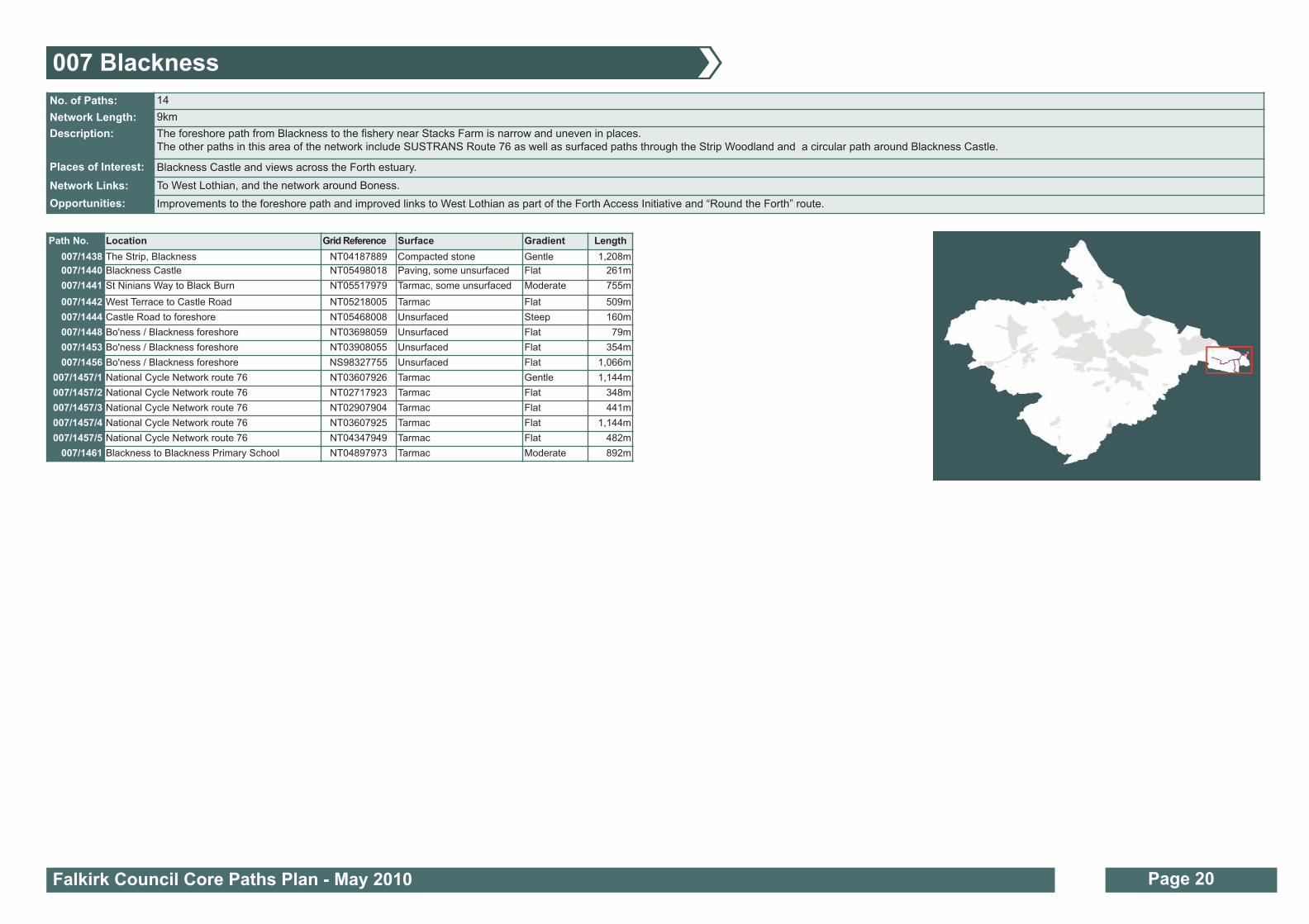
007 Blackness
Path No. Location Grid Reference Surface Gradient Length
007/1438 The Strip, Blackness NT04187889 Compacted stone Gentle 1,208m
007/1440 Blackness Castle NT05498018 Paving, some unsurfaced Flat 261m
007/1441 St Ninians Way to Black Burn NT05517979 Tarmac, some unsurfaced Moderate 755m
007/1442 West Terrace to Castle Road NT05218005 Tarmac Flat 509m
007/1444 Castle Road to foreshore NT05468008 Unsurfaced Steep 160m
007/1448 Bo'ness / Blackness foreshore NT03698059 Unsurfaced Flat 79m
007/1453 Bo'ness / Blackness foreshore NT03908055 Unsurfaced Flat 354m
007/1456 Bo'ness / Blackness foreshore NS98327755 Unsurfaced Flat 1,066m
007/1457/1 National Cycle Network route 76 NT03607926 Tarmac Gentle 1,144m
007/1457/2 National Cycle Network route 76 NT02717923 Tarmac Flat 348m
007/1457/3 National Cycle Network route 76 NT02907904 Tarmac Flat 441m
007/1457/4 National Cycle Network route 76 NT03607925 Tarmac Flat 1,144m
007/1457/5 National Cycle Network route 76 NT04347949 Tarmac Flat 482m
007/1461 Blackness to Blackness Primary School NT04897973 Tarmac Moderate 892m
No. of Paths: 14
Network Length: 9km
Description: The foreshore path from Blackness to the fishery near Stacks Farm is narrow and uneven in places.
The other paths in this area of the network include SUSTRANS Route 76 as well as surfaced paths through the Strip Woodland and a circular path around Blackness Castle.
Places of Interest: Blackness Castle and views across the Forth estuary.
Network Links: To West Lothian, and the network around Boness.
Opportunities: Improvements to the foreshore path and improved links to West Lothian as part of the Forth Access Initiative and “Round the Forth” route.

Falkirk Council Core Paths Plan - May 2010 Page 21
007/1457/5
Map 008
Page 23
007 Blackness
Based upon the Ordnance Survey mapping with the
permission of the Controller of Her Majesty's Stationery
Office, © Crown copyright. Unauthorised reproduction
infringes Crown Copyright and may lead to prosecution
or civil proceedings. Falkirk Council 100023384 (2010).
007/
1457
/4
007/1457/3
007/1457/2
007/1457/1
007/1438
007/1446
007/1461
007/1441007/1441
007/1442
007/1440
007/1444007/1442
007/1441
007/1456
007/1453
007/1448
Blackness
MannerstonHoldings
CauldcoatsHoldings
GrougfootFarm
Walton
Stacks
Burnshot
Firth of Forth

Falkirk Council Core Paths Plan - May 2010 Page 22
008 Bo’ness
Path No. Location Grid Reference Surface Gradient Length
008/1574 Foreshore, Carriden NT02268143 Unsurfaced Flat 476m
008/1576 Kinneil Nature Reserve NS98628139 Compacted stone Moderate 118m
008/1581 Kinneil Wood NS98068024 Unsurfaced Steep 349m
008/1584 Union Street to foreshore / harbour NS99928181 Compacted stone Flat 35m
008/1587 Carriden Glen NT02408090 Unsurfaced Steep 283m
008/1591 Birkhill Station / Clay Mine NS96467910 Compacted stone, part unsurfaced Flat 372m
008/1592 Corbiehall to foreshore NS99548152 Compacted stone Flat 86m
008/1598 Corbiehall to foreshore NS99318149 Compacted stone Flat 29m
008/1603 Union Street to Bo'ness harbour NS99938185 Compacted stone Slight 57m
008/1605 Carriden Brae to Carriden Wood NT02218116 Compacted stone Flat 432m
008/1606 Kinneil Nature Reserve NS98438148 Compacted stone Flat 291m
008/1608 Carriden Brae NT01848097 Part tarmac Steep 610m
008/1611 Muirhouses to Carriden Wood NT02168070 Compacted stone Flat 469m
008/1613 Carriden Wood to foreshore NT02298122 Unsurfaced Slight 121m
008/1616 Kinneil Estate NS98098055 Compacted stone Moderate 873m
008/1618 Kinneil Estate NS97598030 Compacted stone Flat 116m
008/1619 National Cycle Network, route 76 NS96988007 Unsurfaced Steep 1,447m
008/1622 Kinneil Estate NS98328063 Mix of tarmac and compacted stone Flat 64m
008/1632 Kinneil Nature Reserve NS98548160 Compacted stone Flat 302m
008/1639 Kinneil Estate NS98368048 Tarmac Moderate 275m
008/1640 Kinneil Estate NS98478065 Tarmac Flat 218m
008/1641 Snab Brae to Kinneil House NS98648074 Tarmac Flat 288m
008/1643 Kinneil Estate NS97968032 Compacted stone Steep 595m
008/1645 Kinneil Wood NS98247993 Unsurfaced Steep 474m
008/1647 Ewart Grove to Baptie Place NS99398030 Tarmac Flat 163m
008/1656 Fishers Brae to Wester flints plantation NS98897943 Unsurfaced Steep 344m
008/1663 Kinneil Wood NS98458020 Unsurfaced Slight 188m
008/1668 Upper Kinneil to Birkhill NS97117925 Tarmac Slight 761m
008/1671 Kinneil Wood NS98027996 Unsurfaced Steep 260m
008/1672 Kinneil Wood NS98108012 Compacted stone Flat 368m
008/1673 Borrowstoun Road to West Lothian Golf Course
NT00508010 Farm track, compacted stone Slight 475m
008/1674 Snab Lane to Kinneil Nature Reserve NS98508113 Mix of tarmac and compacted stone Flat 133m
008/1675 Boundary Street, Grangepans NT00668166 Compacted stone Gentle 435m
008/1676 Bo'ness Harbour to Boundary Street NT00498183 Compacted stone Flat 412m
008/1677/1 Bo'ness foreshore to Kinneil Nature Reserve and harbour
NT02267990 Compacted stone Flat 543m
008/1677/2 Bo'ness foreshore to Kinneil Nature Reserve and harbour
NS99408152 Compacted stone Flat 227m
008/1677/3 Bo'ness foreshore to Kinneil Nature Reserve and harbour
NS99568161 Compacted stone Flat 163m
008/1677/4 Bo'ness foreshore to Kinneil Nature Reserve and harbour
NS99978185 Compacted stone Flat 1,238m
008/1678 Corbiehall to foreshore NS97257759 Compacted stone Flat 891m
008/1679 Upper Kinneil to Nether Kinneil NS97327975 Tarmac Steep 824m
008/1680 Borrowstoun Road to West Lothian Golf Course
NT00028006 Unsurfaced Moderate 1,167m
008/1681 Road from Mile End to Upper Kinneil Farm
NS88728313 Tarmac Gentle 691m
No. of Paths: 91
Network Length: 41km
Description: The Boness network contains a mixture of routes including paths through woodlands and farmland, along the foreshore and through Kinneil Estate.
Places of Interest: Carriden and Kinneil Woods, Kinneil House, Boness Foreshore Nature Reserve, Antonine Wall, Boness Steam Railway, SUSTRANS Route 76 and Birkhill Clay Mine.
Network Links: To West Lothian, Blackness, Grangemouth and Whitecross.
Opportunities: Further improvements to the south from West Lothian Golf Club to Fishers Brae and Bo’mains Meadow. Extension of River Avon Heritage Trail downstream from Linlithgow Bridge to Polmont Woods and Birkhill Clay Mine.
Path No. Location Grid Reference Surface Gradient Length
008/1457 Kinglass Community Woodland NT00758055 Unsurfaced Moderate 652m
008/1458 Kinneil Wood NS97838011 Unsurfaced Steep 327m
008/1459 Kinneil Wood NS98258004 Compacted stone Moderate 443m
008/1460 Kinneil Wood NS98518000 Mix of tarmac and compacted stone Slight 154m
008/1461 Deanburn Glen NS98848049 Mix of tarmac and compacted stone Moderate 644m
008/1462 Fishers Brae / Rocky Road NS98877845 Mainly compacted stone Moderate 1,423m
008/1463 Fishers Brae / Rocky Road NS98887802 Compacted stone Flat 37m
008/1465 Crawfield Road to Westerflints plantation NS99067942 Unsurfaced Moderate 579m
008/1467 Jameson Avenue to Dean Road NS99308077 Part tarmac, part paved Moderate 205m
008/1471 Braehead NS99858137 Tarmac Steep 724m
008/1474 Victoria Mills Industrial Estate NT01638157 Compacted stone Flat 254m
008/1475 Carriden NT02388072 Mix of tarmac and compacted stone Flat 210m
008/1476 Carriden NT02288060 Unsurfaced Slight 169m
008/1478 Kinneil Nature Reserve NS98728144 Compacted stone Flat 151m
008/1480 Birkhill Clay Mine NS96477880 Compacted stone Slight 278m
008/1481 Birkhill Clay Mine NS96527881 Compacted stone Steep 219m
008/1484 Grangepans to Bridgeness NT01318162 Unsurfaced Flat 86m
008/1489 Borrowstourn Road to Linlithgow NT00737968 Unsurfaced Steep 1,012m
008/1490 West Lothian Golf Course Unsurfaced Flat 1,022m
008/1495 Bo'ness Harbour, foreshore path NT00748196 Compacted stone, part unsurfaced Slight 1,055m
008/1498 Old Manse Wood, Carriden NT02098100 Unsurfaced Steep 937m
008/1500 Carriden NT02518086 Unsurfaced Steep 239m
008/1501 Shore Road, Carriden NT02858084 Compacted stone Steep 413m
008/1510 Kinneil Road to Kinneil Nature Reserve NS98718132 Compacted stone Gentle 271m
008/1511 Grangepans to Bridgeness NT01418161 Compacted stone Flat 95m
008/1512 Grangepans to foreshore (Upper Forth Boat Club)
NT00938164 Tarmac Flat 264m
008/1519 Foreshore, Grangepans NT00898174 Concrete Flat 49m
008/1520 Kinneil Estate NS97668026 Compacted stone Steep 171m
008/1521 Muirhouses to Carriden NT02218045 Compacted stone, part unsurfaced Slight 832m
008/1522 Foreshore, Carriden NT02958088 Compacted stone Flat, but with steps 1,554m
008/1525 Foreshore, Bridgeness NT01898157 Compacted stone, part unsurfaced Flat 489m
008/1526 Foreshore, Bridgeness NT01558174 Unsurfaced Flat 342m
008/1528 Foreshore, Bo'ness NT01088171 Unsurfaced Slight 418m
008/1529 Stewart Avenue NS99958152 Tarmac Flat 754m
008/1530 Kinneil Nature Reserve NS98838146 Compacted stone Slight 65m
008/1534 Philpingstone Road NT01098146 Tarmac Moderate 1,709m
008/1536 Kinneil Road to Kinneil Nature Reserve NS98478117 Compacted stone Flat 341m
008/1537 Bridgeness NT01398165 Unsurfaced Flat 127m
008/1538 Kinneil Wood NS97757996 Part unsurfaced Steep 798m
008/1551 Kinneil Wood NS98388011 Part unsurfaced Steep 193m
008/1552 Kinneil Wood NS98278030 Unsurfaced Steep 278m
008/1555 Deanfield Road NS99108114 Tarmac Moderate 1,312m
008/1557 Corbiehall to foreshore NS99528154 Compacted stone Flat 30m
008/1565 Kinneil Nature Reserve NS98608132 Compacted stone Moderate 27m
008/1568 Kinneil Nature Reserve NS98568139 Compacted stone Slight 201m
008/1571 Corbiehall to foreshore NS99548155 Compacted stone Flat 26m
008/1572 Union Street to foreshore NS99668167 Unsurfaced Flat 69m
008/1573 Foreshore, Carriden NT02408110 Compacted stone, part unsurfaced Steep 179m

Falkirk Council Core Paths Plan - May 2010 Page 23
West Lothian Council
008/1681
Map 007
Page 21
Map 021
Page 47
Map 006
Page 19
008 Bo’ness
Based upon the Ordnance Survey mapping with the
permission of the Controller of Her Majesty's Stationery
Office, © Crown copyright. Unauthorised reproduction
infringes Crown Copyright and may lead to prosecution
or civil proceedings. Falkirk Council 100023384 (2010).
008/1681
008/1681
008/1681
008/1647
008/1465
008/1656
008/1461
008/1619
008/1619
008/1668
008/1591
008/1480
008/1481
008/1462
008/1459
008/1458
008/1460
008/1645008/1538
008/1672008/
1581
008/1663
008/1552008/1643
008/1616
008/1618
008/1639
008/1640008/1622
008/1490
008/1673
008/1490
008/1680
008/1467008/1641
008/1555
008/1510008/1536
008/1674
008/1576008/1568008/1606
008/1632
008/1478
008/1530
008/1677/1
008/1678
008/1677/2
008/1677/3
008/1592
008/1572008/1677/4
008/1584 008/1603
008/1677/4
008/1495
008/1495008/1676
008/1675
008/1519
008/1512
008/1528
008/1484
008/1537
008/1511
008/1526
008/1474008/1525
008/1574
008/1573
008/1613
008/1605
008/1534008/1534008/1471
008/1529
008/1498008/1608
008/1607
008/1607
008/1521
008/1476008/1521
008/1475008/1611
008/1587
008/1500008/1501 008/1522
008/1522
008/1522
Muirhouses
BO’NESS
Firth of Forth
Firth of Forth
Carriden
Bridgeness
Drum
Grahamsdyke
NewtownMaidenpark
Deanfield
Kinneil
Borrowstoun Mains
KinneilWood
Borrowstoun

Falkirk Council Core Paths Plan - May 2010 Page 24
009 Carron and Carronshore (excluding Skinflats)
Path No. Location Grid Reference Surface Gradient Length
009/1674 Carronshore 2000 path NS89038298 Tarmac Flat 232m
009/1675 Roughlands Drive to New Carron Road underpass
NS88328335 Tarmac Flat 184m
009/1678 Kincardine Road to North Main Street and Main Street
NS89228323 Tarmac Flat 342m
009/1681 Mill Road to Ardvreck Place NS88418330 Tarmac Moderate 274m
009/1689 Main Street to North Main Street NS89338318 Tarmac Flat 179m
009/1691 Main Street to River Carron NS89138301 Tarmac Flat 54m
009/1692 Carronshore Road to Mill Road NS88648313 Tarmac Flat 325m
009/1700 Main Street to North Main Street NS89148309 Tarmac Flat 215m
009/1701 Bothkennar Road to Bellsdyke Road
via Waterslap Road
NS89308299 Tarmac Flat 2,325m
009/1702 The Avenue to Glensburgh Road (River Carron path)
NS90228260 Compacted stone Flat 1,926m
009/1703 Roughlands roundabout to Bellsdyke Road NS88108400 Tarmac Flat 838m
009/1704 Bellsdyke Road NS88468431 Tarmac Flat 1,919m
No. of Paths: 13
Network Length: 9km
Description: Carron and Carronshore network consists of a mixture of farmland tracks, on road routes and a stone surfaced path along the River Carron.
Places of Interest: River Carron, Carron Dams SWT Nature Reserve.
Network Links: To Skinflats path network, Abbotshaugh and Cobblebrae Community woodlands, Grangemouth and Skinflats.
Opportunities: Additional and improved links to Grangemouth.

Falkirk Council Core Paths Plan - May 2010 Page 25
009/1701
009/1675
009/1681
009/1674009/1691
009/1700
009/1678
009/1689
009/1701
009/1702
Map 006
Page 16
Map 005
Page 15
Map 010
Page 20
009 Carron and Carronshore (excluding Skinflats)
Based upon the Ordnance Survey mapping with the
permission of the Controller of Her Majesty's Stationery
Office, © Crown copyright. Unauthorised reproduction
infringes Crown Copyright and may lead to prosecution
or civil proceedings. Falkirk Council 100023384 (2010).
Map 011
Page 21
009/1701
009/1704
009/1703
009/1692
Carronshore
Carron
Roughlands
School
School
Bensfield
Kirkton
River Carron
River Carron
River Carro
n

No. of Paths: 28
Network Length: 32km
Description: Network includes paths through woodlands, along the River Forth, through farmland and past historic buildings of The Pineapple and Airth Castle.
Places of Interest: River Forth and The Pineapple.
Network Links: To Stirling, Skinflats and Larbert.
Opportunities: Circular route between South Alloa, Dunmore and Airth. Riverside link between Airth and Dunmore. Improvements to the network within Dunmore Woods.
Falkirk Council Core Paths Plan - May 2010 Page 26
010 Airth
Path No. Location Grid Reference Surface Gradient Length
010/100 Higgins Neuk to Clackmannanshire Bridge NS91818707 Tarmac Gentle 1,753m
010/101 National Cycle Network route 76 Haughs of Airth NS90358636 Tarmac Flat 1,803m
010/103 Airth Castle NS89918675 Compacted stone Flat 626m
010/104 The Pineapple NS88778848 Compacted stone? Flat 576m
010/108 Letham Cottages NS89488588 Compacted stone? Tarmac? Flat 97m
010/109 Letham Terraces to Letham Cottages NS89498605 Compacted stone? Tarmac? Flat 422m
010/112 North Doll Farm to Westfield Farm NS87708809 Mix of tarmac, gravel and unsurfaced
Flat 1,197m
010/114 National Cycle Network route 76 Letham Farm NS88748543 Tarmac Flat 544m
010/120 National Cycle Network route 76 Letham Terraces
NS89228603 Tarmac Flat 1,070m
010/121 Airth The Banks NS91058774 Mix of tarmac, gravel and unsurfaced
Flat 1,964m
010/122 Dunmore to Church Wood NS88599058 Farm track? Moderate 3,255m
010/123 Halls of Airth / Haughs of Airth NS91408560 Tarmac Flat / gentle 1,521m
010/124 Cycleway to Higgins Neuk Roundabout NS91618670 Tarmac Flat / gentle 890m
010/69 The Pineapple NS89308828 Tarmac / Gravel Gentle 593m
010/71 Dunmore to South Alloa NS88479058 Mix of tarmac, gravel and unsurfaced
Flat 3,700m
010/77 Dunmore Home Farm NS88858981 Mix of tarmac, gravel and unsurfaced
Flat 1,074m
010/78 The Pineapple NS88798820 Unsurfaced Flat 810m
010/79 Letham Moss NS88268674 Farm track Flat 2,583m
010/81 National Cycle Network route 76 Mains of Powfoulis
NS90368635 Tarmac Flat 1,820m
010/85 Gamekeeper Cottage to Airth Castle Hotel NS89718736 Tarmac Slight 1,737m
010/86 Letham Terraces to Airth Castle Hotel NS89678663 Tarmac Flat 427m
010/87 Airth Market Cross NS89688763 Tarmac Slight 314m
010/88 Airth Shore Road NS90828722 Tarmac Flat 1,385m
010/89 The Pineapple NS89058860 Compacted stone? Flat 168m
010/91 The Pineapple NS88978844 Tarmac Flat 338m
010/95 The Pineapple NS88988854 Compacted stone? Tarmac? Flat 120m
010/96 The Pineapple to Elphinstone Tower track NS89008854 Unsurfaced Steep 198m
010/99 Letham Cottages to Letham Farm NS89188579 Mix of compacted stone andunsurfaced
Flat 730m

Falkirk Council Core Paths Plan - May 2010 Page 27
Stirling Council
Clackmannanshire Council
Map 006
Page 16
Map 011
Page 29
010 Airth
Based upon the Ordnance Survey mapping with the
permission of the Controller of Her Majesty's Stationery
Office, © Crown copyright. Unauthorised reproduction
infringes Crown Copyright and may lead to prosecution
or civil proceedings. Falkirk Council 100023384 (2010).
010/71
010/71
010/71
010/77
010/122
010/96
010/96
010/96
010/6
9
010/69010/78
010/104
010/91
010/95
010/112010/85
010/85
010/87
010/121
010/88010/100
010/100
010/124
010/123
010/81
010/101010/120
010/120
010/79
010/109
010/99
010/114
010/123
Airth
Dunmore
Firth of Forth
Firth of Forth
Firth of Forth
Kincardine Bridge
Clackmannanshire Bridge
South Alloa
Link to Neighbouring local authority
(Stirling Council)

011 Larbert and Stenhousemuir
Falkirk Council Core Paths Plan - May 2010 Page 28
Path No. Location Grid Reference Surface Gradient Length
011/125 Tryst Road to Chapel Drive NS86938333 Compacted stone Flat 316m
011/126 Falkirk Tryst Golf Course NS86438351 Unsurfaced Flat 589m
011/133 Bellsdyke Road to Hamilton Road NS86218415 Part tarmac, part compacted stone
Flat 1,284m
011/134 New Carron Road to Lodge Drive NS88128303 Tarmac Flat 212m
011/137 Lodge Drive to Jamieson Avenue NS87778319 Tarmac Flat 397m
011/139 New Carron Road underpass to Dunvegan Avenue
NS88078347 Tarmac Flat 348m
011/141 King Street to Dunvegan Avenue NS87858364 Tarmac Flat 197m
011/144 Stenhouse Road to Mill Lade NS87828228 Tarmac Slight 718m
011/145 Alloa Road to Dunvegan Avenue NS87908351 Tarmac Flat 47m
011/148 Alloa Road to Dunvegan Avenue NS87938354 Tarmac Flat 64m
011/151 Lochlands viaduct ot Carronvale Road NS81538115 Unsurfaced Flat 284m
011/154 Bellsdyke hospital site NS86818400 Tarmac Slight 635m
011/155 Holly Avenue to Stenhousemuir Sports Centre NS87998302 Tarmac Flat 36m
011/156 Drum of Kinnaird to Hamilton Road NS87288489 Tarmac Steep 550m
011/161 Torwood Broch path NS83158483 Unsurfaced Flat 727m
011/162 Carronvale Road to swing bridge, River Carron NS86688135 Farm Track Steep 526m
011/167 King Street to Corrie Avenue NS87778368 Tarmac Flat 37m
011/169 Park Drive to Mclaren Court NS86788269 Tarmac Flat 125m
011/170 Main Street to Valeview NS86908282 Tarmac Flat 259m
011/172/1 Old Denny Road to footbridge over M876 NS84438305 Compacted stone Flat 1,801m
011/172/2 Footbridge over M876 to Pamphellgoat Wood NS83458479 Compacted stone, part unsurfaced
Flat 1,206m
011/176 Falkirk Tryst Golf Course NS86688331 Tarmac Steep 500m
011/177 Broomside Place to Larbert Railway Station NS86058235 Tarmac Flat 322m
011/180 Lochlands viaduct to weir, River Carron NS85738191 Compacted stone Flat 362m
011/186 Falkirk Tryst Golf Course NS86818353 Part tarmac, part compacted stone
Flat 286m
011/189 Carronvale Road, Mill Lade to Carron Dams NS87088201 Compacted stone Flat 1,270m
011/190 Falkland Place to Linlithgow Place NS87368367 Tarmac Flat 167m
011/191 Falkland Place to Lomond Crescent NS87368359 Tarmac, part unsurfaced Flat 429m
011/193 Bellsdyke Road to Linlithgow Place NS87338385 Tarmac Flat 383m
011/194 Bellsdyke Road to Corrie Ave NS87558399 Tarmac Flat 214m
011/198 Bellsdyke hospital site NS86908416 Tarmac Flat 304m
011/200 Carron Dams NS87478252 Compacted stone Flat 706m
011/201 Corrie Ave NS87678370 Tarmac Flat 283m
011/203 Bellsdyke hospital site NS86958395 Tarmac Flat 257m
011/204 Bellsdyke Road NS86788385 Tarmac Flat 153m
011/206 Falkirk Tryst Golf Course NS86748376 Unsurfaced Flat 191m
011/207 Falkirk Tryst Golf Course NS86988345 Compacted stone Flat 490m
Path No. Location Grid Reference Surface Gradient Length
011/208 Torwood Castle NS83538447 Compacted stone Moderate 218m
011/209/1 Tor Wood to Pamphellgoat Wood NS83328429 Unsurfaced Slight 433m
011/209/2 Tor Wood to Pamphellgoat Wood NS82007980 Unsurfaced Steep 1,109m
011/210/1 King Street to Falkirk Tryst Golf Course NS87148321 Part tarmac, part paving Flat 182m
011/213/1 Hamilton Road, National Cycle Network route 76 NS86168508 Tarmac Flat 2,021m
011/221/1 Ochilview Park NS86998324 Paving Flat 247m
011/231/1 Lodge Drive NS88008300 Tarmac Flat 52m
011/233/1 Hamilton Road to Hill O'Kinnaird cottage, National Cycle Network route 76
NS87048466 Tarmac Flat 817m
011/235/1 Drum of Kinnaird to Letham, National Cycle Network route 76
NS88288515 Tarmac Flat 1,413m
011/239/1 Corrie Avenue to Lomond Crescent NS87618360 Tarmac Flat 410m
011/242/1 Dunvegan Avenue to Alloa Road NS87978359 Tarmac Flat 26m
011/244/1 Glen Road to Torwood Castle NS83708479 Compacted stone Steep 679m
011/246/1 Broomage Crescent to Torlea Place NS85898326 Compacted stone Flat 279m
011/247/1 Broomage Ave to Broomage greenspace NS85948322 Tarmac Flat 281m
011/250/1 Whinnie Muir NS83988460 Unsurfaced Steep 775m
011/251/1 Bellsdyke Road to Broomage greenspace NS85938340 Tarmac Flat 207m
011/252/1 South View to Mill Lade NS86858221 Compacted stone Gentle 183m
011/563/1 Bensfield farm track to B905 NS88028377 Tarmac Flat 656m
No. of Paths: 55
Network Length: 27km
Description: The network contains a mixture of routes including through woodlands, farmland, golf courses, along the Mill Lade and through open spaces and parks.
Places of Interest: Torwood Castle, Tappoch Broch, Larbert Mill Lade, Carron Dams and River Carron
Network Links: Denny, Mungal and Airth networks, Stirling Council’s network and Cobblebrae Community Woodland.
Opportunities: Development of a path network at Larbert Hospital site. Extension of the River Carron path upstream of Lochlands to Denny and Bonnybridge.

Falkirk Council Core Paths Plan - May 2010 Page 29
011/172/1
Based upon the Ordnance Survey mapping with the
permission of the Controller of Her Majesty's Stationery
Office, © Crown copyright. Unauthorised reproduction
infringes Crown Copyright and may lead to prosecution
or civil proceedings. Falkirk Council 100023384 (2010).
Map 009
Page 25
Map 001
Page 9
Map 012
Page 31
Map 010
Page 27
011 Larbert and Stenhousemuir
Stirling Council
011/172/2
011/209/1
011/
209/
2
011/208
011/161011/244
011/244
011/250
011/251
011/246
011/246
011/247
011/177
011/169011/170
011/180
011/151
011/162
011/252011/189
011/144
011/200
Falkirk TrystGolf Course
M876
011/176
011/126
011/133
011/213
011/233
011/156
011/235
011/154 011/198
011/203
011/194011/1
93
011/563011/201
011/191
011/137
011/231
011/134
011/139
011/141
011/148011/239
011/204
011/206
011/186
011/207011/125
011/210
011/221
LARBERT
Central ParkBusiness Park
Torwood
A9
Antonshill
M9
M9
Forth Valley Acute Hospital
STENHOUSEMUIR
LarbertHigh
School
CarronDams
Cemetery
Station
SouthBroomage
NorthBroomage
River Carron

Falkirk Council Core Paths Plan - May 2010 Page 30
012 Denny, Dunipace, Head of Muir and Dennyloanhead
Path No. Location Grid Reference Surface Gradient Length
012/246 Pamphellgoat Wood to Denovan Road NS82388360 Unsurfaced Flat 293m
012/248 Gumboo, Dunipace, River Carron NS79878298 Unsurfaced Steep 1,267m
012/250 Rosebank Community Woodland NS80548370 Unsurfaced Flat 94m
012/251 Myothill Road to Reedlands Drive NS80648127 Unsurfaced Flat 73m
012/255 Rosebank to Broad Street, Denny NS81028349 Tarmac Flat 823m
012/257 Rosebank to Broad Street, Denny NS81448297 Tarmac Flat 684m
012/258 Winchester Avenue, Denny NS81118319 Tarmac Flat 355m
012/260 Winchester Avenue, Denny to Denovan Road NS81668309 Compacted stone Steep 1,017m
012/265 Myothill, Denny NS80708129 Unsurfaced Flat 163m
012/268 Chacefield Wood NS81638130 Compacted stone Flat 271m
012/270 Rosebank Community Woodland NS80568379 Unsurfaced Flat 314m
012/271 Myothill Road to Reedlands Drive NS80608131 Tarmac Gentle 191m
012/275 Myothill, Denny NS80638138 Unsurfaced Flat 82m
012/276 Herbertshire Playing Fields NS81838233 Compacted stone Flat 382m
012/277 Carron Glen Scottish Wildlife Trust Reserve,Fankerton
NS79088326 Unsurfaced Steep 751m
012/278 Johnstons Park, Fankerton to Carron Glen NS78798321 Compacted stone Steep, with steps 286m
012/281 Denny to Herbertshire Playing Fields NS81618242 Tarmac Flat 146m
012/282 Denny to Herbertshire Playing Fields NS81388250 Tarmac Flat 337m
012/284 Cuthelton Farm track NS82348203 Farm Track Flat 79m
012/291 Old Railway path, Glasgow Road to Kirkland Drive
NS80698250 Tarmac Flat 998m
012/295 Denny railway path / Town House NS81458253 Compacted stone Flat 199m
012/296 Cuthelton Farm track NS82148201 Farm Track Flat 472m
012/302 Little Denny Burn to Herbertshire Playing Field NS81538165 Compacted stone,part unsurfaced
Flat 1,295m
012/306 Chacefield Wood NS81448137 Farm Track Gentle 292m
012/308 Barnego Road to River Carron NS79498328 Unsurfaced Steep 243m
012/309 Dunipace to Barnego Road NS80318318 Tarmac Moderate 1,084m
012/310 Meadow Court to Rosebank Community Woodland
NS80478363 Tarmac Flat 198m
012/316 Myothill NS80778143 Unsurfaced Flat 263m
012/317 Carron Glen Scottish Wildlife Trust Reserve,Fankerton
NS78658332 Compacted stone Steep 272m
012/318 Old Railway path, Glasgow Road to Kirkland Drive
NS79928274 Tarmac Flat 573m
012/319 Rosebank Community Woodland NS80428399 Compacted stone Flat 313m
012/321 Rosebank Community Woodland NS80488378 Unsurfaced Flat 97m
012/323 Rosebank Community Woodland NS80418385 Unsurfaced Flat 81m
012/325 Rosebank Community Woodland NS80458385 Compacted stone Flat 444m
012/326 Drove Loan to Chacefield Wood NS81558106 Compacted stone Gentle 205m
Path No. Location Grid Reference Surface Gradient Length
012/327 Glasgow Road to Denny High School NS81268194 Tarmac Flat 1,232m
012/328Rosebank garages to Quarter Bing and Dales Wood
NS81178446 Unsurfaced Steep 3,409m
012/334 Cuthelton Farm track to Denny High School NS82238214Compacted stone, partunsurfaced
Steep 332m
012/339 Drove Road to Hayfield Terrace NS81138118 Compacted stone, partunsurfaced
Flat 536m
012/340 Demoreham Avenue to Chacefield Wood NS81738171 Compacted stone Steep 811m
012/341 Chacefield Wood to Denny High School NS82478191 Compacted stone Slight 393m
012/342 Cuthelton to Denny High School NS81968215 Compacted stone Flat 197m
012/343 Chacefield Wood to Denny High School NS81958202 Compacted stone Flat 99m
012/347 Chacefield Wood NS82778146 Compacted stone Slight 208m
012/354 Chacefield Wood NS82548144 Compacted stone Gentle 211m
012/355 Chacefield Wood NS82278138 Compacted stone Slight 355m
012/358 Chacefield Wood NS82028135 Compacted stone Flat 190m
012/359 Denovan Road to Pamphellgoat Wood NS82158341 Compacted stone Moderate 441m
012/364 Denny Railway path to Town House NS81548259 Tarmac Flat 179m
012/365 Denny Railway path to Town House NS81548249 Tarmac Flat 48m
012/368 Myothill Road to Head of Muir Primary School NS80778110 Tarmac Slight 390m
012/370 Stoneywood NS80258291 Compacted stone Moderate, with steps
1,041m
No. of Paths: 52
Network Length: 25km
Description: There is a mix of riverside, farmland, woodland and park routes along with tarmac paths to shops and schools.
Places of Interest: River Carron, Scottish Wildlife Trust Reserve at Carron Glen, Rosebank Community Woodland, Chacefield Wood.
Network Links: Torwood, Larbert.
Opportunities:Improved links to Banknock and Bonnybridge, and along disused railway to Falkirk. Improved access provision to (and around) inland water at Drumbowie Reservoir and Little Denny Reservoir.
Extension of River Carron path upstream to Carron Reservoir and mountain biking facility, and downstream to Larbert.

Falkirk Council Core Paths Plan - May 2010 Page 31
012/246
Map 011
Page 29
Map 013
Page 33
012 Denny, Dunipace, Head of Muir and Dennyloanhead
Based upon the Ordnance Survey mapping with the
permission of the Controller of Her Majesty's Stationery
Office, © Crown copyright. Unauthorised reproduction
infringes Crown Copyright and may lead to prosecution
or civil proceedings. Falkirk Council 100023384 (2010).
012/359
012/260
012/2
57
012/364012/295
012/365
012/281
012/282
012/276
012/302012/342
012/334
012/284012/296
012/343
012/327
012/340
012/268012/306
012/341
012/347
012/354012/355
012/358
012/326012/339
012/339
012/316
012/265
012/275
012/271
012/251012/368
012/291
012/318
012/278
012/317
012/277 012/277012/308
012/309
012/248
012/370
012/381 012/258
012/255
012/328
012/310
012/325
012/319
012/270012/250
012/321
DENNY
DennyHigh
School
DUNIPACE
FormerHigh School
Site
Cemetery
Chacefield Wood
Stoneywood
Fankerton
M80
Rosebank
IndustrialEstate
River Carron

Falkirk Council Core Paths Plan - May 2010 Page 32
013 Bonnybridge
Path No. Location Grid Reference Surface Gradient Length
013/374 Bonnyview Gardens to Bonnywood Farm NS82808087 Compacted stone Slight 39m
013/375 Bonnyview Gardens to Bonnywood Farm NS82818083 Compacted stone Moderate 30m
013/388 Thornton Avenue to Highland Dykes Crescent NS82608057 Tarmac Gentle 81m
013/390 Thornton Avenue to Highland Dykes Crescent NS82608073 Tarmac Slight 209m
013/391 Bonnyview Gardens to Bonnywood Farm NS82848083 Compacted stone Flat 48m
013/397 Foundry Road to Bridge Street NS82498014 Compacted stone Flat 117m
013/398 Foundry Road to Bridge Street NS82418018 Compacted stone Flat 80m
013/401 Bonnybridge Recreation Ground NS82238021 Unsurfaced Flat 75m
013/404 Greenhill Road to Roman Road NS82177944 Tarmac Flat 372m
013/408 Bonnyfield Nature Park NS81867986 Compacted stone Flat 506m
013/412 Forth and Clyde canal towpath NS82478022 Compacted stone Flat 142m
013/414 Forth and Clyde canal towpath NS82538031 Compacted stone Flat 135m
013/415 Forth and Clyde canal towpath NS82818036 Compacted stone Flat 473m
013/417 Bonnyview Gardens to Bonnywood Farm NS82828085 Compacted stone Slight 57m
013/418 Bonnyside Farm to Rough Castle NS84017984 Tarmac / Farm Track Steep 172m
013/419 Anderson Public Park NS83078046 Compacted stone Flat 207m
013/420 Forth and Clyde canal towpath NS83948040 Compacted stone Flat 2,164m
013/421 Main Street to Forth and Clyde canal towpath NS82608036 Compacted stone Moderate 34m
013/422 Main Street to Forth and Clyde canal towpath NS82508030 Compacted stone Flat 57m
013/423 Rough Castle Community Woodland NS84377942 Compacted stone Gentle 227m
013/429 Bonnyfield Nature Park NS81528021 Compacted stone Flat 315m
013/430 Forth and Clyde canal towpath NS82298000 Compacted stone Flat 263m
013/431 Bonnyfield Nature Park NS81567997 Compacted stone Flat 111m
013/433 Bonnybridge Toll to Bonnyview Gardens NS82468044 Tarmac Slight 370m
013/434 Thornton Ave to Bonnyview Gardens NS82768075 Tarmac Flat 318m
013/435 Roman Road to Broomhill Road NS82497968 Tarmac Flat 398m
013/436 Bonnyfield Nature Park NS81988010 Compacted stone Flat 42m
013/438 Bonnyfield Nature Park NS81758001 Tarmac Flat 400m
013/442 Rough Castle NS84387953 Compacted stone Moderate 46m
013/443 Rough Castle NS84097963 Compacted stone Gentle 789m
013/453 Emma's Way to Bonnyfield Nature Park NS81978014 Compacted stone Flat 71m
013/454 High Street to Recreation Ground NS82198031 Compacted stone Flat 148m
013/456 Bonnybridge Recreation Ground NS82338023 Compacted stone Slight 175m
013/459 Seabegs Wood NS81547938 Compacted stone Slight 165m
013/464 Bonnyfield Nature Park NS80828190 Tarmac Moderate 2,885m
013/465/1 Bonnyfield Nature Park NS81428028 Compacted stone Flat 262m
013/465/2 Bonnybridge Road to Bonnyvale Place NS81548033 Compacted stone Gentle 68m
013/466 Forth and Clyde canal NS83377997 Water Flat 4,006m
No. of Paths: 38
Network Length: 16km
Description: Routes through Bonnyfield Nature Park to Forth and Clyde Canal towpath and links to Roman Fort sites at Seabegs and Roughcastle.
Places of Interest: Forth and Clyde Canal, Bonnyfield Nature Park, Antonine Wall.
Network Links: Roman Forts at Seabegs and Roughcastle, Falkirk Wheel, South Falkirk Path Network, Banknock and North Lanarkshire.
Opportunities: Link between Bonnyfield Nature Park and Recreation Ground, link onto, and improvements to former railway line between Denny and Falkirk.

Falkirk Council Core Paths Plan - May 2010 Page 33
CORE WATER ROUTE 013/466
Forth & Clyde Canal
013/435
Map 003
Page 13
Map 014
Page 35
Map 012
Page 31
013 Bonnybridge
Based upon the Ordnance Survey mapping with the
permission of the Controller of Her Majesty's Stationery
Office, © Crown copyright. Unauthorised reproduction
infringes Crown Copyright and may lead to prosecution
or civil proceedings. Falkirk Council 100023384 (2010).
013/404
013/418013/418
013/443 013/443
013/442
013/423
013/459
013/430
013/464
013/464
013/464
013/431
013/438
013/408
013/436
013/453013/429
013/465/1 013/465/2
013/4
54
013/401
013/456
013/398
013/430 013/397
013/412
013/422
013/414
013/421013/415
013/419 013/420
013/420
013/388
013/434
013/390
013/391
013/417
013/375
013/374
BONNYBRIDGE
Hospital
BondedWarehouses
BonnyfieldLocal Nature
Reserve
Milnquarter
SeabegsWood
St. Helen’s Loch
High Bonnybridge

No. of Paths: 32
Network Length: 13km
Description: Several routes along old railways as well as some through farmland and areas of former industry. There are also a number of connections onto the Forth and Clyde canal towpath.
Places of Interest: Forth and Clyde Canal, Antonine Wall.
Network Links: North Lanarkshire Council area, Bonnyfield Nature Park, Seabegs Wood.
Opportunities: Improved links to Denny. Improved access into, and within development site at Braeface Road. Extension to disused railway paths.
Falkirk Council Core Paths Plan - May 2010 Page 34
014 Banknock, Haggs and Longcroft
Path No. Location Grid Reference Surface Gradient Length
014/462 Laburnum Road, Banknock NS78127926 Tarmac, part unsurfaced Gentle 237m
014/463 Laburnum Road to Viewfield Road, Banknock NS78027910 Compacted stone Gentle 104m
014/464 Underwood NS80477924 Tarmac / Farm Track Moderate 756m
014/466 Coney Park Crescent, Banknock NS77467923 Tarmac Steep 135m
014/467 Forth and Clyde Canal Towpath NS81167931 Compacted stone Flat 1,085m
014/468 Coneypark, Banknock NS77297922 Part tarmac, part compacted stone
Steep 328m
014/470 Mayfield Drive, Longcroft NS79767944 Tarmac Flat 273m
014/471 Bankview, Banknock NS78357952 Unsurfaced Moderate 461m
014/475 Banknock old railway NS78197939 Compacted stone Flat 131m
014/476 Doups Burn, Banknock NS77947897 Compacted stone Flat 112m
014/477 Doups Burn, Banknock NS77727899 Compacted stone Flat 256m
014/479 Doups Burn, Banknock NS78087912 Compacted stone Flat 98m
014/480 Glenview Avenue to Hollandbush Crescent, Banknock
NS78697915 Tarmac Flat 279m
014/481 Hollandbush Crescent, Banknock NS78587923 Part tarmac, part compacted stone
Flat 45m
014/482 Wellpark Road to Falkirk Canal, Banknock NS77887878 Compacted stone Moderate 37m
014/483 Doups Burn, Banknock NS77987900 Compacted stone Flat 132m
014/484 Doups Burn, Banknock NS77627888 Compacted stone Flat 74m
014/486 Old Railway, Longcroft NS79587942 Unsurfaced Flat 515m
014/487 Old Railway, Longcroft NS79867950 Unsurfaced Flat 113m
014/489 Forth and Clyde Canal Towpath NS79547874 Compacted stone Flat 2,228m
014/490 Rowan Drive to Wellpark Road, Banknock NS77997895 Compacted stone Flat 86m
014/492 Bankier Road to Bog Road, Banknock NS78217923 Tarmac Flat 187m
014/495 Hollandbush Crescent, Banknock NS78677926 Tarmac Moderate 114m
014/496 Wellpark Road to Forth and Clyde canal NS77907885 Compacted stone Slight 114m
014/497 Banknock old railway NS77337926 Compacted stone Flat 85m
014/498 Banknock old railway NS77407926 Compacted stone Flat 93m
014/499 Cherry Lane to canal, Banknock NS78397850 Compacted stone Steep 295m
014/500 Banknock old railway NS77817930 Compacted stone Flat 746m
014/501 Wyndford Lock, Banknock NS77627883 Compacted stone Slight 106m
014/502 Longcroft NS80047968 Part unsurfaced Moderate 535m
014/503 Forth and Clyde Canal NS80017894 Water Flat 3,367m

Falkirk Council Core Paths Plan - May 2010 Page 35
North Lanarkshire Council
CORE WATER ROUTE 014/503
Forth & Clyde Canal
014/489
Map 013
Page 33
Map 012
Page 22
014 Banknock, Haggs and Longcroft
Based upon the Ordnance Survey mapping with the
permission of the Controller of Her Majesty's Stationery
Office, © Crown copyright. Unauthorised reproduction
infringes Crown Copyright and may lead to prosecution
or civil proceedings. Falkirk Council 100023384 (2010).
CORE WATER ROUTE 014/503
014/499
014/
467
014/464
014/502
014/487
014/486
014/470
014/480
014/495
014/481
014/482
014/496014/501
014/484
014/477014/476
014/490
014/483
014/479014/463
014/462014/492
014/468
014/466
014/497 014/498014/500
014/500
014/500
014/475
014/471
BANKNOCK
Haggs
Longcroft
Dennyloanhead
Coneypark
M80
A80
Allandale

No. of Paths: 29
Network Length: 9.5km
Description: Routes to Falkirk Stadium and through Westquarter Glen.
Places of Interest: Westquarter Glen, Antonine Wall.
Network Links: Falkirk Stadium, Union Canal, Callendar Woods, Grangemouth.
Opportunities: Improved links to Falkirk Stadium/Midthorn Community Woodland site. Extensive opportunities exist around the delivery of the HELIX project.
Falkirk Council Core Paths Plan - May 2010 Page 36
015 Lower Braes
Path No. Location Grid Reference Surface Gradient Length
015/503 Redding grasslands NS91787875 Unsurfaced Flat 110m
015/504 Redding grasslands NS91747883 Unsurfaced Slight 324m
015/505 Braeside Place to Westquarter Avenue NS91417875 Tarmac Steep 267m
015/510 A9 to Bog Road NS90648008 Tarmac Flat 158m
015/511 Westquarter Glen NS91227889 Compacted stone Steep 578m
015/512 Hillock Avenue to Stevenson Avenue NS92467840 Tarmac and compacted stone, part unsurfaced
Flat 368m
015/517 Westquarter Glen NS91177884 Compacted stone Moderate 354m
015/521 Redding grasslands NS92007877 Unsurfaced Steep 356m
015/522 Mumrills Road NS92307959 Tarmac Steep 891m
015/523 Redding grasslands NS91747873 Unsurfaced Flat 152m
015/526 Westquarter Avenue to Poolewe Drive NS92027901 Unsurfaced Moderate 230m
015/529 Bog Road NS90617981 Tarmac Gentle 497m
015/532 Westquarter Glen NS91107873 Tarmac Flat 300m
015/536 Hornbeam Crescent to Westquarter Glen NS91187905 Part tarmac, part compacted stone
Slight 50m
015/539 Redding grasslands NS91867878 Unsurfaced Steep 105m
015/543 Zetland Drive to Icehouse Brae NS91287989 Tarmac and compacted stone, part unsurfaced
Moderate 984m
015/547 Redding grasslands NS91787878 Unsurfaced Steep 137m
015/549 Langton Road to Westquarter Glen NS91217909 Tarmac Steep 77m
015/550 Redding grasslands NS91727874 Unsurfaced Steep 59m
015/551 Redding grasslands NS91657869 Unsurfaced Steep 116m
015/552 Westquarter Avenue to Braeside Place NS91527893 Tarmac Moderate 99m
015/553 Grangemouth Road to Bog Road NS90498028 Tarmac Flat 610m
015/554 Redding grasslands NS91567878 Tarmac Steep 129m
015/557 Icehouse Brae North / Laurieston Road NS91408030 Tarmac Flat 689m
015/558 Laurieston Road to A9 NS91018037 Tarmac Flat 755m
015/559 Westquarter Glen NS91237896 Part tarmac, part compacted stone
Steep 120m
015/560 Westquarter Glen NS91237884 Compacted stone Gentle 45m
015/561 Westquarter Glen NS91207906 Part tarmac, part compacted stone
Steep 34m
015/563 Park Crescent to Westquarter Avenue NS91667772 Tarmac Steep 844m

Falkirk Council Core Paths Plan - May 2010 Page 37
015/522
Map 016
Page 39
Map 019
Page 45
Map 002
Page 11
Map 005
Page 17
015 Lower Braes
Based upon the Ordnance Survey mapping with the
permission of the Controller of Her Majesty's Stationery
Office, © Crown copyright. Unauthorised reproduction
infringes Crown Copyright and may lead to prosecution
or civil proceedings. Falkirk Council 100023384 (2010).
015/543
015/557
015/558
015/553
015/510
015/553
015/529
015/512
015/526
015/521
015/523015/551
015/550015/539015/5
47
015/503
015/504
015/552
015/554
015/505
015/563
015/5
63
015/563015/532
015/532
015/532
015/559
015/
517
015/
511
015/5
11
015/536
015/549
015/511
015/561
Laurieston
IndustrialEstate
Westquarter
Depot
Beancross
GrandsableCemetery
Redding
FireStation
LadysmillPark
A9
A9

Falkirk Council Core Paths Plan - May 2010 Page 38
016 Polmont
Path No. Location Grid Reference Surface Gradient Length
016/580 Cassel Brae / Fairy Glen NS92737931 Unsurfaced Steep 589m
016/557 Lewis Road to Ardmore Road NS93827828 Tarmac Flat 264m
016/558 Polmont Road to Cassel Bridge NS92757900 Unsurfaced Flat 44m
016/559 Parkhill, Grey Buchanan Park NS92747892 Unsurfaced Steep 125m
016/561 Parkhill, Grey Buchanan Park NS93047864 Compacted stone Flat 239m
016/562 Polmont Woods NS94097943 Compacted stone Slight 336m
016/563 Parkhill, Grey Buchanan Park NS92897891 Unsurfaced Flat 363m
016/566 Parkhill, Grey Buchanan Park NS93107874 Compacted stone Steep 303m
016/568 Polmont Woods NS94027913 Compacted stone Steep 88m
016/569 Tolsta Crescent NS93527849 Unsurfaced Flat 19m
016/570 Rannoch Park to Fairy Glen NS92847952 Tarmac Flat 347m
016/573 Polmont Woods NS94487954 Compacted stone Steep 473m
016/574 Erskine Hill NS93347833 Tarmac Flat 33m
016/576 Polmont Road to Parkhill NS93087890 Tarmac Steep 108m
016/577 Parkhill, Grey Buchanan Park NS93107853 Part tarmac, part compacted stone
Steep 67m
016/583 Salmon Inn Road to St Margarets Primary School NS92737847 Tarmac Flat 97m
016/586 Tolsta Crescent to Portree Crescent NS90717924 Tarmac, part unsurfaced Moderate 105m
016/590 Millar Park to Gilston Crescent NS93547828 Tarmac Flat 198m
016/591 Lathallan Drive to Portree Crescent NS93467851 Tarmac, part unsurfaced Moderate 88m
016/600 Station Road to St Margarets Primary School NS92907828 Part tarmac, part compacted stone
Flat 482m
016/601 Tolsta Crescent NS93507850 Tarmac Steep 22m
016/602 Gilston Crescent to Union Canal NS94247808 Part tarmac, part compacted stone
Moderate 169m
016/603 Polmonthill NS94747963 Compacted stone Steep 73m
016/605 Polmonthill NS94967957 Compacted stone Steep 382m
016/611 Reddoch Road to Millhall Reservoir NS94377926 Compacted stone Steep 277m
016/612 Gilston Crescent to Union Canal NS94177801 Compacted stone Steep 73m
016/616 Polmont Woods NS93937939 Compacted stone Steep 241m
016/619 Erskine Hill to Millar Park NS93517820 Tarmac Flat 116m
016/621 Lewis Road to Lathallan Drive NS93437856 Part tarmac, part compacted stone
Moderate 117m
016/623 Erskine Hill to Station Road NS93287838 Tarmac Flat 137m
016/627 Bo'ness Road to Polmont Woods NS93937909 Compacted stone Gentle 92m
016/629 Bo'ness Road to Polmont Woods NS93877906 Compacted stone Flat 122m
016/631 Polmont House Gardens to Erskine Hill and Station Road
NS93317832 Tarmac Gentle 84m
016/632 Union Canal to Polmont Railway Station NS92867823 Compacted stone Flat 46m
016/633 Parkhill to Grey Buchanan Court NS92927873 Compacted stone Flat 67m
016/635 Rodel Drive to Taransay Drive NS93897835 Tarmac Moderate 59m
Path No. Location Grid Reference Surface Gradient Length
016/640 Polmont Woods to Millhall Reservoir NS94187912 Compacted stone Moderate 189m
016/641 Gilston Crescent to Millar Park NS93617812 Tarmac Flat 175m
016/643 Inveravon to Nether Kinneil NS95907981 Tarmac Steep 749m
016/648 Inveravon to Wholeflats Roundabout NS94757977 Tarmac Steep 2,186m
016/651 Salmon Inn Road to Union Canal NS92697841 Part unsurfaced Flat 170m
016/652 Jinkaboot Bridge NS94777972 Tarmac Flat 115m
016/653 Taymouth Road to Gilston Crescent NS94007823 Unsurfaced Gentle 951m
016/654 Erskine Hill to Station Road NS93157821 Tarmac Flat 38m
No. of Paths: 44
Network Length: 11km
Description: A range of routes in the Polmont network includes woodland, parkland and on-road routes: Polmont Woods, Gray-Buchanan Park and an on-road section that forms part of SUSTRANS National Cycle Network Route 76.
Places of Interest: Polmont Woods, Antonine Wall, Gray-Buchanan Park, Union Canal.
Network Links: Union Canal, Bo’ness, Grangemouth, Brightons.
Opportunities: Improvements to path network at Gray-Buchanan Park. Enhance network between Polmont and Grangemouth.
Extension of River Avon Heritage Trail downstream from Linlithgow Bridge to Polmont Woods and Birkhill Clay Mine.

Falkirk Council Core Paths Plan - May 2010 Page 39
016/570
Map 008
Page 23
Map 017
Page 41
Map 015
Page 37
Map 006
Page 19
016 Polmont
Based upon the Ordnance Survey mapping with the
permission of the Controller of Her Majesty's Stationery
Office, © Crown copyright. Unauthorised reproduction
infringes Crown Copyright and may lead to prosecution
or civil proceedings. Falkirk Council 100023384 (2010).
016/580
016/648 016/648016/643
016/605
016/652
016/603
016/573
016/611
016/611
016/562
016/616
016/640016/568
016/627
016/629
016/558
016/559
016/577 016/577
016/563
016/576
016/566016/633 016/577
016/577
016/561
016/583
016/651
016/600
016/600016/632
016/623 016/574
016/631
016/619
016/590
016/621
016/621
016/621
016/557
016/641
016/653 016/653
016/602
016/612
016/635
016/586
016/586
016/591016/591
016/601016/569
GrangemouthGolf Course
M9
M9
POLMONT
Gilston
GrangemouthGolf Course
Old Polmont
Junction 5
Junction 4
Parkhill
Polmont Park
Hotel
PumpingStation
River Avon
River Avon
MillhallReservoir

No. of Paths: 14
Network Length: 7km
Description: Route along Union Canal towpath connecting back to Ercall Road through woodland, also routes through park areas.
Places of Interest: Union Canal, Laurie Park.
Network Links: Maddiston, Polmont, Union Canal, The Haining path network.
Opportunities: Links south to Maddiston and Rumford.
Falkirk Council Core Paths Plan - May 2010 Page 40
017 Brightons
Path No. Location Grid Reference Surface Gradient Length
017/653 Braemar Gardens to Sunnyside Avenue NS92677748 Unsurfaced Moderate 219m
017/654 Union Canal towpath NS93377796 Compacted stone Flat 1,417m
017/655 Laurie Park NS93047766 Tarmac Flat 130m
017/657 Union Canal towpath NS94337781 Compacted stone Flat 731m
017/658 Millar Park to Station Road NS93317801 Unsurfaced Gentle 557m
017/662 Wallacelea Bellevue, Rumford NS93017719 Part tarmac Flat 253m
017/663 Gardrum Place to Ercall Road NS93647751 Unsurfaced Steep 272m
017/665 Ercall Road to Whiteside Loan NS93437793 Unsurfaced Steep 553m
017/666 Ercall Road to Union Canal NS93857779 Unsurfaced Steep 599m
017/668 Wallacelea Bellevue to Maddiston Road NS93147725 Compacted stone Flat 258m
017/671 Gardrum Place to Nicolton Ave and Kestrel Drive
NS93477740 Tarmac, part unsurfaced Gentle 380m
017/672 Laurie Park NS93077757 Unsurfaced Moderate 158m
017/673 Gilston Crescent to Union Canal NS94137794 Farm track Steep 111m
017/674 Union Canal NS92557792 Water Flat 1,316m

Falkirk Council Core Paths Plan - May 2010 Page 41
CORE WATER ROUTE 0017/674
Union Canal
0017/653
Map 021
Page 49
Map 020
Page 47
Map 019
Page 45
Map 016
Page 39
017 Brightons
Based upon the Ordnance Survey mapping with the
permission of the Controller of Her Majesty's Stationery
Office, © Crown copyright. Unauthorised reproduction
infringes Crown Copyright and may lead to prosecution
or civil proceedings. Falkirk Council 100023384 (2010).
0017/655
0017/672
0017/662
0017/668
0017/671
0017/671
0017/671
0017/663
0017/6660017/665
0017/673
0017/658
0017/658
0017/654
0017/654
0017/657
CORE WATER ROUTE 0017/674
Union Canal
Laurie Park
BRIGHTONS
RUMFORD
Polmont Station
Battock
The Grange

Falkirk Council Core Paths Plan - May 2010 Page 42
018 Shieldhill and California
Path No. Location Grid Reference Surface Gradient Length
018/674 Easton Drive, Shieldhill to Westquarter Burn NS90337802 Compacted stone Gentle 102m
018/679 Old Drove Road, Main Street to Easton Drive, Shieldhill
NS89957712 Tarmac Moderate 139m
018/683 Easter Pirleyhill, Shieldhill to Union Canal NS89967729 Compacted stone Steep 212m
018/684 Bellsrigg Community Woodland NS90097600 Compacted stone Flat 94m
018/686 Main Street, Shieldhill to Bellsrigg Community Woodland
NS89697660 Unsurfaced Slight 292m
018/688 Bellsrigg Community Woodland NS90307628 Compacted stone Slight 824m
018/694 Burnside Community Woodland NS91337671 Compacted stone Gentle 378m
018/696 Mamre Drive, California to Fairhaven Terrace, Reddingmuirhead
NS90927645 Compacted stone Moderate 297m
018/697 Blacbraes Road, California to Bellsrigg Community Woodland
NS90347604 Compacted stone Flat 582m
018/699 Bellsrigg Community Woodland NS89867653 Compacted stone Slight 290m
018/700 Blackbraes Road to Darnrigg Road NS91707757 Farm track Flat 522m
018/701 Burnside Community Woodland NS91357658 Compacted stone, part unsurfaced
Flat 641m
018/702 Whiteside Muir NS91067656 Unsurfaced Flat 279m
018/703 Bellsrigg Community Woodland NS90037625 Unsurfaced Moderate 413m
018/704 Maddiston to Blackbraes NS91167583 Compacted stone Flat 1,179m
No. of Paths: 15
Network Length: 6km
Description: Path network takes in woodland routes as well as paths along disused railway lines and includes connection through Shieldhill using the Old Drove Road.
Places of Interest: Burnside Community Woodland, Bellsrigg Community Woodland, Old Drove Road.
Network Links: Maddiston, Hallglen, Wallacestone.
Opportunities: Improved access to Mavisbank wood path, Cleuch woodland and canal network. Improved off-road access south toward Avonbridge and Slamannan. Improved promotion and interpretation of Trysts and Drove Road heritage.

Falkirk Council Core Paths Plan - May 2010 Page 43
0018/701
Map 019
Page 45
Map 022
Page 51
Map 003
Page 13
Map 002
Page 11
018 Shieldhill and California
Based upon the Ordnance Survey mapping with the
permission of the Controller of Her Majesty's Stationery
Office, © Crown copyright. Unauthorised reproduction
infringes Crown Copyright and may lead to prosecution
or civil proceedings. Falkirk Council 100023384 (2010).
0018/694
0018/702
0018/6
96
0018/683
0018/674
0018/679
0018/686
0018/699
0018/688
0018/703
0018/697
0018/684
0018/700 0018/700
0018/704
CALIFORNIA
SHIELDHILL
BellsriggCommunityWoodland
BurnsideCommunityWoodland
Blackbraes
Gardrum
Burnside
The ThreeKings
Livery Stables

No. of Paths: 8
Network Length: 7km
Description: Through farmland to connect Reddingmuirhead and Wallacestone to California with links to Burnside Community Woodland, Standrigg Road.
Places of Interest: Burnside Community Woodland, Union Canal.
Network Links: California, Union Canal.
Opportunities: Improved access from Reddingmuirhead to Burnside Community Woodland.
Falkirk Council Core Paths Plan - May 2010 Page 44
019 Reddingmuirhead and Wallacestone
Path No. Location Grid Reference Surface Gradient Length
019/707 Wallacestone Brae to Fairhaven Terrace NS91517725 Part unsurfaced Flat 581m
019/708 Standrigg Road to Burnside Community Woodland
NS91657697 Unsurfaced Steep 585m
019/711 Wallacestone Brae NS91647771 Tarmac Moderate 962m
019/712 Fairhaven Terrace NS91247732 Tarmac Steep 515m
019/716 Standrigg Road to Burnside Community Woodland
NS91667694 Farm Track Moderate 103m
019/717 Shieldhill Road NS79028330 Tarmac Moderate 1,013m
019/718 Union Canal towpath NS86907960 Compacted stone Flat 270m
019/719 Union Canal towpath NS89937702 Compacted stone Flat 464m
019/720 Union Canal NS92787835 Water Flat 2,488m

Falkirk Council Core Paths Plan - May 2010 Page 45
019/718
Map 017
Page 41
Map 018
Page 43
Map 018
Page 43
019 Reddingmuirhead and Wallacestone
Based upon the Ordnance Survey mapping with the
permission of the Controller of Her Majesty's Stationery
Office, © Crown copyright. Unauthorised reproduction
infringes Crown Copyright and may lead to prosecution
or civil proceedings. Falkirk Council 100023384 (2010).
Map 015
Page 37019/719
019/711
019/711
019/712
019/717
019/707
019/708
019/708
019/716
CORE WATER ROUTE 019/720
Union Canal
Middlerig
CORE WATER ROUTE 019/720
Union Canal
REDDINGMUIRHEAD
HM Young OffendersInstitution
Braes High School
WALLACESTONE
BRIGHTONS
Industrial Estate

Falkirk Council Core Paths Plan - May 2010 Page 46
020 Maddiston
Path No. Location Grid Reference Surface Gradient Length
020/765 Manuel Burn NS95117574 Compacted stone Flat 240m
020/766 Wallacelea to California Road NS92697709 Compacted stone Steep 680m
020/767 Murray Crescent to Manuel Burn NS94337686 Unsurfaced Flat 86m
020/769 California Road to Maddiston-Blackbraes path NS93547663 Unsurfaced Slight 33m
020/771 California Road to Maddiston-Blackbraes path NS93517672 Tarmac Moderate 206m
020/772 California Road to Maddiston-Blackbraes path NS92827661 Compacted stone Moderate 227m
020/778 Murray Crescent to Manuel Burn NS94177671 Part tarmac, part compacted stone
Flat 249m
020/783 Union Canal towpath - Bethankie bridge to Kirk bridge
NS94967752 Compacted stone Flat 858m
020/794 Forgie Crescent to Craigend Brickworks NS93807601 Compacted stone Flat 813m
020/796 Maddiston High Road NS94017636 Compacted stone Moderate 233m
020/797 Maddiston High Road NS95107637 Tarmac Flat 416m
020/798 Whiterigg Cottage to Craigend Cottage NS94047569 Compacted stone Flat 786m
020/799 Maddiston High Road NS94447634 Tarmac Slight 439m
020/800 Maddiston High Road NS94737635 Compacted stone Gentle 282m
020/802 Maddiston to Blackbraes NS92367612 Compacted stone Gentle 1,277m
020/809 Parkhall Farm NS94637720 Unsurfaced Flat 1,105m
020/811 Maddiston to Blackbraes NS93207653 Compacted stone Flat 688m
020/812 Maddiston to Blackbraes NS93767664 Compacted stone Slight 486m
020/817 South Brae to Cairneymount Avenue NS94207645 Tarmac Moderate 316m
020/821 Craigend Cottage to Craigend Brickworks NS93407565 Compacted stone Flat 537m
020/822 Union Canal NS95097738 Water Flat 899m
No. of Paths: 21
Network Length: 11km
Description: Variety of routes through farmland, along Union Canal towpath and the disused railway, as well as through the park area at Manuel Burn.
Places of Interest: Union Canal, disused railway lines and sites of former industry.
Network Links: The Loan and Muiravonside Country Park, Union Canal, Brightons and Drumbowie Community Woodland, Standburn.
Opportunities: Path improvements to Parkhall farm right of way between Maddiston and Bethankie Bridge. Improvements to route through the former brickworks site, and linking Rumford with disused railway.
Improved access between Standburn and Maddiston to Blackbraes disused railway.

Falkirk Council Core Paths Plan - May 2010 Page 47
Map 021
Page 49
Map 022
Page 51
Map 018
Page 43
Map 017
Page 41
020 Maddiston
Based upon the Ordnance Survey mapping with the
permission of the Controller of Her Majesty's Stationery
Office, © Crown copyright. Unauthorised reproduction
infringes Crown Copyright and may lead to prosecution
or civil proceedings. Falkirk Council 100023384 (2010).
020/772
020/766
020/
802
020/811
020/771
020/812
020/796
020/794
020/
794
020/821 020/798
020/797
020/800
020/799
020/817
020/778
020/765
020/765
020/767020/809
020/809
020/809020/783
CORE WATER ROUTE 020/822
Union Canal
The Haining
MADDISTON
MaddistonPrimary School Parkhall Farm
HainingWood
Polmont Golf Club
GreenwellsFarmhouse & Livery
Greenwells
A801

Falkirk Council Core Paths Plan - May 2010 Page 48
021 Whitecross
No. of Paths: 42
Network Length: 19km
Description: Circular routes using Union Canal towpath and disused railway lines to connect surrounding villages to Muiravonside Country Park and sections of the River Avon Heritage Trail. Mix of woodland, farmland and park routes.
Places of Interest: Union Canal, River Avon Heritage Trail, Muiravonside Country Park.
Network Links: Avonbridge, Linlithgow Bridge, Maddiston, Candiehead and Standburn.
Opportunities:Off-road access to Muiravonside Country Park from The Loan. Improved access from Candie to Muiravonside Wood. Improved access between Whitecross and Muiravonside Country Park.
Path link through Haining Wood to Lathallan.
Path No. Location Grid Reference Surface Gradient Length
021/825 Muiravonside Country Park NS96067541 Compacted stone Steep 280m
021/828 Muiravonside Country Park NS95967575 Tarmac Steep 270m
021/829 Union Canal towpath NS95467716 Compacted stone Flat 64m
021/830 Muiravonside Country Park NS96087555 Tarmac Moderate 209m
021/832 Union Canal towpath NS96117649 Compacted stone Flat 1,008m
021/836 River Avon Heritage Trail, Muiravonside Country Park
NS96207544 Compacted stone Steep 743m
021/837 Muiravonside Country Park NS96647547 Compacted stone Steep 712m
021/839 Muiravonside Country Park NS96227550 Tarmac Flat 159m
021/842 Muiravonside Country Park NS95307513 Compacted stone Steep 1,456m
021/843 River Avon Heritage Trail, Muiravonside Country Park
NS96737572 Compacted stone Steep 210m
021/845 River Avon Heritage Trail, Carriber Glen to Blue Braes and Muiravonside
NS95737460 Part unsurfaced Steep, with steps 1,672m
021/847 Almond Bing to Muiravonside Country Park NS95937599 Unsurfaced Steep 176m
021/851 B825 road, The Loan NS95197570 Tarmac Flat 339m
021/854 River Avon Heritage Trail, Carriber Bridge NS95947395 Part unsurfaced Flat 42m
021/855 River Avon Heritage Trail, Carriber Bridge to North Glen
NS95927400 Unsurfaced Steep 176m
021/859 Muiravonside Country Park NS96047530 Compacted stone Steep 337m
021/860 Muiravonside Country Park NS96597558 Compacted stone Steep 515m
021/863 Manuel Terrace to Manuel Burn NS96707673 Compacted stone Flat 167m
021/867 Manuel Works NS95877708 Mix of tarmac, compacted stone and concrete
Flat 805m
021/868 Haining Road NS96517688 Tarmac Flat 606m
021/869 Almond Bing NS96127622 Compacted stone Moderate 505m
021/870 Old Railway, The Loan to Almond Bing NS95637601 Unsurfaced Moderate 580m
021/871 Dismantled Railway, Whitecross NS96237688 Unsurfaced Moderate 207m
021/872 Whitecross Road to A803 (Linlithgow Road) NS97267723 Unsurfaced Steep 403m
021/874 Muiravonside Country Park to Avon Aqueduct NS96617584 Timber steps Steep 204m
021/876 Vellore Road to Almond Bing NS95947655 Compacted stone Slight 400m
021/877 Vellore Road to Almond Bing NS95697671 Compacted stone Flat 125m
021/878 Almond Road to Almond Bing NS96137645 Unsurfaced Gentle 91m
021/880 Maddiston High Road to The Loan NS95367616 Tarmac Steep 451m
021/881 Dismantled Railway, Vellore Road to Almond Road
NS96157658 Compacted stone, part unsurfaced
Flat 425m
021/882 Old Railway, The Loan to Almond Bing NS95227585 Unsurfaced, but on stone base
Flat 110m
021/883 Union Canal towpath NS95567695 Compacted stone Flat 86m
021/885 Union Canal towpath NS95507708 Compacted stone Flat 155m
Path No. Location Grid Reference Surface Gradient Length
021/889 Union Canal towpath NS96457594 Compacted stone Flat 432m
021/896 Union Canal towpath NS95657685 Compacted stone Flat 194m
021/897 The Loan NS95357584 Tarmac Flat 185m
021/898 Muiravonside Country Park NS96137542 Compacted stone Steep 100m
021/899 Muiravonside Country Park NS96287548 Compacted stone Steep 47m
021/900 Linlithgow Bridge to Avonbank Community Woodland
NS98327755 Unsurfaced Steep 1,066m
021/901 Avonbank Community Woodland NS98327755 Unsurfaced Moderate 1,066m
021/902 A803 Linlithgow Road to Avonbank Community Woodland
Tarmac Flat 177m
021/903 Union Canal NS96057649 Water Flat 1,918m

Falkirk Council Core Paths Plan - May 2010 Page 49
West Lothian Council
CORE WATER ROUTE 021/903
Union Canal
021/872
Map 022
Page 51
Map 020
Page 47
Map 008
Page 23
021 Whitecross
Based upon the Ordnance Survey mapping with the
permission of the Controller of Her Majesty's Stationery
Office, © Crown copyright. Unauthorised reproduction
infringes Crown Copyright and may lead to prosecution
or civil proceedings. Falkirk Council 100023384 (2010).
021/902
021/901
021/900
021/867
021/868
021/863
Link to Neighbouring local authority
(West Lothian Council)
Link to Neighbouring local authority
(West Lothian Council)
Link to Neighbouring local authority
(West Lothian Council)
021/871
021/881
021/889021/874
021/874
021/843
021/860
021/837
021/837
021/836
021/836
021/899
021/839
021/825
021/830
021/828
021/847
021/870
021/
882
021/897
021/851
021/880
021/869
021/878
021/832
021/876
021/832
021/877
021/896
021/883
021/885
021/829
021/859
021/898
021/842
021/842
021/854
021/855
021/845
021/845
River Avon
River Avon
River Avon
MuiravonsideCountry Park
WHITECROSS
The Loan
M9

Falkirk Council Core Paths Plan - May 2010 Page 50
022 Avonbridge and Standburn
Path No. Location Grid Reference Surface Gradient Length
022/903 Former railway line, River Avon NS88447337 Unsurfaced Flat 1,161m
022/904 Woodend Cottage to Candie Woodland NS94307469 Tarmac Moderate 822m
022/905 Candiehead NS93377404 Unsurfaced Moderate 2,156m
022/907 Drumbowie Nature Park NS92897495 Compacted stone Flat 86m
022/910 Bridge at Wallace's Cave, River Avon Heritage Trail
NS94567306 Wooden Bridge Flat 46m
022/914 River Avon Heritage Trail, Avonbridge NS91337263 Mix of tarmac and compacted stone
Flat 533m
022/915 Standburn to Craigend NS93117546 Tarmac Steep 236m
022/916 River Avon Heritage Trail, Avonbridge NS91687261 Part tarmac, part unsurfaced
Flat 196m
022/918 South Bankhead to Balmitchel, River Avon NS89207315 Unsurfaced Flat 598m
022/920 Avonbridge to River Avon NS90757260 Unsurfaced Gentle 205m
022/921 Drumbowie Nature Park NS93257524 Mix of tarmac and compacted stone
Gentle 268m
022/929 Avonbridge Sewage Works to River Avon Heritage Trail
NS91537284 Unsurfaced Moderate 182m
022/930 River Avon, Avonbridge to South Bankhead Farm NS90357262 Unsurfaced Flat 2,302m
022/936 River Avon Heritage Trail, Wallaces Cave NS94347305 Unsurfaced Moderate 558m
022/937 Hill Farm to River Avon Heritage Trail NS93967325 Unsurfaced Steep 201m
022/938 Avonbridge (Memorial?) NS91157278 Farm track Flat 111m
022/940 Hill Farm to River Avon Heritage Trail NS93857351 Unsurfaced Slight 358m
022/942 Drumbowie Nature Park NS92707500 Gravel Slight 426m
022/944 Standburn to Candie House NS93117464 Unsurfaced Steep 1,085m
022/946 Drumbowie Nature Park NS92697491 Unsurfaced Slight 492m
022/947 Candie Railway NS94287395 Tarmac Flat 744m
022/950 Drumbowie Nature Park NS93067513 Unsurfaced Flat 539m
022/955 River Avon Heritage Trail NS94247426 Unsurfaced Steep 81m
022/956 Public road, Netherton Farm NS94247426 Tarmac Flat 495m
022/963 Drumbowie Nature Park NS93067510 Unsurfaced Flat 439m
022/964 Drumbowie Nature Park NS92867494 Compacted stone Flat 143m
022/966 River Avon Heritage Trail, Strath House NS93387282 Unsurfaced Steep 1,995m
No. of Paths: 27
Network Length: 16.5km
Description: Mix of open farmland and woodland paths with some routes using the local road network.
Places of Interest: Drumbowie Community Woodland, Standburn and River Avon Heritage Trail.
Network Links: Muiravonside Country Park and Linlithgow Bridge, Slamannan, Maddiston.
Opportunities: Extension of River Avon Heritage Trail upstream to connect Avonbridge and Slamannan. Improved access in and around Avonbridge. Large circular horse-friendly route connecting to Muiravonside Country Park.

Falkirk Council Core Paths Plan - May 2010 Page 51
West Lothian Council
022/903
Map 023
Page 53
Map 021
Page 49
022 Avonbridge and Standburn
Based upon the Ordnance Survey mapping with the
permission of the Controller of Her Majesty's Stationery
Office, © Crown copyright. Unauthorised reproduction
infringes Crown Copyright and may lead to prosecution
or civil proceedings. Falkirk Council 100023384 (2010).
022/918
022/930
022/930
022/920
022/930
022/938
022/914
022/916
022/929
022/966
022/966Link to Neighbouring local authority
(West Lothian Council)
Link to Neighbouring local authority
(West Lothian Council)
022/955
022/936
022/937
022/940
022/947
022/905
022/905 022/956
022/904
022/944
022/946
022/942
022/964
022/907
022/963
022/950022/921
022/915
River Avon
River AvonRiver Avon
AVONBRIDGE
STANDBURN
Farrenridge
Coxhill Farm
BroadheadCandie
Kaemuir Farm
Hill Farm
Summerhouse
Balmitchell
North Bankhead

Falkirk Council Core Paths Plan - May 2010 Page 52
023 Slamannan and Limerigg
Path No. Location Grid Reference Surface Gradient Length
023/969 Limerigg Wood NS86157105 Compacted stone Moderate 434m
023/971 Limerigg Wood NS85407058 Compacted stone Flat 1,561m
023/977 Slamannan Road, Limerigg to Limerigg Wood NS85337131 Farm track Gentle 445m
023/987 Binniehill to Slamannan NS85397217 Compacted stone Steep, with steps 29m
023/990 Binniehill Road to Limerigg NS85127142 Unsurfaced Steep 517m
023/993 Old railway, Binniehill NS85517223 Mainly unsurfaced Gentle, with steps 214m
023/1001 Binniehill to Townhead NS85117228 Unsurfaced Steep 493m
023/1002 River Avon, Slamannan to Redbrae NS86787394 Unsurfaced Flat 2,725m
023/1004 Slamannan to Wester Jaw farm NS85407392 Tarmac Flat 741m
023/1006 Wester Jaw to Oakerdykes NS84757407 Tarmac Flat 868m
023/1007 Oakerdykes to Garbethill Burn NS82777380 Tarmac Slight 3,378m
023/1008 Burnbrae to Limerigg Wood NS85707180 Unsurfaced Moderate 526m
023/1009 Limerigg Wood NS86087137 Compacted stone, part unsurfaced
Moderate 319m
023/1027 Slamannan Road, Limerigg to Limerigg Wood NS85817118 Compacted stone Steep 652m
023/1028 Old railway line, Binniehill to Slamannan NS85697233 Compacted stone Flat 166m
023/1030 Slamannan Road, Limerigg to Limerigg Wood NS85857081 Compacted stone Flat 449m
023/1032 High Limerigg to Black Loch NS85777037 Compacted stone Steep 317m
023/1034 Lochside Road to Black Loch NS86027033 Compacted stone Flat 342m
023/1035 Limerigg Wood NS85037093 Unsurfaced Flat 1,304m
023/1042 Binniehill Road to Binniehill railway NS84947171 Unsurfaced Slight 243m
023/1045 Redbrae to Avonbridge / Slamannan old railway NS86127159 Tarmac Moderate 493m
023/1046 Manse Place, Slamannan NS85557348 Tarmac Flat 380m
No. of Paths: 22
Network Length: 16.5km
Description: Mix of farmland and woodland routes.
Places of Interest: Limerigg Woodland, Slamannan Plateau (Bean Geese).
Network Links: Avonbridge, North Lanarkshire Council area.
Opportunities:
Access improvements along disused railway to create circular off-road route round Slamannan and connecting to community woodland in the North Lanarkshire area.
Improved access between Binniehill and Limerigg, and along disused railway between Slamannan and Avonbridge.
Extension to the River Avon Heritage Trail between Avonbridge and Slamannan. Improved access north to rest of network is constrained by SPA designation and land management issues.

Falkirk Council Core Paths Plan - May 2010 Page 53
North Lanarkshire Council
023/1007
Map 018
Page 43
Map 022
Page 51
023 Slamannan and Limerigg
Based upon the Ordnance Survey mapping with the
permission of the Controller of Her Majesty's Stationery
Office, © Crown copyright. Unauthorised reproduction
infringes Crown Copyright and may lead to prosecution
or civil proceedings. Falkirk Council 100023384 (2010).
023/1007
023/1006
023/1004
023/1046
023/1002
023/1045
023/1001
023/993
023/993
023/1028
023/1042
023/990
023/977
023/1035
023/1008
023/1009
023/969
023/1027
023/1030
023/971
023/971
023/1035
023/1032023/1034
River Avon
SLAMANNAN
LIMERIGG
BLack Loch
High Limerigg
Low Limerigg
Salterhill Farm
BalquhatstoneMains
Binniehill
Lodge Farm
Blinkbonnie


Page 55Falkirk Council Core Paths Plan - May 2010 Future Review
Future Review
There is an expectation from the Scottish Government and users that the core paths network will
be signposted and useable within 1-2 years of the plan being adopted.
Section 20 of the LAnd reform (Scotland) Act 2003 places a duty on local authorities to review
the plan for their areas either when they consider it to be appropriate or by virtue of a future
ministerial direction following any review, core paths can be added, diverted or deleted.
Falkirk Council Core Paths Plan


Page 57Falkirk Council Core Paths Plan - May 2010 Appendix 1
Appendix 1: Round 1 Informal Consultation
Falkirk Council Core Paths Plan

Page 58Falkirk Council Core Paths Plan - May 2010 Appendix 2
Appendix 2 : Round 2 Informal Consultation
Date Meeting Attended Attended by
27/6/2006 Land manager consultation, Polmont Golf Club, Maddiston Falkirk Council, Bell Ingram
28/6/2006 Land manager meeting, Park Hotel, Falkirk Falkirk Council, Bell Ingram
29/6/2006 Land manager meeting, Park Hotel, Falkirk Falkirk Council, Bell Ingram
3/7/2006 Land manager meeting, Airth Castle Hotel Falkirk Council, Bell Ingram
10/8/2006 Stirling Access Officer Falkirk Council, Stirling Council
15/8/2006 NLC Core paths meeting Falkirk Council
30/8/2006 Site meeting with Cllr Hamid, Denny Falkirk Council
1/9/2006 Meeting with Cllr Pat Reid, Town Centre Falkirk Council Falkirk Council
26/10/2006 Maddiston Community Council Falkirk Council
9/11/2006 Braes Area Forum Falkirk Council
14/11/2006 Grahamston, Middlefield and Westfield Community Council Falkirk Council, 2 local councillors in attendance
21/11/2006 Larbert and Stenhousemuir Area Forum Falkirk Council
29/11/2006 Denny, Bonnybridge and Banknock Area Forum Falkirk Council
16/1/2007 Bainsford, Langlees and New Carron Community Council Falkirk Council
10/4/2007 Blackness Community Council Falkirk Council
15/4/2007 Lionthorn Community Woodland Easter Event Falkirk Council
28/4/2007 Stenhousemuir Craft Market Falkirk Council
1/5/2007 Skinflats Activity Group Falkirk Council
5/5/2007 and 6/5/2007 Big in Falkirk Event Falkirk Council
9/5/2007 Bo’ness Community Council Falkirk Council, 1 local councillor in attendance
12/5/2007 Grangemouth Craft Market Falkirk Council
19/5/2007 Denny Craft Market Falkirk Council
26/5/2007 Bo’ness Craft Market and Miners Memorial Opening Event Falkirk Council
28/5/2007 Polmont Community Council Falkirk Council, 3 local councillors in attendance
30/5/2007 Denny One Stop Shop Falkirk Council
30/5/2007 Falkirk Area Rider Access Group (FARAG) AGM Falkirk Council
31/5/2007 Shieldhill and California Community Council Falkirk Council, 3 local councillors in attendance
10/6/2007 Falkirk Farmers Market Falkirk Council
17/6/2007 Abbotshaugh Community Woodland Open Day Falkirk Council
17/6/2007 Drumbowie Community Woodland Open Day Falkirk Council
20/6/2007 Agency Open Day Falkirk Council
28/7/2007 Airth Highland Games Falkirk Council
Maps, background information and comments forms were also promoted at the
following venues between May and August 2007 to allow people to see the
preliminary core path network, and give maximum opportunity for promotion and
public comment:
Falkirk Library
Bo’ness Library
Grangemouth Library
Larbert Library
Bo’ness One Stop Shop
Bonnybridge Community Education Centre
Callendar Square One Stop Shop
Camelon Community Project
Dawson Centre
Denny Community Hall
Grange Community Centre
Grangemouth Community Education Centre
Grangemouth One Stop Shop
Greenpark Community Hall
Kersiebank Community Project
Maddiston Community Hall
Shieldhill Community Hall
Slamannan Community Education Centre
Skinflats Community Hall
Stenhousemuir One Stop Shop
Tryst Community Hall
Westfield Community Project
Westquarter Project, Westquarter Primary School
Falkirk Council Core Paths Plan
v Targeted land manager meetings
v Interest group meetings
v Community Council and Area Forum meetings
v Displays in Libraries, One Stop Shops and Community Centres
v Organised events including Big in Falkirk, Craft Markets, Falkirk Farmers Market, Community events and Airth Highland Games
v Open Day for agencies, partner organisations and representatives of other interested parties
v Consultation with all elected members
v Signs erected at either end of proposed core paths
v Website based consultation combined with media press releases and promotional leaflets
v Response to individual requests

Page 59Falkirk Council Core Paths Plan - May 2010 Appendix 3
Appendix 3 : Round 3 Formal Consultation
The draft Falkirk Council Core Paths Plan was available on Falkirk Council’s website. Copies were
also distributed to the following venues between February and April 2008.
Library Locations
Bo’ness Library Bonnybridge Library Denny Library
Falkirk Library Grangemouth Library Larbert Library
Slamannan Library Mobile Library
Council Office Locations
Municipal Buildings, Falkirk
Falkirk Stadium, Westfield
Municipal Buildings, Grangemouth
Abbotsford House, Bainsford
McLaren House, Polmont
Denny Town House, Denny
One Stop Shops
Bo’ness One Stop Shop
Braes Area One Stop Shop
Callendar Square One Stop Shop
Camelon One Stop Shop
Carronbank House
Denny One Stop Shop
Grangemouth One Stop Shop
Stenhousemuir One Stop Shop
Community Centres
Bonnybridge Community Education Centre
Camelon Community Project
Dawson Centre
Denny Community Hall
Grange Community Centre
Grangemouth Community Education Centre
Greenpark Community Hall
Kersiebank Community Project
Maddiston Community Hall
Shieldhill Community Hall
Slamannan Community Education Centre
Skinflats Community Hall
Tryst Community Hall
Westfield Community Project
Westquarter Project, Westquarter Primary School
Falkirk Council Core Paths Plan


Core Path PlanAbbotsford House, David’s Loan, Bainsford,
Falkirk FK2 7YZTelephone 01324 504721 Fax 01324 504709