cover-north indian river county - fellsmere · north indian river county greenways master plan...
TRANSCRIPT

51330062.08
Prepared for
August 2008
North Indian River County Greenways Master Plan Prepared for: Indian River County Metropolitan Planning Organization
Prepared by: Kimley-Horn and Associates, Inc.
In conjunction with: Alta Planning + Design
CivaTerra, Inc.

Indian River County MPO North County Greenways Plan
August 2008 ii
TABLE OF CONTENTS
Page
EXECUTIVE SUMMARY .............................................................................................................1
INTRODUCTION ...........................................................................................................................4
Greenways and Trails ......................................................................................................................4
Purpose .............................................................................................................................................5
Benefits ............................................................................................................................................6
PUBLIC INVOLVEMENT .............................................................................................................8
EXISTING CONDITIONS / DATA COLLECTION ...................................................................10
Unit Cost Data................................................................................................................................16
Programmed Roadway Projects .....................................................................................................17
GREENWAY SELECTION AND EVALUATION PROCESS ...................................................21
PROPOSED GREENWAYS SYSTEM ........................................................................................23
Potential Greenways Corridors ......................................................................................................23
Typical Sections .............................................................................................................................31
Security, Property Values, and Maintenance .................................................................................34
Projected Costs...............................................................................................................................36
Prioritize Greenway Alternatives ...................................................................................................38
GOALS AND OBJECTIVES ........................................................................................................40
GREENWAYS MANAGEMENT COMMITTEE ........................................................................42
IMPLEMENTATION PLAN ........................................................................................................44
Project Phasing...............................................................................................................................44
Funding Sources.............................................................................................................................47
Integrate Greenways in Ongoing Infrastructure Projects ...............................................................47
Develop Greenway Connections to the North, West, and South ...................................................48
Apply for Designation with the Florida Office of Greenways and Trails (OGT) .........................49

Indian River County MPO North County Greenways Plan
August 2008 iii
Comprehensive Plan Revisions......................................................................................................50
Analysis of Environmental and Permitting Impacts ......................................................................52
Partnerships Strategies ...................................................................................................................53
APPENDIX ................................................................................................................................57

Indian River County MPO North County Greenways Plan
August 2008 1
EXECUTIVE SUMMARY
The purpose of this Study is to develop a conceptual master plan that will serve as a guide for
local officials and future partners for selecting appropriate areas for greenways; prioritizing the
greenway corridors; identifying funding opportunities; and forming an oversight committee to
carry out the construction, maintenance, and management of the greenways.
The goal is to establish an interconnected system of greenways and blueways in Indian River
County that promotes multi-modal transportation, connects urban and rural areas locally and
regionally, and enhances recreation and conservation opportunities.
The study area boundaries are defined by the following limits.
To the North – North County Line
To the South – North Relief Canal (east of 82nd Avenue), S.R. 60 (west of 82nd Avenue)
To the East – Atlantic Ocean
To the West – western limits of the MPO’s Planning Area Boundary
Greenways are defined as linear open space along natural or manmade corridors with facilities
for non-motorized travel, including walking, bicycling, running, horseback riding, and other
uses. Trails are often developed within greenways to provide pathways for people to move from
one place to another.
The North Indian River County (NIRC) Greenways Master Plan is part of the overall master plan
for greenways in Indian River County. In February 2007, the Metropolitan Planning
Organization (MPO) adopted the Central Indian River County (CIRC) Greenways Master Plan,
whose study area adjoins the NIRC plan to the south. In addition, several initiatives are already
underway in the NIRC study area to build upon, including State-designation of the Trans-Florida
Central rails-to-trail corridor, the St. Sebastian River Greenway Plan, the Fellsmere Trailhead
Preserve grant, and the Sebastian conservation boardwalk near City Hall.
Public involvement for the Plan consisted of two advertised public meetings to gather input from
the community, three project steering committee (PSC) meetings, three rounds of MPO

Indian River County MPO North County Greenways Plan
August 2008 2
Green berm in the Sebastian Stormwater Park
committee presentations, and interviews with key officials and stakeholders within the study
area.
The proposed greenways system includes 118 miles of active transportation and recreation
facilities, including 31 miles of paved shared-use trails. The proposed greenways system
represents a diverse range of projects, including the proposed rails-to-trail project along the
Trans-Florida Central Railroad Corridor connecting Fellsmere and Sebastian; the South and
North Sebastian Corridors that include portions of the Sebastian Stormwater Park, Sebastian
Harbor Preserve,
Powerline corridor,
and North Sebastian
Conservation Area; a
section of the East
Coast Greenway (a
national trail from
Maine to Key West),
and part of the Florida
Circumnavigational
Saltwater Paddling
Trail (a water trail
around the state’s
perimeter).
A prioritization process was developed based on the Greenways Evaluation Criteria, such as
benefits, constructability, and cost. Five projects that scored above a certain threshold in the
Greenways Evaluation Criteria were named Tier 1 projects. These projects were identified for
implementation activities within the first five years of the Plan. The Tier I projects include the
Trans-Florida Central Railroad Corridor, the South Sebastian Corridor, and the 82nd Avenue
Corridor (connector to the CIRC network).

Indian River County MPO North County Greenways Plan
August 2008 3
Centennial Trail Pelican Island National Wildlife Refuge
An implementation plan was developed that included project phasing; potential funding sources;
integration with ongoing capital improvements; environmental impacts; and partnership
strategies, such as publishing a trail guide for Indian River County and developing a non-profit
organization Friends of Indian River Greenways.
The Indian River MPO recognizes the importance and critical value of interested parties and
advocacy groups in encouraging the implementation of the Greenways Master Plan. The concept
of a Greenways Management Committee was developed by MPO staff as an informal group of
advocates who will oversee the implementation, public support, legal resources, technical
assistance, and maintaining of greenways in Indian River County.

Indian River County MPO North County Greenways Plan
August 2008 4
Unpaved trail in Pelican Island National Wildlife Refuge provides users with a natural experience
INTRODUCTION
The Indian River County Metropolitan Planning Organization (MPO) recognizes the importance
of providing transportation connections between urban areas and rural areas, as well as providing
linkages between urban areas and state parks, water management areas, rivers, wetland systems,
and other natural areas. One way to accomplish this is by providing a network of greenways that
can serve as an alternative to on-road motorized travel.
Greenways and Trails A greenway is defined as linear open space along natural or manmade corridors with facilities
for non-motorized travel, including walking, bicycling, running, horseback riding, and other
uses. Greenways serve a dual-nature as both a link in the transportation system and a park for
recreational purposes. Greenways can exist in both rural and urban areas. Rural greenways,
including abandoned railroad corridors, rivers, large state parks, and ecologically significant
natural corridors that provide for hiking and wildlife migration, are often associated with long-
distance travel and recreation. Protected linear greenway corridors can be more challenging to
provide in urban areas than in rural areas due to land constraints and other obstacles; however,
urban greenways are just as vital as rural greenways because of the critical need for the
environmental and human benefits
associated with greenways in modern
urbanized areas. In addition, the
population base in urbanized areas
often furnishes a higher number of
greenway users within close proximity
than in rural areas. Trails are often
developed within greenways to
provide pathways for people to move
from one place to another. Trails can
be made of natural surfaces, such as
grass or dirt, or hard surfaces, such as
concrete or asphalt.

Indian River County MPO North County Greenways Plan
August 2008 5
Bicycling is a popular activity throughout much of the year in Indian River County
Bicycling and pedestrian facilities are increasingly important components of a well-rounded
multimodal transportation system. Many people in Indian River County take advantage of
favorable weather throughout much of the year by walking and bicycle riding for leisure and
mobility. Providing appropriate facilities can encourage people to make short trips by bicycle or
on foot rather than in an automobile, and this helps contribute to a healthy citizenry.
Nearly one-half of all trips taken in
the United States are less than three
miles in length, according to trip
data reported by the 2001 National
Household Travel Survey.
Furthermore, 28 percent of trips are
less than one mile in length. These
short trips represent a potential
market for greenway travel. There is
also a safety benefit from providing
greenway facilities separated from
automobile travel. Currently,
bicyclists and pedestrians represent
13 percent of all traffic fatalities, but
comprise less than 5 percent of all
trips according to 2007 Traffic Safety Facts compiled by the National Highway Traffic Safety
Administration. A lack of off-road greenway trails can increase exposure for traffic conflicts.
Purpose The purpose of the North Indian River County (NIRC) Greenways Master Plan is to serve as a
guide for local officials and future partners for selecting appropriate areas for greenways;
prioritizing the greenway corridors; identifying funding opportunities; and forming an oversight
committee to carry out the construction, maintenance, and management of the greenways. The
plan establishes an interconnected system of greenways and blueways within North Indian River

Indian River County MPO North County Greenways Plan
August 2008 6
County that promotes multi-modal transportation, connects urban and rural areas, and enhances
recreation and conservation opportunities. The consultant team of Kimley-Horn and Associates,
Inc., Alta Planning+Design, and CivaTerra, Inc. was retained by the Indian River County MPO
to prepare the North Indian River County Greenways Master Plan.
The study area for this project is defined by the North County Line in the north; the North Relief
Canal (from the Atlantic Ocean to 82nd Avenue) and S.R. 60 (from 82nd Avenue to the western
limits of the MPO Planning Area) in the south; the Atlantic Ocean in the east; and the western
limits of the MPO’s Planning Area Boundary in the west.
Benefits The Florida Department of Environmental Protection (FDEP) includes the Office of Greenways
and Trails (OGT), which provides grants for the development of non-motorized trail projects,
maintains a database of Florida greenways, and designates corridors for inclusion in the
statewide greenways network. OGT has prepared the following summary of the benefits and
greenways and trails.
The Benefits of Greenways and Trails:
Increased economic activity through local spending by recreational users
Reduced costs to government through lower infrastructure spending in areas where
greenways and trails take place of development
Increased revenues to government by sales taxes associated with local spending
Increased property values near greenways and trails
Increased environmental benefits, including protection of ecological corridors to help
support wildlife and protection of watersheds
Enhanced quality of life through increased alternative transportation opportunities
Increased public health benefits through recreational use and physical activity
Increased access to cultural and historical resources
Source: Florida Office of Greenways and Trails: OGT Reference and Resource Guide

Indian River County MPO North County Greenways Plan
August 2008 7
“The Real Florida” sign in St. Sebastian River Preserve State
Park
The State of Florida has been working on developing a state wide system of greenways and trails
for transportation, recreation, and conservation purposes. Both the Department of Environmental
Protection (FDEP) and the Department of Transportation (FDOT) have encouraged the
improvement of greenways in order to provide access to conservation lands communities, parks,
other recreational facilities, and cultural and historic sites.
Greenways and trails can play an important role for economic development and tourism in Indian
River County. According to a 2006 survey by the National Association of Homebuilders, the
most desired amenity of prospective buyers is walking, bicycling and jogging trails – over
swimming pools, golf courses, and exercise rooms. Similar case studies have shown the value of
greenways and trails for attracting and maintaining businesses, especially technology companies
that can choose to locate in communities that provide the quality of life amenities they prefer.
With Indian River County’s location, climate,
topography, and population, the greenways system
should be seen as an integral part of the region’s efforts
to attract businesses, residents, and visitors. With the
East Coast Greenway, the Florida Circumnavigational
Saltwater Paddling Trail, and a connected local system
of shared use pathways, there are significant
opportunities for attracting tourists to the “Real Florida”
in Indian River County. This will be especially
favorable for eco-tourism and heritage tourism, both of
which are significant markets.
When implemented, the greenways identified in the North Indian River County Plan will
increase and enhance multi-modal transportation, tourism, education, recreation, economic
development, health, physical fitness, and environmental conservation throughout the area. The
greenways system will provide opportunities for seniors to be more physically active, for
children to walk or bike to school, for people to commute to work without their cars, and to
connect local communities together.

Indian River County MPO North County Greenways Plan
August 2008 8
PUBLIC INVOLVEMENT
The public involvement plan for the North Indian River County Greenways Master Plan was
based on the principles outlined in the Public Involvement Plan for the Indian River
Metropolitan Planning Organization. The MPO public involvement plan makes the following
statement:
“To ensure that the public is afforded adequate opportunity for public input into MPO
matters, the advisory committees represent the fundamental means for the public to
become involved. In addition to citizens, others interested in or affected by
transportation planning may become involved through attendance in committee meetings
and review of committee activities.”
With input and guidance from the MPO, a Project Steering Committee (PSC) was established,
including members of County staff, local governments, and the public. The PSC met four times
during the project, and included the following representatives:
Phil Matson – Indian River County MPO, Project Manager
Libby Harrow – MPO Bicycle/Pedestrian Advisory Committee
Bob Keating – Indian River County
Jim Davis – Indian River County
Cliff Crawford – Indian River County
Roland DeBlois – Indian River County
Sutapa Chatterjee – Indian River County MPO
Jason Nunemaker – City of Fellsmere
Rebecca Grohall – City of Sebastian
David Fisher – City of Sebastian
The PSC participated in the planning process throughout the development of the North County
Greenways Plan. In addition, special outreach efforts including individual meetings and field
reviews were held with local government staff, the Indian River Historical Society, and OGT.
Meetings were also held with the MPO’s committees, including the Citizens Advisory
Committee (CAC), the Technical Advisory Committee (TAC), and the Bicycle Advisory

Indian River County MPO North County Greenways Plan
August 2008 9
Public meeting for North Indian River County Greenways Master Plan
Committee (BAC). Three presentations were given to each committee. The first round of
presentations was held at the outset of the study to present the data collection maps and to gather
initial input and ideas. The second round of presentations was given to gather input on the draft
plan maps. The third round of presentations presented the final plan.
A project website was established by Alta Planning+Design to post maps and documents related
to the Plan development. Local media were involved in publicizing the Plan development
through press releases, attendance at meetings, and articles in local newspapers.
Two advertised public meetings were held during the course of the Plan development. The first
meeting was held on November 8, 2007, to inform the public of the NIRC Greenways Plan,
present the data collection maps, and gather initial input and ideas. Meeting attendees were
given the opportunity to mark ideas on the data collection maps for greenway trails and
opportunities for connections to parks, natural areas, and other destinations. The second meeting
was held on April 9, 2008, to present the draft plan maps and gather input to be incorporated into
the final report. Outreach efforts included direct mailings by the consultant team to special needs
populations, utilizing the 2004 IRC MPO Community Outreach / Development of Communities
Profiles.

Indian River County MPO North County Greenways Plan
August 2008 10
EXISTING CONDITIONS / DATA COLLECTION
In support of Indian River County’s development of a Greenways Plan for the North County
area, pertinent base data were collected to define the existing conditions. In accordance with
Task 2 – Data Collection, the following information has been gathered from existing available
data. This task consisted largely of gathering pertinent planning, environmental, land use, and
engineering information necessary to develop the Greenways Plan. The information gathered
included data necessary to perform adequate evaluations of the environmental, transportation,
and recreation aspects of potential greenways. To the extent possible, the existing conditions
data were collected as geospatial data compatible with ArcGIS. Data not available in this format
were scanned for supplemental information purposes.
Sheets 1 through 3 on the following pages present the base data collection maps.
Following Sheets 1 through 3 is a Table that lists data collected for use in the greenways
planning process. The format, name, source, and supplemental notes are identified when
available. Metadata were collected for GIS shape files to provide detailed information regarding
the source and potential use of GIS data.

60
510
95
512
1
ELC
Fort Drum Marsh Conservation Area
Three Forks Marsh Conservation Area
Russell Grove
Archie Carr NWR
Captain Forster
Stormwater Park
Green Salt Marsh
Windmiller Parcel
Fellsmere Trailhead
South Prong
Preserve
Rodney Kroegel Homestead
Golden Sands County ParkSebastian Harbor Preserve
Sebastian Inlet State Park
Sand Lakes Restoration Area
Flinn Tract Conservation Area
Blue Cypress Conservation Area
Fellsmere Water Management Area
Wabasso Scrub
Prange Islands Conservation Area
Sebastian Scrub Conservation Area
North Sebastian Conservation Area
Oslo Riverfront Conservation Area
Sexton Ranch Conservation Easement
Lost Tree Islands Conservation Area
Pelican Island NWR
St. Sebastian River Preserve State Park
C-54 Canal
Blue Cypress Lake
B r e v a r d
North Indian River County Greenways Master Plan Baseline Data
Existing Trails
Trans-Florida Railroad Greenway
Major Roads
Transit Routes
Public Schools
Libraries
Community Centers
Playgrounds
Municipal Boundaries
Fellsmere
Indian River Shores
Orchid
Sebastian
Vero Beach
Atlantic O
cean
November 1, 2007
Prepared for the Indian River County MPO by:
0 1 20.5Miles
Sheet 1: North County Study Area
11

Indian River County Shooting Range
Donald McDonald Park
Blue Cypress Lake Park
Grant Park
Lions Park
Dale Wimbrow Park
North County Pool Complex
Easy Street Park
Little League Park Complex
Lake Hardee Park
Senior League Recreation Complex
Roadside Park
Colorado Ave Park
510
95
512
82N
D A
VE
Fellsmere Trailhead
Blue Cypress Conservation Area
Fellsmere Water Management Area
St. Sebastian River Preserve State Park
C-54 Canal
Blue Cypress Lake
B r e v a r d
Russell Grove
Sand Lakes Restoration Area
Sexton Ranch Conservation Easement
North Indian River County Greenways Master Plan Baseline Data
Existing Trails
Trans-Florida Railroad Greenway
Major Roads
Transit Routes
Public Schools
Libraries
Community Centers
Playgrounds
Municipal Boundaries
Fellsmere
Indian River Shores
Orchid
Sebastian
Vero Beach
November 1, 2007
Prepared for the Indian River County MPO by:
0 1 20.5Miles
Sheet 2: Fellsmere Study Area
12

Indian River County Shooting Range
Turtle Trail Beach Access
Kiwanis-Hobart Park
Donald McDonald Park
ELC
Grant Park
Gifford Aquatic Center
Treasure Shores Park
Lions Park
Dale Wimbrow Park
North County Pool Complex
Barber Street
Sports Complex
Victory Park
Easy Street Park
Little League Park Complex
Lake Hardee Park
Schumann Drive Park
Riverview Park
Senior League Recreation ComplexWest Wabasso Park
Main Street Boat Dock
Roadside Park
Colorado Ave Park
510
95
512
1
66TH
AV
E
58TH
AV
E
82N
D A
VE
65TH ST
ROSE
LAND R
D
Fellsmere Trailhead
Sand Lakes Restoration Area
St. Sebastian River Preserve State Park
C-54 Canal
North Relief Canal
B r e v a r d
Russell Grove
Archie Carr NWR
Captain Forster
Stormwater Park
Windmiller Parcel
South Prong Preserve
Rodney Kroegel Homestead
Golden Sands County ParkSebastian Harbor Preserve
Wabasso Scrub Conservation Area
Sebastian Scrub Conservation Area
North Sebastian Conservation Area
Pelican Island National Wildlife Refuge
North Indian River County Greenways Master Plan Baseline Data
Existing Trails
Trans-Florida Railroad Greenway
Major Roads
Transit Routes
Public Schools
Libraries
Community Centers
Playgrounds
Municipal Boundaries
Fellsmere
Indian River Shores
Orchid
Sebastian
Vero Beach
November 1, 2007
Prepared for the Indian River County MPO by:
0 1 20.5Miles
Sheet 3: Sebastian Study Area
13

Indian River County MPO North County Greenways Plan
August 2008 14
Data Collection: Existing Conditions GIS Base Map Layers
Shape File Source Date
Parcels Indian River County 2007
Subdivisions Indian River County 2007
Parks Indian River County, City of Sebastian,
City of Fellsmere
2007
FFBOT FNAI 2007
FLMA FNAI 2007
FNAIcc FNAI 2000
Existing Trails Florida Geographic Data Library 2007
City Boundaries Indian River County 2007
Streets and Roads Indian River County 2007
IRC Schools (Public) Kimley-Horn and Associates, Inc. 2006
National Register of Historic Places SHPO 2006
IRC Historic Structures SHPO 2006
Hydrographic Data (HY24L31) Florida Geographic Data Library 2000
Hydrographic Data (HY24P31) Florida Geographic Data Library 2000
Transit Routes and Transit Stops Indian River County 2007
Bike Lanes and Bike Paths Indian River County 2007
Proposed Greenways and Trails Alta Planning+Design, Kimley-Horn and
Associates, Inc.
2007
Trans Florida Railroad Right-of-Way CivaTerra, Inc. 2008 FFBOT – Florida Forever Board of Trustees FNAI – Florida Natural Areas Inventory FLMA – Florida Managed Areas (term refers to a managed conservation land) FNAIcc – Florida Natural Areas Inventory Conservation Areas Zone C SHPO – State Historic Preservation Officer Florida Geographic Data Library is a depository for Geographic Information System data.
http://www.fgdl.org/ The road and water control district right-of-ways are the spaces between the parcels.

Indian River County MPO North County Greenways Plan
August 2008 15
It is important to note the following observations derived from the GIS data collection and field
review process:
There are many existing natural areas that represent potential connection opportunities
for the greenways network. These include the St. Sebastian River Preserve State Park,
North Sebastian Conservation Area, Sebastian Harbor Preserve, Sebastian Stormwater
Park, Wabasso Scrub Conservation Area, Captain Forster Hammock Preserve, Pelican
Island National Wildlife Preserve, Fellsmere Water Management Area, Sand Lakes
Restoration Area, and Blue Cypress Conservation Area.
The Trans-Florida Central abandoned railroad corridor connects Fellsmere and Sebastian
and is comprised of several different landowners. However, significant components are
controlled by public agencies. The City of Fellsmere is working with private landowners
along certain sections of the corridor. The City of Fellsmere has an agreement with
Fellsmere Joint Venture for public access along the abandoned railroad corridor to the
Water Management Area.
There are several existing hiking trails, but few off-road bicycling trails. There are
existing unpaved marked trails in the St. Sebastian River Preserve State Park (Red Trail
in the southwest area and Blue Trail in the southeast area), the North Sebastian
Conservation Area, Pelican Island National Wildlife Refuge, and Blue Cypress
Conservation Area.
The Wabasso Jungle Trail is a scenic trail along the Indian River on Orchid Island. The
unpaved trail is the first county road on the island. The Jungle Trail is frequented by
motorized traffic.
The Fellsmere Grade is an unpaved roadway similar in width and surface to the Wabasso
Jungle Trail. Built in 1919, the Fellsmere Grade was the first public road across the St.
John’s River marsh and connected Fellsmere with areas as far west as Kissimmee.
Today, the Fellsmere Grade serves as public recreational access to the marshes, a boat
launch, and hiking trails along the levees.
Indian River County’s demographics include approximately 2% of residents who walk or
bike to work, more than 13,000 workers living in households with one or no motor
vehicle, more than 25% of residents above age 65, and a per capita income level that is

Indian River County MPO North County Greenways Plan
August 2008 16
slightly above the national average. These data provide additional support for improved
facilities for walking and bicycling. A summary of demographic data is provided in the
Appendix.
A public survey of Indian River County residents ranked bicycle and pedestrian improvements as
the #2 transportation issue. The survey also showed that 70% of respondents do not think that
their community has safe areas for walking and bicycling and that a similar amount believes that
traffic congestion is negatively impacting the quality of life in Indian River County.
Source: 2004 IRC MPO Community Outreach / Development of Communities Profiles
Unit Cost Data Cost data were collected from prior greenway and trail projects to provide planning-level
unit cost estimates to assist with future budgeting and implementation activities. The unit
cost data are provided as guidelines based on similar projects in Florida; more precise cost
estimates are typically developed during the design and permitting phase of a trail project.
Paved Shared-Use Paths:
Natural Surface Shared-Use Paths:
Single Track Mountain Bike or Hiking Trail:
Staffing / Program Costs:
Maintenance Costs:
$300,000 - $400,000 per mile
$200,000 - $250,000 per mile
$10,000 - $20,000 per mile
$6,000 per mile of trail per year
$15,000 per mile of trail per year (1)
Notes – (1) – Costs for shared use paths include usage of maintenance equipment, surface repairs,
vegetation management, tree/shrub replacement, and bench/kiosk/trash receptacle replacement.
Single track trails can be maintained at lower costs. Volunteers can also be utilized for routine
litter pickup and trail patrols. Staffing costs include emergency management, trail user programs,
Indian River County MPO North County Greenways Plan
August 2008 17
and system management costs. Trails built in areas where less landscaping is needed will incur
lower annual maintenance and staffing costs.
Programmed Roadway Projects Programmed roadway widening projects identified in the FY 2007/2008 Indian River County
Transportation Improvement Program (TIP) that may affect potential greenway corridors include
the following.
Interstate 95 from north of CR-512 to Brevard County Line (Add lanes and reconstruct)
Interstate 95 from SR-60/Osceola Boulevard to north of CR-512 (Add lanes and
reconstruct)
CR 510/Wabasso Road, .5 mile east of SR-5/US1 to SR A1A
CR 510, Intracoastal Waterway Bridge (Transfer to FDOT) Repair
CR 510, 61st Drive to Indian River (4 lanes)
CR 510, 75th Court to 61st Drive (4 lanes)
CR 510, CR 512 to 75th Court (4 lanes)
CR 512 Phase 3, Roseland Rd. to Sebastian Middle (4 lanes)
CR 512 Phase 4, Sebastian Middle School to I-95 (4 lanes)
CR 512 Phase 5, I-95 to 130th Ave (4 lanes)
Powerline Rd., Barber Street. to CR 510 (2 lanes)
77th Street, 90th Avenue to 66th Avenue (2 lanes)
81st Street, 66th Avenue to 58th Avenue (2 lanes)
58th Avenue, 77th Street to 53rd Street (4 lanes)
58th Avenue, CR 510 to 77th Street (4 lanes)
66th Avenue, 77th Street. to 59th Street (4 lanes)
66th Avenue, 77th Street to Barber Street (4 lanes)
66th Avenue, Widening Includes Bridges at 33,37,41,45,53,57,
74th Avenue, 77th Street to 26th Street (2 lanes)
82nd Avenue, CR 510 to 77th Street (2 lanes)
U.S. 1, 49th Street to 65th Street (6 lanes)

Indian River County MPO North County Greenways Plan
August 2008 18
Opportunities and constraints maps are shown on the following pages. Sample studies of
successful greenways considered in the development of the Plan are presented in the Appendix.

Blue Cypress Conservation Area
Fellsmere Water Management Area
St. Sebastian River Preserve State Park
Sand Lakes Restoration Area
Stormwater Park
North Sebastian Conservation Area
Sebastian Harbor PreserveRussell Grove
Shadowbrook
Three Forks Marsh Conservation Area
Sebastian Scrub Conservation AreaB L
UE
CY
PRE
SSC
ON
SER
V AT I
ON
AR
EA
T RA
ILS
BLUE CYPRESS CONSERVATION AREA HIKING TRAILS
ST. SEBASTIAN RIVER STATE BUFFER PRESERVE TRAILS
I-95Buffer Preserve
Babcock
Fleming Grant
Ww
Ran
ch
Pine
OakR
iver
Tortoise
Oak
I-95H
wy
S
I-95
Hw
yN
81st St
141s
tAv
77th St
79th St
117th St
138t
hAv
115th St
113th St
109th St
83rd St
82nd
Av
111th St
Seba
stian
Blvd
122th St
S 83rd St
Cou
nty
Ro a
d51
2
102n
dAv
Concha Dr
S
EasySt
122nd St
101st St
91st St
87th St
84th St
85th St
95th St
91st
Av
84th
Av
Easy
St
Geo
rge
St
119th St
103rd St
107th St
90th
Av
105th St
134t
hC
t
TulipDr
Flem
ing
St
Joy Haven Dr
70th
Av
9 7th
Ct
63rd St
99th
Ct
95th
Ct
Main St
Blue
Cyp
ress
Rd
96th
Av
97th
Av 95th
Av
99th
Av
N 89th St
61st St
65th St
49th St
Barber St
53rd St
73rd St
135th St
Mulberry
St
101s
t Ct
69th St
97th St
100t
h C
t
County Road 510
130t
hAv
1 01s
t Av
107t
hA v
100t
hAv
Beva
nD
r
Vocelle Av
S 89th St
Caravan Ter
IndianR
iver Dr
130th St
Wimbrow Dr
Rolling Hill Dr
US
Highway 1
86th St
93rd
Av
78th St
98th
Ct
SW
imbr
owD
r
SBa
ySt
Col
umbu
sS
t
133rd Pl
86th
A v
82nd St
Eagl
e sC
ir
92nd St
92nd
Av
Cavern Ter
57th St
126th St129th Ct
104t
hC
t
128th Ct
105t
hC
t
103 r
dC
t
DelMonte Rd
SO
rang
eS
t
105t
hAv
106 t
hAv
BlossomD
r
Lac o
nia
St
102n
dC
t10
3rd
Av
Lanfair Av
S 93rd St
Fellsmere Grade Rd
Gar
deni
aS
t
SO
lean
derS
tS
Mag
n olia
St
Har
risD
r
State St
NB
ayS
t
Po w
erl ineR
d
Oak
St
Ww
RanchR
d
81
st
CtBa
rker
S t
Englar Dr
Capon Ter
NM
aple
St
Landsdown
e Dr
Fmt DrRosebush
Ter
82
ndCt
Bay
St
89th St
Helicon Ter
94th St
83rd
Av
SP
ine
St
93rd
Ct
Skyline Ln
8 8th St
94th Av
73rd Pl
FellsmereRd
NC
entral Av
StonecropSt
106 t
hC
t
104t
hAv
108t
hAv
Briarcl
iffCirc
le
93rd St
SW
illow
S t
Whi
tmor
eSt
N 83rd St
98th
Ct
104t
hAv
141s
t Av
109th St
84th
Av
105th St
100t
hC
t
130t
hAv
77th St
85th St
77th St
103rd St
69th St
94th
Av
85th St
Blue
Cyp
ress
Rd
113th St
77th St
90th
Av
79th St
State St
82nd
Av
101st St
85th St
95th
Av
97th St
107th St
County Road 512
90th
Av
115th St
106t
hAv
77th St
County
Road 51
2
79th St
Cou
nty
Roa
d51
2
County Road 51294th St
Blue
Cypre
ssRd
89th St
85th St
105t
hC
t
130t
hAv
1 01s
tCt
103rd St
101st St
County Road 512
82nd
Av
81st St
138t
hA
v
91st St
97th St
Laco
nia
St
87th St
83rd St
BLUE CYPRESS PARK
DALE WIMBROW PARK
l Airports
o Apartment Complexes
!£ Boat Ramps
ÆQ Campsites
æ Churches
h Community Centers/Clubs
Á Historic Railroad Station
Æc Library$ Major Shopping Centers
ÆI Picnic Area
(ö Restaraunts
å SchoolsTransit RoutesExisting Greenways
Potential off-road bikewaysPotential on-road bikewaysProposed on-road FacilitiesShared-Use Path
StreetsBlvds and PkwyHwys and TnpksPark & Conservation Land
0 10.5 Miles .
Project Area
North Indian River County Greenways Plan - Fellsmere Opportunities and Constraints
Map Prepared by: Alta Planning + Design & Kimley Horn & Associates Data Sources: Indian River County, State of Florida, ESRI Date: January, 2008
B l u e C y p r e s s L a k e
Fellsmere
SebastianST SEBASTIAN RIVER
STATEBU
FFERP
RE
SERVE
Trail segement in Progress
TRANS-FLORIDA CENTRAL RIGHT OF WAY
BREVARD COUNTY
INDIAN RIVER COUNTY
§̈¦95
Proposed New Development Area
Fellsmere Downtown Civic CenterSite of the annual Frog Leg Festival
Fellsmere Area Expansion-related Opportunities
Trans-Florida Railroad Corridor
St. Sebastian River Greenway
Connector to Central Greenway
Canal Right of Way
Fellsmere Grade Rd
RED TRAIL
THREE FORKS MARSH CONSERVATION AREA TRAILS
BLU
ETR
AIL
19

!£
!£
!£
!£
!£
!£
l
St. Sebastian River Preserve State Park
Sand Lakes Restoration Area
Pelican Island National Wildlife Refuge
Stormwater Park
North Sebastian Conservation Area
Sebastian Harbor Preserve
Sebastian Inlet State Park
Captain Forster Hammock Preserve
Russell Grove
Wabasso Scrub Conservation Area
Treasure Shores
Shadowbrook
Windmiller Parcel
Archie Carr National Wildlife Refuge
Golden Sands County Park
Sebastian Scrub Conservation Area
Rodney Kroegel Homestead
INDIANRIVER
BLUEWAY
TRAIL
EASTCO
ASTG
REENWAY
TRAIL
WA B
ASSO
JUN
GL E
TRA
IL
S TS
E BAS
T IAN
RIV
ER
ST A
TEB
UFF
ER
PR
ESER
VE
I-95
Buffer Preserve
Babcock
Pine
Oak
Fleming Grant
Riv
ervi
ew
Prim
rose
Holly
Ww
Ran
ch
RiverC
onnor
Tortoise
Lakeview
Nicole
Wisteria
Oak
I-95
Hw
yS
I-95
Hw
yN
US
Highway1
69th St66
thAv
81st St
77th St
141s
t Av
58th
Av
79th St
138t
hA v
Highway A1a
73rd St
Seba
stian
Blvd
83rd St
103rd StO
ldDixie
Hwy
IndianR
iver Dr
S 83rd St
102n
dAv
SE
asy
St
Concha Dr
122nd St
91st St
87th St
85th St
91st
Av 64th
Av
84th
Av
Englar Dr
93rd St
111th St
122th St
Geo
rge
St
134t
hC
t
101st St
Joy Haven Dr
TulipDr
Flem
ing
St
70th
Av
97t h
Ct
99th
Ct
95th
Ct
117th St
Main St
96th
Av
97th
Av 95th
Av
99th
Av
113th St
N 89th St
Barber St
135th St
Mulberry
St
101s
t Ct
71st St
100t
h C
t
1 30 t
hAv
101 s
tAv
1 07 t
h Av 10
0th
Av Beva
n D
r
90th
Av
Vocelle Av
95th St
S 89th St Live Oak Dr
Caravan Ter
119th St
109th St
130th St
107th St
105th St
Melrose
Ln
County Road 510
Lanc
eS t
JungleTr
W
imbro w Dr
County Road 512
86th St
78th St
44thAv
98t h
Ct
SW
imbr
owD
r
90th St
SBa
ySt
Per i winkleDr
JungleTrail
133rd Pl
Ocean
Rd
NIndian River Dr
86t h
Av
82nd St
Eagl
esC
i r
93rd
Av
92nd St
Fife
Av
92nd
Av
Cavern Ter
126th St
129th Ct
104t
hC
t
105t
hC
t
103r
dC
t
Sea
Oak
Dr
Indi
es Dr
Del
Monte Rd
82nd
Av
SO
rang
eS
t
Orange Av
105t
hAv
Bellamy
Tr
BlossomD
r
Laco
nia
St
102 n
dC
t
80th
Av
S 81st St
103r
dAv
97th St
Lanfair Av
N 85th St
Easy
St
BiscayneLn
S 93rd St
Gar
d eni
aS t
Laypor t Dr
81st
Av
SO
lean
d erS
t
SM
agn o
li aS
t
Benedictine Ter
Har
risD
r
State St
NB
ayS
t
Pow
erlin
eR
d High
St
Oak
St
75th St
115th St
Ww
RanchRd
Filb
ertS
t
IndianH
arbor Rd
Tole
doS t
BeachsideDr
Bayfront Ter
Chiefs Tr
Bark
erS t
Capon Ter
106t
hA v
Pon
oka St
NM
aple
St
SSeacrest Dr
Fmt Dr
Albatross
Ter
SeaviewD
r
Seah
ouse
St
RosebushTer
82nd
Ct
85th Pl
78th
Av
89th St
Shores Dr
Helicon TerS Carolina Av
94th St
83rd
Av
91st
Ct
44t hC
t
76th Ln
SPi
neSt
93rd
Ct
Skyline Ln
Fellsmere Grade Rd
River Tr
Georgia Blvd
88th St
Carnation Dr
Scr
ollS
t
Shell Ln
94th Av
92nd
Ct
Manly Av
Clearm
ont S
t
FellsmereRd
NC
entral Av
Al dea Dr
106t
hC
t
Airport Dr
129th St
Ablett Ter
Hinchman Av
Ford
ham
St
Grove Pl
Llw
yds
Ln
104t
hA
v
1 08 t
hA v
73rd P l
S Fleming St
NM
ulbe
rryS
t
Arcadia Dr
Lincoln St
Savannah
Dr
Temple
Av
Ithaca Av
EverniaS
t
Booker St
Roseland
Rd
Crystal M
istAv
109th P l
Melton Av
Foster Rd
93rd Ln
NW
illowS
t Empir e Ter
84th St
Rive rside Dr
110th Pl
Brush Foot Drive
Bay
St
Mabry
St
Schu
man
nD
r
96th
Ct
79th
Av
SW
illow
S t
High Ct Orchid Point Way
Whi
tmor
eS
t
Somerset Bay Ln
N 83rd St
89th St
77th St
81st St
141s
tAv
73rd St
85th St
State St
JungleTr
Old
DixieHw
y
109th St
Laco
nia
St
81st St
91st StCou
ntyRoa
d 512
91st Av
Barber S t
78thAv
69th St
94th St
138t
hAv
9 5th
Av9 8th
Ct
138t
hAv
77th St
County Road 512
138t
hAv
103rd St
77th St
84th St
130t
hA
v
100t
hAv
104 t
hC
t
County Road 51085th St
69th St
77th St
Barber St
103rd St
103r
dC
t
77th St
109th St
84th
Av 81st St
County Road 512
SPi
neS
t
N 89th St
Barb
erS
t
US
Highway 1
97th St
130t
hAv
100t
hC
t 87th St
Rosela
ndRd
81st St
79th St
90th
Av
87th St
N 89th St
88th St
73rd St
Ocean
Rd
83rd St
101st St
69th St
91stAv
79th St
83rd St
105th St
106t
hA v
89th St
94th St
105t
hC
t
130thA
v
State St
Jungle
T r
85th St
107th St
94th
Av
9 2n d
A v
77th St
130t
hAv
95th St
97th St
84th St
Schumann Dr
97th
Ct
99th
Ct
104t
hAv
85th S t
101s
t Ct
77th St
79th St
93rd St
82nd St
85th St
Barber St
Seba
stian
Blvd
Dale Wimbrow Park
Sebastian Public Ramp
Sebastian Canoe Launch
Sebastian Inlet Marina
Wabasso Bridge Public Ramp
0 10.5 Miles .
Project Area
North Indian River County Greenways Plan - Sebastian Opportunities and Constraints
l Airports
o Apartment Complexes
!£ Boat Ramps
ÆQ Campsites
æ Churches
h Community Centers/Clubs
Á Historic Railroad Station
Æc Library
$ Major Shopping Centers
ÆI Picnic Area
(ö Restaraunts
å Schools
Transit Routes
Existing Greenways
Shared-Use Path
Bike Lanes
Potential off-road bikeways
Potential on-road bikeways
Roads
Blvds and Pkwy
Hwys and Tnpks
Park & Conservation Land
Fellsmere
SebastianBREVARD COUNTY
INDIAN RIVER COUNTY
§̈¦95
No canal crossing
No bicycle acess on bridge
Current road constructionopportunity for improvement
tu1
BLUE TRAIL
RED TRAIL
YELLOW TRIAL
Existing Shared-use Trail
Trail segement in Progress
Connection to proposed 82nd Ave Bikeways in CIRC
New bridge
Preserve with boardwalks
New Trailhead at CofC Office
Stormwater Park 166 acresManagement Plan in progress
Bald Eagle nesting area
Potential Historic Loop
Orchid
Roseland
Bamma Vickers Lawson House
Map Prepared by: Alta Planning + Design & Kimley Horn & Associates Data Sources: Indian River County, State of Florida, ESRI Date: January, 2008
Central Sebastian Corridor
St. Sebastian River Greenway
Canal Right of Way
20

Indian River County MPO North County Greenways Plan
August 2008 21
GREENWAY SELECTION AND EVALUATION PROCESS
As part of the planning process, potential greenway corridors were identified based on
information obtained from site visits, field work, stakeholder meetings, public involvement, and
the Project Steering Committee. Criteria were developed to evaluate potential corridors for
inclusion in the draft Greenways Plan. The evaluation criteria were intended to be quantitative,
understandable to the public, and sensitive to the potential differences between various greenway
elements (bicycling, equestrian, hiking, and multi-use). These tools helped the Project Steering
Committee to understand the relative value of potential projects so that a system could be
developed that is appropriate to local issues. A copy of the evaluation criteria is included in the
Appendix of this document.
The Florida Office of Greenways and Trails (OGT) Reference and Resource Guide and other
national models identify the following types of Greenways and Trail corridors:
Ecological Corridors: Corridors whose primary purpose is for natural resource protection,
agricultural use, or wildlife conservation. These corridors may also contain trails or other
amenities aimed at serving the human population.
Alternative Transportation Trail Corridors: Rights-of-way primarily for walking, bicycling,
equestrian, and other non-motorized travel, including facilities along roads, railroads, utilities,
and other corridors.
Recreational Corridors: Corridors used primarily for recreation, although these corridors may
contain natural buffers that provide some ecological and/or habitat benefits.
Connectors: Walkways, trails, or on-road routes in heavily built environments that provide key
connections between or within greenways corridors.

Indian River County MPO North County Greenways Plan
August 2008 22
Water Trails: Recognized water routes with access points, resting places, and destination spots
along marine and inland waterways, designed for appropriate watercraft in accordance with the
natural characteristics of each specific area.
These corridor types were considered in the development of the proposed greenway system
alternatives for North Indian River County. Local projects that meet the guidelines of Florida
OGT can be included in the State’s greenways system through an application process. State
designated greenways are eligible for a variety of funding sources, and can offer improved
liability indemnification and other benefits.

Indian River County MPO North County Greenways Plan
August 2008 23
PROPOSED GREENWAYS SYSTEM
Potential Greenways Corridors Based on input from the PSC, available GIS data, and field reviews, maps were created for the
Fellsmere and Sebastian areas showing the proposed greenways system in the North Indian River
County Area. Two maps are provided on the following pages.
North Indian River County Greenways Plan – Fellsmere
North Indian River County Greenways Plan – Sebastian
Powerline Road Trail in the North Sebastian Greenway
Corridor
The Trans-Florida Central Railroad right-of-way is a rails-to-trail project that could connect Fellsmere
and Sebastian

1
18
18
5
13
16
21
North CountyPool Complex
Indian River CountyShooting Range
Fellsmere Trailhead
1
7
18
8
20
4
3
9
2
20
10
13
1112
6
1617
9
66th
Av
CR
507
95th St
90th
Av
Barber St
Roseland R
d
90th St
Bar
ber S
t
CR 510
Barber St
69th St
85th St
CR 512
CR 512
90th
Av
Blue Cypress Conservation Area
Fellsmere Water Management Area
St. Sebastian River Preserve State Park
Sand Lakes Restoration Area
Stormwater Park
North Sebastian Conservation Area
Sebastian Harbor PreserveRussell Grove
Shadowbrook
Three Forks Marsh Conservation Area
Rodney Kroegel Homestead
BLU
E C
YP
RE
S S C
ON
SER
V AT I
ON
AR
EA
T RA
ILS
BLU
E C
YP
RE
S S C
ON
SER
V AT I
ON
AR
EA
HIK
ING
TR
AIL S
BLUE CYPRESS CONSERVATION AREA HIKING TRAILS
North Indian River County Greenways Plan - Fellsmere Greenways Network
B l u e C y p r e s s L a k e
Fellsmere
TRANS-FLORIDA CENTRAL RIGHT OF WAY
BREVARD COUNTY
INDIAN RIVER COUNTY
RED TRAIL
THREE FORKS MARSH CONSERVATION AREA TRAILS
BLU
E TR
AIL
0 10.5 Miles .
Map Prepared by: Alta Planning + Design & Kimley Horn & Associates Data Sources: Indian River County, State of Florida, ESRI Date: March, 2008
§̈¦95
h
l Airports
!£ Boat Ramps
ÆQ Campsites
h Community Centers/Clubs
Á Historic Railroad Station
Æc Library
© Major Shopping Centers
ÆI Picnic Area
å Schools
Park & Conservation Land
Transit Routes
Existing BikewaysExisting Shared-Use Path
Proposed CIRC Bikeways
Existing Greenways# # Hiking
! ! Multi-use
NIRC proposed greenways#### River Greenway
! ! ! Off-road Multi-use
! ! ! On-road Multi-use
"Á
Z To State Road 60 and Blue Cypress Recreational Area
# Trail1 The Trans-Florida Railroad Corridor2 South Sebastian Greenway Trail3 Sebastian Waterfront Path (Indian River Drive
and Downtown Sebastian)4 Fellsmere East5 82nd Ave. (Connector to the Central
Greenway System)6 North Sebastian Greenway7 Fellsmere East8 Blue Cypress Connector9 South Fellsmere10 Historic Sebastian Walking Trail11 CR 512 (Sebastian Boulevard)12 Roseland Road13 CR 510 (including bridge)14 US 1 Bike Lane Completion15 East Coast Greenway Signage and Route
A1A16 66th St. and Englar17 Barber to Route 118 138th Ave. and CR 51219 Blueway Trail20 St. Sebastian River Greenway21 I-95 Sebastian River Preserve Crossing
The greenways depicted are for planningpurposes and will be developed incoordination with appropriate land ownersand regulatory agencies.
24

16
13
1314
1519
21
5
CR 512
Indian River County Shooting Range
North CountyPool Complex
CR 510
Fellsmere Trailhead
1
13
3
20
4
2
20
18
10
1112
6
16
17
7
6 6t h
Av
CR
507
Bar
ber S
t
90th
Av
Rosela
nd R
d69th St
Barber St
Barber St
85th St85th St
69th St
Ba rbe r S
t 95th St
CR 512
Turtle Trail Beach Access
Kiwanis-Hobart Park
Sebastian Inlet State Recreation Area
Donald McDonald Park
Dale Wimbrow Park
Sebastian Inlet State Recreation Area
Barber Street Sports Complex
Easy Street Park
Little League Park Complex
Lake Hardee Park
Schumann Drive Park
Wabasso Causeway Park
Riverview Park
Senior League Recreation ComplexWest Wabasso Park
Grant Park
Treasure Shores Park
Main Street Boat Dock
Colorado Ave Park
St. Sebastian River Preserve State Park
Pelican Island National Wildlife Refuge
Stormwater Park
North Sebastian Conservation Area
Sebastian Harbor Preserve
Captain Forster Hammock Preserve
Russell Grove
Wabasso Scrub Conservation Area
Sand Lakes Restoration Area
Sebastian Inlet State Park
Treasure Shores
Shadowbrook
Windmiller Parcel
Archie Carr National Wildlife Refuge
Golden Sands County Park
Sebastian Scrub Conservation Area
Rodney Kroegel Homestead
IND
IAN R
IVER BLU
EWAY TR
AIL
Sebastian Municipal Airport
North Indian River County Greenways Plan - Sebastian Greenways Network
Fellsmere
BREVARD COUNTY
INDIAN RIVER COUNTY
RED TRAIL
BLU
E TR
AIL
l Airports
!£ Boat Ramps
ÆQ Campsites
h Community Centers/Clubs
Á Historic Railroad Station
Æc Library
© Major Shopping Centers
ÆI Picnic Area
å Schools
Park & Conservation LandTransit Routes
Existing Shared-Use PathExisting Bike Lane
òñð East Coast Greenway Trail
Existing Greenways3# # Hiking! Multi-use
((((( Blueways
NIRC proposed greenways#####River Greenway! ! ! Off-road Multi-use! ! ! On-road Multi-use
0 10.5 Miles .
Map Prepared by: Alta Planning + Design & Kimley Horn & Associates Data Sources: Indian River County, State of Florida, ESRI Date: March, 2008
Sebastian
§̈¦95
h
Æc
"Á
WABASS
O J
UNGLE
TRA
IL
tu1
# Trail1 The Trans-Florida Railroad Corridor2 South Sebastian Greenway Trail3 Sebastian Waterfront Path (Indian River Drive
and Downtown Sebastian)4 Fellsmere East5 82nd Ave. (Connector to the Central
Greenway System)6 North Sebastian Greenway7 Fellsmere East8 Blue Cypress Connector9 South Fellsmere10 Historic Sebastian Walking Trail11 CR 512 (Sebastian Boulevard)12 Roseland Road13 CR 510 (including bridge)14 US 1 Bike Lane Completion15 East Coast Greenway Signage and Route
A1A16 66th St. and Englar17 Barber to Route 118 138th Ave. and CR 51219 Blueway Trail20 St. Sebastian River Greenway21 I-95 Sebastian River Preserve Crossing
The greenways depicted are for planningpurposes and will be developed incoordination with appropriate land ownersand regulatory agencies.
25

Indian River County MPO North County Greenways Plan
August 2008 26
The Central Sebastian Corridor includes the Sebastian Stormwater Park and the Sebastian Harbor Preserve
Kitching Switch Trailhead includes a rustic building with
historical displays
1. The Trans-Florida Central Railroad Corridor from Sebastian west to the Fellsmere Water
Conservation Area. A substantial amount of work has
been done on this corridor by state and local officials.
Portions of the abandoned right-of-way are in public
ownership and traverse a state park, a county park,
conservation areas, and the City of Fellsmere. The eastern
end of this corridor is near a canoe launch park on the St.
Sebastian River. The Kitching Switch Trailhead, located
at North County Park, could serve as a trailhead with
existing parking for the Trans-Florida Central Trail.
2. The South Sebastian Greenway Corridor, which includes the St. John’s River Water
Management District (SJRWMD) Sebastian Stormwater Park and passes north through the
Sebastian Harbor Preserve. This corridor connects two significant conservation areas and could
tie into the North Sebastian Conservation Area (NSCA) via the North Sebastian Greenway.
Numerous destinations are located along or proximate to this corridor, including Sebastian City
Hall, Schumann Drive Park,
Easy Street Park, and Sebastian
Elementary. Additionally, it
may be possible to connect to
Roseland Road through the
NSCA and link up with the St.
Sebastian River Greenway and
the numerous features along that
corridor. This corridor can
make use of the Powerline
Road, a dedicated right-of-way
that has not been improved.

Indian River County MPO North County Greenways Plan
August 2008 27
Local bicyclist preparing for a ride along the Sebastian Waterfront
3. Sebastian Waterfront Path
(Indian River Drive and
Downtown Sebastian) Indian
River Drive runs parallel to the
Indian River Lagoon and passes
by several waterfront parks and
historic sites. This greenway
could build on the “working
waterfront” aspect of this
portion of the Lagoon and
utilize the county’s recently
purchased Archie Smith Fish
House Property. The Kroegel
Homestead could function as
the southern terminus of this greenway. There are historic destinations to the west of this area
across U.S. 1, and this greenway could connect to a “Historical Landmarks Trail” through
destinations in Sebastian.
4. Fellsmere East includes areas of undeveloped land, and historic resources that provide
excellent greenway opportunities. The proposed greenway will bisect recently incorporated
lands in the City of Fellsmere and will connect to the Sand Lakes Restoration Area and the Blue
Cypress Conservation Area Hiking Trails.
5. 82nd Avenue (Connector to the Central County Greenway System) connects the southern
portion of the study area to the Central Indian River Greenway System. The 82nd Avenue
corridor is being studied by FDOT for future improvements that will likely include a shared-use
pathway within the roadway right-of-way.
6. North Sebastian Greenway will provide connectivity through the North Sebastian
Conservation Area (NSCA). This corridor can connect the on-road facility on Roseland Road
via 130th Avenue, the NSCA, and the Powerline corridor, to the South Sebastian Greenway. A

Indian River County MPO North County Greenways Plan
August 2008 28
Boardwalk near Sebastian City Hall in the North Sebastian Conservation Area (NSCA)
loop trail would also be provided within NSCA. Several unpaved nature trails already exist
within the NSCA as shown in the Appendix.
7. Fellsmere Grade runs west from C.R. 507 (138th Avenue) to the marshes along the northern
edge of Indian River County. The facility will provide access to the canal where the local high
school crew team practices and will connect to the Blue Cypress Conservation Area Trails,
including hiking trails along the marsh levee.
8. Blue Cypress Connector would connect C.R. 512 west to the Blue Cypress Conservation
Area through areas recently incorporated into the City of Fellsmere.
9. South Fellsmere corridor will run along the south edge of the City of Fellsmere’s recently
annexed lands and will connect the Blue Cypress Conservation Area Trails on the east and west
side of the city.
10. Historic Loop will navigate the historic sites in the City of Sebastian identified by the
Sebastian Historical Society.

Indian River County MPO North County Greenways Plan
August 2008 29
Unpaved fitness trail in Dale Wimbrow Park along Roseland Road
11. C.R. 512 (Sebastian Boulevard) is an important facility for non-motorized travelers,
connecting the City of Fellsmere and western sections of the county with the U.S. 1 bike lanes,
Sebastian Waterfront Path, and other greenways on the east side of the county.
12. Roseland Road is currently
being used by many local cyclists
as part of their regular ride around
the Indian River County. Bike
lanes will provide additional space
for bicyclists on the road and will
connect with the Sebastian River
Greenway at access points such as
Dale Wimbrow Park. Roseland
Road links C.R. 512 with U.S. 1.
Additional connectivity to the
North Sebastian Conservation
Area can be provided along 130th
Avenue.
13. C.R. 510 (including bridge) will connect C.R. 512 to the only bridge crossing to the barrier
islands. The route will pass the Shadowbrook and the Wabasso Scrub Conservation areas and
will lead travelers across the Indian River Lagoon to the Jungle Trail and the East Coast
Greenways.
14. U.S. 1 Bike Lane currently exists along portions of the roadway and will eventually become
a complete bike lane running the length of U.S. 1. U.S. 1 is a major north-south thoroughfare in
Indian River County and while many sections do have an existing bike lane, there are still a
number of sections where the bike lane is dropped resulting in a confusing and potentially unsafe
facility.

Indian River County MPO North County Greenways Plan
August 2008 30
S.R. A1A has bike lanes and a wide sidewalk
15. East Coast Greenway Signage and
Route A1A is heavily used by cyclists and
provides excellent connections to Brevard
County to the North and St. Lucie County
to the South. The East Coast Greenway
spans 3,000 miles from Calais, Maine to
Key West, Florida and aims to connect
cities and towns of the East Coast with a
continuous accessible path for non-
motorized travelers.
16. 66th Avenue and Englar is a north-south connection running from 69th Street to Barber
Street and will also cross the C.R. 510 route as well as the Central Sebastian Corridor.
17. Barber to U.S. 1 will connect C.R. 512 to U.S. 1, the Old Dixie Highway and is a route that
is currently favored by local bicyclists.
18. 138th Avenue & C.R. 512 is a major north-south route through the City of Fellsmere
connecting the Fellsmere Grade on the north side of town to the Blue Cypress Conservation Area
Trails and southward to S.R. 60.
19. Blueway Trail runs the length of the Indian River Lagoon and will provide water access and
scenic paddling between the mainland the barrier islands. The Blueway Trail forms a portion of
the Florida Circumnavigational Saltwater Paddling Trail.
20. St. Sebastian River Greenway generally runs along the St. Sebastian River
from its northern connection with the Indian River Lagoon south to the county-owned
Shadowbrook conservation property. This corridor may include Roseland Road, which could
connect to the Trans-Florida Railroad Corridor at C.R. 512. The Indian River Land
Trust is actively pursuing the creation of this greenway. Several County parks and the Russell

Indian River County MPO North County Greenways Plan
August 2008 31
Trailhead parking area
with information
kiosks for the Blue Trail at St. Sebastian River Preserve State
Park
Grove conservation area are located along Roseland Road and access the St. Sebastian River. A
canoe launch park is provided north of the intersection of C.R. 510 and C.R. 512. The St.
Sebastian River Greenway has been identified by the Friends of the St. Sebastian River and
conservation efforts are ongoing.
21. I-95 Sebastian River Preserve Crossing is proposed as a long-term facility that will
connect the east and west sides of the St. Sebastian River Preserve State Park, which is divided
by I-95. The I-95 Sebastian River Preserve Crossing would provide non-motorized access
between the Red Trail (west of I-95) and the Blue Trail (east of I-95).
Typical Sections Based on the results of the previous tasks, public input, agency comments, and applicable design
guidelines, a series of typical sections was developed for various locations on the greenways
network. A variety of typical cross-sections are required to provide the flexibility needed to
respond to site conditions and design opportunities. The typical sections include single track
trails, shared-use paths, trails adjacent to roadways, rails-with-trails, trails adjacent to canals, and
water trails. Typical sections provide information on elements to be included in the planned
corridors.

Indian River County MPO North County Greenways Plan
August 2008 32
Shared Use Path
Shared-use path cross-section from the AASHTO Guide for the Development of Bicycle Facilities. This is the most commonly used trail facility guideline in the
U.S. Projects built to this cross-section are eligible for most federal and state transportation funding sources.

Indian River County MPO North County Greenways Plan
August 2008 33

Indian River County MPO North County Greenways Plan
August 2008 34
Security, Property Values, and Maintenance One of the most effective ways to provide support for greenways and trails is to have police and
other community services use bicycles for their routine activities. Studies of community policing
activities have shown that police on bikes are very effective in deterring crime. Officers have a
chance to connect with residents when they are in the community on bikes. In addition, law
enforcement officers can be great models to encourage more people to ride their bikes more
often. The International Police Mountain Bike Association (IPMBA) provides training and
resources for police, EMS, and other community service workers on bikes. An important aspect
of linear parks and trails that can address the crime and intrusion issue is that trails offer natural
surveillance of the area by trail users. Perpetrators of property intrusion crimes tend to seek
concealed locations with little chance of surveillance by others. Furthermore, there is very little
security within the existing unimproved canal right-of-way that would stop a would-be intruder
from wandering along the canal bank.
Trail safety has been studied on a national level. According to national crime statistics
documented by the Rails-to-Trails Conservancy, parks and trails are among the safest public
places in the country – people are two to three times safer on a trail than in a parking lot or on a
street. According to The Impacts of Rail-Trails: A Study of Users and Nearby Property Owners
from Three Trails, the majority of local property owners would rather live near a trail than live
Indian River County MPO North County Greenways Plan
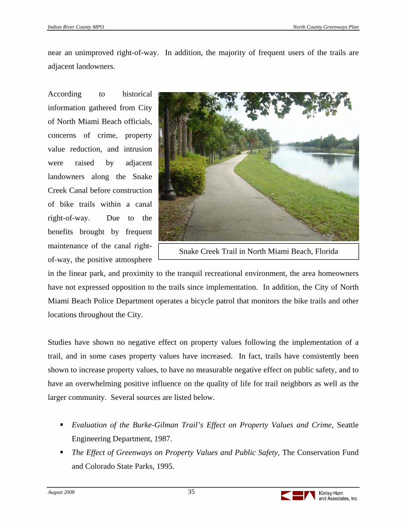
August 2008 35
Snake Creek Trail in North Miami Beach, Florida
near an unimproved right-of-way. In addition, the majority of frequent users of the trails are
adjacent landowners.
According to historical
information gathered from City
of North Miami Beach officials,
concerns of crime, property
value reduction, and intrusion
were raised by adjacent
landowners along the Snake
Creek Canal before construction
of bike trails within a canal
right-of-way. Due to the
benefits brought by frequent
maintenance of the canal right-
of-way, the positive atmosphere
in the linear park, and proximity to the tranquil recreational environment, the area homeowners
have not expressed opposition to the trails since implementation. In addition, the City of North
Miami Beach Police Department operates a bicycle patrol that monitors the bike trails and other
locations throughout the City.
Studies have shown no negative effect on property values following the implementation of a
trail, and in some cases property values have increased. In fact, trails have consistently been
shown to increase property values, to have no measurable negative effect on public safety, and to
have an overwhelming positive influence on the quality of life for trail neighbors as well as the
larger community. Several sources are listed below.
Evaluation of the Burke-Gilman Trail’s Effect on Property Values and Crime, Seattle
Engineering Department, 1987.
The Effect of Greenways on Property Values and Public Safety, The Conservation Fund
and Colorado State Parks, 1995.

Indian River County MPO North County Greenways Plan
August 2008 36
Effects of Three Cary Greenways on Adjacent Residents, Lauren A. Tedder, University of
North Carolina, 1995.
The Impact of the Brush Creek Trail on Property Values and Crime, Michelle Miller
Murphy, Sonoma State University, 1992.
The Economic and Social Benefits of Off-Road Bicycle and Pedestrian Facilities,
National Bicycle and Pedestrian Clearinghouse, 1995.
The Impacts of Rail-Trails, A Study of Users and Nearby Property Owners from Three
Trails (including St. Mark’s Trail in Tallahassee, Florida), National Park Service, 1992.
Trail maintenance is a valid concern of adjacent residents and potential trail users. If the
proposed trail is not properly maintained, it could fall into a state of disrepair that could reduce
the positive community aspect of the trail. It is important to maintain a consistent and frequent
maintenance program after construction of the trail to maintain the appearance and positive
public perception of the trail.
Projected Costs Based on the recommended greenway corridors and the typical sections, cost estimates to
construct and maintain the system of greenways, trailheads, and trail amenities, were developed.
These costs provide as much detail as possible based on planning level data and field
observations. Additional engineering design and feasibility studies will be required to advance
individual projects to construction. Facility management and maintenance costs are included
based on available data from projects in the region. Total greenway system costs are shown in
the following table.
Greenway System Construction Costs Annual System Operations and Maintenance
$13,783,650 - $18,352,750 (1) $459,360 - $1,330,380 (2) (1) – Based on construction costs outlined in the Unit Cost Data section including $300,000 to $400,000 per
mile for paved shared use paths, $200,000 to $250,000 per mile for natural surface trails, $130,000 to
$170,000 per mile for sidewalks, and $15,000 to $25,000 per mile for bike lanes. (2) – Based on $15,000 per mile per year for maintenance costs and $6,000 per mile per year for administration
staffing costs for Shared Use Paths. The costs for the NIRC Greenway System range from the first phase
implementation to the full Paved Surface Trail and Natural Surface Trail system.

Indian River County MPO North County Greenways Plan
August 2008 37
Planning level cost estimate ranges by segment are summarized in the table below.
# Trail Distance
(miles) Type
COST
Low High
1 The Trans-Florida Railroad Corridor 12.0 Paved Surface Trail $3,600,000 $4,800,000
2 South Sebastian Greenway 4.6 Paved Surface Trail $1,380,000 $1,840,000
3 Sebastian Waterfront Path 5.0 Sidewalks $650,000 $850,000
4 Fellsmere East 4.3 Paved Surface Trail $1,290,000 $1,720,000
5 82nd Avenue Connector 2.0 Paved Surface Trail $600,000 $800,000
6 North Sebastian Greenway 4.0 Paved Surface Trail $1,200,000 $1,600,000
7 Fellsmere Grade 6.0 Natural Surface Trail $1,200,000 $1,500,000
8 Blue Cypress Connector 4.0 Paved Surface Trail $1,200,000 $1,600,000
9 South Fellsmere 6.0 Natural Surface Trail $1,200,000 $1,500,000
10 Historic Sebastian Walking Trail 4.2 Sidewalks $546,000 $714,000
11 CR 512 (Sebastian Boulevard) 4.1 Bike Lanes $61,500 $102,500
12 Roseland Road 5.5 Bike Lanes $82,800 $138,000
13 CR 510 (including bridge) 8.4 Bike Lanes $126,000 $210,000
14 US 1 Bike lane completion 5.9 Bike Lanes $89,100 $148,500
15 East Coast Greenway and A1A 6.4 Signage $25,000 $25,000
16 66th St and Englar 3.0 Bike Lanes $45,000 $75,000
17 Barber to Route 1 4.2 Bike Lanes $62,250 $103,750
18 138th Ave and CR 512 11.6 Bike Lanes $174,000 $290,000
19 Blueway Trail 10.3 Blueway cost and infrastructure varies
20 St.Sebastian River Greenway 6.5 River Greenway cost and infrastructure varies
21 I-95 Sebastian River Preserve Crossing 0.8 Paved Surface Trail $252,000 $336,000
Total Proposed Paved Surface Trail 31.7 Total $9,522,000 $12,696,000
Total Proposed Natural Surface Trail 12.0 Total $2,400,000 $3,000,000
Total Sidewalks 9.2 Total $1,196,000 $1,564,000
Total Bike Lanes 42.7 Total $640,650 $1,067,750
Total Other 23.1 Total $25,000 $25,000
All Facilities 118.8 Total $13,783,650 $18,352,750

Indian River County MPO North County Greenways Plan
August 2008 38
Prioritize Greenway Alternatives Once a network plan was developed, potential projects were prioritized using a scoring matrix.
This allowed the Project Steering Committee to have input into the process of recommending
projects for implementation, and provided the consultant team with input for the implementation
section of the plan. Based on the proposed system and using the information presented in the
project descriptions, projects were prioritized based on the following criteria:
Transportation
System Connectivity
Quality of Life Benefits
Multiple Use
Agency Support
Cost
Constructability
Using these criteria, projects were ranked in priority order. These rankings were then used to
group the proposed projects into phased recommendations as follows:
Tier 1 projects are the highest potential greenway projects for near-term project
implementation within 1-5 years.
Tier 2 projects are moderately challenging projects that can supplement the core network
within 6-10 years.
Tier 3 projects are projects that are not currently ready to be implemented, but are
included as long-term potential projects over the next 11-20 years.
Based on the outcome of this process, the results of the previous tasks, and input received from
the public and affected jurisdictions, the prioritization matrix and associated scores are listed
below. The top five scoring projects were selected as the Tier 1 projects and are described in
greater detail in the Appendix.

Indian River County MPO North County Greenways Plan
August 2008 39
South Sebastian
North Sebastian

Indian River County MPO North County Greenways Plan
August 2008 40
GOALS AND OBJECTIVES
Goals and objectives will help the IRCMPO guide the implementation process for the
Greenways system. Physical implementation, user safety, and quality of service benchmarks can
become part of the infrastructure management systems utilized by IRCMPO. These benchmarks
are based on the proposed greenway and trail system presented in the plan, and include the
following performance measures:
Goal 1: Build a connected greenway trail system in Northern Indian River County.
Discussion: Connectivity is a vital element to the success and use of the greenway system. In
order for the proposed projects to reach the greatest number of people for use as both a recreation
and transportation based facility, users will need available access points and connectivity to other
facilities.
Objective 1-1: Complete the Tier 1 Priority projects identified in the Greenways Plan in
the next five years.
Objective 1-2: Complete the entire system within 20 years
Benchmark: Number of miles of trail completed.
Goal 2: Increase the number of people walking and bicycling for transportation and
recreation in Northern Indian River County.
Discussion: The proposed projects offer residents and visitors alike the option of non-motorized
travel and the health benefits of regular exercise. The recreational opportunities and benefits can
help to keep the senior population active and healthy later into life and can help to combat
obesity in children and trail users of all ages.
Objective 2-1: Double the percentage of work and recreational trips made by non-
motorized modes by 2020.
Objective 2-2: Increase the number of trail users by 5% per year as measured through
count data.
Benchmark: Conduct annual counts of pedestrian and bicycle travel at key locations on
the trail system using the National Bicycle and Pedestrian Documentation
Project methodology; utilize 10-year U.S. Census Journey-to-Work data.

Indian River County MPO North County Greenways Plan
August 2008 41
Census 2000 found that 0.7% of Indian River County workers reported
using a bicycle for work trips; 1.3% of Indian River County workers
reported walking for work trips.
Goal 3: Ensure public perception that IRCMPO is making the community safe for
bicycling and walking and promote the area and the new facilities as a resource to drive tourism.
Objective 3-1: Improve the public opinion of bicycle and pedestrian safety in the County
and achieve a positive rating of more than 60% within five years.
Objective 3-2: Promote the greenway network in the County as a tourism resource to
draw more visitors to the area.
Benchmark: Bi-annual update of the IRCMPO survey of community perceptions on
bicycle/pedestrian safety.

Indian River County MPO North County Greenways Plan
August 2008 42
GREENWAYS MANAGEMENT COMMITTEE
The creation of the North County Greenways Plan is the first step on the path to a successful
greenways system in northern Indian River County. The Greenways Plan details numerous trail
opportunities, but without the support of a network of interested parties, the greenways identified
in the Plan may never be developed. To facilitate the development of the greenways identified in
the Plan, a Greenways Management Committee (GMC) was established to serve as an advocacy
group for the implementation of the North County Greenways Plan.
A wide range of stakeholders were identified as potential members of the GMC. These
individuals include representatives from state and local government agencies, environmental
groups, cycling and recreation advocates, and interested public citizens. Potential GMC
members were either involved in the development of the Greenways Plan or recruited to
participate based on their areas of expertise and interest in greenways. The following is an initial
list of potential GMC members.
Indian River Land Trust
Friends of the St. Sebastian River
landscape architect
Civa Terra, planner
St. John’s River Water Management District (SJRWMD)
Indian River County, Environmental Planning Division
City of Sebastian, Planning Department
City of Fellsmere, Community Development Department
St. Sebastian River Buffer Preserve
Indian River County MPO Bicycle Advisory Committee
Historical Society
Pelican Island Audubon Society
It is anticipated that participation and membership of the GMC will fluctuate based on the
group’s success and involvement in project-specific tasks and objectives. However, it is
Indian River County MPO North County Greenways Plan
August 2008 43
expected that a core group of citizens will emerge as greenway advocates and will guide the
efforts of the GMC. Actions taken by the GMC are likely to include:
holding regular meetings,
initiating a local greenways publicity campaign,
establishing a group website,
distributing press releases and letters to local media outlets,
monitoring the implementation of the Greenways Plan,
evaluating the greenways priority list,
coordinating with government agencies,
obtaining funding for the development of greenways,
identifying new greenway opportunities,
beautifying the greenways,
organizing recreational events, and
ensuring regular maintenance activities occur on the greenway system.
The creation of a successful greenway system involves both a sustained planning effort and the
advocacy work of a dedicated group of individuals. As devised, an active GMC will endeavor to
implement the plan and convert the greenway opportunities into reality.
As an example, one of the activities or projects that may be undertaken by the GMC could be to
further an idea that has been developed by MPO staff and local officials to relocate historic
structures onto the greenway trail system for their scenic and cultural value. Key landowners
and businesses could be contacted to determine if surplus property could be donated and re-
located along a greenway trail at strategic locations – such as re-locating an old railroad car
along the Trans-Florida Central rails-to-trail project, which would have relevant historic value.

Indian River County MPO North County Greenways Plan
August 2008 44
IMPLEMENTATION PLAN
This section of the Plan provides a guide for implementation of the greenway system and actions
that will support the ongoing development of greenways and trails in Indian River County.
These actions are intended as both ‘stand alone’ efforts and as integrated elements in ongoing
infrastructure projects.
Project Phasing The NIRC Greenways network will be implemented in phases. The prioritization process
identified five Tier 1 projects. The project phasing is based on the prioritization process, with
some slight tweaks to the order within the Tier to focus on shared-use path projects. The Plan is
intended to be flexible enough to allow portions or segments of other projects to be implemented
as opportunities are presented. For example, there are segments of the Trans-Florida Central
Railroad Corridor where the right-of-way is well preserved. Those segments may be
implemented at an earlier date while the remainder of the project may be implemented in phases
or in conjunction with other scheduled projects.
The table on the following page demonstrates the jurisdictional authority for each corridor
identified in the plan and the time frame identified in the prioritization process. Additional
implementation notes and corridor ownership details are provided in the Appendix.
Potential projects for implementation within the first five years of the plan include:
Trans-Florida Central Railroad Corridor – The Trans-Florida Central Railroad
Corridor runs from Sebastian west to the Fellsmere Water Conservation Area. Portions
of the abandoned railroad right-of-way are in public ownership and traverse a state park,
a county park, conservation areas, and downtown Fellsmere. This project could be a
strong early win for the NIRC Greenway Plan and could ultimately connect the NIRC
communities of Sebastian and Fellsmere via an off-road shared use trail. The two largest
landowners are the State of Florida and Fellsmere Joint Venture. State of Florida lands
include St. John’s River Water Management District and the Department of

Indian River County MPO North County Greenways Plan
August 2008 45
Environmental Protection’s (DEP) St. John’s River Buffer Preserve. Fellsmere Joint
Venture (FJV) is a private entity that owns significant portions of the corridor in the west.
The annexation agreement between the City of Fellsmere and FJV has contributed the
railroad right-of-way east of U Canal of the Fellsmere Water Control District by June
2008 with an allowance for the future co-location of transportation facilities. In addition,
west of U Canal, FJV has agreed to provide public access to the Fellsmere Water
Management Area, including a public boat ramp. Other key implementation steps
include:
o Secure access to the segments of the trail where the right-of-way is not preserved.
o Coordinate with current repaving and rebuilding projects along C.R. 512 to safely
accommodate short-term trail access across the I-95 corridor.
o Coordinate with design efforts along I-95 to determine if the interstate gradient
can be raised to allow a tunnel under the interstate along the railroad right-of-way.
Priority Proposed Greenway Corridor Type of Facility Agency Ownership Timeframe 1 Trans-Florida Central Railroad Corridor Shared-Use Path Various public/private 1-5 years 2 South Sebastian Greenway Corridor Shared-Use Path SJRWMD, IRC, Seb. 1-5 years 3 82nd Avenue (CIRC Connector) Shared-Use Path Seb. Riv. WCD 1-5 years 4 Roseland Road Bike Lanes IRC 1-5 years 5 US 1 Bike Lane Completion Bike Lanes FDOT 1-5 years 6 Sebastian Waterfront Path Sidewalks IRC, Seb. 6-10 years 7 Fellsmere East Shared-Use Path SJRWMD, Ro-Ed, Fells. 6-10 years 8 East Coast Greenway Signage Signage FDOT 6-10 years 9 66th & Englar Bike Lanes IRC, Seb. 6-10 years 10 Barber to Route 1 Bike Lanes IRC, Seb. 6-10 years 11 138th Ave and CR 512 Bike Lanes IRC, Fells. 6-10 years 12 Blueway Trail Water Paddling Trail USACOE, Fla. OGT 6-10 years 13 CR 510 including bridge Bike Lanes IRC 6-10 years 14 Sebastian Historic Loop Sidewalks IRC, Seb. 6-10 years 15 CR 512, Sebastian Blvd. Bike Lanes IRC 6-10 years 16 North Sebastian Greenway Shared-Use Path IRC, Seb. 11-20 years 17 Fellsmere Grade Natural Surface Trail SJRWMD, IRC 11-20 years 18 Blue Cypress Connector Shared-Use Path Fells. Joint Venture 11-20 years 19 South Fellsmere Natural Surface Trail FDEP, SJRWMD 11-20 years 20 Sebastian River Greenway River Greenway FDEP, IRC, J.M. Russell 11-20 years 21 I 95 Sebastian River Preserve Crossing Shared-Use Path FDEP, FDOT 11-20 years

Indian River County MPO North County Greenways Plan
August 2008 46
South Sebastian Greenway Corridor – This corridor includes two critical opportunities
– the Sebastian Stormwater Park and Sebastian Harbor Preserve. In addition, the corridor
includes potential linkages along the powerline corridor. The corridor can extend to the
north to connect to Sebastian City Hall and the North Sebastian Conservation Area
(NSCA) along the North Sebastian Greenway Corridor.
o The corridor can make use of Powerline Road, a dedicated right-of-way that has
not been improved.
o The Stormwater Park represents a potential early win project with a potential trail
around the lakes and along an old roadway bed along the south and west sides of
the park. A small natural-surface parking area exists at the northwest corner of
the Stormwater Park that could serve as a trailhead.
o Numerous destinations are located along or proximate to this corridor, including
City Hall, Schumann Drive Park, Easy Street Park, and Sebastian Elementary.
82nd Avenue (CIRC Connector) – 82nd Avenue is the selected roadway for the southern
portion of the study that will connect to the Central Indian River Greenway System. The
82nd Avenue corridor is being studied by FDOT and Indian River County for future
improvements that will likely include a shared-use pathway within the future roadway
right-of-way.
Roseland Road – Roseland Road is currently being used by many local cyclists as part
of their regular ride around Indian River County. Roseland Road currently has 3-foot
paved shoulders. Bike lanes could be added as part of the next roadway re-surfacing.
.
U.S. 1 Bike Lane Completion – Coordinate with FDOT. U.S. 1 Bike Lane Completion
is an ongoing process which will eventually lead to complete bike lanes running the
length of U.S. 1. U.S. 1 is a major thoroughfare in Indian River County and while many
sections do have an existing bike lane, there are still a number of sections where the bike
lane is not continuous, which could lead to bicyclist confusion and safety concerns.
o Insure that bike lanes are included in any future reconstruction or repaving
projects on U.S. 1.

Indian River County MPO North County Greenways Plan
August 2008 47
Funding Sources A range of general and specific funding opportunities have been identified for the development
and operation of the greenways system in Indian River County. Funding opportunities can
include public and private sources, public/private partnerships, municipal agreements, grants,
and other funding sources. A list of funding resources is provided in the Appendix of this
document.
Perhaps the most common non-local transportation funding source for greenways and trail
projects is the federal Transportation Enhancements (TE) program. TE funds are apportioned by
state departments of transportation for the Federal Highway Administration (FHWA). TE
activities have been similar for the past three federal transportation legislations, including the
Safe, Accountable, Flexible, Efficient Transportation Equity Act – A Legacy for Users
(SAFETEA-LU). The TE program funds 12 categories of programs, incuding:
pedestrian and bicycle facilities,
pedestrian and bicycle safety and education programs, and
landscaping and scenic beautification.
TE funding for Indian River County can be combined into one project each year that may have
more of an impact that programming several smaller projects. Examples of potential projects
that could be implemented by a combined allocation of TE funds are listed below.
Developing a coordinated program of bike lane striping improvements.
Providing bicycle racks and trailhead kiosks at destinations throughout the County.
Implementing priority trail projects identified in the NIRC Greenways Master Plan.
Integrate Greenways in Ongoing Infrastructure Projects One of the most common ways for local governments to implement greenway projects is through
integration with other ongoing infrastructure projects. These may include roadway widening,
roadway resurfacing, utilities projects, or land development and re-development. A review of
programmed roadway improvements in the Transportation Improvement Program (TIP) was

Indian River County MPO North County Greenways Plan
August 2008 48
provided in the Existing Conditions / Data Collection section of this report. This list includes the
following potential bike lanes projects along roadways identified for on-street bicycle facilities:
CR 510/Wabasso Road, .5 mile east of SR-5/US1 to SR A1A
CR 510, Intracoastal Waterway Bridge (Transfer to FDOT) Repair
CR 510, 61st Drive to Indian River (4 lanes)
CR 510, 75th Court to 61st Drive (4 lanes)
CR 510, CR 512 to 75th Court (4 lanes)
CR 512 Phase 3, Roseland Rd. to Sebastian Middle (4 lanes)
CR 512 Phase 4, Sebastian Middle School to I-95 (4 lanes)
CR 512 Phase 5, I-95 to 130th Ave (4 lanes)
Powerline Rd., Barber Street. to CR 510 (2 lanes)
66th Avenue, 77th Street. to 59th Street (4 lanes)
66th Avenue, 77th Street to Barber Street (4 lanes)
66th Avenue, Widening Includes Bridges at 33,37,41,45,53,57,
82nd Avenue, CR 510 to 77th Street (2 lanes)
U.S. 1, 49th Street to 65th Street (6 lanes)
Develop Greenway Connections to the North, West, and South One of the great appeals of greenways and trails lies in the concept of connectivity. Greenways
and trails can connect people with the region’s conservation areas, parks, and open spaces. The
North Indian River County Greenways Master Plan includes potential connections to the north,
west, and south to identify important links to and from other areas of IRC and the neighboring
Counties.
North
Several greenways identified in this study can provide potential connections to the north.
Examples include the East Coast Greenway along S.R. A1A, the Indian River Blueway Trail
along the Indian River Lagoon, U.S. Route 1, and C.R. 507. These corridors provide
connectivity to the Brevard County Greenways Master Plan. The northern portion of Indian
River County includes the St. Sebastian River Preserve State Park, the St. Sebastian River
Greenway, and the North Sebastian Conservation Area. These parks and conservation areas are

Indian River County MPO North County Greenways Plan
August 2008 49
a key element of the Greenway Plan but also provide an opportunity connecting to the Canal
along the Brevard County line to the north. In addition, the Blue Cypress Conservation Area
Trails connect to trails in the Three Forks Marsh Conservation Area Trails in Brevard County.
West
The western portion of Indian River County is largely comprised of agricultural and conservation
lands, including the Blue Cypress Water Management Area (BCWMA). These rural areas
provide a potential ecological connection for the greenways network that could promote
awareness of “Old Florida” and provide possible eco-tourism destinations. Western Indian River
County offers many popular fishing destinations.
South
A Greenways Plan was previously completed for Central Indian River County and the NIRC
plan proposes to connect to those facilities by way of shared use trail on 82nd Avenue.
Additional connectivity to the south and the CIRC plan can be provided from the East Coast
Greenway along S.R. A1A, the Indian River Blueway Trail along the Indian River Lagoon, and
the bike lanes on U.S. 1.
Apply for Designation with the Florida Office of Greenways and Trails (OGT) The Indian River MPO should apply for designation of the NIRC Greenways Plan with the
Florida Department of Environmental Protection (FDEP). The Florida Office of Greenways and
Trails (OGT) is a division within FDEP. The mission of the Florida Greenways and Trails
program is to create a network of greenways and trails throughout Florida, connecting one end of
the state to the other, from Key West to Pensacola. The Florida Greenways and Trails
Designation Program provides for the designation of public lands and waterways and private
lands.
The OGT Designation program was established to raise public awareness of the greenway
network, provide recognition for individual components of the system, and encourage
partnerships in the conservation, development, and management of system components. In
addition to raising public awareness of the greenway network, OGT Designation offers

Indian River County MPO North County Greenways Plan
August 2008 50
incentives such as liability protection; assistance from FDEP in identifying funding sources; and
additional consideration in grant programs such as the Florida Communities Trust Land
Acquisition Program, Recreational Trails Grant Program, and the Florida Recreation
Development Assistance Program. The application process for designation and grants is
described on the Florida OGT website.
Florida Statute 260.0125 provides liability protection for landowners whose land is designated
by the Florida OGT according to the designation requirements of Florida Statute 260.026(2)(d).
Landowners in designated greenway corridors are not required to provide warnings of any
hazardous conditions, structures, or activities on the designated land. In addition, Florida Statute
375.251 (Florida Recreational Use Statute, or RUS) limits liability for landowners opening up
their lands to free public recreation access. A copy of the RUS is found in the Appendix of this
report.
Comprehensive Plan Revisions Indian River County has adopted a comprehensive plan that is consistent with Florida’s Growth
Management Act. The Comprehensive Plan is designed to act as a guide to proper growth
management. The Plan contains eleven chapters, or elements, that document Indian River
County’s planning regulations. Indian River County’s Comprehensive Plan refers to bicyclists,
pedestrians, and trails in various elements of the Plan, including Transportation, and Recreation
and Open Space.
The Transportation Element contains the Bicycle/Pedestrian System section that defines the
existing bicycle and pedestrian system in place in 1998. The Plan indicates that the ideal
bicycle/pedestrian system would be five-foot paved shoulders and five-foot sidewalks on each
side of all thoroughfares. Objective 6 of the Transportation Element stated: “By 2000, the county
will have a continuous pedestrian/bicycle system providing access throughout the urbanized
area of the county.” Policies included under Objective 6 include evaluating utility easements,
railroad rights-of-way, and drainage canal rights-of-way as locations for off-road trails, and
ensuring that pedestrian and bicycle access is provided to all park areas.

Indian River County MPO North County Greenways Plan
August 2008 51
The Recreation and Open Space Element lists foot paths and bicycle trails as outdoor
recreational activities that are available at certain parks throughout the County. Within the North
Indian River County study area, only Riverview Park, Lake Hardee Park, Donald McDonald
Park, and the North Beach Complex are listed as having foot trails. Policy 6.4 of the Recreation
and Open Space Element establishes the Indian River Lagoon and the associated coastal
resources as a greenway and water trail system.
Overall concepts that should be considered for future comprehensive planning efforts include the
following.
Indian River County recognizes the need to encourage bicycle and pedestrian travel for
both transportation and recreation. These uses conserve energy, contribute to cleaner air,
reduce traffic, reduce the need for automobile parking, and improve personal fitness.
The Comprehensive Plan of Indian River County should assure safe and convenient
access to all areas of the County. In addition, the Plan should promote the use of
bicycling and walking as viable and attractive alternatives to the use of automobiles.
Policies that should be implemented in the Indian River County Comprehensive Plan include the
following.
Provide marked bicycle lanes, sidewalks and safe crossings (not just paved shoulders)
along collector and arterial roadways.
Consider bicycle-operating characteristics and Americans with Disabilities Act (ADA)
compliance in the design of intersections and traffic control systems.
Add bicycle and pedestrian facilities to the list of design characteristics necessary for
traditional neighborhood design (TND) areas.
Develop and implement bicycle parking standards for traditional neighborhood design
(TND) areas.
Implement an education program to promote bicyclist and pedestrian safety.
Require compliance with appropriate policies and standards for new development
including bicyclist, pedestrian, and trail facilities within residential communities. Ensure
interconnection of new facilities with the proposed greenway system.

Indian River County MPO North County Greenways Plan
August 2008 52
Analysis of Environmental and Permitting Impacts The proposed greenway network for North Indian River County consists of corridors that have
been identified within existing rights-of-way and portions of some corridors that are currently in
private ownership. Corridors that are in public ownership are currently being utilized for
transportation, utility, or recreational purposes. Therefore, environmental impacts from
implementing greenways and trails are expected to be minimal. However, an environmental
review should be conducted before the design phase for off-road trails and unimproved corridors.
Portions of trail corridors that are currently in private ownership can be developed only with
approval of the existing landowner, which may include agreements such as the annexation
agreement between the City of Fellsmere and Fellsmere Joint Venture, or through public
purchase of private property to bring the corridor segment into public right-of-way.
A field reconnaissance would be required to identify vegetative communities, wildlife, wetlands,
and potential listed species or listed species habitat within the proposed project area. Wetlands
and other surface waters would fall under the jurisdiction of the St. Johns River Water
Management District (SJRWMD) and the US Army Corp of Engineers (USACOE). Mitigation
for impacts to wetlands would be required. Mitigation is determined based on the quality of the
habitat being impacted.
The Florida Department of Environmental Protection (FDEP) has identified the Trans-Florida
Central Railroad Corridor as a potential rails-to-trails project. The environmental permitting
process must be followed to ensure protection of sensitive habitats in the vicinity of the rails-to-
trails project including the St. Sebastian River Preserve State Park and the Fellsmere Water
Management Area. The SJRWMD typically restricts vertical structures, such as shelters,
information kiosks, and landscaping, within 40 feet of the edge of water surface for maintaining
access for maintenance vehicles.
The Indian River Blueway Trail should be implemented within the framework established for the
Florida Circumnavigational Saltwater Paddling Trail, managed by the FDEP, Office of
Greenways and Trails. The Saltwater Paddling Trail includes individual blueway trails identified
in local plans, such as NIRC Greenways. The Saltwater Paddling Trail is a strategic long-term

Indian River County MPO North County Greenways Plan
August 2008 53
priority for FDEP, but it relies heavily on the involvement of local governments, private
organizations, paddling clubs, and volunteers.
Trails implemented along canal rights-of-way must be designed and permitted in accordance
with the Sebastian River Water Control District or the Fellsmere Farms Water Control District.
Drainage and maintenance concerns must be considered during the design and permitting
process.
Remaining corridors are within property owned by the City of Sebastian, City of Fellsmere,
Indian River County, or the Florida Department of Transportation (FDOT).
Partnerships Strategies The success of the North Indian River County (NIRC) Greenways Master Plan will depend upon
developing community partnerships for implementation, fundraising, and promotion of the trail
system. Establishing the Greenways Management Committee is an excellent first step by the
Indian River County MPO to pursue the community framework that will allow planning and
implementation activities to flourish. Potential opportunities for marketing and promotion of the
greenways system for the Greenways Management Committee and local governments to
consider are listed below.
Adopt-a-Trail / Maintenance Program: An ‘adoption’ program can be established so
organizations, individuals and businesses can adopt a mile of trail, an engraved brick or trail
marker, a bench, a bike rack, a trailhead or other elements of the trail system. This can facilitate
fundraising and maintenance of the trail system, and is a good way to built support for trails with
a cross section of community partners. Since IRCMPO is a planning agency, cooperative
maintenance agreements will be needed with the Parks & Recreation Department for off-street
trails, and with Transportation facilities departments for on-road facilities.
Publish a Trail Guide for Indian River County: An ‘early win’ for Indian River County
would be to provide literature and trail maps for public use. A trail guide would provide
information on access points, existing trails, rental equipment locations, and other information

Indian River County MPO North County Greenways Plan
August 2008 54
for residents and visitors. This information could be provided in electronic format online, or
could be published and made available in hard copy. The map can be funded and produced by
revenue from advertising, or can be funded as a public service promotional item.
Friends of Indian River Greenways: Most successful trail programs have the support of a
local non-profit organization that can advocate, raise funds and collaborate with local officials.
A ‘friends’ organization can serve as a focal point for community support and outreach. The
board of this organization can include a broad range of community interests, such as health
providers, schools, businesses, bike clubs and other partners.
Annual Events: There are numerous opportunities for North Indian River County to promote
special events related to the greenways system. These could include a Greenway 5k along the
beach or a proposed trail corridor or an Indian River County Triathlon that included kayaking,
running and bicycling. These types of events can provide public awareness, visibility for
sponsors and fundraising opportunities for the trail system.
Active Living Seniors: With the significant local population of seniors and retirees, and the
need for this population to remain physically active, it will be important to develop programs that
connect this population to the greenways. Walking and physical fitness programs can be linked
to guided tours of existing trails, as well as increased use of new trails as they are developed.
This user map was produced for bicyclists in Boca Raton, Florida.

Indian River County MPO North County Greenways Plan
August 2008 55
Trips for Kids: Trips For Kids provides the materials, moral support and inspiration that an
individual or group needs to help disadvantaged kids discover the joy of mountain biking.
Operating in the United States and Canada, they open the world of cycling to at risk youth
through mountain bike rides and Earn-A-Bike programs. The more than forty Trips for Kids
chapters combine lessons in personal responsibility, achievement and environmental awareness
through the development of practical skills and the simple act of having fun on a bike.
Additional information is available at the organization’s website, www.tripsforkids.org.
The first steps of implementing the Greenways Plan, and the probable lead agency are
summarized as follows:
1. First Phase Projects
Lead: IRCMPO staff; GMC
2. Transportation Enhancements Funding
Lead: IRCMPO staff
3. Friends of Indian River Greenways
Lead: New non-profit (or partnership with an existing 501(c) organization); GMC
4. Maintenance Agreements
Lead: Parks & Recreation and Engineering staff
5. Florida OGT Designation
Lead: IRCMPO Staff
Trips for Kids and bike racks adopted by local partners are examples of opportunities to promote the North Indian River Greenways system.
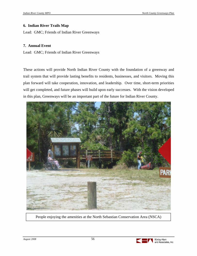
Indian River County MPO North County Greenways Plan
August 2008 56
People enjoying the amenities at the North Sebastian Conservation Area (NSCA)
6. Indian River Trails Map
Lead: GMC; Friends of Indian River Greenways
7. Annual Event
Lead: GMC; Friends of Indian River Greenways
These actions will provide North Indian River County with the foundation of a greenway and
trail system that will provide lasting benefits to residents, businesses, and visitors. Moving this
plan forward will take cooperation, innovation, and leadership. Over time, short-term priorities
will get completed, and future phases will build upon early successes. With the vision developed
in this plan, Greenways will be an important part of the future for Indian River County.

Indian River County MPO North County Greenways Plan
August 2008 57
APPENDIX
Demographic and Transportation Data
Sample Successful Greenway Examples
NIRC Greenway Evaluation Criteria
North Sebastian Conservation Area Brochure
Tier I Project Description Sheets
Right-of-Way and Implementation Notes
Funding Sources
Florida Recreational Use Statute

Indian River County MPO North County Greenways Plan
August 2008 58
Indian River County Demographic and Transportation Data

Indian River County MPO North County Greenways Plan
August 2008 59

Successful Examples:Successful Examples: Hillsborough County, FL
• Greenways Master Plan completed in 1994
• Greenways Program• Greenways Program established to implement the plan
• Greenways Committee meets quarterly
• 5 trails• 5 trails• http://www.hillsboroughcounty
.org/parks/greenways/g/p /g y /
60

Successful Examples:
• Indianapolis Cultural Trail
Successful Examples: Indianapolis, IN
• Indianapolis Cultural Trail• Urban trail for walking and
biking• “A cultural connection to the
great outdoors” – Indianapolis Business Journal, March 15-21, , ,2004
• Serves as a signature facility for the Central Indiana Greenwaythe Central Indiana Greenway System
• http://www.indyculturaltrail.info/
61

Successful Examples:
Creating Connections:
Successful Examples: Pennsylvania Greenways Partnership• Creating Connections:
The PennsylvaniaGreenways andTrails How To Manual
• Thousands of miles of rural and urban greenway pathsand urban greenway paths implemented
• Highlights 6 steps ofcreating a trail
• http://www.pagreenways.org/
62
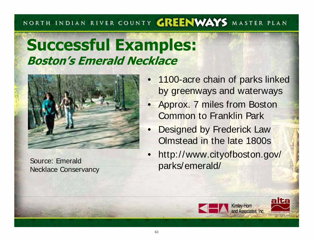
Successful Examples:Successful Examples: Boston’s Emerald Necklace
• 1100-acre chain of parks linked by greenways and waterways
• Approx 7 miles from Boston• Approx. 7 miles from Boston Common to Franklin Park
• Designed by Frederick Law Olmstead in the late 1800s
• http://www.cityofboston.gov/parks/emerald/Source: Emerald parks/emerald/Necklace Conservancy
63

Indian River County MPO North County Greenways Plan
August 2008 64
North IRC Greenways: Evaluation Criteria
Criteria Description / Points Maximum Score
Transportation Benefits
Increases use of non-motorized travel by providing access to the following destinations within .5 mile of the proposed corridor: Access to Schools: 3 Access to Major Destinations: 3 Access to Parks & Recreation: 3 Access to Transit: 3 Bike/Ped Safety: 3
15
System Connectivity
Provides an essential link in the proposed network: 20 This link is important as a ‘stand alone project, but not critical to the overall system 10 This is a long-term element and potential future link 5
20
Regional Benefits
Tourism: 3 Environmental: 3 Economic: 3 Health / Fitness: 3 Quality of Life: 3
15
Multiple Use Bicyclists: 3 Pedestrians / Runners: 3 Water Trail: 2 Equestrian: 2
10
Agency Support
Project currently has support (20) Project has potential to receive agency support (10) Project is not likely to receive support (0)
20
Cost
Project can be implemented for: < $200k / mile (10) $200k - $500k / mile (5) > $500k / mile (0)
10
Constructability
Project requires further study but is likely to be advanced (5) Project is feasible and ready for implementation (10)
10

Welcome to the North Sebastian
Conservation Area! The North Sebastian Conservation Area was
purchased by Indian River County in 1996 with cost-share funds from the Florida Communities Trust.
The habitats throughout the Conservation Area provide visitors many opportunities to see a diverse array of plant and animal species. Trails are rated by difficulty and distance to the trailhead. As always, please use caution when visiting the conservation area. You may encounter poisonous snakes, feral hogs, alligators and poisonous plants. Sturdy walking shoes and a supply of drinking water are a must for a long hike. Also remember that ALL plants and animals on the conservation area are protected. Taking, harassing or otherwise disturbing any plant or animal on site is strictly prohibited and is enforced. There are many state and federally protected animals and plants on site and harassment of any kind will not be tolerated.
1 SEBASTIAN TRAIL - Easy The trailhead begins in an area adjacent to a freshwater lake with a perimeter of Pine Flatwoods. Great Blue Herons and other wading birds are typically aloft in the Sand Pines or on the Lake's edge. Osprey and otters may be encountered searching for their lunch as well. This is a shady area perfect for a picnic or outdoor classroom activities. Two picnic tables are located here.
2 BROMELIAD BOULEVARD - Easy This trail takes visitors from the trailhead entrance through Pine Flatwoods that surrounds the freshwater lake. Be sure to keep an eye
open for Pileated and Red-bellied Woodpeckers and other songbirds. This area is typically quiet and shady and the northern edge of the trail begins
to transition into Rosemary Scrub. The trees are laden with bromeliads, all of which are protected
by state law. You may also find Sky Blue Lupine blooming in the late winter and early spring on this trail.
3 JAYS WALK - Easy The Jays Walk is an area where platted roads for a subdivision were installed. (nesting jay photo right) This area is an easy walk within xeric oak scrub and is home to a family of scrub jays. Some of these jays are “banded”, so if you see them, you may notice that some of the family members have "bracelets" on their legs. These bands are placed in a sequence that is unique to each bird. The Jays Walk Trail gives visitors a glimpse of prime Xeric Oak Scrub inhabited by many species that are becoming increasingly rare. Some of these species such as the Florida Scrub Jay are restricted to Florida's unique scrub habitat and are not found anywhere else in the world! Xeric Oak Scrub is composed primarily of Chapman's Oak, Scrub Oak and Myrtle Oak. While these trees can get taller, in optimal scrub-jay habitat, they should be no taller than 6' high. This area was successfully burned with assistance from the Florida Division of Forestry. Prior to the prescribed burn, there were no scrub jays using this area; a true sign of success was when the current family of jays moved in and began defending and nesting in this area. This family of jays is relatively tame, but please stay on the trails and respect their home.
4 CACTUS CAUSEWAY - Moderately Difficult Walking through the Cactus Causeway, visitors will see an exceptional scrub area restored by timbering. The entire conservation area was timbered in 2001. There are remnant piles of logging debris left for a future prescribed burn. This area is a wonderful example of high quality scrub habitat. Also in this area, Curtiss' Milkweed was discovered in 2005, a State listed
Endangered species. It is very hard to find except when blooming because it resembles a small scrub oak seedling (photo right).
5 REINDEER RIDGE - Moderately DifficultThis trail is a beautiful walk through a variety of habitats including Rosemary Scrub and a freshwater wetland at the north end. The trail winds up a coastal ridge remnant, visitors will encounter a variety of plant species including coral bean and scrub hickory. Look for nesting osprey and foraging tortoises.
6 HOLLY’S HOLLOW – Moderately Difficult This trail has a beautiful boardwalk that takes visitors through a native holly area surrounded by a freshwater marsh and scrub. When on the boardwalk, visitors get a unique view of the scrub to the south, distant pine flatwoods and a beautiful holly filled wetland. This is a special treat in the winter months when the holly is laden with bright red berries that the migrating songbirds adore.
7 MALLARD’S MARK – Moderately Difficult This trail crosses the central wetland by way of a 200 foot boardwalk with observation deck. Be sure to visit this area where ducks, cranes, wood storks (photo left), wading birds
and other wildlife abound in the freshwater marsh that lies centrally within the conservation area. The wetland dries periodically throughout the year and provides a feeding area for many wildlife species. This area is a must see any time of the year!
8 ROSELAND TRAIL – Easy This trail ends (or begins) at 130th Street and may be used by Roseland residents for access to the conservation area. The trail gives visitors an opportunity to see scrub jays, gopher tortoises, osprey and restored scrub.
9 HIDEAWAY HILL - Difficult This trail takes adventurers next to a freshwater wetland and up the ancient coastal ridge. Inhabitants of this area include Osprey, Red-Tailed Hawks, and many songbirds. Keep an eye open for Bobcat, Raccoon, Opossum and other tracks from creatures who ventured through the previous night. This trail is sandy, may have trip hazards and is relatively steep, please watch your step.
10 OSPREY HIDEAWAY - DifficultOsprey Hideaway runs along the top of an ancient dune line. The trail is adjacent to the Florida East Coast Railroad. The area is full of Scrub Hickory and other scrub endemic species. Watch for Osprey nests and gopher tortoises, they abound in this area. FUN FACT: Osprey can be distinguished from Bald Eagles by having a white belly and a black stripe along their eye. Adult Bald Eagles have a black belly, an all white tail and all white head and neck, with no back stripe on their eye. They are also larger than an Osprey. Osprey feed primarily on fish.
11 TERRITORY TRAIL – Moderately Difficult This trail runs through an edge of scrub and saw palmetto. It is occupied by a family of scrub jays and sometimes one may see two families disagreeing over territorial boundaries, especially during the spring months. This trail is a beautiful trail that you won’t want to miss.
12 POWERLINE ROAD - Easy (to water's edge) Although you may not be able to cross the Powerline Road trail, it is certainly worth walking to the water's edge. This area is full of pond lilies, St. Johns Wort and other freshwater species. The wetland is typically 3-4 feet deep
and makes a perfect feeding spot for herons (Great Blue Heron photo to left), egrets and ducks. If you are lucky, you may even find Roseate Spoonbills, Wood Storks and Sandhill Cranes in this area.
13 PALMETTO PATH - Difficult Palmetto Path is a difficult trail that runs on the outer boundary of the conservation area. This
65

area is home to a family of scrub jays and many gopher tortoises.
14 GOPHER’S GALLEY – Moderately Difficult The footpath of this trail is relatively easy to traverse, but does take visitors further from the trailhead. This area is a beautiful area of native grasses, sedges and rushes and when in full bloom, you will encounter a beautiful array of yellow bachelor buttons, white hat pins, and other native wildflowers. This area seems to be a favorite spot for our Gopher Tortoises (photo right) who relish the abundant variety of vegetation they can eat. This trail may be wet during parts of the year.
15 PRAIRIE PATH – Moderate to Difficult Prairie Path is a beautiful trail that takes visitors through a freshwater wet prairie full of Bachelor Buttons, Bog Buttons, Road Grass, Hollies and other wetlands species. Just after or during a rain, you will hear a chorus of native frogs singing their love songs to attract a mate. This path may become significantly wet. When the trail crosses 14, you will enter an area to the north that is full of native holly, bay and oaks.
16 LITTLE LOOP – Moderate to Difficult Due to the distance to the trailhead, this trail is rated as moderate to difficult. A trek through this area will take you through a Pine Flatwoods full of Sand Pine, Saw Palmetto, Gallberry and other native species.
Florida Scrub Jays may be found in the small patch of scrub here. This area is an excellent area to see a great variety of migrating songbirds in the fall, winter and spring.
17 CRANE CROSSING – Difficult This trail takes visitors to the edge of a freshwater depression. Walk quietly and you may catch a glimpse of wading birds including Great Blue Herons, Egrets, Tri-Colored Herons and other birds feasting on freshwater fish. This
trail may not be passable during the summer months due to deep water.
18 THE OUTERBANKS – Difficult This trail is a multi-use trail for horses, bicyclists and hikers. Use caution, as trails may be hazardous. This trail is the longest and runs along the outer edge of the Conservation Area. Users will traverse an array of habitats including Hydric and Mesic Pine Flatwoods, freshwater wetlands and scrub.
TRAIL DEFINITIONS:Easy Trails (white on map) are easier to traverse, receive more maintenance to remove trip hazards, have accessible boardwalks and are relatively close to the trailhead. Equestrian users are discouraged from using these trails frequently. Trails 1, 2 & 3 are approximately 1mile round trip from the Friendship Park Trailhead. Moderately Difficult Trails may be sandy or wet, have uneven surfaces and may have objects, roots or other trip hazards. Difficult Trails are furthest from the trailhead, receive less maintenance, may be wet throughout parts of the year and are more difficult to traverse. Trail markers are also spaced further apart. Trails may also be less distinct and are narrower. Before venturing onto these trails make sure you have plenty of water and a first aid kit. Equestrian users are encouraged to use these trails.
Trails that are color coded in Gray are connector trails that may be used for variety.
PET OWNERS: When you visit the conservation area come prepared to pick up your pet’s waste and dispose of it properly. Trash bins are located at the trailheads.ALL DOGS MUST BE KEPT ON A LEASH. FAILURE TO DO SO MAY RESULT IN HAVING TO PROHIBIT DOGS FROM THE CONSERVATION AREA IN THE FUTURE.
Trail conditions are rustic: be prepared for uneven ground, exposed tree roots and primitive conditions. Bicyclist are welcome, but please use caution on the trails and be cautious of other visitors. Horses are welcome, please stay on designated trails and be cautious of other users. Horses are not allowed on the boardwalks. You may encounter bees, poison ivy, alligators, rattlesnakes or other dangerous wildlife, please use caution and don’t feed the wildlife. Taking of any plant or animal is strictly prohibited. Motorized vehicles of any kind (including boats) are strictly prohibited. Please report damages or violations to the conservation lands manager or Sebastian Police Department immediately. Bringing wildlife to the conservation area is strictly prohibited. Please contact the conservation lands manager if you are concerned about native wildlife. Please be respectful of the area, this is home to many species of animals and plants.
TAKE ONLY PICTURES, LEAVE ONLY FOOTPRINTS
DESTROY NOTHING and ENJOY EVERYTHING!
NORTH SEBASTIAN CONSERVATION AREA
This project was partially funded by the Land & Water Conservation Fund through the U.S.
Department of Interior and the Florida Department of Environmental Protection.
Special Thanks to:
For more information or to schedule group tours, please contact the Indian River County
Conservation Lands Manager at 772-589-9223; [email protected] or visit
www.ircgov.com/conservation
The Conservation Area is open from dawn until dusk each day.
66
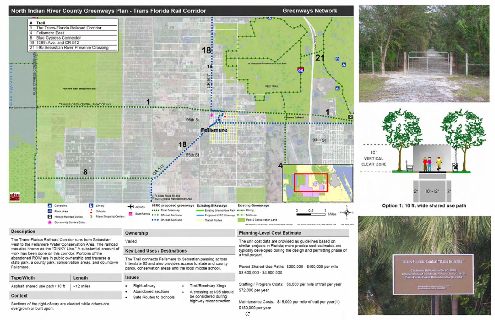
67

68

69

70
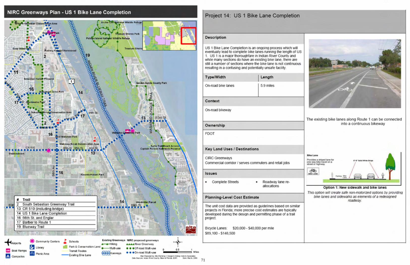
71

North Indian River County Greenways Master Plan Right-of-Way and Implementation Notes
72
Trail # Name Type Right-of-Way Ownership Implementation Notes
Prioritization Score
Prioritization Ranking
1
The Trans-Florida Central Railroad Corridor
Off-road multi-use
• St. John's River Water Mgmnt Dist
• Fellsmere Joint Venture • Patel Associates • Florida DEP • Dean Luethje • Fellsmere 392 LLC • State Trust Fund of
Florida • Indian River County • Indian River County
School Board
• the two largest landowners are the State of Florida and Fellsmere Joint Venture
• two segments of this corridor remain in private ownership on either side of I-95
• the potential exists to connect to CR 512 through the St. Sebastian River State Preserve and Fellsmere Trailhead to provide a connection across I-95 and to avoid Fellsmere 392 LLC and Luethje private properties in the short-term 93 t1
14 US 1 Bike Lane completion
On-road multi-use Florida DOT
striping modifications and additional pavement in certain areas along U.S. 1 93 t1
12 Roseland Road On-road multi-
use Indian River County
striping modifications and additional pavement along Roseland Road to create bike lanes; project could also be accomplished during re-surfacing 87 3
5
82nd Avenue (CIRC Connector)
Off-road multi-use
Sebastian River Water Control District (future roadway right-of-way)
develop multi-use trail in future 82nd Avenue roadway right-of-way 85 4
2
South Sebastian Greenway Corridor
Off-road multi-use
• St. John's River Water Mgmnt Dist
• Indian River County • City of Sebastian
• Stormwater Park trail is a potential early win project (SJRWMD and City)
• would connect Power Line corridor with Barber/Englar corridor
• use existing road where possible around south and west sides of Stormwater Park 83 t5

North Indian River County Greenways Master Plan Right-of-Way and Implementation Notes
73
15 East Coast Greenway
On-road multi-use Florida DOT signage 83 t5
3
Sebastian Waterfront Path (Indian River Drive and Downtown Sebastian)
On-road multi-use
City of Sebastian; Indian River County
portions have wide sidewalks; adjacent property owner resistance to sidewalks along the northern portion of corridor 80 7
11
CR 512 (Sebastian Boulevard)
On-road multi-use Indian River County bike lanes 75 t8
18 138th Avenue and CR 512
On-road multi-use Indian River County bike lanes 75 t8
13 CR 510 (Wabasso)
On-road multi-use Indian River County bike lanes 73 10
4 Fellsmere East Off-road multi-
use RO-ED Corp; St. John's River Water Mgmnt Dist
recently incorporated into City of Fellsmere; develop greenway corridor as area develops 72 t11
16 66th Street and Englar
On-road multi-use
City of Sebastian; Indian River County bike lanes 72 t11
17 Barber Street On-road multi-
use City of Sebastian; Indian River County bike lanes 72 t11
10
Historic Sebastian Walking Trail
On-road multi-use Florida DOT; City of Sebastian sidewalks 68 14
19 Blueway Trail Blueway
Florida Department of Environmental Protection; US Army Corps of Engineers
construct access points such as boat ramps and canoe launches 67 15

North Indian River County Greenways Master Plan Right-of-Way and Implementation Notes
74
6
North Sebastian Greenway Corridor
Off-road multi-use
City of Sebastian; Indian River County
two main sections of trail - in Powerline Road corridor and in NSCA 64 16
7 Fellsmere Grade
Off-road multi-use
St. John's River Water Mgmnt Dist
multi-use trail in SJRWMD ROW; appropriate for natural surface trail 63 17
8 Blue Cypress Connector
Off-road multi-use Fellsmere Joint Venture
passes through recently incorporated area of City of Fellsmere; currently owned by Fellsmere Joint Venture; would likely only be developed into a public greenway trail in conjunction with potential future development in the area 58 t18
9 South Fellsmere Off-road multi-
use Florida DOT; Indian River County
multi-use trail along boundary between Fellsmere Joint Venture and Blue Cypress Recreation Area; appropriate for natural surface trail 58 t18
20 St. Sebastian River Greenway
River Greenway
Florida Department of Environmental Protection; Indian River County; John M. Russell
River Greenway – Conservation corridor; continue acquisition efforts to obtain continuous public river buffer 56 20
21
I-95 Sebastian River Preserve Crossing
Off-road multi-use
Florida Department of Environmental Protection; Florida DOT
Potential multi-use trail with grade-separated crossing of I-95 to link Blue Trail and Red Trail 40 21

Indian River County MPO North County Greenways Plan
August 2008 75
Funding Sources for Greenways and Trails
Source: http://www.enhancements.org/rtcfunding.asp
Funding Type: State Jurisdiction: FL Funding Program: Florida Communities Trust Implementing Agency: Florida Department of Community Affairs Intended for: a portion for recreation trails Description: The Florida Communities Trust (FCT) helps local governments implement their comprehensive plans through the acquisition of land, utilizing funds from the state's Preservation 2000 Act and Florida Forever Act. The Florida Communities Trust differs from other acquisition programs, focusing exclusively on locally selected acquisition projects. Each year, the program makes grants to local governments to help them buy coastal, conservation, recreation, greenways, and open space land. Since few local governments have land-buying experience, Trust staff also provide technical assistance. They help cities and counties put grant applications together and are part of the negotiation and acquisition team during the purchase process. Web site: http://www.dca.state.fl.us/ffct/
Funding Type: State Jurisdiction: FL Funding Program: Florida Recreation Development Assistance Program Implementing Agency: Florida Department of Environmental Protection, Division of Recreation & Parks, Bureau of Design & Recreation Services Intended for: includes the construction or renovation of recreational trails Description: The Florida Recreation Development Assistance Program (FRDAP) is a competitive program which provides grants for acquisition or development of land for public outdoor recreation use. The program is administered by the Florida Department of Environmental Protection (DEP). The Bureau of Design and Recreation Services of DEP’s Division of Recreation and Parks has direct responsibility for FRDAP. Funds from FRDAP may be used to acquire or develop land for public outdoor recreation or to construct or renovate recreational trails. Municipal or county governments or other legally constituted entities with the legal responsibility to provide public outdoor recreation may apply for FRDAP funds. FRDAP grant applications may be submitted during an announced submission period, usually early fall each year. The applicant is required to supply a match at certain funding levels. The local match requirement is based upon the total project cost. Web site: http://www.dep.state.fl.us/parks/bdrs/frdap.htm

Indian River County MPO North County Greenways Plan
August 2008 76
Funding Type: Federal Jurisdiction: Nationwide Funding Program: Recreational Trails Program Implementing Agency: U.S. Department of Transportation's Federal Highway Administration (FHWA) Intended for: Trails Description: The U.S. Congress first authorized the Recreational Trails Program in the Intermodal Surface Transportation Efficiency Act of 1991. It was reauthorized in 1998 under the Transportation Equity Act for the 21st Century (TEA-21). The Recreational Trails Program provides funds to the States to develop and maintain recreational trails and trail-related facilities for both nonmotorized and motorized recreational trail uses. Examples of trail uses include hiking, bicycling, in-line skating, equestrian use, cross-country skiing, snowmobiling, off-road motorcyling, all-terrain vehicle riding, four-wheel driving, or using other off-road motorized vehicles. Web site: http://www.fhwa.dot.gov/environment/rectrails/index.htm Funding Type: Federal Jurisdiction: Nationwide Funding Program: Land and Water Conservation Fund (LWCF) Grants Implementing Agency: National Park Service Intended for: includes trails and greenways Description: This Federal funding source was established in 1965 to provide "close-to-home" park and recreation opportunities to residents throughout the United States. Money for the fund comes from the sale or lease of nonrenewable resources, primarily federal offshore oil and gas leases and surplus federal land sales. LWCF grants can be used by communities to build a variety of parks and recreation facilities, including trails and greenways. LWCF funds are distributed by the National Park Service to the states annually. Communities must match LWCF grants with 50 percent of the local project costs through in-kind services or cash. All projects funded by LWCF grants must be used exclusively for recreation purposes, in perpetuity. Projects must be in accordance with each State's Comprehensive Outdoor Recreation Plan. $140 million dollars is available to states through this program in Fiscal Year 2002. Through the life of this program, $3.2 billion dollars has been allocated, nearly 2.5 million acres have been acquired, and 38,000 land and water projects have been funded. Web site: http://www.nps.gov/ncrc/programs/lwcf/ Funding Type: Federal Jurisdiction: Nationwide Funding Program: Transportation Enhancements (TE) Implementing Agency: Federal Highway Administration via FDOT & IRCMPO Intended for: includes trails and other bicycle/pedestrian facilities Description: Created in 1991 under the Intermodal Surface Transportation Efficiency Act (ISTEA), renewed in 1998 with the Transportation Equity Act for the 21st Century (TEA-21), then renewed again in 2005 with the Safe, Accountable, Flexible, Efficient Transportation Equity Act, A Legacy for Users (SAFETEA-LU), Transportation Enhancements (TE) require every State to reserve at least 1 percent of their Federal surface transportation funds for designated

Indian River County MPO North County Greenways Plan
August 2008 77
Transportation Enhancements Activities, such as pedestrian and bicycle facilities, pedestrian and bicycle safety and education, and the conversion of abandoned railway corridors to trails. Between Fiscal Year 1992 and Fiscal Year 2005, the Federal government provided approximately $437 million in TE funds to Florida. As with other Federal-aid funding, the Federal government typically pays for 80 percent of project costs. The project sponsor – a State, a local government or a non-governmental organization – pays the balance. Bicycle and pedestrian facility improvements represent the largest of the twelve eligible transportation enhancement activities (approximately 47 percent of TE spending). Web site: http://www.enhancements.org/ Funding Type: Private Jurisdiction: Nationwide Funding Program: AmeriCorps' National Civilian Community Corps (NCCC) Implementing Agency: AmeriCorps' National Civilian Community Corps (NCCC) Intended for: includes trail building or trail improvements Description: One project that NCCC members work on is the building or improving of trails. AmeriCorps' NCCC members created or improved more than 200 miles of hiking trails in 25 states nationwide. Teams cleared trees and brush, leveled trails to comply with federal guidelines on handicapped access, implemented erosion control techniques, and created and updated signs. These trails are located in rural, urban, and national parks from California to Maine, and are used by tens of thousands of Americans each year. Web site: http://www.americorps.org/nccc/
Funding Type: Private Jurisdiction: Nationwide Funding Program: Kodak American Greenways Awards Implementing Agency: The Conservation Fund Intended for: planning and design of greenways Description: The Kodak American Greenways Awards, a partnership project of Kodak, The Conservation Fund, and the National Geographic Society, provides small grants to stimulate the planning and design of greenways in communities throughout America. The annual awards program was instituted in response to the President's Commission on Americans Outdoors recommendation to establish a national network of greenways. Made possible by a generous grant from Eastman Kodak, the program also honors groups and individuals whose ingenuity and creativity foster the creation of greenways. Web site: http://www.conservationfund.org

Indian River County MPO North County Greenways Plan
August 2008 78
Funding Type: Private Jurisdiction: Nationwide Funding Program: Bikes Belong Coalition Implementing Agency: Bikes Belong Coalition Intended for: bicycle facilities projects Description: The Bikes Belong Coalition seeks to assist local organizations, agencies, and citizens in developing bicycle facilities projects that will be funded by TEA-21, the Transportation Equity Act for the 21st Century. The Bikes Belong Coalition will accept applications for grants of up to $10,000 each, and will consider successor grants for continuing projects. Funding decisions are made on a rolling basis. Web site: http://www.bikesbelong.org
Funding Type: Private Jurisdiction: Nationwide Funding Program: Fish America Foundation Implementing Agency: Fish America Foundation Intended for: can include greenways that enhance or conserve water resources Description: Fish America Foundation provides funding to public and private organizations for projects that enhance or conserve water and fisheries resources, including community efforts. In the last 18 years, the Foundation has provided 620 grants totaling more than $4.9 million to improve the fisheries resource in all 50 states and Canada. To apply for a grant, send a completed application, a letter of support from a state resource agency, and evidence of your organization’s nonprofit status. The grant award is approximately $10,000. Web site: http://www.asafishing.org/content/conservation/fishamerica/ Funding Type: Private Jurisdiction: Nationwide Funding Program: Oracle Corporate Giving Program Implementing Agency: Oracle Intended for: can include trails/greenways Description: Oracle provides grants to medical research, endangered animal protection, environmental protection, and K-12 math, science, and technology education. Past recipients have included trail groups. Web site: http://www.oracle.com/corporate/giving/community/index.html?giving.html

Indian River County MPO North County Greenways Plan
August 2008 79
Funding Type: Private Jurisdiction: Nationwide Funding Program: The Global ReLeaf Heritage Forest Program Implementing Agency: American Forests Intended for: planting tree seedlings on public lands Description: The Global Relief Heritage Forest Program, American Forestry Association, provides funding for planting tree seedlings on public lands. Emphasis is placed on diversifying species, regenerating the optimal ecosystem for the site, and implementing the best forest management practices. Web site: http://www.americanforests.org/global_releaf/grants/ Funding Type: Private Jurisdiction: Nationwide Funding Program: National Trails Fund Implementing Agency: American Hiking Society Intended for: hiking trails Description: The American Hiking Society's National Trails Fund is the only privately funded national grants program dedicated solely to hiking trails. National Trails Fund grants have been used for land acquisition, constituency building campaigns, and traditional trail work projects. Since the late 1990's, the American Hiking Society has granted nearly $200,000 to 42 different organizations across the U.S. For more information, please see the Web site. Web site: http://www.americanhiking.org/alliance/fund.html Funding Type: Federal Jurisdiction: Nationwide Funding Program: Safe Routes to Schools Implementing Agency: Florida Department of Transportation Intended for: Alternative transportation for children Description: The Safe Routes to School Program (SRTS) was authorized in August 2005 by Section 1404 of the federal transportation act, SAFETEA-LU (the Safe, Accountable, Flexible, Efficient Transportation Equity Act: A Legacy for Users). This program will provide a total of $612 million in Federal-aid highway funds to State Departments of Transportation (DOTs) over five Federal fiscal years (FY2005-2009), to make it safer, easier, and more fun for children in grades K through 8, to walk or bicycle to and from school. The Florida Department of Transportation will be receiving approximately $28.7 million for SRTS, through FY 2009. These funds will be administered through the seven FDOT Districts and overseen by the State Safe Routes to School Coordinator. Program guidelines and an application are being developed, which will result in a competitive application process for infrastructure projects and non-infrastructure programs. Web site: http://www.dot.state.fl.us/safety/SRTS_files/SRTS.htm

Indian River County MPO North County Greenways Plan
August 2008 80
Florida Recreational Use Statute
FLORIDA STATUTES TITLE XXVIII NATURAL RESOURCES; CONSERVATION, RECLAMATION, AND USE
CHAPTER 375 OUTDOOR RECREATION AND CONSERVATION
375.251 Limitation on liability of persons making available to public certain areas for recreational purposes without charge.
(1) The purpose of this act is to encourage persons to make available to the public land, water areas and park areas for outdoor recreational purposes by limiting their liability to persons going thereon and to third persons who may be damaged by the acts or omissions of persons going thereon.
(2)(a) An owner or lessee who provides the public with a park area or other land for outdoor recreational purposes owes no duty of care to keep that park area or land safe for entry or use by others, or to give warning to persons entering or going on that park area or land of any hazardous conditions, structures, or activities thereon. An owner or lessee who provides the public with a park area or other land for outdoor recreational purposes shall not by providing that park area or land:
1. Be presumed to extend any assurance that such park area or land is safe for any purpose,
2. Incur any duty of care toward a person who goes on that park area or land, or
3. Become liable or responsible for any injury to persons or property caused by the act or omission of a person who goes on that park area or land.
(b) This section shall not apply if there is any charge made or usually made for entering or using such park area or land, or any part thereof, or if any commercial or other activity, whereby profit is derived from the patronage of the general public, is conducted on such park area or land, or any part thereof.
(3)(a) An owner of land or water area leased to the state for outdoor recreational purposes owes no duty of care to keep that land or water area safe for entry or use by others, or to give warning to persons entering or going on that land or water of any hazardous conditions, structures, or activities thereon. An owner who leases land or water area to the state for outdoor recreational purposes shall not by giving such lease:
1. Be presumed to extend any assurance that such land or water area is safe for any purpose,
2. Incur any duty of care toward a person who goes on the leased land or water area, or
Indian River County MPO North County Greenways Plan
August 2008 81
3. Become liable or responsible for any injury to persons or property caused by the act or omission of a person who goes on the leased land or water area.
(b) The foregoing applies whether the person going on the leased land or water area is an invitee, licensee, trespasser, or otherwise.
(4) This act does not relieve any person of liability which would otherwise exist for deliberate, willful or malicious injury to persons or property. The provisions hereof shall not be deemed to create or increase the liability of any person.
(5) The term "outdoor recreational purposes" as used in this act shall include, but not necessarily be limited to, hunting, fishing, swimming, boating, camping, picnicking, hiking, pleasure driving, nature study, water skiing, motorcycling, and visiting historical, archaeological, scenic, or scientific sites.