crantock conservation area character appraisal & management …€¦ · the crantock...
TRANSCRIPT

Crantock Conservation Area Character Appraisal & Management Proposals
March 2010

The Crantock Conservation Area Character Appraisal and Management Proposals were commissioned by Restormel Borough Council. It was endorsed by Restormel Borough Council’s Policy and Scrutiny Committee 4 and Cabinet in January 2008 and was subsequently endorsed by Cornwall Council as a material consideration within the emerging Cornwall Council Local Development Framework on 24 April 2010.

Contents
Summary
1 Introduction
2 Location and Setting
3 Historic Development
4 Character
5 Negative features and issues
6 Management proposals
Sources

Acknowledgements: Thanks go to Cornwall County Council’s Historic Environment Service, the Cornwall Centre (Cornish Studies Library) and Cornwall Record Office for their assistance during the research for this appraisal.
A draft version of this appraisal has been through a public consultation process and revised in light of comments received. Thanks go to all who took part in the consultation process, in particular the Parish Council who hosted the public exhibition and meeting. Contacts
Historic Environment Service Cornwall Council 39 Penwinnick Road St Austell PL25 5DR
01726 223454.
This document is available to view and download on the Council’s website - at http://www.cornwall.gov.uk/default.aspx?page=17377
Maps The maps are based on Ordnance Survey material with the permission of the Ordnance Survey on behalf of the Controller of Her Majesty’s Stationery Office © Crown copyright. Unauthorised reproduction infringes Crown copyright and may lead to prosecution and/or civil proceedings. The map data, derived from Ordnance Survey mapping, included within this publication is provided by Restormel Borough Council under licence from the Ordnance Survey in order to fulfil its public function to publicise local public services. Restormel Borough Council Licence No. (100018639) 2008.
The tithe map of 1839 is reproduced with permission of the Cornwall Record Office, Cornwall County Council.
The first edition Ordnance Survey map is reproduced. Based on the Ordnance Survey and Landmark 1880 OS 1:2500 historic mapping with the permission of the Controller Her Majesty's Stationery Office © Crown copyright and Landmark Information Group. Unauthorised reproduction infringes Crown copyright and may lead to Prosecution or civil proceedings. CCC licence No 100019590. All material copyright © Cornwall County Council 2008. © Restormel Borough Council 2008 No part of this document may be reproduced, stored in a retrieval system, or transmitted in any form or by any means without the prior permission of the publisher.
March 2010

Character Appraisal Crantock and Management Proposals Conservation Area
Summary Summary of special interest Crantock was the principal settlement of the Gannel before the rise of Newquay. Its topographical location at the mouth of the
estuary has been a focus of activity and maritime trade since the prehistoric period. Crantock’s present day character owes much to
its historic significance as a rural agricultural churchtown and home to the medieval collegiate church of St Carantoc. Its settlement
form, based on the convergence of roads from the surrounding area, is typical of churchtowns. At Crantock, the roads meet around
a medieval animal pound, now known as the Round Garden, forming the heart of the village. St Carantoc’s church is the surviving
church of the College, marked out by its large 14th century chancel where the canons congregated for worship. A medieval holy
well to the saint is located close to the Round Garden, now housed in a 17th century well house.
The surviving farmhouses and converted agricultural buildings of the farm units that operated from the village core continue to
shape the rural character of the settlement today. Of particular interest are the significant group of large, mid 17th century
farmhouses and the later 18th and 19th century rubble and cob vernacular cottage rows. Crantock’s surviving thatched roofs are an
important element of the character of the village and form the largest surviving group of thatched buildings in the Borough.
The beautiful natural setting of the village has made it a popular tourist destination and the seasonal influx of day visitors and
holiday residents dramatically changes the character of the village in the peak summer months. The settlement expanded rapidly
during the late 20th century with estate-based residential development to the south. Due to the enclosing topography, the
conservation area is not particularly visually affected by this development and retains its strongly contained character.
Summary 1March 2010

Character Appraisal Crantock and Management Proposals Conservation Area
Summary 2
Location at the head
of a side valley draining into the Gannel estuary, fosters a
strong sense of containment and enclosed character,
sheltered from the sea
Green spaces, like the Round Garden, and churchyard are important to
Crantock’s rural character as are front gardens, Cornish hedge
boundaries and trees
Important historic public realm features include
the medieval Round Garden and 17th century St Carantoc’s
Well.
Distinctive churchtown settlement form
based around the convergence of roads from the surrounding area centred on the Round Garden (a
medieval animal pound). Irregular and informal building pattern underlines
the organic development of the village
Dominated by former farmhouses, agricultural buildings and vernacular cottage rows. Early
survivals date from the mid 17th century with the majority of historic buildings of 18th and 19th century date. Killas rubble, cob, thatch and scantle slate produce a built environment rich in texture with
a solidity and sense of mass
Contained views within the village core. Wider
panoramic views from the edges of the conservation area including across the Gannel to
Pentire. Church tower is the main landmark
Historically significant as the site of
the collegiate church of St Carantoc, principal settlement of
the Gannel before the rise of Newquay and agricultural village.
Now a popular tourist destination close to
Crantock Beach
CRANTOCK IS A SPECIAL PLACE
March 2010

Character Appraisal Crantock and Management Proposals Conservation Area
Negative features and issues
The appraisal has identified the following negative features or
issues adversely affecting the special character of the
conservation area:
• Weak and underplayed areas of the settlement:
- the centre of the village focused on the Round Garden –
uncoordinated and poorly detailed public realm; poor
presentation and interpretation of the historic assets of
the Round Garden and St Carantoc’s Well.
- the approach to the church along Langurroc Road, and
the area around the public lavatories, Water Lane – loss
of enclosure, poor public realm and boundary
treatments.
• Public realm issues – uncoordinated public realm,
dominance and proliferation of road signs and markings
and prominent overhead cables.
• The incremental loss of traditional architectural features
due to inappropriate alterations to historic buildings.
• Weakening of the traditional thatching traditions of the
village.
• ‘Anywhere’ development that fails to respect and enhance
the special character of the conservation area.
• The threat from climate change.
Summary 3March 2010

Character Appraisal Crantock and Management Proposals Conservation Area
Management proposals
The protection and enhancement of the special character of
the conservation area depends on the positive conservation
management of the settlement. In addition to the existing
national statutory legislation and local planning policy controls
the following management proposals are recommended:
• No changes are proposed to the existing conservation area
boundary.
• Consideration of the establishment of a register of locally
important historic buildings.
• Consideration of the introduction of an Article 4(2) Direction
to protect significant historic features and details of unlisted
dwellings within the conservation area.
• Maintain and strengthen Crantock’s local thatching
tradition.
• Public realm enhancements particularly:
- In the areas around the Round Garden, Water Lane
public lavatories and Langurroc Road approach to the
church.
- audit and rationalisation of signage and road markings
• Develop a tree strategy to access the need for the
designation of Tree Preservation Orders and general tree
management issues.
• Ensure that all new development in the conservation area
is sustainable, high quality, well designed 21st century
architecture that responds to its historic context.
• Recognition of the archaeological significance of the
collegiate church of St Carantoc complex and multi-period
cemetery.
• Promote and celebrate the special architectural and historic
interest of Crantock.
• Respond to the challenge of climate change.
Summary 4March 2010
Character Appraisal Crantock and Management Proposals Conservation Area
1 Introduction What is a conservation area? A conservation area is ‘an area of special architectural or
historic interest the character or appearance of which it is
desirable to preserve or enhance’.
Section 69 of the Planning (Listed Buildings and Conservation
Areas) Act 1990.
What does conservation area status mean? Conservation area status provides the opportunity to promote
the protection and enhancement of the special character of
the defined area. Designation confers a general control over
development that could damage the area’s character with
strengthened controls covering the demolition of buildings,
minor development and the protection of trees.
Change is inevitable in most conservation areas and it is not
the intention of the designation to prevent the continued
evolution of places. The challenge within conservation areas
is to manage change in a way that maintains, reinforces and
enhances the special qualities of the area.
What is the purpose of this appraisal? This appraisal seeks to provide the basis for making informed,
sustainable decisions in the positive management, protection
and enhancement of the Crantock conservation area.
Initial chapters provide a brief account of the historic
development of the settlement and an analysis of its special
character. Subsequent sections identify negative features and
issues that detract from the area and outline management
proposals.
This appraisal follows the current guidance set out by English
Heritage in the 2006 publication ‘Guidance on conservation
area appraisals’.
The appraisal is not intended to be comprehensive and the
omission of any particular building, feature or space should
not be taken to imply that it is of no interest.
1: Introduction 5March 2010

Character Appraisal Crantock and Management Proposals Conservation Area
Planning policy context This appraisal should be read in conjunction with the wider
national, regional and local planning policy and guidance.
Relevant documents include:
• Planning (Listed Buildings and Conservation Areas) Act 1990
• Planning Policy Guidance 15: Planning and the Historic Environment
• Planning Policy Guidance 16: Archaeology and Planning (PPG15 and PPG16 are due to be replaced with a combined document PPS5 Planning for the Historic Environment in the near future)
• Cornwall Structure Plan 2004, particularly Policy 2 Character Areas, Design and Environmental Protection
• Restormel Borough Council’s Local Plan 2001-2011, particularly Chapter 5 Environment and Conservation and Chapter 25 Newquay - Environment and Conservation, Policy N2.
Community involvement and adoption A draft version of this appraisal went through a public
consultation process. A four-week public exhibition was held
at the Memorial Hall during November 2007 providing a
summary of the appraisal findings, together with handout
summary leaflets on the appraisal and information on living in
a conservation area, access to a paper copy of the full
appraisal and consultation response forms. A presentation of
the appraisal’s finding was given at a public meeting of
Crantock Parish Council on 15 November 2007, followed by a
discussion session. Identified stakeholders and interested
parties were directly notified including the Parish Council,
councillors and officers of the Borough Council and County
Council, and Newquay Old Cornwall Society. The consultation
was advertised with posters in the village, local press
coverage and an article in the parish magazine. The draft
appraisal and response form was made available through the
Council’s website and paper copies were available to view at
the exhibition, the local library and the Council Offices.
The consultation responses were evaluated and the appraisal
was amended in light of comments received. This document
was endorsed by Restormel Borough Council in January
2008. It was formally endorsed by the Policy and Scrutiny
Committee 4 at the meeting of 7 January 2008 and by the
1: Introduction 6March 2010

Character Appraisal Crantock and Management Proposals Conservation Area
Cabinet at the meeting of 14 January 2008. The appraisal will
be a material consideration when applications for change
within the conservation area or its setting are considered by
the Council.
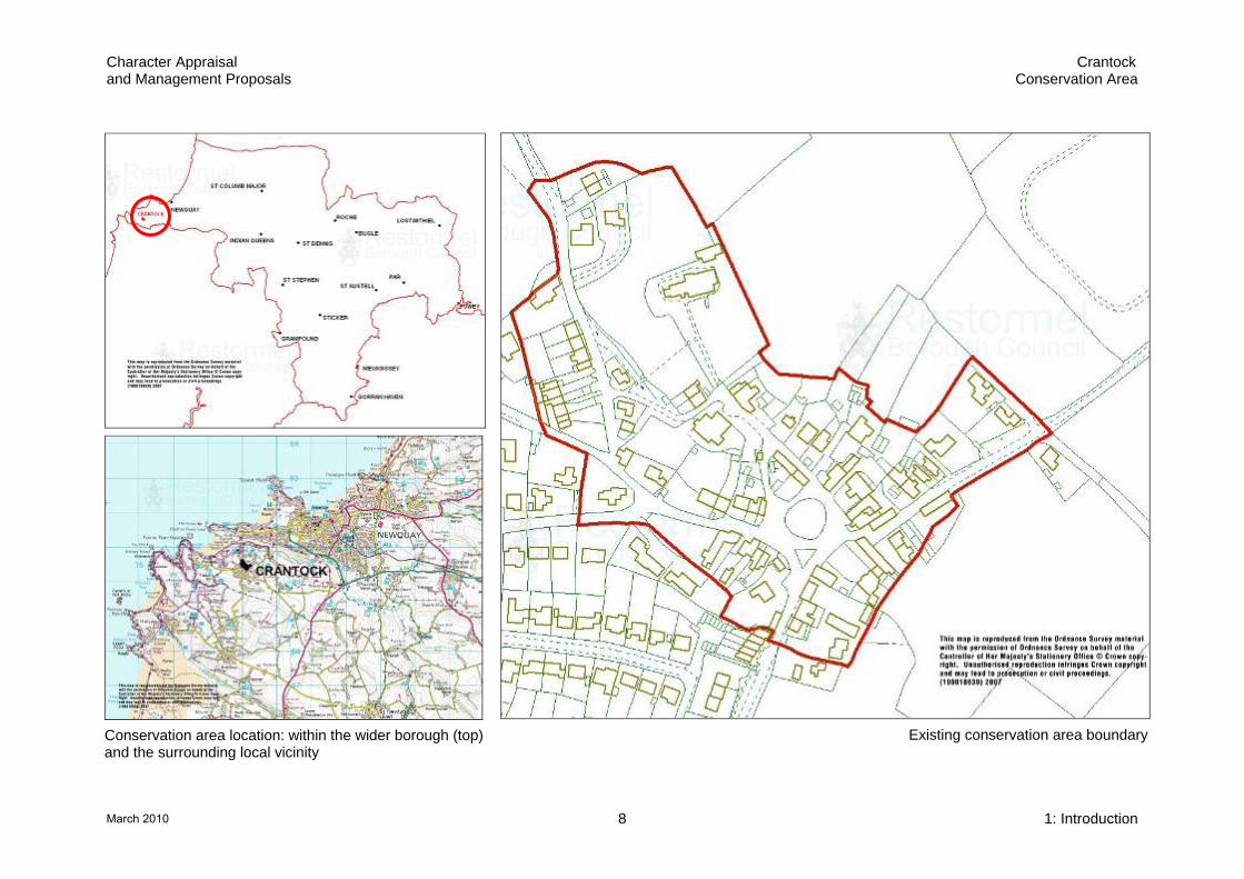
Crantock conservation area The Crantock conservation area was first designated in 1976.
The current designated area covers the historic core of the
village, centred on the Round Garden with the church to the
north.
1: Introduction 7March 2010
Character Appraisal Crantock and Management Proposals Conservation Area
Conservation area location: within the wider borough (top) and the surrounding local vicinity
Existing conservation area boundary
1: Introduction 8March 2010
Character Appraisal Crantock and Management Proposals Conservation Area
2 Location and context Crantock is situated on the north Cornish coast within the
boundary of the Central 2 area of Cornwall Council. The
village lies to the immediate south of Newquay, but is
separated from it by the strong landscape boundary of the
Gannel Estuary. Crantock Beach is 1 km to the north west of
the village at the mouth of the Gannel, protected by the
headlands of Pentire Point East and West.
The settlement is approached from minor roads running to
West Pentire from the A392 and the A3075.
The popular South West Coastal Path crosses Crantock
Beach 1 km from the village.
The National Trust have significant landholdings in the
surrounding area and hold the Round Garden at the centre of
the village.
Activity and use
The historic function of the settlement as a place of religious
significance and as a rural agricultural churchtown has
shaped the character of the present day settlement. Today,
Crantock is a residential, leisure and holiday centre with a
large beach and range of holiday accommodation, including
bed and breakfast, hotels, nearby caravan parks and a
growing number of holiday cottages and second homes. The
seasonal influx of day visitors and temporary residents during
the summer months dramatically changes the character of the
settlement. Traffic levels, general activity, vibrancy and
commercial vitality all vary according to the season. The lively
permanent resident community enjoy a range of year round
facilities and services including the post office and shop,
public houses and village hall. During the summer months
enterprises focused on the tourist and leisure market add to
the economic activity of the village, including gift shops, art
and craft galleries and cafes.
2: Location and context 9March 2010
Character Appraisal Crantock and Management Proposals Conservation Area
Topography
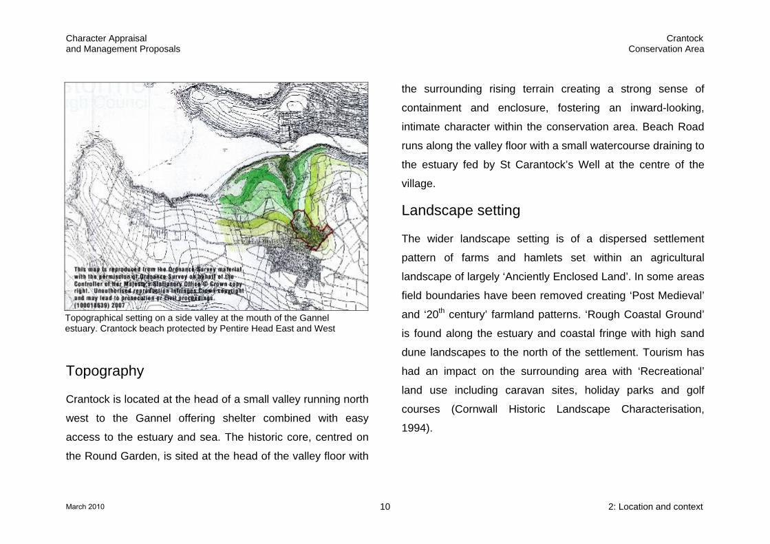
Crantock is located at the head of a small valley running north
west to the Gannel offering shelter combined with easy
access to the estuary and sea. The historic core, centred on
the Round Garden, is sited at the head of the valley floor with
the surrounding rising terrain creating a strong sense of
containment and enclosure, fostering an inward-looking,
intimate character within the conservation area. Beach Road
runs along the valley floor with a small watercourse draining to
the estuary fed by St Carantock’s Well at the centre of the
village.
Topographical setting on a side valley at the mouth of the Gannel estuary. Crantock beach protected by Pentire Head East and West
Landscape setting
The wider landscape setting is of a dispersed settlement
pattern of farms and hamlets set within an agricultural
landscape of largely ‘Anciently Enclosed Land’. In some areas
field boundaries have been removed creating ‘Post Medieval’
and ‘20th century’ farmland patterns. ‘Rough Coastal Ground’
is found along the estuary and coastal fringe with high sand
dune landscapes to the north of the settlement. Tourism has
had an impact on the surrounding area with ‘Recreational’
land use including caravan sites, holiday parks and golf
courses (Cornwall Historic Landscape Characterisation,
1994).
2: Location and context 10March 2010

Character Appraisal Crantock and Management Proposals Conservation Area
Historic core of the village with Round Garden and collegiate church. Extensive late 20th century expansion to right. View south east (CCC, Historic Environment, ACS 699)
The Gannel estuary is a significant landscape boundary
dividing the resorts of Newquay and Pentire to the north and
the more agricultural landscape to the south.
Crantock falls within the Newquay and Perranporth Coast
character area (CA15) in the Cornwall and Isles of Scilly
Landscape Study.
Geology
The underlying geology is of Lower Devonian slates,
siltstones and sandstones, locally referred to, by a traditional
mining term, as ‘killas’. The first edition Ordnance Survey 25”
map of c1880 shows areas of nearby quarrying to the north
east in a field quarry and at Penpol. Activity is also shown in
the sand dunes off Beach Road, but this probably relates to
sand extraction for use as an agricultural fertiliser. The sharp
embankment to the north east boundary of Barnhill, Vosporth
Hill, to the east of the conservation area, may also relate to
quarrying.
Setting of the conservation area
Crantock is a settlement of two halves. The historic
settlement, broadly covered by the conservation area, forms
the northern half, with an extensive area of estate-based
residential expansion to the south, now grown to cover a
larger area than the original village itself.
2: Location and context 11March 2010

Character Appraisal Crantock and Management Proposals Conservation Area
Two areas of historic ‘suburb’ development have been
subsumed by this expansion; Halwyn (meaning White Hall) is
documented from the 14th century and located at the junction
of Halwyn Road and Halwyn Hill; and an area of mid/late 19th
century development on West Pentire Road including the
Vicarage, parish room and later residential villa-terrace.
The division between ‘Old’ and ‘New’ Crantock is reinforced
by the underlying enclosing valley head topography of the
historic core. The 20th century growth area, on higher ground
to the south, makes little visual impact on the character of the
contained historic settlement.
The wider surrounding landscape is of rural, agricultural
countryside with Cornish hedge boundaries and narrow,
country lanes. There is a prominent and extensive caravan
park to the north east and coastal bungalow and villa
developments along the estuary and headlands.
A sewage treatment works is located off Beach Road to the
north west of the conservation area. It has a generally low
visual impact, although boundary treatment improvements
would be beneficial.
Crantock Beach, the Gannel Estuary and the surrounding
sand dunes form an important element in the setting of the
conservation area and one of the major attractions of the
settlement. The significance of this landscape is reflected in
its extensive coverage of natural environment designations.
Historic associations
A number of myths and legends are associated with Crantock,
including the story of St Carantoc floating ashore on an altar
and the ‘Lost City of Langarrow’ - a tale that the settlement
was once much larger – a city with seven churchyards that
became buried in sand because of the sacrilege of the clergy.
These ‘tall stories’, now grown fantastical through centuries of
retelling and elaboration, are based on earlier truths; the
crossings of the Celtic Saints from Ireland and Wales and the
former power, land holdings, influence and subsequent
decline of Crantock Collegiate church.
2: Location and context 12March 2010

Character Appraisal Crantock and Management Proposals Conservation Area
Historic environment designations
St Carantoc landing at Crantock on his floating altar as depicted in a stained glass window in the church
The current historic environment designations within the
conservation area are:
• No scheduled monuments.
• 22 listed building designations. Some of these include
more than one structure, others refer to monuments in the
churchyard. The church of St Carantoc is Grade I listed, all
the rest are of Grade II status.
• The local plan defines two areas of local architectural and
historic value to the north and south east of the
conservation area, largely comprising the green field
landscape setting of the settlement.
2: Location and context 13March 2010

Character Appraisal Crantock and Management Proposals Conservation Area
3 Historic development
Historic interest
Crantock is located in an area of extensive prehistoric activity with evidence for a dispersed settlement pattern,
coastal burial cemeteries and cliff castles.
Crantock is the site of an early medieval Christian enclosure or ‘lann’, known as Langorroc, reputedly
founded in the 5th century AD by St Carantoc.
The Collegiate church of St Carantoc was founded
sometime before the Norman Conquest, and may
represent a continuation of the lann. It was the dominant
force in the settlement until its suppression in 1548. The
existing church, with its enlarged chancel, is the only
surviving building, set within a large rectangular enclosure.
Crantock was the medieval churchtown for the wider
parish; the principal settlement for the surrounding area.
Largely agricultural in character, a number of farms
operated from the village, with traces remaining of the
surrounding medieval strip field system. Farmhouses and
high status dwellings survive from the mid 17th century.
19th century sources show a number of pubs and
malthouses in the settlement, together with a non
conformist chapel. Later 19th century development,
including a larger chapel, a vicarage and parish room took
place on the outskirts of the village.
Rapid residential expansion during the late 20th century
has more than doubled the size of Crantock.
3: Historic development 14March 2010

Character Appraisal Crantock and Management Proposals Conservation Area
Prehistoric
The surrounding landscape was densely occupied during the
prehistoric period due to the richness and diversity of the
available natural resources. Numerous settlement and burial
sites have been identified through excavation and survey.
Crop marks, visible on aerial photographs, show the remains
of defended farm enclosures or ‘rounds’ of late prehistoric and
Romano-British date. Bronze Age barrow cemeteries are
common along the coastal headlands, including Pentire Point
East. To the immediate west of the conservation area sherds
from a Bronze Age urn were discovered at Sandy Close and
are likely to relate to the remains of a decayed barrow. Iron
Age cliff castles, such as Kelsey Head to the west, also
demonstrate the prehistoric significance of the area and were
likely involved in the control of maritime trade. The Gannel
estuary was a trading focus from the earliest times with strong
links with Wales and Ireland from the Iron Age. Crantock
Beach offered protection to vessels along the exposed north
coast.
Extensive prehistoric activity is recorded in the surrounding area including settlement sites, barrow cemeteries, cliff castles and find spots – shown in red (extract from Cornwall County Council’s Historic Environment Record)
Numerous burials have been discovered on the west side of
Beach Road opposite the churchyard. The character of some
of these inhumations suggests an Iron Age date, with
descriptions of possible crouched and cist burials. The area
has been interpreted as a multi-period cemetery.
3: Historic development 15March 2010

Character Appraisal Crantock and Management Proposals Conservation Area
Early medieval Christian activity
Crantock is the site of an early medieval Christian enclosure
or ‘lann’ reputedly founded in the 5th century by St Carantoc,
an Irish missionary. This early establishment was known as
‘Langorroc’ and it is likely that it was sited within or close to
the vicinity of the current churchyard. Some of the burials
discovered on the west of Beach Road may date to this period
and be related to the lann. The location, at the head of a
valley associated with a navigable estuary, is typical of such
foundations.
The medieval settlement
Crantock was the medieval churchtown, or principal
settlement, for the surrounding parish and central focus of the
Gannel estuary. Much of its importance was based around the
collegiate church of St Carantoc. This wealthy foundation may
have had a hand in the development of the medieval ‘New
Quay’ on the north side of the Gannel. The success of this
development and the town of Newquay that developed around
it ultimately superseded Crantock as the principal settlement
of the area. Prior to the development of the ‘New Quay’, first
documented in 1439, the Gannel estuary was already an
important trading place. There are references to Crantock as
a fishing port as early as the 13th century with continuing
strong links with Wales and Ireland.
Fishing, shipping, farming, mining and smelting form the
historic economic backdrop to the college, settlement and its
hinterland. Stories of smuggling along the Gannel are
common with a reputed smuggler’s hole at the Albion Inn.
The collegiate church of St Carantoc
Christian activity seems to have continued or was re-
established prior to the Norman Conquest. The Domesday
entry of 1086 states ‘The Canons of St Carantoc hold
Langorroc as they held it in the time of King Edward’. This
reference provides the first documentary evidence of the
collegiate community of canons at Crantock. Collegiate
churches were similar to monastic foundations with the life of
3: Historic development 16March 2010
Character Appraisal Crantock and Management Proposals Conservation Area
the community centred on religious devotion. Unlike a
monastery, collegiate churches were served and administered
by a college of canons - priests who had not taken monastic
vows, and who were therefore able to own private property
and mix with the outside world. In 1291 the community
numbered 10 canons. Although many of these establishments
became renowned places of learning, such as Glasney
College, Penryn and the colleges at Oxford and Cambridge,
education, at least initially, was not a defining feature.
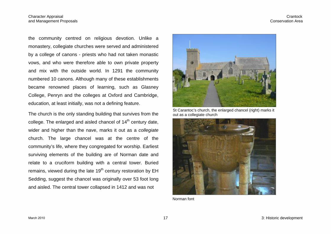
The church is the only standing building that survives from the
college. The enlarged and aisled chancel of 14th century date,
wider and higher than the nave, marks it out as a collegiate
church. The large chancel was at the centre of the
community’s life, where they congregated for worship. Earliest
surviving elements of the building are of Norman date and
relate to a cruciform building with a central tower. Buried
remains, viewed during the late 19th century restoration by EH
Sedding, suggest the chancel was originally over 53 foot long
and aisled. The central tower collapsed in 1412 and was not
St Carantoc’s church, the enlarged chancel (right) marks it out as a collegiate church
Norman font
3: Historic development 17March 2010

Character Appraisal Crantock and Management Proposals Conservation Area
rebuilt. The lower stages of the west tower are thought to be
of 13th century date.
Evidence for the college complex includes the large sub-
rectangular enclosure surrounding the church, described in
the tithe map apportionments of 1839 as ‘the old churchyard’
and two fields to the west of Beach Road named ‘Langurrow’,
a derivation of the name of the original lann. Earthworks
comprising hollows, banks and mounds in the field to the west
of Beach Road and to the north west of the church suggest
the presence of further archaeological remains.
As well as the collegiate church, the enclosure also contained
the chapel of St Ambrusca the Virgin. First recorded in 1309,
this chapel was a point of pilgrimage and remains were extant
as late as the 18th century. A holy well dedicated to the saint
was sited nearby. A modern well house, ‘St Ambrews well’ is
located to the north on Beach Road.
Large rectangular enclosure forming the original extent of the churchyard (2007 Cartographic Engineering. All rights reserved)
Modern well house dedicated to St Ambrusca, Beach Road
3: Historic development 18March 2010

Character Appraisal Crantock and Management Proposals Conservation Area
Remains of a medieval field system in the wider landscape
Historic topography
Round Garden – medieval pound
Holy Wells
Stream draining to the Gannel
Historic road pattern
Collegiate churchyard enclosure
St Carantoc’s church
Possible sub-enclosure for St Ambrusca the Virgin’s Chapel Documented discovery of human burial Approximate area of multi-period cemetery
Area of crop marks
Medieval stone coffin
Farm complexes
Farmhouses
Surviving agricultural building
Farmyard Methodist chapel, later Sunday School
Medieval strip field system
Known public houses
Known malthouses Poor houses
19th century Smithy
17th century hall house
Surviving 17th century buildings
3: Historic development 19March 2010

Character Appraisal Crantock and Management Proposals Conservation Area
Medieval churchtown
The College was the dominant feature of the medieval
churchtown of Crantock, but the centre of the settlement was
to the south east, focused around a sub-triangular open area.
This space has been partially filled with the development of
Step-a-Side and the Cosy Nook café buildings, but retains two
features of likely medieval, or earlier date;
• a holy well dedicated to St Carantoc with a stream running
from it to the Gannel, remembered in ‘Water Lane’, its
meandering course shapes some of the property
boundaries, and
• a circular enclosure known as the Round Garden, now in
the ownership of the National Trust. This walled enclosure
is believed to have originated as a pound to enclose stray
livestock. Animals would be held until claimed by their
owners and a fine paid to the parish.
The medieval settlement consisted of a number of farms, hall
houses and cottages. The remains of a medieval strip field
system can be detected in the surrounding landscape,
Holy well of St Carantoc, 17th century well house with later seating area
The Round Garden, a medieval pound enclosure to hold stray livestock
3: Historic development 20March 2010
Character Appraisal Crantock and Management Proposals Conservation Area
with the distinctive long, parallel and slightly curving
boundaries surviving best to the south and west.
After the college
John Leland visited Cornwall in 1536 and noted the College:
‘Apon an viii myles from Paddestou ys a lytle house of
Canons Secular, cawled Crantoke’. Already reduced in size
from ten canons to four, the College was finally suppressed in
1548 and its lands confiscated by the Crown and
subsequently passed to the Coles of Trerice and successively
through a number of owners. The church survived because it
also functioned as the parish church, but all other buildings
were seemingly abandoned and no longer survive. It is likely
that building materials from the former college structures were
reused throughout the village.
Hals, writing in 1740, records Crantock and the Gannel as a
place frequented for its safe entrance and anchorage, and for
its abundance of fish and fowl, and records that at high tides
large ships could navigate the river. However, by the mid 19th
century the river had silted up and its mouth was becoming
encroached by sand deposits restricting the size of vessel that
could navigate it.
The tithe map of 1839 provides detailed evidence of the
settlement. The apportionments list the dwelling houses and
gardens making up the majority of the settlement and also the
farmyards, mohays, orchards and meadows. At least three
farms were located around the settlement core with surviving
farmhouses of the Ship Inn Farmhouse and Great Western
dating to the mid 17th century and Vosporth Villa of 19th
century date. Farming remained the dominant occupation and
basis for the local economy during the 19th century.
The tithe apportionments note two public houses; the Ship Inn
[691] and the Albion Inn [682]. A third, the Tiddliwink or
Anchor, was also present in 1800. A malthouse and yard is
noted on Beach Road [696], owned by Samuel Hicks, then
owner of the Albion. A further malthouse survives to the west
of Great Western and has a date stone of 1825.
3: Historic development 21March 2010

Character Appraisal Crantock and Management Proposals Conservation Area
Top right: Tithe map of 1839 © Cornwall County Council
N
1841
1841-1880
1880-1907
1907- present
2nd edition Ordnance Survey, 1:25, 000 c1907 © Cornwall County Council
Right: Historic development mapping
3: Historic development 22March 2010

Character Appraisal Crantock and Management Proposals Conservation Area
A carpenters shop is recorded on the site of Vosporth Villa
[667]. Poor houses are noted in the ‘Old church yard’ [812]
and on the former waste close to the Round Garden at [688].
The first edition Ordnance Survey 1:25, 000 map of c1880
shows the settlement at the end of the 19th century. There are
relatively few changes from the tithe map. The smithy at the
corner of Green Lane and Beach Road dates to between the
two maps, as does St Ambros, Beach Road.
Two Wesleyan chapels are also additions. The earlier chapel
was situated in the centre of the village with the larger
replacement constructed at Halwyn to the south on Trevowah
Road in 1872. The earlier chapel was subsequently used as a
Sunday School and is now in residential use (Rosemaddon).
The substantial vicarage, now Tregenna House Hotel, on
West Pentire Road was also constructed between the two
maps, probably on former glebe land. In 1895 the adjacent
Parish Room was built, subsequently followed by the short
terrace on the opposite side of the road, depicted on the 2nd
edition Ordnance Survey map of c1907. This terrace is of the
Great Western, mid 17th century farmhouse
Ship Inn Farmhouse, mid 17th century
The Old Albion, late 18th centurypublic house
Malt House, Langurroc Road with date stone of 1825
Poor houses built in the corner of the churchyard, early 19th century (cottage to right rebuilt)
Former smithy, now converted to residential use, mid-late 19th century
3: Historic development 23March 2010

Character Appraisal Crantock and Management Proposals Conservation Area
same character as the contemporary residential expansion
that was occurring in Newquay.
20th century to present
The village has rapidly expanded during the late 20th century
with extensive estate-based residential development to the
south of the conservation area.
Change within the conservation area has been less dramatic.
The former farm complexes have been converted to
residential and holiday accommodation reflecting the
changing local economy. The Cornishman public house and a
number of detached properties have been constructed as infill
development.
Later chapel with date stone of 1872, Trevowah Road
Late 19th century former Vicarage,West Pentire Road
Early 19th century Wesleyan Chapel, later Sunday School, now in residential use
Former Parish Rooms adjacent to vicarage, West Pentire Road
20th century estate-based expansion to the south of the conservation area (2007 Cartogaphic Engineering. All rights reserved.)
Early 20th century residential terrace, West Pentire Road, sharing the character of contemporary Newquay
3: Historic development 24March 2010
Character Appraisal Crantock and Management Proposals Conservation Area
Archaeological potential
Archaeological deposits and building archaeology in the
settlement has the potential to provide further evidence of its
origins, development and evolution. There is particular
potential for evidence relating to prehistoric activity, early
Christian activity, the medieval College complex and the farms
operating from the village core.
The area of the large church enclosure is of particular
importance, holding extensive burials and possibly the
remains of the further College buildings. Land to the west of
Beach Road has also yielded evidence of extensive burials,
including some of potentially Iron Age date, suggesting a
multiphase cemetery. Henderson suggested that some of the
farmhouses in the churchtown may incorporate fragments of
the old prebendal houses (ie the canon’s houses) and
detailed building recording and analysis may yield further
evidence.
The thatched roofs of the village have scope for
archaeological interest as earlier thatched layers are often
retained under successive coats. Smoke-blackened thatch,
where the underside of the roof covering has been sooted, is
usually medieval in date or at the latest 17th century and is
evidence that the building was at one time an hall house with
an open fire. Historic layers provide a good source of
information on the history of botany and agriculture, as well as
of the building itself.
Given the richness of prehistoric archaeology in the
surrounding area there is potential for equally early deposits
within the settlement. Wind blown sand may have sealed
these remains potentially promoting high levels of
preservation.
A detailed archaeological survey and further documentary
research of the Round Garden was a recommendation of the
2001 Gannel Estuary Archaeological and Historic Assessment
by Cornwall Archaeological Unit. Such investigation may yield
information about its origins and changing function.
3: Historic development 25March 2010

Character Appraisal Crantock and Management Proposals Conservation Area
4 Settlement character
Essential character
The historic development and topography of Crantock has
created a settlement with a strong local distinctiveness.
Essential characteristics include:
The topographic location at the head of a side valley,
draining to the Gannel estuary, that fosters an enclosed,
contained character to the historic core of the village.
The distinctive churchtown settlement form based on the
convergence of roads from the surrounding area meeting
at the Round Garden, a medieval animal pound enclosure.
The informal and irregular settlement grain emphasising
the organic nature of the development of the village, with a
diversity of plot sizes and building siting, including a
number of historic farmyard complexes.
Views to the church tower, the principal landmark of the
village. Within the historic core views are contained within
the streetscape and by the enclosing valley head
topography. From the edges of the conservation area
more panoramic views open up across the Gannel to
Newquay and Pentire.
More panoramic views are available from the edges of the
conservation area, including views across the Gannel to
the ‘resort’ development of Pentire. The church tower is
the principal landmark of the village.
The built environment is dominated by historic
farmhouses, agricultural buildings and vernacular cottage
rows. Earliest architectural survivals include the Norman
elements of the church, although St Carantoc’s dates
predominantly from the 15th century and the 19th century
restoration. Secular historic buildings include an important
group of impressive farmhouses dating to the mid 17th
century. Other buildings, including the cottage rows, date
to the 18th and 19th century.
Common materials are killas rubble and cob, with a
mixture of granite or brick dressings and timber lintels.
4: Settlement character 26March 2010

Character Appraisal Crantock and Management Proposals Conservation Area
White colourwashed, roughcast and stuccoed elevations
unify the streetscape. The large number of surviving
thatched roofs is particularly significant, the most notable
group within the Borough. The thatching tradition of the
village is of combed wheat reed with simple flush wrapover
ridges and plain eaves. More elaborate thatching patterns,
with block cut ridges in water reed, are not locally
distinctive to Cornwall. Other historic roofs are of scantle
slate. The combination of cob, thatch and roughcast
creates a distinctive built environment rich in texture with a
solidity, sense of mass and softness of line that sits well
with the surrounding landscape.
Good survival levels of traditional architectural detailing
underline the high quality and completeness of the
conservation area. Detailing is generally restrained and
simple. Windows are a mixture of small, square casements
in the cottages and earlier survivals, with little elaboration
to lintels and dressings and larger, vertical sashes with
more formal dressings and keystone detailing in later
buildings. Porches are an important feature ranging from
simple porch hoods to more elaborate structures such as
the two storey slate-hung, porch of Montrose House.
Rubble built boundary walls are an essential part of the
special character, with painted timber gates and granite
gate posts.
Crantock has a number of important historic public realm
features including the Round Garden, a medieval animal
pound owned by the National Trust, and St Carantoc’s
Well, now housed in a listed 17th century well house.
Poorly detailed, uncoordinated public realm treatments
detract from the special character of key areas of the
village including the Round Garden core, Water Lane and
the Langurroc Road approach to the church.
Trees, informal front garden planting, Cornish hedge
boundaries and green spaces are important in the rural
character of the village. The Round Garden, churchyard
and undeveloped Beach Road valley side are important
green spaces, linking the village to its surrounding
landscape.
4: Settlement character 27March 2010

Character Appraisal Crantock and Management Proposals Conservation Area
Spatial analysis
Topography and settlement form
The strong underlying topography ensures that historic
Crantock retains its compact and contained character despite
the extensive expansion of the settlement during the late 20th
century. The location at the head of the valley promotes the
‘inward-looking’ nature of the historic core, focused around
the Round Garden at the convergence of many of the roads
leading to the village from the surrounding area. The high
granite hedge boundary walls and enclosing trees of the
medieval pound dominate this central space.
The valley descending to the Gannel remains a defining
feature of the settlement. The compact character and tightly
packed density of the village core opens up along the
approach to the beach. The undeveloped, steeply sloping,
grassland below the churchyard bring the surrounding
countryside into the settlement. The stream, fed by the central
well, is now culverted through the settlement core but re-
emerges along Beach Road, passing through the sewage
treatment plant and out to the Gannel estuary.
The organic nature of the development of the settlement is
shown in its built form, characterised by the diversity of plot
shapes, sizes and building siting. Buildings are set in a variety
of locations and forms:
• set back from the road behind long front gardens, e.g. the
large buildings including the former farmhouses, Great
Western and Vosporth Villa.
• set gable end to the road, e.g. the Old Malthouse and
Rosemaddon the former Chapel.
• set directly onto the road side, eg. the infill development of
Step-a-Side and the Cosy Nook Café and the blank
elevations of the former agricultural buildings at Halwyn
Hill.
• later residential developments have a greater degree of
planned uniformity, e.g. the cottage rows along Beach
Road.
4: Settlement character 28March 2010

Character Appraisal Crantock and Management Proposals Conservation Area
The beautiful landscape setting of the village at the head of a side valley draining to the sand dune landscape and Crantock Beach at the mouth of the estuary.
The radiating pattern of roads from the surrounding area converging at the circular Round Garden gives Crantock its distinctive settlement form. The large rectangular enclosure of the church complex survives to the north west. © 2007 Cartographic Engineering. All rights reserved.
4: Settlement character 29March 2010

Character Appraisal Crantock and Management Proposals Conservation Area
Spatial analysis
Road network
Green open space
Medieval field system
Landmark building
Significant trees
Watercourse
Loss of enclosure
Local / streetscape landmark Negative area
Intrusive frontage / feature
Area of special sense of place
Significant build line
Important views and vistas
Area of archaeological significance
Significant historic boundary treatment
Valley head enclosing topography
Spatially extant farmyards
4: Settlement character 30March 2010

Character Appraisal Crantock and Management Proposals Conservation Area
The informal settlement pattern and irregular grouping of
buildings creates a contrast between the sweeping curves of
the underlying valley topography and the angular patterns
created by the mixture of elevation aspects and varied
rooflines of the built environment.
The remains of several farmyards survive within the village.
Although now converted for residential use, the original spatial
arrangement of open yards ringed by former agricultural
buildings survives. Associated farmhouses are generally
nearby, often forming one side of the yard, with the front
façades facing away from the farm.
Contained and enclosed character created by the head of the valley location
Roads converge at the Round Garden marking the heart of the settlement
Varied building siting emphasises the organic development of the village
Beach Road descends along the valley to the Gannel. Dominated by beach traffic in the summer
Cottage rows and later terraces have more uniform build lines, such as at Beach Road
Historic farmyards survive within the village, although now converted for residential use
4: Settlement character 31March 2010

Character Appraisal Crantock and Management Proposals Conservation Area
Key views and vistas
Views within the settlement core are generally contained
within the streetscape and of short distances. More panoramic
and wide-ranging views are available from the fringes of the
conservation area.
The church tower is the main landmark of the village and
many key views focus on its staged, crenulated form and
black and gold clock face. From the west, particularly Beach
Road, its elevated position on the valley side makes it all the
more significant. From the level ground to the south beyond
the Old Albion Inn at Langurroc Road ‘picture postcard’ views
of the church are framed by the lychgate and churchyard
trees.
From the fringes of the conservation area, for example
Vosporth Hill and Gustory Road, wider views open out to the
high surrounding horizon lines of the rising valley sides.
Twentieth century residential development and the extensive
tree cover and vegetation surrounding the historic core are
dominant features of these views.
Beyond the principal landmark of the church tower, views over the Gannel to Pentire can be glimpsed
Distinctive Crantock skyline viewed from the towans shows the dominance of the church in the valley setting
From the west of the conservation area views across the
Gannel estuary are visible. The dense development of Pentire
forms the backdrop to some views of the church and the
contrast between the character of the village and this resort
development with its characteristic density, balconies, large
windows and conservatories is notable. These views are the
only evidence of the village’s proximity to Newquay.
The most significant view of the village in its landscape setting
is from the sand dunes at the mouth of the Gannel estuary.
Looking up the valley, the village spans the horizon with the
dominant silhouette of the church forming a distinctive part of
the skyline.
4: Settlement character 32March 2010

Character Appraisal Crantock and Management Proposals Conservation Area
4: Settlement character 33
Built environment analysis Key: Principal listed building Historic building (surviving building shown on 2nd edition OS map c1907 and significant later
structures, some may be curtilage listed buildings)
March 2010

Character Appraisal Crantock and Management Proposals Conservation Area
Built environment
Architectural characteristics
The built environment of the conservation area is dominated
by former farmhouses, converted agricultural buildings and
vernacular cottages. There is a broadly equal mix of listed
buildings, non-listed historic buildings and late 20th and 21st
century infill and redevelopment. Distinctive architectural
groups include:
• Farmhouses and other large, high status buildings dating
from the mid 17th–19th centuries: for example Great
Western and Ship Inn Farmhouses of mid 17th century
date, The Hatch and Pelyn that originated as a mid 17th
century hall house and Vosporth Villa of early 19th century
date.
• Farm buildings – now mostly converted to alternative
uses, but retaining their agricultural character. The Round
House, near Ship Inn Farmhouse is a horse-whim house.
Historic maps show another circular whim house attached
to the farm complex behind Great Western but the building
no longer survives.
• 18th and early 19th century Cottage rows – including
Church Town, Church Gate and Lanherne Cottages, a rare
survival of a pair of back-to-back houses originally built as
poorhouses in the south west corner of the churchyard.
• Later 19th and early 20th century cottage terraces on the
outskirts of the historic village, Beach Road; and as infill
and redevelopment within the core.
• The church complex – with its distinctive chancel,
incorporating Norman and medieval fabric, together with a
group of 6 listed monuments in the churchyard and the
listed lych gate
• Purpose-built institutional, industrial and commercial buildings are few in number and mostly accommodated in
adapted residential dwellings, for example the Old Albion
pub and shops. Notable buildings include the early 20th
4: Settlement character 34March 2010

Character Appraisal Crantock and Management Proposals Conservation Area
•
century Institute, the early 19th century chapel, now in
residential use, with much of the external plainness of the
agricultural buildings, a 19th century smithy and a malthouse,
both now in residential use.
The variety of architectural styles and irregularity of building
siting and orientation create a varied built environment.
Common materials and recurring architectural forms and
details unify the streetscape. Buildings are generally of two
stories, with a variety of plan form often featuring outshoot
extensions and porches such as Great Western, Montrose
House and the Ship Inn Farmhouse. The former agricultural
buildings, cottage rows and later 19th century terraces have a
linear plan form, sometimes parallel to the line of the road and
sometimes at right angles to it. The group of high status large
houses and farmhouses often feature symmetrical facades
with central doorways, as do the later cottage terraces. More
irregular elevations are found in other structures, suggesting a
history of alteration, incremental extension and adaptation.
Some houses have been subdivided such as the Hatch and
Penlyn, which were originally a mid 17th century single storey
The Hatch, part of a mid 17th century cross passage hall house
Vosporth Villa, one of Crantock‘s important group of farmhouses
The Round House a former horse-whim house for grinding corn
Historic farm buildings are now mostly converted but retain much of their original character
18th and 19th century cottage rows are an important architectural group in the village
Late 19th century listed lychgate marking the entrance to the churchyard
4: Settlement character 35March 2010

Character Appraisal Crantock and Management Proposals Conservation Area
building of three room and cross passage plan. Other small
dwellings have been amalgamated such as the three units
now forming the Old Albion.
Later 19th century and early 20th century development has a
less vernacular character and some buildings, such as 1 & 2
Dale Cottages, are reminiscent of the contemporary
residential expansion at neighbouring Newquay, with gabled
dormers to attics, use of buff brick dressings and palm trees in
front gardens. A terrace of similar houses survives outside the
conservation area, opposite the vicarage on West Pentire
Road.
The success of the late 20th and 21st century infill and
redevelopment is mixed, with a tendency for poor quality and
inappropriate materials, such as artificial stone, pebble dash
finishes and suburban designs.
Dale Cottages. Late 19th – early 20th century development has a less vernacular character
Novel modern building forms have been inspired by local distinctiveness; thatched garage at The Hatch
Shops are accommodated in previously residential buildings, Post Office, Halwyn Hill
The Memorial Hall an early 20th century Reading Room, Institute and village war memorial
Late 20th and 21st century infill development is of mixed success in terms of enhancing the character of the conservation area
Montrose House - impressive two storey slate hung porch. Modern inserted shop front
4: Settlement character 36March 2010
Character Appraisal Crantock and Management Proposals Conservation Area
Materials
Common building materials include the local slatestone
(killas) laid as irregular rubble with granite or brick dressings.
Elvan rubble is used at Vosporth Villa and granite rubble at
the Old Albion.
There is a substantial amount of cob construction in the
village, particularly in the vernacular cottages. Ground floors
are of irregular rubble with upper floors of cob bulging over
the lower masonry. These mixed construction houses are
generally colourwashed, with roughcast or render covering the
cob. The distinctive qualities of the material: the sense of
mass and thickness of the walls, depth of window reveals,
softness of the rounded corners and texture of the uneven
surface, contribute to Crantock’s distinctive character. The
combination of cob and thatch is particularly significant to the
uniqueness of the village.
Cornish slate is another important material that contributes to
character. There is a limited amount of slate hanging in the
village such as the porch of Montrose House. Many roofs are
of scantle slate, laid to gabled, hipped and half-hipped design.
The long ridge lengths of the cottage rows, later terraces and
ranges of agricultural buildings form strong horizontal lines
within the settlement. This combination of roof shapes adds to
the mixture of angles, planes and gradients defining the
character of the built environment. A number of the scantle
slate roofs are in a poor condition and slurried or bitumen
coated, such as Great Western.
Crantock is particularly significant for the number of surviving
thatched roofs, the most significant survival within the
Borough. Evidence suggests that thatched roofs were
previously more widespread throughout the village, such as
the raised coped verge to the left gable end of the Great
Western farmhouse. This tradition reflects the agricultural
nature of the village and the easy availability of suitable
thatching material.
The contrast between the crisp lines of the slate roofs and the
rounded, curved form of the deep overhanging thatch is an
important characteristic of the roofscape.
4: Settlement character 37March 2010

Character Appraisal Crantock and Management Proposals Conservation Area
The thatching tradition of the settlement is of combed wheat
reed with simple flush wrapover ridges and plain eaves on a
gable end roof form, such as at the Ship Inn Farmhouse.
Historic photographs provide a good record of thatching
traditions. Since the 1960s re-thatching has seen the
introduction of increasingly ornate and elaborate ridge
decoration resulting in roofs of a different character to the
traditional plain form typical of the region.
Chimneystacks are an important element of the roofscape.
The village displays a mixture of forms including a number of
17th and 18th century examples of large, square, staged
rubble-built construction set at gable ends, with shaped tops
and later ceramic pots. Later examples are of red brick and of
slighter construction.
The use of colour within the village is limited with
colourwashes generally restricted to white and window
fenestration limited to black or white. The use of pastel
shades is seen in a number of refurbished properties. This
restrained palette is unusual for its ‘seaside’ location. Painted
doors inject some colour as do the red brick dressings of later
buildings. Historic photographs suggest that the irregular
rubble buildings were traditionally white washed.
Local details
There is a generally good survival of traditional detailing in the
historic buildings of the village, adding an authenticity and
sense of quality and completeness to the conservation area.
Detailing is relatively restrained and simple.
Windows are a mixture of small, almost square casements to
the cottages and some of the oldest surviving structures, with
larger, vertical, rectangular sashes in the higher status and
later buildings. Sashes with decorative glazing bars are a
feature of some of the late 19th century buildings such as the
terrace of double fronted cottages on Beach Road and the
unusual first floor oriels at Penhelva. Bay windows are
uncharacteristic of the conservation area and normally reflect
later alterations such as in the Post Office and adjoining
4: Settlement character 38March 2010
Character Appraisal Crantock and Management Proposals Conservation Area
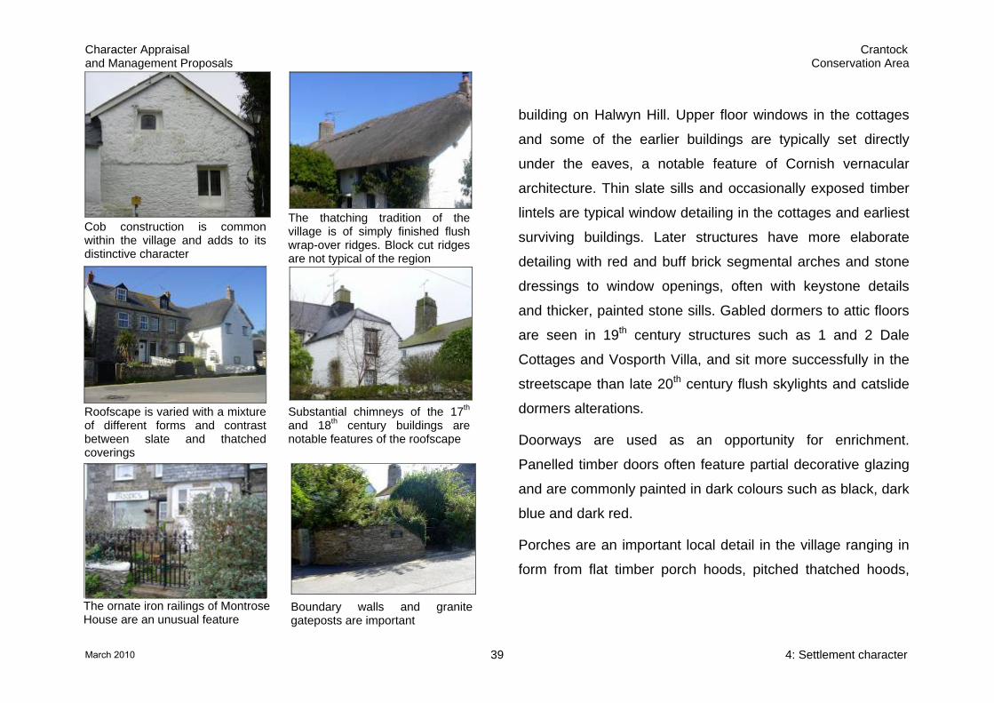
Substantial chimneys of the 17th and 18th century buildings are notable features of the roofscape
building on Halwyn Hill. Upper floor windows in the cottages
and some of the earlier buildings are typically set directly
under the eaves, a notable feature of Cornish vernacular
architecture. Thin slate sills and occasionally exposed timber
lintels are typical window detailing in the cottages and earliest
surviving buildings. Later structures have more elaborate
detailing with red and buff brick segmental arches and stone
dressings to window openings, often with keystone details
and thicker, painted stone sills. Gabled dormers to attic floors
are seen in 19th century structures such as 1 and 2 Dale
Cottages and Vosporth Villa, and sit more successfully in the
streetscape than late 20th century flush skylights and catslide
dormers alterations.
The thatching tradition of the village is of simply finished flush wrap-over ridges. Block cut ridges are not typical of the region
Cob construction is common within the village and adds to its distinctive character
The ornate iron railings of Montrose House are an unusual feature
Roofscape is varied with a mixture of different forms and contrast between slate and thatched coverings
Doorways are used as an opportunity for enrichment.
Panelled timber doors often feature partial decorative glazing
and are commonly painted in dark colours such as black, dark
blue and dark red.
Porches are an important local detail in the village ranging in
form from flat timber porch hoods, pitched thatched hoods,
Boundary walls and granite gateposts are important
4: Settlement character 39March 2010

Character Appraisal Crantock and Management Proposals Conservation Area
and simple projecting porches to the more substantial slate
hung two storey porch of Montrose House. Supported on
granite columns, this structure was likely originally open to
ground floor level with a first floor room above. Vosporth Villa
also features a central gabled and glazed porch.
Mid height rubble-built boundary walls are an important
feature of the village defining garden plots. Coping courses
are often of vertically set stones, sometimes of white quartz
spar stones as at Vosporth Villa. Some boundaries are of
Cornish hedge type construction with associated vegetation,
such as the Round Garden and at the Hatch where the stones
are vertically set. Granite gateposts are a common feature
with timber gates. The ornate iron railings to the boundary at
Montrose House are unusual for the village and emphasis the
status of the property. The robust character of these
boundaries adds to the special qualities of the built
environment of the village and contrasts strongly with the
modern timber fences and wire boundary treatments that look
flimsy and insubstantial in comparison.
4: Settlement character 40March 2010

Character Appraisal Crantock and Management Proposals Conservation Area
Streetscape
Public realm
Crantock has a number of important historic public realm
features including the Round Garden, and the holy wells of St
Carantoc, with its 17th century listed well house, and St
Ambrusca on Beach Road. The village stocks survive
relocated in the churchyard and are thought to date to the 17th
century. The red K7 phone box on the edge of the Round
Garden is a listed structure in its own right.
Several areas of historic surfacing survive adding texture and
interest to the streetscape, including the cobbled gutters along
Vosporth Hill.
Key areas of the village are currently let down by poor public
realm treatments; in particular the area around the Round
Garden, Water Lane and the Langurroc Road approach to the
church. The Round Garden area is the heart of the village but
is currently fragmented by the uncoordinated and poorly
Poorly detailed and uncoordinated public realm detracts from key areas of the village
Loss of enclosure and poor public realm along Langurroc Road mar the approach to the church
St Carantoc’s well is currently lost behind an area of car parking
17th century village stocks, now in the churchyard
Listed K7 phone box with other street furniture and ephemera
Water Lane’s urban public realm jars with the rural character of the settlement
4: Settlement character 41March 2010

Character Appraisal Crantock and Management Proposals Conservation Area
detailed public realm treatment. St Carantoc’s well and the
Round Garden are under used assets, offering little in terms
of interpretation and celebration of their historic significance.
Traffic management measures clutter the streetscape and
erode its rural character. The extensive use of double yellow
lines to control parking pressures during the summer season,
signage and large painted road markings all detract from the
special character of the village.
The heavy and obtrusive overhead wirescape is a prominent
negative feature in many parts of the settlement and extended
television aerials can be an intrusive element of the village
roofscape.
Street furniture is relatively limited but the range of materials,
styles and detailing creates a confused sense of clutter rather
than enhancing the special character of the village.
The public realm treatment of Water Lane is more suited to
the urban resort character of Newquay than the rural village
atmosphere of Crantock.
The approach to the church along Langurroc Road is
weakened by a loss of the sense of enclosure that defines the
rest of the village with poor boundary and public realm
treatments.
Greenscape
Trees, vegetation and greenscape form an important element
of Crantock’s character. Unusually for Cornwall the village has
a central ‘green’ area around the Round Garden. The
churchyard also forms an important green space and is
surrounded by other informal areas of rough grassland, scrub
cover and windblown trees on the valley side below. This
grassland connects the village with the sand dune landscape
of the Gannel and Crantock beach.
Informal front garden planting throughout the village is an
important characteristic, with plots defined by stone built
boundary walls softened by vegetation that merge with the
lush Cornish hedges of the surrounding countryside.
4: Settlement character 42March 2010

Character Appraisal Crantock and Management Proposals Conservation Area
The Round Garden forms an important, if underused, green space in the heart of the village
The churchyard and undeveloped valley side below link the village with its surrounding landscape
The ‘village green’ is unusual for Cornwall. Trees are important in the village core
The resort-style palms of the municipal planting, restricted to
the area around the public toilets of Water Lane, is attractive
but jars with the rural character of the rest of the village.
Trees form an important part of the character of the village.
Individual trees act as significant streetscape features, such
as the mature conifer on Langurroc Road. Trees and mature
planting within the garden plots of the village core soften the
built environment. Planting in the gardens on the surrounding
valley sides forms important tree cover and a more extensive
black cloth to the conservation area, softening the transition
between the historic settlement and 20th century expansion. A
number of mature trees form significant features on the
horizon of the enclosing valley sides around the conservation
area.
Although attractive, municipal planting is more in character with Newquay than the rural village
There are a number of significant trees in the village including this example at Langurroc Road
4: Settlement character 43March 2010

Character Appraisal Crantock and Management Proposals Conservation Area
5 Negative features and issues There are a number of negative features and issues within the
conservation area.
Weak and underplayed areas of the village
The heart of the settlement around the Round Garden is
currently underplayed and offers scope for enhancement.
Elements of the uncoordinated and poorly detailed public
realm detract from the special character of the area and the
presentation, celebration and interpretation of the historic
assets of the Round Garden and St Carantoc’s well could be
improved.
The public realm presentation of Water Lane and the
important approach to the church along Langurroc Road also
offer the opportunity for enhancement. The public toilets,
associated surfacing and concrete capped boundary wall
have a more urban character than the surrounding village and
are not sympathetic to the conservation area.
The roughly surfaced car park to the rear of The Cornishman
public house is a weak area of the settlement and may have
potential for some level of sympathetic redevelopment.
Public realm
Generally the public realm of the village fails to match the high
quality of the conservation area and detracts from its special
character.
Key negative features include the prominent overhead cables
throughout the settlement, extensive road markings and
signage and the uncoordinated approach to the design, siting
and detailing of streetscape items.
Loss of historic architectural features,
inappropriate alterations and additions
The survival of historic detailing is generally very good,
however, some incremental loss has occurred. The
replacement of windows, doors, traditional wall surfaces and
5: Negative features and issues 44March 2010

Character Appraisal Crantock and Management Proposals Conservation Area
roof coverings with inappropriate materials and designs
erodes special character. Such changes not only negatively
affect individual buildings, they also affect the wider street
scene.
In general, the condition of the historic buildings in the village
is good. However, there are a number of historic roofs in a
poor state of repair, making them vulnerable to loss. Several
historic scantle slate roofs have been bituminised, which
ultimately leads to the disintegration of the slate.
Residential conversions of the former agricultural, industrial
and religious buildings have generally been sensitive to the
original character of the structures. However, some of the
commercial conversions, modern extensions and garage
block developments have detracted from the special character
of the conservation area.
Incremental change to the thatched roofs of the village is a
negative issue affecting Crantock’s special character. Since
the 1960s the plain flush ridge tradition, distinctive of
Cornwall, has been weakened by the introduction of
elaborately patterned block ridge designs in water reed,
typical of the thatching traditions of the Fenlands of England.
‘Anywhere’ new development
The extensive expansion of the settlement makes relatively
little immediate visual impact on the conservation area.
However, it is disappointing that the distinctiveness, quality
and character seen in the historic core did not inspire ‘New
Crantock’. The 20th and 21st century development to the south
pays little regard to its setting in terms of layout, design and
materials.
Recent development within the conservation area has been of
mixed success. Too many of the infill buildings have an
‘Anywhere’ quality, failing to respect the historic grain and
topography of the village, and the locally distinctive
architectural form, quality of materials, scale, design and
massing of the historic built environment. As a result some of
this development has eroded, rather than enhanced the
special character of the village.
5: Negative features and issues 45March 2010

Character Appraisal Crantock and Management Proposals Conservation Area
Traffic and traffic management
Traffic congestion, gridlock of Beach Road and illegal parking
are issues that negatively affect Crantock during the summer
season. The absence of footpaths in much of the village
results in conflict between pedestrians and vehicles. Failure to
enforce existing parking control measures has resulted in a
proliferation of road markings and official and private signage.
Climate change and the historic environment
Climate change has the potential to seriously affect the
village. The increase in the frequency of extreme weather
conditions and flooding has the potential to damage buildings,
landscapes and archaeology. Equally, measures designed to
address climate change may also have an impact on the
special character of the conservation area.
5: Negative features and issues 46March 2010

Character Appraisal Crantock and Management Proposals Conservation Area
6 Management Proposals
Conservation area boundary review
The conservation area boundary has been reviewed as part of
the appraisal process and no changes are required. The area
is tightly drawn to ensure that the designation is not devalued.
It does not mean that features outside the defined area are of
no historic interest. Indeed there are a number of outlying
sites to the south of the existing conservation area of
confirmed architectural and historic interest:
• the historic group at Halwyn Road and Trevowah Road
including Crantock Methodist church
• the group at West Pentire Road including the former parish
rooms and vicarage
The areas of local architectural and historic value designated
by the local plan cover the important landscape setting of the
existing conservation area and have the potential for
prehistoric archaeology and remains relating to the early
Christian and medieval religious activity. However,
conservation area designation is not generally an appropriate
means of protecting the wider natural landscape and so these
areas are not recommended as extensions.
The setting of a conservation area is a material consideration
within the planning process and setting issues will be
considered as part of the positive conservation management
of the settlement.
Recommendation: No changes are proposed to the existing conservation area boundary.
Local list
The listed building designation of the village does not
adequately reflect the local importance of much of the historic
building stock in the conservation area. English Heritage,
PPG15 and the Heritage Protection White Paper ‘Heritage
Protection for the 21st century’ encourage local authorities to
designate lists of locally important buildings and to formulate
local framework policies for their protection.
6: Management proposals 47March 2010

Character Appraisal Crantock and Management Proposals Conservation Area
As part of the ongoing Heritage Protection reforms, English
Heritage will produce standardisation criteria and good
practice guidance for such local listing. This appraisal
identifies surviving historic buildings that are shown on the 2nd
edition Ordnance Survey map of c1907 and could form the
basis for the production of the local list.
Recommendation: The Council will consider establishing a register of locally important historic buildings in light of the recommendations made in the ongoing Heritage Protection reforms.
Article 4 (2) Directions
The incremental loss of historic architectural detail and
inappropriate alterations to historic buildings has been
identified as a negative issue affecting the special character of
the conservation area. Listed building legislation protects
many of the settlement’s historic buildings and the introduction
of an Article 4 (2) Direction should be considered to protect
the special character of the residential unlisted buildings
within the conservation area.
Article 4 (2) Directions work by removing certain permitted
development rights allowing greater control over changes to
elevations, boundaries and materials. The Direction has to
specify a prescribed range of development that materially
affects some aspects of the external appearance of unlisted
dwelling houses that may normally be altered under ‘permitted
development rights’, for example:
• Removal or replacement of any door or window
• Replacement of painted finishes with stains on woodwork or joinery
• Erection, alteration or removal of chimneys or flues
• Addition of porches, carports and sheds
• Changes to wall surface treatments including the painting of previously unpainted elevations, the addition of renders or claddings
• Changes of roof materials and installation of roof lights
• Demolition or alteration of boundary treatments Such directions can only be used where there is reliable
evidence to suggest that otherwise permitted development is
likely to take place that would damage an interest of
acknowledged importance and which would therefore be in
6: Management proposals 48March 2010
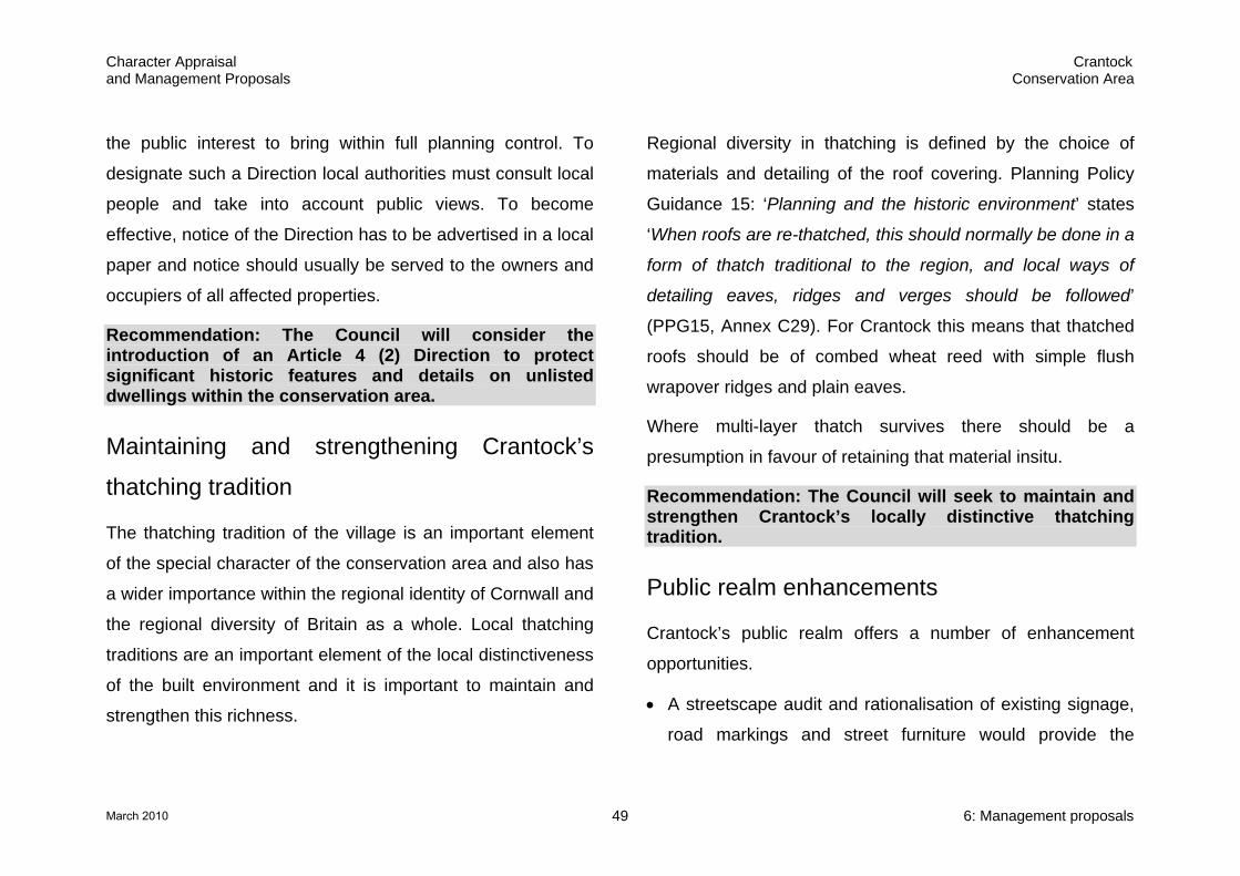
Character Appraisal Crantock and Management Proposals Conservation Area
the public interest to bring within full planning control. To
designate such a Direction local authorities must consult local
people and take into account public views. To become
effective, notice of the Direction has to be advertised in a local
paper and notice should usually be served to the owners and
occupiers of all affected properties.
Recommendation: The Council will consider the introduction of an Article 4 (2) Direction to protect significant historic features and details on unlisted dwellings within the conservation area.
Maintaining and strengthening Crantock’s
thatching tradition
The thatching tradition of the village is an important element
of the special character of the conservation area and also has
a wider importance within the regional identity of Cornwall and
the regional diversity of Britain as a whole. Local thatching
traditions are an important element of the local distinctiveness
of the built environment and it is important to maintain and
strengthen this richness.
Regional diversity in thatching is defined by the choice of
materials and detailing of the roof covering. Planning Policy
Guidance 15: ‘Planning and the historic environment’ states
‘When roofs are re-thatched, this should normally be done in a
form of thatch traditional to the region, and local ways of
detailing eaves, ridges and verges should be followed’
(PPG15, Annex C29). For Crantock this means that thatched
roofs should be of combed wheat reed with simple flush
wrapover ridges and plain eaves.
Where multi-layer thatch survives there should be a
presumption in favour of retaining that material insitu.
Recommendation: The Council will seek to maintain and strengthen Crantock’s locally distinctive thatching tradition.
Public realm enhancements
Crantock’s public realm offers a number of enhancement
opportunities.
• A streetscape audit and rationalisation of existing signage,
road markings and street furniture would provide the
6: Management proposals 49March 2010

Character Appraisal Crantock and Management Proposals Conservation Area
opportunity to clear the streetscape of unnecessary clutter.
Redundant and duplicate items could be removed, and
consideration given to the reduction and sensitive design,
siting, scale and grouping of fixtures, fittings and markings.
• A number of key areas would benefit from targeted public
realm enhancement projects to deliver a coordinated, well
designed and appropriate treatment that reflects and
enhances the rural character of the village. Key areas for
improvement are the heart of the village around the Round
Garden, Water Lane and the Langurroc Road approach to
the church.
• Improved presentation of the Round Garden enclosure and
St Carantoc’s holy well, combined with a targeted public
realm enhancement scheme would strengthen this area as
the heart of the village.
A management plan should be established for the care and
presentation of the Round Garden. Opportunities for
increasing access, exploration and activity within the
enclosure should be encouraged. There may be some
scope for some sensitive public art based interpretation of
its former use as an animal pound.
• Reduction of the impact of overhead lines through a
programme of undergrounding.
Recommendation: The Council will work with its partners to promote public realm enhancements within the conservation area as opportunities arise and will ensure that future public realm works respect and enhance the special character of the conservation area.
Trees
Trees form an important part of the character of the village.
Conservation area designation affords some degree of
protection, however, to ensure that this element of Crantock’s
special character is protected and enhanced a tree strategy
should be formulated to access the need for the designation
of Tree Preservation Orders (TPOs) and general tree
management issues. This strategy should include TPO
protection for significant trees outside the conservation area
that contribute to its special character in long-distance views
6: Management proposals 50March 2010

Character Appraisal Crantock and Management Proposals Conservation Area
and as horizon features. A replanting strategy should also be
included to re-establish structure that has been lost through
the gradual depletion of trees in and around the conservation
area and to manage the impact of loss of trees through over
maturity.
Recommendation: The Council will develop a tree strategy for the conservation area to access the need for the designation of Tree Preservation Orders and general tree management issues.
Traffic management
The effective enforcement of existing traffic management
measures is essential in order to keep the impact of signage
and road markings to a minimum.
Issues such as the traffic – pedestrian conflict and the grid
lock caused by beach traffic during the summer season may
require more detailed analysis and intervention by the
relevant traffic authority. The Local Plan includes a policy
encouraging measures to close off the central core of the
village to coaches, non access parking and through traffic and
for the development of a coach/car park on the approach to
the village off Halwyn Road with footpath access to the village
square (Policy N2(2)).
The village has a good bus service and ways of encouraging
car-free visits to the village and beach should be explored and
promoted.
Recommendation: The Council will work with its partners to explore ways to ameliorate the negative impact of traffic and traffic management measures on the special character of the conservation area.
New development in the conservation area
Within the conservation area there may be scope for a limited
amount of further infill development. To be successful, any
new development needs to be mindful of the local character of
the village, while at the same time being distinctly of the 21st
century. Poorly designed and detailed ‘pastiche’ development
can be as eroding to special character as development that
shows no regard for its setting. Any future development
provides the exciting opportunity to add sustainable, high
6: Management proposals 51March 2010
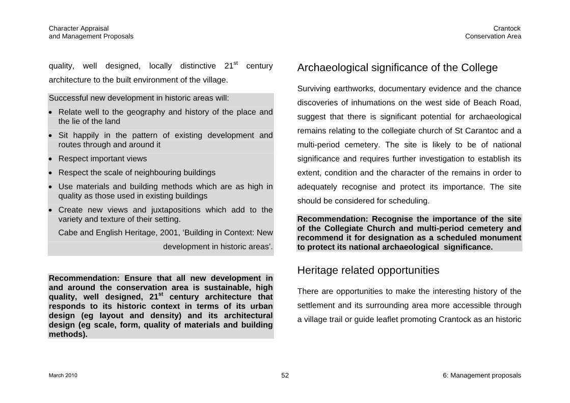
Character Appraisal Crantock and Management Proposals Conservation Area
quality, well designed, locally distinctive 21st century
architecture to the built environment of the village.
Successful new development in historic areas will:
• Relate well to the geography and history of the place and the lie of the land
• Sit happily in the pattern of existing development and routes through and around it
• Respect important views
• Respect the scale of neighbouring buildings
• Use materials and building methods which are as high in quality as those used in existing buildings
• Create new views and juxtapositions which add to the variety and texture of their setting. Cabe and English Heritage, 2001, ‘Building in Context: New
development in historic areas’.
Recommendation: Ensure that all new development in and around the conservation area is sustainable, high quality, well designed, 21st century architecture that responds to its historic context in terms of its urban design (eg layout and density) and its architectural design (eg scale, form, quality of materials and building methods).
Archaeological significance of the College
Surviving earthworks, documentary evidence and the chance
discoveries of inhumations on the west side of Beach Road,
suggest that there is significant potential for archaeological
remains relating to the collegiate church of St Carantoc and a
multi-period cemetery. The site is likely to be of national
significance and requires further investigation to establish its
extent, condition and the character of the remains in order to
adequately recognise and protect its importance. The site
should be considered for scheduling.
Recommendation: Recognise the importance of the site of the Collegiate Church and multi-period cemetery and recommend it for designation as a scheduled monument to protect its national archaeological significance.
Heritage related opportunities
There are opportunities to make the interesting history of the
settlement and its surrounding area more accessible through
a village trail or guide leaflet promoting Crantock as an historic
6: Management proposals 52March 2010
Character Appraisal Crantock and Management Proposals Conservation Area
settlement and highlighting its surviving features. Wider walks
could include other sites of historic interest within the area.
Recommendation: The Council will work with its partners, and establish itself as a community leader, in the response to the challenges of climate change.
Recommendation: The Council will explore and encourage opportunities for the celebration of the special architectural and historic interest of the conservation area.
Responding to the challenge of climate
change
Sustainable development lies at the heart of the Council’s
planning policy and Cornwall is committed to becoming one of
the UK’s most sustainable places.
Interventions such as the greater use of renewable energy
technologies and eco friendly development, would need to be
evaluated on a case-by-case basis. However, ultimately the
historic environment is made up of evidence of how we have
adapted and evolved in response to new pressures and
opportunities and it is likely that one of the defining features of
21st century development will be our response to climate
change.
6: Management proposals 53March 2010

Character Appraisal Crantock and Management Proposals Conservation Area
Sources Published sources Anon, undated ?195-, Crantock (pamphlet guide at Cornish Studies Library c/914.2372) Anon, 1972, Crantock Methodist Church Centenary Brochure 1872-1972 Barton, R, M, 1964. An Introduction to the Geology of Cornwall, D Bradford Barton Ltd, Truro Brown, Rev M & Hattam, Rev M, 1996. The parish church of St Carantoc Collier, Mrs, 1898. Some account of St Crantock, an Ancient Cornish Church, Journal of the British Archaeological Association English Heritage, 2000. Thatch and thatching: a guidance note Gilbert, D, 1838. The Parochial History of Cornwall, Vol 1, JB Nichols and Son, London Gossip, J, 2001. The Gannel Estuary, Cornwall. Archaeological and Historic Assessment, Cornwall Archaeological Unit report for the National Trust and Cornwall County Council’s Countryside Service, Report No: 2001R009 Hitchens, F, 1824. History of Cornwall, edited by Samuel Drew, William Penaluna, Helston
Jeffery, P, 2004. The Collegiate churches of England and Wales, Robert Hale, London Pearse Chope, R (ed), 1967. Early Tours in Devon and Cornwall, David and Charles, Newton Abbot Pevsner, N, revised Radcliffe, E, 1970 (2nd ed). The Buildings of England: Cornwall, Yale University Press, London Polsue, J, 1974. Lake’s Parochial History of the County of Cornwall, Vol I (originally published 1867-73) National Trust, 1987. Coast of Cornwall: Crantock to Holywell Bay
Strategic, policy and programme documents Cornwall County Council, 2004, Cornwall Structure Plan Cornwall County Council, 2006, Cornwall and Isles of Scilly Landscape Study, Draft Character Area Profile text and mapping Department for Culture, Media and Sport, 2007, Heritage Protection for the 21st Century Department of the Environment, 1990, Planning Policy Guidance 16:Archaeology and Planning Department of the Environment and Department of National Heritage, 1994, Planning Policy Guidance 15: Planning and the Historic Environment English Heritage, January 2006. Climate change and the historic environment
Sources 54March 2010
Character Appraisal Crantock and Management Proposals Conservation Area
English Heritage, February 2006 (a). Guidance on conservation area appraisals English Heritage, February 2006 (b). Guidance on the management of conservation areas Guise, R and Webb, J, 2006. The character of Restormel: a guide for residents, developers and designers, draft document produced for Restormel Borough Council Planning (Listed Buildings and Conservation Areas) Act 1990 McCormack, A, R, April 1976. Crantock: study of proposed conservation area, Restormel Borough Council Restormel Borough Council. Local Plan 2001-2011 Restormel Borough Council, March 2006. Local Development Framework: Statement of Community Involvement
Map sources Tithe map of Crantock parish, 1839 First edition 1:25000 Ordnance Survey map c1880 Second edition 1:25000 Ordnance Survey map c1907
Internet sources Access to Archives – www.a2a.org.uk English Heritage - Images of England. Listed building descriptions with some images.
Gazetteer of Markets and Fairs in England and Wales to 1516 - http://www.history.ac.uk/cmh/gaz/gazweb2.html Crantock village - http://www.westwind.co.uk/westwind/cornwall/crantock.html Cornwall Victoria County History, draft text available for the Collegiate Church of St Carantoc from the Religious History Study being undertaken by Nicholas Orme - http://www.cornwallpast.net/ Other sources Cornwall Council’s Historic Environment Record including the Sites and Monuments Record, Historic maps, aerial photographs, Historic Landscape Characterisation Photocopied document, anonymous and undated held at the Cornish Studies Library ‘Notes on the parish taken from the parish registers and other sources’, 942.372
Sources 55March 2010