creating a natural resources inventory
TRANSCRIPT

1
Creating a Natural Resources InventoryJanuary 14, 2016Climate Smart Communities Webinar
Photos by Laura Heady
Laura HeadyConservation and Land Use Coordinator
&Ingrid HaeckelConservation and Land Use SpecialistHudson River Estuary Program and Cornell University

2
Hudson River Estuary ProgramWorking to achieve six key benefits:
• vital estuary ecosystem• clean water• resilient communities• conservation of fish, wildlife, and habitats• preservation of river’s natural scenery• enhanced opportunities for education, access, recreation, and inspiration
http://www.dec.ny.gov/lands/4920.html

3
Today’s Presentation• What’s at stake?• Natural resources inventories (NRIs): The process and examples• Guidebook: Creating a Natural Resources Inventory*• Putting the Inventory to Work
Photo by Laura Heady

4
Photo by Laura Heady
What’s at stake if we don’t plan proactively to conserve important natural resources?
natural resources
“ecosystem services”
water quality and quantity
flood control
temperature moderation
carbon storage
clean air
human health
recreation and education
scenery
fisheries and forest products
natural pollinators

5
Photo by L. Heady
Photo by C. Bowser
What’s at stake?
Climate Change Resilience
Conservation of natural resources like forests, wetlands, and floodplains can help communities build resiliency to:• increasing temperatures, • sea level rise, and• variability in precipitation.
Photo by L. Heady

6
An acre of trees absorbs the same amount of CO2 in one year as the amount produced by a car driven 26,000 miles. (North Carolina State Cooperative Extension)
An acre of wetlandcan store 1-1.5 million gallons of floodwater.
(United States EPA)
Photo by L. Heady
Climate Change Resilience: Examples
Photo by L.HeadPhoto by L.Heady

7
“In many instances, it is less expensive for a community to maintain open space that naturally maintains water quality, reduces runoff, or controls flooding than to use tax dollars for costly engineered infrastructure projects such as water filtration plants and storm sewers.”
What’s at stake?
Economic Benefits of Open Space:

8
In 2011, residents and nonresidents spent $9.2 billion on wildlife-related recreation (hunting, fishing, and wildlife-watching)in New York.
(USFWS 2014)Photo by L. Heady
Phot
o by
L. H
eady
Economic Benefits of Recreation:
What’s at stake?

9What’s at stake?
Photos by L. Heady
“The future is literally in our hands to mold as we like. But we cannot wait until tomorrow. Tomorrow is now.”
-Eleanor Roosevelt

10
Recommended Conservation and Planning Approach

11

12
What is a Natural Resources Inventory (NRI)?• a compilation and description of natural
resources within a particular area (municipality, watershed, region)
• primary focus is naturally-occurring resources, but cultural resources are often included

13
• a stand-alone document, or a chapter in a comprehensive or open space plan
• a series of GIS maps, PDF maps, Google Earth Pro maps, or a display of large-format maps
• a watershed characterization in a watershed plan, or a county-wide or regional inventory
What is a Natural Resources Inventory (NRI)?
What does your community need? What will it use?
It can take many forms, for example:

14
Who develops an NRI in NY? CACs and EMCs
Photo by Laura Heady
CACs (Article 12-F, General Municipal Law)“…shall keep an inventory and map…of all open areas within the municipality…” and “…all open marsh lands, swamps and all other wet lands in a like manner…”
EMCs (Article 47, Environmental Conservation Law)“…shall develop and maintain an inventory of natural resources within the county…shall include wetlands and open spaces…”
Anyone on a CAC?
15
geologyand soils
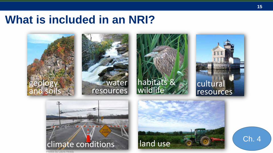
What is included in an NRI?
cultural resources
habitats &wildlife
climate conditions
water resources
land usePhotos by Laura Heady
Ch. 4

16
What is included in an NRI?Two approaches:• “Basic” NRI – uses publicly available data• “Detailed” NRI – basic data + new analysis or study
What does your community want?
Pho
to b
y La
ura
Hea
dy

17
What is included in an NRI? 1) maps

18
What is included in an NRI?
2) data and sources1) maps

19
What is included in an NRI?
2) data and sources1) maps
3) report (goals, methods, resource descriptions, findings, recommendations)

20
What is included in an NRI? 1) maps

21
What is included in an NRI?
2) data and sources1) maps

22
What is included in an NRI?
2) data and sources1) maps
3) report (goals, methods, resource descriptions, findings, recommendations)

23
Why inventory natural resources?
educates landowners prepares developers contributes to community vision
NRIs provide an opportunity to educate and raise awareness about your community’s natural assets.
Photo by G. Goff

24
Why inventory natural resources?
know what questions to ask provide consistency in reviews consider the context of a project,
i.e., the “big picture”
NRIs provide a valuable reference for planning, designing, and reviewing. They help decision-makers to:
Photo by Laura Heady

25

26

27
Why inventory natural resources?
visualization of natural features and interconnectedness
foundation for comprehensive plan and zoning updates, open space planning, watershed planning
NRIs also help us view resources at a town-wide or county scale (and beyond). They provide:
28
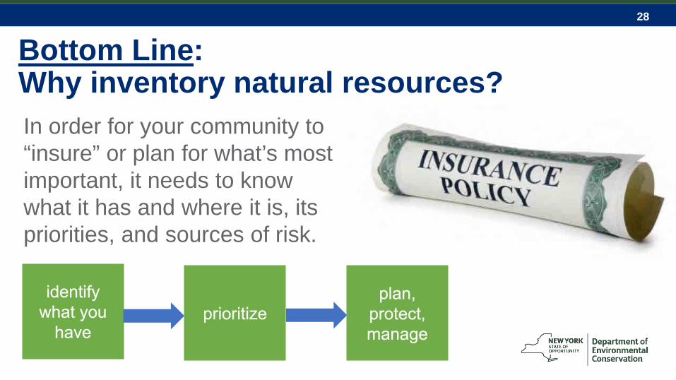
Bottom Line: Why inventory natural resources?In order for your community to “insure” or plan for what’s most important, it needs to know what it has and where it is, its priorities, and sources of risk.

29
Examples of Inventory ProjectsTown of Rosendale NRIDone by: environmental commission, volunteers$$$: Minimal costs covered by commission’s budget Used existing data + commission created original data
on historical and cultural sites, and protected open space.
Town of Shawangunk OSIDone by: team of graduate students, which included resident$$$: Minimal costs covered by town board Used existing data + created original data and analysis
on unfragmented forest, riparian travel corridors, and wetland/floodplain buffers.
App. J

30
Examples of Inventory Projects (cont’d)
Town of Ancram Natural Resources Conservation PlanDone by: CAC and Hudsonia Ltd.$$$: Funding from Hudson River Valley Greenway, Hudson River Bank and Trust Foundation, and the Town Used existing data + habitat mapping completed by
volunteers.

31
Examples of Inventory Projects (cont’d)
Town of Pleasant Valley Open Space and Farmland Plan Done by: Open Space Committee, Taconic Site Design and AKRF$$$: Funding from Hudson River Estuary Grant Used existing data to inventory natural resources
and identifies and describes priority areas.
Technical and Funding Assistance

32
• Outlines an approach to developing an inventory
• Recommends resources to inventory• Suggests available data to include
and where to find help• Considers ways to analyze the
results• Presents ideas and examples for
putting the inventory to workwww.dec.ny.gov/lands/100925.html
The Guidebook at a Glance

33
Who is the guidebook especially designed for?Boards, commissions, and groups that are:• involved in environmental review
and conservation planning• starting or updating an NRI, comp plan, open
space plan, or watershed characterization• taking the next steps with a completed
inventory
Photo by David Burns
Photo by Laura Heady

34
What’s in the guide?Ch. 1: Introduction (why/what)Ch. 2: Getting Started (process)Ch. 3: Mapping Options (online tools and GIS)Ch. 4: What to Include (inventory components)Ch. 5: Analyze the Information (what does it all mean?)Ch. 6: Putting the Inventory to Work (next steps)
plus appendices….

35
geologyand soils
Resources to include in an NRI:
cultural resources
habitats &wildlife
climate conditions
water resources
land usePhotos by Laura Heady
pg. 15

36
Each resource description includes:• background• what to include
(readily available data)
• detailed inventory studies (to gather new, local data)
• where to find help

37
Example:WetlandsBackground: defining features, multiple values, relation to other surface water, mapping issues
What to include: National Wetland Inventory, NYS Freshwater Wetlands, soils drainage data (poorly and somewhat poorly drained classes)
Detailed inventory studies: wetland inventory and evaluation methods, wetland buffer delineation
Where to find help: DEC Freshwater Wetlands Program, DEC Hudson River Estuary Program, county soil and water conservation districts
pg. 24

38
Town of Pleasant Valley surface hydrology Town of Ancram detailed wetlands
pg. 86

39
Example:ForestsBackground: interior forest habitat, forestcorridors, fragmentation of forests, pestsand invasive species
What to include: large forests (>200 ac), matrix forest blocks and linkage zones, significant communities
Detailed inventory studies: biodiversity assessment (habitat mapping), managed forest land, street tree inventory
Where to find help: Hudson River Estuary Program, New York Natural Heritage Program, DEC Forest Stewardship Program pg. 33

40
Rensselaer Plateau interior forestTown of Pleasant Valley woodlands
pg. 88

41
Your NRI is complete. What’s next?Analyze the information:
• Which resources have the greatest value to the community? Why?
• What are the threats?• Are there resources that have importance to
adjacent communities or the region?Ch. 5

42
Your NRI is complete. What’s next?Putting the Inventory to Work:• public education• comprehensive planning• open space planning and
implementation, watershed plans• critical environmental areas• zoning and subdivision regulations• development review
A completed NRI can receive up to 5 points through the Climate Smart Communities Certification Program (Action 6.17)
Ch. 6

43
Climate Smart Communities Program certification actions informed by NRIs:
6.19: Preserve natural areas through zoning or other regulations
7.10: Create or update a watershed assessment to identify flooding and water quality priorities
7.12: Conserve, revegetate, reconnect floodplains and riparian buffers
7:13: Conserve natural areas for species migration and ecosystem resilience
7.17: Conserve wetlands and forests to manage stormwater, recharge groundwater, and mitigate flooding

44
Identify high priority natural areasin your comprehensive plan or an open space plan
Critical habitat areas Large forests Wetland complexes Drinking water protection Working farmland or forests Scenic resources
Town of Pleasant Valley Open Space and Farmland Plan

45
Example from the Town of Red Hook: Community Preservation Fund
Real estate transfer tax toward open space preservation; must first by approved by NYS legislature.Parcels ranked for protection by: Agriculture and water resources Ecological features Scenic vistas, trails, and greenways Historical values Update will consider habitat connectivity
46
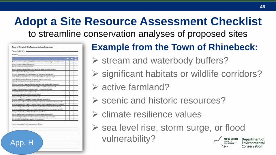
Example from the Town of Rhinebeck: stream and waterbody buffers? significant habitats or wildlife corridors? active farmland? scenic and historic resources? climate resilience values sea level rise, storm surge, or flood
vulnerability?
Adopt a Site Resource Assessment Checklist to streamline conservation analyses of proposed sites
App. H

47
NYS Stormwater Management Design Manual guidelines: Preserve existing natural areas Minimize impervious surfaces Use green infrastructure practices
to reduce additional runoff
Photo by Laura Heady
Identify and prioritize areas for stormwatermanagement at the start of the design process

48
Example from the City of Newburgh:Green Infrastructure Opportunity MappingThe city’s current NRI effort plans to highlight and analyze impervious areas for their potential contributions to green infrastructure functions, including: existing streets, medians, and sidewalks hard-packed underutilized and vacant lots surface parking
This information will be incorporated to project reviews following the CAC’s Green Infrastructure Policy.

49
Designate Critical Environmental Areas A specific area designated by a state or local agency
through SEQR as having exceptional or unique environmental or cultural characteristics. Examples:
Brings attention to high priority resources during SEQRhttp://www.dec.ny.gov/permits/45500.html
Aquifer or reservoir protection High quality stream corridor Rare plant or animal habitat Ridgelines or steep slopes

50
Photo: Nature Conservancy
Example from Dutchess County: Stissing Mountain CEAs Mountain area – steep slopes Headwater forests and wetlands Exceptional wildlife habitat

51
Overlay zoning
Use zoning to conserve priority natural areas
Applies a new set of standards and incentives within existing zoning districts to better achieve natural resource protection goals (does not replace existing zoning districts)
Steep slopes Floodplains Wetlands
Aquifers Significant
habitatsTown of Warwick Biodiversity Overlay Zone

52
Example from the Town of Coxsackie: Natural Resource Protection Standards
Applies to all land containing natural resource constraints, including: Steep slopes Watercourses Wetlands Wildlife habitat
Photo by Greene Land Trust

53
Wetland and watercourse protection: Protects all NWI wetlands and 50-ft buffer Requires field delineations of all wetlands Protects variable-width buffers on
streams based on USGS maps; 25-ft buffer on all other streams
Specifies allowable uses/management of buffer areas (e.g., no lawns)
Photo by Ingrid Haeckel
Example from the Town of Coxsackie: Natural Resource Protection Standards

54
Photo by S. Cuppett
Example: Town of Woodstock Protects all streams and wetlands,
including small streams, and small, isolated wetlands in the municipality
Protects adjacent buffer areas of variable width (30-100 ft) based on drainage area or wetland size
Wetland inspector and planning board refer to townwide habitat map
Adopt a Wetland and Watercourse Ordinance

55
What else is in the guide?
App. A: Agencies & OrganizationsApp. B: Publications & Web ResourcesApp. C: Recommended GIS Data SourcesApp. D: Information about Commonly Used MapsApp. E: Biodiversity Assessment Overview

56
What else is in the guide?
App. F: Hudson Valley Climate ResilienceApp. G: Model Local Law to Adopt the NRIApp. H: Sample Checklist for Assessing Site Resources During Subdivision ReviewApp. I: Examples of Maps from a Municipal NRIApp. J: Examples of Inventory Projects

57
• PDF version available to view or download at: www.dec.ny.gov/lands/100925.html
• Limited number of print copies available
• Technical assistance available for Estuary watershed communities
• Estuary Grant funding

58
Hudson Valley Natural Resource Mapper
Interactive web map• Estuary• Streams & Watersheds• Wetlands• Large Forests• Biodiversity
www.hudson.dnr.cals.cornell.edu/mapper

59
For more information:
Connect with us:Facebook: www.facebook.com/NYSDECTwitter: twitter.com/NYSDECFlickr: www.flickr.com/photos/nysdec
Laura HeadyConservation & Land Use [email protected]
Ingrid HaeckelConservation & Land Use [email protected] River Estuary Program and Cornell University
Thank you!
Photo by Laura Heady