emlr fish inventory - natural resources management board
TRANSCRIPT

Cover
The Eastern Mount Lofty Ranges
Fish Inventory Michael Hammer
Aquasave


Title page
The Eastern Mount Lofty Ranges Fish Inventory
Distribution and conservation of freshwater fishes of tributaries to the Lower River Murray, South Australia September 2004 Michael Hammer Native Fish Australia SA Scientific officer [email protected] www.nativefishsa.asn.au A joint program between Native Fish Australia (SA), Aquasave and the River Murray Catchment Water Management Board.

This report may be cited as: Hammer M (2004) The Eastern Mount Lofty Ranges Fish Inventory: Distribution and Conservation of Freshwater Fishes of Tributaries to the Lower River Murray, South Australia. Native Fish Australia (SA) Inc & River Murray Catchment Water Management Board. ISBN 0-9581530-4-3
Acknowledgements The extent and detail of this Inventory could not have been achieved without the involvement and expertise of many people, and the funding of the River Murray Catchment Water Management Board (RMCWMB). Thanks in-particular to numerous members of Native Fish Australia (SA) for assistance in the field, Leanne Pillar for final proof reading, and to Kerri Muller and Mardi van der Wielen (RMCWMB) for supporting the project, spatial information layers and help in the field. Also, thanks to SARDI Aquatic Sciences (Inland Waters) for equipment hire and some field assistance, Ashwood Ceasar (DWLBC) for producing GIS maps that assisted with site selection/survey design, DWLBC for access to unpublished hydrological and aerial videography data and the South Australian Museum who provided important access to the historic fish collection. The involvement and enthusiasm of the community was both encouraging and appreciated, with many landholders allowing access to locations on private property, participating in surveying and also sharing invaluable knowledge on the history and lie of the land. Members of Catchment and Landcare groups assisted with site access and sampling, which was greatly appreciated.
© Native Fish Australia (SA) Inc. 2004 c/o 120 Wakefield St Adelaide SA 5000 All photographs © Michael Hammer, otherwise as per acknowledgement Front cover: from the top left; male and female southern pygmy perch, Finniss River stream habitat, flathead gudgeon and cut-out of mountain galaxias. Acronyms commonly used in this document: NFA(SA): Native Fish Australia (SA) SAMA: South Australian Museum, Adelaide RMCWMB: River Murray Catchment Water Management Board EMLR: Eastern Mount Lofty Ranges EPBC Act: Environmental Protection and Biodiversity Conservation Act 1999 (Federal) DWLBC: Department for Water Land and Biodiversity Conservation TL: Total Length, ds: down stream, us: up stream

Foreword Fishes are dependent on underwater environments for existence. Consequently species, particularly those restricted to dispersal within freshwater, cannot simply escape poor conditions by removing themselves from the water until favourable conditions return. Hence the diversity and abundance of fishes can tell us much about the natural history and health of aquatic habitats. The ecology and adaptations of such creatures to variable aquatic environments, particularly intermittent streams such as those in the Eastern Mount Lofty Ranges, is also fascinating. At a time when water is in such heavy demand for irrigation supply and with ever increasing regional and rural development, it is timely to review the current status of fish in the region. This document sets the scene to begin to understand the characteristics and conservation requirements for a badly neglected faunal group, the freshwater fishes. It aims to ensure that fish and other underwater creatures are considered in regional planning and management by government and on the land, as fish have specific requirements linked within complex ecosystems. The Eastern Mount Lofty Fish Inventory forms one in a series of similar surveys being conducted by Native Fish Australia (SA) as part of a determined effort to better document the distribution and conservation requirements of native fish in South Australia. Areas covered to date include the South East and Lower Lakes, with surveying on Kangaroo Island near completion and additional regions of the State being targets for future surveys. An ideal introduction to local species and aquatic habitats as a context for this document is contained in the ‘Data Sheet: Freshwater Fishes of Mount Lofty Ranges – Murray-Darling Basin in SA’ (Hammer and Butler 2001). This report details the distribution of threatened species as well as habitats on private property. While the benefits of having such information are invaluable in the long-term context of species conservation, consideration needs to be given to the sensible distribution and application of this information. The report has been prepared on the best information available at the time and no responsibility is taken for any errors or omissions. About Native Fish Australia (SA) Native Fish Australia (SA)’s activities and goals are directed towards the research and conservation of our native fish and aquatic environments. We recognise the need for the integration of ongoing research in our local area, the promotion of native fish, community involvement in research, and education aimed at the protection and enhancement of native fish into the future. This will involve the raising of issues important in ensuring these aims, such as the information featured in this Inventory. Get involved by contacting or becoming a member of NFA (SA). Membership forms and constitution are available from www.nativefishsa.asn.au
Executive summary The Eastern Mount Lofty Fish Inventory is a cumulation of recent surveys and monitoring in a distinct section of the Murray-Darling Basin near Adelaide. It provides a comprehensive overview of the distribution of species in intermittent stream environments and terminal wetland areas for 16 catchments that drain toward the Lower River Murray or Lake Alexandrina. Data on fish species composition and abundance, water quality and habitat characteristics is presented for over 180 sites. The Eastern Mount Lofty Ranges are an important refuge for aquatic biota at the local and Murray-Darling Basin level. Distinct patterns of species and habitat occurred within and between different catchments. In total sixteen native species were captured including one species of national conservation significance (Yarra pygmy perch), three endangered species ‘protected’ under state legislation (Yarra and southern pygmy perch, river blackfish) as well as six other species considered rare at the state level. In addition three hybrid forms of carp gudgeons were also collected. Museum specimens, literature and local reports indicate that another 11 native species were once present or might still occur in the study region. Seven introduced species were recorded. The Inventory identified that the region has high natural values warranting protection and recognition within regional management such as distinctive habitat, threatened species and other taxa isolated in particular areas (and hence potentially genetically distinct). A summary of significant catchment features includes:
• Currency Creek: isolated populations of mountain galaxias and flathead gudgeon, diverse lowland fish community,
• Tookayerta Creek: unique spring fed and swamp habitat (local and national level significance), including patchy distributions of the threatened southern pygmy perch and river blackfish, also distinctive colour form of mountain galaxias,
• Finniss River: contrasting bedrock defined geomorphology with spring fed sections and some peat swamp, disjunct populations of threatened southern pygmy perch and good populations of mountain galaxias. Also diverse habitat structure and fish species richness in lowland areas including wetland habitat supporting Yarra pygmy perch,
• Angas River: spring fed upland and lowland pools, healthy population of river blackfish, severely restricted southern pygmy perch population and isolated dwarf flathead gudgeon and mountain galaxias populations,
• Bremer River: contrasting sub-catchments, large lowland pools, highly restricted habitat for river blackfish in Rodwell Creek,
• Reedy Creek: distinct geomorphology (waterfalls), few fish but including an isolated population of dwarf flathead gudgeon in distinctive habitat,
• Salt Creek: contrasting saline habitat, some large and isolated aquatic refuge pools, • Saunders Creek: little water but important lowland spring-pools with Murray-Darling
carp gudgeon, • Marne River: rocky gorge with isolated mountain galaxias and unique spring fed
section (large cool pools within Mallee surrounds) containing a restricted and ever contracting population of river blackfish as well as other small native fish.
Data indicates that water resource development has likely had, and will continue to have, a considerable effect on the health of fish populations in the region, especially during natural dry periods (accentuation or creation of no flow events, loss of base flow), reducing the presence and quality of permanent refuge pools. Specific cases of broad and localised habitat destruction also appear to have affected species distributions in the region and introduced predators were implicated in the restricted occurrence of small native fish. Under the premise that freshwater fish are ideal indicators of the health of our waterways, recommendations are made that identify areas for research and the future protection and enhancement of important aquatic habitat in the Eastern Mount Lofty Ranges.

Contents 1.0 Introduction ......................................................................................................................... 1 2.0 Methods ............................................................................................................................... 3
2.1 Collating historic records ................................................................................................ 3 2.2 Study area........................................................................................................................ 3 2.3 Sampling sites ................................................................................................................. 6 2.4 Climatic conditions during sampling .............................................................................. 6 2.5 Fish survey procedure ..................................................................................................... 6 2.6 Other fauna and flora ...................................................................................................... 8 2.7 Environmental descriptors .............................................................................................. 8
3.0 General Results.................................................................................................................... 9 3.1 Species richness .............................................................................................................. 9 3.2 Historic data .................................................................................................................. 11
4.0 Regional summary............................................................................................................. 13 4.1 Currency Creek ......................................................................................................... 17 4.2 Deep Creek ............................................................................................................... 19 4.3 Tookayerta Creek...................................................................................................... 20 4.4 Finniss River ............................................................................................................. 23 4.5 Angas River .............................................................................................................. 27 4.6 Bremer River ............................................................................................................ 31 4.7 Salt Creek.................................................................................................................. 37 4.8 Reedy Creek.............................................................................................................. 39 4.9 Saunders Creek ......................................................................................................... 41 4.10 Marne River ............................................................................................................ 43
5.0 Species summary ............................................................................................................... 47 5.1 Stream species (wholly freshwater) .............................................................................. 47 5.2 Stream species (diadromous) ........................................................................................ 57 5.3 Larger river species ....................................................................................................... 59 5.4 Wetland species............................................................................................................. 60 5.5 No fish…....................................................................................................................... 61 5.7 Translocated native species........................................................................................... 63 5.8 Exotic species................................................................................................................ 63
6.0 Other fauna ........................................................................................................................ 69 7.0 Implications and management ........................................................................................... 71
7.1 Characteristics of the fish fauna and aquatic habitats ................................................... 71 7.2 Historic conditions and environmental change ............................................................. 72 7.3 Environmental water requirements ............................................................................... 74 7.4 Restoration and enhancement ....................................................................................... 76 7.5 Introduced species and management............................................................................. 77 7.6 Fish and farm dams ....................................................................................................... 78 7.7 Research and monitoring............................................................................................... 79 7.8 Conclusion .................................................................................................................... 80
8.0. References ........................................................................................................................ 81 Appendix 1. Native freshwater fish of the Murray-Darling Basin............................................... 84 Appendix 2. Site details and summary of survey methods...................................................... 85 Appendix 3. Oral history ......................................................................................................... 89

Eastern Mount Lofty Fish Inventory
Page 1
1.0 Introduction South Australia is largely devoid of stream habitat. Several lowland rivers sourced many hundreds of kilometres away flow through normally dry regions of the State (e.g. Cooper Creek, Diamantina and Murray rivers), while one naturally wetter region, the South East, mostly lacks natural drainage organisation and instead has aquatic habitats distributed as a mosaic of wetland features (at least under natural conditions). The Mount Lofty Ranges, linking with the Flinders Ranges in the north and stretching in a southerly direction to the Fleurieu Peninsula, is one region where topography and rainfall do combine to provide stream habitats. Catchments in the region discharge into one of two major drainage divisions: (a) the South Australian Gulf Division - essentially those streams on the western slopes of the range that drain toward Gulf St Vincent and including a small section of the southern Fleurieu Peninsula that discharges directly into the Southern Ocean, and (b) the Murray-Darling Drainage Division or Murray-Darling Basin – streams in the Eastern Mount Lofty Ranges (EMLR) that drain towards either the Lower River Murray or Lake Alexandrina. The current physical form of the Mount Lofty Ranges was evident by the early Tertiary period (~60-80 M years ago), shaped by significant earth movements along regional fault lines (Twidale 1976). The physical force of streams has since this formation, played an integral part in shaping the current landscape, and modern streams of the Mount Lofty Ranges retain a prominent role in the natural and cultural heritage of the region. Being close to a large population base in Adelaide (over 1 million people) and linked to several major regional (Mt Barker, Strathalbyn, Murray Bridge) and rural centres, there is a large and continuing pressure on EMLR streams from intensive rural and urban development (e.g. extensive land clearance, considerable hydrological development - particularly in the last 15 years, stormwater, stock access, swamp drainage etc). As the ultimate point for runoff in catchments, the end result of harmful practices in surrounding landscapes can be felt in waterways (e.g. pollution, siltation, water abstraction in dams). It is thus important to have a level of knowledge of regional aquatic biodiversity and related environmental requirements to assist in the protection of remaining natural values and begin to restore ecosystems in the face of considerable anthropogenic change. Freshwater fish should be viewed as important indicators of stream health due to their total reliance on aquatic (underwater) environments for all life history stages. For example certain native species require particular flow events for migration, access to habitat, and cues for ecological processes, while exotic species may thrive in altered conditions (e.g. Puckridge et al. 1998; Harris and Silveira 1999). As well, fish as higher order predators, can be affected (e.g. poor recruitment) by degradation of other ecosystem components and may have a role in ecosystem function (e.g. Flecker and Townsend 1994). These factors, combined with the familiarity and affection often shown toward fish by local communities, means that fish potentially serve as icons for the understanding and responsible stewardship of local waterways. There are indications that the EMLR has a diverse and unique fish community. The list of freshwater fishes for the region is reasonably well-established, with the streams known to currently or historically support at least 26 native species. These fish range from tiny species such as carp gudgeons that reach just a few centimetres, to medium sized river blackfish and congolli (up to about 30cm), through to the mighty Murray cod, a species that can grow to well over a metre in length (Hammer and Butler 2001). Additional species are still being documented such as Yarra pygmy perch in 2001, and research into the population genetics of the southern pygmy perch has identified unique and divergent genetic sub-populations isolated in particular catchments (Hammer 2001, 2002b). Such patterns likely extend to other species restricted to dispersal in freshwater, and protecting genetic diversity is imperative as a base for biodiversity conservation within a regional and national context.
Page 2
Eastern Mount Lofty Ranges
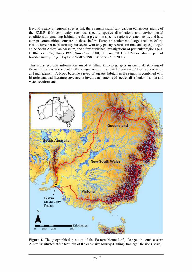
Beyond a general regional species list, there remain significant gaps in our understanding of the EMLR fish community such as: specific species distributions and environmental conditions at remaining habitat, the fauna present in specific regions or catchments, and how current communities compare to those before European settlement. Large sections of the EMLR have not been formally surveyed, with only patchy records (in time and space) lodged at the South Australian Museum, and a few published investigations of particular regions (e.g. Nettlebeck 1926; Hicks 1997; Sim et al. 2000; Hammer 2001, 2002a) or sites as part of broader surveys (e.g. Lloyd and Walker 1986; Bertozzi et al. 2000). This report presents information aimed at filling knowledge gaps in our understanding of fishes in the Eastern Mount Lofty Ranges within the specific context of local conservation and management. A broad baseline survey of aquatic habitats in the region is combined with historic data and literature coverage to investigate patterns of species distribution, habitat and water requirements.
Figure 1. The geographical position of the Eastern Mount Lofty Ranges in south eastern Australia: situated at the terminus of the expansive Murray-Darling Drainage Division (Basin).

Eastern Mount Lofty Fish Inventory
Page 3
2.0 Methods 2.1 Collating historic records A morphological examination of fish specimens housed at the South Australian Museum, Adelaide (SAMA) was conducted to obtain a verified catalogue of historic records for the EMLR. This was combined with a review of literature as an insight into species distributions, potential habitat and key survey locations. A dedicated effort was also made to document oral history regarding local knowledge of fish species in the region, past and present (see Appendix 3 for more detail). 2.2 Study area The EMLR study region here includes whole stream catchments draining the south eastern flank of the Mount Lofty Ranges between Currency Creek in the South and the Marne River to the North and bounded by Lake Alexandrina and the River Murray (Figs 2 & 5), an area of some 4600km2. The area includes 17 distinct catchments (Fig. 2), not all of which contain permanent surface water (e.g. no fish sampling sites could be located in the Bees Knees, Long Gully, Milendella Creek, Preamimma Creek, Rocky Gully and Sandergrove Plains catchments).
Figure 2. Topography and catchments of the Eastern Mount Lofty Ranges study area.
Lake Alexandrina
River Murray

Page 4
Elevation at the region of hydrological separation between the east and west Mount Lofty Ranges varies between 200-480m above sea level (Fig 2). The study area experiences a Mediterranean Type climate, with long hot summers and rainfall predominantly concentrated within winter and spring (prevailing low pressure systems from the south-west). Yearly average rainfall varies considerably from 800mm at higher elevations to a mere 300mm on flats at the base of the range (see Fig. 3). The principal habitat type in the region is small streams (generally less than 20m wide), with some peat swamps, isolated spring pools and large lowland pools present, as well as larger river channel or wetland habitats at the junction of streams and the River Murray or Lake Alexandrina. There is considerable variation in the geomorphic and hydrological character of streams, further compounded by differing patterns and intensity of regional land use. In general, most catchments comprise a network of small tributaries originating from the moderate gradient ‘slopes’ of the Range that tend toward distinct habitat in a single lowland channel, usually via a steep gorge, and then meander across a lowland ‘flat’ before eventually reaching the Lower River Murray or Lake Alexandrina (actual stream discharge ranges from near permanent, seasonal and to highly erratic: see Section 4.0).
Figure 3. Map depicting rainfall zones of the Eastern Mount Lofty Ranges. Note the contrasting rainfall band areas for different catchments.
Eastern Mount Lofty Fish Inventory
Page 5
Flow pattern for the upper Angas River 1997-2004
0
500
1000
1500
2000
2500
3000
3500
4000
4500
Jan-96Apr-96Jul-96O
ct-96Jan-97Apr-97Jul-97O
ct-97Jan-98Apr-98Jul-98O
ct-98Jan-99Apr-99Jul-99O
ct-99Jan-00Apr-00Jul-00O
ct-00Jan-01Apr-01Jul-01O
ct-01Jan-02Apr-02Jul-02O
ct-02Jan-03Apr-03Jul-03O
ct-03Jan-04
Flow
(meg
alitr
es)
a)
Flow
(meg
alitr
es)
Upper Angas River Flow gauge Data
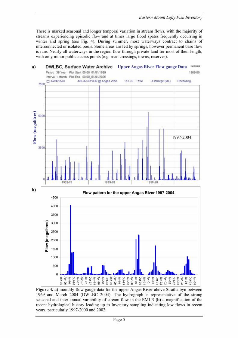
There is marked seasonal and longer temporal variation in stream flows, with the majority of streams experiencing episodic flow and at times large flood spates frequently occurring in winter and spring (see Fig. 4). During summer, most waterways contract to chains of interconnected or isolated pools. Some areas are fed by springs, however permanent base flow is rare. Nearly all waterways in the region flow through private land for most of their length, with only minor public access points (e.g. road crossings, towns, reserves).
Figure 4. a) monthly flow gauge data for the upper Angas River above Strathalbyn between 1969 and March 2004 (DWLBC 2004). The hydrograph is representative of the strong seasonal and inter-annual variability of stream flow in the EMLR (b) a magnification of the recent hydrological history leading up to Inventory sampling indicating low flows in recent years, particularly 1997-2000 and 2002.
1997-2004
b)

Page 6
2.3 Sampling sites Site selection was primarily designed to give an even spatial coverage of catchments and to include representation of distinct geomorphic zones within catchments (i.e. with the aid of GIS coverage and 1:50k topographic maps). The number of sites in a geomorphic zone was increased if there was considerable heterogeneity in habitat or hydrologic conditions. However, water availability and land access heavily dictated site location. With the cooperation of land holders/managers and local Catchment and Landcare groups, many sites were deliberately located on private property to encourage community involvement, collect oral history and raise awareness of aquatic fauna (e.g. fish data sheet distribution). Identification of permanent pools in 2004 sampling was aided with specialised GIS coverage of the survey region from aerial videography of catchments in autumn 2003 produced by the Department for Water Land and Biodiversity Conservation (DWLBC 2004). This data provided information on visible surface water from overhead helicopter surveys, and was a useful supplement to local knowledge, particularly in drier catchments (ground truthing was still required to increase the accuracy and reliability of these maps). Inventory sites were grouped into the catchment areas listed in 2.2 to assist in the interpretation of results. Sites within catchments are arranged according to increasing distance from stream termini along the primary river, then in a similar manner for tributary streams progressing upstream in the catchment. Site number prefixes indicate year of sampling (e.g. ML04 = 2004). Site suffixes are used to indicate information on site sampling location or history:
• A – represents the same site sampled on a preceding occasion (temporal comparison), • M – ongoing monitoring site for threatened fish species, • a and b (small caps) – paired sites located in close proximity.
2.4 Climatic conditions during sampling Sampling in 2004 followed a dry summer and virtually no rainfall occurred across the region during the March to June sampling period. The preceding 2003 winter did have reasonable rainfall and moderate flows in the more southern catchments, but 2002 was a low rainfall year. The longer term trend for the previous ten years was of below average rainfall and corresponding stream flow, especially during 1997-2000 (e.g. low stream flows in the Angas River: Fig. 4; see also Savadamuthu 2003). 2.5 Fish survey procedure Thirty-eight field days/nights with a two or three person sampling team was used to collect 2004 Inventory data. This effort was supplemented by two other specific surveys in the Angas and Marne catchments, as well as opportunistic collections in various catchments occurring between autumn 1999 and autumn 2003. Data from a collaborative project involving the collection of mountain galaxias for future genetic studies (see Raadik 2001) was also included. Sampling was carried out under Section 59 permit exemptions under the Fisheries Act 1982. A site generally consisted of a main pool or river channel location where sampling was concentrated and general site descriptors obtained (see section 2.7), with supplementary investigations employed within a 100m stretch of habitat. For consistency in method and interpretation of environmental parameters, all surveying was conducted by the author, with field assistants over the period including numerous Native Fish Australia (SA) members, representatives of community and government groups and landholders.

Eastern Mount Lofty Fish Inventory
Page 7
The sampling methodology was designed to assess fish species richness and relative abundance in high water conductivity pools with varying degrees of size, depth, habitat complexity and water clarity. It also aimed for minimum impact (e.g. low disturbance to sensitive habitats/concentrated pools, minimal handling, sub-sampling larger catches to be measured and avoiding hot weather). Timing was aligned to the autumn period when fish are easiest to sample owing to the concentrated nature of stream pools. A range of gear types were used for field sampling, often applied in conjunction depending on habitat. Site specific details are maintained on a NFA(SA) data base for direct examination in future monitoring programs with a summary appearing in Appendix 2. Standard sampling involved three ten-metre hauls of a seine net (7mx2m, 6mm mesh), with additional dip netting (square frame, 0.5m diameter, 4mm stretch mesh) of emergent or overhanging edge vegetation for 15-30 minutes. Some smaller pools required less hauls or could be sampled with dip nets. Sites with high structural integrity, difficult access or situated in sensitive areas (preventing seining) were sampled with bait traps (collapsible, 400x250x200mm, 3 & 6mm inlets; baited with dry cat food and set for 2 daylight hours) and other supplementary techniques. At larger deeper sites fyke nets (single 6m wing, 3 compartments and 5mm half mesh) were set and left overnight. Supplementary techniques included underwater night observations (torch from bank or snorkelling) conducted for sites with high transparency. Angling was employed on a limited number of occasions for larger introduced species, with local reports providing valuable input on the presence of these species (the survey focus was on detecting remaining native fish populations and hence the gear used is most effective for medium and smaller species). Electrofishing was employed only at a handful of sites, as high water conductivities, low transparency, pool structure (e.g. narrow deep pools) and limited availability prevented wider use as a standard technique. Due to taxonomic confusion the abundance of carp gudgeons Hypseleotris spp. was combined to produce a single figure. However, different forms at sites were recorded (sensu Bertozzi et al. 2000; Hammer and Butler 2001), with many identifications verified by genetic typing as part of ongoing studies being conducted at the Evolutionary Biology Unit of SA Museum (Hammer 2001; Adams and Hammer, unpublished data). Notes were made on microhabitat where species were captured and any signs of reproductive condition and external disease or parasites were recorded. Total length (TL) was recorded for certain components of catches and to obtain general biological information (size range, snap shot of population structure) and specific ongoing monitoring data on threatened species and environmental flows. Vouchers were taken, where specimens were abundant, and lodged with the SAMA as historical records and to verify identification. All introduced species were destroyed and the stomach content of introduced predatory species examined.
Inspecting catches from a seine net (left) and fyke net

Page 8
2.6 Other fauna and flora Records of opportunistic samples of turtles and larger macroinvertebrates such as yabbies and shrimps (Macrobrachium and Paratya) were made. The survey design also encompassed specific cataloguing of ‘aquatic plants’ including submerged plants, charophytes (a particular group of algae) and small sensitive plants found near to the waters edge, with specimens collected and pressed, and lodged at the State Herbarium (a separate report has been prepared for aquatic plants). 2.7 Environmental descriptors Location (description and GPS- WGS 84 datum), waterway, catchment, weather, land use, potential impacts and environmental characteristics were recorded for each sampling site to assist with the interpretation of results and future replication (monitoring). Environmental characteristics included details of aquatic and interlinked riparian condition as follows (see Hammer 2001 for specific details on category definitions):
• Habitat type (i.e. stream, spring pool, river channel, wetland, instream dam), • Pool size (a reflection of surface area), • Bank slope (e.g. steep, gradual incline), • Depth (max and average), • Substrate type (e.g. sand, gravel, mud).
Contributions to cover (% and type):
• Submerged – physical (e.g. snags, leaf litter, rock), • Submerged – biological (e.g. aquatic plants, Chara,
other algae), • Emergent (e.g. reeds, rushes and sedges, tea tree), • Fringing vegetation within 2 metres of the waters edge
(particular note of small amphibious species on the bank such as Crassula, Centella, Ranunculus) (see images on the right),
• Canopy – measure of over hanging vegetation (shade), • Terrestrial vegetation cover.
Flow environment:
A temporal measure of connectivity based on seasonal conditions and local landholder input (e.g. ephemeral, annual connection or permanently connected).
Pool condition and flow: A measure of water level in comparison to the normal bank level of a pool (e.g. concentrated, bank level, in flood) and recording of Flow at the time of sampling ranked relative to autumn conditions in local streams as either: seep, low, medium or high.
Water quality (TPS MC-81 meter):
• Temperature @ 0.3m, • pH, • Conductivity (range 10-25,000µS = µScm-1), 1:2 dilutions were sometimes needed, • Water transparency measured in situ against a white object with comments on
contributions to low values such as natural tannin or algae. A detailed database of environmental descriptors is also maintained by NFA(SA) and RMCWMB for more specific information and future comparison.

Eastern Mount Lofty Fish Inventory
Page 9
Table 3.1.1. Species richness.
Native Richness # Sites
0 68 1 55 2 30 3 19 4 9 5 3 6 5 7 1 8 3 9 0
10 0 11 0 12 0 13 1 14 0
3.0 General Results Some 146 sites were visited in autumn 2004. To complete regional coverage and also provide for a limited temporal comparison of fish captures, 49 sites visited between February 1999 and April 2003 are also included in subsequent analysis (a total of 180 different sites plus 15 temporal sampling events coinciding with 2004 sites). The supplementary data is sourced from: • Specific surveys of the Angas River (Hammer 1999) and Marne River (Hammer 2002a), • Collaborative research with T. Raadik (Arthur Rylah Institute, Melbourne) involving the
collection of mountain galaxias for genetic research (six sites in the series: ML02-158 -172), • Other opportunistic collections in the region by the author including threatened species
monitoring. Ten sites dry in 2004 were inspected and documented as important linkage to historic data (i.e. sites that previously did have water and fish) and/or as ‘aquatic plant’ sampling sites.
Fish were captured on a large number of sampling events (143 of 195 sites ~ 70%). In total over 31,000 fish were recorded (Table 3.0.1). Sixteen native species were captured including one species of national conservation significance (Yarra pygmy perch), three endangered species ‘protected’ under state legislation (Yarra and southern pygmy perch, river blackfish) as well as six other species considered rare at the state level (see Table 3.0.1.). In addition three hybrid forms of carp gudgeons were also collected. Museum specimens, literature and local reports indicate that another 11 native species were once present or might still occur in the study region (these are discussed in Section 5). Seven introduced species were recorded (Table 3.0.1). A single carp x goldfish hybrid was recorded from site ML02-06A in the Marne River. 3.1 Species richness Native fish were captured at roughly two out of every three sites sampled (126 sites). Native species richness values were mostly low, with between one and four species for the majority of sites (Table 3.1.1). All sites with six or more native fish captured were located at the terminal end of streams with high connectivity to the River Murray or Lake Alexandrina. ‘Reedlands’ on the lower Finniss River (ML04-45) had a particularly high range of native species (n = 13). Only the occasional upstream site had high native richness (two had five native species: ML04-70 - Angas River, ML04-112 - Bremer River). The most widespread native fish was the mountain galaxias (69 sites and 2729 individuals). Carp gudgeons were also widespread and numerically abundant (40 sites, 7340 captured), a similar trend for flathead gudgeon (36 sites, 1961 captured). Dwarf flathead gudgeon occurred at a reasonable number of sites but generally occurred in low relative abundance (26 sites, only 430 captured) and southern pygmy perch was patchily distributed and on occasion locally abundant (20 sites, 1404 captured). Rarer native species included river blackfish (12 sites), common galaxias (12 sites) and congolli (7 sites), while a range of species such as Yarra pygmy perch, smelt and Murray rainbowfish were only collected from a few wetland sites at stream termini. Exotic fish were widely distributed throughout the EMLR occurring at 82 different sites, with up to a combination of four introduced species found at some sites. Gambusia was the most commonly encountered (16222 fish from 61 sites), followed by redfin (24 sites) and carp (23 sites). Tench were only recorded at three sites in the Angas River Catchment.

Page 10
Table 3.0.1. Summary of freshwater fishes recorded in the Eastern Mount Lofty Ranges survey area (survey data and historic records) with national and state conservation status.
Conservation status: National: VU – vulnerable under the EPBC Act 1999. State: P – protected under the Fisheries Act 1982, CREN – Critically endangered, EN –Endangered, VU – vulnerable, R – Rare under the draft Threatened Species Schedule NPWSA. * possible local extinctions. species/hybrid forms confirmed with genetic research (see text)
Common name Scientific name National State # sites
# caught
Pouched lamprey Geotria australis EN 0 0 Shortheaded lamprey Mordacia mordax EN 0 0 Shortfinned eel Anguilla australis R 0 0 Freshwater catfish Tandanus tandanus P, VU 0 0* Bony herring Nematalosa erebi 5 54 Australian smelt Retropinna semoni 7 73 Climbing galaxias Galaxias brevipinnis VU 0 0 Common galaxias Galaxias maculatus 12 201 Mountain galaxias Galaxias olidus R 69 2729Murray rainbowfish Melanotaenia fluviatilis R 1 8 Smallmouthed hardyhead Atherinosoma microstoma 3 29 Murray hardyhead Craterocephalus fluviatilis VU EN 0 0* Unspecked hardyhead Craterocephalus stercusmuscarum fulvus R 3 16 Chanda perch Ambassis agassizii P,CREN 0 0* River blackfish Gadopsis marmoratus P, EN 12 176 Murray cod Maccullochella peelii peelii VU R 0 0* Murray-Darling golden perch Macquaria ambigua ambigua 0 0 Southern pygmy perch Nannoperca australis P, EN 20 1404Yarra pygmy perch Nannoperca obscura VU P, EN 2 14 Silver perch Bidyanus bidyanus P, VU 0 0* Congolli Pseudaphritis urvillii R 7 19 Carp gudgeons (total) Hypseleotris spp. 40 7340 Midgley's carp gudgeon Hypseleotris sp. 1 Murray-Darling carp gudgeon Hypseleotris sp. 3 R Hybrid forms Hypseleotris spp. Purple-spotted gudgeon Mogurnda adspersa P,CREN 0 0* Flathead gudgeon Philypnodon grandiceps 36 1961Dwarf flathead gudgeon Philypnodon sp. R 26 430 Western bluespot goby Pseudogobius olorum 4 9 Introduced species Goldfish Carassius auratus 8 83 Carp Cyprinus carpio 23 78 Tench Tinca tinca 3 11 Rainbow trout Oncorhynchus mykiss 3 14 Brown trout Salmo trutta 9 95 Gambusia Gambusia holbrooki 61 16222Redfin Perca fluviatilis 24 144
Eastern Mount Lofty Fish Inventory
Page 11
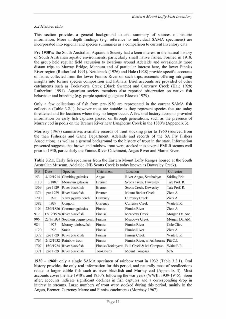
3.2 Historic data This section provides a general background to and summary of sources of historic information. More in-depth findings (e.g. reference to individual SAMA specimens) are incorporated into regional and species summaries as a comparison to current Inventory data. Pre 1930’s: the South Australian Aquarium Society had a keen interest in the natural history of South Australian aquatic environments, particularly small native fishes. Formed in 1918, the group held regular field excursion to locations around Adelaide and occasionally more distant trips to Murray Bridge, Mannum and of particular interest here, the lower Finniss River region (Rutherford 1991). Nettlebeck (1926) and Hale (1928) provide specific accounts of fishes collected from the lower Finniss River on such trips, accounts offering intriguing insights into former species composition and habitats. Brief accounts are provided of other catchments such as Tookayerta Creek (Black Swamp) and Currency Creek (Hale 1928; Rutherford 1991). Aquarium society members also reported observation on native fish behaviour and breeding (e.g. purple-spotted gudgeon: Blewett 1929). Only a few collections of fish from pre-1930 are represented in the current SAMA fish collection (Table 3.2.1), however most are notable as they represent species that are today threatened and for locations where they no longer occur. A few oral history accounts provided information on early fish captures passed on through generations, such as the presence of Murray cod in pools on the Bremer River near Langhorne Creek in the 1880’s (Appendix 3). Morrissy (1967) summarises available records of trout stocking prior to 1960 (sourced from the then Fisheries and Game Department, Adelaide and records of the SA Fly Fishers Association), as well as a general background to the history of trout in the state. Information presented suggests that brown and rainbow trout were stocked into several EMLR steams well prior to 1930, particularly the Finniss River Catchment, Angas River and Marne River. Table 3.2.1. Early fish specimens from the Eastern Mount Lofty Ranges housed at the South Australian Museum, Adelaide (NB Scotts Creek is today known as Dawesley Creek).
F # Date Species Catchment Location Collector 153 4/12/1914 Climbing galaxias Angas River Angas, Strathalbyn Stirling Eric 1110 3/1887 Mountain galaxias Bremer Scotts Creek, Dawesley Tate Prof. R. 1369 pre 1929 River blackfish Bremer Scotts Creek, Dawesley Tate Prof. R. 1374 pre 1929 River blackfish Bremer Mount Barker Creek Zietz A. 1200 1928 Yarra pygmy perch Currency Currency Creek Zietz A. 1382 1929 Congolli Currency Currency Creek Waite E.R. 1104 22/3/1886 Common galaxias Finniss Finniss River Zietz A. 917 12/12/1924 River blackfish Finniss Meadows Creek Morgan Dr. AM906 23/3//1924 Southern pygmy perch Finniss Meadows Creek Morgan Dr. AM984 1927 Murray rainbowfish Finniss Finniss River Cole Clive 1120 1928 Smelt Finniss Finniss River Zietz A. 1372 pre 1929 River blackfish Finniss Finniss Creek Waite E.R. 1764 2/12/1932 Rainbow trout Finniss Finniss River, nr Ashbourne Pitt C.J. 1707 15/3/1924 River blackfish Finniss/Tookayerta Bull Creek & Mt.Compass Waite E.R. 1371 pre 1929 River blackfish Tookayerta Mount Compass N/A 1930 – 1960: only a single SAMA specimen of rainbow trout in 1932 (Table 3.2.1). Oral history provides the only real information for this period, and naturally most of recollections relate to larger edible fish such as river blackfish and Murray cod (Appendix 3). Most accounts cover the late 1940’s and 1950’s following the war years (WWII: 1939-1945). Soon after, accounts indicate significant declines in fish captures and a corresponding drop in interest in streams. Large numbers of trout were stocked during this period, mainly in the Angas, Bremer, Currency Marne and Finniss catchments (Morrissy 1967).

Page 12
1960’s and 70’s: very little information was located for this period, with the exception of data for the lower Finniss River. Mr Mal Hogarth continued on the SA Aquarium Society tradition, with some notable records included in a series of specimens lodged at the SAMA (Table 3.2.2). Oral history provided a direct link to the fish community and environments of the time via John Endersby who grew up at ‘Reedlands’ on the lower Finniss, spending considerable time netting for small fish, an art he was taught by Mr. Hogarth (Appendix 3). There are a few SAMA records for the 1970’s including a pouched lamprey from the Bremer River. Some stream sites were surveyed by a joint Fisheries and SAMA team (stream survey program) (L. Grey, pers. comm.) - unfortunately data from this sampling was not published and specimens do not appear to have been lodged as documentation. Carp appeared in the district in the mid 1970’s (Appendix 3) and Fulton (2004) summarises documented data on legal trout releases that have occurred in the region from 1979 onwards. Table 3.2.2. SA Museum records for the lower Finniss River region in the 1960’s. F # Species Collection date Location Collector
7531 Goldfish 1 March 1961 Finniss River Hogarth Mal 9037&35 Murray hardyhead 1 March & May 1961 Finniss River Hogarth Mal. 7750 Gambusia 1 March 1961 Finniss River Hogarth Mal. 7727 Carp gudgeon 1 March 1961 Finniss River Hogarth Mal. 7666 Yarra pygmy perch 1 March 1961 Finniss River Hogarth Mal. 5065 Dwarf flathead gudgeon 1 March 1961 Finniss River Hogarth Mal. 7626 Freshwater catfish 1 March 1961 Finniss River Hogarth Mal. 3087 Yarra pygmy perch May 1962 Finniss River Hogarth Mal. 7667 Chanda perch April 1963 Finniss River Hogarth Mal. 9034 Murray hardyhead April 1963 Finniss River Hogarth Mal. 10048 Un-specked hardyhead April 1963 Finniss River Hogarth Mal. 7633 Carp gudgeon April 1963 Finniss River Hogarth Mal. 7623 Purple-spotted gudgeon April 1963 Finniss River Endersby John 7443 Yarra pygmy perch April 1963 Finniss River Hogarth Mal 5722 Flathead gudgeon April 1963 Finniss River Hogarth Mal. 5064 Dwarf flathead gudgeon 1 March 1964 Finniss River Hogarth Mal. 1980’s: a period of renewed interest in the region mainly led by the studies of Lance Lloyd (University of Adelaide). He sampled select sites in a few catchments (Marne, Angas, lower Finniss and Tookayerta) as part of a broader investigation of the autoecology and conservation status of small fishes of the South Australian section of the Murray-Darling Basin (EMLR sites were revisited as part of the current survey). The official reference for this work is the peer reviewed paper by Lloyd and Walker (1986), however significant citation is also made to the raw data and additional detail of his masters thesis (Lloyd 1987). A range of specimens were left with SAMA verifying the data collected. 1990 onwards: studies on the Hypseleotris species complex identified hybrid forms in Dawson Creek and also recorded a juvenile blackfish on Dawson Creek (Bertozzi 1990; Bertozzi et al. 2000). Hicks (1997) investigated the affect of acid mine drainage on fish in Dawesley Creek which included comparison with sites in a number of EMLR southern catchments. There was a reasonable representation of specimens lodged at the SAMA, many deposited by the then Collection Manager of Ichthyology, Terry Sim (summarised in Sim et al. 2000). Bryan Pierce (formerly SARDI) did conduct research in the area (see Pierce 1997), however the nature and extent of this remains unclear due to a lack of publications to this date. Most work just before or after 2000 is superseded or incorporated into this Inventory (e.g. Hammer 1999, 2002a). Wedderburn (2000) revisited some of Lloyd’s sites and Hammer (2001) undertook a specific investigation of the range, habitat and genetics of southern pygmy perch in the EMLR as a foundation to recovery efforts (Hammer 2002b, 2004; Conallin and Hammer 2003). Lower stream sites are supplemented by recent work on the Lower Lakes (Wedderburn and Hammer 2003).

Eastern Mount Lofty Fish Inventory
Page 13
4.0 Regional summary This section provides a summary of the characteristics, habitat types and condition for various catchments. Species patterns are discussed in relation to current and historic records as well as requirements for future monitoring and investigation. General catchment descriptors for the region are presented below, and then specific information is provided for ten main catchments where permanent pools were located during autumn 2004. Each summary includes mention of specific features such as rainfall and topography (see also 2.2), water conductivity (summarised visually in Fig. 5), natural barriers (summary Table 4.0.1) and the availability of long-term refuges. Sampling locations for southern catchments (draining towards Lake Alexandrina) and northern catchments (draining towards the lower River Murray) are displayed in Figures 6 and 8 respectively.
Figure 5. Visual representation of autumn water conductivity values at sampling sites (refer to Fig. 2 for catchment names).
Conductivity (µScm-1)
Page 14
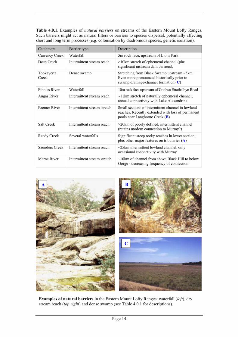
Table 4.0.1. Examples of natural barriers on streams of the Eastern Mount Lofty Ranges. Such barriers might act as natural filters or barriers to species dispersal, potentially affecting short and long term processes (e.g. colonisation by diadromous species, genetic isolation).
Catchment Barrier type Description
Currency Creek Waterfall 5m rock face, upstream of Lions Park Deep Creek Intermittent stream reach >10km stretch of ephemeral channel (plus
significant instream dam barriers).
Tookayerta Creek
Dense swamp Stretching from Black Swamp upstream ~5km. Even more pronounced historically prior to swamp drainage/channel formation (C)
Finniss River Waterfall 10m rock face upstream of Goolwa-Strathalbyn Road Angas River Intermittent stream reach ~11km stretch of naturally ephemeral channel,
annual connectivity with Lake Alexandrina
Bremer River Intermittent stream stretch Small sections of intermittent channel in lowland reaches. Recently extended with loss of permanent pools near Langhorne Creek (B)
Salt Creek Intermittent stream reach >20km of poorly defined, intermittent channel (retains modern connection to Murray?)
Reedy Creek Several waterfalls Significant steep rocky reaches in lower section, plus other major features on tributaries (A)
Saunders Creek Intermittent stream reach ~25km intermittent lowland channel, only occasional connectivity with Murray
Marne River Intermittent stream stretch ~10km of channel from above Black Hill to below Gorge - decreasing frequency of connection
Examples of natural barriers in the Eastern Mount Lofty Ranges: waterfall (left), dry stream reach (top right) and dense swamp (see Table 4.0.1 for descriptions).
A B
C

Eastern Mount Lofty Fish Inventory
Page 15
Table 4.0.2. Summary of species composition for the major catchments of the Eastern Mount Lofty Ranges (X – captured in Inventory sampling, P –reported as present/sampled recently, * recorded historically, ? – possibly occurred based on suitable current or historic habitat).
Common name Cur
renc
y C
reek
Dee
p C
reek
Took
ayer
ta C
reek
Finn
iss R
iver
`
Ang
as R
iver
Bre
mer
Riv
er
Salt
Cre
ek
Ree
dy C
reek
Saun
ders
Cre
ek
Mar
ne R
iver
Pouched lamprey ? ? P * * ?
Shortheaded lamprey ? ? ? ? ? ?
Shortfinned eel ? *
Freshwater catfish *
Bony herring X X X X X
Australian smelt X X X X X X
Climbing galaxias ? ? *
Common galaxias X X X X X X *
Mountain galaxias X ? X X X X ? ? X
Murray rainbowfish * X
Small-mouthed hardyhead X X X X
Murray hardyhead ? * * ? *
Unspecked hardyhead X X P X
Chanda perch * *
River blackfish ? X * X X X
Murray cod * *
Murray-Darling golden perch P P *
Southern pygmy perch ? X X X ? ?
Yarra pygmy perch * X X
Silver perch * * *
Congolli X P X X X ? *
Carp gudgeons ? X X X X X X X
Purple-spotted gudgeon * ? ? ?
Flathead gudgeon X X X X X X X
Dwarf flathead gudgeon X X X X X X X
Western bluespot goby P X X X X
Introduced species
Goldfish X X X X X
Carp X X X X X X
Tench * X * *
Rainbow trout P X X X X *
Brown trout P X X * * *
Gambusia X X X X X X X X X X
Redfin X X X X X X P Total species known per catchment 15 1 14 30 21 24 1 10 2 22
Number native 11 0 10 23 15 17 0 5 1 15

Page 16
Figu
re 6
. Loc
atio
n of
sam
plin
g si
tes i
n th
e Ea
ster
n M
ount
Lof
ty R
ange
s for
sout
hern
cat
chm
ents
that
dra
in to
war
d La
ke A
lexa
ndrin
a.

Eastern Mount Lofty Fish Inventory
Page 17
4.1 Currency Creek The most southerly of the EMLR catchments, Currency Creek is a small (88km2) and heavily branched system, experiencing moderate rainfall. It drains swampy upland areas through relatively steep alluvial and rocky creeks in an easterly direction. The main stream network comprises a north and south branch that join just before a steep gorge and then flows on a gradual slope past Stuart’s Bridge (Mt Compass to Goolwa Road). There is a small waterfall just above the railway bridge near the Currency Creek Township and from here Currency Creek meanders toward an extend arm of Lake Alexandrina via a river channel. Remnant vegetation in the catchment is sparse, with often only a thin riparian strip of gums was present. Flow is largely intermittent in most of the catchment (today) but localised springs were detected at several sites. Pools are generally small and shallow, with heavy erosion and siltation obvious in the mid catchment. Larger and deeper pools do occur in the lower section of the catchment above and below the waterfall. Cover values were generally low comprising snags and some emergent vegetation (submerged aquatic plants were rare). Some sampling sites were in fenced sections, however much of the catchment has unrestricted stock access. Water quality was reasonable at sampling sites, with generally low autumn conductivity values, increasing to greater than 5000µS at Stuart’s Bridge and at Goolwa Road. Nine native and three exotic species were captured, most of these in the section below the waterfall (Table 4.1.2). Schools of common galaxiids were observed below the waterfall (upstream of site ML04-01a), however they appeared unable to negotiate this barrier. Above the waterfall, mountain galaxias were wide spread (six out of nine sites) and locally abundant at site ML04-07 including many large adults (up to 125mm TL). They were absent from suitable habitat at ML04-20. Flathead gudgeon were restricted to lowland pools below the gorge and were also abundant at site ML04-07. Populations in the upper catchment were restricted to strings of isolated pools, while lower down, habitats were more continuous. Introduced fish were not widely recorded, and were generally in low numbers with the exception of Gambusia in shallow pools at site ML04-19 and instream dams at ML04-18 (Table 4.1.2). Brown and rainbow trout are reported to be stocked in the gorge stream section between sites ML04-20 and ML04-07, with 4000-12,000 fingerlings released per year in the years 1979-2002 (Fulton 2004). An early record of trout release in the catchment is also noted by Morrissy (1967) - 200 brown trout in 1938. Large rainbow trout have been previously observed by landholders at site ML04-20. There is an historic record of Yarra pygmy perch from the lower section of the catchment (Table 3.2.1) and common galaxias, congolli and yellow eye mullet (estuarine species) downstream from near the Goolwa Road Bridge in 1929 (Hale 1929, cited in Rutherford 1991). Virtually no historic data exists on native fish upstream of the waterfall. An additional section of the catchment, Crayfish Creek (southern branch) was inspected in 2001 (Hammer 2001). No fish were detected, however, restoration works were improving the condition of the stream. The section of deeper, red gum lined pools below Stuart’s Bridge appeared suitable river blackfish habitat, while swampy sections in the upper catchment are similar to southern pygmy perch habitat in Tookayerta Creek that prior to extensive dam construction and swamp clearance might have supported a pocket of the species. Similarly, an extensive flat in the mid-section of the catchment at site ML04-20 was historically thought to be a large swampy area (Appendix 3) and may have supported southern pygmy perch, prior to drainage and incision of a stream channel leading to the loss of swamp habitat. Future sampling could target the potential river blackfish habitat in the lower catchment and involve more intensive range mapping to determine the security of mountain galaxias populations (potentially genetically distinct), especially with respect to the potential impact of decreasing flows and trout.

Page 18
Table 4.1.1. Sampling locations in the Currency Creek Catchment. Site Code Date Waterway Location Habitat type ML04-01a 24/02/2004 Currency Creek Lions Park, Goolwa Road Stream ML04-01b* 01/03/2004 Currency Creek Trib. Peel Road Stream ML04-07 01/03/2004 Currency Creek Stuart's Bridge Stream ML04-20 11/03/2004 Currency Creek 'Arundell' Stream ML04-03 24/02/2004 Currency Creek (Nth branch) Mt Compass to Victor Road Stream ML04-19 11/03/2004 Currency Creek (Sth branch) 'Kilchoan' Stream ML04-06 01/03/2004 Currency Creek (Sth branch) Off Mosquito Hill Road Stream ML04-02 24/02/2004 Currency Creek Trib. Below Kidman Road Stream ML04-04 01/03/2004 Currency Creek Trib. Leane Road Stream ML04-05 01/03/2004 Currency Creek Trib. Mt Compass to Victor Road Stream ML04-18 01/03/2004 Currency Creek Trib. 'Berrima' -series of dams Instream
* Dry upon inspection in autumn 2004 a and b (small caps) – paired sites located in close proximity. Table 4.1.2. Fish species and relative abundance recoded for the Currency Creek Catchment.
Site Code Bon
y he
rrin
g
Aus
tralia
n sm
elt
Com
mon
gal
axia
s
Mou
ntai
n ga
laxi
as
Smal
lmou
thed
har
dyhe
ad
Uns
peck
ed h
ardy
head
Sout
hern
pyg
my
perc
h
Yar
ra p
ygm
y pe
rch
Riv
er b
lack
fish
Con
golli
Wes
tern
blu
espo
t gob
y
Car
p gu
dgeo
n sp
p.
Flat
head
gud
geon
Dw
arf f
lath
ead
gudg
eon
Rai
nbow
trou
t
Bro
wn
trout
Gol
dfis
h
Car
p
Tenc
h
Gam
busi
a
Red
fin
Spec
ies r
ichn
ess
Num
ber e
xotic
ML04-01a 30 5 65 25 4 XF 1 150 6 1 25 6 11 3 ML04-01b 0 0 ML04-07 75 216 2 0 ML04-20 3 XB 50 2 1 ML04-03 37 1 0 ML04-19 25 200 2 1 ML04-06 6 1 0 ML04-02 6 1 0 ML04-04 12 1 0 ML04-05 0 0 ML04-18 500 1 1
X: recoded historically but not sampled in the current survey, P: recently sampled/report of presence. Historical records: A (2000-2002), B (1990-1999), C (1980-1989), D (1960-1979), E (1930-1959), F (<1930).
Upland and lowland habitat in the Currency Creek Catchment: (above) a large pool below the old Goolwa Road bridge (ML04-01a) and (right) a stream pool (ML04-02)

Eastern Mount Lofty Fish Inventory
Page 19
4.2 Deep Creek A small catchment (68km2) nested between the Currency Creek and Tookayerta Creek catchments. Two small tributaries extend from a steep hillside (small elevated section of the catchment with medium rainfall) and transcend into a highly incised lowland channel. Aquatic habitat consisted mainly of instream dams, and water was relatively fresh where present with spring fed sections in the upper reaches. A long dry stretch across the plain forms a considerable natural barrier. Only the introduced Gambusia was located (Table 4.2.2) and it appears to be widespread in relation to limited surface waters (e.g. the species was observed during casual inspection of several other instream dams). There were reports of rainbow trout being stocked into an instream dam at ML04-51, and no other fish were recalled by locals interviewed. Numerous small emergent plants and tea tree were located near some springs. No shrimp were recorded. Future sampling could target the spring fed sections in remnant vegetation at the top of the main two tributaries (e.g. potential mountain galaxias habitat) as these could not be accessed during the survey.
Table 4.2.1. Sampling locations in the Deep Creek Catchment.
Site Code Date Waterway Location Habitat type ML04-22 11/03/2004 Deep Creek (North branch) Deep Creek Road Instream dam ML04-51 27/03/2004 Deep Creek (North branch) 'Kunmunya' -above and below dam Stream ML04-23 11/03/2004 Deep Creek (South branch) Kokoda Rd Stream
Table 4.2.2. Fish species and relative abundance recorded for the Deep Creek Catchment.
Site Code Clim
bing
gal
axia
s
Com
mon
gal
axia
s
Mou
ntai
n ga
laxi
as
Smal
lmou
thed
har
dyhe
ad
Sout
hern
pyg
my
perc
h
Yar
ra p
ygm
y pe
rch
Riv
er b
lack
fish
Car
p gu
dgeo
n sp
p.
Flat
head
gud
geon
Dw
arf f
lath
ead
gudg
eon
Rai
nbow
trou
t
Bro
wn
trout
Gol
dfis
h
Car
p
Tenc
h
Gam
busi
a
Red
fin
Spec
ies r
ichn
ess
Num
ber e
xotic
ML04-22 1000 1 1 ML04-51 XB 300 1 1 ML04-23 0 0
X: recoded historically but not sampled in the current survey, P: recently sampled/report of presence. Historical records: A (2000-2002), B (1990-1999), C (1980-1989), D (1960-1979), E (1930-1959), F (<1930).
Spring fed habitaton a small tributary of the Deep Creek Catchment (ML04-51) (left) and heavily eroded ephemeral channel lower in the catchment.

Page 20
4.3 Tookayerta Creek Characterised by glacial sands, peat, swamp heath vegetation and high rainfall, the Tookayerta Creek Catchment is highly contrasting to other catchments in the region and indeed elsewhere in the state and Murray-Darling Basin. It is a small catchment (100km2) perched in a low gradient basin with headwaters originating on either side of the Mount Compass Township. However, these are not headwaters in the traditional sense, rather a series of interconnected swamps (under natural conditions) along shallow depressions. The catchment is Y shaped and basically has three main arms: the Nangkita Creek and upper Tookayerta Creek (forming the branches of the Y) and a smaller tributary, Swampy Creek. These unite to form a continuous lower Tookayerta Creek section eventually connecting with the Finniss River arm of Lake Alexandrina. Stream habitats are generally heavily associated with swampy littoral areas or disappear into swamp vegetation (e.g. tea tree) or large beds of Phragmites along stream sections. The Swampy Creek area (and indeed much of the catchment) would have once been a continuous swamp, however, clearance (physical and by stock), excavation and drainage now means that fragments of swamps are interconnected by channels or dams. Creek lines are modified or artificial in many areas but there are still true lotic habitats, particularly in upper Tookayerta Creek. There is stock access in places of the catchment, but considerable areas, including most sites sampled, are fenced or have alternate land use. Habitat values recorded were generally high. Instream cover values were generally low (e.g. few snags or rocks, occasional site with beds of Potamogeton ochreatus) but most sites had a very high percentage cover of emergent vegetation. This likely reflects the strong lateral connectivity of permanent flow or spring feeding detected at the majority of sites, and the swampy nature of the catchment (substrate was generally silt or peat, with occasional sections of sand). The catchment is renowned for outstanding water quality (e.g. low autumn water conductivity values recorded: <500µS for most of the catchment) and is one of very few catchments in the state with year round stream flow (although a small section of Nangkita Creek at site ML01-13 stopped flowing in summer 2003; suspected to be due to pumping upstream). A total of ten native and four introduced species were recorded in the catchment including southern and Yarra pygmy perch and river blackfish (Table 4.3.2). These included three species sampled recently (i.e. marked as present) at the mouth of Tookayerta Creek (Wedderburn and Hammer 2003) and redfin at ML04-26ba (local report). Hybrid carp gudgeon (MD x Sp. X) were recorded at site ML04-42M. Species richness was highest at the terminus of the catchment with most exposure to Lake Alexandrina, and ranged between one and three native species for upstream sites. Mountain galaxias and southern pygmy perch were well spread in the catchment (ten and seven sites respectively). There is a clear separation in the native fish fauna from the lowest sites (ML04-42M, 123M) and elsewhere in the catchment, and for the only species overlapping these zones, the southern pygmy perch, there are two genetically distinct populations represented (lower catchment fish are part of a Lake Alex sub-population; Hammer 2001). Native fish abundance was reasonable, with southern pygmy perch and mountain galaxias locally common but patchily distributed. River blackfish numbers were low probably owing to the generally small size of available habitat. Sampling sites were located in contiguous sections or large areas (e.g. swamps) as opposed to highly restricted and fragmented pools observed in other catchments. Exotic species seem well established in the Tookayerta Catchment (recorded at seven sites: Table 4.3.2), particularly Gambusia which occupied sites that had low flow during autumn. Gambusia have additionally been recorded at site ML02-172 (a monitoring site) in the past when the area experienced low summer flows and pool contraction in summer 2000/01 (Hammer unpublished data). Brown trout were common in flowing sections of upper Tookatyerta Creek and the general presence and distribution of large predatory species (redfin and trout spp.) is probably higher as indicated by previous sampling which targeted these species.

Eastern Mount Lofty Fish Inventory
Page 21
Redfin have been captured at ML04-21M and just below this site at Goolwa Road, an instream dam at Winery Road (above site ML04-24M), and are also present in the upper Tookayerta Creek (Hammer pers. obs; Hicks unpublished data; landholder reports). Rainbow trout have been recorded at Goolwa Road in 1998 (Hicks unpublished data). The Tookayerta Creek Catchment does not appear to have been stocked as heavily with trout as surrounding EMLR catchments, with documented stockings under permit limited to an introduction of 500 brown trout into Nangkita Creek in 1986 (Fulton 2004). Current distribution suggests there have been other illegal releases or trout farm escapees. There are few historic fish records for the catchment, not surprising given the inaccessible nature of swamps (the dominant historic habitat). River blackfish were recorded from the vicinity of Mt Compass before the 1930’s (Table 3.2.1). Four additional species, single specimens of Murray rainbowfish and Murray hardyhead as well as flyspecked hardyhead and carp gudgeon, were previously recorded in the general vicinity of site ML04-123M at the mouth of the Tookayerta Creek/Lake Alexandrina (Lloyd 1987). Lloyd held warranted fears for the future of southern pygmy perch in the upstream catchment as he witnessed the invasion of Gambusia to the system after 1984 (Lloyd 1991). Sampling of southern pygmy perch numbers before and after Gambusia invasion (1982-84 vs 1987-88) revealed alarming decreases in pygmy perch abundance and possible declines in recruitment (Lloyd 1991). Fortunately, southern pygmy perch appears to have remained stable in this catchment, although it has apparently disappeared from the Mt Compass Boardwalk Swamp (ML04-55a) where it was recorded in 1996 (SAMA F8076). Future research should continue to map the range of threatened species and monitor the population dynamics of known populations with respect to variation in environmental conditions. Such work could link with considerable restoration efforts underway in the catchment.
Unique spring fed swamp habitats in the Tookayerta Creek Catchment: Swamp Creek (top left), a larger pool on Tookayerta Creek (ML04-21M) (bottom left) and a close up of peat swamp, habitat of southern pygmy perch and mountain galaxias (right)

Page 22
Table 4.3.1. Sampling locations in the Tookayerta Creek Catchment. Site Code Date Waterway Location Habitat type ML04-123M 30/04/2004 Tookayerta Creek Mouth Tookayerta Creek/Lake Alexandrina Wetland ML04-42M 24/03/2004 Tookayerta Creek Protea farm, Black Swamp Instream dam ML04-21M 11/03/2004 Tookayerta Creek 'Sleepy Hollow,' Deep Creek Road Stream ML02-36 30/05/2002 Tookayerta Creek ds Ice Factory Stream ML04-26b 17/03/2004 Tookayerta Creek Cleland Gully Road Stream ML04-26a 17/03/2004 Tookayerta Creek Country Cabins Stream ML04-56 30/03/2004 Tookayerta Creek Trib. 'Square Waterhole' Swamp ML04-52 30/03/2004 Swampy Creek Scott property @ causway Drain ML04-54M 30/03/2004 Swampy Creek Brawleys Swamp Swamp ML04-53 30/03/2004 Swampy Creek SA Forest dam Instream dam ML01-13 26/10/2001 Nangkita Creek off Waterfall Drive Stream ML02-172A 17/05/2002 Nangkita Creek us Willowburn Road Stream ML04-50M 27/03/2004 Nangkita Creek us Willowburn Road Stream ML02-37 30/05/2002 Nangkita Creek Gauging station us Adelaide-Victor Road Stream ML04-55b 30/03/2004 Nangkita Creek Trib. Mt Compass-Victor Road Stream ML04-55a 30/03/2004 Nangkita Creek Trib. Mt Compass Boardwalk Swamp Swamp
A – represents the same site sampled on a preceding occasion (temporal comparison), M – ongoing monitoring sites for threatened fish species.
a and b (small caps) – paired sites located in close proximity. Table 4.3.2. Fish species and relative abundance for the Tookayerta Creek Catchment.
Site Code Com
mon
gal
axia
s
Mou
ntai
n ga
laxi
as
Smal
lmou
thed
har
dyhe
ad
Mur
ray
hard
yhea
d
Uns
peck
ed h
ardy
head
M
urra
y ra
inbo
wfis
h
Sout
hern
pyg
my
perc
h
Yar
ra p
ygm
y pe
rch
Riv
er b
lack
fish
Con
golli
Wes
tern
blu
espo
t gob
y
Car
p gu
dgeo
n sp
p.*
Purp
le-s
potte
d-gu
dgeo
n
Flat
head
gud
geon
Dw
arf f
lath
ead
gudg
eon
Rai
nbow
trou
t
Bro
wn
trout
Gol
dfis
h
Car
p
Tenc
h
Gam
busi
a
Red
fin
Spec
ies r
ichn
ess
Num
ber e
xotic
ML04-123M P XC XC XC P 12 P 1 XC 14 1 P 6 9 2 ML04-42M 4 37 P 3001,4 2 4 50 7 1 ML04-21M 80 1 XB 30 XB 3 1 ML02-36 1 5 2 1 ML04-26b 4 1 1 ML04-26a P 5 P P 2 2 ML04-56 20 40 2 0 ML04-52 12 94 1 3 0 ML04-54M P 4 P 3 0 ML04-53 0 0 ML01-13 10 20 2 1 ML02-172A 30 35 20 XB XA 3 0 ML04-50M 17 16 P XB XA 3 0 ML02-37 1 1 0 ML04-55b 50 1 0 ML04-55a 10 XB 1 0 X: recoded historically but not sampled in the current survey, P: recently sampled/report of presence. Historical records: A (2000-2002), B (1990-1999), C (1980-1989), D (1960-1979), E (1930-1959), F (<1930).
*Carp gudgeon species and hybrid forms detected: 1 Murray-Darling (MD), 2 Midgely’s (Midg), 3 MD x Midg, 4 MD x species X, 5 Midg x species X
Eastern Mount Lofty Fish Inventory
Page 23
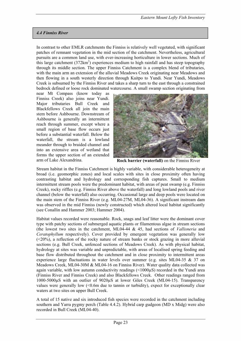
4.4 Finniss River In contrast to other EMLR catchments the Finniss is relatively well vegetated, with significant patches of remnant vegetation in the mid section of the catchment. Nevertheless, agricultural pursuits are a common land use, with ever-increasing horticulture in lower sections. Much of this large catchment (372km2) experiences medium to high rainfall and has steep topography through its middle section. The upper Finniss Catchment is a complex blend of tributaries, with the main arm an extension of the alluvial Meadows Creek originating near Meadows and then flowing in a south westerly direction through Kuitpo to Yundi. Near Yundi, Meadows Creek is subsumed by the Finniss River and takes a sharp turn to the east through a constrained bedrock defined or loose rock dominated watercourse. A small swamp section originating from near Mt Compass (know today as Finniss Creek) also joins near Yundi. Major tributaries Bull Creek and Blackfellows Creek all join the main stem before Ashbourne. Downstream of Ashbourne is generally an intermittent reach through summer, except where a small region of base flow occurs just before a substantial waterfall. Below the waterfall, the stream is a lowland meander through to braided channel and into an extensive area of wetland that forms the upper section of an extended arm of Lake Alexandrina. Stream habitat in the Finniss Catchment is highly variable, with considerable heterogeneity at broad (i.e. geomorphic zones) and local scales with sites in close proximity often having contrasting habitat and hydrology and corresponding fish captures. Small to medium intermittent stream pools were the predominant habitat, with areas of peat swamp (e.g. Finniss Creek), rocky riffles (e.g. Finniss River above the waterfall) and long lowland pools and river channel (below the waterfall) also occurring. Occasional large and deep pools were located on the main stem of the Finniss River (e.g. ML04-27M, ML04-36). A significant instream dam was observed in the mid Finniss (newly constructed) which altered local habitat significantly (see Conallin and Hammer 2003; Hammer 2004). Habitat values recorded were reasonable. Rock, snags and leaf litter were the dominant cover type with patchy sections of submerged aquatic plants or filamentous algae in stream sections (the lowest two sites in the catchment, ML04-44 & 45, had sections of Vallisneria and Ceratophyllum respectively). Cover provided by emergent vegetation was generally low (<20%), a reflection of the rocky nature of stream banks or stock grazing in more alluvial sections (e.g. Bull Creek, unfenced sections of Meadows Creek). As with physical habitat, hydrology at sites was variable and unpredictable, with areas of localised spring feeding and base flow distributed throughout the catchment and in close proximity to intermittent areas experience large fluctuations in water levels over summer (e.g. sites ML04-35 & 37 on Meadows Creek, ML04-30M & ML04-16 on Finniss River). Water quality data collected was again variable, with low autumn conductivity readings (<1000µS) recorded in the Yundi area (Finniss River and Finniss Creek) and also Blackfellows Creek. Other readings ranged from 1000-5000µS with an outlier of 9020µS at lower Giles Creek (ML04-15). Transparency values were generally low (<0.6m due to tannin or turbidity), expect for exceptionally clear waters at two sites on upper Bull Creek. A total of 15 native and six introduced fish species were recorded in the catchment including southern and Yarra pygmy perch (Table 4.4.2). Hybrid carp gudgeon (MD x Midg) were also recorded in Bull Creek (ML04-40).
Rock barrier (waterfall) on the Finniss River

Page 24
Recorded presence for some species (i.e. marked as present) included recent captures of a pouched lamprey and a rainbow trout from below the waterfall (just upstream from site ML04-43: Hammer 2001), three smaller native species (smallmouthed hardyhead, western bluespot goby and bony herring) from the vicinity of ML04-45 at ‘Reedlands’ (Hammer 2001) and Murray-Darling golden perch in the vicinity of ML04-44 & 45 (recent angler reports and a SAMA specimen). Species richness was highest below the waterfall (11-17 species), with six native species recorded above the waterfall. Mountain galaxias was wide-spread in the catchment and represented at a large number of sites (21 of 29). Flathead gudgeon and southern pygmy perch were wide spread along the main stem of the catchment from Meadows Creek through to ‘Reedlands’, however the latter only occurred in isolated sites or groups of sites. There is some overlap in the fish fauna above and below the waterfall, including low numbers of common galaxias that must negotiate this barrier (recorded at site ML03-53A) and mountain galaxias recorded in riffle sections between larger pools at sites ML04-43 & 44 in the lowland section. Southern pygmy perch above the waterfall are a distinct genetic sub-population of the species (Hammer 2001). Native fish abundance was variable with some species locally common (e.g. mountain galaxias in tributaries, southern pygmy perch in select pools). Sampling locations were generally located in patchy strings of waterholes or continuous stream sections. Exotic species are well represented in the catchment (Table 4.4.2). Gambusia (14 sites) were common in Meadows Creek, mid Finniss River and at ‘Reedlands’, redfin (9 sites) were found along the main stem of the catchment and brown trout (9 sites) in the mid section of the catchment (lower Meadows Creek, mid Finniss River, Bull Creek, Blackfellows Creek). The occasional rainbow trout is recorded near Yundi (Appendix 3) while brown trout were reported as present at several additional sites by anglers (e.g. ML04-27M & 49). Large numbers of brown trout (in excess of 20,000) have been stocked into the catchment in recent years (mid Finniss, Meadows Creek and Bull Creek); a process which has occurred for some time (Fulton 2004). Trout (assumedly brown trout as these were stocked in the catchment at the time: Morrissy 1967) were known in the vicinity of ML04-45 (lowland channel) in the 1920’s (Hale 1928) as were tench in the 1960’s (near site ML04-45: Appendix 3). Several larger native species have been known to occur in the region below the waterfall through to Lake Alexandrina historically: a large Murray cod was caught slightly upstream from site ML04-44 in about 1940 (Appendix 3) and there are rumours of more recent captures downstream below the Winery Road ford culvert; silver perch (known locally as bream) were angled from near the Strathalbyn to Goolwa Road Bridge (between sites ML04-43 & 44) in the 1950’s (Appendix 3); freshwater catfish were recorded in the 1920’s (e.g. Nettlebeck 1928), with a more recent capture of a juvenile near site ML04-45 in 1984 by Lance Lloyd (SAMA F10098); and river blackfish from near ML04-44 (Hale 1928). A range of small native species have also previously been recorded including Murray rainbowfish in the 1920’s (Nettlebeck 1926), southern purple-spotted gudgeon (records for near site ML04-44 in the 1920’s and at site ML04-45 in the early 1960’s: Nettlebeck 1926, Hale 1928; Table 3.2.2), chanda perch in the 1960’s (vicinity of ML04-45: SAMA F7667) and Murray hardyhead near site ML04-45 in the 1980’s (common at the time: Lloyd 1987). Upstream from the waterfall, river blackfish appear to have been wide spread before the 1950’s with records from the mid catchment (near Coles Crossing and Yundi) through to Meadows Creek and also Bull Creek (Table 3.2.1; Appendix 3). Southern pygmy perch were dip netted from Brayside Ford (ML04-16) in winter 2003 but were not located in subsequent autumn 2004 sampling (perhaps a temporary record washed downstream from a nearby population). Ideally the spatial resolution of sampling in this catchment needs to be increased for a more detailed understanding of species distributions in relation to habitat and the threat posed by specific processes such as water abstraction and trout stocking. The amount of habitat offered and the recorded historic presence of river blackfish suggests this species may still remain in isolated pockets, and dedicated field work to locate the species may be worthwhile.

Eastern Mount Lofty Fish Inventory
Page 25
Table 4.4.1. Finniss River Catchment sampling locations. Site Code Date Waterway Location Habitat type ML04-45 25/03/2004 Finniss River 'Reedlands' River Channel ML04-44 24/03/2004 Finniss River Railway Bridge Stream ML04-43 24/03/2004 Finniss River 'Wirra Wirra' (Junction Giles Ck) Stream ML04-31M 19/03/2004 Finniss River us waterfall in flowing section Stream ML03-53A 07/04/2003 Finniss River Top of springs above waterfall Stream ML04-30M 19/03/2004 Finniss River Top of springs above waterfall Stream ML02-11A 02/03/2002 Finniss River Brayside Road Ford Stream ML04-16 09/03/2004 Finniss River Brayside Road Ford Stream ML04-38 22/03/2004 Finniss River Finniss Bridge Stream ML04-25M 17/03/2004 Finniss River ds Coles Crossing (us causeway) Swamp/instream damML03-51A 07/04/2003 Finniss River ds Cole's Crossing (clay cliff pool) Stream ML04-24M 17/05/2004 Finniss River ds Cole's Crossing (clay cliff pool) Stream ML04-27M 17/03/2004 Finniss River ds Coles Crossing (large pools) Stream ML04-49 27/03/2004 Finniss River Enterprise Road Stream ML04-36 21/03/2004 Finniss River East of Yundi (Chaplin prop.) Stream ML04-15 09/03/2004 Giles Creek Below Signal Flat Road Stream ML04-17 10/03/2004 Giles Creek Haines Road Stream ML04-29M 18/03/2004 Bull Creek Mcharg Creek Road Bridge Stream ML04-40 22/03/2004 Bull Creek North of Ashbourne @ creek junction Stream ML04-41 22/03/2004 Bull Creek us Bald Hills Road Stream ML04-28 18/03/2004 Mcharg Creek Opposite Ti Tree Road Stream ML04-39 30/03/2004 Blackfekllows Creek ‘Riverside’ Stream ML03-44 19/01/2003 Blackfellows Creek Heritage Scrub Stream ML04-46 25/03/2004 Blackfellows Creek Heritage Scrub, opp. Mt Magnificent CP Stream ML04-47 27/03/2004 Finniss Creek Burma Road Stream ML04-48 27/03/2004 Finniss Creek 'Shoshanna' Instream dam ML04-34M 21/03/2004 Meadows Creek Thorn Dairy (1st Causway) Stream ML04-35 21/03/2004 Meadows Creek Thorn Dairy (2nd Causway) Stream ML04-37 21/03/2004 Meadows Creek Water Reserve Stream ML02-170 17/05/2002 Meadows Creek Wickhams Hill Road Stream ML04-32 21/03/2004 Meadows Creek Heyson Trail Crossing Stream ML04-33 21/03/2004 Meadows Creek Trib. Badgers Road Stream
A – represents the same site sampled on a preceding occasion (temporal comparison), M –monitoring sites for threatened fish, a and b (small caps) – paired sites located in close proximity.
Habitat at sites in the Finniss Catchment was highly variable: a lowland Vallisneria filled pool (ML04-44) (above); rocky pool mid-Finniss River (ML04-24M) (top right) and an alluvial pools on Meadows Creek (top right). See also bedrock based, spring fed pool in Section 7.3

Page 26
X: recoded historically but not sampled in the current survey, P: recently sampled/report of presence. Historical records: A (2000-2002), B (1990-1999), C (1980-1989), D (1960-1979), E (1930-1959), F (<1930).
*Carp gudgeon species and hybrid forms detected: 1 Murray-Darling (MD), 2 Midgely’s (Midg), 3 MD x Midg, 4 MD x species X, 5 Midg x species X Note: the following species were also recorded as present (P) at site ML04-45: bony herring, smallmouthed hardyhead and western bluespot goby
Site Code Pouc
hed
lam
prey
Fr
eshw
ater
cat
fish
Aus
tralia
n sm
elt
Com
mon
gal
axia
s M
ount
ain
gala
xias
Mur
ray
hard
yhea
d
Uns
peck
ed h
ardy
head
Mur
ray
rain
bow
fish
Cha
nda
perc
h M
urra
y co
d M
urra
y-D
arlin
g go
lden
per
ch
Sout
hern
pyg
my
perc
h Y
arra
pyg
my
perc
h R
iver
bla
ckfis
h Si
lver
per
ch
Con
golli
Car
p gu
dgeo
n sp
p.*
Purp
le-s
potte
d-gu
dgeo
n
Flat
head
gud
geon
Dw
arf f
lath
ead
gudg
eon
Rai
nbow
trou
t B
row
n tro
ut
Gol
dfis
h
Car
p Te
nch
Gam
busi
a
Red
fin
Spec
ies r
ichn
ess
Num
ber e
xotic
ML04-45 XC P P XC 10 XF XD P 3 2 P 401 XD 100 50 30 2 XD 200 P 17 4 ML04-44 20 40 5 XE P XF 2 XF 10 70 XB 5 4 20 1 11 4 ML04-43 P 25 5 XE 8 10 P 4 3 8 3 ML04-31M 5 150 2 0 ML03-53A 4 26 101 5 4 0 ML04-30M P 10 94 P 4 0 ML02-11A 40 11 40 5 4 0 ML04-16 P 3 1 10 13 5 2 ML04-38 11 38 27 3 1 ML04-25M XA XA 13 50 2 1 ML03-51A 20 117 15 1 4 1 ML04-24M 3 113 P 3 0 ML04-27M 1 3 XE 22 P 2 5 2 ML04-49 3 P 100 2 4 3 ML04-36 6 XE 7 P 2 50 7 6 4 ML04-15 4 2 80 3 1 ML04-17 0 0 ML04-29M 216 1 0 ML04-40 244 1161,3 2 3 1 ML04-41 300 XF 15 2 1 ML04-28 150 1 0 ML04-39 15 1 0 ML03-44 4 60 2 1 ML04-46 0 0 ML04-47 13 2 3 60 4 2 ML04-48 410 380 1000 3 1 ML04-34M 10 111 5 40 4 1 ML04-35 4 5 3 100 6 5 3 ML04-37 1 XF 2 10 3 1 ML02-170 60 60 15 3 1 ML04-32 150 40 500 3 1 ML04-33 0 0
Table 4.4.2. Fish species and relative abundance recoded for the Finniss River Catchment.

Eastern Mount Lofty Fish Inventory
Page 27
4.5 Angas River The Angas River Catchment is moderate in size (199km2) and has reasonable rainfall for most of its area. Much of the land has been cleared and dedicated to stock grazing, dairy or viticulture. It has a semi-circular arc of elevated land draining toward a main drainage channel, the Angas River, which extends from headwaters near Flaxley, through Strathalbyn, and to its confluence with Lake Alexandrina near Milang. A fan of tributaries including Middle/Paris, Dawson, Doctors and Burnside creeks join in or near Strathalbyn. Under current conditions, the later two creeks are ephemeral (no permanent pools located), and the upper Angas River and Dawson and Middle creeks are episodic stream systems. There is a large degree of geomorphic variation within the catchment and considerable hydrological variability between stream sections. Much of the catchment consists of alluvial red gum (Eucalytus camaldulenis) lined tributaries, with spring fed upper reaches near Macclesfield. Below Strathalbyn, the character of the Angas differs considerably consisting of bedrock based, larger pools fringed with Phragmites and Typha. The stream gains permanent flow through much of this approximately 5km section via groundwater base flows. Further downstream, the stream becomes an ephemeral channel (significant natural barrier), meandering 13km across a lowland flat before reaching its terminus with Lake Alexandrina via a small section of river channel. Pools are generally smaller in upland areas, with a long series of deeper pools in the mid section of the catchment Habitat values recorded were generally low to moderate, with contributions to instream cover mostly from physical components such as snags and rock (generally <30%) and emergent vegetation such as Typha and Phragmites (generally 10-30%). Few sites had significant amounts of submerged aquatic vegetation, with the exception of Angas River-Middle Creek junction (ML04-68M: thick bed of Potamogeton tricarinatus) and Bagley Bridge (ML04-144: river channel thick with Ceratophyllum). Some sections of the catchment have been fenced or do not have stock access, with a visible demonstration of the benefits of fencing toward the density of riparian vegetation and general stream condition observable at a pair of fenced and unfenced sites on upper Dawson Creek (ML04-72a,b). Autumn salinities were generally high, increasing along a stream gradient from the upper Angas at 1800µS to between 6000-7000µS for most sites in the mid catchment, and approaching 10,000µS in lower Dawson Creek (with an outlier ML04 at 430µS probably recently filled from road runoff). A total of 12 native and six introduced species were recorded including southern pygmy perch and river blackfish (Table 4.5.2). Hybrid carp gudgeon (MD x Midg) were also recorded at numerous sites. A single southern pygmy perch was recorded recently (i.e. marked as present) at Bagley Bridge in 2003 (Conallin and Hammer 2003) along with mountain galaxias at ML99-03 (P. Kerby, Waterwatch pers. comm: Appendix 3). Species richness was highest at the small section of river channel at the terminus of Lake Alexandrina (ten native species), with species occurring in this section having only minor overlap with six species from upstream sites: dwarf flathead gudgeon (both regions), only two carp gudgeons down stream (at ML99-10A), flathead gudgeon (2 only upstream at ML04-70) and the single pygmy perch at Bagley Bridge (likely to belong to a Lake Alexandrina genetic sub-population rather than the highly genetically distinct Angas River sub-population: see Hammer 2001).
Large pool in the section of the Angas below Strathalbyn (ML04–64)

Page 28
Mountain galaxias and carp gudgeons were wide spread (18 and 15 of 32 sites respectively), carp gudgeons in particular were abundant at many localities. Dwarf flathead gudgeon were patchily distributed (eight sites) and southern pygmy perch and river blackfish restricted to a few sites in small areas (Table 4.5.2), with the former species in particularly low abundance. Some sampling sites were located in continuous stream sections (e.g. below Strathalbyn, near Macclesfield) however, most sites represented isolated pools and in areas like Middle Creek, the only water in a stream stretch. Introduced species were not common in the Angas Catchment (except for the river channel habitat at the River mouth) but occurred widely (15 sites) and with six different species represented (Table 4.5.2). Gambusia was only noted at the River Channel habitat and three sites in the mid-catchment. Redfin occurred slightly more widely including lower Middle Creek (six sites). Tench were collected at three sites in the Mid Angas and in Dawson Creek. Rainbow trout were located upstream and downstream of an instream dam on the Angas River in Macclesfield (stocked there four years ago: Appendix 3) as well as a small pool in the Dawson Creek (ML99-01A). At the latter site removal of this predator corresponded to increasing richness and abundance of native fish over time (see ML00-02A & ML04-62Mb). Rainbow and brown trout were stocked in the Angas River in the early 1900’s around Strathalbyn (Morrissy 1967) with other stockings of rainbow trout under permit reported in 1984/85 (Fulton 2004) or illegally into instream dams (e.g. ML00-01: Hicks 1997). Carp have been recorded in Middle Creek pools in 2001 (Hammer 2001), they have dried seasonally since and similarly tench have been recorded at additional sites in Dawson Creek (Hicks 1997; Hammer 2001). Historic records indicate that several native species were once more widespread in the catchment. River blackfish were until the 1950’s quite common in the Angas River from Strathalbyn through to downstream of ‘Riverview’ (Sim et al. 2000; Appendix 3). The species experienced considerable decline in the ensuing years and today has a contracted upstream and downstream range in comparison to former records (see Table 4.5.2). River blackfish also now appeared to have been extirpated from Dawson Creek where they were common at ML00-01 in the 1980s (Lloyd 1987) and persisted to at least 1990 (a single juvenile specimen: Bertozzi 1990). Southern pygmy perch have also declined in Dawson Creek with major pool drying witnessed in the last five years. This species and mountain galaxias were previously recorded from: • Border pool (ML04-62Ma) prior to 2003 when it dried (a single fish was located in 2004), • Friesian Drive (ML04-61) in 1983 (Lloyd 1987; dry for at least six months in 2004), • Ashbourne Road (ML04-63) in 1997 (Hicks 1997; pool had dried in 2004).
Pools in Middle Creek (ML04-66M) that were dry in 2004 (likely as the combined result of earthworks to realign the creek in the mid 1980’s, upstream water abstraction and a dry climatic period) have previously contained southern pygmy perch as well as mountain galaxias and dwarf flathead gudgeon (Sim et al. 2000; Hammer 2001). It also appears that congolli have been able to migrate up the ephemeral lowland channel in times of flow (e.g. records at Belvidere in the 1950’s: Appendix 3) and another diadromous species, the climbing galaxias was recorded at Strathalbyn in 1914 (Table 3.2.1). A single Murray hardyhead was recorded from the Angas River Mouth in 1983 (Lloyd 1987). The spatial coverage of this catchment is more detailed than for other catchments, specifically in the mid section due to efforts to monitor and map the range of declining threatened native fish. Future research should continue regular monitoring and could further map the range, abundance and habitat of river blackfish. The carp gudgeons of the catchment have been of considerable interest in taxonomic research (Bertozzi et al. 2000) and populations look to play an important future part in understanding the species complex and in the study of unisexual vertebrates through research at the SA Museum (M. Adams pers. comm.). Understanding why introduced fish are less prevalent in sections of the Angas than in other catchments would also be of potential use in the broader control of these species.

Eastern Mount Lofty Fish Inventory
Page 29
Table 4.5.1. Sampling locations in the Angas River Catchment. Site Code Date Waterway Location Habitat type
ML99-11 25/03/1999 Angas River Angas River Mouth River Channel ML99-10A 25/03/1999 Angas River Bagley Bridge River Channel ML04-144 06/06/2004 Angas River Bagley Bridge River Channel ML01-52 11/03/2001 Angas River 500m us Bagley Bridge River Channel ML99-09 17/05/1999 Angas River 'Riverview' Stream ML99-08A 17/05/1999 Angas River Belvidere Stream ML04-143 06/06/2004 Angas River Belvidere Stream ML99-07 21/04/1999 Angas River Gurney property Stream ML04-64 31/03/2004 Angas River ds Willyaroo bridge Stream ML99-06 21/02/1999 Angas River us Humberg Road Ford Stream ML01-51 11/02/2001 Angas River Strathalbyn Stream ML01-12 25/10/2001 Angas River Strathalbyn footbridge Stream ML04-70 05/04/2004 Angas River North Parade Stream ML04-68M 01/04/2004 Angas River Middle Creek/Angas R junction Stream ML04-71 06/04/2004 Angas River 'The Lodge' Stream ML99-05 07/05/1999 Angas River Rankine property Stream ML99-04 17/05/1999 Angas River 'Martindale', bend in River Stream ML99-03 17/03/1999 Angas River 'The Downs' Stream ML04-59 31/03/2004 Angas River 'Willowdene' Stream ML04-57 31/03/2004 Angas River Crystal Lake, below dam Stream ML04-58M 31/03/2004 Angas River Searle Rd Stream ML99-02 10/03/1999 Angas River Quarry Rd -Flaxley Rd Junction Stream ML04-63 31/03/2004 Dawson Creek Ashbourne Road Stream ML04-61* 31/03/2004 Dawson Creek Reserve -Friesian Drive Stream ML04-62Ma 31/03/2004 Dawson Creek Border pool Stream ML99-01A 03/04/1999 Dawson Creek Pool below dam spillway Stream ML00-02A 13/02/2000 Dawson Creek Pool below dam spillway Stream ML04-62Mb 31/03/2004 Dawson Creek Pool below dam spillway Stream ML00-01 13/02/2000 Dawson Creek Large instream dam Instream dam ML04-65 31/03/2004 Dawson Creek Dog Trap Road Stream ML04-72b 06/04/2004 Dawson Creek 'Dorset Park' (fenced section) Stream ML04-72a 06/04/2004 Dawson Creek 'Dorset Park' Stream ML04-60* 31/03/2004 Doctors Creek Macclesfield Road Stream ML04-66M* 01/04/2004 Middle Creek Earthworks area Stream ML04-67 01/04/2004 Middle Creek Whittwers property Stream ML04-69 01/04/2004 Paris Creek Old Mine off Paris Creek Rd Stream
* Dry in autumn 2004; A –the same site sampled on a preceding occasion (temporal comparison); M – monitoring site for threatened fish species; a and b (small caps) – paired sites located in close proximity.
Stream pools on the Angas River above Strathalbyn and (right) Paris Creek (ML04-69)

Page 30
Table 4.5.2. Fish species and relative abundance recorded for the Angas River Catchment.
Site Code Bon
y he
rrin
g
Aus
tralia
n sm
elt
Clim
bing
gal
axia
s
Com
mon
gal
axia
s
Mou
ntai
n ga
laxi
as
Smal
lmou
thed
har
dyhe
ad
Mur
ray
hard
yhea
d
Sout
hern
pyg
my
perc
h
Yar
ra p
ygm
y pe
rch
Riv
er b
lack
fish
Con
golli
Wes
tern
blu
espo
t gob
y
Carp
gudg
eon s
pp.*
Flat
head
gud
geon
Dw
arf f
lath
ead
gudg
eon
Rai
nbow
trou
t
Bro
wn
trout
Gol
dfis
h
Car
p
Tenc
h
Gam
busi
a
Red
fin
Spec
ies r
ichn
ess
Num
ber e
xotic
ML99-11 16 31 7 3 5 3 5 1 8 2 ML99-10A 5 5 14 XC 23 4 1 4 28 3 9 3 ML04-144 19 XC P 1 2 17 23 7 4 30 1 10 4 ML01-52 10 5 10 15 50 5 2 ML99-09 XE XE XE 11 1 2 1 ML99-08A XE XE 21,3 1 8 3 1 ML04-143 18 XE XE 1631,3 3 2 3 5 2 ML99-07 8 17 4001,3 5 1 20 6 2 ML04-64 4 62 6001,3 5 2 5 30 7 3 ML99-06 3 501,3 25 3 4 2 ML01-51 7 4 141,3 2 4 5 2 ML01-12 XF XE 8001,3 3 XE 2 1 4 2 ML04-70 2 1 XE 8001,3 2 1 5 0 ML04-68M 8 331,3 2 0 ML04-71 2 7 1761,3 2 4 1 ML99-05 891,3 17 2 0 ML99-04 0 0 ML99-03 P 1 0 ML04-59 60 1 0 ML04-57 30 12 2 1 ML04-58M 40 1 0 ML99-02 15 1 0 ML04-63 XB XB XA XB 0 0 ML04-61 XC XC XC 0 0 ML04-62Ma 22 1 XA XA 2 0 ML99-01A 61,3 1 2 1 ML00-02A 2501,3 1 0 ML04-62Mb 13 1 191,3 3 0 ML00-01 2 XB 5001,3 XC 5 3 1 ML04-65 5 1 0 ML04-72b 100 1 0 ML04-72a 30 1 0 ML04-60 0 0 ML04-66M XA XA XA XC XA 0 0 ML04-67 4 8001,3 2 0 ML04-69 80 1 0
X: recoded historically but not sampled in the current survey, P: recently sampled/report of presence. Historical records: A (2000-2002), B (1990-1999), C (1980-1989), D (1960-1979), E (1930-1959), F (<1930).
*Carp gudgeon species and hybrid forms detected: 1 Murray-Darling (MD), 2 Midgely’s (Midg), 3 MD x Midg, 4 MD x species X, 5 Midg x species X

Eastern Mount Lofty Fish Inventory
Page 31
4.6 Bremer River The Bremer is a large catchment (589km2; second only in size to the mostly dry Ferriss-McDonald Catchment to which the Bremer River contributes flow intermittently via a lowland channel, Mosquito Creek, that branches off near Langhorne Creek). The Bremer River runs roughly north to south parallel with the base of the Range extending from small headwaters above Harrogate, through Callington then along a lowland plain via Langhorne Creek to its junction with Lake Alexandrina. The latter sections of the River from above Langhorne Creek are today ephemeral, with a small section of permanent river channel at the junction of the Lake. Two major tributaries drain from the flank of the range east toward the Bremer River: the Mt Barker Creek sub catchment that includes Western Flat, Nairne and Dawesley creeks, and Rodwell Creek, joining the Bremer just below Woodchester. Hence sections of the catchment are contrasting in topography, geology, rainfall and vegetation, particularly between the Mt Barker Creek sub-catchment (high rainfall, elevation and gradient, considerable urban areas) and elsewhere (more agricultural, low rainfall and topography). Stream habitats vary in the two distinct regions of the catchment, with shallower creeks in headwater areas compared to a series of deep irregular pools along the Bremer main channel. Significant pollution has occurred as a result of mining activities along side Dawesley Creek at Brukunga (Hicks 1997) and stock access is commonplace in areas that are not urbanised. Specific cases of habitat alteration with council works were observed at Mt Barker (infilling of stream at ML04-87) and at the Harrogate Bridge (infilling and disruption of stream pools). Habitat values were generally moderate, with instream cover often provided by rock and snags (generally 10-30%) and at patchy sites there was significant amounts (>20%) of submerged aquatic vegetation such as Potamogeton spp. and Chara (e.g. sites ML04-82, 98 &108). Values for submerged cover provided by emergent vegetation were low (<20%) perhaps due to large seasonal variations in pool level (i.e. riparian plants stranded above the waterline) and the small relative edge ratio of large pools that might be fringed by species such as Typha and Phragmites (i.e. low overall percentage of the pool occupied, but still could be important cover). Autumn water conductivity values were high along the Bremer River, particularly from Harrogate through to Callington (range: 9990-12,810µS) and slightly fresher downstream (e.g. 4190µS at ML04-111). Conductivities were also high along Rodwell Creek (4300-11,620µS) but slightly fresher in the Mt Barker Creek sub-catchment (generally <3000µS for stream environments). Water transparency values were mostly low (<0.8m). A total of eleven native and five introduced species were recorded including the first record of river blackfish from the catchment for 50 years (see Fig. 7). Hybrid carp gudgeon (MD x Midg) were recorded at eight sites (Table 4.6.2). One species, the Murray-Darling golden perch, was included (i.e. marked as present) based on recent reports by anglers at ML04-145 & 112. As with several preceding catchments, species richness was high at the terminus of the catchment (ML04-145: eight native species) with three species only recorded from this small region. However, upstream and downstream species composition was not as contrasting as observed in catchments like the Tookayerta or Angas with distributions for flathead gudgeon, and common galaxias, congolli and Murray-Darling golden perch recorded both up and downstream of the ephemeral lowland channel. Flathead gudgeon and carp gudgeon were wide spread (11 and ten sites respectively) and often locally abundant (Table 4.6.2). Mountain galaxias were rare (7 of 32 sites) as was dwarf flathead gudgeon, recorded only at three sites. River blackfish were only located at two proximate sites in Rodwell Creek (ML04-82 & 83a). Sampling sites were often isolated stream pools, with the exception of sites on Mt Barker Creek and a long series of lowland pools below Callington (ML04-111). Translocated carp gudgeon and freshwater catfish were captured in one small instream dam off Dawesley Creek (ML04-94).

Page 32
Exotic species were overall widespread in different sections of the Catchment but with the exception of Gambusia were not commonly captured (Table 4.6.2). Recent reports by anglers indicated that carp and redfin do occur at additional sites (marked as present) and such larger bodied species were probably under sampled in the large and deep pools of the lower Bremer due to the difficulty in sampling this habitat. A single rainbow trout was captured (ML04-111). Historically there is documentation of brown trout having been stocked into the Bremer River and Mt Barker, Nairne and Bryce creeks (Morrissy 1967). Historic records indicate that several native species were once more widespread in the catchment. The iconic Murray cod occurred in the lower Bremer River downstream of Hartley through to Langhorne Creek until about 1942 (Sim et al. 2000; Appendix 3). River blackfish were recorded in Mt Barker Creek and Dawesely Creek (pre 1929: Table 3.2.1; Appendix 3), the upper Bremer at Harrogate (Appendix 3), the mid Bremer River (e.g. at Callington) and additional locations on Rodwell Creek including: a large pool at Woodchester (ML04-84) where the species was caught until the 1950’s (Sim et al. 2000) and other pools near ML04-83b where they were collected in the early 1900’s (the exact pools where fish were caught historically dried this summer for the first time in living memory: Appendix 3). Congolli were also recorded in Rodwell Creek (ML04-83b: Appendix 3). Mountain galaxias were previously known from Dawesley Creek (Table 3.2.1) and at sites in Harrogate prior to extensive pool drying in the last two years (Table 4.6.2). There is a speculative report that a southern purple-spotted gudgeon was caught near Callington (ML04-73) in the 1970’s (Appendix 3). Future research should focus on finding if additional pools of river blackfish occur in Rodwell Creek (although initial on ground inspection and aerial videography data suggest that only a few other pools are present in the area) and sample more intensively the large pools on the lower Bremer (ideally with bigger nets).
Contrasting sections (sub-catchments) of the Bremer Catchment: top left – Mt Barker Creek; above –upstream of Callington (ML04-95); top right - Rodwell Creek blackfish habitat (ML04-83a) and large lowland pool (ML04-111)

Eastern Mount Lofty Fish Inventory
Page 33
Table 4.6.1. Sampling locations in the Bremer River Catchment.
Site Code Date Waterway Location Habitat type ML04-79 09/04/2004 Mosquito Creek Gollan's Waterhole Waterhole ML04-145 06/06/2004 Bremer River Bremer River Mouth River Channel ML04-80* 09/04/2004 Bremer River floodplain 'Metella' Wetland ML04-78 09/04/2004 Bremer River floodplain Hill Swamp Swamp ML04-81* 07/06/2004 Bremer River Frank Potts Reserve, Langhorne Creek Stream ML04-112 28/04/2004 Bremer River Wandstead Road Stream ML04-111 27/04/2004 Bremer River us Jeanch Rd Stream ML04-73 18/04/2004 Bremer River 'Collray' (old Princess Hwy xing) Stream ML04-95 18/04/2004 Bremer River 'Collray' Stream ML04-98 19/04/2004 Bremer River ds Crofton Park Stream ML04-93 15/04/2004 Bremer River Military Road Stream ML04-92 15/04/2004 Bremer River Appleton Cottage Stream ML01-10A 20/10/2001 Bremer River Harrogate main bridge Stream ML02-159A 16/05/2002 Bremer River Harrogate main bridge Stream ML04-91a 15/04/2004 Bremer River Harrogate main bridge Stream ML01-11A 20/10/2001 Bremer River Harrogate, behind Tennis Courts Stream ML04-91b* 15/04/2004 Bremer River Harrogate, behind Tennis Courts Stream ML04-90a 15/04/2004 Bremer River The Swimming Hole 'Taworri' Stream ML04-90b 15/04/2004 Bremer River Instream dam, 'Taworri' Instream dam ML04-99 19/04/2004 Bryce Creek us Harrogate Road Stream ML04-96 18/04/2004 Dawesley Creek Princess Hwy Stream ML04-97 18/04/2004 Dawesley Creek us Peggy Buxton Road Stream ML04-94 18/04/2004 Dawesley Creek Trib. 'Kiah Nangara' Instream dam ML04-109 27/04/2004 Mt Barker Creek Mt Barker Springs Gauging Station Stream ML02-160A 16/05/2002 Mt Barker Creek ds Adelaide Road Stream ML04-87 14/04/2004 Mt Barker Creek ds Adelaide Road Stream ML04-86 14/04/2004 Mt Barker Creek Trib. Hurling Drive Stream ML04-88 14/04/2004 Mt Barker Creek Trib. Clegget Road Stream ML04-108 27/04/2004 Western Flat Creek 'Newenham', us bridge Stream ML04-85 14/04/2004 Western Flat Creek 'Madabareenah' Instream dam ML04-89 14/04/2004 Nairne Creek Sydney Road Stream ML04-84 09/04/2004 Rodwell Creek The Lagoon, Woodchester Stream ML01-50A 04/01/2001 Rodwell Creek 'Highland Valley' (b) corner pool Stream ML04-83b* 09/04/2004 Rodwell Creek 'Highland Valley' (b) corner pool Stream ML04-83a 09/04/2004 Rodwell Creek 'Highland Valley' (b) cliff pool Stream ML04-82 09/04/2004 Rodwell Creek 'Highland Valley' (a) Stream ML04-110 27/04/2004 Rodwell Creek off Bunnetts Road Stream
* Dry upon inspection in autumn 2004 A – represents the same site sampled on a preceding occasion (temporal comparison), M – ongoing monitoring sites for threatened fish species.
a and b (small caps) – paired sites located in close proximity.
Large flathead gudgeon captured near Callington on the Bremer River -107mm total length

Page 34
Table 4.6.2. Fish species and relative abundance recorded for Bremer River Catchment.
Site Code Pouc
hed
lam
prey
Sh
ortfi
nned
eel
B
ony
herr
ing
Fres
hwat
er c
atfis
h C
omm
on g
alax
ias
Mou
ntai
n ga
laxi
as
Smal
lmou
thed
har
dyhe
ad
Mur
ray
cod
Mur
ray-
Dar
ling
gold
en p
erch
So
uthe
rn p
ygm
y pe
rch
Riv
er b
lack
fish
Silv
er p
erch
C
ongo
lli
Wes
tern
blu
espo
t gob
y
Car
p gu
dgeo
n sp
p.*
Purp
le-s
potte
d-gu
dgeo
n
Flat
head
gud
geon
Dw
arf f
lath
ead
gudg
eon
Rai
nbow
trou
t B
row
n tro
ut
Gol
dfis
h C
arp
Tenc
h
Gam
busi
a
Red
fin
Spec
ies r
ichn
ess
Num
ber e
xotic
ML04-79 5000 1 1 ML04-145 1 3 1 P XE 1 1 20 1 P 10 P 10 3 ML04-80 0 0 ML04-78 XA XA 10 1 6 3 3 ML04-81 XC XC XF XA XF XC XA XC XC 0 0 ML04-112 X 5 XE P 1 30 7 1 200 2 8 3 ML04-111 XE XE 11 32 4 1 1 5 2 ML04-73 XE 23 X? 363 XC 1104 3 1 ML04-95 13 210 4 100 4 2 ML04-98 20 1 0 ML04-93 5391,3 1 0 ML04-92 25 1 0 ML01-10A 23 13 2 1 2 5 2 ML02-159A 23 301,3 50 1 1 5 2 ML04-91a XA 11 9 XA XA 2 0 ML01-11A 6 XD 131,3 6 1 4 2 ML04-91b XA XD XA XA XA 0 0 ML04-90a 5 1 0 ML04-90b 2 2 31 3 2 ML04-99 0 0 ML04-96 XF XF 0 0 ML04-97 0 0 ML04-94 T T1,3 0 0 ML04-109 XF 50 1 1 ML02-160A 40 XF 7 2 1 ML04-87 P XF 30 P 3 2 ML04-86 0 0 ML04-88 1 1 0 ML04-108 50 1 1 ML04-85 0 0 ML04-89 8 1 0 ML04-84 XE 631,3 94 XE 30 3 1 ML01-50A 4 XF XF 5001,3 50 3 1 ML04-83b XF XF 0 0 ML04-83a 1 7 1101,3 30 4 1 ML04-82 17 351 15 3 1 ML04-110 20 1 1
X: recoded historically but not sampled in the current survey, P: recently sampled/report of presence, T: translocated species.
Historical records: A (2000-2002), B (1990-1999), C (1980-1989), D (1960-1979), E (1930-1959), F (<1930). *Carp gudgeon species and hybrid forms detected: 1 Murray-Darling (MD), 2 Midgely’s (Midg), 3 MD x Midg, 4 MD x species X, 5 Midg x species X

Eastern Mount Lofty Fish Inventory
Page 35
Figure 7. Article appearing in “The Mount Barker Courier” (April 21st 2004, pg. 7) following the rediscovery of river blackfish in Rodwell Creek during Inventory sampling.

Page 36
Figure 8. Location of sampling sites in the Eastern Mount Lofty Ranges for northern catchments that drain toward the lower River Murray.

Eastern Mount Lofty Fish Inventory
Page 37
4.7 Salt Creek The Salt Creek Catchment is a medium size catchment (199km2) at the extremities of the Mount Lofty Ranges (small spit of the Range on the eastern edge of the Bremer Valley). As a consequence it has low topography and low, highly variable rainfall. Much of the catchment comprises plains, with only a small defined section of elevation and hydrological organisation in the upper sections stretching from near Bondleigh to Tepko (i.e. Salt Creek and Long, Mitchell, Gum and Flag gullies). From below the Murray Bridge to Wellington Road the main ephemeral channel is shallow and poorly defined. Stream habitat was restricted to irregular pools along defined channels and given the dry, warm landscape, permanent pools were clearly maintained by vertical connectivity to groundwater sources. While there were not a great number of permanent pools located, it was surprising to note some were quite large and up to 1.5m deep (e.g. Round Waterhole – ML04-116; ML04-117 on Long Gully Creek), serving as drought refuges. Usually sampling sites represented the only water for considerable distances and several of these refuges were fenced. Otherwise stock access is common along watercourses in the catchment. Habitat values were generally low, with a little instream cover such as rock (<20%), however some sites had dense beds of filamentous algae and/or Chara (ML04-114, 117), with this cover present at most sites (between 5-60%). Emergent vegetation was virtually absent, with minor instream cover at some sites provided by Juncus. Autumn water levels were often below a line of fringing sedges, and most pools were exposed with little shade. Salt Creek lived up to its name, with autumn conductivity readings in the catchment ranging from 17,530-30,000µS. Water transparency values were often high (~0.8m). A single (introduced) species was captured in the catchment, Gambusia (3 of 7 sites: Table 4.7.2). They occurred at sites on the main branch of Salt Creek from ‘Pine Villa’ (ML04-114) upstream to Round Waterhole (ML04-116) and were common when present. There was no indication that any other native or exotic fish have been recorded previously in the catchment. The presence of freshwater shrimp (Paratya) at Round Waterhole was of interest and the location also had numerous longneck turtles present. Survey coverage was reasonable. Aerial videography proved a good representation of actual surface water, and there are there do not appear to be many other pools within the broader coverage that could be investigated.
Round water hole –one of a handful of permanent refuges in the Salt CreekCatchment

Page 38
Table 4.7.1. Sampling locations in the Salt Creek Catchment.
Site Code Date Waterway Location Habitat type ML04-114 28/04/2004 Salt Creek ‘Pine Villa’ Stream ML04-115 28/04/2004 Salt Creek us Rockleigh Rd xing Stream ML04-116 28/04/2004 Salt Creek Round Waterhole Stream ML04-119 29/04/2004 Salt Creek Trib. Gum Gully, Federation Trail xing Stream ML04-118 29/04/2004 Mitchell Gully Creek Mitchell Gully Ruins Stream ML04-117 29/04/2004 Long Gully Creek off Annie Lane Stream ML04-74 08/04/2004 Long Gully Creek Critchley Road Stream
Table 4.7.2. Fish species and relative abundance recorded for the Salt Creek Catchment.
Site Code Com
mon
gal
axia
s
Mou
ntai
n ga
laxi
as
Smal
lmou
thed
har
dyhe
ad
Mur
ray
hard
yhea
d
Wes
tern
blu
espo
t gob
y
Car
p gu
dgeo
n sp
p.
Flat
head
gud
geon
Dw
arf f
lath
ead
gudg
eon
Rai
nbow
trou
t
Bro
wn
trout
Gol
dfis
h
Car
p
Tenc
h
Gam
busi
a
Red
fin
Spec
ies r
ichn
ess
Num
ber e
xotic
ML04-114 200 1 1 ML04-115 250 1 1 ML04-116 50 1 1 ML04-119 0 0 ML04-118 0 0 ML04-117 0 0 ML04-74 0 0
Reedy Creek Catchment: left – Mannum waterfalls section transcending from the ‘slopes’ onto the lower Murray plain; bottom left –fenced habitat on Bryce Creek (ML04-107) with dense and diverse riparian vegetation and lower –highly saline pool on mid-Reedy Creek (ML04-76), habitat of dwarf flatheadgudgeon and Gambusia

Eastern Mount Lofty Fish Inventory
Page 39
4.8 Reedy Creek The Reedy Creek catchment is a large catchment (314km2), reasonably elevated in its upper half which experiences moderate rainfall. Two main sub-catchments drain this upper section: Dairy/Baker Creek and Harrison Creek with an area stretching between Mount Torrens, Tungkillo and the Mt Pleasant-Sedan Road. These drainage networks transcend through very steep rocky sections (numerous natural rock barriers and waterfalls) as they converge towards a point above the Palmer to Mannum Road. Below the junction Reedy Creek is a lowland stream containing interspersed pools (the small Loxton/Gorge Creek sub catchment joins the main channel in this section), before reaching the Mannum waterfalls. Below the Murray Bridge to Mannum Road crossing, the channel enters an extensive shallow wetland with an opening to the River Murray near Caloote. Stream habitats are highly variable based on the distinct catchment sections. The section above Palmer has a general lack of large and deep permanent pools (long term refuges). There were some springs, but most pools also had highly variable water levels, with significant contraction over summer. Spring feeding was apparent in a small section below Palmer (ML04-125). Stock access to watercourses is common in the catchment, with fenced areas highly contrasting to elsewhere (e.g. thick and diverse riparian vegetation at ML04-107 on Bryce Creek). Habitat values were generally low mostly comprising physical contributions to instream cover (~20-40%: rock with some snags). Only a few sites had biological contributions to cover with dense beds of Chara at ML04-77 & 125, and most had low amounts (<20%) of instream emergent vegetation (small patches of Typha and Schoenoplectus pungens, and fringing Juncus) probably owing to the often gravel or rocky stream edges and variation in water levels. Autumn water conductivity values were high, mostly ranging between 6000-12,500µS across the catchment, with lower values at a section of Bryce Creek (ML04-107; 3660µS) and upper Harrison Creek (ML04-104; 3870µS). An extremely high conductivity value was recorded for a concentrated pool in the section below Palmer (ML04-76; 33,000µS). Transparency values were low (mostly < 0.5m) and a few sites had clearer water (e.g. ML04-107 & 125). A total of five native and four exotic species were recorded in the catchment (Table 4.8.2). Hybrid carp gudgeon (Midg x species X) were also recorded at ML04-127. Species richness was highest in the lower catchment, with all but one native species, the dwarf flathead gudgeon, restricted in range to below the Mannum waterfalls. An interesting isolated (and potentially genetically distinct) population of dwarf flathead gudgeon was recorded in the section between the Mannum waterfalls and steep gorges near Palmer (i.e. ML04-76 & 125). The abundance of gudgeon at these sites was reasonable to high (Table 4.8.2). Permanent pools in the reach are patchy being mostly isolated with a small spring fed section at and below ML04-125 (mid catchment). No native fish, and few fish in general, were located upstream of the Palmer to Mannum Road. Introduced fish were restricted to either below the Palmer Road or to the upper section within a single tributary, Bryce Creek (Table 4.8.2). Gambusia occurred in three distinct regions, below and above the Mannum waterfalls and then at site ML04-106 on Bryce Creek, and were common or abundant when present. Redfin were only recorded in low numbers at site ML04-107 (Bryce Creek), and carp and goldfish were restricted to sites below the Mannum waterfalls. There is a report that 500 brown trout were stocked in an unspecified section of the catchment in 1989 (Fulton 2004). There are no records of additional native species having been known from the Catchment. Smelt and common galaxias were previously present at ML04-127 below the Mannum Waterfalls in 2001 (Hammer 2001). Further field investigations could monitor and map the range of the isolated dwarf flathead gudgeon population and possibly further examine permanent pools in Bryce Creek as the most likely area where native species might be located in the upstream catchment.

Page 40
Table 4.8.1. Sampling locations in the Reedy Creek Catchment. Site Code Date Waterway Location Habitat type ML04-141 22/05/2004 Reedy Creek Reedy Creek Wetland Wetland ML04-127 03/05/2004 Reedy Creek Waterfalls Reserve Stream ML04-124 02/05/2004 Reedy Creek Waterfalls Stream ML04-125 02/05/2004 Reedy Creek 'Abrahams' Stream ML04-76 29/04/2004 Reedy Creek Palmer to Mannum Road Stream ML04-77 08/04/2004 Gorge Creek Spring off Peachs Rd Spring pool ML04-120 29/04/2004 Loxton Creek ds Kubens Rd Stream ML04-122 29/04/2004 Harrison Creek ds Gorge Stream ML04-121 29/04/2004 Harrison Creek Waterfall Stream ML04-105 22/04/2004 Harrison Creek Tungkillo - Palmer Rd Stream ML04-104 22/04/2004 Harrison Creek Rosebank @ Ck Junction Stream ML04-103 21/04/2004 Baker Creek ds Henschke Road Stream ML04-107 22/04/2004 Bryce Creek us Hoads Woolshed Road Stream ML04-106 22/04/2004 Bryce Creek East of large power lines Stream ML04-102 21/04/2004 Dairy Creek Junction of Dairy and Baker Ck Stream ML04-75 08/04/2004 Dairy Creek 'Thorlindah' (ds Henschke Rd) Stream ML04-100 19/04/2004 Dairy Creek 'Dairy Springs' Stream ML04-101 21/04/2004 Dairy Creek tributary Tea Tree Spring Stream
Table 4.8.2. Fish species and relative abundance recorded for the Reedy Creek Catchment.
Site Code Aus
tralia
n sm
elt
Com
mon
gal
axia
s
Mou
ntai
n ga
laxi
as
Mur
ray
hard
yhea
d
Uns
peck
ed h
ardy
head
Mur
ray
rain
bow
fish
Sout
hern
pyg
my
perc
h
Riv
er b
lack
fish
Con
golli
Wes
tern
blu
espo
t gob
y
Car
p gu
dgeo
n sp
p.*
Purp
le-s
potte
d-gu
dgeo
n
Flat
head
gud
geon
Dw
arf f
lath
ead
gudg
eon
Rai
nbow
trou
t
Bro
wn
trout
Gol
dfis
h
Car
p
Tenc
h
Gam
busi
a
Red
fin
Spec
ies r
ichn
ess
Num
ber e
xotic
ML04-141 1 1 11 1 P 50 6 2 ML04-127 XA XA 171,5 304 5 19 6 50 6 3 ML04-124 2 100 2 1 ML04-125 143 200 2 1 ML04-76 31 200 2 1 ML04-77 500 1 1 ML04-120 0 0 ML04-122 0 0 ML04-121 0 0 ML04-105 0 0 ML04-104 0 0 ML04-103 0 0 ML04-107 2 1 1 ML04-106 400 1 1 ML04-102 0 0 ML04-75 0 0 ML04-100 0 0 ML04-101 0 0 X: recoded historically but not sampled in the current survey, P: recently sampled/report of presence. Historical records: A (2000-2002), B (1990-1999), C (1980-1989), D (1960-1979), E (1930-1959), F (<1930).
*Carp gudgeon species and hybrid forms detected: 1 Murray-Darling (MD), 2 Midgely’s (Midg), 3 MD x Midg, 4 MD x species X, 5 Midg x species X

Eastern Mount Lofty Fish Inventory
Page 41
4.9 Saunders Creek The Saunders Creek Catchment is of moderate size (222km2), being a narrow, long area stretching from near Springton through to the River Murray north east of Mannum. Only a small section of the catchment extends into higher elevations and hence rainfall is low and irregular across most of the catchment (and even here there appears to be a significant rain shadow effect). Its headwaters comprise two small tributary streams that flow in a northerly direction, before both turn to the east. They join just before a steep rocky gorge. From below the gorge, the Saunders Creek is an ephemeral channel that meanders in a roughly south easterly direction until reaching a small section of spring fed, permanent pools lined with red gum and Phragmites in the region of Lenger Reserve (~5km upstream from the River Murray). Below here, the channel is once again ephemeral and shallow, with no real wetland area where the Creek joins the Murray. There is little permanent stream habitat in the catchment today, with only a few pools upstream of and in the Saunders Gorge, and the small string of pools near Lenger Reserve. Hence sampling sites represented most of the permanent water in the Catchment and pools were generally isolated. Stock access is common, however, significant sections of the Catchment where water occurs have been fenced or have no stock (e.g. Saunders Gorge Sanctuary and some areas upstream from here; Lenger Reserve and upstream pools). Instream habitat values were low, with generally ~20-30% submerged physical cover (rock, snags), no submerged aquatic vegetation (with the exception of Chara recorded from a small spring on Kinappa Creek, a small gully near Saunders Gorge) and only small amounts of submerged Typha or Phragmites at a few sites. Autumn water conductivity values were moderate to high ranging from 5780-10,030µS but were lower (2920µS) at Kinappa Creek. Only a single native fish, carp gudgeon, was recorded in the catchment, restricted to the small section of permanent pools at or above Lenger Reserve (ML04-128, ML01-08; Table 4.9.2). Hybrid carp gudgeon (MD x species X) were also recorded at these two sites. The abundances of carp gudgeons at ML04-128 was very high and less at ML01-08 (habitats there were deeper and snag filled and hence harder to sample). No records of any other native fish being recorded in the catchment were located. One exotic fish, Gambusia, was common at three sites – Lenger Reserve area and also at ML04-131 on upper Saunders Creek (Table 4.9.2). There is anecdotal evidence that carp are occasionally sighted at Lenger Reserve and at Saunders Gorge (Carlsa Carter, National Trust, pers. comm.; Appendix 3). Sample coverage was reasonably comprehensive, and future sampling should monitor the small population of native carp gudgeon in the catchment and investigate any reports of permanent pools not sampled or sightings of small fish.
Very little permanent water was located in the Saunders Catchment, most pools were small and isolated – left ML04-131 and right – rocky pool in the Saunders George.

Page 42
Table 4.9.1. Sampling locations in the Saunders Creek Catchment.
Site Code Date Waterway Location Habitat type ML04-135 05/05/2004 Kinappa Creek Weir on spring Spring pool ML01-08 03/12/2001 Saunders Creek Lenger Reserve Stream ML04-128 03/05/2004 Saunders Creek us Springs Road Junction Stream ML04-129 03/05/2004 Saunders Creek Saunders Gorge Sanctuary Stream ML04-130 03/05/2004 Saunders Creek ds Strachans Road Stream ML04-131 04/05/2004 Saunders Creek 'Myrtle Grove' Stream ML04-132 04/05/2004 Saunders Creek ds Jutland Road Stream
Table 4.9.2. Fish species and relative abundance recorded for the Saunders Creek Catchment.
Site Code Clim
bing
gal
axia
s
Com
mon
gal
axia
s
Mou
ntai
n ga
laxi
as
Riv
er b
lack
fish
Con
golli
Wes
tern
blu
espo
t gob
y
Car
p gu
dgeo
n sp
p.
Purp
le-s
potte
d-gu
dgeo
n
Flat
head
gud
geon
Dw
arf f
lath
ead
gudg
eon
Rai
nbow
trou
t
Bro
wn
trout
Gol
dfis
h
Car
p
Tenc
h
Gam
busi
a
Red
fin
Spec
ies r
ichn
ess
Num
ber e
xotic
ML01-08 151, 4 XB 40 2 1 ML04-128 5001,4 600 2 1 ML04-129 XB 0 0 ML04-132 0 0 ML04-131 200 1 1 ML04-130 0 0 ML04-135 0 0
X: recoded historically but not sampled in the current survey, P: recently sampled/report of presence. Historical records: A (2000-2002), B (1990-1999), C (1980-1989), D (1960-1979), E (1930-1959), F (<1930).
*Carp gudgeon species and hybrid forms detected: 1 Murray-Darling (MD), 2 Midgely’s (Midg), 3 MD x Midg, 4 MD x species X, 5 Midg x species X
Large pool on lower Saunders Creek– one in a series within an isolated spring fed section of the Catchment and an interesting ecological scenario with red gum and reed-lined pools situated within harsh Mallee country. Top – a female Murray-Darling carp gudgeon from the stream section.

Eastern Mount Lofty Fish Inventory
Page 43
4.10 Marne River The Marne River Catchment is large catchment (476km2) with surface flows supported mostly by rainfall in its upper sections at higher elevations spreading between Springton, Eden Valley and Keyneton. The upland catchment area comprising two separate sub-catchments (upper Marne and North Rhine Rivers) spills through a confined gorge before becoming an ephemeral red gum lined channel through much drier lowland areas until it reaches the township of Black Hill. The stretch following forms a unique ecological scenario, with harsh Mallee terrain sliced by a lush valley supported by a spring fed stream. Historically this stream stretch was continuous through to a deep clear wetland at the Marne Mouth near Wongulla (around 20km upstream of Mannum) before flowing into the River Murray. Surface water connection between the upper and lower sections is only facilitated by flows and flood spates of sufficient magnitude to traverse the ephemeral channel (e.g. a flow event in winter 2004 was continuous from the Gorge to the Marne Mouth for a few days in August). There was broad variation in the nature of pools in different regions of the catchment. Generally small shallow, highly contracted and isolated pools were located in the North Rhine River. Similar but more permanent pools were present in the upper Marne and Marne Gorge, with a notable longer stretch of pools at the top of the Marne Gorge. The Black Hill Springs section has an ever contracting section of continuous deep pools. Much of the catchment has unrestricted stock access, with several fenced sites contrasting in the amount and diversity of riparian plant species (e.g. ML02-16, ML04-138 & 140M). Stream habitats values were variable, especially the amount of submerged physical cover (5-50% of snags or rock) and the submerged area of emergent plants (5-60%: Typha provided cover where waters were more permanent e.g. ML04-140M at Black Hill Springs; sites above the Marne Gorge such as ML02-16 & 158A). Very few sites had significant amounts of submerged aquatic vegetation with the exception of Vallisneria at the Marne Mouth (ML02-05). There was permanent flow at some sites at Black Hill Springs and at the gauging station in the Marne Gorge (ML04-137) otherwise flow was largely intermittent with pools contracting over summer. A total of nine native and three introduced species were recorded including river blackfish (Table 4.10.2). Hybrid carp gudgeon (MD x Midg, Midg x X) and a carp x goldfish hybrid were also recorded at sites ML02-05 and ML02-06A respectively. Species richness declined upstream from the Marne Mouth (ML02-05; eight native species). Four native species were recorded in the Black Hill Springs stream section, and a single species, the mountain galaxias, at select sites upstream of there (no fish were found in the North Rhine River). The overall abundances and extent of populations in the Marne River were generally poor. Mountain galaxias were common in a few pools (ML04-133M & 134), however, these sites represented the only water for considerable distances and only ML04-133M (with ML02-15, 16 & 158A) had a series of pools containing mountain galaxias. The Black Hill Springs section, while once extensive, is now effectively reduced to a series of pools between ML04-138 & 139 and a pool of stagnant water at ML02-33. Reasonable numbers of fish do occur with remaining water (i.e. river blackfish, mountain galaxias, carp gudgeon and dwarf flathead gudgeon). Exotic fish had a restricted distribution in the catchment only being recorded in the Black Hill Springs section and the Marne Mouth. Redfin were previously known from the Black Hill Springs section (ML02-07) and the pools at the top of the Marne Gorge (Appendix 3; Wedderburn 2000). Rainbow trout have previously been record in the Black Hill Springs section and at pools at the top of the Marne Gorge (Appendix 3) with documented trout stocking records for the Marne including 500 brown trout in 1915, 5000 rainbow trout between 1951-1960 and yearly or biannual stockings of 500-2000 rainbow trout between 1979-1988 (Morrissy 1967; Fulton 2004). Tench were recorded from the Marne Mouth in the 1950’s (Appendix 3).

Page 44
Several additional native species and extended ranges for currently represented species are known from historic records. Single specimens of chanda perch, Murray hardyhead and congolli were collected from the Marne Mouth in 1983 (Lloyd 1987) and common galaxias from small pools just upstream (now dry) in the 1980’s (Appendix 3). A range of larger native fish species were present in a deep lagoon about 500m upstream of the Marne Mouth in the 1950’s (now also dry): Murray-Darling golden perch, silver perch and congolli (Appendix 3). Congolli were also known to migrate into the Black Hill Springs section, where river blackfish, Murray-Darling golden perch and mountain galaxias were more widespread and occurred at several locations (see Table 4.10.2) that are now dry or nearly so (Appendix 3). Future surveying in this catchment should concentrate on further documenting the range and monitoring the abundance of river blackfish. Increased investigation in upper catchment sites may also be useful to better assess the range of mountain galaxias and to determine if the broader pattern of no fish in the North Rhine River is true at smaller scales (although aerial vidoegraphy only indicated a few additional unsurveyed pools).
Upland stream habitat (ML04-134M) with good instream cover on the Marne River (top) with large mountain galaxias (126mm) and lower – Black Hill Springs pool with underwater photo of a river blackfish (ML02-06A)

Eastern Mount Lofty Fish Inventory
Page 45
Table 4.10.1. Sampling locations in the Marne River Catchment. Site Code Date Waterway Location Habitat type ML02-05 25/02/2002 Marne River/River Murray Marne Mouth & wetland Wetland ML04-139 05/05/2004 Marne River Black Hill Springs (c) Swamp ML02-06A 25/02/2002 Marne River Black Hill Springs (b) Stream ML04-140M 05/05/2004 Marne River Black Hill Springs (b) Stream ML04-138 05/05/2004 Marne River Black Hill Springs (a) Spring pool ML02-33 16/03/2002 Marne River Spring tributary to main channel Spring pool ML02-08* 25/02/2002 Marne River Christian Reserve Stream ML02-07 26/02/2002 Marne River Behind turf farm Stream ML02-28A 26/02/2002 Marne River Marne Gorge ds Gauging Station Stream ML04-136M 05/05/2004 Marne River Marne Gorge, ds Gauging station Stream ML04-137 05/05/2004 Marne River Gauging Station, Marne Gorge Stream ML02-158A 16/05/2002 Marne River off Jutland Road Stream ML04-133M 04/05/2004 Marne River ds Jutland Road Stream ML02-15 07/03/2002 Marne River above and below Jutland Road ford Stream ML02-16 08/03/2002 Marne River Rhine Water Reserve Stream ML02-13A 07/03/2002 Marne River off Vigars Road, ds creek junction Stream ML04-134M 04/05/2004 Marne River Creek Junction, off Vigars Road Stream ML02-21 10/03/2002 Marne River Moss Smith Road Stream ML02-12 07/03/2002 Marne River Trib. Shearers Road Stream ML02-14 07/03/2002 Marne River Trib. Boehm Springs Road Stream ML02-17 08/03/2002 North Rhine River M. Wrights Road Stream ML02-18 08/03/2002 North Rhine River Sedan Road Stream ML02-19 08/03/2002 North Rhine River Water Reserve 'Netherford' Stream ML02-20 10/03/2002 North Rhine River Ford north of Keyneton Stream ML02-22 08/03/2002 North Rhine River us Pine Hut Road Stream
* Dry upon inspection in autumn 2004 A – represents the same site sampled on a preceding occasion (temporal comparison), M – ongoing monitoring sites for threatened fish species.
a and b (small caps) – paired sites located in close proximity.
Black Hill Springs pool in flood during August 2004 - receiving a short burst of low conductivity water

Page 46
Table 4.10.2. Fish species and relative abundance recorded for the Marne River Catchment.
Site Code Pouc
hed
lam
prey
B
ony
herr
ing
Aus
tralia
n sm
elt
Com
mon
gal
axia
s
Mou
ntai
n ga
laxi
as
Mur
ray
hard
yhea
d
Uns
peck
ed h
ardy
head
M
urra
y ra
inbo
wfis
h C
hand
a pe
rch
Mur
ray-
Dar
ling
gold
en p
erch
Riv
er b
lack
fish
Silv
er p
erch
C
ongo
lli
Car
p gu
dgeo
n sp
p.*
Purp
le-s
potte
d-gu
dgeo
n Fl
athe
ad g
udge
on
Dw
arf f
lath
ead
gudg
eon
Rai
nbow
trou
t B
row
n tro
ut
Gol
dfis
h C
arp
Tenc
h
Gam
busi
a
Red
fin
Spec
ies r
ichn
ess
Num
ber e
xotic
ML02-05 2 1 XC XC 2 8 XC XE XE XC 1121,2,3,5 4 3 9 2 XE 56 10 3 ML04-139 XC XB XC XC XB 6 XC 5 50 3 2 ML02-06A 9 21 61 10 3 2 6 2 ML04-140M P 10 P P P 5 6 2 ML04-138 3 8 201 11 P 10 6 2 ML02-33 XB XB 2101 XA 1970 XB 2 1 ML02-08 XC XC XC XC XC XC 0 0 ML02-07 XB XB 0 0 ML02-28A 25 1 0 ML04-136M XA 0 0 ML04-137 3 1 0 ML02-158A 26 1 0 ML04-133M 53 1 0 ML02-15 2 XB XA 1 0 ML02-16 15 1 0 ML02-13A 20 1 0 ML02-21 2 1 0 ML04-134M 19 1 0 ML02-12 0 0 ML02-14 0 0 ML02-17 0 0 ML02-18 0 0 ML02-19 0 0 ML02-20 0 0 ML02-22 0 0
X: recoded historically but not sampled in the current survey, P: recently sampled/report of presence. Historical records: A (2000-2002), B (1990-1999), C (1980-1989), D (1960-1979), E (1930-1959), F (<1930).
*Carp gudgeon species and hybrid forms detected: 1 Murray-Darling (MD), 2 Midgely’s (Midg), 3 MD x Midg, 4 MD x species X, 5 Midg x species X

Eastern Mount Lofty Fish Inventory
Page 47
5.0 Species summary This section provides an overall summary of the range, distribution and remaining habitats occupied by species, perceived environmental requirements, ecological notes, and details of species decline. Some of these aspects have been addressed in the regional summary, particularly regarding current and historic distribution. Future analysis of spatial data (species composition and environmental descriptors) should ideally involve detection of patterns using statistical methods such as ordination to support the general observations made below (e.g. Hammer 2001). For the purpose of further discussion, species are grouped based on occupancy of specific EMLR broad habitat types and summation of their life history mode. Streams, as the core habitat type under investigation, are the foundation of two categories: fish that complete their lifecycle in stream environments (i.e. stream species – wholly freshwater) and another group that migrate into EMLR streams (i.e. stream species – diadromous). Some larger, wholly freshwater native species overlap between EMLR stream habitat and river or open water habitat of the lower Murray Region (i.e. larger river species) and a group of smaller native taxa were recorded in interconnected wetlands at the terminus of EMLR stream habitat (i.e. wetland species). There is naturally some overlap in these categories. Patterns for sites with no fish, translocated native species and exotic fish are also discussed. Small distribution maps are provided for selected species (see Figure 2 for catchment details) and red dots in distribution maps represent positive sites unless noted otherwise. 5.1 Stream species (wholly freshwater) Mountain galaxias: have a wide range but a disjunct distribution including the five catchments draining into Lake Alexandrina plus the Marne River Catchment. Within this distribution the species was commonly recorded (69 sites) and occurred above natural barriers in mid catchment and headwater areas, with only small populations detected in lowland areas in the lower Finniss and Marne Rivers. Specific habitat types included intermittent stream pools, spring fed sections (larger pools and riffles), swamps and the occasional instream dam. The species was often recorded in moderate to high abundance where present, but showed variation even at proximate sites. Small to medium stream pools in series, with near year-round flow and at higher elevations (wetter areas) was suitable mountain galaxias habitat. However, habitat conditions at recorded sites were overall highly variable, ranging from tiny streams (e.g. Mcharg Creek: ML04-28) to large, deep lowland pools (e.g. Black Hill Springs & lower Angas River). About half the sites where the species occurred experienced some sort of vertical connectivity to groundwater sources (i.e. flow or pools maintained by groundwater) and nearly all locations where the species was common or abundant (abundance >20) had flow prior to the onset of seasonal rains (i.e. spring fed pool or local base flow). Most sites were also well shaded (>30% canopy) and both flow and shade are likely to be important components in maintaining cool required habitat over summer. Positive sites usually had reasonable instream physical cover contributions, but seldom was there submerged aquatic vegetation at sites nor did emergent vegetation contribute significant amounts of instream cover (e.g. Table 5.1.1). Collection sites had autumn water conductivities ranging from 140-9660µS.

Page 48
Autumn length measurements were collected for a total of 408 mountain galaxias with fish ranging between 36 and 126mm TL (equal largest individuals were located at sites ML04-07 on Currency Creek and ML02-13A on the Marne River). The species appears to spawn in winter or early spring based on opportunistic observations of breeding condition: ripe male and female fish were detected on 6/6/04 from the lower Angas River (ML04-143), running ripe male fish (4/5/04) from the upper Marne (ML04-134M) and running ripe male and female fish (16/5/02) from the mid Marne (ML02-158A). Supplementary winter 2004 observations of the Finniss River in flood (at ML04-16) identified that mountain galaxias are active (or are moved) during flooding as they were located in freshly flooded habitat (on a road!). A local report at the same site also indicated that fish matching the description of mountain galaxias migrated over the culvert when a small flow of water was trickling over the ford in early winter 2003. A migratory nature, or local mobility, is consistent with the species being able to occupy variable stream environments (e.g. recolonisation). Mountain galaxias were often the only species sampled at a stream site (29 of the 69 sites where the species was sampled). Otherwise they commonly occurred with southern pygmy perch, carp gudgeon and river blackfish but had an anti-distribution with respect to introduced predators. At stream sites where introduced predators (rainbow and brown trout, redfin: see 5.7) were captured or known to occur, mountain galaxias were either absent from otherwise suitable habitat or occurred in pools free from introduced predators (see Table 5.7.2). At micro-habitat scales mountain galaxias often occurred in tiny sub-sets of habitat such as:
• a small pool in a riffle section between larger deeper pools occupied by brown trout and redfin (ML04-36 - Finniss River);
• in a shallow sub-section of a pool, with a brown trout in the deeper more permanent section (ML03-51A - mid-Finniss River);
• above a barrier (road culvert) with brown trout below (ML04-47 - Finniss Creek); • a tiny rock pool with four mountain galaxias within a series of large pools occupied
by brown trout (ML03-44 - Blackfellows Creek); • small shallow pools otherwise unsuitable for adult trout or redfin (e.g. ML04-40 on
Bull Creek, ML04-35 on Meadows Creek). There was a clear displacement of mountain galaxias by trout at microhabitat scales, however, in two instances they co-existed in reasonable numbers at the broader site. Mountain galaxias showed resistance to the effects of trout at sites with permanent flow (i.e. availability of quality shallow habitats), combined with low trout numbers, on the upper Angas River (ML04-57) and a site on Bull Creek (ML04-41). Mountain galaxias were found to recolonise a small pool on Dawson Creek (ML99-01A) following the removal of a rainbow trout (see temporal site data in Table 4.5.1). The overall distribution and abundance of mountain galaxias has likely been reduced considerably from historic levels given changes to the flow regimes (i.e. heavy abstraction and reduced pool availability) and the introduction of large predatory species. There is evidence for recent declines where pools have dried in the Angas, Bremer and Marne catchments and broader loss of habitat with the pollution of Dawesley Creek (historic record for prior to the 1930’s: Table 3.2.1). There is currently confusion surrounding the taxonomy of mountain galaxias (Raadik 2001). Locally, the species displays visible variation in colour pattern between different catchments which provides an indication of potentially genetically distinct populations (e.g. as shown for southern pygmy perch: Hammer 2001) or even different species. Tookayerta Creek mountain galaxias are particularly distinct as a yellow spotted form contrasting to variable greyer forms elsewhere (see pictures pg. 49). This important aspect of local biodiversity will be investigated in the near future as part of molecular genetic investigations into the mountain galaxias species complex as a collaborative project lead by T. Raadik (Arthur Rylah Institute, Melbourne) and involving the South Australian Museum.

Eastern Mount Lofty Fish Inventory
Page 49
Table 5.1.1. Environmental conditions at mountain galaxias sites (abundance >20). * spring fed
Site Code Abu
ndan
ce
River System Habitat Dep
th m
ax (m
)
Connectivity Flow Subs
urfa
ce p
hysi
cal %
Subs
urfa
ce b
iolo
gica
l %
Emer
gent
%
Shad
e %
Con
duct
ivity
(µS
)
ML04-62Ma 22 Angas River Stream 0.5 Annual connection None 30 2 20 60 3050ML01-10A 23 Bremer River Stream 1.5 Medium connection (6mo) Low 30 0 10 80 - ML02-159A 23 Bremer River Stream 0.6 Medium connection (6mo) None 30 0 20 50 6880ML04-19 25 Currency Creek Stream 0.8 Medium connection (6mo)* Low 20 0 10 20 1040ML02-28A 25 Marne River Stream 1.5 Annual connection None 20 10 0 40 4600ML03-53A 26 Finniss River Stream 1.5 Medium connection (6mo)* Low 30 10 20 60 2000ML02-158A 26 Marne River Stream 1.0 Medium connection (6mo) None 20 0 30 10 3470ML04-57 30 Angas River Stream 1.0 Permanent connection* Medium 30 10 20 40 1700ML04-72a 30 Angas River Stream 1.0 High Connection (9 mo)* Low 30 5 2 10 9660ML02-172 30 Tookayerta Creek Stream 1.2 Permanent connection* Medium 30 10 30 80 270ML04-03 37 Currency Creek Stream 1.6 Medium connection (6mo) None 20 0 30 60 690ML04-58M 40 Angas River Stream 1.6 High Connection (9 mo) Low 10 2 50 60 1800ML02-160A 40 Bremer River Stream 1.2 High Connection (9 mo) Medium 20 10 30 20 1370ML02-11A 40 Finniss River Stream 1.0+ Medium connection (6mo) Low 40 0 0 60 2600ML04-55b 50 Tookayerta Creek Stream 0.6 Permanent connection* Low 30 0 10 80 300ML04-133M 53 Marne River Stream 1.0 Medium connection (6mo) None 30 0 20 60 4970ML04-59 60 Angas River Stream 1.5 Permanent connection Medium 20 10 30 50 1890ML02-170 60 Finniss River Stream 0.5 Medium connection (6mo) None 20 0 10 30 4110ML04-07 75 Currency Creek Stream 2.0 High Connection (9 mo) Low 40 10 5 60 5080ML04-69 80 Angas River Stream 2.0 High Connection (9 mo)* Low 30 10 30 70 1740ML04-72b 100 Angas River Stream 0.6 High Connection (9 mo)* Low 30 20 10 60 8430ML04-28 150 Finniss River Stream 1.5 High Connection (9 mo)* Seep 10 10 30 80 1000ML04-32 150 Finniss River Stream 1.2 High Connection (9 mo)* Seep 5 50 15 30 4860ML04-29M 216 Finniss River Stream 2.0+ Permanent connection* Low 20 10 20 80 1680ML04-40 244 Finniss River Stream 1.0 High Connection (9 mo)* Low 40 10 20 80 1990ML04-41 300 Finniss River Stream 2.0 Permanent connection* Low 15 5 10 80 1160ML04-48 410 Finniss River Instream dam 1.5 Permanent connection* Low 2 0 5 5 850
The two main forms of mountain galaxias in the Eastern Mount Lofty Ranges – left a speckled (often yellow) form inhabiting the Tookayerta Catchment (also a similar grey speckled form in the Finniss) and a variable marbled form that occurs in the Currency, Angas, Bremer and Marne (shown below) catchments.

Page 50
Southern pygmy perch: the current Inventory confirms the restricted range and distribution of this species in the EMLR: patchy areas of three southern catchments, Tookayerta Creek Finniss River and Angas River, as well as fringes of Lake Alexandrina, that represent the spatial boundaries of four distinct genetic sub-populations (Hammer 2001). Most positive locations were monitoring sites from previously identified pygmy perch habitat, however broader sampling located the species from a new section of the Finniss River catchment in the swampy Finniss Creek (ML04-48) and also upper Tookayerta Creek (ML04-56). Specific habitat types included intermittent stream pools, spring fed pools, swamps and one instream dam. Was found to be locally abundant at some sites. The distribution of southern pygmy perch in some of the catchments is highly restricted especially in the Angas. The number of sites identified (20) is an over reflection of their distribution as many of these were in close proximity (e.g. ML04-67, 68M &71; ML04-62Ma & 62Mb; ML04-30M & 31M; ML04-24M & 27M). Close sites were located in areas with diversity in local habitat and hydrology indicating some variation in remaining habitat which shows distinct characteristics in different catchments (Hammer 2001). Remaining stream habitat generally consisted of small, shallower and often well-shaded pools, commonly with spring feeding and usually high levels of submerged cover (algae, rocks, snags, emergent vegetation and occasionally submerged aquatic plants), however, they were also found in some larger pools that lacked introduced predators (e.g. ML04-42M & 56) (Table 5.1.2). The species appears to make use of emergent vegetation (especially overhanging grasses), with juveniles commonly found here. Edge vegetation also appears to be important during high flows as the species has been noted to move out of flow and shelter in this cover (Hammer 2001). Hence stream side riparian buffers can be important, and perhaps not co-incidentally most sites where southern pygmy perch were caught had high levels of edge vegetation (often fenced) that would be immersed in winter. Over 650 southern pygmy perch were measured in autumn 2004. The largest individual was 68mm TL from Tookayerta Creek (fish over 70mm are rare in EMLR streams) and 90% of fish were between 20-50mm TL. There appeared to be flexibility in spawning season under different environmental conditions, with small juveniles (15-20mm) collected in March from Tookayerta Creek (ML04-21M) – at most other locations juvenile fish were much larger by this stage (30-40mm TL). At stream sites southern pygmy perch was often recorded with mountain galaxias and occasionally with carp gudgeons, river blackfish and Gambusia (occurred with a range of species in wetland habitats). The species had a mostly complementary distribution with respect to large introduced predators (see 5.2) and there was evidence that southern pygmy perch were forced to more marginal habitats of smaller and shallower pools (more likely to dry) when larger pools (longer-term refuges) were occupied by such species (e.g. Dawson Creek, ML99-01A; Meadows Creek, ML04-35; mid Finniss River, ML03-51A & ML04-27M). Decline has been most noticeable in the Angas River Catchment in Dawson Creek (see 4.5), and historically the species was almost certainly located in other intervening habitat occurring between or near currently isolated population fragments (e.g. more extensive populations in Meadows Creek, Finniss River, Angas River, Middle Creek).

Eastern Mount Lofty Fish Inventory
Page 51
Table 5.1.2. Environmental conditions at southern pygmy perch sites. * spring fed
Site Code Date Abu
ndan
ce
River System Habitat type Dep
th m
ax (m
)
Connectivity Sub
surf
ace
phys
ical
%
Sub
surf
ace
biol
ogic
al %
E
mer
gent
%
Edg
e ve
geta
tion
%
Sha
de %
Con
duct
ivity
ML04-62Ma 31/03/2004 1 Angas River Stream 0.5 Annual connection 30 2 20 60 60 3050ML04-62Mb 31/03/2004 1 Angas River Stream 1.2 Annual connection 5 0 30 30 40 - ML04-67 01/04/2004 4 Angas River Stream 1.1 Medium connection (6mo) 20 0 0 10 30 3750ML04-68M 01/04/2004 8 Angas River Stream 1.5 Medium connection (6mo)* 5 70 15 80 10 6810ML04-70 05/04/2004 1 Angas River Stream 2.0 Medium connection (6mo) 30 2 30 80 10 3660ML04-71 06/04/2004 7 Angas River Stream 2.0 Medium connection (6mo) 30 5 20 20 40 4120ML03-51A 07/04/2003 117 Finniss River Stream 0.5 Medium connection (6mo) 30 10 0 30 40 2330ML03-53A 07/04/2003 101 Finniss River Stream 1.5 Medium connection (6mo)* 30 10 20 40 60 2000ML04-24M 17/05/2004 113 Finniss River Stream 0.8 Medium connection (6mo) 15 15 0 60 60 1820ML04-27M 17/03/2004 3 Finniss River Stream 2.0+ Medium connection (6mo) 30 10 10 60 50 1650ML04-30M 19/03/2004 94 Finniss River Stream 1.2 Medium connection (6mo)* 30 20 10 60 80 1870ML04-31M 19/03/2004 150 Finniss River Stream 0.6 Permanent connection* 30 40 10 80 60 1860ML04-34M 21/03/2004 111 Finniss River Stream 0.8 High Connection (9 mo)* 40 30 10 80 80 2690ML04-35 21/03/2004 4 Finniss River Stream 1.2 High Connection (9 mo) 20 20 15 80 80 4050ML04-45 25/03/2004 3 Finniss River R.Channel 2.0+ Permanent connection 2 60 20 20 0 3010ML04-48 27/03/2004 380 Finniss River Instream dam 1.5 Permanent connection* 2 0 5 10 5 850 ML02-172 17/05/2002 35 Tookayerta Creek Stream 1.2 Permanent connection* 30 10 30 10 80 270 ML04-21M 11/03/2004 80 Tookayerta Creek Stream 2.0 Permanent connection* 5 5 30 90 10 590 ML04-42M 24/03/2004 37 Tookayerta Creek Instream dam 2.0 Medium connection (6mo) 2 0 5 75 10 900 ML04-50M 27/03/2004 16 Tookayerta Creek Stream 1.2 Permanent connection* 10 10 20 10 80 350 ML04-52 30/03/2004 94 Tookayerta Creek Drain 1.2 Permanent connection* 10 10 30 80 10 580 ML04-54M 30/03/2004 4 Tookayerta Creek Swamp 0.2 Permanent connection* 5 0 90 100 50 590 ML04-56 30/03/2004 40 Tookayerta Creek Swamp 2.0 Permanent connection* 10 5 30 60 0 320
Distinct genetic sub-populations of southern pygmy perch (inset) occur in the EMLR in contrasting habitat in three different catchments: left - rocky habitat in the Finniss, centre– Tookayerta swamp habitat and right – pool habitat on the mid-Angas River

Page 52
River blackfish: current range includes a thin band encompassing lowland habitats in three southern tributaries (Tookayerta, Angas, Bremer) plus the Marne River, however, distribution is highly restricted to small pockets of habitat. The populations in the Marne and Bremer River catchments in-particular are small and isolated. In the Marne River, available spring fed pools are now limited to an approximate 1.5km of stream, and aerial videography and on ground investigation indicates that there are no pools upstream and only a few possible pools downstream of the Rodwell Creek population that might be suitable (currently known from 2 pools <0.5km of stream). Even the other two catchments do not offer huge areas; the section of the Angas River offering deep permanent pools stretches for about 5km downstream of Strathalbyn and the Tookayerta Creek Catchment is overall quite small, where river blackfish distribution is likely patchily distributed along ~20km of stream/swamp. Abundances at sites were generally moderate to low, with the exception of ML04-64 on the Angas River. Remaining habitat recorded for the species was quite distinct, constituting medium to large pools that were deep (>1.0m), that often had good instream cover and always well developed emergent structure (usually large sections of Typha on vertical or undercut banks). The unique environmental conditions of the Tookayerta Creek offered a slightly different subset of habitat parameters that included permanent flowing swamp sections. River blackfish habitat nearly always experienced spring feeding that maintained cool (< 20ºC), deep pools over summer. Many had permanent flow as a result of springs and these seemed to be the main factor in maintaining suitable habitat, especially in warm areas with unreliable stream flow (increasingly so in the Marne River and Rodwell Creek). Autumn salinity levels at blackfish sites ranged from fresh in the Tookayerta Catchment (270-590µS) to reasonably saline elsewhere (4300-8890µS). They were recorded at a range of pH values (6.27-8.96). Table 5.1.3. Environmental conditions at river blackfish sites. * Spring fed
Site Code Date Abu
ndan
ce
River System Habitat Dep
th m
ax (m
)
Connectivity Subs
urfa
ce p
hysi
cal %
Subs
urfa
ce b
iolo
gica
l %
Emer
gent
%
Tran
spar
ency
(m)
Con
duct
ivity
(µS)
ML01-51 11/02/01 4 Angas River Stream 1.5 High Connection (9 mo) 30 0 30 0.4 - ML99-06 21/02/99 3 Angas River Stream 4.0 High Connection (9 mo)* 30 2 20 1.2 - ML04-64 31/03/04 62 Angas River Stream 1.5 High Connection (9 mo)* 20 20 30 0.4 6600ML99-07 21/04/99 17 Angas River Stream 3.0 Permanent connection* 20 20 20 1.5 - ML04-83a 09/04/04 7 Bremer River Stream 2.0 Medium connection (6mo)* 20 0 30 0.5 6820ML04-82 09/04/04 17 Bremer River Stream 1.5 Medium connection (6mo)* 20 30 20 0.3 4300ML04-140M 05/05/04 10 Marne River Stream 1.2 Permanent connection* 5 5 30 1 5150ML04-138 05/05/04 8 Marne River Spring pool 3.0+ Irregular connection* 20 0 10 1 8890ML04-21M 11/03/04 1 Tookayerta Creek Stream 2.0 Permanent connection* 5 5 30 0.5 590 ML04-26a 17/03/04 5 Tookayerta Creek Stream 2.0 Permanent connection* 10 50 20 0.8 330 ML04-52 30/03/04 1 Tookayerta Creek Drain 1.2 Permanent connection* 10 10 30 0.8 580 ML02-172 17/05/02 20 Tookayerta Creek Stream 1.2 Permanent connection* 30 10 30 0.5 270
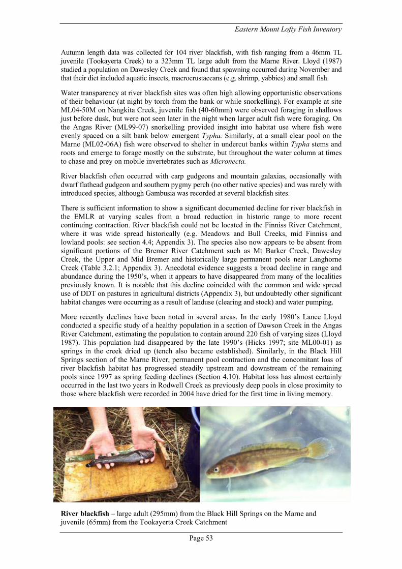
Eastern Mount Lofty Fish Inventory
Page 53
Autumn length data was collected for 104 river blackfish, with fish ranging from a 46mm TL juvenile (Tookayerta Creek) to a 323mm TL large adult from the Marne River. Lloyd (1987) studied a population on Dawesley Creek and found that spawning occurred during November and that their diet included aquatic insects, macrocrustaceans (e.g. shrimp, yabbies) and small fish. Water transparency at river blackfish sites was often high allowing opportunistic observations of their behaviour (at night by torch from the bank or while snorkelling). For example at site ML04-50M on Nangkita Creek, juvenile fish (40-60mm) were observed foraging in shallows just before dusk, but were not seen later in the night when larger adult fish were foraging. On the Angas River (ML99-07) snorkelling provided insight into habitat use where fish were evenly spaced on a silt bank below emergent Typha. Similarly, at a small clear pool on the Marne (ML02-06A) fish were observed to shelter in undercut banks within Typha stems and roots and emerge to forage mostly on the substrate, but throughout the water column at times to chase and prey on mobile invertebrates such as Micronecta. River blackfish often occurred with carp gudgeons and mountain galaxias, occasionally with dwarf flathead gudgeon and southern pygmy perch (no other native species) and was rarely with introduced species, although Gambusia was recorded at several blackfish sites. There is sufficient information to show a significant documented decline for river blackfish in the EMLR at varying scales from a broad reduction in historic range to more recent continuing contraction. River blackfish could not be located in the Finniss River Catchment, where it was wide spread historically (e.g. Meadows and Bull Creeks, mid Finniss and lowland pools: see section 4.4; Appendix 3). The species also now appears to be absent from significant portions of the Bremer River Catchment such as Mt Barker Creek, Dawesley Creek, the Upper and Mid Bremer and historically large permanent pools near Langhorne Creek (Table 3.2.1; Appendix 3). Anecdotal evidence suggests a broad decline in range and abundance during the 1950’s, when it appears to have disappeared from many of the localities previously known. It is notable that this decline coincided with the common and wide spread use of DDT on pastures in agricultural districts (Appendix 3), but undoubtedly other significant habitat changes were occurring as a result of landuse (clearing and stock) and water pumping. More recently declines have been noted in several areas. In the early 1980’s Lance Lloyd conducted a specific study of a healthy population in a section of Dawson Creek in the Angas River Catchment, estimating the population to contain around 220 fish of varying sizes (Lloyd 1987). This population had disappeared by the late 1990’s (Hicks 1997; site ML00-01) as springs in the creek dried up (tench also became established). Similarly, in the Black Hill Springs section of the Marne River, permanent pool contraction and the concomitant loss of river blackfish habitat has progressed steadily upstream and downstream of the remaining pools since 1997 as spring feeding declines (Section 4.10). Habitat loss has almost certainly occurred in the last two years in Rodwell Creek as previously deep pools in close proximity to those where blackfish were recorded in 2004 have dried for the first time in living memory.
River blackfish – large adult (295mm) from the Black Hill Springs on the Marne and juvenile (65mm) from the Tookayerta Creek Catchment

Page 54
Carp gudgeons: the carp gudgeon species complex (Bertozzi et al. 2000; Hammer and Butler 2001) has historically caused considerable confusion for species lists of the region. The current Inventory benefited from identification experience as part of the SA Museum’s genetic studies into the group. Two species were positively identified: the Murray-Darling carp gudgeon and Midgley’s carp gudgeon, as well as a variety of F1 hybrid forms. The western carp gudgeon was not found in the region. The hybrid forms often occurred in the absence of one of the parental species, and hence it is suspected that there are unisexual forms occurring (i.e. clonal populations). Accordingly the EMLR appears to have local, national and international significance for the study of unisexual vertebrates. Distinct patterns of species and hybrid forms were recorded in different catchments and habitat types (see Section 4). Midgely’s carp gudgeon (and the Midg x sp X form) was restricted to wetland habitat at the junction of the Marne and Murray rivers and lower Reedy Creek. The Murray-Darling carp gudgeon and its hybrid forms (MD x Midg, MD x sp. X) (referred to as Murray-Darling type carp gudgeon hereafter) were found in a range of stream and wetland habitats in the lower to middle reaches of streams, including isolated pockets in spring pools (e.g. Marne River & Saunders Creek), small tributaries (e.g. Bull Creek, Finniss Catchment), an instream dam (Dawson Creek), stable lowland pools (e.g. Angas River & Bremer River) and small pools with highly fluctuating conditions (e.g. Middle Creek, Angas Catchment). Habitat and water quality was subsequently highly varied (e.g. 900 to over 10,000µS) but interestingly often constituted only low to medium levels of submerged and emergent cover (i.e. 20-30%). Underwater observations in the Angas River indicated that at night they were distributed throughout the water column. Murray-Darling type carp gudgeon were found concentrated below a small cement ford on the Bremer River above Harrogate during winter flows (ML01-11A) suggesting they might be migratory at least at local scales. Murray-Darling type carp gudgeon were often in high abundance with a range of other species, though seldom were they in high abundance at the same sites that large introduced predators or Gambusia occurred. The largest individuals were located at site ML04-128: two 68mm TL males and a 69mm TL female fish (general size range was 20-50mm TL). Given the taxonomic confusion, little is known of the historic distribution of different species and hybrid forms, with a more in-depth morphological revision of museum specimens required, although there are only a few specimens. Lloyd and Walker (1986) listed the western carp gudgeon for several sites, however it is likely the same species from the current survey were detected and not the true western carp gudgeon Hypseleotris klunzingeri s.s. There are indications of some localised declines for ‘carp gudgeons’ in the Bremer and Angas catchments due to recent pool drying over summer.
Carp gudgeons - male hybrid (MD x Midg) (top) and female (MD) from the Angas River
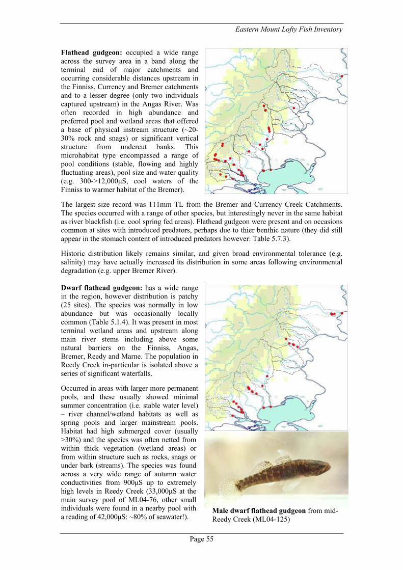
Eastern Mount Lofty Fish Inventory
Page 55
Flathead gudgeon: occupied a wide range across the survey area in a band along the terminal end of major catchments and occurring considerable distances upstream in the Finniss, Currency and Bremer catchments and to a lesser degree (only two individuals captured upstream) in the Angas River. Was often recorded in high abundance and preferred pool and wetland areas that offered a base of physical instream structure (~20-30% rock and snags) or significant vertical structure from undercut banks. This microhabitat type encompassed a range of pool conditions (stable, flowing and highly fluctuating areas), pool size and water quality (e.g. 300->12,000µS, cool waters of the Finniss to warmer habitat of the Bremer). The largest size record was 111mm TL from the Bremer and Currency Creek Catchments. The species occurred with a range of other species, but interestingly never in the same habitat as river blackfish (i.e. cool spring fed areas). Flathead gudgeon were present and on occasions common at sites with introduced predators, perhaps due to thier benthic nature (they did still appear in the stomach content of introduced predators however: Table 5.7.3). Historic distribution likely remains similar, and given broad environmental tolerance (e.g. salinity) may have actually increased its distribution in some areas following environmental degradation (e.g. upper Bremer River). Dwarf flathead gudgeon: has a wide range in the region, however distribution is patchy (25 sites). The species was normally in low abundance but was occasionally locally common (Table 5.1.4). It was present in most terminal wetland areas and upstream along main river stems including above some natural barriers on the Finniss, Angas, Bremer, Reedy and Marne. The population in Reedy Creek in-particular is isolated above a series of significant waterfalls. Occurred in areas with larger more permanent pools, and these usually showed minimal summer concentration (i.e. stable water level) – river channel/wetland habitats as well as spring pools and larger mainstream pools. Habitat had high submerged cover (usually >30%) and the species was often netted from within thick vegetation (wetland areas) or from within structure such as rocks, snags or under bark (streams). The species was found across a very wide range of autumn water conductivities from 900µS up to extremely high levels in Reedy Creek (33,000µS at the main survey pool of ML04-76, other small individuals were found in a nearby pool with a reading of 42,000µS: ~80% of seawater!).
Male dwarf flathead gudgeon from mid- Reedy Creek (ML04-125)

Page 56
The largest fish measured in sampling was 58mm TL (a ripe female from the Marne River springs) and large individuals (>50mm) were common at ML04-125 on Reedy Creek and other sites on the lower reaches of streams. A 65mm TL adult male was collected close to ML04-45 on the lower Finniss River in supplementary sampling (lodged at SAMA). Dwarf flathead gudgeon co-occurred with most other species, and were commonly recorded with dwarf flathead gudgeon included carp gudgeons, flathead gudgeon, carp and Gambusia (16-19 matching sites). A presence at one site was confirmed via stomach content analysis of redfin (ML99-08A). The isolation of some populations combined with varied and unusual habitat (e.g. saline pools on Reedy Creek) provides a good incentive for future genetic research to define variation between different local and national populations. Table 5.1.4. Environmental conditions at dwarf flathead gudgeon sites. * Spring fed
Site Code Date Abu
ndan
ce
River System Habitat type Dep
th m
ax (m
)
Connectivity Sub
surf
ace
phys
ical
%
Sub
surf
ace
biol
ogic
al %
Em
erge
nt %
Con
duct
ivity
(µS)
ML04-144 06/06/04 23 Angas River River Channel 1.5 Irregular connection 2 80 10 2370 ML04-143 06/06/04 3 Angas River Stream 2.0 High Connection (9 mo) 20 0 30 6210 ML04-111 27/04/04 4 Bremer River Stream 3.0 Medium connection (6mo) 20 0 10 4190 ML04-112 28/04/04 7 Bremer River Stream 1.0 Medium connection (6mo) 30 2 10 8030 ML04-138 05/05/04 11 Marne River Spring pool 3.0+ Irregular connection* 20 0 10 8890 ML04-139 05/05/04 6 Marne River Stream 1.0 Irregular connection* 10 0 20 5740 ML04-141 22/05/04 1 Reedy Creek Wetland 0.8 Permanent connection 5 0 20 1140 ML04-125 02/05/04 143 Reedy Creek Stream 1.5 Annual connection* 10 50 5 14080ML04-124 02/05/04 2 Reedy Creek Stream 1.0 Annual connection 30 10 0 18270ML04-127 03/05/04 5 Reedy Creek Stream 0.6 Annual connection 30 0 0 12300ML04-123M 30/04/04 1 Tookayerta Creek Wetland 1.5 Permanent connection 10 70 10 2540 ML04-42M 24/03/04 4 Tookayerta Creek Instream dam 2.0 Medium connection (6mo) 2 0 5 900 ML04-43 24/03/04 10 Finniss River Stream 1.5 High Connection (9 mo)* 30 2 10 1840 ML04-44 24/03/04 70 Finniss River Stream 1.5 High Connection (9 mo)* 20 10 20 3000 ML04-45 25/03/04 50 Finniss River River Channel 2.0+ Permanent connection 2 60 20 3010 ML04-64 31/03/04 5 Angas River Stream 1.5 High Connection (9 mo)* 20 20 30 6600 ML04-70 05/04/04 1 Angas River Stream 2.0 Medium connection (6mo) 30 2 30 3660 ML04-76 29/04/04 31 Reedy Creek Stream 0.6 Annual connection 30 10 20 33000ML99-05 07/05/99 17 Angas River Stream 2.0 Medium connection (6mo) 30 0 10 - ML99-07 21/04/99 5 Angas River Stream 3.0 Permanent connection* 20 20 20 - ML99-08A 17/05/99 1 Angas River Stream 2.0 High Connection (9 mo) 20 0 30 - ML99-10A 25/03/99 1 Angas River River Channel 1.5 Irregular connection 5 65 15 - ML04-01a 24/02/04 6 Currency Creek Stream 2.0 High Connection (9 mo) 40 5 5 5210 ML04-16 09/03/04 1 Finniss River Stream 2.0 Medium connection (6mo) 40 0 2 2730 ML02-05 25/02/02 3 Marne River Wetland 1.0 Permanent connection 10 50 5 780 ML02-06A 25/02/02 10 Marne River Stream 1.3 Permanent connection* 10 2 60 5000 ML02-11A 02/03/02 5 Finniss River Stream 1.0+ Medium connection (6mo) 40 0 0 2600 ML01-12 25/10/01 3 Angas River Stream 1.5 High Connection (9 mo) 10 0 30 -

Eastern Mount Lofty Fish Inventory
Page 57
5.2 Stream species (diadromous) Congolli: limited to a few terminal wetlands and lowland stream sites in the Finniss and Bremer rivers (seven sites). A generally rare catch and only recorded in higher numbers (n = 8) at site ML04-43 on the lower Finniss. The few fish captured in streams were all larger individuals (182-261mm TL). In the Bremer River large congolli are reported as ‘riding at the front of the wave’ of the first waters that flow downstream in the lowland channel toward Lake Alexandrina near the township of Langhorne Creek (Appendix 3). Previously recorded from the Marne Mouth wetland and up into the Black Hill Springs (Appendix 3). A few individuals also apparently negotiated the intermittent lowland channel of the Angas River historically, being caught as far up as Strathalbyn (Appendix 3), and they occurred further up the Bremer River (e.g. site ML04-83b on Rodwell Creek). Little is known about the lifecycle of this species or the importance of stream habitat in the region for recruitment.
Congolli from the lower Finniss River being measured Common galaxias: a common species in the Lower Lakes and to a lesser degree the lower section of the River Murray. This species occurs at stream termini and penetrates small distances upstream in well connected systems (e.g. Finniss River, Bremer River, Reedy Creek). Its upstream distribution was often marked by barriers such as waterfalls on the Finniss River and Currency Creek. In lowland stream habitat it occupied larger pools with reasonable cover (30-40%) and could often be observed in small schools feeding from the surface (e.g. Currency Creek Lions Park and upstream to the waterfall). The largest individual captured measured 148mm TL (Finniss River). Formerly reported to occur in a reed-lined pool at the Marne Mouth wetland prior to it going dry (Appendix 3).

Page 58
Climbing galaxias: this species is known only from a single specimen in the region, a large adult collected from Strathalbyn in 1914. There is very little suitable habitat for the species accessible in the EMLR due to natural migration barriers, however it probably occurred more commonly before construction of the Barrages and abstraction in stream catchments that would serve to reduce connectivity to lowland streams and hence larval migration upstream. The historic record confirms a natural presence in the Murray-Darling Basin as fish in upstream areas of the Murray are believed to have been translocated via the Snowy River Hydroelectric Scheme (Waters et al. 2002). Climbing galaxias still remain on southern Fleurieu streams and migratory larvae might potentially find their way to the Murray Mouth and on to local streams. Lampreys: the status of pouched and shorthead lamprey in the area remains little known as they are hard to detect owing to cryptic larval behaviour and short periods of movement. There are indications that they were once more common in the River Murray, detected at barriers (locks and weirs) during inland migrations (Scott et al. 1974), and presumedly this would translate to patterns of occurrence in the EMLR also (i.e. upstream migration of adults returning from the sea). A dead adult pouched lamprey (possibly post spawning) was captured from below the Finniss River waterfall in 2001 (SAMA F10095) and another individual of the same species from the lower Bremer River in 1978 (SAMA F4384). There is an historic record of a large (~70cm) lamprey taken from the Angas River at Strathalbyn in 1898 (Sim et al. 2000; Appendix 3) and the size is consistent with it also being a pouched lamprey (Potter 1996 refers to the size of adult shorthead lamprey returning to freshwater as 300-440mm and pouched as 500-700mm). A targeted survey may reveal some information about the suitability of lower streams as habitat for ammocetes (larval lampreys that live in sediment) and hence whether EMLR streams are important for the conservation of these unique species (e.g. the flowing Black Hill Springs section of the Marne and Lower Finniss would appear ideal habitat for ammocetes).
Main: Shorthead lamprey captured from Hindmarsh Island, insets oral discs of shorthead lamprey (left) and pouched lamprey (right)
Shortfinned eel: a record from the Bremer River above Langhorne Creek (SAMA F6357, September 1988), with the occasional adult located in the lower Murray region. Its presence is probably a natural part of the species distribution as the westernmost area for occasional larval migration.

Eastern Mount Lofty Fish Inventory
Page 59
5.3 Larger river species Murray cod: occurred within the Bremer River catchment historically in lowland habitat of large snag filled (red gum) pools within and upstream of the Langhorne Creek township (Sim et al. 2000; Appendix 3). Given the long time period of reports (1800’s through to 1940’s) and a reasonable area of available habitat, this population was possibly self-sustaining, however only larger fish (>5lbs) were recalled (i.e. memorable catches). Additional historic records from the Lower Finniss River (where it may still occur –see Section 4.4) likely formed part of a broader Murray population that may have benefited locally from stream habitat or flows. Similarly a healthy population was previously known just outside the mouth of the Marne Wetland: Appendix 3. Detailed surveys of historic habitat with larger gear types may detect any remnant fish. Murray-Darling golden perch (callop): whilst the species was not collected a current and/or historic presence was confirmed by local reports and SAMA specimens from the lower Bremer, Finniss and Marne rivers (see Section 4; Appendix 3). Habitat extending upstream into streams currently includes larger snag filled pools on the Bremer and prior to significant loss of flows from the Black Hill Springs included pools near Christian Reserve (Appendix 3). The species is known to be highly migratory (Reynolds 1983), and probably occurs in streams as immigrants from the Murray. However it is possible that the species spawns locally in response to stream discharge (especially on the Finniss). It would be interesting to investigate the source of fish (i.e. local stream, the Lower Lakes or further upstream on the Murray) and identify the types and duration of flows required for successful migration (colonisation) of streams and/or local recruitment (e.g. through otolith microchemistry linked to environmental data). Silver perch: known from the Marne Mouth wetland, channel at the Bremer River Mouth and the lower Finniss River historically, this species has undergone large declines in the South Australian section of the River Murray since the 1970’s. It may have formed a local population in the Finniss or spawned in association with stream discharge, however the small stream population likely were sourced from the Murray and relied on the health of this broader population for persistence. Hence silver perch may re-establish at former habitats with a resurgence of numbers in the River Murray and Lower Lakes. Catfish: the broader Murray range of this species appeared to just overlap in the region historically, known from the lower Finniss channel and wetland area as well just at the edge of the Marne Mouth historically (see Section 4). As with silver perch this species has undergone broader declines in the Murray since the 1970’s. The last record for the Finniss River was in 1984 (SAMA F10098), suggesting that suitable habitat and environmental conditions occurred relatively recently and that the species may still survive in the extensive area of wetland on the Finniss.
Green shading = historic stream records
Callop from Langhorne Creek 8/1/2002 (via L. Potts)
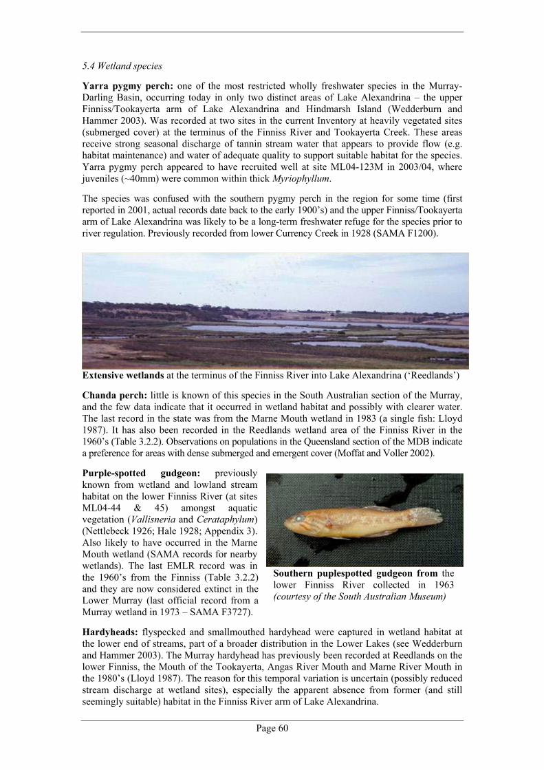
Page 60
5.4 Wetland species Yarra pygmy perch: one of the most restricted wholly freshwater species in the Murray-Darling Basin, occurring today in only two distinct areas of Lake Alexandrina – the upper Finniss/Tookayerta arm of Lake Alexandrina and Hindmarsh Island (Wedderburn and Hammer 2003). Was recorded at two sites in the current Inventory at heavily vegetated sites (submerged cover) at the terminus of the Finniss River and Tookayerta Creek. These areas receive strong seasonal discharge of tannin stream water that appears to provide flow (e.g. habitat maintenance) and water of adequate quality to support suitable habitat for the species. Yarra pygmy perch appeared to have recruited well at site ML04-123M in 2003/04, where juveniles (~40mm) were common within thick Myriophyllum. The species was confused with the southern pygmy perch in the region for some time (first reported in 2001, actual records date back to the early 1900’s) and the upper Finniss/Tookayerta arm of Lake Alexandrina was likely to be a long-term freshwater refuge for the species prior to river regulation. Previously recorded from lower Currency Creek in 1928 (SAMA F1200).
Extensive wetlands at the terminus of the Finniss River into Lake Alexandrina (‘Reedlands’) Chanda perch: little is known of this species in the South Australian section of the Murray, and the few data indicate that it occurred in wetland habitat and possibly with clearer water. The last record in the state was from the Marne Mouth wetland in 1983 (a single fish: Lloyd 1987). It has also been recorded in the Reedlands wetland area of the Finniss River in the 1960’s (Table 3.2.2). Observations on populations in the Queensland section of the MDB indicate a preference for areas with dense submerged and emergent cover (Moffat and Voller 2002). Purple-spotted gudgeon: previously known from wetland and lowland stream habitat on the lower Finniss River (at sites ML04-44 & 45) amongst aquatic vegetation (Vallisneria and Cerataphylum) (Nettlebeck 1926; Hale 1928; Appendix 3). Also likely to have occurred in the Marne Mouth wetland (SAMA records for nearby wetlands). The last EMLR record was in the 1960’s from the Finniss (Table 3.2.2) and they are now considered extinct in the Lower Murray (last official record from a Murray wetland in 1973 – SAMA F3727). Hardyheads: flyspecked and smallmouthed hardyhead were captured in wetland habitat at the lower end of streams, part of a broader distribution in the Lower Lakes (see Wedderburn and Hammer 2003). The Murray hardyhead has previously been recorded at Reedlands on the lower Finniss, the Mouth of the Tookayerta, Angas River Mouth and Marne River Mouth in the 1980’s (Lloyd 1987). The reason for this temporal variation is uncertain (possibly reduced stream discharge at wetland sites), especially the apparent absence from former (and still seemingly suitable) habitat in the Finniss River arm of Lake Alexandrina.
Southern puplespotted gudgeon from the lower Finniss River collected in 1963 (courtesy of the South Australian Museum)

Eastern Mount Lofty Fish Inventory
Page 61
Murray rainbowfish: recorded at the Marne Mouth wetland and common in Murray wetlands through to Wellington. Historic records indicate the species occurred in a small pocket of the lower lakes in the Reedlands/lower Finniss River region through to the 1980’s (see 3.2 and 4.4). Smelt: recorded in open areas of wetlands at stream termini and also appears to venture small distances up some streams at times, probably following flows (e.g. resident in lower Finniss River - ML04-44) and records in stream habitat of the Marne River at ML04-139 in 1983 (Lloyd 1987) and Reedy Creek in 2001 (ML04-127; Hammer 2001). Flood observations during August 2004 from the Winery Road causeway on the Finniss River (between sites ML04-44 & 45) identified that smelt are active during periods of high flow as they were recorded in still water flooded out onto the roadway. Bony herring: recorded in a few wetland sites, strictly an open water species of the Lakes and Lower Murray. Similarly, the western bluespot goby was restricted to stream termini wetlands connected with Lake Alexandrina. 5.5 No fish… There were particular patterns to sites with no fish recorded. Nine sites in the southern and Marne catchments were dry at the time of sampling with most of these having permanent water and fish in the past - an indication of recent trends in the decline of local ecosystems (e.g. Christian Reserve, Marne River; sites on Dawson Creek - Angas Catchment; upper Bremer River at Harrogate; pools on Rodwell Creek; Langhorne Creek, lower Bremer River). There were point source problems at other sites such as on Dawesley Creek that is currently too polluted from mine tailings (low pH, high metal concentrations) to support fish (Hicks 1997) (although improvements are being made). Other ‘no fish sites’ occurred in areas such as the North Rhine River (probably too salty and/or ephemeral today to support native fish) or otherwise small tributaries that might be ephemeral or marginal habitat. Drier northern catchments (Salt, Reedy and upper Saunders creeks) are significantly isolated from sources of native fish by natural barriers (modern and historic influence), have relatively low rainfall and highly variable aquatic environments, and today have few large permanent refuges, strong seasonal pool contraction and generally high conductivity. A lack of historic records makes it difficult to assess whether native fish occupied these areas prior to European settlement.
An almost dry pool on Rodwell Creek (ML04-83b) –this pool was a deep (~2m) permanent pool prior to the summer of 2004

Page 62
Table 5.5.1. Environmental conditions at sites where fish were not recorded. NB Most sites in naturally isolated sections of Reedy, Salt and Saunders creeks are not shown. * Dry. Site Code Waterway Location Comment ML99-04 Angas River 'Martindale', bend in River Freshly risen pools ML04-66M* Middle Creek Earthworks area Formerly pygmy perch, mountain
galaxias, carp gudgeon ML04-61* Dawson Creek Reserve -Fresian Drive Formerly pygmy perch, mountain
galaxias ML04-60* Doctors Creek Macclesfield Road Ephemeral creek ML04-63 Dawson Creek Ashbourne Road Freshly filled: formerly pygmy perch,
mountain galaxias, carp gudgeon ML04-91b* Bremer River Harrogate, behind Tennis Courts Dried 03 & 04. Formerly blackfish,
galaxias, carp gudgeon (A) ML04-96 Dawesley Creek Princess Hwy Polluted (mining): formerly mountain
galaxias, blackfish ML04-97 Dawesley Creek us Peggy Buxton Road Polluted (sewage): formerly mountain
galaxias, blackfish ML04-99 Bryce Creek us Harrogate Road High conductivity ML04-83b* Rodwell Creek 'Highland Valley' (b) corner pool Dried first time 04: formerly galaxias,
carp gudgeon and blackfish ML04-81* Bremer River Frank Potts Reserve, Langhorne
Creek Historically permanent: formerly cod, blackfish, callop
ML04-80* Bremer River 'Metella' -floodplain Aquatic plant site ML04-86 Mt Barker Creek Trib. Hurling Drive Ephemeral trib. ML04-01b* Currency Creek Trib. Peel Road Ephemeral trib. (formerly perm. pools)ML04-05 Currency Creek Trib. Mt Compass to Victor Road Small trib. ML04-23 Deep Creek Kokoda Rd Isolated catchment ML04-46 Blackfellows Creek Heritage Scrub, opp. Mt Magnificent
Conservation Park Probably has brown trout (common just upstream) excluding galaxiids
ML04-17 Giles Creek Haines Road Upper tributary ML04-33 Meadows Creek Trib. Badgers Road Ephemeral trib. ML02-18 North Rhine River Sedan Road High conductivity ML02-20 North Rhine River Ford north of Keyneton High conductivity ML02-22 North Rhine River us Pine Hut Road Nice pools - heavy seasonal contraction ML02-19 North Rhine River Water Reserve 'Netherford' Nice pools and spring ML02-17 North Rhine River M. Wrights Road Eutrophic, saline ML02-12 Marne River Trib. Shearers Road Upper tributary ML02-08* Marne River Christian Reserve Formerly spring fed: blackfish,
mountain galaxias, gudgeons ML02-07 Marne River Behind turf farm Suitable pool; formerly mountain
galaxias ML02-14 Marne River Trib. Boehm Springs Road Upper tributary ML04-136M Marne River Marne Gorge, ds Gauging station Fish present two years ago: high
conductivity, eutrophication, pumping ML04-126* Milendella Creek us Creek Jn., off The Gap Road Isolated catchment, no perm. water ML04-113* Preamimma Creek Off Preamimma Rd Isolated catchment, no perm. water ML04-129 Saunders Creek Saunders Gorge Sanctuary Springs have stopped flowing, pools
drying up and concentrated
A

Eastern Mount Lofty Fish Inventory
Page 63
5.6 Translocated native species Self-sustaining populations (recruits detected) of locally sourced catfish (lower Murray) and carp gudgeon (same catchment) were collected from one small dam off Dawesley Creek (ML04-94). There were reports of Murray-Darling golden perch and fly-specked hardyhead being stocked into an instream dam on Doctors Creek (a tributary to the Angas River), and on-ground communication with landholders indicates that larger native species such as Murray cod and golden perch are commonly stocked into farm dams in the Eastern Mount Lofty Ranges, often without the required permit from PIRSA (generally due to a lack of awareness). 5.7 Exotic species Most exotic species only occupied less variable, warmer or degraded habitats often associated with the lower end of catchments or terminal wetlands. However, Gambusia and three introduced predators (redfin, brown and rainbow trout) warrant special attention as they had wide ranges including stream habitat. Goldfish: has had a long term presence in the region (known as golden carp) and remains widespread across lowland habitats, generally in association with wetland areas. Its distribution and abundance in stream habitats appears limited as it was only detected at a few stream pool sites below Strathalbyn on the Angas River and the lower Bremer River. Carp: arrived in the region in the mid 1970’s and rapidly became abundant (Sim et al. 2000; Appendix 3). Survey data indicates they are widespread in the lower areas of catchments (24 sites) but they were not present in large numbers. Most individuals captured in stream habitat were large adults (>400mm TL) with the limited number of juvenile fish a potential indicator that many carp are sourced from the River Murray/Lake Alexandrina or farm dams (e.g. ML04-90b above Harrogate, other reports in the Angas River Catchment) rather than local instream recruitment. The species occurred in larger stream pools or river channel habitats with a range of species, most often with the three gudgeon species and Gambusia. Tench: reported to have been common historically, declining soon after carp appeared in the region (Sim et al. 2000; Appendix 3). Was detected in low abundance within a restricted range in the mid Angas River Catchment (in and below Strathalbyn and Dawson Creek). Large adults and juveniles were both represented, but occupied a limited range encompassed large deep pools where carp gudgeon were abundant.
A large tench captured on Dawson Creek, a tributary to the Angas River
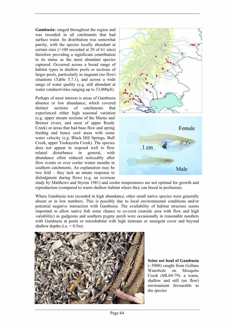
Page 64
Gambusia: ranged throughout the region and was recorded in all catchments that had surface water. Its distribution was somewhat patchy, with the species locally abundant at certain sites (>100 recorded at 20 of 61 sites) therefore providing a significant contribution to its status as the most abundant species captured. Occurred across a broad range of habitat types in shallow pools or sections of larger pools, particularly in stagnant (no flow) situations (Table 5.7.1), and across a wide range of water quality (e.g. still abundant at water conductivities ranging up to 33,000µS). Perhaps of most interest is areas of Gambusia absence or low abundance, which covered distinct sections of catchments that experienced either high seasonal variation (e.g. upper stream sections of the Marne and Bremer rivers, and most of upper Reedy Creek) or areas that had base flow and spring feeding and hence cool areas with some water velocity (e.g. Black Hill Springs, Bull Creek, upper Tookayerta Creek). The species does not appear to respond well to flow related disturbance in general, with abundance often reduced noticeably after flow events or over cooler winter months in southern catchments. An explanation may be two fold – they lack an innate response to dislodgment during flows (e.g. an overseas study by Matthews and Styron 1981) and cooler temperatures are not optimal for growth and reproduction (compared to warm shallow habitat where they can breed in profusion). Where Gambusia was recorded in high abundance, other small native species were generally absent or in low numbers. This is possibly due to local environmental conditions and/or potential negative interaction with Gambusia. The availability of habitat structure seems important to allow native fish some chance to co-exist (outside area with flow and high variability) as gudgeons and southern pygmy perch were occasionally in reasonable numbers with Gambusia at pools or microhabitat with high instream or emergent cover and beyond shallow depths (i.e. > 0.5m).
Seine net haul of Gambusia (~5000) caught from Gollans Waterhole on Mosquito Creek (ML04-79): a warm, shallow and still (no flow) environment favourable to the species
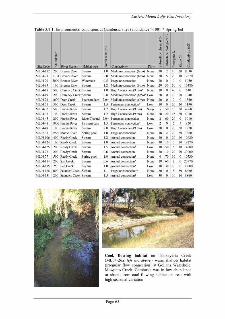
Eastern Mount Lofty Fish Inventory
Page 65
Table 5.7.1. Environmental conditions at Gambusia sites (abundance >100). * Spring fed
Site Code Abu
ndan
ce
River System Habitat type Dep
th m
ax (m
)
Connectivity Flow Sub
surf
ace
phys
ical
%
Sub
surf
ace
biol
ogic
al %
Em
erge
nt %
Sha
de %
Con
duct
ivity
(µS)
ML04-112 200 Bremer River Stream 1.0 Medium connection (6mo) None 30 2 10 30 8030ML04-73 1104 Bremer River Stream 2.0 Medium connection (6mo) None 30 5 20 10 12270ML04-79 5000 Bremer River Waterhole 0.5 Irregular connection None 20 0 0 0 5050ML04-95 100 Bremer River Stream 1.2 Medium connection (6mo) None 20 30 10 0 10380ML04-18 500 Currency Creek Stream 1.0 High Connection (9 mo)* None 10 0 40 0 510 ML04-19 200 Currency Creek Stream 0.8 Medium connection (6mo)* Low 20 0 10 20 1040ML04-22 1000 Deep Creek Instream dam 2.0+ Medium connection (6mo) None 20 0 0 0 1360ML04-51 300 Deep Creek Stream 1.5 Permanent connection* Low 10 0 20 20 1190ML04-32 500 Finniss River Stream 1.2 High Connection (9 mo) Seep 5 50 15 30 4860ML04-35 100 Finniss River Stream 1.2 High Connection (9 mo) None 20 20 15 80 4050ML04-45 200 Finniss River River Channel 2.0+ Permanent connection None 2 60 20 0 3010ML04-48 1000 Finniss River Instream dam 1.5 Permanent connection* Low 2 0 5 5 850 ML04-49 100 Finniss River Stream 2.0 High Connection (9 mo) Low 30 0 20 30 1270ML02-33 1970 Marne River Spring pool 1.0 Irregular connection None 10 2 20 30 3660ML04-106 400 Reedy Creek Stream 1.2 Annual connection None 40 0 20 40 10620ML04-124 100 Reedy Creek Stream 1.0 Annual connection None 30 10 0 20 18270ML04-125 200 Reedy Creek Stream 1.5 Annual connection* Low 10 50 5 10 14080ML04-76 200 Reedy Creek Stream 0.6 Annual connection None 30 10 20 20 33000ML04-77 500 Reedy Creek Spring pool 1.0 Annual connection* None 0 70 10 0 10530ML04-114 200 Salt Creek Stream 0.6 Annual connection* None 10 60 2 0 23970ML04-115 250 Salt Creek Stream 1.0 Annual connection* Low 10 30 10 0 30000ML04-128 600 Saunders Creek Stream 1.1 Irregular connection* None 30 0 5 50 8660ML04-131 200 Saunders Creek Stream 1.5 Annual connection* Low 30 0 10 10 8860
Cool, flowing habitat on Tookayerta Creek (ML04-26a) left and above - warm shallow habitat (irregular flow connection) at Gollans Waterhole, Mosquito Creek. Gambusia was in low abundance or absent from cool flowing habitat or areas with high seasonal variation

Page 66
Records of brown (red dots) and rainbow (orange dots) trout from the Inventory. Maroon shapes represent additional areas where trout have been and/or are still being stocked based on inferred locations of habitat suitability from broader records (Morrissy 1967; Fulton 2004) as well as personal communication with landholders.
Rainbow trout: only recorded at three sites in the Angas and Bremer Catchments, but undoubtedly under sampled and more wide-spread given stocking in the region (e.g. recent records in Tookayerta Creek near the Strathalbyn to Goolwa Road, various reports of stocking into instream dams). Found in larger pool environments displaying a mutually exclusive distribution with galaxiids that either occurred at nearby sites or in different pools or microhabitat (see table 5.7.2). Small fish and various macroinvertebrates were found as components of stomach content (see Table 5.7.3) Brown trout: found in larger pools in higher rainfall areas (Finniss River and Tookayerta Creek), and as with rainbow trout is likely to be more wide-spread (see distribution figure). Most positive sites were permanent pools or other larger refuges (e.g. spring fed stream stretch). The presence of varied size classes and small juveniles at site ML03-44 on Blackfellows Creek is an indication that recruitment in the wild occurs in the area. Juveniles (n =2 <100mm TL) co-occurred with galaxias and carp gudgeon in lower Bull Creek, however, at six other sites there was a clear separation in either local presence or microhabitat between brown trout and small native species (especially mountain galaxias, but also southern pygmy perch) (Table 5.7.2), and small fish were found in the stomach content of brown trout (Table 5.7.3). There were additional sites where similar patterns occur but with the additional presence of redfin (likely that both species could be influencing local patterns). Redfin: a wide range and occurring in sections of most catchments, with recent records in others where they were not captured (e.g. Tookayerta Creek and Marne River catchments: Appendix 3; Wedderburn 2000). As with Gambusia, there were areas where redfin appeared absent or in low numbers preventing easy detection, and this may relate to possible environmental conditions such as seasonal variability or flow. Redfin were found in larger deeper pools (generally >1.5m) with medium levels of submerged cover (20-30%) and water conductivities ranging from 620-8030µS. The size of captured fish ranged from 89-380mm TL, with ripe female fish often noted. Varied patterns of species occupancy at sites were noted, but redfin rarely occurred in the same pool as small native fish, especially southern pygmy perch – the level of submerged and emergent cover seems important (Table 5.7.2). The species clearly predate on native fish at times as stomach content analysis revealed mountain galaxias, flathead gudgeon and dwarf flathead gudgeon (including large adult specimens) (Table 5.7.3).

Eastern Mount Lofty Fish Inventory
Page 67
Table 5.7.2. Species composition (minus wetland taxa) for sites where introduced predators were recorded in the Eastern Mount Lofty Ranges. * Indicates suitable habitat but native species not recorded or excluded from suitable habitat due to introduced predators. X = historic records.
Site Code Waterway Rai
nbow
trou
t
Bro
wn
trout
Red
fin
Com
mon
gal
axia
s
Mou
ntai
n ga
laxi
as
Sout
hern
pyg
my
perc
h
Yar
ra p
ygm
y pe
rch
Riv
er b
lack
fish
Con
golli
Car
p gu
dgeo
n sp
p.
Flat
head
gud
geon
Dw
arf f
lath
ead
gudg
eon
Gam
busi
a
Comment ML04-57 Angas River 12 30* Galaxias in shallow pools only ML99-01A Dawson Creek 1 * * 6 Native species recovered since removal ML04-111 Bremer River 1 * 1 32 4 Common galaxias downstream ML03-44 Blackfellows Creek 60 4* Galaxias in one small pool only ML04-40 Bull Creek 2 244 116 The two trout where juveniles ML04-41 Bull Creek 15 300* X Galaxias in pools without trout ML04-47 Finniss Creek 3 13* 2 60 Trout ds, galaxias us road culvert ML03-51A Finniss River 1 20* 117* 15* Natives in shallow sub-section of pool ML04-27M Finniss River P 2 1* 3* X 22 Pygmy perch and galaxias in shallows onlyML04-36 Finniss River 2 7 6* X 7 50 Galaxias in small pool in riffle only ML04-49 Finniss River P 2 * * 3 100 Suitable galaxiid and pygmy perch habitat ML04-35 Meadows Creek 3 6 * 4* 5 100 Pygmy perch in a small isolated pool only ML02-36 Tookayerta Creek 5 1* Ideal mountain galaxias habitat ML04-26b Tookayerta Creek 4 * * Suitable galaxias and blackfish habitat ML04-01a Currency Creek 6 65 X 1 150 6 25 Lowland habitat ML04-16 Finniss River 13 * P* 3 1 10 Pygmy perch in winter only ML04-38 Finniss River 27 * 1 38 Suitable mountain galaxias habitat ML04-43 Finniss River 3 25 5 8 10 Lowland habitat ML04-44 Finniss River 1 40 5 X 2 10 70 20 Lowland habitat ML01-51 Angas River 4 7 4 14 Rocky pool ML04-143 Angas River 3 18 X X 163 3 Natives all from ds pool, redfin us pool ML04-144 Angas River 1 19 P 1 17 23 30 Lowland habitat ML04-71 Angas River 2 2* 7* 176 Only two pygmy perch in pools w redfin ML99-06 Angas River 3 3 50 25 V. deep pool ML99-08A Angas River 8 * X X 2* 1 Low numbers small natives ML99-10A Angas River 3 14 2 4 1 28 Lowland habitat ML99-11A Angas River 1 7 5 3 Lowland habitat ML01-10A Bremer River 2 23 1 2 Most galaxias from a smaller pool ds ML01-11A Bremer River 1 6 X 13 ML02-159A Bremer River 1 23 30 50 ML04-112 Bremer River 2 5 1 30 7 200 ML04-145 Bremer River P 3 1 20 10 Lowland habitat ML04-90b Bremer River 31 2 Instream dam ML04-78 Bremer River 6 X Swamp ML02-160A Mt Barker Creek 7 40 X Co-existing ML04-107 Bryce Creek 2 Suitable mountain galaxias habitat?
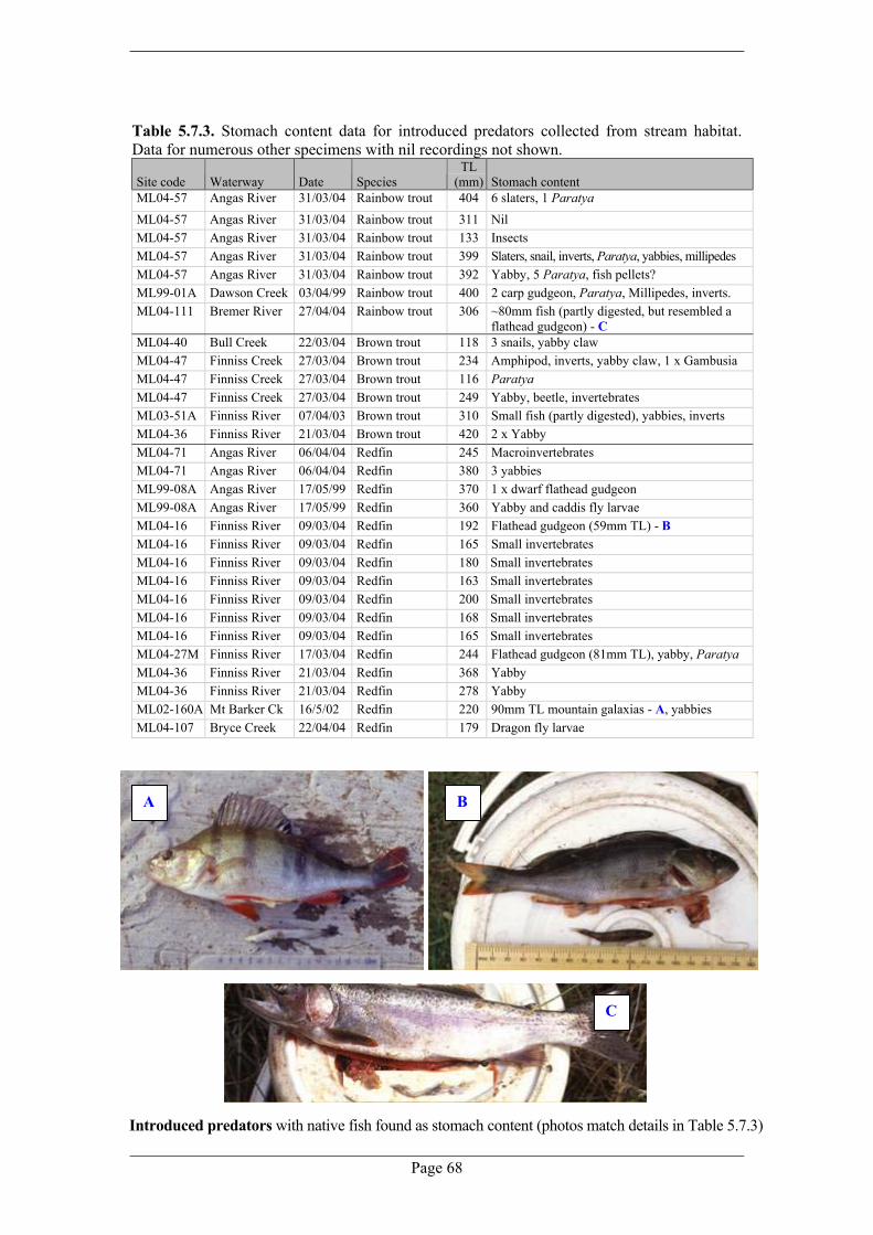
Page 68
Table 5.7.3. Stomach content data for introduced predators collected from stream habitat. Data for numerous other specimens with nil recordings not shown.
Site code Waterway Date Species TL
(mm) Stomach content ML04-57 Angas River 31/03/04 Rainbow trout 404 6 slaters, 1 Paratya ML04-57 Angas River 31/03/04 Rainbow trout 311 Nil ML04-57 Angas River 31/03/04 Rainbow trout 133 Insects ML04-57 Angas River 31/03/04 Rainbow trout 399 Slaters, snail, inverts, Paratya, yabbies, millipedes ML04-57 Angas River 31/03/04 Rainbow trout 392 Yabby, 5 Paratya, fish pellets? ML99-01A Dawson Creek 03/04/99 Rainbow trout 400 2 carp gudgeon, Paratya, Millipedes, inverts. ML04-111 Bremer River 27/04/04 Rainbow trout 306 ~80mm fish (partly digested, but resembled a
flathead gudgeon) - C ML04-40 Bull Creek 22/03/04 Brown trout 118 3 snails, yabby claw ML04-47 Finniss Creek 27/03/04 Brown trout 234 Amphipod, inverts, yabby claw, 1 x Gambusia ML04-47 Finniss Creek 27/03/04 Brown trout 116 Paratya ML04-47 Finniss Creek 27/03/04 Brown trout 249 Yabby, beetle, invertebrates ML03-51A Finniss River 07/04/03 Brown trout 310 Small fish (partly digested), yabbies, inverts ML04-36 Finniss River 21/03/04 Brown trout 420 2 x Yabby ML04-71 Angas River 06/04/04 Redfin 245 Macroinvertebrates ML04-71 Angas River 06/04/04 Redfin 380 3 yabbies ML99-08A Angas River 17/05/99 Redfin 370 1 x dwarf flathead gudgeon ML99-08A Angas River 17/05/99 Redfin 360 Yabby and caddis fly larvae ML04-16 Finniss River 09/03/04 Redfin 192 Flathead gudgeon (59mm TL) - B
ML04-16 Finniss River 09/03/04 Redfin 165 Small invertebrates ML04-16 Finniss River 09/03/04 Redfin 180 Small invertebrates ML04-16 Finniss River 09/03/04 Redfin 163 Small invertebrates ML04-16 Finniss River 09/03/04 Redfin 200 Small invertebrates ML04-16 Finniss River 09/03/04 Redfin 168 Small invertebrates ML04-16 Finniss River 09/03/04 Redfin 165 Small invertebrates ML04-27M Finniss River 17/03/04 Redfin 244 Flathead gudgeon (81mm TL), yabby, Paratya ML04-36 Finniss River 21/03/04 Redfin 368 Yabby ML04-36 Finniss River 21/03/04 Redfin 278 Yabby ML02-160A Mt Barker Ck 16/5/02 Redfin 220 90mm TL mountain galaxias - A, yabbies ML04-107 Bryce Creek 22/04/04 Redfin 179 Dragon fly larvae
A B
C
Introduced predators with native fish found as stomach content (photos match details in Table 5.7.3)

Eastern Mount Lofty Fish Inventory
Page 69
6.0 Other fauna This section provides a brief description of other fauna sampled opportunistically during fish sampling. Distribution maps are shown for three commonly sampled crustaceans: the yabby (Cherax destructor), Murray shrimp (Macrobrachium australiense) and glass shrimp (Paratya australiensis), and Table 6.1.1 highlights other opportunistic samples. While only supplementary data, information further highlights the diverse local aquatic communities and could serve as a starting point for future studies (e.g. distribution and habitat, genetic investigations). For example populations of Paratya, Macrobrachium and freshwater mussels (Velesunio ambiguus) occur in isolated areas above barriers and may be genetically distinct, and examination of aquatic snails collected from sites indicate that streams of the EMLR might be the last refuges for some species that are now extinct in the Lower Murray (Keith Walker, University of Adelaide pers. comm.).
Che
rax
ParatyaMacrobrachium

Page 70
Table 6.1.1. Opportunistic fauna samples.
Site Code Habitat type River System Other animals ML01-50A Stream Bremer River Leech ML04-84 Stream Bremer River Long and shortneck turtle ML00-01 Instream dam Angas River Longneck turtle ML04-83a Stream Bremer River Longneck turtle ML04-95 Stream Bremer River Longneck turtle ML02-15, 21 Stream Marne River Longneck turtle (A)
ML02-21 Stream Marne River Longneck turtle ML02-28A Stream Marne River Longneck turtle ML04-137 Stream Marne River Longneck turtle ML04-116 Stream Salt Creek Longneck turtle ML04-130 Stream Saunders Creek Longneck turtle ML04-104 Stream Reedy Creek Longneck turtle, interesting snail ML04-145 River Channel Bremer River Longneck turtle, Velesunio ambiguus ML04-99 Stream Bremer River Mosquito larvae ML04-27M Stream Finniss River Rare snails ML04-16 Stream Finniss River Shortneck turtle (B)
ML04-53 Instream dam Tookayerta Creek Snail, pobblebonk tadpoles ML04-109 Stream Bremer River Snails ML04-89, 90a Stream Bremer River Snails ML04-18 Stream Currency Creek Tadpole ML02-14 Stream Marne River Tadpole ML04-103 Stream Reedy Creek Tadpole (C)
ML02-37 Stream Tookayerta Creek Tadpole ML04-92 Stream Bremer River Tadpole (large black) ML04-38 Stream Finniss River Tadpole (speckled in colour) ML04-06 Stream Currency Creek Tadpoles ML04-17 Stream Finniss River Tadpoles ML02-07, 17, 22 Stream Marne River Tadpoles ML04-132 Stream Saunders Creek Tadpoles ML04-88 Stream Bremer River Tadpoles, lot snails ML04-23 Stream Deep Creek Tadpoles, spotted grass frog ML02-170 Stream Finniss River Tadpoles, Velesunio ambiguus ML04-07 Stream Currency Creek Velesunio ambiguus ML04-44 Stream Finniss River Velesunio ambiguus
ML99-04 Stream Angas River Velesunio ambiguus shells ML04-144 River Channel Angas River Velesunio ambiguus, spotted grass frog ML99-07 Stream Angas River Water rat tML04-125 Stream Reedy Creek Water rat
A B
C

Eastern Mount Lofty Fish Inventory
Page 71
7.0 Implications and management This section draws together key aspects of regional habitat and species patterns to provide perspectives for the significance and management of EMLR fishes. In applying this broad-brush approach some local messages may be overlooked, and hence in specific cases interpretations should be made from the catchment summaries in Section 4. Species richness: looking at overall figures, 28 species (16 captured) in EMLR catchments represents a high number of species occurring or previously known compared to the overall state total (58 species: Hammer and Walker 2004) and for the Murray-Darling Basin as a whole (41 fishes: Appendix 1). Streams provide habitat for several state threatened species while wetlands at stream termini generally had a diverse species composition including a large portion of the Murray range of the nationally ‘vulnerable’ Yarra pygmy perch. The Finniss River recorded a particularly high species richness (15 native species) with values in strictly stream habitat also comparatively high (>3 native species) in this catchment, as well as the Angas, Bremer, Marne and Tookayerta catchments. Significant habitats: concentrating on stream fauna, three species, namely southern pygmy perch, river blackfish and mountain galaxias, are currently supported in distinct outlier habitat of the Murray-Darling Basin with the next closest populations of these species occurring considerable distances upstream (e.g. Loddon River, Ovens River, Upper Murray). Within the EMLR, the Tookayerta, Finniss, Angas, Bremer and Marne are of special significance considering the representation of the endangered southern pygmy perch and/or river blackfish. Other isolated populations of mountain galaxias and/or dwarf flathead gudgeon also occur in these catchments as well as Currency Creek and Reedy Creek. The Tookayerta Creek catchment stood out from other catchments due to its contrasting and unique habitat (especially swamps and permanently flowing sections), its water quality and the wide representation of threatened species compared to rather patchy distributions elsewhere. That said, each catchment had particular and distinct geomorphic and hydrological character (e.g. rocky nature of the Finniss, deep pools of the Angas, permanent pools in an otherwise parched landscape in Salt Creek) comprising a blend of different habitat types worthy of protection individually and collectively as an interesting and distinct region. Areas with permanent base flow (spring fed pools) were regional features both in terms of water availability and the types of ecosystems they supported, often representing localised hotspots for fish diversity and threatened species. The Eastern Mount Lofty Ranges offers a rare habitat type (regional and state level) and serves as outlier habitat and refuge for species at the terminus of an ailing River Murray. The following discussion concentrates on issues and priorities for protecting this habitat. 7.1 Characteristics of the EMLR fish fauna and aquatic habitats Intermittent streams can be harsh environments considering seasonal extremes in temperature, flow (or no flow) and pool level, and resultant fluctuations in the condition and availability of habitat. It appears that as a result of such variation steam habitats of the EMLR generally support few native species especially higher up in catchments where the most variable environments occur (often only supported mountain galaxias or had no fish). However, natural variation seems to be an important factor in maintaining species rich fish assemblages at wetlands on the lower reaches of streams. Further down in catchments the disturbance of stream flow provides variation in the spatial and temporal nature of wetland habitats that contrast to the stable lentic conditions of the highly regulated lower River Murray, and stream flow likely represents a key factor in the richness and composition (including threatened species) of wetland fish communities (e.g. lower Finniss and Tookayerta).

Page 72
A few wholly freshwater species had distributions strongly aligned to stream habitat and they persist either by occupying specific stable habitats (e.g. river blackfish) and/or by having life history characteristics and population dynamics that are suited to variable environments (e.g. mountain galaxias, southern pygmy perch). Other species appeared to occupy niches in both streams and wetlands, and this requires a broad tolerance covering the lower extremes of environmental variability (e.g. gudgeons). Some migratory species appear to colonise the lower areas of streams opportunistically based on connectivity from larger population reservoirs when conditions are favourable (e.g. common galaxias). But this is not to say that stream habitats are not utilised for breeding and recruitment (e.g. congolli?). The species patterns observed in preceding sections suggest a number of broad predictors as to the fish composition (or lack of fish) in a catchment. These include natural isolation, catchment area, elevation and rainfall, and availability of long term refuges. These appear to act independently to exclude species from otherwise suitable habitat (e.g. barriers), as well as being related or cumulative (e.g. isolation across intermittent stream lengths due to low stream flow) and work over short time frames (e.g. local migration of diadromous species) or longer evolutionary periods (e.g. access to source populations over time). At finer scales however (i.e. sections of a geomorphic reach), casual patterns were harder to identify owing to the often highly variable nature of habitats and the extremely localised nature of fish distributions, especially threatened taxa such as river blackfish and southern pygmy perch. This could be aided by more in-depth analysis of the data (e.g. GIS modelling), and does suggests that the intensity of sampling could be increased in the future for important areas or habitat types. Identifying the influence of isolation is important in many aspects of management and conservation. Fishes isolated in particular regions are prone to genetic differentiation, potentially accompanied with ecological and behavioural adaptation to local environments. Hence isolated populations or communities represent significant and discrete natural values for protection (e.g. genetically distinct sub-populations, core remaining habitat), and given their often insular and restricted nature are extremely vulnerable to anthropogenic change. Seasonal isolation also occurs commonly in stream sections due to summer pool contraction (especially low rainfall years), where fish habitat often becomes limited to small stretches or isolated pools, particularly in upper catchment areas and regions with lower average rainfall. These refuge habitats form the basis of local metapopulations (groups of smaller populations that experience some gene flow or exchange of individuals) where some populations may be lost but in the long run a species persists via an interchange of individuals from source areas or a mosaic of patches that might shift during the course of time (Burgman and Lindenmayer 1998). Seasonal flow extremes: top – highly contracted summer pool on the mid-Finniss River, middle - winter flow on the North Rhine River and bottom Currency Creek waterfall in flood (3/8/04)

Eastern Mount Lofty Fish Inventory
Page 73
7.2 Historic conditions and environmental change In general, comparison of current and historic fish records suggest that several species were once more wide spread and in far greater abundance (especially river blackfish, also southern pygmy perch and mountain galaxias) and that some have potentially been lost from the region (e.g. Murray cod, purple-spotted gudgeon). There have been general and often significant reductions in species richness from lower stream reaches and wetlands (drastically so at the Marne Mouth wetland, also at the Finniss River). Remaining species distributions are being whittled away too: there is evidence of continuing local extirpations at locations like Dawson Creek on the Angas River and the Black Hill Springs on the Marne River. The trend of decline is likely much greater than that realised due to the relatively low level of historic information available, and considering drastic change in the current condition of local environments. The region has been extensively cleared of its native vegetation (>90%), implying significant changes to hydrology, water quality, salinity and sediment input/geomorphic stability. Interlinked pressures based on landuse (significant urban areas, wide spread agriculture and ever increasing viticulture) have also for example reduced the amount and nature of flows, delivered pollutants (point source or broader impact), damaged riparian areas (stock) and provided other localised habitat destruction (see Section 4). Perhaps the most pressing current issue is decline in stream flow witnessed with recent levels of dam development and other water use (see 7.3). The combined effect has been one of reduction in the extent and quality of permanent refuges and overall core fish habitat, thus suppressing the natural ability of populations to be buffered from or respond to natural disturbance (e.g. occasional severe floods and drought). For example, there were numerous cases of currently dry stream reaches that historically contained permanent pools or flow, including areas that had only recently dried for the first time in living memory.
Examples of continuing habitat destruction in the EMLR: clockwise from top left- in-filling of Mt Barker Creek during works (ML04-87); significant physical alteration of a stream stretch during bridge works at Harrogate (ML02-159A); large causeway constructed across the mid-Finniss River and stock access – still common along EMLR waterways

Page 74
7.3 Environmental water requirements Within the variable seasonal and interannular nature of stream flow in the EMLR there are particular extremes that likely provide significant points of stress or physical processes that shape the distribution and dynamics of fish populations. For example under natural seasonal or longer term periods of low rainfall the amount of available habitat contracts at microhabitat (e.g. water level), site (refuges) or regional (stream connections) scales and species that persist in the region must be attuned to flow cycles. However, increasingly the natural flow regime of streams in the EMLR is being altered and this has and will affect the ability of species to respond to disturbance such as persistence during drought or recolonisation following local extirpation (e.g. drought, destructive flood or artificial problems such as pollution). In a more general sense local fish are likely attuned to natural patterns of flow for successful recruitment. Aspects of environmental water requirements are noted in relation to refuge maintenance, connectivity and natural disturbance. Different types of habitats would have different considerations due to complex and variable patterns of stream flow over different spatial and temporal scales (e.g. upland environment compared to larger lowland pools and spring fed areas versus naturally dry habitat). Refuge maintenance: the condition and availability of refuges is linked to aspects of flow:
• The overall availability of pools→ impacted by length of period of no flow and the timing
of the seasonal onset of flows, also groundwater and potentially aspects of flow volume or frequency (e.g. winter 2004 delivery of fresh water (~1000µS) to the Black Hill Springs),
• Water level is often linked to the degree of structural complexity (e.g. water may drop below emergent and submerged cover) and reflects cover in refuges that may be important to allow a variety of species to co-exist with concentrated conditions, especially where non-native species have been introduced→ as above also potentially buffered by vertical connections to groundwater,
• Water quality with concentration can reach levels that stress fish causing direct mortality or declines in condition, a particular problem for species attuned to spawning soon after the onset of seasonal flow (e.g. Inventory observations on mountain galaxias). Mountain galaxias, southern pygmy perch and river blackfish all have relatively low thermal tolerance (e.g. Harasymiw 1983; McDowall and Fulton 1996) → affected by the length of time between flows, summer top ups or freshes and spring feeding.
Connectivity: important on a number of levels, especially for the colonisation of biota into or between habitats such as: • The upstream migration of diadromous or other migratory species into catchments→
attractant flow and then appropriate time period of connection to allow migration, • More localised movements of species with population expansion or migration facilitating
recolonisation and gene flow→ sufficient time of smaller or low velocity flows, • Lateral connections to edge and floodplain habitat that might be important areas for
recruitment (e.g. southern pygmy perch) or otherwise might maintain healthy riparian habitat as cover→ even rise and fall in water level, appropriate length of time of inundation.
Left - riffle connecting large pools on a spring fed section of the Finniss River (ML04-30M) and right -once permanent, spring fed pools at Christian Reserve, Marne River (springs dried in 1997)

Eastern Mount Lofty Fish Inventory
Page 75
Disturbance: important for physical processes and potential biological response such as: • Regular habitat maintenance→ decongest thick reed areas, flush silt and salts, • Flushing exotics like Gambusia which appear to lack an innate response to flooding, • Variability to wetland areas in an otherwise stable (regulated) environment of the lower
Murray and Lakes (regular flushes of sufficient magnitude). Capture of surface water in dams is significant in the Eastern Mount Lofty Ranges, with particularly high levels of development (Fig. 9). For example stream modelling in the Marne River Catchment (Marne River Environmental Flows Technical Panel 2003) identified farm dams to have: • Increased the length of no flow periods in the wettest subcatchment from 20% to 73%
of days, and in Marne Gorge from 13% to 45% of days, • Decreased the median annual flows out of the wettest subcatchment by 76% and
through Marne Gorge by 25%, • Reduced the volume and frequency of, or completely removed, summer freshes, • Delayed the onset of winter flows by capturing flows during the break in season, • Reduced the frequency, height, duration and, hence, coverage of low, medium & high flows.
Modelling for the Finniss River (Savadamuthu 2003) also identified significant changes to stream hydrology including a reduction in overall runoff, especially during dry years (potentially > 25%) and over summer (potentially up to 72% for the study area). Both studies also predict that impacts will increase if farm dam development continues. Such alterations to the volume and timing of flows, particularly smaller flows, via farm dam abstraction as well as the relatively unquantified use of groundwater is a key threat to local ecosystems (i.e. availability and condition of refuges as well as the nature of connections and disturbance). Significant signs of stress are already evident in the condition of habitats and summer refuges, with an overall accentuation of naturally dry periods being of particular concern. There is some urgency to address the protection of important natural values that are under immediate threat (e.g. drying of Black Hill Springs, Rodwell Creek and Dawson Creek).
Figure 9. Farm dam data for stream catchments of the Eastern Mount Lofty Ranges (DWLBC 2003) (e.g. data for the Finniss River catchment = 1819 dams with a storage capacity of over 7000 megalitres and a density of 20 megalitres per km2 of the catchment). Note these figures are for levels of development in 1999 and are initial estimates only and there has been considerable development in some regions over the ensuing five years.
0
1000
2000
3000
4000
5000
6000
7000
8000
Cur
renc
y
Dee
p C
reek
Too
kaye
rta
Finn
iss
Ang
as
Bre
mer
Ree
dy
Sau
nder
s
Mar
neNo.
of
Farm
Dam
s / E
stim
ated
cap
cpit
y (M
L)
0
5
10
15
20
25
30Fa
rm D
am D
ensi
ty (
ML/
SqK
m)
Estimated Dam Capacity(ML)
No. of dams
Dam Volume Density(ML/SqKm)
Stream Catchments

Page 76
7.4 Restoration and enhancement The scope for restoring and enhancing aquatic habitats has been set largely in previous discussion of the significance and characteristics of regional habitats. The ever-increasing concern shown by the community for protecting regional biodiversity is also a strong factor (e.g. the strong representation of Catchment and Landcare groups and general involvement of the community in the EMLR). Encouragingly a strong focus on catchment restoration does exist in the area (e.g. see Hammer 2002b), and this forms a good platform for more dedicated programs. Importantly such works and environmental changes need to be well documented to identify positive environmental response, best practice and ensure change does not inadvertently negatively affect remaining natural values (e.g. broad-scale willow removal often leaves barren, exposed habitat unsuitable for fish). Protecting water resources for the environment is the major broad regional conservation issue for the future, however field observations during the Inventory suggest that localised projects are likely to have a positive influence on the quality and quantity of habitat for aquatic fauna and flora, especially the protection and enhancement of refuges either as important local habitat and/or specific areas for threatened species. This could include habitat improvements such as stock exclusion and revegetation, reducing other threats such as introduced fish or pool pumping, and identifying and addressing point source pollution (e.g. road and stormwater runoff & point sources of pigeon faecal matter - a particular problem noted at several bridges in and above Strathalbyn as well as Rodwell Creek at Woodchester). As naturally wet areas, habitats respond rapidly to stock removal with visual and functional improvements (e.g. more submerged and emergent fish (and frog) habitat, shade, stabilised sediments and banks). Other benefits including:
• Improved water quality for the environment and stock (less parasites and disease risk). • Stock management benefits- easier to move. • Possible financial gains with concentrated management of productive land types,
reduced erosion and loss of land. • Biodiversity benefits: return of native birds and other wildlife. • Aesthetics (visual improvement) as green healthy areas look good! • Provides a sense of achievement and ownership.
On these benefits, enhancement of virtually any area is possible with even small steps or practices. It is important to consider seasonal variations (e.g. flood levels) when providing riparian buffers as observations on the nature of habitats. Some indications of fish behaviour during winter 2004 suggest that when water levels and stream velocity are high, habitat at stream edges becomes important shelter. The continuing incidence of significant habitat destruction (e.g. Finniss and Bremer rivers) also indicates a strong need for education and proactive approaches with new developments.
Left - Fenced section of Dawson Creek (ML04-72b) and right - a modified flow gauging weir in the Marne Gorge designed to improve conditions for fish passage

Eastern Mount Lofty Fish Inventory
Page 77
7.5 Introduced species and management The current study provides evidence to support broader patterns of impact and local concerns that introduced predatory species (i.e. redfin and trout) are a problem in intermittent streams of the EMLR (e.g. Crowl et al. 1992; Hammer 2000, 2002b; Morgan et al. 2002). Sampling identified examples of site and microhabitat exclusion of native fish by redfin and/or trout and also identified small native fish in the stomach contents of these predators. The predators that reach sizes much larger than the maximum size of native fish which have evolved in the region (i.e. >30cm) also occupied or are stocked into some of the best over-summer and long-term refuges - larger pools (e.g. Finniss River) or spring fed stream sections (e.g. Bull Creek, Tookayerta Creek), reducing the value of these habitats for native fish which are potentially forced to more marginal and unreliable habitats (e.g. shallow pools more likely to dry). Dedicated fine-scale investigations would probably identify that these impacts are greater than that observed from opportunistic observations as part of broader sampling. Interestingly some natural barriers appear to provide protection for native fish such as a population of pygmy perch above but not below the waterfall on the Finniss River (redfin and trout recorded below) and some man-made barriers also appear to provide protection (e.g. small road culvert on Finniss Creek with mountain galaxias above and brown trout below). It is thus important to recognise this habitat separation (or isolation: see 7.1) as a consideration for any projects to remove or modify instream structures. The wide-spread and often abundant Gambusia undoubtedly has an impact on native species distribution and abundance through competition and aggressive interaction (e.g. see Lloyd 1987). Observations that certain environmental conditions seem to suppress their abundance such as flow, cool winter temperatures and winter flow disturbance imply that natural variability in flows might be a key to protecting native fish populations (e.g. for southern pygmy perch that co-exist at some sites in Tookayerta Creek with Gambusia and occur above the distributional limit of Gambusia in the Angas River Catchment). Similarly there appeared to be some conditions limiting the distribution of redfin where they were absent from some pools or present only in low numbers. Hence a key management objective is to maintain natural variation in EMLR streams and enhance habitats (e.g. structure such as riparian vegetation and snags as cover) to potentially suppress introduced fish and to cater for the requirements of native species to allow resistance to negative interactions (e.g. strong native fish recruitment). It follows that if environmental conditions deteriorate further, increased exposure of native species to introduced fish will occur (e.g. loss of riffles that currently allow habitat separation between trout and mountain galaxias; increased Gambusia and carp abundance with degradation). Temporal monitoring at sites where larger predators have been removed (rainbow trout from a pool on Dawson Creek, redfin from Middle Creek) provides circumstantial evidence that native fish numbers and species richness increased following removal of the exotics. Hence direct control measures might be useful in confined environments like stream pools and targeting larger exotic fish in waterways is an option for active community participation (e.g. redfin fish-outs). Preventing avenues for introduction is an obvious management control that requires a wider level of public education concerning: (a) identifying that species such as trout and redfin are in fact not native as some people believe, (b) the impacts of such species can be significant in small stream environments, especially for species with already small and restricted distributions, (c) it is illegal to introduce species to waterways without permit (e.g. fingerling sales of angling species to the public), and (d) dams within catchment that can overflow into natural waterways are a potential avenue for introduction (e.g. several dams with carp in the Angas and Bremer catchments). In general a broader recognition of the problem is required fitting in with control programs for other pest species in terrestrial environments to achieve holistic outcomes. The same message applies for species native to other areas of Australia that might be translocated to the region (see next section).

Page 78
7.6 Fish and farm dams In addition to problems with exotic fish in farm dams, there are issues with a number of the larger native fish of the Murray-Darling Basin bred in commercial aquaculture facilities interstate (i.e. likely different gene pools to Lower Murray fish) and made available for sale as fingerlings to the general public. On-ground communication with landholders indicates that these are commonly stocked into farm dams in the Eastern Mount Lofty Ranges, often without the required permit from PIRSA. There is a potential for fish to escape from farm dams (those which are not isolated from catchment areas) into waterways during high flow events, posing ecological and genetic impacts to local ecosystems (e.g. they are large predators). Problems with the previous escape of exotic species such as carp and redfin were mentioned by local landholders (Appendix 3). There was also an indication of strong interest and demand for small native fish alternatives in dams either as food for larger fish or in the view of increasing biodiversity. While this is at least partially positive (i.e. instead of sourcing exotics) such stockings need to be done carefully and with the required permits to limit un-natural range increases that could erode genetic diversity (e.g. strong structure at the catchment level) or introduce competition to small vulnerable populations. An example of this problem was demonstrated for an instream dam on Doctors Creek (a tributary to the Angas River that joins upstream of Strathalbyn) which was reported to have been recently stocked with golden perch and flyspecked hardyhead (the later could refer to several species). The source of these fish would assumedly have been from interstate hatcheries (possibly not even in the Murray-Darling Basin for the hardyhead) and if these fish escaped during high flows they could easily end up in the Angas River or Lake Alexandrina causing potential genetic pollution of local golden perch and hardyhead. They could also occupy habitat where they do not naturally occur (e.g. golden perch is a predator and might be a threat to the highly restricted southern pygmy perch population). A management plan discussing translocation and options for sourcing small native fish for farm dams is required.
Redfin from the Angas River – note the large jaw gape that can easily accommodate most adult native fish of the region
Carp collected from the Angas River (ML04-143)

Eastern Mount Lofty Fish Inventory
Page 79
7.7 Research and monitoring The EMLR Fish Inventory provides the first comprehensive survey of the area and provides valuable baseline data for future programs of research and restoration. Specific regions that could be targets for more detailed investigation have been covered in Sections 4 and 5 (see also Hammer 2002b, 2004), with the more detailed investigation of the range of threatened species and further identification of refuge habitats a logical next stage of Inventory sampling. Monitoring is also a high priority to track the condition of habitats (e.g. Conallin and Hammer 2003) and the response of species to variation in environmental conditions and positive or negative change such as restoration or threatening processes, especially with respect to environmental flows. Some specific areas for future research and monitoring include: • Specific scientific investigations into species requirements for long-term viability (e.g.
detailed range mapping and ecological studies for River blackfish, mountain galaxias and dwarf flathead gudgeon),
• Investigations to increase understanding of groundwater hydrology, especially in key habitats, and identify and control water usage that could threaten dependent ecological communities (especially Rodwell Creek, Black Hill Springs, lower Finniss River, Meadows Creeks, Tookayerta Catchment),
• Further investigations into environmental water requirements to maintain and enhance fish populations at varying scales – local habitat management, preservation of metapopulation dynamics (connections) and terminal wetland maintenance,
• Initiate community based projects that involve detecting ecological response following restoration initiatives such as fencing, introduced species removal or environmental flow improvements, or decline such as habitat destruction or river abstraction (with expert assistance with fish monitoring, at least in the initial stages),
• Identify particular points of stress for important habitats (e.g. summer low in water level) and look to develop safe guards and actions to protect existing natural values (e.g. increase habitat, return environmental flows),
• Investigation of the species boundaries and spatial genetic structure of different fish and aquatic biota across contrasting EMLR catchments,
• Temporal replication of fish surveying to further knowledge of fish and ecosystem dynamics in local intermittent streams.
Promoting fish as an indicator of aquatic health may help the incorporation of these recommendations as components of programs such as Waterwatch, the focus of school projects and within the priorities of regional management and planning.
Flooding on the lower Finniss River (Winery Road) in August 2004: understanding the role of disturbance and flows to the health of local catchments is a key focus for future research and management such as: protecting and restoring habitats like terminal wetlands and summer refuges; exotic species control; and identifying actions for community involvement

Page 80
7.8 Conclusion The Eastern Mount Lofty Ranges is often overlooked in discussion of significant habitats at the Murray-Darling Basin level probably owing to its small size. However, the area is rich in aquatic diversity and provides a refuge otherwise isolated from other stream habitats in the Basin. The highly varied habitats of the region support threatened species and communities (fish but also nationally ‘critically endangered’ (EPBC Act) Fleurieu Swamps and associated biota) and have a role in maintaining wetland environments in the Lower Lakes, wetlands recognised as internationally important under the Ramsar Convention. Hence it is imperative to fully catalogue the biodiversity of the region and understand processes that threatened its future persistence. The current fish Inventory represents a first step in this process. Given large levels of historic change and continuing pressures, especially competing demands for water during dry periods, there are considerable challenges to the conservation of natural values in the EMLR. These values include unique habitat types of spring pools and permanent flow and rare species or isolated and potentially genetically distinct populations of more wide-spread taxa. In variable stream environments the availability and quality of refuges seems central to healthy fish populations, especially in climatically harsh seasons and extended dry periods. Hence identifying and protecting permanent refuges and natural flow regimes is a vital component of regional management, with the area of environmental water requirements a clear priority for the future. Finally, there is a common undervaluing of stream habitats in the EMLR, with a frequent perception that the river or stream is ‘just filled with carp’ or is ‘dead’. Survey data clearly indicate this is by and large not the case. Further, landholders and others with local interests were often amazed to learn of the local diversity of native fish on their back doorstep, and consequently had a renewed interest and sense of ownership for stream habitat. For effective protection and enhancement of stream habitats, education aimed at a broader awareness of natural values and threats is required. This can in part be aided by the dissemination of information in this report to highlight that there are definitely things left to save in the region.

Eastern Mount Lofty Fish Inventory
Page 81
8.0 References Bertozzi T. (1990) Morphological and biochemical variation in the western carp gudgeon Hypseleotris klunzingeri Ogilby from the Lower River Murray, South Australia. Honours thesis, The University of Adelaide. Bertozzi T., Adams M. and Walker K. F. (2000). Species boundaries in carp gudgeons (Eleotrididae: Hypseleotris) from the River Murray, South Australia: evidence for multiple species and extensive hybridization. Marine and Freshwater Research 51, 805-815. Blewett C. F. (1929). Habits of some Australian freshwater fishes. South Australian Naturalist 10, 21-29. Burgman M. A. and Lindenmayer D. B. (1998). 'Conservation Biology for the Australian Environment.' (Surrey Beatty and Sons: New South Wales.) Conallin A. and Hammer M. (2003). Fish surveys of selected streams in the Eastern Mount Lofty Ranges, South Australia. MDFRC Report No. 7/2003. The Murray-Darling Freshwater Research Centre. (Mildura.) Crowl T. A., Townsend C. R. and McIntosh A. R. (1992). The impact of introduced brown and rainbow trout on native fish: the case of Australasia. Reviews in Fish Biology and Fisheries 2, 217-241. DWLBC (2003 & 2004). Unpublished data. Department of Water Land and Biodiversity Conservation. (Adelaide.) Flecker A. S. and Townsend C. R. (1994). Community-wide consequences of trout introduction in New Zealand streams. Ecological Applications 4, 798-807. Hale H. M. (1928). Aquarists in camp. Cited in Rutherford B. A. (1991). 'The South Australian Aquarium Society. 1918-1932, The First Fifteen years. An Official History.' (Brian A. Rutherford: Modbury Heights, South Australia.) Hammer M. (1999). Distribution, richness and diversity of freshwater fishes in the Angas River Catchment, South Australia. Unpublished Biological Investigations report, Flinders University. (Adelaide.) Hammer M. (2000). Trout and fisheries legislation: a serious threat to South Australia's biodiversity. In 'Xanthopus: Newsletter of the Nature Conservation Society of South Australia'. pp. 8-9. Hammer M. (2001) Molecular systematics and conservation biology of the southern pygmy perch Nannoperca australis (Günther, 1861) (Teleostei: Percichthyidae) in south-eastern Australia. B. Sc. (Honours) thesis, Adelaide University. Hammer M. (2002a). Environmental water requirements for freshwater fishes of the Marne River Catchment, South Australia. Report produced for the River Murray Catchment Water Management Board. (Adelaide.) Hammer M. (2002b). 'Recovery Outline for the Southern Pygmy Perch in the Mount Lofty Ranges, South Australia.' (Department of Environmental Biology, University of Adelaide and Native Fish Australia (SA) Inc.: Adelaide.) Hammer M. (2004). Recovery progress for the southern pygmy perch in the Mount Lofty Ranges: 2001-2003. Native Fish Australia (SA) Inc. (Adelaide.)

Page 82
Hammer M. and Butler G. (2001). Data sheet: freshwater fishes of the Mount Lofty Ranges, part B, Murray Drainages. Upper River Torrens Landcare Group Inc. (Mount Pleasant, South Australia.) Hammer M. P. and Walker K. F. (2004). A catalogue of South Australian freshwater fishes including new records, range extensions and translocations. Transactions of the Royal Society of South Australia 128, 85-97. Harasymiw B. J. (1983). Effect of Temperature on Life Stages of Latrobe River Fish Species. State Electricity Commission of Victoria, SO/83/69.) Harris J. H. and Silveira R. (1999). Large-scale assessments of river health using an Index of Biotic Integrity with low-diversity fish communities. Freshwater Biology 41, 235-252. Hicks D. (1997) The impact of acid mine drainage on fish distribution in the southeast Mt Lofty Ranges, South Australia. B.Sc. (Honours) thesis, University of Adelaide. Lloyd L. N. (1987) Ecology and distribution of the small native fish of the lower River Murray, South Australia and their interactions with the exotic mosquitofish, Gambusia affinis holbrooki. M. Sc. thesis, University of Adelaide. Lloyd L. N. and Walker K. F. (1986). Distribution and conservation status of small freshwater fish in the River Murray, South Australia. Transactions of the Royal Society of South Australia 100, 49-57. Marne River Environmental Flows Technical Panel (2003). Environmental Water Requirements of the Marne River, South Australia - Final Report. River Murray Catchment Water Management Board. Matthews W. J. and Styron J. T. (1981). Tolerance of headwater vs. mainstream fishes for abrupt physiochemical changes. The American Midland Naturalist 105, 149-158. McDowall R. M. and Fulton W. (1996). Family Galaxiidae: galaxiids. In 'Freshwater Fishes of South-eastern Australia'. (Ed. McDowall.) pp. 52-77. (Reed Books: Chatswood NSW.) Morgan D. L., Hambleton S. J., Gill H. S. and Beatty S. (2002). Distribution, biology and likely impacts of the introduced redfin perch (Perca fluviatilis) (Percidae) in Western Australia. Marine and Freshwater Research 53, 1211-1221. Morrissy N. M. (1967) The ecology of trout in South Australia. B.Sc. (Honours) thesis, University of Adelaide. Nettlebeck N. (1926). Fishes of the Finniss River. South Australian Naturalist 7, 64-65. Pierce B. (1997). "Fair go" for endangered eight. Southern Fisheries 5, 12-13. Potter, I.C. (1996) Family Mordaciidae & Geotriidae. In 'Freshwater Fishes of South-eastern Australia'. (Ed. McDowall.) pp. 32-38. (Reed Books: Chatswood NSW.) Puckridge J. T., Sheldon F., Walker K. F. and Boulton A. J. (1998). Flow variability and the ecology of large rivers. Marine and Freshwater Research 49, 55-72. Raadik T. (2001). When is a mountain galaxias not a mountain galaxias? Fishes of Sahul 15, 785-789.

Eastern Mount Lofty Fish Inventory
Page 83
Reynolds L. F. (1983). Migration patterns of five fish species in the Murray-Darling River system. Australian Journal of Marine and Freshwater Research 34, 857-871. Rutherford B. A. (1991). 'The South Australian Aquarium Society. 1918-1932, The First Fifteen years. An Official History.' (Brian A. Rutherford: Modbury Heights, South Australia.) Savadamuthu K. (2003). Surface Water Assessment of the Upper Finniss Catchment. Department of Water, Land and Biodiversity Conservation. (Adelaide.) Scott T. D., Glover C. J. M. and Southcott R. V. (1974). 'The Marine and Freshwater Fishes of South Australia.' 2nd Edn Edn. (Government Printer: Adelaide.) Sim T., Potts L., Hammer M. and Doube J. (2000). Fishes. In 'Natural History of Strathalbyn and Goolwa Districts'. pp. 97-108. (Douglas Press: Woodville North, South Australia.) Twidale C. R. (1976). Geomorphological evolution. In 'Natural History of the Adelaide Region'. (Eds Twidale, Tyler and Webb.) pp. 43-59. (Royal Society of South Australia Inc.: Adelaide.) Waters J. M., Shirley M. and Closs G. P. (2002). Hydroelectric development and translocation of Galaxias brevipinnis: a cloud at the end of the tunnel? Canadian Journal of Fisheries and Aquatic Sciences 59, 49-56. Wedderburn S. (2000) Habitat and conservation status of small fish in the Lower River Murray, and a comparison of the western carp gudgeon (Hypseleotris klunzingeri) and gambusia (Gambusia holbrooki) as larval mosquito predators. B.Sc. (Honours) thesis, University of Adelaide. Wedderburn S. and Hammer M. (2003). The Lower Lakes fish Inventory: distribution and conservation of freshwater fishes of the Ramsar Convention wetland at the terminus of the Murray Darling Basin, South Australia. Native Fish Australia (SA) Inc. (Adelaide.)

Page 84
Appendix 1. List of native freshwater fish known from the Murray-Darling Basin: 43 species including freshwater landlocked populations of estuarine gobies (a total of 31 obligate freshwater species)
Common name Scientific name Pouched lamprey Geotris australis Shorthead lamprey Mordacia mordax Short-finned eel Anguilla australis Long-finned eel Anguilla reinhardtii Hyrtl’s tandan Neosilurus hyrtlii Rendahl’s tandan Porochilus rendahli Freshwater catfish Tandanus tandanus Bony herring Nematalosa erebi Australian smelt Retropinna semoni Climbing galaxias† Galaxias brevipinnis Barred galaxias Galaxias fuscus Common galaxias Galaxias maculatus Mountain galaxias* Galaxias olidus Flat-headed galaxias Galaxias rostratus Murray rainbowfish Melanotaenia fluviatilis Desert rainbowfish Melanoatenia splendida tatei Small-mouthed hardyhead Atherinosoma microstoma Darling River hardyhead Craterocephalus amniculus Murray hardyhead Craterocephalus fluviatilis Unspecked hardyhead Craterocephalus stercusmuscarum fulvus Chanda perch Ambassis agassizii Two-spined blackfish Gadopsis bispinosus River blackfish Gadopsis marmoratus Murray cod Maccullochella peelii peelii Trout cod Maccullochella macquariensis Murray-Darling golden perch Macquaria ambigua ambigua Macquarie perch Macquaria australasica Estuary perch Macquaria colonorum Southern pygmy perch Nannoperca australis Yarra pygmy perch Nannoperca obscura Silver perch Bidyanus bidyanus Spangled grunter Leiopotherapon unicolor Congolli Pseudaphritis urvillii Western carp gudgeon Hypseleotris klunzingeri Murray-Darling carp gudgeon Hypseleotris sp. A Midgley’s carp gudgeon Hypseleotris sp. B Hybrid carp gudgeon Hypseleotris spp. (e.g. Lakes) Purple-spotted gudgeon Mogurnda adspersa Flathead gudgeon Philypnodon grandiceps Dwarf flathead gudgeon Philypnodon sp. Tamar goby Afurcagobius tamarensis Western blue spot goby Pseudogobius olorum Lagoon Goby Tasmanogobius lasti * likely species complex (Raadik 2001) † native in SA only, interstate populations appear to be the result of translocation

Eastern Mount Lofty Fish Inventory
Page 85
Appendix 2. Site details and summary of survey methods
Site Code Date Easting Northing Landuse Pool condition Sein
e net
Dip
net
Fyk
e net
Bait
trap
Efis
hing
Nig
ht o
bs
Day
obs
Ang
ling
ML99-01A 03/04/99 306500 6095950 Fenced Bank level + + ML99-02 10/03/99 301100 6107700 Road side Low level + + + + ML99-03 17/03/99 303900 6102800 Fenced Bank level + + + ML99-04 17/05/99 305800 6099400 Grazing- light Bank level + + + + ML99-05 07/05/99 307600 6097800 Grazing- light Bank level + + ML99-06 21/02/99 310250 6095100 Fenced Bank level + + ML99-07 21/04/99 310650 6093850 Fenced Bank level + + + ML99-08A 17/05/99 313200 6092600 Fenced Bank level + + + + ML99-09 17/05/99 314500 6091500 Fenced Bank level + + + ML99-10A 25/03/99 318400 6081300 Fenced Bank level + + ML99-11A 25/03/99 318300 6080950 Grazing- light Bank level + + ML00-01 13/02/00 306400 6095900 Fenced Low level + + + ML00-02A 13/02/00 306500 6095950 Fenced Bank level + + ML01-08 03/12/01 350682 6146134 Reserve Bank level + + + + + ML01-10A 20/10/01 318500 6130700 Road side Bank level + + ML01-11 20/10/01 318400 6130600 Recreation Bank level + + + ML01-12 25/10/01 308200 6096300 Recreation Bank level + + + + ML01-13 26/10/01 290700 6085300 Fenced Bank level + ML01-50A 04/01/01 311100 6103850 Fenced Bank level + + ML01-51 11/02/01 308300 6096300 Recreation Low level + + + + ML01-52 11/03/01 318050 6081400 Grazing- heavy Low level + + + ML02-05 25/02/02 369657 6159363 Recreation Bank level + + + ML02-06A 25/02/02 363088 6158313 Fenced Bank level + + + + ML02-07 26/02/02 341205 6162387 Fenced Bank level + + + + ML02-08 25/02/02 361500 6159100 Reserve Dry + ML02-11A 02/03/02 298100 6085800 Fenced Low level + + ML02-12 07/03/02 326972 6160538 Grazing- light Bank level + + ML02-13A 07/03/02 323155 6161928 Grazing- heavy Low level + ML02-14 07/03/02 321113 6161343 Road side Low level + ML02-15 07/03/02 331706 6162321 Grazing- light Low level + + + + + ML02-16 08/03/02 331688 6162061 Reserve Bank level + + + ML02-17 08/03/02 332966 6165363 Grazing- heavy Low level + + ML02-18 08/03/02 331569 6172765 Fenced Low level + + ML02-19 08/03/02 331822 6169483 Grazing- heavy Bank level + + + ML02-20 10/03/02 330286 6175502 Road side Low level + ML02-21 10/03/02 328966 6161995 Grazing- light Low level + + + ML02-22 08/03/02 332100 6168100 Fenced Low level + + + ML02-28A 26/02/02 338164 6161572 Grazing- heavy Low level + + + ML02-33 16/03/02 360357 6159102 Fenced Low level + + + ML02-36 30/05/02 287905 6083211 Fenced Bank level + + + ML02-37 30/05/02 282000 6086383 Horticulture Low level + ML02-158A 16/05/02 331500 6162200 Grazing- light Low level + ML02-159A 16/05/02 318500 6130500 Fenced Concentrated + ML02-160A 16/05/02 304500 6117000 Urban area Bank level + ML02-170 17/05/02 290100 6101000 Grazing- heavy Concentrated + + ML02-172 17/05/02 287500 6086400 Fenced Bank full + + ML03-44 19/01/03 288712 6091079 Fenced Concentrated + ML03-51A 07/04/03 292400 6088600 Grazing- light Concentrated + + ML03-53A 07/04/03 298300 6085800 Fenced Bank level + ML04-01a 24/02/04 297670 6074300 Recreation Low level + + + ML04-01b 01/03/04 296200 6074200 Fenced Dry +
Page 86
Site Code Date Easting Northing Landuse Pool condition Sein
e net
Dip
net
Fyk
e net
Bait
trap
Efis
hing
Nig
ht o
bs
Day
obs
Ang
ling
ML04-02 24/02/04 287600 6079400 Fenced Low level + + ML04-03 24/02/04 285259 6077117 Fenced Bank level + + ML04-04 01/03/04 284938 6077779 Road side Concentrated + + ML04-05 01/03/04 285950 6075080 Fenced Low level + + ML04-06 01/03/04 286937 6075263 Grazing- light Low level + + ML04-07 01/03/04 293241 6075865 Grazing- light Bank level + + + ML04-12 04/03/04 272898 6064111 Grazing- heavy Low level + + ML04-13 04/03/04 273971 6064387 Road side Bank level + ML04-15 09/03/04 300431 6085062 Grazing- heavy Concentrated + + ML04-16 09/03/04 298040 6085831 Fenced Low level + + + + ML04-17 10/03/04 300798 6090023 Road side Bank level + + ML04-18 01/03/04 285352 6076056 Grazing- light Bank level + + + ML04-19 11/03/04 286899 6077900 Grazing- light Low level + + + ML04-20 11/03/04 289391 6077579 Grazing- light Low level + + + ML04-21M 11/03/04 295420 6081662 Fenced Bank level + ML04-22 11/03/04 294300 6081200 Grazing- heavy Low level + + ML04-23 11/03/04 292873 6079404 Grazing- light Bank level + + ML04-24M 17/05/04 292374 6088407 Grazing- light Low level + ML04-25M 17/03/04 292530 6088631 Grazing- light Bank level + + ML04-26a 17/03/04 285683 6083257 Fenced Bank level + + ML04-26b 17/03/04 286600 6083300 Road side Bank level + + ML04-27M 17/03/04 292448 6088247 Grazing- light Low level + ML04-28 18/03/04 294874 6095120 Fenced Low level + + ML04-29M 18/03/04 296194 6095462 Road side Bank level + + + + ML04-30M 19/03/04 298353 6085776 Fenced Bank level + ML04-31M 19/03/04 298446 6085658 Fenced Bank level + + ML04-32 21/03/04 290288 6102727 Grazing- light Bank level + + + ML04-33 21/03/04 286126 6097518 Road side Bank level + + ML04-34M 21/03/04 285574 6093563 Fenced Low level + ML04-35 21/03/04 285432 6093018 Fenced Low level + + ML04-36 21/03/04 286410 6089682 Grazing- light Bank level + + + + ML04-37 21/03/04 285860 6094085 Reserve Low level + + ML04-38 22/03/04 295700 6090900 Fenced Concentrated + ML04-39 30/03/04 287610 6090459 Grazing- light Bank level + + ML04-40 22/03/04 297115 6093715 Grazing- light Bank level + + + ML04-41 22/03/04 296600 6098300 Grazing- light Bank level + ML04-42M 24/03/04 303327 6077319 Fenced Low level + ML04-43 24/03/04 299945 6084246 Fenced Bank level + + ML04-44 24/03/04 301499 6081528 Fenced Bank level + + + + + ML04-45 25/03/04 303373 6079330 Grazing- heavy Bank level + + ML04-46 25/03/04 288602 6090503 Fenced Bank level + + ML04-47 27/03/04 285117 6090025 Fenced Bank level + ML04-48 27/03/04 283397 6089481 Fenced Concentrated + + ML04-49 27/03/04 288008 6088987 Fenced Bank level + + + ML04-50M 27/03/04 287700 6086300 Fenced Bank level + ML04-51 27/03/04 291480 6080734 Grazing- heavy Low level + + ML04-52 30/03/04 293334 6084940 Fenced Bank level + + ML04-53 30/03/04 291990 6086259 Forestry Concentrated + ML04-54M 30/03/04 292976 6085382 Fenced Bank level + + ML04-55a 30/03/04 283763 6085240 Fenced Low level + ML04-55b 30/03/04 283908 6085345 Road side Bank level + + ML04-56 30/03/04 284470 6083029 Fenced Bank level + ML04-57 31/03/04 303063 6104706 Grazing- light Bank level + + + ML04-58M 31/03/04 302851 6105691 Urban area Bank level + +
Eastern Mount Lofty Fish Inventory
Page 87
Site Code Date Easting Northing Landuse Pool condition Sein
e net
Dip
net
Fyk
e net
Bait
trap
Efis
hing
Nig
ht o
bs
Day
obs
Ang
ling
ML04-59 31/03/04 303674 6104282 Grazing- light Bank level + + + ML04-60 31/03/04 305095 6101800 Road side Dry + ML04-61 31/03/04 307071 6096181 Recreation Dry + ML04-62Ma 31/03/04 306639 6096087 Fenced Concentrated + + ML04-62Mb 31/03/04 306400 6095950 Fenced Bank level + ML04-63 31/03/04 307723 6096228 Urban area Low level + + ML04-64 31/03/04 310239 6094509 Urban area Bank level + + ML04-65 31/03/04 302652 6095321 Grazing- heavy Low level + + ML04-66M 01/04/04 307734 6097201 Fenced Dry + ML04-67 01/04/04 307831 6097149 Urban area Concentrated + ML04-68M 01/04/04 308154 6096930 Fenced Bank level + + ML04-69 01/04/04 299524 6101222 Grazing- light Bank level + + + ML04-70 05/04/04 308128 6096850 Vacant land Bank level + ML04-71 06/04/04 308055 6097135 Grazing- heavy Low level + + ML04-72a 06/04/04 300674 6095908 Grazing- heavy Bank level + + ML04-72b 06/04/04 301334 6095587 Fenced Bank level + + ML04-73 18/04/04 321575 6113335 Fenced Bank level + + + + ML04-74 08/04/04 325974 6123869 Road side Concentrated + + ML04-75 08/04/04 324893 6138618 Grazing- light Concentrated + + ML04-76 29/04/04 332317 6137835 Road side Concentrated + ML04-77 08/04/04 333193 6135001 Grazing- heavy Bank level + + ML04-78 09/04/04 322815 6090124 Grazing- light Concentrated + ML04-79 09/04/04 326548 6090239 Reserve Concentrated + ML04-80 09/04/04 322248 6087192 Grazing- light Dry + ML04-81 07/06/04 322070 6091888 Recreation Dry + ML04-82 09/04/04 310008 6104157 Fenced Low level + + ML04-83a 09/04/04 310338 6103970 Grazing- light Bank level + ML04-83b 09/04/04 311038 6103897 Fenced Dry + ML04-84 09/04/04 315328 6102524 Grazing- light Bank level + + + ML04-85 14/04/04 304289 6111029 Fenced Low level + + ML04-86 14/04/04 305334 6115525 Road side Concentrated + ML04-87 14/04/04 304600 6117200 Recreation Low level + ML04-88 14/04/04 304678 6119416 Urban area Bank level + ML04-89 14/04/04 310052 6120862 Road side Concentrated + ML04-90a 15/04/04 317394 6134216 Grazing- heavy Bank level + + ML04-90b 15/04/04 317446 6134368 Grazing- light Low level + + + ML04-91a 15/04/04 318600 6130664 Road side Concentrated + + ML04-91b 15/04/04 318400 6130600 Recreation Dry + ML04-92 15/04/04 318662 6130751 Fenced Low level + + ML04-93 15/04/04 320569 6124470 Fenced Concentrated + + ML04-94 18/04/04 311482 6125119 Fenced Low level + ML04-95 18/04/04 321280 6115200 Grazing- heavy Concentrated + + + ML04-96 18/04/04 313000 6120700 Road side Bank level + ML04-97 18/04/04 312450 6125200 Fenced Bank level + + + ML04-98 19/04/04 320964 6116472 Grazing- light Bank level + ML04-99 19/04/04 317504 6127405 Grazing- light Low level + + + ML04-100 19/04/04 317500 6137400 Fenced Bank level + + + ML04-101 21/04/04 322845 6137655 Grazing- heavy Bank level + + + + ML04-102 21/04/04 326983 6138459 Grazing- light Low level + + ML04-103 21/04/04 325366 6139301 Grazing- light Low level + ML04-104 22/04/04 325969 6148796 Grazing- light Low level + + + ML04-105 22/04/04 326716 6144999 Road side Low level + ML04-106 22/04/04 320187 6141812 Grazing- light Bank level + + + ML04-107 22/04/04 322565 6142906 Fenced Bank level + +
Page 88
Site Code Date Easting Northing Landuse Pool condition Sein
e net
Dip
net
Fyk
e net
Bait
trap
Efis
hing
Nig
ht o
bs
Day
obs
Ang
ling
ML04-108 27/04/04 302816 6115319 Grazing- heavy Bank level + + ML04-109 27/04/04 310131 6115412 Fenced Bank level + + + ML04-110 27/04/04 308972 6110076 Fenced Bank level + ML04-111 27/04/04 320138 6107095 Grazing- light Bank level + + ML04-112 28/04/04 317096 6099102 Grazing- light Low level + + ML04-113 28/04/04 326332 6119966 Grazing- heavy Dry ML04-114 28/04/04 334045 6122040 Grazing- light Low level + ML04-115 28/04/04 328800 6124500 Grazing- light Bank level + + ML04-116 28/04/04 327855 6125292 Fenced Low level + + + + ML04-117 29/04/04 327902 6123351 Fenced Low level + + ML04-118 29/04/04 325982 6125082 Fenced Low level + + ML04-119 29/04/04 325372 6126568 Fenced Bank level + ML04-120 29/04/04 326855 6132968 Grazing- light Low level + ML04-121 29/04/04 328512 6139332 Fenced Bank level + + ML04-122 29/04/04 330312 6139467 Fenced Bank level + + ML04-123M 30/04/04 304579 6076969 Vacant land Bank level + ML04-124 02/05/04 337103 6133488 Grazing- light Low level + + ML04-125 02/05/04 334586 6134228 Fenced Bank level + + + ML04-126 02/05/04 331050 6147192 Grazing- light Concentrated + ML04-127 03/05/04 337623 6132938 Reserve Concentrated + ML04-128 03/05/04 350531 6146364 Road side Low level + ML04-129 03/05/04 336231 6154156 Fenced Low level ML04-130 03/05/04 330676 6156244 Grazing- light Low level + ML04-131 04/05/04 330697 6157512 Grazing- light Low level + + + ML04-132 04/05/04 333153 6157094 Fenced Bank level + + ML04-133M 04/05/04 331644 6162341 Grazing- light Bank level + ML04-134M 04/05/04 323141 6161926 Grazing- light Low level + ML04-135 05/05/04 337148 6157203 Grazing- light Bank level + + ML04-136M 05/05/04 338160 6161579 Grazing- light Low level + ML04-137 05/05/04 337990 6161657 Grazing- light Bank level + ML04-138 05/05/04 362492 6159043 Fenced Bank level + + + ML04-139 05/05/04 364585 6158749 Fenced Bank level + ML04-140M 05/05/04 363088 6158313 Fenced Bank level + + ML04-141 22/05/04 340129 6131436 Grazing- light Concentrated + + ML04-143 06/06/04 313228 6092606 Vacant land Bank level + ML04-144 06/06/04 318373 6081222 Road side Low level + + + ML04-145 06/06/04 323069 6082075 Recreation Bank level + +

Eastern Mount Lofty Fish Inventory
Page 89
Appendix 3. Oral history Contents Background ............................................................................................................................90General comments ..................................................................................................................91Currency Creek.......................................................................................................................92Tookayerta Creek ...................................................................................................................92Finniss River ..........................................................................................................................93Angas River............................................................................................................................96Bremer River ..........................................................................................................................98Reedy Creek .........................................................................................................................102Salt Creek .............................................................................................................................102Saunders Creek.....................................................................................................................102Marne River..........................................................................................................................103