crook county natural hazard mitigation planthe crook county natural hazards mitigation plan (nhmp)...
TRANSCRIPT

Crook County Natural Hazard Mitigation Plan
2017 Update
DRAFT

Crook County Natural Hazard Mitigation Plan 2017 Update Central Oregon Intergovernmental Council
Cover photos courtesy of Crook County.
DRAFT

Crook County Natural Hazard Mitigation Plan 2017 Update Central Oregon Intergovernmental Council
CROOK COUNTY OREGON RESOLUTION NO. XXXXXX A RESOLUTION OF CROOK COUNTY ADOPTING THE NATURAL HAZARD MITIGATION PLAN 2017 UPDATE WHEREAS Crook County recognizes the threat that natural hazards pose to people and property within Crook County; and WHEREAS Crook County has prepared a multi-hazard mitigation plan, hereby known as the Crook County Natural Hazard Mitigation Plan 2017 Update in accordance with the Disaster Mitigation Act of 2000; and WHEREAS the Crook County Natural Hazard Mitigation Plan 2017 Update identifies mitigation goals and actions to reduce or eliminate long-term risk to people and property in Crook County from the impacts of future hazards and disasters; and WHEREAS adoption by the Crook County Court demonstrates their commitment to the hazard mitigation and achieving the goals outlined in the Crook County Natural Hazard Mitigation Plan 2017 Update. NOW THEREFORE, BE IT RESOLVED BY CROOK COUNTY, OR THAT: Section 1. In accordance with (local rule for adopting resolutions), the Crook County Court adopts the Crook County Natural Hazard Mitigation Plan 2017 Update. ADOPTED by a vote of ____ in favor and ____ against, and ____ abstaining, this ____ day of _________, 2017. By: __________________________________ (print name) ATTEST: By: __________________________________ (print name) APPROVED AS TO FORM: By: __________________________________ (print name)
DRAFT
Crook County Natural Hazard Mitigation Plan 2017 Update Central Oregon Intergovernmental Council
RESOLUTION NO. 1318
A RESOLUTION ADOPTING THE NATURAL HAZARD MITIGATION PLAN 2017
UPDATE AND CITY OF PRINEVILLE ADDENDUM
WHEREAS, Crook County and the City of Prineville recognize the threat that natural hazards
pose to people and property within Crook County and the City of Prineville; and
WHEREAS, Crook County and the City of Prineville have prepared a multi-hazard mitigation
plan known as the Crook County Natural Hazard Mitigation Plan 2017 Update and City of
Prineville Addendum in accordance with the Disaster Mitigation Act of 2000; and
WHEREAS, the Crook County Natural Hazard Mitigation Plan 2017 Update and City of
Prineville Addendum identifies mitigation goals and actions to reduce or eliminate long-term risk
to people and property in Crook County and the City of Prineville from impacts of future hazards
and disasters; and
WHEREAS, adoption by the City of Prineville demonstrates its commitment to the hazard
mitigation and achieving the goals outlined in the Crook County Natural Mitigation Plan 2017
Update and City of Prineville Addendum.
Based on the above recitals, THE CITY OF PRINEVILLE resolves that the Crook County
Natural Hazard Mitigation Plan 2017 Update and City of Prineville Addendum is hereby adopted
and the necessary city officials are authorized and instructed to execute such document.
DRAFT

Crook County Natural Hazard Mitigation Plan 2017 Update Central Oregon Intergovernmental Council
Passed by the City Council this _____ day of June, 2017.
__________________________________
Betty J. Roppe, Mayor
ATTEST:
________________________________
Lisa Morgan, City Recorder
DRAFT

Crook County Natural Hazard Mitigation Plan 2017 Update Central Oregon Intergovernmental Council i
2017 Steering Committee John Jackson Amateur Radio Emergency Services / RACES Steve Forrester City of Prineville James Wilson City of Prineville Information Technology Dale Cummins City of Prineville Police Department Jimmy O’Daniel City of Prineville Police Department Larry Seymour City of Prineville Police Department Mark Monroe City of Prineville Police Department Tobie Reynolds Crook County 911 Seth Crawford Crook County Administration Casey Kaiser Crook County Chamber of Commerce Michael Ryan Crook County Emergency Management Matt Smith Crook County Fire & Rescue Russ Deboodt Crook County Fire & Rescue Max Hamblin Crook County Health Department Muriel Delavergne-Brown Crook County Health Department Vicky Ryan Crook County Health Department Izzac Ross Crook County Information Technology Ann Beier Crook County Planning Department Bob O’Neal Crook County Road Department Leland Bliss Crook County School District James Savage Crook County Sherriff’s Office John Gautney Crook County Sherriff’s Office Russell Rhoden Ochoco Irrigation District Adam Barnes Oregon Department of Forestry Gordon Foster Oregon Department of Forestry Caroline Gordon U.S. Forest Service Stacey Forson U.S. Forest Service Hallie Adams Central Oregon Intergovernmental Council Julie Jameson Central Oregon Intergovernmental Council Copies of the plan are available online or by contacting: Hallie Adams, Program Coordinator Central Oregon Intergovernmental Council 334 NE Hawthorne Ave., Bend, OR 97701 [email protected] | (541) 548-9527 https://coic2.org/community-development/crookcountynhmp/
DRAFT

Crook County Natural Hazard Mitigation Plan 2017 Update Central Oregon Intergovernmental Council ii
Table of Contents EXECUTIVE SUMMARY ................................................................................................... 6 SECTION 1: INTRODUCTION .......................................................................................... 9
1.0 Introduction ................................................................................................. 10 1.1 The 2005 Natural Hazards Mitigation Plan (NHMP) .................................. 13 1.2 2010 NHMP Update .................................................................................... 16 1.3 2017 NHMP Update .................................................................................... 17 1.4 Hazard Assessment ..................................................................................... 19 1.5 Crook County NHMP Mission ..................................................................... 20 1.6 Crook County NHMP Goals ......................................................................... 20 1.7 Plan Organization ........................................................................................ 22 1.8 Integrated Plans and Process to Integrate Plans ....................................... 24
SECTION 2: A TOUR OF CROOK COUNTY
2.0 A Tour of Crook County ............................................................................... 27 2.1 Geographic Conditions ................................................................................ 30 2.2 Population and Demographics ................................................................... 32 2.3 Economy ...................................................................................................... 34
SECTION 3: NATURAL HAZARD IDENTIFICATION AND RISK ASSESSMENT .................. 35 3.0 Natural Hazard Identification and Risk Assessment .................................. 36 3.1 Crook County Hazard Analysis .................................................................... 37 3.2 Natural Hazard Identification ..................................................................... 39 3.3 Flood Hazard ................................................................................................ 40 3.4 Wildland Fire Hazard ................................................................................... 50 3.5 Severe Winter Storm and Windstorm Hazard ........................................... 59 3.6 Volcano Hazard ............................................................................................ 66 3.7 Earthquake Hazard ...................................................................................... 69 3.8 Landslide Hazard ......................................................................................... 72
SECTION 4: ACTION ITEMS AND IMPLEMENTATION .................................................... 75
4.0 General Introduction ................................................................................... 76 4.1 How Action Items Are Organized ............................................................... 77 4.2 Mitigation Strategy ...................................................................................... 79 4.3 Multi-Hazard Action Items .......................................................................... 81 4.4 Earthquake Hazard Action Items ................................................................ 86 4.5 Flood Fire Hazard Action Items .................................................................. 87 4.6 Wildland Fire Hazard Action Items ............................................................. 88 4.7 Severe Weather Events Hazard Action Items ............................................ 89 4.8 Landslide Hazard Action Items ................................................................... 90 4.9 Volcano Hazard Action Items ...................................................................... 90
DRAFT

Crook County Natural Hazard Mitigation Plan 2017 Update Central Oregon Intergovernmental Council iii
SECTION 5: PLAN MAINTENANCE AND UPDATING ...................................................... 91
5.0 Plan Maintenance and Updating .......................................................... 92 5.1 Convener ............................................................................................... 92 5.2 Plan Adoption ........................................................................................ 93 5.3 Ongoing Monitoring .............................................................................. 93 5.4 Implementation through Existing Programs ........................................ 95 5.5 Economic Analysis of Mitigation Projects ............................................ 95 5.6 Continued Public Involvement ............................................................. 95
CITY OF PRINEVILLE ADDENDUM .................................................................................. P1
P1.0 Overview ................................................................................................ P2 P2.0 Community Profile ................................................................................ P3 P3.0 Mission, Goals and Action Items .......................................................... P6 P4.0 Risk Assessment .................................................................................... P9 P5.0 Flood Hazard ......................................................................................... P10 P6.0 Wildland Fire Hazard ............................................................................. P19 P7.0 Severe Winter Storm and Wind Storm Hazard .................................... P27 P8.0 Volcano Hazard ..................................................................................... P31 P9.0 Earthquake Hazard ................................................................................ P32 P10.0 Landslide Hazard ................................................................................... P35 P11.0 Plan Implementation and Maintenance .............................................. P37
APPENDIX A: ACRONYMS ............................................................................................... A1
A1.0 Acronyms ............................................................................................... A2 APPENDIX B: HAZARD BACKGROUND INFORMATION ................................................. B1
B1.0 Flood Hazard ......................................................................................... B2 B2.0 Wildfire Hazard ..................................................................................... B11 B3.0 Severe Winter Storm and Windstorm Hazard ..................................... B22 B4.0 Landslide Hazard ................................................................................... B29 B5.0 Earthquake Hazard ................................................................................ B34 B6.0 Volcano Hazard ..................................................................................... B36
APPENDIX C: BENEFIT COST ANALYSIS .......................................................................... C1
C1.0 Approaches for Economic Analysis ...................................................... C2 C1.1 What are Some Economic Analysis Approaches for Evaluating
Mitigation Strategies? ........................................................................... C2 C1.2 Implementing the Approaches ............................................................. C5 C1.3 Economic Returns of Natural Hazard Mitigation ................................. C6 C1.4 Additional Costs from Natural Hazards ................................................ C7 C1.5 Additional Considerations..................................................................... C8 C1.6 Resources .............................................................................................. C8
DRAFT

Crook County Natural Hazard Mitigation Plan 2017 Update Central Oregon Intergovernmental Council iv
APPENDIX D: RESOURCE DIRECTORY ............................................................................ D1 D1.0 Resource Directory ................................................................................ D2
APPENDIX E: PUBLIC PROCESS ....................................................................................... E1
E1.0 Public Process ........................................................................................ E2 E1.1 Steering Committee .............................................................................. E2 E1.2 Public Notices ........................................................................................ E3 E1.3 Public Townhall Meetings ..................................................................... E3 E1.4 Meetings by the Crook County Court and
the City of Prineville City Council ......................................................... E3 E1.5 Contacts with Agencies ......................................................................... E3 E1.6 Steering Committee Agendas and Meeting Notes .............................. E4 E1.7 Public Notices ........................................................................................ E11 E1.8 Public Agency Contact List .................................................................... E14
APPENDIX F: CHANGES TO THE 2010 NHMP ................................................................ F1
F1.0 Purpose .................................................................................................. F2 F1.1 Introduction and background ............................................................... F2 F1.2 NHMP Plan ChangeS ............................................................................. F3
DRAFT

Crook County Natural Hazard Mitigation Plan 2017 Update Central Oregon Intergovernmental Council Executive Summary 1
What is in the Natural Hazard Mitigation Plan? The Crook County Natural Hazards Mitigation Plan (NHMP) 2017 Update includes resources and information to assist county residents, public and private sector organizations, and others interested in participating in planning for natural hazards. This plan represents a mitigation plan for “All Natural Hazards” that may impact Crook County. The plan represents a collection of information and decision that is based on the data available at the time it was created. This plan will be reviewed annually by the Crook County Office of Emergency Management to consider changes that may impact the performance of the plan, and to monitor implementation of the mitigation action items (see Section 4). The plan will receive a complete review and update at least every five years. During the complete reviews, the plan will be evaluated with respect to new requirements and action items. The plan provides a list of activities that may assist Crook County in reducing risk and preventing loss from future natural hazard events. The action items address multi-hazard issues, as well as activities for flood, fire, severe winter storm, windstorm, earthquake, landslide and volcanic eruption hazards. What is the NHMP mission? Through the implementation of the NHMP, Crook County will promote sound public policy designed to protect citizens, critical facilities, infrastructure, private property, and the environment from natural hazards. This can be achieved by increasing public awareness, documenting the resources for risk reduction and loss prevention, and identifying activities to guide the county towards building a safer, more sustainable community. The mission of the Crook County NHMP is:
To reduce risk, prevent loss and protect life, property and the environment from natural hazard events through coordination and cooperation among public and private partners.
What are NHMP Goals? The NHMP goals describe emergency management preparedness objectives and directions that Crook County governments, agencies, associations and citizens should strive to implement.
Executive Summary
Crook County Natural Hazard Mitigation Plan 2017 Update
DRAFT

Crook County Natural Hazard Mitigation Plan 2017 Update Central Oregon Intergovernmental Council Executive Summary 2
These goals were evaluated and reviewed during the NHMP 2017 update process to ensure alignment with the 2017 NHMP Steering Committee’s interests in expanding natural hazard mitigation efforts throughout the County. The NHMP goals approved through the 2017 update are shown in Table ES-1 below: Table ES-1. 2017 Crook County Natural Hazard Mitigation Plan Goals. Goal Goal Statement Community Priority Partnership and Coordination
- Identify mitigation of risk reduction measures that address multiple areas (i.e. environment, transportation, and telecommunications).
- Coordinate public/private sector participation in planning and implementing mitigation projects throughout the county.
- Seek partnerships in funding and resources and resources for future mitigation efforts.
1
Emergency Services
- Minimize life safety issues. - Promote, strengthen, and coordinate emergency
response plans. - Evaluate the performance of critical facilities during a
natural hazard event.
2
Education and Outreach
- Further the public’s awareness and understanding of natural hazards, potential risk, including economic vulnerability, and options available when natural hazard events occur.
- Provide public information and education to all residents of the county concerning natural hazard areas and mitigation efforts.
3
Prevention - Reduce the threat of loss of life and property from natural hazards.
- Incorporate information on known hazards and provide incentives to make hazard mitigation planning in land use policies and decisions, which include plan implementation.
4
Property Protection
- Lessen impact from natural disaster on individual properties, businesses and public facilities.
- Increase awareness at the individual level and encourage activities that can prevent damage and loss of life from natural hazards.
5
Natural Resource Protection
- Preserve and rehabilitate natural systems to serve natural hazard mitigation functions (i.e. floodplains, wetlands, watersheds, and urban interface areas).
6
Structural Projects
- When applicable utilize structural mitigation activities to minimize risks associated with natural hazards.
7
DRAFT

Crook County Natural Hazard Mitigation Plan 2017 Update Central Oregon Intergovernmental Council Executive Summary 3
Who participated in the 2017 NHMP update process? The Crook County NHMP was first approved in 2005. The original development of the plan was completed through a collaborative effort between Crook County citizens, public agencies, non-profit organizations, the private sector, and regional and state organizations. Public participation played a key role in development of goals and action items. Interviews were conducted with stakeholders throughout the county, and all of our workshops were open to the public to include our Sheriff’s Town Hall Meetings. Several citizens were actively involved in our plan’s development. The steering committee was comprised of representatives from:
Crook County Citizens
Crook County Sheriff’s Office
Crook County Court
Crook County Fire and Rescue
Crook County GIS
Crook County Emergency Management
Crook County Road Department
Crook County Planning Department
Ochoco Irrigation District
Bureau of Reclamation
Bureau of Land Management
United States Forest Service
Prineville City Administrators
Prineville Public Works
Prineville Police Department
Oregon Department of Transportation
Oregon Department of Forestry
CDA Consulting Group Inc.
Singe Tree Consulting Group In 2010, Crook County and the City of Prineville updated the 2005 NHMP with the assistance of CDA Consulting Group Inc. FEMA requires that all local jurisdictions update their mitigation plans every five years to incorporate new hazard and risk information and to continue the ongoing public process to review and update the action items the NHMP. In 2017, Crook County and the City of Prineville updated the 2010 NHMP with the assistance of Central Oregon Intergovernmental Council. The update of the plan was managed through Crook County Emergency Management and the 2017 NHMP Update Steering Committee. The update process focused on integrating updated data which would improve the County’s understanding of risks and impacts associated with natural hazards. Public involvement was an important part of the update process; a public meeting was held to collect public input on the 2017 NHMP.
DRAFT

Crook County Natural Hazard Mitigation Plan 2017 Update Central Oregon Intergovernmental Council Executive Summary 4
What are mitigation action items and how are they organized? The mitigation action items are a listing of activities in which county governments, agencies, associations and citizens can work on to reduce the risks associated with natural hazards. The following information is included for each action item:
Action Item Identifier. Each identifier includes information on whether the action is considered to be a Short-Term action item (ST) or a Long-Term action item (LT). Short-term action items are activities that city or county agencies may implement with existing resources and authorities within one or two years. Long-term action items may require new or additional resources or authorities, and may take between one and five years to implement.
Each action item identifier is also is numbered and categorized by type of hazard including; multi-hazard (MH), flood (FL), wildland fire (WF), sever winter storm (SWS), landslide (LS), earthquake (E) and Volcano (V). The numbering of action items does not indicate priority; each action item has equal weight. The reasoning for this is that action items should be implemented as prudently as possible based upon the availability of staff and financial resources and match with programs that promote efficiencies through coordination and collaboration.
Ideas for Implementation. Each action item includes ideas for implementation and
potential resources, which may include grant programs or human resources.
Coordinating Organization. The coordinating organization is the public agency with regulatory responsibility to address natural hazards, or that is willing and able to organize resources, find appropriate funding, or oversee activity implementation, monitoring, and evaluation. Coordinating organizations may include local, county, regional, agencies that are capable of or responsible for implementing activities and programs.
Partner Organizations. The Partner Organizations are listed as well as agencies or
public/private sector organizations that may be able to assist in the implementation of action items by providing relevant resources to the coordinating organization. The partner organizations listed in the Resource Directory of the Crook County Natural Hazards Mitigation Plan (Appendix D) include other are potential partners that may be able to provide assistance.
Timeline1. Action items include both short and long-term activities. Each action item includes an estimate of the timeline for implementation. Short-term action items (ST) are activities which county agencies are capable of implementing with existing resources and authorities within one to two years. Long-term action items (LT) may require new or additional resources or authorities, and may take between one and five years to
1 Omitted from the Executive Summary Action Item Table.
DRAFT

Crook County Natural Hazard Mitigation Plan 2017 Update Central Oregon Intergovernmental Council Executive Summary 5
complete. Some action items are listed as “ongoing”, meaning that a continuous effort is anticipated throughout the life of the plan.
Plan Goals Addressed. The plan goals addressed by each action item are included as a
way to monitor and evaluate how well the mitigation plan is achieving its goals once implementation begins. The plan goals are organized into the following areas:
Partnerships and Implementation
Emergency Services
Education and Outreach
Prevention
Property Protection
Natural Resource Protection
Structural Projects The 2017 NHMP action items are summarized within Table ES-2. Table ES-2 demonstrates goals achieved by each action item as well as the coordinating organization that may lead the implementation effort associated with each action item. Table ES-2 serves only as a summary; additional detail and information is provided in Section 4 of the NHMP. Table ES-2. Summary of the Crook County NHMP Mitigation Action Items. Action Item Identifier
Mitigation Action Title Coordinating Organization
Goal Implementation
Implementation Ideas Summary
Multi Hazard Action Items ST-MH-1 Sustain a public awareness campaign
about natural hazards Crook County Emergency Management
2, 3, 4 Inform and educate the public about potential natural hazards in Crook County, personnel preparedness, mitigation activities and opportunities, and options available when natural hazard events occur.
ST-MH-2 Develop public and private partnerships to foster natural hazard program coordination and collaboration in Crook County
Crook County Emergency Management
1, 3, 4 Coordination and implementation of county-wide and tri-county emergency management policies and procedures, training and exercises.
ST-MH-3 Maintain a GIS inventory of all critical facilities, large employers/public assembly areas, and lifelines, and use the GIS to evaluate their vulnerability by comparing them with hazard-prone areas.
Crook County GIS
2, 3, 4, Expanding and maintaining data on the County GIS databases containing information about natural hazards, land development, community infrastructure, and demographics.
ST-MH-4 Promote natural hazards safety education.
School Districts, Facility Safety Personnel, Search and Rescue
1, 3,4 Natural Hazards Safety Education includes earthquake duck-and-cover drills, fire safety training, facility lock down drills, evacuations drills, hazardous materials training, and hug a tree presentations in many types of forums.
ST-MH-5 Establish partnerships to coordinate and collect geo-science and technical information for identifying potential
Crook County GIS, USFS GIS, BLM GIS, ODF
1, 3, 4 Many public agencies in Crook County collect geo-science and technical for their own internal
DRAFT

Crook County Natural Hazard Mitigation Plan 2017 Update Central Oregon Intergovernmental Council Executive Summary 6
areas of risk. GIS needs. County GIS could use this data to develop hazard maps for Emergency Management and mitigation purposes.
ST-MH-6 Maintain and enhance the systems that support populations with special needs. (e.g., elderly and disabled persons) during disaster.
Crook County Emergency Management
1, 2, 3, 4 Coordinate with public and private organizations to continue to identify vulnerable populations; establish and maintain protocols to update and maintain the database; and, develop plans and exercises to integrate vulnerable populations with disaster response.
ST-MH-7 Explore funding sources and grant opportunities for county-wide natural hazard mitigation activities.
Mitigation Plan Steering Committee
3, 4 Identify grants and appropriate loans for local governments, agencies, organizations and property owners to take a proactive role in hazards mitigation.
ST-MH-8 Evaluate security methods and processes to assess what types of data will have open public access versus restricted responder agency access.
Mitigation Plan Steering Committee
3, 4 Coordinate with local and state legal representatives to evaluate Oregon law; assess emergency management data to determine if it contains sensitive or critical information; develop protocols for access and distribution of sensitive data.
LT-MH-1 Review the Crook County Emergency Operations Plan and the Natural Hazards Mitigation Plan on an annual basis. Conduct a complete review of the plans and have them officially promulgated by the approving authorities every 5 years.
Crook County Emergency Management
2 Crook County Emergency Management will coordinate a plan review annually and a plan update at least every five years. During the complete reviews, the plans will be evaluated with respect to new requirements and action items.
LT-MH-2 Use hazard information as a basis for reviewing site-specific land use decisions.
Crook County GIS
4 Continually implement hazard mitigation policies and regulations.
LT-MH-3 Improve planning, notification, and training for volunteers.
Crook County Emergency Management
1, 2, 3 Identify, train and provide exercises for how volunteers can assist during different types of disaster
LT-MH-4 Promote hazard resistant utility and telecommunication construction and maintenance methods.
Crook County emergency Management, ARES
3, 4 Support and encourage utility and telecommunications companies to use construction and maintenance methods that are aligned with natural hazard preparedness practices.
LT-MH-5 Collect data for significant non-declared natural hazard events.
Crook County Emergency Management
1, 2, 3 Damage information should be collected and stored locally for significant non-declared natural disasters.
LT-MH-6 Develop a recovery plan for Crook County and Prineville from the effects of catastrophic hazards.
Crook County Emergency Management
1, 2 Develop a scenario based long-term recovery plan (Continuity of government plan) that identifies how Crook County and the City of Prineville will recover from a catastrophic event.
Flood Hazard Action Items ST-FL-1 Coordinate river gauge information. NWS
(Pendleton Office)
1 Crook County Emergency Management, National Weather Service, and all watershed councils, can benefit from coordinated river gauge
DRAFT

Crook County Natural Hazard Mitigation Plan 2017 Update Central Oregon Intergovernmental Council Executive Summary 7
information that is tied into National Weather Service flood forecasting activities.
ST-FL-2 Conduct a workshop for target audiences on National Flood Insurance Programs, mitigation activities, and potential assistance from FEMA’s Flood Mitigation Assistance and Hazard Mitigation Grant Programs.
County Planning, County Emergency Management Agencies
1, 3, 4, 5 Present information on how other communities have addressed building in the floodplain to target audiences.
ST-FL-3 Update the Flood Insurance Rate (FIRM) Maps for Crook County using the 2010 FIRM maps.
Prineville Emergency Management, County Planning, County GIS
1, 4, 5 Work with FEMA to adopt the 2010 FIRM maps
LT-FL-1 Encourage private property owners to restore natural systems within the floodplain, and to manage riparian areas and wetlands for flood abatement.
Crook County/Prineville Emergency Management
5, 6 In addition to encouraging private property owners, managing publicly owned riparian and floodplain areas for conversion to open space/parkland/greenway is key to restoring natural floodwater absorption capacities.
LT-FL-2 Preserve water quality by using storm water best management practices.
County Roads, DEQ
6 Model standards could be the National Pollution Discharge Elimination System (NPDES).
LT-FL-3 Evaluate and asses the interest in County and City participation in the NFIP Community Rating System.
Crook County/Prineville Emergency Management, County Planning
1, 3, 4, 5 Participation in the NFIP Community Rating System could save residents considerable amounts money on insurance premiums.
LT-FL-4 Coordinate with Ochoco Irrigation District to evaluate the vulnerability of Ochoco Dam to natural hazards.
County Emergency Management, OID, Water Master
3, 4, 7 Share technical data as it becomes available and consider the impacts of earthquake, floods and other natural hazard.
Wildland Fire Hazard Action Items ST-WF-1 Continue to promote public awareness
campaigns for individual property owners living in interface areas.
Crook County Emergency Management
1, 3, 4, 5 Focus on individual community outreach efforts.
ST-WF-2 Continue to reduce wildfire fuels. County Planning, State Fire Marshal
3, 4, 5, 6 Identify and implement methods of disposal or utilization of fire fuels removed from individual properties.
Severe Winter Storm and Wind Storm Hazard Action Items ST-SWS-1
Coordinate with local and state agencies to collect and identify data that would assist in developing a vulnerability and risk assessment related to the possible effects of climate change, especially as it may be associated with draught and a reduction of the water table.
Crook County Emergency Management, NHMP Steering Committee
1, 3, 4 Expand the conversation of natural hazards to include discussions on climate change and draught; coordinate with local and state agencies and review data as it becomes available; and determine if sufficient data is available to conduct a vulnerability ad risk assessment.
Landslide Hazard Action Items LT-LS-1 Assess Crook County’s and City of
Prineville’s Vulnerability to Landslides. Crook County Emergency Management
4, 5 After sufficient data is compiled about the landslide hazard in Crook County a more detailed vulnerability assessment should be completed.
Earthquake Hazard Action Items ST-E-1 Develop in-depth studies to determine Crook County 1, 4 Work with agencies and expand
DRAFT

Crook County Natural Hazard Mitigation Plan 2017 Update Central Oregon Intergovernmental Council Executive Summary 8
county and region’s vulnerability to earthquake.
Emergency Management
existing studies to address scope of vulnerability; communicate study findings with key stakeholders and make policy and procedure changes that support study results that mitigate earthquake hazards.
ST-E-2 Promote building safety through nonstructural improvements.
Crook County Emergency Management
1, 4, 5 Publicize information on building safety and partner with Deschutes and Jefferson County Emergency Management to coordinate and promote non-structural strategies and mitigation information.
Volcano Hazard Action Items ST-V-1 Provide a Volcanic Ash Mitigation
Guidebook on the County Website for Citizens and businesses.
Crook County Emergency Management
1, 3 Develop public awareness through workshops and publications and update the County web links include broader information related to volcanic ash mitigation.
DRAFT

Crook County Natural Hazard Mitigation Plan 2017 Update Central Oregon Intergovernmental Council Section 1 Introduction 9
Section Page 1.0 Introduction 10 1.1 The 2005 Natural Hazards Mitigation Plan (NHMP) 13 1.2 2010 NHMP Update 16 1.3 2017 NHMP Update 17 1.4 Hazard Assessment 19 1.5 Crook County NHMP Mission 20 1.6 Crook County NHMP Goals 20 1.7 Plan Organization 22 1.8 Integrated Plans and Process to Integrate Plans 24
Section 1: Introduction
Crook County Natural Hazard Mitigation Plan 2017 Update
DRAFT

Crook County Natural Hazard Mitigation Plan 2017 Update Central Oregon Intergovernmental Council Section 1 Introduction 10
1.0 Introduction
Throughout history, the residents of Crook County have dealt with the various natural hazards affecting the area. Photos, journal entries, and newspapers from the mid-1800s show that the residents of the area dealt with high water, severe weather events, wildfires, earthquakes and even volcanic activity. Although there were fewer people in the area, the natural hazards adversely affected the lives of those who depended on the land and the climate conditions for food and welfare. As the population of the county increases, the exposure to natural hazards creates an even higher risk than experienced historically. Crook County is a mostly rural county with a 2016 population of 21,5802 residents. Crook County is characterized by the unique and attractive desert landscape that connects the various communities in Central Oregon. However, the potential impacts of natural hazards associated with the terrain make the environment and population vulnerable to natural disaster situations. The county is subject to flooding, wildfires, severe weather events, earthquakes, landslides, and volcanic activity. It is impossible to predict when these disasters will occur, or the extent which they will affect the county. However, the careful planning and collaboration among public agencies, private sector organizations, and citizens within the community, it is possible to minimize the losses that can result from natural disasters. Recent destructive events in Crook County include two flood events (2005 and 1998). The 2005 event primarily affected Juniper Canyon, a rural area southeast of Prineville. Heavy rain and associated high water volumes caused extensive damage to rural infrastructure and property as well as interruptions of transportation. A flood event in May of 1998 impacted both rural and urban areas of Crook County. The small Ochoco Creek which bisects Prineville and provides much of the Ochoco Valley with irrigation water swelled far beyond its 100-year flood level. Prolonged precipitation accompanied by an early snow melt caused the Ochoco Reservoir to overflow and release water over its spillway. The large volume of water associated with this event destroyed several bridges and devastated a mobile home park located in the center of Prineville. The damages to Crook County residents and businesses were estimated to be about 17 million dollars. The county sought and received a Presidential Disaster Declaration to obtain federal assistance for its flood recovery effort. The Crook County Emergency Management Office estimated that the flood of 1998 directly or indirectly effected 63% of its 20,000 residents. Claims filed under the Federal Emergency Management Agency’s (FEMA) National Flood Insurance Program from Crook County residents and businesses accounted for a large portion of the entire claims throughout the State in 1998. In addition to federal disaster relief funds, Crook County sought and received disaster relief money from the Hazard Mitigation Grant Program. This program helps communities engage in mitigation activities designed to reduce losses from future natural hazard events.
2 Portland State University Population Research Center, 2016, https://www.pdx.edu/prc/population-reports-
estimates
DRAFT

Crook County Natural Hazard Mitigation Plan 2017 Update Central Oregon Intergovernmental Council Section 1 Introduction 11
Why Develop a Mitigation Plan? It is important to identify effective ways to reduce vulnerability to disasters, especially considering the rising cost of such disasters. Natural hazard mitigation plans assist communities in reducing risk from natural hazards by identifying resources, information, and strategies for risk reduction, while helping to guide and coordinate mitigation activities throughout the county. The plan provides a set of action items to reduce risk from natural hazards through education and outreach programs, the development of partnerships, and implementation of preventative activities and mitigations steps. The resources and information within the Mitigation Plan: (1) establishes a foundation for continued coordination and collaboration among agencies and the public in Crook County related to natural hazards preparedness; (2) identify and prioritize future mitigation projects; and (3) assist in meeting the requirements of federal assistance programs. The Crook County NHMP aligns with federal requirements (Disaster Mitigation Act of 2000; Title 44 Code of Federal Regulations (CFR) § 201.6). The Mitigation Plan works in conjunction with other county plans, including the County Comprehensive Land Use, Emergency Operations Plan, the Community Wildfire Plan and others. Participants in this Mitigation Plan The resources and information described within the 2017 NHMP update pertain to all areas within the county and the recommendations can lay ground work for localized mitigation plans and partnerships. This plan provides a framework for planning for natural hazards for the entire Crook County. This Plan affects all properties and jurisdictions within Crook County, and includes the City of Prineville and all rural unincorporated communities. Natural Hazard Land Use Policy in Oregon Planning for natural hazards is an integral element of Oregon’s statewide land use planning program, which began in 1973. All Oregon cities and counties have comprehensive plans and implementing ordnances that are required to comply with statewide planning goals. The continuing challenge faced by local officials and state government is to keep this network of coordinated local plans effective in responding to the changing conditions and needs of Oregon communities. This is particularly true in the case of planning for natural disasters where communities must balance development pressures with detailed information on the nature and extent of hazards. Oregon’s land use program has given its communities and citizens a unique opportunity to
Within the context of
this plan, “mitigation”
is the development and
implementation of
activities designed to
reduce or eliminate
impacts resulting from
natural hazards.
DRAFT

Crook County Natural Hazard Mitigation Plan 2017 Update Central Oregon Intergovernmental Council Section 1 Introduction 12
ensure that natural hazards are addressed in the development and implementation of local comprehensive plans. In 1996, FEMA estimated that Oregon saves about 10 million dollars annually in flood losses because of strong land-use planning3. Statewide land use planning goal 7: Planning for natural hazards, calls for local plans to include inventories, policies, and ordnances to guide development in hazard areas. Goal 7, along with other land-use planning goals, has helped to reduce losses from natural hazards. State Support for Natural Hazard Mitigation All mitigation occurs at the local level, and the primary responsibility for development and implementation of risk reduction strategies and policies lies with the local jurisdictions. Local jurisdictions, however, are not alone. Partners and resources exist at the state and federal levels. Numerous Oregon state agencies have a role in natural hazards and natural hazard mitigation. Some of the key agencies involved in natural hazards are:4
Oregon Office of Emergency Management (OEM) is responsible for disaster mitigation, preparedness, response, recovery, and the administration of federal funds after a major disaster declaration.
Oregon Building Codes Division (BCD) and local counterparts are responsible for construction and for some hazards that are building-specific in their occurrence (such as earthquakes); also included are provisions for expansive soils and damage assessment of buildings after an earthquake.
Oregon Department of Geology and Mineral Industries, (DOGAMI) is responsible for geologic hazard characterization, public education, the development of partnerships aimed at reducing risk, and exceptions (based on science based refinement of tsunami inundation zone delineation) to state mandated tsunami zone restrictions.
Oregon Department of Forestry (ODF) is responsible for all aspects of wildland fire protection on private, state, and Eastern Oregon-BLM forest lands and administers forest practices regulations.
Department of Land Conservation Development is responsible for planning-based hazard management including implementation of land use planning and Goal 7 (natural hazards), with attention given to hazard assessments and hazard mitigation.
Plan Methodology Mitigation plans form the foundation for a community's long-term strategy to reduce disaster losses and break the cycle of disaster damage, reconstruction, and repeated damage5. Mitigation strategies implemented before natural hazards occur can further reduce disruption to
3 FEMA Media Library, 2013. https://www.fema.gov/media-library-data/20130726-1521-20490-2025/howto1.txt
4 Descriptions derived from Oregon Department of Geology and Minerals Industries, Special Paper 31 Mitigating
Geologic Hazards in Oregon: A Technical Reference Manual, 1999. 5 https://www.fema.gov/hazard-mitigation-planning
DRAFT

Crook County Natural Hazard Mitigation Plan 2017 Update Central Oregon Intergovernmental Council Section 1 Introduction 13
essential public and business services, reduce the risk to human life and alleviate damage to personal and public property and infrastructure. Building a NHMP is a large endeavor and requires a significant effort to become an effective tool to reduce the risk associated with natural hazard disasters. Key elements that are needed to build, evaluate or update an effective plan include planning and public involvement processes that are intertwined to create a blueprint for reducing the potential losses identified in the risk assessment. The mitigation plan is a framework for risk-based decision making to reduce damages to lives, property, and the economy from future disasters. It is created through a collaborative planning process that seeks out available information on hazards and risk, coupled with a community public involvement process. During this process the various hazards are inventoried, the risks from each are evaluated along with an evaluation of possible losses that could be sustained. Understanding the risks and impacts that can be caused by natural disasters sets the stage to develop and evaluate concepts, actions and measures that can be used to increase community preparedness through mitigation efforts. These mitigation efforts are prioritized and established through a public process. An open public involvement process is essential to the development of an effective plan. In order to maintain a comprehensive approach to reducing the effects of natural disasters, the planning process for the 2017 update integrated the public comment process used in the 2010 update process. This approach seeks to obtain the greatest possible input in both the collection of important information and data; and the review of mitigation opportunities that are designed to reduce the risk of natural hazard disasters. The following describes the development of the Crook County NHMP.
1.1 The 2005 Natural Hazards Mitigation Plan (NHMP) – The Seven Steps to a Successful Crook County NHMP A result of the 1998 flood event which affected Crook County was an increased awareness of natural hazards that pose a risk to Prineville/Crook County residents. Various county and city departments agreed to make natural hazard mitigation a priority and began convening as the Natural Hazard Mitigation Committee. This committee encouraged the development of the 2005 county-wide Natural Hazards Mitigation Plan. The plan identified the various hazard types that might impact county residents as well as mitigation steps that could be implemented to reduce the risk of and impacts caused by natural disasters. Led by the Crook County Emergency Management office, NHMP Steering Committee set out to develop a 2005 process to complete the NHMP in a series of seven steps:
DRAFT

Crook County Natural Hazard Mitigation Plan 2017 Update Central Oregon Intergovernmental Council Section 1 Introduction 14
Step 1 Organize and prepare the plan Step 2 Community Involvement Step 3 Describe Community and how mitigation is addressed Step 4 Identify and characterize the natural hazards impacting Crook County Step 5 Define our plan goals Step 6 Develop Solutions Step 7 Set the plan in motion
The committee played an integral role in developing the mission, goals, and action items for the mitigation plan. Information in the 2005 mitigation plan is based on research from a variety of sources. Data sources and contributors to the plan included:
Input from the steering committee The steering committee played an integral role in developing the mission, goals, and action items for the Mitigation Plan. The 2005 steering committee was comprised of 23 people representing various agencies and organizations in Crook County and the City of Prineville.
Stakeholder interviews The Crook County Hazard Mitigation Team conducted 19 interviews with individuals, specialists, and organizations working in natural hazards planning. These interviews were avenues of participation for county stake holders not present on the steering committee. The interviews helped identify common concerns related to natural hazards and identified key short and long term activities to reduce risk from natural hazards in Crook County.
Statewide and National Plan Review Crook County Hazard Mitigation Team reviewed natural hazard mitigation plans from around the country and looked at current FEMA planning standards, including the Community Rating System. Plans from Jackson County Oregon, Clackamas County Oregon, Deschutes County and the Planning for Natural Hazards: Oregon Technical Resource Guide, State of Oregon Natural Hazards Mitigation Plan, Central Oregon Natural Hazard Mitigation Plan, and Post Disaster Hazard Mitigation Planning Guidance for State and Local Governments helped identify reference materials and models for use in the development in the Crook County Mitigation Plan, and as a resource to communities within Crook County.
Business Preparedness Survey Crook County Hazard Mitigation Team implemented a survey to gauge the level of preparedness of individual businesses in Crook County, and to assess information needs regarding mitigation activities, and local, state, and national resources and programs. The
DRAFT

Crook County Natural Hazard Mitigation Plan 2017 Update Central Oregon Intergovernmental Council Section 1 Introduction 15
result of this survey identified potential strategies for reducing Crook County economic risk from natural hazards.
Hazard Specific Research Crook County Hazard Mitigation Team collected data and compiled research on six specific natural hazards, including, wildfire, flood, landslide, severe winter storm, wind storms, and earthquakes. Specific research material came from OEM, DOGAMI, ODF, NWS, Bowman Museum, pioneer citizen recollection, and the Central Oregonian.
Public Workshops Crook County Hazard Mitigation Team facilitated six workshops to inform the public on Crook County Natural Hazards, and gather comments and ideas from the citizens of Crook County about mitigation planning. The public also prioritized goals that will help guide mitigation activities in reducing the risk from natural hazards.
2005 Crook County Hazard Mitigation Planning Process
Figure 1-1. 2005 Crook County Natural Hazard Mitigation Plan components and inputs.
2005 Crook County NHMP
Steering Committee:
Plan guidance; Goal and action item
formulation
Public Workshops:
Plan goal priorities; Ideas for mitigation
activities
Business Preparedness Questionnaire:
Gauge level of small business preparedness
Hazard Specific Research:
History; Data collection; Hazard assessment
Stakeholder Interviews:
Key concerns; Existing and potential mitigation activities DRAFT

Crook County Natural Hazard Mitigation Plan 2017 Update Central Oregon Intergovernmental Council Section 1 Introduction 16
Figure 1-1 demonstrates the various components and inputs to the 2005 Natural Hazard Mitigation Plan which helped to (1) ensure a strong local perspective and (2) identify strategies and activities to make Crook County more disaster-resilient over time. The key outcomes from the different types of participation were essential to the formulating the 2005 five-year action plan.
1.2 2010 NHMP Update In 2010 Crook County and Prineville set out to update the 2005 Natural Hazard Mitigation Plan. FEMA requires that all local jurisdictions update their mitigation plans every five years to incorporate new hazard and risk information and to continue the ongoing public process to review and update the action items the NHMP. Crook County contracted with CDA Consulting Group Inc. to assist in completing the 2010 update process. The update of the plan was managed through the Crook County Emergency Management Office. CDA used direction from the Code of Federal Regulation Title 44 together with input from the Oregon Office of Emergency Management and the Federal Emergency Management Agency to design the 2010 update process. This process focused on identifying new data (since 2005) that would improve or refine the County’s understanding of risks and impacts associated with natural hazard disasters. Appendix A provides details regarding the specific significant changes that have been incorporated into this update. The Crook County Emergency Planning Committee (CCEPC), which is a multi-disciplinary emergency management standing committee within the county, served as the Steering Committee for the 2010 update effort. The membership of the CCEPC was expanded to include additional disciplines and stakeholders to assist in the update effort. In total there were nearly 40 people, representing eleven discipline groups listed on the steering committee roster. This included the following discipline groups:
Communications
Elected Officials
Emergency Management
Fire
Law Enforcement
Ochoco Irrigation District/Dams
Private Sector/Business
Public Administration/Planning
Public Health/Environmental Health
Public Works/Roads
Schools
DRAFT

Crook County Natural Hazard Mitigation Plan 2017 Update Central Oregon Intergovernmental Council Section 1 Introduction 17
Public involvement was designed to be a cornerstone in the update process. In addition to targeted notices to state and federal departments and agencies, five public townhall meetings were scheduled to take input on the NHMP update. The meetings were set in different areas of the county to increase the opportunities for input. These meetings included four regional meetings located in the unincorporated communities of:
Post Store
Juniper Canyon fire station
Powell Butte Community Hall
Ochoco West Subdivision In addition, a county-wide meeting was held on November 23, 2010 in the Crook County Fire and Rescue conference room to testimony and to allow comment on the 2010 update plan during the drafting stage and prior to plan approval. In November a review of the process and draft plan were scheduled and heard as formal agenda items before the Crook County Court and the Prineville City Council. Final hearings and adoption of the 2010 Plan Update were initiated in December 2010. The 2010 NHMP planning process also included the review and incorporation of plans, studies, reports and information that were identified during the 2005-2010 update cycle. This was accomplished through coordination with the Steering committee and specific notice and contacts to state and deferral agencies, including:
Federal Emergency management Agency
Oregon Department of Forestry
Oregon Department of transportation
Oregon Department of Environmental Quality
Oregon Department of Geology and Mineral Industries
Oregon Division of State Lands
Oregon State Building Codes Division
Oregon State Fire Marshalls Office
Oregon Bureau of reclamation
City Of Prineville
Crook County
1.3 2017 NHMP Update
The 2010 Crook County NHMP was updated in 2017 to include updated data and information. FEMA requires that all local jurisdictions update their mitigation plans every five years to
DRAFT

Crook County Natural Hazard Mitigation Plan 2017 Update Central Oregon Intergovernmental Council Section 1 Introduction 18
44 CFR §201.6 (d)(3) A local jurisdiction must review and revise its plan to reflect changes in development.
incorporate new hazard and risk information and to continue the ongoing public process to review and update the action items in the NHMP. Crook County contracted with Central Oregon Intergovernmental Council (COIC) to coordinate and facilitate the 2017 update of the Crook County NHMP. The update of the plan was managed through the Crook County Emergency Management Office. COIC used direction from the 2010 NHMP update process and the Federal Emergency Management Agency to design the 2017 update process. This process focused on identifying new data (since 2010) that would improve or refine the County’s understanding of risks and impacts associated with natural hazard disasters, including updates or changes in development. Appendix F provides details regarding the specific significant changes that have been incorporated into this update. The 2017 Crook County NHMP Steering Committee was made up of 27 people, representing 16 discipline groups. The following discipline groups were represented on the committee:
Chamber of Commerce
Communications
Elected Officials
Emergency Management
Fire
Oregon Department of Forestry
United States Forest Service
Bureau of Land Management
Information Technology / GIS
Law Enforcement
Ochoco Irrigation District/Dams
Private Sector/Business
Public Administration/Planning
Public Health/Environmental Health
Public Works/Roads
School District Public involvement was designed to be foundational in the update process. A public comment meeting was held on June 14, 2017 in Prineville for members of the public to comment on the draft 2017 Crook County NHMP prior to plan approval.
44 CFR §201.6 (b)(2) The planning process shall include an opportunity for neighboring communities, local and regional agencies involved in hazard mitigation activities, and agencies that have the authority to regulate development, as well as businesses, academia, and other private and non-profit interests to be involved in the planning process.
44 CFR §201.6 (b)(1) The planning process shall include an opportunity for the public to comment on the plan during the drafting stage and prior to plan approval.
DRAFT

Crook County Natural Hazard Mitigation Plan 2017 Update Central Oregon Intergovernmental Council Section 1 Introduction 19
A review of the process and draft 2017 Crook County NHMP was heard as a formal agenda item before the Crook County Court and was submitted to the Prineville City Council in June 2017. Final hearings and adoption of the 2017 NHMP were initiated in June 2017. The 2017 NHMP planning process also included the review and incorporation of plans, studies, reports and technical information that were identified during the 2010 and 2017 update processes. This was accomplished through coordination with the Steering Committee and specific notice and contacts to state and deferral agencies, including:
Federal Emergency Management Agency
Oregon Department of Forestry
Oregon Department of Transportation
Oregon Department of Environmental Quality
Oregon Department of Geology and Mineral Industries
Oregon Division of State Lands
Oregon State Building Codes Division
Oregon State Fire Marshalls Office
Oregon Bureau of Reclamation
City Of Prineville
Crook County
1.4 Hazard Assessment The Prineville/Crook County Mitigation Plan compiles data for six natural hazards in the county, and establishes mitigation goals and activities that should be revised annually. Updating the action plan contents allows for the introduction of new data and technical resources, and maintains strong ties between cooperating agencies, organizations, non-profits, and governments. This continuous integration of new knowledge improves the assessment of each of the hazards in this plan, and improves Prineville and Crook County’s ability to plan for, and withstand, the impacts of natural hazard events. Conducting a hazard assessment can provide information on the location of the hazard, the value of existing land and property in the hazard location, and an analysis of risk to life, property and the environment that may result in a natural hazard event. Specifically, the three levels of a hazard assessment are:
44 CFR §201.6 (c)(1) The plan describes the review and incorporation of existing plans, studies, reports, and technical information.
44 CFR §201.6 (c)(1) The plan shall document the planning process used to develop the plan, including how it was prepared, who was involved in the process, and how the public was involved.
DRAFT

Crook County Natural Hazard Mitigation Plan 2017 Update Central Oregon Intergovernmental Council Section 1 Introduction 20
Hazard Identification identifies the geographic extent of the hazard, the intensity of the hazard and the probability of its occurrence. Maps are frequently used to display hazard identification data. Vulnerability Assessment combines hazard identification with an inventory of the existing (or planned) property and population exposed to a hazard. Risk Analysis involves estimating the damage, injuries, and financial losses likely to be sustained in a geographic area over a given period of time. This level of analysis involves using mathematical models. The two measurable components of risk analysis are magnitude of the harm that may result and the likelihood of the harm occurring.
Hazard assessments are subject to the availability of hazard-specific data. Gathering data for a hazard assessment requires a commitment of resources on the part of participating organizations and agencies. Each hazard specific section of the Prineville/Crook County Mitigation Plan includes a section on hazard identification using data and information from county, city, and/or state agency sources.
1.5 Crook County NHMP Mission
The Crook County/Crook County Natural Hazards Mitigation Plan Mission is:
To reduce risk, prevent loss, and protect life, property, and the environment from natural hazard events through coordination and cooperation among public and private partners.
The 2017 NHMP Steering Committee reviewed the mission statement and confirmed that it still accurately conveys the appropriate approach for prioritizing hazard mitigation within Crook County.
1.6 Crook County NHMP Goals The NHMP goals describe the overarching guiding principles for setting directions to mitigate risks from natural hazards. This Section describes the mitigation goals that Crook County and the City of Prineville agree will reduce or avoid long-term vulnerabilities to identified hazards. Through the 2017 Plan Update, the Steering Committee evaluated to 2010 NHMP goals. As with the 2005 and 2010 processes, the 2017 Steering Committee agreed that public participation was a key aspect in developing plan goals. The goals were originally developed through meetings with the 2005 project steering committee, stakeholder interviews, and public workshops which served as methods to obtain input and priorities in developing goals for reducing risk and preventing loss for natural hazards in Crook County.
DRAFT

Crook County Natural Hazard Mitigation Plan 2017 Update Central Oregon Intergovernmental Council Section 1 Introduction 21
Seven public workshops were held during the compilation of the 2005 mitigation plan, five public workshops were held during the 2010 update, and one public comment session was held during the 2017 update. The purpose of these workshops was to inform the public about natural hazards that occur in Crook County, and to allow for public input on the natural hazard mitigation process. Crook County citizens established community priorities for the original 2005 plans goals through a voting process that asked each participant to choose three goal statements that are most important to them. After each participant made their choices, the outcomes were tallied and are represented in Table 3.1 of the 2005 NHMP. The 2017 NHMP Steering Committee reviewed and evaluated this section of the 2010 Plan and agreed that all of the plan goals are important and relevant. Table 1-1. 2017 Crook County Natural Hazard Mitigation Plan Goals. Goal Goal Statement Community Priority
Partnership and Coordination
- Identify mitigation of risk reduction measures that address multiple areas (i.e. environment, transportation, and telecommunications).
- Coordinate public/private sector participation in planning and implementing mitigation projects throughout the county.
- Seek partnerships in funding and resources and resources for future mitigation efforts.
1
Emergency Services
- Minimize life safety issues. - Promote, strengthen, and coordinate emergency
response plans. - Evaluate the performance of critical facilities during a
natural hazard event.
2
Education and Outreach
- Further the public’s awareness and understanding of natural hazards, potential risk, including economic vulnerability, and options available when natural hazard events occur.
- Provide public information and education to all residents of the county concerning natural hazard areas and mitigation efforts.
3
Prevention - Reduce the threat of loss of life and property from natural hazards.
- Incorporate information on known hazards and provide incentives to make hazard mitigation planning in land use policies and decisions, which include plan implementation.
4
Property Protection
- Lessen impact from natural disaster on individual properties, businesses and public facilities.
- Increase awareness at the individual level and
5
DRAFT

Crook County Natural Hazard Mitigation Plan 2017 Update Central Oregon Intergovernmental Council Section 1 Introduction 22
encourage activities that can prevent damage and loss of life from natural hazards.
Natural Resource Protection
- Preserve and rehabilitate natural systems to serve natural hazard mitigation functions (i.e. floodplains, wetlands, watersheds, and urban interface areas).
6
Structural Projects
- When applicable utilize structural mitigation activities to minimize risks associated with natural hazards.
7
The 2017 Steering Committee chose to accept the 2005/2010 goals in the seven topic areas demonstrated in Table 1-1. The update Steering Committee reprioritized the goals, as seen above, to better represent the needs of County residents and businesses. This effort was conducted through a process that thoroughly deliberated each of the goals statements and concluded in a voting process to select goal priorities. The 2017 Steering Committee agreed with the 2005 effort that using the “goals in establishing community mitigation priorities does not negate or eliminate any goals”6. The goals provide assistance when making determinations which risk reducing action items to fund first, should funding become available.
1.7 Plan Organization The Mitigation Plan contains five sections, seven appendices, a City of Prineville Addendum, an executive summary, City and County draft resolutions, and additional information related to federal compliance labeled Crosswalk Memo. The plan has been reformatted and graphics have been updated to make the document more user-friendly. The NHMP has been designed with the end user in mind. Noting that most people using the NHMP will be involved in local emergency management issues, government or a chamber of commerce, the plan has been designed to get to the details quickly. The new format allows the reader to get information quickly by moving the hazard identification, risks, action items and plan maintenance forward into the document. Those that need further background material can read these details in the appendices. The NHMP is designed to implement its goals and mission to develop and execute activities designed to reduce or eliminate impacts resulting from natural hazards. The Steering Committee reviewed, analyzed, and updated each section of the NHMP described below. Executive Summary The Executive Summary provides an overview of the major components of the plan. It identifies the plan’s mission and goals, and summarizes key findings and conclusions related to hazard vulnerability and risk. This information sets the backdrop for understanding why mitigation is important, and connects these vulnerabilities to preparedness actions that will reduce risks.
6 From Section 3 of the 2005 Prineville/Crook County Natural Hazard Mitigation Plan.
DRAFT

Crook County Natural Hazard Mitigation Plan 2017 Update Central Oregon Intergovernmental Council Section 1 Introduction 23
Section 1: Introduction The introduction describes the concepts of a mitigation plan and includes information and methodology regarding how the 2005 plan was developed, the then updated in 2010 and 2017. It also includes background information regarding the hazard mitigation planning process, hazard assessments and the state-wide setting for natural hazard planning. Section 2: Tour of Crook County This section provides a brief history of the chronic natural events that have occurred in Crook County. This section also identifies information related to the overall profile of Crook County, including geographic conditions, population, demographics and the economy. Section 3: Natural Hazards Identification and Risk Assessment This section describes the history of natural hazards in Crook County for three time periods: prior to 2005 (the date of the first County NHMP), 2005-2010, and 2010-2017. It describes each of six hazard types that Crook County may be susceptible to. This section includes information related to vulnerability and risk assessments for each hazard type. Additional background information for each hazard type is located in Appendix B of the Plan. Section 4: Action Items and Implementation This section reflects updated mitigation action items that were developed by the 2017 NHMP Update Steering Committee. The committee evaluated and assessed the progress made on each action item within the 2010 plan, and revised and developed new mitigation action items that are appropriate for possible and likely implementation through the 2017 NHMP implementation period. This section includes mitigation action items for each of the natural hazard types that are thought to impact Crook County. Section 5: Plan Maintenance and Update This section provides information about successes that have occurred since the development of the 2010 plan and sets a course for implementation of the 2017 plan through continued public involvement, agency coordination, mitigation implementation and program management. This includes expectations for updating the plan in the future to meet continuing changes in the environment, funding, available information and capabilities to mitigate risk. Plan Appendices The appendices are designed to provide users of the Crook County NHMP with a second tier of information that expands on information within the main body of the plan. This includes additional background material, changes that occurred through the 2017 update, resource information, connections to other plans and more.
Appendix A: Acronyms provides a list of acronyms for county, regional, state, and federal agencies and organizations, and terms that may be referred to within the NHMP.
DRAFT

Crook County Natural Hazard Mitigation Plan 2017 Update Central Oregon Intergovernmental Council Section 1 Introduction 24
Appendix B: Hazard Background Information includes additional background material on each selected natural hazard type. This includes background information reproduced from the 2010 plan that was located in hazard chapter, together with new data and information that was collected through the 2017 update process. Appendix C: Benefit Cost Analysis describes FEMA’s requirements for benefit cost analysis in natural hazards mitigation, as well as various approaches for conducting economic analysis of proposed mitigation activities. This appendix outlines three approaches for conducting economic analysis of natural hazard mitigation projects. It describes the importance of implementing mitigation activities, different approaches to economic analysis of mitigation strategies, and methods to calculate costs and benefits associated with mitigation strategies. Appendix D: Resource Directory includes county, regional, state, and national resources information. Appendix E: Public Process explains and provides detail on the 2017 update process, steering committee work, and the public outreach effort. Appendix F: Change Memo and Action Item Changes are two memos that identify the changes between the 2010 NHMP and this 2017 NHMP update. The Sections Change Memo describes general changes that have been made to the 2017 NHMP on a section by section basis. The Mitigation Actions Changes memo documents changes that were made to each action item located in the 2010 NHMP that resulted in a process to create the 2017 Mitigation Action Items. Appendix G: Crook County Community Wildfire Protection Plan is included by reference to the Crook County NHMP 2017 update. Appendix H: Preliminary FEMA Preliminary Flood Impact Study is included by reference to the Crook County NHMP 2017 update.
1.8 Integrated Plans and Process to Integrate Plans This section includes a process by which local governments will incorporate the requirements of the mitigation plan into other planning mechanisms such as comprehensive or capital improvement plans, when appropriate. This plan is intended to be consistent with the Oregon State Natural Hazard Mitigation Plan and with all local plans including but not limited to:
Crook County Comprehensive Plan;
DRAFT
Crook County Natural Hazard Mitigation Plan 2017 Update Central Oregon Intergovernmental Council Section 1 Introduction 25
City of Prineville Comprehensive Plan;
Capital Improvement Plans;
Utility Master Plans;
Crook County Transportation System Plan;
City of Prineville Transportation System Plan;
Crook County Community Wildfire Protection Plan
Other relevant plans. Crook County and the City of Prineville shall endeavor to incorporate the requirements of the mitigation plan into other planning mechanisms and shall, when appropriate, use the annual review of the NHMP as the process to:
1. Consider if inconsistencies exist and to provide corrections; 2. Incorporate the mitigation strategy and other information contained in the Crook County
NHMP (e.g., risk assessment) into other planning mechanisms.
DRAFT

Crook County Natural Hazard Mitigation Plan 2017 Update Central Oregon Intergovernmental Council Section 2 Tour Crook County 26
Section Page 2.0 A Tour of Crook County 27 2.1 Geographic Conditions 30 2.2 Population and Demographics 32 2.3 Economy 34
Section 2: A Tour of Crook County
Crook County Natural Hazard Mitigation Plan 2017 Update
DRAFT

Crook County Natural Hazard Mitigation Plan 2017 Update Central Oregon Intergovernmental Council Section 2 Tour Crook County 27
2.0 A Tour of Crook County
Why Plan for Natural Hazards in Crook County? Across the United States, natural hazards cost communities billions of dollars, taking a toll on the built environment, human life, and the local economy. Crook County is no exception. Since its early settlement in the mid to late 1800s, the county and its residents have been subject to financial loss and property damage from flooding, landslides, wildfires, and severe weather events. Natural hazards will inevitably impact Crook County in the future. This fact illustrates the critical need for strategies to reduce risk from natural hazards. Events such as flooding and wildfires are part of the natural process. They become natural disasters when they impact humans and development. Crook County’s growing population places increased demands on the county’s infrastructure and undeveloped areas. The number of people living in the rural areas of Crook County highlights this interface between people, property, and the natural environment, and places them at risk from natural hazard events now and in the future.
Figure 2-1. Crook County7.
7 Crook County GIS. http://gis.co.crook.or.us/GISData/WebServices/tabid/2542/Default.aspx
DRAFT

Crook County Natural Hazard Mitigation Plan 2017 Update Central Oregon Intergovernmental Council Section 2 Tour Crook County 28
Chronic Natural Events Chronic hazards occur with some degree of frequency and include flooding, landslides, severe weather events, wildfires, and rock falls. These hazards impact communities with devastating economic consequences. During the last century, Crook County experienced at least 7 major floods.8 The landmark event occurred in March of 1952. This flood completely covered the town of Prineville and caused significant damage to the economy and infrastructure. Shortly after Bowman Dam was constructed and regulated flows began in December of 1960. Juniper Canyon Creek drains an area between Ochoco Creek and Crooked River drainages. In 1979 Juniper Canyon Creek over topped its banks washing out the Paulina Highway and flooding most of the southern end of Prineville. In 1987 the Juniper Canyon flood control project was completed to convey water from Paulina Highway to the Crooked River. The Juniper Canyon flood control board is still active today. In May of 1998, Crook County experienced another destructive event. A large storm system moved into Central Oregon, releasing approximately 7 inches of rain in a 24 hour period. This amount was unusually high, as the average rainfall for Crook County is approximately 10.5 inches per year. To complicate matters, the Ochoco Reservoir was full anticipating a long upcoming irrigation season. The high rainfall in combination of several other factors resulted in the overtopping of the reservoir’s spillway with a discharge in the range of a 50-100 year storm event. This flood caused nearly 17 million dollars in damage to homes, businesses, and infrastructure in Crook County. More than 300 homes were affected by the flood and 50 were completely destroyed.9 In June of 1998, President Clinton Declared Crook County eligible for disaster assistance due to damages resulting from this flood. In winter of 2005, a rural area of Crook County felt the impacts of another flood event. Despite 1987 Juniper Canyon flood control project efforts, heavy precipitation and high water volumes in Juniper Canyon damaged rural infrastructure and property as well as transportation interruptions. Crook County saw two devastating winter storms in 1919 with 30 inches of snowfall in 3 days and 1973 with 40 inches of snowfall in two days. These winter storms placed a huge burden on the infrastructure of Crook County and not only played havoc on residential plumbing, but also jammed traffic, cut power and took a heavy toll on the agricultural industry. Over the last century, Crook County has also experienced scores of major fire events resulting in millions of dollars in damage and suppression activities. Lightning is the primary cause of wildfire in the County. However, the potential risk for human caused fires increases as more people move into the urban Wildland interface. Human activities like running saws or other equipment, or burning debris piles can contribute to increased wildfire risk.
8 Bowman Museum, Prineville, OR; also, Central Oregonian; and Interviews with Local Pioneers.
9 City of Prineville Crook County Flood Mitigation Action Plan (1999)
DRAFT

Crook County Natural Hazard Mitigation Plan 2017 Update Central Oregon Intergovernmental Council Section 2 Tour Crook County 29
Catastrophic Natural Hazard Events Catastrophic events do not occur with the same frequency as chronic hazards, but can have devastating consequences. Earthquakes and volcanoes are two types of catastrophic hazards. These types of natural hazards are difficult to predict, affect a wide geographic area, and can severely impact entire regions. Crook County has been relatively unaffected by seismic activity since its settlement. Since 1982, there have been 11 small earthquakes epicentered within Crook County. These earthquakes have all registered lower than 3.0 in magnitude. Crook County sits on two inactive faults.10 Eastern Oregon remains a very active seismic area. A series of earthquakes in Klamath County, south of Crook County, during the 1990s cost their community 7 million dollars in damages and complete destruction of the Klamath County Courthouse. Although direct earthquake impacts are relatively mild in Crook County, all counties east of the Cascade Range have the potential to feel substantial indirect impacts of severe earthquake events sourced in the Cascadia subduction zone11. Indirect impacts include disruption of and other impacts related to transportation corridors (roads, rail, air), power supply, supply chain distribution (fuel, food, natural gas, etc.), demand for logistics and staging areas, shelter, and relocation of individuals and animals from the directly impacted areas. Transportation interruptions and prioritization of emergency supplies to Western Oregon will disrupt raw material imports and finished agricultural product export, thereby causing a large financial disruption with necessity for alternate routing to ports of opportunity, increasing shipping costs and affecting Oregon’s agricultural economy. Massive staging areas are likely to be required in various areas of Central and Eastern Oregon with relief supplies likely to be primarily located at an established federal incident support base at Roberts Field Airport in Redmond, Deschutes County, Oregon. River traffic on the Columbia River will be an important response and recovery lifeline. Mutual aid from Eastern Oregon local jurisdictions will be sought to the maximum degree possible. Many building inspectors, law enforcement, firefighters, medical personnel, engineers, and public works personnel may deploy to the impacted areas of Western Oregon. There have been no documented volcanic events affecting Crook County during Oregon’s recorded history. However, Crook County sits downwind of the volcanically active Cascade Range. Depending on weather and wind patterns, Crook County is susceptible to eruptive ejecta from even 100 miles away meaning Mt. Hood, Mt. Jefferson, The Three Sisters, Mt. Bachelor, Newberry Crater, and other volcanoes in the area pose a distant threat. Understanding the characteristics of hazards that affect Crook County helps define strategies to minimize the risk to personal safety and reduce potential damage to public and private property, the economy, and environment. Communities engaged in natural hazards mitigation also have access to federal resources, such as FEMA’s Hazard Mitigation Grant Program that can be used in
10
State of Oregon Department of Geology and Mineral Industries (2003) 11
Oregon Office of Emergency Management, Cascadia Subduction Zone Catastrophic Response Plan (2012). https://www.oregon.gov/OMD/OEM/plans_train/docs/CSZ/1_csz_plan_final.pdf
DRAFT

Crook County Natural Hazard Mitigation Plan 2017 Update Central Oregon Intergovernmental Council Section 2 Tour Crook County 30
the wake of a variety of natural hazard events. These funds become available to communities after the President of the United States declares a particular region a disaster area, as in the May 1998 Flood.
2.1 Geographic Conditions The Crook County Landscape Located in the very center of the State, Crook County occupies the very heart of Oregon covering 2,991 square miles. The area is rich in natural resources: forests, mountains, rivers, streams, lakes, and high desert dominate the landscape. Crook County’s climate is pleasant and diverse. Consequently, the area’s natural beauty has increased its popularity in recent decades. The growing population and increased development in Crook County increases its risk from natural hazards events by threatening loss of life, property, and long-term economic disruption. Climate Late October typically marks the beginning of the winter months in Crook County. The high desert environment sees an average temperature of 31.8oF in January and 64.5oF in July with 10.5 inches of precipitation on average annually. The quantity of precipitation in Central Oregon is in sharp contrast to the 37 to 50 inches typically seen in other parts of the Pacific Northwest. In most winters there are 1 to 4 snow storms that blow through leaving an average of 10 inches of snow each year. Summer precipitation is very low, and Crook County holds one of the state’s all-time heat records of 114 oF. These factors increase the risk of wildfire and require irrigation for the county’s crops. Topography Four major terrain features characterize Crook County Boundaries. The Ochoco Mountain Range to the east/northeast, the Maury Mountain Range to the south/southeast, the Powell Buttes to the west, and the Grizzly Grey Buttes to the north. The Crooked River (and its tributaries) cuts through each of these regions on its journey to join the Deschutes River and Metolious River at the Round Butte Dam. Crook County’s terrain is typical to Central Oregon’s High desert region. Considering low annual rainfall and unique soil conditions, landslides are an annual occurrence. While seismic events within Crook County pose a relatively low severity threat to the county, seismic events epicentered in the Cascade Range to the west pose a considerable threat considering aforementioned indirect impacts on transportation, supply and demand of goods/services, and displacement of Western Oregon residents to Crook County. Ochoco Mountains/Ochoco National Forest With a total of almost 1,500 square miles, the Ochoco National Forest is endowed with vast natural resources, scenic grandeur, and tremendous recreation opportunities. People are drawn
DRAFT

Crook County Natural Hazard Mitigation Plan 2017 Update Central Oregon Intergovernmental Council Section 2 Tour Crook County 31
to the Ochoco for its majestic ponderosa pine stands, picturesque rim rock vantage points, deep canyons, unique geologic formations, abundant wildlife, and plentiful sunshine. The Ochoco National Forest is divided into four ranger districts: Big Summit, Paulina, Prineville, and Snow Mountain. The Crooked River National Grassland is also administered by the Ochoco and encompasses about 111,000 acres. The Ochoco contains three designated Wilderness Areas. The largest of the three, the 17,400 acre Mill Creek Wilderness contains deep canyons, towering pinnacles, and opportunities for solitude. The wilderness has meadows at 6,000 feet giving way to lower-elevation forests of dense pine and fir, dissected by Mill Creek and its tributaries. A unique feature of this wilderness is the pair of volcanic plugs called Twin Pillars. The Black Canyon Wilderness is 13,400 acres in size. It incorporates a variety of ecosystems ranging from dense forests to rugged canyons. Three sides of the canyon reach elevations to 6,000 feet, while waters in the gorge have down cut through lava basalt, and empty into the South Fork of the John Day River at 2,800 feet. The 5,400 acre Bridge Creek Wilderness is small but boasts some wonderful scenic vistas and solitude. There are no trails maintained in this wilderness but an old trail and a mile of old road exist. The Bridge Creek Wilderness is characterized by steep terrain, open meadows, forested slopes, and barren plateaus called scab flats. Bridge Creek flows through the heart of the wilderness. Most visitors to the Bridge Creek arrive for fall hunting seasons12 Nearby volcanic neighbors include Mt. Bachelor, North, Middle and South Sisters, Mt. Jefferson, and Mt. Hood. While dramatic eruptions of the volcanoes have been absent during the last century, continued subduction and presence of numerous faults indicates that a significant seismic or volcanic event could occur at any time. Seismic activity can also trigger landslides and cause flash flood events due to breached dams, jeopardizing the safety of downstream Prineville. Land Use Due to the topography and climate described above, land is used most intensively by people in the valley below two major Dams Bowman and Ochoco. Development has followed the land use patterns of the early settlers; farmers located in the rich valley floors and miners and claimed the foothill and mountainous areas. 13 Agriculture, rural, suburban, urban, industrial, and rural service center land uses are concentrated in the fertile Prineville valley, whereas forest and open space and pockets of agriculture occur in surrounding mountainous and high desert plateau regions of the County. Subsequently, intense Prineville Valley development is subject to increase risk from associated flood hazards. Forested mountains and juniper covered land surrounding these valleys pose a significant risk to the entire region from urban forest interface wildfire events.
12
Ochoco National Forest, United States Forest Service 13
United States Geological Survey/recollection of Pioneer Citizens of Crook County
DRAFT

Crook County Natural Hazard Mitigation Plan 2017 Update Central Oregon Intergovernmental Council Section 2 Tour Crook County 32
2.2 Population and Demographics A Historical Perspective Crook County was established on October 24, 1882. It was created from the southern part of Wasco County and named after U.S. Army Major-General George Crook, a hero of the Snake Indian Wars. Crook County is situated in the geographic center of Oregon. It has been reduced from its original size of 8,600 square miles to 2,986 square miles by the creation of Jefferson County in 1914 and Deschutes County in 1916. The current boundaries were established in 1927. Crook County is bounded by Jefferson and Wheeler Counties to the north, Grant and Harney Counties to the east, and Deschutes County to the south and west. In 1882 the Legislative Assembly established Prineville as the County seat. The voters confirmed the choice of Prineville, the only incorporated town in the County, in the 1884 general election. Prineville was named in honor of the town's first merchant, Barney Prine. The first courthouse was a one story wooden structure at the corner of West 5th and Main Streets. In 1885 a two story wooden structure was built for $5,474. By 1905 this building was considered unsafe to store the County's records, and a $16,526 bid was accepted to erect a new, brick and stone courthouse. The building was completed in 1909, at a cost $48,590, and remodeled in the early 1990s. The government of Crook County consisted originally of a county judge, two county commissioners, clerk, treasurer, and sheriff. The position of school superintendent appeared by 1899. The County also added an assessor. The first census in 1890 showed a population of 3,244 excluding the Indians. There has been a fluctuation in the population's growth. Routes over the Cascades were difficult to find and traverse, thus delaying development in the area until access was more developed. The first effort was in 1862 when a supply train with cattle crossed the Scott Trail. This was also the first group of non-natives to spend the winter in central Oregon. The discovery and development of the Santiam Pass in the 1860s made development of the area much easier. Demographics Crook County is one of the most sparsely populated areas in the state, with 7 persons per square mile, compared to the state average of 39.9 persons per square mile and 87.4 persons per square mile nationally14. Crook County is rural, with one incorporated city, Prineville, located in the geographical center of the state of Oregon. Prineville is the county seat and location for most
14
U.S. Census Bureau, 2010.
DRAFT

Crook County Natural Hazard Mitigation Plan 2017 Update Central Oregon Intergovernmental Council Section 2 Tour Crook County 33
services. Other distinct population areas include Post/Paulina, 54 miles from Prineville, Powell Butte, 15 miles from Prineville, and in the valleys south of Prineville, and area referred to as Juniper Canyon. To illustrate the remoteness of the County, there are no public transportation services and we are located 150 miles from the nearest international airport, train or metro bus service15. Crook County has experienced rapid population growth due mostly to high levels of in migration. Between 1990 and 2000, Crook County’s population grew 35.94%, drastically higher than the State of Oregon’s 20 percent growth Rate for the same period.16 Between 2000 and 2010, Crook County’s population grew 9.4% to 20,97817, and grew an additional 2.9% between 2010 and 2016 to 21,58018. Population growth is expected to continue with Crook County’s population projected to reach 25,640 by year 206519. Access and Functional Needs in Crook County Natural hazards do not discriminate, but impacts in terms of loss and the ability to recover vary greatly among groups. According to Peggy Stahl of the FEMA Preparedness, Training, and Exercise Directorate, 80% of the disaster burden falls on the public, and within that number, a disproportionate burden is placed on individuals with disabilities and other access and functional needs groups: women, youth, minorities, and seniors.20 It is estimated that as many as 19.4% of Crook County residents are living below poverty level21. In 2015, 7.3% of Crook County’s civilian labor force was unemployed.22 Crook County also has a number of foster care facilities and nursing homes located within our floodplains. Considering individuals with disabilities and other access and functional needs, it is important to review hazard mitigation policies for all sectors and populations in a community.23 Education and outreach services can help all citizens of Crook County understand the risks from natural hazards and how to be prepared on an individual level for a natural hazard event. Another social issue related to natural hazards is the potential imbalance between the costs and benefits of natural hazards mitigation and recovery. The cost of natural hazard recovery can place unequal financial responsibility on the general population, when only a small proportion
15
Crook County Health Department 16
U.S. Bureau of Census. (2000), population of Oregon and it’s Counties and incorporated places, public Law 94-171 Redistricting Data. 1990-2000, prepared by Office of Economic Analysis, DAS State of Oregon 17
U.S. Census Bureau, 2000 and 2010. 18
Portland State University Population Research Center, 2016, https://www.pdx.edu/prc/population-reports-estimates 19
Coordinated Population Forecast 2015 through 2065: Crook County, Portland State University Population Research Center. https://www.pdx.edu/prc/sites/www.pdx.edu.prc/files/Crook_Forecast_Report_201506.pdf 20
Hazards Workshop Session Summary #16, Disasters Diversity and Equity.(July (2000). University of Colorado, Boulder. 21
U.S. Census Bureau, American Community Survey, 2015. 22
U.S. Census Bureau, American Community Survey, 2015. 23
Hazards Workshop Session Summary #16, Disasters Diversity and Equity.(July (2000). University of Colorado, Boulder., and the Crook County Emergency Operations Plan
DRAFT

Crook County Natural Hazard Mitigation Plan 2017 Update Central Oregon Intergovernmental Council Section 2 Tour Crook County 34
may benefit from government funds used to rebuild private structures.24 Equity issues should be recognized during natural hazard planning and a key education and outreach goal of this mitigation plan is to “provide public information and education to all residents of the County concerning natural hazard areas and mitigation efforts.” (See section 4 of this plan.) Crook County strives to ensure that all County requirements and restrictions are consistently applied. Crook County Emergency Management is working with the Oregon State Department of Human Resources, Senior and Disabled Services and other community service organizations to develop a system that serves people with physical and cognitive disabilities that impair their mobility, sight, or ability to independently respond to natural hazards.25
2.3 Economy During the 1990s the wood products industry in Crook County lost a significant portion of its jobs. Four major mills closed and left many of our residents commuting to Bend, Redmond and Madras for work. Because of an increase in population, our construction industry has shown tremendous growth and has helped offset the jobs lost to the crash of the local wood products industry. A great deal of job growth in Crook County has been in the service and trade sectors as well as the data industry and other alternative energy technology sectors. Economic growth in Crook County has come from service, trade, or information sectors rather than the traditional resource-based industries. Services are in greater demand, particularly government and health services. Les Schwab is the largest employer in Crook County. Technological industry companies have been established in Prineville, including Apple and Facebook. Recreational uses have grown in importance to the County, driving population growth and providing the basis for an increasingly important tourism sector of the economy. Beef production, grain, mint, and hay are the main products of Crook County’s agricultural sector. Crook County’s economy might be vulnerable to natural hazard events if, for example, highways, streets, and railroads become impassible due to flooding, landslides, wildfires, earthquakes or other natural hazard events. Employees would be unable to get to work while products and business inventory, including perishable foods, would be stalled along the way. The County’s tourism industry would be impacted. As business and industry recover from inventory damage, transportation delays, disruption of communications and utilities, and ultimately loss of customers in the wake of a natural hazard event, the entire community could suffer severe economic consequences. As Crook County’s population continues to grow, it becomes important that a broad spectrum of partnerships and collaboration exist to comprehensively address natural hazard mitigation, and reduce risk and prevent loss for Crook County residents.
24
Olshansky,Robert B.,Rogers, David, J., Unstable Ground: Landslide Policy in the United States, Ecology Law Quarterly (Vol. 13:939, 1987) p 948 25
Crook County Emergency Operations Plan, Section III, Annex Q, Special Needs Population
DRAFT

Crook County Natural Hazard Mitigation Plan 2017 Update Central Oregon Intergovernmental Council Section 3 Natural Hazard Identification and Risk Assessment 35
Section Page 3.0 Natural Hazard Identification and Risk Assessment 36 3.1 Crook County Hazard Analysis 37 3.2 Natural Hazard Identification 39 3.3 Flood Hazard 40 3.4 Wildland Fire Hazard 50 3.5 Severe Winter Storm and Windstorm Hazard 59 3.6 Volcano Hazard 66 3.7 Earthquake Hazard 69 3.8 Landslide Hazard 72
Section 3: Natural Hazard Identification and Risk Assessment
Crook County Natural Hazard Mitigation Plan 2017 Update
DRAFT

Crook County Natural Hazard Mitigation Plan 2017 Update Central Oregon Intergovernmental Council Section 3 Natural Hazard Identification and Risk Assessment 36
3.0 Natural Hazard Identification and Risk Assessment Background and Overview The 2010 Crook County NHMP includes information and mitigation action items for six natural hazards. These included: flood, wildfire, severe winter storm, volcano, earthquake, and landslide hazards. As part of the 2017 plan update the NHMP Steering Committee reviewed these six hazard types as well as the other possible natural hazards and made a determination that the six hazard types identified in the 2010 NHMP are still major hazards that impact Crook County with one exception: “severe winter storms” will be replaced by “severe weather events.” The six natural hazards which may impact Crook County included in this NHMP are as follows:
Flood Wildfire Severe Weather Events
Volcano Earthquake Landslide
Crook County conducted and completed a hazard analysis of the six natural hazards using hazard analysis methodology available through resources provided by the Oregon Office of Emergency Management (OEM)26. The document states the following:
This hazard analysis methodology was first developed by FEMA circa 1983, and gradually refined by OEM over the years. During 1984, the predecessor agency to OEM (Emergency Management Division) conducted workshops around the State of Oregon that resulted in all of Oregon's 36 counties producing an analysis using this methodology. Since then, several cities have also conducted an analysis using this method. The methodology produces scores that range from 24 (lowest possible) to 240 (highest possible), one order of magnitude from lowest to highest. Vulnerability and probability are the two key components of the methodology. Vulnerability examines both typical and maximum credible events, and probability endeavors to reflect how physical changes in the jurisdiction and scientific research modify the historical record for each hazard. Vulnerability accounts for approximately 60% of the total score, and probability approximately 40%. For local governments, conducting the hazard analysis described in this document is a useful early step in planning for hazard mitigation, response, and recovery. This method provides the jurisdiction with a sense of hazard priorities, or relative risk. It doesn't predict the occurrence of a particular hazard, but it does "quantify" the risk of one hazard compared with another. By doing this analysis and planning can first be focused where the risk is greatest. Among other things, this hazard analysis can:
26
Oregon Emergency Management Hazard Analysis Methodology, updated May 2008 https://www.oregon.gov/OMD/OEM/docs/library/oem_hazard_analysis_methodology_5_08.pdf
DRAFT

Crook County Natural Hazard Mitigation Plan 2017 Update Central Oregon Intergovernmental Council Section 3 Natural Hazard Identification and Risk Assessment 37
Help establish priorities for planning, capability development, and hazard mitigation;
Serve as a tool in the identification of hazard mitigation measures;
Be one tool in conducting a hazard-based needs analysis;
Serve to educate the public and public officials about hazards and vulnerabilities; and
Help communities make objective judgments about acceptable risk.
3.1 Crook County Hazard Analysis Using this analysis, the six natural hazard types were scored with severity ratings and weighted factors to produce a numerical outcome. The outcomes were then used to prioritize the disasters by type, the risk, and vulnerability to Crook County residents and property. In this analysis, there are four categories used to consider the overall risk. These include:
1. History 2. Vulnerability 3. Maximum Threat 4. Probability
Using the State methodology, severity ratings (SR) are applied using the following values:
Low = choose the most appropriate number between 1 to 3 points Medium = choose the most appropriate number between 4 to 7 points High = choose the most appropriate number between 8 to 10 points
The severity rating values are used to fill in the following categories as follows:
History (record of previous occurrences) Low 0 - 1 event per 100 years Medium 2 - 3 events per 100 years High 4 + events per 100 years Vulnerability (percentage of population and property likely to be affected) Low < 1 % affected Medium 1 - 10% affected High > 10% affected Maximum Threat (percentage of population and property that could be impacted under a worst-case scenario) Low < 5% affected Medium 5 - 25% affected High > 25% affected Probability (the likelihood of occurrence within a specified period of time) Low one incident likely within a 75 to 100 year period Medium one incident likely within a 35 to 75 year period
DRAFT

Crook County Natural Hazard Mitigation Plan 2017 Update Central Oregon Intergovernmental Council Section 3 Natural Hazard Identification and Risk Assessment 38
High one incident likely within a 10 to 35 year period Each of the four categories is then weighted to produce a score where vulnerability accounts for approximately 60% of the total score, and probability approximately 40%. The weighted factors are as follows:
1. History (SR X 2) 2. Vulnerability (SR X 5) 3. Maximum Threat (SR X 10) 4. Probability (SR X 7)
Although the analysis is blended with both factual data and opinioned factors, the outcome still produced an outcome where the hazard types can be compared against one another to prioritize overall hazard risk. Table 3-1. The Crook County Hazard Analysis Matrix demonstrates the results of this analysis. “WF” refers to weight factor. Hazard History
WF: 2 Vulnerability WF: 5
Maximum Threat WF: 10
Probability WF: 7
Total Score
Earthquake* 3 10 10 10 226 Flood 10 9 9 10 225 Wildfire 10 5 7 10 185 Severe Weather Events 10 4 6 10 170 Volcano 3 10 10 1 163 Landslide 2 2 9 4 132
*Special attention was given to the potential for a severe Cascadia Subduction Zone earthquake and associated secondary impacts in the hazard analysis described in this section and shown in Section 3.1. As shown in Table 3-1, earthquake hazards scored the highest overall risk score with 226 points out of a total 240 possible points. While earthquake has not been a frequent occurrence historically in Crook County, it is anticipated that a catastrophic earthquake will occur along the Cascadia Subduction Zone in the relatively near future. This projected disaster would be high severity in nature with substantial primary and secondary impacts on large numbers of people (including a possible tsunami in western Oregon, displacement of the large population centers, and the need for Central Oregon resources to be dispatched to areas impacted most heavily by the disaster)27. Flood hazards scored the second-highest overall risk score with 225 points. This high rank in the hazard analysis is supported by fairly frequent incidents of this hazard with high probability of reoccurrence within the next 10-35 year time period. Although frequency of wildfire occurrence is roughly equal to that of flood occurrence in Crook County, it scores lower due to its lower impact on population and property as wildfires generally occur in less densely
27
Oregon Office of Emergency Management, Cascadia Subduction Zone Catastrophic Response Plan, 2012. https://www.oregon.gov/OMD/OEM/plans_train/docs/CSZ/1_csz_plan_final.pdf
DRAFT

Crook County Natural Hazard Mitigation Plan 2017 Update Central Oregon Intergovernmental Council Section 3 Natural Hazard Identification and Risk Assessment 39
44 CFR §201.6 (c)(2)(ii) The risk assessment shall include an overall summary of each hazard and its impact on the community.
populated areas. Understanding the comparative risk of the other listed hazards will have a similar logic. Completing the hazard analysis required knowledge of the hazards, including history of occurrences, impacts to property and populations, and indicators of future probability. This knowledge and input from the NHMP Steering Committee was coupled with historical and probability data to develop a score for each hazard.
3.2 Natural Hazard Identification The results of this natural hazard risk assessment provide an analysis of the potential risk to life, property, and the environment which may result from natural hazard events. The assessment is supported by and developed from data related to the identification of natural hazards. This natural hazard identification section provides (1) a description of the location, extent, previous occurrences, and future probability of all natural hazards that can impact Crook County, and (2) an overall summary of each hazard and its impact on the community. The outputs from this natural hazard planning effort are used to:
Prioritize the hazards by their greatest risk to the County;
Provide information that sets the background and basis for establishing mitigation strategies to reduce risk;
As a tool to inform decisions makers regarding land use planning, urban growth management, and public safety regulation;
Public education and awareness;
Identifying natural hazard planning gaps that may require further study.
Natural Hazards The following parts of this NHMP Section provide information on each hazard type, including the type, location, and extent of each hazard, the hazard history prior to 2016, data sources, vulnerability assessments, and risk assessments. More extensive descriptions of each hazard background are provided in Appendix B of the NHMP.
44 CFR §201.6 (c)(2)(i) The risk assessment shall include a description of the type, location and extent of all natural hazards that can affect the jurisdiction. The risk assessment shall include information on previous occurrences of hazard events and on the probability of future hazard events.
DRAFT

Crook County Natural Hazard Mitigation Plan 2017 Update Central Oregon Intergovernmental Council Section 3 Natural Hazard Identification and Risk Assessment 40
3.3 Earthquake Hazard (Hazard Analysis Score = 226)
According to the Pacific Northwest Seismic Network28 (PNSN):
The seismology lab at the University of Washington records roughly 1,000 earthquakes per year in Washington and Oregon. Between one and two dozen of these cause enough ground shaking to be felt by residents. Most are in the Puget Sound region, and few cause any damage. However, based on the history of past damaging earthquakes and our understanding of the geologic history of the Pacific Northwest, we are certain that damaging earthquakes (magnitude 6 or greater) will recur in our area, although we have no way to predict whether this is more likely to be today or years from now.
The geographical position of Crook County makes it susceptible to earthquakes from four sources, though expert opinions vary regarding the degree of susceptibility from each. The four sources are: 1. The off-shore Cascadia Fault Zone, 2. Deep intraplate events within the sub-ducting Juan de Fuca Plate, 3. Shallow crustal events within the North American Plate, and 4. Earthquakes associated with renewed volcanic activity. All have some tie to the subducting or diving of the dense, oceanic Juan de Fuca Plate under the lighter, continental North American Plate. In the “Basin and Range” area in the southern part of the region (Klamath and Lake Counties) earthquakes are also associated with extension (pulling apart of the crust). Stresses occur because of these movements. There also appears to be a link between the sub-ducting plate and the formation of volcanoes some distance inland from the off-shore fault zone. When crustal faults slip, they can produce earthquakes with magnitudes (M) up to 7.0 and can cause extensive damage, which tends to be localized in the vicinity of the area of slippage. Deep intraplate earthquakes occur at depths between 30 and 100 kilometers below the earth’s surface. They occur in the subducting oceanic plate and can approach M7.5. Subduction zone earthquakes pose the greatest hazard. They occur at the boundary between the descending oceanic Juan de Fuca Plate and the overriding North American Plate. This area of contact, which starts off the Oregon coast, is known as the Cascadia Subduction Zone (CSZ). The CZ=CSZ could produce a local earthquake along the coast up to 9.0 or greater. Central Oregon includes portions of five physiographic provinces including High Cascades, Blue Mountains, Basin and Range, High Lava Plains, and Deschutes-Columbia Plateau. Consequently, its geology and earthquake susceptibility varies considerably. There have been several significant earthquakes in the region; however, all have been located in Klamath and Lake
28
http://www.pnsn.org/INFO_GENERAL/eqhazards.html
DRAFT

Crook County Natural Hazard Mitigation Plan 2017 Update Central Oregon Intergovernmental Council Section 3 Natural Hazard Identification and Risk Assessment 41
Counties. Additionally, faults have been located in Klamath and Lake Counties. The region has also been shaken historically by crustal and intraplate earthquakes and prehistorically by subduction zone earthquakes centered outside the area. All considered, there is good reason to believe that the most devastating future earthquakes would probably originate along shallow crustal faults in the region. Although direct earthquake impacts are relatively mild in Crook County, all counties east of the Cascade Range have the potential to feel substantial indirect impacts of severe earthquake events sourced in the Cascadia Subduction Zone (CSZ)29 which would have substantial impacts on the transportation and quantities of people and goods within the region. Central Oregon is slated to be the command and control center for the state of Oregon in the case of this event. There have been significant community outreach efforts to date in regard to severe earthquake primary and secondary impacts, including information distributed to the public at a January 2016 public event which demonstrates to the public how to prepare on a budget and specific community-based action items. The topic of CSZ earthquake preparedness is a consistent part of the Crook County Emergency Preparedness Committee agenda and discussion. All Crook County employees take Incident Command System classes as part of their professional development and preparedness, and a new employee reporting policy requires employees to report attendance information which would be useful in the case of an emergency. Mutual aid agreements exist between Crook and some other Oregon counties which outline details of how counties can share resources in disaster situations. Hazard History: prior to 2005 The most recent earthquake event in the area occurred in April 2004 with a two-day swarm of 100 to 200 small, unfelt earthquakes. Table 3-2 below charts recent events recorded in and around the Sisters Bulge. Table 3-2. Significant Earthquakes in the Central Oregon Region.30 Date Location Magnitude Remarks Approx Yrs. 1400 BCE ,1050 BCE, 600 BCE, 400 CE , 750 CE, 900 CE
Offshore, Cascadia Subduction Zone
Likely 8-9 Based on Studies of earthquakes and tsunamis in Willapa Bay, Wa. These are the midpoints of the age ranges for these six events. BCE—Before the Common Era
Jan. 1700 Offshore, Cascadia, Subduction
Approx. 9.0 Generated a tsunami that struck Or., Wa., Japan; destroyed Native Am. Coastal villages
29
Oregon Office of Emergency Management, Cascadia Subduction Zone Catastrophic Response Plan (2012). https://www.oregon.gov/OMD/OEM/plans_train/docs/CSZ/1_csz_plan_final.pdf 30
Wong, Ivan, Bolt, Jacqueline, 1995, A Look Back at Oregon’s Earthquake History, 1841-1994, Ore. Geology, p.125-139
DRAFT

Crook County Natural Hazard Mitigation Plan 2017 Update Central Oregon Intergovernmental Council Section 3 Natural Hazard Identification and Risk Assessment 42
Zone April 1906 North of
Lakeview V Three felt aftershocks
April 1920 Crater Lake V One of three shocks January 1923 Lakeview VI March 1958 SE of Adel 4.5 May-June 1968 Adel 4.7-5.1 Damage to homes. 20 earthquakes of
M4. or greater were recorded between 5/28—6/24/68
September 1993 Klamath Falls 5.9 and 6.0 Series of earthquakes, the largest being M6. Damage to Klamath Falls—two related fatalities
Hazard History: 2005-2010 During the 2005 NHMP review process, contacts were made to state and federal agencies to inquire about data relating to flood activity during this time period. Representatives from Oregon Department of Geology and Mineral Industries (DOGAMI)31 indicated that no specific hazard data was available through a search of their data catalog for the Prineville area, and a reference was provided for a new geological map that DOGAMI published in 2006. Link: http://www.naturenw.org/cgi-bin/quikstore.pl?store=maps&product=001447. DOGAMI also noted that Light Detection and Ranging (LiDAR) was flown for the Crook County area. LiDAR is an optical remote sensing technology that measures properties of scattered light to find range and/or other information of a distant target. Another representative from DOGAMI32 identified that they have several geologic publications that cover the parts of Crook County around Prineville. The following link identifies three field guides that cover the west part of Crook County. http://www.oregongeology.org/pubs/og/OGv69n01.pdf. Although there have been no significant earthquake activity in Crook County during the past five years, notable earthquake activity continues to occur throughout the Pacific Northwest. Using a web search, data was discovered that identified earthquake data for the Pacific Northwest. Below is a listing of notable earthquakes that occurred from 2010-2016.
31
Email from Kaleena Hughes [mailto:[email protected]] Monday, September 27, 2010 9:10 AM to Clay Moorhead, CDA Consulting Group Inc. 32
Email from Jason McClaughry [mailto:[email protected]] Sent: Monday, September 27, 2010 10:03 AM to Clay Moorhead, CDA Consulting Group Inc.
DRAFT

Crook County Natural Hazard Mitigation Plan 2017 Update Central Oregon Intergovernmental Council Section 3 Natural Hazard Identification and Risk Assessment 43
Hazard History: 2010 - 2016 Table 3-3. Oregon and Washington Earthquakes Above Magnitude 3.0, 2010-2016.33 Mag. Date / Local Time Distance From Nearby Town
3.3 2016/12/09 01:50:29 PST 33.4 km (20.8 mi) SE ( 146. azimuth) from Morton, WA
3.3 2016/12/04 22:42:00 PST 21.3 km (13.2 mi) WSW ( 240. azimuth) from Coos Bay, OR
3.6 2016/11/02 07:52:19 PDT 14.0 km (8.7 mi) W ( 275. azimuth) from Astoria, OR
3 2016/10/22 10:17:05 PDT 3.9 km (2.4 mi) SW ( 214. azimuth) from Fall City, WA
3.1 2016/10/10 02:14:42 PDT 12.0 km (7.5 mi) SE ( 139. azimuth) from Ellensburg, WA
3 2016/10/03 21:29:22 PDT 4.9 km (3.1 mi) WNW ( 296. azimuth) from Woodburn, OR
3.1 2016/10/02 11:09:20 PDT 9.2 km (5.7 mi) NE ( 43. azimuth) from Maple Valley, WA
3 2016/09/16 17:29:39 PDT 25.4 km (15.8 mi) SE ( 142. azimuth) from Port Angeles, WA
3.1 2016/09/06 23:50:25 PDT 10.4 km (6.4 mi) SSW ( 211. azimuth) from Deming, WA
3.7 2016/07/31 11:53:27 PDT 22.7 km (14.1 mi) NNE ( 21. azimuth) from Aberdeen, WA
3.1 2016/07/16 18:16:43 PDT 16.5 km (10.2 mi) WSW ( 246. azimuth) from Portland, OR
3 2016/07/01 13:18:29 PDT 11.4 km (7.1 mi) SSE ( 148. azimuth) from Granite Falls, WA
3.5 2016/07/01 11:36:27 PDT 12.0 km (7.4 mi) SE ( 145. azimuth) from Granite Falls, WA
3.1 2016/06/27 15:04:28 PDT 74.9 km (46.5 mi) NNW ( 341. azimuth) from Crescent City, CA
3.7 2016/04/05 11:06:36 PDT 19.7 km (12.2 mi) SE ( 141. azimuth) from Friday Harbor, WA
3.5 2016/02/20 09:27:22 PST 14.1 km (8.7 mi) W ( 261. azimuth) from Bremerton, WA
4.8 2015/12/29 23:39:29 PST 18.2 km (11.3 mi) N ( 11. azimuth) from Victoria, BC
3.4 2015/11/25 13:20:37 PST 32.1 km (19.9 mi) ESE ( 116. azimuth) from Darrington, WA
3 2015/11/25 12:11:58 PST 33.0 km (20.5 mi) ESE ( 114. azimuth) from Darrington, WA
3.3 2015/10/28 21:35:40 PDT 8.4 km (5.2 mi) SSW ( 197. azimuth) from Morton, WA
3.9 2015/09/12 15:22:12 PDT 3.5 km (2.2 mi) NE ( 48. azimuth) from North Bend, WA
3.1 2015/09/03 15:29:21 PDT 22.5 km (14.0 mi) S ( 178. azimuth) from Morton, WA
4.2 2015/09/01 09:42:45 PDT 40.7 km (25.3 mi) N ( 358. azimuth) from Grand Coulee, WA
4 2015/07/04 08:42:18 PDT 20.8 km (12.9 mi) ENE ( 78. azimuth) from Eugene, OR
3.2 2015/06/25 06:24:47 PDT 31.6 km (19.6 mi) E ( 83. azimuth) from Tillamook, OR
3 2015/06/04 06:48:24 PDT 13.1 km (8.1 mi) SW ( 232. azimuth) from Morton, WA
3 2015/05/15 15:42:43 PDT 15.1 km (9.4 mi) WNW ( 282. azimuth) from Maupin, OR
3.5 2015/05/07 01:42:35 PDT 20.9 km (13.0 mi) ESE ( 116. azimuth) from Mount Vernon, WA
4 2015/02/18 01:04:11 PST 32.2 km (20.0 mi) NNW ( 330. azimuth) from Ellensburg, WA
3.7 2015/01/23 05:47:51 PST 19.2 km (11.9 mi) ENE ( 76. azimuth) from Pendleton, OR
3.2 2015/01/10 08:59:13 PST 30.9 km (19.2 mi) WSW ( 237. azimuth) from Forks, WA
3 2014/12/19 06:01:06 PST 40.9 km (25.4 mi) W ( 272. azimuth) from Salem, OR
33
Pacific Northwest Seismic Network. https://pnsn.org/events?city_center=&custom-ui=rectangle&date_end=2016-12-31&date_start=2010-01-01&depth_max=1000&depth_min=-5&distance=&etypes%5B%5D=le&etypes%5B%5D=uk&etypes%5B%5D=re&etypes%5B%5D=lf&gap_max=&lat_center=&lat_max=49.21042&lat_min=41.90227&lon_center=&lon_max=-116.35482&lon_min=-125.05599&mag_max=9.9&mag_min=3.0&order=desc&page=1&phase_min=&radius=&rms_max=&s_phase_min=&sort_by=event_time_utc
DRAFT

Crook County Natural Hazard Mitigation Plan 2017 Update Central Oregon Intergovernmental Council Section 3 Natural Hazard Identification and Risk Assessment 44
3 2014/12/16 17:18:53 PST 58.9 km (36.6 mi) WSW ( 242. azimuth) from Coos Bay, OR
3.1 2014/11/03 08:43:57 PST 70.1 km (43.6 mi) E ( 88. azimuth) from La Grande, OR
3.8 2014/10/11 23:24:59 PDT 13.2 km ( 8.2 mi) ENE ( 62. azimuth) from Olympia, WA
4 2014/09/17 03:06:12 PDT 28.5 km ( 17.7 mi) W ( 269. azimuth) from Bremerton, WA
3 2014/09/16 05:43:41 PDT 26.6 km ( 16.5 mi) SSW ( 197. azimuth) from Morton, WA
3.5 2014/07/28 04:04:34 PDT 17.5 km ( 10.9 mi) SW ( 226. azimuth) from Bremerton, WA
3.3 2014/05/25 04:21:43 PDT 36.7 km ( 22.8 mi) SW ( 229. azimuth) from Mount Vernon, WA
3.3 2014/05/05 21:07:39 PDT 70.5 km ( 43.8 mi) NNW ( 327. azimuth) from Crescent City, CA
3.1 2014/04/20 07:39:20 PDT 72.5 km ( 45.0 mi) E ( 100. azimuth) from Adel, OR
3.2 2014/04/06 20:33:12 PDT 12.1 km ( 7.5 mi) NNE ( 26. azimuth) from Newberg, OR
3 2014/02/27 07:48:51 PST 17.1 km ( 10.6 mi) WNW ( 287. azimuth) from Bremerton, WA
3 2014/02/03 12:29:08 PST 9.9 km ( 6.1 mi) NNE ( 15. azimuth) from Tacoma, WA
3.8 2014/01/24 05:53:28 PST 55.0 km ( 34.2 mi) WNW ( 291. azimuth) from Grants Pass, OR
3.1 2013/12/30 06:59:37 PST 31.5 km ( 19.6 mi) NNW ( 327. azimuth) from Okanogan, WA
3 2013/12/06 04:57:07 PST 18.5 km ( 11.5 mi) W ( 273. azimuth) from Poulsbo, WA
3.6 2013/12/05 23:55:51 PST 18.4 km ( 11.5 mi) W ( 272. azimuth) from Poulsbo, WA
3.1 2013/10/29 04:24:14 PDT 42.2 km ( 26.2 mi) WNW ( 293. azimuth) from Entiat, WA
3.1 2013/09/05 00:09:41 PDT 10.7 km ( 6.7 mi) ENE ( 73. azimuth) from Poulsbo, WA
3.1 2013/08/23 18:12:48 PDT 27.1 km ( 16.8 mi) SSW ( 198. azimuth) from Morton, WA
3.6 2013/08/23 18:08:08 PDT 27.3 km ( 17.0 mi) SSW ( 198. azimuth) from Morton, WA
3.7 2013/08/23 14:38:35 PDT 27.6 km ( 17.1 mi) SSW ( 198. azimuth) from Morton, WA
3.5 2013/08/20 11:41:30 PDT 23.3 km ( 14.5 mi) SSW ( 196. azimuth) from Bremerton, WA
3.1 2013/08/02 19:11:16 PDT 27.2 km ( 16.9 mi) SSW ( 199. azimuth) from Morton, WA
4.2 2013/06/26 19:45:35 PDT 39.3 km ( 24.4 mi) WNW ( 298. azimuth) from Entiat, WA
3.1 2013/05/07 21:22:57 PDT 52.1 km ( 32.4 mi) NW ( 322. azimuth) from Forks, WA
3.5 2013/04/10 08:32:29 PDT 37.3 km ( 23.2 mi) NW ( 322. azimuth) from Poulsbo, WA
3.5 2013/04/07 01:57:07 PDT 27.1 km ( 16.9 mi) SSW ( 202. azimuth) from Bremerton, WA
3.1 2013/03/24 04:39:04 PDT 67.2 km ( 41.8 mi) NW ( 310. azimuth) from Klamath Falls, OR
3.2 2013/03/22 12:32:13 PDT 41.1 km ( 25.5 mi) W ( 274. azimuth) from Poulsbo, WA
3.5 2013/01/30 17:03:17 PST 45.8 km ( 28.5 mi) NNE ( 21. azimuth) from Portland, OR
3.4 2013/01/25 01:11:56 PST 16.0 km ( 9.9 mi) W ( 273. azimuth) from Mount Vernon, WA
3.2 2013/01/24 19:43:07 PST 51.8 km ( 32.2 mi) WSW ( 247. azimuth) from Newport, OR
4 2012/12/26 22:36:46 PST 22.3 km ( 13.8 mi) NW ( 306. azimuth) from Friday Harbor, WA
3.4 2012/11/30 13:30:15 PST 42.9 km ( 26.7 mi) NNW ( 343. azimuth) from Crescent City, CA
3.1 2012/11/19 06:15:09 PST 16.1 km ( 10.0 mi) NW ( 320. azimuth) from Portland, OR
3.1 2012/10/15 23:22:45 PDT 73.6 km ( 45.8 mi) NW ( 319. azimuth) from Crescent City, CA
3.1 2012/09/13 10:33:45 PDT 24.0 km ( 14.9 mi) ESE ( 111. azimuth) from Wenatchee, Wa
3.5 2012/09/07 21:57:45 PDT 13.2 km ( 8.2 mi) ESE ( 101. azimuth) from Woodburn, OR
3.1 2012/07/31 16:53:11 PDT 65.5 km ( 40.7 mi) NW ( 322. azimuth) from Crescent City, CA
3.4 2012/03/24 14:16:17 PDT 8.8 km ( 5.5 mi) SSE ( 152. azimuth) from Mount Vernon, WA
3.7 2012/03/20 02:28:37 PDT 42.7 km ( 26.5 mi) SW ( 229. azimuth) from Newport, OR
3.1 2012/03/20 01:43:47 PDT 43.4 km ( 26.9 mi) SW ( 225. azimuth) from Newport, OR
DRAFT

Crook County Natural Hazard Mitigation Plan 2017 Update Central Oregon Intergovernmental Council Section 3 Natural Hazard Identification and Risk Assessment 45
3.5 2012/03/18 11:48:45 PDT 27.0 km ( 16.8 mi) S ( 178. azimuth) from Satsop, WA
3.2 2012/03/12 04:37:21 PDT 44.2 km ( 27.4 mi) SW ( 225. azimuth) from Newport, OR
3.3 2012/01/25 02:51:30 PST 24.4 km ( 15.2 mi) S ( 173. azimuth) from Morton, WA
4.7 2011/11/18 05:09:00 PST 11.6 km ( 7.2 mi) N ( 349. azimuth) from Okanogan, WA
3.2 2011/10/14 23:11:29 PDT 4.5 km ( 2.8 mi) NNE ( 15. azimuth) from Hanford-400, WA
3.4 2011/10/14 15:25:16 PDT 29.1 km ( 18.1 mi) ESE ( 115. azimuth) from Eatonville, WA
3.2 2011/09/22 13:22:06 PDT 2.1 km ( 1.3 mi) NNW ( 347. azimuth) from Maple Valley, WA
3 2011/09/05 19:20:46 PDT 21.6 km ( 13.4 mi) ENE ( 70. azimuth) from Port Angeles, WA
3.2 2011/09/03 21:13:39 PDT 4.8 km ( 3.0 mi) NNE ( 17. azimuth) from Hanford-400, WA
3 2011/08/18 23:54:59 PDT 19.4 km ( 12.0 mi) W ( 269. azimuth) from Darrington, WA
3.9 2011/07/24 05:19:28 PDT 40.0 km ( 24.9 mi) W ( 266. azimuth) from Poulsbo, WA
3.2 2011/07/23 01:03:40 PDT 14.1 km ( 8.8 mi) E ( 93. azimuth) from Carnation, Wa
3.1 2011/07/15 20:54:00 PDT 3.2 km ( 2.0 mi) W ( 260. azimuth) from Darrington, WA
3.1 2011/06/14 18:52:58 PDT 14.0 km ( 8.7 mi) NW ( 305. azimuth) from Kirkland, Wa
3.4 2011/04/06 10:45:00 PDT 49.2 km ( 30.6 mi) ESE ( 111. azimuth) from Eatonville, WA
3.3 2011/02/14 10:37:45 PST 31.3 km ( 19.5 mi) S ( 171. azimuth) from Morton, WA
4.2 2011/02/14 10:35:25 PST 31.1 km ( 19.3 mi) S ( 171. azimuth) from Morton, WA
3.7 2011/02/08 08:36:36 PST 8.7 km ( 5.4 mi) WNW ( 291. azimuth) from Friday Harbor, WA
3.3 2011/01/18 23:10:45 PST 42.9 km ( 26.7 mi) NE ( 51. azimuth) from Diablo, WA
3.3 2011/01/07 14:35:40 PST 4.6 km ( 2.8 mi) SSE ( 156. azimuth) from Monroe, WA
3.8 2010/12/30 01:17:46 PST 12.6 km ( 7.8 mi) ESE ( 113. azimuth) from Maupin, OR
3.4 2010/11/22 15:56:28 PST 31.0 km ( 19.3 mi) SSE ( 156. azimuth) from Friday Harbor, WA
4.4 2010/11/16 07:51:08 PST 12.0 km ( 7.5 mi) W ( 269. azimuth) from Morton, WA
3.1 2010/09/04 04:04:29 PDT 55.2 km ( 34.3 mi) NW ( 325. azimuth) from Crescent City, CA
3.4 2010/07/03 15:25:19 PDT 69.9 km ( 43.4 mi) W ( 274. azimuth) from Grants Pass, OR
4 2010/06/17 07:23:24 PDT 56.9 km ( 35.3 mi) SSW ( 198. azimuth) from Yakima, Wa
3.1 2010/05/25 05:21:00 PDT 5.8 km ( 3.6 mi) NW ( 316. azimuth) from Carnation, Wa
3.7 2010/03/29 14:27:11 PDT 31.7 km ( 19.7 mi) W ( 271. azimuth) from Ellensburg, WA
3 2010/02/24 01:34:15 PST 31.4 km ( 19.5 mi) SSW ( 213. azimuth) from Aberdeen, WA
3.4 2010/02/20 02:05:09 PST 15.4 km ( 9.6 mi) SE ( 134. azimuth) from Victoria, BC
3.8 2010/01/02 08:36:45 PST 10.6 km ( 6.6 mi) ESE ( 113. azimuth) from Maupin, OR
DRAFT

Crook County Natural Hazard Mitigation Plan 2017 Update Central Oregon Intergovernmental Council Section 3 Natural Hazard Identification and Risk Assessment 46
Figure 3-1. Oregon and Washington Earthquakes Above Magnitude 3.0, 2010-2016.34 Vulnerability Assessment Prior to 2005, the DOGAMI has developed two earthquake loss models for Oregon based on the two most likely sources of seismic events; 1) The Cascadia Subduction Zone (CSZ), and 2) combined crustal events. Both models are based on HAZUS, a computerized program, currently used by the Federal Emergency Management Agency (FEMA) as a means of determining potential losses from earthquakes. The CSZ event is based on a potential 8.5 earthquake generated off the Oregon coast. The model does not take into account a tsunami, which probably would develop from the event. The 500-year crustal model does not look at a single earthquake (as in the CSZ model); it encompasses many faults, each with a 10% change of producing an earthquake in the next 50 years. The model assumes that each fault will
34
Pacific Northwest Seismic Network. https://pnsn.org/earthquakes/map?city_center=&custom-ui=rectangle&date_end=2016-12-31&date_start=2010-01-01&depth_max=1000&depth_min=-5&distance=&etypes%5B%5D=le&etypes%5B%5D=uk&etypes%5B%5D=re&etypes%5B%5D=lf&gap_max=&lat_center=&lat_max=49.21042&lat_min=41.90227&lon_center=&lon_max=-116.35482&lon_min=-125.05599&mag_max=9.9&mag_min=3.0&order=desc&page=1&phase_min=&radius=&rms_max=&s_phase_min=&sort_by=event_time_utc
DRAFT

Crook County Natural Hazard Mitigation Plan 2017 Update Central Oregon Intergovernmental Council Section 3 Natural Hazard Identification and Risk Assessment 47
produce a single “average” earthquake during this time. Neither model takes unreinforced masonry building into consideration. DOGAMI investigators caution that the models contain a high degree of uncertainty and should be used only for general planning purposes. Despite their limitations, the models do indicate that damage would occur. Although direct earthquake impacts are relatively mild in Crook County, all counties east of the Cascade Range have the potential to feel substantial indirect impacts of severe earthquake events sourced in the Cascadia subduction zone35. Indirect impacts include disruption of and other impacts related to transportation corridors (roads, rail, air), power supply, supply chain distribution (fuel, food, natural gas, etc.), demand for logistics and staging areas, shelter, and relocation of individuals and animals from the directly impacted areas. Transportation interruptions and prioritization of emergency supplies to Western Oregon will disrupt raw material imports and finished agricultural product export, thereby causing a large financial disruption with necessity for alternate routing to ports of opportunity, increasing shipping costs and affecting Oregon’s agricultural economy. Massive staging areas are likely to be required in various areas of Central and Eastern Oregon with relief supplies likely to be primarily located at an established federal incident support base at Roberts Field Airport in Redmond, Deschutes County, Oregon. River traffic on the Columbia River will be an important response and recovery lifeline. Mutual aid from Eastern Oregon local jurisdictions will be sought to the maximum degree possible. Many building inspectors, law enforcement, firefighters, medical personnel, engineers, and public works personnel may deploy to the impacted areas of Western Oregon. Although the region is vulnerable to earthquake-induced landslides alongside volcanoes and strong ground shaking, little evidence is presented for these events specific to Crook County. However, earthquake-induced landslides and liquefaction are vulnerabilities in Crook County as demonstrated by Oregon Department of Geology and Mineral Industries (DOGAMI) models (Figures 3-2 and 3-3). The liquefaction hazard is primarily due to Crook County’s position in a valley.
35
Oregon Office of Emergency Management, Cascadia Subduction Zone Catastrophic Response Plan (2012). https://www.oregon.gov/OMD/OEM/plans_train/docs/CSZ/1_csz_plan_final.pdf
DRAFT

Crook County Natural Hazard Mitigation Plan 2017 Update Central Oregon Intergovernmental Council Section 3 Natural Hazard Identification and Risk Assessment 48
Figure 3-2. Earthquake-induced liquefaction hazard in Central Oregon.36
Figure 3-3. Earthquake-induced landslide susceptibility in Central Oregon.37
36
Oregon Department of Geology and Mineral Industries HazVu, retrieved 3/7/2017 from http://www.oregongeology.org/hazvu/ 37
Oregon Department of Geology and Mineral Industries HazVu, retrieved 3/7/2017 from http://www.oregongeology.org/hazvu/
DRAFT

Crook County Natural Hazard Mitigation Plan 2017 Update Central Oregon Intergovernmental Council Section 3 Natural Hazard Identification and Risk Assessment 49
Risk Assessment The Cascadia Subduction Zone generates devastating earthquakes (magnitude 8+ and 9+ range) on average every 250-500 years. However, as with any natural processes, the average time between events can be misleading. Seventy-five percent of large Cascadia earthquakes which have occurred over the past 8,000 years have occurred less than 310 years apart. Local earthquakes along regional faults may also pose concerns as well.38 Establishing a probability for devastating or damaging earthquakes is difficult given the small number of historic events in the region. Earthquakes generated by volcanic activity in Oregon‘s Cascade Range are possible, but likewise unpredictable. According to PNSN:
Although scientists have tried for decades to predict earthquakes, no one has discovered a method which can be applied with regular success. For some areas with well-understood patterns of seismicity, it may be possible to forecast decades-long time windows when large earthquakes are likely to occur. However, the Pacific Northwest has only been monitored for a couple of decades; not long enough to allow us to see what patterns, if any, exist here. Seismologists are still trying to understand what types of earthquakes are possible here, and what kind of shaking we will experience from future earthquakes (depending on the earthquake location and size, and the site geology and topography). Earthquake hazards can be reduced by advance preparation; such as coordinating emergency communications and activities across jurisdictional lines, preparing personal emergency plans, and considering seismic hazards in land use plans, building codes, and planning for medical, utility, and emergency facilities.39
If a significant CSZ earthquake event were to occur in the Oregon Cascades, the maximum threat to the County is high due to the wide-spread damage and secondary impacts that could occur; this event would greatly impact transportation routes in and out of the region, thereby isolating Central Oregon. This isolation would cause concerns not only for people, but for goods and fuel as well. There is a 10-15% chance of a magnitude 9+ earthquake occurring in the next 50 years, and a 37% chance of a magnitude 8+ earthquake occurring in the next 50 years40.
38
[Entire paragraph] - email communication on 4/29/2017 with Daniele McKay, Natural Resources Instructor, Oregon State University Cascades. 39
http://www.pnsn.org/INFO_GENERAL/eqhazards.html 40
Email communication on 4/29/2017 with Daniele McKay, Natural Resources Instructor, Oregon State University Cascades.
DRAFT
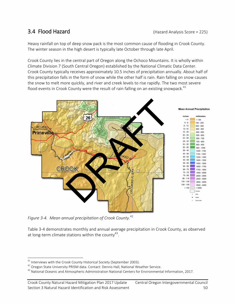
Crook County Natural Hazard Mitigation Plan 2017 Update Central Oregon Intergovernmental Council Section 3 Natural Hazard Identification and Risk Assessment 50
3.4 Flood Hazard (Hazard Analysis Score = 225)
Heavy rainfall on top of deep snow pack is the most common cause of flooding in Crook County. The winter season in the high desert is typically late October through late April. Crook County lies in the central part of Oregon along the Ochoco Mountains. It is wholly within Climate Division 7 (South Central Oregon) established by the National Climatic Data Center. Crook County typically receives approximately 10.5 inches of precipitation annually. About half of this precipitation falls in the form of snow while the other half is rain. Rain falling on snow causes the snow to melt more quickly, and river and creek levels to rise rapidly. The two most severe flood events in Crook County were the result of rain falling on an existing snowpack.41
Figure 3-4. Mean annual precipitation of Crook County.42 Table 3-4 demonstrates monthly and annual average precipitation in Crook County, as observed at long-term climate stations within the county43.
41
Interviews with the Crook County Historical Society (September 2003). 42
Oregon State University PRISM data. Contact: Dennis Hall, National Weather Service. 43
National Oceanic and Atmospheric Administration National Centers for Environmental Information, 2017.
DRAFT

Crook County Natural Hazard Mitigation Plan 2017 Update Central Oregon Intergovernmental Council Section 3 Natural Hazard Identification and Risk Assessment 51
Table 3-4. Monthly and annual average precipitation (inches) in Crook County (1981-2010).
Weather Station
Mean Precipitation (inches)
J F M A M J J A S O N D Annual Barnes Station 44
1.5 1.2 1.1 1.2 1.4 1.0 0.7 0.7 0.6 0.9 1.6 1.9 13.80
Prineville 45 1.1 1.0 0.9 0.9 1.2 0.9 0.6 0.3 0.4 0.8 1.2 1.4 10.68
Table 3-5. Mean snow water equivalent (inches) at month start in Crook County (1981-2010).
SNOTEL Station
Snow Water Equivalent at Month Start (inches)
J F M A M J J A S O N D Derr 46 5.7 9.8 12.8 12.0 1.5 0.0 0.0 0.0 0.0 0.0 0.0 1.9
Ochoco Meadows 8
4.4 7.4 10.0 9.5 0.0 0.0 0.0 0.0 0.0 0.0 0.0 1.8
Snow Mountain 8
3.3 6.3 9.8 12.2 4.2 0.0 0.0 0.0 0.0 0.0 0.0 1.4
The eastern, northern, and southern boundaries of Crook County are mountainous, with a valley in the center of the county. These mountains collect rain and snow and deliver it to Crooked River and Ochoco Creek Valley. Slopes of the surrounding mountains are relatively steep and have shallow, rocky soils. These types of soils have low absorption properties and quickly transport rainwater to the river system. The type and relative amount of vegetation cover dramatically affect how quickly rainwater moves into waterways with heavy vegetation cover slowing the movement of rainwater into the river. When vegetation is reduced or removed, rainwater moves more rapidly into the river system, contributing to higher water levels. Logging, clearing for development, and agricultural practices can all contribute to rapid water level fluctuations in Crook County’s rivers and creeks. Crook County includes numerous areas where development has historically been located within the floodplain. Increased development within the floodplain increases the risk of flood damage to buildings and people. When structures or fill are placed in the floodplain, water is displaced. Development may cause floodwaters to rise higher than before the development was located in the hazard areas. This is particularly true if the development is located within the floodway. Impervious surfaces, including roads, parking areas, and roof structures collect water rapidly and
44
National Oceanic and Atmospheric Administration, National Centers for Environmental Information, 2017. Barnes Station Weather Station, GHCND: USC00350501. https://www.ncdc.noaa.gov/cdo-web/datasets/NORMAL_MLY/stations/GHCND:USC00350501/detail 45
National Oceanic and Atmospheric Administration, National Centers for Environmental Information, 2017. Prineville Weather Station, GHCND: USC00356883. https://www.ncdc.noaa.gov/cdo-web/datasets/NORMAL_MLY/stations/GHCND:USC00356883/detail 46
NRCS National Water and Climate Center SNOTEL Data: https://wcc.sc.egov.usda.gov/reportGenerator/view/customGroupByMonthReport/semimonthly/state=%22OR%22%20AND%20network=%22SNTL%22%20AND%20outServiceDate=%222100-01-01%22%7cname/1980-10-01,1981-09-30:1,3,5,7,9,11,13,15,17,19,21,23/stationId,name,WTEQ::median_1981?submit=View+Normals
DRAFT

Crook County Natural Hazard Mitigation Plan 2017 Update Central Oregon Intergovernmental Council Section 3 Natural Hazard Identification and Risk Assessment 52
44 CFR §201.6 (d)(3) A local jurisdiction must review and revise its plan to reflect changes in development.
transport the water to stormwater systems that may not be designed to mitigate heavy rainfall conditions, which will result in flooding. Crook County Hazard History: prior to 2016 Flooding is a familiar occurrence in Crook County. Over the past 100 years, the county has experienced major flood events on a regular basis. Floods are the most common of all natural hazards, and both Oregon and Crook County have an extensive history of flooding. The frequency of flooding combined with concentrated development along rivers and streams caused millions of dollars in damage to Crook County over the past several decades. The growing population and development activity in the floodplain can increase the risk of flood related damages. The following timeline lists some of the major flood events that have occurred in Crook County.
Crook County Flood Timeline
August 04, 1904: Crooked River floods, destroys crops, shuts down the Prineville Railway, washes away portions of a State Highway.
1918: Flood downtown Prineville, Homes and Businesses damaged. Citizens displaced Both the Crooked River and Ochoco Creek Swell
December 1951, January 1952: Prineville Floods, Crooked River runs well over its banks. Many business and homes damaged 300 People evacuated, 150 home evacuated.
December 1955, January 1956: Prineville floods. Citizens evacuated, homes and businesses damaged.
August 1991: Rural Crook County, Near Post. What was described as the Aspen Valley Flood. Also described as Newsome Creek. Summer Super Cell dumped several inches of rain. Barns and houses demolished, one person killed, one person injured
May 1998: Prineville floods, Ochoco Creek rises beyond flood levels. Federal Disaster Declaration.
Winter 2005: Juniper Canyon flood. Damage to rural infrastructure and property; transportation disruptions.
January 2011: Rural Crook County, near Post and Juniper Canyon. Heavy rainfall, melting snow, and ice-dammed culverts contributed to flood conditions. Damage to rural infrastructure and property; transportation disruptions.
The landmark flood event for Crook County in the last century was the flood of 1952. This flood set most of the record high-water marks for the region. The primary cause of this flood was warm rain on a substantial snowpack. The rain quickly melted the snow, and caused Ochoco Creek and the Crooked River to overrun their banks. All subsequent floods have been compared to this event. The 1952 flood was characterized as a “100-year” flood event, or a flood event
DRAFT

Crook County Natural Hazard Mitigation Plan 2017 Update Central Oregon Intergovernmental Council Section 3 Natural Hazard Identification and Risk Assessment 53
with a return interval of 100 years. A “100- year” flood has a 1% chance of occurring in any given year, or a 26% chance of occurring during the life of a 30-year home mortgage. In May 1998, Crook County experienced another devastating flood. In the weeks preceding the flood, the county received abundant rain and snowfall. A warm and heavily moisture-laden storm front, typical to the Pacific El Nino pattern, followed the abundant snowfall. The warm rain quickly melted the snow pack, and county streams and rivers rapidly filled their channels, exceeding their banks. This particular flood event caused over $16 million in damages to Crook County homes, businesses and infrastructure, including damage to over 1000 properties; over 1000 residents were impacted by the flood47. Vulnerability Assessment Using GIS technology and flow velocity models, it is possible to map the damage that can be expected from flood events; spatial analysis can achieve a high level of detail with identification of individual properties which are likely to be impacted by a flood of a given magnitude. The flood hazard for Crook County and the City of Prineville was identified by FEMA in their Crook County Flood Insurance Rate Maps (FIRMs). These maps were first completed in July 1989. The maps outline the extent of the 100-year, or base, floodplain; the floodplain consists of the area of land which would be impacted by floodwaters in a flood event of this magnitude. These maps are used by FEMA to identify properties that need to purchase flood insurance and, if developed, need to meet floodplain development regulations. FIRMs for Crook County were updated by FEMA in February 2012. These maps were based upon updated information and technology that increased the accuracy of delineating the floodplain and floodway area along the Crooked River and Ochoco River. Updated FIRMs are available at the FEMA Flood Map Service Center48. The Crook County Geographic Information System (GIS) Department has incorporated updated FIRM data into their GIS database. A query was developed to combine floodplain boundaries of 2012 FIRM data with the current certified tax roll for properties within the County. FIRM data were used to identify the flood hazard for the 2017 NHMP update. Figures 3-5, 3-6, and 3-7 below show the spatial distribution of the Crook County 100-year-event floodplain as identified in updated FIRMs. When this information is plotted it can show more specifically where the flood zones are in relation to property and structures. The mapping capability provides detail on a property by property basis and is a significant tool that can be used for many purposes, most importantly compliance with the FEMA Floodplain regulations. Although the scale of the county-wide map shown in Figure 3-5 makes it difficult to identify exact structures which would be impacted in a 100-year flood event, we use this to reference the floodplain data available through the FEMA FIRMs and through Crook County’s GIS system.
47
City of Prineville / Crook County Flood Mitigation Action Plan, Clay Moorhead, CDA Consulting Group Inc. (2000) 48
FEMA Flood Map Service Center. https://msc.fema.gov/portal
DRAFT

Crook County Natural Hazard Mitigation Plan 2017 Update Central Oregon Intergovernmental Council Section 3 Natural Hazard Identification and Risk Assessment 54
Additional flood hazard potential is in regard to the Ochoco Reservoir Dam. In the event of a severe earthquake and associated failure of the Ochoco Reservoir Dam, severe flooding could occur, especially if this event occurred during snowmelt season in May or June.
Figure 3-5. Flood Insurance Rate Map floodplain data are available through the FEMA Flood Map Service Center49 and through Crook County GIS’ Floodplain Comparison Application50. This figure demonstrates the spatial distribution of the 100-year event floodplain in Crook County.
49
FEMA Flood Map Service Center. https://msc.fema.gov/portal 50
Crook County GIS Floodplain Comparison Application. http://geo.maps.arcgis.com/apps/webappviewer/index.html?id=a3525e4075ac4b4dacd388cef3566fa4
DRAFT
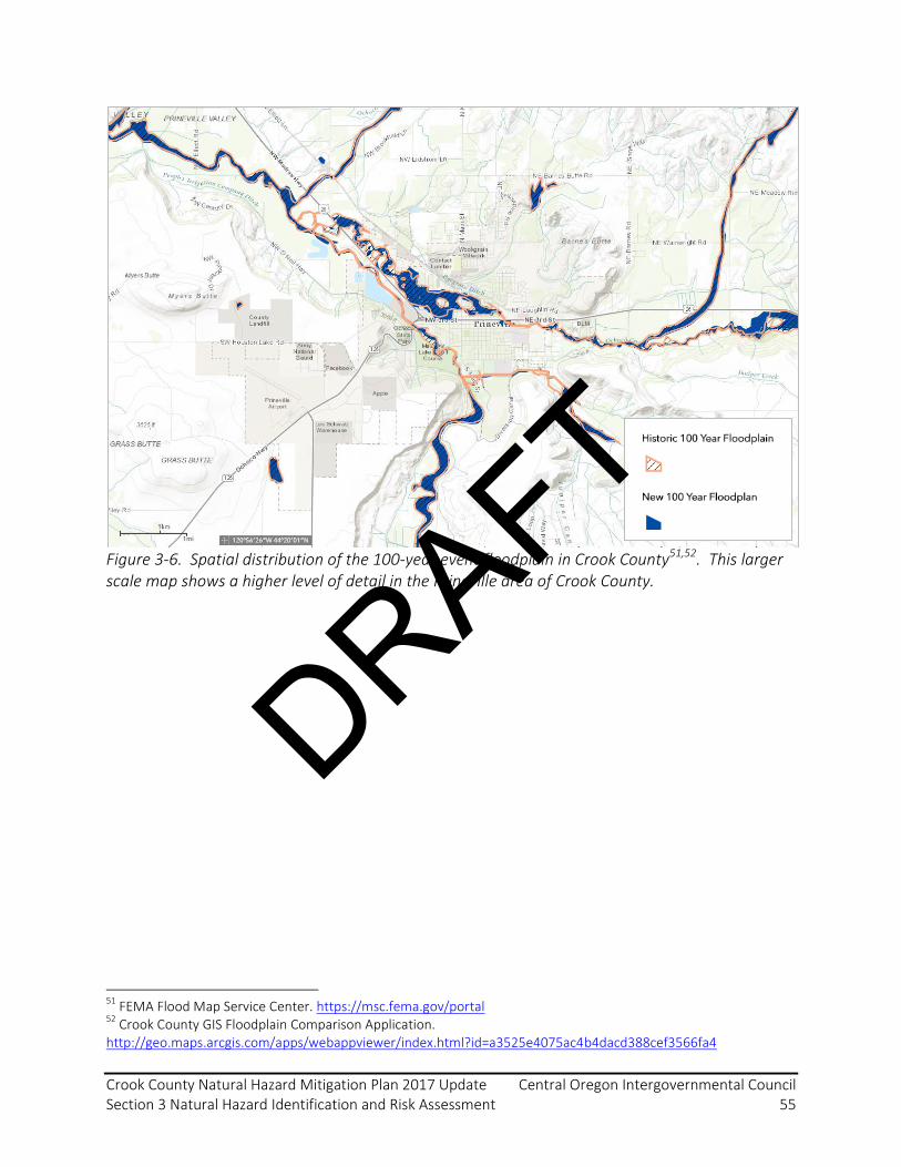
Crook County Natural Hazard Mitigation Plan 2017 Update Central Oregon Intergovernmental Council Section 3 Natural Hazard Identification and Risk Assessment 55
Figure 3-6. Spatial distribution of the 100-year event floodplain in Crook County51,52. This larger scale map shows a higher level of detail in the Prineville area of Crook County.
51
FEMA Flood Map Service Center. https://msc.fema.gov/portal 52
Crook County GIS Floodplain Comparison Application. http://geo.maps.arcgis.com/apps/webappviewer/index.html?id=a3525e4075ac4b4dacd388cef3566fa4
DRAFT

Crook County Natural Hazard Mitigation Plan 2017 Update Central Oregon Intergovernmental Council Section 3 Natural Hazard Identification and Risk Assessment 56
Figure 3-7. The spatial distribution of the 100-year event floodplain in relation to property and structures in Prineville demonstrates the capability of flood impact mapping and spatial analysis53,54. Risk Assessment The floodplain begins as a very narrow strip of land adjacent to the upper tributaries of Ochoco Creek and Crooked River, and steadily increases in width at lower elevations. The floodplain is widest in the center of Prineville and near the confluence of Ochoco Creek and Crooked River. The Ochoco River bisects the City of Prineville and the floodplain location includes urban areas. The Prineville city boundary has expanded in recent years. In 2017, a query was developed through Crook County GIS which used updated corporate boundary lines to select tax lot parcels that intersected the floodplain. This information was cross-referenced to the real market value (improvements component only) for five building types. Through the 2017 NHMP update, a request was made to FEMA and the Oregon Department of Land Conservation and Development (DLCD) to determine if there were any 53
FEMA Flood Map Service Center. https://msc.fema.gov/portal 54
Crook County GIS Floodplain Comparison Application. http://geo.maps.arcgis.com/apps/webappviewer/index.html?id=a3525e4075ac4b4dacd388cef3566fa4
44 CFR §201.6 (c)(3)(ii) All plans must address National Flood Insurance Program insured structures that have been repetitively damaged by floods.
DRAFT
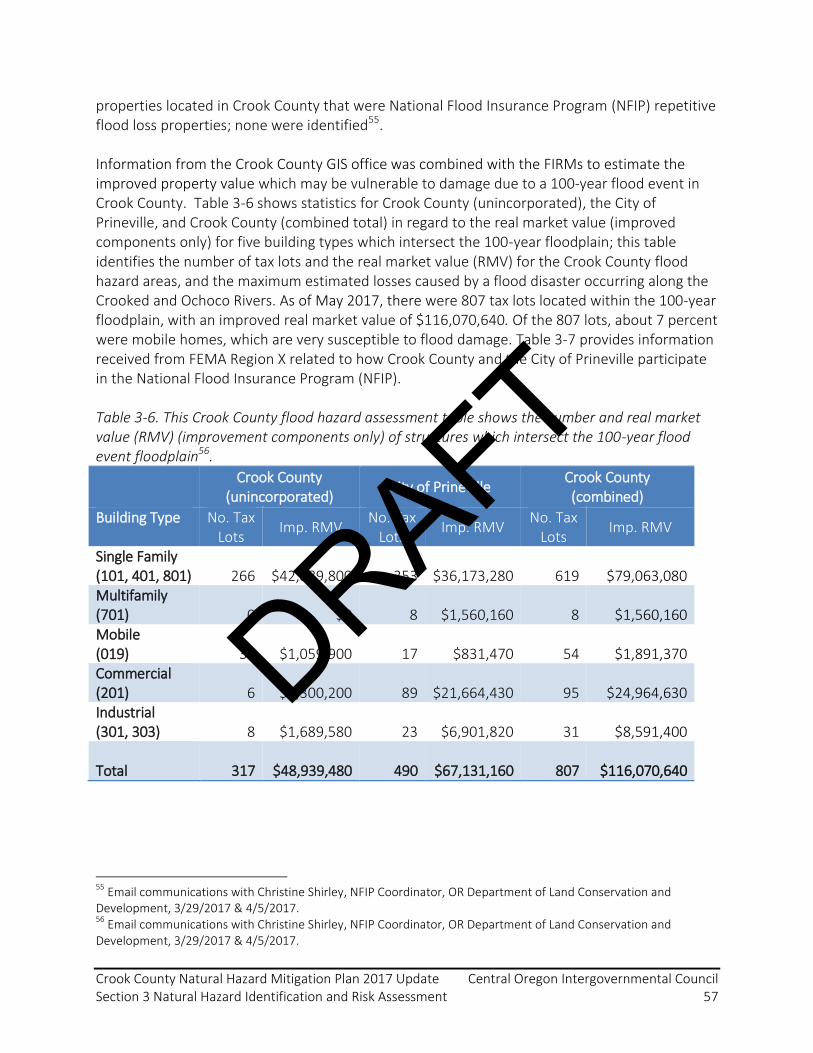
Crook County Natural Hazard Mitigation Plan 2017 Update Central Oregon Intergovernmental Council Section 3 Natural Hazard Identification and Risk Assessment 57
properties located in Crook County that were National Flood Insurance Program (NFIP) repetitive flood loss properties; none were identified55. Information from the Crook County GIS office was combined with the FIRMs to estimate the improved property value which may be vulnerable to damage due to a 100-year flood event in Crook County. Table 3-6 shows statistics for Crook County (unincorporated), the City of Prineville, and Crook County (combined total) in regard to the real market value (improved components only) for five building types which intersect the 100-year floodplain; this table identifies the number of tax lots and the real market value (RMV) for the Crook County flood hazard areas, and the maximum estimated losses caused by a flood disaster occurring along the Crooked and Ochoco Rivers. As of May 2017, there were 807 tax lots located within the 100-year floodplain, with an improved real market value of $116,070,640. Of the 807 lots, about 7 percent were mobile homes, which are very susceptible to flood damage. Table 3-7 provides information received from FEMA Region X related to how Crook County and the City of Prineville participate in the National Flood Insurance Program (NFIP). Table 3-6. This Crook County flood hazard assessment table shows the number and real market value (RMV) (improvement components only) of structures which intersect the 100-year flood event floodplain56.
Crook County (unincorporated)
City of Prineville Crook County (combined)
Building Type No. Tax Lots
Imp. RMV No. Tax
Lots Imp. RMV
No. Tax Lots
Imp. RMV
Single Family (101, 401, 801) 266 $42,889,800 353 $36,173,280 619 $79,063,080 Multifamily (701) 0 $0 8 $1,560,160 8 $1,560,160 Mobile (019) 37 $1,059,900 17 $831,470 54 $1,891,370 Commercial (201) 6 $3,300,200 89 $21,664,430 95 $24,964,630 Industrial (301, 303) 8 $1,689,580 23 $6,901,820 31 $8,591,400 Total 317 $48,939,480 490 $67,131,160 807 $116,070,640
55
Email communications with Christine Shirley, NFIP Coordinator, OR Department of Land Conservation and Development, 3/29/2017 & 4/5/2017. 56
Email communications with Christine Shirley, NFIP Coordinator, OR Department of Land Conservation and Development, 3/29/2017 & 4/5/2017.
DRAFT

Crook County Natural Hazard Mitigation Plan 2017 Update Central Oregon Intergovernmental Council Section 3 Natural Hazard Identification and Risk Assessment 58
Table 3-7. Information regarding the participation of Crook County and the City of Prineville in FEMA’s National Flood Insurance Program57. FIRM = Flood Insurance Rate Map. Rep. = repetitive. CAV = Community Assistance Visits.
Jurisdiction Current FIRM Date
Initial FIRM
CAV Date
Total Paid Losses
Substantial Damage Claims
Rep. Losses
Severe Rep. Losses
Total Policies
Pre-FIRM Policies
Crook County (unincorp.)
Feb. 2012
July 1989
May 1999 11 0 0 0 65 34
City of Prineville
Feb. 2012
July 1989
May 1999 37 3 0 0 134 74
Crook County finds that, as can be noted from Table 3-1, flood hazards scored as the second-highest overall risk score with 225 points out of a total 240 possible points. This is supported by the fact that there have been more frequent and more severe impacts associated with flood occurrence. This is compounded by a high probability of a reoccurrence occurring within the next 10-35-year time period. Historically, significant development and urban populations have located within flood prone areas of Crook County. As such, the vulnerability and maximum threat from this natural hazard type is high.
57
Email communications with Christine Shirley, NFIP Coordinator, OR Department of Land Conservation and Development, 3/29/2017 & 4/5/2017.
DRAFT

Crook County Natural Hazard Mitigation Plan 2017 Update Central Oregon Intergovernmental Council Section 3 Natural Hazard Identification and Risk Assessment 59
3.5 Wildland Fire Hazard (Hazard Analysis Score = 185)
Wildland fire is a significant natural hazard in Central Oregon due to its frequency and severe impacts. While Crook County has experienced only a few large wildland-urban-interface (WUI) fires within the last seven years, it has been the setting for many smaller fires with significant potential for major impact on WUI areas and critical infrastructure. Neighboring counties have experienced numerous, high impact WUI fire incidents providing Crook County emergency managers insight into the complexities of such incidents. Crook County residential development is expanding further into sites traditionally covered by wildland vegetation bringing with it the potential for the WUI fire scenarios envisioned by Congress when they passed the “Healthy Forest Restoration Act of 2003.”58 The escalating size and intensity of these interface fires is the subject of continuing research in several scientific disciplines. These include the arenas of forest health, hazardous fuels treatment, and community infrastructure protection as well as study of the impoacts of climate change. These issues are likewise the subject of significant public discourse. Over the last two decades, community awareness has developed substantially regarding the interface fire threat as well as interest and involvement in issues of hazardous fuels treatment activities. Increases in large fires in recent years have heightened community awareness and willingness to address fire safety. Central Oregon population growth has become a companion issue. Between 2000 and 2010, Crook County’s population grew by 9.4% to 20,978 with an additional 2.9% population growth to 21,580 between 2010 and 201659. Continued population growth is expected in Crook County with a projected 18.8% increase to 25,640 residents by year 206560. Population growth will have significant impacts on citizen exposure and infrastructure vulnerability to wildland fire.61 Wildfire hazard assessments have traditionally been conducted by individual jurisdictional agencies and organizations, and in many cases have been driven by local rural fire protection district boards of directors, county ordinance, and for wildland agencies state or federal law, regulation, policy, or directives. In Deschutes County, hazard assessments in a variety of forms have been previously completed by individual fire districts. The outputs from these assessments have been incorporated into agency response plans and into Community Wildfire Protection Plans. The Oregon Department of Forestry identified Deschutes County as one of two pilot counties for implementation of the
58
“Healthy Forests Restoration Act of 2003” (H.R. 1904); One Hundred Eighth Congress; Administrative implementation information available on the National Fire Plan website, www.fireplan.gov. 59
U.S. Census Bureau, 2010. 60
Coordinated Population Forecast 2015 – 2065: Crook County. Portland State University Population Research Center. https://www.pdx.edu/prc/sites/www.pdx.edu.prc/files/Crook_Forecast_Report_201506.pdf 61
U.S. Bureau of Census, 2000. Population of Oregon and it’s Counties and Incorporated Places, Public Law 94-171 Redistricting Data, prepared by the Office of Economic Analysis, Dept of Administrative Services, State of Oregon.
DRAFT

Crook County Natural Hazard Mitigation Plan 2017 Update Central Oregon Intergovernmental Council Section 3 Natural Hazard Identification and Risk Assessment 60
Oregon Forestland-Urban Interface Fire Protection Act of 1997, also known as Senate Bill 360 (SB-360).62 The implementation process contained an extensive wildfire hazard identification component which has been embodied in Oregon Administrative Rule. This system is becoming applicable throughout the state in “wildland-urban interface areas” as defined by the statute. SB-360 has been implemented in Crook County. The mitigation treatment standards of the Crook County Fire Ready program were derived from the SB-360 standards so that there is now one defensible space treatment standard county-wide. Figure 3-8 illustrates Crook County precipitation patterns, the rain shadow effect from the Cascades Mountains, and effect of the higher elevation of the Ochoco Mountains. Table 3-8 shows Crook County precipitation patterns as observed at long-term climate stations.
Figure 3-8. Mean annual precipitation of Crook County, 1981-201042.
62
ORS 477.015-477.061
DRAFT

Crook County Natural Hazard Mitigation Plan 2017 Update Central Oregon Intergovernmental Council Section 3 Natural Hazard Identification and Risk Assessment 61
Table 3-8. Monthly and annual average precipitation (inches) in Crook County (1981-2010).
Weather Station
Mean Precipitation (inches)
J F M A M J J A S O N D Annual Barnes Station 63
1.5 1.2 1.1 1.2 1.4 1.0 0.7 0.7 0.6 0.9 1.6 1.9 13.80
Prineville 64 1.1 1.0 0.9 0.9 1.2 0.9 0.6 0.3 0.4 0.8 1.2 1.4 10.68
Table 3-9. Mean snow water equivalent (inches) at month start in Crook County (1981-2010).
SNOTEL Station
Snow Water Equivalent at Month Start (inches)
J F M A M J J A S O N D Derr 65 5.7 9.8 12.8 12.0 1.5 0.0 0.0 0.0 0.0 0.0 0.0 1.9
Ochoco Meadows 21
4.4 7.4 10.0 9.5 0.0 0.0 0.0 0.0 0.0 0.0 0.0 1.8
Snow Mountain 21
3.3 6.3 9.8 12.2 4.2 0.0 0.0 0.0 0.0 0.0 0.0 1.4
Tri-County Large Fire History: 1990 - 2010 Tables 3-10 and 3-11 list some of the larger wildland fires in the tri-county (Crook, Deschutes and Jefferson) area that necessitated an emergency management response beyond that of the local wildland fire and natural resource agencies. Since the 1990 Awbrey Hall fire, the local structural and wildland fire services have substantially refined the emergency response system for these types of destructive interface fires. Under the leadership of the Central Oregon Fire Chief’s Association, the pre-planned interface fire mutual aid and task force system has effectively integrated the operational response process for structural and wildland fire fighting resources from all three counties. This response system is recognized as one of the most effective interagency efforts in the state. As is the case with the regional focus of tables below, much of Section 3.5 of this plan is presented with a regional focus on Crook, Deschutes and Jefferson counties. The scope and multi-jurisdictional nature of the local wildfire demand has driven development of a regional approach to pre-incident planning, training, initial and reinforced response, and recovery activities. The benefit of this type of coordinated approach is broadly acknowledged by fire service leadership as essential to meeting the local wildfire challenge.
63
National Oceanic and Atmospheric Administration, National Centers for Environmental Information, 2017. Barnes Station Weather Station, GHCND: USC00350501. https://www.ncdc.noaa.gov/cdo-web/datasets/NORMAL_MLY/stations/GHCND:USC00350501/detail 64
National Oceanic and Atmospheric Administration, National Centers for Environmental Information, 2017. Prineville Weather Station, GHCND: USC00356883. https://www.ncdc.noaa.gov/cdo-web/datasets/NORMAL_MLY/stations/GHCND:USC00356883/detail 65
NRCS National Water and Climate Center SNOTEL Data: https://wcc.sc.egov.usda.gov/reportGenerator/view/customGroupByMonthReport/semimonthly/state=%22OR%22%20AND%20network=%22SNTL%22%20AND%20outServiceDate=%222100-01-01%22%7cname/1980-10-01,1981-09-30:1,3,5,7,9,11,13,15,17,19,21,23/stationId,name,WTEQ::median_1981?submit=View+Normals
DRAFT
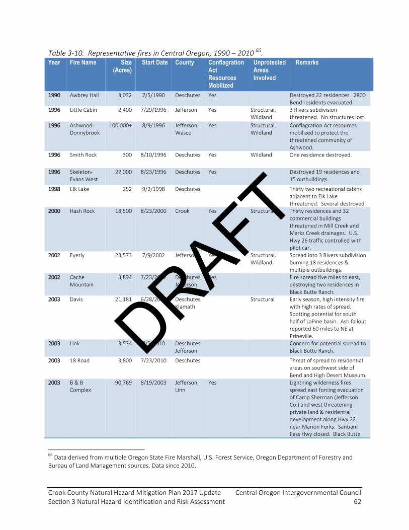
Crook County Natural Hazard Mitigation Plan 2017 Update Central Oregon Intergovernmental Council Section 3 Natural Hazard Identification and Risk Assessment 62
Table 3-10. Representative fires in Central Oregon, 1990 – 2010 66. Year Fire Name Size
(Acres) Start Date County Conflagration
Act Resources Mobilized
Unprotected Areas Involved
Remarks
1990 Awbrey Hall 3,032 7/5/1990 Deschutes Yes Destroyed 22 residences. 2800 Bend residents evacuated.
1996 Little Cabin 2,400 7/29/1996 Jefferson Yes Structural, Wildland
3 Rivers subdivision threatened. No structures lost.
1996 Ashwood- Donnybrook
100,000+ 8/9/1996 Jefferson, Wasco
Yes Structural, Wildland
Conflagration Act resources mobilized to protect the threatened community of Ashwood.
1996 Smith Rock 300 8/10/1996 Deschutes Yes Wildland One residence destroyed.
1996 Skeleton-Evans West
22,000 8/23/1996 Deschutes Yes Destroyed 19 residences and 15 outbuildings.
1998 Elk Lake 252 9/2/1998 Deschutes Thirty two recreational cabins adjacent to Elk Lake threatened. Several destroyed.
2000 Hash Rock 18,500 8/23/2000 Crook Yes Structural Thirty residences and 32 commercial buildings threatened in Mill Creek and Marks Creek drainages. U.S. Hwy 26 traffic controlled with pilot car.
2002 Eyerly 23,573 7/9/2002 Jefferson Yes Structural, Wildland
Spread into 3 Rivers subdivision burning 18 residences & multiple outbuildings.
2002 Cache Mountain
3,894 7/23/2002 DeschutesJefferson
Yes Fire spread five miles to east, destroying two residences in Black Butte Ranch.
2003 Davis 21,181 6/28/2010 DeschutesKlamath
Structural Early season, high intensity fire with high rates of spread. Spotting potential for south half of LaPine basin. Ash fallout reported 60 miles to NE at Prineville.
2003 Link 3,574 7/5/2010 DeschutesJefferson
Concern for potential spread to Black Butte Ranch.
2003 18 Road 3,800 7/23/2010 Deschutes Threat of spread to residential areas on southwest side of Bend and High Desert Museum.
2003 B & B Complex
90,769 8/19/2003 Jefferson, Linn
Yes Lightning wilderness fires spread east forcing evacuation of Camp Sherman (Jefferson Co.) and west threatening private land & residential development along Hwy 22 near Marion Forks. Santiam Pass Hwy closed. Black Butte
66
Data derived from multiple Oregon State Fire Marshall, U.S. Forest Service, Oregon Department of Forestry and Bureau of Land Management sources. Data since 2010.
DRAFT

Crook County Natural Hazard Mitigation Plan 2017 Update Central Oregon Intergovernmental Council Section 3 Natural Hazard Identification and Risk Assessment 63
Ranch was threatened as the fire moved south.
2007 GW 7,357 8/31/2007 Deschutes Yes Structural, Wildland
1221 dwelling structures saved, 50 threatened, zero destroyed
2007 Mile Post 8 120 9/27/2007 Crook Structural, Wildland
1 dwelling structures saved, 1 threatened, zero destroyed
2008 S Summit Springs Complex
1,745 8/17/2008 Jefferson Structural, Wildland
12 dwelling structure saved, 15 threatened, zero destroyed
2008 Juniper Butte
40 7/19/2008 Crook Structural, Wildland
5 dwelling structures saved, 5 threatened, zero destroyed.
2010 Rooster Rock 6,037 8/2/2010 Deschutes Yes Structural, Wildland
14 dwelling structures saved, 20 threatened, zero destroyed
Table 3-11. WUI Fires in Central Oregon, 2011 – 2016 67,68. Year Fire Name Size
(Acres) Start Date County Conflagration
Act Resources Mobilized
Unprotected Areas Involved
Remarks
2012 Pole Creek 26,119 9/9/2012 Deschutes No No Lightning-caused wilderness fire that impacted the community of Sisters and high recreation use areas for several weeks.
2014 Fox 9,955 Crook No NA NA
2014 Two Bulls 6,906 6/7/2014 Deschutes Yes No This fire was extremely close to the western boundary of the City of Bend 260 structures saved, 260 threatened, zero destroyed
2014 Center 2,515 7/13/2014 Crook No NA NA
2014 Donnybrook 20,763 7/13/2014 Jefferson No NA NA
2015 Corner Creek 25,660 6/29/2015
Multiple, including Crook
No NA Early season, lightning-caused fire which impacted multiple jurisdictions as well as Greater sage-grouse habitat
2015 Cove Fire 282 August Jefferson No NA 2 homes lost
2015 County Line 2
67,207 8/12/2015 Multiple, including Jefferson
Yes NA 1,077 structures saved, 1084 threatened, 7 destroyed
2016 Akawana 2,094 6/7/2016 Deschutes Yes No Early season, lightning-caused fire in the wildland urban interface 912 structures saved, 912 structures threatened, zero destroyed
67
Email communication from Lauren Miller, Fire/Fuels Planning Support, Central Oregon Fire Management Service, U.S. Forest Service. Communication: 3/10/2017. 68
Adam Barnes, Assitant Unit Forester, Oregon Department of Forestry. Email communication on 5/8/2017.
DRAFT

Crook County Natural Hazard Mitigation Plan 2017 Update Central Oregon Intergovernmental Council Section 3 Natural Hazard Identification and Risk Assessment 64
Vulnerability Assessment The Crook County Community Wildfire Protection Plan (CWPP) was adopted in June 2005, and updated in 2007 and again in 2014. The CWPP describes numerous areas where Crook County is vulnerable to wildfire, with these areas are designated as having “high” or “extreme” hazard ratings.69 The 2014 CWPP describes a residential boom in Crook County in the 2000s with associated increases in housing units as well as increases in economic infrastructure during recovery from the economic collapse in 2008/2009; these increases in residential and economic infrastructure have expanded the county’s WUI, exposing more residents and infrastructure to risks posed by wildfire69. Vulnerability to fire is caused by numerous conditions. The Crook County CWPP states that most of the wildland-urban interface (WUI) areas occur in sites dominated by either Juniper/sage/grass or Ponderosa pine/dry fir70. Climate and weather as well as development within the WUI all have a significant impact on wildfire vulnerability. Additionally, transportation routes such as roads have a large impact on fire response, including mitigation efforts and evacuation. Crook County communities that have the potential to be impacted by wildfire include:
City of Prineville
Powell Butte
Paulina
Rager Ranger Station
Ochoco Reservoir
Mill Creek
Marks Creek
McKay Creek
Ochoco West
Prineville Reservoir
Juniper Acres Risk Assessment The information above and in Table 3-10 illustrates not only the escalating size of large wildland fires in Central Oregon, but also the increasing impact on the citizens, values-at-risk, and infrastructure of the counties. The fuels, weather, and development conditions that have driven large, high impact wildland interface fires in Deschutes and Jefferson counties are also present in Crook County. Between 1981 - 2003, 82 homes were consumed in nine wildfires within the
69
Crook County Community Wildfire Protection Plan. (2014). https://newcoic.files.wordpress.com/2013/10/crook-county-cwpp-2014_reduced-size-for-web.pdf 70
Crook County Community Wildfire Protection Plan. (2014). https://newcoic.files.wordpress.com/2013/10/crook-county-cwpp-2014_reduced-size-for-web.pdf
DRAFT

Crook County Natural Hazard Mitigation Plan 2017 Update Central Oregon Intergovernmental Council Section 3 Natural Hazard Identification and Risk Assessment 65
Upper Deschutes Basin Fire Learning network boundary71. Only 2 homes were consumed in one wildfire between 2003 and 2016 in Crook, Jefferson, and Deschutes Counties72.
The County finds that there is an extensive history of wildland fires in and around Crook County. But because these fires occur more often in rural areas, the County has seen moderate impacts. With increases in population, especially within WUI areas, these impacts may increase the county’s vulnerability and maximum threat in future years. The county will likely be impacted by a significant wildland fire within the next ten to 35 years. Table 3-12. Acres burned by large fires within the Upper Deschutes Basin Fire Learning Network (UDBFLN) boundaries, 1900 – 200573
. This table demonstrates that more acres were burned by catastrophic wildfires within the boundaries of the UDFLN in 2000-2005 than in the previous century.
Time Period Acres Burned
1900-1999 127,162 2000-2005 128,817
One of the significant issues to reduce risk is the progress in hazardous vegetation treatment that Crook County has made with the assistance of FEMA PDM grants, Crook County-Fire Ready and the development of the Rangeland Fire Associations in the east county. These efforts have helped to address some of the unprotected lands issues. Since 2010, there has been 910 acres of fuels treatment within Crook County74. The CWPP identifies six geographical risk assessment areas, each containing communities and multiple components of critical infrastructure. These are identified as:
1. Powell Butte 2. McKay 3. Juniper Canyon 4. Maurys 5. Paulina 6. Twelve Mile
The CWPP includes an assessment for each risk assessment area. Hazard and protection priorities are identified for each area. The CWPP provides a numerical scoring for identified hazard locations to prioritize that have the higher vulnerability and risk.
71
Central Oregon Fire Atlas. 72
Adam Barnes, Assistant Unit Forester, Oregon Department of Forestry. Email communication on 5/8/2017. 73 Crook County NHMP, 2010. (Central Oregon Fire Atlas (original source) not available with updated information during the 2017 update process). 74 Email communication with Stu Otto, Oregon Department of Forestry Stewardship Forester, and Adam Barnes, Oregon Department of Forestry Assistant Unit Forester on 5/10/2017.
DRAFT

Crook County Natural Hazard Mitigation Plan 2017 Update Central Oregon Intergovernmental Council Section 3 Natural Hazard Identification and Risk Assessment 66
3.6 Severe Weather Events Hazard (Hazard Analysis Score = 170)
Crook County is threatened by hazards generated from weather conditions almost every year. Storms bring heavy rains, strong winds, hail, and occasionally ice and snow. Flooding and landslides can also accompany severe storms. Damaging storms are most common from October through April. Severe storms can create conditions that disrupt essential regional systems such as public utilities, telecommunications, and transportation routes. Wind, snow, and ice associated with severe winter storms can knock down or otherwise damage trees, power lines, and utility services. Freezing winter temperatures can damage agricultural crops and utilities. Lightning poses a risk to life and can result in property damage. Although not storm-based, drought is another type of severe weather event which affects Crook County, and can have extensive impacts on agriculture and water availability. Weather hazards cause damage to private property and public infrastructure, and occasionally cause injury or death. Severe storms affect all parts of Crook County. However, the varied elevations and topography of the County mean that the impact of a storm is variable depending on the location. The Ochoco Mountains, located within the center and eastern portions of the County, regularly receive the highest amounts of snowfall, and the strongest wind gusts in the County. The Cascade Mountain range to the west of the County blocks much of the potential rainfall in the area. The most frequent severe weather-related hazards in the Crook County are snow, wind, ice, and freezing temperatures. Occasionally, storms from the Pacific bring rain during the warmer months with most severe rainstorms coming in the form of thunderstorms. While tornadoes are very infrequent and pose a relatively small risk to Crook County, there is a slight potential for this hazard as well. The geographic extent of severe weather events covers all of Crook County, however, no spatial data are available to map extreme weather occurrences in Crook County. The nature of this hazard varies by location, with elevation playing a large role in spatial distribution. Although severe storm conditions are more hazardous at higher elevations, population centers generally concentrated at lower elevations are at high risk of this hazard. Localized and flash flooding, snow, ice, hail, lightning, and high winds associated with severe weather events put people and property at risk. Even lower wind speeds typical in the lower valleys of Crook County are enough to knock down trees and power lines and cause other property damage. Despite a lack of wind speed data for higher elevations, it is clear that the mountainous portions of the county experience much higher winds, under more varied conditions. A basic level of wind hazard can be assumed for every location in the county where trees can be found. The damage sustained by a winter storm and other severe weather hazards is very dependent on types and numbers of existing and future buildings, infrastructure, and critical facilities located in the identified hazard areas. Changes in vegetation, soil grading, storm water systems, the
DRAFT

Crook County Natural Hazard Mitigation Plan 2017 Update Central Oregon Intergovernmental Council Section 3 Natural Hazard Identification and Risk Assessment 67
amount of impermeable surface, etc. can impact the likelihood and degree of winter storm hazards. Hail storms also pose a risk to people and property in Crook County. Table 3-13 shows recently recorded hail storms in Crook County. Hazard History: 2005 – 2016 Table 3-13. Storm data and unusual weather phenomenon in Crook County, 2008 – 2015 75.
Year / Month Location Type Remarks
July 2008 Prineville Hail Hail: 0.75 inch diameter August 2008 Prineville 10-mile
radius Hail Hail: 0.75 – 1 inch diameter
June 2009 Prineville 5-mile radius
Heavy Rain, Hail, Wind
Water covering road, damaging wind, large hail
July 2009 Prineville 10-mile radius
Hail Hail: 1 inch diameter
August 2009 Prineville 10-mile radius
Wind, Hail Hail: 0.88 inch diameter, damaging winds
January 2011 Post 5-mile radius Ice, Rain Flood due to ice dam, warm temperatures
Vulnerability Assessment While a quantitative vulnerability assessment (an assessment that describes number of lives or amount of property exposed to the hazard) has not yet been conducted for Crook County windstorm, winter storm, and other severe weather events, there are many qualitative factors (issues relating to what is in danger within a community) that point to potential vulnerability. Severe weather can cause power outages, transportation and economic disruptions, significant property damage, and pose a high risk for injuries and loss of life. The event can also be typified by a need to shelter and care for individuals impacted by the event. Several destructive severe weather events have brought economic hardship and affected the life safety of county residents. Future events may carry similar impacts county-wide. Severe Winter Storms Crook County has severe winter storms that occur with regularity, although none have been noted to be on the magnitude of a national disaster. Higher elevations have greater exposure to snow and ice, but may be less economically vulnerable, because they are sparsely populated. Roads may be closed longer in more isolated areas, and extreme snowfall or flash flood events may simply be more dangerous in the mountains. Outreach programs, emergency communications systems, and special emergency response plans may be the most effective ways to reduce vulnerability in outlying areas of the County.
75
Email communication with Dennis Hall, National Weather Service on 3/28/2017.
DRAFT

Crook County Natural Hazard Mitigation Plan 2017 Update Central Oregon Intergovernmental Council Section 3 Natural Hazard Identification and Risk Assessment 68
Windstorms Every location in the county is exposed to some level of windstorm-related hazards, and each location is vulnerable to the extent that trees are in close proximity to a structure, road, power line, or other critical infrastructure. Because of Crook County's high elevation, many of its residents are often exposed to high winds, especially during the winter months and during summer thunderstorms. Certain properties or facilities are vulnerable because of an inherent susceptibility to wind damage, perhaps at certain critical times. As with severe winter storms, Crook County's higher elevations have greater exposure to high winds, but may be less economically vulnerable than other regions of the state because of its low population levels. Risk Assessment Crook County has a history of severe storms, but to date these storm have not cause severe impacts to Crook County populations or property. Based upon the experiences documented within this plan, the county finds that there is moderate risk associated with the devastating impact of a severe winter storm hazard, and the vulnerability and maximum threat to property and populations within the County to also be moderate. The Crook County Hazard Analysis Matrix Table 3-1 describes the values placed on the overall risk associated with this natural hazard.
DRAFT

Crook County Natural Hazard Mitigation Plan 2017 Update Central Oregon Intergovernmental Council Section 3 Natural Hazard Identification and Risk Assessment 69
3.7 Volcano Hazard (Hazard Analysis Score = 163)
Volcanoes are present in Washington, Oregon, and California where volcanic activity is generated by continental plates moving against each other (Cascadia Subduction Zone movement). Because the population of the Pacific Northwest is rapidly expanding, volcanoes of the Cascade Range are now considered some of the most dangerous in the United States. Crook County sits east of all of the Cascade Range Volcanoes. The terrain between Crook County and its closest volcanic threats; Newberry Crater, Mt. Bachelor, Broken Top, Three Sisters, Mt. Jefferson and Mt. Hood makes for a very low probability that a lahar would affect Crook County76. However, lava flows are a possibility in Crook County, especially in the southern and western portions of the county77. Volcanic eruptions can send ash airborne with wind spreading the ash for many miles, putting Crook County at risk for ash fall from volcanic eruptions nearly anywhere in the Cascades78. An erupting volcano can also trigger flash floods, earthquakes, rockfalls, and mudflows. Volcanic ash can contaminate water supplies, cause electrical storms, and collapse roofs. Additionally, volcanic ash can have significant impacts on air quality, thereby creating risks for human health. The nature of volcanic eruptions is such that the immediate danger area covers approximately a 20-mile radius from the eruptive origin, but danger can also extend 100 miles or more from a volcano. Since Crook County falls outside of the 20-mile immediate threat area, our main hazard will be ash fall from Volcanoes as far north as Mount St. Helens to as far south as Mount Shasta. Businesses and individuals can make plans to respond to volcano emergencies. Planning is prudent because once an emergency begins, public resources can often be overwhelmed, and citizens may need to provide for themselves and make informed decisions. Knowledge of volcano hazards can help citizens make a plan of action based on the relative safety of areas around home, school, and work. Hazard History: prior to 2005 Although lava rock is relatively easy to find in Crook County, there have been no recent volcanic events in Crook County. The last volcanic eruption happened hundreds of thousands of years ago. This eruption created the basaltic rock that is seen in the Crook River canyon below Bowman Dam.
76
Email communication on 3/30/2017 with Daniele McKay, Natural Resources Instructor, Oregon State University Cascades. 77
Email communication on 3/30/2017 with Daniele McKay, Natural Resources Instructor, Oregon State University Cascades. 78
Email communication on 3/30/2017 with Daniele McKay, Natural Resources Instructor, Oregon State University Cascades.
DRAFT

Crook County Natural Hazard Mitigation Plan 2017 Update Central Oregon Intergovernmental Council Section 3 Natural Hazard Identification and Risk Assessment 70
The closest recent eruption occurred at Mount St. Helens beginning on May 18, 1980. Following two months of earthquakes and minor eruptions and a century of dormancy, Mount St. Helens in Washington, exploded in one of the most devastating volcanic eruptions of the 20th century. Although less than 0.1 cubic mile of magma was erupted, 58 people died, and damage exceeded 1.2 billion dollars. Fortunately, most people in the area were able to evacuate safely before the eruption because the U.S. Geological Survey (USGS) and other scientists had alerted public officials to the danger. As early as 1975, USGS researchers had warned that Mount St. Helens might soon erupt. Coming more than 60 years after the last major eruption in the Cascades (Lassen Peak), the explosion of St. Helens was a spectacular reminder that the millions of residents of the Pacific Northwest share the region with live volcanoes. The eruption of Mount St. Helens caused heavy damage and disruption to businesses and other essential services throughout Washington and much of Oregon. If one of the central Cascade Volcanoes erupted the impacts to people and property would be severe. Hazard History: 2005 – 2016 Contacts were made to state and federal agencies during the 2005 review process to inquire about data relating to volcanic activity during this time period. No documented volcanic activity was reported by these agencies for any volcanic activity in proximity to Crook County for this time period. The 2017 NHMP Steering Committee, including a Crook County geologist, discussed the hazard history since 2010, and concluded that no additional significant volcanic activity has occurred in the 2010 – 2016 time period. Vulnerability Assessment Mount St. Helens is a tephra (ash) producing volcano. According to a USGS publication79, the most serious tephra hazards in the region are due to Mount St. Helens, the most prolific producer of tephra in the Cascades during the past few thousand years. The report exhibits a probability map that identifies that Crook County has an annual probability of receiving an accumulation of 10 centimeters or more of tephra accumulation at 0.01% or less80. Data was not available at the time of this update to determine the specific vulnerability to the types and numbers of existing or future buildings, infrastructure and critical infrastructure. According to a report prepared by John R. Labadie entitled Volcanic Ash Effects and Mitigation81, “volcanic ash is abrasive, mildly corrosive, and conductive (especially when wet); it may also carry a high static charge for up to two days after being ejected from a volcano. The ash is easily entrained in the air by wind or vehicle movement and may remain suspended in the air for many minutes. Due to the combination of these qualities, volcanic ash is pervasive. It can penetrate all but the most tightly-sealed enclosures”. Ash can have a significant impact on all forms of activity including public health, transportation, traffic, utilities, critical infrastructure, electronics,
79
W.E. Scott, R.M. Iverson, J.W. Vallance, and W. Hildreth, 1995, Volcano Hazards in the Mount Adams Region, Washington: U.S. Geological Survey Open-File Report 95-492 80
http://vulcan.wr.usgs.gov/Volcanoes/Cascades/Hazards/ash_accumulation_10cm.html 81
The full report is included in the Hazard Background appendix
DRAFT

Crook County Natural Hazard Mitigation Plan 2017 Update Central Oregon Intergovernmental Council Section 3 Natural Hazard Identification and Risk Assessment 71
and others. Specifically, suspended and ground ash could significantly impair aviation and ground transportation activities; with decreased function of air transportation, emergency response and other regional and beyond-region transportation, various activities could be significantly impacted. Crook County has other vulnerabilities associated with volcanic impacts in addition to ash-related impacts. For example, if Mt. Hood or another regional volcano had a warm thaw, the associated flooding could cause large mud flows to come off of the mountain. This type of hazard could disrupt transportation, causing more people to be in Central Oregon 82. Risk Analysis The likelihood or magnitude of a volcanic eruption cannot be forecast with confidence83. However, if an eruption of significant magnitude occurs, the volcanic ash cloud and fallout could be a high hazard for Crook County, and the most likely risk appears to be from ash accumulation, with a chance of accumulation being very low in any given year. Seismic activity (shown in the chapter on earthquake hazard) identifies numerous and regular earthquake activity within the Pacific Northwest. No specific earthquake data was identified for Crook County. As such it is concluded that Crook County faces no immediate and direct threat from a volcanic eruption and therefore has a low probability of threat. The County does have an indirect risk of ash accumulation that could have broad ranging impacts. Through the research and discovery phase of this update, there was insufficient data available to determine losses associated with a volcanic hazard event. This does not mean that such an eruption could not occur in any given year. Crook County must remain vigilant to the possibilities of a volcanic disaster.
82
Personal communication on 3/29/2017 with Carrie Gordon, USFS Geologist, Ochoco National Forest & DOGAMI website. 83
John R. Labadie entitled Volcanic Ash Effects and Mitigation
DRAFT

Crook County Natural Hazard Mitigation Plan 2017 Update Central Oregon Intergovernmental Council Section 3 Natural Hazard Identification and Risk Assessment 72
3.8 Landslide Hazard (Hazard Analysis Score = 132)
Landslides are defined as any detached mass of soil, rock, or debris that moves down a slope or a stream channel. Seldom if ever, can a landslide be attributed to a single cause. All landslides involve the failure of the earth under stress. Landslides are typically triggered by periods of heavy rainfall and/or rapid snowmelt. Earthquakes, volcanoes, and excavations may also trigger them. Also, an intense wildfire may destroy vegetation and affect organic material so that with even normal rainfall, soil saturation may trigger a landslide. Locations with extremely steep slopes are most susceptible to landslides. Landslides on these slopes tend to move more rapidly and can be more dangerous than other landslides. Landslides are particularly common along stream banks, reservoir shorelines, and large lakes. Although landslides are natural geologic processes, their incidence and impact on people and property can be exacerbated by human activities such as excavation and grading, drainage and groundwater alterations, and changes in vegetation. Property damage from landslides throughout Oregon, including Crook County, continues to rise, in part due to increased development. Rapidly moving landslides present the greatest risk to human life, and persons living in or traveling through areas prone to rapidly moving landslides are at increased risk for serious injury. Rapidly moving landslides have also caused most of the recent landslide related injuries and deaths in Oregon. Most of the landslides in Crook County associated with flood events have been rapidly moving debris flows. Identifying and mapping landslide-prone areas and planning for development are essential to help reduce the risks of landslide hazards to life and property in Crook County. Hazard History: Prior to 2005 Landslides are a serious geologic hazard in almost every state in America. Landslides threaten transportation corridors, fuel and energy conduits, and communications facilities. While not all landslides result in property damage, many landslides impact roads and other infrastructure, and can pose a serious life-safety hazard. Growing population and an increase in housing demand has caused development to occur more frequently in hazard-prone areas. No data source was referenced related to actual slide activity prior to 2005. This does not mean that landslides did not occur. There may have been numerous landslides that were not recorded, or where data did not exist to document the hazard activity. However, since devastating events would have been recorded, we assume that the history of impacts for landslides is low.
DRAFT

Crook County Natural Hazard Mitigation Plan 2017 Update Central Oregon Intergovernmental Council Section 3 Natural Hazard Identification and Risk Assessment 73
Hazard History: 2010 to 2016 During the 2017 update process, contacts were made to Oregon Department of Transportation (ODOT) to inquire about data relating to landslide activity which may have affected transportation routes within and nearby Crook County during this time period. The Oregon Department of Transportation (ODOT) identified a few projects (Highway 26 near Warm Springs and Highway 26 near Mitchell) in which work is being developed and conducted by the agency to mitigate landslide (and seismic) risk and transportation disruptions in these areas84. The landslide prone areas that were identified by ODOT included areas that could potentially impact state highways. No other documented landslide activity was noted by these agencies. In addition a steering committee made up of emergency managers, responder agencies, and local, state and federal administrators led the effort to update the Crook County Natural Hazard Mitigation Plan. The 2017 NHMP Steering Committee discovered no evidence of recorded landslide activity during this time period. Vulnerability Assessment The coordination effort to identify data related to significant landslide disaster activity in Crook County demonstrates a lack of vulnerability studies for locations other than the State’s highway system. Although topographic and steep slope data is available, there are no correlation studies that pinpoint vulnerability locations that would impact buildings or people. Nonetheless, both the City of Prineville and Crook County have both implemented steep slope ordinances to regulate development in hazard-prone areas. Landslides can affect services needed to support the Crook County population, including transportation systems, utilities, and property damage. The impacts from a devastating landslide could have a significant impact of maintaining critical lifelines to the area, and may cause economic damage to larger urban centers like the City of Prineville. As mentioned in Section 3.3 above, earthquake-induced landslide is a vulnerability within Crook County (Figure 3-9).
84
Phone communication with Jim Scholtes, Assistant District Manager, District 10, Oregon Department of Transportation, 5/20/2017.
DRAFT

Crook County Natural Hazard Mitigation Plan 2017 Update Central Oregon Intergovernmental Council Section 3 Natural Hazard Identification and Risk Assessment 74
Figure 3-9. Earthquake-induced landslide susceptibility in Central Oregon.85 Risk Assessment The Oregon Department of Transportation (ODOT) has completed mitigation planning with regard to landslide activities along the state highways system in Crook County. ODOT has identified information on landslides and rockfalls in Crook County. The information identifies the most problematic landslides and rockfalls will impact state highways. A comprehensive survey of Highways 380 and 126 has been completed by ODOT at this time. Crook County finds that there is no significant history of devastating impacts from landslides. Although landslide could cause serious damage, the vulnerability of impacts to populations or property is low. However, if a serious landslide event were to occur, the maximum threat from this type of disaster would be high. The probability of a severe landslide event occurring within the next 35-100 year period is currently anticipated to be moderate. It is important to note that there is a significant amount of dormant landslide terrain within Crook County (specifically within the Ochocos) which will reactivate at some point, potentially during a significantly wet spring. These reactivations have the potential to cause significant damage; for example, the Ochoco Dam is built on dormant landslide terrain. Additionally, the potential for and impacts of landslides in neighboring counties are high.
85
Oregon Department of Geology and Mineral Industries HazVu, retrieved 3/7/2017 from http://www.oregongeology.org/hazvu/
DRAFT
Crook County Natural Hazard Mitigation Plan 2017 Update Central Oregon Intergovernmental Council Section 4 Action Items and Implementation 75
Sections: Page
4.0 General Introduction 76 4.1 How Action Items Are Organized 77 4.2 Mitigation Strategy 79 4.3 Multi-Hazard Action Items 81 4.4 Earthquake Hazard Action Items 86 4.5 Flood Fire Hazard Action Items 87 4.6 Wildland Fire Hazard Action Items 88 4.7 Severe Weather Events Hazard Action Items 89 4.8 Landslide Hazard Action Items 90 4.9 Volcano Hazard Action Items 90
Section 4: Action Items and Implementation
Crook County Natural Hazard Mitigation Plan 2017 Update
DRAFT

Crook County Natural Hazard Mitigation Plan 2017 Update Central Oregon Intergovernmental Council Section 4 Action Items and Implementation 76
4.0 General Introduction The 2005 Crook County Natural Hazard Mitigation Action Plan (NHMP) included 42 short term and long term action items that could reduce the County’s risk and vulnerability to natural disasters.
In 2010 the Crook County NHMP was updated through an extensive process that included numerous opportunities for public input. A steering committee was also established to assist in thoroughly reviewing the Plan’s content and to update the action items. The 2010 Update Steering Committee found that eleven action items had been completed and a couple more were moved to the county’s operational plans (such as the Emergency Operations Plan). Some of the action items also fell within an “ongoing” category where continuous efforts were expected to occur, and the remaining items were continuing on in some form of work plan. It was their opinion that these accomplishments had reduced Crook County’s vulnerability and risk to natural disasters. They also noted that mitigation efforts need to continue, likely indefinitely. Through the review of the action items and the Plan’s goals, the steering committee refined the actions that they believed provided the greatest benefit toward at enhancing the County’s natural hazard preparedness. This included efforts to mitigate the vulnerabilities and risks of natural hazards. The Steering Committee recommended 28 new and revised Action Items through the 2010 Update for the next 5-year planning period. A detailed list of changes to the actions included in the 2005 NHMP is provided in Appendix A: Memorandum of Action Item Changes of the 2005 Crook County NHMP. Action items were again updated during the 2017 NHMP update process. Specifically, coordinating and partner organizations were examined and updated as necessary. Action items were examined and updated to reflect any changes in completion, change in need, etc. The changes described above are reflected in the action items that are prioritized for work through the next plan update cycle (2018-2022). The action items are intended to achieve compliance with national and state regulations and will aid in the reduction of effects of hazards on new, existing and future buildings, infrastructure, and critical facilities located in the identified hazard areas.
44 CFR §201.6 (c)(3)(ii) The hazard mitigation strategy shall include a section that identifies and analyzes a comprehensive range of specific mitigation actions and projects being considered to reduce the effects of each hazard, with particular emphasis on new and existing building and infrastructure.
DRAFT

Crook County Natural Hazard Mitigation Plan 2017 Update Central Oregon Intergovernmental Council Section 4 Action Items and Implementation 77
4.1 How Action Items Are Organized The mitigation action items are a listing of activities in which county governments, agencies, associations and citizens can work on to reduce the risks associated with Natural Hazards. Each action item includes an estimate of the timeline for implementation. The NHMP action items are grouped into seven hazard topics which include:
1. Multi-Hazard 2. Flood Hazard 3. Wildfire Hazard 4. Severe Weather Events 5. Landslide Hazard 6. Earthquake Hazard 7. Volcano Hazard
Each section includes action items that are targeted to be addressed on either a short tem or long term basis. The action items include a description of the action step followed by implementation ideas, coordinating organizations, partner organizations, timeline, and Plan goals addressed. Implementation ideas are identified as possible ways to successfully complete the action item. These steps are considered to be preliminary and may change as the action item is implemented. Coordinating organizations includes the public agency with regulatory responsibility to address natural hazards, or that is capable of overseeing the implementation of the effort. Partner organizations include agencies or public/private sector organizations that may be able to assist with the implementation of action’s efforts. The action items are intended to implement the overall goals of this Plan. So with each action item, one or more Plan goals are identified. This will aid the County in documenting the successes that are accomplished through each step of the way. The components of each action item are as follows:
Action Item Identifier. Each identifier includes information on whether the action is considered to be a Short-Term action items (ST) or a Long-Term action items (LT). Short-term action items are activities that city or county agencies may implement with existing resources and authorities within one or two years. Long-term action items may require new or additional resources or authorities, and may take between one and five years to implement.
Each action item identifier is also is numbered and categorized by type of hazard including; multi-hazard (MH), flood (FL), wildland fire (WF), severe weather events (SWE), landslide (LS), earthquake (E) and Volcano (V). The numbering of action items does not
DRAFT

Crook County Natural Hazard Mitigation Plan 2017 Update Central Oregon Intergovernmental Council Section 4 Action Items and Implementation 78
indicate prioritization. The 2010 NHMP Update Steering Committee determined that it was important that each of the action items have equal weight (with the exception of being short-term or long term). The reasoning for this is that action items should be implemented as prudently as possible based upon the availability of staff and financial resources, and matched with programs that promote efficiencies through coordination and collaboration. The 2017 NHMP Steering Committee agreed with this decision.
Ideas for Implementation. Each action item includes ideas for implementation and
potential resources, which may include grant programs or human resources.
Coordinating Organization. The coordinating organization is the public agency with regulatory responsibility to address natural hazards, or that is willing and able to organize resources, find appropriate funding, or oversee activity implementation, monitoring, and evaluation. Coordinating organizations may include local, county, regional, agencies that are capable of or responsible for implementing activities and programs.
Partner Organizations. The Partner Organizations are listed as well as agencies or
public/private sector organizations that may be able to assist in the implementation of action items by providing relevant resources to the coordinating organization. The partner organizations listed in the Resource Directory of the Crook County Natural Hazards Mitigation Plan (Appendix D) include other are potential partners that may be able to provide assistance.
Timeline. Action items include both short and
long-term activities. Each action item includes an estimate of the timeline for implementation. Short-term action items (ST) are activities which county agencies are capable of implementing with existing resources and authorities within one to two years. Long-term action items (LT) may require new or additional resources or authorities, and may take between one and five years to complete. Some action items are listed as “ongoing”, meaning that a continuous effort is anticipated throughout the life of the plan.
Plan Goals Addressed. The plan goals addressed by each action item are included as a
way to monitor and evaluate how well the mitigation plan is achieving its goals once implementation begins. The plan goals are organized into the following areas:
Partnerships and Implementation
Emergency Services
Education and Outreach
Prevention
44 CFR §201.6 (c)(3)(i) The hazard mitigation strategy shall include a description of mitigation goals to reduce or avoid long-terms vulnerabilities to the identified hazards. DRAFT

Crook County Natural Hazard Mitigation Plan 2017 Update Central Oregon Intergovernmental Council Section 4 Action Items and Implementation 79
Property Protection
Natural Resource Protection
Structural Projects The following includes the approved action items that were developed during the 2010 NHMP update and reviewed and revised during the 2017 NHMP update process.
4.2 Mitigation Strategy A mitigation strategy provided the County’s blueprint for reducing potential losses of identified risks. The Crook County Hazard Analysis Matrix86 provided more information on the risk and vulnerabilities of natural hazards in Crook County. Mitigation Strategy The Mitigation Strategy for the 2017 NHMP is to support the Plan Mission87 by promoting the Plan Goals88 through implementation of Action Items that have been prioritized by the 2017 Steering Committee as being short-term or long term tasks. The County will consider the Cost/Benefit of implementing Mitigation Action Items identified within this Plan and will consider the approaches for Cost /Benefit analysis described in Appendix C of this Plan. Analysis This section identifies and analyzes a comprehensive range of specific mitigation actions and projects recommended to reduce the effects of each natural hazard type. During the 2010 update process, the Steering Committee met on October 14, and October 21, 2010 to:
Evaluate the Natural Hazard Mitigation Plan Goals
86
Found in Section 3 of the Crook County NHMP 87
Found in Section 1 of the Crook County NHMP 88
Found in Section 1 of the Crook County NHMP. Section 1 describes mitigation goals that are recommended to reduce or avoid long-term vulnerabilities to identified hazards.
44 CFR §201.6 (c)(3) The plan shall include a mitigation strategy that provides the jurisdiction’s blueprint for reducing the potential losses identified in the risk assessment, based on existing authorities, policies, programs, and resources, and its ability to expand on and improve these existing tools.
44 CFR §201.6 (c)(3)(iii) The hazard mitigation strategy shall include an action plan, describing how the actions identified will be prioritized, implemented, and administered by each local jurisdiction. Prioritization shall include a special emphasis on the extent to which benefits are maximized according to a cost-benefit review of the proposed projects and their associated costs.
DRAFT

Crook County Natural Hazard Mitigation Plan 2017 Update Central Oregon Intergovernmental Council Section 4 Action Items and Implementation 80
Confirm or modify the Goals
Prioritize the Goals
Evaluate the criteria for prioritizing Mitigation Action Items
Identify, analyze and prioritize actions related to continued compliance with the NFIP
Create a recommended list of Mitigation Action Items During this review, particular emphasis was made by the committee to evaluate hazard impacts on new and existing buildings and infrastructure, and to select and prioritize action items that will reduce the hazard risks for these structures and to the population of Crook County. The 2017 Steering Committee met on March 29, 2017 to review the 2010 action items and identify any necessary updates or changes for the 2017 – 2022 time period. Prioritization The Action Items listed within this Section are prioritized by natural hazard type into short-term and long-term tasks (defined in the Action Item Identifier above). The 2017 Steering Committee considered costs and benefits in the prioritization of each action item. The Committee prioritized the action items into short-term and long-term tasks based upon a special emphasis on the extent to which benefits are maximized according to a cost benefit review of the proposed projects and their associated costs. Implementation The Action Items are implemented and administered by Crook County and in some circumstances the City of Prineville. Each Action Item listed within the Section includes a “Coordinating Organization”. The Coordinating Organization is tasked with implementation of action item. Compliance with NFIP This Crook County NHMP is intended to be in compliance with the National Floodplain Insurance Plan (NFIP). Both Crook County and the City of Prineville participate in the NFIP. Crook County and the City of Prineville will continue to participate in the NFIP program. This Plan includes a Mitigation action Step that is designed to maintain compliance with the NFIP through a local compliance review that occurs during each annual review of the Crook County NHMP89.
89
See ST-FL-3
44 CFR §201.6 (c)(3)(ii) The hazard mitigation strategy shall address each jurisdiction’s participation in the NFIP and continued compliance with NFIP requirements, as appropriate.
44 CFR §201.6 (c)(3)(iii) The hazard mitigation strategy shall include an action plan, describing how the actions identified will be prioritized, implemented, and administered by each local jurisdiction. Prioritization shall include a special emphasis on the extent to which benefits are maximized according to a cost-benefit review of the proposed projects and their associated costs.
DRAFT

Crook County Natural Hazard Mitigation Plan 2017 Update Central Oregon Intergovernmental Council Section 4 Action Items and Implementation 81
4.3 Multi Hazard Action Items ST-MH-1: Sustain a public awareness campaign about natural hazards. Implementation ideas: Inform and educate the public about potential natural hazards in Crook County, personal preparedness, mitigation activities and opportunities, and options available when natural hazard events occur. The public awareness campaign may take many forms:
Present hazard specific information at public workshops;
Distribute preparedness and mitigation information at the Crook County Fair, Deschutes County Fair, and other public functions;
Disseminate the Crook County Emergency Operations Plan for families and county residents;
Maintain a natural hazards display at the Bowman/Crook County Museum;
Use Public Service Announcements to educate the public about emergency procedures;
Survey the public to determine their level of preparedness and find out what deters them from taking preventative actions; and
Develop a hazard information website that contains scientific facts about natural hazards, information on building codes, list of companies that provide insurance for specific hazards, and educational information on damage prevention.
Coordinating Organizations: Crook County Emergency Management, Crook County Health and Human Services Partner Organizations: Bowman Museum, City of Prineville Planning/Crook County Planning, Crook County Fire, ODF, BLM, USFS Timeline: Ongoing Plan Goals Addressed: Education and Outreach, Prevention, Emergency Services ST-MH-2: Develop public and private partnerships to foster natural hazard program coordination and collaboration in Crook County. Implementation ideas:
Coordination and implementation of county-wide and tri-county emergency management policies and procedures;
Coordination of countywide emergency management training and exercises;
Enhancing emergency operations preparedness, resources and facilities;
Coordinating and collaborating available resources, grant opportunities, and other assistance;
Disseminating information from Oregon Emergency Management and the Federal Emergency Management Agency.
Coordinating Organizations: Crook County Emergency Management Partner Organizations: Crook County Emergency Management, Crook County Planning, Crook County Fire, ODF, BLM, USFS, Crook County Health and Human Services, Jefferson County Emergency Management, Deschutes County Emergency Management Timeline: Ongoing Plan Goals Addressed: Education and Outreach, Prevention, Partnership and Coordination
DRAFT

Crook County Natural Hazard Mitigation Plan 2017 Update Central Oregon Intergovernmental Council Section 4 Action Items and Implementation 82
ST-MH-3: Review the Crook County Emergency Operations Plan and the Natural Hazards Mitigation Plan on an annual basis. Conduct a complete review of the plans and have them officially promulgated by the approving authorities every 5 years. Implementation Ideas: Crook County Emergency Management will coordinate a plan review annually and a plan update at least every five years. During the complete reviews, the plans will be evaluated with respect to the coordination of existing plans, new requirements and action items. Endeavor to incorporate the requirements of the mitigation plan into other planning mechanisms. Coordinating Organizations: Crook County Emergency Management Partner Organizations: Crook County Emergency Management, Mitigation Plan Steering Committee, ARC, Law Enforcement Heads, Fire Heads, OSP, ODF, ODOT, ARNAG, ARES, OEM, FEMA, Crook County Health and Human Services Timeline: Ongoing Plan Goals Addressed: Emergency Services ST-MH-4: Promote natural hazards safety education. Implementation Ideas: Natural Hazards Safety Education includes earthquake duck-and-cover drills, fire safety training, facility lock down drills, evacuations drills, hazardous materials training, and hug-a-tree presentations. Natural hazards safety education may take place in schools, hospitals and businesses, as well as preparedness fairs and community events. Coordinating Organizations: School Districts, Facility Safety Personnel, Search and Rescue Partner Organizations: Crook County Emergency Management, Crook County Planning, Crook County Fire, ODF, BLM, USFS, OEM, FEMA, Association of Safety Engineers, Media, Utility and Telecommunications Companies, Crook County Health and Human Services Timeline: Ongoing Plan Goals Addressed: Education and Outreach, Prevention, Partnership and Coordination ST-MH-5: Establish partnerships to coordinate and collect geo-science and technical information for identifying potential areas of risk. Implementation Ideas: Many public agencies in Crook County collect geo-science and technical for their own internal needs. Often these agencies contract with County GIS to work with their data and create specialized maps. With these agencies’ permission, County GIS could use the data to develop hazard maps for Emergency Management and mitigation purposes. One key outcome would be the coordination of disparate vegetation mapping. This would allow wildland fire risk assessment to be done at large scale, rather than an individual parcel scale. Coordinating Organizations: Crook County GIS, USFS GIS, BLM GIS, ODF GIS
44 CFR §201.6 (c)(4)(ii) The plan shall include a process by which local governments incorporate the requirement of the mitigation plan into other planning mechanisms such as comprehensive or capital improvements, when appropriate.
DRAFT

Crook County Natural Hazard Mitigation Plan 2017 Update Central Oregon Intergovernmental Council Section 4 Action Items and Implementation 83
Partner Organizations: Crook County Emergency Management, Crook County Planning, Crook County Fire, ODF, BLM, USFS, DOGAMI, USGS, NOAA, OEM, FEMA, Crook County Health and Human Services Timeline: Ongoing Plan Goals Addressed: Education and Outreach, Prevention, Partnership and Coordination ST-MH-6: Maintain and enhance the systems that support individuals with disabilities and other access and functional needs during disaster. Implementation Ideas: Crook County and partner public and private organizations have developed a system that will serve people who have access and functional needs that affect their ability to independently respond to disasters. The system currently includes an initial database available to 911 and Emergency Operations Center that shows the location of vulnerable populations. I will be important to:
Coordinate with public and private organizations to continue to identify vulnerable populations;
Establish and maintain protocols to update and maintain the database;
Develop plans and exercises to integrate vulnerable populations with disaster response. Coordinating Organizations: Crook County Emergency Management Partner Organizations: Crook County Health and Human Services, County GIS, ARC Timeline: 1-2 Years Plan Goals Addressed: Education and Outreach, Prevention, Partnership and Coordination, Emergency Services. ST-MH-7-Explore funding sources and grant opportunities for county-wide natural hazard mitigation activities. Implementation Ideas: Identify grants and appropriate loans for local governments, agencies, organizations and property owners to take a proactive role in hazards mitigation. There are different types of mitigation grant programs, for example, federal fire money for wildfire hazard mitigation, Hazard Mitigation Grant Program for various types of hazard mitigation, and flood mitigation assistance program. Coordinating Organizations: Mitigation Plan Steering Committee Partner Organizations: Crook County Emergency Management, Crook County Administration, OEM, FEMA, Crook County Health and Human Services Timeline: Ongoing Plan Goals Addressed: Education and Outreach, Prevention. ST-MH-8: Evaluate security methods and processes to assess what types of data will have open public access versus restricted responder agency access. As an example should an inventory of critical facilities be available to the public or limited to use by emergency responder agencies. Implementation Ideas:
Coordinate with local and state legal representatives to evaluate Oregon law;
Assess emergency management data to determine if it contains sensitive or critical information;
DRAFT

Crook County Natural Hazard Mitigation Plan 2017 Update Central Oregon Intergovernmental Council Section 4 Action Items and Implementation 84
Develop protocols for access and distribution of sensitive data. Coordinating Organizations: Mitigation Plan Steering Committee Partner Organizations: Crook County Emergency Management, Crook County Administration, OEM, FEMA, Crook County Health and Human Services Timeline: Ongoing Plan Goals Addressed: Education and Outreach, Prevention ST-MH-9: Create and maintain a single GIS inventory resource of all critical facilities, large employers/public assembly areas, and lifelines, and use the GIS to evaluate their vulnerability by comparing them with hazard-prone areas. Implementation ideas: Expanding and maintaining data on the County GIS databases containing information about natural hazards, land development, community infrastructure, and demographics. These data sets may be used to create hazard maps, assess risk and develop plans. Public facilities and infrastructure to be included: government buildings (City of Prineville, Crook County), fire stations, law enforcement buildings, school district buildings, hospitals, Apple, Facebook, Les Schwab, cellular communication towers. Coordinating Organizations: Crook County GIS Partner Organizations: Crook County Emergency Management, Crook County Planning, Crook County Fire, ODF, BLM, USFS, ARC, QWEST, Crook County Road, Prineville Public Works, Power Companies, OID, Crook County Health and Human Services, Oregon Department of Geology and Mineral Industries (DOGAMI will be the source of information about and location of hazard-prone areas). Timeline: Ongoing Plan Goals Addressed: Education and Outreach, Prevention, Emergency Services LT-MH-1: Use hazard information as a basis for reviewing site-specific land use decisions. Implementation Ideas: Continually implement hazard mitigation policies and regulations. Coordinating Organizations: Crook County Planning Department, Crook County Emergency Management Partner Organizations: Crook County GIS Timeline: Ongoing Plan Goals Addressed: Prevention LT-MH-2: Improve planning, notification, and training for volunteers. Implementation Ideas:
Identify and prioritize how volunteers can assist during different types of disaster;
Train volunteers about their roles and include them in community disaster exercises;
Develop a notification process for volunteers that incorporates different thresholds of activation;
Establish protocols for the registration and training of emergent volunteers;
Evaluate the creation of a Community Emergency Response Team (CERT) countywide;
DRAFT

Crook County Natural Hazard Mitigation Plan 2017 Update Central Oregon Intergovernmental Council Section 4 Action Items and Implementation 85
Actively work to expand and encourage City and County government to expand community neighborhood watch programs.
Coordinating Organizations: Crook County Emergency Management Partner Organizations: Crook County Administration, Crook County SO, CERT, ARC, CCSO SAR, Crime Prevention, Crook County Health and Human Services Timeline: 3-5 Years Plan Goals Addressed: Education and Outreach, Partnership and Coordination, Emergency Services LT-MH-3: Promote hazard resistant utility and telecommunication construction and maintenance methods. Implementation Ideas: Support and encourage utility and telecommunications companies to use construction and maintenance methods that are aligned with natural hazard preparedness practices. Coordinating Organizations: Crook County Emergency Management, Crook County Planning Partner Organizations: Auxiliary Communications, Crook County Information Technology, Prineville Information Technology Timeline: 3-5 Years Plan Goals Addressed: Education Outreach, Prevention LT-MH-4: Collect data for significant non-declared natural hazard events. Implementation Ideas: Damage information should be collected and stored locally for significant non-declared natural disasters. This information can include countywide damage totals for each event, with the idea that over time this data will show the geographic patterns of occurrence and vulnerability. Coordinating Organizations: Crook County Emergency Management Partner Organizations: Insurance Companies, OSU Extension, County GIS, County Building, County Planning, U.S. Forest Service, Bureau of Land Management, Oregon Department of Transportation Timeline: Ongoing Plan Goals Addressed: Education and Outreach, Partnerships and Coordination, Emergency Services LT-MH-5: Develop a recovery plan for Crook County and Prineville from the effects of catastrophic hazards. Implementation Ideas: Develop a scenario based long-term recovery plan (Continuity of Government plan) that identifies how Crook County and the City of Prineville will recover from a catastrophic event. Refer to Crook County Emergency Operations Plan for additional information and progress. Coordinating Organizations: Crook County Emergency Management Partner Organizations: Crook County Administration, OEM
44 CFR §201.6 (c)(3)(iv) For multi-jurisdictional plans, there must be identifiable action items specific to the jurisdiction requesting FEMA approval or credit of the plan.
DRAFT

Crook County Natural Hazard Mitigation Plan 2017 Update Central Oregon Intergovernmental Council Section 4 Action Items and Implementation 86
Timeline: 3-5 Years Plan Goals Addressed: Partnership and Coordination, Emergency Services
4.4 Earthquake Hazard Action Items ST-E-1: Develop in-depth studies to determine county and region’s vulnerability to earthquake. Implementation Ideas:
Work with OEM, DOGAMI, FEMA and USGS and expand existing studies to address scope of vulnerability;
Communicate study findings with key stakeholders affiliated with public awareness, education, policy and mitigation strategies identified in study;
If needed, make policy and procedure changes that support study results that mitigate earthquake hazards.
Coordinating Organization: Crook County Emergency Management Partner Organizations: OEM, DOGAMI, FEMA, USGS, Public Environmental Health, Crook County Health and Human Services Timeline: 1-2 Years Plan Goals Addressed: Prevention, Partnership and Coordination ST-E-2: Promote building safety through nonstructural improvements. Implementation Ideas:
Publicize information on securing water heaters, book cases, filing cabinets, light fixtures and other items that can cause injuries and block exits;
Work with local building supply outlets to feature checklists/retrofit kits for reducing nonstructural risk;
Partner with Deschutes and Jefferson County Emergency Management to coordinate a booth at the Redmond Home Show to promote non-structural strategies and mitigation information. Will conduct general public outreach at Emergency Services booth at Crook County Fair.
Coordinating Organization: Crook County Emergency Management Partner Organizations: Local Businesses, Jefferson and Deschutes County Emergency Management Timeline: 1-2 Years and ongoing. The Natural Hazard Mitigation update committee believes this is an important task that should continue to be developed as an ongoing effort. Plan Goals Addressed: Prevention, Partnership and Coordination, Property Protection
DRAFT

Crook County Natural Hazard Mitigation Plan 2017 Update Central Oregon Intergovernmental Council Section 4 Action Items and Implementation 87
4.5 Flood Hazard Action Items ST-FL-1: Coordinate river gauge information. Implementation Ideas: Crook County Emergency Management, Ochoco Irrigation District, Bureau of Reclamation, National Weather Service, and all watershed councils, can benefit from coordinated river gauge information that is tied into National Weather Service flood forecasting activities. Coordinating Organization: NWS (Pendleton Office) Partner Organizations: Ochoco Irrigation District, Bureau of Reclamation, Watershed Councils, Cities, OSU Extension Service, USGS, WRD, USACE, BOR, private river gauges Timeline: Ongoing Plan Goals Addressed: Partnership and Coordination ST-FL-2: Conduct a workshop for target audiences on National Flood Insurance Programs, mitigation activities, and potential assistance from FEMA’s Flood Mitigation Assistance and Hazard Mitigation Grant Programs. Implementation Ideas: Include information about the financial aspects of building (and rebuilding) in the floodplain. Present information on how other communities have addressed building in the floodplain. Selected target audiences can include: townhalls, realtors, lending institutions, surveyors, engineers, and government agencies. Refer to Crook County Emergency Operations Plan for supplementary resources. Coordinating Organization: County Planning, Crook County Community Development (Community Development Director), County Emergency Management Agencies Partner Organizations: Watershed Councils, OEM, FEMA Timeline: Annually Plan Goals Addressed: Property Protection, Education and Outreach, Prevention, Partnership and Coordination ST-FL-3: Maintain compliance with the National Flood Insurance Program (NFIP) and Update the Flood Insurance Rate (FIRM) Maps for Crook County using the 2010 FIRM maps. Implementation Ideas: Work with FEMA to adopt the 2010 FIRM maps. Maintain compliance with the NFIP through a local compliance review that occurs during each annual review of the Crook County NHMP. Coordinating Organization: Crook County Emergency Management, County Planning, County GIS Partner Organizations: FEMA, DLCD Timeline: 1 year for the FIRM update; NFIP compliance is annually. Plan Goals Addressed:Property Protection, Prevention, Partnership and Coordination LT-FL-1: Encourage private property owners to restore natural systems within the floodplain, and to manage riparian areas and wetlands for flood abatement. Implementation Ideas: In addition to encouraging private property owners, managing publicly owned riparian and floodplain areas for conversion to open space/parkland/greenway is key to
DRAFT

Crook County Natural Hazard Mitigation Plan 2017 Update Central Oregon Intergovernmental Council Section 4 Action Items and Implementation 88
restoring natural floodwater absorption capacities (i.e. Ochoco Creek Flood mitigation projects, Striker Field). Coordinating Organization: Crook County Emergency Management Partner Organizations: County Parks and Planning, FEMA, Watershed Councils, Cities, USACE, DSL Timeline: Ongoing Plan Goals Addressed: Property Protection, Natural Resource Protection LT-FL-2: Preserve water quality by using storm water best management practices. Implementation Ideas: Model standards could be the National Pollution Discharge Elimination System (NPDES). Coordinating Organization:County Roads, DEQ Partner Organizations: Watershed Councils, WRD, USACE Timeline: Ongoing Plan Goals Addressed: Natural Resource Protection LT-FL-3: Evaluate and assess the interest in County and City participation in the NFIP Community Rating System. Implementation Ideas: Participation in the NFIP Community Rating System could save residents considerable amounts money on insurance premiums. Coordinating Organization: Crook County Emergency Management, County Planning Partner Organizations: Watershed Councils, OEM, FEMA Timeline: 3-5 Years Plan Goals Addressed: Property Protection, Education and Outreach, Prevention, Partnership and Coordination LT-FL-4: Coordinate with Ochoco Irrigation District to evaluate the vulnerability of Ochoco Dam to natural hazards. Implementation Ideas:
Share technical data as it becomes available;
Consider the impacts of earthquake, floods and other natural hazards. Coordinating Organization: Crook County Emergency Management, Ochoco Irrigation District, Bureau of Reclamation Partner Organizations: Watershed Councils, USACE, BOR, WRD Timeline: 3-5 years Plan Goals Addressed: Education and Outreach, Prevention, Structural
4.6 Wildland Fire Hazard Action Items
ST-WF-1: Continue to promote public awareness campaigns for individual property owners living in interface areas. Implementation Ideas: Focus on individual community outreach efforts through:
DRAFT

Crook County Natural Hazard Mitigation Plan 2017 Update Central Oregon Intergovernmental Council Section 4 Action Items and Implementation 89
Working demonstrations of risk reduction measures (i.e. survivable space around structures; driveway, road and bridge specifications; and landscaping);
Voluntary site visits by fire crews to consult with landowners about specific ways to reduce risk to their property and to identify properties that would not be saved if a wildfire event occurred;
Mailings;
Public service announcements in the media;
Warn prospective buyers to ask about the level of fire protection available and fire insurance rating for properties in Crook County;
Noxious weed abatement. Coordinating Organization: Crook County Emergency Management Partner Organization: Media, County Planning, OEM, FEMA, Crook County Health and Human Services, Oregon Department of Forestry, BLM, USFS Timeline: Ongoing Plan Goals Addressed: Property Protection, Education and Outreach, Prevention, Partnership and Coordination ST-WF-2: Continue to reduce wildfire fuels. Implementation Ideas: Identify and implement methods of disposal or utilization of fire fuels removed from individual properties (i.e. prescribed fire application, fuel reduction through grass/timber/brush removal, small diameter forest product based industries, chipping etc.). Coordinating Organization: Crook County Landfill, BLM, ODF, USFS Partner Organization: County Planning, State Fire Marshal, Crook County Health and Human Services Timeline: Ongoing Plan Goals Addressed: Property Protection, Education and Outreach, Prevention, Natural Resource Protection
4.7 Severe Weather Event Hazard Action Items ST-SWE-1: Coordinate with local and state agencies to collect and identify data that would assist in developing a vulnerability and risk assessment related to the possible effects of climate change, especially as it may be associated with drought and a reduction of the water table. Implementation Ideas:
Expand the conversation of natural hazards to include discussions on climate change and drought;
Coordinate with local and state agencies and review data as it becomes available;
Coordinate with the Oregon Water Master to review and evaluate historic water table data and compare to current conditions;
Determine if sufficient data is available to conduct a vulnerability and risk assessment. Coordinating Organizations: Crook County Emergency Management, NHMP Steering Committee
DRAFT

Crook County Natural Hazard Mitigation Plan 2017 Update Central Oregon Intergovernmental Council Section 4 Action Items and Implementation 90
Partner Organizations: Oregon Water Master, Crook County Planning, Crook County Fire, ODF, BLM, USFS, DOGAMI, USGS, NOAA, OEM, FEMA, Crook County GIS, Crook County Health and Human Services Timeline: 1-3 years Plan Goals Addressed: Education and Outreach, Prevention, Partnership and Coordination
4.8 Landslide Hazard Action Items LT-LS-1: Assess Crook County’s and City of Prineville’s Vulnerability to Landslides Implementation Ideas: After sufficient data is compiled about the landslide hazard in Crook County a more detailed vulnerability assessment should be completed. Note: OEM recently ran LiDAR across the entire state including Crook County. Refer to Section 3.3 p8 and Figures 3-2 and 3-3 for additional information and figures. Coordinating Organization: Crook County Emergency Management Partner Organization: ODOT, DOGAMI, OEM, ODF, County Planning, USFS, BLM Timeline: 1-2 years Plan Goals Addressed: Property Protection, Prevention
4.9 Volcano Hazard Action Items
ST-V-1: Provide a Volcanic Ash Mitigation Guidebook on the County Website for Citizens and businesses. Implementation ideas:
Develop public awareness through workshops and publications. During this process, Crook County will refer to 1980 Mt. St. Helens eruption outreach and education materials lessons learned (what worked and what didn’t work).
Update the County web links include broader information related to volcanic ash mitigation.
Coordinating Organization: Crook County Emergency Management, USGS-Cascade Volcano Observatory Partner organization: DOGAMI Timeline: 1-2 years Plan Goals Addressed: Education and Outreach, Partnership and Coordination
DRAFT

Crook County Natural Hazard Mitigation Plan 2017 Update Central Oregon Intergovernmental Council Section 5 Plan Maintenance and Updating 91
Sections: Page
5.0 Plan Maintenance and Updating 92 5.1 Convener 92 5.2 Plan Adoption 93 5.3 Ongoing Monitoring 93 5.4 Implementation through Existing Programs 95 5.5 Economic Analysis of Mitigation Projects 95 5.6 Continued Public Involvement 95
Section 5: Plan Maintenance and Updating
Crook County Natural Hazard Mitigation Plan 2017 Update
DRAFT

Crook County Natural Hazard Mitigation Plan 2017 Update Central Oregon Intergovernmental Council Section 5 Plan Maintenance and Updating 92
44 CFR §201.6 (d)(3) A local jurisdiction must review and revise its plan to reflect changes in development.
5.0 Plan Maintenance and Updating Regular plan maintenance and updating allows this document to remain fresh and enables the County to advance its level of preparedness through the implementation of mitigation action items. Plan maintenance and updating is a process that combines open public involvement and the collection of new data to make informed decisions the assist in mitigating the disastrous effects on natural hazards, making the county more resilient to natural disasters. Part of any successful plan is keeping the plan current through continuous maintenance. This Plan may be updated through a number of processes; including annual monitoring by the Crook County Emergency Management, twice annual monitoring by the Crook County Emergency Preparedness Committee, updating through the use of the NHMP Steering Committee, and a major update review during each 5-year plan update cycle. This section of this document details the process that will ensure that the Prineville/Crook County Natural Hazards Mitigation Plan remains an active and relevant document. The plan maintenance process includes a schedule for monitoring and evaluating the plan annually and producing a plan revision every five years. This section describes how the county will integrate public participation throughout the plan maintenance process.
5.1 Convener Crook County Emergency Management Crook County Emergency Management (CCEM) will be the convener for the ongoing plan maintenance processes including:
Annual review - The Prineville/Crook County Natural Hazards Mitigation Plan will be evaluated on an annual basis to determine the effectiveness of programs, and to reflect changes in land development or programs that may affect mitigation priorities;
NHMP Steering Committee Plan implementation and updates – The CCEM will lead the efforts to regularly involve the NHMP Steering Committee in ongoing activities;
5-year major review – The CCEM will be responsible for compliance with FEMA’s hazard mitigation planning requirements included in 44 CFR Part 201, including conducting a major review of the Crook County NHMP every five years.
The CCEM is a division of the Sherriff’s Department. CCEM is the coordinating governmental office responsible for emergency preparedness, mitigation, response and recovery efforts for the Crook County.
DRAFT

Crook County Natural Hazard Mitigation Plan 2017 Update Central Oregon Intergovernmental Council Section 5 Plan Maintenance and Updating 93
44 CFR §201.6 (c)(5) The plan shall include documentation that the plan has been formally adopted by the governing body of the jurisdiction requesting approval of the plan. For multi-jurisdictional plans, each jurisdiction requesting approval of the plan must document that it has been formally adopted.
Crook County Natural Hazard Mitigation Plan (NHMP) Steering Committee The NHMP Steering Committee is a sub-committee of the Crook County Emergency Preparedness Committee (CCEPC). The CCEPC serves as the NHMP Steering Committee when conducting regular and routine activities associated with plan implementation, maintenance, and amendments and updates to the NHMP. This committee is also responsible for continued public involvement and they involve additional key stakeholders and the general public in decision making processes involved with any amendments to the Plan. The NHMP Steering Committee is made up of numerous responder disciplines, representatives of state agencies, local governmental agencies and the chamber of commerce. The committee meets on a monthly schedule and leads a multi-agency/multi-discipline effort to develop and implement preparedness and response actions. The Prineville Emergency Management will be represented on the Committee.
5.2 Plan Adoption The Crook County Court and City of Prineville Council will be responsible for adopting the Prineville/Crook County Natural Hazards Mitigation Plan and the City of Prineville Addendum to this plan; documentation demonstrating formal adoption of the NHMP by these bodies is included in this plan. These governing bodies have the authority to promote sound public policy regarding natural hazards. Once the NHMP has been adopted, the County Emergency Manager will be responsible for submitting it to the State Hazard Mitigation Officer at Oregon Emergency Management. Oregon Emergency Management will submit the updated NHMP to the Federal Emergency Management Agency (FEMA) for review. This review will address the federal criteria outlined in FEMA’s Flood Mitigation Assistance program.
5.3 Ongoing Monitoring The Crook County NHMP states that the County will review the Crook County Natural Hazards Mitigation Plan on an annual basis and conduct a complete review of the plans and have them officially promulgated by the approving authorities every 5 years90. Additional action items within the plan are to sustain a public awareness campaign about natural hazards by informing and educating the public about potential natural hazards in Crook, and to develop public and private partnerships to foster natural hazard program coordination and collaboration in Crook
90
Mitigation Action Item LT-MH-1
DRAFT

Crook County Natural Hazard Mitigation Plan 2017 Update Central Oregon Intergovernmental Council Section 5 Plan Maintenance and Updating 94
44 CFR §201.6 (d)(3) A local jurisdiction must review and revise its plan to reflect progress in local mitigation efforts.
44 CFR §201.6 (d)(3) A local jurisdiction must review and revise its plan to reflect changes in priorities.
44 CFR §201.6 (c)(4)(i) The plan maintenance process shall include a section describing the method and schedule of monitoring, evaluating, and updating the mitigation plan within a five-year cycle.
County91. Achieving these actions will ensure that ongoing processes will occur to tracking and implement the plan. Topics that the Steering Committee could consider include:
Ongoing prioritizing of action items and work plan
Delegation of action item management and implementation
Tracking and monitoring action item implementation
Consideration of changes or appropriateness of action items
Consideration of new information that could change assumptions, the risk assessment, or implementation actions of the plan
Natural hazard preparedness exercises Ongoing Monitoring Steps include:
1. The CCEM will be responsible for conducting and documenting progress made on the Crook County NHMP on an annual basis. The CCEM will review each action item to track and document progress made.
2. Although the CCEPC meets monthly, the CCEPC should act as the NHMP Steering
Committee and be convened once a year. The purpose of the annual review meeting will be to consider the annual review report prepared by the CCEM, to determine the effectiveness of efforts made to implement the Plan, to promote public involvement and to consider new information, changing situations in the County, as well as changes in state or federal policies.
3. Document successes and any modification to the Plan’s priorities or actions. If significant changes to the Plan are warranted, the Steering Committee shall forward a report identifying their conclusions to the Crook County Court for their review and consideration.
Crook County NHMP Review Schedule:
Year 1 (2018): Review risk assessment information and actions for implementation progress and prioritization. Document outcomes. Year 2 (2019): Review risk assessment information and actions for implementation progress and prioritization. Document outcomes.
91
Mitigation Action Items ST-MH-1 and ST-MH-2
DRAFT

Crook County Natural Hazard Mitigation Plan 2017 Update Central Oregon Intergovernmental Council Section 5 Plan Maintenance and Updating 95
44 CFR §201.6 (c)(4)(iii) The plan maintenance process shall include a discussion on how the community will continue public participation in the plan maintenance process.
Year 3 (2020): Review risk assessment information and actions for implementation progress and prioritization. Document outcomes. Year 4 (2021): Begin formal 5-year update of the NHMP. Review Risk Assessment and actions to include new data if applicable. Year 5 (2022): Formal Update of the NHMP for FEMA review. During the five-year review, the plan will be updated to meet current federal and state requirements through a public process that supports the mission of this plan.
5.4 Implementation through Existing Programs Crook County addresses statewide planning goals and legislative requirements through its Comprehensive Land Use Plan, capital improvement plans, and County building codes. The Natural Hazard Mitigation Plan provides a series of recommendations that are closely related to the goals and objectives of existing planning programs. Crook County will have the opportunity to implement recommended mitigation action items through existing programs and procedures.
5.5 Economic Analysis of Mitigation Projects The Federal Emergency Management Agency’s approaches to identify costs and benefits associated with natural hazard mitigation strategies or projects fall into two general categories: benefit/cost analysis and cost-effectiveness analysis. Conducting benefit/cost analysis for a mitigation activity can assist communities in determining whether a project is worth undertaking now, in order to avoid disaster-related damages later. Cost-effectiveness analysis evaluates how best to spend a given amount of money to achieve a specific goal. Determining the economic feasibility of mitigating natural hazards can provide decision-makers with an understanding of the potential benefits and costs of an activity, as well as a basis upon which to compare alternative projects. Appendix C provides additional resources and information in regard to cost benefit analysis methods.
5.6 Continued Public Involvement Crook County and the City of Prineville are dedicated to involving the public directly in the continual review and updates of the Natural Hazard Mitigation Plan. Copies of the plan will be catalogued and kept at the Crook County Public Library. The existence and locations of these copies will be publicized on the Crook County and City of Prineville website. This site will also contain contact information where questions or comments can be made. The plan also includes the address and the phone number for Crook County Emergency Management.
DRAFT

Crook County Natural Hazard Mitigation Plan 2017 Update Central Oregon Intergovernmental Council City of Prineville Addendum P1
Sections: Page P1.0 Overview P2 P2.0 Community Profile P3 P3.0 Mission, Goals and Action Items P6 P4.0 Risk Assessment P9 P5.0 Flood Hazard P10 P6.0 Wildland Fire Hazard P19 P7.0 Severe Winter Storm and Wind Storm Hazard P27 P8.0 Volcano Hazard P31 P9.0 Earthquake Hazard P32 P10.0 Landslide Hazard P35 P11.0 Plan Implementation and Maintenance P37
Addendum: City of Prineville
City Addendum to the Crook County Natural Hazard Mitigation Plan 2017 Update – City of Prineville, Oregon
DRAFT

Crook County Natural Hazard Mitigation Plan 2017 Update Central Oregon Intergovernmental Council City of Prineville Addendum P2
P1.0 Overview The City of Prineville is the oldest city in Central Oregon, the county seat and the only incorporated City in Crook County. The City of Prineville’s partnership with Crook County’s Natural Hazard Mitigation Plan supports a mutual effort to increase County and the City of Prineville’s resilience to natural hazards. This addendum focuses on the natural hazards that could affect City of Prineville, Oregon, which include:
Earthquake
Flood
Wildland Fire
Severe Weather Events
Volcano
Landslide It is impossible to predict exactly when disasters may occur, or the extent to which they will affect the city. However, with careful planning and collaboration among public agencies, private sector organizations, and citizens within the community, it is possible to minimize the losses that can result from natural hazards. The addendum supports mitigation actions that are found within the Crook County NHMP. The City’s Natural Hazard Mitigation effort is nested within the overall Crook County NHMP. Prineville considers itself a partner in the implementation of the plan, its mission, goals and mitigation actions. This City’s role in this partnership is to reduce the risks posed by natural hazards through education and outreach programs, the development of partnerships, and the implementation of preventative activities such as land use or watershed management programs. As an example, Prineville and Crook County reviewed and adopted FEMA Flood Insurance Rate Maps (FIRM) updated in 2012. The County’s Geographic Information System (GIS) includes the newly adopted floodplains in GIS applications and decision-making. The actions described in the addendum are intended to be implemented through existing and new plans and programs within the City. This addendum is comprised of the following sections: 1) Addendum Development Process; 2) Community Profile; 3) Risk Assessment; 4) Mission, Goals, and Actions; and 5) Plan Implementation and Maintenance. 2010 Addendum Development Process & 2017 Addendum Update Process In summer of 2010, the City of Prineville partnered with Crook County to develop a Pre-Disaster Mitigation Planning Grant proposal to create natural hazards mitigation plan addenda to the Crook County NHMP for the City of Prineville. FEMA awarded the City and County a pre-disaster mitigation planning grant, and planning efforts were underway through the fall of 2010. The City of Prineville Addendum to the Crook County NHMP was updated in 2017 during the 2017 Crook County NHMP update process.
DRAFT

Crook County Natural Hazard Mitigation Plan 2017 Update Central Oregon Intergovernmental Council City of Prineville Addendum P3
Representatives from the City of Prineville served on the 2017 steering committee for the Crook County NHMP. This included participation from the following:
City of Prineville Administration
City of Prineville Police Department
Crook County – Prineville Chamber of Commerce
City of Prineville Information Technology Additionally, the City was represented on the steering committee by the Chamber of Commerce and the Crook County Fire and Rescue District which serves both the City of Prineville and the County fire district. The City of Prineville also provided data for the update process related to information that had changed between 2010 and 2017; this included updated information in regard to flood mapping, etc. A public meeting was held during the 2017 NHMP update process; this meeting was located within the City of Prineville. Notice of this public meeting was included in the Prineville Central Oregonian newspaper. This public meeting was created to provide an open public involvement process. Prineville believes it is essential to include public involvement into the development of an effective plan. In order to develop a more comprehensive approach to reducing the effects of natural disasters, the public meeting included:
An opportunity for the public to comment on the plan during the drafting stage and prior to plan approval;
An opportunity for local and regional agencies involved in hazard mitigation activities, and agencies that have the authority to regulate development, as well as businesses, academia and other private and nonprofit interests to be involved in the planning process; and
Review and incorporation, if appropriate, of existing plans, studies, reports, and technical information.
The planning process used to initially create the City of Prineville Addendum in 2010 was designed to: (1) result in an addendum that is Disaster Mitigation Act 2000 compliant; (2) coordinate with the County’s plan; and (3) build a partnership between the City and County that can play an active role in plan implementation. The final adopted and approved addendum was made a part of the Crook County NHMP and is linked to the Crook County Emergency Management website and placed at the Crook County library and other locations. Twice per year, the NHMP is an agenda item of the Crook County Emergency Preparedness Committee; considering this schedule, the NHMP is discussed a total of ten times throughout the five-year period between NHMP updates. Although not widely advertised, the general public has access to these meetings.
P2.0 Community Profile The following section describes the City of Prineville from a number of perspectives in order to help define and understand the city’s sensitivity and resilience to natural hazards. Sensitivity factors can be
DRAFT

Crook County Natural Hazard Mitigation Plan 2017 Update Central Oregon Intergovernmental Council City of Prineville Addendum P4
defined as those community assets and characteristics that may be impacted by natural hazards, (e.g., special populations, economic factors, and historic and cultural resources). Community resilience factors can be defined as the community’s ability to manage risk and adapt to hazard event impacts (e.g., governmental structure, agency missions and directives, and plans, policies, and programs). The information in this section represents a snapshot in time of the current sensitivity and resilience factors in the City of Prineville when the plan was developed. The information documented here, along with the risk assessments located below, are used as the local level rationale for the risk reduction actions identified at the end of this addendum.
Geography & Climate The City is located near the confluence of the Crooked River and Ochoco Creek and contains a total land area of 10.92 square miles92. The City was founded in 1877 and was named after the first merchant (Barney Prine) to locate in the City. Population & Demographics In 2015, Prineville had an estimated population of 9,26693. In 2016 Crook County had a population of 21,58094. In 2015, Prineville’s population represented 44.2% of the total county population. Disaster impacts disproportionately affect different population segments including those with various access and functional needs. Of the City’s total population, the population of those that were 65 years of age or older in 2015 represented 18.9%95. 7% of the population is a minority population96. 28.3% of total households had children under the age of 1897.
Employment & Economics The City serves as the anchor for economic growth in Crook County with companies like Les Schwab tires, Facebook, Apple, and public sector employment including County government and the Bureau of Land Management. Prineville serves as a center for both private and public sector jobs. Median income can be used as an indicator of the strength of the region’s economic stability. In 2015, the median annual household income in Prineville was $30,291 as compared to the national figure of $53,889.
Government Structure Prineville has a City Manager form of Government with the City Manager acting as the Chief Executive Officer. Policy is set by a seven-member city council. The Mayor presides at all meetings of the City Council and recommends measures he/she deems advisable. The Mayor has the power to appoint all members to city boards. The Mayor votes on all Council business and signs any ordinances passed by the Council.
92
US Census Bureau, Quick Facts, 2010. https://www.census.gov/quickfacts/table/POP060210/4159850 93
US Census Bureau, American Community Survey, 2015. 94 Portland State University Population Research Center, 2016, https://www.pdx.edu/prc/population-reports-estimates 95 US Census Bureau, American Community Survey, 2015. 96 US Census Bureau, American Community Survey, 2015. 97 US Census Bureau, American Community Survey, 2015.
DRAFT

Crook County Natural Hazard Mitigation Plan 2017 Update Central Oregon Intergovernmental Council City of Prineville Addendum P5
Land Use & Development Growth issues are at the forefront of discussion amongst citizens in Prineville. As vacant lands within the Urban Growth Boundary (UGB) develop with new homes and businesses the City of Prineville staff are required to make sure that development is consistent with local and state law. Figure P-1 shows City of Prineville boundary annexations since 2010. The City’s Comprehensive Land Use Plan has many guidelines for development, which are intended to protect of the values of the City. The NHMP serves as the controlling documenting for numerous development codes. Included in these protection codes are regulation related to steep slope, development in the floodplain and natural hazard protections. The City of Prineville Addendum to the Crook County Natural Hazard Mitigation Plan includes a range of recommended action items that, when implemented, will reduce the city’s vulnerability to natural hazards. These recommendations are consistent with the goals and objectives of the City’s comprehensive plan and implementing ordinances.
Figure P-1. City of Prineville boundary annexations since 2010.98 The following are some of the plans and policies already in place that support the NHMP99.
98
Crook County GIS Department, email communication on 3/28/2017. 99
Joshua Smith, City of Prineville Senior Planner, email communication on 5/10/2017.
DRAFT

Crook County Natural Hazard Mitigation Plan 2017 Update Central Oregon Intergovernmental Council City of Prineville Addendum P6
Prineville Comprehensive Plan
Land Use Code
Flood Prevention Code
Building Regulations
Wastewater and Water Master Plans
Transportation System Plan
Land Use Code Chapter 155: Natural Features Overlay District
Stormwater Pollution Reduction Plan
Community Organizations and Programs Social systems can be defined as community organizations and programs that provide social and community-based services, such as health care or housing assistance, to the public. Social systems can serve as partners in hazard mitigation through a number of methods including:
Education and outreach – organization could partner with the community to educate the public or provide outreach assistance on natural hazard preparedness and mitigation.
Information dissemination – organization could partner with the community to provide hazard-related information to target audiences.
Plan/project implementation – organization may have plans and/or policies that may be used to implement mitigation activities or the organization could serve as the coordinating or partner organization to implement mitigation actions.
Social Services in Prineville include efforts supported by:
Red Cross;
Chamber of Commerce;
Oregon Department of Human Services;
Crook County Public Health Department;
St. Charles Medical Center, Prineville;
Lutheran Community Service NW;
And others.
P3.0 Mission, Goals, and Action Items Mission The mission of the City of Prineville’s Addendum is:
To reduce risk, prevent loss and protect life, property and the environment from natural hazard events through coordination and cooperation among public and private partners.
The 2017 NHMP Steering Committee reviewed the mission statement and confirmed that it still accurately conveys the appropriate approach for this Plan and Addendum. This mission statement conveys the cooperative relations between the City of Prineville and Crook County. Implementation will occur through implementation of the NHMP and through existing plans and programs such as the floodplain steep slope ordinances.
DRAFT

Crook County Natural Hazard Mitigation Plan 2017 Update Central Oregon Intergovernmental Council City of Prineville Addendum P7
Goals The plan goals help guide the direction of future activities aimed at reducing risk and preventing loss from natural hazards. The goals listed here serve as checkpoints as agencies and organizations begin implementing mitigation action items. Through the 2017 Plan Update, the Steering Committee evaluated the 2010 NHMP goals and chose to accept the 2010 goals in the seven topic areas. As with the 2005 and 2010 processes, the 2017 Steering Committee agrees that public participation has played a key role in developing plan goals. The goals were originally developed through meetings with the 2005 project steering committee, stake holder interviews, and public workshops which served as methods to obtain input and priorities in developing goals for reducing risk and preventing loss for natural hazards in Crook County. Public meetings were an integral part of the 2005, 2010, and 2017 Crook County NHMP update processes. The purpose of public meetings is to inform the public about natural hazards that occur in Crook County, and identify community priorities, and potential strategies for achieving those priorities. Crook County citizens established community priorities for the original 2005 plans goals through a voting process that asked each participant to choose three goal statements that were most important to them (a more thorough description of this process and the outcomes can be found in the 2005 NHMP). The 2017 NHMP Steering Committee reviewed the 2010 goals of the NHMP and held a public comment meeting to allow an opportunity for public input not only on the goals, but the entire NHMP and City of Prineville addendum. Table P-1. 2017 Crook County Natural Hazard Mitigation Plan Goals. Goal Goal Statement Community Priority
Partnership and Coordination
- Identify mitigation of risk reduction measures that address multiple areas (i.e. environment, transportation, and telecommunications).
- Coordinate public/private sector participation in planning and implementing mitigation projects throughout the county.
- Seek partnerships in funding and resources and resources for future mitigation efforts.
1
Emergency Services
- Minimize life safety issues. - Promote, strengthen, and coordinate emergency
response plans. - Evaluate the performance of critical facilities during
a natural hazard event.
2
Education and Outreach
- Further the public’s awareness and understanding of natural hazards, potential risk, including economic vulnerability, and options available when natural hazard events occur.
- Provide public information and education to all residents of the county concerning natural hazard areas and mitigation efforts.
3
DRAFT

Crook County Natural Hazard Mitigation Plan 2017 Update Central Oregon Intergovernmental Council City of Prineville Addendum P8
Prevention - Reduce the threat of loss of life and property from natural hazards.
- Incorporate information on known hazards and provide incentives to make hazard mitigation planning in land use policies and decisions, which include plan implementation.
4
Property Protection
- Lessen impact from natural disaster on individual properties, businesses and public facilities.
- Increase awareness at the individual level and encourage activities that can prevent damage and loss of life from natural hazards.
5
Natural Resource Protection
- Preserve and rehabilitate natural systems to serve natural hazard mitigation functions (i.e. floodplains, wetlands, watersheds, and urban interface areas).
6
Structural Projects - When applicable utilize structural mitigation activities to minimize risks associated with natural hazards.
7
The 2017 update Steering Committee agreed with the 2010 and 2005 assessments that using the “goals in establishing community mitigation priorities does not negate or eliminate any goals”100. The goals provide assistance when making determinations which risk reducing action items to fund first, should funding become available. Action Items and Implementation
The City of Prineville participated in the development of the Crook County NHMP Action Items and Implementation (refer to Section 4 of the Crook County NHMP). As an equal partner in the development and implementation of the Action Items, the City hereby incorporates Section 4 of the Crook County NHMP into this Addendum and will analyze, prioritize, and implement Action Items accordingly. In addition, the City includes the following additional action items: ST-MH-1: Participate in implementation and maintenance of the Crook County NHMP. Implementation Ideas:
Work with Crook County and emergency preparedness partners, agencies, districts, and
organizations to Implement and maintain the Crook County NHMP.
Participate as a member of the NHMP Steering committee.
Coordinate data and information as appropriate to maintain and update the NHMP.
Engage the public through a public participation process whenever Plan maintenance or
updating occurs.
Coordinating Organizations: City of Prineville Emergency Management
100
From Section 3 of the 2005 Prineville/Crook County Natural Hazard Mitigation Plan.
DRAFT

Crook County Natural Hazard Mitigation Plan 2017 Update Central Oregon Intergovernmental Council City of Prineville Addendum P9
Partner Organizations: Crook County Emergency Management, OEM, FEMA, Department of Land Conservation and Development, County Planning, County GIS, Crook County Health and Human Services Timeline: Continuous participation and annual reviews of the NHMP. Plan Goals Addressed:Property Protection, Prevention, Partnership and Coordination ST-FL-1: Maintain compliance with the National Flood Insurance Program (NFIP) and update the Flood Insurance Rate (FIRM) Maps for Crook County using current FIRM maps. Implementation Ideas: The City of Prineville and Crook County FIRM maps were updated in 2012. As additional FIRM updates occur, the City will work with FEMA to adopt new FIRM maps. Maintain compliance with the NFIP through a local compliance review that occurs during each annual review of the Crook County NHMP. Refer to Crook County ST-FL-3.
Coordinating Organization: City of Prineville Emergency Management, Partner Organizations: FEMA, DLCD, County Planning, County GIS Timeline: 1 year for the FIRM update; NFIP compliance is annually. Plan Goals Addressed:Property Protection, Prevention, Partnership and Coordination LT-FL-1: Evaluate and assess the interest in County and City participation in the NFIP Community Rating System Implementation Ideas: Participation in the NFIP Community Rating System could save residents considerable amounts money on insurance premiums. Refer to Crook County LT-FL-3.
Coordinating Organization: City of Prineville Emergency Management Partner Organizations: Watershed Councils, OEM, FEMA, County Planning, County Emergency Management Agencies Timeline: 3-5 Years Plan Goals Addressed: Property Protection, Education and Outreach, Prevention, Partnership and Coordination
P4.0 Risk Assessment The following hazards have been addressed in the Crook County NHMP. The City of Prineville participated in the cooperative development of the County’s plan throughout the 2017 NHMP update process. During this time the City considered details of the Plan at the 2017 NHMP Steering Committee meetings regarding Section 3 of the plan. The City has reviewed the NHMP and has assessed how its risks vary from the risks facing the entire planning area; considering this was a joint process, the City of Prineville and Crook County as a whole were both considered in the development of the hazard analysis matrix shown in Section 3 and in Table P-1 below. There are six natural hazard types which may impact the City of Prineville, these include:
1. Earthquake 2. Flood 3. Wildland Fire 4. Severe Weather Events 5. Volcano 6. Landslide
DRAFT

Crook County Natural Hazard Mitigation Plan 2017 Update Central Oregon Intergovernmental Council City of Prineville Addendum P10
Crook County Hazard Analysis Matrix The City of Prineville concurs with and adopts the hazard analysis matrix for Crook County (found in Section 3 of this plan and in Table P-2 below). Although there may be differences on the scope and magnitude of various natural hazards impact on the City versus the County, the overall risk using the formula found in Section 3 are the same for both the City and the County. Below is the Prineville and Crook County Hazard Analysis Matrix. Table P-2. The Crook County and City of Prineville Hazard Analysis Matrix. “WF” refers to weight factor.
Hazard History WF: 2
Vulnerability WF: 5
Maximum Threat WF: 10
Probability WF: 7
Total Score
Earthquake* 3 10 10 10 226 Flood 10 9 9 10 225 Wildfire 10 5 7 10 185 Severe Weather Events 10 4 6 10 170 Volcano 3 10 10 1 163 Landslide 2 2 9 4 132
*Special attention was given to the potential for a severe Cascadia Subduction Zone earthquake and associated secondary impacts in the hazard analysis described in this section and shown in Section 3.1. As shown in Table P-2, earthquake hazards scored the highest overall risk score with 226 points out of a total 240 possible points. While earthquake has not been a frequent occurrence historically in Crook County, it is anticipated that a catastrophic earthquake will occur along the Cascadia Subduction Zone in the relatively near future. This projected disaster would be high severity in nature with substantial primary and secondary impacts on large numbers of people (including a possible tsunami in western Oregon, displacement of the large population centers, and the need for Central Oregon resources to be dispatched to areas impacted most heavily by the disaster)101. Flood hazards scored the second-highest overall risk score with 225 points. This high rank in the hazard analysis is supported by fairly frequent incidents of this hazard with high probability of reoccurrence within the next 10-35-year time period. Although frequency of wildfire occurrence is roughly equal to that of flood occurrence in Crook County, it scores lower due to its lower impact on population and property as wildfires generally occur in less densely populated areas. Understanding the comparative risk of the other listed hazards will have a similar logic.
P5.0 Earthquake Hazard (Hazard Analysis Score = 226)
According to the Pacific Northwest Seismic Network102 (PNSN):
The seismology lab at the University of Washington records roughly 1,000 earthquakes per year in Washington and Oregon. Between one and two dozen of these cause enough ground shaking to be felt by residents. Most are in the Puget Sound region, and few cause any damage. However, based on the history of past damaging earthquakes and our understanding of the geologic history
101
Oregon Office of Emergency Management, Cascadia Subduction Zone Catastrophic Response Plan, 2012. https://www.oregon.gov/OMD/OEM/plans_train/docs/CSZ/1_csz_plan_final.pdf 102
http://www.pnsn.org/INFO_GENERAL/eqhazards.html
DRAFT

Crook County Natural Hazard Mitigation Plan 2017 Update Central Oregon Intergovernmental Council City of Prineville Addendum P11
of the Pacific Northwest, we are certain that damaging earthquakes (magnitude 6 or greater) will recur in our area, although we have no way to predict whether this is more likely to be today or years from now.
The geographical position of the City of Prineville makes it susceptible to earthquakes from four sources, though expert opinions vary regarding the degree of susceptibility from each. The four sources are: 1. The off-shore Cascadia Fault Zone, 2. Deep intraplate events within the sub-ducting Juan de Fuca Plate, 3. Shallow crustal events within the North American Plate, and 4. Earth quakes associated with renewed volcanic activity. All have some tie to the subducting or diving of the dense, oceanic Juan de Fuca Plate under the lighter, continental North American Plate. In the “Basin and Range” area in the southern part of the region (Klamath and Lake Counties) earthquakes are also associated with extension (pulling apart of the crust). Stresses occur because of these movements. There also appears to be a link between the sub-ducting plate and the formation of volcanoes some distance inland from the off-shore fault zone. When crustal faults slip, they can produce earthquakes with magnitudes (M) up to 7.0 and can cause extensive damage, which tends to be localized in the vicinity of the area of slippage. Deep intraplate earthquakes occur at depths between 30 and 100 kilometers below the earth’s surface. They occur in the subducting oceanic plate and can approach M7.5. Subduction zone earthquakes pose the greatest hazard. They occur at the boundary between the descending oceanic Juan de Fuca Plate and the overriding North American Plate. This area of contact, which starts off the Oregon coast, is known as the Cascadia Subduction Zone (CSZ). The CZ=CSZ could produce a local earthquake along the coast up to 9.0 or greater. Central Oregon includes portions of five physiographic provinces including High Cascades, Blue Mountains, Basin and Range, High Lava Plains, and Deschutes-Columbia Plateau. Consequently, its geology and earthquake susceptibility varies considerably. There have been several significant earthquakes in the region; however, all have been located in Klamath and Lake Counties. Additionally, faults have been located in Klamath and Lake Counties. The region has also been shaken historically by crustal and intraplate earthquakes and prehistorically by subduction zone earthquakes centered outside the area. All considered, there is good reason to believe that the most devastating future earthquakes would probably originate along shallow crustal faults in the region. Although direct earthquake impacts are relatively mild in Crook County, all counties east of the Cascade Range have the potential to feel substantial indirect impacts of severe earthquake events sourced in the Cascadia Subduction Zone (CSZ)103 which would have substantial impacts on the transportation and quantities of people and goods within the region. Central Oregon is slated to be the command and control center for the state of Oregon in the case of this event. There have been significant community outreach efforts to date in regard to severe earthquake primary and secondary impacts, including information distributed to the public at a January 2016 public event
103
Oregon Office of Emergency Management, Cascadia Subduction Zone Catastrophic Response Plan (2012). https://www.oregon.gov/OMD/OEM/plans_train/docs/CSZ/1_csz_plan_final.pdf
DRAFT
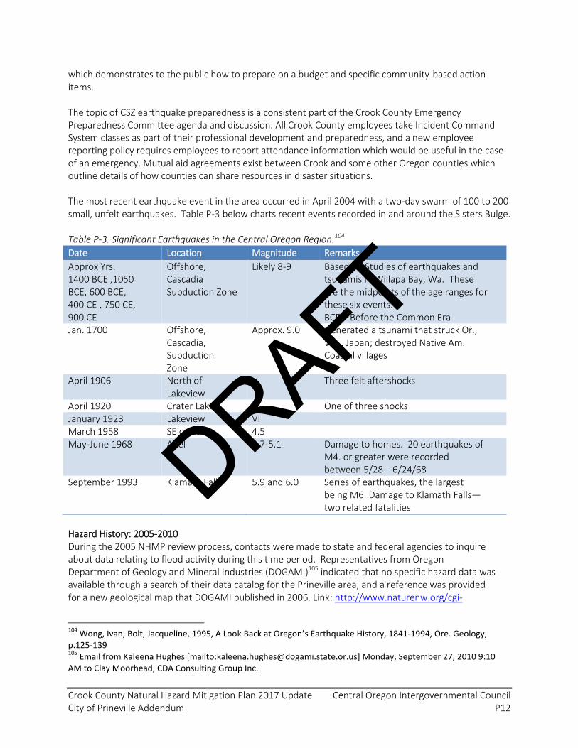
Crook County Natural Hazard Mitigation Plan 2017 Update Central Oregon Intergovernmental Council City of Prineville Addendum P12
which demonstrates to the public how to prepare on a budget and specific community-based action items. The topic of CSZ earthquake preparedness is a consistent part of the Crook County Emergency Preparedness Committee agenda and discussion. All Crook County employees take Incident Command System classes as part of their professional development and preparedness, and a new employee reporting policy requires employees to report attendance information which would be useful in the case of an emergency. Mutual aid agreements exist between Crook and some other Oregon counties which outline details of how counties can share resources in disaster situations. The most recent earthquake event in the area occurred in April 2004 with a two-day swarm of 100 to 200 small, unfelt earthquakes. Table P-3 below charts recent events recorded in and around the Sisters Bulge. Table P-3. Significant Earthquakes in the Central Oregon Region.104
Date Location Magnitude Remarks
Approx Yrs. 1400 BCE ,1050 BCE, 600 BCE, 400 CE , 750 CE, 900 CE
Offshore, Cascadia Subduction Zone
Likely 8-9 Based on Studies of earthquakes and tsunamis in Willapa Bay, Wa. These are the midpoints of the age ranges for these six events. BCE—Before the Common Era
Jan. 1700 Offshore, Cascadia, Subduction Zone
Approx. 9.0 Generated a tsunami that struck Or., Wa., Japan; destroyed Native Am. Coastal villages
April 1906 North of Lakeview
V Three felt aftershocks
April 1920 Crater Lake V One of three shocks
January 1923 Lakeview VI
March 1958 SE of Adel 4.5
May-June 1968 Adel 4.7-5.1 Damage to homes. 20 earthquakes of M4. or greater were recorded between 5/28—6/24/68
September 1993 Klamath Falls 5.9 and 6.0 Series of earthquakes, the largest being M6. Damage to Klamath Falls—two related fatalities
Hazard History: 2005-2010 During the 2005 NHMP review process, contacts were made to state and federal agencies to inquire about data relating to flood activity during this time period. Representatives from Oregon Department of Geology and Mineral Industries (DOGAMI)105 indicated that no specific hazard data was available through a search of their data catalog for the Prineville area, and a reference was provided for a new geological map that DOGAMI published in 2006. Link: http://www.naturenw.org/cgi-
104
Wong, Ivan, Bolt, Jacqueline, 1995, A Look Back at Oregon’s Earthquake History, 1841-1994, Ore. Geology, p.125-139 105
Email from Kaleena Hughes [mailto:[email protected]] Monday, September 27, 2010 9:10 AM to Clay Moorhead, CDA Consulting Group Inc.
DRAFT

Crook County Natural Hazard Mitigation Plan 2017 Update Central Oregon Intergovernmental Council City of Prineville Addendum P13
bin/quikstore.pl?store=maps&product=001447. DOGAMI also noted that Light Detection and Ranging (LiDAR) was flown for the Crook County area but data will not be released until after the 2010 NHMP update is completed. LDAR is an optical remote sensing technology that measures properties of scattered light to find range and/or other information of a distant target. Another representative from DOGAMI106 identified that they have several geologic publications that cover the parts of Crook County around Prineville. The following link identifies three field guides that cover the west part of Crook County. http://www.oregongeology.org/pubs/og/OGv69n01.pdf. Although there have been no significant earthquake activity in Crook County during the past five years, notable earthquake activity continues to occur throughout the Pacific Northwest. Using a web search, data was discovered that identified earthquake data for the Pacific Northwest. Below is a listing of notable earthquakes that occurred from 2010-2016. Hazard History: 2010 - 2016 Table P-4. Oregon and Washington Earthquakes Above Magnitude 3.0, 2010-2016.107
Mag. Date / Local Time Distance From Nearby Town
3.3 2016/12/09 01:50:29 PST 33.4 km (20.8 mi) SE ( 146. azimuth) from Morton, WA
3.3 2016/12/04 22:42:00 PST 21.3 km (13.2 mi) WSW ( 240. azimuth) from Coos Bay, OR
3.6 2016/11/02 07:52:19 PDT 14.0 km (8.7 mi) W ( 275. azimuth) from Astoria, OR
3 2016/10/22 10:17:05 PDT 3.9 km (2.4 mi) SW ( 214. azimuth) from Fall City, WA
3.1 2016/10/10 02:14:42 PDT 12.0 km (7.5 mi) SE ( 139. azimuth) from Ellensburg, WA
3 2016/10/03 21:29:22 PDT 4.9 km (3.1 mi) WNW ( 296. azimuth) from Woodburn, OR
3.1 2016/10/02 11:09:20 PDT 9.2 km (5.7 mi) NE ( 43. azimuth) from Maple Valley, WA
3 2016/09/16 17:29:39 PDT 25.4 km (15.8 mi) SE ( 142. azimuth) from Port Angeles, WA
3.1 2016/09/06 23:50:25 PDT 10.4 km (6.4 mi) SSW ( 211. azimuth) from Deming, WA
3.7 2016/07/31 11:53:27 PDT 22.7 km (14.1 mi) NNE ( 21. azimuth) from Aberdeen, WA
3.1 2016/07/16 18:16:43 PDT 16.5 km (10.2 mi) WSW ( 246. azimuth) from Portland, OR
3 2016/07/01 13:18:29 PDT 11.4 km (7.1 mi) SSE ( 148. azimuth) from Granite Falls, WA
3.5 2016/07/01 11:36:27 PDT 12.0 km (7.4 mi) SE ( 145. azimuth) from Granite Falls, WA
3.1 2016/06/27 15:04:28 PDT 74.9 km (46.5 mi) NNW ( 341. azimuth) from Crescent City, CA
3.7 2016/04/05 11:06:36 PDT 19.7 km (12.2 mi) SE ( 141. azimuth) from Friday Harbor, WA
3.5 2016/02/20 09:27:22 PST 14.1 km (8.7 mi) W ( 261. azimuth) from Bremerton, WA
4.8 2015/12/29 23:39:29 PST 18.2 km (11.3 mi) N ( 11. azimuth) from Victoria, BC
3.4 2015/11/25 13:20:37 PST 32.1 km (19.9 mi) ESE ( 116. azimuth) from Darrington, WA
106 Email from Jason McClaughry [mailto:[email protected]] Sent: Monday, September 27,
2010 10:03 AM to Clay Moorhead, CDA Consulting Group Inc. 107
Pacific Northwest Seismic Network. https://pnsn.org/events?city_center=&custom-ui=rectangle&date_end=2016-12-31&date_start=2010-01-01&depth_max=1000&depth_min=-5&distance=&etypes%5B%5D=le&etypes%5B%5D=uk&etypes%5B%5D=re&etypes%5B%5D=lf&gap_max=&lat_center=&lat_max=49.21042&lat_min=41.90227&lon_center=&lon_max=-116.35482&lon_min=-125.05599&mag_max=9.9&mag_min=3.0&order=desc&page=1&phase_min=&radius=&rms_max=&s_phase_min=&sort_by=event_time_utc
DRAFT
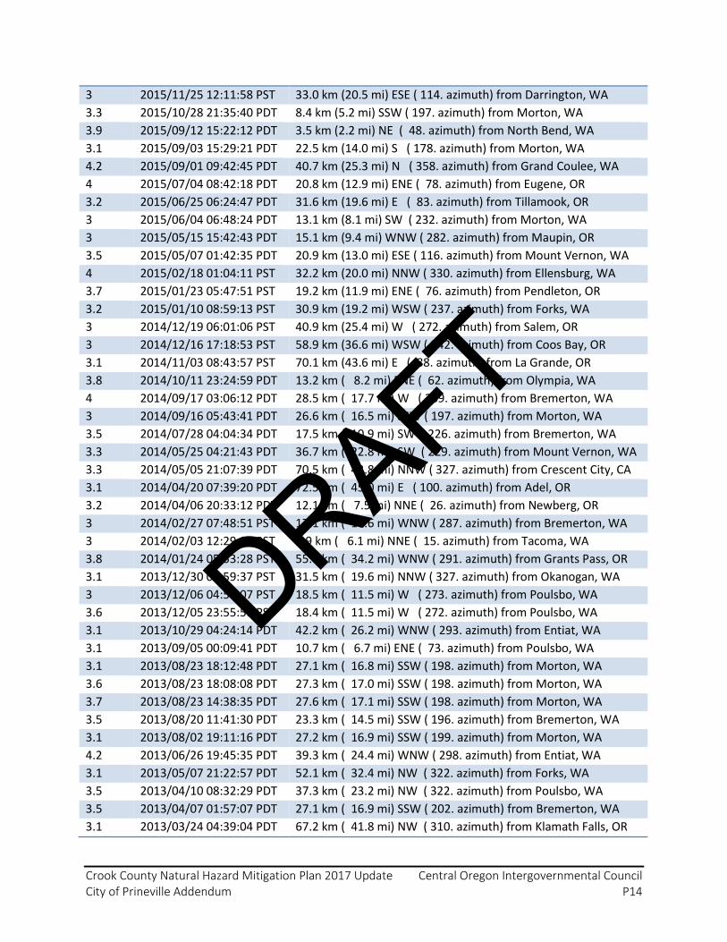
Crook County Natural Hazard Mitigation Plan 2017 Update Central Oregon Intergovernmental Council City of Prineville Addendum P14
3 2015/11/25 12:11:58 PST 33.0 km (20.5 mi) ESE ( 114. azimuth) from Darrington, WA
3.3 2015/10/28 21:35:40 PDT 8.4 km (5.2 mi) SSW ( 197. azimuth) from Morton, WA
3.9 2015/09/12 15:22:12 PDT 3.5 km (2.2 mi) NE ( 48. azimuth) from North Bend, WA
3.1 2015/09/03 15:29:21 PDT 22.5 km (14.0 mi) S ( 178. azimuth) from Morton, WA
4.2 2015/09/01 09:42:45 PDT 40.7 km (25.3 mi) N ( 358. azimuth) from Grand Coulee, WA
4 2015/07/04 08:42:18 PDT 20.8 km (12.9 mi) ENE ( 78. azimuth) from Eugene, OR
3.2 2015/06/25 06:24:47 PDT 31.6 km (19.6 mi) E ( 83. azimuth) from Tillamook, OR
3 2015/06/04 06:48:24 PDT 13.1 km (8.1 mi) SW ( 232. azimuth) from Morton, WA
3 2015/05/15 15:42:43 PDT 15.1 km (9.4 mi) WNW ( 282. azimuth) from Maupin, OR
3.5 2015/05/07 01:42:35 PDT 20.9 km (13.0 mi) ESE ( 116. azimuth) from Mount Vernon, WA
4 2015/02/18 01:04:11 PST 32.2 km (20.0 mi) NNW ( 330. azimuth) from Ellensburg, WA
3.7 2015/01/23 05:47:51 PST 19.2 km (11.9 mi) ENE ( 76. azimuth) from Pendleton, OR
3.2 2015/01/10 08:59:13 PST 30.9 km (19.2 mi) WSW ( 237. azimuth) from Forks, WA
3 2014/12/19 06:01:06 PST 40.9 km (25.4 mi) W ( 272. azimuth) from Salem, OR
3 2014/12/16 17:18:53 PST 58.9 km (36.6 mi) WSW ( 242. azimuth) from Coos Bay, OR
3.1 2014/11/03 08:43:57 PST 70.1 km (43.6 mi) E ( 88. azimuth) from La Grande, OR
3.8 2014/10/11 23:24:59 PDT 13.2 km ( 8.2 mi) ENE ( 62. azimuth) from Olympia, WA
4 2014/09/17 03:06:12 PDT 28.5 km ( 17.7 mi) W ( 269. azimuth) from Bremerton, WA
3 2014/09/16 05:43:41 PDT 26.6 km ( 16.5 mi) SSW ( 197. azimuth) from Morton, WA
3.5 2014/07/28 04:04:34 PDT 17.5 km ( 10.9 mi) SW ( 226. azimuth) from Bremerton, WA
3.3 2014/05/25 04:21:43 PDT 36.7 km ( 22.8 mi) SW ( 229. azimuth) from Mount Vernon, WA
3.3 2014/05/05 21:07:39 PDT 70.5 km ( 43.8 mi) NNW ( 327. azimuth) from Crescent City, CA
3.1 2014/04/20 07:39:20 PDT 72.5 km ( 45.0 mi) E ( 100. azimuth) from Adel, OR
3.2 2014/04/06 20:33:12 PDT 12.1 km ( 7.5 mi) NNE ( 26. azimuth) from Newberg, OR
3 2014/02/27 07:48:51 PST 17.1 km ( 10.6 mi) WNW ( 287. azimuth) from Bremerton, WA
3 2014/02/03 12:29:08 PST 9.9 km ( 6.1 mi) NNE ( 15. azimuth) from Tacoma, WA
3.8 2014/01/24 05:53:28 PST 55.0 km ( 34.2 mi) WNW ( 291. azimuth) from Grants Pass, OR
3.1 2013/12/30 06:59:37 PST 31.5 km ( 19.6 mi) NNW ( 327. azimuth) from Okanogan, WA
3 2013/12/06 04:57:07 PST 18.5 km ( 11.5 mi) W ( 273. azimuth) from Poulsbo, WA
3.6 2013/12/05 23:55:51 PST 18.4 km ( 11.5 mi) W ( 272. azimuth) from Poulsbo, WA
3.1 2013/10/29 04:24:14 PDT 42.2 km ( 26.2 mi) WNW ( 293. azimuth) from Entiat, WA
3.1 2013/09/05 00:09:41 PDT 10.7 km ( 6.7 mi) ENE ( 73. azimuth) from Poulsbo, WA
3.1 2013/08/23 18:12:48 PDT 27.1 km ( 16.8 mi) SSW ( 198. azimuth) from Morton, WA
3.6 2013/08/23 18:08:08 PDT 27.3 km ( 17.0 mi) SSW ( 198. azimuth) from Morton, WA
3.7 2013/08/23 14:38:35 PDT 27.6 km ( 17.1 mi) SSW ( 198. azimuth) from Morton, WA
3.5 2013/08/20 11:41:30 PDT 23.3 km ( 14.5 mi) SSW ( 196. azimuth) from Bremerton, WA
3.1 2013/08/02 19:11:16 PDT 27.2 km ( 16.9 mi) SSW ( 199. azimuth) from Morton, WA
4.2 2013/06/26 19:45:35 PDT 39.3 km ( 24.4 mi) WNW ( 298. azimuth) from Entiat, WA
3.1 2013/05/07 21:22:57 PDT 52.1 km ( 32.4 mi) NW ( 322. azimuth) from Forks, WA
3.5 2013/04/10 08:32:29 PDT 37.3 km ( 23.2 mi) NW ( 322. azimuth) from Poulsbo, WA
3.5 2013/04/07 01:57:07 PDT 27.1 km ( 16.9 mi) SSW ( 202. azimuth) from Bremerton, WA
3.1 2013/03/24 04:39:04 PDT 67.2 km ( 41.8 mi) NW ( 310. azimuth) from Klamath Falls, OR
DRAFT

Crook County Natural Hazard Mitigation Plan 2017 Update Central Oregon Intergovernmental Council City of Prineville Addendum P15
3.2 2013/03/22 12:32:13 PDT 41.1 km ( 25.5 mi) W ( 274. azimuth) from Poulsbo, WA
3.5 2013/01/30 17:03:17 PST 45.8 km ( 28.5 mi) NNE ( 21. azimuth) from Portland, OR
3.4 2013/01/25 01:11:56 PST 16.0 km ( 9.9 mi) W ( 273. azimuth) from Mount Vernon, WA
3.2 2013/01/24 19:43:07 PST 51.8 km ( 32.2 mi) WSW ( 247. azimuth) from Newport, OR
4 2012/12/26 22:36:46 PST 22.3 km ( 13.8 mi) NW ( 306. azimuth) from Friday Harbor, WA
3.4 2012/11/30 13:30:15 PST 42.9 km ( 26.7 mi) NNW ( 343. azimuth) from Crescent City, CA
3.1 2012/11/19 06:15:09 PST 16.1 km ( 10.0 mi) NW ( 320. azimuth) from Portland, OR
3.1 2012/10/15 23:22:45 PDT 73.6 km ( 45.8 mi) NW ( 319. azimuth) from Crescent City, CA
3.1 2012/09/13 10:33:45 PDT 24.0 km ( 14.9 mi) ESE ( 111. azimuth) from Wenatchee, Wa
3.5 2012/09/07 21:57:45 PDT 13.2 km ( 8.2 mi) ESE ( 101. azimuth) from Woodburn, OR
3.1 2012/07/31 16:53:11 PDT 65.5 km ( 40.7 mi) NW ( 322. azimuth) from Crescent City, CA
3.4 2012/03/24 14:16:17 PDT 8.8 km ( 5.5 mi) SSE ( 152. azimuth) from Mount Vernon, WA
3.7 2012/03/20 02:28:37 PDT 42.7 km ( 26.5 mi) SW ( 229. azimuth) from Newport, OR
3.1 2012/03/20 01:43:47 PDT 43.4 km ( 26.9 mi) SW ( 225. azimuth) from Newport, OR
3.5 2012/03/18 11:48:45 PDT 27.0 km ( 16.8 mi) S ( 178. azimuth) from Satsop, WA
3.2 2012/03/12 04:37:21 PDT 44.2 km ( 27.4 mi) SW ( 225. azimuth) from Newport, OR
3.3 2012/01/25 02:51:30 PST 24.4 km ( 15.2 mi) S ( 173. azimuth) from Morton, WA
4.7 2011/11/18 05:09:00 PST 11.6 km ( 7.2 mi) N ( 349. azimuth) from Okanogan, WA
3.2 2011/10/14 23:11:29 PDT 4.5 km ( 2.8 mi) NNE ( 15. azimuth) from Hanford-400, WA
3.4 2011/10/14 15:25:16 PDT 29.1 km ( 18.1 mi) ESE ( 115. azimuth) from Eatonville, WA
3.2 2011/09/22 13:22:06 PDT 2.1 km ( 1.3 mi) NNW ( 347. azimuth) from Maple Valley, WA
3 2011/09/05 19:20:46 PDT 21.6 km ( 13.4 mi) ENE ( 70. azimuth) from Port Angeles, WA
3.2 2011/09/03 21:13:39 PDT 4.8 km ( 3.0 mi) NNE ( 17. azimuth) from Hanford-400, WA
3 2011/08/18 23:54:59 PDT 19.4 km ( 12.0 mi) W ( 269. azimuth) from Darrington, WA
3.9 2011/07/24 05:19:28 PDT 40.0 km ( 24.9 mi) W ( 266. azimuth) from Poulsbo, WA
3.2 2011/07/23 01:03:40 PDT 14.1 km ( 8.8 mi) E ( 93. azimuth) from Carnation, Wa
3.1 2011/07/15 20:54:00 PDT 3.2 km ( 2.0 mi) W ( 260. azimuth) from Darrington, WA
3.1 2011/06/14 18:52:58 PDT 14.0 km ( 8.7 mi) NW ( 305. azimuth) from Kirkland, Wa
3.4 2011/04/06 10:45:00 PDT 49.2 km ( 30.6 mi) ESE ( 111. azimuth) from Eatonville, WA
3.3 2011/02/14 10:37:45 PST 31.3 km ( 19.5 mi) S ( 171. azimuth) from Morton, WA
4.2 2011/02/14 10:35:25 PST 31.1 km ( 19.3 mi) S ( 171. azimuth) from Morton, WA
3.7 2011/02/08 08:36:36 PST 8.7 km ( 5.4 mi) WNW ( 291. azimuth) from Friday Harbor, WA
3.3 2011/01/18 23:10:45 PST 42.9 km ( 26.7 mi) NE ( 51. azimuth) from Diablo, WA
3.3 2011/01/07 14:35:40 PST 4.6 km ( 2.8 mi) SSE ( 156. azimuth) from Monroe, WA
3.8 2010/12/30 01:17:46 PST 12.6 km ( 7.8 mi) ESE ( 113. azimuth) from Maupin, OR
3.4 2010/11/22 15:56:28 PST 31.0 km ( 19.3 mi) SSE ( 156. azimuth) from Friday Harbor, WA
4.4 2010/11/16 07:51:08 PST 12.0 km ( 7.5 mi) W ( 269. azimuth) from Morton, WA
3.1 2010/09/04 04:04:29 PDT 55.2 km ( 34.3 mi) NW ( 325. azimuth) from Crescent City, CA
3.4 2010/07/03 15:25:19 PDT 69.9 km ( 43.4 mi) W ( 274. azimuth) from Grants Pass, OR
4 2010/06/17 07:23:24 PDT 56.9 km ( 35.3 mi) SSW ( 198. azimuth) from Yakima, Wa
3.1 2010/05/25 05:21:00 PDT 5.8 km ( 3.6 mi) NW ( 316. azimuth) from Carnation, Wa
3.7 2010/03/29 14:27:11 PDT 31.7 km ( 19.7 mi) W ( 271. azimuth) from Ellensburg, WA
DRAFT

Crook County Natural Hazard Mitigation Plan 2017 Update Central Oregon Intergovernmental Council City of Prineville Addendum P16
3 2010/02/24 01:34:15 PST 31.4 km ( 19.5 mi) SSW ( 213. azimuth) from Aberdeen, WA
3.4 2010/02/20 02:05:09 PST 15.4 km ( 9.6 mi) SE ( 134. azimuth) from Victoria, BC
3.8 2010/01/02 08:36:45 PST 10.6 km ( 6.6 mi) ESE ( 113. azimuth) from Maupin, OR
Figure P-2. Oregon and Washington Earthquakes Above Magnitude 3.0, 2010-2016.108
Vulnerability Assessment Prior to 2005, the DOGAMI has developed two earthquake loss models for Oregon based on the two most likely sources of seismic events; 1) The Cascadia Subduction Zone (CSZ), and 2) combined crustal events. Both models are based on HAZUS, a computerized program, currently used by the Federal Emergency Management Agency (FEMA) as a means of determining potential losses from earthquakes. The CSZ event is based on a potential 8.5 earthquake generated off the Oregon coast.
108
Pacific Northwest Seismic Network. https://pnsn.org/earthquakes/map?city_center=&custom-ui=rectangle&date_end=2016-12-31&date_start=2010-01-01&depth_max=1000&depth_min=-5&distance=&etypes%5B%5D=le&etypes%5B%5D=uk&etypes%5B%5D=re&etypes%5B%5D=lf&gap_max=&lat_center=&lat_max=49.21042&lat_min=41.90227&lon_center=&lon_max=-116.35482&lon_min=-125.05599&mag_max=9.9&mag_min=3.0&order=desc&page=1&phase_min=&radius=&rms_max=&s_phase_min=&sort_by=event_time_utc
DRAFT

Crook County Natural Hazard Mitigation Plan 2017 Update Central Oregon Intergovernmental Council City of Prineville Addendum P17
The model does not take into account a tsunami, which probably would develop from the event. The 500-year crustal model does not look at a single earthquake (as in the CSZ model); it encompasses many faults, each with a 10% change of producing an earthquake in the next 50 years. The model assumes that each fault will produce a single “average” earthquake during this time. Neither model takes unreinforced masonry building into consideration. DOGAMI investigators caution that the models contain a high degree of uncertainty and should be used only for general planning purposes. Despite their limitations, the models do indicate that damage would occur. Although direct earthquake impacts are relatively mild in Crook County, all counties east of the Cascade Range have the potential to feel substantial indirect impacts of severe earthquake events sourced in the Cascadia subduction zone109. Indirect impacts include disruption of and other impacts related to transportation corridors (roads, rail, air), power supply, supply chain distribution (fuel, food, natural gas, etc.), demand for logistics and staging areas, shelter, and relocation of individuals and animals from the directly impacted areas. Transportation interruptions and prioritization of emergency supplies to Western Oregon will disrupt raw material imports and finished agricultural product export, thereby causing a large financial disruption with necessity for alternate routing to ports of opportunity, increasing shipping costs and affecting Oregon’s agricultural economy. Massive staging areas are likely to be required in various areas of Central and Eastern Oregon with relief supplies likely to be primarily located at an established federal incident support base at Roberts Field Airport in Redmond, Deschutes County, Oregon. River traffic on the Columbia River will be an important response and recovery lifeline. Mutual aid from Eastern Oregon local jurisdictions will be sought to the maximum degree possible. Many building inspectors, law enforcement, firefighters, medical personnel, engineers, and public works personnel may deploy to the impacted areas of Western Oregon. Although the region is vulnerable to earthquake-induced landslides alongside volcanoes and strong ground shaking, little evidence is presented for these events specific to the City of Prineville. However, earthquake-induced landslides and liquefaction are vulnerabilities in Crook County as demonstrated by Oregon Department of Geology and Mineral Industries (DOGAMI) models (Figures P-3 and P-4). The liquefaction hazard is primarily due to Crook County’s and Prineville’s position in a valley.
109
Oregon Office of Emergency Management, Cascadia Subduction Zone Catastrophic Response Plan (2012). https://www.oregon.gov/OMD/OEM/plans_train/docs/CSZ/1_csz_plan_final.pdf
DRAFT
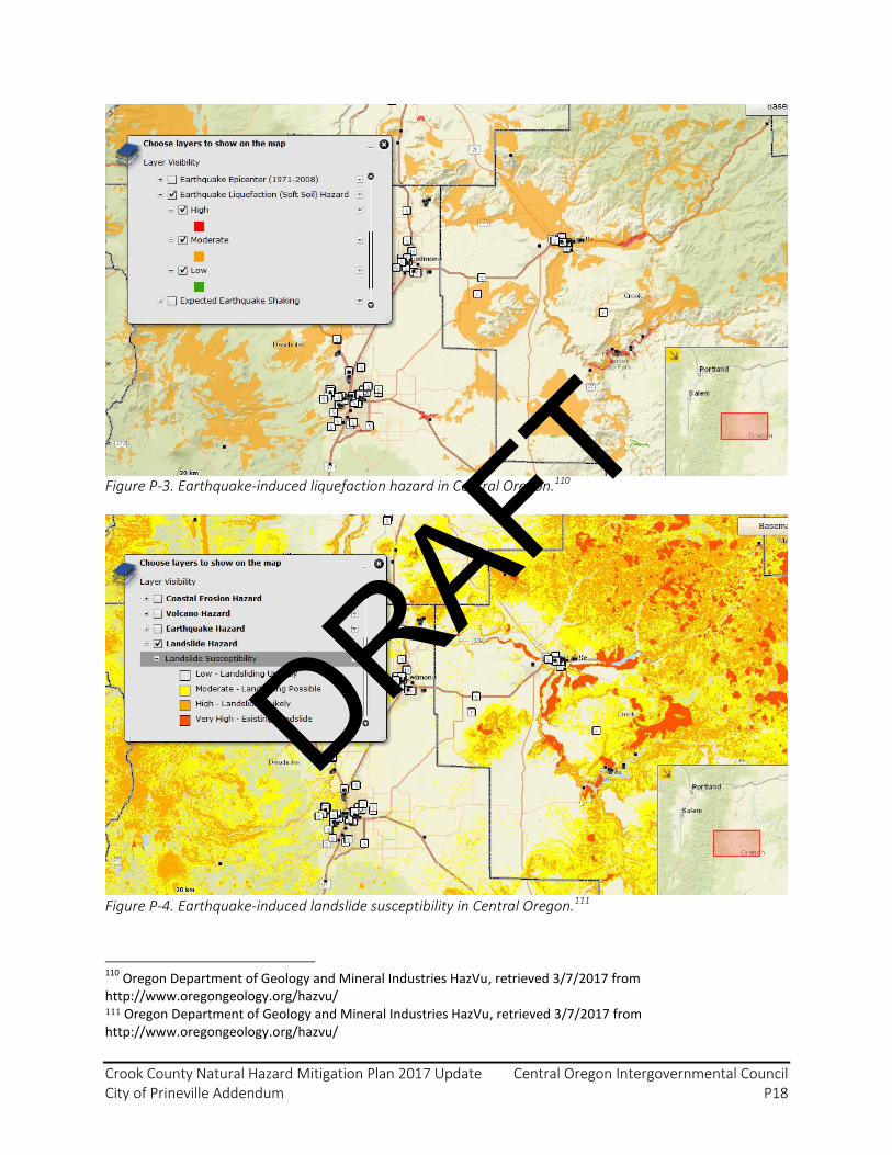
Crook County Natural Hazard Mitigation Plan 2017 Update Central Oregon Intergovernmental Council City of Prineville Addendum P18
Figure P-3. Earthquake-induced liquefaction hazard in Central Oregon.110
Figure P-4. Earthquake-induced landslide susceptibility in Central Oregon.111
110
Oregon Department of Geology and Mineral Industries HazVu, retrieved 3/7/2017 from http://www.oregongeology.org/hazvu/ 111 Oregon Department of Geology and Mineral Industries HazVu, retrieved 3/7/2017 from http://www.oregongeology.org/hazvu/
DRAFT

Crook County Natural Hazard Mitigation Plan 2017 Update Central Oregon Intergovernmental Council City of Prineville Addendum P19
Risk Assessment
The Cascadia Subduction Zone generates devastating earthquakes (magnitude 8+ and 9+ range) on average every 250-500 years. However, as with any natural processes, the average time between events can be misleading. Seventy-five percent of large Cascadia earthquakes which have occurred over the past 8,000 years have occurred less than 310 years apart. Local earthquakes along regional faults may also pose concerns as well.112 Establishing a probability for devastating or damaging earthquakes is difficult given the small number of historic events in the region. Earthquakes generated by volcanic activity in Oregon‘s Cascade Range are possible, but likewise unpredictable. According to PNSN:
Although scientists have tried for decades to predict earthquakes, no one has discovered a method which can be applied with regular success. For some areas with well-understood patterns of seismicity, it may be possible to forecast decades-long time windows when large earthquakes are likely to occur. However, the Pacific Northwest has only been monitored for a couple of decades; not long enough to allow us to see what patterns, if any, exist here. Seismologists are still trying to understand what types of earthquakes are possible here, and what kind of shaking we will experience from future earthquakes (depending on the earthquake location and size, and the site geology and topography). Earthquake hazards can be reduced by advance preparation; such as coordinating emergency communications and activities across jurisdictional lines, preparing personal emergency plans, and considering seismic hazards in land use plans, building codes, and planning for medical, utility, and emergency facilities. 113
If a significant CSZ earthquake event were to occur in the Oregon Cascades, the maximum threat to Crook County and to Prineville is high due to the wide-spread damage and secondary impacts that could occur; this event would greatly impact transportation routes in and out of the region, thereby isolating Central Oregon. This isolation would cause concerns not only for people, but for goods and fuel as well. There is a 10-15% chance of a magnitude 9+ earthquake occurring in the next 50 years, and a 37% chance of a magnitude 8+ earthquake occurring in the next 50 years114.
P6.0 Flood Hazard (Hazard Analysis Score = 225)
Heavy rainfall on top of deep snow pack is the most common cause of flooding in Crook County. The winter season in the high desert is typically late October through late April. The City of Prineville is located in northwest Crook County, in the central part of Oregon along the Ochoco Mountains. It is wholly within Climate Division 7 (South Central Oregon) established by the National
112
[Entire paragraph] - email communication on 4/29/2017 with Daniele McKay, Natural Resources Instructor, Oregon State University Cascades. 113
http://www.pnsn.org/INFO_GENERAL/eqhazards.html 114
Email communication on 4/29/2017 with Daniele McKay, Natural Resources Instructor, Oregon State University Cascades.
DRAFT

Crook County Natural Hazard Mitigation Plan 2017 Update Central Oregon Intergovernmental Council City of Prineville Addendum P20
Climatic Data Center. The City receives approximately 10.5 inches of precipitation per year. About half of this precipitation is snow and the other half is rain. Rain falling on snow causes the snow to melt more quickly, and river and creek levels to rise rapidly. The two most severe flood events in Crook County were the result of rain falling on an existing snowpack.115 Table P-5 demonstrates monthly and annual average precipitation in Prineville, as observed at a long-term climate station in the city116. Table P-5. Monthly and annual average precipitation (inches) in Prineville (1981-2010). Weather Station
Mean Precipitation (inches)
J F M A M J J A S O N D Annual
Prineville 117
1.1 1.0 0.9 0.9 1.2 0.9 0.6 0.3 0.4 0.8 1.2 1.4 10.68
Table P-6. Mean snow water equivalent (inches) at month start in Crook County (1981-2010). SNOTEL Station
Snow Water Equivalent at Month Start (inches)
J F M A M J J A S O N D
Derr 118 5.7 9.8 12.8 12.0 1.5 0.0 0.0 0.0 0.0 0.0 0.0 1.9
Ochoco Meadows 8
4.4 7.4 10.0 9.5 0.0 0.0 0.0 0.0 0.0 0.0 0.0 1.8
Snow Mountain 8
3.3 6.3 9.8 12.2 4.2 0.0 0.0 0.0 0.0 0.0 0.0 1.4
The eastern, northern, and southern boundaries of Crook County are mountainous, with a valley in the center of the county. These mountains collect rain and snow and deliver it to Crooked River and Ochoco Creek Valley. The City is located near the confluence of these two water bodies. Portions of the City are located with the flood zones as mapped by FEMA, and the City includes numerous areas where development has historically been located within the floodplain. This includes residential, commercial and industrial land uses. Increased development within the floodplain increases the risk of flood damage to buildings and people. When structures or fill are placed in the floodplain, water is displaced. Development may cause floodwaters to rise higher than before the development was located in the hazard areas. This is particularly true if the development is located within the floodway. Impervious surfaces, including roads, parking areas and roof structures collect water rapidly and transport the water to storm water systems that may not be designed to mitigate heavy rainfall conditions, which will result in flooding.
115
Interviews with the Crook County Historical Society (September 2003). 116
National Oceanic and Atmospheric Administration National Centers for Environmental Information, 2017. 117
National Oceanic and Atmospheric Administration, National Centers for Environmental Information, 2017. Prineville Weather Station, GHCND: USC00356883. https://www.ncdc.noaa.gov/cdo-web/datasets/NORMAL_MLY/stations/GHCND:USC00356883/detail 118
NRCS National Water and Climate Center SNOTEL Data: https://wcc.sc.egov.usda.gov/reportGenerator/view/customGroupByMonthReport/semimonthly/state=%22OR%22%20AND%20network=%22SNTL%22%20AND%20outServiceDate=%222100-01-01%22%7cname/1980-10-01,1981-09-30:1,3,5,7,9,11,13,15,17,19,21,23/stationId,name,WTEQ::median_1981?submit=View+Normals
DRAFT

Crook County Natural Hazard Mitigation Plan 2017 Update Central Oregon Intergovernmental Council City of Prineville Addendum P21
Prineville Flood History: prior to 2016
August 04, 1904: Crooked River floods, destroys crops, shuts down the Prineville Railway, washes away portions of a State Highway.
1918: Flood downtown Prineville, Homes and Businesses damaged. Citizens displaced Both the Crooked River and Ochoco Creek Swell
December 1951, January 1952: Prineville Floods, Crooked River runs well over its banks. Many business and homes damaged 300 People evacuated, 150 home evacuated.
December 1955, January 1956: Prineville floods. Citizens evacuated, homes and businesses damaged.
May 1998: Prineville floods, Ochoco Creek rises beyond flood levels. Federal Disaster Declaration.
Winter 2005: Juniper Canyon flood. Damage to rural infrastructure and property; transportation disruptions.
The landmark flood event for Crook County in the last century was the flood of 1952. This flood set most of the record high-water marks for the region. The primary cause of this flood was warm rain on a substantial snowpack. The rain quickly melted the snow, and caused Ochoco Creek and the Crooked River to overrun their banks. All subsequent floods have been compared to this event. The 1952 flood was characterized as a “100-year” flood event, or a flood event with a return interval of 100 years. A “100- year” flood has a 1% chance of occurring in any given year, or a 26% chance of occurring during the life of a 30-year home mortgage. In May 1998, Crook County experienced another devastating flood. In the weeks preceding the flood, the county received abundant rain and snowfall. A warm and heavily moisture-laden storm front, typical to the Pacific El Nino pattern, followed the abundant snowfall. The warm rain quickly melted the snow pack, and county streams and rivers rapidly filled their channels, exceeding their banks. This particular flood event caused over $16 million in damages to Crook County homes, businesses and infrastructure, including damage to over 1000 properties; over 1000 residents were impacted by the flood119. Vulnerability Assessment Using GIS technology and flow velocity models, it is possible to map the damage that can be expected from flood events; spatial analysis can achieve a high level of detail with identification of individual properties which are likely to be impacted by a flood of a given magnitude. The flood hazard for Crook County and the City of Prineville was identified by FEMA in their Crook County Flood Insurance Rate Maps (FIRMs). These maps were first completed in July 1989. The maps outline the extent of the 100-year, or base, floodplain; the floodplain consists of the area of land which would be impacted by floodwaters in a flood event of this magnitude. These maps are used by FEMA to identify properties that need to purchase flood insurance and, if developed, need to meet floodplain development regulations. FIRMs for Crook County were updated by FEMA in February 2012. These maps were based upon updated information and technology that increased the accuracy of delineating the
119
City of Prineville / Crook County Flood Mitigation Action Plan, Clay Moorhead, CDA Consulting Group Inc. (2000)
DRAFT

Crook County Natural Hazard Mitigation Plan 2017 Update Central Oregon Intergovernmental Council City of Prineville Addendum P22
floodplain and floodway area along the Crooked River and Ochoco River. Updated FIRMs are available at the FEMA Flood Map Service Center120. The Crook County Geographic Information System (GIS) Department has incorporated updated FIRM data into their GIS database. A query was developed to combine floodplain boundaries of 2010 FIRM data with the 2010 certified tax roll (certified October 8, 2010) for properties within the County. Updated FIRM data was used to identify the flood hazard for the 2010 NHMP update; the same assumptions were used for the 2017 NHMP update. Figures P-5, P-6, and P-7 below show the spatial distribution of the Crook County 100-year-event floodplain as identified in updated FIRMs. When this information is plotted it can show more specifically where the flood zones are in relation to property and structures. The mapping capability provides detail on a property by property basis and is a significant tool that can be used for many purposes, most importantly compliance with the FEMA Floodplain regulations. Although the scale of the county-wide map shown in Figure P-5 makes it difficult to identify exact structures which would be impacted in a 100-year flood event, we use this to reference the floodplain data available through the FEMA FIRMs and through Crook County’s GIS system. Additional flood hazard potential is in regard to the Ochoco Reservoir Dam. In the event of a severe earthquake and associated failure of the Ochoco Reservoir Dam, severe flooding could occur, especially if this event occurred during snowmelt season in May or June.
120
FEMA Flood Map Service Center. https://msc.fema.gov/portal
DRAFT

Crook County Natural Hazard Mitigation Plan 2017 Update Central Oregon Intergovernmental Council City of Prineville Addendum P23
Figure P-5. Flood Insurance Rate Map floodplain data are available through the FEMA Flood Map Service Center121 and through Crook County GIS’ Floodplain Comparison Application122. This figure demonstrates the spatial distribution of the 100-year event floodplain in Crook County.
121
FEMA Flood Map Service Center. https://msc.fema.gov/portal 122
Crook County GIS Floodplain Comparison Application. http://geo.maps.arcgis.com/apps/webappviewer/index.html?id=a3525e4075ac4b4dacd388cef3566fa4
DRAFT

Crook County Natural Hazard Mitigation Plan 2017 Update Central Oregon Intergovernmental Council City of Prineville Addendum P24
Figure P-6. Spatial distribution of the 100-year event floodplain in Crook County123,124. This larger scale map shows a higher level of detail in the Prineville area of Crook County.
123 FEMA Flood Map Service Center. https://msc.fema.gov/portal 124 Crook County GIS Floodplain Comparison Application. http://geo.maps.arcgis.com/apps/webappviewer/index.html?id=a3525e4075ac4b4dacd388cef3566fa4
DRAFT

Crook County Natural Hazard Mitigation Plan 2017 Update Central Oregon Intergovernmental Council City of Prineville Addendum P25
Figure P-7. The spatial distribution of the 100-year event floodplain in relation to property and structures in Prineville demonstrates the capability of flood impact mapping and spatial analysis125,126.
Risk Assessment The floodplain begins as a very narrow strip of land adjacent to the upper tributaries of Ochoco Creek and Crooked River, and steadily increases in width at lower elevations. The floodplain is widest in the center of Prineville and near the confluence of Ochoco Creek and Crooked River. The Ochoco River bisects the City of Prineville and the floodplain location includes urban areas. The Prineville city boundary has expanded in recent years. In 2017, a query was developed through Crook County GIS which used updated corporate boundary lines to select tax lot parcels that intersected the floodplain. This information was cross-referenced to the real market value (improvements component only) for five building types. Through the 2017 NHMP update, a request was made to FEMA and the Oregon Department of Land Conservation and Development (DLCD) to determine if there were any properties located in Crook County that were National Flood Insurance Program (NFIP) repetitive flood loss properties; none were identified127.
125 FEMA Flood Map Service Center. https://msc.fema.gov/portal 126 Crook County GIS Floodplain Comparison Application. http://geo.maps.arcgis.com/apps/webappviewer/index.html?id=a3525e4075ac4b4dacd388cef3566fa4
44 CFR §201.6 (c)(3)(ii) All plans must address National Flood Insurance Program insured structures that have been repetitively damaged by floods.
DRAFT

Crook County Natural Hazard Mitigation Plan 2017 Update Central Oregon Intergovernmental Council City of Prineville Addendum P26
Information from the Crook County GIS office was combined with the FIRMs to estimate the improved property value which may be vulnerable to damage due to a 100-year flood event in Crook County. Table 3-6 shows statistics for Crook County (unincorporated), the City of Prineville, and Crook County (combined total) in regard to the real market value (improved components only) for five building types which intersect the 100-year floodplain; this table identifies the number of tax lots and the real market value (RMV) for the Crook County flood hazard areas, and the maximum estimated losses caused by a flood disaster occurring along the Crooked and Ochoco Rivers. As of May 2017, there were 807 tax lots located within the 100-year floodplain, with an improved real market value of $116,070,640. Of the 807 lots, about 7 percent were mobile homes, which are very susceptible to flood damage. Table 3-7 provides information received from FEMA Region X related to how Crook County and the City of Prineville participate in the National Flood Insurance Program (NFIP). Table P-7. This Crook County flood hazard assessment table shows the number and real market value (RMV) (improvement components only) of structures which intersect the 100-year flood event floodplain128. Crook County
(unincorporated) City of Prineville Crook County (combined)
Building Type No. Tax Lots
Imp. RMV No. Tax
Lots Imp. RMV
No. Tax Lots
Imp. RMV
Single Family (101, 401, 801) 266 $42,889,800 353 $36,173,280 619 $79,063,080 Multifamily (701) 0 $0 8 $1,560,160 8 $1,560,160 Mobile (019) 37 $1,059,900 17 $831,470 54 $1,891,370 Commercial (201) 6 $3,300,200 89 $21,664,430 95 $24,964,630 Industrial (301, 303) 8 $1,689,580 23 $6,901,820 31 $8,591,400 Total 317 $48,939,480 490 $67,131,160 807 $116,070,640
Table P-8. Information regarding the participation of Crook County and the City of Prineville in FEMA’s National Flood Insurance Program129. FIRM = Flood Insurance Rate Map. Rep. = repetitive. CAV = Community Assistance Visits.
Jurisdiction Current FIRM Date
Initial FIRM
CAV Date
Total Paid Losses
Substantial Damage Claims
Rep. Losses
Severe Rep. Losses
Total Policies
Pre-FIRM Policies
Crook County (unincorp.) Feb. 2012
July 1989
May 1999 11 0 0 0 65 34
City of Prineville Feb. 2012
July 1989
May 1999 37 3 0 0 134 74
127 Email communications with Christine Shirley, NFIP Coordinator, OR Department of Land Conservation and Development, 3/29/2017 & 4/5/2017. 128
Email communications with Christine Shirley, NFIP Coordinator, OR Department of Land Conservation and Development, 3/29/2017 & 4/5/2017. 129
Email communications with Christine Shirley, NFIP Coordinator, OR Department of Land Conservation and Development, 3/29/2017 & 4/5/2017.
DRAFT

Crook County Natural Hazard Mitigation Plan 2017 Update Central Oregon Intergovernmental Council City of Prineville Addendum P27
Crook County finds that, as can be noted from Table P-2, flood hazards scored as the second-highest overall risk score with 225 points out of a total 240 possible points. This is supported by the fact that there have been more frequent and more severe impacts associated with flood occurrence. This is compounded by a high probability of a reoccurrence occurring within the next 10-35-year time period. Historically, significant development and urban populations have located within flood prone areas of Crook County. As such, the vulnerability and maximum threat from this natural hazard type is high.
P7.0 Wildland Fire Hazard (Hazard Analysis Score = 185)
Wildland fire is a significant natural hazard in Central Oregon due to its frequency and severe impacts. While Crook County has experienced only a few large wildland-urban-interface (WUI) fires within the last seven years, it has been the setting for many smaller fires with significant potential for major impact on WUI areas and critical infrastructure. Neighboring counties have experienced numerous, high impact WUI fire incidents providing Crook County emergency managers insight into the complexities of such incidents. The City of Prineville has not experienced a WUI fire within the City limits; however, the City sees the potential impact of this hazard to be similar to Crook County. Prineville’s residential development is expanding further into sites traditionally covered by wildland vegetation bringing with it the potential for the wildland-urban interface scenarios. The escalating size and intensity of these interface fires is the subject of continuing research in several scientific disciplines. These include the arenas of forest health, hazardous fuels treatment, and community infrastructure protection as well as study of the impacts of climate change. These issues are likewise the subject of significant public discourse. Over the last two decades, community awareness has developed substantially regarding the interface fire threat as well as interest and involvement in issues of hazardous fuels treatment activities. Increases in large fires in recent years have heightened community awareness and willingness to address fire safety. Central Oregon population growth has become a companion issue. Between 2000 and 2010, Crook County’s population grew by 9.4% to 20,978 with an additional 2.9% population growth to 21,580 between 2010 and 2016130. Continued population growth is expected in Crook County with a projected 18.8% increase to 25,640 residents by year 2065131. In 2015, Prineville had an estimated population of 9,266132; Prineville’s population represented 44.2% of the total county population. Population growth will have significant impacts on citizen exposure and infrastructure vulnerability to the effects of wildland fire.133
130
U.S. Census Bureau, 2010. 131
Coordinated Population Forecast 2015 – 2065: Crook County. Portland State University Population Research Center. https://www.pdx.edu/prc/sites/www.pdx.edu.prc/files/Crook_Forecast_Report_201506.pdf 132
US Census Bureau, American Community Survey, 2015. 133
U.S. Bureau of Census, 2000. Population of Oregon and it’s Counties and Incorporated Places, Public Law 94-171 Redistricting Data, prepared by the Office of Economic Analysis, Dept of Administrative Services, State of Oregon.
DRAFT

Crook County Natural Hazard Mitigation Plan 2017 Update Central Oregon Intergovernmental Council City of Prineville Addendum P28
Wildfire hazard assessments have traditionally been conducted by individual jurisdictional agencies and organizations, and in many cases have been driven by local rural fire protection district boards of directors, county ordinance, and for wildland agencies state or federal law, regulation, policy, or directives. The Oregon Department of Forestry identified Deschutes County as one of two pilot counties for implementation of the Oregon Forestland-Urban Interface Fire Protection Act of 1997, also known as Senate Bill 360 (SB-360).134 The implementation process contained an extensive wildfire hazard identification component which has been embodied in Oregon Administrative Rule. This system is becoming applicable throughout the state in “wildland-urban interface areas” as defined by the statute. SB-360 has been implemented in Crook County. The mitigation treatment standards of the Crook County Fire Ready program were derived from the SB-360 standards so that there is now one defensible space treatment standard county-wide. Tri-County Large Fire History: 1990 - 2010 Tables P-9 and P-10 list some of the larger wildland fires in the tri-county (Crook, Deschutes and Jefferson) area that necessitated an emergency management response beyond that of the local wildland fire and natural resource agencies. Since the 1990 Awbrey Hall fire, the local structural and wildland fire services have substantially refined the emergency response system for these types of destructive interface fires. Under the leadership of the Central Oregon Fire Chief’s Association, the pre-planned interface fire mutual aid and task force system has effectively integrated the operational response process for structural and wildland fire fighting resources from all three counties. This response system is recognized as one of the most effective interagency efforts in the state. As is the case with the regional focus of tables below, much of Section P1.6 of this Addendum is presented with a regional focus on Crook, Deschutes and Jefferson counties. The scope and multi-jurisdictional nature of the local wildfire demand has driven development of a regional approach to pre-incident planning, training, initial and reinforced response, and recovery activities. The benefit of this type of coordinated approach is broadly acknowledged by fire service leadership as essential to meeting the local wildfire challenge. Table P-9. Representative fires in Central Oregon, 1990 – 2010 135. Year Fire Name Size
(Acres) Start Date County Conflagration
Act Resources Mobilized
Unprotected Areas Involved
Remarks
1990 Awbrey Hall 3,032 7/5/1990 Deschutes Yes Destroyed 22 residences. 2800 Bend residents evacuated.
1996 Little Cabin 2,400 7/29/1996 Jefferson Yes Structural, Wildland
3 Rivers subdivision threatened. No structures lost.
1996 Ashwood- Donnybrook
100,000+ 8/9/1996 Jefferson, Wasco
Yes Structural, Wildland
Conflagration Act resources mobilized to protect the threatened community of
134
ORS 477.015-477.061 135
Data derived from multiple Oregon State Fire Marshall, U.S. Forest Service, Oregon Department of Forestry and Bureau of Land Management sources. Data since 2010.
DRAFT

Crook County Natural Hazard Mitigation Plan 2017 Update Central Oregon Intergovernmental Council City of Prineville Addendum P29
Ashwood.
1996 Smith Rock 300 8/10/1996 Deschutes Yes Wildland One residence destroyed.
1996 Skeleton-Evans West
22,000 8/23/1996 Deschutes Yes Destroyed 19 residences and 15 outbuildings.
1998 Elk Lake 252 9/2/1998 Deschutes Thirty two recreational cabins adjacent to Elk Lake threatened. Several destroyed.
2000 Hash Rock 18,500 8/23/2000 Crook Yes Structural Thirty residences and 32 commercial buildings threatened in Mill Creek and Marks Creek drainages. U.S. Hwy 26 traffic controlled with pilot car.
2002 Eyerly 23,573 7/9/2002 Jefferson Yes Structural, Wildland
Spread into 3 Rivers subdivision burning 18 residences & multiple outbuildings.
2002 Cache Mountain
3,894 7/23/2002 DeschutesJefferson
Yes Fire spread five miles to east, destroying two residences in Black Butte Ranch.
2003 Davis 21,181 6/28/2010 DeschutesKlamath
Structural Early season, high intensity fire with high rates of spread. Spotting potential for south half of LaPine basin. Ash fallout reported 60 miles to NE at Prineville.
2003 Link 3,574 7/5/2010 DeschutesJefferson
Concern for potential spread to Black Butte Ranch.
2003 18 Road 3,800 7/23/2010 Deschutes Threat of spread to residential areas on southwest side of Bend and High Desert Museum.
2003 B & B Complex
90,769 8/19/2003 Jefferson, Linn
Yes Lightning wilderness fires spread east forcing evacuation of Camp Sherman (Jefferson Co.) and west threatening private land & residential development along Hwy 22 near Marion Forks. Santiam Pass Hwy closed. Black Butte Ranch was threatened as the fire moved south.
2007 GW 7,357 8/31/2007 Deschutes Yes Structural, Wildland
1221 dwelling structures saved, 50 threatened, zero destroyed
2007 Mile Post 8 120 9/27/2007 Crook Structural, Wildland
1 dwelling structures saved, 1 threatened, zero destroyed
2008 S Summit Springs Complex
1,745 8/17/2008 Jefferson Structural, Wildland
12 dwelling structure saved, 15 threatened, zero destroyed
2008 Juniper Butte
40 7/19/2008 Crook Structural, Wildland
5 dwelling structures saved, 5 threatened, zero destroyed.
2010 Rooster Rock 6,037 8/2/2010 Deschutes Yes Structural, Wildland
14 dwelling structures saved, 20 threatened, zero destroyed
DRAFT

Crook County Natural Hazard Mitigation Plan 2017 Update Central Oregon Intergovernmental Council City of Prineville Addendum P30
Table P-10. WUI Fires in Central Oregon, 2011 – 2016 136,137. Year Fire Name Size
(Acres) Start Date County Conflagration
Act Resources Mobilized
Unprotected Areas Involved
Remarks
2012 Pole Creek 26,119 9/9/2012 Deschutes No No Lightning-caused wilderness fire that impacted the community of Sisters and high recreation use areas for several weeks.
2014 Fox 9,955 Crook No NA NA
2014 Two Bulls 6,906 6/7/2014 Deschutes Yes No This fire was extremely close to the western boundary of the City of Bend 260 structures saved, 260 threatened, zero destroyed
2014 Center 2,515 7/13/2014 Crook No NA NA
2014 Donnybrook 20,763 7/13/2014 Jefferson No NA NA
2015 Corner Creek 25,660 6/29/2015
Multiple, including Crook
No NA Early season, lightning-caused fire which impacted multiple jurisdictions as well as Greater sage-grouse habitat
2015 Cove Fire 282 August Jefferson No NA 2 homes lost
2015 County Line 2
67,207 8/12/2015 Multiple, including Jefferson
Yes NA 1,077 structures saved, 1084 threatened, 7 destroyed
2016 Akawana 2,094 6/7/2016 Deschutes Yes No Early season, lightning-caused fire in the wildland urban interface 912 structures saved, 912 structures threatened, zero destroyed
Vulnerability Assessment The Crook County Community Wildfire Protection Plan (CWPP) was adopted in June 2005, and updated in 2007 and again in 2014. The CWPP describes numerous areas where Crook County is vulnerable to wildfire, with these areas are designated as having “high” or “extreme” hazard ratings.138 The 2014 CWPP describes a residential boom in Crook County in the 2000s with associated increases in housing units as well as increases in economic infrastructure during recovery from the economic collapse in 2008/2009; these increases in residential and economic infrastructure have expanded the county’s WUI, exposing more residents and infrastructure to risks posed by wildfire69. Vulnerability to fire is caused by numerous conditions. The Crook County CWPP states that most of the wildland-urban interface (WUI) areas occur in sites dominated by either Juniper/sage/grass or Ponderosa
136
Email communication from Lauren Miller, Fire/Fuels Planning Support, Central Oregon Fire Management Service, U.S. Forest Service. Communication: 3/10/2017. 137
Adam Barnes, Assitant Unit Forester, Oregon Department of Forestry. Email communication on 5/8/2017. 138
Crook County Community Wildfire Protection Plan. (2014). https://newcoic.files.wordpress.com/2013/10/crook-county-cwpp-2014_reduced-size-for-web.pdf
DRAFT

Crook County Natural Hazard Mitigation Plan 2017 Update Central Oregon Intergovernmental Council City of Prineville Addendum P31
pine/dry fir139. Climate and weather as well as development within the WUI all have a significant impact on wildfire vulnerability. Additionally, transportation routes such as roads have a large impact on fire response, including mitigation efforts and evacuation. The NHMP identifies Prineville as a community that could be impacted by wildfire. Risk Assessment The information above illustrates not only the escalating size of large wildland fires in Central Oregon, but also the increasing impact on the citizens, values-at-risk, and infrastructure of the counties. The fuels, weather and demographic conditions that have driven development of large, high impact, high intensity wildland interface fires in Deschutes and Jefferson counties are also present in and around the City of Prineville.
The City finds that there is an extensive history of wildland fires in Central Oregon, including one near the City of Prineville. With increases in population, especially within urban interface areas, these impacts may increase the City’s vulnerability and maximum threat in future years. The county will likely be impacted by a significant wildland fire within the next ten to 35 years.
P8.0 Severe Weather Events Hazard (Hazard Analysis Score = 170)
The City of Prineville is threatened by hazards generated from weather conditions almost every year. Storms bring heavy rains, strong winds, and occasionally ice and snow. Flooding and landslides can also accompany severe storms. Damaging storms are most common from October through April. Severe storms can create conditions that disrupt essential regional systems such as public utilities, telecommunications, and transportation routes. Wind, snow, and ice associated with winter storms can knock down or otherwise damage trees, power lines, and utility services. Freezing winter temperatures can damage utilities. The most frequent weather related hazards in the City are snow, wind, ice, and freezing temperatures. Occasionally, storms from the Pacific bring rain during the warmer months with most severe rainstorms in Crook County coming in the form of thunderstorms. While tornadoes are very infrequent and pose a relatively small risk to Crook County, there is a slight potential for this hazard as well. Hazard History: 2005 - 2016 Table P-11. Storm data and unusual weather phenomenon in Crook County, 2008 – 2015 140. Year / Month Location Type Remarks
July 2008 Prineville Hail Hail: 0.75 inch diameter August 2008 Prineville 10-mile radius Hail Hail: 0.75 – 1 inch diameter June 2009 Prineville 5-mile radius Heavy Rain,
Hail, Wind Water covering road, damaging wind, large hail
July 2009 Prineville 10-mile radius Hail Hail: 1 inch diameter August 2009 Prineville 10-mile radius Wind, Hail Hail: 0.88 inch diameter, damaging
winds
139 Crook County Community Wildfire Protection Plan. (2014). https://newcoic.files.wordpress.com/2013/10/crook-county-cwpp-2014_reduced-size-for-web.pdf 140
Email communication with Dennis Hall, National Weather Service on 3/28/2017.
DRAFT

Crook County Natural Hazard Mitigation Plan 2017 Update Central Oregon Intergovernmental Council City of Prineville Addendum P32
January 2011 Post 5-mile radius Ice, Rain Flood due to ice dam, warm temperatures
The City frequently is impacted by the effects of severe weather events. Several non-recorded destructive weather events and storms have brought economic hardship and affected the life safety of City residents. Future windstorms may carry similar impacts. The damage sustained by severe weather hazards is very dependent on types and numbers of existing and future buildings, infrastructure, and critical facilities located in the identified hazard areas. The City is also impacted by severe weather in other areas. Road closures due to severe winter weather on Mt. Hood stop commerce traffic and reduce the ability to obtain needed services and restrict the truck traffic that supplies Prineville’s commercial and industrial businesses. Vulnerability Assessment While a quantitative vulnerability assessment (an assessment that describes number of lives or amount of property exposed to the hazard) has not yet been conducted for Crook County windstorm, winter storm, and other severe weather events, there are many qualitative factors (issues relating to what is in danger within a community) that point to potential vulnerability. Severe weather can cause power outages, transportation and economic disruptions, significant property damage, and pose a high risk for injuries and loss of life. The event can also be typified by a need to shelter and care for individuals impacted by the event. Several destructive severe weather events have brought economic hardship and affected the life safety of county residents. Future events may carry similar impacts county-wide. The City of Prineville is susceptible to direct and indirect impacts on infrastructure, property and business closures. Losses from interruptions in electric service can occur and road closures can cripple the community’s ability to maintain transportation to vital services and commerce. Builds and infrastructure within the City could be damaged or destroyed. Additionally, emergency response operations can be hampered when roads are blocked. Risk Assessment The City finds that there are a high number of severe weather events that impact the community. The community is resilient to the damaging impacts of minor storm events, but would be susceptible to damage from an intense storm event. Based upon the experiences documented within this Plan, the City finds that there is moderate risk associated with the devastating impact of a severe weather hazard, and the vulnerability and maximum threat to property and populations within the City is also considered to be moderate.
P9.0 Volcano Hazard (Hazard Analysis Score = 163)
Volcanoes are present in Washington, Oregon, and California where volcanic activity is generated by continental plates moving against each other (Cascadia Subduction Zone movement). Because the population of the Pacific Northwest is rapidly expanding, volcanoes of the Cascades Range are now considered some of the most dangerous in the United States. Prineville sits east of all of the Cascade Range Volcanoes. The terrain between Crook County and its closest volcanic threats; Newberry Crater, Mt. Bachelor, Broken Top, Three Sisters, Mt. Jefferson and Mt.
DRAFT

Crook County Natural Hazard Mitigation Plan 2017 Update Central Oregon Intergovernmental Council City of Prineville Addendum P33
Hood makes for a very low probability that a lahar would affect Prineville141. However, lava flows are a possibility in Crook County, especially in the southern and western portions of the county142. Volcanic eruptions can send ash airborne with wind spreading the ash for many miles, putting Crook County at risk for ash fall from volcanic eruptions nearly anywhere in the Cascades143. An erupting volcano can also trigger flash floods, earthquakes, rockfalls, and mudflows. Volcanic ash can contaminate water supplies, cause electrical storms, and collapse roofs. Additionally, volcanic ash can have significant impacts on air quality, thereby creating risks for human health. The nature of volcanic eruptions is such that the immediate danger area covers approximately a 20-mile radius from the eruptive origin, but danger can also extend 100 miles or more from a volcano. Since Crook County falls outside of the 20-mile immediate threat area, our main hazard will be ash fall from Volcanoes as far north as Mount St. Helens to as far south as Mount Shasta. Businesses and individuals can make plans to respond to volcano emergencies. Planning is prudent because once an emergency begins, public resources can often be overwhelmed, and citizens may need to provide for themselves and make informed decisions. Knowledge of volcano hazards can help citizens make a plan of action based on the relative safety of areas around home, school, and work. Hazard History: prior to 2005 Although lava rock is relatively easy to find in and around the City, the closest recent eruption occurred at Mount St. Helens beginning on May 18, 1980. Following two months of earthquakes and minor eruptions and a century of dormancy, Mount St. Helens in Washington, exploded in one of the most devastating volcanic eruptions of the 20th century. Although less than 0.1 cubic mile of magma was erupted, 58 people died, and damage exceeded 1.2 billion dollars. Fortunately, most people in the area were able to evacuate safely before the eruption because the U.S. Geological Survey (USGS) and other scientists had alerted public officials to the danger. As early as 1975, USGS researchers had warned that Mount St. Helens might soon erupt. Coming more than 60 years after the last major eruption in the Cascades (Lassen Peak), the explosion of St. Helens was a spectacular reminder that the millions of residents of the Pacific Northwest share the region with live volcanoes. The eruption of Mount St. Helens caused heavy damage and disruption to businesses and other essential services throughout Washington and much of Oregon. If one of the central Cascade Volcanoes erupted the impacts to people and property would be severe. There have been no other recent volcanic events nearby. The last volcanic eruption happened hundreds of thousands of years ago. This eruption created the basaltic rock that is seen in the Crook River canyon below Bowman Dam.
141
Email communication on 3/30/2017 with Daniele McKay, Natural Resources Instructor, Oregon State University Cascades. 142 Email communication on 3/30/2017 with Daniele McKay, Natural Resources Instructor, Oregon State University Cascades. 143 Email communication on 3/30/2017 with Daniele McKay, Natural Resources Instructor, Oregon State University Cascades.
DRAFT

Crook County Natural Hazard Mitigation Plan 2017 Update Central Oregon Intergovernmental Council City of Prineville Addendum P34
Hazard History: 2005 – 2016 Contacts were made to state and federal agencies during the 2005 review process to inquire about data relating to volcanic activity during this time period. No documented volcanic activity was reported by these agencies for any volcanic activity in proximity to Crook County for this time period. The 2017 NHMP Steering Committee, including a Crook County geologist, discussed the hazard history since 2010, and concluded that no additional significant volcanic activity has occurred in the 2010 – 2016 time period. Vulnerability Assessment Mount St. Helens is a tephra (ash) producing volcano. According to a USGS publication144, the most serious tephra hazards in the region are due to Mount St. Helens, the most prolific producer of tephra in the Cascades during the past few thousand years. The report exhibits a probability map that identifies that Crook County has an annual probability of receiving an accumulation of 10 centimeters or more of tephra accumulation at 0.01% or less145. Data was not available at the time of this update to determine the specific vulnerability to the types and numbers of existing or future buildings, infrastructure and critical infrastructure. According to a report prepared by John R. Labadie entitled Volcanic Ash Effects and Mitigation146, “volcanic ash is abrasive, mildly corrosive, and conductive (especially when wet); it may also carry a high static charge for up to two days after being ejected from a volcano. The ash is easily entrained in the air by wind or vehicle movement and may remain suspended in the air for many minutes. Due to the combination of these qualities, volcanic ash is pervasive. It can penetrate all but the most tightly-sealed enclosures”. Ash can have a significant impact on all forms of activity including public health, transportation, traffic, utilities, critical infrastructure, electronics, and others. Specifically, suspended and ground ash could significantly impair aviation and ground transportation activities; with decreased function of air transportation, emergency response and other regional and beyond-region transportation, various activities could be significantly impacted. Crook County has other vulnerabilities associated with volcanic impacts in addition to ash-related impacts. For example, if Mt. Hood or another regional volcano had a warm thaw, the associated flooding could cause large mud flows to come off of the mountain. This type of hazard could disrupt transportation, causing more people to be in Central Oregon 147. Risk Analysis The likelihood or magnitude of a volcanic eruption cannot be forecast with confidence148. However, if an eruption of significant magnitude occurs, the volcanic ash cloud and fallout could be a high hazard for Crook County, and the most likely risk appears to be from ash accumulation, with a chance of accumulation being very low in any given year. Seismic activity (shown in the chapter on earthquake hazard) identifies numerous and regular earthquake activity within the Pacific Northwest. No specific earthquake data was identified for Crook County. As such it is concluded that Crook County faces no immediate and direct threat from a volcanic eruption and therefore has a low probability of threat. The
144
W.E. Scott, R.M. Iverson, J.W. Vallance, and W. Hildreth, 1995, Volcano Hazards in the Mount Adams Region, Washington: U.S. Geological Survey Open-File Report 95-492 145
http://vulcan.wr.usgs.gov/Volcanoes/Cascades/Hazards/ash_accumulation_10cm.html 146
The full report is included in the Hazard Background appendix 147
Personal communication on 3/29/2017 with Carrie Gordon, USFS Geologist, Ochoco National Forest & DOGAMI website. 148
John R. Labadie entitled Volcanic Ash Effects and Mitigation
DRAFT

Crook County Natural Hazard Mitigation Plan 2017 Update Central Oregon Intergovernmental Council City of Prineville Addendum P35
County does have an indirect risk of ash accumulation that could have broad ranging impacts. Through the research and discovery phase of this update, there was insufficient data available to determine losses associated with a volcanic hazard event. This does not mean that such an eruption could not occur in any given year. Crook County must remain vigilant to the possibilities of a volcanic disaster.
P10.0 Landslide Hazard (Hazard Analysis Score = 132)
Landslides are defined as any detached mass of soil, rock, or debris that moves down a slope or a stream channel. Seldom if ever, can a landslide be attributed to a single cause. All landslides involve the failure of the earth under stress. Landslides are typically triggered by periods of heavy rainfall and/or rapid snowmelt. Earthquakes, volcanoes, and excavations may also trigger them. Also, an intense wildfire may destroy vegetation and affect organic material so that with even normal rainfall, soil saturation may trigger a landslide. Locations with extremely steep slopes are most susceptible to landslides. Landslides on these slopes tend to move more rapidly and can be more dangerous than other landslides. Landslides are particularly common along stream banks, reservoir shorelines, and large lakes. Although landslides are natural geologic processes, their incidence and impact on people and property can be exacerbated by human activities such as excavation and grading, drainage and groundwater alterations, and changes in vegetation. Property damage from landslides throughout Oregon, including Crook County, continues to rise, in part due to increased development. Rapidly moving landslides present the greatest risk to human life, and persons living in or traveling through areas prone to rapidly moving landslides are at increased risk for serious injury. Rapidly moving landslides have also caused most of the recent landslide related injuries and deaths in Oregon. Most of the landslides in Crook County associated with flood events have been rapidly moving debris flows. Identifying and mapping landslide-prone areas and planning for development are essential to help reduce the risks of landslide hazards to life and property in the City of Prineville. Hazard History: Prior to 2005 Landslides are a serious geologic hazard in almost every state in America. Landslides threaten transportation corridors, fuel and energy conduits, and communications facilities. While not all landslides result in property damage, many landslides impact roads and other infrastructure, and can pose a serious life-safety hazard. Growing population and an increase in housing demand has caused development to occur more frequently in hazard-prone areas. No data source was referenced related to actual slide activity prior to 2005. This does not mean that landslides did not occur. There may have been numerous landslides that were not recorded, or where data did not exist to document the hazard activity. However, since devastating events would have been recorded, we assume that the history of impacts for landslides is low.
DRAFT

Crook County Natural Hazard Mitigation Plan 2017 Update Central Oregon Intergovernmental Council City of Prineville Addendum P36
Hazard History: 2010 to 2016 During the 2017 update process, contacts were made to Oregon Department of Transportation (ODOT) to inquire about data relating to landslide activity which may have affected transportation routes within and nearby Crook County during this time period. The Oregon Department of Transportation (ODOT) identified a few projects (Highway 26 near Warm Springs and Highway 26 near Mitchell) in which work is being developed and conducted by the agency to mitigate landslide (and seismic) risk and transportation disruptions in these areas149. The landslide prone areas that were identified by ODOT included areas that could potentially impact state highways. No other documented landslide activity was noted by these agencies. In addition a steering committee made up of emergency managers, responder agencies, and local, state and federal administrators led the effort to update the Crook County Natural Hazard Mitigation Plan. The 2017 NHMP Steering Committee discovered no evidence of recorded landslide activity during this time period. Vulnerability Assessment The coordination effort to identify data related to significant landslide disaster activity in Crook County demonstrates a lack of vulnerability studies for locations other than the State’s highway system. Although topographic and steep slope data is available, there are no correlation studies that pinpoint vulnerability locations that would impact buildings or people. Nonetheless, both the City of Prineville and Crook County have both implemented steep slope ordinances to regulate development in hazard-prone areas. Landslides can affect services needed to support the Crook County population, including transportation systems, utilities, and property damage. The impacts from a devastating landslide could have a significant impact of maintaining critical lifelines to the area, and may cause economic damage to larger urban centers like the City of Prineville. As mentioned in section P1.4 above, earthquake-induced landslide is a vulnerability within Crook County (Figure P-9).
149 Phone communication with Jim Scholtes, Assistant District Manager, District 10, Oregon Department of Transportation, 5/20/2017.
DRAFT

Crook County Natural Hazard Mitigation Plan 2017 Update Central Oregon Intergovernmental Council City of Prineville Addendum P37
Figure P-9. Earthquake-induced landslide susceptibility in Central Oregon.150 Risk Assessment The Oregon Department of Transportation (ODOT) has completed mitigation planning with regard to landslide activities along the state highways system in Crook County. ODOT has identified information on landslides and rockfalls in Crook County. The information identifies the most problematic landslides and rockfalls will impact state highways. A comprehensive survey of Highways 380 and 126 has been completed by ODOT at this time. Crook County finds that there is no significant history of devastating impacts from landslides. Although landslide could cause serious damage, the vulnerability of impacts to populations or property is low. However, if a serious landslide event were to occur, the maximum threat from this type of disaster would be high. The probability of a severe landslide event occurring within the next 35-100 year period is currently anticipated to be moderate. It is important to note that there is a significant amount of dormant landslide terrain within Crook County (specifically within the Ochocos) which will reactivate at some point, potentially during a significantly wet spring. These reactivations have the potential to cause significant damage; for example, the Ochoco Dam is built on dormant landslide terrain. Additionally, the potential for and impacts of landslides in neighboring counties are high.
P11.0 Plan Implementation and Maintenance Regular plan maintenance and updating allows this document to remain fresh and enables the City to advance its level of preparedness through the implementation of mitigation action items. Plan maintenance and updating is a process that combines open public involvement and the collection of new
150 Oregon Department of Geology and Mineral Industries HazVu, retrieved 3/7/2017 from http://www.oregongeology.org/hazvu/
DRAFT

Crook County Natural Hazard Mitigation Plan 2017 Update Central Oregon Intergovernmental Council City of Prineville Addendum P38
data to make informed decisions the assist in mitigating the disastrous effects on natural hazards, making the county more resilient to natural disasters. Part of any successful plan is keeping the plan current through continuous maintenance. This Plan may be updated through a number of processes; including annual monitoring by the City of Prineville Emergency Management, twice annual monitoring by the Crook County Emergency Preparedness Committee, updating through the use of the NHMP Steering Committee, and a major update review during each 5-year plan update cycle. This Section of this document details the process that will ensure that the Prineville/Crook County Natural Hazards Mitigation Plan remains an active and relevant document. The plan maintenance process includes a schedule for monitoring and evaluating the plan annually and producing a plan revision every five years. This section describes how the county will integrate public participation throughout the plan maintenance process. Convener City of Prineville Emergency Management The City of Prineville will designate a staff member or members to serve the roles necessary to maintain, implement, and update this Addendum to the Crook County NHMP. For the purpose of this Addendum, this role is called Prineville Emergency Management. The City of Prineville through the Prineville Emergency Management will maintain, implement, and update this Addendum, and will maintain the same plan maintenance schedule as Crook County. Both local governments benefit from a coordinated simultaneous effort. The Prineville Emergency Management will be the convener of the City of Prineville Addendum maintenance review and update. The Prineville Emergency Management will maintain regular coordination with Crook County Emergency Management and will participate in regular plan implementation efforts as a partner with Crook County. The City will participate with the Crook County NHMP Steering Committee to support the roles of the Committee and its effort to implement and update the Crook County NHMP. Crook County Emergency Management Crook County Emergency Management (CCEM) will be the convener for the ongoing plan maintenance processes of the Crook County NHMP including:
Annual review - The Prineville/Crook County Natural Hazards Mitigation Plan will be evaluated on an annual basis to determine the effectiveness of programs, and to reflect changes in land development or programs that may affect mitigation priorities;
NHMP Steering Committee Plan implementation and updates – The CCEM will lead the efforts to regularly involve the NHMP Steering Committee in ongoing activities;
5-year major review – The CCEM will be responsible for compliance with FEMA’s hazard mitigation planning requirements included in 44 CFR Part 201, including conducting a major review of the Crook County NHMP every five years.
The CCEM is housed in the Sherriff’s Department. CCEM is the coordinating governmental office responsible for emergency preparedness, mitigation, response and recovery efforts for the Crook County.
DRAFT

Crook County Natural Hazard Mitigation Plan 2017 Update Central Oregon Intergovernmental Council City of Prineville Addendum P39
Crook County Natural Hazard Mitigation Plan (NHMP) Steering Committee The NHMP Steering Committee is a sub-committee of the Crook County Emergency Preparedness Committee (CCEPC). The CCEPC serves as the NHMP Steering Committee when conducting regular and routine activities associated with Plan implementation, maintenance, and amendments and updates to the NHMP. This committee is also responsible for continued public involvement and they involve additional key stakeholders and the general public in decision making processes involved with any amendments to the Plan. The NHMP Steering Committee is made up of numerous responder disciplines, representatives of state agencies, local governmental agencies and the chamber of commerce. The committee meets on a monthly schedule and leads a multi-agency/multi-discipline effort to develop and implement preparedness and response actions. The Prineville Emergency Management will be represented on the Committee. Plan Adoption The Crook County Court and City of Prineville Council will be responsible for adopting the Prineville/Crook County Natural Hazards Mitigation Plan and the City of Prineville Addendum. These governing bodies have the authority to promote sound public policy regarding natural hazards. Once the NHMP has been adopted, the County Emergency Manager will be responsible for submitting it to the State Hazard Mitigation Officer at Oregon Emergency Management. Oregon Emergency Management will submit the updated NHMP to the Federal Emergency Management Agency (FEMA) for review. This review will address the federal criteria outlined in FEMA’s Flood Mitigation Assistance program. Ongoing Monitoring This Addendum shall be reviewed by Prineville Emergency Management on an annual basis and a complete review of the Addendum will occur every 5 years151. Topics that the Steering Committee could consider include:
Ongoing prioritizing of action items and work plan
Delegation of action item management and implementation
Tracking and monitoring action item implementation
Consideration of changes or appropriateness of action items
Consideration of new information that could change assumptions, the risk assessment, or implementation actions of the Plan
Natural hazard preparedness exercises Ongoing Monitoring Steps include:
4. The CCEM will be responsible for conducting and documenting progress made on the Crook County NHMP and the Prineville Addendum on an annual basis. The CCEM will review each action item to track and document progress made.
5. Although the CCEPC meets monthly, the CCEPC should act as the NHMP Steering Committee and
be convened once a year. The purpose of the annual review meeting will be to consider the
151
Mitigation Action Item LT-MH-1
DRAFT
Crook County Natural Hazard Mitigation Plan 2017 Update Central Oregon Intergovernmental Council City of Prineville Addendum P40
annual review report prepared by the CCEM, to determine the effectiveness of efforts made to implement the Plan, to promote public involvement and to consider new information, changing situations in the County, as well as changes in state or federal policies.
6. Document successes and any modification to the Plan’s priorities or actions. If significant
changes to the Plan are warranted, the Steering Committee shall forward a report identifying their conclusions to the Crook County Court for their review and consideration.
Crook County NHMP Review Schedule:
Year 1 (2018): Review risk assessment information and actions for implementation progress and prioritization. Document outcomes. Year 2 (2019): Review risk assessment information and actions for implementation progress and prioritization. Document outcomes. Year 3 (2020): Review risk assessment information and actions for implementation progress and prioritization. Document outcomes. Year 4 (2021): Begin formal 5-year update of the NHMP. Review Risk Assessment and actions to include new data if applicable. Year 5 (2022): Formal Update of the NHMP for FEMA review. During the five-year review, the Plan will be updated to meet current federal and state requirements through a public process that supports the mission of this Plan.
Five-Year Review of Addendum The City of Prineville Addendum will be updated every five years in conjunction with the Crook County NHMP. During this update, the following questions will be asked to determine what actions are necessary to update the plan. The convener will be responsible for convening the city’s steering committee to address the questions outlined below.
Are the plan’s goals still applicable?
Do the plan’s priorities align with state priorities?
Are there new partners that should be brought to the table?
Are there new local, regional, state or federal policies influencing natural hazards that should be addressed?
Has the community successfully implemented any mitigation activities since the plan was last updated?
Have new issues or problems related to hazards been identified in the community?
Do existing actions need to be reprioritized for implementation?
Are the actions still appropriate, given current resources?
Have there been any changes in development patterns that could influence the effects of hazards?
Are there new studies or data available that would enhance the risk assessment?
Has the community been affected by any disasters? Did the plan accurately address the impacts of this event?
The questions above will help the steering committee and the Prineville Emergency Management to determine what components of the mitigation plan need updating. The committee will be responsible for updating any deficiencies found in the plan based on the questions above.
DRAFT

Crook County Natural Hazard Mitigation Plan 2017 Update Central Oregon Intergovernmental Council City of Prineville Addendum P41
Implementation through Existing Programs The City of Prineville addresses statewide planning goals and legislative requirements through its Comprehensive Land Use Plan, capital improvement plans, and County building codes. The Natural Hazard Mitigation Plan and the City of Prineville Addendum provide a series of recommendations that are closely related to the goals and objectives of existing planning programs. Crook County will have the opportunity to implement recommended mitigation action items through existing programs and procedures. Economic Analysis of Mitigation Projects The Federal Emergency Management Agency’s approaches to identify costs and benefits associated with natural hazard mitigation strategies or projects fall into two general categories: benefit/cost analysis and cost-effectiveness analysis. Conducting benefit/cost analysis for a mitigation activity can assist communities in determining whether a project is worth undertaking now, in order to avoid disaster-related damages later. Cost-effectiveness analysis evaluates how best to spend a given amount of money to achieve a specific goal. Determining the economic feasibility of mitigating natural hazards can provide decision-makers with an understanding of the potential benefits and costs of an activity, as well as a basis upon which to compare alternative projects. Appendix C provides additional resources and information in regard to cost benefit analysis methods. Continued Public Involvement The City of Prineville and Crook County are dedicated to involving the public directly in the continual review and updates of the Natural Hazard Mitigation Plan. Copies of the plan will be catalogued and kept at all of the public libraries in the County. The existence and locations of these copies will be publicized on the Crook County and City of Prineville website. This site will also contain contact information where questions or comments can be made. The plan also includes the address and the phone number to Crook County Emergency Management.
DRAFT

Crook County Natural Hazard Mitigation Plan 2017 Update Central Oregon Intergovernmental Council Appendix A: Acronyms A1
Sections: Page
A1.0 Acronyms A2
Appendix A: Acronyms
Crook County Natural Hazard Mitigation Plan 2017 Update
DRAFT

Crook County Natural Hazard Mitigation Plan 2017 Update Central Oregon Intergovernmental Council Appendix A: Acronyms A2
A1.0 Acronyms The following acronyms are used in the action plan and are provided here for clarification. ARC American Red Cross
ARES Amateur Radio Emergency Services
BLM Bureau of Land Management
CCFR Crook County Fire and Rescue
CCSO Crook County Sheriff’s Office
CDBG Community Development Block Grant
CERT Community Emergency Response Team
CPW Community Planning Workshop (University of Oregon)
CVO Cascade Volcano Observatory (USGS)
DEQ Department of Environmental Quality (State of Oregon)
DLCD Department of Land Conservation & Development (State ofOregon)
DOGAMI Department of Geology & Mineral Industries (State of Oregon)
FEMA Federal Emergency Management Agency
FIRM Flood Insurance Rate Map
FMA Flood Mitigation Assistance (FEMA Program)
FTE Full Time Equivalent
GIS Geographic Information System
HMGP Hazard Mitigation Grant Program
HUD Housing & Urban Development (United States)
IISOI Insurance and Information Services of Oregon & Idaho
LEPC Local Emergency Planning Committees
MCIC Mass Casualty Incident Committee
NCDC National Climate Data Center
NFIP National Flood Insurance Program
NHMP Natural Hazard Mitigation Plan
NOAA National Oceanic & Atmospheric Administration
NRCS Natural Resources Conservation Service
NWS National Weather Service
ODF Oregon Department of Forestry
DRAFT

Crook County Natural Hazard Mitigation Plan 2017 Update Central Oregon Intergovernmental Council Appendix A: Acronyms A3
ODOT Oregon Department of Transportation
OEM Office of Emergency Management (Oregon Military Department)
OIT Oregon Institute of Technology
ONHW Oregon Natural Hazards Workshop (University of Oregon)
OSP Oregon State Police
OSSPAC Oregon Seismic Safety Policy Advisory Commission
PPD Prineville Police Department
PP&L Pacific Power & Light
DRAFT

Crook County Natural Hazard Mitigation Plan 2017 Update Central Oregon Intergovernmental Council Appendix B: Hazard Background Information B1
This appendix contains addition background information related to each of the hazards that shape Crook County’s hazard mitigation programs.
Sections Page
B1.0 Flood Hazard B2 1.1 Flood Impacts in Crook County B2 1.2 Flood Causes and Characteristics B2 1.3 Community Flood Issues B4 1.4 Private Property B4 1.5 Public Infrastructure Flood Issues B5 1.6 Federal Programs B6 1.7 State Programs B8 1.8 Local Programs B8
B2.0 Wildfire Hazard B11 2.1 Existing Situation, Strategies and Programs B12 2.2 Wildfire Mitigation Activities B19 2.3 Crook County Wildland Protection Plan B21
B3.0 Severe Winter Storm and Windstorm Hazard B22 3.1 Weather Patterns Marine Air Masses B24 3.2 Property Protection B26 3.3 Current Mitigation Activities B27
B4.0 Landslide Hazard B29 4.1 Landslide Causes and Characteristics B29 4.2 Community Landslide Issues B30
B5.0 Earthquake Hazard B34 B6.0 Volcano Hazard B36
6.1 Related Volcanic Hazards B37 6.2 Volcanic Impacts B38 6.3 Central Oregon Volcanoes B40
Appendix B: Hazard Background Information
Crook County Natural Hazard Mitigation Plan 2017 Update
DRAFT

Crook County Natural Hazard Mitigation Plan 2017 Update Central Oregon Intergovernmental Council Appendix B: Hazard Background Information B2
B1.0 FLOOD HAZARD B1.1 Flood Impacts in Crook County As floodwaters rise and overflow riverbanks, homes and other properties within and near the floodplain are impacted. Most urban and developed areas in Crook County are on valley floors, along rivers and streams, and most of the city of Prineville is built on a natural floodplain. Fast moving water in the floodway can cause severe damage and dramatic change. Buildings in the way of fast moving water can be washed off their foundations and vehicles can float away. Meanwhile, other structures become vulnerable when fast moving water is combined with debris. Bridge support structures can be battered, destroying the bridge, or leaving it unsafe for use. Power lines and pipelines can also be damaged or lost to the debris carried in fast-moving water. Prior to the 1998 flood event, most of the bridges that crossed the Ochoco Creek were built with a pier construction. These bridges had pier supports that were physically located in the river. During the May 1998 flood, swollen Ochoco Creek carried trees and debris into the City of Prineville. The debris was large enough to get caught up in the bridge piers causing the debris to pile up on bridges near the downtown area. The debris jams created a damming effect around the bridge structure that causing the flood waters to rise and move away from its natural water course. Bridges, roads, and utilities needed significant repairs resulting from this flood. As a result the flood, the City of Prineville and Crook County, together with financial support from state and federal programs have replaced four of the pier support bridges with free span bridge construction. Shallow, slow moving water is less destructive, but often more costly, and accounts for most of the flooding damage in Crook County. Saturation damage occurs in basements and ground floors of houses that are inundated by floodwaters, soaking the contents of the houses, as well as the building materials. This type of flooding occurs not only within the floodplain, but also in areas where the land around the building is not able to drain the water faster than it can accumulate. Most of the losses Crook County residents suffered in the 1998 flood were due to saturation damage.152 Development raises the base-flood elevation by forcing the river to compensate for the flow space obstructed by the inserted structures. Over time, when structures or materials are added to the floodplain, and no fill is removed to compensate, serious problems can arise.
B1.2 Flood Causes and Characteristics Many types of flooding occur in Crook County, including riverine, flash, shallow, and urban flooding. Following are descriptions of each type of flooding and their effects in Crook County. Riverine Floods Riverine floods, or over-bank flooding of rivers and streams, are the most common form of flooding. Most communities in Crook County have the potential to experience this riverine flooding after spring rains, heavy thunderstorms, or snowmelt. These floods can be slow or fast rising, but generally develop over a
152
City of Prineville/ Crook County Flood Mitigation Action Plan, Clay Moorhead, CDA Consulting Group Inc. (2000)
DRAFT

Crook County Natural Hazard Mitigation Plan 2017 Update Central Oregon Intergovernmental Council Appendix B: Hazard Background Information B3
period of days. The most severe flooding conditions generally occur when direct rainfall is augmented by snowmelt, like the 1952 New Years Day flood and the May 1998 flood. Flash Floods Flash floods are a major cause of weather-related deaths in the United States. Flash floods usually result from intense storms dropping large amounts of rain within a brief period. Flash floods occur with little or no warning and rivers can rise in a manner of minutes. Flash floods are most common in arid and semi-arid areas where there is steep topography, little vegetation and intense but short-duration rainfall. Crook County, located in a high desert region, is prone to this type of flooding. Steep topography combined with clearing of vegetation for development and timber production causes rapid runoff of rainwater. Flash floods occur in both urban and rural settings in Crook County, principally along smaller rivers and drainage ways. Covering land within cities with non-permeable surfaces and the construction of storm water drainage systems compound the effects of flash flooding. Storm water systems are designed to move the rainwater quickly out of the city, and into the local drainage way. This additional rapid infusion of water can push rivers over their banks, and literally create a wall of water moving downstream. In flash flood situations, waters rise rapidly, move at high velocities, and often contain large amounts of debris. Occasionally, floating debris or ice can accumulate at a natural or man-made obstruction and restrict the flow of water. Water held back by ice jams or debris dams can cause flooding upstream. Subsequent flash flooding can occur downstream if the obstruction suddenly releases. Additionally, manmade structures like dams that retain water in reservoirs can fail and create flash flood downstream. In August 1991 Crook County experienced a flash flood that was caused when a thunder storm dumped a large amount of water into the Newsome Creek drainage. Although Newsome Creek is located in a sparsely populated region of Crook County, the tragic flash flood cost the Crook County Community both human life and agriculture property damage. Dams, or impoundments, can mitigate the effects of some types of flood events by storing runoff from large storms and releasing it slowly. Conversely, dams can cause flooding as well, by failing and releasing a flash flood down the river channel. The city of Prineville sits below two large reservoirs. The closest is the Ochoco dam located 6 miles east of Prineville. The Ochoco is a hydraulic fill structure that was constructed following WWI and rehabilitated by the Bureau of Reclamation in 1949 to increase the reservoir capacity. Shallow Area Flooding Shallow area flooding is a special type of riverine flooding. FEMA defines shallow flood hazards as areas that are inundated by the 100- year flood with water depths of one to three feet. Shallow area flooding is generally caused by broad, slow moving water on the floodplain. Urban Flooding As land is converted from fields or woodlands to paved surfaces, it loses its ability to absorb rainfall. This transition from permeable to impermeable surfaces results in more water running off instead of filtering into the ground. Thus, water moves faster to waterways, resulting in flow levels rising above historic, pre-development levels. During periods of urban flooding, streets can become swift moving rivers and
DRAFT

Crook County Natural Hazard Mitigation Plan 2017 Update Central Oregon Intergovernmental Council Appendix B: Hazard Background Information B4
basements can fill with water. Storm drains often back up with yard waste causing additional, localized flooding. Storm water systems are a benefit to urban areas, by quickly removing captured rainwater. However, they can be detrimental to areas downstream because they cause increased stream flows due to the rapid influx of captured storm water into the waterway. It is very important to evaluate storm water systems in conjunction with development in the floodplain to prevent unnecessary flooding to downstream properties. Another cause of urban flooding is grading associated with development. Grading may cause changes in drainage direction from one property to another.
B1.3 Community Flood Issues Human Life Protection of human life is of primary importance. This issue is tied to several other community issues. Keeping homes safe from floodwaters will also help protect human life. Critical Facilities/Lifelines The City of Prineville is divided by the Ochoco Creek, and the major regional hospital is located on the south side of the river. If the Ochoco floods and blocks access across the valley, people on the north side of the valley will be cut off from the primary medical facilities in the county. Additionally, fire, Emergency Medical Services (EMS), and law enforcement response could be severely limited if roads and bridges were made impassable due to floodwaters.
B1.4 Private Property Homes Private homes that are built in flood prone areas are of particular concern. In 1996, flood damage to private property totaled one-third of damages statewide. Crook County had insurance claims that totaled nearly $1.5 million for the 1998 flood event. Manufactured Homes Statewide, the 1996 floods destroyed 156 housing units. Of those units, sixty-one percent were mobile homes and trailers. Numerous manufactured home parks are located along Ochoco Creek in Crook County. Many older manufactured home parks are located in floodplain areas. Manufactured homes have a lower level of structural stability compared to traditional lumber-built homes. Manufactured homes in floodplain zones should be anchored to provide additional structural stability during flood events. Crook County and Prineville regulate building codes for new construction and the placement of manufactured homes within the floodplain. These codes require methods and practices to minimize flood damage. Businesses The economic losses due to business closures often total more than the initial property losses that result from flood events. Business owners and their employees are significantly impacted by flood events. Direct damages from flooding are the most common impacts, but indirect damages, such as diminished
DRAFT

Crook County Natural Hazard Mitigation Plan 2017 Update Central Oregon Intergovernmental Council Appendix B: Hazard Background Information B5
clientele, can be just as debilitating to a business. Following the May 1998 flood, businesses in Prineville suffered direct damage from high water, and reduced water service resulting from damage to the public water system.
B1.5 Public Infrastructure Flood Issues Buildings and Roads In 1996, Oregon and parts of Washington experienced a devastating flood event, in Oregon, damages to public buildings represented 34% of total public losses. Public buildings such as libraries, schools and government buildings are of concern to the county due to their potential utility in the event of a flood. These buildings house critical governmental services and can be used as temporary locations for medical and emergency housing services. Road systems are important to the local economy, and during hazard events, resilient road connections are critical for providing essential and emergency services. Roads are maintained by multiple jurisdictions. Federal, state, county, and city governments all have a stake in protecting roads from flood damage. Road networks in Crook County frequently cross floodplain and floodway areas. Bridges Bridges are key points of concern during flood events for two primary reasons:
1. Bridges are often important links in road networks, crossing watercourses or other significant natural features.
2. Bridges can be obstructions in the floodway, collecting debris and inhibiting the flow of water during flood events. This can cause water to back up and inundate areas upstream from the bridge that would not otherwise be affected.
A number of pier construction bridges that crossed Ochoco Creek obstructed the flow of water and began collecting trees and other debris flowing down the stream. During the flood, heavy equipment was used to remove debris as it floated downstream towards the bridges. After the flood event, the bridges required significant repair work. The Juniper Street, Main Street, Deer Street and Harwood Street bridges have all been replaced since the 1998 flood. The new bridges are all designed with open span construction, allowing debris to pass through with little impact to the stream. The Elm Street bridge is the only one left with pilings in the steam. As of the 2017 update process, the Elm Street bridge replacement project has been funded by the Oregon State Department of Transportation Statewide Transportation Improvement Program (STIP) with an estimated date of replacement in 2018-2020153. The City of Prineville is working to expedite the timing to reduce the flood hazard for the area. Wastewater and Drinking Water Systems Flood events significantly impact drinking water and waste water systems. When sewer systems are inundated with floodwaters, raw sewage can be flushed into the waterways, posing a significant health hazard. Additionally, drinking water supplies can be contaminated with flushed wastewater or high levels of solids (eroded soil for example), and made unsafe for consumption. Both water and sewage systems often require significant repair and maintenance work following a significant flood event. During the 1998 flood portions of Prineville’s surface streets were underwater. As a result the sewer systems
153
Scott Smith, City of Prineville Public Works, phone communication on 6/6/2017.
DRAFT

Crook County Natural Hazard Mitigation Plan 2017 Update Central Oregon Intergovernmental Council Appendix B: Hazard Background Information B6
located within the street flooded. Although sewer can come out of a flooded manhole, no data is available to identify if contamination occurred during the flood event. However, floodwater rushing into the sewer system did cause problems to the waste water treatment facility. Records show that flood water overwhelmed the treatment and holding capabilities of Prineville’s waste water treatment facility. Stormwater Stormwater systems collect and concentrate rainwater and rapidly deliver it into the local waterway. This infusion of water causes increased flows downstream. During large rainstorms and flood events, these systems are pushed past their capacity and storm water begins flowing over-ground, causing other infrastructure damage. Traditional storm water systems are a benefit to urban areas by quickly removing captured rainwater, however, they can be detrimental to areas downstream. Other problems often develop where open ditches enter culverts or go underground. The filling of ditches and swales near buildings can inhibit or prevent the flow of water that can compound these problems. Inadequate maintenance, especially following leaf accumulation in the fall, can also contribute to the flood hazard in urban areas. Parks and Open Space Public parks and publicly owned open space that are located in the flood hazard areas can provide a buffer between flood hazards and private property. Wetlands in public ownership can reduce flood impacts by absorbing floodwaters and buffering water level fluctuations. Power Supply Flooding also significantly impacts electrical supply systems. Floodwaters may cause electrical lines to short-out and cause transformers to fail. Additionally, debris transported by floodwaters can knock down power poles and put live, high-voltage lines in the water, posing a serious electrocution hazard to people. Communications/Phone Lines Telephone and cable lines are similarly susceptible to floodwaters and floating debris. Underground lines are more resistant to flood damage, but can be exposed and damaged by swift currents.
B1.6 Federal Programs
Anticipating and planning for flood events is an important activity for Crook County. Federal programs provide insurance and funding to communities engaging in flood hazard mitigation. The Federal Emergency Management Agency (FEMA) manages the National Flood Insurance Program (NFIP). The agency also administers grant programs through grants to reduce the risks of natural disasters and losses to property or people through projects and programs that mitigate the impacts natural disasters. These programs provide grant money to local governments for hazard mitigation efforts and owners of properties who have suffered losses from natural hazard events.
The National Flood Insurance Program (NFIP) The NFIP is a federal program administered by the Federal Emergency Management Agency (FEMA). The function of the NFIP is to provide flood insurance to homes and businesses located in floodplains at a reasonable cost, and to encourage the location of new development away from the floodplain. The program maps flood risk areas, and requires local implementation to reduce the risk, primarily through restricting new development in floodplains. The maps are known as Flood Insurance Rate Maps (FIRM).
DRAFT
Crook County Natural Hazard Mitigation Plan 2017 Update Central Oregon Intergovernmental Council Appendix B: Hazard Background Information B7
Crook County’s FIRM was last updated and adopted by the City of Prineville and Crook County in 2012. New maps include advances in mapping for the area together with hydraulic modeling to increase the accuracy of the floodplain zones. The County’s Geographic Information System (GIS) includes the newly adopted floodplains in GIS applications and decision-making. Participation in the NFIP requires the adoption and enforcement of a local floodplain management ordinance that controls development in the floodplain. This type of ordinance is currently in effect in Crook County and the City of Prineville, and Crook County and the City of Prineville are participating in the NFIP. The total claims from this program in Crook County since 1981 total over $1.6 million. No new repetitive flood loss properties were identified between 2005 and 2016. Three substantial damage claims were made in February of 2012 within the City of Prineville while none were made in the unincorporated Crook County area during the six-year period between the 2010 and 2017 update. Community Rating System (CRS) Another program under the NFIP is the Community Rating System (CRS). This voluntary program recognizes and rewards efforts that go beyond the minimum standards of the NFIP. This recognition is in the form of reduced flood insurance premiums for communities that adopt such standards. CRS encourages voluntary community activities that reduce flood losses, facilitate accurate insurance rating, and promote flood insurance awareness. Crook County and the City of Prineville do not yet participate in the CRS. If Crook County and the City of Prineville did participate, it may have a rating as high as 8, which would give the citizens of Crook County a 10% discount on flood insurance premiums. Crook County and City of Prineville will continue to weigh the costs and benefits of the program.
Hazard Mitigation Grant Program (HMGP) The HMGP is administered by the Federal Emergency Management Agency (FEMA) and provides grants to state and local governments to implement long-term hazard mitigation measures after a federal disaster declaration. It is important to stress that the HMGP is available only after the president has issued a federal disaster declaration. Following the flood event of 1998, Crook County and the City of Prineville received a presidential disaster declaration and applied to the HMGP program. The funding that Crook County received was applied to a variety of projects throughout the county. An example of the types of projects already completed is described below:
City of Prineville – Developed a ponding area West of Ochoco Creek Park
City of Prineville – Replacement of several Ochoco Creek bridges damaged by the 1998 flood.
City of Prineville – Acquired properties in the floodplain along Ochoco Creek and developed a Storm Water Management and Flood Mitigation Action Plan
City of Prineville / Crook County – Upgraded several bridges along Ochoco Creek
Crook County - Home Elevation Projects along Ochoco Creek
City of Prineville - Home Elevation Projects along Ochoco Creek
DRAFT

Crook County Natural Hazard Mitigation Plan 2017 Update Central Oregon Intergovernmental Council Appendix B: Hazard Background Information B8
B1.7 State Programs
State Land Use Planning Goals There are 19 statewide planning goals that guide land use in the State of Oregon. One goal in particular focuses on land use planning and natural hazards:
Goal 7: Areas Subject to Natural Disasters and Hazards, requires local governments to adopt comprehensive plans (inventories, policies and implementing measures) and to reduce risk to people and property from natural hazards. Natural hazards for purposes of this goal include floods, landslides, earthquakes and related hazards, tsunamis, coastal erosion, and wildfires. Local governments may identify and plan for other natural hazards.
B1.8 Local Programs Local Governing Regulations There are three primary local governments with that regulate and plan for lands with Crook County. These include Crook County, the City of Prineville and the Crook County Park and Recreation District. Crook County Regulations Crook County Comprehensive Plan Policies were adopted to set standards and guidance for development within the 100-year floodplain. The County policies that are in effect as of the 2017 update include:
FLOODPLAIN POLICIES It shall be the policy of Crook County to recognize the 100-year floodplain areas as the minimum areas which could be inundated by flood, and to require strict controls for development near, or presently within them. The following shall be considered in relation to development in floodplain areas:
1. High density development shall occur as far from the floodplain as possible. 2. Building and engineering requirements such as drainage systems, minimum floor
elevations, and diking as set forth by federal regulations shall be required within areas that could potentially have high water problems.
3. Construction standards established by the Federal Insurance Agency for Emergency Program Aid shall be observed; these include: a. Proper anchoring of structures. b. Use of construction materials that will minimize flood damage. c. Adequate drainage of new subdivisions. d. New or replacement utility systems are to be located and designed to preclude flood
loss. e. All new construction or improved/repaired structures in flood hazard areas are to be
elevated or flood-proofed to the 100-year elevation. It shall be the policy of Crook County to identify and maintain floodways in their natural, undeveloped condition in order to:
1. Minimize meander and bank erosion damage. 2. Provide an unobstructed channel for flood waters to provide conditions for minimum
velocity and stream flow. 3. To reduce flood damage in areas not protected by flood control structures.
DRAFT

Crook County Natural Hazard Mitigation Plan 2017 Update Central Oregon Intergovernmental Council Appendix B: Hazard Background Information B9
The portion of the floodplain nearest the stream channel shall be considered best suited for: a. Grazing, hay and grain fields, orchards, truck gardens, nurseries, or other open space
agriculture. b. Parks, playgrounds, golf courses, ball fields, or other recreation not involving
structures. c. Locations of utility lines. d. Storage during non-flood seasons.
The county Floodplain Overlay ordinance was first implemented in 1978 and was amended by Ordinance 18 in 2003. The Floodplain Overlay ordinance has been accepted by the Land Conservation and Development Commission as sufficient to comply with Statewide Goal 7 for flood hazards, and meets the minimum requirements for NFIP eligibility. Prineville Regulations Likewise the City of Prineville also has Comprehensive Plan policies related to the protection of the floodplain. These policies include: The Prineville Comprehensive Plan states –
Chapter 3 Natural Environment Goal # 1: Protect and enhance identified Goal 5 resources and other features of the natural environment using a variety of methods and strategies Natural Environment Values and Policies
Programs are needed to address the protection of the natural environment in a balanced and fair fashion given the urban development goals of the City. Prineville’s limited protection program achieves an appropriate balance between urban development needs (employment, housing, schools, parks and institutions), conservation of significant natural resources, and protection of life and property from natural hazards.
The creeks and rivers that traverse the community need special setback protection and corridor enhancement. Prineville has applied a three-tiered protection program that recognizes different levels of development that have occurred near Ochoco Creek, Crooked River, and the Hudspeth and Ryegrass Drainages.
The Prineville community has long experience with damaging floods. Prineville will amend the floodplain ordinance to incorporate a “no net loss of flood storage capacity” standard. Significant riparian corridors and wetlands within the 100-year floodplain will have a high level of protection.
Update and modify development regulations to provide protection of Goal 5 and other natural resources, reduce potential for flooding, and encourage private and/or public-private partnerships to protect and enhance sensitive natural areas.
In addition both the Crook County and the City of Prineville have specific development ordinances that set standards for all properties located within the floodplain.
DRAFT

Crook County Natural Hazard Mitigation Plan 2017 Update Central Oregon Intergovernmental Council Appendix B: Hazard Background Information B10
Floodway development is currently regulated and Crook County (and FEMA154) requires engineering (“no rise”) certification that the proposed developments will not cause the base flood (100-year flood) elevation to rise more than 1.0 foot. Displacement of a few inches of water can mean the difference between no structural damage occurring in a given flood event and the inundation of many homes, businesses, and other facilities. Careful attention must be paid to development that occurs within the floodplain and floodway of a river system to ensure that structures are prepared to withstand base flood events. The City of Prineville has also adopted a flood regulation code in 1999 which is identified as Section 151 of the City’s development regulations. The code is intended to comply with all state and federal requirements applicable at the time of its adoption. The City has also adopted the Natural Features Overlay District (NFOD) & Slope Hazard Requirements (Chapter 155). The Purpose section of the NFOD states the “Chapter implements the Prineville Comprehensive Plan by protecting significant natural features and mitigating against potential natural hazards as mapped and described in the adopted Prineville Natural Features Inventory.” Crook County Park and Recreation District Crook County Park and Recreation District has adopted a comprehensive plan that incorporates a Greenway Vision. The greenway vision is described in the District’s key findings as follows:
Key Findings: Based on input from the community, the following themes are important to the community and should be considered as high priorities for the District. River Greenways – The development of a river greenway concept along Ochoco and McKay Creeks and the Crooked River has extensive support in the community. (Key Finding #5)
The greenways are mapped on the Parks Vision map abutting the Crooked River and Ochoco Creek.
154
Section 60.3 (d) (3) of the National Flood Assistance Program Regulations
DRAFT

Crook County Natural Hazard Mitigation Plan 2017 Update Central Oregon Intergovernmental Council Appendix B: Hazard Background Information B11
B2.0 WILDFIRE HAZARD Introduction Wildland fire plays a large, reoccurring and high impact role as a natural hazard in Central Oregon. While Crook County has experienced only one large wildland-urban-interface (WUI) fire within the last decade, it has also been the setting for several smaller interface fires with significant potential for major impact on interface areas and critical infrastructure. Neighboring counties have experienced numerous, high impact WUI fire incidents providing Crook County emergency managers insight into the complexities of such incidents. Crook County residential development is expanding further into sites traditionally covered by wildland vegetation bringing with it the potential for the wildland-urban interface scenarios envisioned by Congress when they passed the “Healthy Forest Restoration Act of 2003.” In 2005, Crook County completed its initial Community Wildfire Protection Plan. It was subsequently updated in 2007 and in 2014. Beginning in 2007, Crook and Deschutes Counties have jointly been the recipients of two FEMA Pre-Disaster Mitigation Grants to treat hazardous vegetation in wildland-urban interface areas. With the support of these grant funds, Crook County-Fire Ready, a wildfire safety preparedness framework, has been initiated to provide community focus on mitigation activities. Crook, Deschutes and Jefferson counties are often grouped into a single region for Wildland fire planning and mitigation efforts. Since 1990 there have been at least thirteen larger WUI fires within the tri-county area. Between 2005 and 2016 there was one large scale fire in Crook County (Bailey Butte Complex). Local fuel mitigation efforts likely help to mitigate additional large scale fires in the area. It has been noted that fuels are the real driving component of the WUI fire risk. Since the 2010 NHMP update, two rangeland associations in Crook County have been developed which provide increased wildland and rangeland fire protection for private land areas outside of the Crook County Rural Fire Protection District. However, there is no structural fire protection for private land areas outside of the Oregon Department of Forestry Central Oregon District boundary. Wildland fire protection on U.S. Forest Service and Bureau of Land Management managed public lands is provided by those agencies. There are likewise substantial resource commitment and fiscal costs associated with emergency response to these incidents. As an example, this impact on local organizations in adjoining Deschutes and Jefferson Counties, was demonstrated by the multiple agency and organizational response in 2003 to the Davis Fire, Link Fire and the B & B Complex. The costs associated with multiple day mobilization of law enforcement, search and rescue and structural fire assets can quickly deplete these local agency budgets. Residential evacuation trigger American Red Cross mobilization and when major transportation routes are impacted, Oregon Department of Transportation and county Road Department personnel are also mobilized. Depending on the scope and specifics of an individual fire, additional agency and non-governmental support organizations may also be mobilized to help mitigate the impact on citizens and community infrastructure. The rapid rates of spread and fire intensity observed in the recent past have raised the awareness level of the public and local public safety officials. Public safety and structural mobilization, at some level, occurs shortly after the initial smoke report for every wildland fire with urban interface threat potential. In these types of events, mobilization costs are incurred whether or not the fire directly impinges on population concentrations and structural development. Impacts on state highways from smoke, the fire
DRAFT

Crook County Natural Hazard Mitigation Plan 2017 Update Central Oregon Intergovernmental Council Appendix B: Hazard Background Information B12
front or the need to shut down a highway segment to facilitate an evacuation brings Oregon Department of Transportation and Oregon State Police into the picture. In a similar manner, even modest scale residential evacuations trigger sheltering and support activities from the American Red Cross. The Davis and Link fires and the B&B Complex from 2003 (Deschutes, Jefferson and Klamath Counties) illustrate this potential impact. The Davis Fire started in Klamath County just to the southwest of La Pine, ultimately burning about 21,000 acres. While this fire remained on the Deschutes National Forest, the threat to down-wind communities required a massive mobilization of law enforcement, search and rescue, ODOT and structural fire resources from both Klamath and Deschutes counties to address the potential spread. Ash fall from this incident was reported in Prineville, some 60 miles to the northeast of the fire. The Link Fire started near Link Lake in Jefferson County to the northwest of Black Butte Ranch. In 2002, the nearby Cache Mountain Fire quickly spread over six miles from its point of origin into Black Butte Ranch leading to an expedited evacuation of the community and ultimately the destruction of two residences. While the 2003 Link Fire did not spread out of the wildland areas, the lessons learned from the Cache Fire experience triggered public safety concerns and preparation for another evacuation. The B & B Complex, because of its size and duration, created a large scale impact on local government agencies, local community public safety and the regional economy in part due to the closure of Highway 20 access over Santiam Pass. Much of the recent public policy discussion associated with the wildland-urban interface at federal, state and local levels and has been focused on resources and public safety issues. While that will continue to be an important component of future initiatives, these examples of rapidly moving, high intensity fires with long-range spotting demonstrate the need for coordinated fuels treatment strategies that address fire behavior issues for several miles beyond private land / public land boundary areas.
B2.1 Existing Situation, Strategies and Programs Because of Crook County’s geo-physical location, it sets astride the boundary of two general vegetative ecosystems: a) the “high desert” dominated by Western Juniper and a variety of sage brush and grass species in the western and southern portions of the county and, b) a transition to dry-site Ponderosa pine and mixed conifer as elevation increases into the Ochoco Mountains in the northern and eastern areas of the county.155 The boundary between these two general eco-types is driven for the most part by elevation, precipitation and soil moisture-holding capacity. Central Oregon Fire Adapted Ecosystems Most central Oregon ecosystems, particularly those at low and mid elevations adjacent to most community and residential development, are described as fire-adaptive. Vegetative species in these areas have evolved in and are dependent on relatively short fire return intervals.
155
Natural Vegetation of Oregon and Washington by Jerry F. Franklin and C.T. Dryness, 1973, Oregon State University Press, 452p. Chapter VII-Forest Zones of Eastern Oregon and Washington.
DRAFT

Crook County Natural Hazard Mitigation Plan 2017 Update Central Oregon Intergovernmental Council Appendix B: Hazard Background Information B13
Over the last 100-plus years, fire suppression and forest management activities have altered this natural fire return interval. This has created species shifts, increases in stand density and forest fuels. This change has increased susceptibility of the forest to insects, diseases and to wildfire.156 Recent inventory and analysis of this shift by the Ochoco National Forest stratifies the national forest and adjacent lands into one of four condition classes based on the number of “missed” fire entries.157 Vegetative Mapping for Fire Regime and Condition Class 158 The Deschutes National Forest, Ochoco National Forest and the Prineville District of the Bureau of Land Management, working together as Central Oregon Fire Management Services (COFMS), completed the “Central Oregon Fire Management Plan 2003” (FMP). Included in that plan is an extensive Fire Regime and Condition Class analysis of the condition of the vegetation on those public lands managed by the agencies. The FMP analysis is broken out for each of sub-basin watersheds within the jurisdictions. Because of the wide variability in vegetative types in central Oregon, the fire regime/condition class approach was selected as the best method to describe the range of conditions present on the ground. The approach is described in “Protecting People and Sustaining Resources in Fire-Adapted Ecosystems: A Cohesive Strategy, The Forest Service Management Response to the General Accounting Office Report GAO/RCED-99-65, April 13, 2000.” Table B-1 below, transcribed verbatim from the source document, describes the concept and the fire regime-condition class relationships. Please see “Wildfire Hazard Assessment” section below for Fire Regime-Condition Class map. Table B-1. Fire Regime and Condition Class Description from Central Oregon Fire Management Plan, 2003.
Historic Natural Fire Regime Group
Condition Class 1 Condition Class 2 Condition Class 3
Fire Regime I
0-35 yr return interval low severity
Dry forest types:
Ponderosa pine, interior Douglas-fir, pine-oak woodlands, and very dry grand fir type
Large stand-replacing events can occur under certain weather conditions but are extremely rare events
Surface fuel models 2,6,8,9
Expected 90th % flame length approx 2 feet
Non-lethal fire effects ladder fuels infrequent Low crown fire potential Low expected smoke production
Canopy closure <55%
No missed disturbance cycles
Surface fuel models 2,6,9,10,11
Expected 90th % flame length 4 to 8 ft
Mixed fire effects (between 20% and 80% mortality to dominants) common ladder fuels
Moderate to high crown fire potential Smoke production greater than historic expected level Canopy closure 55%
Surface fuel models 6,10,11,12,13
Expected 90th % flame length>8 ft
Lethal fire effects
Ladder fuels common to abundant
Crown fire potential very high to extreme
High smoke production
Disturbance deficit is evident in species composition, stand vigor
Missed two or more disturbances
156
Interview from Brandon Smith with Stephen Fitzgerald, OSU Extension Forester 157
Central Oregon Fire Management Plan 2003, Central Oregon Fire Management Services, Chap 3-Scope of Fire Management. 158
2010 Crook County Natural Hazard Mitigation Plan
DRAFT

Crook County Natural Hazard Mitigation Plan 2017 Update Central Oregon Intergovernmental Council Appendix B: Hazard Background Information B14
to 70%
Missed one or two disturbances
Fire Regime II 0-35 yr return interval lethal severity
Rangeland types: grasslands and savannahs, mesic sagebrush and mountain shrub.
Surface fuel models 1,2, 3, 5, 6, 14-21 custom
Surface vegetative cover 50%+ or near site potential Invasive juniper < 4ft
Surface fuel models 1, 14, 18, 21
Surface vegetative cover < 50% or somewhat below site potential Invasive juniper 4ft + tall
Surface fuel models 14,21
Surface vegetative cover < 25% or dramatically below site potential Non-native species trending towards dominance
Fire Regime III 35-100 yr return mixed severity
Mixed conifer types: mesic Douglas-fir, grand fir,
western hemlock, western redcedar
heterogeneous landscape vegetative patterns
Surface fuel models 2,6,8,9
Crown fire potential low
Low potential for non-native plant invasion
Infrequent ladder fuels and high crown base heights (6 ft +)
Surface fuel models 2,6,9,10,11
Crown fire potential moderate to high
Non-native species present and trending toward dominance
Typical successional development unlikely due to past high grade cutting/insect & disease impacts/type conversion to shrub dominance
Surface fuel models 6,10,11,12,13
Crown fire potential very high to extreme
Non-native species trending towards dominance Typical successional development unlikely due to past high grade cutting/insect & disease impacts/type conversion to shrub dominance
Fire Regime IV
35-100+ yr interval stand replacement severity
Lodgepole, dry shrub: Seral communities that arise from infrequent stand replacement fires
Surface fuel models 2,6,8,9
All crown fire potential categories
Low potential for non-native plant invasion
Surface fuel models 2,6,9,10,11
All crown fire potential categories Non-native species present and trending toward dominance
Surface fuel models 6,10,11,12,13
All crown fire potential categories
Non-native species trending towards dominance
Fire Regime V
>200 yr return
stand replacement Rarely burns, if ever
Most fire regime V stands are within historic ranges, class 1
Undefined Significant soil loss
Vegetative type conversion (weed dominance)
While each of the fire regimes described in Table B-1 exist in Crook County, Fire Regime 1 and Fire Regime 2 generally describe the forest condition that is present at the lower elevations adjacent to the more densely population areas of the county. The forest vegetative species shift cited in the paragraph above however is causing a greater presence of Fire Regime 3 at lower elevations with an increasing dominance of non-native species and increased fuels loading in those sites. This results in higher levels of fire intensity, crowning and spotting potential.
DRAFT

Crook County Natural Hazard Mitigation Plan 2017 Update Central Oregon Intergovernmental Council Appendix B: Hazard Background Information B15
Fire Behavior Wildland fire behavior is comprised of three components: fuels, topography and weather. While these three parameters individually define fire behavior, their interactive dynamics offer insight for effective mitigation approaches.159 Fuels The fuels aspect of fire behavior takes into consideration loading, size and shape, compactness, horizontal and vertical continuity and chemical composition. Each of these parameters offers opportunities for effective hazardous fuels treatment mitigation actions. Due to the dry nature of most wildland-urban interface areas of Crook County, many of the brush species contain a significant amount of volatile, highly flammable oils and resins (e.g. bitterbrush). These relatively low profile fuels can generate very intense, high flame length fire behavior. This is similar to fires observed in the chaparral fires in southern California. Topography Topography takes into account elevation and slope position and steepness, aspect and shape of the country. Crook County’s west boundary is located at about 3000 feet in an area of high desert vegetation. Elevation generally increases, up to about 6000 feet, as the terrain becomes more broken in the northern and eastern portions of the county, which are part of the Ochoco Mountains. The rain shadow effect of the Cascades that limits precipitation is still present in the lower western and southern parts of the county. The Cascades also contribute to gusty, turbulent, dry cold front passage that has historically contributed to high intensity fires with rapid rates of fire spread and medium to long range spotting particularly in the western half of the county. The increasing elevation of the Ochoco Mountains provide an additional lifting effect as weather events move through the area which can result in significant increases in precipitation. Weather As mentioned above, central Oregon weather is strongly affected by the Cascade Mountains. While annual average precipitation in Prineville is about 10.5 inches, Ochoco Ranger Station in the western foothills of the Ochoco Mountains receives about 17 inches per year.160 The relatively low precipitation, particularly at lower elevations adjacent to areas of community development, strong solar radiation and gusty wind patterns combine to generate a fairly dry environment. There are some opportunities to compensate for the wildland interface fire exposure effects of local dry climatic conditions and weather patterns by consideration of topographic features during home construction and development planning. Overall, however, the greatest potential to impact fire behavior lies with hazardous fuels management, varying in scope from defensible space around individual homes and structures to well planned, landscape scale treatments, consistent with vegetative type present, to mimic the effects of periodic low intensity fire. In central Oregon, forests ecologically within the historical norm are also more fire tolerant and are less susceptible to high intensity, stand-replacement fires. Ultimately, fire behavior is related to the structure of the forest fuels. Hazardous fuels treatment strategies are the subject on on-going research efforts.161
159
Fire in Oregon’s Forests: Risks, Effects and Treatment Options, Chapter 12-Fire Behavior and Fire-Resilient Forests by James K. Agee. Oregon Forest Resource Institute, 2002. 160
Atlas of Oregon CD, University of Oregon Press 161
Science Basis for Changing Forest Structure to Modify Wildfire Behavior and Severity by Russell T. Graham, Sarah McCaffrey and Theresa B. Jain. RMRS-GTR-120, U.S. Department of Agriculture Forest Service, 2004.
DRAFT

Crook County Natural Hazard Mitigation Plan 2017 Update Central Oregon Intergovernmental Council Appendix B: Hazard Background Information B16
The Wildland-Urban Interface of Crook County Over the last 10 years, public recognition of the term “wildland-urban interface” (WUI) has become somewhat greater as large fires, the loss of residences to wildland fires, and highly visible smoke columns have become more common-place. The term “wildland-urban interface” helps to describe the boundary and inter-mixture of structural development adjacent to and within areas dominated by wildland vegetation. Likewise fire suppression tactics in interface areas, both structural and wildland, must be adapted significantly in many cases due to the close proximity of structures and wildland fuels. There are however several additional “interface” situations that occur in the county. Many of these interface characteristics overlay and further complicate the development and implementation of hazardous fuels mitigation activities. In addition to residential/wildland boundaries, there are checkerboard ownership patterns between federal and private landowners. There is the boundary mixture between the lower elevation high desert ecotype and the Ponderosa pine type. There is a mix of long-term residents who have a greater understanding of how to successfully “live with fire” and nearly as many residents who have lived here 15 years or less. Likewise there is a mix of philosophies about how forests and other wildland areas should be managed. There is a general understanding by professional resource managers that publicly managed lands are typically managed to meet a certain set of objectives, while privately owned lands are often managed to meet different objectives. That concept is not universally understood by the public. The area is also transitioning from an economy based on agriculture and forest products to one based on tourism and recreation. Community perspectives are changing as well. The Crook County Community Wildfire Protection Plan (CWPP) and the use of FEMA Pre-Disaster Mitigation grants have assisted in a greater level of public awareness and a higher level of mitigation in the WUI. Climate Change The potential for significant climate change has been a topic of discussion globally, particularly during the last decade. Lower elevation Crook County ecosystems appear to be particularly susceptible to the effects of such changes. As discussed earlier, the lower edge of the dry pine vegetative zone would be expected to show the impact of such long-term changes in available precipitation. The impact of the multiple-year drought is also being observed in Western Juniper stands. Oregon State University has launched its Spatial Climate Analysis Service162 and the University of Washington’s Climate Impact Group163 may be able to provide analysis support to mitigation planning if such climate shift should occur. Structural and Wildland Fire Services Coordination The fire services, both structural and wildland, provide a full spectrum of educational, prevention, pre-attack planning and incident response consistent with statutory, jurisdictional and regulatory responsibility and authority for private and public lands within Crook County. The fire services in central Oregon have responded to expanding community development, increasing population and increasing wildland-urban interface fire load by developing one of the most well-
162
Available at www.ocs.oregonstate.edu/prism/ 163
Available at www.jisao.washington.edu/PNWimpacts/index.html
DRAFT

Crook County Natural Hazard Mitigation Plan 2017 Update Central Oregon Intergovernmental Council Appendix B: Hazard Background Information B17
coordinated structural/wildland response systems in the state. In addition to a joint pre-planned initial and extended attack system for the Oregon Department of Forestry, USFS and BLM, a tri-county pre-planned Interface Task Force system is in place for the structural fire departments. The wildland and structural resources are often blended at the fire scene to meet the specific demands of that interface fire situation. During the months of July and August in both 2002 and 2003, this system was activated to some degree on nearly a weekly basis. The experiences of the late 1970s (Bridge Creek and Cold Springs/Tollgate fires) spawned the development of this progressive effort that undergoes annual re-evaluation and revision. Many improvements were in place for the 1990 Awbrey-Hall Fire near Bend. Lessons learned from that experience provided the foundation for further refinement of the response system. The 1996 fire season provided Central Oregon a challenging mix of interface (Little Cabin and Skeleton), wilderness (Park Meadow and Moolack) and unprotected lands wildfires (Ashwood-Donnybrook, Smith Rock and several smaller incidents) and multiple, high-saturation, dry lightning storm events. The following fires all resulted in extensive activation of these pre-planned systems during the initial and extended attack phases of the fires.
2002: Cache Mountain, Eyerly
2003: Davis Link, 18 Road fires, B and B Complex, Cache Moutain
2010: Rooster Rock (outside of Sisters)
2015: Two Bulls
2016: Akawana The effectiveness of these systems continues to work well, in part, because of annual coordination and update processes and the strong interagency working relationships between all of the jurisdictional and supporting organizations. Multi-Agency Coordination Beginning in the mid-1980s, the Central Oregon fire services held periodic “disaster drills”, both table-top and scaled field exercises. Initially these drills were developed around wildland interface fires. Later a variety of non-fire (“all-risk”) components such as flood, loss of transportation routes, petroleum spills, etc. were blended into the scenarios. These drills helped to identify components of the response process that were most subject to break-down. These components were re-engineered and integrated into the preplanned response system. These drills also became important to the on-going development of a more integrated, interagency coordination, particularly for wildland and interface fires. After the 1990 Awbrey Hall Fire the fire services recognized that a more formalized, pre-planned multi-agency coordination (MAC) process was needed. A series of developmental planning meetings resulted in the establishment of a MAC Center at the City of Bend Public Works Building. This facility was used for both periodic exercises and for a variety of incidents. In the mid-1990s, as the Deschutes County Sheriff’s new facility was being developed, design accommodations were made in a large conference/training area for co-location of the MAC Center. This facility has been offered to support a Central Oregon-wide MAC Center, although Crook County is currently exploring options for a county MAC facility in Redmond.
DRAFT

Crook County Natural Hazard Mitigation Plan 2017 Update Central Oregon Intergovernmental Council Appendix B: Hazard Background Information B18
Multi-agency coordination training and drills are now held in the Bend facility for a wide variety of agency personnel from throughout Central Oregon. The tri-county responder agencies have continued to utilize and integrate the MAC system in all of its regional exercises. Reinforced Incident Response Capacity Central Oregon is somewhat unique in its capacity to quickly provide expanded staffing to larger scale fire incidents. The U.S. Forest Service, Bureau of Land Management and the Oregon Department of Forestry have a large pool of personnel trained and certified to meet the requirements of all management positions within the Incident Command System. The Central Oregon Interagency Incident Management Team (Type 2) was first organized in the late 1970s. Its initial purpose was to provide a local, pre-established team of personnel to manage developing interface fire incidents until further assistance could be mobilized to the area. At the time, typically an Oregon Department of Forestry or federal incident management team (IMT) would require at least 6 to 10 hours to mobilize and travel to central Oregon. Because of the significant number of local assignments over the last 20 years, the Central Oregon IMT developed its experience and level of expertise substantially. The current interagency IMT dispatching process has identified four Type-2 IMTs within Oregon that are scheduled on a one week on/three weeks off rotation. With the large fire load now being experienced, there is high demand for these teams. Over the last few years they have been heavily mobilized to incidents throughout the western U.S. for a significant period each year. Because fires behavior has intensified due to weather conditions and hazardous fuels build-up, the importance of ready availability of these pre-organized IMT teams is more important than ever. Mobilization of both ICS pool personnel and local IMTs are managed through the Central Oregon Interagency Dispatch Center (COIDC) in Redmond which provides integrated dispatching services for the Deschutes and Ochoco National Forests, Oregon Department of Forestry and the Prineville District of the Bureau of Land Management. COIDC also serves as a coordination point for mutual aid requests from the structural fire services in Crook, Deschutes and Jefferson counties and all surrounding wildland organizations and agencies. Organizationally, there is the opportunity to utilize these ICS trained personnel for other than fire incidents. In September, 1999, “Fire and Ice: The roles of State and Federal Forestry Agencies in Disaster Management and Response” was published. This Task Force report, sponsored by the National Association of State Foresters (NASF) in cooperation with the FEMA and USDA-Forest Service, focused on the value of Incident Command System (ICS)-trained wildland fire management personnel in support of multi-jurisdictional incident response.164 There is however a fiscal limitation to using these wildland agency personnel in support of all-risk incidents. The Central Oregon Cooperative Wildland Fire Agreement is signed by all fire service agencies, both structural and wildland. The wildland fire agencies are funded however to address wildland fire issues. There are statutory and agency-specific limitations to spending dedicated firefighting funds for other types (“all risk”) incidents if there has not been a governor’s or federal declaration of emergency. In the
164
“Fire and Ice: The Roles of State and Federal Forestry Agencies in Disaster Management and Response.” National Association of State Foresters in cooperation with the Federal Emergency Management Agency and the USDA Forest Service, 21 pages, September, 1999.
DRAFT

Crook County Natural Hazard Mitigation Plan 2017 Update Central Oregon Intergovernmental Council Appendix B: Hazard Background Information B19
absence of such a declaration or development of an expanded interagency mutual aid agreement, there may be a substantial delay in mobilizing these wildland personnel in, for example, logistical support roles. Examples of incidents where this situation could be critical include high-impact earthquakes, reservoir breach or any other incident where large scale impact to communities has occurred. This administrative/fiscal limitation may require legislative or additional administrative action. In this era of accelerated preparation for incident response, this potential barrier to timely dispatch of support personnel may delay mobilization and negate the benefits of pre-event preparedness planning. Central Oregon Fire Chief’s Association The Central Oregon Fire Chief’s Association (COFCA) provides the forum in Crook, Deschutes and Jefferson counties to integrate the refinements to the interface fire response system for individual structural and wildland agencies. COFCA also provides the leadership umbrella for a variety of local interagency prevention, investigation and training groups. One such example is the Central Oregon Fire Prevention Cooperative. Fire Prevention The central Oregon fire services, both structural and wildland, have a long tradition of effective organization-specific and cooperative programs. In dry, fire-prone regions such as central Oregon, a fire prevention program should conceptually address two facets of preventing destructive wildfires: a) ignition prevention and, b) large, catastrophic fire prevention. An effective example of a cooperative ignition prevention effort is the Central Oregon Fire Prevention Cooperative (COFPC). This effort was organized in 1978 to provide a forum for coordination of common fire prevention needs between the state and federal wildland agencies and the dozen structural fire service agencies in Crook, Deschutes and Jefferson counties. This organization, the second of its kind in the state at the time, provided a mechanism to maximize effective use of staffing and fiscal resources from all of the cooperating agencies. Its purpose was to conduct a wide variety of ignition prevention, youth education, public service and public education initiatives. The cooperative remains active today and has received state, regional and national recognition for its efforts. The second facet of such a program is, in effect, a safety net to mitigate the adverse impact of fires that do occur. Current local examples focus on broad hazardous fuels treatment strategies to keep fires at more manageable levels and the development of defensible space around individual homes. There are a variety of local programs currently active and several more in the developmental stage throughout the county.
B2.2 Wildfire Mitigation Activities Local fire prevention and hazardous fuels treatment efforts have been an integral component of the local interagency coordination picture since the early 1980s. The challenge of an expanding wildland-urban interface was recognized in Central Oregon two decades ago. The local fire service response system reflects that long period of interface fire experience and the recognized value of pre-incident mitigation activities. More recently, several high visibility initiatives have demonstrated the effectiveness of mitigation efforts and have also demonstrated that local citizens are ready to help meet the wildland urban interface fire challenge.
DRAFT
Crook County Natural Hazard Mitigation Plan 2017 Update Central Oregon Intergovernmental Council Appendix B: Hazard Background Information B20
“Fire Free! Get in the Zone” - One of the most recognized of these local efforts is the “Fire Free! Get in the Zone” campaign. This initiative got its start after the Skeleton Fire experience. SAFECO Insurance Company and the Bend Fire Department developed the concept and the program. This program has expanded with support from all of the fire services and has now become an annual event county-wide and in adjoining Crook and Jefferson counties. It has drawn national and international interest. A National Fire Plan grant coordinated through the Oregon Department of Forestry expanded the availability of the program for other communities with “starter packages” for program distribution other communities.165 The advent of the National Fire Plan and more recently, congressional passage of the Healthy Forest Restoration Act, has jump-started an elevated level of community interest in hazardous fuels treatment. The Crook County Community Wildfire Protection Plan was adopted in 2005 and had its first periodic update in 2007. The Plan is currently undergoing its second periodic review, expected to be completed in early 2011. This plan provides for a level of coordination between federal land managers, state agencies, local government and citizen groups to identify mitigation needs, set priorities and track results for each community area. Since 2007, Crook County and Deschutes County have received grant funding support under FEMA’s Pre-Disaster Mitigation program. Crook County has been addressing a variety of mitigation activities with the support of these funds. The Crook County-Fire Ready Homeowners Guide was adapted from a similar Oregon Department of Forestry publication and distributed widely through wildland-urban interface neighborhoods. Commercial chipper contractors supported by grant funds provide debris disposal support. Presentations on the role of hazardous fuels treatments to provide defensible space around building and along driveways and evacuation routes is provided at community and town hall meetings. The Crook County-Fire Ready program is intended to provide a public information framework for use by all jurisdictional agencies: fire agencies, Emergency Management evacuation route information, public utilities, etc. This program is designed to utilize disaster resistant efforts through the use of long-term wildfire mitigation strategies to reduce the overall risk to wildfire hazards. A significantly higher level of interest and knowledge is evident among neighborhoods that have participated in the program to date. Crook County continues to utilize mitigation grant funds to implement the CCCP. Of particular focus is a mitigation effort to reduce forest fuels within the WUI, especially in location that the CCCP has designated with a high hazard rating. This program usually begins with an outreach program that is used to notify individual landowners and homeowners associations and other groups of the fuels reduction projects. Private lands are assessed and a fuels reduction treatment plan is developed. Typically the costs of the treatment are shared between the property owner and the County. The mitigation grant is used to offset these costs Wildfire Hazard Identification The Oregon Forestland-Urban Interface Fire Protection Act of 1997 also known as Senate Bill 360 is being implemented in Crook County. “The Act recognizes that actions needed to address the wildland interface problem must include the active participation of local community leaders and, most importantly, individual landowners.
165
State of Oregon Natural Hazards Mitigation Plan, Fire Chapter-Wildland-Urban Interface Loss Reduction Plan, page F-12. Information available at www.firefree.org.
DRAFT

Crook County Natural Hazard Mitigation Plan 2017 Update Central Oregon Intergovernmental Council Appendix B: Hazard Background Information B21
Senate Bill 360 establishes, for the first time in Oregon, a comprehensive statewide policy regarding fire protection and mitigation in wildland interface areas. It defines the wildland interface and sets in place a process to identify and classify these areas. The legislation also provides standards to help wildland interface owners more effectively manage and minimize hazards that could ignite or spread fire on their property. According to the Oregon Department of Forestry:166
The Oregon Forestland-Urban Interface Fire Protection Act, often referred to as Senate Bill 360, enlists the aid of property owners toward the goal of turning fire-vulnerable urban and suburban properties into less-volatile zones where firefighters may more safely and effectively defend homes from wildfires. Basically, the law requires property owners in identified forestland-urban interface areas to reduce excess vegetation, which may fuel a fire, around structures and along driveways. In some cases, it is also necessary to create fuel breaks along property lines and roadsides.
B2.3 Crook County Wildfire Protection Plan The Crook County Wildfire Protection Plan is incorporated into this appendix by reference.
166
http://www.oregon.gov/ODF/FIRE/SB360/sb360.shtml
DRAFT

Crook County Natural Hazard Mitigation Plan 2017 Update Central Oregon Intergovernmental Council Appendix B: Hazard Background Information B22
B3.0 SEVERE WEATHER EVENT HAZARDS
Climate There are nine climate zones in Oregon. Crook County coincides with the western portion of Climate Zone 7. This overview of Crook County's climate is based in part on data for Zone 7, as well as weather data from local weather stations. Crook County's high altitude, rugged topography and its distance from the Pacific Ocean are the principal factors influencing the nature of its weather. The most populated portion of Crook County lies within Prineville, the County's only incorporated city. The Cascade Range effectively separates the region from the most severe impacts of the storm systems moving east from the Pacific. As indicated in Table B-2, Prineville has an average annual precipitation of 10.7 inches per year. Average temperatures in Prineville range from 31.5 degrees Fahrenheit in January to 64.3 degrees in July. Average high temperatures in July are over 85.7 degrees Fahrenheit. Because of Crook County's geographic location east of the Cascades and in the high desert, average precipitation levels are low, especially in comparison to the Willamette Valley. The majority of central Oregon's precipitation levels come from thunderstorms, which are more common than in western areas.' For this reason, central and eastern Oregon has more uniform precipitation levels throughout the year." Rain events in Crook County are most commonly ones of high precipitation levels despite lower rainfall amounts than in the Willamette Valley, snowfall averages in Crook County's valleys are much greater. The county's drier climate and higher altitudes result in colder winter temperatures, and annual snowfall totals are typically between twenty and thirty inches. Mountain locations receive far more snow than the valleys. Valley locations average around three storms annually that yield at least an inch of snow, while mountain locations may average thirty such storms per year." Because of Crook County's location east of the Rockies, it experiences much colder temperatures than the Willamette Valley. Often, arctic air moves west of the Rockies and makes its way into central Oregon. Figure B-1 below illustrates Crook County precipitation patterns, the rain shadow effect from the Cascades Mountains and effect of the higher elevation of the Ochoco Mountains.
DRAFT

Crook County Natural Hazard Mitigation Plan 2017 Update Central Oregon Intergovernmental Council Appendix B: Hazard Background Information B23
Figure B-1. Mean annual precipitation of Crook County.167 Table B-2 demonstrates monthly and annual average precipitation in Crook County, as observed at long-term climate stations within the county168. Table B-2. Monthly and annual average precipitation (inches) in Crook County (1981-2010).
Weather Station
Mean Precipitation (inches)
J F M A M J J A S O N D Annual
Barnes Station 169
1.5 1.2 1.1 1.2 1.4 1.0 0.7 0.7 0.6 0.9 1.6 1.9 13.80
Prineville 170 1.1 1.0 0.9 0.9 1.2 0.9 0.6 0.3 0.4 0.8 1.2 1.4 10.68
167
Oregon State University PRISM data. Contact: Dennis Hall, National Weather Service. 168
National Oceanic and Atmospheric Administration National Centers for Environmental Information, 2017. 169
National Oceanic and Atmospheric Administration, National Centers for Environmental Information, 2017. Barnes Station Weather Station, GHCND: USC00350501. https://www.ncdc.noaa.gov/cdo-web/datasets/NORMAL_MLY/stations/GHCND:USC00350501/detail 170
National Oceanic and Atmospheric Administration, National Centers for Environmental Information, 2017. Prineville Weather Station, GHCND: USC00356883. https://www.ncdc.noaa.gov/cdo-web/datasets/NORMAL_MLY/stations/GHCND:USC00356883/detail
DRAFT

Crook County Natural Hazard Mitigation Plan 2017 Update Central Oregon Intergovernmental Council Appendix B: Hazard Background Information B24
B3.1 Weather Patterns Marine Air Masses Most of eastern Oregon is dominated by dry air masses. However, the Cascade Mountains protect Crook County from all but the most powerful movements of marine air. Subtropical Air Masses Subtropical air masses from the far southwest regions of the Pacific are most commonly associated with the wettest storms and with relatively warm temperatures of the Willamette Valley. Because of Crook County's location east of the Cascades, many subtropical air masses do not reach the high desert plateau. Gulf of Alaska Air Masses When Pacific low-pressure systems form at high latitudes, they may bring air that is moist and cold enough to cause snowstorms. Prineville's elevation of approximately 2,900 feet is particularly susceptible to snow generated by these air masses. These air masses can also be involved in certain kinds of fierce windstorms. California Air Masses South winds pass over California before coming into Oregon. These may arrive during the winter in advance of a storm system, when they bring warm, dry air from the Great Basin by way of California. During the summer, California air masses produce thunderstorms in the county when they bring moist Pacific air." Severe Winter Storms Each year the State of Oregon receives many "mid-latitude synoptic-scale cyclones" These systems approach from the Pacific, rotating counterclockwise around a low-pressure zone. Oregon's big winter storms share the following characteristics:
They move in a general west-to-east direction, with occasional detours to the north or south.
They form over the north Pacific.
They produce both wind and rain. Much of Crook County's annual precipitation comes from these storms.
They occur almost exclusively during the cool season, from October to March.
They move fairly rapidly, affecting an area for a day or less.
Pacific storm systems generate predictable wind patterns. Winds generally originate from the south-southeast. As the leading edge of the storm passes over the County, wind direction changes to blow from the south-southwest. These are the destructive winds, which constitute the storm's main wind hazard. A cold front defines the trailing edge of the storm, and winds shift once again to bring cold air from the west-northwest. Cold winds arriving at the end of a Pacific storm can cause violent windstorms affecting small areas in mountain valleys along the west side of Crook County. Rain In Crook County, rain is most common during summer thunderstorms. These thunderstorms occur much more frequently in Crook County than in most parts of western Oregon. Theses intense rain events often cause flooding because of the high volume of water that falls in a short amount of time. Precipitation that occurs during the winter months in Crook County often comes in the form of snow and ice.
DRAFT

Crook County Natural Hazard Mitigation Plan 2017 Update Central Oregon Intergovernmental Council Appendix B: Hazard Background Information B25
Snow Freezing temperatures and sufficiently moist air are required to produce a snowstorm. Crook County often receives heavier snowfall than the rest of western Oregon. Prineville, Crook County's only incorporated city, receives less snowfall amounts than other portions of the county due to its location in the Crooked River Valley. The northeastern portion of the County experiences the most significant snowfall levels, in the higher altitudes of the Ochoco Mountains. Unincorporated communities such as Powell Butte experience higher snowfall totals as well, due to their higher elevation than Prineville. Windstorms A majority of the destructive surface winds in Oregon come out of the southwest. Under certain conditions, very strong east winds may occur, but these are usually limited to small areas in the vicinity of the mountain passes. The more frequent and widespread strong winds from the southwest are associated with storms moving onto the coast from the Pacific Ocean. If the winds are from the west, they are often stronger on the coast than in the interior valleys due to the north-south orientation of the Coast Range and Cascades. The Coast Range and Cascade Range shelters Crook County from the majority of Pacific windstorms." The most destructive winds are those which blow from the south, parallel to the major mountain ranges. The Columbus Day Storm of 1962 was a classic example of a south wind storm. The storm developed off the coast of California, moved to the northeast, and then turned north and paralleled the Oregon coast. High winds are common in the mountains of both the Ochoco Range within Crook County. Cold air from the northwest arriving behind Pacific storm fronts filters through mountain canyons into the basins and valleys of central Oregon. If the cold air is deep enough, it can spillover the mountain ridge. As the air funnels through canyons and over ridges, wind speeds may exceed 100 mph. Official wind observations in Oregon are all made at valley locations, but unofficial observations indicate that gusts over 100 mph occur several times a year across the higher ridges throughout Oregon." These very localized winds are unique to mountainous terrain. They are often intense, but of short duration and affect relatively small areas. High wind events in mountainous regions are probably underreported because of the lack of official weather stations there. Damaging winds in Oregon are most often generated by Pacific windstorms. Records of major Pacific windstorms are documented by state agencies and weather stations throughout Oregon, including several official weather stations in Crook County's lower valleys. Many of the county's frequent localized windstorms go unrecorded. One of Oregon's most powerful windstorms occurred in December of 1995. This storm caused massive damage throughout the state. The 113 mph gusts measured in Portland illustrate the force of the 1995 storm. The most powerful windstorm to hit Oregon statewide was the Columbus Day Storm of 1962. Statewide, an estimated $170 million of damage occurred with 23 deaths. Thunderstorms The National Climatic Data Center (NCDC) database for thunderstorms does not have recorded data for Crook County. Unfortunately, despite the numerous thunderstorms that occur, few are recorded. However, several severe weather events have been recorded by the NCDC of "bi-products" of thunderstorms, including heavy amounts of hail and rain. A thunderstorm in Powell Butte in 1997 sent a 2-foot wall of water through several homes and fields, causing significant damage."
DRAFT

Crook County Natural Hazard Mitigation Plan 2017 Update Central Oregon Intergovernmental Council Appendix B: Hazard Background Information B26
Lightning is almost always an element of summer thunderstorms in Crook County, and is a direct hazard to human safety. More commonly, lightning damages property, primarily when it causes wildfires. Forested and grasslands are particularly vulnerable to thunderstorm lightning strikes during drought years. On July 28, 1997, a lightning strike touched off a one and one half acre fire in a residential area within Prineville." Wind is a factor in most thunderstorms, and thunderstorm winds are sometimes very strong. A thunderstorm in 1998 created wind gusts of up to 45 mph, causing damage in the area. In August 2000, a lightning strike caused a 16,000 acre fire within the Mill Creek Wilderness area, east of Prineville." The fire threatened the community of Mark's Creek." Community Severe Winter Storm & Windstorm Issues Crook County residents face a number of difficult issues when dealing with storms and their aftermath. Residents are primarily concerned with protecting life, property, infrastructure, utilities, and transportation systems from storm damages.
B3.2 Property Protection Severe Winter Storm Damages Storm water drainage problems are one cause of property damage from severe winter storms. Insufficient or improperly maintained culverts or other elements of storm drainage systems cause localized flooding, and can lead to saturated soils and structural subsidence. Structural damage from subsidence can be very costly. Property is also at risk due to flooding (see Flood Hazard section) and landslides (see Landslide section) resulting from heavy rainfall and snow melt. Trees, power lines, telephone lines, and television and radio antennas can be impacted by ice, wind, snow, and falling trees and limbs. Soil that is saturated can cause trees to lose their ability to stand and can be uprooted falling on houses, cars, utilities and other property. Similarly, if streets are icy, it is difficult for emergency personnel to travel and may pose a secondary threat to life if police, fire, and medical personnel cannot respond to calls. Winter storms are deceptive killers. Many of the deaths that occur are indirectly related to the actual storm, including deaths resulting from traffic accidents on icy roads, heart attacks while shoveling snow, and hypothermia from prolonged exposure to the cold. Windstorm Damages Windstorms have the ability to cause damage over 100 miles from the center of storm activity. Isolated wind phenomena in the mountainous regions have more localized effects. Winds near the earth's surface and associated pressure effects on walls, doors, windows, and roofs, may cause structural components, the elements that provide the buildings structure, to fail. Wind pressure can create a direct and frontal assault on a structure, pushing walls, doors, and windows inward. Conversely, passing currents can create lift and suction forces that act to pull building components and surfaces outward. The effects of winds are magnified in the upper levels of multi-story structures. As positive and negative forces impact the buildings protective envelope (doors, windows, and walls), the result can be roof or building component failures and considerable structural damage.
DRAFT

Crook County Natural Hazard Mitigation Plan 2017 Update Central Oregon Intergovernmental Council Appendix B: Hazard Background Information B27
Debris carried along by extreme winds can directly contribute to loss of life and indirectly to the failure of protective building envelope, siding or walls of the building. When severe windstorms strike a community, downed trees, power lines, and damaged property can be major hindrances to emergency response and disaster recovery. Agricultural Damages Strong winds can damage agricultural products. Following the Columbus Day Storm of 1962 pear producers throughout Oregon reported severe crop damage. Severe storms in October will consistently threaten late season agricultural products. Utilities Soil saturation as a result of heavy rainfall can destabilize tree root systems. When heavy rainfall is accompanied by high winds, trees can be easily blown down, potentially causing damage to power lines and other utility infrastructure. Saturate d soils are also much mo re sub je ct to landslides. High winds near ground level can be very destructive. Storm winds indirect1ydamage buildings, power lines, the environment, and infrastructure by falling trees and branches. Historically, falling trees have been the major cause of power outages. According to Pacific Power & Light (PP&L), even 20 mph winds create a risk of falling trees. While the PP&L's tree hazard mitigation program has been successful, it only addresses trees that potentially threaten PP&L power lines. PP&L identified other areas besides power line easements that are at risk for tree-falls, including stands of trees left as visual screens adjacent to new timber cuts, and trees at the edges of new developments on the rural urban fringe. Trees in these kinds of locations are much more vulnerable to strong winds than are trees in areas of contiguous forest.
Transportation Road closures from snow and ice can have severe consequences for commerce and public safety. Some roads in Crook County are regularly closed due to snow and ice hazards. Commerce and industry are especially dependent on the Highway 26 and Highway 126 corridor, which may be subject to closure during storms. Many smaller roads are subject to flash flood damage at creek crossings, and to localized flooding from overwhelmed drainage systems. Roads blocked by fallen trees during a windstorm isolate people by cutting them off from their homes, jobs and essential services. Blocked roads also disrupt business services by preventing the transportation of goods. Falling trees often bring electric power lines down to the pavement, creating the possibility of lethal electric shock. Utility lines brought down by summer thunderstorms have also been known to cause wildfires, which can start in dry roadside vegetation. Closed transportation corridors impact many Crook County industries, which engage in product exports, services for tourists, and other transportation-dependant activities. Additionally, power outages can have significant indirect impacts on commerce and industry through business closures and lost work time.
B3.3 Current Mitigation Activities The following activities are currently being carried out by local, regional, state, and national organizations.
DRAFT

Crook County Natural Hazard Mitigation Plan 2017 Update Central Oregon Intergovernmental Council Appendix B: Hazard Background Information B28
Farm Service Agency crop insurance The Non-insured Crop Disaster Assistance Program (NAP) insures crops when other crop insurance is not available. It provides assistance for farmers who grow such crops, limiting their losses from natural disaster and helping to manage their overall business risk. Eligible crops include agricultural commodities that are: grown for food, planted and grown for livestock consumption, (including but not limited to grain and seeded and native forage crops), crops grown for fiber, except for trees; and specialty crops, such as aquaculture, floriculture, ornamental nursery, Christmas trees, turf for sod, industrial crops, and seed crops used to produce crops that are eligible for NAP. Oregon Department of Transportation The Oregon Department of Transportation (ODOT) has well-established programs to reduce the incidence of road closures from rain, snow, and ice, and windstorms. These include engineering standards for road construction as well as a tree removal program. County and State Planning Transformer substations are another aspect of public infrastructure subject to natural hazards. Statewide building and codes are in place to reduce vulnerability to windstorm hazards. The State Building Code already requires that buildings in Crook County be designed to resist wind speeds of 80 miles per hour. All utility facilities constructed on forestlands must submit to a conditional use process. The City of Prineville Code of Ordinances requires all new utility lines be placed underground. Pacific Power and Light tree mitigation Pacific Power and Light (PP&L) spends $4 million per year in Crook County on mitigating trees that are potentially hazardous to power lines during windstorms. The program involves pruning and tree removal, and the company has a fairly extensive outreach program. PP&L also operates a program through which the company subsidizes property owners to replace trees inappropriate for their location in or adjacent to utility easements. Power lines in high-wind zones are constructed according to different standards than areas with a lower wind hazard. These standards include stronger support wires, stronger connections, and different standards for poles and towers. PP&L also provides outreach and education related to hazard mitigation. PP&L distributes numerous brochures from the International Society of Arboriculture on subjects such as Recognizing Tree Hazards, Avoiding Tree & Utility Conflicts, and many others on proper tree selection and care, especially in utility easements. PP&L’s in-house forestry department has also put out their own publication on these subjects. PP&L distributes information from the U.S. Forest Service and the Washington State Department of Resources on landscaping for wildfire defense. For information about how to obtain these publications, contact PP&L National Weather Service The Pendleton Office of the National Weather Service issues severe winter storm watches and warnings when appropriate to alert government agencies and the public of possible or impending weather events. The watches and warnings are broadcast over NOAA weather radio and are forwarded to the local media for retransmission using the Emergency Alert System.
DRAFT

Crook County Natural Hazard Mitigation Plan 2017 Update Central Oregon Intergovernmental Council Appendix B: Hazard Background Information B29
B4.0 LANDSLIDE HAZARD
B4.1 Landslide Causes and Characteristics
Excavation and Grading Slope excavation is generally needed in order to develop home sites or build roads on sloping terrain. Grading can result in slopes that are steeper than the pre-existing natural slopes. This increase in slope steepness as well as the added weight of fill placed on slopes can increase the potential for landslide hazards. Excavation practices, sometimes aggravated by drainage, can reduce the stability of otherwise stable slopes. Drainage and Groundwater Alterations Water flowing through the ground is often the factor that finally triggers many landslides. Any activity that increases the amount of water flowing into landslide-prone slopes can increase land slide hazards. Broken or leaking water or sewer lines can be problematic, as can water retention facilities that direct water onto slopes. Even lawn irrigation and minor alterations to small streams in landslide prone locations can result in damaging landslides. Ineffective storm water management and excess runoff can also cause erosion and increase the likelihood of landslides. Finally, development that results in an increase in impermeable surface will impair the ability of the land to absorb water and increases the risk of flooding as well as landslide hazards. Changes in Vegetation Removing vegetation from steep slopes can increase landslide hazards. Areas that have experienced wildfires and land clearing for development can have even longer periods of increased landslide hazards because forest recovery may take considerable time or may never occur. In addition, woody debris (both natural and logging slash) in stream channels may cause impacts from debris flows to be more severe. Types of Landslides Landslides vary greatly in the volumes of rock and soil involved, the length, width, and depth of the area affected, frequency of occurrence, and speed of movement. Some characteristics that determine the type of landslide are slope of the hillside, moisture content, and the nature of the underlying materials. Landslides are given different names depending on the type of failure and their composition and characteristics. Types of landslides include slides, rock falls, and flows. Slides Slides move in contact with the underlying surface. Slides include:
Rockslides – the down slope movement of a rock mass along a plane surface
Slumps – the sliding of material along a curved or flat surface. Slumps are relatively intact landslides, generally made up of soil, which moves down slope at slow to moderate velocities. Slumps may occur without soil saturation. Slumps occur when a slope is undercut or when the top of a slope is overloaded with increased weight, such as from buildings or roads. Types of slumps include rotational (movement along a curved surface) and translational (movement along a flat surface).
DRAFT

Crook County Natural Hazard Mitigation Plan 2017 Update Central Oregon Intergovernmental Council Appendix B: Hazard Background Information B30
Rotational slides occur when sliding material moves along a curved surface.
Translational slides occur where movement occurs along a flat surface. These slides are generally slow moving and can be deep. Slumps are small rotational slides that are generally shallow. Slow-moving landslides can occur on relatively gentle slopes and can cause significant property damage, but are far less likely to result in serious injuries than rapidly moving landslides. Flows Flows are primarily liquid movements in which mass (e.g., soil and rock) breaks up and flows during movement. It involves individual particles that move separately within a moving mass. They can occur in bedrock (less common) or in soils. Rock flows are generally a slow, deep, or shallow creep. Debris and mudflows tend to have higher water content than other landslides and often occur as a rapid movement. Debris flows usually occur on steep slopes and are often associated with prolonged rainfall, or rapid snowmelt that cause sharp changes in ground water levels. Debris flows were the most common type of landslide in Crook County during the 1998 flood event. Debris flows typically move rapidly and tend to increase in volume as they scour out a channel. They are complex and usually begin from slides in loose slope deposits on mountainsides. They are commonly composed of rock fragments, boulders, cobbles and gravel set in a matrix of sand with some clay content. Mudflows occur in wet sand or in silty-clays or clays that are so reworked with water or so liquefied by structural collapse that they adopt a flow mode. Falls and Topples In falls, material is detached from a steep slope or cliff and descends through the air by free fall or by bouncing or rolling down slope. Rock falls are common along Oregon highways where the roads are cut through bedrock. Earthquakes often trigger rock falls. Topples consist of the forward rotation of rocks or other materials about a pivot point on a hill slope. Topples generally create an end-over-end motion of rock down slope. The main step in planning for falls and topples is to produce suitable surveys created by engineering geologists or geomorphologists of likely hazard areas.
B4.2 Community Landslide Issues Acres of property may be damaged and buildings and homes destroyed by landslides. Landslides can cause associated dangers such as broken electrical, water, gas, and sewage lines, and disrupt roadways and railways. Finally, landslides can result in injury and loss of life. Property Damage Landslides can cause significant commercial and residential property damage. Landslides occur as “on-site” hazards and “off-site” hazards. On-site hazards occur on or near development areas. In general, slower moving landslides cause most of the property damage in urban areas. Off-site hazards typically begin on steep slopes at a distance from homes or developments, and are often rapidly moving. These rapidly moving landslides have caused most of the property damage in rural areas.+ Utility Infrastructure Damage Damage to water, gas, electrical and sewer lines are another important problem resulting from landslides. These damages include not only the costs of replacing and repairing damaged facilities, but also the costs associated with the disruption of the utilities.
DRAFT

Crook County Natural Hazard Mitigation Plan 2017 Update Central Oregon Intergovernmental Council Appendix B: Hazard Background Information B31
Roads and Railway Damage Much of the economic loss caused by landslides is borne by federal, state and local agencies. Highway construction is an area where mitigation practices could have a dramatic effect on reducing the economic loss associated with landslides. Many of the practices of excavation and grading used in road construction contribute to slope instability. Death and Injury Most of the death and injuries caused by landslides occur from rapidly moving landslides. Such landslides are impossible for people to outrun. The most common type of rapidly moving landslide is debris flow. Current State-wide Mitigation Activities Statewide LCDC Goal 7 and Senate Bill 12 serve as the foundation for local ordinances that regulate development in areas subject to landslide hazards, including landslides. Senate Bill 12 was adopted in 1999 in response to the catastrophic landslide events that occurred in Oregon in 1996. In brief, Senate Bill 12171:
Directs the Oregon Department of Geology and Mineral Industries (DOGAMI) to identify areas potentially prone to debris flows on "further review area" maps;
Directs the Oregon Department of Land Conservation and Development (DLCD) to assist local governments in implementing the Bill;
Requires the Oregon Board of Forestry to adopt regulations that reduce the risks associated with rapidly moving landslides;
Requires the Oregon Department of Forestry (ODF) and DOGAMI to provide technical assistance to local governments;
Requires the Oregon Department of Transportation (ODOT) to provide warnings to motorists during periods determined to be of the highest risk of rapidly moving landslides along areas of state highways with a history of being most vulnerable to rapidly moving landslides; and
Directs the Office of Emergency Management of the Department of State Police to coordinate state resources for rapid and effective response to landslide-related emergencies.
Senate Bill 12 establishes responsibilities for local governments as well. The bill requires local governments to "regulate through mitigation measures and site development standards the siting of dwellings and other structures designed for human occupancy in further review areas where there is evidence of substantial risk for rapidly moving landslides." Governments are limited in prohibiting development in high-risk areas unless they offer property owners an opportunity to participate in a Transfer of Development Rights program. Local Governing Regulations As part of the 2010 update, it was noted that Crook County’s Comprehensive Plan includes the following policies:
NATURAL HAZARDS POLICIES
171
http://www.oregon.gov/LCD/HAZ/landslidesstatbackgrnd.shtml
DRAFT

Crook County Natural Hazard Mitigation Plan 2017 Update Central Oregon Intergovernmental Council Appendix B: Hazard Background Information B32
a. The county shall recognize the development limitations imposed by the carrying capacities of natural resources; i.e. surface and ground water capacities, soils, geology, etc.
b. Natural resource physical limitations shall be one of the primary evaluation factors for development approval. The carrying capacities thereof shall not be exceeded.
c. It shall be recognized that problem areas or hazards do not necessitate disapproval of development, but that higher development standards can be expected in order to minimize problems or hazards.
d. To maintain development costs at a minimum and to encourage the most efficient use of resources by guiding development to low hazard or physical limitation areas.
e. High density development shall be encouraged in areas having high carrying capacities and low physical limitations, and discouraged in areas having low carrying capacities and high or severe physical limitations. Thereof, the following criteria shall be considered:
a. Slopes greater or less than 30%. b. Safe distance from rimrock scarps, talus debris and fractures. c. Sufficient quality and quantity of water. d. Location relative to floodplain channels, high ground water, unstable soils or
geology, etc. f. It shall be the developer/builder's burden of proof for determining the degree of hazard
or physical resource carrying capacity. g. Natural resource evaluations, hazard determinations, development effect and corrective
measures shall be determined by a licensed bonded consultant at the expense of the developer for proposed developments located in recognized hazard areas or areas with severe physical limitations.
Likewise, the City of Prineville also completed effort to identify, protect and mitigate natural hazards by amending its comprehensive plan to include the following:
City of Prineville Comprehensive Plan- Prineville’s topography and small town charm are inseparably linked with natural floodplains and drainage ways, air quality issues, sensitive riparian areas, steep slopes, varied topography, historic flooding potential, urban flora and fauna, and high water tables. Thus, Prineville will need to adopt development regulations to protect critical areas (sensitive fish and wildlife habitat, frequently flooded areas, steep slopes, wetlands) and preserve air quality. Regulations should be balanced with other local values and in conformance with state law. Efforts to protect the natural environment should focus on maintaining a balance between the economy and ecology of the area while enhancing the aesthetic and livability ideals of the community.
Natural Environment Values and Policies
Programs are needed to address the protection of the natural environment in a balanced and fair fashion given the urban development goals of the City. Prineville’s limited protection program achieves an appropriate balance between urban development needs (employment, housing, schools, parks and institutions), conservation of significant natural resources, and protection of life and property from natural hazards.
The cliffs and rimrock areas should be preserved and local regulations should be crafted to limit development intrusion into these areas. Prineville will continue to apply Crook County
DRAFT

Crook County Natural Hazard Mitigation Plan 2017 Update Central Oregon Intergovernmental Council Appendix B: Hazard Background Information B33
scenic setbacks along rimrock canyons as land is annexed to the City, and new local regulations will protect the rimrock face and talus slopes below.
Barnes Butte provides the scenic backdrop and identity to Prineville, and is recognized as the community’s defining scenic resource site. Prineville will allow for an appropriate residential development, while protecting Barnes Buttes and associated steep slopes, dry washes and raptor habitat through a three-tiered protection program.
Prineville’s development code includes the Natural Features Overlay District (NFOD) & Slope Hazard Requirements (Chapter 155) which provides slope hazard regulations, but does not specifically call out landslides. Oregon State Building Code Standards The Oregon Building Codes Division adopts statewide standards for building construction that are administered by the state and local municipalities throughout Oregon. The One- and Two-Family Dwelling Code and the Structural Specialty Code contain provisions for lot grading and site preparation for the construction of building foundations. Both codes contain requirements for cut, fill and sloping of the lot in relationship to the location of the foundation. There are also building setback requirements from the top and bottom of slopes. The codes specify foundation design requirements to accommodate the type of soils, the soil bearing pressure, and the compaction and lateral loads from soil and ground water on sloped lots. The building official has the authority to require a soils analysis for any project where it appears the site conditions do not meet the requirements of the code, or that special design considerations must be taken. ORS 455.447 and the Structural Code require a seismic site hazard report for projects that include essential facilities such as hospitals, fire and police stations and emergency response facilities, and special occupancy structures, such as large schools and prisons. This report includes consideration of any potentially unstable soils and landslides. Resource Information Additional resources can be found at the Department of Geology and Mineral Industries. In 2006 the department published the Oregon Geology Fact Sheet/ Landslide Hazards in Oregon. The factsheet provides general information on common slide types, triggers and conditions and resources for getting additional information. The factsheet can be found on the web at: http://www.oregongeology.org/sub/publications/landslide-factsheet.pdf DRAFT

Crook County Natural Hazard Mitigation Plan 2017 Update Central Oregon Intergovernmental Council Appendix B: Hazard Background Information B34
B5.0 EARTHQUAKE HAZARD Volcanic earthquakes are commonly smaller than about magnitude 2.5, roughly the threshold for shaking felt by observers close to the event. Swarms of small earthquakes may persist for weeks to months before eruptions, but little or no damage would occur to buildings in surrounding communities. Some volcanic related swarms may include earthquakes as large as about magnitude 5. For the communities of Bend, La Pine, and Sunriver, shallow earthquakes in the magnitude 4-5 range that are located beneath Newberry volcano would cause walls to rattle or windows and dishes to vibrate. Tectonic earthquakes occur periodically in south-central and southeast Oregon, and they are capable of exceeding the magnitude of volcanic earthquakes. Newberry volcano lies at the northwest margin of a broad geographic province known as the Basin and Range, an area whose land forms result from earthquake activity. Tectonic earthquakes as large as magnitude 7 may strike areas south and east of Newberry. Statistically speaking, central Oregon residents are far more likely to feel earthquake shaking than to witness an eruption in the area.
The Pacific Northwest Seismic Network (PNSN) operates seismograph stations and locates earthquakes in Washington and Oregon. They provide information on Pacific Northwest earthquake activity and hazards information through a website at http://www.pnsn.org/welcome.html. The PNSN is based at the University of Washington in the Department of Earth and Space Sciences and are operated jointly by several northwest institutions including the US Geological Survey(USGS) Earthquake Hazard Program, University of Oregon, Cascade Volcano Observatory and others. They are principally funded through the USGS, the Department of Energy, and the State of Washington.
According to the PNSN:
The seismology lab at the University of Washington records roughly 1,000 earthquakes per year in Washington and Oregon. Between one and two dozen of these cause enough ground shaking to be felt by residents. Most are in the Puget Sound region, and few cause any damage. However, based on the history of past damaging earthquakes and our understanding of the geologic history of the Pacific Northwest, we are certain that damaging earthquakes (magnitude 6 or greater) will recur in our area, although we have no way to predict whether this is more likely to be today or years from now.
An earth quake scenario was developed in 2005 by the Cascade Region Earthquake Workgroup (CREW) to evaluate the impacts of a magnitude 9.0 Cascade Subduction Zone earthquake172. The scenario indicates that east of the Cascades “communities can expect a lower level of shaking. Even so, they will feel economic effects from the regional damage and will be important staging points for recovery efforts in Cascadia.” Existing Mitigation Activities Existing mitigation activities include current mitigation programs and activities that are being implemented by county, regional, state, or federal agencies or organizations. Codes currently support buildings being constructed to meet certain earthquake standards. Training is provided to the public about mitigating structural earthquake damage.
172
http://www.crew.org/papers/CREWCascadiaFinal.pdf
DRAFT

Crook County Natural Hazard Mitigation Plan 2017 Update Central Oregon Intergovernmental Council Appendix B: Hazard Background Information B35
The Oregon Department of Geology and Mineral Industries (DOGAMI) also provides significant information and resources related to earthquake hazards. DOGAMI administers the 2005 Oregon Senate Bill 2 to develop a statewide seismic needs assessment that includes seismic safety surveys of K-12 public school buildings and community college buildings that have a capacity of 250 or more persons, hospital buildings with acute inpatient care facilities, fire stations, police stations, sheriffs' offices and other law enforcement agency buildings. The assessments provide rapid visual screenings (RVS) to categorize the likelihood of structural building failure in the event of an earthquake. According to DOGAMI, $1.2 billion will be appropriated to improve seismic safety statewide through structural rehabilitation grants. Based on the results of the RVS for Crook County173, sixteen school, hospital and police buildings were rates as high or very high for collapse potential174 due to seismic hazards.
173
http://www.oregongeology.com/sub/projects/rvs/reports/Croo_hos01.pdf 174
using the FEMA 154/March 2002 manual for RVS
DRAFT

Crook County Natural Hazard Mitigation Plan 2017 Update Central Oregon Intergovernmental Council Appendix B: Hazard Background Information B36
Figure B-2. Volcano Characteristics
B6.0 VOLCANO HAZARD Volcanic Causes and Characteristics Volcanoes are commonly conical hills or mountains built around a vent that connect with reservoirs of molten rock below the surface of the earth. Some younger volcanoes may connect directly with reservoirs of molten rock, while most volcanoes connect to empty chambers. Unlike most mountains, which are pushed up from below, volcanoes are built up by an accumulation of their own eruptive products: lava or ash flows and airborne ash and dust. When pressure from gases or molten rock becomes strong enough to cause an upsurge, eruptions occur. Gases and rocks are pushed through the opening and spill over, or fill the air with lava fragments. Figure B-2 diagrams the basic features of a volcano. There are four principal types of volcanoes: cinder cones, composite, shield, and lava domes. Shield Volcanoes Shield volcanoes are built almost entirely of lava flows. In the south Cascades, lava oozes out in all directions from a central summit vent, or group of vents, building a dome-shape cone. These cones are small when compared to shield volcanoes in other parts of the world; many south Cascades volcanoes are less than ten miles long as opposed to 40 to 50 miles long. Cascade shield volcanoes can remain active for a few months, years, or even centuries. Lava commonly erupts from vents along fractures that develop on the flanks of the cone. Shield volcanoes tend to erupt non-explosively and pour out large volumes of lava. The North Sister, Mount Washington, Belknap, and Three Fingered Jack are all examples of Shield Volcanoes. Composite Volcanoes Sometimes referred to as strato-volcanoes, most composite volcanoes have a crater at the summit that contains a central vent or a clustered group of vents. Lava either flows through breaks in the crater wall or from fissures on the flanks of the cone. Lava, solidified within the fissures, form dikes that greatly strengthen the cone. The essential feature of a composite volcano is a conduit system through which magma from a reservoir deep in the Earth's crust rises to the surface. The volcano is built up by the accumulation of material erupted through the conduit and increases in size as lava, cinders, and ash, are added to its slopes. Composite volcanoes are long-lived and are recurrently active over hundreds of thousands of years. Composite volcanoes tend to erupt explosively and pose considerable danger to nearby life and property through their tendency to produce pyroclastic flows and lahars. The South and Middle Sisters and Broken Top are all major composite volcanoes. They are located about 40 miles to the West of Crook County. The South Sister is becoming more and more active over the years.
DRAFT

Crook County Natural Hazard Mitigation Plan 2017 Update Central Oregon Intergovernmental Council Appendix B: Hazard Background Information B37
In the spring of 2004 there was a swarm of earthquakes in the area of the South Sister. Scientists have been monitoring a small uplift of earth on its west slope. Eruptions Volcanic eruptions can be placed into two general categories: those that are explosive, such as the 1980 eruption of Mount St. Helens, and those that are effusive, such as the gentle lava flows, fountains, and spatter cones common in Hawaii. Many eruptions are explosive in nature. They produce fragmented rocks from erupting lava and surrounding parent rock. Some eruptions are highly explosive and produce fine volcanic ash that rises many kilometers into the atmosphere in enormous eruption columns. Explosive activity also causes widespread tephra fall, pyroclastic flows and surges, debris avalanches, landslides, lahars, earthquakes, and flash floods.
B6.1 Related Volcanic Hazards Tephra Tephra consists of volcanic ash (sand-sized or finer particles of volcanic rock) and larger fragments. During explosive eruptions, tephra together with a mixture of hot volcanic gas are ejected rapidly into the air from volcanic vents. Larger fragments fall down near the volcanic vent while finer particles drift downwind as a large cloud. When ash particles fall to the ground, they can form a blanket-like deposit, with finer grains carried further away from the volcano. In general, the thickness of ashfall deposits decreases in the downwind direction. Tephra hazards include impact of falling fragments, suspension of abrasive fine particles in the air and water, and burial of structures, transportation routes and vegetation. Crater lake exhibits characteristics of tephra. 100 + miles to the south of Crook County is Crater Lake. Crater Lake is a composite volcano whose top collapsed and formed a huge depression, or caldera, that lays in the remains of Mount Mazama after a series of tremendous explosions occurred approximately 7,600 years ago – the largest known eruption from a Cascades Range volcano. In Crook County, there is evidence that nearly 1.5 feet of ash accumulated from the explosion on Mount Mazama. Volcanic Landslides Landslides – or debris avalanches – are a rapid downhill movement of rocky material, snow, and (or) ice. Volcanic landslides range in size from small movements of loose debris on the surface of a volcano to massive collapses of the entire summit or sides of a volcano. Steep volcanoes are susceptible to landslides because they are built up partly of layers of loose volcanic rock fragments. Landslides on volcano slopes are triggered not only by eruptions, but also by heavy rainfall or large earthquakes that can cause materials to break free and move downhill. Earthquakes Volcanic eruptions can be triggered by seismic activity and earthquakes can occur during or after a volcanic eruption. Earthquakes produced by stress changes are called volcano-tectonic earthquakes. These earthquakes, typically small to moderate in magnitude, occur as rock is moving to fill in spaces where magma is no longer present and can cause land to subside or produce large ground cracks. In addition to being generated after an eruption and magma withdrawal, these earthquakes also occur as magma is intruding upward into a volcano, opening cracks and pressurizing systems. Volcano-tectonic earthquakes do not indicate that the volcano will be erupting.
DRAFT

Crook County Natural Hazard Mitigation Plan 2017 Update Central Oregon Intergovernmental Council Appendix B: Hazard Background Information B38
Lahars and Flash Floods Lahar is an Indonesian term that describes a hot or cold mixture of water and rock fragments flowing down the slopes of a volcano or river valley. Lahars typically begin when floods related to volcanism are produced by melting snow and ice during eruptions of ice-clad volcanoes like Mount Hood, Mount Jefferson and the Three Sisters. Floods can also be generated by eruption caused waves that could overtop dams or move down outlet streams from lakes. Lahars react much like flash flood events in that a rapidly moving mass moves downstream, picking up more sediment and debris as it scours out a channel. This initial flow can also incorporate water from rivers, melting snow and ice. By eroding rock debris and incorporating additional water, lahars can easily grow to more than 10 times their initial size. But as a lahar moves farther away from a volcano, it will eventually begin to lose its heavy load of sediment and decrease in size. Lahars often cause serious economic and environmental damage. The direct impact of a lahar's turbulent flow front or from the boulders and logs carried by the lahar can easily crush, abrade, or shear off at ground level just about anything in the path of a lahar. Even if not crushed or carried away by the force of a lahar, buildings and valuable land may become partially or completely buried by one or more cement-like layers of rock debris. By destroying bridges and key roads, lahars can also trap people in areas vulnerable to other hazardous volcanic activity, especially if the lahars leave deposits that are too deep, too soft, or too hot to cross.
B6.2 Volcanic Impacts Building and Infrastructure Damage Buildings and other property in the path of a flash flood, debris flow, or tephra fall can be damaged. Thick layers of ash can weaken roofs and cause collapse, especially if wet. Clouds of ash may cause electrical storms that start fires or damp ash can short-circuit electrical systems and disrupt radio communication. Pollution and Visibility Tephra fallout from an eruption column can blanket areas within a few miles of the vent with a thick layer of pumice. High-altitude winds may carry finer ash tens to hundreds of miles from the volcano, posing a hazard to flying aircraft, particularly those with jet engines. In an extreme situation, the Redmond and Crook County Airports would need to close to prevent the detrimental effect of fine ash on jet engines and for pilots to avoid total impaired visibility. Fine ash in water supplies will cause brief muddiness and chemical contamination. Economic Impacts Volcanic eruptions can disrupt the normal flow of commerce and daily human activity without causing severe physical harm or damage. Ash a few millimeters thick can halt traffic, possibly up to one week, and cause rapid wear of machinery, clog air filters, block drains and water intakes, and can kill or damage agriculture. Transportation of goods between Crook County and nearby communities and trade centers could be deterred or halted. Crucial transit routes into Central Oregon could become impassible if a major volcanic event occurred. Hwy 26 would be affected by an eruption of Mount Hood. Hwy 126 could be threatened by an eruption of
DRAFT
Crook County Natural Hazard Mitigation Plan 2017 Update Central Oregon Intergovernmental Council Appendix B: Hazard Background Information B39
any of the Three Sisters or Mount Jefferson, and Hwy 97 could be threatened by an eruption of Mount Shasta. Predicting Volcanic Eruptions An important sign of an impending volcanic eruption is seismic activity beneath the volcanic area. The USGS and the Pacific Northwest Seismograph Network (PNSN) at the University of Washington continually monitor the Cascades for indications of volcanic activity. In many cases, seismologists can interpret subtle differences between earthquakes related to the rise of magma and the more familiar quakes caused by tectonic movement and fault slippage. Other warning signs of magma rising into the subsurface include increased release of volcanic gases from small openings called fumaroles and changes in the gas composition. Deformation of the ground surface in the vicinity of a volcano may also indicate that magma is approaching the surface. Typically, these warning signs appear a few weeks to months before an eruption, but can last for decades or even centuries without leading to an eruption. Government officials and the public must realize the limitations in forecasting eruptions and be prepared for such uncertainty. Airport closures can disrupt airline schedules for travelers. Fine ash can cause short circuits in electrical transformers, which in turn cause electrical blackouts. Volcanic activity can also force nearby recreation areas to close for safety precautions long before the activity ever culminates into an eruption. The interconnectedness of the region’s economy could be disturbed after a volcanic eruption due to the interference of tephra fallout with transportation facilities such as Hwy26 and the railroad. Death and Injury Inhalation of volcanic ash can cause respiratory discomfort, damage or result in death for sensitive individuals miles away from the cone of a volcano. Likewise, emitted volcanic gases such as fluorine and sulfur dioxide can kill vegetation for livestock or cause a burning discomfort in the lungs. Current Mitigation Activities Communities, businesses, and citizens can plan ahead to mitigate the effects of possible volcanic eruptions. Long-term mitigation includes using information about volcano hazards when making decisions about land use and citing of critical facilities. When volcanoes erupt or threaten to erupt, appropriate emergency response is needed. Such response will be most effective if citizens and public officials have an understanding of volcano hazards and have planned the actions needed to protect communities. Monitoring Volcanic Activity The U. S. Geological Survey’s Cascades Volcano Observatory (CVO) in Vancouver, Washington, monitors and assesses hazards from the volcanoes of the Cascade Range in Washington, Oregon, and California. Seismic monitoring is shared with the USGS center in Menlo Park, California, (for northern California) and the Pacific Northwest Seismograph Network (PNSN) at the University of Washington in Seattle (for Washington and Oregon). Assessing Volcanic Threat According to the USGS175, “A National Volcano Early Warning System --NVEWS -- is being formulated by the Consortium of U.S. Volcano Observatories (CUSVO) to establish a proactive, fully integrated, national-scale monitoring effort that ensures the most threatening volcanoes in the United States are properly monitored in advance of the onset of unrest and at levels commensurate with the threats posed.”176 They note that over the past 25 years the United States has experienced a diverse range of the destructive
175
http://pubs.usgs.gov/of/2005/1164/ 176
http://pubs.usgs.gov/of/2005/1164/
DRAFT

Crook County Natural Hazard Mitigation Plan 2017 Update Central Oregon Intergovernmental Council Appendix B: Hazard Background Information B40
phenomena that volcanoes can produce. They predict that hazardous volcanic activity will continue to occur, and -- because of increasing population, increasing development, and expanding national and international air traffic over volcanic regions -- the exposure of human life and enterprise to volcano hazards is increasing. Because volcanoes exhibit seismic activity in advance of an eruption it is possible analyze this data. Significant advances in technology and monitoring have occurred since the cataclysmic eruption of Mount St. Helens. This advance in volcanology has led to the testing of models of volcanic behavior which are becoming more reliable in forecasting expected volcanic activity. Armed with this capability, it may be possible to anticipate an eruption. With this type of forecasting, communities at risk may be forewarned with reliable information in sufficient time to implement response plans and mitigation measures. Resources
Volcano- Section IA 6 of the Oregon State Emergency Operation Plan -http://www.oregon.gov/OMD/OEM/plans_train/docs/eop/eop_ia_6_volcano.pdf?ga=t
USGS General Volcano Information - http://volcanoes.usgs.gov/publications/factsheets.php
Cascade Range Volcano weekly activity update - http://volcanoes.usgs.gov/activity/archiveupdate.php?noticeid=5863
Pacific Northwest Seismic Network, all about earthquakes and geologic hazards of the Pacific Northwest - http://www.pnsn.org/
Oregon department of Geology and Mineral Industries - http://www.oregongeology.org/sub/default.htm
Volcanic Ash Effects and Mitigation, by John R. Labadie adapted from a report prepared in 1983 for the Air Force Office of Scientific Research and the Defense Advanced Research Projects Agency
Paleogene calderas of central and eastern Oregon: Eruptive sources of widespread tuffs in the John Day and Clarno Formations - The Geological Society of America Field Guide 15 2009
Digital Data for Volcano Hazards of the Three Sisters Region, Oregon - By S.P. Schilling, S. Doelger, W.E. Scott, and R.M. Iverson - 2008 U.S. Geological Survey Open-File Report 2007-1221
B6.3 Central Oregon Volcanoes177
Newberry Caldera Volcano Newberry volcano is a broad shield volcano located in central Oregon. It has been built by thousands of eruptions, beginning about 600,000 years ago. At least 25 vents on the flanks and summit have been active during several eruptive episodes of the past 10,000 years. The most recent eruption 1,300 years ago produced the Big Obsidian Flow. Thus, the volcano's long history and recent activity indicate that Newberry will erupt in the future. -- Sherrod, et.al., 1997 Newberry Caldera, Paulina Peak, Paulina and East Lakes Newberry Volcano, centered about 20 miles southeast of Bend, Oregon, is among the largest Quaternary volcanoes in thee conterminous United States. It covers and area in excess of 500 square miles, and lavas from it extend northward many tens of miles beyond the volcano. The highest point on the volcano,
177
This section brought to you by the USGS.
DRAFT

Crook County Natural Hazard Mitigation Plan 2017 Update Central Oregon Intergovernmental Council Appendix B: Hazard Background Information B41
Paulina Peak with an elevation of 7,984 feet, is about 4,000 feet higher than the terrain surrounding the volcano. The gently sloping flanks, embellished by more than 400 cinder cones, consist of basalt and basaltic andesite flows, andesitic to rhyolitic ash-flow and air-fall tuffs and other types of pyroclastic deposits, dacite to rhyolite domes and flows, and alluvial sediments produced during periods of erosion of the volcano. At Newberry's summit is a 4- to 5-mile-wide caldera that contains scenic Paulina and East Lakes. The caldera has been the site of numerous Holocene eruptions, mostly of rhyolitic composition, that occurred as recently as 1,400 years ago. ... Newberry lies 40 miles east of the crest of the Cascade Range ... -- MacLeod, 1981 Newberry Basaltic Eruptions Basaltic eruptions are well known from observations elsewhere, such as at Hawaii, where spectacular fountains of spatter and cinders are associated with lava flows. At Newberry, basaltic eruptions have occurred repeatedly on the volcano's flanks and in the caldera. Typical products of a basaltic eruption are the 7,000-yr-old cinder cone of Lava Butte and its surrounding lava flows, located 10 kilometers (6 miles) south of Bend. Basaltic eruptions commonly begin with lava fountains that hurl cinders or spatter as far as 1 kilometers (0.6 miles) from the vent. Ejecta are thrown aloft for hundreds to a few thousand meters. Large fragments are expelled from the vent along ballistic trajectories, like artillery shells. Smaller particles are carried by wind and convective updrafts. The resulting deposits may be many meters thick near the vent and build a steep-sided cinder cone, but they generally thin to a few millimeters within 10 kilometers (6 miles) distance downwind. The chief hazard from ballistic ejection is direct impact. Some spatter will be hot upon impact and likely will start forest fires. -- Sherrod, et.al., 1997 Big Obsidian Flow The eruptive sequence that culminated in the Big Obsidian Flow 1,300 years ago exemplifies several aspects of a typical rhyolitic eruptive sequence at Newberry volcano. The eruptions began with tephra showers that deposited pumice lumps and dense lava blocks as large as 1 meter (3 feet) within the caldera. ... As the eruption progressed, pyroclastic flows swept downslope from the Big Obsidian vent to Paulina Lake. The boat ramp at Little Crater Campground is excavated in these pyroclastic-flow deposits, as is the caldera road upslope from Paulina Lake. The flows entered Paulina Lake, perhaps causing secondary steam explosions and displacing water from the lake into Paulina Creek. The final stage of eruption produced the Big Obsidian Flow itself, a lava flow that moved slowly, probably advancing only a few meters or tens of meters per day as it oozed down an inner caldera wall and ponded on the caldera floor. The Big Obsidian Flow is about 1.8 kilometers (6,000 feet) long and locally thicker than 20 meters (65 feet). -- Sherrod, et.al., 1997
Three Sisters Region Two Types of Volcanoes in the Region Two types of volcanoes exist in the Three Sisters region and each poses distinct hazards to people and property. South Sister, Middle Sister, and Broken Top, major composite volcanoes clustered near the center of the region, have erupted repeatedly over tens of thousands of years and may erupt explosively in the future. In contrast, mafic volcanoes, which range from small cinder cones to large shield volcanoes like North Sister and Belknap Crater, are typically short-lived (weeks to centuries) and erupt less explosively than do composite volcanoes. Hundreds of mafic volcanoes scattered through the Three Sisters region are part of a much longer zone along the High Cascades of Oregon in which birth of new mafic volcanoes is possible. -- Scott, et.al., 2001
DRAFT

Crook County Natural Hazard Mitigation Plan 2017 Update Central Oregon Intergovernmental Council Appendix B: Hazard Background Information B42
The Three Sisters Volcanoes The Three Sisters area contains 5 large cones of Quaternary age-- North Sister, Middle Sister, South Sister, Broken Top, and Mount Bachelor. North Sister and Broken Top are deeply dissected and probably have been inactive for at least 100,000 years. Middle Sister is younger than North Sister, and was active in late Pleistocene but not postglacial time. South Sister is the least dissected; its basaltic andesite summit cone has a well preserved crater. Most of South Sister predates late Wisconsin glaciation and is therefore older than 25,000 years; however, eruptions of rhyolite from flank vents have occurred as recently as 2,000 years ago. -- Hoblitt, et.al., 1987 Latest South Sister Activity The latest eruptions on South Sister, which occurred in two closely spaced episodes about 2,000 years ago, illustrate a relatively modest scale of eruptive activity. Initial explosive eruptions produced small pyroclastic flows and tephra fallout from several aligned vents low on the south flank. Tephra fallout deposits more than 2 meters (7 feet) thick, composed of pumice, rock fragments, and ash, blanketed areas within 2 kilometers (1 mile) downwind of vents; at 13 kilometers (8 miles) about 10 centimeters (4 inches) fell. Less than one centimeter (0.5 inch) of ash fell at least as far as 40 kilometers (25 miles) south of the vents (at Cultus Lake) and east of the vents (at Bend). Following tephra eruptions, lava emerged from two vent areas, forming a large lava flow, Rock Mesa, and several small lava domes. Decades to a few centuries later, a similar eruptive sequence occurred along a zone of vents that extended from just north of Sparks Lake to high on the southeast flank of South Sister, as well as along a shorter zone on the north flank near Carver Lake. -- Scott, et.al., 2001
Mount Hood Mount Hood Volcano For the general public, Mount Hood is perhaps the most accessible and preeminent of Oregon's volcanoes, located only 75 kilometers east-southeast of Portland, Oregon. It is the highest peak in the state (3,426 meters - 11,239 feet) and one of the most often climbed peaks in the Pacific Northwest. In summer, Mount Hood's timberline wilderness is a pastoral garden for backpackers. In winter and spring the volcano's slopes host several downhill ski runs and cross-country tracks. -- Sherrod, 1990, IN: Wood and Kienle Eruptive History Mount Hood is also one of the major volcanoes of the Cascade Range, having erupted repeatedly for hundreds of thousands of years, most recently during two episodes in the past 1,500 years. The last episode ended shortly before the arrival of Lewis and Clark in 1805. When Mount Hood erupts again, it will severely affect areas on its flanks and far downstream in the major river valleys that head on the volcano. Volcanic ash may fall on areas up to several hundred kilometers downwind. -- Scott, et.al., 1997 Collapse of Lava Domes Eruptive activity at Mount Hood during the past 30,000 years has been dominated by growth and collapse of lava domes. The last two episodes of eruptive activity occurred 1,500 and 200 years ago. Repeated collapse of lava domes extruded near the site of Crater Rock, Mount Hood's youngest lava dome, generated pyroclastic flows and lahars and built much of the broad smooth fan on the south and southwest flank of the volcano. -- Scott, et.al., 1997
DRAFT

Crook County Natural Hazard Mitigation Plan 2017 Update Central Oregon Intergovernmental Council Appendix B: Hazard Background Information B43
Quicksand River In 1805, Meriwether Lewis and William Clark named a river on the south side of the Columbia River gorge the "Quicksand River." Their description of a wide, shallow river with a bed "formed entirely of quicksand," bears little resemblance to the narrow, moderately deep river we call today the Sandy River. What happened? The answer lay 50 miles away at Mount Hood. An eruption in the 1790's caused a tremendous amount of volcanic rock and sand to enter the Sandy River drainage. That sediment was still being flushed downstream when Lewis and Clark saw and named the river. Since 1806, the river has removed the excess sediment from its channel. The Toutle River in southwest Washington was similarly affected by the 1980 eruptions of Mount St. Helens. -- Gardner, et.al., 2000
Mount Bachelor Mount Bachelor Volcanic Chain The Mount Bachelor volcanic chain provides one example of the type and scale of eruptive activity that has produced most of the High Cascades platform, which consists chiefly of scoria cones and lava flows, shield volcanoes, and a few steep-sided cones of basalt and basaltic andesite. The chain is 25 kilometers long; its lava flows cover 250 square kilometers and constitute a total volume of 30-50 cubic kilometers. -- Scott and Gardner, 1990 Mount Bachelor Volcano The Three Sisters area contains 5 large cones of Quaternary age-- North Sister, Middle Sister, South Sister, Broken Top, and Mount Bachelor. ... Mount Bachelor, which is between 11,000 and 15,000 years old, is the youngest of these volcanoes in the Cascades. -- Hoblitt, et.al., 1987
Mount Jefferson Mount Jefferson Volcano Mount Jefferson is a prominent feature of the landscape seen from highways east and west of the Cascades. Mount Jefferson (one of thirteen major volcanic centers in the Cascade Range) has erupted repeatedly for hundreds of thousands of years, with its last eruptive episode during the last major glaciation which culminated about 15,000 years ago. Geologic evidence shows that Mount Jefferson is capable of large explosive eruptions. The largest such eruption occurred between 35,000 and 100,000 years ago, and caused ash to fall as far away as the present-day town of Arco in southeast Idaho. Although there has not been an eruption at Mount Jefferson for some time, experience at explosive volcanoes elsewhere suggests that Mount Jefferson cannot be regarded as extinct. If Mount Jefferson erupts again, areas close to the eruptive vent will be severely affected, and even areas tens of kilometers (tens of miles) downstream along river valleys or hundreds of kilometers (hundreds of miles) downwind may be at risk. -- Walder, et.al., 1999 Upper Cone Most of the cone (upper 1,000 meters) of Mount Jefferson is less than 100,000 years old, with much of it younger than the explosive event described above. The upper cone is composed largely of dacite lava flows and domes, many of which appear to have been emplaced when glaciers on the volcano were much large than at present. It is likely that during growth of the domes, material was shed off to form pyroclastic flows and lahars, but if so, that record has been largely removed by glacial erosion. -- Walder, et.al., 1999
DRAFT

Crook County Natural Hazard Mitigation Plan 2017 Update Central Oregon Intergovernmental Council Appendix B: Hazard Background Information B44
Youngest Lava Flows The youngest lava flows in the Mount Jefferson area are basaltic lava flows from Forked Butte and an unnamed butte south of Bear Butte. Both of these flows postdate the large eruption of Mount Mazama (Crater Lake) of about 7,600 years. -- Walder, et.al., 1999 Localized Floods and Lahars During the last few centuries, several small lakes were formed on the flanks of Mount Jefferson when small tributary valleys became dammed by glacial moraines (ridges of sediment left behind by glaciers). Several of these moraines have breached during the 20th century, producing local floods and small lahars. -- Walder, et.al., 1999
Belknap Youngest Cascade Shield Volcano Another type of (Cascade) basaltic activity is characterized by the concentration of many tephra and lava-flow eruptions at a central vent and several flank vents. This type of activity has built shield volcanoes typically 5-15 kilometers in diameter and several hundred meters to more than 1000 meters high. Many have summit cinder cones. Belknap in central Oregon is the youngest such shield volcano in the Cascades and has lava flows as young as 1,400 years. -- Hoblitt, et.al., 1987 Eruptive History The Belknap shield volcano and its distal lava tongues cover 98 square kilometers of the crest of the central High Cascades in Oregon. Prior to 2,900 years before present, the first eruptive phase distributed basaltic cinders and ash over a broad area to the northeast and southeast, while basaltic lavas moved 10 kilometers eastward from a growing shield. A second phase, 2,883 years before present (carbon-14), produced an adventive shield of basaltic andesite on the east flank, known as "Little Belknap". The third phase was responsible for the bulk of modern Belknap volcano. It was constructed by effusion of basaltic andesite lavas from the central vent (Belknap Crater), 1,495 years before present (carbon-14), and from a vent 2 kilometers to the south (South Belknap cone), 1,775 years before present (carbon-14). The final eruptions from the northeast base of Belknap Crater sent lavas 15 kilometers westward into the valley of the McKenzie River. -- Taylor, 1990, IN: Wood and Kienle
Mount Washington Mount Washington Volcano Eruptions of relatively uniform basaltic andesite lavas produced a shield volcano, 5 kilometers in diameter, surmounted by a summit cone that probably reached an elevation of 2,600 meters, around 1,200 meters above the pre-existing basalt field. Mafic ash accumulated on the flanks of the shield and has been preserved as thick sections of palagonitic tuff on the southwest and northeast sides of the summit cone. The volcano was intruded by a micronorite plug which now forms the central pinnacle, 0.4 kilometers in diameter. Although no isotopic ages are available, all of the Mount Washington lavas and the underlying basalt appear to be of normal paleomagnetic polarity; the age of Mount Washington is probably no more than a few 100,000 years, similar to that of other central High Cascade stratovolcanoes. During the late Pleistocene, cirques were excavated into the flanks of the summit cone by valley glaciers which extended more than 12 kilometers east and west. -- Taylor, 1990, IN: Wood and Kienle
DRAFT

Crook County Natural Hazard Mitigation Plan 2017 Update Central Oregon Intergovernmental Council Appendix B: Hazard Background Information B45
Recent Spatter Cones The is no evidence of recent reactivation of Mount Washington volcanism, but a series of aligned small basaltic andesite spatter cones erupted on the northeast flank approximately 1,330 years ago (carbon-14). -- Taylor, 1990, IN: Wood and Kienle
Broken Top Broken Top - Complex Stratovolcano Broken Top is a complex stratovolcano magnificently exposed by glacial erosion. Pleistocene eruptions of basaltic andesite lava produced a broad shield with a core of oxidized agglomerate invaded by dikes and sills. Subordinate silicic magmas were erupted intermittently; andesite, dacite, and rhyodacite lavas, intrusives, and pyroclastic flow deposits are associated with the predominant mafic lavas from the lower flanks to the summit of the volcano. The central crater of Broken Top was enlarged to a diameter of 0.8 kilometers, probably by subsidence. The resulting depression was filled by thick flows of basaltic andesite and eventually the summit cone was buried beneath a shroud of thin, vesicular lavas. After the central conduit had congealed to a plug of micronorite, the core of the volcano was subjected to hydrothermal alteration. Glacial cirques have been carved into three sides of the mountain, revealing internal structure. Holocene eruptive activity on the flanks has produced basaltic cones, flows, and ash deposits interbedded with Neoglacial moraines and outwash. -- Taylor, 1990, IN: Wood and Kienle
Lava Butte This cinder cone rises 500 feet from the surrounding forest floor offering breathtaking views of the Cascades. At the 5000-foot summit is a fire lookout and visitor rest area with interpretive displays. Turn left from Lava Lands Visitor Center parking and follow signs to Lava Butte. The Butte is closed to trailers due to inadequate parking. -- U.S. Forest Service Pamphlet, 1994 The basaltic andesite flow derived from Lava Butte extends northward more than 5 miles and westward 3 miles to the Deschutes River. ... It is one of many basaltic andesite flows on Newberry that have carbon-14 ages of about 6,100 years. ... The lava flow emerges from the south side of the butte. -- Hoblitt, et.al., 1987
Pilot Butte A cinder cone at the east city limits at Bend. Visible from its easily accessible top are the snow peaks of the Cascade Range (listed from the north): Mount Hood, 11,235 feet; Mount Jefferson, 10,495 feet; Three-Fingered Jack, 7,848 feet; Mount Washington, 7,802 feet; North Sister, 10,094 feet; Middle Sister, 10,053 feet; South Sister, 10,354 feet; Broken Top, 9, 165 feet; and Mount Bachelor Ski Resort Area, 9,600 feet. -- Bend Chamber of Commerce, 1984
Three Fingered Jack Three Fingered Jack (2,390 meters) is the most distinctive volcano in this part of the range -- (Central Oregon High Cascades south of Mount Jefferson to Santiam Pass). This deeply glaciated basaltic andesite shield volcano has around 800 meters of relief and is centered on a pyroclastic cone that underlies the summit of the mountain. The cone lacks a high-level conduit-filling plug, however, unlike other shield
DRAFT

Crook County Natural Hazard Mitigation Plan 2017 Update Central Oregon Intergovernmental Council Appendix B: Hazard Background Information B46
volcanoes such as nearby Mount Washington south of Santiam Pass. Three Fingered Jack is undated by radiometric methods, but its age probably lies between 0.50 and 0.25 million years ago (500,000 and 250,000 years ago), as inferred from its erosional state compared to other shield volcanoes in the High Cascades. -- Sherrod, 1990, IN: Wood and Kienle
DRAFT

Crook County Natural Hazard Mitigation Plan 2017 Update Central Oregon Intergovernmental Council Appendix C: Benefit Cost Analysis C1
Sections: Page C1.0 Approaches for Economic Analysis C2 C1.1 What are Some Economic Analysis Approaches for Evaluating
Mitigation Strategies? C2 C1.2 Implementing the Approaches C5 C1.3 Economic Returns of Natural Hazard Mitigation C6 C1.4 Additional Costs from Natural Hazards C7 C1.5 Additional Considerations C8 C1.6 Resources C8
Appendix C: Benefit Cost Analysis
Crook County Natural Hazard Mitigation Plan 2017 Update
DRAFT

Crook County Natural Hazard Mitigation Plan 2017 Update Central Oregon Intergovernmental Council Appendix C: Benefit Cost Analysis C2
C1.0 Approaches for Economic Analysis This appendix was developed in 2005 and included information by the Oregon Natural Hazards Workgroup of the University of Oregon’s Community Service Center and the City of Portland Office of Emergency Management. The sources contributing to this appendix were reviewed during the 2017 update process, and were updated where appropriate. The appendix outlines three approaches for conducting economic analysis of natural hazard mitigation projects. It describes the importance of implementing mitigation activities, different approaches to economic analysis of mitigation strategies, and methods to calculate costs and benefits associated with mitigation strategies. Information in this section is derived in part from: The Interagency Hazards Mitigation Team, State Hazard Mitigation Plan, (Oregon Military Department – Office of Emergency Management, 2000), and Federal Emergency Management Agency Publication 331, Report on Costs and Benefits of Natural Hazard Mitigation. This section is not intended to provide a comprehensive description of benefit/cost analysis, nor is it intended to provide the details of economic analysis methods that can be used to evaluate local projects. It is intended to (1) raise benefit/cost analysis as an important issue, and (2) provide some background on how economic analysis can be used to evaluate mitigation projects. Why Evaluate Mitigation Strategies? Mitigation activities reduce the cost of disasters by minimizing property damage, injuries, and the potential for loss of life, and by reducing emergency response costs, which would otherwise be incurred. Evaluating possible natural hazard mitigation activities provides decision-makers with an understanding of the potential benefits and costs of an activity, as well as a basis upon which to compare alternative projects. Evaluating mitigation projects is a complex and difficult undertaking, which is influenced by many variables. First, natural disasters affect all segments of the communities they strike, including individuals, businesses, and public services such as fire, police, utilities, and schools. Second, while some of the direct and indirect costs of disaster damages are measurable, some of the costs are non-financial and difficult to quantify in dollars. Third, many of the impacts of such events produce “ripple-effects” throughout the community, greatly increasing the disaster’s social and economic consequences. While not easily accomplished, there is value, from a public policy perspective, in assessing the positive and negative impacts from mitigation activities, and obtaining an instructive benefit/cost comparison. Otherwise, the decision to pursue or not pursue various mitigation options would not be based on an objective understanding of the net benefit or loss associated with these actions.
C1.1 What are Some Economic Analysis Approaches for Evaluating Mitigation Strategies?
The approaches used to identify the costs and benefits associated with natural hazard mitigation strategies, measures, or projects fall into three general categories: benefit/cost analysis, cost-effectiveness analysis and the STAPLE/E approach. The distinction between the three methods are outlined below: Benefit/Cost Analysis Benefit/cost analysis is a key mechanism used by the state Office of Emergency Management (OEM), the Federal Emergency Management Agency, and other state and federal agencies in evaluating hazard mitigation projects, and is required by the Robert T. Stafford Disaster Relief and Emergency Assistance
DRAFT

Crook County Natural Hazard Mitigation Plan 2017 Update Central Oregon Intergovernmental Council Appendix C: Benefit Cost Analysis C3
Act, Public Law 93-288, as amended. Benefit/cost analysis is used in natural hazards mitigation to show if the benefits to life and property protected through mitigation efforts exceed the cost of the mitigation activity. Conducting benefit/cost analysis for a mitigation activity can assist communities in determining whether a project is worth undertaking now, in order to avoid disaster related damages later. Benefit/cost analysis is based on calculating the frequency and severity of a hazard, avoided future damages, and risk. In benefit/cost analysis, all costs and benefits are evaluated in terms of dollars, and a net benefit/cost ratio is computed to determine whether a project should be implemented. A project worth pursuing will have a benefit/cost ratio greater than 1 (i.e., the net benefits will exceed the net costs). Cost-Effectiveness Analysis Cost-effectiveness analysis evaluates how best to spend a given amount of money to achieve a specific goal. This type of analysis, however, does not necessarily measure costs and benefits in terms of dollars. Determining the economic feasibility of mitigating natural hazards can also be organized according to the perspective of those with an economic interest in the outcome. Hence, economic analysis approaches are covered for both public and private sectors as follows. Investing in public sector mitigation activities Evaluating mitigation strategies in the public sector is complicated because it involves estimating all of the economic benefits and costs regardless of who realizes them, and potentially to a large number of people and economic entities. Some benefits cannot be evaluated monetarily, but still affect the public in profound ways. Economists have developed methods to evaluate the economic feasibility of public decisions which involve a diverse set of beneficiaries and non-market benefits. Investing in private sector mitigation activities Private sector mitigation projects may occur on the basis of one of two approaches: it may be mandated by a regulation or standard, or it may be economically justified on its own merits. A building or landowner, whether a private entity or a public agency, required to conform to a mandated standard may consider the following options: 1. Request cost sharing from public agencies; 2. Dispose of the building or land either by sale or demolition; 3. Change the designated use of the building or land and change the hazard mitigation compliance requirement; or 4. Evaluate the most feasible alternatives and initiate the most cost effective hazard mitigation alternative. The sale of a building or land triggers another set of concerns. For example, real estate disclosure laws can be developed which require sellers of real property to disclose known defects and deficiencies in the property, including earthquake weaknesses and hazards to prospective purchasers. Correcting deficiencies can be expensive and time consuming, but their existence can prevent the sale of the building. Conditions of a sale regarding the deficiencies and the price of the building can be negotiated between a buyer and seller. STAPLE/E Approach Conducting detailed benefit/cost or cost-effectiveness analysis for every possible mitigation activity could be very time consuming and may not be practical. There are some alternate approaches for conducting a
DRAFT

Crook County Natural Hazard Mitigation Plan 2017 Update Central Oregon Intergovernmental Council Appendix C: Benefit Cost Analysis C4
quick evaluation of the proposed mitigation activities which could be used to identify those mitigation activities that merit more detailed assessment. One of these methods is the STAPLE/E Approach. Using STAPLE/E criteria, mitigation activities can be evaluated quickly by steering committees in a systematic fashion. This criteria requires the committee to assess the mitigation activities based on the Social, Technical, Administrative, Political, Legal, Economic, and Environmental (STAPLE/E) constraints and opportunities of implementing the particular mitigation item in your community. The second chapter in FEMA’s April How-To Guide “Developing the Mitigation Plan – Identifying Mitigation Actions and Implementation Strategies” as well as the “State of Oregon’s Local Natural Hazard Mitigation Plan: An Evaluation Process” outline some specific considerations in analyzing each aspect. The following are suggestions for how to examine each aspect of the STAPLE/E Approach from the “State of Oregon’s Local Natural Hazard Mitigation Plan: An Evaluation Process”.
Social: Community development staff, local non-profit organizations, or a local planning board can help answer these questions.
• Is the proposed action socially acceptable to the community? • Are there equity issues involved that would mean that one segment of the community is treated unfairly? • Will the action cause social disruption?
Technical: The city or county public works staff, and building department staff can help answer these questions.
• Will the proposed action work? • Will it create more problems than it solves? • Does it solve a problem or only a symptom? • Is it the most useful action in light of other community goals?
Administrative: Elected officials or the city or county administrator, can help answer these questions.
• Can the community implement the action? • Is there someone to coordinate and lead the effort? • Is there sufficient funding, staff, and technical support available? • Are there ongoing administrative requirements that need to be met?
Political: Consult the mayor, city council or county planning commission, city or county administrator, and local planning commissions to help answer these questions.
• Is the action politically acceptable? • Is there public support both to implement and to maintain the project?
Legal: Include legal counsel, land use planners, risk managers, and city council or county planning commission members, among others, in this discussion.
• Is the community authorized to implement the proposed action? Is there a clear legal basis or precedent for this activity? • Are there legal side effects? Could the activity be construed as a taking? • Is the proposed action allowed by the comprehensive plan, or must the comprehensive plan be amended to allow the proposed action? • Will the community be liable for action or lack of action? • Will the activity be challenged?
DRAFT
Crook County Natural Hazard Mitigation Plan 2017 Update Central Oregon Intergovernmental Council Appendix C: Benefit Cost Analysis C5
Economic: Community economic development staff, civil engineers, building department staff, and the assessor’s office can help answer these questions.
• What are the costs and benefits of this action? • Do the benefits exceed the costs? • Are initial, maintenance, and administrative costs taken into account? • Has funding been secured for the proposed action? If not, what are the potential funding sources (public, non-profit, and private)? • How will this action affect the fiscal capability of the community? • What burden will this action place on the tax base or local economy? • What are the budget and revenue effects of this activity? • Does the action contribute to other community goals, such as capital improvements or economic development? • What benefits will the action provide? (This can include dollar amount of damages prevented, number of homes protected, credit under the CRS, potential for funding under the HMGP or the FMA program, etc.)
Environmental: Watershed councils, environmental groups, land use planners and natural resource managers can help answer these questions.
• How will the action impact the environment? • Will the action need environmental regulatory approvals? • Will it meet local and state regulatory requirements? • Are endangered or threatened species likely to be affected?
The STAPLE/E approach is helpful for doing a quick analysis of mitigation projects. Most projects that seek federal funding and others often require more detailed Benefit/Cost Analyses.
C1.2 Implementing the Approaches Benefit/cost analysis, cost-effectiveness analysis, and the STAPLE/E are important tools in evaluating whether or not to implement a mitigation activity. A framework for evaluating mitigation activities is outlined below. This framework should be used in further analyzing the feasibility of prioritized mitigation activities.
1. Identify the Activities Activities for reducing risk from natural hazards can include structural projects to enhance disaster resistance, education and outreach, and acquisition or demolition of exposed properties, among others. Different mitigation project can assist in minimizing risk to natural hazards, but do so at varying economic costs. 2. Calculate the Costs and Benefits Choosing economic criteria is essential to systematically calculating costs and benefits of mitigation projects and selecting the most appropriate activities. Potential economic criteria to evaluate alternatives include:
DRAFT

Crook County Natural Hazard Mitigation Plan 2017 Update Central Oregon Intergovernmental Council Appendix C: Benefit Cost Analysis C6
• Determine the project cost. This may include initial project development costs, and repair and operating costs of maintaining projects over time. • Estimate the benefits. Projecting the benefits or cash flow resulting from a project can be difficult. Expected future returns from the mitigation effort depend on the correct specification of the risk and the effectiveness of the project, which may not be well known. Expected future costs depend on the physical durability and potential economic obsolescence of the investment. This is difficult to project. These considerations will also provide guidance in selecting an appropriate salvage value. Future tax structures and rates must be projected. Mitigation Plan Action Items ID Funding Source
B/C Analysis STAPLE/E or Cost-Effectiveness Financing alternatives must be researched, and they may include retained earnings, bond and stock issues, and commercial loans.
• Consider costs and benefits to society and the environment. These are not easily measured, but can be assessed through a variety of economic tools including existence value or contingent value theories. These theories provide quantitative data on the value people attribute to physical or social environments. Even without hard data, however, impacts of structural projects to the physical environment or to society should be considered when implementing mitigation projects. • Determine the correct discount rate. Determination of the discount rate can just be the risk-free cost of capital, but it may include the decision maker’s time preference and also a risk premium. Including inflation should also be considered.
3. Analyze and Rank the Activities Once costs and benefits have been quantified, economic analysis tools can rank the possible mitigation activities. Two methods for determining the best activities given varying costs and benefits include net present value and internal rate of return.
• Net present value. Net present value is the value of the expected future returns of an investment minus the value of expected future cost expressed in today’s dollars. If the net present value is greater than the project costs, the project may be determined feasible for implementation. Selecting the discount rate, and identifying the present and future costs and benefits of the project calculates the net present value of projects. • Internal Rate of Return. Using the internal rate of return method to evaluate mitigation projects provides the interest rate equivalent to the dollar returns expected from the project. Once the rate has been calculated, it can be compared to rates earned by investing in alternative projects. Projects may be feasible to implement when the internal rate of return is greater than the total costs of the project. Once the mitigation projects are ranked on the basis of economic criteria, decision makers can consider other factors, such as risk, project effectiveness, and economic, environmental, and social returns in choosing the appropriate project for implementation.
C1.3 Economic Returns of Natural Hazard Mitigation The estimation of economic returns, which accrue to building or landowner as a result of natural hazard mitigation, is difficult. Owners evaluating the economic feasibility of mitigation should consider reductions in physical damages and financial losses. A partial list follows:
DRAFT

Crook County Natural Hazard Mitigation Plan 2017 Update Central Oregon Intergovernmental Council Appendix C: Benefit Cost Analysis C7
• Building damages avoided • Content damages avoided • Inventory damages avoided • Rental income losses avoided • Relocation and disruption expenses avoided • Proprietor’s income losses avoided
These parameters can be estimated using observed prices, costs, and engineering data. The difficult part is to correctly determine the effectiveness of the hazard mitigation project and the resulting reduction in damages and losses. Equally as difficult is assessing the probability that an event will occur. The damages and losses should only include those that will be borne by the owner. The salvage value of the investment can be important in determining economic feasibility. Salvage value becomes more important as the time horizon of the owner declines. This is important because most businesses depreciate assets over a period of time.
C1.4 Additional Costs from Natural Hazards Property owners should also assess changes in a broader set of factors that can change as a result of a large natural disaster. These are usually termed “indirect” effects, but they can have a very direct effect on the economic value of the owner’s building or land. They can be positive or negative, and include changes in the following:
• Commodity and resource prices • Availability of resource supplies • Commodity and resource demand changes • Building and land values • Capital availability and interest rates • Availability of labor • Economic structure • Infrastructure • Regional exports and imports • Local, state, and national regulations and policies • Insurance availability and rates
Changes in the resources and industries listed above are more difficult to estimate and require models that are structured to estimate total economic impacts. Total economic impacts are the sum of direct and indirect economic impacts. Total economic impact models are usually not combined with economic feasibility models. Many models exist to estimate total economic impacts of changes in an economy. Decision makers should understand the total economic impacts of natural disasters in order to calculate the benefits of a mitigation activity. This suggests that understanding the local economy is an important first step in being able to understand the potential impacts of a disaster, and the benefits of mitigation activities.
DRAFT

Crook County Natural Hazard Mitigation Plan 2017 Update Central Oregon Intergovernmental Council Appendix C: Benefit Cost Analysis C8
C1.5 Additional Considerations Conducting an economic analysis for potential mitigation activities can assist decision-makers in choosing the most appropriate strategy for their community to reduce risk and prevent loss from natural hazards. Economic analysis can also save time and resources from being spent on inappropriate or unfeasible projects. Several resources and models are listed on the following page that can assist in conducting an economic analysis for natural hazard mitigation activities. Benefit/cost analysis is complicated, and the numbers may divert attention from other important issues. It is important to consider the qualitative factors of a project associated with mitigation that cannot be evaluated economically. There are alternative approaches to implementing mitigation projects. Many communities are looking towards developing multi-objective projects. With this in mind, opportunity rises to develop strategies that integrate natural hazard mitigation with projects related to watersheds, environmental planning, community economic development, and small business development, among others. Incorporating natural hazard mitigation with other community projects can increase the viability of project implementation.
C1.6 Resources178 CUREe Kajima Project, Methodologies For Evaluating The Socio-Economic Consequences Of Large Earthquakes, Task 7.2 Economic Impact Analysis, Prepared by University of California, Berkeley Team, Robert A. Olson, VSP Associates, Team Leader; John M. Eidinger, G&E Engineering Systems; Kenneth A. Goettel, Goettel and Associates Inc.; and Gerald L. Horner, Hazard Mitigation Economics Inc., 1997. Federal Emergency Management Agency, Benefit/Cost Analysis of Hazard Mitigation Projects, Riverine Flood, Version 1.05, Hazard Mitigation Economics Inc., 1996. This reference was updated in 2007. Federal Emergency Management Agency Report on Costs and Benefits of Natural Hazard Mitigation. Publication 331, 1997. Goettel & Horner Inc., Earthquake Risk Analysis Volume III: The Economic Feasibility of Seismic Rehabilitation of Buildings in The City of Portland, Submitted to the Bureau of Buildings, City of Portland, August 30, 1995. Goettel & Horner Inc., Benefit/Cost Analysis of Hazard Mitigation Projects Volume V, Earthquakes, Prepared for FEMA’s Hazard Mitigation Branch, October 25, 1995. Horner, Gerald, Benefit/Cost Methodologies for Use in Evaluating the Cost Effectiveness of Proposed Hazard Mitigation Measures, Robert 178
This section adopted by Crook County/Prineville with permission from City of Portland Emergency Management
DRAFT

Crook County Natural Hazard Mitigation Plan 2017 Update Central Oregon Intergovernmental Council Appendix C: Benefit Cost Analysis C9
Olson Associates, Prepared for Oregon State Police, Office of Emergency Management, July 1999. Interagency Hazards Mitigation Team, State Hazard Mitigation Plan, (Oregon Military Department – Office of Emergency Management, 2000). Risk Management Solutions, Inc., Development of a Standardized Earthquake Loss Estimation Methodology, National Institute of Building Sciences, Volume I and II, 1994. VSP Associates, Inc., A Benefit/Cost Model for the Seismic Rehabilitation of Buildings, Volumes 1 & 2, Federal Emergency Management Agency, FEMA Publication Numbers 227 and 228, 1992. VSP Associates, Inc., Benefit/Cost Analysis of Hazard Mitigation Projects: Section 404 Hazard Mitigation Program and Section 406 Public Assistance Program, Volume 3: Seismic Hazard Mitigation Projects, 1993. VSP Associates, Inc., Seismic Rehabilitation of Federal Buildings: A Benefit/Cost Model, Volume 1, Federal Emergency Management Agency, FEMA Publication Number 255, 1994.
DRAFT

Crook County Natural Hazard Mitigation Plan 2017 Update Central Oregon Intergovernmental Council Appendix D: Resource Directory D1
Sections: Page D1.0 Resource Directory D2
Appendix D
Appendix D: Resource Directory
Crook County Natural Hazard Mitigation Plan 2017 Update
DRAFT

Crook County Natural Hazard Mitigation Plan 2017 Update Central Oregon Intergovernmental Council Appendix D: Resource Directory D2
D1.0 Resource Directory
The following tables provide information on county, state and federal mitigation resources and programs. This resource directory is organized in five sections:
County Resources and Programs
State Resources and Programs
Federal Resources and Programs
Business Resources and programs
Additional Organizations Table D-1. Additional Resources and Programs.
Program Hazard Agency Contact Information Type of Assistance Planning for Landslides
Landslides American Planning Association (APA)
Principal Investigator, Landslides Project, Research Department, APA, 122 South Michigan Ave., Suite 1600, Chicago, IL 60603, 312-431- 9100,[email protected], http://www.planning.org/lands lides/
APA's research department’s program brings together solutions from multiple disciplines into a single source. It helps serve local planning efforts in identifying landslide hazards early in the planning process to minimize exposure to landslide risks.
Emergency prevention, preparedness, and response
Multi-hazard American Red Cross
ARC – Oregon Trail Chapter, P.O. Box 3200, Portland, OR 97208, 503-284-1234, [email protected], http://www.redcross-pdx.org
Services provided by the American Red Cross include emergency assistance, disaster relief, and health and safety courses.
Business Education & Resources
Multi-hazard Institute for Business & Home Safety (IBHS)
IBHS, 1408 N. Westshore Blvd, Suite 208, Tampa, FL, 33607, 813-286-3400, www.ibhs.org/ibhs2
The IBHS is a nonprofit association that engages in communication, education, engineering and research. Their mission is to reduce deaths, injuries, property damage, economic losses and human suffering caused by natural disasters.
Insurance Information
Multi-hazard Insurance Information Service of Oregon and Idaho (IISOI)
IISOI, 503-241-1757 or 1-800- 457-8713, [email protected]
IISOI is a non-profit consumer education/ communications organization supported by the property-casualty insurance industry in Oregon & Idaho. Its primary purpose is to explain the function and services of the insurance industry, to inform the public of the many factors that regulate the cost of the protection they buy, and to improve relations with the public through a well-planned
DRAFT

Crook County Natural Hazard Mitigation Plan 2017 Update Central Oregon Intergovernmental Council Appendix D: Resource Directory D3
consumer education program Risk Management
Multi-hazard Public Entity Risk Institute (PERI)
Public Risk Management Association, 1815 N. Fort Myer Drive, Suite 1020 Arlington, VA 22209, 703-528- 770, [email protected]
PERI serves the risk management needs of local governments, small businesses, and small nonprofit entities.
Emergency Management & Mitigation Programs
Earthquake Oregon State Police (OSP) – Office of Emergency Management (OEM)
Earthquake and Tsunami Programs Coordinator, Plans and Training Section, Oregon Emergency Management, PO Box 14370, Salem, Oregon 97309-5062 503-378-2911 x22237
OEM coordinates the initial response to an earthquake including on-site inspectors providing damage assessment. OEM also holds a statewide emergency response exercise pertaining to the possible Cascadia subduction zone earthquake.
Geologic Information & Mapping Capabilities
Earthquake & Landslide
Oregon Department of Geology & Mineral Industries
DOGAMI, 800 NE Oregon St., Suite 965, Portland, OR 97232, 503-731-4100, web: http://www.oregongeology.com
DOGAMI’s mission is to serve a broad public by providing a cost-effective source of geologic information for Oregonians and to use that information in partnership to reduce the future loss of life and property due to geologic hazards.
Research & Inventories
Earthquake & Landslide
Portland State University, Geology Department
Department of Geology, Portland State University, PO Box 751, Portland, OR 97207-0751, 503.725.3022, [email protected], http://www.geol.pdx.edu
Portland State University conducts research and prepares inventories and reports for communities throughout Oregon.
Emergency Management & Mitigation Programs
Flood OSP – OEM OEM Hazard Mitigation Officer, 503-378-2911, ext. 22247
OEM administers FEMA’s hazard mitigation grant program, which provides monies for acquisition, elevation, relocation, and demolition of structures located in the floodplain. OEM also administers FEMA’s Flood Mitigation Assistance Program.
Emergency Management & Mitigation Programs
Landslide OSP – OEM OEM Hazard Mitigation Officer, 503-378-2911, ext. 22247
In relation to Senate Bill 12 and rapidly moving landslide hazards, OEM coordinates state resources for rapid and effective response to landslide-related emergencies
Landslide / Debris Flow Warning & Fire Protection
Landslide & Wildfire
Oregon Department of Forestry (ODF)
ODF, 2600 State St., Salem, OR 97310, 503-945-7200, [email protected] http://www.odf.state.or.us
The mission of the Department of Forestry is to serve the people of Oregon through the protection, management, and promotion of a healthy forest environment, which will enhance Oregon’s livability and economy for today and tomorrow.
DRAFT

Crook County Natural Hazard Mitigation Plan 2017 Update Central Oregon Intergovernmental Council Appendix D: Resource Directory D4
Emergency Management & Mitigation Programs
Multi-hazard OSP – OEM OEM, P.O. Box 14370 Salem, OR 97309-5062, 503-378-2900, http://egov.oregon.gov/OOHS/OE M/index.shtml
The purpose of OEM is to execute the Governor’s responsibilities to maintain an emergency services system as prescribed in Oregon Revised Statutes Chapter 401 by planning, preparing and providing for the prevention, mitigation and management of emergencies or disasters that present a threat to the lives and property of citizens of and visitors to the State of Oregon
State Land Use Planning Program
Multi-hazard Department of Land Conservation & Development (DLCD)
DLCD, 635 Capitol St. NE, Suite 150, Salem, OR 97301-2540, 503- 373-0050, [email protected], http://egov.oregon.gov/LCD/contac t_us.shtml
DLCD administers the state’s Land Use Planning Program. DLCD serves as Oregon’s federally designated agency to coordinate floodplain management. DLCD conducts various landslide-related mitigation activities.
Hazard- Related Publications
Multi-hazard Nature of the Northwest Information Center (NNIC)
NNIC, 800 NE Oregon St., Suite 177, Portland, OR 97232, 503-872- 2750, [email protected], http://www.naturenw.org/
DOGAMI and the USDA Forest Service, Pacific Northwest Region operate the NNIC jointly. It offers a selection of maps and publications from state, federal and private agencies.
Climate Information
Multi-hazard Oregon Climate Service (OCS)
OCS, Strand Agriculture Hall 326, OSU, Corvallis, OR 97331- 2209, 541-737-5705, [email protected], http://www.ocs.oregonstate.edu/
OCS is the state repository for weather and climate information. OCS collects, manages and maintains Oregon weather and climate data; and performs independent research related to weather and climate issues.
Building Codes
Multi-hazard Oregon Dept. of Consumer & Business Services (DCBS) – Building Codes Division
BCD, 1535 Edgewater St. NW, P.O. Box 14470 Salem, OR 97309- 0404, 503-378-4133, [email protected], http://www.cbs.state.or.us/externa l/bcd/
BCD of DCBS is responsible for administering statewide building codes. Responsibilities include adoption of statewide construction standards that help create disaster-resistant buildings, particularly for flood, wildfire, wind, foundation stability, and seismic hazards.
Water Resources
Multi-hazard Oregon Department of State Lands (DSL)
DLS, 775 Summer St. NE, Suite 100, Salem, OR, 97301, 503-378- 3805, http://www.oregonstatelands.us/
DSL is a resource manager and a regulatory agency, responsible for administration of Oregon’s RemovalFill Law, which is intended to protect, conserve and allow the best use of the state’s water resources.
DRAFT

Crook County Natural Hazard Mitigation Plan 2017 Update Central Oregon Intergovernmental Council Appendix D: Resource Directory D5
Economic Development
Multi-hazard Oregon Economic & Community Development Department (OECDD)
OECDD, 775 Summer St. NE, Suite 200, Salem, OR 97301, 503- 986-0123, http://www.econ.state.or.us/
OECDD provides economic and community development throughout the state, and administers programs that assist businesses, communities and people. Oregon's economic development system is designed to meet the state's changing economy, provide flexibility in funding statewide and regional needs, and focus on funding economic and community development services for rural and distressed communities
Fire Protection & Prevention
Wildfire Office of the State Fire Marshal (OSFM)
OSFM, 4760 Portland Road NE, Salem, OR 97305-1760, 503-378- 3473, [email protected], http://egov.oregon.gov/OOHS/SFM /
The Fire & Life Safety Services of OSFM contains 15 Deputy State Fire Marshals. Each deputy’s responsibilities varies depending upon the region; however, basic responsibilities that each has in common are (1) Resource for and assistance to the local fire jurisdictions and their communities, (2) Public education for the local fire jurisdictions, (3) Inspections of businesses, public assemblies, schools, day care centers, residential care facilities and prisons, (4) Fire investigations, (5) Conflagration management.
National Earthquake Hazards Reduction Program
Earthquake FEMA, DOI – USGS, OEM
Oregon Earthquake Program Coordinator, 503-378-2911, ext. 22237
Training, planning and technical assistance under grants to states or local jurisdictions. Technical and planning assistance for activities associated with hazards mitigation. Seismic mapping for U.S.
Water Resources
Flood US Army Corps of Engineers (ACE), Floodplain Management Services Program (FPMS)
USACE-Portland District, FPMS Special Assistant, P.O. Box 2946, Portland, OR 97208-2946, 503- 808-4874, http://www.nwp.usace.army.mil
The purpose of the FPMS is to provide flood plain information to public agencies and private sectors for the reduction of flood damage. The objective is to support comprehensive flood plain management planning with technical services and planning guidance at all appropriate government levels; and to encourage and guide toward prudent use of the Nation's flood plains for the benefit of
DRAFT

Crook County Natural Hazard Mitigation Plan 2017 Update Central Oregon Intergovernmental Council Appendix D: Resource Directory D6
the national economy and welfare.
Aquatic Ecosystem Restoration
Flood USACE USACE, Portland District, Planning, Continuing Authorities Program Manager, P.O. Box 2946, Portland, OR 97208-2946, 503- 808-4733, http://www.nwp.usace.army.mil/P m/planning/cap/206/home.asp
Section 206 of the Water Resources Development Act of 1996, provides authority for the Corps to restore aquatic ecosystems. The Corps performs restoration projects in areas that affect water, such as rivers, lakes, and wetlands. They evaluate projects that benefit the environment through restoring, improving, or protecting aquatic habitat for plants, fish and wildlife.
Stream Gauging & Flood Forecasting
Flood U.S. Geological Survey (USGS) & National Weather Service (NWS)
USGS, Office of Surface Water, 413 National Center, Reston, VA 22092, 703-648-5977 NWS, Office of Hydrology, 1325 East-West Highway, Silver Spring, Maryland 20910, 301-713-0006
NWS is the responsible agent for forecasting weather, issuing storm warnings, displaying weather and flood signals for the benefit of agriculture. The NWS uses many sources of data when developing its flood forecasts, and the USGS is the principal source of data on river depth and flow. The USGS operates and maintains more than 85% of the Nation's stream-gauging stations, which includes 98% of those that are used for real-time river forecasting.
Partners for Fish & Wildlife Program
Flood U.S. Fish & Wildlife Service (USFWS)
Division of Fish & Wildlife Mgt & Habitat Restoration, 4401 N. Fairfax Dr., Arlington, VA 22203, 703-358-2201
The Service's Partners for Fish and Wildlife program offers technical and financial assistance to private (non-federal) landowners to voluntarily restore wetlands and other fish and wildlife habitats on their land.
Cooperating Technical Partners Program
Flood Federal Emergency Management Agency (FEMA)
FEMA, Federal Insurance and Mitigation Administration, Hazard Mapping Division, 500 ‘C’ Street SW, Washington, DC 20472 Attn: FEMA G&S Coordinator
An innovative approach to creating partnerships between FEMA and participating NFIP communities, regional agencies, and state agencies that have the interest and capability to become more active participants in the FEMA Flood Hazard Mapping Program.
Wetlands Program Development Grants
Flood Environmental Protection Agency (EPA)
US EPA Region 10, 1200 Sixth Avenue, Seattle, WA, 98101, 206-553-6219, [email protected]
Provides eligible applicants an opportunity to conduct projects that promote the coordination and acceleration of research,
DRAFT

Crook County Natural Hazard Mitigation Plan 2017 Update Central Oregon Intergovernmental Council Appendix D: Resource Directory D7
investigations, experiments, training, demonstrations, surveys, and studies relating to the causes, effects, extent, prevention, reduction, and elimination of water pollution.
Clean Water Act TMDL Mini Grants
Flood EPA EPA-Office of Water/Office of Wetlands, Oceans and Watersheds, Assessment and Watershed Protection Division/Watershed Branch, 401 M Street SW (4503F), Washington, DC 20460, 202-260-7074
The mini-grants provide narrowly defined grants of $5,000 to $15,000 to regions/states/tribes for undertaking TMDL development on high priority watersheds using a holistic watershed approach. Mini-grants also are often oriented toward innovative or progressive uses of the TMDL concept that may become routine in future TMDLs
Mitigation Grant Programs
FEMA FEMA Region X, 130 – 228th St. SW, Bothell, WA, 98021, www.fema.gov
Funding for the program is provided through the National Pre-Disaster Mitigation Fund to assist States and local governments (to include Indian Tribal governments) in implementing cost-effective hazard mitigation activities that complement a comprehensive mitigation program. All Applicants and sub-applicants must be participating in the National Flood Insurance Program (NFIP)
Flood Hazard Mapping
Flood FEMA – Map Service Center (MSC)
FEMA – MSC, P.O. Box 1038, Jessup, MD 20794-1038, 1-800-358-9616, [email protected]
The Map Service Center (MSC) provides Flood Insurance Rate Maps indicating a community's flood hazard areas and the designated flood zone and elevations, if applicable.
Watershed Protection & Flood Prevention
Flood USDA-Natural Resources Conservation Service (NRCS)
NRCS, Financial Assistance Programs Division, National Watershed Program Leader, 14th and Independence Ave., SW Room 6103A-S, Washington, DC 20250, 202-720-8770
NRCS cooperates with states and local agencies to implement soil conservation and other actions including flood prevention; conservation, development, utilization and disposal of water; and conservation and proper utilization of land
Wetlands Reserve Program
Flood USDA-NRCS Leslie Deavers, 202-720-1062, http://www.nrcs.usda.gov/pro grams/farmbill/2002/
Voluntary program offering landowners the opportunity to protect, restore, and enhance wetlands on their property The NRCS provides technical and
DRAFT

Crook County Natural Hazard Mitigation Plan 2017 Update Central Oregon Intergovernmental Council Appendix D: Resource Directory D8
financial support to help with wetland restoration efforts.
National Dam Safety Program
Flood, Earthquake
FEMA FEMA Region X, 130 – 228th St. SW, Bothell, WA, 98021, www.fema.gov
Addresses safety and security for dams through the coordination by FEMA of federal programs and initiatives for dams and the transfer of federal best practices in dam security to the states.
Volcano Hazards Program
Volcanic Eruptions
DOI-USGS U.S. DOI, U.S.G.S., Menlo Park, California, [email protected], http://volcanoes.usgs.gov/
Volcano hazard warnings and operation of five volcano observatories to monitor and assess volcano hazard risk.
Wildfire Mitigation
Wildfire U.S. Fire Administration
U.S.F.A., 16825 South Seton Avenue, Emmitsburg, MD 21727, 301-447-1000 http://www.usfa.fema.gov/index. shtm
The mission of the USFA is to reduce life and economic losses due to fire and related emergencies, through leadership, advocacy, coordination, and support. USFA serves independently, in coordination with other Federal agencies, and in partnership with fire protection and emergency service communities. The USFA provides public education, training, technology and data initiatives
National Wildland /Urban Interface (WUI) Fire Program
Wildfire National Fire Protection Association (NFPA)
National Fire Protection Association, 1 Batterymarch Park, P.O. Box 9101, Quincy, MA 02269-9101
The National WUI Fire Program is a long-term commitment to a simple vision and mission: VISION: Wildland fires can occur in areas of residential development without the occurrence of disastrous loss. MISSION: To promote community-wide responsibility in the use of technology, policy and practices that minimize the loss of life and property to wildland fire independent of firefighting efforts
Environ- mental Stewardship
Multi-hazard National Oceanic & Atmospheric Administration (NOAA)
Office of Policy and Strategic Planning, NOAA, Room 5805, Herbert C. Hoover Building, 14th & Constitution Avenue N.W., Washington, D.C. 20230, 202-482-5916, Strategic Plan@PSP@NOAA
NOAA’s mission is to describe and predict changes in the Earth's environment, and conserve and manage wisely the nation's coastal and marine resources to ensure sustainable economic opportunities. Through strategic planning, NOAA evaluates how best to accomplish this mission.
Climate Multi-hazard National NWS, Western Region NWS provides weather,
DRAFT

Crook County Natural Hazard Mitigation Plan 2017 Update Central Oregon Intergovernmental Council Appendix D: Resource Directory D9
Information Weather Service (NWS)
Headquarters, 125 South State Street, Salt Lake City, UT 84103, http://www.wrh.noaa.gov/
hydrologic, and climate forecasts and warnings for the U.S., its territories, adjacent waters and ocean areas, for the protection of life and property and the enhancement of the national economy
Disaster Mitigation Planning
MultiHazard Economic Development Administration (EDA)
Disaster Mitigation Planning, Technical Assistance, Economic Recovery Grants, EDA Disaster Recovery Coordinator 202- 482-6225
EDA addresses the economic dislocations caused by major catastrophic natural disasters by providing post-disaster program assistance for long-term economic recovery to impacted communities in areas eligible under a Presidential disaster declaration. EDA provides grants for planning, technical assistance, revolving loan funds and infrastructure to support long-term recovery and mitigation activities of communities to help accelerate recovery and insulate the local economy from the impacts of future disasters in hazard-prone areas
Indian Housing Assistance
Multi-hazard U.S. Housing & Urban Development (HUD)
Office of Public & Indian Housing (PID), HUD, 451 7th Street S.W., Washington, DC 20410, 202-708-1112
The Office of PIH ensures safe, decent, and affordable housing, creates opportunities for residents' self-sufficiency and economic independence, and assures the fiscal integrity of all program participants.
Land Acquisition
Multi-hazard USFWS USFWS, Division of Realty, 703-358-1713, [email protected]
Acquires or purchased easements on high-quality lands and waters for inclusion into the National Wildlife Refuge System.
Federal Lands to Parks
Multi-hazard National Parks Service (NPS)
Federal Lands to Parks, Pacific West Region, NPS, 1111 Jackson St., Suite 700, Oakland, CA 94607, 510-817-1445, [email protected], http://www.ncrc.nps.gov/flp/flp_contact.html
Identifies, assesses, and transfers surplus Federal lands to communities for state and local parks and recreation, such as open space.
National Mapping Program
Multi-hazard U.S. Geological Survey
Earth Science Information Center, USGS, 1-888-275-8747, [email protected], http://geography.usgs.gov/stand ards/
Makes available maps, imagery, spatial data, remotely sensed data, and related information; and distributes maps of the National Atlas. It coordinates Federal topographic mapping and digital cartographic
DRAFT

Crook County Natural Hazard Mitigation Plan 2017 Update Central Oregon Intergovernmental Council Appendix D: Resource Directory D10
activities. Emergency Management Institute
Multi-hazard FEMA FEMA Region X, 130 – 228th St. SW, Bothell, WA, 98021, www.fema.gov
EMI serves as the national focal point for development and delivery of emergency management training to enhance the capabilities of federal, state, local, and tribal governments, volunteer organizations, and public/private sectors to minimize the impact of disasters on the American public.
Hazard Mitigation Grant Program (HMGP)
Multi-hazard FEMA FEMA Region X, 130 – 228th St. SW, Bothell, WA, 98021, www.fema.gov
HMGP provides grants to States and local governments to implement long-term hazard mitigation measures after a major disaster declaration.
Public Assistance Program
Multi-hazard FEMA FEMA Region X, 130 – 228th St. SW, Bothell, WA, 98021, www.fema.gov
Disaster aid to repair, replace, or supplement parts of a community's infrastructure
Disaster Recovery Assistance
Multi-hazard HUD – Community Planning & Development
Portland Field Office, 400 S.W. Sixth Avenue, Suite 700, Portland, OR 97204-1632, 503- 326-2561
Provides critical housing and community development resources to aid disaster recovery, including mortgage assistance.
HOME Investment Partnerships Program
Multi-hazard HUD – Community Planning & Development
Office of Affordable Housing Programs, 1-800-998-9999, www.hud.gov/progdesc/cpdindx. html
Provides funds to states and local governments for permanent and transitional housing acquisition, rehabilitation, new construction, and rental-based tenant assistance for low-income households
Community Development Block Grant - Small Cities and Insular Areas Program
Multi-hazard HUD, Oregon Economic & Community Development Department (OECDD)
Community Planning & Development Specialist, State & Small Cities Division, Office of Block Grant Assistance, Office of Community Planning & Development, Room 7184, HUD, 451 Seventh Street, SW., Washington, DC 20410-7000, 202-708-1322
Through the CDBG program, HUD allocates funds by formula among eligible state and local governments, and also makes funds available to insular areas, for activities which principally benefit low- and moderate-income persons, aid in the elimination of slums or blighting conditions, or meet other community development needs having a particular urgency.
Emergency Conservation Program
Multi-hazard USDA - Farm Service Agency (FSA)
USDA FSA Service Center, Marion County FSA 3867 Wolverine St NE, Salem, OR 97305-4266, 503-399-5741, http://disaster.fsa.usda.gov/ecp. htm
Provides emergency funding and technical assistance for farmers and ranchers to rehabilitate farmland damaged by natural disasters and for carrying out emergency water conservation
DRAFT

Crook County Natural Hazard Mitigation Plan 2017 Update Central Oregon Intergovernmental Council Appendix D: Resource Directory D11
measures in periods of severe drought.
Disaster Loan Programs
Multi-hazard U.S. Small Business Administration (SBA)
SBA, Disaster Area 4 Office, P. O. Box 419004, Sacramento, CA 95841-9004, 1-800-488-5323, http://www.sba.gov/disaster_rec ov/loaninfo/dloanassit.html
SBA s disaster loans are the primary form of Federal assistance for non-farm, private sector disaster losses. Disaster loans from SBA help homeowners, renters, businesses of all sizes, and nonprofit organizations fund rebuilding.
Environmental Quality Incentives Program
Multi-hazard USDA-NRCS Marion County NRCS 3867 Wolverine St NE, Salem, OR 97305-4266, 503-399-5741, www.or.nrcs.usda.gov/contact /marion.html
Technical, education, and limited financial assistance to encourage environmental enhancement.
Soil Survey Multi-hazard USDA-NRCS Marion County NRCS 3867 Wolverine St NE, Salem, OR 97305-4266, 503-399-5741, www.or.nrcs.usda.gov/contact /marion.html
Maintains soil surveys of counties or other areas to assist with farming, conservation, mitigation or related purposes.
Emergency Watershed Protection
Multi-hazard USDA-NRCS Marion County NRCS 3867 Wolverine St NE, Salem, OR 97305-4266, 503-399-5741, www.or.nrcs.usda.gov/contact /marion.html
Provides technical and financial assistance for relief from imminent hazards in small watersheds, and to reduce vulnerability of life and property in small watershed areas damaged by severe natural hazards.
Land Protection
Multi-hazard USDA-NRCS Marion County NRCS 3867 Wolverine St NE, Salem, OR 97305-4266, 503-399-5741, www.or.nrcs.usda.gov/contact /marion.html
Technical assistance for runoff retardation and soil erosion prevention to reduce hazards to life and property.
Rural Development Disaster Assistance
Multi-hazard USDA Rural Development
1201 NE Lloyd Blvd., Suite 801, Portland, OR, 97232, 503-414- 3300 or 1-866-923-5626, http://www.senate.gov/cgibin/exitmsg?url=http://www.rur dev.usda.gov
Rural Development helps borrowers who are victims of a disaster to recover from the financial hardship, to minimize the potential delinquency or liquidation, and to protect the Government’s interest. Rural Development can consider the servicing options available to assist the affected borrower, i.e. repayment moratorium. Housing programs available in rural areas with a population of 10,000 or less.
Emergency Preparedness
Multi-hazard U.S. Department of Homeland
National Disaster Medical System (NDMS), http://ndms.dhhs.gov/index.htm
NDMS is responsible for supporting Federal agencies in the management and
DRAFT

Crook County Natural Hazard Mitigation Plan 2017 Update Central Oregon Intergovernmental Council Appendix D: Resource Directory D12
Security, FEMA, Response Division, Operations Branch
l coordination of the Federal medical response to major emergencies and Federally declared disasters
Contingency Planning
Multi-hazard Association of Contingency Planners (Business Emergency Planning)
ACP_Membership@techenterp rises.net, http://www.acpinternational.com/
Association of Contingency Planners is a non-profit association that fosters continued professional growth and development in effective contingency and business planning. Contingency planning is a required element for successful business and government emergency management agencies to address mitigation, response and recovery planning issues.
Landslide Mitigation
Landslide Washington Department of Ecology
Department of Ecology, P.O. Box 47600, Olympia, WA 98504, http://www.ecy.wa.gov/programs /sea/landslides/
Department of Ecology’s landslides Website contains tips for reducing risk, warning signs, and maps.
Emergency Manager Certification
International Association of Emergency Managers
http://www.iaem.com/ IAEM is a non-profit educational organization dedicated to promoting the goals of saving lives and protecting property during emergencies and disasters.
Emergency Management Information & Assistance
National Emergency Management Association (NEMA)
NEMA, P.O. Box 11910, Lexington, KY 40578, 859-244-8000, http://www.nemaweb.org/indes.c fm
NEMA provides national leadership and expertise in comprehensive emergency management.
Voluntary Organizations Pre-Disaster Coordination
National Voluntary Organizations Active in Disasters
NVOAD, PO Box 151973, Alexandria, VA 22315, 703.339.5596 http://www.nvoad.org/
NVOAD coordinates planning efforts by many voluntary organizations responding to disaster. Member organizations provide more effective and less duplicative service by getting together before disasters strike.
DRAFT

Crook County Natural Hazard Mitigation Plan 2017 Update Central Oregon Intergovernmental Council Appendix E: Public Process E1
Section: Page E1.0 Public Process E2 E1.1 Steering Committee E2 E1.2 Public Notices E3 E1.3 Public Townhall Meetings E3 E1.4 Meetings by the Crook County Court and
the City of Prineville City Council E3 E1.5 Contacts with Agencies E3 E1.6 Steering Committee Agendas and Meeting Notes E4 E1.7 Public Notices E11 E1.8 Public Agency Contact List E14
Appendix E: Public Process
Crook County Natural Hazard Mitigation Plan 2017 Update
DRAFT

Crook County Natural Hazard Mitigation Plan 2017 Update Central Oregon Intergovernmental Council Appendix E: Public Process E2
E1.0 Public Process During 2017, Crook County initiated an update to the 2010 Natural Hazard Mitigation Plan (NHMP). This effort was called the Crook County NHMP 2017 update process. Crook County and the City of Prineville are dedicated to involving the public directly in the continual review and updates of the Natural Hazard Mitigation Plan. In addition, Federal law requires that the update include documentation of the planning process used to develop the plan, including how it was prepared, who was involved in the process, and how the public was involved. This Appendix describes the public process and documents the steps used for public involvement in the update process. Crook County contracted with Central Oregon Intergovernmental Council (COIC) to facilitate and assist with the 2017 update process. The update of the plan was managed through Crook County Emergency Management. This process focused primarily on identifying new data (since 2010) which would improve or refine Crook County’s and the City of Prineville’s understanding of the risks and impacts associated with natural hazard disasters. Crook County believes that an open public process is essential to the development of an effective NHMP. COIC is a council of governments for the tri-county Central Oregon region (Crook, Deschutes, and Jefferson Counties), and has expertise in facilitation and technical assistance with over 50 years of experience working with local governments. Crook County and COIC designed the update process to specifically include an opportunity for public involvement and public input on the NHMP. This 2017 update of the NHMP is the result of these efforts.
E1.1 Steering Committee The 2017 Crook county Natural Hazard Mitigation Plan Review Steering Committee consisted of stakeholders and City and County officials of various disciplines. The Crook County Emergency Planning Committee (CCEPC), which is a multi-disciplinary emergency management standing committee within the county, served as the base of the Steering Committee. The membership of the CCEPC was expanded to include additional disciplines and stakeholders to assist in the update effort. The 2017 Crook County NHMP Steering Committee was made up of 27 people, representing 16 discipline groups. The following discipline groups were represented on the committee:
Chamber of Commerce
Communications
Elected Officials
Emergency Management
Fire
Oregon Department of Forestry
United States Forest Service
Bureau of Land Management
Information Technology / GIS
Law Enforcement
Ochoco Irrigation District/Dams
Private Sector/Business
DRAFT

Crook County Natural Hazard Mitigation Plan 2017 Update Central Oregon Intergovernmental Council Appendix E: Public Process E3
Public Administration/Planning
Public Health/Environmental Health
Public Works/Roads
School District Steering Committee Meetings There were seven meetings held with the NHMP Steering Committee during the 2017 update process. These meetings were held on:
February 15, 2017
March 8, 2017
March 29, 2017
April 19, 2017
May 10, 2017
May 31, 2017
June 21, 2017
E1.2 Public Notices Notice was placed in the Prineville Central Oregonian to encourage public involvement. This notice provided information about and an invitation to participate in a formal public comment meeting to allow comment on the NHMP during the drafting stage and prior to plan approval.
E1.3 Public Comment Meeting A public comment meeting was held on June 14, 2017 in Prineville to collect public comment and input on the 2017 NHMP update during the drafting stage and prior to plan approval.
E1.4 Meetings of the Crook County Court and the City of Prineville City Council The NHMP Steering Committee was granted time at the June 21, 2017 Crook County Court (Board of Commissioners) meeting to review the plan, plan updates, and receive plan approval. The 2017 NHMP was also reviewed by the City of Prineville City Council. The following materials provide documentation of these public involvement activities.
E1.5 Contacts with Agencies The 2017 NHMP update process also included the review and incorporation of data and information which were updated since 2010. This was accomplished through coordination with the Steering Committee and specific notice and contacts to city, county, state, and federal agencies and institutions, including:
DRAFT

Crook County Natural Hazard Mitigation Plan 2017 Update Central Oregon Intergovernmental Council Appendix E: Public Process E4
City of Prineville o Planning Department o Public Works Department
Crook County o Assessor’s Office o Community Development Department o GIS Department o Planning Department
Federal Emergency Management Agency
Oregon Department of Forestry
Oregon Department of Geology and Mineral Industries
Oregon Department of Land Conservation and Development
Oregon Department of Transportation
Oregon Military Department / Office of Emergency Management
Oregon State University – Cascades o Natural Resources Department
E1.6 Steering Committee Agendas and Meeting Notes
See below for a record of 2017 NHMP Steering Committee meeting agendas and notes.
DRAFT

Crook County Natural Hazard Mitigation Plan 2017 Update Central Oregon Intergovernmental Council Appendix E: Public Process E5
Crook County Natural Hazard Mitigation Steering Committee Natural Hazard Mitigation Plan
Meeting Notes – February 15, 2017 Project: Continue with the Natural Hazard Mitigation Plan update. All meetings will be held at Crook County Health Department Conference Room, 375 NW Beaver St. #100, Prineville, OR, 2-4pm, unless otherwise noted. In attendance: Casey Kaiser (Prineville Chamber of Commerce), Dale Cummins (City of Prineville PPD), Vicky Ryan (Crook County Health Dept.), Bob O’Neal (Crook County Road Dept.), Michael Ryan (CCSO), Frank Jones (ODF Representative), Leland Bliss (Crook County School District), Caroline Gordon (US Forest Service), Russ Deboodt (Crook County Fire & Rescue) Agenda:
Introductions & Agenda Review
Review Purpose, Objectives, Timeline
General Roles/Responsibilities and Format of Meetings
Discuss Update Methodology
Section 1 Review, Discuss, Update
Section 2 Review, Discuss, Update
Wrap-up and Action Items o Review roles and responsibilities for updates of sections 1 & 2 o Reminder to read sections 3 & 4 for update at next meeting
We went over the purpose of these meetings and discussed our review purpose, objectives and timelines. We also discussed general roles and responsibilities and format of these meetings. Ideas on new goals to consider in update were brought forth by committee members. We went through Section 1 and discussed a few key areas that need to be updated. Everyone agreed the population information needed to be updated to reflect current stats. There was some extensive discussion on the water master plan, which is updated every five years. Michael Ryan asked to make the Plan easier to read by changing the font, adding spaces and graphics, where appropriate. In Section 2 there were a few changes and word phrases to add and change. All URLs needed to be checked and confirmed.
DRAFT

Crook County Natural Hazard Mitigation Plan 2017 Update Central Oregon Intergovernmental Council Appendix E: Public Process E6
Crook County Natural Hazard Mitigation Steering Committee Natural Hazard Mitigation Plan Meeting Notes – March 8, 2017
Project: Continue with the Natural Hazard Mitigation Plan update. All meetings will be held at Crook County Health Department Conference Room, 375 NW Beaver St. #100, Prineville, OR, 2-4pm, unless otherwise noted. In attendance: Casey Kaiser (Prineville Chamber of Commerce), Larry Seymour (City of Prineville PPD), Seth Crawford (Crook County Judge), Matt Smith (Crook County Fire & Rescue), Bob O’Neal (Crook County Road Dept.), Michael Ryan (CCSO), Leland Bliss (Crook County School District), Caroline Gordon (US Forest Service) Agenda:
Introductions & Agenda Review, Review Revisions to Timeline
Review & Approve Revisions to Sections 1 & 2
Section 3 Review, Discuss, and Update
Section 4 Review, Discuss, and Update
Wrap-up and Action Items o Review roles and responsibilities for updates of sections 3 & 4 o Reminder to read sections 4 (cont.) & 5 for update at next meeting
We reviewed sections 1 & 2 and approved them as noted. Section 3 discussion involved redefining “Severe Winter Storms” to “Severe Weather Events” There was also a roundtable discussion on probability of earthquake numbers – upped them to 10/10. Since flooding is an issue in this area, the group really focused on making the necessary changes in the plan. Census data was also a concern. DRAFT

Crook County Natural Hazard Mitigation Plan 2017 Update Central Oregon Intergovernmental Council Appendix E: Public Process E7
Crook County Natural Hazard Mitigation Steering Committee Natural Hazard Mitigation Plan
Meeting Notes – March 29, 2017
Project: Continue with the Natural Hazard Mitigation Plan update. All meetings will be held at Crook County Health Department Conference Room, 375 NW Beaver St. #100, Prineville, OR, 2-4pm, unless otherwise noted. In attendance: Vicky Ryan (Crook County Health Dept.), Bob O’Neal (Crook County Road Dept.), Caroline Gordon (US Forest Service), Adam Barnes (ODF), Jimmy O’Daniel (Prineville PD) Agenda:
Introductions & Agenda/Timeline Review
Review & Approve Revisions to Section 2 & Section 3: 3.0 – 3.5
Section 3: 3.6 – 3.8 Review, Discuss, and Update
Section 4 Review, Discuss, and Update
Wrap-up and Action Items o Reminder to read section 5 and bring your suggested updates at the next meeting
Today’s meeting we approved Section 2 as complete, and continued on with Section 3. We reviewed vulnerability assessments for each hazard. We also discussed further risk analysis and preparation. Items for discussion included:
- Flood Hazard - Severe Weather - Volcano Hazard (history and risk analysis) - Earthquake Hazard (catastrophe preparation) - Landslide Hazard (history and severity preparation)
At the end of the meeting we discussed creating public opportunities for public involvement. Public notices will be published in the Central Oregonian and Bend Bulletin newspapers. They will also be posted at the Crook County Court House, City Hall, and Public Library. There is a public meeting scheduled for June 14 at the Fire Hall at 6pm. Proposed timelines: May 31 – Steering committee meeting – finalize plan details, if needed June 14 – Public meeting 6-7pm June 21 – Steering committee meeting
DRAFT
Crook County Natural Hazard Mitigation Plan 2017 Update Central Oregon Intergovernmental Council Appendix E: Public Process E8
Crook County Natural Hazard Mitigation Steering Committee Natural Hazard Mitigation Plan Meeting Notes – April 19, 2017
Project: Continue with the Natural Hazard Mitigation Plan update. All meetings will be held at Crook County Health Department Conference Room, 375 NW Beaver St. #100, Prineville, OR, 2-4pm, unless otherwise noted. In attendance: Casey Kaiser (Chapter of Commerce), Dale Cummins (City of Prineville PPD), Vicky Ryan (Crook County Health Dept.), Bob O’Neal (Crook County Road Dept.), Michael Ryan (CCSO, Emergency Manager), Leland Bliss (CC School District), Adam Barnes (ODF), Russ Deboodt (CC Fire & Rescue) Agenda:
Introductions & Agenda/Timeline Review
Review & Approve Revisions to Section 3: 3.6 – 3.8 & Section 4
Section 5 Review, Discuss, and Update
City of Prineville Addendum Review, Discuss, and Update
Appendices A, C, D, E Review, Discuss, and Update
Wrap-up and Action Items Today was the fourth meeting of the NHMP Steering Committee. We approved Section 3 as complete, and continued on with Section 4. We reviewed vulnerability assessments for each hazard. We also discussed further risk analysis and preparation. Items for continued discussion included:
- Earthquake Hazard - Volcano Hazard - Landslide Hazard - Flood Hazard - Severe Weather - Multi Hazard Action Items
Section 4 was approved after some discussion Section 5 was reviewed and approved City of Prineville Addendum was reviewed and approved Appendices A, C, D were reviewed and approved Appendix E was tabled for next meeting.
DRAFT

Crook County Natural Hazard Mitigation Plan 2017 Update Central Oregon Intergovernmental Council Appendix E: Public Process E9
Crook County Natural Hazard Mitigation Steering Committee Natural Hazard Mitigation Plan Meeting Notes – May 10, 2017
Project: Continue with the Natural Hazard Mitigation Plan update. All meetings will be held at Crook County Health Department Conference Room, 375 NW Beaver St. #100, Prineville, OR, 2-4pm, unless otherwise noted. In attendance: Vicky Ryan (Crook County Health Dept.), Bob O’Neal (Crook County Road Dept.), Michael Ryan (CCSO, Emergency Manager), Mark Monroe (City Prineville Police Dept.), Adam Barnes (ODF) Agenda:
Introductions & Agenda/Timeline Review
Review & Approve Revisions to Section 5, City of Prineville Addendum, Appendices A, C, D
Appendices E, B, F, G, H: Review, Discuss, and Update
City & County Draft Resolution: Review, Discuss, and Update
Cover TOC Acknowledgements, Crosswalk Response Memo, Exec Summary: Review, Discuss, Update
Discuss Public Meeting & Associated News Release: Location, Who Should be There, When/How to Announce
Wrap-up and Action Items This was our fifth Crook County NHMP Steering Committee meeting. We reviewed, discussed and approved the said agenda items. We also discussed the details regarding our upcoming meeting for the NHMP on June 14. Section 5 – approved Appendices A, C, D were approved with a couple small changes. Appendix B – quick review and brief discussion on flash floods. A couple of action items were generated here referring to the “maintaining the waterway…” Michael suggested we find out who/how to get this under ownership and get it fixed. Currently it is not owned by anyone. Another point Michael suggested is with the Ochoco Creek, from the dam to where it dumps into the Crooked River. It has a problem that has to be solved. We need to identify this problem and deal with it. It’s getting worse every year and we will not be able to mitigate it until it’s solved. Wildfire section – Adam Barnes led a discussion on this section and made a few changes/updates. Appendix E, G, H – approved Proposed timelines: June 14 – Public meeting 6-7pm June 21 – briefing @ 9:30am – 15-minute timeslot
DRAFT

Crook County Natural Hazard Mitigation Plan 2017 Update Central Oregon Intergovernmental Council Appendix E: Public Process E10
E1.7 Public Notice See below for a record of public notices associated with the 2017 NHMP update process.
DRAFT

Crook County Natural Hazard Mitigation Plan 2017 Update Central Oregon Intergovernmental Council Appendix E: Public Process E11
Crook County Crook County Sheriff’s Office & Emergency Management
308 NE 2nd
Street Prineville, OR 97754
June 1, 2017
Re: Press Release For immediate distribution:
PUBLIC MEETING SCHEDULED FOR REVIEW OF THE DRAFT CROOK COUNTY NATURAL HAZARD MITIGATION PLAN
CROOK COUNTY, OREGON, Thursday, June 01, 2017 ------ A public meeting to review the Crook County Natural Hazard Mitigation Plan (NHMP) is scheduled for Wednesday, June 14 from 6:00 pm- 7:00 pm at the Crook County Fire and Rescue Main Station located at 500 NE Belknap St. in Prineville, Oregon according to the Crook County NHMP Steering Committee. During the meeting, the public is invited to make comments or suggestions. City, County, and Emergency Management officials will be on hand to answer questions. All comments received from the public will be documented and considered for inclusion in the NHMP. According to the Steering Committee, the NHMP is a process designed to reduce the loss of life and property during times of hazardous events. The NHMP will help increase coordination between local, state, and federal agencies during times of disaster. In addition, by completing a hazard mitigation plan, Crook County is entitled to apply for future federal relief dollars to fund specific mitigation projects designed to reduce or eliminate vulnerabilities resulting from disaster events throughout Crook County. The NHMP is being completed through a cooperative effort of officials from Crook County and the City of Prineville, and upon approval from the Crook County Court and City of Prineville City Council, it will be submitted to the Oregon Office of Emergency Management (OEM) for review and comment and will then be submitted to the Federal Emergency Management Agency (FEMA) for final review. For more information please contact: Vicky Ryan - Crook County Health and Human Services Emergency Preparedness Coordinator / Crook County Public Information Officer (PIO) (541) 323-2467, [email protected] Hallie Adams - COIC (541) 548-9527, [email protected]
DRAFT

Crook County Natural Hazard Mitigation Plan 2017 Update Central Oregon Intergovernmental Council Appendix E: Public Process E12
E1.8 Public Agency Contact List Table E1.8-1. Public Agency Contact List. Agency Address Email Phone Contact Oregon Department of Forestry
2600 State St. Salem, Oregon 97310 [email protected] 503-945-7200 General
Oregon Department of Transportation District 10
63055 N. Highway 97 Bend OR 97701 [email protected] 541-388-6169 Pat Creedican
Oregon Department of Transportation
355 Capitol St NE, MS 11 Salem OR 97301 888-275-6368 General
Oregon Department of Environmental Quality
811 SW 6th Avenue, Portland OR 97204-1390 [email protected] 503-229-5696 General
Oregon Department of Land Conservation and Development
635 Capitol St. NE, Suite 150, Salem OR 97301-2540 [email protected] 503-934-0027 Christine Shirley
Oregon Department of Geology and Mineral Industries
800 NE Oregon St, Suite 965, Portland OR 97232 971-673-1555 General
Oregon Department of State Lands
775 Summer St. NE Suite 100, Salem OR 97301-1279 [email protected] 503-986-5200 General
Federal Emergency Management Agency (FEMA) Region X
130 - 228th Street, Southwest, Bothell WA 98021-8627 425-487-4600 General
Oregon Building Codes Division [email protected] NA General
Oregon Fire Marshall 3565 Trelstad Ave. SE Salem OR 97317 [email protected] 503-373-1540 General
Oregon Office of Emergency Management
3225 State St Room 115 Salem OR 97301 [email protected] 503-378-2911 General
Oregon Military Department / Office of Emergency Management
3225 State St Room 115 Salem OR 97301 [email protected] 503-378-4660 Angie Lane
Singletree Consulting [email protected] NA John Jackson Oregon Department of Consumer and Business Services
350 Winter St NE PO Box 14480 Salem OR 97309 [email protected] 503-378-4100 General
DRAFT

Crook County Natural Hazard Mitigation Plan 2017 Update Central Oregon Intergovernmental Council Appendix F: Changes to 2005 NHMP F1
Sections: Page
F1.0 Purpose F2 F1.1 Introduction and background F2 F1.2 NHMP Plan Changes F3
Appendix F: Changes to the 2010 NHMP
Crook County Natural Hazard Mitigation Plan 2017 Update
DRAFT

Crook County Natural Hazard Mitigation Plan 2017 Update Central Oregon Intergovernmental Council Appendix F: Changes to 2005 NHMP F2
F1.0 Purpose The purpose of this memo is to describe changes that were made to the 2010 Crook County Natural Hazard Mitigation Plan during the 2017 update process. This memo documents those changes and can be used to assist the reader to see how the plan has evolved during this update. Crook County’s first Natural Hazard Mitigation Plan (NHMP) was approved by FEMA in December of 2005. The Disaster Mitigation Act of 2000 requires that NHMPs be updated every five years to remain eligible for FEMA disaster and hard mitigation grant funding. These grant sources provide needed funding to Crook County for hazard mitigation efforts and natural hazard planning efforts. Crook County secured funding from the Federal Emergency Management Agency (FEMA) through the Oregon Office of Emergency Management (OEM) to update the Crook County Hazard Mitigation Plan in 2017. Funding was provided through the federal Hazard Mitigation Grant Program (HMGP). Through coordination with OEM, it was determined that it would be appropriate to include the City of Prineville into the update process. This especially made since as Prineville is the only incorporated city within the County, it contains approximately one third of the County population and includes significant property susceptible to natural hazards.
F1.1 Introduction and Background In 2016, Crook County entered into an agreement with Central Oregon Intergovernmental Council (COIC) to facilitate the 2017 NHMP update process. COIC worked with Crook County, the City of Prineville, and the Crook County Emergency Planning Committee (CCEPC) to create a steering committee which engaged in efforts to amend and update Crook County NHMP and the City of Prineville addendum to the NHMP. COIC designed the update schedule including a public comment meeting to review, evaluate, and update the NHMP. COIC met with the Steering Committee to review the entire NHMP document and to coordinate the primary amendments to the Plan. This included review and update (as necessary and appropriate) of the:
Mission Statement;
Plan goals and priorities;
Natural hazard data between 2010 and 2016;
Risk assessment;
Action items;
Plan data. Changes were made to the plan to review it, update it with current information, and make it more effective and visually appealing. The section listings below identify significant and major changes that were made to the Plan through the update effort. The most significant changes to the reorganization of the plan include:
1. Updating plan graphics
DRAFT

Crook County Natural Hazard Mitigation Plan 2017 Update Central Oregon Intergovernmental Council Appendix F: Changes to 2005 NHMP F3
2. Integrating Cascadia Subduction Zone seismic risk into the plan, and revising the Hazard Risk Assessment results accordingly
3. Updating all plan data and hazard history to include current information Where possible the language in the 2010 NHMP was preserved. As such, much of the original 2005 Plan language can still be found with this update. The text was edited to include information about the update process, new data available since the 2010 plan was adopted, and to support the revised section topic, themes and organization.
F1.2 NHMP Plan Changes This section outlines specific noteworthy changes that were made to each section of the 2017 Crook County NHMP from the 2010 Crook County NHMP. Plan-Wide Changes
Formatting: The plan was reformatted with different text, table, graphic, and diagram design for a cleaner aesthetic and ease of reading.
Figure and table captions were added throughout the plan.
Source information (and associated links) were updated.
Callout boxes were used throughout the plan to demonstrate when various plan requirements were met and in compliance with specific Codes of Federal Regulation.
Cover Page and Acknowledgements The cover has changed to include new graphics and to include the 2017 update information. It also includes acknowledgement to members of the 2017 Steering Committee, Crook County and Central Oregon Intergovernmental Council. Section 1: Introduction
Demographic information throughout this section was updated using more recent data from the U.S. Census Bureau and the Portland State University Population Research Center.
Section 2: A Tour of Crook County
Added 2005 Juniper Canyon flood event as an additional example of a chronic natural event.
Changes to natural hazard types: added rock falls as a chronic natural hazard, replaced “severe winter storms” with “severe weather events.”
DRAFT

Crook County Natural Hazard Mitigation Plan 2017 Update Central Oregon Intergovernmental Council Appendix F: Changes to 2005 NHMP F4
Added content regarding impacts of a Cascadia subduction zone earthquake to the Catastrophic Natural Hazard Events section.
Demographic information throughout this section was updated using more recent data from the U.S. Census Bureau and the Portland State University Population Research Center.
Access and functional needs section was updated using current terms and language. Section 3: Natural Hazard Identification and Risk Assessment
Natural hazard “severe winter storms” was replaced by “severe weather events.”
The hazard analysis for earthquakes was updated to reflect increased risks associated with vulnerability and probability; these increases were primarily associated with a Cascadia Subduction Zone seismic event.
Hazard occurrence and hazard history information was updated for each hazard.
Earthquake Hazard
All earthquake hazard data were updated to be current.
The risk, hazard level, and plan information associated with earthquake impacts on Crook County was increased significantly due to a Cascadia Subduction Zone event.
Additional information and figures were added in regard to earthquake-induced liquefaction risk in Crook County.
Flood Hazard
All flood hazard data were updated to be current.
Information in regard to Flood Insurance Rate Maps for Crook County and integration with the County’s GIS was updated to be current.
Information in regard to the National Flood Insurance Program was updated to be current. Wildfire Hazard
All wildfire hazard data were updated to be current.
Severe Weather Events
This hazard type was changed to reflect inclusion of all severe weather events, including drought.
All severe weather event hazard data were updated to be current.
DRAFT

Crook County Natural Hazard Mitigation Plan 2017 Update Central Oregon Intergovernmental Council Appendix F: Changes to 2005 NHMP F5
Volcano Hazard
All volcano hazard data were updated to be current. Landslide Hazard
All landslide hazard data were updated to be current.
Additional information and figures were added in regard to earthquake-induced liquefaction risk in Crook County.
Section 4: Action Items and Implementation This section did not undergo significant changes during the 2017 NHMP update process. Changes include:
Coordinating and partner organizations were added to specific action items as appropriate.
Agency and population names were updated to be accurate and current. Section 5: Plan Maintenance and Updating This section did not undergo significant changes during the 2017 NHMP update process. Changes include:
Agency acronyms were updated to be accurate and current. City of Prineville Addendum The sections of the City of Prineville Addendum were changed in accordance with the changes to the Crook County NHMP, as noted above. DRAFT