culm grasslands proof of concept study
TRANSCRIPT

Culm Grasslands Proof of Concept Study:
Understanding the value of Culm Grasslands for environmental ecosystem services
Richard Brazier ([email protected]),
Alan Puttock , Charles Cowap, Mark Elliott and Susan Warren

Research aim: Quantify the hydrological functioning, soil and water quality of Culm grasslands and in so doing, establish a solid knowledge base, from which management of these landscapes can progress.
Overview: Culm grasslands are an internationally important example of wet pasture, heavily impacted by land use change, resulting in a major reduction in extent. • Recognised significance for biodiversity. • Culm National Character Area (NCA) covers 3500 km2 in SW England with Devon supporting over 80 %
of remaining Culm in England. • Policy changes, encouraged a transition to intensively managed grassland (IMG) and in some areas,
lack of management has led to scrub encroachment. • Culm sites fragmented, now covering only ~2 % of the Culm NCA (575 sites, mean area 7 ha). • Culm grasslands and further recreation could deliver multiple benefits for water and soil resources.
However, there is a lack of quantitative understanding and an evidence base is required to address this knowledge gap.
Study Rationale and Aim

1. A total of 575 designated Culm grassland sites within Culm NCA 2. A total area of 3926 ha but highly fragmented with mean area of 7 ha
Study Area

Experimental Design: Site Selection
Site Soil Series HOST AREA (ha) Elevevation (m) Slope (deg) Mean Rainfall (mm yr)
Halsdon MANOD 17 4.7 54.33 2.0 1006.51
Stowford Moors NERCWYS 21 20 160.90 1.9 1293.02
Meshaw Moor HALLSWORTH 24 11.5 188.17 2.4 1185.67
Desktop GIS analysis indicated that: • 90 % of Culm sites found on 3 key HOST sites • Mean slope of 3.6 deg; Mean Elevation of 155 m; Mean long term average rainfall of 1195 mm yr-1
• Meshaw site: comparison with intensively managed grassland (IMG, previously Culm). • Stowford site: comparison with invasive scrubland, and wet woodland.

Experimental Design: Soil Characteristics and Water
Level • At each site 3 10*10 m plots selected. • Characterisation sampling of soil samples (top 5 cm) , 120 per site. • Analysed for: Top soil depth, bulk density, organic matter content, total carbon, total nitrogen, total, organic and
inorganic phosphorus, total soil moisture, particle size (top 5cm). • Rainfall monitored (automated logging) at base station of each site. • Each plot has 2 instrumented dipwells to measure hydrological response • Time series analysed and presented for period: November 2012-January 2014.

Experimental Design: Catchment Response and Water
Quality
• At Stowford Moor (headwater catchment), site characteristics allow the hydrological behaviour and water quality of a Culm dominated catchment to be investigated.
• Catchment outlet equipped with a rated super-critical flume, with stilling well and level sensor to monitor flow.
• Time series November 2012- Jan 2014 analysed and presented. • Also equipped with a pump sampler to take flow paced water quality throughout rainfall-runoff events. • Water quality samples analysed for: pH, suspended sediment, total oxidised nitrogen, phosphorus,
dissolved organic carbon and colour.
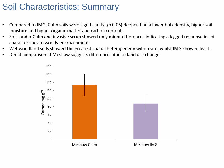
Soil Characteristics: Summary
• Compared to IMG, Culm soils were significantly (p<0.05) deeper, had a lower bulk density, higher soil moisture and higher organic matter and carbon content.
• Soils under Culm and invasive scrub showed only minor differences indicating a lagged response in soil characteristics to woody encroachment.
• Wet woodland soils showed the greatest spatial heterogeneity within site, whilst IMG showed least. • Direct comparison at Meshaw suggests differences due to land use change.
0
20
40
60
80
100
120
140
160
180
Meshaw Culm Meshaw IMG
Car
bo
n m
g g¯
¹

Water level and storage: IMG vs. Culm
Culm
IMG

Catchment Response
Time series for flume discharge (Q: m-3 s-1), rainfall and dipwell levels (mean depth (m)) at Stowford Moor.

Water Quality and Analogous Examples
Water quality concentration median values
Site DOC (mg l-¹) TON (mg l-¹) P (µg l-¹) SS (mg l-¹)
Stowford Moor
Catchment 10.8 2.7 30.0 24.0
Aller Agriculture
Catchment* 5.0 9.5 45.0 77.9
*Summary values taken for all storm flow samples collected between July 2010 and January 2013 at the Aller catchment outlet (Glendell, 2013). Water quality concentration median values (DOC = dissolved organic carbon; TON = total oxidised nitrogen; P = phosphorus and SS = suspended sediment) for the Aller and Stowford Moor catchments.
Storm Flow Concentration Ranges
Site DOC (mg l-¹) P (µg l-¹) SS (mg l-¹)
Stowford Moor Catchment 4-26 0-398 6-410
Den Brook Agricultural
Catchment* 9-248 90-5870 20-925
*Granger et al (2010) Water, Air and Soil Pollution.
Table 5.2. Comparison of water quality storm flow concentration ranges (DOC = dissolved organic carbon; P = phosphorous and SS = suspended sediment) from all events monitored at Stowford moor and high resolution temporal monitoring of a storm event at Den Brook.
For the 11 events monitored, the Stowford catchment showed: mean pH of 6.28 ± 0.32; mean DOC of 9.91 ± 3.18 mg l-¹; mean TON of 3.45 ± 2.64 mg l-¹; mean P of 66.84 ± 71.15 μg l-¹ and mean SS of 51.55 ± 69.11 mg l-¹

The Economic Value of Ecosystem Services
Focus on: •Water resource management and carbon storage. • The present contribution of the existing Culm grasslands. • The value of Devon Wildlife Trust’s contribution by its restoration work to date • The potential value if Culm grasslands were restored to their 1900 levels. • The value of the Culm within an example water catchment. • The comparative value between Culm grassland and IMG.

Service or feature Original base
Quantity M3/ha
Culm water storage
l/m2
277 2,770
IMG water storage 61 610
Difference 216 2,160
Culm topsoil depth
cm deep
47 4,700
IMG topsoil depth 27 2,700
Difference 20 2,000
Culm carbon storage
g/cm2
1.8 180
IMG carbon storage 1.5 150
Difference 0.3 30
Total Present Value 379 ha
The Economic Value of Ecosystem Services: Resource
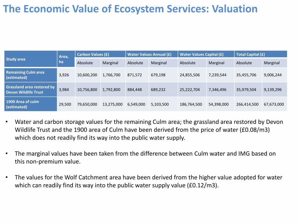
Study area Area, ha
Carbon Values (£) Water Values Annual (£) Water Values Capital (£) Total Capital (£)
Absolute Marginal Absolute Marginal Absolute Marginal Absolute Marginal
Remaining Culm area (estimated)
3,926 10,600,200 1,766,700 871,572 679,198 24,855,506 7,239,544 35,455,706 9,006,244
Grassland area restored by Devon Wildlife Trust
3,984 10,756,800 1,792,800 884,448 689,232 25,222,704 7,346,496 35,979,504 9,139,296
1900 Area of culm (estimated)
29,500 79,650,000 13,275,000 6,549,000 5,103,500 186,764,500 54,398,000 266,414,500 67,673,000
The Economic Value of Ecosystem Services: Valuation
• Water and carbon storage values for the remaining Culm area; the grassland area restored by Devon Wildlife Trust and the 1900 area of Culm have been derived from the price of water (£0.08/m3) which does not readily find its way into the public water supply.
• The marginal values have been taken from the difference between Culm water and IMG based on
this non-premium value. • The values for the Wolf Catchment area have been derived from the higher value adopted for water
which can readily find its way into the public water supply value (£0.12/m3).

Study area Area, ha
Carbon Values (£) Water Values Annual (£) Water Values Capital (£) Total Capital (£)
Absolute Marginal Absolute Marginal Absolute Marginal Absolute Marginal
Culm in Wolf Catchment area for Roadford Reservoir, 2007 area (estimated)
132 356,400 59,400 43,824 37,356 1,253,604 661,320 1,610,004 720,720
Culm in Wolf Catchment area for Roadford Reservoir, 1947 area (estimated)
455 1,228,500 204,750 151,060 128,765 4,321,135 2,279,550 5,549,635 2,484,300
The Economic Value of Ecosystem Services: Upper Wolf, Case Study for Restoration
2007 and 1947 coverage of Culm grassland within the Wolf catchment, upstream of Roadford reservoir.

• Estimated that the loss of water and carbon value from Culm grasslands, which have been converted to intensively managed grasslands since 1900 is £32.3 million at current prices. • Work undertaken to date by Devon Wildlife Trust in the restoration of Culm grassland is estimated to have a potential benefit of £9.139 million by the time it has taken full effect. • The remaining Culm area is estimated to have a water and carbon value of £35.46 million, a marginal value over the alternative of intensively managed grassland of £9 million. Such figures now need to be combined with data describing agricultural productivity to understand whether recreation of Culm grasslands is viable at landscape scales
Species rich meadows above Roadford Reservoir
Conclusions: Key Findings…

Ongoing and Future Work
• Continue monitoring at Stowford (3 to 5 years?) to assess the impacts of HLS agreement work upon: soil and vegetation structure; soil resources; water storage; hydrological behaviour of catchment and water quality.
• Work across more grasslands where Culm (or Rhôs pasture elsewhere in the UK) can be recreated and
monitoring of impact. Ideally in rural communities that have experienced or are at risk of flooding. • Undertake work at the catchment scale (i.e. Upper Wolf, above Roadford lake) to understand the current
impact of land use and how this changes with Culm recreation.
• Examine the policy, fiscal and funding mechanisms by which land managers might be encouraged to respond to the valuable opportunity to protect water and carbon benefits for future generations (Payment for Ecosystem Services)
• There are other ecosystem service benefits of Culm grassland and the Culm NCA, such as tourism and
added value agricultural products, that were beyond the scope of this valuation study. These would also benefit from future research and analysis.

Thanks to all the funders of this work…