national character 149. the culm area profile: supporting
TRANSCRIPT
1
www.gov.uk/natural-england
149. The CulmSupporting documents
National CharacterArea profile:
2
149. The CulmSupporting documents
National CharacterArea profile:
IntroductionAs part of Natural England’s responsibilities as set out in the Natural Environment White Paper1, Biodiversity 20202 and the European Landscape Convention3, we are revising profiles for England’s 159 National Character Areas (NCAs). These are areas that share similar landscape characteristics, and which follow natural lines in the landscape rather than administrative boundaries, making them a good decision-making framework for the natural environment.
NCA profiles are guidance documents which can help communities to inform theirdecision-making about the places that they live in and care for. The informationthey contain will support the planning of conservation initiatives at a landscape scale, inform the delivery of Nature Improvement Areas and encourage broader partnership working through Local Nature Partnerships. The profiles will also help to inform choices about how land is managed and can change.
Each profile includes a description of the natural and cultural features that shape our landscapes, how the landscape has changed over time, the current key drivers for ongoing change, and a broad analysis of each area’s characteristics and ecosystem services. Statements of Environmental Opportunity (SEOs) are suggested, which draw on this integrated information. The SEOs offer guidance on the critical issues, which could help to achieve sustainable growth and a more secure environmental future.
NCA profiles are working documents which draw on current evidence andknowledge. We will aim to refresh and update them periodically as newinformation becomes available to us.
We would like to hear how useful the NCA profiles are to you. You can contact theNCA team by emailing [email protected]
National Character Areas map
1 The Natural Choice: Securing the Value of Nature, Defra(2011; URL: www.official-documents.gov.uk/document/cm80/8082/8082.pdf)2 Biodiversity 2020: A Strategy for England’s Wildlife and Ecosystem Services, Defra(2011; URL: www.defra.gov.uk/publications/files/pb13583-biodiversity-strategy-2020-111111.pdf)3 European Landscape Convention, Council of Europe(2000; URL: http://conventions.coe.int/Treaty/en/Treaties/Html/176.htm)
3
149. The CulmSupporting documents
National CharacterArea profile:
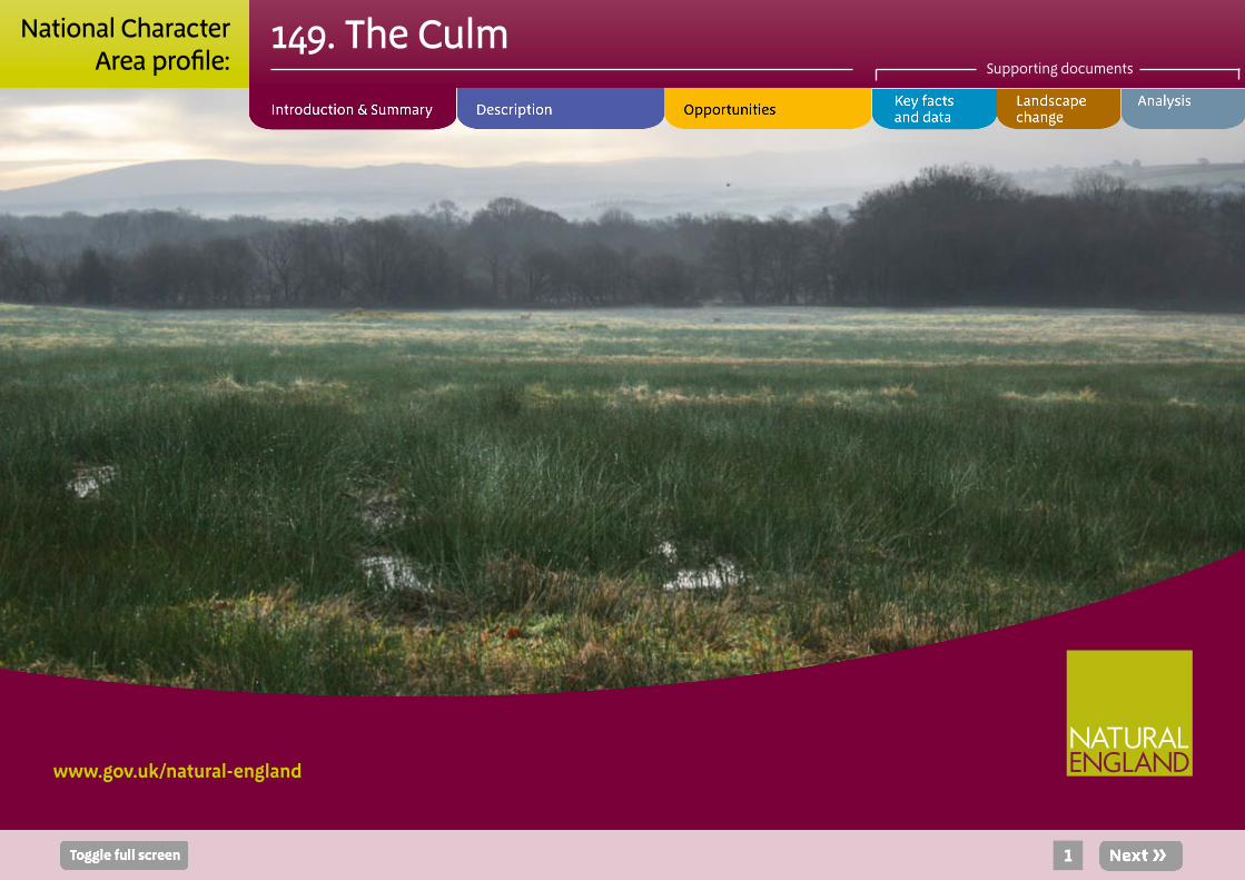
SummaryThe rolling ridges and plateaux of the Culm extend across north-west Devon and north-east Cornwall, reaching from the foot of Dartmoor in the south-west and the edge of the Cornish Killas in the west, to the spectacular Atlantic coast of cliffs and sandy beaches in the north. North-eastwards they meet the Exmoor landscape and stand high above the Devon Redlands. The open, often treeless, ridges are separated by an intricate pattern of small valleys forming the catchments of the Rivers Taw, Torridge and Mole. This is largely a remote and sparsely populated landscape.
The geodiversity of the area is of national importance. Dramatically folded rocks – seen particularly around Hartland – allow access to and interpretation of the geodiversity, and create a distinctive coastline. The exceptional beauty, tranquillity and wildness of the coast are reflected in its designation as both the North Devon Area of Outstanding Natural Beauty (AONB) and a Cornwall AONB, and recognition as Heritage Coast. The UNESCO North Devon Biosphere Reserve forms a focus for the wealth of biodiversity found across the area. Similarly, this rich resource is reflected in the designation of four Special Areas of Conservation (SAC) within the area: the Tintagel–Marsland–Clovelly Coast SAC and the Culm Grasslands SAC. Dunsdon National Nature Reserve (NNR) provides access to and interpretation of the internationally important Culm grassland habitat.
The area is a popular visitor destination, providing many leisure and recreation opportunities. The South-West Coast Path National Trail provides access to dramatic cliffs and remote coves. Clovelly and Hartland Point are examples of popular coastal destinations. Inland, a more tranquil, pastoral landscape provides for quiet leisure and recreation, walking, cycling and riding.
Influenced by the Atlantic climate, impermeable geology and clay soils, the area produces lush grasslands and, subsequently, notable volumes of meat and dairy produce. Biodiversity, geodiversity, tranquillity and a distinct sense of place are key components of the landscape. Changes in climate, localised development pressures – most prominently wind energy development – and changes in agricultural practices and regimes, are most likely to result in changes in this otherwise deeply rural, pastoral landscape.
Click map to enlarge; click again to reduce.

4
149. The CulmSupporting documents
National CharacterArea profile:
Statements of Environmental Opportunity
■ SEO 1: Seek to maintain, enhance and join up the distinctive and internationally important areas of Culm grassland, with their simple patterns of fields, hedgebanks, woodlands, rivers and tributaries, and their strong links to past land use and settlement. This will bring benefits in terms of reducing soil erosion, improving soil quality and water availability, regulating water flow, promoting the interpretation of the historic environment, enhancing biodiversity and supporting pastoral farming.
■ SEO 2: Safeguard the rich geological record and current geomorphological processes, particularly along the internationally important coastline. Where possible, allow the unimpaired operation of natural coastal processes, resulting in the creation of new habitats, conserving and enhancing landscape character, and benefiting biodiversity and the historic environment.
■ SEO 3: Protect open views and the simple, austere character of the landscape and seascape, enhancing access to and interpretation of the wealth of natural and heritage assets, and recreational opportunities, throughout the area – including the South West Coast Path.
Windbury Head.

5
149. The CulmSupporting documents
National CharacterArea profile:
DescriptionPhysical and functional links to other National Character AreasThe slates, fissile mudstones, shales and sandstones of the Upper Carboniferous Culm Measures are uncomformably overlain by the Permo-Triassic sandstones of the Devon Redlands NCA to the east.
Extensive views of mid and east Devon are gained from the high plateau in the north-east of the area, as are views towards Exmoor, Lundy and Cornwall.
There is limited movement of sediment along the coast, due to the characteristic pattern of inlets and headlands, and the low volume of sediment available. However, there is some littoral movement of sediment northwards from Trevose Head in the Cornish Killas NCA towards Hartland Point, and a sediment sink in Barnstaple Bay draws sediment from between Hartland Point and Morte Point in the Exmoor NCA.
The Tamar catchment, including Upper and Lower Tamar Lakes and Roadford Reservoir, flows south, and continues southwards to form the boundary between the south Devon and Cornish Killas NCAs. It flows between the counties of Devon and Cornwall, providing much of the water for the Plymouth conurbation.
To the south, and partly defining the boundary of the area, the A30 and formerly commercial (now heritage) railway form a transport corridor linking Exeter with Launceston and, via the A386, with Plymouth too. To the north, the
Devon Red Ruby cattle grazing on Whiteleigh Meadow SSSI.
A361, the North Devon Link Road, partly forms the boundary of the area, and links Barnstaple and Bideford with the M5 to the east. The A39 provides the main coastal access route to north Cornwall.
Okehampton, in the south of the area, acts as a gateway to Dartmoor National Park. Launceston, in the south-west, has historically acted as a gateway to Cornwall, and continues to do so today.

6
149. The CulmSupporting documents
National CharacterArea profile:
Key characteristics
■ Rolling, open plateaux – in places steeply undulating – with many small but deep valleys, fast-flowing rivers and streams that drain the area (principally to the west and south), and wide views across a remote landscape.
■ A consistent geology, underlain by the dramatically folded mudstones and sandstones of the Culm Group. Distinctive geological features such as the Sticklepath Fault and expressions of Variscan deformation.
■ Heavy, poorly-drained soil, which supports a pastoral landscape of low agricultural quality but high nature conservation interest.
■ Contrasting enclosed, wooded valleys of the Taw and Torridge, cutting through the ridges with open valley floors. Roads, railways and bridges provide communication along these valleys.
■ Distinctive Culm grassland, or Rhôs pasture, containing uncommon plant communities, including purple moor grass, rush pasture, wet heath, mires and fens.
■ Little tree cover on the plateau, except for occasional wind-sculpted hedgerow and farmstead trees, and conifer blocks. Woodland is more frequent in the shelter of valleys and combes running to the sea, and where associated with estates.
■ Mosaic of field patterns reflecting the historic land use of the Culm, surrounded by characteristic hedgebanks.
■ Scattered hamlets and farms in cob and whitewashed stone, connected by winding, sunken lanes.
■ Spectacular coastline of high cliffs and estuarine features, nationally important geological features and narrow wooded combes, with occasional fishing villages (such as Clovelly) in sheltered coves.
Upper reaches of the River Torridge.

7
149. The CulmSupporting documents
National CharacterArea profile:
The Culm today
The open, rolling plateau of the Culm is divided by an intricate pattern of valleys forming the catchments of the Rivers Taw, Torridge and Tamar. There are wide, sweeping views from the hill tops, occasionally interrupted by wind-sculpted trees, copses and overgrown hedges. The character of much of the Culm is dominated by these wide views, along with the variety of field patterns and the visual accents given by settlement. This is largely a remote and sparsely populated landscape, with hamlets and isolated farms of cob and whitewashed stone linked by narrow, winding lanes. Villages are most often a closely grouped collection of simple, even austere, cottages huddled around defendable central squares or ‘burys’ – Holsworthy and Bradworthy are two examples. The few towns, such as Great Torrington and Launceston, are formed around medieval marketplaces. There are few main roads and no major settlements.
The dominant influence on the landscape is the heavy clay overlaying the Upper Carboniferous Culm Measures, giving rise to heavy, wet soils, making cultivation difficult. Reflecting this, and the oceanic climate, the predominant land use is grass production for livestock – mainly dairy cattle, but also some beef cattle and sheep. North Devon ‘Red Ruby’ cattle are often prominent in the landscape, their colour contrasting with the muted green and buff of the grasslands.
The area contains one of the greatest concentrations of species-rich grasslands in the UK. The Culm grasslands are a distinctive element of the landscape, containing uncommon plant communities including purple moor grass, rush pasture, wet heath, mires and fens, as well as communities punctuated with seasonally bright wildflowers including meadowsweet, ragged robin, devil’s-bit scabious and many types of orchid. There is a rich associated invertebrate fauna, including the rare marsh fritillary butterfly and narrow-bordered bee
Traditional hedge management.
hawk-moth. The birds associated with the Culm grasslands include tree pipit, grasshopper warbler, and nationally important populations of willow tit. Fields are delineated by species-rich hedgebanks (occasionally neglected), supporting profusions of wildflowers and providing habitats for brimstone and brown hairstreak butterflies, dormice and foraging bats, as well as providing nesting sites for many bird species.

8
149. The CulmSupporting documents
National CharacterArea profile:
More modern settlements, like Westward Ho!, have spread along the lower-lying land of levels and sand dunes. The exposed, high, rugged cliffs exhibit spectacularly folded rocks, with maritime grassland and heath on the cliff-tops. It is these coastal cliffs that support internationally important, isolated western oak woods rich in lichens, bryophytes and ferns, some found nowhere else in the UK. Numerous steep, narrow combes, many densely wooded, extend inland from the coast. Settlements are rare along this wild coastline, with only the occasional hamlet or cottage, while the distinctive villages of Clovelly and Bucks Mills sit in two of the combes on the northern coast. The qualities of this coastal landscape are recognised in their designation as part of the North Devon Area of Outstanding Natural Beauty (AONB) and as a Heritage Coast.
Walking along the South West Coast Path National Trail, across the open, windswept cliff-tops, and looking west across the expanse of ocean, one is struck by a timeless sense of raw nature devoid of human influence. The humbling feeling is sharpened when Atlantic storm waves crash against the twisted strata of exposed rocky cliffs, sending thunderous sprays of surf into the air. Dropping down into a coastal combe from the cliffs or farmland, a strong sense of refuge and shelter is felt, made more striking by the presence of enclosing woodland in the combes and by the abrupt drop in wind speed. The variety and quality of the landscape and coast attract many visitors, who contribute to the local economy.
There is a diverse mosaic of field patterns: long, narrow, former common fields around hamlets; irregular, older fields on the valley sides; and rectilinear enclosures on the high ridges and wet valley bottoms. Hedgerows vary from over-managed to neatly trimmed to overgrown, but, where they are low, the openness of the landscape is emphasised: there can be long views punctuated only by power lines, wind turbines and occasional industrial buildings at the settlement edges. There are scattered copses and hedgerow trees of oak, ash and beech, especially in the north-west. Substantial areas of post-war conifer plantations, in particular around Broadbury, can dominate the landscape. In the south, around places with woodland-originated names like Shebbear and Buckland Filleigh, a more intricate landscape of small fields carved out of woodland is to be found.
Cutting through this landscape are the valleys of the Taw, Torridge and Tamar, and their tributaries: the Taw and Torridge were made famous as the home of Henry Williamson’s Tarka the Otter. The main steep-sided valleys follow broad, meandering and sweeping courses, with fertile, alluvial soils on the flat valley bottoms. The main areas of deciduous woodland are found on the steep valley sides. They are dominated by oak, birch and rowan, often lichen-covered and with lush ground cover resulting from the sheltered, humid conditions and clean air. The Torridge valley narrows rapidly, so that brief glimpses of the river are often only possible where sinuous lanes cross narrow stone bridges. Upstream, the valleys split into an intricate and dramatic network of headwaters. The Tarka Trail provides a well-used access route through this landscape.
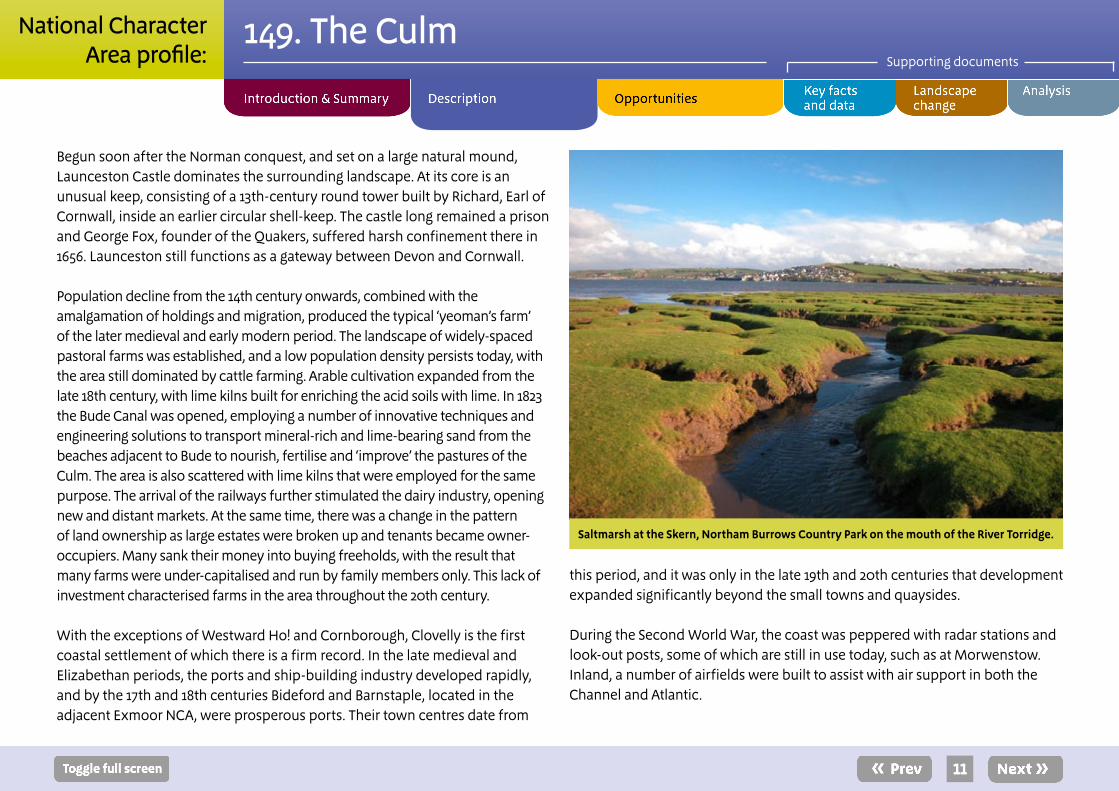
The Culm meets the sea abruptly as sheer and dramatic cliffs, only broken in a few places by small coves, occasionally with fine, sandy beaches. Larger bays are at Bude and Bideford, and at the Taw–Torridge estuary, with its mud and sand flats. At the latter, the ports of Barnstaple (in the Exmoor NCA), Bideford, Northam and Appledore have expanded much beyond their ancient centres.

9
149. The CulmSupporting documents
National CharacterArea profile:
The landscape through time
The area is almost entirely underlain by the Culm Supergroup. This consists of mudstones, siltstones, sandstones, cherts and thin limestones deposited from the late Devonian (365 million years ago) to the late Carboniferous (310 million years ago) in the Culm Basin. The Culm Basin originated through the development of west–northwest to east–southeast trending faults, resulting in the extension and subsidence of the continental shelf, and the deposition of deep-water mudstones, cherts and limestones. The Culm Basin was slowly in-filled during the late Carboniferous, and connections with open sea became restricted, as the Amorican Continent (southern Europe) came into collision with southern England. As it was cut off from the sea, the Culm Basin became a freshwater lake. Rivers drained into it from the surrounding area, forming deltas and alluvial plains on which forest developed. Thin, smutty coals were produced after the forests were drowned and buried.
As the continental collision progressed, the Culm Basin was uplifted and compressed to form part of the mountain range that developed across southern and south-western England during the late Carboniferous and early Permian (the Variscan Orogeny). This compression was responsible for the spectacular folding now seen on the coast. What evidence there is suggests that during the Permian and Triassic, west Devon and Cornwall were an arid upland, and the area appears to have remained above sea level to the present day. Structures, such as the Sticklepath Fault, developed during a phase of relaxation and extension of the crust after the Variscan Orogeny. The line of the Sticklepath Fault is a weakness that the River Torridge has exploited. It was also the site of small lake basins opened by faulting during the Late Eocene and Oligocene period, for example at Petrockstow. During the medieval period, the area near Fremington was extensively extracted from, as was the area around Petrockstow later into the 20th century.
Hartland Point.

10
149. The CulmSupporting documents
National CharacterArea profile:
Although small ice sheets appear to have developed in parts of the adjacent Dartmoor and Exmoor NCAs, it is likely that the Culm NCA was only ever subject to periglacial conditions, with the development of head and other solifluction deposits on hill slopes and valley sides.
The rocks in the periglacial landscape weathered through physical and chemical breakdown into ‘head’ deposits, which have developed into different soils depending on the geology and the landform. A band of mainly shale across the south of the area has developed into heavy clays, which form a more or less impervious layer, and lead to widespread waterlogged, mottled soils. These also occur on the flatter hill tops and foot slopes of the rest of the NCA, but on steeper slopes (and where sandstones are more widespread) there are more freely-draining, loamy soils. In the very wettest areas, on the hill tops to the north-west, peaty-topped soils have formed.
The nature of the geology, combined with erosion, has led to the development of dramatic landforms on the coast. Many of the cliffs, for example at Hartland Quay, expose spectacularly folded rocks. The Taw–Torridge estuary contains mudflats, salt marsh, sand banks, pebble ridges, dunes and beaches, demonstrating a wide range of geomorphological and tidal estuary processes. Of particular note are the dune systems at Northam Burrows.
The earliest recorded human activity is Mesolithic occupation of the coastland at Westward Ho!, Cornborough and Baggy Point, but there is also some evidence from further inland. At this time the sea level was lower than at present. Inland, substantial evidence of prehistoric activity is apparent from clusters of bronze-age barrows on prominent ridges and cliff-tops, such as at Gallantry Bower, and where ‘cliff castles’ and hill forts, such as Embury Beacon and Clovelly Dykes, were developed. It is likely that many of the ridgetops had
been cleared of vegetation by this time. Evidence of Roman activity in the area can be seen at forts at Alverdiscott, Okehampton and North Tawton. The date and speed of Saxon occupation is uncertain, but was probably gradual. And the area was not finally ‘pacified’ until King Aethelstan drew the boundary between Devon and Cornwall in the 10th century.
By 1086, the time of Domesday Book, the area was as densely settled as on the good red sandstone soils of south Devon. Most habitations appear to have been isolated farms or hamlets of up to ten households, and many of the existing villages appear in Domesday Book. Villages, like Holsworthy and Bradworthy, developed by grouping buildings around a defendable central square or ‘bury’, and with defensible circuit earthwork, as at Lydford. There is abundant evidence of an expanding population from the 11th to the end of the 13th century, when the density of settlement on the Culm peaked. As well as the boroughs and villages, there were many hamlets surrounded by common fields divided into numerous long, narrow strips. Many of these were ‘fossilised’ by subsequent medieval enclosure, and are present around quiet minor hamlets as well as the more extensive fields around settlements like Hartland, Woolfardisworthy (or Woolsery, as it is known locally) and Parkham Ash. Beyond these lay the ‘outfield’, which was occasionally brought into cultivation and then returned to rough grazing, as well as individual farmsteads with their own fields. Although some of the latter may have been ancient, many represent the reclamation of moorland by freemen under licence from the lord of the manor. Beyond lay the open moor, the grazing rights of which usually belonged to an individual parish or borough. Sheep and the wool industry contributed significantly to the shape of the landscape. Enduring features in the landscape are the deep-cut tracks resulting from the use of packhorse trains carrying wool, traversing difficult terrain.
11
149. The CulmSupporting documents
National CharacterArea profile:
this period, and it was only in the late 19th and 20th centuries that development expanded significantly beyond the small towns and quaysides.
During the Second World War, the coast was peppered with radar stations and look-out posts, some of which are still in use today, such as at Morwenstow. Inland, a number of airfields were built to assist with air support in both the Channel and Atlantic.
Begun soon after the Norman conquest, and set on a large natural mound, Launceston Castle dominates the surrounding landscape. At its core is an unusual keep, consisting of a 13th-century round tower built by Richard, Earl of Cornwall, inside an earlier circular shell-keep. The castle long remained a prison and George Fox, founder of the Quakers, suffered harsh confinement there in 1656. Launceston still functions as a gateway between Devon and Cornwall.
Population decline from the 14th century onwards, combined with the amalgamation of holdings and migration, produced the typical ‘yeoman’s farm’ of the later medieval and early modern period. The landscape of widely-spaced pastoral farms was established, and a low population density persists today, with the area still dominated by cattle farming. Arable cultivation expanded from the late 18th century, with lime kilns built for enriching the acid soils with lime. In 1823 the Bude Canal was opened, employing a number of innovative techniques and engineering solutions to transport mineral-rich and lime-bearing sand from the beaches adjacent to Bude to nourish, fertilise and ‘improve’ the pastures of the Culm. The area is also scattered with lime kilns that were employed for the same purpose. The arrival of the railways further stimulated the dairy industry, opening new and distant markets. At the same time, there was a change in the pattern of land ownership as large estates were broken up and tenants became owner-occupiers. Many sank their money into buying freeholds, with the result that many farms were under-capitalised and run by family members only. This lack of investment characterised farms in the area throughout the 20th century.
With the exceptions of Westward Ho! and Cornborough, Clovelly is the first coastal settlement of which there is a firm record. In the late medieval and Elizabethan periods, the ports and ship-building industry developed rapidly, and by the 17th and 18th centuries Bideford and Barnstaple, located in the adjacent Exmoor NCA, were prosperous ports. Their town centres date from
Saltmarsh at the Skern, Northam Burrows Country Park on the mouth of the River Torridge.

12
149. The CulmSupporting documents
National CharacterArea profile:
The dramatic coast and simple pastoral life of the inland plateau have attracted and inspired many visitors and residents alike. The coastal landscape of Westward Ho! inspired Charles Kingsley to write his novel of the same name. The Reverend R S Hawker drew on his life as vicar of Morwenstow for his writing and poetry. And, more recently, the photographer James Ravilious poignantly captured rural life and the people of north Devon on film.
In recent years the area has seen some localised changes, the most notable being road improvement and development. The A361 (the North Devon Link Road) has affected the higher open plateau between Tiverton and South Molton, cutting in half one important Culm grassland site at Hares Down, Knowstone and Rackenford Moor. Similarly, the widening of the A30 and by-passing of Okehampton have reduced the sense of tranquillity and subtly altered the transition between this NCA and neighbouring Dartmoor. Improvements to the A39 between Barnstaple and Bideford, and a new crossing of the River Taw, south of Barnstaple, have resulted in increased suburbanisation. Over the past ten years wind turbines have become a more common feature in the landscape, with large installations at Bradworthy (Forestmoor) and Fullabrook Down, in the adjoining NCA.
In general, the character of the landscape is unchanging and somewhat timeless. In places, the woodland and timbered nature of the landscape has increased and been enhanced. Since the foot and mouth disease outbreak of 2001, the number of grazing animals on the Culm’s grasslands has remained constant, but grazing is now managed in more concentrated systems. This has resulted in a slight shift towards less intensive management in some places, and has subsequently enhanced biodiversity.
Greencliff to Cockington Cliff.
13
4Defra priority catchments identified under the England Catchment Sensitive Farming Delivery Initiative http://archive.defra.gov.uk/foodfarm/landmanage/water/csf/documents/state-aid-ecsfdi2008.pdf
149. The CulmSupporting documents
National CharacterArea profile:
Ecosystem services
The Culm NCA provides a wide range of benefits to society. Each is derived from the attributes and processes (both natural and cultural features) within the area. These benefits are known collectively as ‘ecosystem services’. The predominant services are summarised below. Further information on ecosystem services provided in the Culm NCA is contained in the ‘Analysis’ section of this document.
Provisioning services (food, fibre and water supply) ■ Food provision: The area is characterised by its dairy production, and is also a producer of quality beef cattle, including traditional Red Ruby, and lamb. The sections of arable land in the south-east of the NCA also contribute to food provision through cereal production.
■ Timber provision: The relatively high proportion (13 per cent) of woodland in this area is not reflected in the availability of timber. Much of the woodland is located in the very difficult to access coastal combes and steep-sided valleys of the Taw and Torridge; however, plantations at the centre of the area have the capacity to produce both hard and soft wood in significant volumes.
■ Biomass energy: Existing woodlands and hedgerows are being brought under sympathetic management with potential for some biomass production as a by-product of commercial timber production. Opportunities for growing miscanthus do exist, where not in conflict with Culm grassland sites and below-ground heritage assets, with high potential yields identified across the area.
■ Water availability: Most of the area is classified as having additional water available for abstraction, although the NCA contains some areas that either have no water available for additional abstraction or are already over-abstracted.
There are two reservoirs in the NCA: Upper and Lower Tamar Lakes, and Roadford Reservoir. In the Taw and Tamar catchments the main abstractions are for public water supply, agriculture, aquaculture and hydroelectric power (although in the latter case only small sections of river experience reduced flow). Within the North Cornwall catchment, the main abstraction (making up 50 per cent) is for hydroelectric power generation, followed by aquaculture.
Regulating services (water purification, air quality maintenance and climate regulation)
■ Regulating soil erosion: The majority of soils in this NCA are medium to heavy soils that are at only limited risk of erosion. They are most at risk on steeper slopes under cultivation, and as a result of high rainfall. The upper reaches of the Tamar within this NCA down to Launceston fall within a Department for Environment, Food and Rural Affairs (Defra) priority catchment area, due to the high rates of sedimentation. The gently-sloping terrain, with its predominantly loamy or slowly permeable clay soils, has moderate to high run-off potential, with rates of surface flow leading to soil erosion and sedimentation within waterbodies.4 In addition, these soils have limited potential for increasing organic matter levels by management interventions, because levels are already likely to be high.
■ Regulating soil quality: The freely-draining, slightly acid, loamy soils, covering 55 per cent of the NCA, have good water infiltration where the soil structure is good. The slowly permeable, seasonally wet, acid, loamy and clayey soils (24 per cent) are easily damaged when wet, and are at risk of causing diffuse pollution and flooding as a result of poor water infiltration. In addition, these soils have limited potential for increasing organic matter levels by management interventions.

14
5North Devon Catchment Flood Management Plan, Environment Agency (2009) http://publications.environment-agency.gov.uk/pdf/GESW1109BOUN-e-e.pdf
6East Cornwall Catchment Flood Management Plan, Environment Agency (2009) http://publications.environment-agency.gov.uk/pdf/GESW1109BOUH-e-e.pdf
149. The CulmSupporting documents
National CharacterArea profile:
■ Regulating water quality: Groundwater quality across the north and centre of the NCA is good, although there are also large areas with poor groundwater quality. Most rivers within the NCA are of moderate ecological quality, although stretches of the Tamar are considered poor. The upper reaches of the Tamar have been identified as a Defra priority catchment.
■ Regulating water flow: Impermeable rocks and steep gradients in the upper catchments give the rivers a ‘flashy’ nature, which can cause rapid flooding downstream after heavy rainfall, particularly when this coincides with high tides in the estuaries and at outfalls.5 There is high fluvial flood risk along the coast in East Cornwall (as demonstrated by the 2004 flooding of Boscastle, on the border between this NCA and the Cornish Killas, and the 2012 flooding of Clovelly), where the watercourses rise on high ground in small catchments and flow rapidly downhill in deep, narrow valleys directly to the sea.6
■ Regulating coastal flooding and erosion: Rates of cliff erosion are generally slow and beaches are likely to maintain their current form with continued inputs. Localised problems may occur where cliff erosion undermines the South West Coast Path and coastal car parks. The Shoreline Management Plans for both Cornwall and the Isles of Scilly and for North Devon have recommended active and uninterrupted erosion, to allow natural processes to evolve along much of the coast.
Cultural services (inspiration, education and wellbeing) ■ Sense of place/inspiration: A sense of place is derived from the pastoral character: open, rolling ridges, intimate river valleys and the distinctive Culm grasslands on commons, unenclosed ground and unimproved pasture, with
blocks of both deciduous and coniferous woodland. The coast is defined as Heritage Coast and falls within the North Devon AONB. It is dramatic and striking, varying from low-lying levels, long sandy beaches and sand dunes, to high cliffs and sheltered coves, and incorporating picturesque, traditional fishing villages.
■ Sense of history: There is a wealth of visible prehistoric remains, including bronze-age barrows and prominent hill forts. Medieval wayside crosses are another characteristic element of the landscape, together with a high proportion of medieval houses by national standards related to the medieval pattern of dispersed settlement and early enclosure. Settlement is simple and timeless in character.
■ Tranquillity: The area remains a national ‘island of tranquillity’, largely undisturbed by major development or roads. Only a small proportion (1 per cent) of the area is urban and only local intrusion occurs around the few towns and adjacent to the few major roads.
■ Recreation: Recreational opportunities are provided by 112 km of the South West Coast Path National Trail, the National Cycle Network, and numerous regional routes including the Tamar Trail, Tarka Trail, Two Castles Trail, Two Moors Way, West Devon Way and Ruby Trail.
■ Biodiversity: Some 3,500 ha of the NCA, or 1.2 per cent, is designated as a Site of Special Scientific Interest (SSSI), and there are four Special Areas of Conservation (SAC) within the area. Almost 6,000 ha of the NCA are covered by Biodiversity Action Plan (BAP) priority woodland – upland oak, lowland mixed deciduous, lowland beech and yew, and wet woodland. There are almost 3,000 ha of

15
149. The CulmSupporting documents
National CharacterArea profile:
purple moor grass and rush pasture – this is one of the last strongholds of Rhôs pasture or Culm grassland in Britain. The area boasts internationally important populations of marsh fritillary butterfly, and nationally important populations of willow tit and dingy mocha moth. The rivers in the area, the Taw, Torridge and Tamar, provide important habitats for salmonids, and also the most southerly population of freshwater pearl mussel. The coastal fringe of the NCA is important for maritime cliff and slope BAP habitat, consisting of steep (often wooded) slopes and important geological exposures.
■ Geodiversity: The underlying geology of the area determines and influences the soils, drainage, and many of the habitats and human activities found across the area. The ability to observe, record and interpret geological formations and geomorphological processes, particularly along the coast, is an important contribution to education. Dramatically folded strata are exposed along much of the coastline and this is one of the most distinctive elements of this landscape.
Marsh fritillary butterfly.
16
149. The CulmSupporting documents
National CharacterArea profile:
SEO 1: Seek to maintain, enhance and join up the distinctive and internationally important areas of Culm grassland, with their simple patterns of fields, hedgebanks, woodlands, rivers and tributaries, and their strong links to past land use and settlement. This will bring benefits in terms of reducing soil erosion, improving soil quality and water availability, regulating water flow, promoting the interpretation of the historic environment, enhancing biodiversity and supporting pastoral farming.
For example, by: ■ Extending and linking fragmented areas of Culm grassland managed
through extensive, productive grazing, including areas of purple moor grass and rush pasture, focusing on locations where this will impede water flow, provide enhanced water quality and help to store water – reducing the effects of peak rainfall.
■ Realising opportunities for creating Culm grassland on areas of cleared conifer plantation – particularly where it would provide enhanced habitat linkage.
■ Encouraging the uptake of grant schemes to support the purposes of international (SAC) designation and the management of Culm grassland, benefiting numerous invertebrate species (particularly marsh fritillary), and floristic and invertebrate diversity generally. This will also benefit the conservation of the historic environment.
■ Introducing flexibility (including less intensive grazing regimes) into land management, supporting existing mixed farming systems and encouraging the re-introduction of more, and increasing the floristic diversity of ryegrass leys. This will all encourage a more diverse range of habitats, vegetation types and structures to develop, thus enabling habitats to respond to the effects of climate change, and enabling species to move as a result.
■ Managing and extending the area of internationally important western oak woodland on steep valley sides and in coastal combes, supporting extensive lichen and bryophyte communities, aiding water infiltration and reducing soil erosion.
■ Where appropriate, supporting and re-introducing sustainable, traditional woodland management techniques, such as selective felling, pollarding and coppicing, particularly on steeper valley sides in areas where soil erosion is not a risk. This will provide a sustainable local source of wood fuel and biomass.
■ Maintaining levels of important scrub habitat to benefit a range of bird species and scarce invertebrates such as the dingy mocha moth.
■ Protecting and reinforcing the pattern and network of hedgerows and hedgebanks, the often ancient and defining character of the ridges and hills. This will provide opportunities for the movement and migration of flora and fauna, regulate water flow and reduce soil erosion, particularly to support and reinstate extensive grazing regimes, and to restrict livestock access to rivers and streams. Where possible, using the arisings from hedgerow and hedgerow tree management as a source of local wood fuel.
Statements of Environmental Opportunity
17
149. The CulmSupporting documents
National CharacterArea profile:
SEO 1: Continued
■ Realising opportunities to make further connections between arable and pastoral land use through features such as hedgebanks, streams, sunken lanes and woodlands. Particular attention should be paid to features on the steeper slopes of valleys, to reduce soil erosion and subsequent sediment run-off into watercourses.
■ Working with existing projects (such as Nature Improvement Areas, Living Landscapes and catchment restoration projects), as well as emerging initiatives, to deliver enhanced land management and habitat linkage, as well as real engagement with local communities and user groups.
■ Maintaining and creating wetland habitats (including wet woodland) in the flood plains and upper reaches of the Taw, Torridge and Tamar and their tributaries, where these habitats can help slow water flow, reducing unwanted downstream flooding.
■ Maintaining areas of cliff-top grassland in favourable condition, through restoring grazing to accessible areas and to the unimproved pastures in the combe bases.
18
149. The CulmSupporting documents
National CharacterArea profile:
SEO 2: Safeguard the rich geological record and current geomorphological processes, particularly along the internationally important coastline. Where possible, allow the unimpaired operation of natural coastal processes, resulting in the creation of new habitats, conserving and enhancing landscape character, and benefiting biodiversity and the historic environment.
For example, by: ■ Maintaining and enhancing geological features where they are best expressed, such as the Carboniferous sediments and Variscan folds exposed on the coast, and the landforms and sediments associated with the Sticklepath Fault.
■ Sympathetically managing active quarries with special interest, and appropriately managing redundant extraction sites to allow for the continued study of geological records.
■ Maintaining the natural processes at the Northam Burrows sand dune system in the Taw–Torridge estuary, keeping the landward areas free from development, and promoting natural marginal and tidal habitats that support a rich assemblage of overwintering passage waders, and other flora and fauna.
■ Undertaking landscape restoration, creation and enhancement activities informed by and planned around the nationally recognised natural beauty, special qualities, elements and features of the North Devon AONB and Cornwall AONB.
■ Maintaining an undeveloped coastline, contributing to a sense of wildness, naturalness and exposure, and allowing geomorphological processes along the coast. This will promote the development of estuarine and intertidal elements such as mudflats, sand flats, salt marsh, dunes and shingle bars, which all contribute to flood risk management, coastal protection, landscape character, biodiversity and recreation, while maximising carbon sequestration and storage in intertidal sediments.
■ Ensuring that plans to enable adaptation to coastal change are in place, particularly where hard defences are not sustainable.
■ Incorporating coastal heritage sites into adaptation plans through recording, promoting, understanding and recognising their historic significance, and their contribution to local culture and coastal landscape character.
■ Maintaining the quality of beaches and the shoreline, ensuring their ongoing attractiveness to visitors.

19
149. The CulmSupporting documents
National CharacterArea profile:
SEO 3: Protect open views and the simple, austere character of the landscape and seascape, enhancing access to and interpretation of the wealth of natural and heritage assets, and recreational opportunities, throughout the area – including the South West Coast Path.
For example, by: ■ Maintaining important open views, tranquillity, a sense of wildness and connection to the maritime environment through sensitive, responsive planning of future land use and offshore developments.
■ Maintaining the pattern and distribution of settlement, carefully locating any necessary new development and infrastructure to avoid clutter and visual intrusion.
■ Promoting the use of local vernacular building materials, proportions and sizes, using this understanding to inspire locally-distinctive and sustainable development.
■ Promoting the important role played by soil in the development of the landscape through a network of interpretation sites – particularly on the coast, along forestry tracks, or where roads and rivers expose soils and make them accessible.
■ Carefully planning the location of new woodland, tree planting and land-cover to maintain a sense of openness.
■ Maintaining and improving access along and connecting with the South West Coast Path National Trail, and throughout the rights of way network, and promoting enjoyment, awareness and understanding of less well-known sites and features. This will accommodate and diffuse tourism pressures in order to maintain existing levels of tranquillity, remoteness and landscape character.
■ Encouraging access to, and interpretation and understanding of, cultural, natural and heritage assets by all sections of the community, to enable better current and future management and planning of the environment. Delivering the purposes of the North Devon AONB and Cornwall AONB to conserve and enhance the natural beauty of the landscape.
■ Promoting access to the natural environment across the area. Making the most natural, historic, inspirational and tranquil places available to all, particularly incorporating sustainable access to and from the South West Coast Path, and supporting and encouraging sustainable visitor initiatives.
■ Maintaining the open character and archaeological interest and potential, in addition to its benefits for biodiversity and carbon capture, of the few remaining areas of rough ground found across the area.

20
149. The CulmSupporting documents
National CharacterArea profile:
Additional opportunities
1. Reinforce and enhance the existing landscape structure as part of any identified growth of urban areas, principally around Barnstaple, Bideford, Holsworthy, Torrington and Westward Ho! and other larger settlements, ensuring that high-quality green infrastructure is incorporated into all scales of development, enhancing access, recreation, landscape character, biodiversity and geodiversity.
For example, by: ■ Using the traditional character of the internationally important coastal landscape, and the nationally recognised special qualities of the North Devon AONB, as the foundation for all new development along or adjacent to the coast.
■ Promoting the use of sustainable and locally sourced materials, vernacular building techniques and styles, and existing landscape character, to inform design to ensure visual and functional integration with the surrounding landscape. Promoting the integration of renewable energy technologies as part of new low-carbon, sensitive developments.
■ Using and replicating natural and semi-natural landscape features, such as hedgebanks, permanent grassland, broadleaf woodland, streams and wetlands to help integrate new development and reduce flood risk to both new and existing settlements.
■ Providing access to high-quality green space through well-designed green infrastructure, to benefit health and wellbeing, and to provide habitat, increasing the permeability of the urban landscape to biodiversity.

21
149. The CulmSupporting documents
National CharacterArea profile:
Supporting document 1: Key facts and data1. Landscape and nature conservation designationsThe Culm NCA contains 3,831 ha of the Dartmoor National Park. It also contains 9,009 ha of the North Devon Coast Area of Outstanding Natural Beauty (AONB) and 7,814 ha of the Cornwall AONB. The NCA also contains the Heritage Coast covering 4 per cent of the area.
Management Plans for the protected landscape(s) can be found at: ■ www.dartmoor-npa.gov.uk/ ■ www.northdevon-aonb.org.uk/ ■ www.cornwall-aonb.gov.uk/
Source: Natural England (2011)
1.1 Designated nature conservation sitesThe NCA includes the following statutory nature conservation designations:
Tier Designation NameArea (ha)
Percentage of NCA
International n/a n/a 0 0
European Special Protection Area (SPA)
n/a 0 0
Special Area of Conservation (SAC)
Tintagel-Marsland-Covelly Coast SAC; Culm Grasslands SAC; South Dartmoor Woods SAC; Dartmoor SAC
2,363 1
National National Nature Reserve (NNR)
Dunsdon Farm NNR 37 <1
National Site of Special Scientific Interest (SSSI)
A total of 64 sites wholly or partly within the NCA
3,396 1
Source: Natural England (2011)
Please note: (i) Designated areas may overlap (ii) all figures are cut to Mean High Water Line, designations that span coastal areas/views below this line will not be included.
Land covered by International and European nature conservation designations totals 2,363 ha, 1 per cent of the total land area; national designations cover 3,396 ha, again 1 per cent of the NCA.
There are 786 local sites in the Culm covering 9,311 ha, or 3 per cent of the NCA. Source: Natural England (2011)
■ Details of individual Sites of Special Scientific Interest can be searched at: http://www.sssi.naturalengland.org.uk/Special/sssi/search.cfm
■ Details of Local Nature Reserves (LNR) can be searched: http://www.lnr.naturalengland.org.uk/Special/lnr/lnr_search.asp
■ Maps showing locations of Statutory sites can be found at: http://magic.defra.gov.uk – select ‘Designations/Land-Based Designations/
Statutory’
1.2 Condition of designated sitesA breakdown of SSSI condition as of March 2011 is as follows:
SSSI condition category Area (ha)Percentage of SSSI in category condition
Unfavourable declining 167 5
Favourable 2,519 74
Unfavourable no change 200 6
Unfavourable recovering 510 15
Source: Natural England (March 2011)
22
149. The CulmSupporting documents
National CharacterArea profile:
Details of SSSI condition can be searched at: http://www.sssi.naturalengland.org.uk/Special/sssi/reportIndex.cfm
2. Landform, geology and soils2.1 ElevationElevation ranges from 0.2 m below sea level to a maximum of 343 m. An undulating plateau, the highest points are where the plateau meets Dartmoor to the south and Exmoor to the east. The lowest points are the river valleys which cut through the plateau.
Source:The Culm Countryside Character area description
2.2 Landform and processThe centre of the area is a broad and rolling, much dissected plateau with rounded summits rising to around 250 m AOD. The valleys drain into the rivers Taw and Torridge and southwards to the Tamar, cutting deep courses. The western edge is a series of high sea cliffs in which the folded and faulted character of the Culm Measures is spectacularly displayed, especially in the vicinity of the marked promontory at Hartland Point. The cliffs are broken only by the Bude and Taw-Torridge estuaries.
Source:The Culm Countryside Character area description
2.3 Bedrock geologyThe Culm is made up of an undulating plateau of folded Carboniferous shales and sandstones - the Culm Measures - which were deposited over a period of about 50 million years during the Carboniferous Period in a marine basin on the coast of a major desert continent. As the marine basin became shallower river deltas formed and freshwater fossils, rather than marine, appear. The delta deposits are the source of the thin coal seams which give the ‘Culm Measures’
their name. These sediments were folded dramatically during the Variscan Orogeny, or mountain-building episode, giving rise to the structures visible today. In the centre of the area, at Petrockstow, is a basin containing Tertiary clays which are worked for ball clay.
Source: The Culm Countryside Character area description, The Culm Natural Area Profile, British Geological Survey maps
2.4 Superficial depositsAlluvium and river terrace sediments have been deposited along watercourses. The Culm lay on the southern edge of ice during the various glacial periods and is important for understanding Quaternary deposits.
Source: The Culm Countryside Character area description, The Culm Natural Area Profile, British Geological Survey maps
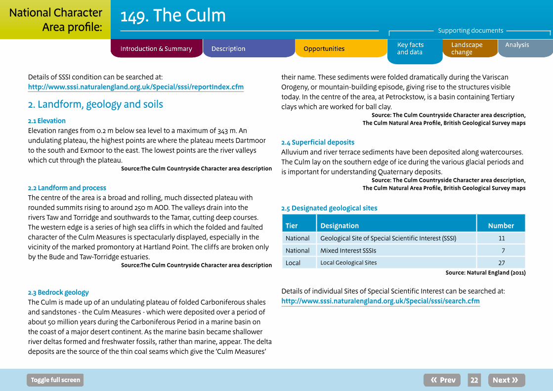
2.5 Designated geological sites
Tier Designation Number
National Geological Site of Special Scientific Interest (SSSI) 11
National Mixed Interest SSSIs 7
Local Local Geological Sites 27Source: Natural England (2011)
Details of individual Sites of Special Scientific Interest can be searched at: http://www.sssi.naturalengland.org.uk/Special/sssi/search.cfm

23
149. The CulmSupporting documents
National CharacterArea profile:
2.6 Soils and Agricultural Land ClassificationThe shales of the Culm Measures give rise mainly to heavy, infertile stagnogley soils on the hilltops and valley bottoms but, on some valley sides, there are better drained, more fertile brown earths.
Source:The Culm Natural Area Profile, The Culm Countryside Character Area Description
The main grades of agricultural land in the NCA are broken down as follows (as a proportion of total land area):
Agricultural Land Classification Area (ha) Percentage of NCA
Grade 1 22 <1
Grade 2 6,699 2
Grade 3 151,881 53
Grade 4 117,431 41
Grade 5 4,056 1
Non-agricultural 995 <1
Urban 1,469 <1Source: Natural England (2010)
Maps showing locations of sites can be found at: http://magic.defra.gov.uk – select ‘Landscape’ (shows ALC and 27 types of soils).
3. Key waterbodies and catchments 3.1 Major rivers/canals
The following major rivers/canals (by length) have been identified in this NCA.
Name Length in NCA (km)River Torridge 70River Taw 56River Tamar 41River Little Dart 26River Ottery 26River Yeo 24River Carey 20River Waldon 18River Daltch 17River Trushel 17River Okement 16River Deer 14River Bray 13River Lyd 12River Mole 12River Wolf 12River Claw 11River Teign 5River West Okemont 4River East Okement 3River Kenn 1
Source: Natural England (2010)
Please note: other significant rivers (by volume) may also occur. These are not listed where the length within the NCA is short.

24
149. The CulmSupporting documents
National CharacterArea profile:
The NCA has several rivers, the main river valleys are the Taw and Torridge with their many tributaries, flowing south to north. River Taw tributaries include the Little Dart River, River Mole and River Yeo (Lapford). River Torridge tributaries include the rivers Yeo, Mere, Walden and Okemont. Also the NCA contains the catchment for the Tamar and tributaries including rivers Deer, Carey, Claw, Wolf and Ottery which flows north to south, forming the Devon/Cornwall border.
3.2 Water qualityThe total area of Nitrate Vulnerable Zone is 100,746, or 36 per cent of the NCA.
Source: Natural England (2010)
3.3 Water Framework DirectiveMaps are available from the Environment Agency showing current and projected future status of water bodies http://maps.environment-agency.gov.uk/wiyby/wiybyController?ep=maptopics&lang=_e
4. Trees and woodlands4.1 Total Woodland CoverThe NCA contains 36,066 ha of woodland, or 13 per cent of the total area, of which 6,184 ha is ancient woodland.
Source: Natural England (2010) and Forestry Commission (2011)
4.2 Distribution and size of woodland and trees in the landscapeThe main areas of deciduous woodland are found in the steep-sided river valleys of the Taw and Torridge; dominated by oak, birch and rowan. Some of the valley woodlands have been re-planted with conifers and with hardwood trees such as sweet chestnut and sycamore. There are also substantial areas of post-war conifer plantations, mainly of sitka spruce, on the high, poor ground.
Source: The Culm Natural Area Profile, The Culm Countryside Character Area Description
4.3 Woodland typesA statistical breakdown of the area and type of woodland found across the NCA is detailed below.
Area and proportion of different woodland types in the NCA (over 2 ha)
Woodland type Area (ha) Percentag of NCA
Broadleaved 22,716 8
Coniferous 7,572 3
Mixed 1,377 <1
Other 4,401 2
Source: Forestry Commission (2011)
Area and proportion of ancient woodland and planted ancient woodland sites (PAWS) within the NCA.
Woodland type Area (ha) Percentag of NCA
Ancient semi-natural woodland 3,125 1
Ancient re-planted woodland (PAWS) 3,059 1
Source: Natural England (2004)

25
149. The CulmSupporting documents
National CharacterArea profile:
5. Boundary features and patterns5.1 Boundary featuresHedgerows and hedge banks are the dominant forms of enclosure. Hedges vary between neatly-trimmed and overgrown. Many are wide, with hawthorn, blackthorn and hazel as the principal vegetation. Hedgerow trees of oak, beech and occasionally ash occur especially in the north-west.
Source: The Culm Countryside Character Area description; Countryside Quality Counts (2003)
5.2 Field patternsThe varieties of field patterns are a key characteristic of The Culm. There is a mosaic of field patterns: long, narrow, former common fields around hamlets; irregular older fields on the valley sides; and rectilinear patterns on high ridges and wet valley bottoms. Piecemeal enclosure, generally completed by the 16th century, typically retains curved shapes of medieval strips on at least one of longer sides, notably in the Bude and Torrington areas. Larger-scale enclosure is also found, representing enclosure of larger groups of strips for example on the northern edge of Dartmoor. Rectilinear patterns deriving from late 18th and 19th century enclosure are concentrated on the high ridges and wet valley bottoms.
Source: The Culm Countryside Character Area description; Countryside Quality Counts (2003)
6. AgricultureThe following data has been taken from the Agricultural Census linked to this NCA.
6.1 Farm type The area supports a wide range of farm types: 1,187 grazing livestock (lowland), mainly sheep, 25 per cent; 601 dairy, 13 per cent; 595 grazing livestock LFA, 12 per cent; 407 mixed, 8 per cent; 351 cereals, 7 per cent; 132 horticulture, 3 per cent; 127 specialist poultry, 2 per cent; 47 generally cropping, 1 per cent; and 43 specialist pig
farms, 1 per cent. There are 1,195 farms, or 25 per cent, classified as ‘other types’; holdings with only horses, with only grass and fodder crops, or with only fallow land or buildings, and holdings with unknown activity. Between 2000 and 2009, there was a large increase in the number of specialist pig farms, 153 per cent, but they remain a ‘niche’ activity. Many other farm types also saw an increase with the number of specialist poultry farms rising by 49 per cent, cereal farms by 36 per cent, horticulture by 19 per cent, other types by 17 per cent, general cropping by 15 per cent and grazing livestock LFA by 12 per cent. However, dairy farms decreased by 40 per cent, grazing livestock (lowland) by 20 per cent and mixed farms by 6 per cent. The area remains predominantly pastoral in use.
Source: Agricultural Census, DEFRA (2010)
6.2 Farm sizeFarm units between 5 and 20 ha are the commonest by numbers of holdings; 1,274 units covering 6 per cent of the total farmed area. Holdings between 20 and 50 ha are the second most common with 1,061 units, covering 15 per cent of the farmed area. Fifty-one per cent of the total farmed area is managed by farms over 100 ha in size. Between 2000 and 2009 the number of holdings across most farm sizes fell, the largest reduction being among farms of 20 to 50 ha which have seen a reduction of 178 holdings or 14 per cent. By contrast farms over 100 ha increased in the same period by 118 holdings or 18 per cent.
Source: Agricultural Census, DEFRA (2010)
6.3 Farm ownershipSeventy-eight per cent of the total farm area is owned while the remainder is tenanted. There has been a 5 per cent decrease in owned land during the period 2000 to 2009, but a sharp rise in tenanted land of 46 per cent.
2009: Total farm area = 242,619 ha; owned land = 188,237 ha 2000: Total farm area = 234,629 ha; owned land = 197,455 ha
Source: Agricultural Census, DEFRA (2010)
26
149. The CulmSupporting documents
National CharacterArea profile:
6.4 Land useThe majority of the farmed area is grass and un-cropped land; 182,704 ha or 77 per cent. The next most common crop at 26,668 ha or 11 per cent of the total farmed area is cereals. The biggest increase in land cover during the period 2000 to 2009 was other arable crops at 80 per cent of the area or 3,536 ha, followed by stock feed, up by 19 per cent or 249 ha. Oil seed rape showed a steep decrease by 53 per cent or 1,466 ha as did cash roots by 30 per cent or 74 ha.
Source: Agricultural Census, DEFRA (2010)
6.5 Livestock numbersSheep are the most numerous livestock in the area with 605,500 animals, followed by cattle with 307,100, and then pigs with 41,300. There was a decline in the number of all livestock between 2000 and 2009. The numbers of sheep fell by 273,300 or 31 per cent, pigs by 15,000 or 27 per cent and cattle by 16,700 or 5 per cent.
Source: Agricultural Census, DEFRA (2010) 6.6 Farm labourThe vast majority of farms are run by owner farmers, 6,643, as opposed to salaried managers, 122. Since 2000, there has been a reduction in the numbers of owner farmers, down by 781 and an increase in salaried managers by 36. The numbers of full time workers has decreased by 171 as has the number of casual/ gang workers, by 239. Over the same period the numbers of part time workers has increased by 170.
Source: Agricultural Census, DEFRA (2010)
Please note: (i) Some of the Census data are estimated by Defra so may not present a precise assessment of agriculture within this area (ii) Data refers to commercial holdings only (iii) Data includes land outside of the NCA where it belongs to holdings whose centre point is recorded as being within the NCA.
7. Key habitats and species7.1 Habitat distribution/coverage Western oak woodland: Present on steeper valley sides of the Taw, Torridge and Tamar and a few discrete coastal cliff locations. Inland, deciduous woodland has often been replaced with conifer plantations. On steeper slopes throughout the area sessile oak is predominant, with rowan, holly and hazel, planted and self-seeded beech can be a strong component. On moister, deeper soils there is a greater diversity of tree and ground flora – pedunculate oak and ash with birch and hazel are dominant. Coastal woodlands have extensive lichen and bryophyte communities and are also a stronghold for the rare Devon whitebeam. The Dizzard is a unique dwarf oak wood with a dense wind-clipped canopy which supports an internationally important lichen community with 131 species recorded.
Parkland: Though not habitat of significant proportions in NCA, a number of parks including Clovelly and Dunsland, are noted for their extensive lichen communities.
Culm grassland (Rhôs pasture): This habitat is unlike any other in England, and subsequently referred to as Culm grasslands, nationally the habitat type is known as Rhôs pasture. Culm grassland is found throughout the area. Species-rich pastures, typical of poorly-drained acid soils, support a suite of purple moor-grass and rush communities. These pastures typically form a mosaic of vegetation communities with heathland, other species-rich grassland and wet woodland. It supports distinctive and often attractive plant species, including heath spotted-orchid, south marsh-orchid, bogbean, saw-wort. A number of characteristic butterflies are found, including the marbled white, and marsh, heath, silver-washed and high-brown fritillaries. Culm grassland supports a number of typical bird species including grasshopper warbler and willow tit, as well as habitat for breeding curlew and reed bunting and overwintering snipe and woodcock.

27
149. The CulmSupporting documents
National CharacterArea profile:
Sea cliffs and slopes: The coastal habitats along the full length of this NCA support a diversity of plant and animal species, including many specialist species tolerant of extreme exposure to wind and salt. Specialist lichens range from near the water to the high rock ledges; crevice species such as English stonecrop, sea campion, thrift and kidney vetch proliferate. A number of cliff nesting birds such as kestrel, peregrine, raven, shag and rock pipit are regularly found on the cliffs.
Estuarine habitats: The estuary of the Taw-Torridge is comprised of areas of mudflat, sandflat and saltmarsh and a series of other distinctive, associated habitats. These include eel-grass, glasswort and cord-grass communities. The mudflats and sandbanks support abundant burrowing invertebrates which are a source of food for many bird and fish species. The estuary is of national importance for certain over-wintering passage waders, namely curlew, golden plover and lapwing.
Sand dunes and shingle banks: Northam Burrows, located south of the Taw-Torridge estuary, is the principle area for this habitat, though other smaller areas occur at Instow, Widemouth Bay and Bude. The dunes are largely dominated by marram grass, which with other areas of dry grassland supports many species of plants and provide roosting and feeding grounds for many bird species.
Other: Rivers and streams supporting a wide variety of fish species including brown trout, dace, eel, and gudgeon are found across the area. Wet and carr woodlands, farmland and reservoirs also feature.
Source: The Culm Natural Area Profile.
7.2 Priority habitatsThe Government’s new strategy for biodiversity in England, Biodiversity 2020, replaces the previous Biodiversity Action Plan (BAP) led approach. Priority habitats and species are identified in Biodiversity 2020, but references to
BAP priority habitats and species, and previous national targets have been removed. Biodiversity Action Plans remain a useful source of guidance and information. More information about Biodiversity 2020 can be found at; www.naturalengland.org.uk/ourwork/conservation/biodiversity/protectandmanage/englandsbiodiversitystrategy2011.aspx.
The NCA contains the following areas of mapped priority habitats (as mapped by National Inventories). Footnotes denote local/expert interpretation. This will be used to inform future national inventory updates.
Priority habitat Area (ha) Percentage of NCA
Broadleaved mixed and yew wood-land (Broad Habitat)
17,989 6
Purple moor grass and rush pasture 2,948 1
Maritime cliff and slope 1,274 <1
Lowland heathland 1,169 <1
Coastal and flood plain grazing marsh 898 <1
Lowland meadows 155 <1
Coastal sand dunes 68 <1
Upland calcareous grassland 51 <1
Lowland dry acid grassland 32 <1
Mudflats 15 <1
Upland heathland 13 <1
Blanket bog 5 <1
Reedbeds 4 <1Source: Natural England (2011)
Maps showing locations of priority habitats are available at: ■ http://magic.defra.gov.uk – Select ‘Habitats and Species/Habitats’

28
149. The CulmSupporting documents
National CharacterArea profile:
7.3 Key species and assemblages of species ■ Maps showing locations of some key species are available at:
http://magic.defra.gov.uk – Select ‘Habitats and Species/Habitats’
■ Maps showing locations of S41 species are available at http://data.nbn.org.uk/
8. Settlement and development patterns 8.1 Settlement patternScattered farmsteads and hamlets, including a high proportion of medieval or earlier origin, with market towns and occasional small villages are found across the area.
Source: The Culm Countryside Character Area description; Countryside Quality Counts (2003)
8.2 Main settlementsThere are only a few larger inland villages and small towns like Hartland and Great Torrington, the most extensive areas of settlement are on the coast at Barnstaple, Bideford, Westward Ho! and Bude. The total estimated population for this NCA, derived from ONS 2001 census data, is: 156,076.
Source: The Culm Countryside Character Area description; Countryside Quality Counts (2003)
8.3 Local vernacular and building materialsTraditional building materials are cob, with some surviving examples from the late medieval period, and slatestone, with slate roofs from local and Welsh quarries and some surviving thatch. More recent buildings are in stone and brick.
Source: The Culm Countryside Character Area description; Countryside Quality Counts (2003)
9. Key historic sites and features9.1 Origin of historic featuresThere is evidence of pre-historic activity including clusters of bronze-age barrows on prominent ridges. Medieval wayside crosses are a particular feature of the area, many of round or ‘wheel’ form, marking routes between settlements, boundaries, junctions and processes of religious observance.
Source: Draft Historic Profile, Countryside Quality Counts, The Culm Countryside Character Area description
9.2 Designated historic assets This NCA has the following historic designations:
■ 10 Registered Parks and Gardens covering 1,017 ha ■ 1 Registered Battlefield/s covering 63 ha ■ 381 Scheduled Monuments ■ 6,008 Listed Buildings
Source: Natural England (2010)
More information is available at the following address: http://www.english-heritage.org.uk/caring/heritage-at-risk/
http://www.english-heritage.org.uk/professional/protection/process/national-heritage-list-for-england/
10. Recreation and access10.1 Public access
■ 3% of the NCA 8,609 ha is classified as being publically accessible. ■ There are 1,760 km of Public Rights of Way at a density of 0.6 km per km2. ■ There is 1 National Trail, the South West Coastal Path, extending 112 km within the NCA.
Sources: Natural England (2010)

29
149. The CulmSupporting documents
National CharacterArea profile:
The table below shows the breakdown of land which is publically accessible in perpetuity:
Access designation Area (ha) Percentage of NCA
National Trust (Accessible all year) 517 <1
Common Land 1,662 1
Country Parks 255 <1
CROW Access Land (Section 4 and 16) 6,247 2
CROW Section 15 639 <1
Village Greens 12 <1
Doorstep Greens 1 <1
Forestry Commission Walkers Welcome Grants 407 <1
Local Nature Reserves (LNR) 60 <1
Millennium Greens 2 <1
Accessible National Nature Reserves (NNR) 56 <1
Agri-environment Scheme Access 137 1
Woods for People 5,141 2
Sources: Natural England (2011)
Please note: Common Land refers to land included in the 1965 commons register; CROW = Countryside and Rights of Way Act 2000; OC and RCL = Open Country and Registered Common Land.
11. Experiential qualities11.1 TranquillityBased on the CPRE map of Tranquillity (2006) the NCA is least tranquil around Barnstaple Bay particularly in the neighbourhood of Bideford and alongside the A roads to Bude, Launceston and Okehampton. The greatest areas of tranquillity can be found along the heritage coast at Hartland Point, the adjacent inland region and to the east of Launceston.
A breakdown of tranquillity values for this NCA are detailed in the table below:
Tranquillity Score
Highest Value within NCA 49
Lowest Value within NCA -59
Mean Value within NCA 10
Sources: CPRE (2006)
■ More information is available at the following address: http://www.cpre.org.uk/resources/countryside/tranquil-places
11.2 Intrusion The 2007 Intrusion Map (CPRE) shows the extent to which rural landscapes are ‘intruded on’ from urban development, noise (primarily traffic noise), and other sources of visual and auditory intrusion. This shows that the results are similar to the tranquillity scores with the undisturbed areas in the parklands and woodlands. A breakdown of intrusion values for this NCA are detailed in the table below.
Intrusion category 1960s (%) 1990s (%) 2007 (%)
Percentage change
(1960s-2007)
Disturbed 2 11 18 +16
Undisturbed 97 89 82 -15
Urban <1 <1 0 0
Sources: CPRE (2007)
Notable trends from the 1960s to 2007 are the increase in disturbance.
■ More information is available at the following address: http://www.cpre.org.uk/resources/countryside/tranquil-places

30
149. The CulmSupporting documents
National CharacterArea profile:
12 Data sources
■ British Geological Survey (2006) ■ Natural Area Profiles, Natural England (published by English Nature 1993-1998 ) ■ Countryside Character Descriptions, Natural England (regional volumes published by Countryside Commission/Countryside Agency 1998/1999)
■ Joint Character Area GIS boundaries, Natural England (data created 2001) ■ National Parks and AONBs GIS boundaries, Natural England (2006) ■ Heritage Coast Boundaries, Natural England (2006) ■ Agricultural Census June Survey, Defra (2000,2009) ■ National Inventory of Woodland & Trees, Forestry Commission (2003) ■ Countryside Quality Counts Draft Historic Profiles, English Heritage (2004)* ■ Ancient Woodland Inventory, Natural England (2003) ■ Priority Habitats GIS data, Natural England (March 2011) ■ Special Areas of Conservation data, Natural England (data accessed in March 2011) ■ Special Protection Areas data, Natural England (data accessed in March 2011) ■ Ramsar sites data, Natural England (data accessed in March 2011) ■ Sites of Special Scientific Interest, Natural England (data accessed in March 2011)
■ Detailed River Network, Environment Agency (2008) ■ Source protection zones, Environment Agency (2005) ■ Registered Common Land GIS data, Natural England (2004) ■ Open Country GIS data, Natural England (2004) ■ Public Rights of Way Density, Defra (2011) ■ National Trails, Natural England (2006) ■ National Tranquillity Mapping data, CPRE (2007) ■ Intrusion map data, CPRE (2007) ■ Registered Battlefields, English Heritage (2005) ■ Record of Scheduled Monuments, English Heritage (2006) ■ Registered Parks and Gardens, English Heritage (2006) ■ World Heritage Sites, English Heritage (2006) ■ Incorporates Historic Landscape Characterisation and work for preliminary Historic Farmstead Character Statements (English Heritage/Countryside Agency 2006)Detailed River Network, Environment Agency (2008)
Please note all figures contained within the report have been rounded to the nearest unit. For this reason proportion figures will not (in all) cases add up to 100%. The convention <1 has been used to denote values less than a whole unit.
V1.0

31
149. The CulmSupporting documents
National CharacterArea profile:
Recent changes and trends
Trees and woodlands ■ Countryside Quality Counts (CQC) data reveals some change inconsistent with character between 1990 and 1998, with a decline in woodland area. Conversely, woodland character was found to have been enhanced, largely as a result of extensive new planting in a form that appeared consistent with existing patterns (within the area of the South West Forest) and the marked uptake of management agreements for established stock.
■ The Culm has been identified as a high priority for woodland conservation, particularly its wet woodlands and upland oak woods, and the creation of new woodland, aligned with the objectives for the South West Forest project, although coppice restoration is identified as a low priority.
Boundary features ■ The second half of the 20th century saw a decline in the extent and condition of boundary features. Stewardship agreements have brought about a positive change in hedge and hedgebank management, the introduction of fencing to protect hedges from livestock, hedge and tree planting, and general restoration. 5,124 km of hedgerow, 106 km of ditch, 50 km of hedge bank and 610 km of earth bank are now managed by land managers under Environmental Stewardship.
Agriculture ■ Generally the agricultural profile of the area has remained stable and predominantly pastoral with 77 per cent of the area under grass or un-cropped. The number of dairy farms has decreased, but yields from the area probably remain consistent.
■ There has been a slight increase in ‘niche’ agricultural activity; specialist pig and poultry rearing, small holdings and horticulture.
■ The numbers of livestock in the area have decreased over recent years with less sheep – reduced by approximately 30 per cent between 2000 and 2010 – cattle and pigs overall.
Settlement and development ■ Little development has occurred across the much of the area in recent years; however, given its undeveloped nature, where it does occur it often results in a marked change. Development around the fringes of Holsworthy, Bideford and Torrington and some coastal settlements is discernable, including leisure and recreational developments.
■ Some wind farm developments and larger agricultural developments are prominent in the landscape, particularly in the extensive views across the main inland plateaux.
Supporting document 2: Landscape change

32
149. The CulmSupporting documents
National CharacterArea profile:
Semi-natural habitat ■ Culm grassland, a habitat unique in England, and nationally known as Rhôs pasture, extends in pockets across much of the area. The extent and condition of Culm grassland has been maintained in recent years following a period of significant loss.
■ The amount and biological condition of western oak woodland has also been maintained, often due to the inaccessible nature of the terrain where it occurs.
■ The dynamic and complex coastal habitats of cliffs, sand dunes, rocky shores and estuaries, containing saltmarsh, sand banks and mud flats, continue to develop, providing long-lasting and fresh opportunities for colonisation and occupation by a wide range of flora and fauna.
Historic features ■ Heritage assets are an important component of the area and generally remain stable in condition and character; for example, about 68 per cent of historic farm buildings remained unconverted and about 94 per cent intact structurally in 2010 (source: Countryside Quality Counts).
Coast and rivers ■ The coastline is designated as part of the Tintagel-Marsland-Clovelly Coast SAC. This designation is related to the actively and uninterrupted erosive nature of the coastline, valued for both its natural landscape, geological and ecological interests.
■ Natural geomorphological processes are the most apparent changes to the coast; however, constraints and locally complex situations arise, for example at Northam Burrows.
■ The cliffs and rock platform throughout the area continue to slowly erode, varying in extent dependant on local geological factors.
■ The beaches have maintained their form with continued inputs of cliff and carbonate material offsetting any losses.
■ The biological river water quality is predominantly moderate; however, a number of sub-catchments are now failing on water quality. The chemical water quality of rivers has been maintained as predominantly very good.
Drivers of change
Climate change ■ Increased storminess, periods of drought and the increased prevalence of pests and diseases may have an impact upon the area’s internationally important western oak woodlands, particularly through sudden oak death. Scattered copses and hedgerow trees of oak, ash and beech, are further threatened through the loss of shallow-rooting beech to drought and windthrow, as well as characteristic parklands and ancient orchards.
■ Conversely, warmer winters could promote increased tree growth, as well as the suitability of new non-native species such as Corsican pine – with the south west being particularly suitable for the growth of high-quality softwood timber – and Holm oak, further affecting woodland composition.
■ Other semi-natural habitats may also deteriorate, including the area’s internationally important Culm grassland, of which purple moor-grass and rush communities may suffer from increasing drought conditions. There is also the threat of sea-level rise placing the Taw-Torridge estuary habitats

33
149. The CulmSupporting documents
National CharacterArea profile:
under pressure, as well as the Northam Burrows sand dune system where hindshore development, such as golf courses and landfill sites, prevent landward migration, reducing their effectiveness as a coastal defence and degrading a valuable habitat.
■ Changes in precipitation cycles, such as increased autumn/winter precipitation and decreased summer precipitation, will potentially alter the flow regimes of the rivers Taw, Torridge and Tamar and their tributaries, increasing the flashiness of flows with potential for more frequent winter flooding, summer drought and occasional summer flooding.
Other key drivers ■ Allowing natural coastal processes to operate unimpeded.
■ Pressure to develop within the area is generally low. Given the overall sensitivity of the landscape and natural environment, great attention to detail needs to be employed to ensure the enhancement of character and of quality environment, result from any development.
■ Given the generally sparse population and exposed nature of the area, pressure to erect further wind farms will be sustained. Conserving and enhancing the character and special qualities of the designated landscape – Cornwall AONB and North Devon AONB – will remain a priority and present a challenge. In addition, off-shore wind farms and other marine renewable energy schemes may result in changes to seaward views and a perceived intrusion into the ‘wildness’ of the coast.
■ Watercourses are generally short, but with large catchments resulting in rapidly occurring flood events. Management of plateau areas to withhold water and reduce the velocity of sporadic peak rainfall will be highly effective.
■ Maintaining pastoral farming activity and encouraging extensive, low input livestock production to maintain and extend the amount of Culm grassland. However, maintaining an agricultural economy to sustain a labour force sufficient to manage the farmed landscape may be a challenge.
■ Climate change adaptation, increased demand for locally produced food and niche markets, market economies and increased visitor activity may provide opportunities for further farm business diversification.

Black Church Rock - Mouth Mill.
34
The following analysis section focuses on a selection of the key provisioning, regulating and cultural ecosystem goods and services for this NCA. These are underpinned by supporting services such as photosynthesis, nutrient cycling, soil formation and evapo-transpiration. Supporting services perform an essential role in ensuring the availability of all ecosystem services.
Biodiversity and geodiversity are crucial in supporting the full range of ecosystem services provided by this landscape. Wildlife and geologically-rich landscapes are also of cultural value and are included in this section of the analysis. This analysis shows the projected impact of Statements of Environmental Opportunity on the value of nominated ecosystem services within this landscape.
Supporting document 3: Analysis supporting Statements of Environmental Opportunity
149. The CulmSupporting documents
National CharacterArea profile:
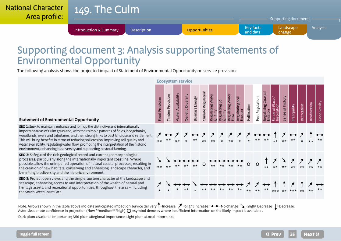
35
149. The CulmSupporting documents
National CharacterArea profile:
Note: Arrows shown in the table above indicate anticipated impact on service delivery =Increase ↗ =Slight Increase ↗ =No change ↗ =Slight Decrease ↗ =Decrease. Asterisks denote confidence in projection (*low **medium***high) =symbol denotes where insufficient information on the likely impact is available .
Dark plum =National Importance; Mid plum =Regional Importance; Light plum =Local Importance
Supporting document 3: Analysis supporting Statements of Environmental OpportunityThe following analysis shows the projected impact of Statement of Environmental Opportunity on service provision:
Statement of Environmental Opportunity
Ecosystem service
Foo
d P
rovi
sion
Tim
ber
Pro
visi
on
Wat
er A
vaila
bili
ty
Gen
etic
Div
ersi
ty
Biom
ass
Ener
gy
Clim
ate
Regu
lati
on
Regu
lati
ng W
ater
Q
ualit
yRe
gula
ting
Soi
l Q
ualit
yRe
gula
ting
Wat
er
Flow
Regu
ltat
ing
Soil
Eros
ion
Polli
nati
on
Pest
Reg
ulat
ion
Regu
latin
g C
oast
al
Eros
ion
Sen
se o
f Pla
ce /
Insp
irat
ion
Sen
se o
f his
tory
Tran
quili
ty
Recr
eati
on
Bio
dive
rsit
y
Geo
dive
rsit
y
SEO 1: Seek to maintain, enhance and join up the distinctive and internationally important areas of Culm grassland, with their simple patterns of fields, hedgebanks, woodlands, rivers and tributaries, and their strong links to past land use and settlement. This will bring benefits in terms of reducing soil erosion, improving soil quality and water availability, regulating water flow, promoting the interpretation of the historic environment, enhancing biodiversity and supporting pastoral farming.
** **
**
* **
**
**
*
**
*
*
**
**
**
**
**
*
**
**
SEO 2: Safeguard the rich geological record and current geomorphological processes, particularly along the internationally important coastline. Where possible, allow the unimpaired operation of natural coastal processes, resulting in the creation of new habitats, conserving and enhancing landscape character, and benefiting biodiversity and the historic environment.
**
** **
**
** o
** **
**
** o o
**
**
**
**
**
**
**
SEO 3: Protect open views and the simple, austere character of the landscape and seascape, enhancing access to and interpretation of the wealth of natural and heritage assets, and recreational opportunities, throughout the area – including the South West Coast Path.
*
*
* **
* **
**
**
**
**
**
** **
***
**
***
**
** **

36
149. The CulmSupporting documents
National CharacterArea profile:
Landscape attributes
Landscape attribute Justification for selection
A plateau landscape, deeply incised by many steep-sided valleys of varying scale.
■ Water has carved through underlying sandstones, slates and shale to leave a series of rounded, undulating ridges.
■ The highly distinctive and internationally recognised geology of the Culm Measures defines the form, land use and character of this area.
■ The area marks the southern edge of glacial activity during the last ice-age.
Valley and coastal woodlands contrasting strongly with often treeless plateaux and ridges.
■ On steeper valley sides – particularly along the rivers Taw, Torridge and Tamar – and in discrete coastal locations, western oak woodland perpetuates; a habitat of international importance rich in lichen and bryophyte species due to the clean air in the area. These are evocative, often secret places.
■ On ridge-tops and higher ground the area is marked by a lack of trees and woodland, although modern conifer plantation, popular for recreational activity, occupies large blocks at the centre of the area.
■ Woodland and parkland often indicates the presence of estate land with sporting interests and continuity of ownership and management for hardwood timber production.
■ Occasional wind-sculpted trees near the coast and on high ridges, and solitary mature field boundary and in-field trees in more sheltered parts, are prominent landmark features.

37
149. The CulmSupporting documents
National CharacterArea profile:
Landscape attribute Justification for selection
Wide views across a remote and sometimes rugged landscape with contrasting patches of heath, common, grassland and rushy pasture in varied field patterns defined by traditional hedgebanks.
■ Wide open nature of the landscape, with long views across sparsely populated and agriculturally-poor farmland.
■ Pasture is the dominant land use as a result of the underlying geology giving rise to poor, acidic, heavy clay soils. The permanent grassland has low productivity, but very high nature conservation value.
■ Culm grassland, purple moor grass and rush pastures, is a priority habitat, supporting distinctive plant communities and a number of bird species including grasshopper warbler and willow tit, curlew, reed bunting and overwintering and breeding snipe. Important assemblages of invertebrates inhabit the permanent rush pasture and heath of the Culm, particularly varieties of butterflies including marbled white, marsh and other fritillaries.
■ The variety of field patterns is a characteristic of the Culm and reflects piecemeal enclosure of the area, fossilisation of ancient cultivation systems, abandonment and re-enclosure. Former common fields around hamlets, irregular older fields on valley sides and rectilinear patterns of later enclosure on high ridges and in valley bottoms, illustrate a complex history of farming marginal land.
■ Flower-rich hedgerows on steep hedgebanks separate the fields and provide habitats for butterflies, dormice and hunting raptors.

38
149. The CulmSupporting documents
National CharacterArea profile:
Landscape attribute Justification for selection
A stunning and diverse coast with spectacular geological features, cliffs, sandy beaches, sand dunes and estuaries.
■ Most of the coast is designated as AONB (North Devon, and Cornwall) and also defined as Heritage Coast. ■ The area contains some of the finest cliff scenery in Britain, with sheer crags, important geological features and coastal waterfalls; for example, at Hartland Point and Quay.
■ The remote cliffs and cliff-top grasslands and heaths are important habitats, many designated for specialist plant and animal species. Cliff nesting birds are also an important feature; for example, kestrel, peregrine, raven and rock pipit.
■ Dramatic cliffs and geological features are contrasted by estuaries, occasional beaches and dunes. The Taw-Torridge estuary is of national importance, and supports a range of habitats and species. Sand dunes occur at a number of sites, principally at Northam Burrows.
■ Settlement is sparse along the coast, but distinctive and often much visited, particularly places such as Clovelly, Bude and Westward Ho!
■ Occasional fine sandy and remote beaches popular with visitors. ■ The South West Coast Path provides ready access to this, otherwise remote landscape.
A strong sense of history, but often reflecting the lack of human presence or activity, or a marginal existence.
■ First recorded human activity in the area is from the Mesolithic era, along the coast at Westward Ho! ■ Clusters of bronze-age barrows occur on prominent ridges, and medieval wayside and boundary crosses can be found, still marking important junctions and parish boundaries.
■ Settlement is generally in the form of farmsteads and hamlets, some shrunken into single farms from gathered small-holdings, others amalgamating into villages, and many of medieval or earlier origin. The dispersed nature of settlement has lead to both hill top and valley hamlets and villages.
■ Barnstaple and Bideford have grown to larger settlements reflecting the maritime significance of Bideford Bay and the Taw-Torridge estuary creating a rare safe-haven and port on the north Devon and Cornwall coast.
■ Communication and transport routes across the landscape are few with most roads following the course of ancient tracks and sunken lanes. The railway line from Barnstaple to Exeter – The Tarka Line – follows the meandering course of the River Taw, affording picturesque views of the valley.
A remote and tranquil landscape, uncluttered by modern development, but at times and in places wild and exposed.
■ Broad, uninterrupted skies lacking vertical features and with a simple, uncluttered character. ■ An inspirational coastline, prompting both artistic and literary expression and physical, active endeavour, such as climbing, surfing and other water sports.

39
149. The CulmSupporting documents
National CharacterArea profile:
Landscape opportunities
■ The tranquillity, simplicity and uninterrupted character of the inland portion of the area, acting as a foil to the inspiring, rugged and often exposed character of the coast.
■ The historic pattern of field enclosure linked by sunken lanes and flower-rich hedge banks forming a rural mixed-farm, but predominantly pastoral landscape.
■ Important geological, geomorphological and archaeological sites and assets from erosion, damage and loss due to inappropriate land management and development.
■ Culm grasslands, rush pastures and wet meadows, moorland broadleaf woodland, particularly in the Taw and Torridge valleys and on ridge tops, to maintain diversity of species and value for flora and fauna, enhancing the mosaic, texture and pattern of the landscape.
■ Sand dunes and ‘soft’, natural sea defences – estuarine mudflats and marshes – to allow for natural processes and to maintain a dynamic coastal landscape.
■ Conifer woodlands, popular for recreation, for ongoing access and transition to native broadleaf woodland, heath and rush pasture.
■ The restoration of hedge banks, small woodlands and estate landscapes to reinforce the structure and historic pattern of enclosure and land use.
■ The creation of new landscapes at the fringes of Barnstaple, Bideford and Bude, which make the most of existing landscape features and elements supporting the diverse landscape character.
■ To ensure ongoing access to and space for recreation and leisure activities, both along the coast and the secluded, enclosed river valleys.
Rivers and streams flow through wooded, steep-sided valleys down to the sea, such as here at Mouthmill.
40
149. The CulmSupporting documents
(Footnotes)
5 Natural England website, Opportunities and optimum sitings for energy crops, http://www.naturalengland.org.uk/ourwork/farming/funding/ecs/sit-ings/areas/041.aspx
6 Environment Agency, Humber River Basin Management Plan, December 2009.
7 Environment Agency, River Basin Management Plan, Humber River Basin District, Annex A: Current state of waters, December 2009.
8 Natural England, Capital Grant Scheme - Funding Priority Statement 2010/11, Catchment 6: East Riding of Yorkshire and North Lincolnshire, date unknown.
9 Environment Agency, The Humber Flood Risk Management Strategy, March 2008
10 Environment Agency, The Humber Flood Risk Management Strategy, March 2008
11 Humber Estuary Coastal Authorities Group, Flamborough Head to Gibraltar Point Shoreline Management Plan Non-Technical Summary, Con-sultation Draft, 2009
12 Environment Agency, Hull and Coastal Streams Catchment Flood Management Plan, draft main stage summary document, June 2008
13 Environment Agency, Grimsby and Ancholme Catchment Flood Management Plan: Summary report, December 2009
14 CPRE intrusion map, 2007
National CharacterArea profile:
Service
Assets/attributes: main contributors to service State
Main beneficiary Analysis Opportunities
Principal services offered by opportunities
Food provision
Livestock and dairy units
This is an important area for dairy cattle, lamb and beef. Close to 80 per cent of the area is grass or ‘un-cropped’. With over 300,000 cattle and 600,000 sheep, the area is a significant producer of meat and dairy produce. Traditional breeds of cattle, including Devon Red Ruby cattle, are still present in numbers and can add premium value to meat and dairy products.
Regional Livestock production remains the mainstay of agricultural activity across the area. Dairy and meat production are not only the dominant agricultural activities, but are also closely linked to many of the cultural aspects of the area; the sense of place, biodiversity, sense of history and heritage assets.
Inappropriate stocking rates and overly intensive production can result in soil erosion and diffuse pollution, and reductions in soil quality and soil-carbon storage. In some locations, well-managed production may have the capacity to increase outputs and given the close association between livestock, grassland and traditions in the area, further local branding may add value.
Continue to work with the local farming community to explore how and where to increase the overall carrying capacity of livestock across the Culm while avoiding adverse impacts on other ecosystem services such as soil and water quality.
Identify areas where reduced stocking rates or changed management techniques would positively influence water quality and reduce potential soil erosion, while maintaining viable levels of productivity.
Food provision
Regulating soil erosion
Regulating water quality
Sense of place
Ecosystem service analysis
The following section shows the analysis used to determine key Ecosystem Service opportunities within the area. These opportunities have been combined with the analysis of landscape opportunities to create Statements of Environmental Opportunity.
Please note that the following analysis is based upon available data and current understanding of ecosystem services. It does not represent a comprehensive local assessment. Quality and quantity of data for each service is variable locally and many of the services listed are not yet fully researched or understood. Therefore analysis and opportunities may change upon publication of further evidence and better understanding of the inter-relationship between services at a local level.

41
149. The CulmSupporting documents
National CharacterArea profile:
Service
Assets/attributes: main contributors to service State
Main beneficiary Analysis Opportunities
Principal services offered by opportunities
Timber provision
Existing woodland
The relatively high proportion of woodland in this area (13 per cent) is not reflected in the availability of timber. Much of the woodland is located in the difficult to access coastal combes and steep-sided valleys of the Taw and Torridge; however, plantations at the centre of the area have capacity to produce both hard and soft wood in significant volume.
Local There are limited opportunities to accommodate woodland creation without causing a significant change in the character of the area or reducing the extent of grassland. Most existing deciduous woodland is located on steep valley sides and coastal combes and inaccessible for commercial timber provision. Short-term provision would arise from the removal of conifer plantations, but reversion to Culm grassland or conversion to broadleaf woodland would limit further provision.
Bringing existing deciduous woodland into traditional management, where possible, would create a local supply of timber. Increased biodiversity and soil stability may result from positive, targeted management.
There may be limited opportunities for woodland creation on some valley sides and coastal combes helping to reduce flows of water and limit soil erosion; however, their use for timber production will be limited. Sites supporting other semi-natural habitats, important species and heritage assets will need to be avoided.
Manage traditional hedgerows and hedgebank vegetation for the provision of timber for local wood-fuel supply.
Timber provision
Biodiversity
Climate regulation
Regulating water flow
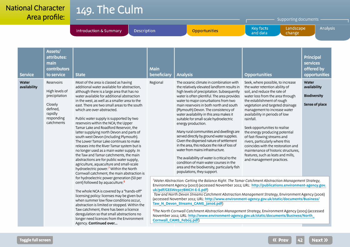
42
149. The CulmSupporting documents
National CharacterArea profile:
Service
Assets/attributes: main contributors to service State
Main beneficiary Analysis Opportunities
Principal services offered by opportunities
Water availability
Reservoirs
High levels of precipitation
Closely defined, rapidly responding catchments
Most of the area is classed as having additional water available for abstraction, although there is a large area that has no water available for additional abstraction in the west, as well as a smaller area to the east. There are two small areas to the south which are over-abstracted.
Public water supply is supported by two reservoirs within the NCA; the Upper Tamar Lake and Roadford Reservoir, the latter supplying north Devon and parts of south west Devon (including Plymouth). The Lower Tamar Lake continues to make releases into the River Tamar system but is no longer used as a main water supply. In the Taw and Tamar catchments, the main abstractions are for public water supply, agriculture, aquaculture and small-scale hydroelectric power.7 Within the North Cornwall catchment, the main abstraction is for hydroelectric power generation (50 per cent) followed by aquaculture.8
The whole NCA is covered by a “hands-off” licensing policy: licenses may be given but when summer low flow conditions occur, abstraction is limited or stopped. Within the Taw catchment, there has been a licence deregulation so that small abstractions no longer need licences from the Environment Agency. Continued over...
Regional The oceanic climate in combination with the relatively elevated landform results in high levels of precipitation. Subsequently water is often plentiful. The area provides water to major conurbations from two main reservoirs in both north and south (Plymouth) Devon. The consistency of water availability in this area makes it suitable for small-scale hydroelectric energy production.
Many rural communities and dwellings are served directly by ground water supplies. Given the dispersed nature of settlement in the area, this reduces the risk of loss of water from mains infrastructure.
The availability of water is critical to the condition of main water courses in the area and the biodiversity, particularly fish populations, they support.
Seek, where possible, to increase the water retention ability of soil, and reduce the rate of water loss from the area through the establishment of rough vegetation and targeted drainage management to increase water availability in periods of low rainfall.
Seek opportunities to realise the energy producing potential of fast-flowing streams and rivers, particularly where this coincides with the restoration and maintenance of historic structures, features, such as leats and mills, and management practices.
Water availability
Biodiversity
Sense of place
7Water Abstraction: Getting the Balance Right. The Tamar Catchment Abstraction Management Strategy, Environment Agency (2007) (accessed November 2012; URL: http://publications.environment-agency.gov.uk/pdf/GESW0307BMCH-E-E.pdf) Taw and North Devon Streams Catchment Abstraction Management Strategy, Environment Agency (2006) (accessed November 2012; URL: http://www.environment-agency.gov.uk/static/documents/Business/Taw_N_Devon_Streams_CAMS_Jan06.pdf)
8The North Cornwall Catchment Abstraction Management Strategy, Environment Agency (2005) (accessed November 2012; URL: http://www.environment-agency.gov.uk/static/documents/Business/North_Cornwall_CAMS_Feb05.pdf)
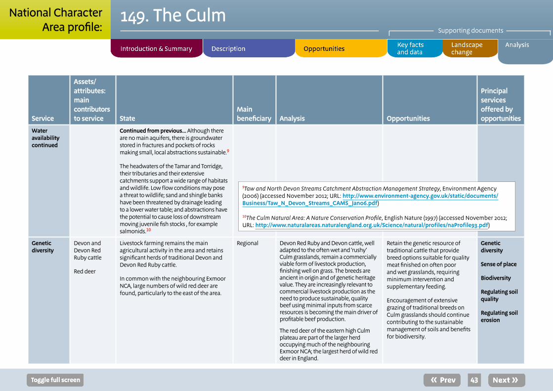
43
149. The CulmSupporting documents
National CharacterArea profile:
Service
Assets/attributes: main contributors to service State
Main beneficiary Analysis Opportunities
Principal services offered by opportunities
Water availabilitycontinued
Continued from previous... Although there are no main aquifers, there is groundwater stored in fractures and pockets of rocks making small, local abstractions sustainable.9
The headwaters of the Tamar and Torridge, their tributaries and their extensive catchments support a wide range of habitats and wildlife. Low flow conditions may pose a threat to wildlife; sand and shingle banks have been threatened by drainage leading to a lower water table; and abstractions have the potential to cause loss of downstream moving juvenile fish stocks , for example salmonids.10
Genetic diversity
Devon and Devon Red Ruby cattle
Red deer
Livestock farming remains the main agricultural activity in the area and retains significant herds of traditional Devon and Devon Red Ruby cattle.
In common with the neighbouring Exmoor NCA, large numbers of wild red deer are found, particularly to the east of the area.
Regional Devon Red Ruby and Devon cattle, well adapted to the often wet and ‘rushy’ Culm grasslands, remain a commercially viable form of livestock production, finishing well on grass. The breeds are ancient in origin and of genetic heritage value. They are increasingly relevant to commercial livestock production as the need to produce sustainable, quality beef using minimal inputs from scarce resources is becoming the main driver of profitable beef production.
The red deer of the eastern high Culm plateau are part of the larger herd occupying much of the neighbouring Exmoor NCA; the largest herd of wild red deer in England.
Retain the genetic resource of traditional cattle that provide breed options suitable for quality meat finished on often poor and wet grasslands, requiring minimum intervention and supplementary feeding.
Encouragement of extensive grazing of traditional breeds on Culm grasslands should continue contributing to the sustainable management of soils and benefits for biodiversity.
Genetic diversity
Sense of place
Biodiversity
Regulating soil quality
Regulating soil erosion
9Taw and North Devon Streams Catchment Abstraction Management Strategy, Environment Agency (2006) (accessed November 2012; URL: http://www.environment-agency.gov.uk/static/documents/Business/Taw_N_Devon_Streams_CAMS_Jan06.pdf)
10The Culm Natural Area: A Nature Conservation Profile, English Nature (1997) (accessed November 2012; URL: http://www.naturalareas.naturalengland.org.uk/Science/natural/profiles/naProfile93.pdf)
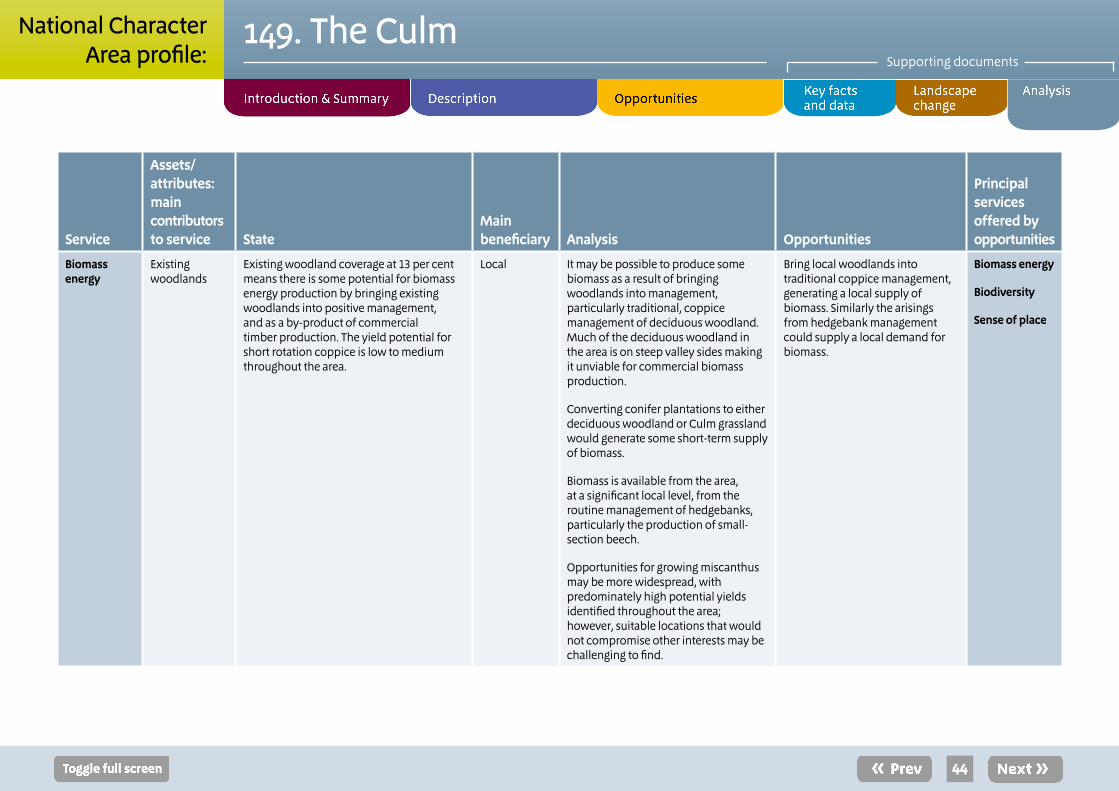
44
149. The CulmSupporting documents
National CharacterArea profile:
Service
Assets/attributes: main contributors to service State
Main beneficiary Analysis Opportunities
Principal services offered by opportunities
Biomass energy
Existing woodlands
Existing woodland coverage at 13 per cent means there is some potential for biomass energy production by bringing existing woodlands into positive management, and as a by-product of commercial timber production. The yield potential for short rotation coppice is low to medium throughout the area.
Local It may be possible to produce some biomass as a result of bringing woodlands into management, particularly traditional, coppice management of deciduous woodland. Much of the deciduous woodland in the area is on steep valley sides making it unviable for commercial biomass production.
Converting conifer plantations to either deciduous woodland or Culm grassland would generate some short-term supply of biomass.
Biomass is available from the area, at a significant local level, from the routine management of hedgebanks, particularly the production of small-section beech.
Opportunities for growing miscanthus may be more widespread, with predominately high potential yields identified throughout the area; however, suitable locations that would not compromise other interests may be challenging to find.
Bring local woodlands into traditional coppice management, generating a local supply of biomass. Similarly the arisings from hedgebank management could supply a local demand for biomass.
Biomass energy
Biodiversity
Sense of place

45
149. The CulmSupporting documents
National CharacterArea profile:
Service Assets/attributes: main contributors to service
State Main beneficiary
Analysis Opportunities Principal services offered by opportunities
Climate regulation
Occasional peaty soils
Existing ancient semi-natural woodlands
Estuaries, wetlands and grazing marsh
Permanent Culm grassland
Soil carbon content is low at 0-10 per cent throughout the NCA with a small area in the north west that reaches 20 per cent. The woodland cover creates humus-rich soils that have higher carbon levels and there are carbon stores locked in the wetlands (fens and flood plain grazing marsh) and areas of remaining Culm grassland (Rhôs pasture).
.
Local The ‘moors’ and ‘downs’ in the north-east of the area (Rackenford Moor, Knowstone Moor and Hares Down for example) have peaty soils with carbon content not dissimilar to areas of nearby Exmoor. Peaty soils are also found in the north-west of the area around Bursdon Moor, Hartland Forest and Meddon Moor.
The NCA’s heavy soils under permanent pasture, principally Culm grassland, and in a waterlogged condition store significant amounts of carbon and should be maintained in this state.
Similarly, the soils of the ancient semi-natural woodland sites, particularly along the valley sides of the rivers Taw and Torridge, within the area, store significant proportions of carbon.
Ensure areas with peaty soils are managed to maintain high water levels to prevent desiccation of existing soils and subsequent loss of carbon dioxide.
Encourage high water level management of areas to promote the development vegetation suitable for and capable of storing carbon dioxide.
Seek opportunities to expand the area of woodland adjacent to existing ancient semi-natural woodland sites to realise the potential for further, long-term carbon sequestration and storage associated with woodland management.
Maintain areas of permanent pasture and existing high water levels to prevent loss of carbon dioxide.
Seek opportunities to inform land managers of the importance of soil for the retention of carbon.
Climate regulation
Regulating water quality
Water availability
Biodiversity
Regulating soil quality
Timber provision

46
149. The CulmSupporting documents
National CharacterArea profile:
11Water for Life and Livelihoods. River Basin Management Plan. South West River Basin District, Defra/Environment Agency (2009) (accessed November 2012; URL: http://wfdconsultation.environment-agency.gov.uk/wfdcms/en/southwest/Intro.aspx)
12Defra catchment priorities identified under the England Catchment Sensitive Farming Delivery initiative http://www.defra.gov.uk/foodfarm/landmanage/water/csf/documents/catchment-priorities.pdf
Service Assets/attributes: main contributors to service
State Main beneficiary
Analysis Opportunities Principal services offered by opportunities
Regulating water quality
Fast flowing streams and rivers
Extensive areas of semi-natural habitats including Culm grassland and woodland
An area of high rainfall
.
Groundwater quality across the north and centre of the area is good. There is a large area of poor groundwater quality to the south-west, as well as to the east and far south-east.11 Most rivers within the area are of moderate ecological quality, although the Tamar and its’ tributaries have stretches of poor ecological quality. The upper catchment of the Tamar has been identified as a Defra priority catchment, suffering from nutrient run-off and siltation leading to damage to fish populations.12 There are several stretches of river in the east that are classed as having poor ecological status. The only river with poor chemical status is the lower reaches of the Torridge.
Regional Water quality is important to this area in support of much of the biodiversity resource to be found associated with rivers and watercourses. Particularly the quality of the Taw, Torridge and Tamar and their tributaries is significantly and directly influenced by the management of the surrounding farmland.
Careful management of grasslands and livestock, particularly minimising inputs, controlling access to watercourses and waste (farmyard manure) management, is essential to maintaining good water quality. Improved farm infrastructure will reduce sources of pollution and further contribute to maintaining good water quality.
On steeper valley slopes existing deciduous woodland helps reduce the amount of sediment and diffuse pollution reaching watercourses.
Increase areas of permanent pasture (Culm grassland) with extensive grazing and low fertiliser inputs, particularly around the upper catchment of Tamar. Where necessary and appropriate provide interlinking grassland buffer strips/ grass verges running across slopes adjacent or near to water bodies.
Create new woodlands, principally on steeper valley sides where they can aid the reduction of diffuse pollution reaching watercourses.
Regulating water quality
Regulating soil erosion
Timber provision

47
149. The CulmSupporting documents
National CharacterArea profile:
Service Assets/attributes: main contributors to service
State Main beneficiary
Analysis Opportunities Principal services offered by opportunities
Regulating soil quality
Freely draining slightly acid soils (55% of the NCA)
Slowly permeable wet, slightly acid soils (24% of NCA)
More fertile loamy brown soils on valley sides
There are five main soil types in this NCA: freely draining slightly acid loamy soils, covering 55% of the area; slowly permeable seasonally wet acid loamy and clayey soils (24%); freely draining acid loamy soils over rock (9%); slightly acid loamy and clayey soils with impeded drainage (8%); and freely draining flood plain soils (2%).
The freely draining slightly acid loamy soils (half the area) have good water infiltration where the soil structure is good. The slowly permeable seasonally wet acid loamy and clayey soils (quarter of the area) are easily damaged when wet and are at risk of diffuse pollution and flooding as a result of poor water infiltration. In addition, these soils have limited potential for increasing organic matter levels by management interventions.
Regional Compaction, erosion, over-drainage and loss of vegetation on peat soils to the east and north-west of the area will result in localised deterioration in soil quality.
Organic matter may be being lost through tillage across more intensively farmed areas away from concentrations of permanent pasture. Lack of long-established organic matter makes soils more susceptible to compaction and erosion.
Seek to maintain and improve the structure and stability of peat soils where they exist. Similarly, where small, exposed and bare areas of peat soil occur they would be improved through re-vegetation with semi-natural vegetation.
Ensure levels of long-established organic matter are maintained in higher-value agricultural soils, where found, minimising tillage operations where possible.
Identify and apply grazing regimes that increase sward diversity and increase the deposition and overall levels of organic matter. Manage with extensive grazing regimes to reduce stocking densities and avoid soil compaction. Also avoid compaction through unnecessary machinery use particularly during protracted periods of wet weather.
Regulation of soil quality
Regulation of soil erosion
Regulation of water quality
Regulating water flow (flooding)

48
149. The CulmSupporting documents
National CharacterArea profile:
13Defra priority catchments identified under the England Catchment Sensitive Farming Delivery Initiative http://archive.defra.gov.uk/foodfarm/landmanage/water/csf/documents/state-aid-ecsfdi2008.pdf
Service Assets/attributes: main contributors to service
State Main beneficiary
Analysis Opportunities Principal services offered by opportunities
Regulating soil erosion
Slowly permeable clay soils on plateaux and valley floors
Better drained, more fertile brown earths on valley sides
The upper reaches of the Tamar down to Launceston fall within a Defra Priority Catchment (Catchment Sensitive Farming area). The gently sloping terrain with predominantly loamy or slowly permeable clay soils have moderate to high run-off potential, with surface waters leading to soil erosion and resultant sedimentation of rivers.13
Regional Cold, slowly permeable clay soils on the plateaux result in the predominantly pastoral character of the area. The permanent pasture across much of the landscape reduces the risk of soil erosion, although inappropriate stocking may cause compaction and result in increase overland water flow and subsequent increased erosion. More fertile soils on valley sides are more prone to soil erosion, particularly as the impermeable soils of the higher plateaux tend to lead to rapid run-off. Reducing the velocity and quantity of water running over the valley sides would reduce erosion and subsequent sedimentation of rivers.
Seek and realise opportunities for introducing permanent grassland, woodland and restoring field boundaries (hedgebanks) along valley sides in areas particularly prone to soil erosion or adjacent to main rivers and their tributaries.
Maintain permanent pasture across the plateaux and encourage management for increased water holding capacity and higher water levels.
Regulation of soil erosion
Regulation of soil quality
Climate regulation

49
149. The CulmSupporting documents
National CharacterArea profile:
Service Assets/attributes: main contributors to service
State Main beneficiary
Analysis Opportunities Principal services offered by opportunities
Regulating water flow
Wet, rush pasture
Fast flowing rivers and streams
Wooded, steep-sided valleys
Flood-meadows
Springs on the upland moors (adjacent Dartmoor NCA to the south) and heaths, feed steep, fast-flowing streams that run to the low lying Taw and Torridge estuaries in the north and the Tamar in the west. Annual rainfall is high at over 2,000mm on the moors and uplands and 800-1,000mm near the coast. Impermeable granite and steep gradients in the upper catchments give the rivers a “flashy” nature leading to flash flooding after heavy rainfall, particularly when this coincides with high tides in the estuaries.14 There is high fluvial flood risk in East Cornwall along the coast, as demonstrated by the 2004 flooding of Boscastle (on the border between this NCA and the Cornish Killas NCA), where watercourses rise on high ground in small catchments and flow rapidly in deep, narrow valleys and combes directly to the sea.15
The lower reaches of the Torridge are susceptible to flooding affecting Great Torrington and especially Bideford, which has had a history of flooding (with major flood defences being put in place at Bideford Quay). There is also regular flooding along the lower reaches of the Tamar and its tributaries, including the River Kinsey; a flood threat to Launceston.
Regional Although most of the NCA is at little or no risk from flooding, management of catchments is critical to the regulation of flooding in key settlements at the lower reaches of watercourses. Flood events are expected to increase with climate change. Topography will limit the extent of flooding but flood depth is expected to increase, partially attributable to rising sea level affecting the estuaries (see coastal flooding below).
Naturalising flood plains and creating wetland habitats (some outside of the NCA) will reduce flood risk downstream in settlements (within the NCA). Creating conditions for rivers to re-engage with their flood plains and reconnecting different parts of the flood plain, as well as increasing storage of water in upland areas (including Dartmoor lying outside the NCA) will make a significant contribution to mitigating flood risk.
There needs to be appropriate management in the wider catchments aimed at reducing surface water run-off through, for example, best practice cultivation techniques and timing, woodland planting, and creation of buffer zones adjacent to river banks. Such measures will be particularly beneficial in the Upper Tamar to reduce flood risk in the Central Tamar area.16
Increasing the levels of organic matter to improve overall soil structure and increase the permeability of soils across the plateaux will further contribute to water retention and reduce rates of run-off.
Slow down run-off from the plateau areas by encouraging the planting of strategically located deciduous woodland, repairing eroded channels and tracks and cross-slope cultivation. Increase the water storage capacity of the plateaux by encouraging permanent grass and increased organic matter in soils.
Seek opportunities to restore rivers to their natural courses in defined locations where past engineering has modified fluvial pathways. Manage cultivation in valleys and adjacent to watercourses to optimism water penetration. Reinstate permanent pasture adjacent to watercourses along narrow valleys.
Regulating water flow
Regulating soil erosion
Regulating soil quality
Sense of place
16Tamar Catchment Flood Management Plan, Environment Agency (2009) (accessed November 2012; URL: http://publications.environment-agency.gov.uk/pdf/GESW1109BOUP-e-e.pdf)
14North Devon Catchment Flood Management Plan, Environment Agency (2009) (accessed November 2012; URL: http://publications.environment-agency.gov.uk/pdf/GESW1109BOUN-e-e.pdf)
15East Cornwall Catchment Flood Management Plan, Environment Agency (2009) (accessed November 2012; URL: http://publications.environment-agency.gov.uk/pdf/GESW1109BOUH-e-e.pdf)
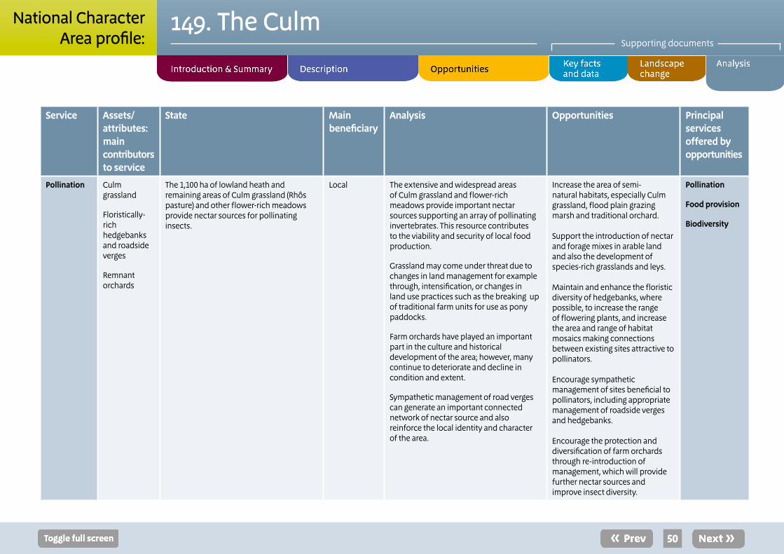
50
149. The CulmSupporting documents
National CharacterArea profile:
Service Assets/attributes: main contributors to service
State Main beneficiary
Analysis Opportunities Principal services offered by opportunities
Pollination Culm grassland
Floristically-rich hedgebanks and roadside verges
Remnant orchards
The 1,100 ha of lowland heath and remaining areas of Culm grassland (Rhôs pasture) and other flower-rich meadows provide nectar sources for pollinating insects.
Local The extensive and widespread areas of Culm grassland and flower-rich meadows provide important nectar sources supporting an array of pollinating invertebrates. This resource contributes to the viability and security of local food production.
Grassland may come under threat due to changes in land management for example through, intensification, or changes in land use practices such as the breaking up of traditional farm units for use as pony paddocks.
Farm orchards have played an important part in the culture and historical development of the area; however, many continue to deteriorate and decline in condition and extent.
Sympathetic management of road verges can generate an important connected network of nectar source and also reinforce the local identity and character of the area.
Increase the area of semi-natural habitats, especially Culm grassland, flood plain grazing marsh and traditional orchard.
Support the introduction of nectar and forage mixes in arable land and also the development of species-rich grasslands and leys.
Maintain and enhance the floristic diversity of hedgebanks, where possible, to increase the range of flowering plants, and increase the area and range of habitat mosaics making connections between existing sites attractive to pollinators.
Encourage sympathetic management of sites beneficial to pollinators, including appropriate management of roadside verges and hedgebanks.
Encourage the protection and diversification of farm orchards through re-introduction of management, which will provide further nectar sources and improve insect diversity.
Pollination
Food provision
Biodiversity

51
149. The CulmSupporting documents
National CharacterArea profile:
Service Assets/attributes: main contributors to service
State Main beneficiary
Analysis Opportunities Principal services offered by opportunities
Regulation of coastal flooding and erosion
Resilient coastal cliffs and wide sandy beaches
Rocky foreshores and wave cut platforms
Coastal flood plains, estuaries and associated habitats
Most of this area is characterised by sea cliffs and slopes descending to the Atlantic with wide sandy beaches often backed by sand dunes.
Carboniferous sandstone is the dominant geology with headlands occurring where there are sections of more resistant rock.17
This entire stretch of coast is nationally important for its geology and geomorphology making it important to maintain and observe natural processes. SACs and SPAs in the area are further enhanced by their natural landscape, geological (cliff geology, rocky foreshores and wave cut platforms) and associated ecological interests.
The coastline from Hartland Point to Westward Ho! is low lying and susceptible to flooding. The coastal towns of Westward Ho! Bude and Widemouth are protected by coastal defences.
At Bude, residential and commercial development fronts the low-lying area of the beach, canal and River Neet making it vulnerable to flooding.18
Regional The Cornwall and Isles of Scilly and the North Devon Shoreline Management Plans recommend active and uninterrupted erosion to allow natural evolution of much of the coast.
Cliff erosion is generally slow and beaches are likely to maintain current form with continued inputs. Tidal flow has little influence on coastal erosion, with wave energy driving both erosion and sediment transport. Localised problems may occur where cliff erosion undermines the South West Coastal Path and coastal car parks or where localised land slips block roads.19 The beach at Westward Ho! may be subject to drawdown in front of the defences putting more pressure on the sea wall.20
In low lying areas there are significant coastal flood plains along estuaries that have the capacity to store floodwater, but pressure on these areas is greatly increased by the discharge of river flood waters (see river flooding).
Maintain active and uninterrupted erosion to allow natural processes to prevail along much of the coast, particularly where this supports and enhances natural flood defence mechanisms and allows for the exposure and interpretation of nationally important geological formations and coastal geomorphological processes.
Increase areas of wetland habitats in the coastal flood plains around Taw/Torridge estuary to increase ability to store coastal floodwaters.
Regulating coastal flooding and erosion
Regulating water flow
Geodiversity
Biodiversity
Sense of place
17Cornwall and the Isles of Scilly Shore Management Plan (accessed November 2012; URL: http://www.ciscag.org/draftsmpindex.html)
18Cornwall and the Isles of Scilly Shore Management Plan (accessed November 2012; URL: http://www.ciscag.org/draftsmpindex.html)
19North Devon & Somerset Shore Management Plan http://www.ndascag.org/smp1manunits.html
20North Devon & Somerset Shore Management Plan http://www.ndascag.org/smp1manunits.html

52
149. The CulmSupporting documents
National CharacterArea profile:
Service Assets/attributes: main contributors to service
State Main beneficiary
Analysis Opportunities Principal services offered by opportunities
Sense of place/ inspiration
Open, expansive pastoral landscape with extensive, uninterrupted views
Contrast of steep-sided, densely wooded valleys with meandering streams and river.
Species-rich, distinctive ‘rushy’ pastures
Highly distinctive, dramatic and dynamic coast
A simple, austere vernacular architecture
Sense of place is provided by the pastoral character of open, rolling ridges and intervening intimate river valleys with fast flowing rivers, a mosaic field pattern defined by windswept hedgebanks and farmstead trees, patches of heath, common, coniferous blocks and valley woodlands. The area’s distinctive and internationally important Culm grassland on commons, unenclosed ground and unimproved pasture are a defining element. The pastoral, rural nature of the area is captured and explored in the poignant photographs of James Ravilious.
Occasional, distinctive settlements on skylines follow the ridgelines and are contrasted by deep sunken lanes. The coast is an essential part of the character of the area, much falls within the North Devon AONB and is defined as Heritage Coast.
Feelings of inspiration and escapism are associated with the panoramic views across a remote landscape from ridge tops only interrupted by small villages and clumps of wind-sculpted trees. The spectacular coastline of high cliffs with fishing villages in sheltered coves has inspired artists and photographers. The area was the inspiration for the novel “Westward Ho” by Charles Kingsley and the writing and poetry of the Reverend R S Hawker.
National The Culm has a very strong character defined by its underlying geology. The coastal strip with its dramatic cliffs and exquisite beaches is popular with visitors providing both intense tranquillity and leisure and recreational opportunities. The whole landscape has a timeless character, derived in part from its surviving pastoral land use. The often simple and austere landscape, buildings and field pattern away from the dynamic and dramatic coast are a marked and defining contrast.
While the ‘wild’ and remote rugged coastline inspires artists, poets and writers, much of the inland plateau, free from clutter, development and infrastructure permits quiet contemplation and inward reflection. The intimacy of wooded valleys and sunken lanes, bounded by high hedgebanks, adds a further, distinctive dimension.
Identifying, protecting and reinforcing the distinctive elements and features of the landscape are essential to maintaining the distinctive and inspirational character of the area.
Of particular importance are the maintenance of the ‘wild’ and dramatic coastline, the intimate and secluded wooded valleys and combes, and the open, uncluttered, and generally undeveloped character of the main plateau.
All opportunities to ensure that development respects local settlement patterns and building materials should be taken, and to avoid the loss of historic evidence through insensitive development or management.
Sense of place
Recreation
Sense of history

53
149. The CulmSupporting documents
National CharacterArea profile:
Service Assets/attributes: main contributors to service
State Main beneficiary
Analysis Opportunities Principal services offered by opportunities
Sense ofhistory
Some surviving prehistoric features still prominent in the landscape
Settlement pattern of Saxon or medieval origin
Strong association with the sea and tradition of small-scale fishing
Strong surviving pastoral land use and character
Ancient deciduous woodland on steep-sided valleys
A sense of history is to be associated with the wealth of visible prehistoric remains including bronze age barrows and prominent hill forts as at Clovelly Dykes, and the Roman forts and associated remains at Okehampton. On a smaller scale, masonry bridges and medieval wayside crosses are characteristic of the area. The settled nature of the area is reflected in the dispersed settlement pattern; small hamlets and farms of cob or whitewashed stone and thatch or slate roofs. Elsewhere nucleated settlements are often nestled around a defendable central square with a prominent church, such as at Holsworthy Settlement is largely medieval or earlier in origin.
Regional Many heritage assets are fragile and highly susceptible to loss or damage due to direct impacts or inappropriate management. Much below-ground heritage may remain undiscovered or unexplored in this undeveloped area, and care should be taken not to unnecessarily disturb or damage buried heritage assets.
The range of features present in the area allows for study of past human activity, informing current land management. Emphasis should be placed on the need to continue to protect and interpret the wealth of heritage present.
The protection of heritage assets should be ensured at every opportunity including distinctive assets such as the coastal hill forts and bronze-age burial mounds. Also, opportunities to enhance the setting, interpretation and legibility of heritage assets should be identified and realised.
The restoration and conversion of vernacular buildings should be sympathetic, use local materials and preserve local distinctiveness.
Sense of history
Sense of place
Geodiversity
Recreation

54
149. The CulmSupporting documents
National CharacterArea profile:
Service Assets/attributes: main contributors to service
State Main beneficiary
Analysis Opportunities Principal services offered by opportunities
Sense oftranquillity
Minimal recent development
Lack of major roads and infrastructure
Coast remains generally undeveloped
The area has experienced a decline in tranquillity since the 1960s. Undisturbed areas have decreased from 97 per cent in the 1960s to 80 per cent in 2007 (CPRE Intrusion Map, 2007). Nevertheless, the area remains a national ‘island of tranquillity’, largely undisturbed by major development or roads. Only a small proportion of the area is urban (1 per cent). Areas of low tranquillity include Great Torrington, Bideford, Launceston, Okehampton, Stratton and South Molton as well as road corridors such as the A39, the A30 and the A361; although much of this is relative.
Characteristics of the landscape that are particularly important in conveying a sense of tranquillity are the sections of undeveloped coastline and open ridges and contrasting intimate wooded valleys.
National Much of the area remains undeveloped, uncluttered and free from recent development. Some detraction from the overwhelming sense of tranquillity has arisen due to developments such as the A361 North Devon Link Road and at popular coastal resorts.
The history of enclosure and agricultural traditions have resulted in few roads, extensive agricultural practices using relatively small agricultural equipment and scattered, small settlements and farmsteads.
Notably, intrusion from light pollution is minimal.
The uncluttered and undeveloped character of the area should be protected and intrusion into the most rural areas avoided. In particular, light pollution and light spillage from any new development should be prevented or minimised.
Opportunities to conserve the sense of remoteness and ‘wildness’, particularly along the coast and in the wooded valleys, should be taken. The sense of tranquillity should be enhanced where opportunities arise through the removal of obtrusive features, such as signage, lighting, overhead lines and poles.
Sense of tranquillity
Sense of place
Sense of history

55
149. The CulmSupporting documents
National CharacterArea profile:
Service Assets/attributes: main contributors to service
State Main beneficiary
Analysis Opportunities Principal services offered by opportunities
Recreation South West Coast Path National Trail
Network of public rights of way and local trails
Access to beaches, Atlantic tides, dunes and coastal cliffs
The area offers an extensive network of rights of way totalling 1,800 km at a density of 0.6 km per km2. In addition open access land covers nearly 3,000 ha or 1 per cent of the area.
Recreational opportunities are provided by 112 km of the South West Coast Path National Trail and the National Cycle Network as well as numerous regional routes including the Tamar Trail, Tarka Trail, Two Castle Trail, West Devon Way and Ruby Trail. Waterside walks exist around the Upper and Lower Tamar Lakes and Roadford Reservoir.
High ranging Atlantic tides and swells make the area popular for surfing and other waterborne activities.
National The coast is a particularly popular destination for visitors; the dynamic and dramatic coastline of cliffs and beaches and the picturesque villages, combined with a warm Atlantic climate make this both an exciting and relaxing place. The South West Coast Path National Trail provides ready access to more remote parts of the coast.
Much of the inland plateau is only lightly used and predominantly by local residents. The vast range of experiences available to visitors and residents allows for a dispersal of activities across much of the area, although the coast remains the main focus of attention.
Further opportunities for enhancements to the public rights of way network should be realised. Improved access opportunities should incorporate enhanced interpretation, particularly of heritage assets and features.
Extend awareness of access and recreational opportunities available across the area, and particularly away from the coast.
Recreation
Sense of place
Sense of tranquillity
Sense of history

56
149. The CulmSupporting documents
National CharacterArea profile:
Service Assets/attributes: main contributors to service
State Main beneficiary
Analysis Opportunities Principal services offered by opportunities
Biodiversity Culm grassland
Atlantic oak woodlands
Coastal and estuarine habitats
The area contains almost 6,000 ha of BAP priority woodland (upland oak woods, lowland mixed deciduous, lowland beech and yew, and wet woodland), which are of high conservation value and support significant populations of lichens, bryophytes, ferns, fungi and woodland birds.
There are more than 3,000 ha of purple moor grass and rush pasture (one of the last strongholds of Culm grassland (Rhôs pasture) in Britain dominated by purple moor grass or rushes together with heath and a wide diversity of flowering plants now found on small fragmented sites).
Other BAP priority habitats include maritime cliff and slope (1,300 ha), lowland heath (1,100 ha), fen (1,000 ha) and coastal and flood plain grazing marsh (900 ha). The area is also important for neutral meadows which are rare than the Culm grassland. 3,500 ha of the NCA is designated SSSI (1.2 per cent) and there are 4 SACs within the NCA.
The area is of importance for a number of invertebrate species, notably marsh fritillary butterfly, narrow-bordered bee and hawk-moth.
The area is important for a number of bird species including – willow tit, tree pipit, grasshopper warbler and those associated with the coast.
National Across much of the area many habitats, particularly Culm grassland, oak woodland and coastal and estuarine habitats, occur in coherent and heterogeneous mosaics. Generally designated sites and habitats are in favourable or favourable, recovering condition.
Marsh fritillary butterfly and many other invertebrates have benefitted from concerted habitat management and creation work in recent years. A number of bird species have also benefitted from habitat management and creation works across the area.
Grazing regimes remain critical to the condition, extent and diversity of Culm grassland.
Extensive and traditional management of deciduous woodlands may also be advantageous.
Coastal and estuarine habitats are, perhaps, most affected by climate change and rises in sea levels and adaptation to change will be critical – incorporating sustainable grazing management to these habitats is critical for their survival.
The network of existing hedgerows and hedgebanks make an important contribution to the connectivity of habitats and should be continued to be managed to maintain their structure and condition.
Seek to increase and where necessary restore areas of Culm grassland, re-linking remaining fragmented areas of this internationally important habitat.
Restore and manage wetland and coastal habitats and manage to increase their adaptability to climate change and rising sea levels.
Where appropriate encourage traditional management techniques in areas of internationally important oak woodland on the steep-sided valleys of the rivers Taw and Torridge and in coastal combes. Where possible, extend the area of deciduous woodland along valleys and combes.
Consider opportunities to enhance the floristic diversity of all grasslands through introductions of legumes and forbs to temporary and permanent grasslands.
Restore and replant traditional orchards.
Biodiversity
Sense of place
Regulating water flow
Regulating soil erosion
Regulating soil quality

57
149. The CulmSupporting documents
National CharacterArea profile:
Service Assets/attributes: main contributors to service
State Main beneficiary
Analysis Opportunities Principal services offered by opportunities
Geodiversity Dramatic sea cliffs illustrating the succession of Culm Group rocks and complex Variscan folding
Coastal
geomor-phological processes
Local stone used in vernacular buildings
There are 11 geological SSSI across the area and a further 7 SSSI cited as including geological interest and features. The range of sites includes coastal cliff, mines and quarries reflecting the close association of the Culm geology with human and cultural activity.
Coastal geomorphological processes are also of considerable importance and demonstrate a dynamic responsive coastline functioning naturally.
The wealth and variety of geology and geomorphology provides opportunities for the study and use of local stone in buildings reinforcing local distinctiveness.
National Geodiversity sites and features occur across the area with concentrations and particular features of interest along the coast, including hard rock features and coastal processes. Caves, quarries and fluvial geomorphological sites also feature in the rich range of geodiversity present.
Geology and geomorphology also influence the aesthetic and cultural qualities of the area; the scale and drama of cliffs and dunes; the visible remains of prehistoric and bronze age occupation; and local buildings and bridges.
Identify and realise opportunities for enhanced access to and understanding of geodiversity and soils within the area.
Maintain natural geomorphological processes, particularly along rivers and the coast that contribute to the regulation of coastal flooding.
Support the use of local stone as a building material to help maintain local distinctiveness.
Geodiversity
Sense of place
Sense of history
Biodiversity
Water availability
Regulating water flow

58
Natural England is here to secure a healthy natural environment for people to enjoy, where wildlife is protected and England’s traditional landscapes are safeguarded for future generations.
Catalogue Code: NE389 ISBN: 978-1-78367-166-3
Should an alternative format of this publication be required, please contact our enquiries line for more information: 0845 600 3078 or email [email protected]
www.gov.uk/natural-england
149. The CulmSupporting documents
National CharacterArea profile:
Photo creditsFront cover: Speccott Moor © Devon Wildlife TrustPages 4, © North Devon Coast Areas of Outstanding Natural BeautyPage 5: © Rob Wolton/Natural EnglandPage 6, 7 & 15: © Devon Wildlife TrustPage: 9, 11, 12 & 34 © Neville Stannikk/North Devon Coast Areas of Outstanding Natural BeautyPage: 39 © North Devon Coast Areas of Outstanding Natural Beauty
This note/report/publication is published by Natural England under the Open Government Licence - OGLv2.0 for public sector information. You are encouraged to use, and reuse, information subject to certain conditions.
For details of the licence visit www.naturalengland.org.uk/copyright
Natural England images are only available for non commercial purposes. If any other information such as maps or data cannot be used commercially this will be made clear within the note/report/publication.
© Natural England 2015